IRRIGATION REPORTS. - USGS · IRRIGATION REPORTS. The following list contains the titles and brief...
88
Transcript of IRRIGATION REPORTS. - USGS · IRRIGATION REPORTS. The following list contains the titles and brief...

IRRIGATION REPORTS.
The following list contains the titles and brief descriptions of the principal reports relating to water supply and irrigation prepared by the United States Geological Survey since 1890:
1S90.
First Annual Report of the United States Irrigation Survey, 1890; octavo, 123 pp. Printed as Part II, Izrigation, of the Tenth Annual Report of the United States Geolog
ical Survey, 1888--89. Contains a statement of the origin of the Irrigation Survey, a preliminary report on the organization and prosecution of the survey of the arid lands for purposes of irrigation, and report of work done during 1890.
1S91.
~econd Annual Report of the United States Irrigation Survey,1891; octavo, 395 pp. Published as Part II, Irrigation, of the Eleventh Annual Report of the United States
Geolo~ical Survey, 1889-00. Contains a description of the hydrography of the arid region and of the engineering operations carried on by the Irrigation t:lurvey during 1890; also the statement of the Director of the Survey to the House Committee on Irrigation, and other papers, including a bibliography of irrigation literature. Illustrated by 29 plates and 4 figures.
Third Annual Report of the United States Irrigation Survey,1891; octavo, 576 pp. Printed as Part II of the Twelfth Annual Report of the United States Geoiogical Survey,
1890-91. Contains "Report upon the location and survey of reservoir sites during the fiscal year ended June 30, 1891," by A. H. Thompson; "Hydrography of the arid regions," by F. H. Newell; and "Irrigation In India," by Herbert M. Wilson. Illustrated by 93 plates and 190 figures.
Bulletins of the Eleventh Census of the United States upon irrigation, prepared by F. H. Newell; quarto.
No. 35, Irrigation in Arizona; No. 60, Irrigation in New Mexico; No. 85, Irrigation in Utah; No. 107, Irrigation in Wyoming; No. 153; Irrigation in Montana; No. 157, Irrigation in Idaho; No. 163, Irrigation in Nevada; No. 178, Irrigation in Oregon; No. 193, Artesian wells for irrigation; No. 198, Irrigation in Washington.
1S92.
Irrigation of western United States, by F. H. Newell; extra census bulletin No. ~3, September 9, 1892; quarto, 22 pp.
Contains tabulations showing the total number, average size, etc., of irrigated holdings, the total area and average size of irrigated farms in the subhumid regions, the percentage of number of farms irrigat.,d, character of crops, value of irrigated lands, the average cost of irrigation, the investment and profits, together with a resume of the water supply and a description of irrigation by artesian wells. lllustrated by colored maps showing the location and relative extent of the irrigated areas.
1S93.
Thirteenth Annual Report of the United States Geological Survey, 1891-92, Part III, Irrigation, 1893; octavo, 486 pp.
Consists of three papers: "Water supply for irrigation," by F. H. Newell; "American engineering" and "Engineering results of the Irri~ation Survey." by Herbert M. Wilson; and "Construction of topographic maps and selection and survey of reservoir sites," by A. H. Thompson. illustrated by 77 plates and 119 figures.
A geological reconnaissance in central Washington, by Israel Cook Russell, 1893; octavo, 108 pp., 15 plates. Bulletin No. 108 of the United States Geological Survey; price, 15 cents.
Contains a description of the examination of th~eologic structure in and adjacent to the drainage basin of Yakima River and the great plains of the Columbia to the east of this area, with special reference to the occurrence of artesian waters.
1S94.
Report on agriculture by irrigation in the western part of the United States at the Eleventh Census, 1890, by F. H. Newell, 1894; quarto, 283 pp.
Consists of a general description of the condition of irrigation in the United States, the area irrigated, cost of works. their value and profits; also describes the water supply. the value of water, of artesian wells, reservoirs, and other details; then takes up eacll. State and Territory in order, giving a general description of the condition of agriculture by irrigation, and dis"usses the physical conditions and local peculiarities in each county.
Fourteenth Annual Report of the United States Geological Survey, 1892-93, in two parts; Part II, Accompanying papers, 1894; octavo, 597 pp.
Contains papers on "Potable waters of the eastern United States," by W J McGee; "Natural mineral waters of the United States," by A. C. Peale; and "Results of stream measurements," by F. H. Newell. illustrated by maps and diagrams.
IRR 21 (Continued on third page of cover.)

· DEPARTMENT OF THE INTERIOR
WATER-SUPPLY
AND
IRRIGATION PAPERS-
OF THE
UNITED STATES GEOLOGICAL SURVEY
No. 2i
WASHINGTON . GOVERNMENT PRINTING OFFIOE
1899

UNITED STATES GEOLOGICAL SURVEY CHARLES D. WALCOTT, DIRECTOR
WELLS OF NORTHERN INDIANA
BY
FRANK LEVERETT
WASHINGTON GOVERNMENT PRINTING OFFICE
1899

CONTENTS.
Page. Letter of transmittaL ___ . _ _ ___ . __ .... __ .. __ . ________ .••. __ • _ • _ _ .• _ .. __ . _ . 7 General statement_._ . ___________ .. ___ .. ___ ... _ _ _ _ _. _______ .. _____ •. ____ . 9 Detailed discussion of wells._ _ _ . ___ .. ____ ....... ___ . ___ . __ . __ . _. _ .. __ . _ _ _ 13
Lake County ... _ . _ . ___ . _ . _ . __ .. ____ ... ____ . _. _. _ .. __ . _ .. _____ . _____ .. _ _ 13 Porter County. __ . ______ . __ .. _____ . _ _ ... ___ .. _ . ___ . ____ . _____ ... _ _ _ _ _ _ 15 Laporte County .. __________ . _. _ ... _. __ . __ .. ___ .. _ . __ .. ___ . __ . . . . . . . . . 18 St. Joseph County ... _ ... ____ ....• ___ .. __ . _ ... _______ • _ .. _______ ..... _ 21 Elkhart County . _ ... ____ .. _. ___ ... _ .. __ .. _. __ . _. _. _ ..... _. __ . _ .. _ .. _ _ _ 23 Lagrange County __ ._. __ ... _. _ . ______ . ______ ... _ ......... ____ ..... ___ . _.. 25 Steuben County _ . __ .. _ _ _ ___ . _______ . _ .. ______ .. _ . __ . _ _ _ _ _ _ _ _ _ ... _.. 27 Dekalb County __ .. _. _ . _ . __ . _____ .. _______ . ___________________ .. ____ .. 29
Noble County . ____ ... ·-------- ---------- ______ .. -------------------- 31 Kosciusko County _____ . _ . _ .. ____ .. ____ .. _____ ... __ . ____ . _ ... __ ... _ _ 35 Marshall County. __ . _ . ____ . _ _ _ _ _ _ _ _ _ ________________ . ____ .. _ _ _ _ _ _ _ _ _ _ 37 Starke County .. ___ .. __ . ___ . _ _ _ _ _ _ _ _ _ _ _ _ _ ______ . __ ... _. _ _ _ _ _ _ _ _ _ _ _ _ _ _ 39 Newton County __ . _ .... _ _ __ .. _ ... __ . __ .. __ . __ . _____ . _ ... _ .. _. __ ... _ _ _ 40 Jasper County ... __ ... _ .... _ .. __ .. __ .. ____ . _ . . . _ . _ . ___ . __ . ___ ..... __ . . 44 Pulaski County. ___ · __ .. _ .. _ .. ________ . __ . ___ . _____ . ___ . __ .. _. ____ -~ .. _ 46 Fulton County .. __ ... _____ . ___ .... _ _ _ ... _. __ . ____ . _ . _. _ •. __ . _ • ___ .. _ 46 Whitley County_ _ _ _ . _. ____ ... ________ . ____ . ___ . ___ .. _. ___ ..... ___ . _ _ 4 7 Allen County _____ .. _____________ ...... __ ... __ .•. ____ . _ •• _. __ .. __ •. __ . 48 Adams County __ . ___ . ___________ . ________ . _______ . _ .. _. __ . _ .. __ . __ . __ . 51 Wells County . _____ ... _ _ . _____ ... __ . ____ . _. ____ . _____ .. _ . ______ . ___ . 52 Huntington County . ____ .. ____________ . _____ .. ______ . ________ ... __ . _. 54 Wabash County . ___ . ___ .. . . ____ . _. ____ . _ . ___ . ________ .• ____________ . 55 Miami ·County_. _. _ .. ____ .... __________ . ____ . _ ... __ .. _______ . __ . _ .. _ _ _ _ 57 Cass County .. _ .. ________ . _ ... ______________________ . __ .• _ . ___ . _ _ _ _ _ _ _ 59
White County---------- ____ ·--------. ------------------------------ 60 Benton County _ . _. _ .. ________________ .. __________ . ______________ . _ _ _ _ 61 Warren County _________ .. ___ . __ . ___ . _______ . _____ . _ . ____________ . _ _ _ 66 Tippecanoe County_.__ _ _. _____ . ___ . ___ .. ____ .. __ .. _____ . ____ . _ .. _ _ _ _ 67
Carroll County .... ------- __ .------------_ ...... __________ ... ____ _____ 70
Clinton County _____ ----------------- ··---------- --------- __ ------ 71 Howard County .• ____ • ___ . __ . _ _ _ _ _ _ _. _ _ . __ . __ _ .: ____ • ________ • _ . ___ . 73 Tipton County __ .• _ .. ___ . ____ .... _____ . __ . __________ . __ • _. ___ .. _ . __ . _ 75
Grant County.----------·---------------- --------------------------- 76 Blackford County . _____ ... __ .. _ . __ . ___ . _ .• ____ • ____ . _. ______ .. __ • ___ . 77
Jay County------------------------·-------·------------------------- 78 Index _. ____ • . . __ .. __ •• __ .• _. _______ .. _. ____ .. _____ .•••.••. __ .•• _. _ _ _ _ _ _ _ _ 81
5

ILLUSTRATIONS.
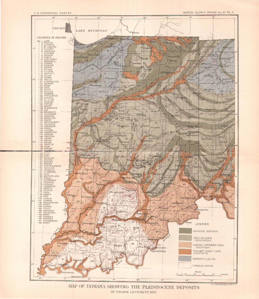
PLATE I. Map of Indiana showing the relation of the drift to the ordinary wells ____ . _ _ _ _ _ _ _ _ _ _ _ _ _ _ _ _ _ _ _ _ _ _ . . _ _ _ _ _ _ . _ _ _ _ _ _ _ _ _ _ _ _ _ _ _ _ 9
II. Map of Indiana showing the Pleistocene deposits _____ . _ _ _ _ _ _ _ _ _ 12 6 -
LETTER OF TRANSMITTAL.
DEPARTMENT OF THE INTERIOR, UNITED STATES GEOLOGICAL SURVEY,
DIVISION OF HYDROGRAPHY, Washington, October 20, 1898.
SIR: I have the honor to transmit herewith a report on the wells of Indiana, prepared by Mr. Frank Leverett, assistant geologist of this ·survey. This material was brought together by Mr. Leverett in connection with glacial investigations, as noted in the general discussion of the water 1·esources of Indiana and Ohio, published in Part IV of the Eighteenth Annual Report of the Survey, on pages 419-559. Many details wei·e omitted in that publication, as the volume assumed bulky dimensions; but these detailed facts have considerable value and are needed for reference by citizens of Indiana, and it is therefore desirable to make them available by publishing them in the series of Water-Supply and Irrigation Papers.
With these data are presented two maps, one illustrating the distribution of the glacial deposits and the other the relation of the drift to the ordinary wells of the State. These are portions of Plates XXXVI and XXXVII of Part IV of the Eighteenth Annual Report. Their reproduction in connection with this paper is essential to the clear understanding of the descriptive matter.
Very respectfully, F. H. NEWELL,
Hon. CHARLES D. WALCOTT, Hydrographer in Charge.
Director United States Geological Survey. 7


No. 1. LAKE II 2.PORTER u 3. LA PORTE II 4. s: JOSEPH 11 5. ELKHART " 6 . LAGRANGE " 7 . STEUBEN " 8. DEKALB " 9 . NOBLE " 10 . KOSCIUSKO " 11. MARSHALL " 12. STARKE " 13. NEWTON u 14.JASPER " 15. PULASKI 1' 16. FULTON '' 17. WHITLEY " 18. ALLEN •· 19. ADAMS •' 20. WELLS ~o 21. HUNTINGTON ·• 22. WABASH " 23. MIAMI "24. CASS "25. WHITE "26. BENTON " 27. WARREN "28. TIPPECANOE •· 29. CARROLL "30. CLINTON II 31. HOWARD "32. TIPTON "33. GRANT " 34. BLACKFORD II 35. JAY "36. RANDOLPH "37. DELAWARE "38. MADISON " 39. HAM'! LTO N '' 40. BOONE "41. MONTGOMERY "42. FOUNTAIN . "43. VERMILION . "44. PARKE "45. PUTNAM u 46. HENDRICKS ". 47. MARION "48. HANCOCK "49. HENRY "SO. WAYNE ' ' 51. UNION "52 . FAYETTE "53. RUSH "54. SHELBY
JOHNSON
CLAY VI GO SULLIVAN GREENE MONROE
"63. BROWN ·' 64. BARTHOLOMEW "65. DECATUR II 66. FRANKLIN "67. DEARBORN "68. OHIO "69. SWITZERLAND II 70. RIPLEY "71. JEFFERSON •• 72. JENNINGS " 73. JACKSON "74. LAWRENCE "75. MARTIN "76. OAVIESS '1 77. KNOX "78. GIBSON "79. PIKE 1' 80. DUBOIS •• 81. ORANGE " 82. WASHINGTON " 83. SCOTT "84. CLARKE "85. fLOYD "86. HARRISON " 87 . CRAWFORD ~ 88. PERRY "89. SPENCER " 90. WARRICK "91. VAND ERBURG "92. POSEY
WATER-SUPPLY PAPER No. 21 PL. I.
I UNOLAC!ATED ._ __ ---.J tV{ ells ru rock)
5 10
DlU~'~' 5'tv 50' 1Bes1; voells USlJaJlyin-rc)Ck )
Ditif'T 25'to75' IWclts-fl-equcntly enter roclcl
DRIFT lOO 'or'MORE ( V\TeUs seklom erlter rock )
Scale '0 30
MAP OF INDIANA SHOWING THE REJ_jATION O:F THE DRIFT TO THE ORDINARY WELLS BY .!<~RANK [,E;VERBTT,l897

WELLS OF NORTHERN INDIANA.1
By FRANK LEVERETT.
GENERAL STATEMENT.
The data included in this discussion of Indiana wells were collected mainly during the prosecution of the study of the glacial drift by the writer under the direction of Prof. T. C. Chamberlin. The portion of the State north of the latitude of Terre Haute and Brookville, embracing about two-thirds of the area, has been examined much more thoroughly than the portion south of that line. In the former district nearly every township has been traversed and close attention given to the conditions for obtaining wells. In the latter district only a few hasty trips have been made. Consequently the discussion for the norther:p two-thirds of the State is much fuller than for the southern third. In addition to material personally collected a considerable amount is taken from reports of the Indiana geological survey, many well sections having been published in those reports. Such material is accredited to the original sources.
A portion of the State, as has long been known, lies outside the glacial boundary. The approximate position of the boundary has been determined in part by Prof. G. F .. Wright, in connection with the United States Geological Survey, and in part by members of the Indiana geological survey. Professor Wright's location of the glacial boundary in the southwestern part of the State appears to be less accurate than in the southeastern part. In the former district it has been found by members of the Indiana survey and also by Prof. J. C. Branner to be in places at least 20 miles back from the limit.s of the drift, but in the latter district the writer's studies have sustained, in the main, the tracing made by Pr·ofessor Wright, no drift having been noted more than 6 or 8 miles outside his line. The latest results concerning the position of the glacial boundary are embodied in the glacial map of Indiana and Ohio here presented (Pl. 1). It will be observed that the boundary lies south of the Ohio River as far west as the vicinity of Louisville, Kentucky. Just above this city it crosses the Ohio and turns abruptly northward, passing through western Clarke, northeastern Washington, central Jackson, and eastern Brown
1 The length of a single paper in this series being hmited by law to 100 pages, it is necessary to divide this paper into two parts and issue them separately. The last part, relating to the southern portion of the State, will be published as Water-Supply and Irrigation PaperNo. 26 (in press).
9

10 WELLS OF NORTHERN INDIANA. [No.21.
counties, Indiana, a distance of about 50 miles. The course is then westward for about 30 miles, through northern Brown and northern Monroe counties. In northwestern Monroe County it makes an abrupt turn to the south and leads through western Monroe, eastern Greene, western Martin, and northwestern Dubois counties. From southwestern Dubois County the course is south of west across Pike, Gibson, and Posey counties to the extreme southwestern corner of the State.
The average thickness of the drift in the State is estimated to be about 130 feet. It consists of a complex series of sheets, differing widely in age and in structure. These sheets are made known largely by the well sections which appear in this report, for streams and natural exposures seldom reach the bottom of the drift. From a study of the drift sheets of Indiana and neighboring States, the glacial succession has been worked out sufficiently to determine the leading stages of glaciation and deglaciation.
It appears that the sheet which forms the surface of ·much of the glaciated portion of Illinois, and which is known as the Illinoian drift sheet, is exposed only in a few counties in Indiana, in the southwestern and southeastern portions of the State, the remainder being covered by later deposits of drift. The thickness where this single sheet is exposed to view averages scarcely more than 30 feet, or less than one-fourth the estimated average for the State.
In Illinois and Iowa there is a sheet of glacial drift exposed to view which was apparently deposited contemporaneously with the great silt deposit of the Mississippi Valley, to which the German term loess has been applied. This sheet has not yet been identified in Indiana, but the Illinoian drift sheet, where exposed to view, is capped by a deposit of loess-like silt, several feet in thickness, which was in all probability deposited at the time of the loess deposition of the Mississippi Valley and of the correlative drift sheet, which from its development in Iowa is known as the Iowan sheet. The Iowan drift sheet may be present underneath later drift sheets in the northern portion of Indiana.
The next important stage of glaciation has been termed the Wisconsin, chiefly because of its extent and early recognition as~a later sheet of drift in the State of that name. It covers the northeastern fourth of Illinois and extends south into Indiana, about to the latitude of Terre Haute and Brookville. The border is somewhat irregular, but departs scarcely more than 20 miles to the north or south of a line leading eastward from Terre Hante to Brookville, the greatest departure being in the western part. of the State, where it is deflected northward near the line of the Wabash River about 20 miles. The course of this boundary is indicated on the glacial map (Pl. I). It passes near the towns of Terre Haute, Rockville, Greencastle, Mooresville, Columbus, and Brookville. The loess referred to above covers
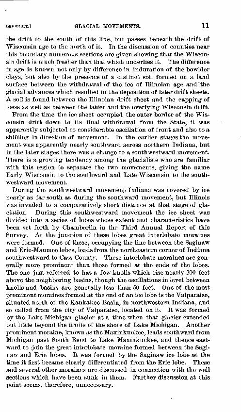
LEVERETT.) GLACIAL MOVEMENTS. 11
the drift to the south of this line, but passes beneath the drift of Wisconsin age to the north of it. In the discussion of counties near this boundary numerous sections are given showing that the Wisconsin drift is much fresher than that which underlies it. The difference in age is known not only by difference in induration of the bowlder clays, but also by the presence of a distinct soil formed ~m a land surface between the withdrawal of the ice of Illinoian age and· the glacial advances which resulted in the deposition of later drift sheets. A soil is found between the Illinoian drift sheet and the capping of loess as well as between the latter and the overlying Wisconsin drift.
From the time the ice sheet occupied the outer border of the Wisconsin drift down to its final withdrawal from the State, it was apparently subjected to considerable oscillation of front and also to a shifting in direction of movement. In the earlier stages the movement was apparently nearly southward·across northern Indiana, but in the later stages there was a change to a southwestward movement. There is a growing tendency among the glacialists who are familiar with this region to separate the two movements, giving the name Early Wisconsin to the southward and Late Wisconsin to the southwestward movement.
During the southwestward movement Indiana was covered by ice nearly as far south as during the southward movement, but Illinois was invaded to a comparatively short distance at that stage of glaciation. During this southwestward movement the ice sheet was divided into a series of lobes whose extent and characteristics have been set forth by Chamberlin in the Third Annual Report of this Survey. At the junction of these lobes great interlobate moraines were formed. One of these, occupying the line between the Saginaw and Erie-Maumee lobes, leads from the northeastern corner of Indiana southwestward to Cass County. These interlobate moraines are generally more prominent than those formed at the ends of the lobes. The orie just referred to has a few knolls which rise nearly 200 feet above the neighboring basins, though the oscillations in level between knolls and basins are generally less than 50 feet. One of the most prominent moraines formed at the end of an ice lobe is the Valparaiso, situated north of the Kankakee Basin, in northwestern Indiana, and so called from the city of Valparaiso, located on it. It was formed by the Lake Michigan glacier at a time when that glacier extended hut little beyond the limits of the shore of Lake Michigan. Another prominent moraine, known as the Maxinkuckee, leads southward from Michigan past South Bend to Lake Maxinkuckee, and thence eastward to -join the great interlobate moraine formed between the Saginaw and Erie lobes. It was formed by the Saginaw ice lobe at the time it first became clearly differentiated from the Erie lobe. These and several other moraines are discussed in connection with the well sections which have been sunk iu them. Further discussion at this point seems, therefore, unnecessary.

12 WELLS OF NORTHERN INDIANA. [NO. 21.
It will be observed that the structure of the drift is intimately related to the position with 1·eference to the ice margin at the time of deposition. Much of the drift deposited under the margin of the ice is a compact, bowlder clay, to which the Scottish term till is applied, while that deposited at the end, or carried beyond the ice by waters issuing from it, consists largely of sand and gravel, or if the issuing waters were sluggish the deposits may be of a silty character.
In the discussion of the counties which border the Kankakee marsh attention is called to a deposit of sand which covers the glacial drift. It was formed apparently by a glacial lake which occupied that region for a brief period while the ice sheet was still blocking the Wabash Valley to the south. This lake was long since recognized by Bradley and named Lake Kankakee. 1 A lake formerly extended beyond the present shore of Lake Michigan into the northwestern counties of Indiana, to which the writer has recently applied the name Lake Chicago. 2 It had southwestward discharge, through what is known as the Chicago outlet, into the Des Plaines River and thence to the Illinois and Mississippi. This lake also has left deposits of sand on the counties of Indiana which it covered. In the northeastern part of Indiana there is also an old lake area with well-defined beach lines, occupied by the glacial Lake Maumee, 3 which had southwestward discharge, through the "Fort Wayne outlet," into the Wabash River. This lake bottom is covered less thickly by deposits of sand and silt than the bottoms of Lakes Kankakee and Chicago.
The discussion begins at the northwestern corner of the State, and counties are taken up in order in tiers, the first tier running west to east, the second from east to west, the third from west to east, etc., following nearly the numbering of the counties on the maps. In the case of the southern counties, the data are so meager that they are considered in groups under the head of the immediately subjacent rock formation.
The records of wells here present~d should not be understood to indicate the usual depth, for the majority of wells probably are less than 25 feet in depth. They represent the deepest concerning which information could be obtained, and are selected because such wells convey more information con erning the drift structure and its capacity for supplying wells than the shallow ones. The relation of the drift to the ordinary wells is set forth in Pl. II.
The borings for natural gas, which are especially numerous in the central and eaAtern parts of the State, often throw light upon the structu1:e of the deeper portion of the drift and its water resources where deep water wells have not been made. They also throw considerable light upon the water horizons in the underlying rock str~ta. Such information as was obtained from the records of these borings· is
t Geol. of illinois, Vol. IV, 1870, pp. 226-229. 2 Geol. and Nat. Hist. Survey, Chicago Acad. of Sciences, Bull. No.2, 1897, pp. 64-66. s C. R. Dryer, Sixteenth Ann. Rept. Indiana Geol. Survey, 1888, pp.l07-114.
No. l. LAKE ' 1 2 . PORTER .. 3. LA PORTE " 4 . s: JOSEP H " 5. ELK HART " 6 . LAGRANGE .. 7 . STEUBEN " 8 . DEKALB " 9 . NOBLE ·• 10 . KOSCIUSKO •· 11. MARS HALL ·· 12 . STARKE " 13. NEWTON .. 14.JASPER .. 15. PULASKI •· 16. FULTON ~< 17. WH ITLEY " 18. ALLEN " 19. ADAMS " 20. WELLS .. 21. HUNTINGTON •' 22 . WABASH .. 23. MIAMI "24. CASS ' ' 25. WHITE •· 26. BENTON "27. WARREN "28. TIPPECANOE •· 29. CARROLL "30. CLINTON '' 31. HOWARD "32. TIPTON "33. GRANT ·• 34. BLAC~FORO "35. JAY "36. RANDOLPH "37. DELAWARE " 38. MADISON "39. HAMILTON •' 40. BOONE ~> 41. MONTGOMERY •· 42. FOUNTAIN •· 43. VERMI LION "44. PARKE "45. PUTNAM "46. HENDRICKS "47 . MARIOf+. '' 48. HANCOCK " 49. HENRY " 50 . WAYNE ·· 51 UNION ''52 FAYETTE ·'53. RUSH "54. SHE
'' 58 . CLAY "59. 1/ IGO "60. SUI_LIVAN "61. GRE ENE "62. MONROE "63. BROWN ·· 64. BARTHOLOMEW ·• 6S. DECATUR ·• 66. FRANK UN "67. DEARBORN '' 66. OHIO '' 69. SWITZERLAND ·· 70. RIPLEY ·• 71. JEFFERSON " 72. J ENNINGS " 73. JACKSON "74. LAWRENCE "75. MARTIN " 76. DAVI ESS " 77. KNOX "7~. GIBSON •• 79. PI KE •• 80. DUBOIS
_ "81 . ORANG E "82. WASHINGTON " 83. SCOTT "84. CLARKE ' ' 85. FLOYD .. 86 HARRISON "87. CRAWFORD .. 88. PERR Y "89 SPENC ER ·· 90. WARRICK .. 91 VANDERBUR G "92. POSEY
I -L
WATER-SUPPLY PAPER No.21 .PL.II .
Glu\.C IAL FU J)(j~;::;
'ITLL PLAn; S (WISCONSIN )
LO~:ss COVr~R~~D TILT, (ILLINOIAN)
VALLEY TlRII'T Ai'\D AT.LUV11'M
EX'I'fNC' T I JAI; i·;s
r-_jl L - FNG t.ACI. \ '1' 1•:1l
ScaJe
MAP OF I:\TDJANA SHOWIXG TIJE PLEISTOCE~E DEPOSITS HY FBA'<K [,}_; VJ~ RJ::TT, 1897
LITH. N Y

LEVERETT.) LAKE COUNTY. 13
here presented, though it is not so full as could be desired. In this connection it may be remarked U1at information concerning water supply in the deeper part of the drift and in the underlying rocks is very meager, compa1·ed with the knowledge concerning the sp.rface portion of the drift. Information concerning these deeper bQds has been greatly extended since the discovery of natural gas. In many instances borings which failed to obtain gas have been subsequently turned to use because"'()f the water which they yield. Thus a resource which was overlooked in the excitement incident to the discovery of gas is likely to receive proper development in the near future.
DETAILED DISCUSSION OF WELLS.
LAKE COUNTY.
General statement.-Lake County, situated in the extreme northwest corner of Indiana, has for its northern border the shore of Lake Michigan and for its southern border the Kankakee River. It extends eastward from the State line about 16 miles, and has an area of 500 square miles. '
The Valparaiso moraine leads west to east across the central portion of the county, and has a width of about 10 miles. It is a somewhat elevated :rolling tract, standing 100 to 200 feet higher than Lake Michigan. Wells are sunk to considerable depth, few wells being obtained at less than 25 feet, while many are 50 to 100 feet or more. These wells are obtained usually in beds or pockets of sand or gravel between till sheets.
North of the moraine there is a low plain, much of which was cov~red by Lake Chicago, the glacial predecessor of Lake Michigan, which ····.ad its outlet southwest to the Des Plaines River. For several miles ·~outh from the present shore of Lake Michigan the sand deposits of ·~his old lake bottom are so heavy that wells 10 to 40 feet in depth are ·'lften obtained without reaching the underlying till. But near the ... 'loraine the sand becomes thinner, and is in places but a mere skim ·1oating. On this portion of the plain wells are carried to as great ·iepth as on the moraine, and water is obtained in gravel deposits in ~~he till. ~outh of the Valparaiso moraine is a narrow strip of gravelly land
·~~ 3d by the waters escaping from the ice at the time it occupied ... ~1 .aoraine. On this plain the wells usually obtain their water at
•iepths of 10 to 25 feet, without reaching the bottom of the gravel ··leposit. Extending several miles north from the Kankakee, in the ,·vmthern part of the county, there is a marsh too wet for settlement.
The glacial deposits of Lake County are,so heavy that wells may ··>e obtained without entering the underlying rock. Borings for arte~··i.an water or for natural gas, made at Hammond, Hobart, and Crown :·':)oint, penetrate 110, 160, and 176 feet of drift, respectively. From ·'·hese borings it appears that the drift of this county may have an r'.verage thickness of about 150 feet.
14 WELLS OF NORTHERN INDIANA. [No.21.
Individual wells.-At Hammond many wells are driven to a depth of 10 to 18 feet in sand, entering water at about 8 feet. Filters are used in some cases. Below the sand is a nearly solid bed of blue till, 90 feet in thickness, which contains but little water. At about 110 feet Lockport (often called Niagara) limestone is entered, which furnishes water containing sulphureted hydrogen. The artesian well boring at the distillery, 1,900 feet in depth, is discussed elsewhere. 1
At Whiting a portion of the water supply is furnished by shallow wells in the beach sand, 20 feet or less in depth. A portion of the water supply is pumped from Lake Michigan by the Standard Oil Company and made use of by many families.
The villages of Gibson, Hessville, Tolleston, Liverpool, and Lake all depend upon shallow wells driven or dug to a depth of 10 to 40 feet in the surface sand. In some cases contamination is liable to occur from privy vaults and other sources.
At Hobart the wells 15 to 25 feet in depth usually penetrate a few feet of clay, which probably prevents contamination of water. A well at Owens's brickyard reaches the underlying rock and has the following section:
Feet. Yellow silt, pebblelesG, calcareous .........•...•• ~-. _________ .... ___ --- .. _ _ _ _ 10 Blue silt, pebbleless, calcareous ..... _. __ .. ___ ._ ....... __ . _. ___ ~ ~. ____ . ___ . _ _ 50 Blue till, hard and stony _______ . _ _ _ _ _ _ _______________________ .• _ _ _ _ _ _ _ _ _ _ _ _ 97 Hard rock. _______ • ______ . __ .. _____________ . __________ . ______ .. _. _______ .. _. 3
Total.----------------------------- .. ---------------------·------------ 160
Mr. Leavenworth's well, 3 miles west of Hobart, depth 80 feet, is above the limits of the lake deposit and is mainly through blue till. Several wells in that vicinity 50 to 100 feet deep do not reach the bottom of the drift.
Wells in the vicinity of Ainsworth, on the north slope of the Valparaiso moraine, often exceed 50 feet. After penetrating yellow till 10 or 12 feet they are mainly th1·ough blue till.
In the vicinity of Crown Point, near the crest of the Valparaiso moraine, the1·e are several tubular wells 7 5 or 80 feet in depth, ~ainly through blue till.
Tubular wells in the vicinity of St .• John, near the crest of the moraine, obtain water at 50 to 100 feet in sand beds included in the-,tii.i;;
Wells on the south slope of the Valparaiso moraine usually en~ water-bearing sand or gravel after penetrating a few feet of till, water being more easily obtained there than on the crest or north slope.
A well at the powder factory, 1 mile west of Miller Station, in the northern part of the county, 75 feet in depth, entered a bed of molluscan shells at the bottom of the sand, 40 feet below the surface and probably several feet above the level of Lake Michigan. Below the shells a bluish silt or fine sand is penetrated 35 feet.
1 See Eighteenth Ann. Rept. U. S. Geol. Survey, 1896-9'1, Part IV, 1897, p. 489.

LEVERETT.] DETAILED DISCUSSION OF WELLS. 15
PORTER COUNTY.
General statement.-Porter County is situated just east of Lake County, and has Lake Michigan for its northern and the K~nkakee River for its southern border. It is 15 miles in breadth, 25 to 30 miles in length, and has an area of 410 square miles.
The Valparaiso moraine traverses the county from southwest to northeast, slightly north of the center, and has a width of about 8 miles. It reaches a higher elevation in this county than in Lake, some points being fully 250 feet above Lake Michigan. It includes several lakes, one of which furnishes the water supply for Valparaiso, the county seat. In the western portion of the county till predominates as far as wells penetrate-150 to 200 feet. But in the eastern portion of the county, where the moraine reaches its highest 9levation, it contains a large amount of dry sand and gravel, and strong wells are obtained only by penetrating to a depth of 100 to 160 reet.
Extending north from the moraine there is a low plain reaching to the Calumet River, which is underlain, as a rule, by till, but Is coated quite generally with sand. In this plain wells vary greatly in depth, but are usually 20 to 40 feet.
North of the Calumet River there is a narrow ridge of till forming a feeble morainic belt. Its width seldom exceeds 1 mile and its relief is but 30 to 50 feet. .Along this ridge wells are frequently 75 to 125 feet in depth, it being one of the most difficult places in the county to obtain water.
North of this till ridge there are heavy deposits of lake sand, rendering a portion of the district a barren waste. The sand is drifted by the wind into dunes 100 to 200 feet in height. This belt, however, occupies only a breadth of 2 or 3 miles, though extending the entire width of the county. This district is largely uninhabited. In the farms along its border next the till ridge wells usually obtain water before reaching the bottom of the sand at depths of 25 to 50 feet.
South of the Valparaiso moraine the formations are like those of Lake County, there being a gravel plain several miles in width, extending on the south into the uninhabited Kankakee marsh. The moraine extends spurs out into this gravel plain nearly to the borders of the marsh.
The glacial deposits of this county, like those of Lake, are so heavy that wells obtain water without entering the underlying rock. Borings for natural gas made at Valparaiso, Hebron, and Boone Grove ?enetrate 126, 108, and 140 feet of drift, respectively, while a boring ~or an artesian well in the northeast part of the county has 245 feet ·'>f drift. It appears from these borings that the average thickness of ·~he drift in this county may slightly exceed 150 feet. Several wells :=tlong the Valparaiso moraine, as indicated below, reach a depth of ·1ver 150 feet without entering rock.
16 WELLS OF NORTHERN INDIANA. [No.21.
Individual wells.-The Blair artesian well, in the extreme northeast corner of the county (sec. 1, T. 37, R. 5 W. ), has the following section:
Feet. 1. Sand with peaty beds near bottom ___________ . ______ .. _. _ ... ______ . _ .. _. 30 2. Adhesive blue clay with thin sand beds __ . __ . ____ . ____ . ___ . __ ..... _. _____ ·. 55 3. Gravel and sand with water ______ .. __ . __ . _ .. ___ . ____ . _. _. ________ . _. _. . 9 4. Blue clay likeN o. 2. ____ . _. ________ . __________ .. ____ .. _ _ _ ____ . ________ . 110 5. Gravel with water __ .. ___ . _________ .. ___ . __________ . ___________ . _____ . _ _ 6 6. Blue clay like No. 2 _________ . _ . ____ .. ____ . ________ . _____ . ____ .. ____ . __ . _ _ 35 7. Shale (?) ___________ . _ _ _ _ _ _ ... _________ . ____ . ___ .. _____ . _____ . _____ • ____ . 1 8. Hard gray limestone _ . _ ... __ ... ___ . ____ . _ .. ____ . _ . ______ .. _________ . ____ . 180 9. Soft rock, subject to caving in places __ . __ . ___________ ..... _. __ . ___ . ____ . 66
10. Hard limestone ___ . ___________ .. ____ .. _______ . __________ .. ____ . ________ . _ 372
Total·-------------------------------------------------·---------- 864
The well mouth is about 20 feet above Lake Michigan, or 600 feet above tide. Flows occur at 68, 72, 78, ·so, 85, 95, and about 200 feet in the drift. The flows were weak until a depth of about 85 feet was reached, when a strong flow with head 18 feet above the surface_ was obtained. The flow from 200 feet is also strong. The water from all the veins in the drift is fresh and of good quality. At a depth of 370 feet sulphur water was struck, which gradually increased in strength in the next 150 feet. The head is, however, 10 feet lower than that from the drift deposits. The combined flow is about 400 barrels per hour and the temperature 62° F.
At Furnessville, on a beach line in the north part of the county, a well 80 feet in depth penetrated beach sand 25 feet, at the base of which logs were encountered. Below the logs is a blue clay, probably till, which was penetrat.ed about 50 feet when a water-bearing sand and gravel was struck.
A well on the beach line immediately north of Calumet River, near the east line of the county, obtains water at the base of the beach sand at 23 feet. Neighboring wells south of the beach line enter a blue clay, nearly pebbleless, at 3 to 5 feet, and in some cases penetrate this to a depth of 50 feet before obtaining water.
At Chesterton and Hageman, in the northern part of the county, wells are seldom more than 20 feet in depth, and usually obtain water at 10 or 12 feet. As they are mainly through sand, there is danger of contamination.
Records of several wells were obtained along the till ridge north of Calumet River, near Chesterton. They penetrate yellow till18 or 20 feet, below which is a blue till, hard and stony, which is usually penetrated 40 or 50 feet before a water-bearing sand or gravel can be obtained. In one well a dry sand, 15 or 20 feet in thickness, was found between the yellow and blue tills, and the blue till there afforded no water until it had been penetrated 70 f~et. The depth of the well is 125 feet.

LEVERETT.] PORTER COUNTY. 17
From the Calumet River south to the Valparaiso moraine water is usually obtained at 8 to 25 feet. In some cases surface clay a few feet in depth is penetrated, but quite as often the wells are almost entirely in sand or gravel. In the western part of the county, however, in the vicinity of -Wheeler and northward for 4 or 5 miles, this plain is underlain by a compact till, and wells are in some places difficult to obtain. There is a small till ridge leading north from Wheeler, on which it is especially difficult to obtain wells. Several borings have been made along the ridge to a depth of 100 to 200 feet. In one case a boring was abandoned at 200 feet without obtaining water. In another case water was obtained after penetrating 155 feet of till. Another well found water after penetrating 115 feet of till. A plain known as Twenty Mile Prairie, lying north and east of the till ridge just mentioned, is underlain by a very fine sand, so that wells have been carried to a depth of 150 feet before entering coarse sand or gravel. On this prairie there is usually:
Feet.
1. Yellow till _______ ----------------------·--·-·---------------------- 7 to 10 2. Blue till __________________ ---··------- _____ -'----- ------- __ .. ·------- 20 3. Fine gray quicksand __ --_ _______________ ------ ___ .---· ____ --·----· ____ 75 to 125
Passing to the Valparaiso moraine, we find in the western part of . the county a region in which strong wells are difficult to obtain, except in a few favored localities, there being a very compact till, similar to that on the plain north of the moraine. At Smalls Crossing, 3. miles southwest of Wheeler, a well penetrates the following beds:
Feet. 1. Yellow till ______ ----------·. ___ ..... _ .. __________ .. _ ... ______ ----.. 8 to 10 2. Blue tilL ___________ . ____ ... ___ .. __ . __ . __ . _____ ..... _____ .. _ ..•• __ .. 35 to 40 3. A fine sandy deposit, in places resembling tilL. ____ . ___ ...•... _. _ .. _ 150 4. Coarse water-bearing sand._ .. _ .•.•. _____ . ___ . _. __ ... - _. _. _. _ ••• ---. 19
Total _________ . _ _ _ _ _ _ ____ •• __ .. _ . ____________ . ___ .. __ .. __ .. _ _ _ _ 219
Mr. Currier's well, 1 mile south of Wheeler, in which no good vein of water was found, penetrates-
Feet. 1. Yellow till ... ~-------- _____ .... ··--- -----· ---~-------------- ·----------- 15 2. Blue till, soft . __ . __ . _ . _. __ . _ _ _ _ _ ... __ .. ___ ................ _ .•..• ---. -.-- 140
3. Blue till, hard----------------------------------------------- ------------ 39 Total._ •• __ . ______ • ____ .. _ . ______ .. __ . _ . ____ . ___ . ____ .. _ . __ . _ .•. __ . _.- _ 194
On the south slope of the moraine in the western part of the county, water-bearing sand or gravel is usually found at about 40 or 50 feet.
Following the moraine northeastward to Valparaiso, the till is found to give place in its lower portion to beds of sand and gravel. In the southern part of Valparaiso, and also for some distance south of the city, wells often obtain water at a depth of 25 feet. Occasional deeper wells in that district show a large amount of coarse sand or fine gravel below a few feet of surface till. On the elevated ground in the north-
IRR21--2

18 WELLS OF NORTHERN INDIANA. [No.2!.
ern part of Valparaiso wells usually penetrate about 30 or 40 feet of yellow and blue till, underlain by dry sand, which is often penetrated 50 or 60 feet before water-bearing sand or gravel is 1•eached. The drift is of this character for several miles northeast from Valparaiso, and wells are often carried to a depth of 130 to 160 feet before obtaining water. For example, a boring at Jackson Center penetrates-
Feet. 1. Yellow till ________ . ____ . __ . ________________________ . _________ . __ . _ . . 20 2. Dry sand._ . ____ . ____ . __ . ______ .. ___________ .. __________ . ___ . ___ . _ . . . 90 3. Blue-gray clay, tough and spongy~_ .. _______ . _ . _ .. __ . _ _ _ _ _ _ _ _ _ _ _ _ _ _ _ _ 45 or 50 4. Water-bearing sand . __ . ____ . __ ... _______ . _______ ~ _________________ . _ 10
Total ________________ . _ . ____ . __ . . . .. ____ .. __ . . _ , _ _ _ _ _ _ _ _ _ _ _ _ _ _ _ _ 170
In some wells near Jackson Center a water-bearing sand is found at the top of the blue clay (No. 3) at about 120 feet. Where this is too fine to be easily screened the wells continue through the blue clay, obtaining water in coarse sand at 160 to 175 feet. Near. Flint Lake the wells are 100 to 130 feet deep and obtain water in the sand above the blue clay.
In southern Porter County a boring for gas at Boone Grove penetrates-
Feet. 1. Yell ow loamy clay ___________ .. _ .. __________________ . _ _ _ _ _ _ _ _ _ _ _ _ _ _ _ _ _ _ _ _ _ 8 2. Water-bearing sand _____ .. ______ . _______________ . _ .. _ _ _ _ _ _ _ _ _ _ _ _ _ _ _ _ _ _ _ _ _ 92 3. Hard blue till _________________________ . ___ . _. _. _______ . ________ .. _ _ _ _ _ _ _ _ 40 4. Black shale (Devonian) . __ .. ____ . ____ . __ . _ .. _____ ...... __ . . . ___ . _____ : . . 125 5. Limestone _____ . ___ .. _ ~ .. __ ... _. ____ .. ____ ..... _____ .... - _ . __ •..... _ ... _ _ _ 15
Total •. __________ .. _ . ___ .. _ . _ . __ . ___ .. _ . _____ • _________ . _______ .. ___ • • 280
In the gravel plain south of the Valparaiso moraine wells usually obtain water at 10 to 20 feet, without penetrating any till. The gravel in places, however, does not coat the sheet of till that lies outside the moraine. Thus at Kouts Station there is a surface till 18 or 20 feet, beneath which water is obtained in a deposit of gravel at 25. to 35 feet. At Hebron, also, wells encounter till, and water is found at about 40 feet.
The Kankakee marsh extends several miles north of the river in the southern part of the county, and this area is so generally covered with water that it is unfit for settlement.
LAPORTE COUNTY.
General statement.-Laporte County is situated immediately east of Porter. It fronts for a few miles on Lake Michigan, on its ,»orthern boundary, but that boundary is formed mainly by the State line. The southern boundary is formed mainly by the Kankakee River, but in the southeastern part the county extends a few miles beyond the river. The width of the county is 21 to 23 miles and the length is 22 to 32 miles, being greatest at the western border. The area is 540 square miles.
LEVERETT.] LAPORTE COUNTY. 19
The Valparaiso moraine leads northeastward across the northwestern portion of the county and has a width of about 6 miles. Its crest has an elevation of 225 to 300 feet or more above Lake Michigan. It incloses several Ja,kes, from one of which the city water supply of Laporte is obtained. · It rises very abruptly on its northwest .border above the low plain that lies between it and Lake Michigan, but on its southeast border a gravel outwash from the moraine is built up neal'ly to the level of the crest, and the descent is gradual from the moraine to the Kankakee niarsh. The marsh stands fully 100 feet above Lake Michigan in eastern I.aporte County and about 75 feet at the western border of the county. It is, therefore, 150 to 200 feet or more below the crest of the moraine. The gravel plain makes a descent of 75 or 100 feet in the intet·val of 8 or 10 miles between tht>o moraine and the marsh.'
On the low plain bordering Lake Michigan, in the nort,hwestern partof the county, there are a series of narrow t.ill ridges or feeble moraines which govern the drainage of that region to a marked degree, though having a relief of but 30 to 50 feet. On the immediate border of the lake there are prominent dunes, rising in places to a height of 150 feet above lake level.
The glacial deposits are so heavy that ordinary wells are obtained without entering the underlying rock. A boring for gas at Lacrosse, in the southern part of the county, is reported to enter rock at 38 feet. The gas boring at Laporte, the county seat, penetrates 295 feet of drift. The gas boring at Michigan City penetrates 250 feet, while the artesian well at the penitentiary at Michigan City penetrates only 170 feet. These borings indicate that the thickness varies greatly, and are scarcely sufficient to justify an estimate of the average thickness for the county.
Individual wells.-The gas-well boring at Michigan City has the following section:
Feet. 1. Dry surface sand _____ ~_. __ . ________ . _ . _________________ . ____________ - _ _ _ _ 15 2. Quicksand ___________________________________ ----·--------------- ________ 10 3. Gravel ___ . _ _ _ _ _ _ _ _ _ _ _ .. _ .. ____ . ____ . ____________ . ______ . _ _ _ _ _ _ _ _ _ _ _ _ _ _ _ 5 4. Blue till, pebbly and rather hard ______________ .. --·-- ______ -----. _________ 167 5. Gravel containing cobble and bowlders ________________________ .:__________ 15 6. Sand and gravel, with occasional large stones. __ ------ _ ___ __ __ _ _ ___ _ __ __ _ 40 7. Limestone, with thin beds of shale, extending to the bottom of the welL___ 570
Total __ . _________________________ . . _ _ _ _ _ . _ _ _ _ _ _ _ _ _ _ _ _ _ _ _ _ _ _ _ _ _ _ _ _ _ _ _ _ 819
At a depth of 210 feet a flow of fresh water was obtained from the drift, with a head 15 feet above the surface. The strength of the flow increased downward to the rock at 250 feet. A strong flow of sulphur water was obtained from the limestone at about 450 feet.

20 WELLS OF NORTHERN INDIANA. LN0.21.
The artesian well at the penitentiary, 1 mile west of Michigan City, has the following section reported by Dr. Levette: 1
Feet. 1. Surface sand _____ . _ _ _ _ _ _ _ _ _ _ . ___________ . . ______________ . _ . _ _ _ _ _ 48 2. Clay __ . _____________ • __________ . _. _ .. _______ .. ___ . _______ . _ _ _ . _______ . _ _ 4 3. Sand _____________ . _ _ _ _ _ _ _ _ _ _ _ _ . ___ . _________ ·_ .. _ _ _ _ _ _ . __ . _ _ _ _ _ _ _ _ _ _ _ _ _ 24 4. Clay _____ .. _________ . ________ . ____________________ . ____________ . . _____ ~· 66 5. Sand _ _ _________ . ________ :. . __ . __ . _ _ _ _ _ _ _ _____ . __ . _________ .. _________ . 30
6. ]darcellus shale·---------------------------------------------------·---- 76 7. Upper Silurian limestone, with fossils. _________________ . ________________ 293!
Total ________________________________________________________________ 541!
The boring is reported to terminate in a porous limestone rock which furnishes a flow of water strongly impregnated with sulphureted hydrogen. Its head is 22 feet above the surface .of the ground; rate of discharge about 300 gallons per minute; temperature, 57° F. The well mouth being about 18 feet above the level of Lake Michigan, or 600 feet above tide, the head at this well is 622 feet above tide.
A remarkable instance of the rise of water in a sand dune above lake level, was found at the Yankee Slide, a dune on the shore of Lake Michigan, in the west part of Michigan City. Wells on its slope, at an altitude of 40 or 50 feet above the lake, obtain water at a depth of but 12 feet.
The wells on the low plain in northwestern Laporte County, and also on the till ridges which traverse that plain, show a preponderance of till. The water-bearing sand and gravel appears to be in local deposits or 'sheets of limited extent. Neighboring wells often have very dissimilar sections. In some a sand or gravel bed appears, which is absent in others; some show a solid bed of till to a depth of 75 or 100 feet, while others present alternations of till with sand or gravel. The deepest well record obtained on this plain is that at a farmhouse 4t miles south of Michigan City, and is as follows:
Feet. 1. Yellow tilL __ . _____________ . _____________ . _________ .. _ . ______ . _ . ___ . _ _ 20 2. Dry sand ___________ .... _______ . ________ . ______ .. ___ ·~ . ___ . _____ . _ _ _ _ _ _ 8 to 10 3. Blue till ___ ·~ __ . _________ ... _______ . ___ . ____________ . __ .. ______ · __ • _ _ _ _ 85 to 90 4. Sand _______ . ___________ .. ___ . _____________ . _____________ . _____ . _ _ _ _ _ 50
Total ____ .. ____ . __________________ . _____ .. ________ . _____________ . _ _ _ 165
There are beach lines traversing this plain immediately south and east from Michigan City, on which wells are sometimes obtained at depths of 12 to 16 feet without reaching the bottom of the beach deposits.
On the north slope of the Valparaiso moraine, near the west line of the county, and just south of the Lake Shore and Michigan Southern Railway, a well148 feet in depth enters dry sand below till at about
1 Fifth Ann. Rept. Indiana Geol. Survey, 1873, pp. 470-4n.

LEVERETT.] ST. JOSEPH .COUNTY. 21
20 feet, which continues to the water-bearing sand and gravel near the bottom. Occasional deep wells along this moraine show that sand and gravel, as in the above section, greatly preponderate over the till. As a rule, however, wells are obtained along the moraine without penetl·ating to greater depth than 50 feet.
Wells on the gravel plain, south of the moraine, are usually obtained at 10 to 20 feet. S~veral villages situated on this gravel plain depend upon these shallow wells for drinking water, though the water appears liable to contamination.
The gas-well boring near Lacrosse, in the southern part. of the county, enters water in gravel5 feet below the surface, and wells in that vicinity are only 10 to 17 feet in depth. The boring was carried to a depth of 838 feet, but water does not rise above the surface, which is 675 feet above tide. The well is used for watering stock.
ST. JOSEPH COUNTY.
Generalstatement.-St. Joseph County is_ situated east of Laporte, about midway of the north boundary of the State. Its area is 470 square miles. About one-half the county is a gravel plain formed by the outwash from the ice sheet. In the northwestern portion of the
, county the outwash is from the "Valparaiso moraine, and the plain descends froJP. about 800 feet at the border of the moraine to 725 feet at the border' of the Kankakee marsh. In the southwestern portion of the county the outwash is westward from the Maxinkuckee moraine of the Saginaw lobe, and there is a similar descent from the moraine to the Kankakee marsh. In the northeastern portion of the county there is an extensive gravel plain along the St. Joseph River, whose head is in southern Michigan in a later moraine of the Saginaw lobe. The southeastern part of the county is occupied by a till plain which borders the Maxinkuckee moraine on the east. The Maxinkuckee moraine passes diagonally across the county from the southwest to the north border and has a width of about 5 miles. It is interrupted by a gap 10.t the St. Joseph River near South Bend 2 or 3 miles in width. The highest portions of this moraine stand fully 300 feet above Lake Michigan, or about 900 feet above tide.
Very little is known concerning the thickness of the glacial deposits, there being, so far as the writer is aware, but one point within the county where rock has been struck. A gas boring at South Bend, in the valley of St. Joseph River, has 137 feet of drift. Its altitude is but 725 feet above tide, or fully 150 feet lower than the uplands of the southeastern portion of the county. If, therefore, the rock surface has a general level as low as at South Bend, the drift of the county would be from 120 to 300 feet in thickness, with an average of perhaps 200 feet.

22 WELLS OF NORTHERN INDIANA; [No.21.
Individual wells.-The gas-well boring at South Bend is reported by Dr. Phinney 1 as follows:
Feet. 1. Sand ____________________________ . __ . _ _ ______ . __ . ____ . _ _ _ _ _ _ _ _ _ _ _ _ _ _ _ 25 2. Gravel __ . ____________________ . _____ . _ _ _ _ _ _ _ _ _ _ _ _ _ _ _ _ _ _ _ _ _ _ _ _ _ _ _ _ _ _ _ _ _ 20 3. Clay ______ . ____ . __________________________ . _____ . _________ . _ _ _ _ _ _ _ _ _ _ 30 4. Sand ______ • ____________ ~- ________________________________ .. ______ .. _ _ _ _ 25 5. Gravel _______ . _______________ . _ .. __ ..... _____ . _ . _ .. __ . _ _ _ _ _ _ _ _ _ _ _ _ _ _ _ _ _ _ 37 6. Shales ____ ~ __ . ____ . _____ . _______ . _ _ . _ . __ . _ . ______ . ____ . __________ .. _ _ 238 7. Limestone ______________________________ ----·-·---·-------------- ___ 805 8. Limestones and shales ___ .. ___ . _ . __ .. _ . ___ .. ___ . ______ . ______ . _ .. _ _ _ 220 9. Utica shale ____________ . ____ . __ . ___ . _ . ___________________ .. _ . _. _. _ . _ _ 185
10. Trenton limestone_. ________ ~ _ ... _____ . __ . ____________ . _________ . _ _ _ _ _ 85
Total ____ .. ______ . _ _ _ _ _ _ _ _ _ _ _ _ ___ . _ . _ _ _ _ _ _ _ _ _ _ _ _ _ _ _ _ _ _ _ _ _ _ _ _ _ _ _ _ _ _ _ 1, 670
Salt water was struck at 375 and 610 feet, and also in the Trenton at 1,670 feet. From the latter horizon it rose within 200 feet of the surface.
The city of South Bend obtains its water supply from about 30 flowing wells, situated along the valley of the St. Joseph River. The wells have a depth of 100 to 125 feet, with an average of about 110 feet. They are obtained in gravel beneath a bed of cl~y 20 to 40 feet in thickness, which acts as a cover and prevents contamination of the water. This clay is probably a water deposit rather than a glacial deposit, as it is described as entirely free from pebbles of any kind. The head is sufficient to carry the water above the surface only on the low ground along the river bottom, about 670 feet above tide. The gravel plain on which the city was built stands 20 to 30 feet or more above the height to which the water will rise.
The private wells in South Bend are often obtained without penetrating a bed of clay, and the ground water is usually at sufficient height to easily receive the leaching froni cesspools. Such wells may become a source of dang~r to the health of the city. ·
Wells in the city of Mishawaka are also situated on a gravel plain, and are usually about 20 feet in depth, and the water stands within 12 feet of the surface. There appear in the majority of ~ases to be no beds of clay or other impervious material to prevent contamination of the water from cesspools. 'fhe St. Joseph River, drawn upon for fire protection and irrigation, might easily be made to furnish the supply for domest.ic use.
Wells on Portage Prairie, a gravel plain in the northwest part of the county, are usually 60 or 80 feet, and seldom less than 40 feet, in depth. A well on this prairie, at Mr. Womer's, near the State line, 17 4 feet in depth, has the following section:
Feet. 1. Sand and gravel, with water near bottom ....... -------------------------- 67 2. Blue clay and blue quicksand _________________ . _____ . ___ . _____ .. _- _ _ _ _ _ _ _ 99 3. Gravel and sand, with water ____________ . __ . _ _ _ ___ . ____ - ____ - __ ---- _----- 8
Total _________________________________ ----~~· ------------ .. ·------··-- ·- 174
1 Eleventh Ann. Rept. U. S. Geol. Survey, 1889-00, Part I, 1891, p. '134:.

LEVERETT.] ELKBAR'l' COUNTY. 28
Wells on the gravel plain west of the Maxinkuckee moraine, near North Liberty, usually enter clay below the gravel at about 20 feet. Two wells in the Potato Creek valley, east of North Liberty, obtain flows of water from depths of 45 and 70 feet.
Wells at Walkerton, also on the gravel plain, obtain water at 20 or 30 feet. The water surface is usually nearly 20 feet from the mouth of the well, but even this depth is not sufficient to insure freedom from contamination, there being no impervious stratum above the water vein.
A well on the gravel plain between Walkerton and North Liberty, in sec. 5, T. 35, R. 1 E., 160 feet in depth, is mainly through sand and gravel. The water rises nearly to the surface. ~ells in that vicinity usually obtain water at 10 to 20 feet. One well near Walkerton, however, failing to obtain water in the surface gravel, passed through a pebbleless blue clay 50 feet in thickness, obtaining water at a depth of 70 or 80 feet.
Records of two deep wells were obtained on the Maxinkuckee moraine, about 8 miles south of South Bend, in sec. 17, T. 36, R. 2 E. One at Mr. Sweeney's, 131 feet in depth, after penetrating 22 feet of yellow till, passes through alternations of sand and blue till for about
-100 feet before reaching the coarse gravel. The other well, at Mr. McClelland's, has a similar section and is 146 feet in depth.
On the plain east from the Maxinkuckee moraine many wells are but 15 to 20 feet in depth, and enter sand or gravel below till near the bottom. A few tubular wells are 80 or 100 feet in depth.
ELKHART COUNTY.
Generalstatement.-Elkhart County is situated immediately east of St. Joseph County, on the north boundary of the State, and has an area of 470 square miles. Like St. Joseph County, a large portion of its surface is a gravel plain. The most extensive gravel plain is that along the St. Joseph River, in the northwest part of the county, which comprises an area of more than 100 square miles. There is also a gravel plain along the Elkhart River from the southeast corner of the county northwestward to the St. Joseph gravel plain. From the Elkhart gravel plain there are extensions southward into Kosciusko County, past New Paris and Milford, and southeastward into Noble County near Cromwell. This system of gravel plains comprises an area of fully 100 square miles. There is also a narrow gravel plain along Little Elkhart River, in the northeast part of the county. About half the county is, therefore, embracctd in the gravel plains. The uplands consist of a till plain having an area of about 125 square miles, situated in the southwest part of the county, and of morainic belts, with small areas of nearly plain surface, occupying an area of about 150 square miles in the eastern and southern parts of the county. The altitude of the gravel plains is mainly below the 800-foot

24 WELLS OF NORTHERN INDIANA. (NO. 21.
contour. The uplands are mainly between 800 and 900 feet above tide, though small areas on the moraines in the eastern and northeastern parts of the county rise above 900 feet.
The thickness of the drift is known at three points-Elkhart and Goshen, and near New Paris, where it is 122, 162, and 90 feet, respectively. Should the rock surface of the entire county be as low as at these wells, the thickness of the drift would average fully 200 feet.
Individual wells.-At Elkhart the majority of wells are about 30 feet in depth. They penetrate sand and gravel for 20 feet or more, when a thin bed of clay is usually found as a cover for the waterbearing gravel. The mayor reports that he considers 'the clay a protection against contamination.
A few wells in Elkhart have been put down to a depth of 100 to i20 feet, which have sufficient head to overflow on the low ground near the streams. They penetrate usually a large amount of blue clay, and obtain water in a coarse gravel or cobble near the base of the drift. The water from these flowing wells is chalybeate.
At Goshen the city water supply is from a large well, 34 feet in depth and 30 feet in diameter. After penetrating a few feet of surface sand, it passes through 19 feet of blue clay, which is thought to insure its freedom from contamination. The water is obtained from a coarse sand beneath the blue clay. Its head is sufficient to br~ng it to the level of the well mouth.
One of the gas-well borings at Goshen was carried only to the Lockport limestone, where salt water was struck which rose to the surface. Another gas-well boring in that city was carried to a depth of 239 feet into the Trenton (Phinney). So far as known no use is made of the water from either of these wells. -
In the vicinity of Middlebury, in the eastern part of the county, on the elevated portions of the moraine, tubular wells are usually 80 or 100 feet deep and penetrate a large amount of till.
A well on the border of the St. Joseph gravel plain in the northeast part of the county, in sec. 27, T. 38, R. 7 E., is mainly through gravel to a depth of 65 feet. Wells on this plain are usually but 15 or 20 feet.
Near New Paris, on the border of a morainic ridge, one well penetrates till to a depth of 110 feet, another, 1 mile north, 102 feet in depth, is mainly in sand and gravel. It is thought to have struck rock at about 90 feet. The morainic tracts in that vicinity usually contain more gravel and sand than till. Knolls are often composed largely of gravel. In the eastern and northeastern part of the county the morainic tracts contain a larger proportion of till.
The upland plain in the southwestern portion of the county is a continuation of the plain of southeastern St. Joseph County, and its wells have similar depth and structure, being through till for a dista~ce of 20 or 25 feet, when a water-bearing sand or gravel is struck.

LEVERETT.] LAGRANGE COUNTY. 25
In some cases wells are obtained at about 10 feet in a bed of sand or gravel between the yellow and blue till. A few tubular wells have been sunk to a depth of 80 or 100 feet to a water-bearing sand or gravel below a sheet of blue till.
LAGRANGE COUNTY.
General statement.-Lagrange County is situated immediately east of Elkhart, on the north boundary of the State, and has an area of 384 square miles. It is one of the most elevated counties in the State, the greater part of its surface being above the 900-foot contour, while several tracts in the _eastern part of the county, aggregating an area of perhaps 75 square miles, stand above the 1,000-foot contour. It has several small morainic belts, formed by the Saginaw lobe during its recession. It has also conspicuous morainic hills in its northwestern corner and on the eastern border of the county. There is one extensive gravel plain in the county, traversed by Pigeon River. It lies on the southwest border of a prominent Saginaw moraine, which occupies northeastern Lagrange County ttnd passes northwestward into Michigan. This plain has a bFeadth of 2 to 6 miles and traverses nearly the entire width of the county, a distance of over 20 miles. Aside from this main gravel plain there are small areas underlain by gravel, one of which, known as the Haw patch, covers several square miles on the southern boundary of the county; another borders the Little Elkhart River in the western part of the county.
So far as known to the writer, the bottom of the drift has been reached by only one boring in this county, though it has been penetrated to a depth of 200 feet in several wells, and there are numerous wells 100 feet or more in depth. It is thought by Dr. C. R. Dryer 1 that a farm well in southwestern Lagrange County may enter black shale at 150 feet.
Indiv,idual wells.-On the strong morainic belt in the northwest part of the county the sharpest knolls are usually made up of gravel and sand, but _those of gentler contour often contain· till. The wells vary greatly in depth, some being but 15 or 20 feet, while others are 50 to 75 or more. On the overwash gravel plain south of this moraine wells are obtaine,d in gravel at about 20 feet.
In a feeble moraine on the north side of Little Elkhart River, in the western part of the county, the wells are usually about 30 feet in depth; after penetrating 10 to 20 feet of till they enter sand. South of Little Elkhart River the wells are mainly through till. The average depth is 30 or 40 feet, but occasional wells reach 60 feet.
In the gravel plain along Little Elkhart River the wells are usually but 12 to 20 feet in depth, entirely through gravel and sand.
At Lagrange wells are obtained at about 100 feet at the city waterworks, but private wells seldom exceed 40 feet. The detailed record
1 See Eighteenth Ann. Rept. Indiana Geol. Survey, p. 81.

26 WELLS OF NORTHERN INDIANA. (N0.21.
of four of the waterworks wells, published by Dr. Dryer,1 show alternations of sand and gravel with till, in which the thickest beds are but 20 to 25 feet. In well No. 1, 92 feet in depth, the gravel beds amount .to 32 feet, the thickest bed being 12 feet in the upper part. of the section. In well No. 2, 102 feet in depth, the gravel and sand. amount to 47 feet, of which 17 feet occur at the bottom of the well. In well No. 3, 98 feet in depth, the sand. and. gravel amount to 34 feet. In well No. 4, 111 feet in depth, the sand and gravel amount to 33 feet. These wells are within the area of an ordinary town lot, and yet Dr. Dryer reports that the majority of strata can not be correlated in any two of them. In well No. 1 there are 6 beds of gravel; in wells Nos. 2-4, but 5 beds of sand and gravel.
A well near the jail at Lagrange penetrates-Feet.
1. Yellow till. ____ . ___ • _ _ _ _ _ _ _ _ _ __________ . _______________ .• _____ . ___ . __ . _ _ 8 2. Dry sand ___ . . ... ___________ . ___ . _____ . ___ . _____________________ . __ . _ _ _ _ _ 30 3. Gravel with water _____ . ______ . ___ .. __ . __ ... ___ . ___ . _________________ . __ . 2
Total _________ . _ . _ . __ . _______ . _ . _____________ . ________ . _ _ _ _ _ _ _ _ _ _ _ _ _ _ _ 40
A prospect boring for artesian 'Yater at the jail penetrated-Feet.
1. Yellow till. ___________ . ________________ . ____ .. ___ . ______ . __________ . _ _ _ _ _ _ 15 2. Blue till, with thin beds of sand ___ . ______ . _______________ . _____________ . _ 50 3. A brown mold or soil .. ____ . _. _____ .. _____ . __ . ____ . _ . _____ . ____ .. _____ .. _ _ 4 4. Cemented graveL . __ .... ___ ... _. ___ . ___ ... __ . __ . _ . ___ . _. _______________ . _ _ 5 5. Loose gravel with water _. __ . __ . ____ ... ___ . __________________ . ____ . _ _ _ _ _ _ 8 6. Blue till ____ .. ___ . ____ . ___ . ___ . ____ . __ . ______________ . _ . ____ . ___ . . ... ___ . 45 7. Cemented gravel ____ . _ .. __ . __ .. ___ . ________ . . ____ .. _____ . _________ . _ _ _ _ _ _ 8 8. Dry sand and gravel. ________ •. _ ... _ .• _ . __ .•. _______ .. ______ • _ •. _____ . ___ . 70
Total _____________________ -----------------------------·------------- 205
The boring was abandoned without obtaining a flow or reaching rock strata.
A well on a sharp morainic ridge about 4 miles east of Lagrange, 202 feet in depth, failed to find water. Another well on the same farm obtained water-at 175 feet. Both wells were mainly through till. A neighboring well, only 62 feet _in depth, obtained water in gravel below till at about 60 feet.
A well for Dr. Drake, one-half mile north of Valentine, has the following section:
Feet. 1. Sandy yellow tilL __ .. _ • _ .. _ .. __ . ________ .. __ . _______ . _ . _____________ . ____ . 10 2. Blue till _ . ____ . ____________ . ________ . _ .. __________________ . _. ____ . _ _ _ _ _ _ _ 41 3. Gravel with inflammable gas . ______ . _. __________ ~ ______ . __ .. _ _ _ _ _ _ _ _ _ _ _ _ _ 3 4. Blue clay. _ .. __ . _ . _ . __________ . _ . _________ .. _________________ . ___ .. ______ . 46
5. Black muck with leaves and inflammable gas __ -------------------------- 6 6. Soft blue clay __ .. ---------· ______ -~----·.-----------·-------------------- 24 7. Water-bearing sand, coarse at bottom------------------------------------- 10
Total·--------------------------------·------------------------------- 140
1 Eighteenth Ann. Rept. Indiana Geol Survey, pp. ~L
LEVERETT.) STEUBEN COUNTY. 27
A well in the southeast part of the county, one-half mile east of South Milford, penetrates-
Feet. 1. Sandy yellow tilL . ____ .. __ . ____ .... _ _ _ _ _____ . __________ . _ _ _ _ _ _ _ _ _ _ _ _ _ _ _ _ _ 20 2. Bl ne till ____ . ___ ... _________________ . ______________ .. _ . _____ . _ . _____ .. _ . 49 3. Very fine sand. _________ .. _________ . _ .. _. __________ •••.. _ .. _. ___ ..• ___ .. . 20
Total_ _ _ _ _ _ _ . __ . . _________ . _______ . ____ . _ . _ .. ______ ... __ . _ . _ . _ . ___ . . . . 89
A similar fine sand was found in the well at Joseph Ryer's, 4 miles north of Wolcottville, at 30 to 108 feet from the surface.
A well in the west part. of Milford 'rownship, 3 miles north of county line, 97 feet in depth, is largely through sand, gravel, and cobble.
In the vicinity of ·Pretty Lake and Long I.ake, in Milford Township, in the southeast part of the county, there are gravel plains on which wells obtained water at 30 or 40 feet without reaching the bottom of the gravel. On bordering districts wells usually penetrate 25 to 40 feet of till before reaching a water-bearing gravel.
Dr. Dryer reports the occurrence of coal in the drift beds in the southwest part of the county at depths of 76 feet in two neighboring wells under which beds of water-bearing gravel occur. A boring on a neighboring farm is thought to strike shale at 150 feet.
STEUBEN COUNTY.
General statement.-Steuben County is situated in the extreme northeast corner of the State, having Michigan on its northern and Ohio on it.s eastern boundary. On its western border is Lagrange and on its southern border Dekalb County. Its area is ahout 330 square miles. The entire county, except a valley in its southeast corner, stands above the 900-foot contour, and a portion of it rise~ above 1,100 feet, with occasional points 1,150 feet or more. It is estimated that at least one-half of the county stands above the 1,000-foot contour. The great elevation of this county is not due to an elevated rock surface, but to the heavy accumulations of drift. Its western half is occupied by the great interlobate moraine formed. between the Erie lobe and the Saginaw lobe.
The topography of the western half of the county is of the knoband-basin type, and several lakes are inclosed among the morainic knolls and ridges. These lakes have the advantage of beautiful scenery, pure water, and an excellent stock of fish. They are justly the pride of the inhabitants of the county. The largest lake, James Lake, has a length of 5 miles and an average width of half a mile. It is situated near the north line of the county and surrounded by sharp morainic knolls, which rise in places to a height of more than 100 feet above its surface. About this lake is a group of smaller ones, among which Jimerson, Crooked, Loon, Center, and Gage lakes are worthy of mention. These lakes are all tributary to Fawn River and discha~ge northwestward. South of them is a chain of lakes,
28 WELLS OF NORTHERN INDIANA. (N0.21.
which are traversed by Pigeon River. Pleasant Lake, the most conspicuous of these lakes, is about 1 mile in length and one-fourth mile in average width. Below this lake the stream passes through Golden Lake and Hogback Lake, the latter receiving its name from a precipitous ridge of bowlders and gravel which stands on its shore. In the extreme southwestern part of the county is another chain of lakes drained by Turkey Creek, a south tributary of Pigeon River. The largest of th~se, Big Turkey, has a length of about 2! miles and a maximum width of one-half mile.
A moraine of the Lake Erie lobe traverses the eastern part of the county in a north to south direction. This has gentler contours than the interlobate moraine, bu~ incloses several lakelets among its knolls and ridges. .The most conspicuous are Clear Lake, in the northeast corner of the county, having an area of about 2 square miles, and Fish Lake, in the southeast corner, having an area of a little more than 1 square mile. These lakes are tributary to the St. Joseph-of-the-Maumee River. A detailed discussion of the several lakes just mentioned, with observations on the size, depth, and character of their bottoms, is presented by Dr. Dryer in his report on Steuben County. 1 To this report the writer is indebted for the data concerning the dimensions of the lakes. It is suggested by Dr. Dryer that the city of Fort Wayne could find no better source of water supply than these lakes in the southern part of Steuben County.
The only level land in the county of notable extent is found in a narrow plain lying between the interlobate moraine and the Erie moraine just mentioned. It has a breadth of 2 to 5 miles and extends the entire length of the county.
The valleys of Fawn River, Pigeon River, Turkey Creek, and Fish Creek traverse gravelly districts, in which wells may be obtained at comparatively slight depth. The interlobate moraine varies greatly in the constitution of its drift and in the depth at which water may be obtained. Wells are not, however, as a rule, difficult to obtain, their
' average depth being not more than 30 or 40 feet. On the Erie moraine, in the eastern part of the county, and also on the plain west of it, the drift is largely a compact till, and the wells are not infrequently put down to a depth of 100 feet or more.
So far as known no wells in the county have reached rock, but the greatest ascertained depths are not more than 160 to 175 feet.
Indiv,idual wells.-Wells in the vicinity of Angola present much variety in material penetrated. Immediately north of the city is a small district where they obtain water at depths of 20 or 30 feet. Some wells in the city also obt,ain water at slight depth after penetrating a few feet of till. Several wells are put down to depths of 80 to 100 feet
1 Seventeenth Ann. Rept. Indiana Geol. Burvey, 1891, pp. 120-134.
LEVERETT.] DEKALB COUNTY. 29
or more. A well at the Tri-State Normal College has the following section:
Feet. 1. Yellow till. ______________ .. ____ . ________ . __ • _. ___ .•• ____ .. ____ .• ______ . __ . 20 2. Blue till _________ ~ .. ________________ • ____________ . ____ . _________ .. _____ . _ 3
3. Reddish gravelly clay, with thin beds of sand._ .. ____ .____________________ 75 4. Gravel with water_. __ . __ ..... __ ...... _ .. ____ . ___ .. ____ .. _______ . _. ____ . _ 6
Total. __ .. _ .. _____________ . ___ .. ____ .. _____ . ________ . __ . ____ . _ ... _____ . 104
A well on the moraine west of Angola, near Fox Lake, 130 feet deep, was mainly in till. A well 3 miles north of Angola, of the same depth, was mainly in sand and gravel. On a gravel plain on south side of Turkey Lake two wells have a depth of 114 feet, largely through till after penetrating a few feet of surface gravel. A well on an elevated part of the moraine west of r_r:urkey Lake in section 33, Salem Township, 90 feet in depth, was mainly in till. A well 2 miles southeast of Salem Center, 160 feet in depth, penetrates yellow or gray till 40 feet, below which it was mainly in blue till.
Near Hudson wells 80 feet in depth penetrate about 30 feet of sand and gravel and then enter blue till. A well 3 miles west of Hudson, 100 feet in depth, was mainly till.
Wells near Metz, in the eastern part of the county, are frequently 100 feet in depth, mainly till. One well 2 miles southwest of Metz, 103 feet in depth, is in tHl to within 2 to 3 feet of bottom.
Wells in the vicinity of Fish Lake, in the southeastern part of the county, obtain water in gravel at 15 to 25 feet. But within 2 miles back from the lake are frequently through till to a depth of 100 feet and occasionally 150 feet.
DEKALB COUNTY.
General statement.-Dekalb County is situated on the eastern boundary of the State, immediately south of Steuben. It has an area of 370 square miles. Its northwestern corner is occupied by the interlobate moraine of the Erie and Saginaw lobes. The higher part of the moraine rises above the 1,000-foot contour, but its eastern border stands only about 900 feet. The greater part of the county is-occupied by a till plain, standing about 850 to 900 feet above tide. In the southeastern part, on the borders of the St. Joseph-of-the-Maumee, are two moraines of the Erie lobe, but they rise scarcely 25 feet above the border plains.
Over the greater part of the county there is a sheet of till extending to an average depth of about 50 feet from the surface, in which water is seldom obtained in large amount. Below this sheet of till the drift appears to be very largely sand and gravel and yields an unlimited amount of water. There are narrow belts or small areas, usually bordering the valleys, in which water may be obtained in gravel or sand at comparatively slight depth.

30 WELLS OF NORTHERN INDIANA. [NO. 21.
The thickness of the drift in this county has been determined at fourvillages, as follows: Butler, 378 feet; Waterloo, 365 feet; Auburn, 280 feet; Garrett, 3tl8 feet. A boring in the extreme southeastern part of the county, near Spencerville, was carried to a depth of 198 feet without reaching rock. A boring at Kendallville, just west of this county, penetrated 485 feet of drift. These borings, together with the four which strike rock within the county, have sufficiently wide distrHmtion to justify the interpretation that the drift of the county probably averages over 300 feet in thickness, and may possibly average 400 feet. The four borings which enter the rock are on a till plain which stands more than 100 feet below the elevated northwest~rn portion of the county. The rock floor in but one instance (at Auburn) stands above the level of Lake Erie.
Individual wells.-The gas boring at Butler is reported by Dr. Dryer to have the following section:
Feet. 1. Hardpan (till) ______ . _______________ . ________ .. ____________ • ___ . ______ . 15
2. Gravel and coarse sand ___________________ ------ ----------------------· 275 3. Red quicksand ..• ________ . ____ . _ . _ .. ____ . __ ... _ ... __ . _ • _ . _ ... ______ . _ _ 40 4. Compact clay ____ . _. _ . _ . _____ . _ ... ___ . _ . _ .. _ . ____ . ___ . _ . _ .. __ . __ . _ _ _ _ _ _ 45 5. Cobblestones and bowlders __ .. __ . ______ ... ___ . __ . __ . ____ . _ _ _ _ _ _ _ _ _ _ _ _ _ _ 3 6. Black shale . _____ . ____ . _. _____ .. ___ . _ . ____ . _______ . __ . _ .. ___ . _. ___ . _. _. 108 7. Limestone _ .. _ . _____________ . _____ .. _ .. _ _ .. ____ . ___ .... ___ ... __ . _ .. __ . 1, 064 8. Shale__________________________________________________________________ 500 9. Trenton limestone penetrated ____ . _ .. ___________ .. ____ .. ___ . __ . _. _. __ .. 89
Total. ___ ._. _. __ . _ .. ____ .. __ . __ ... _ .. _____ . _ . _ . _ ... ______ . __ ... ____ . 2, 139
Water in large amount is found in the glacial drift. Salt water was struck in the Trenton.
The water wells in the vicinity of Butler usually obtain their supply from depths of 20 to 35 feet, though they are occasionally put down to a depth of 150 feet. In the northern part of the county, 6 or 8 miles northwest from Butler, wells are through till to a depth of 60 or 80 feet before striking water-bearing gravel or sand. The record of a well3 miles south of Hudson was also obtained, which penetrated 75 to 80 feet of till.
At Waterloo the drift at the gas well is as follows: Feet.
1. Till .. __ ... __ . _ .. __ . __ . _ . __________ . _. ____ . __ . ___ . ____ . _______ . _____ . _ . _ . _ 40 2. Sand and gravel with water .. ________ . __ .. __ . ___ . ______ . _____ . _. _ _ _ _ _ _ _ _ 270 3. Blue clay without pebbles .. ____ ----------- ____ -------- ____ -----------· __ 45 4. Gravel and cobble----------------------· ____ .. ------------------------- 10
Total __________________________________________________________________ 365
At Auburn two gas wells each penetrate about 280 feet of drift, which is largely till in its upper half and largely sand and gravel in lower half.
There are occasional shallow flowing wells in the vicinity of Auburn on low ground on the border of Cedar Creek, water being obtained from the gravel below the till. The head is seldom more than 2 to 5 feet below the surface in that locality.
LEVERETT.) NOBLE COUNTY. 31
The gas boring at Garrett penetrates about 50 feet of till, beneath which is 200 feet or more of sand, with a thin bed of gravel at the bottom of the drift. This sand and gravel afford a large amount of water. In Garrett water is often obtained at 40 feet, but the wells are in some cases 75 to 100 feet. North and west from Garrett there are extensive marshes with sandy borders, where wells are obtained at slight depth without f3ntering the till.
Along Cedar Creek Valley, in the southern part of Dekalb County, water is usually obtained at 30 or 40 feet. The wells penetrate more gravel than till, though both are present.
A well in the south~astern part of the county, near the village of St. Joseph, and but a few rods from the bank of the river, 110 feet in depth, is mainly through sand and gravel.
A well on the farm of Christian Hirsh, east of St. Joseph River, near Spencerville, has the following section:
Feet. 1. Yellow till_ . _ _ _ _ _ _________ . _______________ . _. _ . __ . _. _______ . ____ .. _. ___ . 10 2. Blue till _____ . . __ . _ . _____ . ___ . : . _ . ____________________ . _ _ _ _ _ _ _ _ _ _ _ _ _ _ _ _ _ 59 3. Fine sand. __________ . ____ . ____ -__ . _ . _ . _________ . ______________ . ______ . _ _ _ _ 120 4. Gravel _ _ _ _ _ _ _ _ _ _ __ . ___ . ___ . ___ . _ .. __ . _ _ _ _ _ _ _ . __ .. _ . __ .. _____ ~ _. ~ _____ . 9
Total·----------------------------------------------------------·----- 198
In th&t neighborhood there are perhaps a dozen other wells 60 to 100 feet in depth, mainly through till.
NOBLE COUNTY.
General statement.-Noble County is situated immediately east of Dekalb and has an area of 420 square miles. The entire countf has a morainic topography, the greater part of it being the interlobate moraine of the Erie and Saginaw lobes. In the northwestern part of the county the Saginaw moraines branch off from the interlobate belt, while in the southeastern part an Erie moraine is parallel to and closely associated with the interlobate belt.
The portion of the county occupied by the interlobate moraine includes many lak{ls, some of which have an area of 1 to 2 miles or more each. The most important ones are Crooked, Tippecanoe, and Loon lakes, in the southern part of the country, which constitute the head waters of Tippecanoe River. There are several in the northern part of the county and in the adjacent portion of Lagrange County, constituting the head waters of Elkhart River. A few in the western part of the county are also tributary to Elkhart River. These lakes are usually bordered by extensive marshes, though in a few cases ·morainic knolls and ridges rise from their immediate oorders. Those in the southern part of the county tributary to Tippecanoe River have less marshy borders than the lakes tributary to the Elkhart, and the morainic hills in that portion of the county also rise more prominently above the lake basins than in the northern or western portion of the county. While the beauty of scenery does not equal

32 WELLS OF NORTHERN INDIANA. (No.2L
that around the lakes of Steuben County, the quality of the water is excellent and the lakes are well stocked with fish. ..
Except in the southeastern portion of the county wells are usually obtained at moderate depths, seldom exceeding 50 feet. The interlobate moraine and the Saginaw moraines connected with it contain usually a large amount of sand and gravel with the till. The Erie moraine, on the southeast border of the count.y, has much less sand and gravel associated with it, and in consequence many wells need to be sunk to a depth of 100 feet or more.
The thickness of the drift is known at three points, Ligonier, Kendallville, and Albion. At Kendallville it is 485 feet and at Albion 375 feet, but at Ligonier it is only 169 feet. It seems probable that the average thickness of the drift for the county may equal that at Albion.
Individual wells.-The following detailed record of the drift penetrated at Albion was kept by Prof. W. B. Van Gorder, of that city:
Feet. 1. Yellow clay • __ . _ .. _. _____ .. _ .... _. _____ .... ___ . ____ . _. ____ . ___ .... __ . __ _ _ 10 2. Blue clay ... _._. _ ... _. ___ . ____ ....... _ .. _. __ . __ . _____ . __ ......... _ .... _ _ 10 3. Sand and gravel . _______ . __ .... __ . _. _. _ ..... __ . __ . __ .......... _ ........ _ 115 4. Blue clay __ .... _ .. __ .. _ .. _ _ _ _ _ _ _ _ _ _ _. __ . _ ...... _ .. ___ ... _. _. _ ..... _ .. _. 20 5. Sand and gravel, with streaks of blue clay .... _. __ .... ________ ._________ 52 6. Sand and graveL_ . _ . __ . ____ . _ . __ . _. ____ ...... __ ...... __ .. __ .. _ . _ : .. __ . 81 7. Blue clay, with thin beds of sand _. __ .. ___ ........•..... _ .. _ .. _ ........ _ 52 8. Gravel . _ • ___ . _ . _ .... ______ . _ . __ . _ .. _ .. _ . _ .... ____ . _ ... __ .... __ .....• _ _ _ 5 9. Red bowlder clay_._._ ..... __ .. _ .. __ ... _ .. _ .... __ ....... _............... 15
10. Sand _ .. _ ....... _ .... __ . _ ....... _. ___ ... _ .. __ ... _ .. _ ... _ .. _. _. _. __ .. __ .. 5
11. Slate(!) ..•.. -------------------·. --------------------------------.---- 1 12. Sand------------------------------------------------------------------- 9
Total. ___ . _________ . ____ .... __ . _. ____ . _________ . _. ____ . ___ . ___ .. _ .. _. . 375
The water wells at Albion are usually obtained at 60 to 100 feet in the sand and gt·avel below the upper sheet of till. They penetrate from 15 to 30 feet of till at the surface. The underlying sand is either too fine or contains too little water in its upper portion to supply the wells.
The drift at the Kendallville gas-well boring (485 feet), specimens of which were preserved in a glass tube, appears to be mainly sand and gravel below a depth of 20 feet. A record of a water well in this village near the gas well was furnished by the driller, J. Hart, and is as follows:
Feet. 1. Yellow till. _____ ... _ .. _____ . __ . _ ...... ___ .. _ . _. ___ . ___ .. __ . __ .. ___ . _ _ _ _ _ _ 10 2. Dry sand •. ___ . _ . ___ .. __ ... _ . _ . _-: __ .... _ .. _ .. __ .... __ . . . . . . ___ . _ ..... _ . _ . 15 3. Sand,withsomegravel, butlittlewater ........ ------------------· ... · ... 50 4. Soft blue tilL __ . . .. _ .. ____ . __ . __ . ____ ..... _ ..... _. ____ ..•.... _. __ .... _ _ _ 29 5. Gravel, with large amount of water ............ _ .. _ . __ ..: . __ ... . . . . . . . . . • _ 4
Total. __ . _. _ . _. _ .. __ . _ . __ •. _. ____ .. _ .•.. _ ... _ .. _. _____ • _. . _ _ _ _ _ _ _ _ _ _ _ 108
t..EVERETT.] NOBLE COUNTY. 33
A still deeper well at Dr. Mayer's residence in Kendallville is . reported by the driller, Mr. Diebolt, to have the following section:
Feet. 1. Surface clay ____ . . .. ___ . _____ . ____________ .. _________ . _______ .. ____ . _____ . 5 2. Dry gravel .. _ . _________ .. _____ . _ _ _ _ _ _ . _ . _____ . _ _ _ _ _ _ _ . _______________ . __ . 20 3. Water gravel._ .. __ . _. _____ . _ .. _ _ . _______ . ____________ ~ ____________ . _ _ _ _ 10 4. Soft blue clay __ .. ____ . _______ .-. _____________ . ______ . _ _ _ _ _ _ _ _ _ _ _ _ _ _ _ _ _ _ _ _ _ 25 5. Water gravel._ . __ . ___ . _____ .. ____________ . ________________ ... ____ . _ _ _ _ 20 6. Hard blue tilL. _ . ______ . ___ . ________ . _________ . ___________ . ___ . _ .. __ . ___ . 70 7. Soft blue till_ _ _ _ _ . _ _ _ _ . _ . ____ . -___ . _ . ____ . _ . _ .. _______ . _ . ____ . _ _ _ _ _ _ _ _ _ _ 25 8. Water gravel .. ___ . _. __ . _. _ . ____________________ . _ _ _ _ _ _ _ _ ___ . __ . _______ . 10
Total ___________________ -------------------· __ ------------------ ______ 185
A well at J\ilr. Henry Mayer's in the east part of Kendallville, 60 feet in depth, penetrates-
Feet. 1. Yellow tilL ____________ . ____ . _______ . ____________ . __ . ____ . __ . ______ . __ .. _ _ 28 2. Blue quicksand . _. ________ . _________ .. __ . ____________________ . _. _ . ___ .. _ _ 26 3. Ferruginous crust ____ . __ . __ .. ________________ . _ . ______ . ____________ . _. _ _ 1 4. Water gra yeL _____ .. _ . . ______ . _ ~ . _ . ________________________ . ___ . _ _ _ _ _ _ _ _ 5
Total. __ . __ . ______ . __________ . __ . _. ____ . __________ . _ _ _ _ _ _ _ _ _ _ _ _ _ _ _ _ _ _ _ 60
From these sections it appears that the drift may have considerable variability within the limits of the village.
A well about 3 miles east of Kendallville, in section 1, Allen Township, penetrates-
Feet. 1. Yellow till ____________ ._. ___ .. _____ . _. ____ .. __ ... _ .. ________ . _ .. _____ . _ _ _ _ _ 14 2. Blue-gray till, with thin beds of sand or graveL------. __ . ________________ 192
Total ___________________ . ___ . ____ . . __ . _ . ______________ . _ . __ . ______ . _ _ _ 206
This well is in the Erie drift above referred to. A well4 miles northeast of Kendall ville is reported to penetrate 120
feet of till, and one in the extreme northeast corner of the county 75 feet, before obtaining water.
It is reported by Mr. Die bolt that the blue till of the Erie drift found south from Kendallville is much harder to penetrate than the blue till of the Saginaw drift found north and west of that village. A well 1 mile south from Kendall ville penetrates-
Feet. 1. Yellow tilL _: ___ . ____ . _. __ . _ .. _ .. _____ . ______________ . _______ . _. __ . _ . _ _ _ 20 2. Hard blue tilL _____ .. ___ ... ________ . _________ .. ______________ . ___ . _ _ _ _ __ 40 3. Cemented graveL ___ ._. _______ . _____ .. ______ . _________________ . ______ . _ . 15 4. Water gravel. __ ... __ . _ . _. _ . _ _ ____ .. ______ . _ .. _ ... ____ . ___ . ___ . _____ . _ _ 10
Total_ _ _ _ _ . _ _ ________ . ___ ~ ___ . _ .. ________________ .. __ •.. _ . ____ .. _ _ _ _ 85
A well in section 17, Allen Township, on a prominent drift knoll, is 177 feet deep, mainly in till.
Wells in the vicinity of Avilla, and for 5 or 6 miles west from that village, are frequently put down to a depth of 90 or 100 feet, mainly through till. Several wells in the southeastern part of the county,
IRR 21--3 -

34 WELLS OF NORTHERN INDIANA. [N0.21 •
.in Swan and Greene townships, are reported to be mainly through till to a depth of 75 to 160 feet. Dug wells, however, are often obtained in that region at a depth of 20 to 40 feet from thin beds of sand or gravel included in the till.
In the district southeast and south from Albion records of several deep wells were obtained. One near Noblesville, 161 feet in depth, was entirely in till. Another in section 11, Greene Township, was in till to a depth of 100 feet before striking water-bearing gravel. A well in section 35, Jefferson Township, enters gravel below till at 63 feet. One in section 26, Jefferson Township, penetrates till, with thin beds of sand or gravel, to a depth of 102 feet. One in section 16, Jefferson Township, enters water-bearing gravel at 70 feet.
Northeast from Albion, in the vicinity of Rome City, one well, 117 feet in depth, penetrates-
Feet. 1. Sand __________ . ___ . _____ . ______________ .. _______________ . _ _ _ _ _ _ _ _ _ _ _ _ _. 53 2. Soft, adhesive blue clay ______ . ___________ . __ . __ . _ .... __ . __ . ______ ... _ _ _ _ _ 40 3. Sand and graveL __ . _ .. _ . __ .. _______________________ . _ . ____ . ______ .. _ _ _ _ _ _ 24
Total. ____ . _ . ____ . _ _ _ _ _ _ _ _ _ _ ____ . ____ . _____ ... ______ • ____ . _________ .. _ 117
Another, 122 feet in depth, penetrates-Feet.
1. Yellow till. __ ... ___________ . ____ . _____ . ___ .. _ . ______ . ________________ . _ _ _ _ _ 20 2. Soft blue till_ . _______ . ____ . _ _ _ _ _ _ _ _ _ _ _ _ _ __ . _________ . _______________ .. _ _ 45 3. Quicksand . ________________________________ . __________ .. _______ . ____ . _ _ _ _ 8 4. Soft blue tilL_. ____ . ______________ . _ . ___ . __ . _ .. ___ . ____________ .. __ . _ _ _ _ _ 44 5. Gravel with water . _ _ _ _ _ _ _ _ _ _ _ _ _ _ _ _ _ _ _ _ _ _ _ _ _ _ _ _ _ _ _ _ _ _ _ _ _ _ _ _ _ _ _ _ _ _ _ _ _ _ _ _ _ _ 5
Total .. __ . ____ . ____ . ___ . ___________ . ___ . ___ . . _ . _______________ . _ . _ _ _ _ . 122
A well in section 23, Wayne Township, 147 feet in depth, penetrates till, with thin beds of sand and gravel, its entire depth. Another well in the northern part of the same section has a depth of 164 feet in similar material. A well in section 27, 117 feet in depth, also has a similar section.
In the vicinity of Brimfield the surface is sandy to a depth of a few feet, but wells penetrate a large amount of till. One well, a mile east of Brimfield, 60 feet in depth, is mainly in blue till.
A well near Skinner Lake, 3 miles east of Albion, penetrates-Feet.
1. Y allow till _ .. _____ . ___ • _ . _______ . _ _ _ _ . _ ... ______ ... _ . ____ . _ . . . ____ . _ _ 12 2. Soft blue till. _____ . _ . __ . ______ . _ . ___ . _____ ... ______ . __ . __ .. _. __ . __ ... _ _ _ _ 52 3. Sand, with water_._. ____________ . _ .. ___ . _________ ... _ ... ___ . _ . _. _____ . _ _ 4
Total. __ . __ .. _______ . _____ . _______ . _ . _ . ____ . ____ . ___________ .. _ . _ _ _ _ _ _ _ 68
In the northwest part of Noble County, near Hawville, wells show a variable structure, some being entirely in sand and gravel to a depth of 30 or 40 feet, while others are in till to even greater depths before striking a water-bearing gravel.
Wells in the southwestern part of the county usually have 40 to 75 feet, more generally 7 5 feet, of till at surface before entering beds affording a-strong supply of water.
LEVERETT.] KOSCIUSKO COUNTY. 35
From Albion west and northwest the drift appears to be largely of a gravelly constitution and wells are obtained without penetrating to great depth. At Ligonier the depth is about 35 feet. rrhe wells at that village usually penetrate 10 to 20 feet of t,ill before entering the water-bearing gravel. This gravel is shown by the gas-well boring to be 125 feet in depth. There was a large supply of fresh water at about 200 feet in the gas boring, 30 feet below the rock surface.
KOSCIUSKO COUNTY.
Ge,neral statement.-Kosciusko County is situated in the middle portion of the second tier of counties from the north boundary of the State, being immediately ~outh of Elkhart County and west of Noble County. It has an .area of 556 square miles, being exceeded in area by only two other counties in the State.
The eastern and southern portions of the county are situated on the interlobate moraine of the Saginaw and Erie lobe, except the extreme southeastern portion, which is occupied by a moraine of the Erie lobe {the Mississinewa). The northwestern portion of the county, comprising about one-fourth its area, is occupied largely by gravel phtins and by marshes. It is much lower than the moraine, and yet the divide between the Wabash and the Lake Michigan drainage systems passes through it. The general elevation of the plain is about 800 feet above tide. The moraine stands 900 feet or more in its higher portion.
Along the interlobate moraine in the eastern portion of the county there are numerous lakes, one of which, Turkey Lake, has the distinction of being the largest lake in Indiana. The area is probably about 8 square miles, its length being fully 6 miles and its width a mile or more. There are probably a half dozen other lakes having areas of 1 to 2 square miles each, among which may be mentioned Wawasee, Tippecanoe, Boydstown, Barbers, Big Eagle, Little Eagle, and Pike lakes. These lakes are bordered on one or more sides by morainic knolls and ridges, but have usually extensive marshes on other sides. Turkey Lake lies on the inner border of a Saginaw moraine that leaves the interlobate moraine near the border of Noble and Kosciusko counties and passes northwestward into Elkhart County. Wawasee, 'rippecanoe, and Boydstown lakes are situated on the outer border of the same moraine. These lakes have a pure supply of water and are said to be well stocked -with fish. A biological survey of Turkey Lake is in progress under the auspices of the State University. A few small lakes occur along the interlobate moraine in the southern part of the county, among which may be mentioned Yellow Creek, Beaver Dam, Silver, and Rock lakes. None of these have an area of 1 square mile. They lie in the midst of morainic knolls and ridges, with but little marshy land on their borders.
This county is as well favored, perhaps, as anyinthe State in abundant supplies of watE:w for wells at shallow depth. On the plain in the northwestern portion the wells rarely exceed 40 feet and are

36 WELLS OF NOR HERN INDIANA. [No.2L
usually but 10 to 20 feet in dept,h Along the moraine, even in Us most elevated portion, it is rare t find wells that exceed 40 feet in depth. The drift appears to consi t more largely of sand and gravel than of till, unless it be in the ex reme southeastern portion of the county occupied by the Erie morai e.
The thickness of the drift is kno n only in the vicinity of Warsaw, the county seat, where gas-well bo ·ings show it to be in one case 247 and in another 255 feet. A well 3 miles west of Warsaw penetrates 243 feet of drift.
Individ,u)al wells.-At Milford, o 1 a gravel plain in the northern part of the county, the wells have a depth of about 20 feet, entirely through gravel and sand. In the icinity ~f North Galveston, also on the gravel plain, wells enter till bel w the gravel at about 25 feet. In the vicinity of Oswego, also, the ottom of the sand and gravel is reached at 25 feet or less. W ate is usually obtained at both these villages and in the intervening c untry near the base of the gravel. West from North Galveston the plaf.n has a till deposit at the surface, being outside the limits of the gra el overwash. But wells usually find the water-bearing sand and gr vel at 15 or 20 feet.
On Bone Prairie the wells are in some cases put, down to a depth of 60 feet, largely through till, there 'eing only a slight coating of sur-face gravel. I_
At Atwood wells range in depth from 8 feet to 40 feet, but usually obtain water below yellow till at a~out 20 feet.
At Etna Green wells penetrate 2 or 30 feet of till before entering water-bearing gravel.
In the eastern part of the county the wells along the Tippecanoe River and southward for a mile or two are only 10 or 12 feet in depth, largely in sand. North from the r ver they penetrate till to a depth of 30 to 50 feet.
On the border of Turkey Lake a ell40 feet deep is.reported to have penetrated:
I Feet.
!: ~~~v~l_:::::-:::::::: ::::::::::::::::f::::::::::::::::::::::::::::::::::: ~: 3. Water-bearing gravel at bottom.
1
In the vicinity of Pierceton we]s occasionally penetrate 60 feet or more of till. A tubular well1 mil ·n~ ortheast of Pierceton penetrates till about 100 feet.
At Kosciusko there is a surface gravel several feet in depth, but wells usually pass through it and an underlying till int.o a deeper gravel at about 25 feet.
For 2 to 4 miles east from Warsaw the wells are largely through till and have a depth of ll::l to 40 feet.
In the east part of Warsaw a flowing well has been obtained on low ground between Pike and Center lakes at a depth of 102 feet. Its head is about 4 feet above the surface. At one of the gas-well borings

LEVERETT.) MARSHALL COUNTY. 37
in Warsaw there is also a flow of water discharging rapidly from a 7-inch pipe at a height of 2 feet above the surface. As it contains much sulphureted hydrogen, it is probable that a portion of the water is from the rock strata. The overflow is probably caused from accession of water from the drift. In both the gas-well borings at Warsaw the drift is largely saud, filled with water.
In the western portion of the county, south from the Tippecanoe River, in the vicinity of Claypool, Burkett, and Mentone, wells usually penetrate 25 to 40 feet or more of till and occasionally 60 feet.
MARSHALL COUNTY.
General statement.-Marshall County is situated west of Kosciusko County, in the middle portion of the second tier of counties from the north boundary of the State. It has an area of 440 square miles.
The prominent Maxinkuckee moraine leads through the western range of townships from south to north. It also swings southeastward near the southern boundary of the county and has its inner border within the limits of Marshall County as far east as the Tippecanoe River. This moraine constitutes the principal topographic feature of the co~nty, the remainder of the county being a gently undulating plain, with occasional slight ridging of the drift.
Lake Maxinkuckee, from which the moraine takes its name, is situated in the southwestern township of the county and is surrounded by a series of morainic knolls and ridges, which add to the attractiveness of its scenery. The lake occupies perhaps 2 square miles, and its maxim-qm depth is 76 feet. A large number of springs occur on its _borders, and its water is remarkably clear and pure. The lake is said to abound in fish. On the borders of the lake several clubhous~s have been built by Indianapolis, Peru, Plymouth, and other clubs, and summer cottages are numerous along its shore.
Along the border of the lake several flowing wells have been obtained, which rise to a height of 12 to 30 feet above the ~ake surface. The first well driven was only 13 feet in depth. Several have a depth of but 20 or 25 feet. Others are put down to a depth of 50 to 75 feet. One well has a depth of 160 feet, and one reached a depth of 203 feet. There appear to be several water horizons, but the head is no greater from the deep wells than from the shallow ones, and the upper horizon is as strong as any.
Two other prominent localities for obtaining flowing· wells are found in this county, one being along Yellow River, in the vicinity of Plymouth, the other along Y ellowbank Creek, in the vicinity of Teegardm;t. Those in the vicinity of Plymouth are usually but 40 or 50 feet. Those in the vicinity of Teegarden are 40 to 100 feet. In all cases· the flowing wells are from beds of sand or gravel beneath a sheet of till.
The bottom of the drift has, so far as known to the writer, been

38 WELLS OF NORTHERN INDIANA. {NO. 21.
reached in but one locality, Plymouth, the county seat, where a gas boring entered rock at 242 feet.
Ind-it,idual wells. -On the head waters of Yell ow River, near Bremen, in the northeastern part of the county, wells are usually but 12 to 20 feet in depth and penetrate mainly sand and gravel.
At Bremen, however, there is a small ridge of till on which the average depth of wells is about 40 feet. One well in the west part of the village is 100 feet in depth, mainly blue till.
Wells at Inwood are mainly through sand and gravel, though penetrating thin beds of clay; the depth ranges from 20 to 50 feet. Between Inwood and Plymouth the usual depth is about 35 feet, water being obtained in sand or gravel below till.
The gas well at Plymouth has the following section of drift: Feet.
1. Sand and gravel _____ .. __ . _ . __ . _ .. __ . ____ .. __ .. _ .... _ .....•.. _ ..•..• _ . _ • _ _ 40 2. Till. ____ . ___ . _. ___ •••. _ . _. _ . _________ . __ . ____ ...... _ .. ____ .. _ . __ .. __ . __ .. 50 3. Mainly sand and gravel _. _ ... _. _ ................. __ . _ . _____ ...... ___ ..• _. 150
Total._ ... _. _. __ •. _. _ .. _. ___ .. _ . __ . ___ . _. __ .. ___ -. _ _ _ _ _ ____ . _____ . __ 240
Flowing wells in the vicinity of Plymouth are obtained in a narrow belt, scarcely 40 rods in width, along the Yellow River bottoms. They usually penetrate several feet of sand at the surface, below which are alternations of till with sand beds. The best flow is obtained at a depth of 42 to 45 feet.
The flowing wells along Yellowbank Creek are found for 2 or 3 miles west from Teegarden. They penetrate much blue till before reaching a water vein. The water horizon appears to vary greatly in depth in the several wells, there being a range from 40 feet to about 100 feet.
In the southern part of the county, on the plain east and north from the Maxinkuckee moraine, water is usually obtained at 10 to 20 feet. At Tippecanoe Station, on the borders of Tippecanoe River, the depth is but 10 or 15 feet. In the north part of Walnut Township, where the surface is sandy and poorly drained, wells seldom exceed 10 feet in depth. In portions of Walnut Township, although surface bowlders abound as in till tracts, yet the underlying deposits are mainly sand, and wells are found at dept.hs of 10 to 20 feet.
The deepest of the flowing wells at Lake Maxinkuckee is at the residence of D. W. Morman. At the time of the writer's visit the water scarcely reached the surface, 20 feet above the level of the lake. Of the 203 feet penetrated, fully 90 per cent is thought to have been till, the sand beds being but a few feet in thickness.
Messrs. Thompson and Lee, in their ;report on Marshall County, 1
note two wells on the northeast shore which have a head 31 feet above
1 Fifteenth Ann. Rept. Indiana Geol. Survey, pp. 182-186.

LEVERETT.] STARKE COUNTY. 39
the surface of the lake. The wells are each 72 feet in depth and have the following section:
Feet. 1. Soil and yellow clay ____ . ____________________________ . ___ . __ . _ _ . _______ . 8 2. Sand _ _ _ _ _ _ _ _ _ _ _ _ _ _ _ _ _ _ _______ . _____ . _ _ _ _ _ _ . __________ . ________ . ___ . _ _ _ 14 3. Blue clay __________ ... _ _ _ _ _ _ _ _ . _ _ _ _ _ _ _ _ . ________ . ___ . ____ . _ _ _ _ _ _ _ _ _ _ _ _ _ _ 38 4. Sand and gravel __ . __ . ___ . _ _ _ _ _ . __ . _ _ _ _ _ _ _ _ _ __ . _ . ____ . __ : _ _ _ _ _ _ _ _ _ _ _ _ _ 12
Total_ . ____ . ______ . ________ .. _ .. _. ___ . ____ . _ _ _ _ _ _ _ _ _ _ _ _ _ _ _ _ _ _ _ _ _ _ _ 72
A short distance east from these wells the head in a well 50 feet in depth is but 19 feet above the lake. ,..fhe well at the Peru Clubhouse, on the east side of the lake, was bored to a depth of 160 feet and obtained _only a weak flow. At the Indianapolis Clubhouse a good flow was obtained at only 27 feet. At the Highland House a well 33 feet in depth entered water-bearing sand at a depth of 13 feet. Near the Highland House D. W. Morman, of Indianapolis, has several wells. Four of them, averaging about 22 feet in depth, are estimated to have a combined discharge of 15 barrels per minute. These wells feed a ram which supply the grounds with water. Mr. Morman also has a deeper well, with the following section, in which the flow is obtained from the sand above the blue clay:
Feet. 1. Yell ow clay __ . ___ . _________ . ___ . _______ . _ _ _ _ _ _ _ _ _ ___ . _. _ _ _ _ _ _ _ _ __ _ _ _ _ _ _ 11 2. Sand . _______ . _________ . __ . . . _ .. __ . _____________ . __ . ______ . _ _ _ _ _ _ _ _ _ _ _ _ _ _ 25 3. Blue clay ___ . _. _ _ . _. _ _ _. ________ .. _______________ . ________ . __ . __ . ____ . _ 62
Total ___________ . _____ . _. _ _ _ _ _ _ _ _ _. _______________________________ .. _ 98
STARKE COUNTY.
General statement.-Starke County is situated on the eastern border of the head of the Kankakee marsh, in the northwestern part of the State. Its area is about 300 square miles. It is a much lower district than Marshall County on the east, and the surface is covered by sand dunes or marshes, except in the southeast portion, where a small till plain occurs which is nearly free from sand. Underneath the sand, throughout the inhabited portion of the county, a blue till is often found at depths of 10 to 40 feet, but wells are usually obtained in the sand above the till.
A boring at North Judson, for the purpose_of obtaining natu1·al gas, shows the drift to have a thickness of 198 feet. A gas boring at Knox also penetrated a large amount of drift, but the precise depth at which rock is struck has not been ascertained. In both borings till is entered below the sand at a slight depth and constitutes the main part of the drift.
Indiv-idual'wells.-At Knox, the county seat, wells are obtained at various depths, ranging from 14 up to 40 feet, the deeper ones being on sand ridges and the shallow ones on low ground among the ridges. At the gas-well boring at Knox the·water rose nearly to the level of

40 WELLS OF NOR'rHERN INDIANA. (N0.21.
the surface, but the pipes have been withdrawn and the well abandoned. Some of the shallower wells are very liable to contamination.
At North Judson the water is obtained near the base of the sand at depths of 16 to 30 feet, the deeper wells being on sand ridges. There appears to be a liability to contamination of water in this village.
A boring at the north end of Cedar Lake, in the southeastern part of the county, is reported to have the following section:
Feet. 1. Sand ______ . _____ . ____ . _____ . _ ..•. ____ • _ .. _ .• _. ____________ . _. _ .. __ . __ . _ 5 2. Blue clay _ . __ .. _ . _____ . ____________ . _ _ _ _ _ _ _ _ _ _ _ _ _ _ _ _ _ ____ . ____ . _____ ... _. 9t 3. Sand and gravel _ . ___ .. _____ ... _______ . ______ . __ . __ ... ___ . _____ . ___ .. _ . _ _ 3 4. Blue clay ...... _ ... _ .. _ .. __ . _ . ___ .. _______ . __ . __ . __ . __ : _ . _ .... _ . _ .... _ _ _ _ 18
Total. _. __ . ____ . ___ .. _. ________ . _____ .. __ . ___ ... _. _ .. _ . _ . _____ ·_ .. _ _ _ _ _ 35t
Cedar Lake is said to have a depth of 34 feet, with bowlder clay at bottom. 1
Near the east border of the county several wells have been put down to depths of 30 to 100 feet, mainly through till. The deepest one (at Mr. Pette's, in sec. 24, T. R2, R. 1 W. ), about 100 feet in depth, has the following section:
Feet.
1. Yellow till ----------··--·-- ·------------------ ·---------------------- 10 to 12 2. Blue tilL. __________ . __ . _. _ _ _ _ . _. ___ . _ . _ _ _ _ _ _ _ . _. _________________ . 16 3. Gray sand __________ . __ .. _______ .. _____ . __ . ______ . ___________ . _ _ _ _ _ _ 52 4. Blue clay _______ .. ____ ... __ . ___ . ___ . __ . ____ . _. ____ . _. ___ .. _ ... __ . _. _. 4 5. Cemented sand and graveL ____ . ______ . _ _ ___________________ . _. _ _ _ _ 15
Total _______ .. ~ . ___ . ____ . _____ . ____ .. _ . _ . _ . _ . ___ .. ____ . _ . ___ . _ _ _ _ 97 to 99
A mile north from Mr. Pette's, at David Fetter's, a well penetrates-- Feet.
1. Sandy till. ___________ • ______ . __ . _ .. ______ . _________ . ____ •. ___ • _. _ •• __ •. _ _ _ 5 2. Blue till _ . ____ . _______ . ____ . _________ . _ .. _ . ___ .... ________ .. _. ___ . ____ . . . . 12 3. ~uicksand __ .. _____ .... __ . _______ . __ .. __ . _____ ... __ .: __ . _______ .• ____ . _ _ _ _ _ 5
4. Blue till ________ ·-----------·-----·-------- -------------- ·-------------- 30
Total.------------------------·----------------·----------------------- 52
NEWTON COUNTY.
General st(de1nent.-N ewton County is situated on the west border of the State, immediately south of Kankakee River. It has an area of about 400 square miles. The northern third of the county falls within the limits of the Kankakee marsh and the sandy ridges which form the southern border. The central portion of the county is occupied by a moraine 3 to 5 miles in width, which leads across it from west to east. This moraine rises from 50 to 75 feet above the bordering plains on either side and has a ge~tly undulating surface. South from the moraine is a plain trav:ersed by the Iroquois River, which extends southward beyond the limits of the county.
In the sandy northern portion of the county wells were, in the early days of settlement, put down to a slight depth and obtained their water in the sand; but within the past few years they have been
1 lt'ifteenth Ann. Rept. Indiana Geol. Survey, p. 224.
LEYERE.TT.) NEWTON COUNTY. 41
sunk to depths of 50 to 100 feet or more, through a sheet of blue till which underlies the sand, to beds of sand and gravel which furnish a better quality of water than that in the surface sand. Along the morainic ridge wells are usually obtained in the glacial drift, but have occasionally been put down in the underlying rock. The distance to rock is 100 to 150 feet or more. The best wells on the moraine are deep ones, extending nearly to the base of the drift. The moraine appears to be composed of a nearly solid bed of till. In the plain south of the moraine many wells are sunk 75 to 100 feet or more to obtain a bet~er supply of water than is afforded at shallower depths. On the immediate borders of the Iroquois River wells reach a depth of 100 feet without entering rock, but in the southern portion of the county rock is often entered at 25 feet or less. The rock surface appears to be generally much higher on the southern borders of the county than in the district north from the Iroquois River.
Indi·vidual wells.-Records of several deep wells in this county are presented in the Twelfth Annual Report of the State Geologist, and are also given below:
Twelve wells, bored by Hyer Brothers, in and near Kentland, penetrated, on an average, the beds named below:
Feet. 1. Soil _____ • ___ . _. _______ . _ .. _. __ .. _ . __ ... __ . _ .... ____________ .. _________ . _ _ _ 2 3. Yell ow cla v __ . ____ . _ .. ___ . ____ . _ .. ___ .... __ . _ . __ . _________ . ____ . __ . ___ .. 10 3. Blue glacial clay_ . _. __ . __ . _ . _ .... ____ . __ . _. ______ . _____ . ______ . _ . _ _ _ _ _ _ _ _ 45 4. Sharp sand ____ . ___ . ____ . ___ . ________ . _________________ . ___ . _ _ _ _ _ _ _ _ _ _ _ _ _ 2
Total. __ . ________ . ____ . _ .. ______ . ___________ . ____ . ____________ . ___ . _. _ 59
Water rises to within 18 or 20 feet of the surface. The well at the public square in Kentland obtained a flow of water
at 300 feet and penetrated the following strata: Feet.
1. Glacial deposits __________ • _____ . __ • ___ . _______ ..... ____ . _. _ .• _. _ _ _ _ _ _ _ _ _ _ 150 2. Black slate . _. ____ . _ .. ___ . _ _ . _. _ .. _____ .. _ ... ________ . _ .. ______ ... _ . ____ . 73 3. Devonian limestone ______ .. ________ . __ . ___ . ___ . ___ . __ . ______________ •. _ . _ 25 4. Upper Silurian limestone __ . __ . _ _ _ _ _ _ _ _ _ . __ . _. _________ . ______ .. _ .•. ___ . 120
Total ______________________________ ... ---·-------------------------- 368
At Kent's warehouse, in Kentland, an unsuccessful boring for water penetrated:
Feet. 1. Glacial deposits. _______ . __ .. _. ___ . _______________ . __ . _ .. __ .. __ .. ___ .. ____ • 82 2. Black slate-------~-- ___ ---- _______ . __ . __ . _ .... ___ --------. --· ___ .. ___ __ 80
Total .. ---------- ____ ---· •. ______________ ----------· ----------------- 162
A well at Alexander Kent's, 1 mile northeast of Kentland, 320 feet in depth, penetrated 182 feet of drift. A well on his farm, 4 miles northeast of Kentland, found only 50 feet of glacial drift and obtained water in limestone at 53 feet. A well on another farm, 2 miles southwest of Kentland, struck limestone at 50 feet and there obtained water.

42 WELLS OF NORTHERN INDIANA. . (No. 21.
At Mr. Brush's, 3 miles southwest of Kentland, a flowing well has the following section:
Feet. 1. Soil and yellow clay _____________ . ______________________ . ______________ . _ _ _ 9 2. Sand and gravel ____________ . ______________ · ______________________ . _ _ _ _ _ _ _ 4 3. Blue clay _ . ________________________________ .. ________ . _ _ _ _ _ _ _____ .. _ _ _ _ _ _ 68 4. Hardpan gravel. _______________________ . ______________________ . ____ . _ _ _ _ _ _ 4 5. Limestone . _. ___________ . _ _ _ _ _ _ _ _ _ _ _ _ _ _ _ _ _ _ _ _ _ _ _ _ _ _ _ _ _ _ _ _ _ _ _ _ _ _ _ _ _ _ _ _ _ _ _ _ _ 1
Total .. ___ . _ _ _ _ _ _ _____________ . _____ .. ____ . ___________ . _ _ _ _ _ _ _ _ _ _ _ _ _ _ _ _ 86
Another flowing well was obtained at Mr. Drake's, sec. 25, T. 27, R. 9 W., 3 miles east of Kentland. After penetrating 33 feet of till it enters a bed of sand and gravel, from which the flow is obtained.
Several flowing wells have been obtained in the Iroquois Valley on the overflow plain of the river. An average section of several of these wells, furnished by David McKenzie, their driller, is as follows:
1. Soil and sand __________ . _. ____________ . _________ . __________________ .. 2. Blue clay _____ .. _ . ____________ . __ . __________ .. _. ___ . _ _ _ _ - - - . - - ... - - - -3. Hardpan gravel ____ . ___ . _____ . ______________ _ : . . _ .. ______ . __ .. ___ . __ 4. Blue sand with flow of water_ _ _ _ _ _ _ ____ .. ____ . _ . ___ .... __ - __ • - _. ---.
Feet. 14to 17
30 5 4
Total. _ . ____ . ______________________ . ___ . __ . ______________ . _ _ _ _ _ _ _ _ 53 to 56
A well near the State line west of Kentland, reported by Mr. McKenzie, penetrates-
Feet. 1. Soil _ _ _ _ _ . ______________ . _________ . ______________ . __ . _ _ _ _ _ _ _ _ _ _ _ _ _ _ _ _ _ _ _ _ 3 2. Yell ow clay ________________ . ____ . ____ . ______________________ . ___ . __ . _ _ _ _ _ 6
3. BluE! glacial clay. ______________ . _ _ _ _ _. _____ .. __ . _ _ _ _ _ _ _ _ _ _ . _______ . __ . _ _ 25 4. Blue glacial clay with partings of sand _____ . _____ ... _._. __________________ 46 5. Gravel and fine sand ___ . ___ .. _____ . __ . ___ . __ .. ____ ... _ . __________________ . _ 3
Total ___ . _______________________ . _. __ . ______ . ________ . ___ . _____ . ___ . _ _ _ 83
A well on Mr. Peterson's farm, near the State line, in sec. 11, T. 28, R. 10 W., on a high part of the moraine, referred to above, penetrates 168 feet of drift without reaching the rock. Mr. McKenzie reports the following section:
Feet. 1. Soil and yellow clay. ___________________ • _____________ . _. _ . __ . ________ . __ . 6 2. Blue bowlder clay __________ . _______________________ . ____________ . __ . _ _ _ _ 154 3. Fine gravel and sand with water _____ ._. __ . ___ ._. ___________ . _ _ _ _ _ _ _ _ _ _ _ _ 8
Total. __ . _____ . ____ . _. _ _ _ _ _ _ _ _ _ _ _ _ _ _ ___ . ________ . ________ .. __ . __ . _ _ _ _ 168
An almost identical series was found at :Mr. Besicker's, in the adjoining section on the south, where a well 171 feet in depth was in till to a depth of 165 feet before striking water-bearing strata.
About 5 miles northwest from Kentland, in sec. 13, rr. 27, R. 10 W., four wells on the farm of Mr. J. V. Speck are reported to have passed through a brown swamp muck at the bottom of the till, about 80 feet below the surface, beneath which there was water-bearing sand and gravel.
LEVERETT.] NEWTON COUNTY. 43
At Morocco a boring at the Creamery penetrated 127 feet of till, at which depth limestone was entered.
Several wells near the range line east of Morocco, on the north slope Qf the moraine, enter rock at 110 to 120 feet, after penetrating a solid bed of till.
At Mount Ayer, also on the moraine, near the eastern border of the county, many wells get a good supply of water in gravel at 30 or 35 feet, but a few have been put down to depths of 140 to 160 feet. Mr. Ashby's well penetrated 120 feet of drift and 20 feet of rock, as follows:
Feet. 1. Yell ow till __ ~ ____ . __ •• _. ________________________ . _______ . _ _ _ _ _ _ _ _ _ _ _ _ _ _ _ _ 10
2. Blue sand ____ -~-- ---- ---·- ------ _ ----------- .. _____ ----- .... -----· ________ 20 3. Blue till . _ . ________ ... _ _ _ _ ___ ... __ . ___ .. ____________ . __ • _ . ____ . _________ . 90 4. Blue shale __ ·- ___ , . _____ . ___ ..• _ •. _ •• _ •...•. _ .•. _. __ . _ •...• _ .•. __ .• ___ .. _ _ _ _ 20 5. Hard flint rock at bottom.
Total .. _____ . __ . _____ .. , .. _____ . ___ .. _. ______ ... ____ .. ___ . _ _. __ ...... 140
Mr. Lewis Marion's well in the southwest part of the village strikes shale at 139 feet. W. J. Young's well strikes shale at about 150 feet, and a hard rock at 162 feet. The drift is mainly till.
In the vicinity of Brooke a soft till is penetrated to a depth of 50 or 60 feet, below which there is a harder till, extending either to the rock or to water-bearing beds. Several wells between Brooke and the east line of the county overflow when on the low bottoms of the Iroquois River, and rise nearly to the surface on the plain that borders the river. Their depth ranges from 80 feet up to 120 fp.et or more. Rock is usually struck at 100 to 120 feet. The following section at J. B. Lyon's, 1 mile north of Brooke, will illustrate the structure:
1. Yellow till _. ____ . ____ ... _____ . ___ . __ . __ ... ___ ... _ ... _____ . _. ___ . __ . _. __ _
:: ~~;:~~~edti~l~~~~~~~~~~~~~~~~~~~~~~~~~~~~~~~~~~~~~~~~~~~:~~~~~:~~~~~~~~ 4. Blue-brown till . _ .... __ ......• _ .. _. _. __ . _ .... _. __ .. _ ....... _. _ ........ -
Feet. 10 5
55 36
Total .. ___________ .. _________ . ____________ . ___ . _____ .. ______ . ___________ . 106
Rock was struck at 106 feet. Water stands 12 feet below the surface. In the southwest part of T. 27, R. 8 W., and southeast part of
T. 27, R. 9 W., near the south line of the county, several wells strike rock at 40 or 50 feet or less, and there are occasional outcrops of the Lockport (often called Niagara) limestone in low knolls rising a few feet above the level of the bordering plain. Eastward from there to Goodland the drift appears to be generally thin. Rock is struck at about 20 feet. The wells which obtain their water from the Lockport limestone, in the southern part of the county, often reach a depth of 250to 300 feet, and obtain a water charged with sulphureted hydrogen.
A natural gas boring at Kentland, 1,3~5 feet in depth, obtained a sulphurous water with head 45 feet below the surface. It supplies the waterworks.
44 WELLS OF NORTHERN INDIANA. (N0.21.
JASPER COUNTY.
Gene·ral statement.-Jasper County is situated in the northwestern part of the State, immediately east of Newton County and south of the Kankakee marsh. Its area is 570 square miles, the second county in area in the State. Like Newton County, its northern third is covered by the Kankakee marsh and by sand ridges that form the south border of the marsh. Its central portion is traversed by a continuation of the moraine that passes eastward across Newton County. Its southern portion is a plain covered quite extensively with sand, which in places is drifted into dunes.
In the northern part of the county the drift deposits are 75 to 200 feet in depth, but in the central and southern portions, although the altitude is as great as in the northern portion, the drift deposits are generally quite thin, there being often only a coating of sand 10 to 20 feet in depth. In some wells in t,he northern part of the county (cited below) a hard till is found below the soft Wisconsin till which is probably Illinoian drift.
Indi,vidual wells.-On the borders of the Kankakee marsh, in the northern part of the county, wells are usually obtained at slight depth in the sand deposits. But upon approaching the moraine in the central portion of the county the sand has insufficient depth to afford good water, and wells are accordingly sunk to beds of sand and gravel beneath the till.
Two wells at Surrey enter rock at about 90 feet. They are mainly \
through till. Several borings for gas 2 or 3 miles north of Surrey, on the edge of the sandy ridges, strike rock at 80 or 90 feet. The drift is mainly till.
On the crest of the moraine southeast of Surrey a well at Charles Coen's, sec. 12, T. 29, R. 7 W., strikes rock at 192 feet, and there obtains water. A well at William Nowel's, in the same section, strikes rock at 140 feet and obtains water _at 162 feet. In both wells the drift is mainly till. .
In sec. 30, T. 30, R. 6 W., on the north border of the moraine, a well at Jacob Ush's obtains water at 146 feet without striking rock. Another at George Marcum's obtains water at 130 feet. In both wells a soft till is penetrated for about 90 feet, below which is a hard till, extending to the water-bearing sand and gravel. At J. S. Williams's, a short distance north from the wells just mentioned, a well was obtained at the bottom of the soft till at a depth of 97 feet.
A well in a low, marshy tract in sec. 15, T. 30, R. 6 W., enters rock at about 7 5 feet.
A well on the moraine in sec. 13, T. 30, R. 5 W., penetrates 102 feet of drift, mainly blue till. Another well in the same section penetrates 80 feet. A well at Mr. Osborne's, in section 1 of the same township, has 126 feet of drift, and one at Mr. Raybu1·n's, in sectiQn

LEVERETT.) J.ASPER COUNTY. 45
2, 118 feet. In all these wells the water is obtained at slight depth in the underlying rock.
On the plain north of the moraine, in sec. 27, T. 31, R. 5 W., a well at James Gill's enters rock at 47 feet, after penetrating considerable till.
Passing southward near the east side of the county to the south border of the moraine, the rock is found to rise within a few feet of the surface. Wells in sec. 3, r_r. 29, R. 5 W., penetrate but 5 to 15 feet of drift. This region of thin drift extends southward beyond the limits of the county and westward to Rensselaer. Some of the wells obtain their water without entering the rock, but a large number are carried a few feet into the rock.
Immediately west of Rensselaer 'the rock surface suddenly drops down 7 5 or 100 feet or more, so that wells are 80 to 150 feet in drift. For example, a well on the south border of the moraine, in sec. 29, T. 29, R. 7 W., enters rock at 143 feet. A well on the plain south of the Iroquois River, in sec. 3, T. 28, R. 7 W., enters rock at about 80 feet. The rock surface continues low for several miles south from the Iroquois River, in the western part of the county, and wells are often 50 to 75 feet in depth without entering the rock.
In the southern half of T. 27, R. 7 W., the rock surface rises to a greater altitude than in the vicinity of Rensselaer. Although the general elevation is about 50 feet higher than at Rensselaer and the portion of the county east from that city, the wells in this southern end of the county often enter rock at 10 to 20 feet.
At Remington the dug wells are usually 12 to 20 feet in depth, obtaining water near the base of the drift. The drill dwells are 75 to 125 feet in depth. Robert Parker's well, 125 feet i depth, has the following section :
Feet. 1. Drift ____ . _______ . ____ . ____________________ . ___ . ____ . __ . _ . ___ •. _. _ _ 18
2. Shale _____ --------- ___ ·---------------- ___ ---------- .. ---------· ____ 95 to 100 3. Solid stone, probably limestone ____________ .. ___ •• ___ . ___ . ____ . __ . _. 8 to 10
Total. __ . __________ . __ .. _____ . __ . ____ .. __ . _____ . ________ . __ . _____ . 125
The water rises from this depth within 18 feet of the surface. It 1ontains sulphureted hydrogen in small amount.
Wells for water in the vicinity of Rensselaer ran e in depth from RO feet to 200 feet. They entei· rock at 6 to 15 f t. On the low ·!round along the river several of them have head sufficient to over·'1ow, but at the general level of the town the water rises only within ,5 or 6 feet of the_surface. A gas-well boring at Rensselaer was car·"ied to a depth of 1,275 feet, but the boring is not utHized, although a ·~ulphurous water rises to the surface. This water is p:rt)bably from 'ihe Lockport limestone, as in the water wells of the vicinity.

46 WELLS OF NORTHERN INDIANA. [No.2!.
PULASKI COUNTY.
General statement.-Pulaski County is situated in the northwestern part of the State, immediately east of Jasper and south of Stark County. Its area is 430 square miles. Like Stark County, Pulaski is almost entirely occupied by sand ridges and marshes, there being only small areas of cultivable land free from sand, found chiefly on the eastern and southern borders of the county. Although it occupies the divide between the Kankakee, a tributary of the Illinois, and the Tippecanoe, a tributary of the Wabash, there is no dividing ridge, and large tracts in the northwestern part of the county might be drained wtth equal readiness to either stream. No adequate drainage lines have been developed in the -\)ortion of the county west from the Tippecanoe River. The portion east from the river is much better drained.
Individual wells.-In the northwestern portion of the county large areas have never been settled. On the tracts which are cultivated wells are usually obtained at 20 to 40 feet or less without reaching the bottom of the sand. In the southwestern portion of the county the drift deposits are very thin, and wells usually enter rock at 10 to 20 feet. At Medaryville, however, a well at the tile factory penetrates 92 feet of drift and obtains its water supply from the rock at 115 to 120 feet.
In the eastern part of the county wells are usually obtained at shallow depths, either in the sand or in beds of sand and gravel associated with the till.
At Winamac, the county seat, the wells often reach a depth of 50 to 60 feet. They pass through 10 to 25 feet of sand, or a sanely clay loam, below which is a bed of blue till, extending to the water-bearing gravel. The drift at this point is 110 feet in thickness. The gaswell boring, 1,200 feet in depth, obtains a flow of water estimated at 45 gallons per minute. The horizon at which the water was found has not been ascertained.
FULTON COUNTY.
Gene·ral statement.-Fulton County is situated near the middle of the third tier of counties from the north boundary of the State, inunediately east of Pulaski and south of Marshall County. It has an area of 380 square miles.
The surface is very diversified. In the western portion there is a till plain on which occasional drift ridges and knolls occur, and also a few sand ridges. Along the northern boundary there is the Maxinkuckee mo:qtine, and in the east,ern and southeastern portions the western slope of a bulky moraine formed by the Erie lobe, which connectR in northeastern Fulton County with the Maxinkuckee moraine to form the great Erie-Saginaw in·t,erlobate moraine, which, as above noted, leads northeastward into J\llichigan through the northeastern

LEVERETT.] WHITLEY COUNTY. 47
part of Indiana. West from the junction of these two moraines there is much marsh land with sandy ridges, which is imperfectly drained by southern tributaries of Tippecanoe River.
The thickness 'of the drift is known at Rochester, in the central portion of the county, and at Kewanna, in the western portion. At Rochester au artesian well at the court-house has 155 feet of drift, while a gas-well boring, 60 rods northeast from the court-house, has 245 feet. The altitude of the two wells is very nearly the same, and in both there are' alternations of till with sand and gravel. At Kewanna the drift is 167 feet in one well and 208 feet in another. It is largely assorted material, but contains beds of blue till.
Incll:,v,idual wells.-Very few records of the sections of wells were obtained in this county, largely because of their shallowness. The great majority of wells are obtained at depths of 20 or 25 feet; in many cases at 12 or 14 feet. In the extreme northeast corner of the county, however, there is an area of a township or more on the east side of the Tippecanoe River where a compact till makes it necessary to sink wells to a depth of 60 or 80 feet. In one section six wells have an average depth of 70 feet. Another place in which wells are sometimes difficult to obtain is found in the northwest township of the county, in the Maxinkuckee moraine, but here it is rare for a well to exceed 60 feet in depth.
WHITLEY COUNTY.
General statement.-Whitley County is situated in the northeastern part of the State, immediately west of Allen and south of Noble County. It has an area of 330 square miles.
The extreme northwestern border of the county is occupied by the interlobate Erie-Saginaw moraine. The remaining portion of the north west half of the conn ty is larg~ly occupied by the Mississinewa moraine of the Erie lobe, which closely flanks the interlobate moraine.· The inner or southeastern border of the Mississinewa moraine is followed more or less closely by Eel River. rrhe portion of the county lying east and south of Eel River is largely plane surfaced, though occasional knolls and ridges of d1·ift give it some diversity.
This county is preeminently a clay county,. there being but limited areas in which saud or gravel is found at the surface or at slight depth. The drift to a depth of 50 to 60 feet or more is usually a compact till in which only weak wells can be obtained. The most conspicuous exception is a narrow belt along Eel River, scarcely more than a mile in width, in which deposits of sand and gravel appear at the surface, and strong wells are obtained at slight depth.
The thickness of the drift is known at Columbia City, the county seat, and at Larwell, a village about 10 miles west ft·om Columbia City. At Columbia City the gas boring made on low ground near Eel River has 224 feet of drift, mainly sand. At Larwell the gas boring
48 WELLS OF NORTHERN INDIANA. [NO. 21.
made on an elevated part of the moraine has 365 feet of drift. At this point there is about 100 feet of till at the surface, below which the drift is mainly sand and gravel. In both wells large quantitiel;' of water were obtained before reaching the rock. That. at Columbia City overflows. It is probable that in the extreme southeast corner of the county the drift is less than 100 feet.
Indi1J·idual wells.-But few records of wells were obtained in this county, since the sections appear to differ but little in structure. The compact till is reported in the majority of wells in every township of the county. Occasionally considerable variety is found in the distance to the water beds within the limits of a single village, but as a rule no strong wells have been obtained above the general water stratum, 50 to 75 feet below the surface.
At Churubusco, in the extreme northeast part of the county, the deepest well is reported to be 80 feet, while several are 50 feet or more.
At Collins, 4 miles southwest of Churubusco, several wells are 75 or 80 feet, through till.
At Columbia City, which is situated near the Eel River valley, wells often reach the bottom of the till at 30 or 40 feet.
The deepest water well of which record was obtained is on the plain in the southeastern part of the county, and penet,rates-
Feet. 1. Till ___ . _______ . __ .. ___________ . __ . _. _____ . _. _ . _. __ . _. ___ -- _- _ ... _- .. _ _ 67 2. Sand and gravel, with beds of tilL_ .. _____ . ______ .. _. ___________ . _ _ _ _ _ _ _ 130 3. Water gravel . __ . _. _. ___ . _ . _ _ _ . _ . __ . ___ .. ___ . ____ .. ___ .... ___ . _. _ _ _ _ _ _ 5
Total. ________________ .. __ . ____ . __ . __ . _ .. __ .. _. ______ ------ _______ . _ 202
ALLEN COUNTY.
General statement.-Allen County is situated in the northeastern ·part of Indiana, on the east border. lfort Wayne is its county seat. It has the distinction of being the largest county in the State, having an area of 650 square miles.
The greater part of the county has a level surface, though there are two well-defined morainic belts which pass through it. The St. Marys moraine enters in the southeast part and follows the northeast border of the St. Marys River to Fort Wayne. It then finds its continuation northward on the east side of the St. Joseph River. The Wabash morail!:_e enters the county near Zanesville, in its southwest corner, and passes thence northward to the old lake outlet near Aboit. North from the outlet its course is northeastward along the northwest side of the St. Joseph River. There is a narrow plain in southern Allen County between these two moraines, but in northern Allen County they are separated only by the valley of the St. Joseph River. A plain in the northwestern part of the county extends beyond its limits into Dekalb and Whitley counties. The plain in the eastern part of
LEVERETT.] ALLEN COUNTY. 49
the county, formerly covered by the glacial lake which discharged southwestward to the Wabash, has a very smooth surface, with only an occasional low ridge of sand or bar of gravel formed by the lake waters. · In the southern half of the county the thickness of the drift is very much less than in the northern half, though probably averaging not less than 7 5 feet. At Fort Wayne it is 60 to 125 feet or more. Near the north border of the county the drift exceeds 200 feet, two borings having reached that depth without entering rock. In the south part of the county it is in places but 20 or 30 feet.
In this county, as in Whitley, the greater part of the drift peneb·ated by wells is a compact till. Wells are, as a rule, more easily obtained than in Whitley County. Along the St. Joseph River there is a narrow belt of gravelly land. There is also a gravel plain of some extent in the northwest part of the county, near Huntertown, which connects the gravel deposits of the Cedar Creek valley with the gravel belt on Eel River, thus crossing the continental divide between the St. Lawrence and the Mississippi basins. It is needless to say that there is no ridge along this part of the divide.
Individual wells.-A well at the court-house in l!.,ort Wayne, sunk in 1875 for artesian water, reached a depth of 3,000 feet, but its head fell short several feet of coming to the surface, 772 feet above tide. The drift at this boring is 88 feet. A boring for natural gas in the old lake outlet, north of the St. Marys River in Fort Wayne, at an elevation about 750 feet above tide, penetrates 96 feet of drift. One 3 miles west, also in the lake outlet, has 90 feet of drift. The waterworks of Fort Wayne are supplied from about fifty wells, some being in gravel at depths of 40 to 60 feet, others in rock at 250 to 450 feet. Abbott's gas-well boring in the eastern part of the city, at an elevation nearly 800 feet above tide, penetrates 106 feet of drift. In this, as well as several other borings in the vicinity of Fort Wayne, the lower portion of the drift is found to contain much sand and gravel. In one boring near the bank of the Maumee River Dr. Dryer reports a flowing well, depth not given, which upon a partial analysis shows hard water, with a trace of sodium chloride and a small amount of sulphureted hydrogen; also iron carbonate in measurable amount. 1
Wells near the county infirmary, southwest of F01·t Wayne, on the border of the lake outlet, obtain water at 25 or 35 feet. After penetrating a few feet of surface sand they are mainly through till. In a few cases the wells reach a depth of 60 feet.
In the portion of the county north of the lake outlet and west of the St. Joseph River there is usually but 20 or 30 feet of till to be penetrated before a strong stream of water is found in sand or gravel. Possibly a continuous sheet of gravel underlies that region at comparatively slight depth. In one case a boring near the north line of
1 Sixteenth Ann. Rept. Indiana Geol. Survey, p. 127.
IRR21--4

WELLS OF NORTHERN INDIANA. [N0.21.
the county, after penetrating 20 feet of surface till, was carried 125 feet into sand without reaching its bottom.
Reference was made in the discussion of Dekalb County to several wells near Spencerville which have a depth of 60 to 100 feet. Some of these are located in northern Allen County. The well at Christian Hirsh's, 198 feet deep, is very near the county line. This well, after penetrating 70 feAt of till, passed through 120 feet of fine sand before entering a material coarse enough to screen. Sand of such fineness is frequently a greater obstacle to well drillers than a solid blue till free from water.
Deep wells are more common in the northeastern part of the county than elsewhere, there being a heavy sheet of till on the moraine east of the St. Joseph River and also on the old lake plain. It is not rare to penetrate till 60 or 75 feet before obtaining water.
From Fort Wayne eastward to New Haven rock. is usually encountered at 80 feet or less. In some cases wells are obtained at 25 or 35 feet in beds of gravel between the sheets of till. There are also places where wells may be obtained in the sand of the old lake outlet at depths of 20 feet or less.
At the village of New Haven the wells are obtained in gravel at a depth of about 30 feet. There is, however, a well at E. W. Green's, just east of the village, situated on the upper lake beach, which has the following section:
Feet. 1. Beach sand and gravel ______________________ . _____ . ______________ . _ _ _ _ _ _ _ _ 9 2. Blue clay ___ .. _ _ _ _ _ _ _ _ _ _ _ _ _ _ _ _ _ _ _ _ _ _ _ _ _ _ _ _ _ _ _ _ _ _ _ _ _ _ _ _ _ _ _ _ _ _ _ _ _ _ _ _ _ _ _ _ _ _ _ _ _ 33
3. (travel-----------------------------------------------------------·-------- 3 4. Blue till . _____ . ____________________ ... ______________ .. _ _ _ _ _ _ _ _ _ _ _ _ _ _ _ _ _ _ _ _ _ _ _ 23 5. Cobble and gravel_ . _ _ _ _ _ _ _ _ _ _ _ _ _ _ _ _ _ _ _ _ _ _ _ _ _ _ _ _ _ _ _ _ _ _ _ _ _ _ _ _ _ _ _ _ _ _ _ _ _ _ _ _ _ _ _ 5
Total ______________________________ . ____________ -- ________________ . ___ . _ 73
Another well at Mr. Green's, 55 feet in depth, penetrates 18 feet of surface sand, and is then through blue till to the bottom. There are two wells at Herman Schuelk.er's, in New Haven, each about 60 feet in depth, which are mainly till. The waterworks supply at New Haven is from a gas boring 300 feet in depth. In this boring rock was struck at 82 feet. At about 150 feet a strong flow of water was obtained, which rose nearly to the surface, and at 300 feet the head was increased to 11 feet above the surface. An analysis of the water is given elsewhere.1'
A well at Robert Bell's, east from New Haven, near the State line, strikes 1·ock at 60 feet, and obtains water at that depth.
The southeastern portion of the county usually affords strong veins of water at convenient depths, seldom more than 30 or 40 feet. The drift in that portion of the county is probably not more than 75 feet in average thickness.
1 Eighteenth Ann. Rept. U.S. Geol. Survey, Part IV, p. 498.

LEVERETT.] ADAMS COUNTY. 51
In the southwestern and southern portions of the county records of a few wells were obtained which penetrate 20 or 30 feet of till before reaching a water gravel. Occasionally a well is sunk to a depth of 75 feet, largely through till. One well on the moraine in the southwest corner of the county, 102 feet in depth, is mainly through till. Another, 85 feet in depth, is also largely through till. Upon passing eastward from the moraine in the southwest township of the county tubular wells are found to decrease in depth, being 75 or 100 feet on the moraine and but 40 or 50 feet on the bordering plain.
ADAMS COUNTY.
General statement.-A.dams County is situated on the east border of the State, immediately south of Allen. Its area is 330 square miles. Like Allen County, it has a large amount of very plane surface, whose monotony is broken by two moraines, the St. Marys and the Wabash. The St. Marys moraine crosses the northeast corner of the county, and occupies a belt 2 to 4 miles in width along the east border of the St. Marys River. The Wabash moraine traverses the southern and southwestern portion of the county, following the northeast border of the Wabash River, and has a breadth seldom exceeding 2 miles. The altitude of t,he southern portion of the county is somewhat higher than that of the northern portion, but the general descent in the 24 miles from south to north across the county amounts to scarc~ly 100 feet.
The moraines and also the plain tracts present a nearly unbroken sheet of till. There appear to be no definite gravel aprons or outwash deposits from the moraines. In places where the drift is thick considerable sand and gravel is found in its lower portion, but as a rule the drift deposits are thin, their average thickness being scarcely more than 50 feet, if the deep preglacial valleys are disregarded. Wells often reach rock at but 30 or 40 feet or less, and the shallow valleys of the St. Marys and Wabash, scarcely more than 30 feet in depth, have numerous rock outcrops along their courses in this county. The great depth of valley excavation prior to the drift deposition is shown by the gas-well boring at Geneva, in the southern part of the county, where 350 feet of glacial drift was encountered. Within a mile of the boring at Geneva rock outcrops occur at an elevation as high as the well mouth." Notwithstanding the great depth of these preglacial valleys, they are so completely filled that no surface indications of their courses can be s¢en.
Indiv-idual wells.-Along the St. Marys moraine and the plain east of it, in the northeastern part of the county, the J.epth of wells ranges from 20 to 50 feet, mainly through till.
At Decatur rock is struck at the coutt-house well at 40 feet. It penetrates till, with the exception of a few feet of sand at the bottom. Several wells in the city obtain their water supply from this bed of
52 WELLS OF NORTHERN INDIANA. (NO. 21.
sand and gravel above the rock. The city waterworks obtain a supply from limestone at 250 feet.
At Pleasant Mills, near the east border of the county, wells are 20 to 35 feet in depth, mainly through till. They usually obtain water in a bed of sand or gravel, but a few enter the rock.
On the plain south and west from the St. Marys River records of several wells were obtained which enter rock at 50 or 60 feet. They usually penetrate from 35 to 50 feet of till, beneath which a bed of sand is found, which, if not of too fine texture, is made the source of water supply, but if very fine it is cased out, and water is obtained from the underlying rock. On portions of this plain rock is encountered at 20 to 25 feet.
On the Wabash moraine, in the southern part of the county, records of two wells were obtained in sec. 32, T. 25, R. 15 E., which enter rock at 51 and 60 feet. They each penetrate 35 or 40 feet of till, below which is sand. A well on the moraine in section 31 of the same township enters rock at 70 feet. It penetrates till 52 feet, below which is sand and gravel.
Along the Wabash River wells are usually obtained at 15 or 20 feet, either at the surface of the rock or at slight depth in it.
At Geneva, which is situated near the Wabash River, the wells usually obtain water in gravel below till at about 35 feet. A few are sunk into limestone and have a depth of 80 feet. The gas-well boring, as above noted, penetrated 350 feet of drift. Of this, the upper 80 feet was principally till; the remaining 270 feet 'was mainly sand and gravel.
On the plain southwest from the Wabash River rock is usually encountered at but 20 or 30 feet. The majority of wells, however, are obtained without penetrating the rock.
WELLS COUNTY.
Generalstatement.-Wells County is situated immediately west of Adams and south of Allen County, in the northeastern part of the State. It has an area of 357 square miles. Its topography is quite similar to that of Adams County, there being a plain surface except in two moraines, one of which crosses the northeastern portion of the county and the other the southwestern. The one in the northeastern part is the continuation of the Wabash moraine of Adams County. It follows the northeastern border of Wabash River to about the middle of the county, where it turns north away from the river and traverses Allen County, as noted above. The moraine which crosses the southwestern corner follows the northeast border of Salamonie River and receives the name Salamonie from that stream. Neither of these moraines much exceec12 miles in average width in their course through this county. There is also a slight ridging of the drift along

LEVERETT.) WELLS COUNTY. 53
the northeast border of Rock Creek, parallel to and midway between the two moraines just mentioned. Its relief is, however, but 15 or 20 feet, or scarcely half as great as the relief of either of the moraines mentioned. 'rhe streams of this county, like those of Adams, are flowing in small, shallow valleys, cut but 20 to 40 feet into the plains.
The drift is very similar to that of Adams County, being a some· what uniform sheet of compact till at surface, with thin beds of sand included in or underlying it. The thickness of the drift is also moderate, rock being struck at many places at 30 to 50 feet, and occasionally at less depths. The average thickness for the county, unless greatly affected by concealed deep valleys, probably does not exceed 50 feet. There are no surface indications of deep valleys traversing the county, nor have borings shown their presence. The deep borings, however, are not sufficiently numerous to afford much knowledge of the topography of the rock surface.
Ind,ividualrwells.-Wells along the Wabash moraine, in the north part of the county, usually penetrate but 50 or 75 feet of till, and tubular wells are usually put down to these depths. The dug wells obtain moderate amounts of water from local beds of gravel or sand in the till at much less depth. At Kingsland, on the crest of the moraine, a record of one well was obtained, which enters rock at 80 feet, but another well of the same depth does not reach rock; both are mainly through till.
West of the Wabash moraine. rock is usually found at 50 to 70 feet, while in the vicinity of Uniondale it is struck at 20 to 40 feet. The tubular wells often enter the rock. Dug wells usually obtain supplies of water in the lower portion of the drift.
Near the eastern border of the county the drift on the moraine is about 100 feet in thickness, and several wells in that vicinity are 60 to 100 feet in depth. On the plain north of the moraine wells are usually obtained at less than 50 feet.
Along the Wabash River there are numerous outcrops of rock, but wells are ordinarily obtained above the rock at depths of 20 feet or less.
At the city of Bluffton, the county seat, the supply for the water· works is obtained from wells drilled into the rock to a distance of 150 to 300 feet.
On the plain southwest from the Wabash River wells are usually obtained at 40 feet or less in beds of sand or gravel below the till. Occasionally a well i.s sunk to a depth of 60 or 7 5 feet.
On the Salamonie moraine the wells range from 20 feet up to 75 feet or more. They are principally through till.
Along the Salamonie River, and on the plain west of the river, wells are seldom more than 30 feet in depth, and are usually through till to the water vein near the bottom.
54 WELLS OF NOR.THERN INDIANA. [N0.21.
HUNTINGTON COUNTY.
General statement.-Huntington County is situated in northeastern Indiana, west of Wells and the southern portion of Allen County, and has an area of 380 square miles. Huntington is its county seat. The greater part of this county is a smooth, sloping plain, standing 800 to 900 feet above tide. The Salamonie moraine, which enters it from Wells County in the southeastern corner, becomes scarcely traceable near the center of the county, and no other moraine of prominence is found within the limits of the county. The valley~ are small, with one exception, that of the lake outlet, which joins the Wabash at Huntington. This outlet has a depth of 4:0 to 75 feet and a breadth of 1 to 2 miles throughout its course in the county, whereas the Wabash, above its junction with the outlet, and also the Salamonie, have valleys scarcely one-eighth of a mile in average width and of less depth than the lake outlet.
The elevation of the rock surface decreases gradually northward from the southern boundary of the county to the lake outlet. North of the lake outlet it appears to drop down rapidly. The drift is comparatively thin in the port.ion of the county south of the outlet, there being seldom so much as 100 feet encountered in wells. North from the outlet the thickness of drift is 150 to 200 feet or more.
In Huntington County, as in Wells and Adanis, the drift is mainly a compact till. Wells are obtained either in local deposits of gravel and sand within the till or more extensive deposits which appear to prevail near the base of the drift.
Individual wells.-Wells on the plain north of the Wabash outlet have, in a few cases, entered rock at about 140 feet after penetrating a nearly solid sheet of till. Ordinarily, the wells are but 50 to 100 feet and encounter no rock.
In the city of Huntington, on the uplands bordering the lake outlet, wells are frequently obtained at about 30 feet in gravel below till. Along the outlet they are usually sunk into the limestone, which there outcrops quite extensively. The waterworks wells are sunk into the limestone to a depth of about 100 feet. Although there are 11 wells in use, the supply is insufficient and some water is pumped from the river.
Above Huntington, in the vicinity of Roanoke, wells in the old lake outlet are often obtained without entering rock, at depths of 10 to 25 feet. One well near Roanoke enters rock at 36 feet.
In the vicinity of New Lancaster, on the borders of the Salamonie River, gravel is more abundant than elsewhere along the valley and wells often obtain water without penetrating till. Between New Lancaster and Andrews wells commonly penetrate 20 to 40 feet of till.
At Andrews, the wells are usually carried into the limestone to depths of 60 to 150 feet, and occasionally to over 200 feet. The analy-

LEVERETT.] WABASH COUNTY. 55
sis of water from a well in this village, 214 feet in depth, is given elsewhere.1 The water is shown to be slightly saline as well as hard. It also contains much sulphureted hydrogen.
In the vicinity of Warren several flowing wells have been obtained in limestone on low ground along the Salamonie River at a depth of 65 to 100 feet. The head is sufficient to carry the water only 5 or 6 feet above the surface. The water is decidedly chalybeate.
WABASH COUNTY.
General statement.-Wabash County is situated in the north-central portion of the State, with the city of Wabash as its county seat. Its area is 430 square miles. The eastern border of the county is occupied throughout its entire length by the Mississinewa moraine. The northwestern part of the county is occupied by the Erie-Saginaw interlobate moraine, the southeast border of that moraine being near the valley of Eel River. The portion of the county west and south from th~se moraines is a till plain. The morainic ridge on the east border of the county, as well as the interlobate moraine, rises above the 800-foot contour, but the greater part of the plain in the county falls below 800 feet, and on the immediate border of the Wabash scarcely exceeds 700 feet. The valley of the Wabash passes through the county a little south of the center. Occupied as it was by the lake outlet, it is very much larger than the other valleys of the county and the valleys of similar-sized streams in the newer drift area. The average width is fully 1 mile a_nd the depth 50 to 100 feet.
In Wabash County, as in Huntington, the general elevation of the rock surface is much higher south from the Wabash River U1an it is north, and as the altitude of the northern portion is fully as great as that of the southern, the drift deposits of the northern portion are very heavy. The drift of the southern portion is about like that of counties to the east and probably falls below an average of 100 feet. The drift in the northern portion probably in places exceeds 300 feet, the thickness at North Manchester, in Eel River Valley, being 274 feet. In the southern portion, however, there are valleys deeply filled with drift that show a rock surface about as low as that of the northern portion of the county. Such a valley was brought to light -by the boring at Lafontaine (Ashland post-office), where the drift is found to be 300 feet in thickness.
Wabash County resembles the counties to the east in carrying a somewhat uniform sheet of compact till. The only gravelly-districts worthy of note are a narrow belt along the borders of Eel River and terraces in the valley of the Wabash.
Individttal wells.-A boring for natural gas at North Manchester penetrates 27 4 feet of drift, mainly sand. The drift within the limits
t Eighteenth Ann. Rept. U. 8. Geol. Survey, Part IV, p. 498.
56 WELLS OF NORTHERN INDIANA. [No. 21.
of that village, however, varies considerably. Several flowing wells along Eel River valley penetrate till to a depth of 50 to 70 feet, beneath which is a sheet of water with a head sufficient : u rise 10 or 12 feet above the surface. The waterworks supply is from flowing wells 100 feet in depth. In the higher portion of the village wells are ordinarily obtained at 30 or 35 feet, without penetrating much till, but in a few instances they are carried to depths of 100 or 115 feet, largely through till.
On the Mississinewa moraine, east and southeast from North Manchester, wells are often in till to a depth of 100 feet or more before obtaining a strong vein of water. One well, 4 miles east of North Manchester (in sec. 12, T. 29, R. · 7 E.), penetrated 156 feet of till.
On the plain between Eel River and the Wabash and west from the Mississinewa moraine wells usually penetrate till to a depth of 30 or 40 feet to obtain a strong vein of water. On the north side of Eel River, west from North .1\'Ianchester, the interlobate moraine usually presents 50 feet or more of compact till at its surface, through which many wells have been s nnk.
At Laketon, in the valley of Eel River, below North Manchester, a well 125 feet in depth is mainly through sand. It is thought by the residents of that village that the sheet of sand passes northward beneath the till of the moraine, but there have been few deep wells to test the value of this opinion.
At the city of Wabash wells are often obtained in the valley at depths of 15 to 25 feet without reaching the bottom of the gravel. A better supply is, however, obtained at about 100 feet in the limestone. Some objection is offered to the water from the limestone because of its extreme hardness. For that reason the waterworks are supplied largely from drift wells. ~rhe wells are located in the valley of Treaty Creek, south of the city, and are overflowing. The depths range from 42 to 55 feet.
On the Mississinewa moraine, south of the Wabash, several wells have been put down to depths of .95 or 100 feet or more through till before obtaining an adequate supply of water, but as a rule water may be obtained at less than 50 feet.
On the plain west of the Mississinewa moraine, in southern Wabash County, till is usually penetrated to a depth of 25 to 40 feet or more.
At Lafontaine, in the south part of the county, the gas boring penetrates 300 feet of drift, but rock outcrops within a short distance, both above and below Lafontaine, in the bluffs of the Mississinewa River. Wells are usually obtained at Lafontaine and at other points along the J\'Iississinewa, in the southern part of the county, at depths of 25 or 35 feet. Gas borings in the vicinity of Somerset, in the southwest corner of the county, show the drift to have a thickness ranging from 35 up to about 100 feet the lower portion of which is a waterbearing sand or gravel.
LlilVERETT .] MIAMI COUNTY. 57
In the Seventeenth Report of the. Indiana Geological Survey many records of wells are published which have a depth of only 10 to 4.0 feet. With these are occasional records of deeper wells. One near New Madison (sec. 11, T. 29, R. 7 E.), 207 feet in depth, strikes limestone at 181 feet. It penetrates till160 feet, below which is 21 feet of sand. Two other wells in section 26 of the same township penetrate a similar amount of till, and obtain water in sand or gravel at 164 and 185 feet without entering rock.
It is stated that wells occasionally enter rock at 70 or 75 feet on farms 5 miles north of Lagro, but a well in that vicinity, on the farm of Christopher Speicher, strikes no rock at a depth of 156 feet. It is mainly through blue till, there being a thin bed of gravel at 80 to 84 feet and another at 150 to 156 feet.
Records of two deep wells in the southwest township of the county are reported as follows: On farm of Jacob Thomas, depth 64 feet, till except 4 feet of water-bearing gravel at bottom; on farm of L. Waggoner, depth 96 feet, till 80 feet, below which are alternations of gravel, sand, and blue mud, to a limestone at bottom. .
On the farm of John H. Pefley, near the south bluff of the Wabash River, in sec. 18, ',r. 27, R. 8 E., a well 62 feet in depth is reported to have barometric properties of a marked character, there being an inrush of air in fair weather and an escape of air in foul weather. A whistle, made of two convex disks with a hole in the center, attached to a gas pipe screwed into the base plate of the pump may be heard frequently at the distance of one-half mile, and makes apparent the force of the current of air. It is probable that air spaces in the sand offer a medium for the inflow of air to correspond with the changes of atmosphere outside the well. The section of the well is as follows:
Feet. 1. Soil and yellow clay . ____ . ___ ..... _____ . _________ ... _. _. _ .. _. _ ... ___ . _ _ _ _ _ 7 2. Sandy blue clay __ . ___ .. _____ ..... _ .. _. ______ . _. ___ ... _ .. _________ . __ . ____ . 24 3. Blue hardpan clay. ____ . _ _ _ _ _ _ _ _ _ _ . __________ . ___ .... __ . ____ .. ___ . _ . _ _ _ _ _ _ 1 t 4. Dry sand __ .. ___ . _ .. _. ______ . ____ . _____ . __ . __ . _____ . _. __ . _ . ____ .. _ . ___ . _ _ _ 8 5. Sandy blue hardpan __ .... __ . _. __ . __ . _ . __ .. ________ . ______ . __ ...... ___ . _. . 12 6. Water-bearing blue hardpan _ .. ____ . _. _ _ . _. __ . __ . ___ .. _. _ _ _ .. ____ •.. __ . 9t
Total ..... __ . _ .. _ .. _ ... ____ .. __ . ______ .... _ ... _ .. ____ •.. _____ .. ____ • _ _ 62
MIAMI COUNTY.
General statement.-Miami County is situated in the north-central part of the State, immediately west of Wabash County, with Peru as its county 13eat. Its area is 360 square miles. The broad Wabash Valley traverses it nearly centrally from east to west and, as in Wabash County, separates a district of thin drift on the south from one of thick drift on the north. r:rhe northern portion is even more elevated than the southern, but the rock surface is much lowe~in the former district. The portion of the county south of the Wabash is

58 WELLS OF NORTHERN INDIANA.. [N0.21.
nearly all plane surfaced, and so, ;tlso, is much of the district between the Wabash and Eel rivers. That north of Eel River is strongly morainic, and embraces part of the large Erie moraine, which, with the Maxinkuckee moraine of the Saginaw lobe, forms t.he interlobate moraine of northeastern Indiana and southeastern Michigan. rrhe drift is composed largely of till in the plains, but in the moraines there are knolls of gravel and sand associated with the till knolls, as well as extensive deposits of sand and gravel in the deeper portion of the drift.
Individ1.tal wells.-A gas boring 2-! miles north of Peru penetrates 318 feet of drift, a large part of which is water-bearing sand and gravel. Neighboring wells for water usually obtain an abundant supply after penetrating till 30 to 40 feet. One well, however, in sec. 29, T. 28, R. 5 E., penetrated 90 feet of till before obtaining water.
In the city of Peru there are few wells drilled into rock, although there are numerous rock outcrops in the vicinit,y of the city. The average depth of the wells is about 30 feet, wit,h a range from 15 up to 60 feet. They penetrate either a loose alluvial deposit before entering gravel and sand or pass immediately into gravel and sand. There is, therefore, a liability of contamination of the water from cesspools or other sources. The city water supply is pumped from the Wabash River.
At Bunker Hill a sheet of till 25 to 40 feet in thickness is usually passed through before water-bearing sand or gravel is reached. In one of the gas wells at Bunker Hill the drift was 68 feet, in another 84 feet; in both the lower half was largely sand and gravel.
A gas boring east of Bunker Hill, in sec. 21, T. 26, R. 5 E., at an altitude of 175 feet above the Wabash at Peru, penetrates 60 feet of drift, of which 54 feet is till and the lower 6 feet gravel.
At Amboy the wells penetrate ~bout 15 feet of till, beneath which is a water-bearing gravel extending to the rock. In that vicinity rock is struck at 35 to 50 feet.
At Xenia (Converse post-office) the dug wells are 10 to 20 feet in depth, in gravel beneath a sheet of till. The drift in thn.t vicinity is variable in depth, ranging from 25 up to 100 feet or more in thickness. A few wells are drilled into the rock to depths ranging from 100 to 400 feet. From the deep wells the head is sufficient to bring to the surface water which is reported to be of excellent quality.
In the southwestern part of the county wells are often 50 to 70 feet through till, though t;hallower wells are usually obtained.
A well at Denver, in the northern part of the county, is noted by Mr. Gorby, 1 which penetrates 125 feet of sand and gravel and reaches no rock.
1 Sixteenth Ann. Rept. Indiana Geol. Survey, p. 173.

DETAILED DISCUSSION OF WELLS. 59
CASS COUNTY.
General statement.-Cass County is situated in the north-central part of the State, the city of Logansport being its county seat. Its area is 420 square miles. The valley of the Wabash traverses it nearly centrally from east to west. The portion south of the Wabash is a comparatively smooth till plain. The portion north of the Wabash is largely morainic, though there is a plain in the extreme northwest corner of the county. There is not the conspicuous descent of the rock surface from south to north that appears in the three counties along the Wabash east from this county. In the immediate vicinity of the Wabash the drift is thin, but on the upland, both north and south of the river, a thickness of 75 to 100 feet or more is found.-, The drift is very largely till, as in counties to the east.
Indi1.,idual wells.-At Royal Center, in the northwest part of the county, the oil-well borings enter rock at about 110 feet. The water wells are about 40 feet, though having a range from 15 up to 110 feet. They usually penetrate the following series:
Feet. 1. Surface clay ____________ . _________ . __ . ___________ . ___ . _______ . _____ . __ . 4 to 6 2. Gravel _____________________________________ .. __ - ______ . ___ - _______ . _ _ _ o 3. Blue till, extending to the water-bearing gravel ______ . ________ . _______ ~ 40
Total ___ .. ________________________ .. _ .. _. __ . _ .. ____________ . _ _ _ _ _ _ _ _ _ 50
At Logansport wells range in depth from 12 to 80 feet, but the majority are about 40 feet. The rock surface being uneven, wells in some cases reach a depth of 40 feet in drift, while in others they entm· limestone at 10 or 20 feet. The drift in this city being composed mainly of gravel and the water surface being but a few feet below the well mouth, there is much danger of contamination. The city waterworks obtain the supply in part from springs and in part from Eel River.
On the Wabash blu:ff, south from Logansport, wells are about 40 feet in depth, the upper half being through till and the lower in gravel.
A well on the north bluff of Wabash River, near Logansport, sec. 27, T. 27, R. 2 E., was largely through sand and gravel to a depth of 90 feet, and struck wood and leaves near the bottom.
In the vicinity of Lake Cicott, in the western part of the co-q.nty, there are sand deposits on the north bluff of the Wabash which in some cases afford water for wells at a depth of 15 feet. Wells usually, however, penetrate the underlying till.
At Walton, in the southeastern part of the county, the drift is about 80 feet, and is largely till. At Galveston the drift in a valley 20 feet or more below the level of the railway station is shown by a gas boring to be 41 fee~ in thickness. The lower portion contains much water.
60 WELLS OF NORTHERN INDIANA. (N0.21.
WHITE COUNTY.
General statement.-White County is situated in the northwestern part of the State, immediately west of Cass County, its county seat being Monticello. It has an area of 500 square miles. With the exception of a few drift ridges in its southern portion and occasional sand ridges in its northern portion, it has a plane surface. The drift ridges are most conspicuous immediately east of Chalmers. It is at this point that the large Erie moraine, which has been referred to as occupying the northern portion of Miami and Cass counties, makes a curve to the south. A smaller and perhaps older moraine, formed probably by the Saginaw lobe, leads from near Chalmers westward through White and Benton counties. The Tippecanoe valley in its course across White County deepens from a comparatively shallow ditch near the north border of the county to a trench 75 or 100 feet in depth at the south. Its breadth is but a few rods greater than the stream, and is in strong contrast with the large valley of the Wabash, into which it discharges.
The drift in the northwestern portion of this county, like that of adjacent portions of Pulaski and Jasper counties, is very thin, and the majority of wells enter rock at 10 to 20 feet, or even less. In the southeastern portion of the count.y there is a heavy deposit of drift, 200 feet or more in thickness.
Individual wells.-At Monon, in the north part of the county, rock is entered at from 3 to 30 feet. Wells are usually about 40 feet, though they range from 20 to 200 feet in depth. The limestone from which the water is obtained contains a sufficient amount of iron pyrites to affect the water appreciably, though not sufficient to 1·ender it unfit for drinking. ·
At Monticello, the county seat, wells are usually obtained at 20 or 30 feet; in gravel below till. Tubular wells are somewhat deeper, the deepest being about 140 feet. The city water supply comes from a large well of moderate depth, but thought to be beyond the reach of surface contamination. The gas-well boring at this place penetrated 205 feet of drift, largely till.
At Reynolds, in the central portion of the county, there are a series of sand ridges, in which water is often obtained at a depth of 15 or 20 feet, or even less. Tubular wells reach a depth of 75 to 120 feet without entering rock. One of the tubular wells, at Mr. VanVoorst's, 56 feet in depth, is reported to have entered a black muck at the base of the sand, about 30 feet from the surface, 6 or 7 feet in thickness, beneath which is a blue clay about 15 feet thick, extending to the water-bearing gravel at bottom. A well opposite the post-office found a similar muck at the bottom of the sand at 20 feet, and entered gravel beneath it at 25 feet. Wells not infrequently encounter muck below the sand in this region. A well in the south part of Reynolds, 120

LEVERETT.] BENTON COUNTY. 61
feet in depth, encountered either a bowlder or a rock ledge, which prevented further boring.
Among the deepest wells in the county is William Owen's, about 6 miles southwest of Reynolds, 190 feet in depth. It entered rock at 30 feet. Inflammable gas was found at about 145 feet. Wells in that vicinity often strike rock at 20 or 30 feet. The thick drift seems to set in immediately east from a line running south from Reynolds through Chalmers. In Chalmers rock is struck at about 90 feet, but at Albert Gosley's, 1! miles east of Chalmers, no rock was found at 150 feet; and a well at J. N. Bunnell's, a mile southeast of Reynolds, strikes no rock at 160 feet.
On the drift ridge west from Chalmers rock is usually struck at 75 or 80 feet. On the plain north of the ridge it is struck at 20 to 40 feet. On the south slope of the ridge, in sec. 5, T. 25, R. 5 W., rock is struck at 54 feet and water obtained at 75 feet. One well, however, on the moraine near the west line of the county, failed to reach rock at 113 feet. The drift, both on the plain and in the morainic ridges in the southern part of White County, appears to be mainly till.
BENTON COUNTY.
General staternent.-Benton County is situated on the western border of the State, immediately south of Newton and Jasper counties and west from White County. It has an area of 503 square miles, and the village of Fowler is its county seat.
This county is occupied by several somewhat prominent drift ridges. In the north tier of townships there is a sharp drift ridge, scarcely a mile in average width, but 25 to 75 feet in height, passing entirely across the county and forming the south border of a plain which is drained by the Iroquois River. A few miles farther south a prominent ridge enters Benton County from the west and passes eastward, bearing slightly north, to the village of Fowler, where it abruptly terminates. This ridge has a breadth of 3 or 4 miles and a relief of 60 to 75 feet or more above bordering plains. On the south border of the county is a third ridge, which passes eastward to the vicinity of Oxford, where it swings abruptly to the north and terminates immediately east of Fowler. This ridge has about the same breadth as the one north of it, but scarcely so great relief. Aside from the three main ridges just mentioned, there are, northwest from Fowler, a series of sharp drift knolls, 25 to 50 feet in height, filling a portion of the plain between the north and middle ridges. Notwithstanding the occurrence of several prominent ridges, the general elevation of the county is remarkably uniform, the variations in elevation being about that of the relief of the ridges. Nearly the entire county lies between the contours of 700 and 800 feet above tide. A point near Fowler, on a sharp gravel knoll, reaches 857 feet, said to be the highest in the county.
62 WELLS OF NORTHERN INDIANA. [No.2L
The thickness of the drift in this county is found to be very great in the southern and western portions, in one place exceeding 400 .feet. But in the northern and eastern portions of the county, including nearly half its area, the drift is seldom found to exceed 100 feet. The surface portion of the drift appears to be generally a compact till, but the deeper portions, so far as tested by well borings, consist mainly of sand and gravel.
Inclivid·ua.l wells.-The following list of well sections includes several which have already been published, 1 but the majority were personally obtained from well drillers or owners of wells.
The drift in northwestern Benton County, north from Sugar Creek, is shown by several wells to be a compact till to considerable depth, but along Sugar Creek and on the plain to the south much sand is encountered.
At Earl Park a well, bored by P.M. Crane, penetrates-Feet.
1. Soil and yellow till ___________ . ____ . _______ . ___________ . ____ .. _ _ _ _ _ _ _ _ _ _ _ 18 2. Blue till. __ . _ _ . _ _ _ _ _ _ _ _ _ _ _ _ _ _ _ _ _ _ _ _ _ _ _ _ _ _ _ _ _ _ _ _ _ _ _ _ _ _ _ _ _ _ _ _ _ _ _ _ _ _ _ _ _ _ _ _ _ 40 3. Fine gray quicksand _______________ .•. ____ . _____________ .. __ . _ . _________ . 20 4. Blue till ___________ .. ____ . _______ . ___________________________ ... _ _ _ _ _ _ _ _ _ _ 12 5. Limestone _______________ .. _ . __________________ . _ . __ • _________________ . _ _ 12
Total._____ _ _ _ _ _ _ _ _ _ _ _ _ _ _ _ _ _ ___________ . __ . _ _ _ _ _ _ _ _ _ _ _ _ _ _ _ _ _ _ _ _ _ _ _ _ _ 102
The water supply is from the limestone. At Raub's warehouse, in Earl.Park, limestone was struck at 80 feet, and water obtained at 110 feet. The drift was entirely till. Rock is quarried on Sugar Creek, 1 mile north of Earl Park, on ground but 40 to 50 feet lower.
In sec. 1, T. 26, R. 9 W., near the north line of the county, Mr. Schlautenhofer has a well 108 feet in depth, which obtained water at that depth beneath a bed of dark material thought to be coal. Shale was struck at 70 feet.
In sec. 7, T. 26, R. 8 W., a welll09 feet in depth has the following section:
Feet. 1. Soil and yellow clay ____________ . _________________ • __ • _. ______ . _____ . ___ . 6 2. Bl ne clay ______ • _________________________ . _ . _________________ . _ _ _ _ _ _ _ _ _ _ 44 3. Sand ______ . _ .. _____________________________ • _ • __________________ . _ _ _ _ _ _ _ _ 2 4. Blue clay _____ • _ _ _ _ _ _ __________ . _____ . ___ . __ . _. __________ • _ _ _ _ _ _ _ _ _ _ _ _ _ _ 57
Total_ . ___ . _____ . ___ . _____ . _______ .• ______________________ . __________ . 109
Other wells on the same section are obtained at 35 or 40 feet in a bed of gravel beneath the blue clay.
On Mr. Raub's farm, 2 miles east of Earl Park, water is obtained in limestone at 54 feet. The drift, 50 feet, is entirely till.
On t.he crest of the north drift ridge, in sec. 20, T. 26, R. 7 W., Mr. J. W. Swan has a well116 feet in depth, which is thought to have struck sandstone at 82 feet, though it is reported to obtain water from gravel
1 Fifteenth Ann. Rept. Indiana Geol. Survey, pp. 205-220.

LEVERETT.] BENTON COUNTY. 63
at the bottom. The drift was till to a depth of 7 5 feet. .Another well, only 150 yards distant, penetrated till to a depth of 82 feet without entering rock. On the south slope of the moraine M1·. Swan made a well which obtained water beneath the till at 25 to 27 feet. Another well on the south slope penetrated beds as follows:
Feet.
1. Till·----------------------------------------·--------------·--·---------- 21 2. Cemented graveL __ . _____________________ . _ . __ .. _____________ . _- •. -- -- _ .. - 10 3. Water gravel ________________________ --------------------------------·---- 3
Total. __ ... _ . __________________ . ______________________________ . _ . _ _ _ _ _ _ 34
Two miles east from Mr. Swan's, in the western edge of Gilboa Township, a well on the moraine strikes rock at 173 feet. It is reported to be mainly blue till with occasional beds of sand. Water was obtained at a depth of 196 feet. There is a quarry on Pine Creek, just south of this moraine, in sec. 28, T. 26, R. 7 W., at an elevation perhaps 75 feet lower than the well mouth. The rock surface, therefore, varies about 100 feet in elevation.
In the eastern part of the county several wells enter rock at 50 feet or less, and there is a quarry on Pine Creek just north of the village of .Aydelott .
.A well near the northern terminus of the southernmost of the three ridges above mentioned, in sec. 15, T. 25, R. 7 W., enters rock at 55 feet and obtains water at 60 feet. .Another well, in sec. 10 of the same township, 85 feet in depth, enters rock at 72 feet. In both wells the drift is a compact blue till .
.At Fowler the waterworks' supply is obtained from wells about 175 feet in depth. They enter rock at 130 feet. The water rises within 25 feet of the surface and the wells are estimated to yield 150 gallons per minute. Several other deep wells have been made in Fowler and vicinity, which show a considerable variation in the elevation of the rock surface. .A well at Mr. Van Nata's, in the west edge of the village, enters rock at 91 feet, after penet1·ating a nearly· solid bed of till. A neighboring well, bored by Mr. Fowler, only 300 yards distant, reached a depth of 150 feet without encountering rock. In this well the upper 100 feet is till, below which is gravel and sand. The well at the post-office in Fowler strikes no rock at 160 feet. Xhe drift is reported to be mainly sand. .At the Tremont Hotel a well 104 feet in depth strikes no rock and is mainly through sand. The gas-well boring in Fowler, one-fourth mile north of the railway station, strikes rock at 158 feet. In all these wells the surface altitude is very uniform, there being scarcely 10 feet variation. Wells for a short distance north and east of Fowler are obtained at 20 to 30 feet in sand and gravel below till.
On the farm of Mrs. Sumner, at Sugar Grove, 6 miles southwest of Earl Park, rock is struck at 41 feet and water obtained at 47 feet.
A few miles southwest of Fowler; on the middle drift ridge noted 1.------- -

64 WELLS OF NORTHERN INDIANA. [N0.21.
above, several deep wells have been made. Mr. William Bennett, sec. 33, T. 25, R. 9 W., has had several wells sunk to a depth of about 150 feet, and one to a depth of 264 feet, without reaching 1·ock. The drift is mainly till to a depth of 150 feet, below which is sand. The following section is from the well at Mr. Bennett's resit1ence:
Feet. 1. Soil and yellow till .. ______ . _ . _ . _______________ . _______________________ . _ . 20 2. Blue till __ . _________ . _ . ____ ... _____ .... ___ •. __ ••.. _ . . . .•. _ ....... __ . _ _ _ _ 27 3. Hard gray till ____ ..•.... _ . __ ....... _ . ______ • __ . ____ . ________ • _ _ _ _ _ _ _ _ _ _ _ _ 12 4. Ctreenish-graytill ________________________________________________________ 81
5. Fine gravel.·---·---·---------------------------------------------------- 4 6. Ctreenish till ____________________________ . ________ . __ •. _ . _ _ _ _ _ _ _ _ _ _ _ _ _ _ _ _ _ 18
7. Coarse gravel, with water----------------·----·-------------------------· 8 Total_ .. ____ . ___ ... __ . _. _____________ . _____ . ____ . _______ . ____________ . _ 170
A well at Lawrence Broes's, sec. 4, T. 24, R. 9 W., 260 feet in depth encounters no rock, and has a section similar to Mr. Bennett's. A well 3 miles north of Ambia, on the crest of the moraine, penetrates-
Feet. 1. Yellow till __________ . __ . _. ____________________ . _ _ _ _ _ _ _ _ _ _ __ . _. __ • _ _ _ _ _ 14 2. Blue till ____ . ______________ . _______ . ___ . _ _ _ _ _ _ _ _ _ _ _ ____ ... _______ . _ _ _ _ _ 80 3. Fine, dry sand ___ ... _ . _________ . _______ · _______ . _ _ .. ___ . _ . _______ . _ _ _ _ _ _ 20 4. Blue till ____ . _____________ . _ _ _ _ _ _ _ _ _ _ _ _ _ _ _ ___ . ___ . _______________ . _ .. _ _ 46
5. Gravel, with water---------------------------------------·------------ 1 to2 I>epthto water-------------------------------------------------------- 160
At John Shilling's, 4 miles northeast of Ambia, near south border of the moraine, a well114 feet in depth penetrates-
Feet. 1. Soil and sand _____________ . ___ . _ .. _ ... ____ . __ . __ .. __ . ___ . _________ • _ .. _ _ _ 28 2. Blue till ___ . _____ . _ . ___ .. _ . __ . _______ . ______ . _ . ___ . _______ . __ .. _ . __ •• _ _ _ _ 50 3. Quicksand _____ • __ . _________ . _ .. _ . _ . ______________ .. __ .. ____________ • _. _ _ _ 16 4. Blue till _ _ _ _ _ _ _ _ _ __ . ______ . ____________________ . ___ . _____ .• _______ . ____ . 20
Gravel at bottom.
Total ______ .. ___________ . ____________ . __ . _______ .. _____________ • ____ . _ 114
Wells along the south border of the middle ridge are usually obtained at shallow depths, but occasionally 1·each a depth of 50 to 65 feet. rrhey often encounter sand and gravel near the surface. Thus, at James Siddon's well, about 2 miles north of Talbot, the drift is mainly sand to a depth of 24 feet, below which there is a bed of blue till40 feet in thickness, water being obtained in gravel at 65 feet. Another illustration is found in the well at Mr. A. K. Dill's, 3 miles north of Boswell. This well penetrates a loose gravel 18 feet, below which is a thin bed of blue clay, which in turn is underlain by a cementPd gravel 40 to 45 feet in thickness, extending to the water gravel at 65 feet.
In the southern tier of townships several borings have been made which show 300 to 400 feet of drift. At Otterbein, however, a boring 212 feet in depth strikes 1·ock at -132 feet, and about 5 miles north of
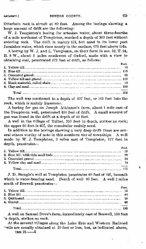
LEVERETl'.] BENTON COUNTY.
Otterbein rock is struck at 80 feet. Among the borings showing a large amount of drift are the following:
W. J. Templeton's boring for artesian water, about three-fourths of a mile northeast of Templeton, reached a depth of 300 feet without entering rock. The drift is mainly till, but sand in its lower part furnishes water, which rises nearly to the surface, 675 feet above tide.
A boring by W. J. and L. Templeton, on their farm in sec. 32, T. 24, R. 8 W., about 5 miles southwest of Oxford, made With a view to obtaining coal, penetrated 372 feet of drift, as follows:
1
Feet. 1. Yellow till ___ . _________ . _____________________________ . ____ . ____ . _ _ _ _ _ _ _ _ _ 12 2. Blue till ______ . ___________________________________________________ . _ _ _ _ _ _ 115 3. Cemented graveL _________ . ______________ . _ . ___ . _____ . _. ___________ .. ___ ,.. 25 4. Yellow till and gravel. ___________ • ____________ . _________ . ____ . ________ . _ _ 110 5. lllack material, called shale ______________________________________ .. _ _ _ _ _ _ 10 6. Clay and sand ___ . __ . __________________ . _____ .. ____________________________ 100
Total ______ .. ____________ . _____ .. ______________________________ . ___ . ___ . 372
The well was continued to a depth of 537 feet, or 165 feet into the rock, which is mainly limestone.
A boring for gas on Joseph Atkinson's farm, about 1 mile east of the Templeton well, penetrated 410 feet of drift. A small amount ·of gas was found in the drift at a depth of 40 feet.
A well in the village of Talbot, 310 feet in depth, strikes no rock; the upper 60 feet is til!, the remainder mainly sand.
In addition to the borings showing a very deep drift there are several others worthy of note in this southern tier of townships. A well made by W. J. Templeton, 2 miles east of Templeton, 177 feet in depth, penetrates-
Feet. 1. Yellow till ____ . _________________________ . __ . _ . ________ . __ . _ _ _ _ _ _ _ _ _ _ _ _ _ _ _ 12
2. Blue till, with thin sand beds ____ ---------------------------------------- 75 · 3. Cemented gravel. ____________________________ . ____ •. ___ . _ _ _ _ _ _ _ _ _ _ _ _ _ _ _ _ _ 20 4. Yellow clay and sand ___ • ___ . ____ . _ _ _ _ __________ • ___ • _ _ _ _ _ _ _ _ _ _ _ _ _ _ _ _ _ _ _ 70
Total.--------------------------·---------------------·--·------------ 177
J. D. Stengle's well at Templeton penetrates 60 feet of till, beneath which is water-bearing sand. Denth of well 80 feet. A well 2 miles south of Boswell penetrates-
Feet. 1. Yell ow till_ . _ . . . _ . ________________ . __________ . __ . _ . ____ .. _ . ______ . __ . _ _ _ _ 13 2. Blue till . __ .. ___ . ________ . ___ . _ . __________ . __ . ___ . _____ . __ . _____ . _ _ _ _ _ _ _ _ 34 3. Quicksand_ -· _ _ _ _ _ _ _ _ _ _ _ _ _ _ _ _ _ _ _ _ _ _ _ ___ . _______________ • __ . _ .• _. _ _ _ _ _ _ _ _ _ 20 4. Gravel. ___ . ___ . ___ . __ . _______________ . _ . _ ... _ .. _ . _ . __ • _ •.. _ . ______ . __ .• _ _ 66
Total.-------------------------·-------------------------·------------ 183 A well on Samuel Dove's farm, immediately east of Boswell, 185 fee~
·~n depth, strikes no rock. At the several villages along the Lake Erie and Western Railroad
'"'Tells are usually obtained at 20 feet or less, but, as indicated above, IRR21-5

66 WELLS OF NORTHERN INDIANA. [NO. 21.
occasional wells are much deeper. Many wells in Templeton obtain water at 20 or 30 feet. They enter blue till at about 6 or 8 feet. At Oxford wells are usually but 14 to 20 feet in depth, though occasionally 80 or 90 feet. In the east part of the village a fl.owing'well has been obtained at a depth of 55 feet. It has a head about 5 feet above the surface. The water is strongly chalybeate. At Ambia, records of two wells were obtained which slightly exceed 100 feet in depth. They are mainly through blue till.
WARREN COUNTY.
General statement.-Warren County is situated on the west bor~er of t1te State, immediately north of the Wabash River, with Williamsport as its county seat. It has an area of 360 square miles.
Like Benton County, which borders it on the north, this county is traversed by several conspicuous ridges of drift. Along its northern border is the southernmost of the ridges described in the account of Benton County. It has a breadth of 2 or 3 miles and a relief above the plain on the south of 40 to 50 feet or more. A few miles southeast of this ridge is a larger one, which enters the State near State Line village, passes northeastward nearly to Williamsport, and there turns north along the west side of Pine Creek. This ridge is 3 to 6 miles in width and has a relief of 30 to 60 feet or more above bordering plains on the north and south. East from Pine Creek are two ridges trending from northwest to southeast, extending from the valley of the creek to the valley of the Wabash, a distance of 8 or 10 miles. They are each a mile or more in width, and stand 30 or 40 feet above the bordering plains. The narrow plain between them is scarcely 1 mile in average width. The extreme northeastern part of the county is a plain. It is estimated that fully one-half the area of the county is occupied by the drift ridges. .
The surface portion of the drift throughout the county is usually a compact till, though the portion east from Pine Creek becomes gravelly in limited areas. Along the Wabash there are conspicuous gravel terraces below Williamsport. Above that city the valley is too narrow for extensive development of terraces. The narrowness is due to the resistant I'ock strata in which the stream has cut its passage. It is, however, seldom less than one-half mile in width.
For some distance north from the Wabash, unless it be at the extreme eastern border of the county, rock is encountered at comparatively slight depth, seldom more than 100 feet; but along the northern border of the county it is probable that the drift, like that of the adjoining portion of Benton County, is 300 to 400 feet or more in thickness.
Individual wells.-But few well records have been obtained in this county, owing partly to the fact that wells are generally obtained at comparatively slight depth.
At Williamsport, the county seat, wells vary greatly in depth, there
!LEVERETT.] TIPPECANOE COUNTY. 167 I
being a range from 14 feet up to about 100 feet. In a portion of ~h.e -city rock is struck at 10 to 15 feet, but there are places where the -drift attains a thickness of 85 feet. A boring for gas at this city 1,540 feet in depth found fresh water at a depth of 65 feet in great quantity; also at about 165 feet. From the latter depth water rises within 32 feet of the surface. Salt water was struck at about 1,200 feet. Gas not being obtained, the salt water was shut off, and the fresh water is thus available for water supply. The well is estimated to yield 20 gallons per minute.
On the Wabash terrace below Williamsport, which stands about 100 to 110 feet above the river, several wells have been sunk to the level of low water in the river. They are through gravel or sand their entire depth. Thcl water rises and falls with the rise and fall ()f the river.
A boring for coal at West Lebanon penetrated a soil containing wood and leaves beneath the blue till at a depth of 140 feet. Rock was entered a short distance beneath this soil. About a mile south-east from West Lebanon, on ground nearly 100 feet higher, rock is .struck at a depth of only 60 feet.
TIPPECANOE COUNTY. ~
General statement.-Tippecanoe County is situated somewhat north {)f the middle of the western part of the State, with Lafayette, the .county seat, near its geographic center. It has an area of 500 square miles. The greater part of the surface is plain or but gently undulating. There are, however, in the southern half a number of sharp .gravelly knolls and ridges, which in places constitute a nearly continuous belt. The most conspicuous one, known as High Gap Ridge, leads from Culver Station we\iward past Taylor and West Point to the vicinity of the Fountain County line. It is, however, less than a mile in width, and the height of the ridges and knolls seldom exceeds .50 'feet. The most conspicuous topographic feature of the county is the troughlike valley traversed by the Wabash River. The valley proper has a depth of more than 100 feet. From its borders there is .a gradual rise both to the northwest and southeast-to an altitude in the northwest more than 200 feet above the river, and in the south-east to fully 300 feet.
With the exception of the sharp gravelly knolls referred to above, t:pe surface portion of the drift is composed largely of compact til,. The wells of the county usually find water at convenient depths, sel-dom penetrating so much as 80 feet. The lower portion of the tlriftl, so far as tested by deep borings and by exposures along the Wabas~ and its tributaries, is largely sand and grav;el.
The thickness of the drift varies greatly, partly because of difference in surface elevation, but more largely because of inequalities of the underlying rock surface. In the western part of the county, in
68 WELLS OF NORTHERN INDIANA. [NO. 21~
the vicinity of the Wabash River, rock ledges rise to a height of 50 to 100 feet or more above the stream, and are well exposed on Flint Creek and Indian Creek. In the northeast.ern part of the county, also, there are rock exposures on the borders of the Wabash and the lower cou~se of Sugar Creek. Between these exposures, occupying the central portion of the county, there is a deeply filled basin, with drift 300 feet or more in thickness. This appears to be part of a great valley or trough which leads westward across southern Benton County.
To sustain the view that a deeply :filled valley extends westward across northern Tippecanoe County, two well sections in the northwestern part of the county are cited. One, in sec~ 26, T. 24, R. 6 W.,. reaches a depth of 176 feet without encountering rock; another, in sec. 18, T. 24, R. 5 W., strikes no rock at a depth of 126 feet. Toward the south, near the Wabash River, the rock appears in valleys of streams at a higher level than the botton of these wells. Passing northward into White County the rock appears at higher level than at these wells. It seems probable that the deepest portion of the valley passes near Dayton and Lafayette and thence north of west across the northwest part of the county, beyond which it finds its continuation westward through southern Benton County.
Along the valley of tne Wabash there are gravel terraces reaching· a height of nearly 100 feet above the stream. The most conspicuous are located below Lafayette, where they receive the name Yv ea Plain. They are also conspicuous in the vicinity of Battle Ground village,. above Lafayette.
Indiv·idual wells.-Wells on the terraces of the Wabash near Battle Ground usually obtain no water within 50 feet of the surface, and in some instances are put down to a depth of 60or80 feet. Mr. J. M. Hicks's well, in the village of Battle ~ound, is 79 feet, entirely through gravel, sand, or other alluvial deposits. Mr. J. P. Clute's well, in the same village, is 60 feet, s~riking blue till near the bottom. Wells ~ast from Battle Ground, near the mouth of Moots Creek, are not infrequently 75 feet in depth, and are largely through sand and gravel.
On the uplands west from Battle Ground wells usually are obtained at about 20 or 30 fQet, but are occasionally deeper. The following sections of wells in that region have been published by Mr. Gorby: 1
John Livingston's well, 2 miles west of Battle Ground, penetrates-Feet.
1. Soil and yellow clay_ . _____________ . _ . _____ . ____ .. ____ . _____ • ______________ ·3() 2. Dry sand ____ .. ___________ .. _______________ . ____ . _ _ _ _ _ _ _ _ _ _ _ _ _ _ _ _ _ _ _ _ _ _ _ _ _ _ 2() 3. B:fiue clay _ .. _ .. ______ • _____ . _____ .. ____________________ . _ _ _ _ _ _ _ _ _ _ _ _ _ _ _ _ _ _ _ 3() 4. Cemented gravel. ___ • _____________ . ___ ._. _. _ _ _ _ _ _ _ _ _ _ _ _ _ _ _ _ _ _ _ _ _ _ _ _ _ _ _ _ _ _ _ _ 2 5. Loose gravel _ . _________ . _. ___ ·- ____ . ______ . _ . _ _ _ _ _ _ _ _________ . ______ . __ . _ . 13
Total _______________________ ·-------------------- ------------------·· 95
t Fifteenth Ann. Rept. Indiana Geol. Survey, pp .. 87-95.

UVERETT.] TIPPECANOE COUNTY. 69
James Bryant's well, 3 miles west of Battle Ground, penetrates-Feet.
1. Soil and yellow clay ____________ • ______ . __________________ . _____ .-_-------- 4 '2. Blue clay ________________________ . _____ . _________________ . ______ -- __ ------ 50 ;B. Dry ·Sand ____ . _________ . ____ . _________ . ____ .• ____ • ___ . __ • ___ • ___ • _ •. _____ - 20 4. Coarse gravel. ___________ . ________ . _. _____________________ .. ___ .--. _-.- •• - 2
Total. ______________ . _ _ ___________ . ________ ,_ ___ · __________ • _ . ___ • _ .... __ - 76 ·
East of the Wabash, in the northern portion of the county, in the vicinity of Buck Creek village, wells are reported by Mr. Gorby to be o0ecasionally 50 to 65 feet in depth. At John Stanfield's a well 65 feet penetrates sand nearly 50 feet before obtaining a coarse water stratum. At Moses Cole's, about 2 miles west of Buck Creek Station, a well :penetrates 55 feet of gravel and sand, entering a blue till near the bottom. In Buck, Creek village, W. W. C. Brown's well, 50 feet in depth, penetrates till 20 feet, beneath which is a fine yellow sand.
In eastern Tippecanoe County wells are usually obtained at 20 to 40 feet. Mr. Gorby reports an unusually large amount of yellow till ii.n that region, it being frequently 23 to 30 feet in depth.
The gas-well boring at Dayton, in the eastern part of the county, penetrates about 300 feet of drift, of which a large part is thought to be sand.
At Lafayette an artesian well, in the valley of the Wabash, about 55 feet above low-water mark, or 560 feet above tide, penetrates 170 feet of drift and obtains a flow of water from the Lockport limestone at 230 feet. The section of this well published by Mr. Gorby shows variable beds of sand, gravel, and clay to a depth of 30 feet, where a dark-gray clay is entered which extends to the depth of 102 feet. Beneath this there is a series of sand, gravel, and clay beds about 30 feet, below which is a very bowldery bed, 40- feet in thickness, extending to the rock. An analysis of the water from this well appears -elsewhere. 1.
The city water supply of Lafayette is obtained from a gravel bed under the Wabash River, about 40 feet below the bed of the stream. The water is found in such abundance at this horizon that the springs which arise from it furnish a considerable portion of the water flowing in the Wabash in dry seasons.
Private wells in Lafayette range in depth from 10feet up to _60 feet, but are most numerous at 40 to 60 feet. As the city is located on a hillside, with variations of nearly 200 feet in elevation, the wells are obtained from several different horizons. Exposures of the drift are quite extensive in the southern part of the city. They uniformly show a large amount of sand and ~ravel beneath a comparatively thin sheet of till.
On the gravel terrace in west afayette, near Purdue Univemity, which stands about 100 feet abo e the river, wells are often sunk to the level of the river bed through the sand and gravel of the terrace.
1 Eighteenth Ann. Rept. U. S. Geol. Survey, Part IV, p. 498.
•
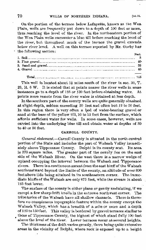
70 WELLS OF NORTHERN INDIANA. (No.21..
On the portion of the terrace below Lafayette, known as the W ea. Plain, wells are frequently put down to a depth of 100 feet or more, thus reaching the level of the river. In the northeastern portion of the y.,r ea Plain wells encounter a blue till before reaching the level of the river, but throughout much of the terrace the gravel extends. below river level. A well on this terrace reported by Mr. Gorby has
· the following section: Feet.
1. Soil. _____ .. ______ .. __________________ . _ _ _ _ _ _ _ _ _ _ _ _ _ _ _ _ _ _ _ _ _ _ _ _ _ _ _ _ _ _ _ _ _ _ _ 3 2. Fine gravel _____ . _____ . __ . _________ . __________________ . _. __ . __ . _. ____ . _. _ 40-3. Sand and graveL _ .. _____ . _ . _ . _______ . 0 ___ 0 ____ 0. _ • _. 0 __ ••••• _. __ • 0 ••• _ _ _ 32 4. Gravel ___ .. _ . _ .. _____ . _________ . _ . _______ 0 _ 0 • ________ 0 • __ •••••• _ • _______ • 40
Total _________________________ --------------------------------------- 115
This well is located about 1t miles south of the rive1~ in sec. 30, T~ 23, R. 6 W. It is stated that at points nearer the river wells in some instances go to a depth of 125 or 130 feet before obtaining water. At points more remote from the river water is obtained at less depth.
In the southern part of the county wells are quite generally obtained at slight depth, seldom exceeding 30 feet and often but 12 to 20 feet. In this region there is very often a l:1ed of water-bearing gravel or sand at the base of the yellow till, 10 to 15 feet from the surface, which affords sufficient water for wells. In some cases, however, wells are carried into the underlying blue til~ and obtain water at depths of 30 to 40 or 50 feet.
CARROLL COUNTY.
General statement.-Carroll County is situated in the north-central portion of the State and includes the part of Wabash Valley immediately above Tippecanoe County. Delphi is its county seat. Its area is 370 square miles. The. greater part of the county lies on the east side of the Wa.bash River. On the west there is a narrow wedge of upland occupying the interval between the Wabash and Tippecanoe rivers. There is a continuous ascent from the east bluff of theW abash southeastward beyond the limits of the county, an altitude of over 800 feet above tide being attained in its southeastern corner. The immediate bluffs of the Wabash are only 675 feet, while the stream is about 125 feet lower.
The surface of the county is either plane or gently undulating, if we except a few sharp drift knolls in the extreme northwest corner. The tributaries of the Wabash have all shallow channels. There is therefore no conspicuous topographic feature within the county except the Wabash Valley, which has a breadth of a mile or more and a depth of 125 to 150 feet. This valley is bordm·ed by gravel terraces similar to
• those of Tippecanoe County, the highest of which stand fully 100 feet above the level of the river. Lower terraces occur at several heights.
The thickness of the drift varies greatly, there being quite. extensive areas in the vicinity of Delphi, where rock is exposed up to a height
LEVERETT.] CLINTON COUNTY. 71
of nearly 50 feet above the river. At Monticello, near the northwest corner of the co-.lnty, the rock floor is found at a level about 100 feet lower than the Wabash. Borings in neighboring portions of Howard and Clinton counties on the southeast show drift 200 to 250 feet or more in thickness, the rock floor being lower than at the outcrops along the Wabash River.
The drift of this county, so far as penetrated in wells, is generally a compact till. Exposures along the streams also are usually mainly till. The wells being shallow over the greater part of the county, the structure of the deeper portion of the drift is not known.
There are very strong springs in the vicinity of Delphi, from which the city water supply is obtained. Their location is about 3 miles northeast of the city, qn the farm of George Snyder. The supply is piped to the city and distributed from the standpipe and also by direct pressure. 1
Individual wells.-Wells are usually obtain~d at such shallow depths that records of but few of them were obtained. One of the deepest was found at Rockfield, in the northern part of the county, where till to a depth of 57 feet was penetrated and no rock encountered. The dug wells at Rockfield are only 15 to 25 feet in depth. Tubular wells are 50 feet or more.
Along the Wabash terraces, both above and below Delphi, wells are occasionally carried to a depth of 40 feet in gravel and sand; but in the vicinity of Delphi, where rock underlies the terrace at slight depth, they are sometimes found at the base of the gravel 10 to 20 feet. On the narrow strip of upland west of the Wabash records of two wells were obtained,· each about 50 feet in depth, one of which was largely through till and the other largely through sand and gravel, though only 40 rods apart.
At Flora a gas-well boring penetrates 136 feet of drift thought to be largely till. There are several flowing wells at this village obtaining water at depths of 12 to 47 feet, the distance to the water-bearing stratum differing in the several wells. The wells are located on low ground along Bachelor's Run, and their head is only about 5 feet above the surface.
CLINTON COUNTY.
General statement.-Clinton County is situated in the north-central portion of the State, south of Carroll and east of Tippecanoe County, with Frankfort as its county seat. It has an area of 400 square miles. This county is an elevated plain, in which the slope i~ westward and northward from the southeast part. Its highest points are probably 950 feet above tide, while its lowest are about 700 feet. To the traveler, however, the county has the appearance of a nearly level plain, the rate of descent being gradual.
1 Seventeenth Ann. Rept. Indiana Geol. Survey, p.l72.

72 WELLS OF NORTHERN INDIANA. [Ko.21.
The greater elevation of the southeastern portion of the county has been shown by numerous gas-well borings to be due, not to the height of rock surface, but to accumulations of drift, there being about 300 feet of drift in that part of the county.
The surface portion of the drift of this county is a compact till, but gas-well borings show that the deeper portion is largely sand and gravel.
'Individual wells.-At Frankfort, the county seat, dug wells are usually obtained at 18 to 25 feet. Tubular wells find a large supply of water at 55 to 65 feet. The wells range 'in depth from 10 up to 90 feet. In the shallow wells sufficient clay is usually penetrated to insure freedom from surface contamination, though in some cases the water rises so near the surface as to be easlly contaminated.
The city water supply of Frankfort is obtained from wells sunk to a depth of about 30 feet below a reservoir which is itself 28 feet in depth. The water fills this reservoir within 3 feet of the surface. Six wells, 8 inches in diameter, are estimated to furnish about 6,000,000 gallons a day. A gas-well boring in the northeast part of Frankfort has the following section:
Feet.
1. Till_--··------··------------------- __ -------------------------------- 30 2. Quicksand. _ _ _ _ _ _ _ _ _ _ _ _. _____________ . _____ • _. ____ . ____ . __________ . _ 10 or 15 3. Hard clay and gravel, with flow of water near bottom. _______________ 25 or 30 4. Gravel and sand, with thin clay beds __ ---- __ ·--- ___________ ..... _ ---- 197 5. Blue pebbly clay-------------------------------------·----------____ 13
Total ______________ . __ . _ ... _____ . ______________ • _. __ . _ _ _ _ _ _ _ _ _ _ _ _ _ 278
A well in the western part of the city did not reach rock at 297 feet. For several miles south and east from Frankfort water is obtained at 15 to 30 feet, being mainly through till, with water-bearing gravel at bottom. North arid west from the city the wells are often of greater depth.
At Scircleville a gas-well boring penetrated 296 feet of drift, of which the upper 150 feet is largely .till, but the , remainder is mainly sand and gravel. Near the east line of the county, about 3 miles east of Scircleville, a gas-well boring enters r!>ck at 260 feet. The drift there is mainly a blue till.
At Kirklin, in the southeast part of the county, a gas-well boring has 252 feet of drift, of which the upper 40 feet is till, but the remainder has alternations of sand and gravel in thin beds, with somewhat thicker sheets of till. The wells in the vicinity of Kirklin obtain a strong supply of water at 40 feet. West from Kirklin wells ar~ often obtained at 16 or 18 feet. Tubular wells are, however, 60 or 70 feet, mainly through till.
At Colfax the deepest wells are 60 or 70 feet, mainly through blue till. Shallower wells are, however, common in that region.
At Mulberry, in the western part of the county, at an elevation 754 feet above tide, a water well at the railway station, 220 feet in depth,

I..EVBRETT.] HOWARD COUNTY. 73
~id not reach rock. It is mainly through till. Another well at a .sawmill in the same village is 150 feet in depth, mainly blue till.
Near Gittingsville, in the northern part of the county, several flowing wells have been obtained at about 20 feet. They are along a valley in sec. 19, T. 23, R. 1 E. In section 30 of the same township a well at R. 0. Young's, 71 feet in depth, penetrates till, with thin beds ()f gravel and sand.
In the vicinity of Sedalia, in the extreme northern portion of the eounty, wells are occasionally sunk to a depth of 80 feet through till, but are usually shallower. A well at J. H. Brown's, in sec. 24, T. 23,
0
R. 1 W.,-126 feet in depth, penetrates-Feet.
1. Till __ • _______________________________ . __ . ____ . 00. __ • __ • ___ • 0 _____ • _ •• Oo. _-. _ 68 '2. Sand, with vegetal deposits and inflammable gas . ___ . ___ . ___ • _ _ _ _ _ _ _ _ _ _ _ _ _ 16
3. Sand __ ------------------------------------------------------------------ 42 4. Gravel, with water at bottom.
Total. ____ 0 __ ~o ________ • ___ 0 _ • _ • __ • __ • _ ••• ______________ •• _____ • ____ • _ • 126
In the Fifteenth Report of the Indiana Survey attention is called to the occurrence of many bowlders in the blue till in Stony Prairie, 5 .or 6 miles southwest from Frankfort, from the surface down to a depth of 50 feet. The western half of the county is liberally strewn with bowlders, but they seldom 'extend to such depth as to be troublesome in excavating wells.
HOWARD COUNTY.
General statement.-Howard County is situated in the north-central portion of the State, immediately south of Cass and Miami counties, with Kokomo as its county seat. Its area is 300 square miles. The -entire surface of the county is plain or gently undulating, there being few, if any, knolls and ridges rising more than 20 feet above the general level. With the exception of a narrow belt along Wild Cat Creek, west from Kokomo, which is less than 800 feet above tide, and possibly a narrow strip on the north border, the county stands between the 800 and 900 feet contour.
The greater portion of the county has a moderate coating of drift, 75 feet or less. But the southwestern part has a larger amount, there being at Russiaville and neighboring points about 150 feet. Where the drift is.of moderate depth it is composed mainly of till, but the deeper portions include much sand and gravel in their lower part. Wells not infrequently find abundance of water at 10 or 20 feet, in beds of gravel between the yellow and blue till, and they rarely penetrate to a greater depth than 40 feet.
Individual wells.-At Kokomo wells are usually obtained at 35 or 40 feet, either in gravel near the base of the drift or in the upper part .of the underlying limestone. A few deep wells 100 to 150 feet have been sunk. The city waterworks are supplied from wells 100 feet .in depth.

74 WELLS OF NORTHERN INDIANA. (NO. 21.
Several gas borings have been made in the vicinity of Kokomo. In some cases the wells have encountered 90 feet of drift, but there is usually a much smaller amount. Some of those in Wild Cat Creek bottom and on the plain south of the creek enter rock at 10 to 20 feet. or less. As a rule, these wells are productive of gas. Those to the west of the city in some cases yield no gas, but, instead, a flow of water. In the Indianapolis Sentinel for July 18, 1895, it is stated that one of these wells had been turned to good account by a farmer for irrigation during a season of excessive drought. Where the watercontains only a moderate amount of saline matter such wells might be made to return some small share at least of the expense incurred in drilling for the gas.
At the village of Greentown, B miles east of Kokomo, wells are usually obtained at 20 to 25 feet in gravel below till. A lower vein of water is obtained at 35 to 45 feet. Gas-well borings at this point show the drift to be about 85 feet in tliickness.
At Fairfield, 6 miles southeast of Kokomo, wells are usually obtained at 20 or 30 feet, there being about 20 feet of surface till. The drift in the vicinity of Fairfield is shown by gas borings to range from 25 feet up to fully 75 feet in <lepth. The well near the railway station itas 47 feet of drift, of which the upper 18 or 20 feet is till and the remainder gravel. A well 4 miles west of Fairfield was found to have 165 feet of drift.
A strong flow of fresh water was obtained from the limestone in a well half a mile north of Fairfield at a depth of 110 feet. It is estimated to discharge 5,000 barrels per day. The head is only 6 feet. above the surface of the ground, and the well mouth at this point is 25 feet lower than at Fairfield railway station.
At Tampico, about 3 miles northeast of Fairfield, wells are usually obtained at 30 feet. The drift at that point is shown by a gas boring to be 103 feet in depth, of which the upper 25 feet is till; the remainder consists of alternations of sand and till. A well 3 miles northeast. of Tampico, bored for gas, has 115 feet of drift. It is reported to have passed through a bed of soil containing leaves at a depth of 103 to 105 feet.
A gas well at Sylvanus Barrett's, in the southeast township of the county, has 98 feet of drift, of which only the upper 10 feet is till,. the remainder being gravel, a part of which is cemented. ·
At Russiaville, in the southwest township of the county, the gaswell boring penetrates 153 feet of drift, as follows:
Feet. 1. Yellow till .. _____ . __________ . __________________ ...•• ___ • _. __ • __ • _. • 10 to 12.
2. Sand with water ________________ ----~- ____ ·----·-------------------- 3 to 4 3. Blue till. _________________ . ____ .. ____ . _ ... _ ... _ .. ____ . _. _____ • _ _ _ _ __ 4(}
4. Sand and gravel, withthi~ beds of tilL.------------·--------------- 95to100
~otal ___________________ ----------------------------------------·---- 153
Water wells in that vicinity are obtained at shallow depths in the sand between till sheets.

LEVBBETT.] DETAILED DISCUSSION OF WELLS. 75
TIPTON COUNTY.
General statement.-Tipton County is situated in north-central Indiana, immediately south of Howard County, with Tipton as· its county seat. Its area is 260 square miles. The surface of this county,. like that of Howard, is gently undulating, and there is a thicker deposit of drift in its western than in its eastern portion. rrhe western portion is also correspondingly higher. In the southwestern part of the county the altitude exceeds 900 feet, while in the northeastern it is little more than 800 feet. The drift in the southwestern part is 250 to 300 feet in depth, while in the northeastern it is 75 to 10(} feet. The surface portion of the drift is generally a compact till, but the deeper portion contains large amounts of sand and gravel.
Individual wells.-At Sharpsville, on the north border of thecounty, the gas-well borings pass through about 70 feet of drift, mainly till. Water wells are obtained at 20 or 25 feet or less, in thin beds of sand or gravel associated with the till.
At the village of Windfall, in the northeast part of the county, the drift at a gas boring is 72 feet. There are, however, thin beds of sand and gravel aRsociated with the till, which afford water for the wells.
On the east border of the county, in the vicinity of Elwood, the drift ranges from 40 feet up to more than 100 feet in the several gas wells which have been sunk. It is mainly a blue till, but with the till there are beds of sand and gravel furnishing water at moderat.e depths.
In the vicinity of Hobbs Station, and southeastward to the southeast corner of the county, gas wells usually enter rock at about 70 or 80 feet, and the greater portion of the drift is till.
At Tipton, near the center of the county, the gas wells show 140 to-200 feet of drift, the greatest depth being found on the bank of Cicer() Creek, in the east part of the city. The dug wells are often obtained at shallow depths, 12 to 20 feet, and it is thought they are liable t<r surface contamination, as the drift is of a porous, gravelly constitution. Better wells are found at 50 to 100 feet, after penetrating a sheet of till. ·Fresh water may be obtained from the limestone, also· at several horizons clown to about 400 feet, below which depth it is liable to become brackish. The city water supply is derived from near the top of the limestone.
At Kempton, in the western part of the county, water is usually obtained at about 35 feet, in the gravel between sheets of till. Several gas wells have been sunk in the vicinity of Kempton, which show the drift to be 240 to 300 feet in thickness. One of these borings, in the east part of the village, penetrates the following drift series:
Feet. 1. Yellow till _________________________ ·-----·----·------ ____ ·--------------- 10 2. Sand and till, each in beds a few feet thick----- ____________ -----_-------- 165 3. Gravel ________________ . _ .. ___________________________ . ____ .. ___ .. ___ -- -.- - 65 4. Sand ___ .. _ . _____ • _ . ___________ . _ . __________________________ . _______ - _ _ _ _ 17
Total _____ ·-----------------------------------------------·----------- 25T

76 WELLS OF NORTHERN INDIANA. [No.2L
Another well in the village with 305 feet of drift penetrates-Feet.
1. T.ill, with thin sand beds_ . ____ .. ____________ . ____ . ______ . __ . _ .. ______ .. __ - 200 2. Sand and gravel ______________________ . _____________________ . ____ . __ -- _- _ 80 ·3. Hard brown till. ___ • ___ •• ___ . ______ . _____ . _ . ___________ - _- ______ .•• _ •• __ • 25
Total ___________________ ---------------------------------------------- 305
A. gas well half a mile east of Kempton has 243 feet of drift, con.sisting mainly of till, but having thin beds of sand and gravel.
At the village of Atlanta a gas-well boring penetrates about 300 feet of drift. Several gas-well borings in the southwest part of the county also penetrate drift 250 to 300 feet.
The following drift section appears in a gas boring near the center -of the county, 3 miles east of Tipton: ,
Feet. 1. Till, yellow and blue _________________________ ----------------~----------- 38
2~ Clravel --------------------·--------------------------------------------- 5 ~. Bluetill _________________________________________________________________ 45 4. Gravel .... _. _____________ .• _. __ . _______ J _________________ • _______ • ___ • _ _ _ _ 15
Total _________ ---------------------·-----------------------~-------.--- 103
A. gas well in sec. 10, T. 21, R. 5 E., penetrates 130 feet of drift, .as follows:
Feet. 1. llellowtill _______________________________________________________________ 10
2. <iravel -----·-------------------------------------------------·---------- 20 3. Blue till _____ . _______________________ .• ______________ . _ . ____________ . _ _ _ _ 80 ·4, Gravel __ . _____ .. _______ . _. ______________ . ___________ . _____ ... __ . _ _ _ _ _ _ _ _ 20
Total---------------------··-----------------------------------·-----· 130
GRANT COUNTY.
Generalstatement.-Grant County is situated in the north-central part of the State, with Marion as its county seat, and has an area of 420 square miles. It is traversed nearly centrally from southeast to northwest by the Mississinewa River. Along the east border of this ;Stream is the Mississinewa moraine, having a breadth of about 5 miles. Aside from this moraine the surface of the county is a gently undulating plain. The moraine itself has gentle swells and sags and is not strikingly in contrast with the plains. Its relief, however, being 50 feet or more, makes it a noticeable feature.
On the portion of the county west from the Mississinewa River the drift is usually thin, it being often but 20 feet or even less in depth. This district, however, appears to be traversed by deeply filled valleys in which the drift has a thickness of 150 to 160 feet or more. In the northeastern part of the county the drift deposits seldom fall below 100 feet, and probably average nearly 150 feet. Throughout the county the surface portion of the drift is generally a compact till. In places where the drift is thick the deeper portions are often made up largely of sand and gravel.

LEVERETT.] BLACKFORD COUNTY.
Individual wells.-At the city of Marion the waterworks are supplied from two classes of wells-first, drift wells 70 feet in depth; second, wells in limestone 240 feet in depth. From both classes of wells the water rises nearly to the surface. A wellS inches in diameter is estimated to yield nearly 4,000 barrels per day. The drift at Marion ranges from about 30 feet in the north part of the city to 15(} feet or more in the south part. The upper portion generally is till toa depth of 30 to 45 feet, the remainder largely sand and gravel.
At Jonesboro, about 6 miles above Marion, on the Mississinewa River, wells are obtained in gravel below till at depths of 10 to 45 feet. The gas-well boring in the village shows the drift to be 162 feet.
At Upland, in the eastern part of the county, wells are usually obtained at about 30 feet, in a bed of gravel between sheets of till. A few wells are sunk into the underlying rock and obtain water at about 150 feet. The waterworks supply is from these rock wells.
At Van Buren the gas well penetrates 92 feet of drift, largely till. Wells in the vicinity of that village are obtained at 20 or 30 feet.
A gas boring in the northwestern part of the county penetrates 182· feet of drift, which is reported to be mainly sand and gravel.
In the southwestern portion of the county, although the drift is thin, wells are usually obtained without entering the rock, there being generally a water-bearing gravel at the base of the drift. Gas-well borings in this part of the county show the drift to have the following thicknesses at the principal villages: At Switzer, 28 feet.; at Swayzee, 22 feet; at Simms, 45 feet; at Point Isabel, 22 feet; at Fairmount, 5· to 35 feet, the thickness varying in different wells. At Fairmount water wells are often drilled into the rock to a depth of about 30 feet. The waterworks supply is from such wells. ·
BLACKFORD COUNTY.
General statement.-Blackford County is situated somewhat north of the middle of the eastern portion of the State, and is one of the smallest counties, having an area of 170 square miles. Its county seat is Hartford City. The Mississinewa moraine traverses the southern townships of the county from west to east, and occupies about 76 square miles. The remainder of the county is a plain. With the exception of a narrow belt in the northeastern part, along the Salamonie River, the drift of this county is about like that of northeastern Grant County-100 to 150 feet or more in thickness. In the northeast corner the thickness is but 20 or 30 feet, or even less. The drift is composed mainly of a compact till, though beds of sand and gravel are sufficiently numerous to supply water. for most of the wells at mod-erate depths. ·
Individual wells.-At Montpelier, in the northeasterp. part of thecounty, wells are in sop:te cases drilled into the limestone, though usually obtaining wate~ at the base of the drift at depths of 15 to 30 feet. · I
78 WELLS OF NORTHERN INDIANA. [N0.21.
At Mill Grove, in the eastern part of the county, a gas-well boring penetrates 143 feet of drift, mainly till. Water wells are usually obtained at moderate depths, seldom more than 40 feet. In a few instances, however, they reach a depth of fully 100 feet in that part of the county.
At Hartford City the several gas borings show the drift t.o range in depth from 80 feet up to 150 feet or more. It is composed of till, interrupted by occasional thin beds of sand. The waterworks supply is from wells drilled into the underlying limestone to a depth of about 250 feet. A well at one of the hotels in Hartford City enters rock at 112 feet. The upper 80 feet is a nearly solid bed of till, below which is 32 feet of sand and gravel. A well 1 mile northwest of •·Hartford City, in section 10, has 177 feet of drift, of which the upper 100 feet is till and the remainder largely sand. One well in the southeast part of Hartford City enters rock at about 80 feet after penetrating 60 feet of till and about 20 feet of sand.
JAY COUNTY.
General statement.-J ay County is situated on the eastern border of the State, somewhat north of the middle, with the county seat at Portland. Its area is 396 square miles. This county is traversed from west to east by two moraip.ic belts, the Mississinewa and the Salamonie. The Mississinewa moraine is oonfined mainly to the southern tier of townships and has a breadth of about 5 miles. The Salamonie moraine is situated mainly in the northern tier of townships, but enters the northern portion of the middle tier near the State line. Its breadth is 3 to 5 miles. The remainder of the county has a nearly plane surface, sloping gently toward the north. With the exception of a few sharp knolls on the Salamonie moraine near Camden (Pennville post-office), in the northwest part of the county, the moraines have gentle swells and sags, which give them but little contrast with the gently undulating plains. They present, however, a nearly continuous ridge with relief of 30 to 50 feet or more above the bordering plains. The altitude of the southern portion of the county exceeds 1,000 feet. The northern border of the county falls below 900 feet.
The drift is composed mainly of a sheet of compact till, and its thickness probably averages about 100 feet. The rock is rarely struck at less than 50 feet, and at Geneva, near the north border of the county, a gas-well boring shows 350 feet of drift.
Individual wells.-Along the north border of the county, near the State line, rock is found at 10 to 20 fe~t, and wells are often sunk into it to slight depths. The thin drift, however, occupies but a few square miles. At Bryant, near the middle of the north line of the county, the drift was found to be 112 feet in thickness.
About 6 miles west of Bryant, in sees. 19 and 30, T. 24, .R. 13 E., wells are difficult to obtain, the moraine at that point being composed

LEVERETT.] .JAY COUNTY. 79
-of till to a depth of 125 feet or more. One well has a depth of 125 feet, another 140 feet, and another 155 feet, none of which enter rock. About a mile west of these wells rock is struck at 130 feet in a well in .section 13, Penn Township.
At Pennville, in southern Penn Township, on the Salamonie River, rock is struck at about 40 feet in several gas borings.
At Portland, the county seat, wells are often obtained at 14 to 30 feet in gravel, but more frequently they are drilled into limestone, which is entered at 30 to 60 feet in the vicinity of this town. A few wells have a depth of 150 feet. The waterworks supply is from wells drilled into the limestone. It is thought that the shallow wells are protected from contamination by a bed of clay which overlies the water-bearing gravel.
Immediately east of Portland wells are obtained in sand between yellow and blue tills at 12 to 20 feet; the blue till is struck at 15 to .30 feet, and extends to the underlying 1·ock at 45 to 50 feet.
A well in section 18, Noble Township, 5 miles east of Portland, -enters rock at 83 feet; one in section 17 enters rock at 160 feet, and -one in section 7 enters rock at 57 feet. They are all situated near , the south border of the Salamonie moraine and are mainly through till.
Near Bellefontaine, in the east part of the county, wells enter rock at 80 to 135 feet -and are mainly through till.
At Como, 6 miles southwest. from Portland, the drift is 80 feet, and .at Red Key 73 feet, mainly till at both places.
At Dunkirk, in the southwestern part of the county, the best wells ,are obtained near the top of the limestone at depths of 65 to 100 feet. The waterworks are supplied from wells of this class. Shallower wells afford only a small amount of water.
Along the Mississinewa moraine, in the southern part of the county, farmers not infrequently have sunk wells to a depth of 50 to 75 feet -or more before obtaining an adequate supply of water. This moraine .appears to afford but little water at shallow depths. 1
I The size of a single paper in this series being limited by law to 100 pages, the remainder of this paper-the portion relating to the southern part of the State-will be published as Water· Supply Paper No. 26 (in press).


INDEX.
Page. Adams County, description of wells in ... 51-52 Ainsworth, description of wells near_____ 14 Albion, description of wells at·-·-----····· 32,34 Allen County, description of wells in ____ 48-51 Ambia, description of wells near . _____ . _ 64,66 Amboy, description of wells at..··--··--- 58 Andrews, description of wells near--···- 54-55 Angola, description of wells near_ . _______ 28-29
Atlanta, description of wells at .... ·-··--· 76 Atwood, description of wells at---·------ 36 Auburn, description of wells near.···-·_ 30 Avilla, description of wells near.......... 33 Battle Ground, description of wells near_ 68-69 Bellefontaine, description of wells near__ 79 Benton County, description of wells in .. 61-66 Blackford County,description of wells in 77-78 Blair, description of well at ... __ .. _. __ .... 16 Bluffton, description of wells at ...... ____ 53 Boone Grove, description of wells at.---- 18 Boswell, description of well near. ____ ---- 64,65 Bremen, description of wells near________ 38 Brimfield, description of wells near...... 34 Brooke, description of wells near_. __ .... _ 43 Bryant, description of wells near .. _...... 78-79 Buck Creek, description of wells near_ .. _ 69 Bunker Hill, description of wells near_.. 58 Burkett, description of wells near....... 37 Butler, des<>ription of wells near......... 30 Carroll County, description of wells in .. 70-71 Cass County, description of wells in...... 59 Chalmers, description of wells near...... 61 Chamberlin: T. C., cited.................. 11 Chesterton, description of wells near____ 16 Churubusco, description of wells at...... 4S Claypool, description of wells near ...... 37 Clinton County, description of wells in .. 71-73 Colfax, description of wells at............ 72 Collins, description of wells at ...... ------ 48 Columbia City, description of wells at... 48 Crown Point, description of wells near.. 14 Dayton, description of well at............ 69 Decatur, description ofwelll!'l at.......... 51 :f>ekalb County, description of wells in .. 29-31 Delphi, description of wells near ........ _ 71 Denver, description of well at............ 58 Dryer, C. R., cited .......•...••....• 25,26,27,28 Dunkirk, description of wells at ... ____ __ 79 Earl Park, description of wells near._.... 62 Elkhart, description of wells at .... ------ 24 Elkhart County, description of wells in_. 23-25 Elwood, description of wells at ____ ------_ 75 Erie ice lobe, description of_ .......... ____ 11 Etna Green, description of wells at __ ·--- 36
IRR 21--6
Page. Fairfield, description of wells near....... 74 Fairmount, description of wells at._..... 77 Flora, description of wells near ... __ .. _... 71 Fort Wayne, description of wells at...... 49 Fowler, description of wells near...... . . . 63 Frankfort, description of wells near_.... 72 Fulton County, description of wells in ___ 46-47 Furnessville, description of well at .. _.... 16 Galveston, description of wells at ..•• ---- 59 Garrett, description of wells at . . . • . . . . . . 31 Geneva, description of wells at .......•... · 52 Gibson, description of wells at............ 14 Gittingsville, description of wells near . . 73 Glacial conditions of Indiana............. 9-13 Goshen, description of wells at........... 24 Grant County, description of wells in ...• 76-77 Greentown, description of wells at....... 74 Hageman, description of wells at........ 16 Hammond, description of wells at........ 14 Hartford City, description of wells near. 78 Hawville, description of wells near----~- 34 Hebron, description of wells at·-------··· 18 Hessville, description of wells at......... 14 Hobart, description of wells near........ 14 Hobbs Station, description of wells at... 75 Howard County, description of wells in .. 73-74 Hudson, description of wells near........ 29 Huntington, description of wells at...... 54 Huntington County, description of wells
in_ .................. ---- .........•..••••..• 54:-55 Illinoian drift sheet; description of....... 10 Inwood, description of wells at........... 38 Iowan drift sheet, description of......... 10 Jackson Center, description of wells near. 18 Jasper County, description of wells in ... 44-45 Jay County, description of wells in .•....• 78-79 Jonesboro, description of wells at........ 77 Kempton, description of wells near ...... 75-76 Kendallville, description of wells near_ .. 32-33 Kentland, description of wells near ... 41-42,43 Kewanna, description of wells at......... 47 Kirklin, description of wells near........ 72 Knox, description of wells at .............. 39-40 Kokomo, description of wells near __ ...... 73-74 Kosciusko, description of wells at .••• ---· 36 Kosciusko County, description of wells in. 35-37 Kouts Station, description of wells at.... 18 Lacrosse, description of wells near....... 21 Lafayette, description of wells near ...... 69-70 Lafontaine, description of wells at....... 56 Lagrange, description of wells near ...... 25-26 Lagrange County, description of wells in_ 25-27 Lagro, description of wells near.......... 57
81

82 INDEX.
Page. Lake, description of wells at.............. 14 Lake County, description of wells in ..... 13-14 Lake Maxinkuckee, description of wells
near------------. _____ .................... 38-39 Laketon, description of wells at__________ 56 Laporte County, description of wells
in. ____ ...... -----· ...... _ .... ------ ---··- 18-21 Ligonier, description of wells at--------- 35 Liverpool, description of wells at________ 14 Loess defined--------------------------____ 10 Logansport, description of wells near.... 59 Marion, description of wells at.------____ 77 Marshall County, description of wells in. 37--39 Maxinkuckee moraine, description of.... 11 Medaryville, description of wells at...... 46 Mentone, description of wells near.------ 37 Metz, description of wells near __________ . 29 Miami County, description of wells in ___ 57-58 Michigan City, descriptionof wells near. 19-20 Milford, description of wells at _________ .. 36 Mill Grove, description of wells at.------ 78 Miller Station, description of well near__ 14 Mishawaka, description of wells at_----·- ~ Monon, description of wells at .. ____ ------ 60 Monticello, description of wells at __ -. _ _ _ _ 60 Montpelier, description of wells at._----- 77 Morocco, description of wells at ..•..• ____ 43 Mount Ayer, description of wells at______ 43 Mulberry, description of wells at-·-- ____ 72-73 New Haven,descriptionofwellsnear____ 50 New Lanca.<~ter; description of wells near 54 New Madison, description of wells near__ 57 New Paris, description of wells near _____ 24--25 Newell, F. H., letter of transmittal by___ 7 Newton County, description of wells in .. 40-43 Noble County, description of wells in .... 31-35 Noblesville, description of wells near____ 34 North Galveston, description of wells
near ____ -·- ------- __________________ ----·- 36 North Judson, description of wells at.... 40 North Liberty, description of wells near. 23 North Manchester, description of wells
near------------ .c ••• ______ .----··- ••• ---- 55-56 Oswego, description of wells near........ 36 Otterbein, description of wells near ...... 64-65 Oxford, description of wells near ....... -. 6IHi6 Pennville, description of wells at. ____ ---- 79 Peru, description of wells near___________ 58 Pierceton, description of wells near •. ___ . 36 Pleasant Mills, description of wells at_._. 52 Plymouth, description of wells near .•. __ . 38 Porter County, description of wells in .. _. 15-18 Portland, description of wells near_ ... __ . 79 Pulaski County, description of wells in.. 46 Remington, description of wells at_------ 45 Rensselaer, description of wells near __ •.. 45 Reynolds, description of wells near .•.... 60-61
Page. Roanoke, description of wells near_______ 54 Rochester, description of wells at........ 47 Rockfield, description of wells at.......... 71 Rome City, description of wells near_____ 34. Royal Center, description of wells at..... 59 Russiaville, description of wells near_____ 74 Saginaw ice lobe, description of__________ 11 St. John, description of wells near ... ___ .. 14. St. Joseph, description of wells near..... 31 St. Joseph County, descriptionofwellsin. 21-23 Scircleville, description of wells near __ ._ 72 Sedalia, description of wells near ..... ____ 73 Sharpsville, description of wells at.-----_ 75 Somerset, description of wells near...... 56 South Bend, description of wells near ... ·22.23 South Milford, description of well near__ 2';'
Spencerville, description of wells near .• _ 31,50 Starke County, description of wells in ... 39-40 Steuben County, description of wells in .. 27-29 Sugar Grove, description of well at...... 63 Surrey, description of wells near--------- 44 Talbot, description of well near __________ 64,65 Tampico, description of wells at__________ 74 Teegarden, description of wells near_.___ 88 Templeton, description of wells near_._. 65,66
Till defined-----------------·---------·---- 12 Tippecanoe County, description of wells
in ____ ---·-· ______ . _____ .--------·------- __ 67-70 Tipton, description of wells at ______ ------ 75,76 Tipton County, description of wells in ... 75-76 Tolleston, description of wells at......... 1 Uniondale, description of wells near...... 53 Upland, description of wells at .... _.----- 77 Vaientine, description of well near------ 26 Valparaiso, description of wells near ____ 17-18 Valparaiso moraine, description of_______ 11 Van Buren, description of wells at....... 77
·Wabash, description of wells· at ..•• ·-·-·- 1)6
0
Wabash County,description of wells in .. 55-57 Walkerton, description of wells near_... 2B Walton, description of wells at ..... -----· 59 Warren, description of wells near ..• ---.. 05 WarrenConnty,description of wells in .. 66--67 Warsaw, description of wells near .••.••. 36-37 Waterloo, description of well at.......... 3o Wells Oounty, description of wells in .... -52-58 West Lebanon, description of wells near_ 67 Wheeler, description of wells near------ 17 White County, description of wells in .... 60-61 Whiting, description of wells at ...• ------ 14: Whitley County; description of wells in .. 47-48 Williamsport, description of wells near __ 66--67 Winamac, description of wells at ..... ---- 46 Windfall, description of wells at ______ .... 75 Wisconsin drift sheet, description of_____ 10 Wolcottville, description of well near.... 27 Xenia, description of wells at ...... _------ 1'18

1893.
Sixteenth Annual Revort of the United States Geological Survey, 1894-95, Part ll, Papers of an economic character, 1895; octavo, 598 pp.
Contains a paper on the public lands and their water supply, by F. H. Newell, illustrated by a large map showing the relative extent and location of the vacant public lands; al8o a report on the water resources of a portion of the Great Plains, by Robert Hay.
A geological reconnoissance of northwestern Wy_oming, by George H. Eldridge, 1894; octavo, 72 pp. Bulletin No. 119 of the United States Geological Survey; price, 10 cents.
Contains a description of the geologic structure of ~rtions of the Bill Horn Range and Big Horn Basin, esDeoially with reference to the coal fields, and remaris upon the water supply and agricultural pOssibilities.
Report of progress of the division of hydrography for the calend81' years 1893 and 1894, by F. H. Newell, 1895; octavo, 176 pp. Bulletin No. 131 of the United States Geological Survey; price, 15 cents.
Contains results of stream measurements at various point!~ mainly •thin the arid relrlon. and records of wells in a number of counties in western .l'i ebrasb, western Kansas, ana eastern Colorado.
1.896.
Seventeenth Annual Report of the United States Ooological Survey, 1895-96, Part n, Economic geology and hydrography' 1896; octavo, 864 pp.
Contains pa_persil on "The underground water of the Arkansas Valley in eastern Colorado," by G. K. G bert; "The water resoUl'Ces of Dlinois." by Frank Leverett; and "Prellmilia.ri report on the artesian areas of a J!Ortion of the Dakotas," by N. H. Darton.
Artesian-well prospects in the Atlantic Coastal Plain region, b7. N. H. Darton, 189!J; octavo, 230 pp., 19 plates. Bulletin No. 138 of the Umted S•tes Geo-logical Survey; pnce, 20 cents. .
Give9 a description of the geologic conditions of the coastal rel:\on from Long Jaland, N.Y., to GeorgiA, and contalris data. relating to many of the deep w8lls.
Rep<>rt of progress of the division of hydrography for the calendar year 1895, by F. H. Newell, hydrographer in charge, 1896; octavo, 356 pp. Bulletin No. 140 of the United States Geological Survey; price, 25 cents.
Contains a description of the instruments and methods employed in m~ streams and the results of liydrograllbiO investigations in various parts of the United States.
189'J.
Eighteenth Annual Report of the United States Geological Survey, 1896-97, Part IV, Hydrography, 1897; octavo, 756 pp.
Contains a "Report of progress of stream measurements for the year 1.8118 "by Arthur P. Davis; " The water resources of Indiana and Obio," by Frank Leverett; 1• New developments in well borin.Jr and irrigation in South Dakota," by N. H. Darton; and "Beservoii'B for irrigation," by J. D. Schuyler.
l898.
Nineteenth Annual Rellort of the United States Geological Survey, 1897-98, Jlat; IV, Hydrography, 1899; octavo, .814pp.
Contains a "Report of P.r<~greBB of stream measurements for the oalendar lear 188'1," by F. H. Newell and others; 'The rock waters of Ohio," by Edward Orton; and Prelimi~ re~ on the flllOI~ and water resources of Nebraska west of the one hundred and third meridian," by N.H. Darton.
WATER-SUPPLY AND IRRIGATION PAPERS, 1896-1898.
Thla series of papers is designed to present in pamphlet form the results of stream mea& urements and of sjleaial investig10tions. A list of these, with other information, is given on the outside (or fourth) page of this cover.
Survey bulletins can be obtained only by prepayment of cost, as noted above. Postage stamps, checks, and drafts can not be accepted. Money should be transmitted by postal money order or express order, made payable to the Director of the United States Geological Survey. Correspondence relating to the publications of the Survey should be addreBBed to The Director, lTDited States Geological Survey, Waahington, D. C.
IRlit ~1
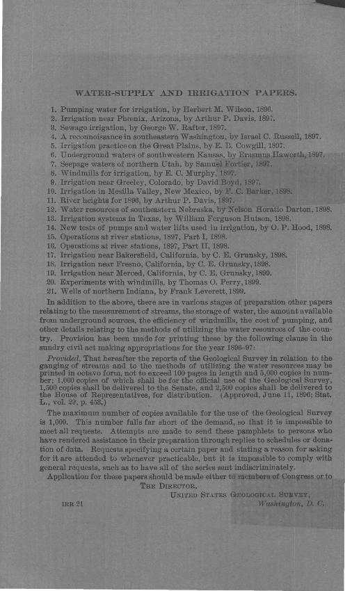
WATER-SUPPLY AND IRRIGATION PAPERS.
1. Pumping water for irrigation, by Herbert M. Wilson, 1896. 2. Irrigation near Phoonix, Arizona, by Arthur P. Davis, 1897. 3. Sewage irrigation, by George W. Rafter, 1897. 4. A reconnaissance in southeastern Washington, by Israel C. Russell, 1897. 5. Irri tion practice on the Great Plains, by E. B. Cowgill, 1897. 6. Underground waters of southwestern Kansas, by Erasmus Haworth, 1897. 7. Seepage waters of northern Utah, by Samuel Fortier, 1897. 8. Windmills for irrigation, by E. C. Murphy, 1897. 9. Irrigation near Greeley, Colorado, by David Boyd, 1897.
10. Irrigation in Mesilla Valley, New Mexico, by F. C. Barker, 1898. 11. River heights for 1896, by Arthur P. Davis, 189 . 12. Water resources of southeastern Nebraska, by Nelson Horatio Darton, 1898. 13. Irrigation systems in Texas, by William Ferguson Hutson, 1898. 14. New tests of pumps and water lifts used in irrigation, by 0. P. Hood, 1898. 15. Operations at river stations, 1897, Part I, 1898. 16. Operations at river stations, 1897, Part II, 1898. 17. Irrigation near Bakersfield, California, by C. E. Grunsky, 1898. 18. Irrigation near Fresno, California, by C. E. Grunsky,l898. 19. Irrigation near Merced, California, by C. E. Grunsky, 1899. 20. Experiments with windmills, by Thomas 0. Perry, 1899. 21. Wells of northern Indiana, by Frank Leverett, 1899.
In addition to the above, there are in various stages of preparation other papers relating to the measurement of streams, the storage of water, the amount available from underground sources, the efficiency of windmills, the cost of pumping, and other details relating to the methods of utilizing the water resources of the country. Provision has been made for printing these by the following clause in the sundry civil act making appropriations for the year 1896-97:
Provided, That hereafter the reports of the Geological Survey in relation to the gauging of streams and to the methods of utilizing the water resources may be printed in octavo form, not to exceed 100 pages in length and 5,000 copies in number; 1,000 copies of which shall be for the official use of the Geological Survey, 1,500 copies shall be delivered to the Senate, and 2,500 copies shall be delivered to the House of Representatives, for distribution. (Approved, June 11, 1896; Stat. L., vol. 29, p. 453.)
The maximum number of copies available for the use of the Geological Survey is 1,000. This number falls far short of the demand, so that it is impossible to meet all requests. Attempts are made to send these pamphlets to person ho have rendered assistance in their preparation through replies to schedules or dona· tion of data. Requests specifying a certain paper and stating a reason for asking for it are attended to whenever practicable, but it is impossible to comply with general requests, such as to have all of the series sent indiscriminately.
Application for these papers should be made either to members of Congress or to THE DIRECTOR,
UNITED STATES GEOLOGICAL SURVEY,
IRR 21 Washington, D. G.