IRL-Basins-Basics-DEOPotentialefforts-05-15
26
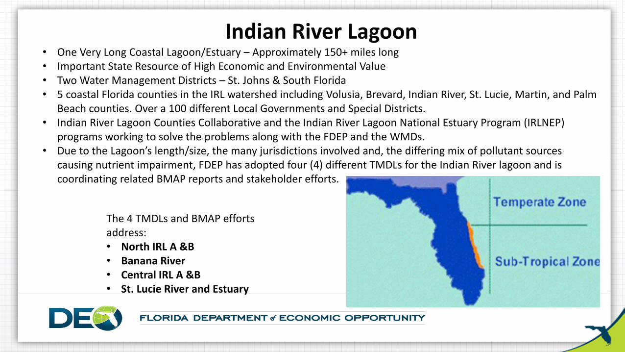
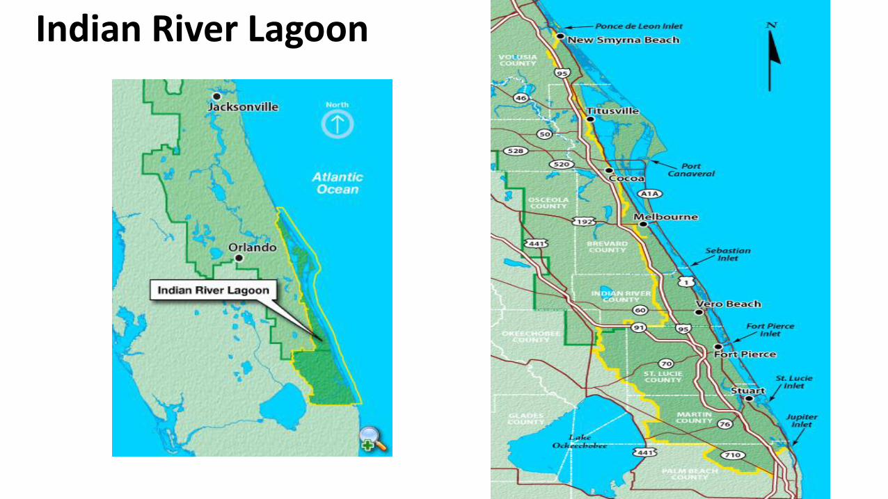
Indian River Lagoon • One Very Long Coastal Lagoon/Estuary – Approximately 150+ miles long • Important State Resource of High Economic and Environmental Value • Two Water Management Districts – St. Johns & South Florida • 5 coastal Florida counties in the IRL watershed including Volusia, Brevard, Indian River, St. Lucie, Martin, and Palm Beach counties. Over a 100 different Local Governments and Special Districts. • Indian River Lagoon Counties Collaborative and the Indian River Lagoon National Estuary Program (IRLNEP) programs working to solve the problems along with the FDEP and the WMDs. • Due to the Lagoon’s length/size, the many jurisdictions involved and, the differing mix of pollutant sources causing nutrient impairment, FDEP has adopted four (4) different TMDLs for the Indian River lagoon and is coordinating related BMAP reports and stakeholder efforts. The 4 TMDLs and BMAP efforts address: • North IRL A &B • Banana River • Central IRL A &B • St. Lucie River and Estuary
-
Upload
dan-pennington -
Category
Documents
-
view
5 -
download
1
Transcript of IRL-Basins-Basics-DEOPotentialefforts-05-15
Indian River Lagoon• One Very Long Coastal Lagoon/Estuary – Approximately 150+ miles long• Important State Resource of High Economic and Environmental Value• Two Water Management Districts – St. Johns & South Florida• 5 coastal Florida counties in the IRL watershed including Volusia, Brevard, Indian River, St. Lucie, Martin, and Palm
Beach counties. Over a 100 different Local Governments and Special Districts.• Indian River Lagoon Counties Collaborative and the Indian River Lagoon National Estuary Program (IRLNEP)
programs working to solve the problems along with the FDEP and the WMDs.• Due to the Lagoon’s length/size, the many jurisdictions involved and, the differing mix of pollutant sources
causing nutrient impairment, FDEP has adopted four (4) different TMDLs for the Indian River lagoon and is coordinating related BMAP reports and stakeholder efforts.
The 4 TMDLs and BMAP efforts address:• North IRL A &B• Banana River• Central IRL A &B• St. Lucie River and Estuary
Indian River Lagoon
ECONOMIC BENEFITS OF THE IRL SYSTEM
A valuable ecological and economic asset for the State of Florida and the counties that border the lagoon and itstributaries.
It is a biologically diverse area considered the most diverse estuary in North America, and was recognized as part ofthe National Estuary Program (NEP) in 1990.
The lagoon directly and indirectly supports a large part of the region’s and the state’s economy.
1.4 million acres – 10 counties drain into the IRL (2.5 times what drained into it 100 years ago)
Economic benefit to six counties within the watershed - $3.7 Billion/yearRecreation: $1.3 Billion/yearReal Estate Value: $934 Million/yearJobs: 15,000 full and part-time jobs/year
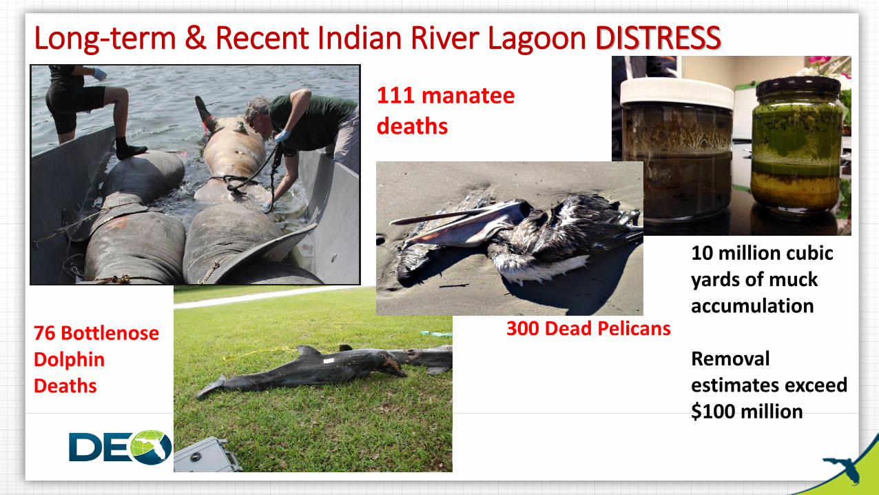
Long-term & Recent Indian River Lagoon DISTRESS
111 manatee deaths
76 Bottlenose Dolphin Deaths
10 million cubic yards of muck accumulation
Removal estimates exceed $100 million
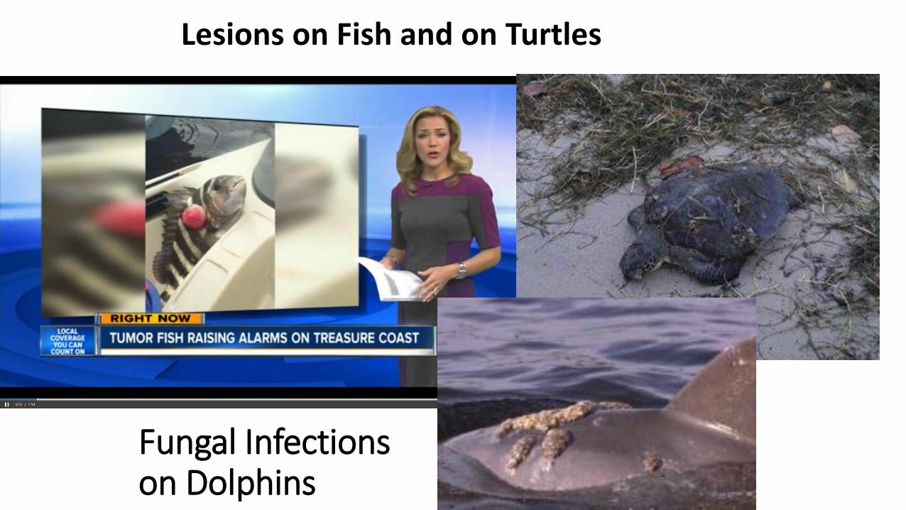
Lesions on Fish and on Turtles
Fungal Infections on Dolphins
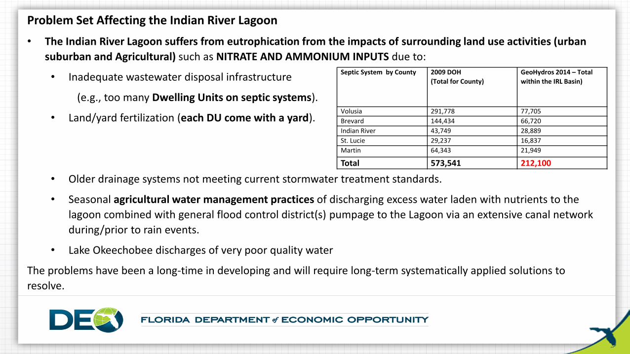
Problem Set Affecting the Indian River Lagoon
• The Indian River Lagoon suffers from eutrophication from the impacts of surrounding land use activities (urban
suburban and Agricultural) such as NITRATE AND AMMONIUM INPUTS due to:
• Inadequate wastewater disposal infrastructure
(e.g., too many Dwelling Units on septic systems).
• Land/yard fertilization (each DU come with a yard).
• Older drainage systems not meeting current stormwater treatment standards.
• Seasonal agricultural water management practices of discharging excess water laden with nutrients to the
lagoon combined with general flood control district(s) pumpage to the Lagoon via an extensive canal network
during/prior to rain events.
• Lake Okeechobee discharges of very poor quality water
The problems have been a long-time in developing and will require long-term systematically applied solutions to
resolve.
Septic System by County 2009 DOH
(Total for County)
GeoHydros 2014 – Total
within the IRL Basin)
Volusia 291,778 77,705
Brevard 144,434 66,720
Indian River 43,749 28,889
St. Lucie 29,237 16,837
Martin 64,343 21,949
Total 573,541 212,100
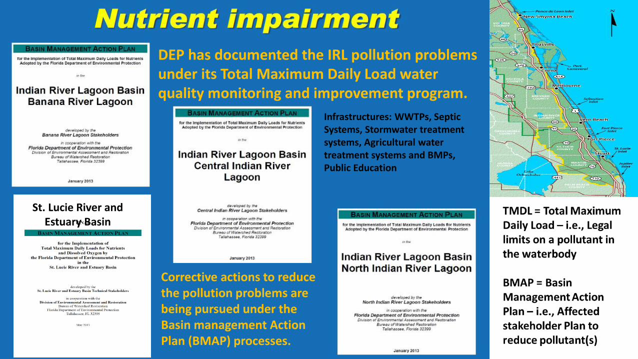
St. Lucie River and Estuary Basin
DEP has documented the IRL pollution problems under its Total Maximum Daily Load water quality monitoring and improvement program.
Infrastructures: WWTPs, Septic Systems, Stormwater treatment systems, Agricultural water treatment systems and BMPs, Public Education
Corrective actions to reduce the pollution problems are being pursued under the Basin management Action Plan (BMAP) processes.
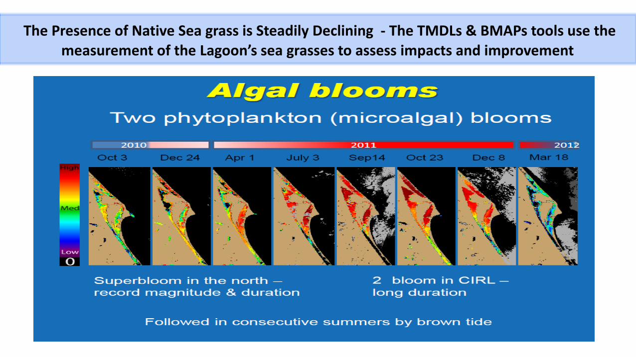
The Presence of Native Sea grass is Steadily Declining - The TMDLs & BMAPs tools use the measurement of the Lagoon’s sea grasses to assess impacts and improvement
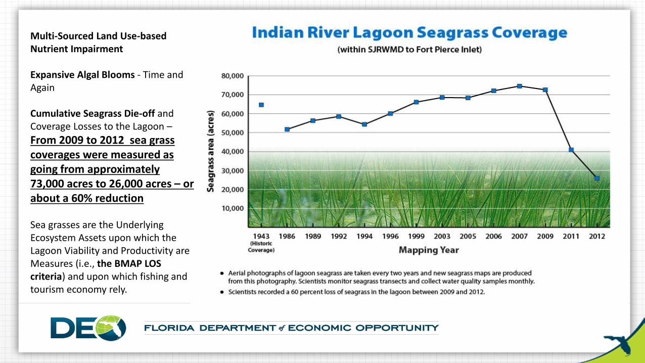
Multi-Sourced Land Use-based Nutrient Impairment
Expansive Algal Blooms - Time and Again
Cumulative Seagrass Die-off and Coverage Losses to the Lagoon –
From 2009 to 2012 sea grass coverages were measured as going from approximately 73,000 acres to 26,000 acres – or about a 60% reduction
Sea grasses are the Underlying Ecosystem Assets upon which the Lagoon Viability and Productivity are Measures (i.e., the BMAP LOS criteria) and upon which fishing and tourism economy rely.
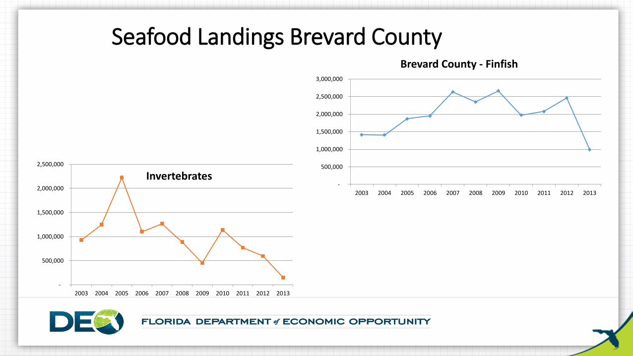
Seafood Landings Brevard County
-
500,000
1,000,000
1,500,000
2,000,000
2,500,000
2003 2004 2005 2006 2007 2008 2009 2010 2011 2012 2013
Invertebrates -
500,000
1,000,000
1,500,000
2,000,000
2,500,000
3,000,000
2003 2004 2005 2006 2007 2008 2009 2010 2011 2012 2013
Brevard County - Finfish
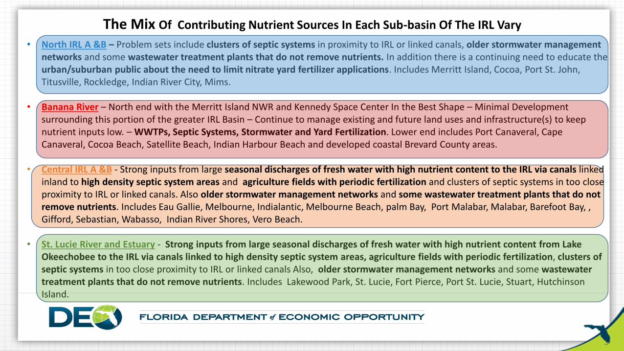
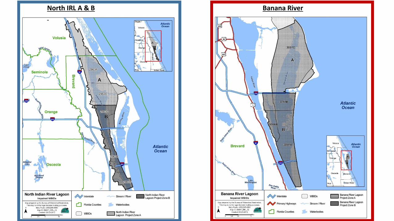
• North IRL A &B – Problem sets include clusters of septic systems in proximity to IRL or linked canals, older stormwater management networks and some wastewater treatment plants that do not remove nutrients. In addition there is a continuing need to educate the urban/suburban public about the need to limit nitrate yard fertilizer applications. Includes Merritt Island, Cocoa, Port St. John, Titusville, Rockledge, Indian River City, Mims.
• Banana River – North end with the Merritt Island NWR and Kennedy Space Center In the Best Shape – Minimal Development surrounding this portion of the greater IRL Basin – Continue to manage existing and future land uses and infrastructure(s) to keep nutrient inputs low. – WWTPs, Septic Systems, Stormwater and Yard Fertilization. Lower end includes Port Canaveral, Cape Canaveral, Cocoa Beach, Satellite Beach, Indian Harbour Beach and developed coastal Brevard County areas.
• Central IRL A &B - Strong inputs from large seasonal discharges of fresh water with high nutrient content to the IRL via canals linked inland to high density septic system areas and agriculture fields with periodic fertilization and clusters of septic systems in too close proximity to IRL or linked canals. Also older stormwater management networks and some wastewater treatment plants that do not remove nutrients. Includes Eau Gallie, Melbourne, Indialantic, Melbourne Beach, palm Bay, Port Malabar, Malabar, Barefoot Bay, , Gifford, Sebastian, Wabasso, Indian River Shores, Vero Beach.
• St. Lucie River and Estuary - Strong inputs from large seasonal discharges of fresh water with high nutrient content from Lake Okeechobee to the IRL via canals linked to high density septic system areas, agriculture fields with periodic fertilization, clusters of septic systems in too close proximity to IRL or linked canals Also, older stormwater management networks and some wastewater treatment plants that do not remove nutrients. Includes Lakewood Park, St. Lucie, Fort Pierce, Port St. Lucie, Stuart, Hutchinson Island.
The Mix Of Contributing Nutrient Sources In Each Sub-basin Of The IRL Vary
North IRL A & B Banana River
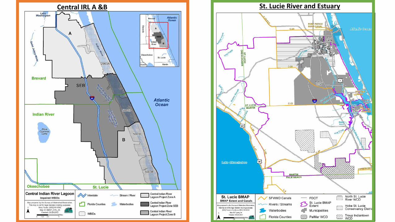
Central IRL A &B St. Lucie River and Estuary
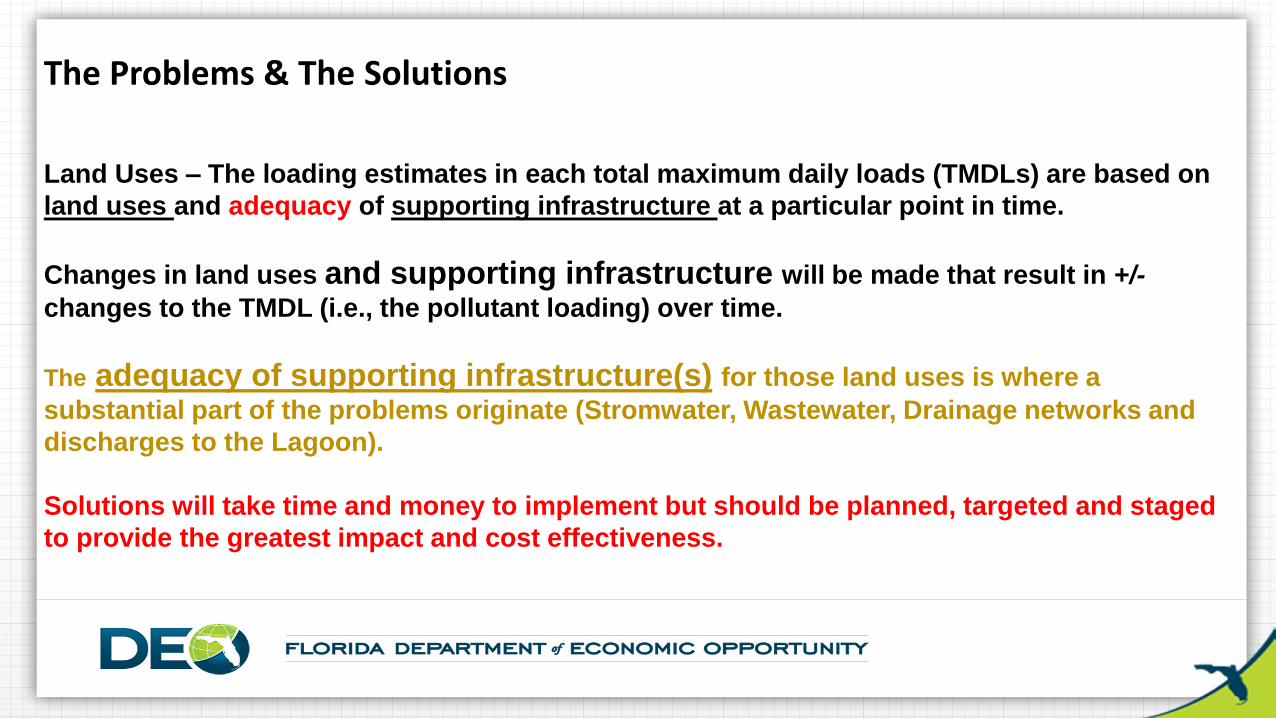
The Problems & The Solutions
Land Uses – The loading estimates in each total maximum daily loads (TMDLs) are based on
land uses and adequacy of supporting infrastructure at a particular point in time.
Changes in land uses and supporting infrastructure will be made that result in +/-
changes to the TMDL (i.e., the pollutant loading) over time.
The adequacy of supporting infrastructure(s) for those land uses is where a
substantial part of the problems originate (Stromwater, Wastewater, Drainage networks and
discharges to the Lagoon).
Solutions will take time and money to implement but should be planned, targeted and staged
to provide the greatest impact and cost effectiveness.
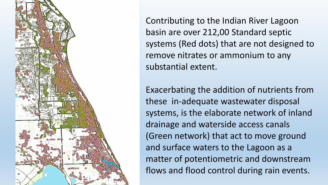
Contributing to the Indian River Lagoon basin are over 212,00 Standard septic systems (Red dots) that are not designed to remove nitrates or ammonium to any substantial extent.
Exacerbating the addition of nutrients from these in-adequate wastewater disposal systems, is the elaborate network of inland drainage and waterside access canals (Green network) that act to move ground and surface waters to the Lagoon as a matter of potentiometric and downstream flows and flood control during rain events.
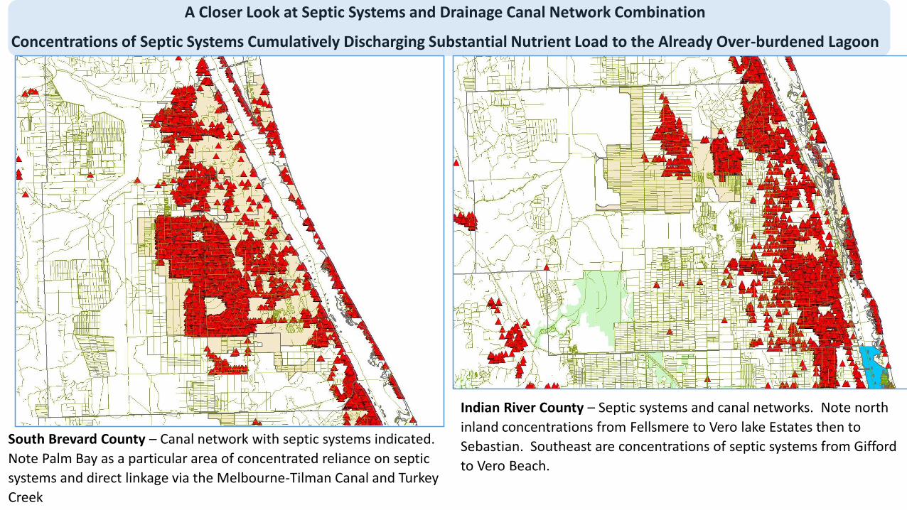
South Brevard County – Canal network with septic systems indicated.
Note Palm Bay as a particular area of concentrated reliance on septic
systems and direct linkage via the Melbourne-Tilman Canal and Turkey
Creek
Indian River County – Septic systems and canal networks. Note north
inland concentrations from Fellsmere to Vero lake Estates then to
Sebastian. Southeast are concentrations of septic systems from Gifford
to Vero Beach.
A Closer Look at Septic Systems and Drainage Canal Network Combination
Concentrations of Septic Systems Cumulatively Discharging Substantial Nutrient Load to the Already Over-burdened Lagoon
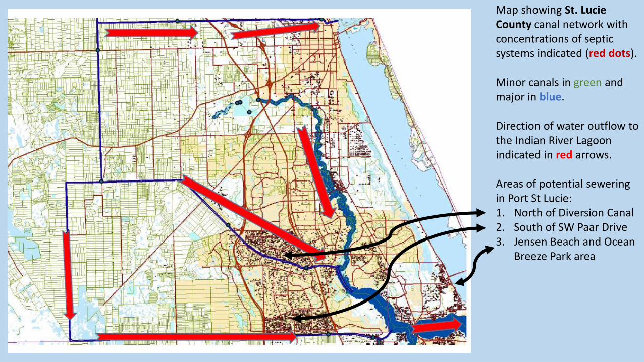
Map showing St. Lucie County canal network with concentrations of septic systems indicated (red dots).
Minor canals in green and major in blue.
Direction of water outflow to the Indian River Lagoon indicated in red arrows.
Areas of potential sewering in Port St Lucie:1. North of Diversion Canal2. South of SW Paar Drive3. Jensen Beach and Ocean
Breeze Park area
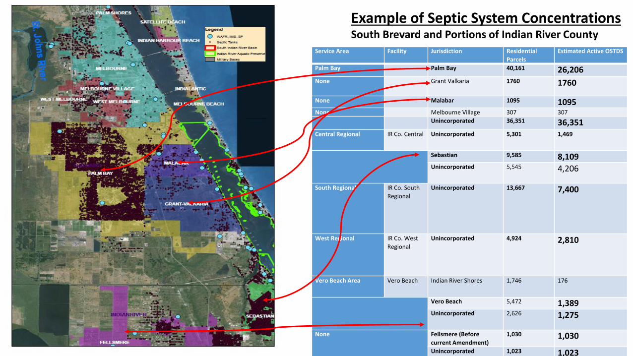
Service Area Facility Jurisdiction Residential
Parcels
Estimated Active OSTDS
Palm Bay Palm Bay 40,161 26,206None Grant Valkaria 1760 1760
None Malabar 1095 1095None Melbourne Village 307 307
Unincorporated 36,351 36,351Central Regional IR Co. Central Unincorporated 5,301 1,469
Sebastian 9,585 8,109Unincorporated 5,545 4,206
South Regional IR Co. South
Regional
Unincorporated 13,667 7,400
West Regional IR Co. West
Regional
Unincorporated 4,924 2,810
Vero Beach Area Vero Beach Indian River Shores 1,746 176
Vero Beach 5,472 1,389Unincorporated 2,626 1,275
None Fellsmere (Before
current Amendment)
1,030 1,030
Unincorporated 1,023 1,023
Example of Septic System ConcentrationsSouth Brevard and Portions of Indian River County
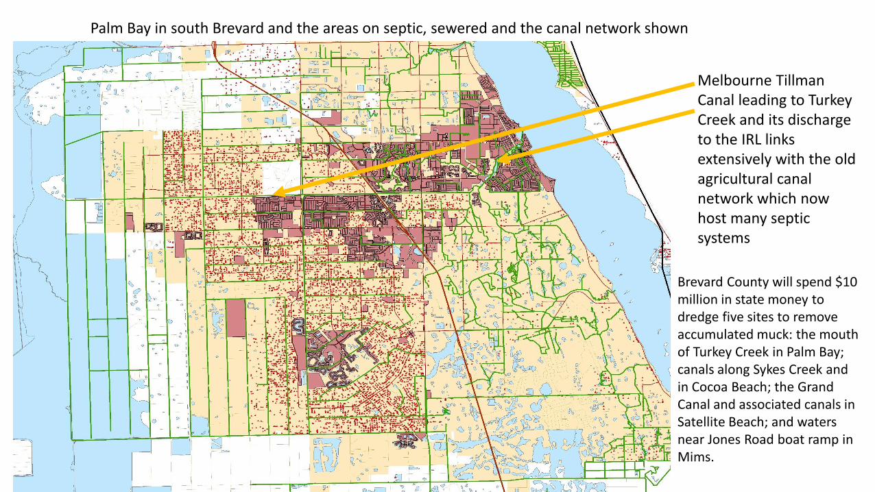
Palm Bay in south Brevard and the areas on septic, sewered and the canal network shown
Melbourne Tillman Canal leading to Turkey Creek and its discharge to the IRL links extensively with the old agricultural canal network which now host many septic systems
Brevard County will spend $10 million in state money to dredge five sites to remove accumulated muck: the mouth of Turkey Creek in Palm Bay; canals along Sykes Creek and in Cocoa Beach; the Grand Canal and associated canals in Satellite Beach; and waters near Jones Road boat ramp in Mims.
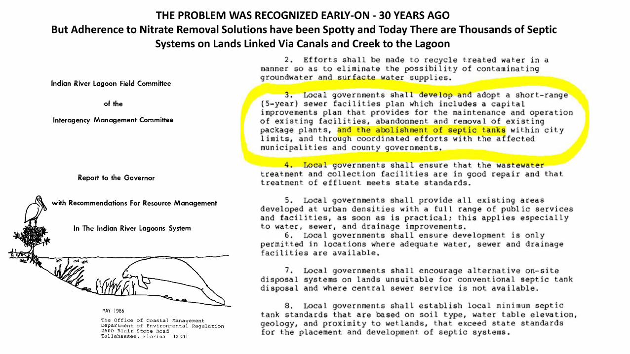
THE PROBLEM WAS RECOGNIZED EARLY-ON - 30 YEARS AGOBut Adherence to Nitrate Removal Solutions have been Spotty and Today There are Thousands of Septic
Systems on Lands Linked Via Canals and Creek to the Lagoon
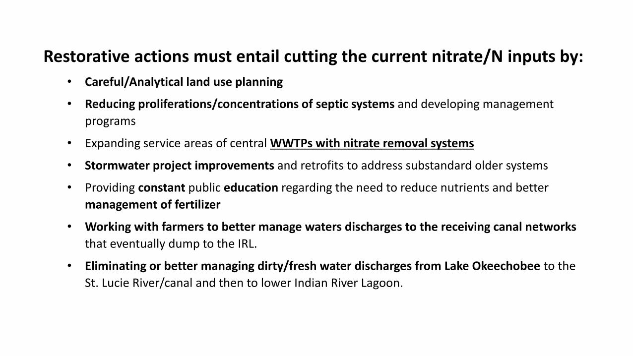
Restorative actions must entail cutting the current nitrate/N inputs by:
• Careful/Analytical land use planning
• Reducing proliferations/concentrations of septic systems and developing management
programs
• Expanding service areas of central WWTPs with nitrate removal systems
• Stormwater project improvements and retrofits to address substandard older systems
• Providing constant public education regarding the need to reduce nutrients and better
management of fertilizer
• Working with farmers to better manage waters discharges to the receiving canal networks
that eventually dump to the IRL.
• Eliminating or better managing dirty/fresh water discharges from Lake Okeechobee to the
St. Lucie River/canal and then to lower Indian River Lagoon.
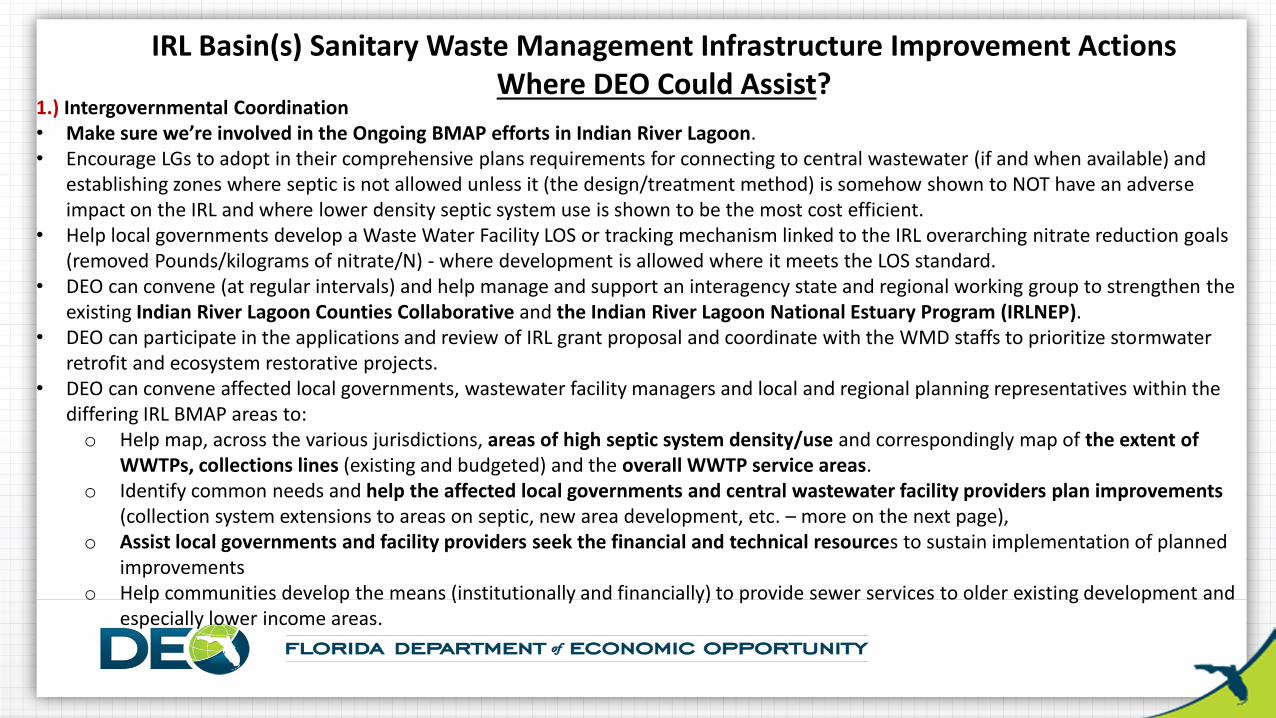
IRL Basin(s) Sanitary Waste Management Infrastructure Improvement Actions Where DEO Could Assist?
1.) Intergovernmental Coordination• Make sure we’re involved in the Ongoing BMAP efforts in Indian River Lagoon.• Encourage LGs to adopt in their comprehensive plans requirements for connecting to central wastewater (if and when available) and
establishing zones where septic is not allowed unless it (the design/treatment method) is somehow shown to NOT have an adverse impact on the IRL and where lower density septic system use is shown to be the most cost efficient.
• Help local governments develop a Waste Water Facility LOS or tracking mechanism linked to the IRL overarching nitrate reduction goals (removed Pounds/kilograms of nitrate/N) - where development is allowed where it meets the LOS standard.
• DEO can convene (at regular intervals) and help manage and support an interagency state and regional working group to strengthen theexisting Indian River Lagoon Counties Collaborative and the Indian River Lagoon National Estuary Program (IRLNEP).
• DEO can participate in the applications and review of IRL grant proposal and coordinate with the WMD staffs to prioritize stormwater retrofit and ecosystem restorative projects.
• DEO can convene affected local governments, wastewater facility managers and local and regional planning representatives within the differing IRL BMAP areas to:o Help map, across the various jurisdictions, areas of high septic system density/use and correspondingly map of the extent of
WWTPs, collections lines (existing and budgeted) and the overall WWTP service areas.o Identify common needs and help the affected local governments and central wastewater facility providers plan improvements
(collection system extensions to areas on septic, new area development, etc. – more on the next page), o Assist local governments and facility providers seek the financial and technical resources to sustain implementation of planned
improvements o Help communities develop the means (institutionally and financially) to provide sewer services to older existing development and
especially lower income areas.
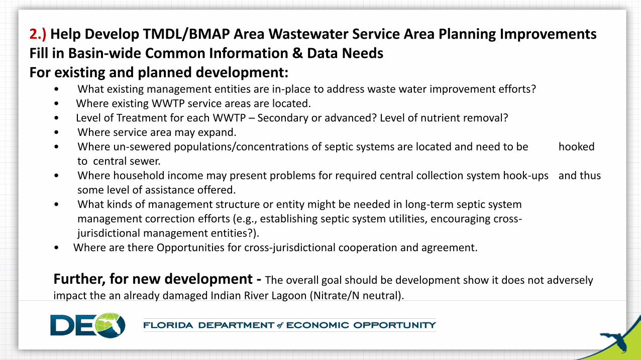
2.) Help Develop TMDL/BMAP Area Wastewater Service Area Planning ImprovementsFill in Basin-wide Common Information & Data NeedsFor existing and planned development:
• What existing management entities are in-place to address waste water improvement efforts?• Where existing WWTP service areas are located.• Level of Treatment for each WWTP – Secondary or advanced? Level of nutrient removal?• Where service area may expand.• Where un-sewered populations/concentrations of septic systems are located and need to be hooked
to central sewer.• Where household income may present problems for required central collection system hook-ups and thus
some level of assistance offered.• What kinds of management structure or entity might be needed in long-term septic system
management correction efforts (e.g., establishing septic system utilities, encouraging cross-jurisdictional management entities?).
• Where are there Opportunities for cross-jurisdictional cooperation and agreement.
Further, for new development - The overall goal should be development show it does not adversely
impact the an already damaged Indian River Lagoon (Nitrate/N neutral).
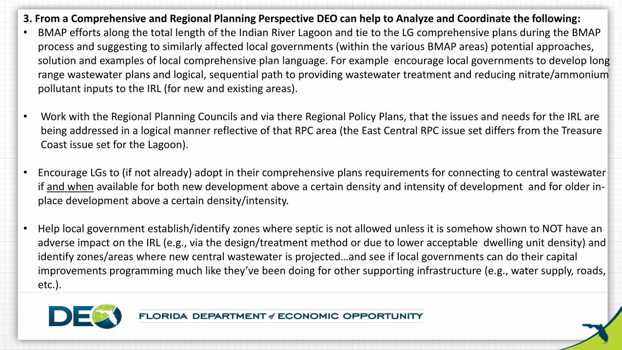
3. From a Comprehensive and Regional Planning Perspective DEO can help to Analyze and Coordinate the following:• BMAP efforts along the total length of the Indian River Lagoon and tie to the LG comprehensive plans during the BMAP
process and suggesting to similarly affected local governments (within the various BMAP areas) potential approaches, solution and examples of local comprehensive plan language. For example encourage local governments to develop long range wastewater plans and logical, sequential path to providing wastewater treatment and reducing nitrate/ammonium pollutant inputs to the IRL (for new and existing areas).
• Work with the Regional Planning Councils and via there Regional Policy Plans, that the issues and needs for the IRL are being addressed in a logical manner reflective of that RPC area (the East Central RPC issue set differs from the Treasure Coast issue set for the Lagoon).
• Encourage LGs to (if not already) adopt in their comprehensive plans requirements for connecting to central wastewater if and when available for both new development above a certain density and intensity of development and for older in-place development above a certain density/intensity.
• Help local government establish/identify zones where septic is not allowed unless it is somehow shown to NOT have an adverse impact on the IRL (e.g., via the design/treatment method or due to lower acceptable dwelling unit density) and identify zones/areas where new central wastewater is projected…and see if local governments can do their capital improvements programming much like they’ve been doing for other supporting infrastructure (e.g., water supply, roads, etc.).
LEADERSHIP THROUGH GOOD PLANNING AND TECHNICAL ASSISTANCEGeneral planning• Encourage DEO planners to participate in local meetings of TMDL groups• Encourage in the review of proposed amendments within the IRL Basin that planners consider facility in-adequacy of the
proposed land uses relative to wastewater infrastructure (i.e. does the proposed density/intensity of use add to or exacerbate existing facility in-adequacies that increase nitrate/ammonium pollutants to the IRL?)
• Encourage IRL planners to attend Collaborative Meetings and identify other groups where participation might be beneficial.• Conduct workshops in each county inviting small cities to discuss nutrient issues, septic tanks, sewers, stormwater.• Talk to RPC and WMD to identify areas containing high volumes of untreated stormwater dischargesStormwater Infrastructure• Encourage local groups adopting roads for stormwater inspections and report to a central facility.• Encourage adoption of stormwater fees for stormwater retrofits Wastewater Infrastructure• Encourage planners to meet with local planners and public wastewater providers to review maps and identify areas feasible
for regional wastewater extensions• Identify areas with wastewater treatment systems that are not treating to advanced treatment standards.• Encourage the establishment of septic tank management programs for inspection, pump out, repair programs and helping to
guide where/when to hookup to available central sewer systems.• Provide comments in letters encouraging analysis of land use patterns and potential for central sewer expansion• Prioritize areas with most septic tanks and approach local governments with highest numbers to encourage wastewater
extensions and septic tank maintenance programs– for example Palm Bay, Deland, Sebastian, Lakewood Park, Martin county unincorporated Indian river county unincorporated, Hobe sound, Stuart, Debary.
• Encourage the establishment of a statewide revolving fund for septic tank conversions to sewers and provide support to find wastewater funding sources data to local governments

QUESTIONS?


![Index []...2003/01/28 · IRL Jack O'Leary 04/11/1997 IRL Peter Lynch 26/11/1997 IRL Darragh McElhinney 2000 IRL Fearghal Curtin 14/07/1998 IRL Charlie O'Donovan 06/08/1999 IRL Barry](https://static.fdocuments.in/doc/165x107/5e9ad3bf924b7b6d1915a79a/index-20030128-irl-jack-oleary-04111997-irl-peter-lynch-26111997.jpg)