Iowa Trails 2000 - Iowa Department of Transportation Space For Bike Lanes Shared Use Paths Bicycle...
103
Connecting People and Trails: Local Community Planning for Bicyclists and Pedestrians submitted by: Suzan A. Pinsof Consulting In Association With Iowa Trails 2000 A Handbook for Local Communities Iowa Department of Transportation
Transcript of Iowa Trails 2000 - Iowa Department of Transportation Space For Bike Lanes Shared Use Paths Bicycle...

Connecting People and Trails:Local Community Planning
for Bicyclists and Pedestrians
submitted by:Suzan A. Pinsof Consulting
In Association With
Iowa Trails 2000
A Handbook for LocalCommunities
Iowa Departmentof Transportation

LIST OF DEFINITIONS ................................................................................ iii
CHAPTER ONEIntroduction: Connecting People and Trails ............................................................ 1
Why Plan Locally for Bicycling and Walking?
What is Bicycle and Pedestrian Planning?
Who Should be Involved?
CHAPTER TWOCreating Your Community Bicycle and Pedestrian Plan ........................................ 7Step 1: Evaluate Existing Conditions ...................................................................... 7
Land-Use and Transportation
Evaluating Users
Analyzing Crashes
Area Attractions and Planning Efforts
Step 2: Seek Public Input ........................................................................................ 13Identify Interested Citizens
Public Participation
Communications
Step 3: Planning Considerations ............................................................................ 16Connecting to the State Trails System
Trails and Roadways for Non-motorized Transportation and Touring
Land Use and Site Design
Roadway Design and Traffic Operations
Community Design Considerations
Step 4: Create A Bicycle System Plan .................................................................... 24Bicycle Network Criteria
Priority Destinations
Corridor Connections
Alternative Evaluation
Draft Bicycle Network Program
Step 5: Pedestrian System Planning ...................................................................... 32Pedestrian Network Criteria
Identifying Priority Service Areas
Evaluating Current Conditions for Pedestrians
Draft Pedestrian Network Plan
Step 6: Develop Implementation Plan .................................................................. 39Planning Context
Programming Projects
Funding
Strategies and Policies
Table Of Contents

IOWA DEPARTMENT OF TRANSPORTATIONii
Table of Contents
CHAPTER THREEDesigning Local Bicycle and Pedestrian Networks ................................................47The Importance of Good Design.............................................................................. 48
Connecting to the State Trail System ......................................................................50
Local Facilities
Signing
Amenities
Bicycle Facilities and Accommodations ..................................................................51
Shared Roadways
Removing Hazards
Increasing Lane Width
Paving Shoulders
Bicycle Routes
Sidewalks As Bicycle Routes
Bicycle Lanes
Bike Lanes At Intersections
One-Way Streets
Contra-Flow Bicycle Lane
Finding Space For Bike Lanes
Shared Use Paths
Bicycle Parking
Pedestrian Facilities and Accommodations ............................................................60
The Sidewalk Corridor
Crossing Streets
Street Corners
APPENDICES
Appendix 1: References and Resources for Non-MotorizedTransportation Planning
Appendix 2: Technical Assistance Resources
Appendix 3: State of Iowa Bicycle and Pedestrian Accommodation Guidance
Appendix 4: Sample Pedestrian Audit and Hazard Reporting Forms
Appendix 5: “Do We Really Need Four Lanes of Traffic?”

CONNECTING PEOPLE AND TRAILS
DEFINITIONS OF BICYCLE AND PEDESTRIAN FACILITIES AND TERMS
ADAAmerican With Disabilities Act of 1990. Broad legislation mandating provision of access to employment,services, and the built environment to those with disabilities.
Bicycle FacilitiesA general term denoting improvements and provisions made by public agencies to accommodate orencourage bicycling, including parking and storage facilities, and shared roadways not specifically designatedfor bicycle use.
Bicycle Lane or Bike LaneA portion of a roadway which has been designated by striping, signing and pavement markings for thepreferential or exclusive use of bicyclists
Bicycle Route System (Bike Route) A system of bikeways designated by the jurisdiction having authority with appropriate directional andinformation route markers, with or without specific bicycle route numbers. Bike routes should establish acontinuous routing, but may be a combination of any and all types of bikeways.
BikewayA generic term for any road, street, path or way which in some manner is specifically designated for bicycletravel, regardless of whether such facilities are designated for the exclusive use of bicycles or are to be sharedwith other transportation modes.
CrosswalkAny portion of a highway at an intersection or elsewhere distinctly indicated for pedestrian crossing by linesor other markings on the surface. Unmarked extensions of the shoulder, curb line or sidewalk are alsoreferred to as crosswalks.
Curb Radius A measure of the sharpness of the corner formed by two intersecting streets.
Curb Ramp A combined ramp and landing within a public sidewalk to accomplish a change of level at a curbed streetcrossing.
Designated Shared RoadwayA shared roadway which has been designated by signing as a preferred route for bicycle use. (Same as BikeRoute.)
Grade Separation The vertical separation of conflicting travel ways with a structure, usually a bridge or underpass.
List of Definitions
iii

IOWA DEPARTMENT OF TRANSPORTATIONiv
GreenwayA linear open space established along either a natural corridor, such as a riverfront, stream valley or ridgeline;or overland along a railroad right-of-way converted to recreational use, a canal, or other route. A greenway, asa broad conservation concept, may or may not allow public access or formal trail development.
Median A raised or painted portion of a divided highway separating travel lanes carrying traffic in oppositedirections.
Parkway The space provided to separate the sidewalk from the vehicular travel facilities, usually landscaped and usedfor various utilities and signing.
Pavement Markings Painted or applied lines or symbols placed on a roadway surface for regulating, guiding or warning traffic.
Pedestrian Signal The signal head that indicates the walk/don’t walk phase of a traffic signal.
Public Walkway A pedestrian facility on public or private space intended to provide passage for public use.
Rail-TrailA shared use path, either paved or unpaved, built within the right-of-way of an existing or former railroad.
Raised Crosswalk A variation of a speed hump in which a crosswalk is raised to sidewalk level and frequently surfaced tocoordinate with the sidewalk rather than the street.
Refuge Island A raised, curbed or painted area within an intersection that allows the pedestrian to cross a portion of thestreet in one movement and continue or wait to cross the next portion.
Right-of-way The right of one vehicle operator or pedestrian to proceed in a lawful manner in preference to another.
Shared RoadwayA roadway which is open to both bicycle and motor vehicle travel. This may be an existing roadway, streetwith wide curb lanes, or a road with paved shoulders.
Shared Use PathA bikeway physically separated from motorized vehicular traffic by an open space or barrier, and either withinthe highway right-of-way or within an independent right-of-way. Shared use paths may also be used bypedestrians, skaters, wheelchair users, joggers and other non-motorized users.
ShoulderThe portion of the roadway contiguous with the traveled way for accommodation of stopped vehicles, foremergency use and for lateral support of sub-base, base and surface courses. When paved and of sufficient
List of Definitions

CONNECTING PEOPLE AND TRAILS v
width, shoulders provide space for bicycle and pedestrian travel. A shoulder is usually separated from thetravel lane by striping, and may be signed as a bike lane under moderate traffic conditions.
SidepathA two-way shared use path located immediately adjacent to a roadway, like an extra wide sidewalk. Notrecommended in most applications due to space limitations, operational problems, and safety hazards atintersections.
Sidewalk The portion of a highway, designed for preferential or exclusive use by pedestrians. (AASHTO) It is usuallyseparated from the roadway with a curb and/or parkway and constructed of a hard durable material.
Speed Humps/ TablesRaised street sections placed either at intersections or in other locations where they are intended to slowtraffic. They are usually 10-12 feet in longitudinal length.
Traffic CalmingRoadway design measures used to slow or divert traffic to increase the safety and attractiveness of streets,especially for pedestrians.
Trail, Multi-Use Path or Bicycle PathSame as Shared Use Path. However, the term bicycle path is becoming less common, since such facilities arerarely used exclusively by cyclists.
Wide Curb LaneAn outside or curbside travel lane of sufficient width for a bicyclist and motorist to share the lane with acomfortable degree of separation. The bicycle space is not striped, and generally the total width is less than aroad with a paved shoulder or bike lane treatment.
List of Definitions


CONNECTING PEOPLE AND TRAILS 1
Chapter One
Why Plan Locally for Bicycling and Walking?
Everybody walks, and many peopleenjoy bicycling. Today, many
communities are exploring ways toencourage these activities.
INTRODUCTION: CONNECTING PEOPLE AND TRAILS
Many communities in Iowa have expressed a desire to develop a planfor better accommodating pedestrians and bicyclists in theircommunity. This desire results from the recognition that walking andbicycling are popular recreational activities and, are increasinglyimportant as “alternative transportation modes.” Recognizing the desireon the part of communities to create better conditions for bicyclingand walking, the Iowa DOT developed this handbook as part of IowaTrails 2000.
This handbook outlines the steps and resources required to create acomprehensive system of bicycle and pedestrian facilities. Such asystem can serve local needs and connect communities to the IowaState Trails System and other regional attractions.
Iowa’s trails have been, and will continue to be, developed through thecombined efforts of citizens and state, regional and local governments.By working cooperatively, state and local governments can serve localbicycle and pedestrian needs and connect communities to the IowaState Trails System and other significant regional attractions.
Why Plan Locally for Bicycling and Walking?Everybody walks, and many people enjoy bicycling. Today, manycommunities are exploring ways to encourage these activities. Somereasons many communities are focusing on bicycling and walkingtoday include:
• The enormous popularity of trails.
• State and national surveys indicate that pedestrians and bicyclistsare the most common trail users, and Iowans would like moretrail opportunities closer to home.
• Pedestrian and bicycle transportation provide many benefits,including:
- transportation alternatives - increased physical activity- improved air quality (reduced auto emissions)- friendlier, livelier and more pleasant communities
• State and federal transportation programs encourage increasedinvestment in alternatives to automobile travel and providefunding for bicycle and pedestrian facilities.
• Increasing motor vehicle volumes and speeds have degradedconditions for bicycling and walking.
• It is federal policy as expressed in The National Bicycling andWalking Study to
- double the current (1994) percentage (from 7.9 percent to 15.8percent) of total trips made by bicycling and walking, and to
- reduce by 10 percent the number of bicyclists andpedestrians killed or injured in traffic crashes.

IOWA DEPARTMENT OF TRANSPORTATION2
Chapter One
What is Bicycle and Pedestrian Planning?Not so many years ago, most urban and suburban communities hadsidewalks and many low volume, low speed roads. Many ruralcommunities had few sidewalks, but traffic was sparse and moved atlower speeds than today. Increases in population and automobile usehave resulted in complex transportation systems that accommodatemore traffic. Motorized traffic has been accommodated withoutalways considering the needs of non-drivers. In response to a growinginterest in walking and bicycling, planners and engineers havedeveloped guidance to improve conditions.
Bicycle and pedestrian planning should be guided by the followingprinciples.
Principle # 1: Local bicycle and pedestrian systems shouldprovide safe and comfortable facilities.
Research has contributed to our understanding of the needs ofbicyclists and pedestrians. For instance, there is unequivocal evidencethat sidewalks protect pedestrians and contribute to overall trafficsafety. Other research indicates that bicycle lanes increase the safetyof bicyclists on roadways between intersections and enhance abicyclist’s sense of comfort in traffic. Research is inconclusive as towhether bicycle lanes help or complicate movements at intersections.Careful design judgment is required for the best application of manybicycle and pedestrian improvements.
There are many ways to increase the perception of safety. Forexample, attractive surroundings are more welcoming to pedestriansand bicyclists. Tree-lined streets with minimum traffic, traveling at lowspeeds, and well-maintained roads and sidewalks invite bicycling andwalking. Buildings in good condition also increase an individual’ssense of comfort and safety in a neighborhood. Higher densityenvironments that provide sidewalks and short distances betweenresidential and commercial areas also encourage walking.
Areas that are inherently unfriendly to bicyclists and pedestrians canbe improved with practical design treatments. For example, the safetyand comfort of pedestrians and bicyclists can be improved at multi-lane crosswalks with the addition of refuge islands and recessed stoplines. Furthermore, the addition of landscaping may also increase aperson’s sense of comfort and safety.
Principle #2: Direct access to destinations and continuitythrough connected facilities encourages the use of bicycle andpedestrian facilities.
Efforts should be made to connect local facilities with adjacentcommunities and state and regional trails.
Pedestrians need a continuous system of sidewalks and crossing
Chapter One
Benefits of Walking andBicyclingHealth:Inactivity is second only to smokingas a national health hazard accordingto the Center for Disease Control andPrevention: walking and bicycling bychildren appear to have fallen 40percent between 1977 and 1995.
Transportation Alternatives:One third of the population does notdrive; independent mobility isimportant for everyone.
Air Quality:Transportation sources are respon-sible for half of all pollution in theUnited States; bicycling and walkingtrips replace between 7.6 and 28.1billion motor vehicle miles, savingbetween 4.4 and 16.3 million metrictons of exhaust.
CONNECTING PEOPLE AND TRAILS 3
Introduction
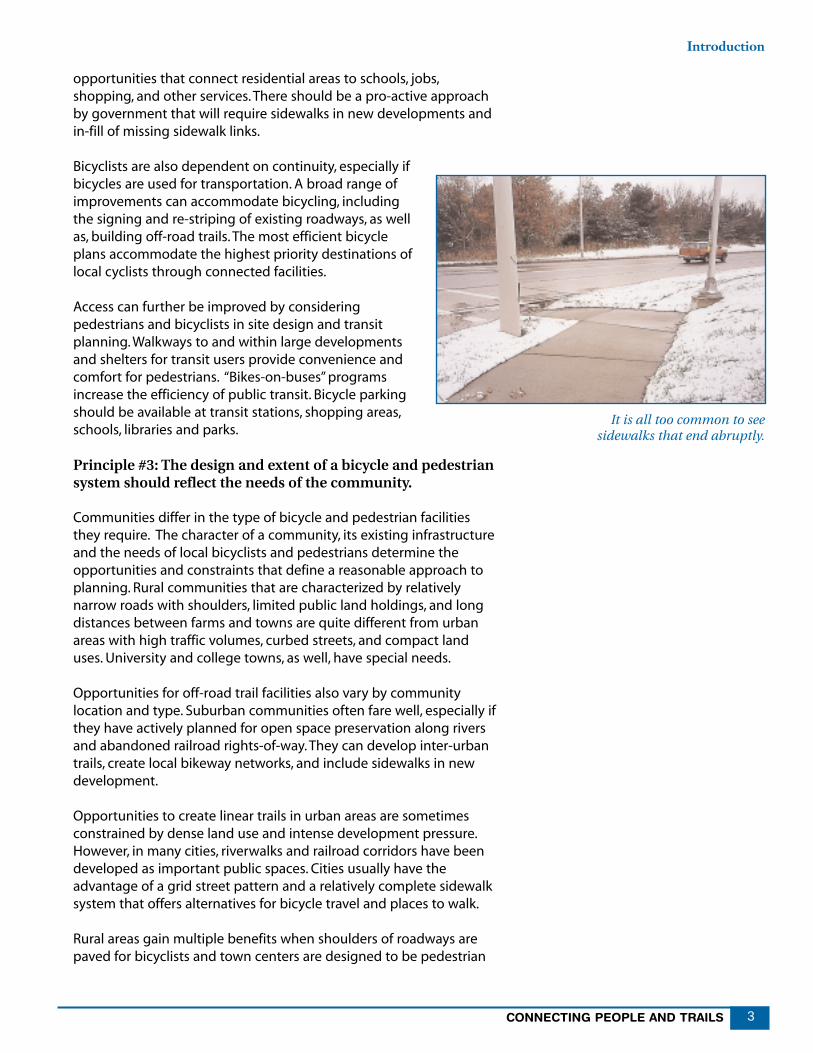
opportunities that connect residential areas to schools, jobs,shopping, and other services. There should be a pro-active approachby government that will require sidewalks in new developments andin-fill of missing sidewalk links.
Bicyclists are also dependent on continuity, especially ifbicycles are used for transportation. A broad range ofimprovements can accommodate bicycling, includingthe signing and re-striping of existing roadways, as wellas, building off-road trails. The most efficient bicycleplans accommodate the highest priority destinations oflocal cyclists through connected facilities.
Access can further be improved by consideringpedestrians and bicyclists in site design and transitplanning. Walkways to and within large developmentsand shelters for transit users provide convenience andcomfort for pedestrians. “Bikes-on-buses” programsincrease the efficiency of public transit. Bicycle parkingshould be available at transit stations, shopping areas,schools, libraries and parks.
Principle #3: The design and extent of a bicycle and pedestriansystem should reflect the needs of the community.
Communities differ in the type of bicycle and pedestrian facilitiesthey require. The character of a community, its existing infrastructureand the needs of local bicyclists and pedestrians determine theopportunities and constraints that define a reasonable approach toplanning. Rural communities that are characterized by relativelynarrow roads with shoulders, limited public land holdings, and longdistances between farms and towns are quite different from urbanareas with high traffic volumes, curbed streets, and compact landuses. University and college towns, as well, have special needs.
Opportunities for off-road trail facilities also vary by communitylocation and type. Suburban communities often fare well, especially ifthey have actively planned for open space preservation along riversand abandoned railroad rights-of-way. They can develop inter-urbantrails, create local bikeway networks, and include sidewalks in newdevelopment.
Opportunities to create linear trails in urban areas are sometimesconstrained by dense land use and intense development pressure.However, in many cities, riverwalks and railroad corridors have beendeveloped as important public spaces. Cities usually have theadvantage of a grid street pattern and a relatively complete sidewalksystem that offers alternatives for bicycle travel and places to walk.
Rural areas gain multiple benefits when shoulders of roadways arepaved for bicyclists and town centers are designed to be pedestrian
It is all too common to seesidewalks that end abruptly.

IOWA DEPARTMENT OF TRANSPORTATION4
Chapter One
friendly. A correlation exists between high levels of bicycling andwalking and the presence of a college or university. Educationalinstitutions should always be included in a community’s non-motorized planning efforts.
Principle #4: A bicycle and pedestrian plan should beimplemented in phases over a reasonable period of time.
The development of a bicycle system network and pedestrian circula-tion system will be determined, in part, by input from the public, theconfiguration of the existing infrastructure and linear corridors, andavailability of funding. It is important to select popular initial projectsthat can be readily implemented. In addition, early projects shouldinclude low cost items that will make a difference to the community.Subsequent projects will include those that require more coordina-tion and a longer funding horizon.
It is advantageous to secure local funding from a variety of sources.Demonstrating that a plan can be executed through a combination ofalready-planned transportation projects, various grant programs andlocal volunteer efforts builds support for allocating needed matchingfunds and accessing local budgets.
Who Should be Involved?Many local, regional, and state agencies can impact trail, bicycle, andpedestrian planning. Included among these agencies are: transporta-tion, public works, and planning departments at the local, county,regional, and State levels; county conservation boards; and the IowaDepartment of Natural Resources (DNR).
It is essential that citizens also become involved in the planningprocess, partly because a strong public voice and vision will greatlyempower local decision-makers. The business community, includingprivate developers and Chambers of Commerce, represent someimpacted constituents. Associations of homeowners and neighbor-hoods can also participate.
Citizen Advisory Committee
In most communities, there are individuals who are especiallyinterested in trails, pedestrian issues, and/or bicycling. These peoplemay be parents, environmentalists, homeowners, members of bicycleclubs, or advocates for the elderly or those with disabilities. Theymight be individuals who simply like to walk and bicycle and whowant to enhance their communities with better recreational andtransportation facilities. The involvement of these individuals in theplanning process should be encouraged. A citizens’ advisorycommittee can help to create consensus, identify issues and needs,and review planning efforts.
It is essential that citizens alsobecome involved in the
planning process, partlybecause a strong public voice
and vision will greatly empowerlocal decision-makers.

CONNECTING PEOPLE AND TRAILS 5
Introduction
Bicycle/Pedestrian CoordinatorMany communities will not hire or appoint a full-time bicycle,pedestrian, and trail planner. However, every community shouldassign one person to coordinate and oversee trail, bicycle, andpedestrian planning projects. Usually, several departments, includingplanning, public works, traffic, police, parks, and schools have reasonto contribute to these efforts. It is extremely helpful to have oneindividual who can coordinate these various internal departments aswell as work with other agencies.
Involved Public Officials
It is imperative that public officials express their support for theplanning process. In smaller communities with minimal staff, publicofficials may provide leadership and fulfill the coordinator’s role. Inmost communities, there will be dissension by someone at some timeto some aspect of a trail, bicycle, or pedestrian plan. Creative and pro-active leadership can diffuse problems that might stall or stopimportant projects.
Finally, it is important to know that technical assistance is available.The Iowa Department of Transportation (DOT) provides technicalassistance through its Transportation Center Planners. The Iowa DOTalso has a Bicycle and Pedestrian Coordinator who can answer manyquestions about planning, design, and funding. Many projects arefunded through the Metropolitan Planning Organizations (MPOs)which, along with the Regional Plan Affiliations (RPAs), also providetechnical assistance. Additional resources include the IowaDepartment of Natural Resources (DNR), the local office of the FederalHighway Administration (FHWA), and the Bicycle and PedestrianClearinghouse, a national source for publications and information.(See Appendix Three for contact information for DistrictTransportation Planners, MPOs/RPAs and other resources.)
The City of Seattle, Washington hasfound that the following entitiesfacilitate the bicycle and pedestrianplanning process:
• A Bicycle/Pedestrian and/orTrail Advisory Committee
• A Bicycle/PedestrianCoordinator
• Committed Citizens and Public Officials
For Information andAssistance Contact:
Your District Transportation Planner(see map and list in Appendix Two) or the
State Bicycle and PedestrianCoordinatorIowa Department of Transportation800 Lincoln WayAmes, IA 50010
Phone: (515) 239-1621

IOWA DEPARTMENT OF TRANSPORTATION6

CONNECTING PEOPLE AND TRAILS 7
CREATING YOUR COMMUNITY BICYCLE AND
PEDESTRIAN PLAN
Iowa’s residents and visitors sometimes travel long distances toexplore regional and state trails and enjoy bicycle touring. Bicyclingand walking however, remain essentially local activities. Most peoplewalk within one-half mile of their homes and bicycle less than twomiles per trip. Local governments are primarily responsible forimplementing most bicycle and pedestrian projects, whether on trails,streets or sidewalks. Regional and state policies and programmingrequirements provide direction and partial funding for manyprojects—but most projects are locally initiated and implemented.
The following steps describe the process for creating a local plan toaccommodate the recreational and transportation needs of bicyclistsand pedestrians while increasing their overall safety and enjoyment.
STEP 1: EVALUATE EXISTING CONDITIONS
The best plans are developed when pre-plan conditions areunderstood and taken into consideration. The time and energyexpended in initial research and public involvement will preventexpensive delays and produce a widely accepted plan. Bicycle andpedestrian planning does not occur in a vacuum and is often severelyconstrained by community conditions. At the same time, there maybe many opportunities to understand the surrounding environmentby studying the demographics and infrastructure of the community.Land use and transportation patterns, the demographics and trippatterns associated with bicycling and walking, traffic accident data,and the planning activities and facilities of adjacent communitiesinfluence a community’s final plan.
Land Use and Transportation
Existing Information Local, regional, and state transportation plans provide informationabout existing land use and transportation conditions. This informa-tion helps community planners to assess areas needing improvement.It is important to consider the following elements when developing aBicycle and Pedestrian plan:
• Roadway Infrastructure:
- interconnected grid or sub-division pattern - traffic counts- pavements and lane widths - travel speeds on area roadways- location of traffic signals - location of existing bikeways
Chapter Two
STEPS TO CREATING A BICYCLEAND PEDESTRIAN PLAN
Step 1: Evaluate Existing Conditions
Step 2: Seek Public Input
Step 3: Planning Considerations
Step 4: Create a Bicycle System Plan
Step 5: Pedestrian System Planning
Step 6: Develop Implementation Plan

IOWA DEPARTMENT OF TRANSPORTATION8
Chapter Two
• Land Use:
- distance to shopping, housing and schools - mixed or separated use patterns- location of sidewalks; what policies relate to their installation- presence of barriers and obstacles, such as major highways,
rivers, railroad yards, factories and warehouses- presence of railroad rights-of-way and rivers that could be
developed as trails
New InformationAdditional studies can be conducted to better understand the landuse and transportation environment. These studies can include:
• Traffic Studies: Speed studies, traffic counts, bicycle and pedestriancounts, and roadway measurements must sometimes beconducted to determine candidate locations for improvements.
• Walking Audit: A subjective assessment of sidewalks and generalpedestrian conditions conducted by such individuals as localofficials, planners, interested adults and children. (See Appendix 4for sample audit form.)
• Sidewalk Inventories: Map existing sidewalks. Note the conditionof walkways, important destinations and gaps in the system.
• Bikability Checklist: The National Highway Traffic SafetyAdministration (NHTSA) is developing a bicycle audit to be usedfor the assessment of bicycle conditions. Even an informal bicycleride through the community can aid planners as they assessbiking conditions.
• Surveys: Additional insights about general conditions can beobtained by formal and informal surveys. For instance, in onecommunity a brief questionnaire in the local paper askedresidents to identify “difficult” intersections. Some of those identi-fied became the focus of prototype pedestrian design alternatives.
Product/Action
Key to developing a successful plan is the identification of elementsthat support or discourage pedestrian and bicycle travel. Sometimes itbecomes clear that destinations are not far apart, but the connectingroadway system is limited to a few heavily traveled arterials thataccommodate neither bicycles nor pedestrians. Land use inventoriesand maps are useful for identifying potential destinations for bicycletravel and priority service areas for pedestrian improvements.Assessments of traffic patterns and the available street infrastructurecan help to identify both problem areas and streets that accommo-date bicyclists or pedestrians fairly well.

CONNECTING PEOPLE AND TRAILS 9
• Develop one or more maps that indicate:
- potential destinations- existing bikeways- trail corridors- known pedestrian activity areas- signalized intersections- traffic data- problem and opportunity areas
• Write a description of the environment summarizing the primarystrengths and opportunities as well as the problems andconstraints in the existing conditions for bicyclists andpedestrians.
Evaluating Users
Bicyclist Skill LevelsWhen planning for bicyclists and pedestrians, design considerationsshould meet the needs of a variety of age and skill levels. The FederalHighway Administration identifies three levels of cycling ability:
Group A: Advanced Bicyclists — These are experienced riderswho can operate under most traffic conditions. They prefer tooperate on the existing street and highway system.
Group B: Basic Bicyclists — These are casual or new adult andteenage riders who are less confident of their ability to operate intraffic without special provisions for bicycles. These riders preferlow-speed, low traffic volume streets or designated bicycle facili-ties.
Group C: Children — These are pre-teen riders whose roadwayuse is monitored by parents. Eventually they are accordedindependent access to the system. They and their parents preferresidential streets with low motor vehicle speed limits andvolumes, sidewalks, and trails.
Local bicycle planning and design should, as much as possible,consider the needs of all three skill groups. However, Group Bbicyclists will be the primary user of most bikeway networks.
Trip PatternsNext to auto travel, walking is America’s most favored travel mode,surpassing bus, rail, taxi and bicycle choices by a 4-to-1 ratio. In largecities (+ 1million) that have rail systems, walking represents more than13 percent of all person trips, as opposed to 7 percent nationwide.
Bicycle travel represents only 1 percent of all trips and the 1990 U.S.Census found that only 0.4 percent of work trips are made by bicycle.In communities with superior accommodations for bicyclists, thepercentage is much higher. For instance, biking to work is 25 percentin Davis, California and 11 percent in Madison, Wisconsin.
Step 1: Evaluate Existing Conditions

The National Bicycling and Walking Study states that there are threeprimary factors that correlate with high levels of bicycle commuting:
• Relatively short work trip distances
• Relatively high ratio of bike lanes to arterials
• Presence of a university
The most common factors that deter bicycling include:
• Concern about traffic safety
• Adverse weather
• Poor roadway conditions
• Trip distances
Factors that encourage bicycling include:
• Safe bicycle lanes
• Financial incentives
• Shower and storage facilities
• Rise in gas prices
Walking trips are correlated with similar factors.Additionally, studies have shown that those who donot have regular access to a car walk more. As agroup, non-drivers include school-age children andthe elderly, college-age students, and those whocannot afford or choose not to own a car.
The Nationwide Personal Transportation Survey(NPTS) finds a correlation between bicycling andwalking and younger age groups as indicated byTable 1.
Bicycle and Walking Trip PurposeIn most studies, bicycling is found to be primarily a recreational activity. Surveys find that between 55percent and 96 percent of respondents describe thepurpose of their bicycling as recreational. However,many people (from 7 percent to 65 percent in varioussurveys), say that they also use bicycles forwork/school/utility trips. The 1995 NTPS summarizesbicycle and walking trip purposes as shown in Table 2.
TABLE 1Bicycling and Walking Trips by Age Group (NPTS, 1995)
Age Group Percent Walking Percent BicyclingTrips Trips
16 & under 10% 3.5%
24 & under 8% 2.2%
25-59 4% <1%
60 & over 5% <1%
IOWA DEPARTMENT OF TRANSPORTATION10
Chapter Two
The National Bicycling andWalking Study concludes that,“…if bicycling facilities are designed toallay safety concerns and are linkedin such a way that access matchesthe access motorists have come toexpect, then utilitarian bicyclingwill increase.”
TABLE 2Bicycling and Walking Trips by Purpose (NPTS, 1995)
Trip Purpose Bicycling Walking
Work 9% 9%
School/Church 9% 15%
Shopping/Personal 22% 42%
Social/Recreational 60% 34%

Trip Purpose on TrailsIt is commonly assumed that trails are used mostly for recreationalpurposes. A study of suburban trails in northeastern Illinois revealedsome surprising results. Sixty-six percent of bicyclists and 54 percentof pedestrians were using the trails for other than recreationalpurposes. Twenty-five percent of the respondents indicated that theyhad chosen to use the trail instead of driving to their destination.
Product/Action
Information on the demographics and trip making patterns associ-ated with bicycling and walking can help planners develop realisticgoals. For instance, college towns have a higher potential level ofbicycle use. Communities with public transit might have higher levelsof walking.
MPOs and RPAs can assist local governments with access to CensusTravel to Work data for percentages of walking and bicycling trips towork in the region. They can also provide average work trip lengthdata. This data can offer some insight into local patterns. However,Census data is not a definitive measure of non-motorized trip making.Work travel accounts for only 20 percent of all trips and just 9 percentof bicycling and walking trips and Census data applies only to tripstaken in late March. Some regional agencies might have producedadditional travel studies that would offer insights into local travelpatterns.
• If data is available, produce a summary of local travel patternsincluding any available information about bicycle andpedestrian trip making and average trip length for all modes.
Analyzing Crashes
The National Highway Traffic Safety Administration, (NHTSA)maintains detailed statistics on traffic deaths and injuries. Apedestrian or bicyclist is killed or injured by a motor vehicle every 4minutes. Pedestrian and bicyclist fatalities have decreased between1987 and 1997, by 21 percent (pedestrians); and 14 percent(bicyclists), respectively. National statistics and trends offer insightinto general patterns and offer a point of comparison for localinformation.
Trends would indicate walking and bicycling are getting safer. It isalso possible that people are walking and bicycling less. To the extentthat national trip data captures non-motorized travel, it appears thatbicycling is increasing somewhat and walking is decreasing.
The good news is that there is a general downward trend in trafficfatalities and this trend seems to be applying to pedestrians andbicyclists as well as motorists. The bad news is that certain people,especially children, might be walking and bicycling less than theyonce did, and this might be partly due to significant injuries and
CONNECTING PEOPLE AND TRAILS 11
Step 1: Evaluate Existing Conditions
Although children seem to bebicycling and walking less, theyremain vulnerable to death and injuryin traffic:
– Bicyclists under age 16 accountedfor 31 percent of fatalities and 43percent of injuries in traffic crashes.
– More than one-fourth of childrenwho were killed in traffic accidentswere pedestrians.
The National Highway Traffic SafetyAdministration is sponsoring researchto refine development of bicycle/pedestrian crash analysis software foruse by local governments.
Contact: Marv Levy, NHTSA,[email protected].

deaths associated with these activities.
Additional insight from national bicycle and pedestrian crash analysisinclude the facts that:
• Most bicyclist and pedestrian fatalities occurred in urban areas, atnon-intersection locations, and in the evening and night time hours.
• Males greatly outnumber females as bicyclist (76 percent) andpedestrian (68 percent) fatalities.
• Alcohol involvement – either for the driver or the victim – wasreported in one-third of the traffic crashes that resulted inbicyclist fatalities and in 45 percent of the pedestrian fatalities.
Product/Action
National data can serve as a point of comparison as communities lookat their own crashes. Not enough is known about non-motorized tripmaking to draw definitive conclusions about declines or increases inactual crash rates in relationship to exposure. However, it is possible todo at least three exercises to determine the relative severity of theproblem on the local level.
• Plot all known bicycle/pedestrian crashes on a map; notelocations and check for clustering of accidents at particularlocations or types of location.
• Determine a rate of bicycle and pedestrian crashes in relationship topopulation; compare this rate with the national and state rate.
• Examine police reports and record accidents according to thecategories established by the FHWA to see if patterns of accidenttype emerge.
Area Attractions and Planning Efforts
As communities begin their planning process, it is important toconsider destinations and attractions beyond local borders. Somereasons for such considerations can be:
• A community may want to connect with an existing or potentialstate, regional or adjacent community trail, sidewalk or bikewaysystem.
• A state park, or some other important destination, might bewithin biking distance from town.
Product/Action
Connecting to these other amenities will be important to localresidents and require a planning effort that reaches beyond the localjurisdiction.
• Map nearby trails and attractions.
• Note points of connection to neighboring pedestrian andbicycle facilities.
• Document any agreements between communities that mightimpact local planning efforts.
IOWA DEPARTMENT OF TRANSPORTATION12
Chapter Two
The primary factors causing bicyclefatalities are:– Failure to yield right-of-way: 21.2%
– Riding, working, playing, etc inroadway: 17.3%
– Improper crossing of roadway orintersection: 15.1%
– No factor reported: 27.9%
The primary factors causingpedestrian fatalities are:– Walking, working, playing in the
roadway: 30.5%
– Improper crossing of roadway orintersection: 30.5%
– Darting or running into theroadway, 14.7%
– Failure to yield right-of-way: 13.0%
– No factor reported: 23.3%

CONNECTING PEOPLE AND TRAILS 13
STEP 2: SEEK PUBLIC INPUT
Public involvement in bicycle and pedestrian planning is essentialand works best when the community is involved from the beginning.Bicycle and pedestrian facilities can rarely be implemented to meet allof a community’s needs. Choices must be made that prioritize invest-ment and citizen involvement is essential to determine what prioritiesshould be served.
Identify Interested Citizens
The environment for walking and bicycling affects many individualsand interest groups. Organizations representing the interests ofbicyclists, walkers, trail users, the elderly, the disabled, parents andschools, youth, retail services, business organizations, farmers, and thedevelopment community are all potential participants. Failure toinvolve interested groups can result in opposition that can crippleprogress. Furthermore, many individual citizens have developedpassionate and well-articulated views about the needs of pedestriansand bicyclists. An efficient process can channel this energy andincorporate the attitudes and needs of interested individuals.
Citizen Advisory CommitteeFrequently, a group of interested citizens is invited to join representa-tive local staff to form a Plan Advisory Committee. This format isvaluable because issues can be raised and citizens have the chance toinfluence plan development. Larger communities may form aTechnical Advisory Committee as well, drawing on expertise fromother agencies. This is a practical option for complex planningprocesses that require inter-governmental coordination and complexgrant applications.
A Plan Advisory Committee can become a standingBicycle/Pedestrian Advisory Committee that provides continuingpublic involvement and support. In Seattle, Washington, a citizenbased B/P Advisory Committee regularly reviews all City projects thatmight have an impact on bicyclists and pedestrians. This citizens’group is recognized as a primary factor in Seattle’s successful bicycleand pedestrian program.
Product/Action
• Identify participant organizations in and around the community.
• Establish a Plan Advisory Committee of citizens and profes-sionals.
• For complex plans, establish a Technical Advisory Committee ofprofessionals.
• Establish a standing citizen-based Bicycle/Pedestrian AdvisoryCommittee.
Step 2: Seek Public Input
STEPS TO CREATING A BICYCLEAND PEDESTRIAN PLAN
Step 1: Evaluate Existing Conditions
Step 2: Seek Public Input
Step 3: Planning Considerations
Step 4: Create a Bicycle System Plan
Step 5: Pedestrian System Planning
Step 6: Develop Implementation Plan

IOWA DEPARTMENT OF TRANSPORTATION14
Public Participation
There are generally two phases during which participation by thepublic is solicited. In the planning phase, citizens join professionals toidentify needs and define the network of facilities. During the reviewphase, the public attends meetings to comment on the plan at itsvarious stages of development.
Open Meetings vs. Invited WorkshopsThe complexity of each phase depends on the dynamics of thecommunity. In small communities, both phases might involve publicmeetings. Larger communities might choose to conduct one or moreplanning workshops to which specific professionals and members ofthe public are invited.“Invited” workshops represent a concertedeffort to involve representatives of each interest group. There areseveral models for such workshops.
• At a charette, small groups develop and present toeach other a network proposal for some or all of thearea under consideration.
• The community of Kalamazoo, Michigan held a verysuccessful “Kids’ Planning Charrette.” Fifth gradechildren participated in activities intended to clarifyhow they experienced the pedestrian and bicycleconditions in their neighborhoods and around theirschool. Besides having fun, the children were frank,observant, and articulate about conditions that are notalways perceived by adults.
• Invited workshops bring professionals and citizenstogether to share information on topics ranging fromregional trail planning to bicycle/pedestrian safetyinitiatives.
• Pedestrian Roadshows make use of federallydeveloped materials, along with information aboutlocal conditions, to inspire public officials and citizensto improve the pedestrian environment.
Plan PresentationsPlan presentations can occur at special plan-specific meetings or atregularly scheduled city council meetings. A special meeting set upsolely for the presentation of the draft plan tends to generate moreinformal exchanges between participant and presenters. This can bevaluable, especially early in the process, when important issues oromissions can be addressed. It can also identify opposition to anyelements of the plan at an early stage when dialogue with plannersand public officials can generate constructive responses. One or moreadditional presentations or hearings will present the final draft plan tothe public and to officials for adoption.
Chapter Two
Bicycle Planning “Charrette"

Addressing OppositionAs popular as trails can be, many have also generated vocal andpersistent opposition during planning. In some cases, such asMissouri’s Katy Trail and Iowa’s Cedar Valley Nature Trail, this opposi-tion seriously threatened project implementation. A pro-active publicparticipation process offers the best chance to address oppositionfrom the beginning. It is important to communicate with concernedindividuals and groups, who frequently are those with propertyadjacent to a trail corridor. However, even a proposal to installsidewalks can stimulate debate in some communities. Officials canhelp to deter public efforts to derail projects by being good listenersand having alternatives available, if necessary.
Product/Action
• Hold planning meetings to solicit citizen and professionalinvolvement in plan development.
• Hold at least two plan review opportunities, one for the draftplan and a second on final plan recommendations.
• Reach out pro-actively to work with potential opposition.
Communications
It is always practical to approach interested citizens even before theformal planning process begins. A letter or call to inform people ofthe upcoming plan development will yield more responsive involve-ment. Communication about the plan through special meetings,newsletters, websites, and articles in local newspapers can generatesupport while keeping interested parties informed.
Participants should be informed about upcoming projects and eventsso they have time to place notices in newsletters. This is a veryeffective communication tool. Because not all interested individualsare members of organizations, use of multi-media and municipalmailings is also useful. A project newsletter published several timesduring the planning process can be a useful progress report. It can bedistributed to organizations, individuals, and the media throughmailings and website postings.
Product/Action
• Give participating organizations early notice of upcoming plandevelopment and events/meetings.
• Develop and distribute a regular newsletter about the planningprocess.
• Develop regular media contacts.
• Promote media coverage of all special planning events such asaudits or “Kids’ Planning Charrettes.”
CONNECTING PEOPLE AND TRAILS 15
Step 2: Seek Public Input
Pedestrian Roadshows can be madeavailable to communities by trainedfacilitators who work with localplanners and officials to organize aworkshop and walking audit toexamine pedestrian conditions.
Information is available on theinternet at:http://safety.fhwa.dot.gov/walk
Contact: Leverson Boodlal,[email protected]

IOWA DEPARTMENT OF TRANSPORTATION16
STEP 3: PLANNING CONSIDERATIONS
Bicycle and pedestrian planning should be understood in the largercontext of state, regional, and local planning. These other planningefforts create opportunities to expand the impact of local facilityplanning. Local systems should connect to the State Trail System.Additional opportunities to address non-motorized travel exist inland-use and site planning, as well, and through roadway design andtraffic operations. Some community types have special needs andadvantages as they consider bicycle and pedestrian planning. InIowa, this is especially true of rural and college towns.
Connecting to the State Trails System
The State of Iowa has developed a plan for a statewide system oftrails. Additionally, several regional agencies and many localcommunities have planned and constructed trails. These facilitiesprovide an inter-urban armature of relatively long distance trails. Theyserve a regional population and connect destinations of broadinterest to Iowans and visitors. People often travel to these trails; infact, the trail itself can be a destination.
In contrast to state trails, local systems include trails, bikeways, andwalkways that provide access between a community and the statesystem; provide safe and convenient facilities for bicyclists andpedestrians at the local level; reflect the community style; and,respond to the needs of its citizens.
Trails and Roadways for Non-motorizedTransportation and Touring
Accommodations for bicyclists and pedestrians are made in twocontexts:
• Independent multi-use trails
• Roadway-based facilities
Pedestrians and bicyclists want to go to most of the destinations thatare accessed by cars. Even very extensive trail systems cannot serveall of these destinations. Inevitably, the road right-of-way, consistingof traffic lanes, shoulders, intersections, parkways and sidewalks servesas the primary planning area for bicycle and pedestrian accommoda-tions. Bicycle travel can be greatly enhanced by roadway improve-ments, including various strategies to reduce hazards and createbikeways.
It is in the interests of local governments to participate in developingState and regional trails. Economic benefits are detailed in the Iowa
Chapter Two
STEPS TO CREATING A BICYCLEAND PEDESTRIAN PLAN
Step 1: Evaluate Existing Conditions
Step 2: Seek Public Input
Step 3: Planning Considerations
Step 4: Create a Bicycle System Plan
Step 5: Pedestrian System Planning
Step 6: Develop Implementation Plan

CONNECTING PEOPLE AND TRAILS 17
Trails 2000 handbook,“Implementing Trail-Based EconomicDevelopment Programs.” Local participation in projects thatcomplete the State system offers residents trail opportunities close tohome and creates a facility that will stimulate additional interest inbicycle and pedestrian planning. Local communities should connectneighborhoods to the trail through a local system of facilities. Most ofthese facilities will make use of the existing roads. Roads can bemade considerably safer for bicyclists and pedestrians through themeasures recommended in this handbook. Access to the Statesystem can be further enhanced by the use of signs to guide peopleto trails.
Product/Action
• Include, as priority projects in local bicycle/pedestrian planning,any portions or connections to the State and regional trailsystem that travel through the community.
• Follow the “Trail Design Guidelines,” developed for Iowa Trails2000, as well as the “Design Considerations” summarized inChapter Three below.
• Include and sign connections from the local community to thestate trail.
Land-Use and Site Design
Community Layout Land use patterns are notoriously difficult to influence. Yet, theproximity of development and potential for access between destina-tions is a primary factor in walking and bicycling patterns. Researchshows that areas with higher densities and mixed use developmentare more conducive to walking. In many lower density suburbanenvironments, however, bicycling is often discouraged by obstaclessuch as busy streets without bicycle accommodations andinadequate crossing opportunities.
Site AccessBoth the basic development pattern and the design of individual sitescan encourage or discourage bicycling and walking. For example,large parking lots in the front of buildings, berms that discourageeasy access, and blank walls are intimidating. However, interestingfacades and buildings that face the street and are closer to sidewalkscreate a more pedestrian “friendly” environment. Parking for carsshould either be provided on the street or behind the development.Parking for bikes should also be provided in a protected location andclose to the building to encourage non-motorized access.
Transit ConnectionsWalkways should connect to loading areas from nearby destinations.Bus stops are frequently located in muddy locations without sidewalkconnections, that discourages transit usage. Bicycle parking should beavailable at all fixed rail service stations, bus service hubs, and express
Step 3: Planning Considerations
Many Transit Agencies are adding busracks to buses.Source: Sportworks NW, Inc.

IOWA DEPARTMENT OF TRANSPORTATION18
stops. In many cities, bicycles are accommodated on transit vehicles.Loading the bicycle onto a rack on the bus or into a transit carcombines the flexibility of the bicycle with the efficiency of transit forlonger distances.
Product/Action
The following land-use planning tools are recommended to positivelyimpact walking and bicycling:
• Encourage in-fill development.
• Provide connections between adjacent developments through acomprehensive network of local streets and/or a series of non-motorized paths.
• Allow back access to retail areas from bordering residentialneighborhoods to shorten trip distances for those on foot orbike.
• Design pedestrian connections and adequate crossing opportu-nities between adjacent areas of strip development and acrossbusy streets that border those developments.
• Require sidewalks in conjunction with development, includingappropriate sections of the public right-of-way and privateaccess to buildings.
Roadway Design and Traffic Operations
Roadway Design IssuesPedestrians and bicyclists encounter many problems on the roads,such as high speeds, high volumes, extremely wide intersections thatare difficult to cross, and lack appropriate facilities. Federal policysupports the consideration of non-motorized needs on all federallyfunded roadways. The state of Iowa has recently adopted a new,“Bicycle and Pedestrian Accommodation Guidance,” which will beapplied to state roadways primarily at the time of roadway construc-tion or re-construction. The focus of this guidance is the provision ofbicycle accommodations within highway right-of-way where the needis demonstrated. (See Appendix Three for a copy of this guidance.)
Speed and Its ImpactAccording to research conducted in Germany, the impact of speed onthe severity of pedestrian and bicycle crashes is dramatic. In crasheswhere the vehicle is traveling at 20 mph, fewer than 5 percent ofpedestrians are killed; at vehicle impact speeds of 30 mph, close to 40percent of pedestrians struck have died; and, at 45 mph, more than 80percent are killed.
Based largely on this and other studies of the impact of speed in thetraffic mix, many European countries are implementing policies tomaintain very low speeds in congested pedestrian areas and residen-tial neighborhoods. The results of a program in Graz, Austria, after oneyear, show:
Chapter Two
On February 28,2000 FHWAAdministrator Kenneth Wykle signedoff on a new U.S.DOT policy,Accommodating Bicycle andPedestrian Travel: A RecommendedApproach. The key principle of thispolicy is that bicycling and walkingfacilities will be incorporated in alltransportation projects, unless circum-stances that preclude incorporationare demonstrated.
For information:www.fhwa.dot.gov/environment/bikeped/Design.htm

CONNECTING PEOPLE AND TRAILS 19
• Serious traffic related injuries were reduced by 24 percent.
• Median speeds were not significantly reduced citywide andtraffic flow was more homogenous.
• Traffic behavior improved, especially that of motorists towardpedestrians.
• Noise levels have been reduced.
Traffic CalmingTraffic calming is the term used to describe a variety of techniquesthat slow or constrain traffic so that pedestrians, bicyclists, and motorvehicles share the road on more equal terms. Traffic calmingmeasures are most often used on residential or central businessdistrict streets where increasing pedestrian access and safety isdesirable. In Seattle, where such measures have been introduced inmany neighborhoods, studies have found significant reductions inmotor vehicle speeds, the number and severity of accidents, and airpollution.
Traffic calming introduces variety to street design. A related trend isthe introduction of more flexible street design standards, especially inresidential development. The use of national standards for the designand dimensions of residential streets has resulted in excessively wideand monotonous streets that encourage speeding and discouragepedestrians. Some communities are finding that they want to reclaimstreet space for multiple uses, including play space for children and asafer, more interesting environment for pedestrians and bicyclists. Atrend toward “skinny streets” in residential areas is intended to createa more intimate, attractive, people friendly environment.
Properly designed and implemented traffic calming measures:
• Slow and/or divert traffic
• Reduce traffic accidents
• Reduce pollution
• Increase the safety and pleasure of walking and bicycling
• Provide opportunities for street “greeting”
• Improve the visual appeal of neighborhoods
• Provide opportunities for the shared use of streets as publicspace
Step 3: Planning Considerations
Probability of a Pedestrian Fatality in a Traffic Accident.
5% at 20 mph
37% at 30 mph
83% at 45 mph
0% 10% 20% 30% 40% 50% 60% 70% 80% 90% 100%

IOWA DEPARTMENT OF TRANSPORTATION20
Communities should consider the impact of roadway projects andwhenever possible, incorporate designs that accommodate andencourage bicycle and pedestrian travel.
Product/Action
• Adopt a local policy to consider bicycle and pedestrian needs inall roadway projects.
• Conduct speed studies in several neighborhoods to get a senseof where problems might exist.
• Consider the implementation of traffic calming installations inneighborhoods with speeding concerns.
• Suggest some traffic calming installations if a neighborhood hasa speeding problem and the residents are opposed to the instal-lation of sidewalks.
• Reduce speed limits and constrain traffic, as needed, to increasethe safety of bicyclists and pedestrians.
Community Design Considerations
Some environments require special consideration of the needs ofbicyclists and pedestrians.
Rural CommunitiesThe small populations and sparse development patterns of Iowa’smany rural communities create a different demand and need forbicycle and pedestrian accommodations. Rural areas attract bicyclists,but have limited facilities for them. The land-use patterns consist ofsmall towns and farmland with large tracts of state park land. Roadsare primarily two-lane state or county highways with no shoulders.Most people live in large lot, single-family housing except those “intown” where housing is more dense.
Rural DowntownsIowa’s rural crossroads communities have a unique charm.Unfortunately, the highways that form the major street axes for thesecommunities often present difficult conditions for bicyclists andpedestrians. In some communities, a large amount of through traffictraverses “downtown” and it can include potentially hazardous trucktraffic. Sidewalks and on-road bicycle facilities are needed to servelocal residents and touring cyclists.
It may be necessary to reduce the speed of through traffic withinthese communities. One method used in rural communities in GreatBritain is to construct an “entrance” to the community with a shortspan of brick pavers and a special warning sign that asks motorists toslow their speed and watch for pedestrians and cyclists.
Chapter Two
Mass rides like Iowa’s RAGBRAI visitmany small towns.Source: Main Street Iowa

CONNECTING PEOPLE AND TRAILS 21
Rural Recreational Touring Routes Bicycle touring has become a popular vacation and short-triprecreation activity throughout America. Some rural Iowa countieshave already begun to develop bicycle route networks to servetouring cyclists. Bicycle touring routes should guide cyclists to scenicand suitable backroads. Paved shoulders are preferable for ruralbicycle routes. Touring routes should avoid roads that are excessivelydangerous for cyclists, such as those with very high traffic speeds andsharp turns.
Several route options can be provided for touring cyclists:
• Looped routes of 16 to 64 kilometers (10 to 40 miles) in circumfer-ence can traverse scenic areas and points of interest.
• Long distance touring routes should connect to adjacent counties.The interconnected network should enable a cyclist to crossthrough the state in a direct manner.
Touring routes should be linked to the internal bicycle network inurban areas and small towns. It is essential to develop a bicycle mapand clear signing for established touring routes. Maps can identifypoints of interest such as parks, historic sites, small communities, icecream shops, bed and breakfast inns, etc.
Product/Action
• Install sidewalks in downtown areas, if lacking.
• Work with state and county to get roadway shoulders paved.
• Work with county and other local governments to create routesand maps and to install signs.
• Design and manage the rural highway system to allow shareduse by bicyclists and pedestrians - generally on paved shoulders.
• Increase tourism and recreational opportunities through preser-vation of rural character and bicycle/pedestrian friendlyhighways.
• Promote safe walking and bicycling through education ofmotorists, bicyclists, and pedestrians - “Share the Road” signsshould be used on preferred routes.
• Maintain rural paved shoulders.
College TownsCollege towns are typically those in which development has beenstrongly influenced by the presence of a college or university. There isusually a central destination for work, school, and shopping, thoughthe population in these towns fluctuates in response to the universityor college calendar.
Step 3: Planning Considerations

IOWA DEPARTMENT OF TRANSPORTATION22
DemographicsIowa college towns are associated with a young, educated population.The colleges tend to attract a higher income and more diversepopulation due to the cultural and other amenities available at theschools. The demographics of these communities suggest that thereis a low level of car ownership and a high percentage of walkers andcyclists.
Journey to Work Census information shows that typical college townshave some of the highest percentages of workers who commute bybiking or walking. Along with the high level of social acceptance, thedensity of the campus setting is conducive to walking and cycling.Students are usually young, live close to campus, and often lack othermeans of transportation. The National Bicycle and Walking Studyresearched levels of bicycle commuting in 20 cities across the country.The report concludes that,“the most significant variable appears to bethe dominating presence of a university. These cities have consider-ably higher rates of bicycling than other cities. In fact, no other factorcorrelates so consistently with high levels of bicycle commuting.”
College campuses often generate mixed-use, densely populatedcommunities. Student apartments close to campus are filled tocapacity and nearby business districts are supported by students whoarrive on foot and by bicycle.
Connection to CampusClear and direct on-road bicycle facilities should provide suitableroutes for students between home, campus, and other destinations.Reduced automobile traffic on congested streets surrounding thecampus could increase opportunities for bicycling and walking.
On-campus Bicycling Many universities across the country have implemented successfulon-campus bicycle systems, including the University of California atDavis, University of Wisconsin at Madison, the University of Coloradoat Boulder, and Cornell University in Ithaca, New York. Campus cyclistsmust operate in a complex network of interconnecting pathways,sidewalks, and roadways. They are often viewed as reckless as theytravel between these environments. Good planning and design canreduce conflicts.
University transportation engineers have developed organized spacesfor bicycles on campus. They have established “bicycle dismountzones” on pathways where bicycle and pedestrian traffic are inconflict; clearly marked transition areas between campus pathwaysystems and on-road bikeways; and educational programs for cyclistsand motorists.
Chapter Two

Bicycle Racks in University AreasBicycle parking on university campuses is a key issue. If racks are notprovided, riders lock their bicycles to any stationary object near theirdestination. Bicycles locked to stair railings at entrances can create ahazard by impeding emergency access to buildings. Furthermore,poorly designed and badly located bicycle racks leave riders nochoice but to attach their bicycles to trees, benches, and railings.
The first step in providing adequate bicycle parking is to inventorylegally and illegally parked bicycles at locations throughout campus.This should provide a general idea of the number of new parkingspaces needed (see Appendix One for Bicycle Parking guidance).
Periodic reviews of campus bicycle parking facilities should beconducted to identify maintenance needs and areas where morebicycle racks are needed.
Product/Action
• Work with the college to make the campus, major buildings, andother facilities of universities and educational institutions fullyaccessible to pedestrians and bicyclists, within a radius of at leastthree miles.
• To improve safety, extend pedestrian route networks, shortenexisting pedestrian routes, and increase advantages of walking.
• Orient transportation systems in college and university townstowards the movement of people instead of vehicles to, from,and within campuses.
• Decrease the need for valuable parking spaces by increasing thedevelopment of bikeways, walkways, and secure bicycle parkingfacilities.
• Use traffic calming techniques to make the bicycle andpedestrian environment more appealing.
• Legitimize walking and bicycling through education ofmotorists, bicyclists, and pedestrians.
CONNECTING PEOPLE AND TRAILS 23
Step 3: Planning Considerations

IOWA DEPARTMENT OF TRANSPORTATION24
STEP 4: CREATE A BICYCLE SYSTEM PLAN
Bicyclists want access to most of the same places as motorists, andthey can legally use any roads from which they are not officiallybanned. Many roads are useable for local bicycling but others areundesirable because of such factors as excessive traffic and highspeeds. Bicyclists have varying levels of comfort in traffic, dependingon skill levels and aversion to risk. The average adult bicyclist isuncomfortable in heavy, fast traffic and prefers an improveddesignated bicycle facility system.
A bicycle facility network is a continuous, connected system of trailsand on-road bikeways that accommodates the needs of the averagecyclist safely and conveniently. This network offers informationthrough signs and pavement markings, and special facilities asneeded. The following six criteria should be considered in thedevelopment of a bicycle network plan.
Bicycle Network Criteria
Directness - A bicycle network plan should provide the mostdirect routes to major destinations.
Continuity - A continuous, connected system of bicycle facilitiesshould serve major destinations. If there is a significant break ina proposed route, that route should be left off the designatedsystem until the gap can be connected or bridged.
Safety - Where a choice exists, bikeways should be designated onstreets with less traffic and lower speeds. When travel speeds arehigh and traffic is heavy, on-street bicycle lanes or side-pathfacilities may be considered. When a bikeway crosses a majorarterial road, a stop sign or traffic signal should control thecrossing traffic.
Comfort - Comfort for a cyclist includes the safety of smoothpavements and light traffic, as well as intangible pleasures liketree-shaded streets, pleasant neighborhoods, and interestingviews. On streets with significant traffic, bike lanes increase thecomfort of average riders.
Access to Destinations - It is essential to provide routes that leadto major destinations, and to make specific destinations bicycleaccessible. Access routes that do not require traveling throughparking lots, and conveniently located, well-designed bike racks
Chapter Two
STEPS TO CREATING A BICYCLEAND PEDESTRIAN PLAN
Step 1: Evaluate Existing Conditions
Step 2: Seek Public Input
Step 3: Planning Considerations
Step 4: Create a Bicycle System Plan
Step 5: Pedestrian System Planning
Step 6: Develop Implementation Plan

CONNECTING PEOPLE AND TRAILS 25
contribute to improved access.
Timely Implementation - A bicycle network plan is only as goodas the possibility of its being implemented. Many significantimprovements are low cost and others can be accomplished aspart of already planned street and bridge projects. Prioritizingprojects, developing alternatives for controversial proposals, andusing funding efficiently will assure timely implementation.
Planning for bicycle transportation has much in common withplanning for other modes. A network of facilities that meets demandsfor circulation and access is required. The process of planning thisnetwork requires the identification of priority destinations andconnecting corridors, the evaluation of alternatives, and the program-ming of projects.
Priority Destinations
When developing a facility network, it is important to identify prioritydestinations, which can include:
• Existing trails, parks, and recreational facilities
• Central business districts
• Shopping areas
• Schools and universities
• Community centers
• Public services, including libraries and post offices
• Employment centers
The public participation process will identify additional destinations.In addition to priority destinations, participants can be asked toidentify:
• Favored routes
• Hazardous or difficult intersections
• Obstacles (e.g. high-volume bridges without sidewalks or bikelanes and freeways)
• Corridors considered to have trail potential
• Priority bicycle parking locations
Corridor Connections
Corridor connections are the obvious connections through the
Step 4: Create A Bicycle System Plan
BICYCLE NETWORK
PLANNING PROCESS
PRIORITY
DESTINATIONS
CORRIDOR
CONNECTIONS
ALTERNATIVE
EVALUATION
DRAFT PROGRAM

community between residential areas and priority destinations.By connecting priority destinations along available roadway and trailcorridors, it is possible to generate bicycle “desire lines.” Corridors thatconnect destinations can be identified, and along with trail potentials,will form the basis of the initial network. There might be just one orseveral roads within each corridor. By applying the network criteria,and evaluating roads for their bicycle compatibility, planners canidentify bicycle network candidate roads. Trail opportunities mustalso be evaluated. While many trail opportunities can accommodatemulti-use paths, some are suitable for walking only or will bedesignated for incompatible motorized uses.
Product/Action
• Map that illustrates potential trail opportunities; priority destina-tions;“desire line” corridors; and, hazards and obstacles, asknown.
• If possible, conduct these mapping exercises during or after aplanning “charrette.”
Alternative Evaluation
Alternative evaluation determines which street and trail opportunitiesare most suitable for bicycle travel. Steps to consider when evaluatingtrail opportunities include:
Evaluating Trail OpportunitiesOpportunities for trail development exist within many types of linearcorridors. Some of the most desirable corridors are abandonedrailroads. Operating railroads with wide rights-of-way also sometimesshare the corridor with a trail. Assess the status of area railroadcorridors:
• Are any abandonments planned?
• Are extra wide rights-of-way on operating railroad alignmentsavailable that might accommodate a “trail with rail” facility?
• What is the ownership status of already abandoned railroads?
Additional trail opportunities exist along waterways, highways andwithin utility rights-of-way. Assess other corridors:
• Do canals, rivers or existing greenways offer trail opportunities?
• Are substantial riparian corridors publicly owned?
• Do neighboring communities or other public agencies ownportions of corridors to which your community might connect?
• Might public easements be granted along desirable utilitycorridors?
• Do highway rights-of-way offer adequate width for a trail thatwould serve identified priority destinations?
IOWA DEPARTMENT OF TRANSPORTATION26
Chapter Two

CONNECTING PEOPLE AND TRAILS 27
Evaluating Roadway OpportunitiesWhile bicyclists have legitimate access to most roads, some roads are definitelypreferable to others. Research indicates that the primary conditions that impactthe bicycle compatibility of roads are:
• Roadway widths
• Traffic volumes
• Traffic speeds
Roadway width, the single most important factor, is modified by:
• The presence of a parking lane.
• The presence and usable width of a paved shoulder.
Other conditions impact bicycle traffic, too, and can be incorporated to varyingdegrees in the evaluation of roads. Surface condition, traffic controls, trucktraffic, parking turnover, right-turning vehicle volume, and adjacent land-use, allinfluence bicycling.
Bicyclists are given adequate operating space on roadways in one of two ways:
• A shared lane of adequate width to allow the safe operation of a bicycleand motor vehicle.
• An exclusive bicycle lane.
The width required for sharing a traffic lane with cars is proportional toautomobile speeds. On low-speed narrow residential streets, bicycles and carsmove at similar speeds. As speeds increase, the requirements for road widthsincrease to allow for safe operating distances between bicycles and motorvehicles.
The FHWA publication, Selecting Roadway Design Treatments to AccommodateBicycles, (see Design References, Appendix One), offers suggested widths forvarious types of shared roadways. Generally, a lane width of from 12 to 15 feet isconsidered adequate for shared use by bicyclists and motorists in most trafficconditions. The provision of bicycle lanes requires from 4 to 5 feet of space pertravel direction. If a road requires 12-foot travel lanes, 8-foot parking lanes, and 5-foot bicycle lanes, a roadway width of 50 to 52 feet would be required to handletwo-way traffic with parking.
Step 4: Create A Bicycle System Plan
Space Requirements for Standard Roadway, Parking and Bike Lane WidthsSource: Pinsof and Musser, Bicycle Facility Planning, Amercian Planning Association, 1995

However, localities throughout the United States have incorporatedthese needs into varying configurations. For instance, in the City ofChicago, a combined bicycle/parking lane of 11 to 12 feet is pairedwith a travel lane of 10 to 11 feet on some streets. This allows 44-footwide streets (a fairly common width in Chicago), to provide bicyclelanes. Lane widths of less than 12 feet are gaining acceptance wheretraffic moves relatively slowly, as on busy city streets, and where it isfairly light, as on residential streets.
Product/Action
Once basic information is known, roadway evaluation can beapproached several ways. An informal evaluation works well whenplanners and traffic engineers are familiar with local roads. Thisapproach involves the following steps:
• Examine traffic data and roadway dimensions for the roads thatconnect priority destinations.
• Note location of traffic controls at arterial crossing locations.
• Determine which roads might be candidates for bikewaytreatments, using design considerations and references assummarized in Chapter Three.
• Based upon priority destinations, locate bicycle parkingrecommendations.
Bicycle Compatibility IndexIn recent years, several research teams have worked to standardizemethods to assess the bicycle compatibility of roads. These method-ologies rely on formulas to assign a number that represents relativebicycle compatibility to segments of the road. These formulas have, tovarying degrees, been correlated with bicyclists’ experience ofcomfort and safety. The “Bicycle Compatibility Index (BCI)” is underdevelopment by a team of researchers under FHWA sponsorship. Itassigns values to several factors, including:
• Curb lane width and volume
• Traffic speeds in the 85th percentile
• Type of roadside development
• Presence of a parking lane, a bicycle lane, or paved shoulder.
The BCI adjusts for the presence of trucks, parking turnover, andnumber of right turns. Once the compatibility factor is determined,alternative scenarios can be tested. For instance, a road with poorcompatibility can be redesigned to provide a bicycle lane or otherimprovements that would improve its BCI score.
The trail and roadway evaluations will eliminate some corridors andstreets. The remaining “candidates” will form the initial facilitynetwork.
IOWA DEPARTMENT OF TRANSPORTATION28
Chapter Two
Information on the BCI is available inBicycle and Pedestrian Research1988, Transportation ResearchRecord 1636, Washington D.C., 1998,ISSN 0361-1981 and athttp://www.nas.edu/trb.
Also, two FHWA reports,“Development of the BicycleCompatibility Index: A Level ofService Concept”,“The BicycleCompatibility Index: A Level ofService Concept, ImplementationManual”, are available from TheFederal Highway Document Center.Fax (310) 577-1421

Product/Action
The initial facility network should be presented to the public, ideallyin an interactive meeting. It should be refined as needed to reflectlegitimate concerns and comments. Once consensus is formed,further evaluation of the corridors will determine what actualimprovements should be programmed.
• Determine priority destinations.
• Evaluate trail opportunity and corridor availability.
• Conduct informal or formal evaluation of roadway bicyclecompatibility, as needed.
• Define preliminary network and present to public.
• Develop alternative routes, if necessary.
• Initiate coordinated planning with other agencies as needed.
Draft Bicycle Network Program
A draft Bicycle Network Program is the preliminary listing of priorityprojects for eventual implementation. It will include a list of corridors,projects, general costs, and will also identify implementing agenciesand an initial implementation schedule. The evaluation process willhave narrowed down the corridors to specific trails and streets. Thetrail planning process should consider which uses are to beaccommodated within available trail corridors. A general assessmentcan be made of appropriate projects for each street. The bicyclenetwork will be made up of a variety of facilities, including those inthe following illustrations. These and other design considerations arediscussed in Chapter Three of this handbook.
CONNECTING PEOPLE AND TRAILS 29
Step 4: Create A Bicycle System Plan
The two primary resources onnational bicycle facility designguidance are:
The American Association of StateHighway and TransportationOfficials' Guide for theDevelopment of Bicycle Facilities,1999
The Federal HighwayAdministration's Manual onUniform Traffic Control Devices,Chapter IX. A new edition of themanual will be published soon.
Bicycle routes on shared roadways - use road “as is;” sign with directional information.
Bike lanes - mark pavement; use appropriate regulatory signs.
Source: Terri Musser for Bicycles &, Inc.
Source: Terri Musser for Bicycles &, Inc.

IOWA DEPARTMENT OF TRANSPORTATION30
Chapter Two
Wide curb lanes - 13 to 15 foot lane width; use “Share the Road” sign.
Paved Shoulders - pave a minimum of 4 feet; optional bicycle route,“Share the Road” signing.
Source: Terri Musser for Bicycles &, Inc.
Source: Terri Musser for Bicycles &, Inc.

Bicycle parking is an important adjunct to a bicycle facility network. The planning process should determinepriority destinations and develop recommendations for bicycle parking.
Product/Action
• Choose appropriate improvements for each corridor.
• Identify locations for bicycle parking.
• Refer to Iowa Trails 2000 for guidance on trail design.
• Refer to Chapter Three for references and design guidance for bicycle facilities.
• Rank improvements by ease of implementation.
• Develop cost estimates for elements of program improvements based on local prices.
• Present the Draft Bicycle Network Program for public comment and incorporate appropriate changes.
Step 4: Create A Bicycle System Plan
CONNECTING PEOPLE AND TRAILS 31
Multi-use trail or path - use with care within roadway right-of-way; use appropriate regulatory and warning signs.
Source: Terri Musser for Bicycles &, Inc.

IOWA DEPARTMENT OF TRANSPORTATION32
STEP 5: PEDESTRIAN SYSTEM PLANNING
Pedestrian planning differs from bicycle planning partly becausealmost everyone walks. Individuals from every age group and abilitylevel use the pedestrian environment and most destinations need tobe accessible by walking. People may be walking less these days,especially in environments that lack pedestrian accommodations.However, many communities are attempting to reverse this trendsince walking is healthful, brings people in contact with theirneighbors, and offers mobility to those who cannot or choose not todrive.
A pedestrian friendly community must provide facilities that allowpeople to walk safely. In some circumstances, roadways and develop-ments must be retrofitted to make walking easier and more inviting.Facilities alone will not encourage walking. Revitalizing downtownsand planning for density and mixed-use development are equallyimportant.
Pedestrian Network Criteria
The Pedestrian Transportation SystemPedestrian facilities, like those for any transportation mode, are mosteffective when they are part of a system that assures connections,continuity, access, and safety. A community-wide system of facilitiesthat is well designed and maintained is essential. It is important toconsider the needs of pedestrians during transportation and develop-ment projects. In an interconnected pedestrian system, sidewalks arecontinuous; crossing streets safely is made possible; and, whereappropriate, measures are taken to slow automobile traffic.
The Sidewalk CorridorIn most communities, sidewalks are the primary transportation facilityfor walking. As such, the sidewalk system must be continuous andprovide access to all pedestrian destinations. The sidewalk corridor isusually parallel to the road from corner to corner. It encompasses thearea from the edge of the road to the property line and provides anarea for walking, separated from vehicle traffic, and additional spacefor signs, streetscaping, and amenities. It must be adequatelymaintained to remain useful.
Chapter Two
Ames, Iowa has revitalized the CBD
STEPS TO CREATING A BICYCLEAND PEDESTRIAN PLAN
Step 1: Evaluate Existing Conditions
Step 2: Seek Public Input
Step 3: Planning Considerations
Step 4: Create a Bicycle System Plan
Step 5: Pedestrian System Planning
Step 6: Develop Implementation Plan

CONNECTING PEOPLE AND TRAILS 33
Criteria for a Good Sidewalk Corridor
Accessibility - Sidewalks should be easily accessible to individualsof all ability levels.
Continuity and Connectedness - As the primary transportationfacility for walking, the sidewalk route should be clear to usersand should not be interrupted by gaps and interveningobstacles and conflicting uses.
Safety - Sidewalks should be adequately separated from traffic,well lighted and free of dangerous surface irregularities.
Landscaping - Trees and landscaping within the sidewalkcorridor should be used to contribute to physical, psychologicaland visual comfort.
Social Space - The social aspect of sidewalk corridors should notbe ignored so that standing, sitting, visiting and children’s playcan occur.
Community Form - Sidewalk corridors should be recognized as acommunity asset and used to contribute to the character ofneighborhoods and business districts, and to strengthencommunity identity.
Street CornersStreet corners are busy places. They are of vital importance to the safeintegration of automobile and pedestrian traffic. Here, peoplesocialize, buy their newspapers, mail letters, and window shop whilewaiting for changing lights or buses. The most dangerous andcomplicated part of an individual’s walk – crossing intersections –occurs at street corners. Street corners house much of the hardware(traffic signals, etc.) that controls the complicated movements atintersections.
Criteria for a Good Street CornerThe following elements should be provided to ensure safe and wellfunctioning street corners.
Adequate Space – Corners should be large enough to accommo-date the typical number of pedestrians waiting to cross, congre-gating for social reasons or waiting for transit. They also must beable to accommodate curb ramps, poles and signs, as well asstreet furniture, transit shelters and other amenities.
Separation From Traffic – Corner design should effectivelydiscourage the encroachment of motor vehicles into thepedestrian area.
Step 5: Pedestrian System Planning
Sidewalks and ADAThe Americans with Disabilities Act(ADA) requires that new and alteredpublic sidewalks and street crossingsbe accessible. Design standards donot exist for these improvements butlocal governments are, nevertheless,required to create accessiblepedestrian facilities. New designguidance is available for public rights-of-way, sidewalks and trails in a newlyreleased publication: AccessibleRights of Way: A Design Guide. (SeeChapter Three for information.)
For more information about ADArequirements, contact the U.S.Architectural and TransportationBarriers Compliance Board, (AccessBoard) at http://www.access-board.gov
Phone: (800) 872-2253

IOWA DEPARTMENT OF TRANSPORTATION34
Visibility – Pedestrians must be able to see and be seen bymotorists at all times. Traffic controls and signals must also bevisible from the pedestrian perspective.
Legibility – Signals, signs and pavement markings shouldcommunicate clear messages to the pedestrian.
Accessibility – All corner features including ramps, landings, callbuttons, pavement markings and textures must meet ADAstandards.
Crosswalks Crosswalks accommodate the most hazardous stage of anypedestrian trip, crossing the street. The purpose of crosswalks is toconcentrate pedestrian crossing movements so that the potentialnumber of conflict points between pedestrians and motor vehiclesare reduced. There are two types of crosswalks: marked andunmarked.
Crosswalks are the natural extension of the sidewalk at corners (or ifthere is no sidewalk, the area that would extend if there were asidewalk). The majority of crosswalks are unmarked. Crosswalks aresometimes marked at mid-block locations. Pedestrians have the right-of-way at crosswalks but are required by law to obey traffic controldevices and laws.
Criteria for Good Crosswalks
Clarity – It is clear where to cross and easy to understandpossible conflict points with traffic.
Visibility – Pedestrians can see and be seen by approachingtraffic – lighting is adequate and obstacles and the location ofthe crosswalk do not obscure the view.
Appropriate Intervals – The potential demand for crossing isreasonably well served by available crossing opportunities.
Adequate Crossing Time – The pedestrian is allotted or can takean adequate amount of time to cross and does not need to waitan unreasonably long time to begin crossing.
Limited Exposure – The distance required to cross is short or it isdivided into shorter segments with median refuges.
Continuous Path – The crosswalk is a direct extension of thepedestrian travel path and is free of obstacles and hazards.
Chapter Two
Transportation planning has, "...responded to traffic congestion ... byrecommending that we buildadditional roads. Two-lane streets arewidened with turning lanes, intersec-tions are expanded, two lanes becomefour, and four lanes become six. Widerroads attract more traffic and moretraffic going at faster speeds makeswalking more dangerous."
- Mean Streets 1998,Surface Transportation Policy Project

CONNECTING PEOPLE AND TRAILS 35
Identifying Priority Service Areas
Walking trips are short trips. Unlike bicyclists who sometimes want totraverse an entire city or region, pedestrians tend to do most of theirwalking close to home, work, school and commercial activity areas,like central business districts and shopping centers. Some of theareas where pedestrian considerations should and often do occur,include:
• Central business districts
• School routes
• Residential areas
• University/college areas
Additional areas of attention where pedestrian considerations should,but often do not, occur include:
• Access to downtown from surrounding neighborhoods
• Arterial and collector roadways that serve commercial andresidential areas
• Neighborhood commercial areas
• Access to parks and community centers
• Hospitals and elderly housing facilities
Product/Action
Define priority pedestrian service areas in your community usingexisting conditions information and the public participation process.
Evaluating Current Conditions for Pedestrians
Conditions can be precarious for pedestrians. Sometimes,there are no sidewalks or they are in poor condition. Theroadway is intimidating with fast traffic, wide intersections,dangerous freeway exits, and inadequate opportunities tocross safely. There are long distances and no pedestrianconnections between adjacent developments.
Several tools can help to evaluate local conditions:
Pedestrian Audits One of the best ways to evaluate a community’s pedestrian environ-ment is to conduct one or more “pedestrian audits.”These are “walks”taken in various neighborhoods during which citizens and publicofficials answer questions about the walking environment. Theseinformal exercises usually reveal a great deal about the walkingenvironment. Even more insights are gained when children and
Step 5: Pedestrian System Planning
Pedestrian “Desire Lines”can be quite literal.
IOWA DEPARTMENT OF TRANSPORTATION36
people with disabilities participate in these audits. (See AppendixFour for a sample audit.)
Sidewalk Inventory For communities with a significant number of sidewalks, it is useful toinventory existing sidewalks, their condition, missing sections androads that have no sidewalks at all. If an entire inventory cannot beconducted in the planning process, citizens can often supply some ofthis information at a public meeting - they will identify the missingpieces that matter to them.
Crosswalk Inventory It is also helpful to consider the pedestrian crossing environment as awhole system. Which signalized crosswalks have walk phases? Aresignals visible to pedestrians? Are traffic gaps adequate at non-signalized intersections?
Hazard Reporting Some communities have adopted programs through whichpedestrians and bicyclists can report hazardous conditions. Acomplementary “spot improvement” program allocates a relativelysmall budget to quickly fix minor problems. More expensive anddifficult problems are included in future planning and programming.(See Appendix Four for a sample hazard reporting card.)
Analysis of Pedestrian CapacityThe 1994 Highway Capacity Manual (HCM), offers an extensivetreatment of pedestrian capacity. It describes the basic principles ofpedestrian traffic flow and procedures for the analysis of pedestrianfacilities. The intended use of the HCM analysis techniques is to assessand plan for adequate capacity at locations of concentratedpedestrian activity - especially sidewalks, crosswalks and streetcorners. A balance is sought between the needs of pedestrians andmotor vehicles.
Product/Action
• Use public participation process to conduct pedestrian audit toassess general conditions and define needs.
• Inventory sidewalks and produce a spreadsheet indicatingmissing segments, gaps and state of repair.
• Examine all or a sample of representative intersection locationsand identify problem locations for pedestrian crossing.
• Develop prototype solutions for common conditions at intersections.
• Consider adoption of a hazard reporting and “spot improvementprogram.”
Chapter Two
"Pedestrians and vehicles must haveequal status in analyzing the optionsat an intersection, and thus, some lossin motor vehicle capacity may benecessary to accommodatepedestrians."
Design and Safety of Pedestrian Facilities,
a recommended practice of theInstitute of Transportation Engineers

CONNECTING PEOPLE AND TRAILS 37
Draft Pedestrian Network Plan
Developing specific pedestrian plans that address design options andpolicies that favorably impact walking is a relatively new activity formunicipal government. A local pedestrian plan is generally policydriven. The City of Portland, Oregon, adopted a pedestrian plan thatdeveloped prototype design and policies to improve conditions inthe primary sub-areas of the walking environment: the sidewalkcorridor, street corners, and crosswalks. Designs and policies wereadopted to complete the sidewalk network, to improve thepedestrian capacity and safety of street corners, and to increase thesafety of crossing streets.
The evaluation process will have identified many needs. Facilityimprovements will be developed based upon these needs. Manycommunities annually program sidewalk in-fill projects as well asassuring that sidewalks are built with new road and developmentprojects.
The Institute of Transportation Engineers suggests the followingguidance for sidewalk installation (See Table 3). Intersectionreconstruction projects offer the opportunity to assess conditions forpedestrians at the corner and in the crosswalks. Crosswalk pavementmarkings, traffic control and signal improvement projects, curb cutinstallations and other projects to address special pedestrian needsare sometimes programmed separately. The pedestrian network planwill be dependent on policies to ensure progress on the sidewalknetwork and include pedestrian considerations in other roadwayprojects.
Product/Action
• Draft policies to build, in-fill and maintain sidewalks, to improveintersections and crossing opportunities, and to slow traffic inspecific areas.
• Prioritize sidewalk in-fill and repair needs considering priorityservice areas, information on the sidewalk inventory, andsidewalk installation guidance to determine relative importance.
• Identify difficult intersections and prioritize improvementsaccording to priority service areas and public input.
• Determine if traffic should be slowed in some locations toaddress safety concerns; prioritize locations.
• Refer to Appendix One for pedestrian and traffic calming designconsiderations and references.
• Develop cost estimates for elements of program improvementsbased on local prices.
• Present Draft Plan at public meetings and incorporate comments.
Step 5: Pedestrian System Planning

IOWA DEPARTMENT OF TRANSPORTATION38
Chapter Two
Table 3: ITE Sidewalk Installation Guidance
Land Use/Roadway Functional New Urban and Existing Urban andClassification and Dwelling Unit Suburban Streets Suburban Streets
Commercial and Industrial Both sides Both sides. Every effort(All Streets) should be made to add
sidewalks where they do not exist and complete missing links.
Residential (Major Arterials) Both sides. Both sides.
Residential (Collectors) Both sides. Multifamily-both sides.
Single family dwellings-prefer both sides; require at least one side.
Residential (Local Streets) More Both sides. Prefer both sides; require at least than 4 Units Per Acre one side.
1 to 4 Units per Acre Prefer both sides; require At least 4-foot shoulder on both sidesat least one side. required.
Less than 1 Unit per Acre One side preferred; shoulder One side preferred, at least 4-footon both sides required. shoulder on both sides required.
Notes:
1) Any local street within two blocks of a school site that would be on a walking route to school sidewalk and curb andgutter required.
2) Sidewalks may be omitted on one side of a new street where that side clearly cannot be developed and where thereare no existing or anticipated uses that would generate pedestrian trips on that side.
3) Where there are service roads, the sidewalk adjacent to the main road may be eliminated and replaced by asidewalk adjacent to the service road on the side away from the main road.
4) For rural roads not likely to serve development, a shoulder at least 4 feet in width, preferably 8 feet on primaryhighways, should be provided. Surface material should provide a stable, mud-free walking surface.
Source: Charles V. Zeeger, et al,Institute of Transportation Engineers

CONNECTING PEOPLE AND TRAILS 39
STEP 6: DEVELOP IMPLEMENTATION PLAN
It is one thing to develop a bicycle and pedestrian plan, and anotherto get it implemented! By following Step 1 through Step 5 of thishandbook, planners and citizens should create momentum throughthe public process and gain official support. Step 6 examines how tofurther institutionalize a local plan through coordination with otherplanning efforts and incorporation into the regional transportationplanning process. In order to create a bicycle and pedestrian friendlycommunity, it is imperative that projects are programmed and fundedand that policies are adopted that assure long-term commitment toplan implementation.
Planning Context
Many local planning factors affect the successful development ofbicycle/pedestrian friendly communities. Land use planning andzoning, street design, open space and park planning, as well as invest-ment decisions, all contribute. Coordination of bicycle/pedestrianplanning with other local planning efforts is essential for effectiveresults and efficient use of resources. Coordination with regional andstate planning is necessary to ensure funding, as well as to use fundsefficiently.
Value of CoordinationCoordination empowers implementation. Bicycle and pedestrianimprovements should be accomplished in the context of otherprojects as often as possible. For instance, if a roadway is beingwidened, then bicycle traffic and pedestrian crossing issues should beconsidered early in the planning process. In this way, a bicycle lane ormedian refuge islands might be included in the project, at relativelylittle cost.
Coordination with other agencies is generally necessary to implementinter-community trail systems. Planning, design, signing and mainte-nance require coordination. Costs and staff time can be saved bypooling projects of a similar type or applying for federal funding for aprogram to benefit multiple communities. For instance, a group ofChicago suburban communities have established a joint program toprovide bicycle parking at commuter rail stations.
Product/Action
• Adopt the bicycle and pedestrian plan into the communitycomprehensive plan and look at other local planning efforts foropportunities to implement aspects of the plan.
• Work with other communities, regional and state agencies todevelop joint planning and funding initiatives.
Step 6: Develop Implementation Plan
STEPS TO CREATING A BICYCLEAND PEDESTRIAN PLAN
Step 1: Evaluate Existing Conditions
Step 2: Seek Public Input
Step 3: Planning Considerations
Step 4: Create a Bicycle System Plan
Step 5: Pedestrian System Planning
Step 6: Develop Implementation Plan

IOWA DEPARTMENT OF TRANSPORTATION40
Programming Projects
When specific projects are identified, planning evolves into program-ming. Programming begins with prioritizing projects.
Criteria for prioritizing projects include:
• Relative need for the facility as identified in the public process.
• Importance to completion of a system of connected facilities.
• Opportunity to accomplish in the context of another improve-ment.
• Relative cost – inexpensive projects that can be readilyimplemented should proceed quickly.
• Schedule – projects that require complex planning and fundingapplications will necessarily be programmed over a longer timeperiod.
These and other factors can be weighted to decide on corridor andproject priorities.
Assigning CostsProject costs must be assigned as accurately as possible. Reliable costestimates result from careful consideration of the process and detailsof the project. Average costs and wage-rate figures are ofteninadequate to properly assess real costs. Professionals familiar withprevailing labor, service and material costs and with Iowa Departmentof Transportation procedures should prepare cost proposals.
Annual and Longer Range ProgramsProjects should be organized into short-range (usually, annual) andlong-range programs. Short-range projects are those with the highestpriority. Five- or 10-year programs will include projects that require alonger planning horizon.
Ideally, among the short-term projects, some will be highly visible andpopular. This will build momentum for the planning effort. Addingbicycle parking improvements or designating bicycle routes withdirectional signing to local attractions are inexpensive options.Another way to get quick results is to work with an alreadyprogrammed improvement to add on a bicycle lane or sidewalkproject.
Product/Action
• Prioritize bicycle projects and pedestrian improvements.
• Develop short- and long-range programs through which planprojects will be implemented.
• Carefully define the scope and costs of projects to improvefunding prospects.
Chapter Two

CONNECTING PEOPLE AND TRAILS 41
Funding
Bicycle and pedestrian projects can be funded through a wide varietyof sources. Trails have been created out of little more than volunteereffort and bake sales. At the same time, many projects requiresubstantial public funding. The major source of public funding forbicycle and pedestrian projects is currently coming through the statefrom TEA 21 funds. TEA 21 (the Transportation Equity Act for the 21stCentury) is the 1998 reauthorization of ISTEA (the Intermodal SurfaceTransportation Efficiency Act of 1991). This legislation sets nationalpolicy for funding roads, transit and now, occasionally, trails. ISTEAstrengthened public involvement in the planning process and madetransportation funds more flexible so they could be used for bicycleand pedestrian projects as well as highways. ISTEA/TEA 21 is thesource of the Transportation Enhancements Program and otherprograms that can fund non-motorized transportation projects. (SeeChapter 6 of Iowa Trails 2000 for additional sources of funding).
Working with Transportation ProjectsMost non-motorized transportation improvements should not needto be funded as independent projects. As supported by federal andstate of Iowa policies, bicycling and walking accommodations shouldbe routinely considered in transportation projects. Most federal andstate transportation funds, such as the Surface TransportationProgram (STP) of TEA 21 may be used for these modes. Manyimprovements specified in local plans can be implemented in thecontext of other transportation projects. Furthermore, the entiretransportation system will become more conducive to walking andbicycling as routine accommodations are undertaken.
Federal and State Transportation FundingThe primary sources of federal and state funding for bicycle andpedestrian projects include various programs authorized by TEA 21.The most significant of these programs are as follows:
Transportation Enhancement Program: funds bicycle and pedestrianprojects (among several other project categories) that serve thetransportation system; new area of eligibility is safety and educationalactivities for pedestrians and bicyclists. Provisions include:
• $3.3 billion nationwide over six years
• Available for bicycle or pedestrian projects that relate to “surfacetransportation”
• 80/20 match applies to state program, not necessarily toindividual projects
• Match may be other federal funds, in-kind services or contribu-tions
Step 6: Develop Implementation Plan

IOWA DEPARTMENT OF TRANSPORTATION42
Hazard Elimination Program: directed toward elimination of hazardousroadway conditions. Provisions include:
• $3.3 billion nationwide over six years
• Bicyclists added to the list of road users for whom hazardouslocations can be treated
• Trails and traffic calming measures explicitly made eligible activi-ties
• 90 percent federal share
CMAQ (Congestion Mitigation and Air Quality) Program: funds projectsthat improve air quality in non-attainment areas. Provisions include:
• $270 million nationwide over six years
• Bicycle and pedestrian projects remain eligible
Transit Enhancements Program: funds to improve access to transit.Provisions include:
• $25-$35 million nationwide over six years
• Bicycle and pedestrian projects are eligible for this new fundingcategory
• 95 percent federal funds
Recreational Trails Program: Special category of TEA 21 specifically fortrail development. Provisions include:
• $270 million nationwide over six years
• 50 percent federal share
Additionally, bicycle and pedestrian projects remain eligible for ScenicByways Program; Bridge Programs; Federal Lands Highways; and,Section 402 safety programs that are administered through theGovernors’ Highway Safety Program.
Whichever funding source is being sought, it will likely fund only aportion of the overall costs of the project. Requirements for localmatches generally range from 50:50 to 80:20. For this reason, acommunity should set aside an annual budget of funds that can beused toward bringing significant outside dollars into the communitythrough such programs. (Chapter 6 of the Iowa Trails Plan 2000includes guidelines for the various TEA 21 funding areas including theIowa DOT’s Transportation Enhancement Program).
Chapter Two

CONNECTING PEOPLE AND TRAILS 43
Inclusion of Projects in the TIPKey to implementing bicycle and pedestrian projects throughtransportation funding sources is to get them included in the MPOand RPA Transportation Improvement Program (the TIP) and the StateTransportation Improvement Program (the STIP). Local bicycle andpedestrian planning should coordinate with regional planningagencies to expedite the inclusion of their projects into the TIP.(Contacts for District Transportation Planners and for the MPOs andRPAs throughout the state are listed in Appendix Three).
The projects must be shown to have a reasonable chance of beingfunded to be included in the TIP. As discussed above, carefulplanning and cost estimating is important. Competition is fierce forfunding, and it is helpful if the regional agency has evaluation criteriathat allow good non-motorized projects to score well. Rural areasthat are not within MPOs will work through the RPA to have a projectincluded in the regional TIP. A community may also apply directly tothe state for inclusion in the STIP if the project has statewide orregional significance. The District Transportation Planners should becontacted for more information.
Product/Action
• Seek inclusion of projects on the regional TIP or Iowa’s STIP.
• Work with the District Transportation Planner for your area.
• Encourage your regional planning agency to establish a non-motorized technical and/or advisory group to help local govern-ments with coordination, planning and project programming.
Strategies and Policies
Developing a plan is the first step toward creating a bicycle andpedestrian-friendly community. No one agency or department canaccomplish this goal alone. Coordination with other planning effortsis necessary and many actors are involved in plan implementation.The check list on the following page summarizes the actions thatmust be taken (strategies and policies), the actors who must beinvolved (implementers), and the planning efforts through which abicycle and pedestrian friendly community can be achieved.
Product/Action
Every community will have its own priorities, opportunities andconstraints. The emphasis of the implementation plan is facilitydevelopment. There are additional ways to improve conditions forbicycling and walking. Safety education and law enforcement canplay important roles. Other seemingly unrelated activities likehousing density and site design have important implications, aspreviously discussed. The following Checklist for Local Communitiesoffers a smorgasbord of strategies and policies to be selected anddeveloped as appropriate for each community.
Step 6: Develop Implementation Plan
The League of Illinois Bicyclists andthe Chicagoland Bicycle Federationhave initiated a project to engagetheir members in recommendingbicycle improvements for scheduledroadway projects. Roadway projectsfrom the region’s TIP are geographi-cally divided to allow members to seewhat projects are coming up.Respondents to a survey indicatedestinations, bicycle traffic, safetyconcerns, and other comments thatwould demonstrate the need forbicycle accommodations.
More information is available athttp://www.chibikefed.org/>tip_project.htm

PLANNING STRATEGIES & POLICIES IMPLEMENTOR
Local Bicycle/ • Make bicycle/pedestrian plan an inter-departmental effort; Local government:Pedestrian Plan establish mechanism to assure coordination multiple departments.
• Basic plan elements include: needs assessment;facility network plan; education and enforcement programs; and, a funding and implementation strategy.
MPO/RPA Bicycle/ • Request amendment of the MPO/RPA Plan to MPO/RPAPedestrian adopt local bicycle plan.Transportation Plan
• Seek opportunities to implement State Trail projects Local government:within local jurisdiction. multiple departments
• Include projects in TIP for ISTEA Funding.
Inter-Local • Develop inter-jurisdictional agreements as needed for Local government and Agreements acquisition, development and maintenance. MPO/RPA
Master/ • Incorporate affirmative policies for bicycle/pedestrian Local government:Comprehensive Plans accommodation. planning departments
• Adopt a local bicycle/pedestrian plan or element includingpolicies and programmed projects.
• Modify local street standard to accommodate shared bicycle/motor vehicle use.
• Include ordinances that encourage: mixed use; cluster zoning combined with more open space; dedication of rights-of-way for trails; and interconnected street patterns.
Capital Improvement • Incorporate bicycle/pedestrian projects and establish Local government:Plans schedule for implementation. multiple departments
Transportation/Highway • Identify roads in local jurisdiction for preferential Local government:Plans development of bicycle facilities. public works departments
• Identify roads for sidewalk construction and crossing improvements.
• Adopt policy to make all roads safer for shared use.
• Tie-in bicycle/pedestrian improvements with highway or municipal street capital improvement plan.
• Review all proposed road maintenance and improvement plans for opportunities to incorporate bicycle/pedestrian friendly design.
• Develop uniform signage to identify bicycle facilities and trailsand educate motorists of potential bicycle use on road.
Parks, Open Space & • Incorporate trails and greenway plans as part of master Local government: parks Recreation Plans parks plan. and recreation departments
IOWA DEPARTMENT OF TRANSPORTATION44
Chapter Two
Implementing Bicycle & Pedestrian Friendly PlanningChecklist for Local Communities
PLANNING STRATEGIES & POLICIES IMPLEMENTOR
• Encourage and use alternative methods of open space, greenway acquisition: non-profit purchase and financing options; conservation easements; transfer of title options;as well as the usual government financing options.
• Adopt a corridor/greenway element that includes multi-use trail development.
• Work with adjoining parks and recreation agencies and communities to plan and implement coordinated facilities.
Zoning • Zone for cluster development, mixed use and open Local government:space preservation. planning departments
• For strip development, consolidate road access but encourage interconnections between developments to encourage pedestrian and bicycle access.
• Examine roadway standards and change to allow traffic calming, and interconnected, narrower, slower roads and paths.
• Review ordinances that ban bicycles from roadway or shoulder areas--most are not warranted.
Site Design Review • Establish a method to amend site designs to improve Local government:non-motorized access to and between sites. planning departments
Local Traffic • Consider traffic calming, but maintain maximum access Local government:for pedestrians and bicyclists. planning departments
• Consider traffic free zones as well as bicycle boulevards and other preferential treatments.
• Establish a hazard reporting system for bicyclists and pedestrians.
• Establish a regular maintenance program for bicycle facilities;sidewalks and shoulders used by bicyclists and pedestrians.
• Improve bicycle/pedestrian access to shopping centers.
School Access Plans • Assure safe routes for bicyclists and pedestrians. Local government:planning departments;
• Provide adequate bicycle parking. school officials and parents
• Provide bicycle safety education.
Private Development • Consider bicycle access incentives such as Development companiesshowers and lockers at employment locations.
• Provide bicycle access and parking.
• Provide public access to bicycle facilities whenever possible.
• Connect bicycle/pedestrian facilities to adjacent developments.
CONNECTING PEOPLE AND TRAILS 45
Step 6: Develop Implementation Plan

IOWA DEPARTMENT OF TRANSPORTATION46
Chapter Two

47CONNECTING PEOPLE AND TRAILS
DESIGNING LOCAL BICYCLE AND
PEDESTRIAN NETWORKS
Bicycle and pedestrian networks are made up of a variety of facilitytypes. Sidewalks, trails, paths, and various kinds of bikewayscontribute to the basic infrastructure that accommodates bicyclingand walking. Existing roadway rights-of-way serve as the primary wayfor non-motorized as well as motorized traffic. Trail opportunitiescomplement roadways to complete the non-motorized network.
Following is a discussion of and guidance for design considerationsfor various bicycle and pedestrian accommodations within thetransportation system. In addition to the linear components of a non-motorized network, traffic control, intersection design, andauxiliary facilities such as bicycle parking are covered.
THE IMPORTANCE OF GOOD DESIGN
Well-designed bicycle and pedestrian facilities are those that are safe,attractive, convenient and easy to use. They minimize user conflicts,and promote proper use.
Poorly designed facilities are those that are used very little, or used inan inappropriate manner. Poor design is unsafe and can createmaintenance difficulties.
Good planning sets the stage for good design. Since most bicyclingand a great deal of walking is on or adjacent to streets, the bestaccommodations result from including bicycle and pedestrian needsat the inception of transportation projects. When added as anafterthought, bicycle and pedestrian facilities will likely be under-designed and costly.
Planning and design resource documents are listed in Appendix One.Of these, several are of primary importance to the local design ofpedestrian and bicycle facilities. These include:
Manual on Uniform Traffic Control Devices (MUTCD). This manualcontains unified national standards for signs, signals, markings, anddevices on all streets and highways open to public travel. “Part IX:Traffic Controls for Bicycle Facilities” establishes national recommen-dations for signing and marking both on-road and off-road bicycle
Chapter Three

IOWA DEPARTMENT OF TRANSPORTATION48
facilities. A completely rewritten Part IX will be included in anupcoming new edition of the MUTCD. Proposed changes to Part IXinclude:
• Bringing the new AASHTO bicycle facilities guide and MUTCDinto conformity
• New bike lane signs and markings
• New “Share the Road” signs
• New loop detector markings for bicyclists
• Variable-size signs for use on shared-use paths
The MUTCD is available from the U.S. Government Printing Office,Superintendent of Documents, P.O. Box 371954, Pittsburgh, PA 15250-7954, (202) 783-3238. FAX orders: (202) 512-2250.
Guide for the Development of Bicycle Facilities, 1999. AmericanAssociation of State Highway and Transportation Officials (AASHTO).These national guidelines and minimum design criteria have beenpublished by AASHTO to provide information on the development ofnew facilities to enhance and encourage safe bicycle travel. Moststate transportation departments use the AASHTO Guide as thestandard for bicycle facility development. The Guide is available fromAASHTO, 444 N. Capitol Street NW, Suite 249, Washington, DC 20001,(202) 624-5800.
Selecting Roadway Design Treatments to Accommodate Bicycles.This manual was published by FHWA in 1994 to assist transportationplanners and engineers in selecting roadway design treatments toaccommodate bicycles. It offers guidelines on the desirable width forvarious types of design treatments based on the anticipated type ofbicycle users and various combinations of traffic operational factors.Document #FHWA-RD-92-073 is available at no cost from the FHWAReports Center, (301) 577-0818. FAX orders: (301) 577-1421.
Design and Safety of Pedestrian Facilities: A RecommendedPractice, 1998. Institute of Transportation Engineers (ITE). This is acompilation of articles by experts on the design of pedestrian facilities. Articles address many aspects of roadway, walkway andcrosswalk design, as well as, grade separation, signing and signalization. It is available from ITE, 525 School St., S.W., Suite 410,Washington, DC 20024-2797. (202) 554-8050.FAX orders: (202) 863-5486.
Chapter Three
CONNECTING PEOPLE AND TRAILS 49
AASHTO is in the process of developing a Guide For theDevelopment of Pedestrian Facilities. It will be similar in scope tothe AASHTO bicycle guide and will provide planning and designguidance. It will be available in early 2002. (See above for contactingAASHTO).
Accessible Rights-of-Way: A Design Manual, 2000. U.S. Architecturaland Transportation Barriers Compliance Board (Access Board). Thisrecently published manual addresses the legal and design aspects ofaccommodating disabled individuals within the street environment.Available from The Access Board, (800) 872-2253http://www.access-board.gov
FHWA is in the process of preparing a two-part report. DesigningSidewalks and Trails for Access: Part I: Review of Existing Guidelinesand Practices, is complete; Part II: Best Practice Design Guide, isunder review. To request a copy of the draft documents call (202)366-7660 or (202) 366-3409. This report addresses the needs of avariety of vulnerable groups, including the elderly, the disabled andchildren. Design details are offered for sidewalks and trails that aremeant to assure the accommodation of the widest possible range ofusers for each type of facility.
Designing Local Bicycle and Pedestrian Networks

IOWA DEPARTMENT OF TRANSPORTATION50
CONNECTING TO THE STATE TRAIL SYSTEM
Ideally, every community should be connected to a significant trail. Ifa community is served by nearby trails, the benefits can be increasedby improved access. Access is improved by:
• Local bicycle and pedestrian facilities
• Signing
• Amenities
Local Facilities
Local bicycle and pedestrian facilities allow and encourage bicyclingand walking in a community. These facilities should complement andconnect to state and regional trails. Design guidance for trails andmulti-use paths is summarized in Chapter Four of Iowa Trails 2000.Design considerations for bicycle and pedestrian facilities within thetransportation system are discussed below.
Signing
There are four basic types of signs that offer information about thebicycle and pedestrian environment:
• Directional signs give street names, trail names, direction arrows,and other navigational information.
• Cautionary signs warn of upcoming roadway crossings, steepgrades, blind curves, and other potential hazards.
• Regulatory signs tell the “rules of the road” prohibiting certainuses or controlling direction of travel.
• Interpretive signs offer educational information and are oftenused on trails.
The street environment is generally signed with directional,cautionary and regulatory signs and markings as specified by theMUTCD.
Trails, and sometimes community bicycle networks, are signed withidentifying names and logos. In some cases, inter-jurisdictional trailsystems share a logo, as is the case of the Cedar Valley Lakes TrailSystem in Waterloo and Cedar Falls, Iowa.
Additional information about trail signing can be found in ChapterFour of Iowa Trails 2000. Signing of bicycle and pedestrian facilities isdiscussed as it relates to the facility considerations that follow.
Chapter Three
Trail Access Sign

CONNECTING PEOPLE AND TRAILS 51
Amenities
The general environment surrounding a specific facility will influencethe level of user comfort. Amenities, provided by the public andprivate sectors, can enhance the trail experience and increase theeconomic benefits of the trail Benches, water fountains, bicycleparking facilities, and pull out bays for maps along trails all makeusing trails, bikeways and sidewalks more pleasant. Additionalamenities that encourage bicycle and pedestrians are casual restau-rants, outdoor cafes, bike shops, gas stations and mini-marts, publictoilets and pedestrianized central business districts. The Cities ofAmes, Waterloo, Des Moines and many other Iowa communities haverevitalized their Central Business Districts to encourage walking toshop and to enhance the enjoyment of public spaces.
BICYCLE FACILITIES AND ACCOMMODATIONS
Shared Roadways
Some streets are useable as is for bicycle travel. These include manyresidential streets, and some collectors and minor arterials. Majorarterials and many minor arterials and collectors require some type ofimprovement to accommodate most bicyclists. The ideal on-streetbicycle network is made up primarily of minor arterials and residentialcollectors. These are generally through streets that do not have thevery high speeds and volumes of major arterial roadways.
Removing Hazards
“To varying extent, bicycles will be used on all highways where theyare permitted,” (AASHTO, 1999). Therefore, all roadways should bemade as safe as possible for bicycle travel.
Bicyclists, even more than motorists, need a smooth, debris-freepavement. Certain design features that can make any roadway a saferplace for bicycling include:
• Signals that can be activated by a cyclist.
• Pavement markings placed over the most sensitive part of a loopso that cyclists know where to position themselves to trip the light.
• Bike-friendly railroad crossings with rubberized crossings and/or awidened pavement that allows a cyclist to cross tracks at rightangles.
• Bike-friendly drainage grates without slats that run parallel to thecurb and “eat” bicycle tires.
• General attention to maintenance needs at the right-hand edge ofthe roadway.
Designing Local Bicycle and Pedestrian Networks
Bicycle-safedrainagegrates
Pavementmarkings allowbicyclists to “trip”the signal
Expand focus of maintenanceactivities

IOWA DEPARTMENT OF TRANSPORTATION52
Increasing Lane Width
“Width is the most critical variable affecting the ability of a roadwayto accommodate bicycle travel,”(AASHTO, 1999). This does notnecessarily mean that all roads should be widened. Lane widths cansometimes be re-configured to provide a wider outside travel lane(12-foot to 14-foot) for shared bicycle, motor-vehicle use.
Special Considerations• Wide curb lanes on arterial roadways improve the
cycling environment but are not designated bicyclefacilities.
• A wide curb lane integrates bicycle and vehicle trafficand forces recognition and awareness on the part ofmotorists, particularly at intersections.
• Wide curb lanes on urban arterials accommodatebicycle use, whereas, striped and signed bike lanesaccommodate and encourage increased bicycle use.
• Shared lanes should not be wider than 14 to 15 feet;greater width encourages motor vehicles to double up;if more than 15 feet of space is available, bicycle lanesshould be considered.
Paving Shoulders
Paved and maintained shoulders improve conditions for bicycle travelon roads without curb and gutter.
Special Considerations• Shoulders must be paved and maintained to a surface
standard equivalent to regular travel lanes.
• Paved shoulders that are intended for bicycle useshould continue through intersections and should notbe routinely used as right-turn lanes for vehiculartraffic.
• Rumble strips should not be used on shouldersdesignated for bicycle travel; if used, additional pavedwidth (4 feet) for cyclists should be provided on theright side of a narrow rumble strip.
• Shoulders may be designated as lanes for preferentialbicycle use through appropriate signage andpavement markings if they meet the recommendedAASHTO width of four feet or greater. (See sectionbelow on bicycle lanes for additional considerations).
4.2 m14’
3.6 m12’
1.8 m(6’)
3.6 m(12’)
1.8 m(6’)
3.6 m(12’)
Chapter Three
Wide Curb LaneSource: Oregon Department ofTransportation
Shoulder BikewaySource: Oregon Department ofTransportation

CONNECTING PEOPLE AND TRAILS 53
Bicycle Routes
Bicycle routes are shared roadways that are signed forpreferential use by bicyclists. Bicycle route signing isrecommended for relatively low volume, low speedstreets that form part of a bicycle facility network thatserves destinations of importance to bicyclists.
Special Considerations• Hazards to bicycle travel should be removed from
designated streets.
• Signed routes should serve a destination unless thepurpose of the route is to explore a certain neighbor-hood, such as an historic district.
• Supplemental information added to bicycle routesigning to indicate direction and distance to destina-tions is very useful.
Sidewalks As Bicycle Routes
It is generally inadvisable to sign sidewalks as bicycleroutes. Even very wide sidewalks do not necessarily add tothe safety of bicyclists, since a wide width encouragesfaster bicycling and increases the potential for conflictswith pedestrians and with motor vehicles at intersections.
Special Considerations• Sidewalk facilities may be used as bikeways for short
distances to provide system continuity where theroadway is not appropriate for bicycle travel.
• Sidewalks may be used as bikeways on narrowbridges.
• Sidewalk riding by young children is common andacceptable.
Bicycle Lanes
Bike lanes are striped portions of the roadwaydesignated for preferential use by bicyclists. The lanesmust be a minimum of 4 feet in width (5 feet whereadjacent to parking), exclusive of curb and gutter.Bicycle lanes have been shown to increase thepredictability of movements by bicyclists and motorists.
15-60 m (50-200 ft)dotted line if bus stopor heavyright turn volume
15-60 m (50-200 ft)dotted line -0.6 m (2 ft) dot,1.8 m (6 ft) space)
Typi
cal a
pplic
atio
n w
here
par
king
per
mitt
ed
Typi
cal a
pplic
atio
n w
here
par
king
pro
hibi
ted
R3-17R7 series sign
(as appropriate)
Normal solidwhite line
Dotted line for bus stopsimmediately beyond the intersection is optional;
otherwise use normalsolid white line
Normal solidwhite line
Optional normalsolid white line
R3-17R7 series sign
(as appropriate)
R3-17R8-3a
R3-17R8-3a
Designing Local Bicycle and Pedestrian Networks
Typical pavement markings for bike laneon two-way street (AASHTO)
Source: Richard Moeur for AASHTO
Variations on Bicycle Route Signing

IOWA DEPARTMENT OF TRANSPORTATION54
Special Considerations• Bike lanes should always be placed to the right of the travel lane
and to the left of the parking lane.
• Bike lanes are one-way facilities.
• Pavement-markings indicate direction of travel.
Bike Lanes At Intersections
Intersections present special problems for bicyclists. However, wherespace is limited due to multiple turn lanes, the approaching bike lanemay be dropped in advance of the intersection, whereby the cyclistassumes proper lane position to proceed straight, and then picks upthe designated bike lane on the other side of the intersection.
Special Considerations• “Bike lane stripes should not be installed across pedestrian cross-
walks; and in most cases should not continue through any streetintersections,” (AASHTO, 1999).
• AASHTO provides guidance for bike lane treatments at varioustypes of intersections.
Chapter Three
A Bike Lane Approaching anIntersection with Throat WideningSource: Richard Moeur for AASHTO
R3-7R
R4-4
Typical Bike Lane SymbolsSource: Richard Moeur for AASHTO
Directional arrow
Preferred symbols Word legend(optional)
= 0.1 m x 0.1 m(4 in x 4 in)

CONNECTING PEOPLE AND TRAILS 55
• Bicycle lanes are generally designated by pavement markings andsymbols.
• The diamond symbol previously used on signs and as a pavementmarking should no longer be used for bike lanes.
One-Way Streets
One-way streets can be difficult for bicyclists. Legally, bicyclists mustride with traffic. On one-way streets, bicyclists often use the sidewalkor ride against traffic, a significantly hazardous practice. Somecommunities provide bike lanes on matched one-way streets. Cyclistscan also be given the legal right to ride the “wrong” way on a one-waystreet in a contra-flow lane, when other options are not available.
Contra-Flow Bicycle Lane
Design solutions need to include elements to make both motorizedand non-motorized users aware of the special conditions that exist ona one-way street that incorporates a contra-flow bike lane:
• The contra-flow lane should be signed and marked 4 to 6 feet fromthe left curb with a “centerline” stripe and pavement stencils forbikes only.
• The entire contra-flow bike lane may be colored blue or red tomake the unusual situation highly visible.
• A regular bicycle lane is typically provided on the right side of thestreet.
• On-street parking may or may not be present on the side thatflows with vehicular traffic but is not recommendedon the contra-flow side.
• Each intersection is signed for two-way bike traffic andone-way motor vehicle traffic.
• Special treatment should be installed at signals toprovide a clear green for wrong-way bike traffic.
Finding Space For Bike Lanes
There are several ways to find space on roadways (shortof pavement widening) for bike lanes. The OregonDepartment of Transportation recommends thefollowing considerations when looking at an existingroadway for bicycle lane opportunities.
Designing Local Bicycle and Pedestrian Networks
Travel Lanes Reduced from 4 to 3 on a One-Way Street Source: Oregon Department of Transportation
1.8 m(6’)
4.2 m(14’)
3.6 m(12’)
3.6 m(12’)
13.2 m(44’)
BEFORE:
AFTER:
3.3 m(11’)
3.3 m(11’)
3.3 m(11’)
3.3 m(11’)

IOWA DEPARTMENT OF TRANSPORTATION56
Reducing Number of Vehicular Travel LanesMany one-way couplets were originally two-way streets. This canresult in an excessive number of travel lanes in one direction.
On two-way streets with four travel lanes and a significant number ofleft-turn movements, re-striping for a center turn lane, two travellanes, and two bike lanes can actually improve traffic flow. (SeeAppendix Five,“Do We Really Need 4 Lanes of Traffic?”)
On other streets, continuous center lanes may be present in areaswith no adjacent land uses to generate turning movements. Thiscenter space can thus be reallocated to bicycle lane space.
Reassess the Need for and Configuration of On-Street ParkingParking can be narrowed to 7 feet, particularly in areas with low truckparking volumes, as today’s cars are smaller.
In some cases, parking may be needed on only one side to accommo-date residences and/or businesses. Note: It is not always necessary toretain parking on the same side of the road through an entirecorridor.
Diagonal parking takes up an inordinate amount of roadway width. Itcan be hazardous, as drivers backing out often have poor visibility ofoncoming traffic. Changing to parallel parking reduces availability byless than one-half of total parking space.
Chapter Three
1.8 m(6’)
3.6 m(12’)
3.6 m(12’)
3.6 m(12’)
14.4 m(48’)
BEFORE:
AFTER:
3.6 m(12’)
3.6 m(12’) 3.6 m
(12’)3.6 m(12’)
1.8 m(6’)
Narrowing parking on aone-way street
Parking removed on one side of a two-way street
1.5 m(5’)
3.6 m(12’)
Parking3 m(10’)
BEFORE:
Parking2.4 m(8’)
3.6 m(12’)
3.6 m(12’)
13.2 m(44’)
AFTER:
Parking3 m(10’)
3.6 m(12’)
Parking2.1 m(7’)
Parking3 m(10’)
1.8 m(6’)
BEFORE:
Parking2.4 m(8’)
3.6 m(12’)
3.6 m(12’)
13.2 m(44’)
AFTER:
Parking3 m(10’)
3.6 m(12’)
3.6 m(12’)
1.8 m(6’)
Changing from diagonal to parallelparking on two-way street
1.8 m(6’)
1.8 m(6’)
2.4 m(8’)
DiagonalParking4.2 m(14’)
BEFORE:
Parking2.4 m(8’)
3.6 m(12’)
3.6 m(12’)
15.6 m52’
AFTER:
DiagonalParking4.2 m(14’)
3.6 m(12’)
3.6 m(12’)
Travel lanes reduced from 4 to 2, withcenter turn lane
Travel lanes reduced from 3 to 2

CONNECTING PEOPLE AND TRAILS 57
Shared Use Paths
Shared-use paths or trails, made of asphalt or concrete, should be 10to 12 feet wide. They should be separated from the roadway systemand designed for use by bicyclists, pedestrians, in-line skaters andother non-motorized users. Sidepaths are shared-use paths thatimmediately parallel roadways, like extra-wide sidewalks.
• Multi-use paths and trails are most appropriate within undevel-oped linear park-type corridors, such as abandoned railroad beds,along stream banks, and within utility rights-of-way.
• Care must be taken to properly locate and sign/mark intersectionsof paths with streets and roadways.
Special Considerations• Contrary to popular belief, a sidepath rider is more
likely to be involved in a collision with a motorvehicle than a cyclist on the street.
• Thus, for non-motorized user safety, sidepathsshould be considered only when the followingcriteria can be met:
- There are relatively few intersecting streets andthere are good sight triangles, includingdriveways.
- The path parallels a high-speed or high-volumeroadway with poor on-street riding conditions.
- There is 15 to 20 feet of barrier-free spaceadjacent to the road for path and clear zones.
Bicycle Parking
A component not to be overlooked in any local bicycle plan is theprovision for adequate bicycle parking destinations. Investments inbicycle parking will:
• Increase overall parking capacity at little cost.
• Eliminate the clutter, pedestrian hazards and tree damage fromrandomly parked bicycles.
• Let people know that they and their bikes are welcome to shoplocally.
• Attract additional users to the bicycle system.
Short-TermShort-term bicycle parking facilities include those racks where acyclist can lock up quickly and easily. Racks that are complicated touse, or any old-fashioned racks that only hold the wheel of thebicycle, should be avoided.
Designing Local Bicycle and Pedestrian Networks
EP = Edge of Pavement
1.5 m(5’) min.
3.0 m(10’)
(3.6 m (12’)in high-use area)
1 m(3’)
EP3.0 m(10’)
Multi-use path standardsSource: Oregon Department
of Transportation

IOWA DEPARTMENT OF TRANSPORTATION58
Recommended short-term bicycle parkingracks meet the following criteria:
• Simple design that can be permanentlyinstalled in the ground.
• Accept the popular U-shaped bike locks,as well as cables and chains withpadlocks.
• Allow a cyclist to easily lock the bikeframe and one wheel to the rack.
Long-TermLong-term bicycle parking should be encouraged in areas where it isnecessary for employees, transit commuters or tenants to park formore than two hours. One simple way to provide long-term parkingis to allow bicycles to be brought and stored inside the workplace.Other options include installing high-security racks, bicycle lids,bicycle lockers, and/or designating locked rooms or cages for bicyclestorage.
Recommended long-term bicycle parking facilities should provide:
• A fully enclosed, secure space for the bicycle, or
• A rack that can secure the frame and both wheelswithout removing either wheel.
Special Considerations
The most important considerations to ensure successfulbicycle parking are a good rack and a good location.When choosing a site, consider the following:
• Racks must be convenient
Bicycle parking must be as convenient or moreconvenient than auto parking. In strip developments,strive to place parking units no further than 50 feetfrom the main building entrance or no further than theclosest non-handicap automobile parking spaces. Incommercial neighborhoods, smaller racks should bedispersed along sidewalks to provide close access tomultiple storefronts.
Chapter Three
Short-Term Bicycle Parking
Different Needs for Longer Stays

CONNECTING PEOPLE AND TRAILS 59
• Racks must be visible
Parked bicycles should be easily visible from the street oradjacent to high pedestrian traffic to discourage bike theft andvandalism. Adequate lighting of the parking area is also critical.
• Racks must be accessible
Locate racks far enough away from walls and other obstacles sothat a bicycle can maneuver in and out even when other bikesare using the rack.
• Racks should not interfere with other uses
This includes taking care not to infringe on pedestrian travelzones, as well as separating bike and auto parking areas toprotect parked bicycles from being damaged by motor vehicles.
• Racks should ideally be protected from inclement weather
Whenever possible, install bicycle parking under an existingawning or overhang, and always place racks on a paved surface.
Designing Local Bicycle and Pedestrian Networks

IOWA DEPARTMENT OF TRANSPORTATION
PEDESTRIAN FACILITIES AND ACCOMMODATIONSThe Sidewalk Corridor
The sidewalk corridor represents the primary transportation facilityfor walking. As such, the sidewalk system must be continuous andprovide access to all the destinations a pedestrian would like to go.The sidewalk corridor varies in width because it should provide atleast 5 feet of walking space and additional space for signs,landscaping and amenities. The sidewalk must be adequatelymaintained to remain useful. The sidewalk corridor is made up ofthree areas: the walkway area, or what is commonly called thesidewalk; the furnishing zone or parkway area; and, the frontage zone.
The sidewalk or walkway is the area intended for pedestrian travel.Sidewalks separate pedestrians from traffic; must be continuous andwell maintained; and, should be a minimum 5 feet in width in residen-tial areas and 6 to 8 feet in commercial areas.
Special Considerations• The Americans with Disabilities Act (ADA), requires that a
useable area of at least 3 feet be provided within the walkwayand that it should have a cross slope of no more than 2 percent.
• Surface should be firm, stable and resistant to slipping.
• Sidewalks should cross driveways; the sidewalk surface andgrade should be maintained across the driveway.
• Pavement markings and/or traffic controls can furtherdemarcate the pedestrian zone.
The furnishing zone or parkway planting strip separates thesidewalk from traffic and provides an area for landscaping, lighting,signs and utilities. Transit stops are located in the furnishing zone. It
varies in width but should be between 4 and 6 feet wide.Landscaping and appropriate lighting create a more pleasantwalking environment.
Special Considerations• On residential streets the parkway plantings contribute to
the ambience of the neighborhood and cool the walkway.
• In commercial areas the furnishing zone can be paved orplanted; it is usually desirable to include planters and treeseven where it is paved.
Chapter Three
Two common types of sidewalkcorridors Source: Portland Pedestrian Design Guide
60
Downtown furnishing zoneSource: Portland Pedestrian Design Guide

CONNECTING PEOPLE AND TRAILS 61
• Major arterials often lack an adequate furnishingzone:
- a worn path is often visible in the grass- the sidewalk is immediately adjacent to travel
lanes, and/or- the walkway is interrupted with utility boxes
and light poles.
• Every attempt should be made to provide anadequate, continuous walkway, separated fromtraffic by a furnishing zone, along arterial streets.
• The comfort and safety of transit use should bemaximized with paved landing areas, transit sheltersand un-obstructed walkways.
The frontage zone is a space from a few inches to several feet in thearea between the walkway and the adjacent property line. This zoneprovides a comfortable shy distance for pedestrians from walls, fencesand bushes. Sometimes outdoor cafes, benches and planters fill thefrontage area.
Special Considerations• Sidewalk amenities such as canopies, signs, flags, fences and
planters are allowable but should not block the walkway.
• ADA requires that building appurtenances may not project morethan 4 inches (100mm) in the frontage area between the heightsof 2 feet 3 inches (686 mm) and 6 feet 8 inches (2030 mm).
Designing Local Bicycle and Pedestrian Networks
Arterial furnishing zone in aninadequate sidewalk corridor
Source: Planning, Design and Maintenanceof Pedestrian Facilities, FHWA
Source: Portland Pedestrian Design Guide

IOWA DEPARTMENT OF TRANSPORTATION62
Crossing Streets
There are two types of crosswalks:• Unmarked
• Marked
The crosswalk is the natural extension of the sidewalk as thepedestrian crosses the street. Crosswalk markings are used to clarifyand visually enhance the pedestrian crossing area where pedestrianscan be expected in significant volumes. They are always installed atsignalized intersections with pedestrian signal heads. Prioritylocations for the installation of marked crosswalks, include:
• Approved school crossings and along recommended safe schoolroutes.
• Areas of substantial conflict between motorists and pedestrians.
• At arterial crossings in central business districts.
• Wherever there is a need to clarify or to increase the visibility ofthe crossing area.
Special Considerations• Crosswalks should not be marked indiscriminately because
motorists may cease to notice or respect their significance.
• If warranted by demand, mid-block pedestrian crosswalks can bemarked.
• Mid-block crosswalks should not generally be installed if anintersection is within 400 feet of the location.
Several crosswalk marking designs are in common use. The ladderand zebra stripe markings are useful where extra visibility is desired.
Median Refuge Islands are used to assist pedestrians who mustcross wide streets. Refuge islands should be a minimum of 6 feetwide and 12 feet long. They are safer when raised and constructedwith barrier curbs. Curb cuts must accommodate wheelchairs and aresometimes used by bicyclists, as well.
Special Considerations• Median refuge islands are appropriate for crosswalk distances that
are greater than 60 feet.
• Are appropriate at complex intersections and for some mid-blockcrosswalks.
Add GRAPHIC # A1-23 with caption “Pedestrians can stage crossing
Chapter Three
Requires two 8-second gaps. Ped. canlook in one direction at a one time.
Requires one 14-second gap. Ped. mustlook in both directions.
At right: Pedestrians can stage crossingof multi-lane roadways.
Four styles of crosswalk markingsSource: Planning, Design andmaintenance of PedestrianFacilities, FHWA

CONNECTING PEOPLE AND TRAILS 63
Right-Turn Lane Islands allow pedestrians to deal with just onevehicle movement at a time. This is especially important where thecurb radius is large and vehicle turning movements are relatively fast.Right-turn slip lanes can pose difficulties for pedestrians, especially ifdesigned to allow continuous right turns. For pedestrians it is best ifturning vehicles must yield to cross traffic in order to create a phasefor pedestrians to cross.
Special Considerations • Right-turn lane islands shorten legs of crossing and
increase visibility and site lines
• Channels turning vehicles
Raised concrete medians that provide left turning bayshave been found to be safer than dual left turn “scramble”lanes. When medians are landscaped, they contribute to theattractiveness of the roadway and create human-scaleboulevards instead of utilitarian and intimidating arterialroadways.
Special Considerations• Medians are appropriate for multi-lane roadways
• Increase pedestrian and vehicle safety
• May be landscaped to provide a pleasant roadway
• Are safer than two-way left turn lanes
Crosswalks at angled intersections should be located as close aspossible to a ninety degree angle with the intersecting street. Thisconfiguration shortens the pedestrian crossing distance. Shorterdistances are safer for pedestrians and allow for optimal timing oftraffic lights.
Special Considerations• Crosswalks that are perpendicular rather than angled provide
shorter crossing distances and are, therefore, safer.
• In some cases, a 90-degree crossing requires that the crosswalk be offset from the corner.
Designing Local Bicycle and Pedestrian Networks
Medians and right-turn islands allowfor safer crossings
Below: Straightening and shorteningcrosswalks at skewed intersections
Source: Planning, Design and Maintenanceof Pedestrian Facilities, FHWA

IOWA DEPARTMENT OF TRANSPORTATION64
Recessed Stop Lines are especially importantwhere multiple travel lanes and multiple turninglanes can block the driver’s view of crossingpedestrians. The driver has a larger field of visionwhen stopped further back from the crosswalk.Since the driver might have difficulty seeingintersecting traffic if stopped too far back fromthe intersection, various considerations musttake place when deciding how far back to placethe stop line.
Special Considerations • Recessed stop lines increase driver site lines.
• Are appropriate on multi-lane and one-way streets.
Street Corners
Street corners concentrate pedestrian activities and should bedesigned to make the pedestrian experience safe and pleasant. Thecorner is the staging area for street crossings, houses various utilityfunctions such as traffic signal equipment, and provides services,including transit access.
Special Considerations • Poles and other utilities should be carefully placed so that the
corner is not obstructed and visibility is protected.
• Traffic controls should be clearly visible to pedestrians, not justmotorists.
• The corner should be designed to prevent motorists fromencroaching on the pedestrian area.
• Ramps, traffic signal call buttons and transit waiting areasshould be accessible to all pedestrians, including those withdisabilities.
Curb cuts/ramps must be ADA compatible in designand placement and must be adequately maintainedto operate optimally. The best placement of curbcuts is that which directs the wheelchair directly intothe crosswalk. Generally two curb cuts, one in eachdirection are preferable to one wide corner cut.Every curb cut should have a level landing area atthe top and bottom of the ramp. On streets with agrade, care should also be taken to make thecrosswalk level. A tactile surface that is perceptibleto a blind or visually impaired person should beincluded in the middle area of the curb cut as it approaches the crosswalk.
Chapter Three
Sight lines are improved byrecessed stop lines Source: Planning, Design andMaintenance of PedestrianFacilities, FHWA
Curb cut should direct pedestrians, including those inwheelchairs, directly into the crosswalkSource: Oregon Bicycle & Pedestrian Plan

CONNECTING PEOPLE AND TRAILS 65
Special ConsiderationsADA requirements include:• The slope of the ramp should be no more than
1:12 (8 percent).
• The cross-slope should be no greater than 1:50(2 percent).
• Every ramp should have a landing at the top andbottom, the cross-slope of which should notexceed 1:50 (2 percent) and it should be 4 feet(1220 mm) in length.
• The width of the ramp and the landing shouldbe at least 3 feet (915 mm).
Curb Bulbs and Extensions effectively narrow theintersection, causing motor vehicles to slow downwhen approaching the intersection, while shorteningthe crossing distance for pedestrians. Pedestrians can see and beseen better at extended curbs. Theadditional corner space can be usedfor benches, bicycle parking andlandscaping, as well as otherpedestrian amenities. In general thesmaller (tighter) the corner radius,the better the condition is forpedestrians. Advantages include alarger pedestrian area, moreflexibility in the placement of curbramps, a shorter crosswalk, andslower vehicle turning movements.
Special Considerations• Larger corner radii create longer
crossing distances and encouragefaster vehicle turns.
• Curb Bulbs/Extensions improve pedestrian site lines and visibility.
• Shorten crosswalk distances
• Provide space for sidewalk amenities
• The “effective radius” of tight corners can be adequate for largervehicles where cars are parked.
It is critical that lighting is adequate at corners so that pedestriansare visible to motorists at night. Nicely designed lighting alsoenhances the pedestrian environment.
Special Considerations
• Adequate lighting increases pedestrian safety.
• It is especially important at the intersections of high volume, highspeed roadways and at transit stops.
Designing Local Bicycle and Pedestrian Networks
Typical perpendicular curb ramp designSource: Portland Pedestrian Design Guide
Curb bulbs shorten crossing distancesSource: Planning and Implementing Pedestrian Facilities in Suburbanand Developing Areas, TRB
“Effective Radius” with parked carsSource: Portland Pedestrian DesignGuideline

IOWA DEPARTMENT OF TRANSPORTATION66

CONNECTING PEOPLE AND TRAILS
References and Resources forNon-Motorized TransportationPlanning
Appendix One
67


GENERAL DESIGN RESOURCES
Highway Capacity Manual, Special Report 209, 1994. TransportationResearch Board, Box 289, Washington, DC 20055, Phone: (202) 334-3214. Next Edition: FHWA Research Program project has identifiedchanges to HCM related to bicycle and pedestrian design.
Manual on Uniform Traffic Control Devices, 1988. Federal HighwayAdministration (FHWA), Superintendent of Documents. P.O. Box371954, Pittsburgh, PA 15250-7954. Next Edition: 2000, will incorpo-rate changes to Part IX that are currently subject of Notice ofProposed Rulemaking.
Flexibility in Highway Design, 1997. FHWA. HEP 30, 400 Seventh StreetSW, Washington, DC 20590.
PEDESTRIAN FACILITY DESIGN RESOURCES
Design and Safety of Pedestrian Facilities, A Recommended Practice,1998. Institute of Transportation Engineers, 525 School Street, SW,Suite 410, Washington, DC 20024-2729. Phone: (202) 554-8050.
Pedestrian Compatible Roadways-Planning and Design Guidelines,1995. Bicycle/Pedestrian Transportation Master Plan, Bicycle andPedestrian Advocate, New Jersey Department of Transportation, 1035Parkway Avenue, Trenton, NJ 08625. Phone: (609) 530-4578.
Improving Pedestrian Access to Transit: An Advocacy Handbook,1998. Federal Transit Administration/WalkBoston. National TechnicalInformation Service, 5285 Port Royal Road, Springfield, VA 22161.
Planning and Implementing Pedestrian Facilities in Suburban andDeveloping Rural Areas, Report No. 294A, Transportation ResearchBoard, Box 289, Washington, DC 20055. Phone: (202) 334-3214.
Planning, Design and Maintenance of Pedestrian Facilities, 1989.Federal Highway Administration. Available from National TechnicalInformation Service, 5285 Port Royal Road, Springfield, VA 22161.Phone: (703) 487-4600.
Pedestrian Facilities Guidebook, 1997. Washington State Departmentof Transportation, Bicycle and Pedestrian Program, P. O. Box 47393,Olympia, WA 98504.
Municipal Strategies to Increase Pedestrian Travel, 1994. WashingtonState Energy Office, 925 Plum Street SE, Olympia, WA 98504.
Portland Pedestrian Design Guide, 1998. Portland Pedestrian Program,1120 SW Fifth Ave, Room 802, Portland, Oregon 97210. Phone: (503)823-7004.

Under development: Implementing Pedestrian Improvements at theLocal Level, 1999. FHWA, HSR 20, 6300 Georgetown Pike, McLean, VA.
Under development: AASHTO Guide to the Development ofPedestrian Facilities, 2000. AASHTO.
BICYCLE FACILITY DESIGN RESOURCES
Guide for the Development of Bicycle Facilities, 1999. AmericanAssociation of State Highway and Transportation Officials (AASHTO),P. O. Box 96716, Washington, DC 20090-6716. Phone: (888) 227-4860.
Implementing Bicycle Improvements at the Local Level (1998), FHWA,HSR 20, 6300 Georgetown Pike, McLean, VA.
Selecting Roadway Design Treatments to Accommodate Bicyclists,1993. FHWA, HEP 10, 400 Seventh Street SW, Washington, DC 20590.
North Carolina Bicycle Facilities Planning and Design Guidelines, 1994.North Carolina DOT, P. O. Box 25201, Raleigh, NC 27611. Phone: (919)733-2804.
Bicycle Facility Planning, 1995. American Planning Association,Planning Advisory Service Report #459. American PlanningAssociation, 122 South Michigan Ave, Suite 1600, Chicago, IL 60603.
Florida Bicycle Facilities Planning and Design Manual, 1994. FloridaDOT, Pedestrian and Bicycle Safety Office, 605 Suwannee Street,Tallahassee, FL 32399.
Evaluation of Shared-use Facilities for Bicycles and Motor Vehicles,1996. Florida DOT, Pedestrian and Bicycle Safety Office, 605 SuwanneeStreet, Tallahassee, FL 32399.
BICYCLE AND PEDESTRIAN PLANNING AND DESIGN
RESOURCES
Oregon Bicycle and Pedestrian Plan, 1995. Oregon Department ofTransportation, Bicycle and Pedestrian Program, Room 210,Transportation Building, Salem, OR 97310, Phone: (503) 986-3555.
Improving Conditions for Bicyclists and Pedestrians, A Best PracticesReport, 1998. FHWA, HEP 10, 400 Seventh Street SW, Washington, DC20590.
Kalamazoo Non-Motorized Transportation Plan, 1999. City ofKalamazoo Public Services Department, 415 Stockbridge Ave,Kalamazoo, MI 49001-2898, Phone: (616) 337-8617.

TRAFFIC CALMING DESIGN RESOURCES
National Bicycling and Walking Study. Case Study #19, Traffic Calmingand Auto-Restricted Zones and other Traffic Management Techniques-Their Effects on Bicycling and Pedestrians, Federal HighwayAdministration (FHWA).
Traffic Calming (1995), American Planning Association, 122 SouthMichigan Avenue, Suite 1600, Chicago, IL 60603.
Neighborhood Traffic Control, 1998. Institute of TransportationEngineers, 525 School Street, SW, Suite 410, Washington, DC 20024.
Traffic Calming in Practice, 1998. Institute of Transportation Engineers,525 School Street, SW, Suite 410, Washington, DC 20024.
Traditional Neighborhood Development Street Design Guidelines,1997. Proposed Recommended Practice, Institute of TransportationEngineers, 525 School Street, SW, Suite 410, Washington, DC 20024.
Making Streets that Work, City of Seattle, 600 Fourth Ave., 12th floor,Seattle, WA 98104-1873. Phone: (206) 684-4000, Fax: (206) 684-5360.
Traffic Control Manual for In-Street Work, 1994. Seattle EngineeringDepartment, City of Seattle, 600 Fourth Ave., Seattle, WA 98104-6967.Phone: (206) 684-5108.
ADA-RELATED DESIGN RESOURCES
Accessible Pedestrian Signals, 1998. U.S. Access Board 1331 F StreetNW, Suite 1000, Washington, DC 2004. Phone: (800) 872-2253.
Accessibility Guidelines for Buildings and Facilities, 1998 (ADAAG). U.S.Access Board, 1331 F Street NW, Suite 1000, Washington, DC 20004.Phone: (800) 872-2253.
Universal Access to Outdoor Recreation: A Design Guide, 1993. PLAE,Inc, MIG Communications, 1802 Fifth Street, Berkeley, CA 94710.Phone: (510) 845-0953.
Under development: Accessible Rights of Way: A Design Manual, 1999.FHWA, HEP 10, 400 Seventh Street SW, Washington, DC 20590.
Under development: Designing Sidewalks and Trails for Access, 1999.(One of two reports will be a design guide) FHWA, HEP 10, 400Seventh Street SW, Washington, DC 20590.

TRAIL DESIGN RESOURCES
Trails for the 21st Century, 1993. Rails-to-Trails Conservancy, 110017th Street NW, 10th Floor, Washington, DC 20036. Phone: (202) 331-9696.
Greenways: A Guide to Planning, Design, and Development, 1993. TheConservation Fund. Island Press, 1718 Connecticut Ave NW, Suite 300,Washington, DC 20009.
Trail Intersection Design Guidelines, 1996. Florida Department ofTransportation, 605 Suwannee St., MS-82, Tallahassee, FL 32399-0450.

CONNECTING PEOPLE AND TRAILS
Section Title
73
Technical Assistance Resources
Appendix Two


Regional Planning Affiliations Representatives and Support Staff November 2000
1
Regions Policy BoardDOT Representatives
District Transportation Planners
Region 1 Upper Explorerland Regional Planning CommissionChad QuickP.O. Box 219Postville, IA 52162-0219319-864-7551fax: 319-864-7535e-mail: [email protected]
Rod Larsenc/o Waterloo ConstructionP.O. Box 1888Waterloo, IA 50704319-235-9503fax: 319-235-9021e-mail: [email protected]
Region 2 North Iowa Area Council of GovernmentsJoe Myhre 121 Third Street, NWMason City, IA 50401641-423-0491fax: 641-423-1637e-mail: [email protected]
Krista Billhorn1420 Fourth Street, SEP.O. Box 741Mason City, IA 50401641-423-7584fax: 641-423-0246e-mail: [email protected]
Region 3 Northwest Iowa Planning & Development CommissionDave HoranP.O. Box 1493Spencer, IA 51301712-262-7225fax: 712-262-7665e-mail: [email protected]
Mark JohnsonP.O. Box 987Sioux City, IA 51102-0987712-276-1451fax: 712-276-2822e-mail: [email protected]
Region 4and Sioux City MPO
Siouxland Interstate Metropolitan Planning CouncilDon Meisner507 7th Street, Suite 401P.O. Box 447Sioux City, IA 51102712-279-6286fax: 712-279-6920e-mail: [email protected]
Mark JohnsonP.O. Box 987Sioux City, IA 51102-0987712-276-1451fax: 712-276-2822e-mail: [email protected]
Region 5 MIDAS Council of GovernmentsSteve Hoesel602 1st Avenue SouthFort Dodge, IA 50501-4604515-576-7183fax: 515-576-7184e-mail: [email protected]
Krista Billhorn1420 Fourth Street, SEP.O. Box 741Mason City, IA 50401641-423-7584fax: 641-423-0246e-mail: [email protected]
Region 6 Region Six Planning CommissionMarty Wymore24 2 North Center StreetMarshalltown, IA 50158-4911641-752-0717fax: 641-752-3978e-mail: [email protected]
Mike Clayton1020 S. Fourth StreetAmes, IA 50010515-239-1202fax: 515-239-1472e-mail: [email protected]
Region 7and Waterloo MPO
Iowa Northland Regional Transportation AuthoritySharon Juon501 Sycamore, Suite 333Waterloo, IA 50703319-235-0311fax: 319-235-2891e-mail: [email protected]
Rod Larsenc/o Waterloo ConstructionP.O. Box 1888Waterloo, IA 50704319-235-9503fax: 319-235-9021e-mail: [email protected]

Regional Planning Affiliations Representatives and Support Staff November 2000
2
Region 8and Dubuque MPO
East Central Intergovernmental AssociationWilliam J. BaumNesler Centre, Suite 330P.O. Box 1140Dubuque, IA 52004319-556-4166fax: 319-556-0348e-mail: [email protected]
Fred DeanIowa 130P.O. Box 2646Davenport, IA 52809319-391-2167fax: 319-388-9266e-mail: [email protected]
Region 9and Davenport MPO
Bi-State Regional CommissionGary Vallem1504 Third AvenueP.O. Box 3368Rock Island, IL 61204-3368309-793-6300fax: 309-793-6305e-mail:[email protected]
Fred DeanIowa 130P.O. Box 2646Davenport, IA 52809319-391-2167fax: 319-388-9266e-mail: [email protected]
Region 10 East Central Iowa Council of GovernmentsDoug Elliott108 Third Street, SESuite 300Cedar Rapids, IA 52401319-365-9941fax: 319-365-9981e-mail: [email protected]
Lee Benfield430 16th Avenue, SWP.O. Box 3150Cedar Rapids, IA 52406-3150319-364-0235fax: 319-364-9614e-mail: [email protected]
Region 11 Central Iowa Regional Transportation Planning AllianceTom KaneArgonne Armory602 East First StreetDes Moines, IA 50309515-237-1339fax: 515-237-1303e-mail: [email protected]
Mike Clayton1020 S. Fourth StreetAmes, IA 50010515-239-1202fax: 515-239-1472e-mail: [email protected]
Region 12 Region XII Council of GovernmentsRick Hunsaker1009 East AnthonyP.O. Box 768Carroll, IA 51401712-792-9914fax: 712-792-1751e-mail: [email protected]
Mike Clayton1020 S. Fourth StreetAmes, IA 50010515-239-1202fax: 515-239-1472e-mail: [email protected]
Region 13 Southwest Iowa Planning CommissionPatrick Hall1501 Southwest 7th StreetAtlantic, IA 50022712-243-4196fax: 712-243-3458e-mail: [email protected]
Mike SlybyP.O. Box 406Atlantic, IA 50022712-243-3355fax: 712-243-6788e-mail: [email protected]
Region 14 ATURA Transportation Planning AffiliationTimothy Ostroski, Exec. DirectorSouthern Iowa Council of Governments101 East Montgomery StreetP.O. Box 102Creston, IA 50801-0102641-782-8491Fax: 641-782-8492e-mail: [email protected]
Mike SlybyP.O. Box 406Atlantic, IA 50022712-243-3355fax: 712-243-6788e-mail: [email protected]
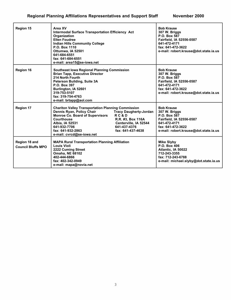
Regional Planning Affiliations Representatives and Support Staff November 2000
3
Region 15 Area XVIntermodal Surface Transportation Efficiency ActOrganizationEllen FoudreeIndian Hills Community CollegeP.O. Box 1110Ottumwa, IA 52501641-684-6551fax: 641-684-6551e-mail: [email protected]
Bob Krause307 W. BriggsP.O. Box 587Fairfield, IA 52556-0587641-472-4171fax: 641-472-3622e-mail: [email protected]
Region 16 Southeast Iowa Regional Planning CommissionBrian Tapp, Executive Director214 North FourthPeterson Building, Suite 3AP.O. Box 397Burlington, IA 52601319-753-5107fax: 319-754-4763e-mail: [email protected]
Bob Krause307 W. BriggsP.O. Box 587Fairfield, IA 52556-0587641-472-4171fax: 641-472-3622e-mail: [email protected]
Region 17 Chariton Valley Transportation Planning CommissionDennis Ryan, Policy Chair Tracy Daugherty-JordanMonroe Co. Board of Supervisors R C & DCourthouse R.R. #3, Box 116AAlbia, IA 52531 Centerville, IA 52544641-932-7706 641-437-4376fax: 641-932-2863 fax: 641-437-4638e-mail: [email protected]
Bob Krause307 W. BriggsP.O. Box 587Fairfield, IA 52556-0587641-472-4171fax: 641-472-3622e-mail: [email protected]
Region 18 and
Council Bluffs MPO
MAPA Rural Transportation Planning AffiliationLouis Violi2222 Cuming StreetOmaha, NE 68102402-444-6866fax: 402-342-0949e-mail: [email protected]
Mike SlybyP.O. Box 406Atlantic, IA 50022712-243-3355fax: 712-243-6788e-mail: [email protected]

Metropolitan Planning Organizations Representatives and Support Staff November 2000
4
City Policy BoardDOT Representatives
(District Transportation Planners)
Cedar Rapids Linn County Regional Planning CommissionJim HalvorsonCity Hall, Sixth FloorCedar Rapids, IA 52401319-286-5041fax: 319-286-5141e-mail: [email protected]
Lee Benfield430 16th Avenue, SWP.O. Box 3150Cedar Rapids, IA 52406-3150319-364-0235fax: 319-364-9614e-mail: [email protected]
Council Bluffs& RPA 18
Metropolitan Area Planning AgencyLouis Violi2222 Cuming StreetOmaha, NE 68102402-444-6866fax: 402-342-0949e-mail: [email protected]
Mike SlybyP.O. Box 406Atlantic, IA 50022712-243-3355fax: 712-243-6788e-mail: [email protected]
Davenport& RPA 9
Bi-State Regional CommissionGary Vallem1504 Third AvenueP.O. Box 3368Rock Island, IL 61204-3368309-793-6300fax: 309-793-6305e-mail: [email protected]
Fred DeanIowa 130P.O. Box 2646Davenport, IA 52809319-391-2167fax: 319-388-9266e-mail: [email protected]
Des Moines Des Moines Area Metropolitan Planning OrganizationTom KaneArgonne Armory602 East First StreetDes Moines, IA 50309-1881515-237-1339fax: 515-237-1303e-mail: [email protected]
Lorne WaznyPark Fair Mall, Suite 7Des Moines, IA 50306515-237-3313fax: 515-237-3323e-mail: [email protected]
Dubuque& RPA 8
East Central Intergovernmental AssociationBill BaumNesler Centre, Suite 330P.O. Box 1140Dubuque, IA 52004319-556-4166fax: 319-556-0348e-mail: [email protected]
Fred DeanIowa 130P.O. Box 2646Davenport, IA 52809319-391-2167fax: 319-388-9266e-mail: [email protected]
Iowa City Johnson County Council of GovernmentsJeff Davidson410 East Washington StreetIowa City, IA 52240319-356-5252fax: 319-356-5009e-mail: [email protected]
Lee BenfieldP.O. Box 3150Cedar Rapids, IA 52406-3150319-364-0235fax: 319-364-9614e-mail: [email protected]
Sioux City& RPA 4
Siouxland Interstate Metropolitan Planning CouncilDon Meisner507 7th Street, Suite 401P.O. Box 447Sioux City, IA 51102712-279-6286fax: 712-279-6920e-mail: [email protected]
Mark JohnsonP.O. Box 987Sioux City, IA 51102-0987712-276-1451fax: 712-276-2822e-mail: [email protected]
Waterloo& RPA 7
Iowa Northland Regional Council of GovernmentsSharon Juon501 Sycamore, Suite 333
Waterloo, IA 50703319-235-0311fax: 319-235-2891e-mail: [email protected]
Rod Larsenc/o Waterloo ConstructionP.O. Box 1888Waterloo, IA 50704319-235-9503fax: 319-235-9021e-mail: [email protected]

CONNECTING PEOPLE AND TRAILS
Section Title
81
State of Iowa Bicycle andPedestrian AccommodationGuidance
Appendix Three


CONNECTING PEOPLE AND TRAILS
Section Title
89
Sample Pedestrian Audit andHazard Reporting Forms
Appendix Four


CONNECTING PEOPLE AND TRAILS
Section Title
95
“Do We Really Need Four Lanesof Traffic?”
Appendix Five