Iowa Airport Land Use Guidebook Color/9...strategies outlined in this Chapter should be evaluated on...
38
Iowa Airport Land Use Guidebook CHAPTER 5 PREVENTION AND MITIGATION STRATEGIES
Transcript of Iowa Airport Land Use Guidebook Color/9...strategies outlined in this Chapter should be evaluated on...
Iowa Airport Land Use Guidebook
CHAPTER 5
PREVENTION AND MITIGATION STRATEGIES
Iowa Airport Land Use Guidebook
Chapter 5 Prevention and Mitigation Strategies
January 2008
THIS PAGE INTENTIONALLY LEFT BLANK

Iowa Airport Land Use Guidebook
Chapter 5 Prevention and Mitigation Strategies
January 2008 Page 1 of 36
5.0 Prevention and Mitigation Strategies
The prevention and mitigation of incompatible land use is a challenging task
that often requires the use of a multitude of techniques. With airports facing
encroachment from various types of land uses, as well as political,
environmental, and public pressures, it is necessary to evaluate each
individual airport and its environs to assess their needs. Land use decisions
are often influenced by an array of criteria; therefore, it is imperative to
understand the complicated relationship between land uses, airports, and
host communities. This chapter summarizes a collection of generally
accepted methods for the prevention, mitigation, and limitation of
incompatible land uses, which can be adapted to address the specific needs
of individual airports.
Preventative and mitigation strategies are tools that federal, state, and local
governments can utilize to address incompatible land uses. While federal
and state agencies develop guidelines and recommendations for compatible
land use, the majority of the responsibility for implementation and
enforcement of programs and decisions lie with local government officials,
city and county planners, airports sponsors, and citizens.
An airport’s area of influence and related airspace can often span across
multiple jurisdictions, further complicating the implementation of land use
controls. Communities that lie within the airport’s jurisdictional boundary
must coordinate efforts to preserve and protect the airport’s environs. Iowa
Code, Chapter 28E Joint Exercise of Governmental Powers, Section 23E.1
enables multiple jurisdictions to enter into partnerships to provide a means
for continued growth and development of the surrounding communities
including airport facilities, as well as Chapter 329 Airport Zoning that allows
for extraterritorial airport zoning. Effective communication between all
entities involved is essential to the development, implementation, and
maintenance of compatible land uses. Appendix M of the Guidebook
provides a brief summary of these Code sections, which can also be
accessed at web site:
www.legis.state.ia.us/IowaLaw.html
Planning techniques and zoning ordinances are used at the local level to prevent incompatible land uses.
Iowa Airport Land Use Guidebook
Chapter 5 Prevention and Mitigation Strategies
January 2008 Page 2 of 36
Local governments are responsible for developing comprehensive plans and
local zoning ordinances, as well as reviewing site plans, plat maps (maps
that define lot boundaries), and subdivision plans to maintain compatible land
use within the airport’s environs. Various local units of government involved
in the planning process can include but are not limited to:
• City councils
• City planning and zoning departments
• City building departments
• County boards and commissions
• County planning departments
• Regional planning agencies
• Airport authorities and commissions
Coordination and communication between local units of government and
airports is vital to the effective implementation and enforcement of land use
compatibility plans, which include compatible land use within the airport’s
environs.
In an effort to build cooperation, the aforementioned entities need to be
involved in the planning process, as well as those who:
• Are directly involved in transportation
• Depend on the airport for product transport
• Have influence on overall community plans
• Are transportation professionals
• Use the airport for daily activities
• Are community decision makers
• Are impacted by airport projects
Involving public agencies, as well as business interests and aviation users,
creates a more comprehensive forum from which to develop land use
compatibility plans. Local understanding and support is essential to preserve
the community’s aviation needs and result in the successful implementation
of a land use compatibility plan, which should protect the airport from the
encroachment of incompatible land uses.
Iowa Airport Land Use Guidebook
Chapter 5 Prevention and Mitigation Strategies
January 2008 Page 3 of 36
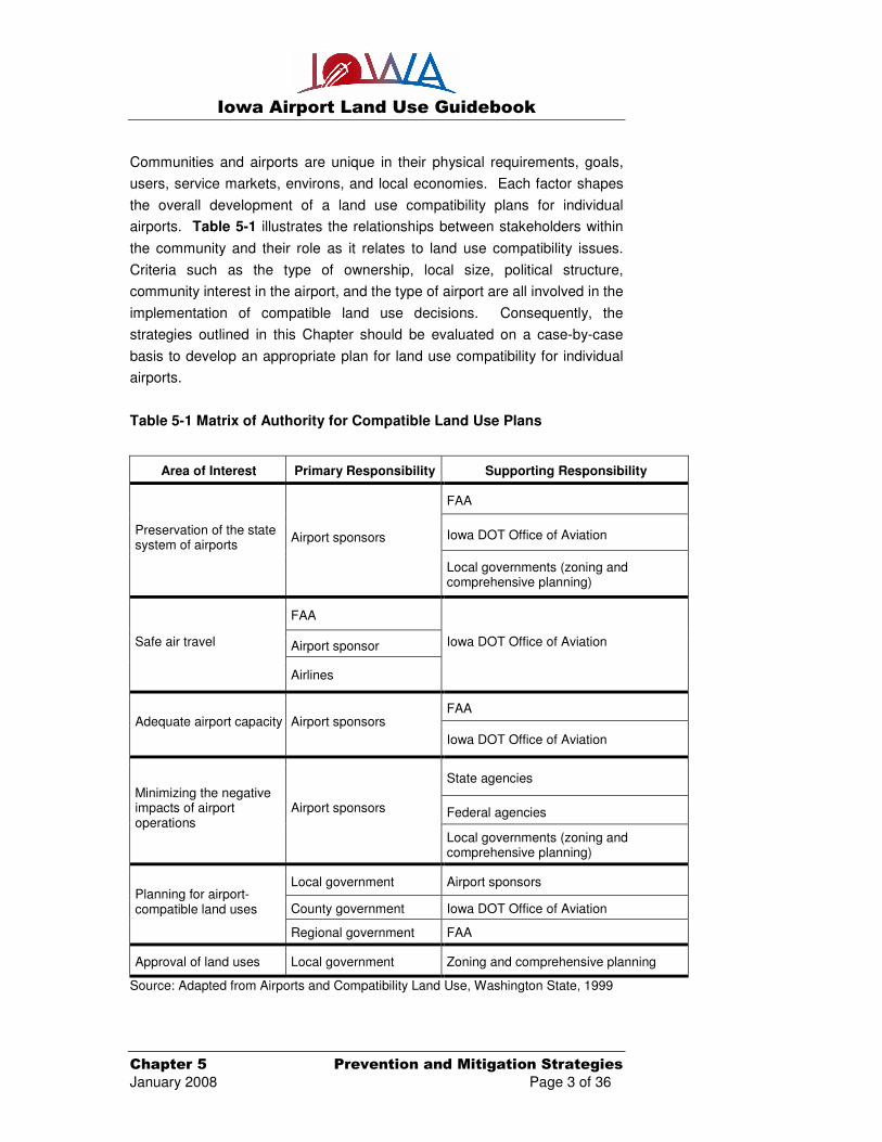
Communities and airports are unique in their physical requirements, goals,
users, service markets, environs, and local economies. Each factor shapes
the overall development of a land use compatibility plans for individual
airports. Table 5-1 illustrates the relationships between stakeholders within
the community and their role as it relates to land use compatibility issues.
Criteria such as the type of ownership, local size, political structure,
community interest in the airport, and the type of airport are all involved in the
implementation of compatible land use decisions. Consequently, the
strategies outlined in this Chapter should be evaluated on a case-by-case
basis to develop an appropriate plan for land use compatibility for individual
airports.
Table 5-1 Matrix of Authority for Compatible Land Use Plans
Area of Interest Primary Responsibility Supporting Responsibility
FAA
Iowa DOT Office of Aviation Preservation of the state system of airports
Airport sponsors
Local governments (zoning and comprehensive planning)
FAA
Airport sponsor Safe air travel
Airlines
Iowa DOT Office of Aviation
FAA Adequate airport capacity Airport sponsors
Iowa DOT Office of Aviation
State agencies
Federal agencies
Minimizing the negative impacts of airport operations
Airport sponsors
Local governments (zoning and comprehensive planning)
Local government Airport sponsors
County government Iowa DOT Office of Aviation Planning for airport-compatible land uses
Regional government FAA
Approval of land uses Local government Zoning and comprehensive planning
Source: Adapted from Airports and Compatibility Land Use, Washington State, 1999

Iowa Airport Land Use Guidebook
Chapter 5 Prevention and Mitigation Strategies
January 2008 Page 4 of 36
As illustrated in Table 5-1, the responsibility for prevention, mitigation, and
restriction of land use incompatibility lies with a number of agencies. The
primary responsibility is vested within local governmental entities such as
elected officials, local planning commissions, and planning departments.
While some of the prevention and mitigation techniques are authorized by
state level agencies, local agencies are typically responsible for the day-to-
day management and implementation of prevention and mitigation strategies.
Various strategies available for use can be grouped into four primary
categories:
• Planning related strategies
o Comprehensive plans
o Airport layout plan/master plan
o Airport land use zoning ordinance
o Height zoning ordinances
o Disclosure requirements
o Site plan reviews
o Plat reviews
o Deed restrictions
• Natural features
o Wildlife hazards
o Vegetation
• Acquisition and notification strategies
o Fee simple acquisitions
o Avigation and noise easements
o Non-suit covenants
o Disclosure to real estate buyers
o Hold harmless agreements
• Noise mitigation strategies
o Sound barriers
o Sound proofing

Iowa Airport Land Use Guidebook
Chapter 5 Prevention and Mitigation Strategies
January 2008 Page 5 of 36
The strategies can be used separately on a case-by-case basis or in
conjunction with multiple strategies to mitigate land uses to best suit the
community and airport needs. Each of these categories and their associated
strategies are described in the following pages to provide additional details
when addressing land use issues. This is not an all inclusive list, but rather a
sample of the most widely used strategies. If other opportunities present
themselves, it is recommended that local agencies consult the Office of
Aviation and the FAA for potential use.
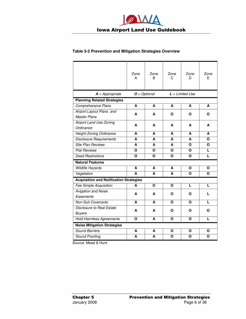
Table 5-2 illustrates a summary of the various prevention and mitigation
strategies related to the specific Airport Overlay Zones. Many of the
strategies and tools can be applied across numerous zones; however, some
are more appropriate in a specific zone than others, which are illustrated in
the following table. For example, land acquisition is most appropriate in
Zone A, however, instances can arise where land acquisition is an option in
Zones B and C, while Zones D and E are not likely to experience a need to
utilize land acquisition.
Iowa Airport Land Use Guidebook
Chapter 5 Prevention and Mitigation Strategies
January 2008 Page 6 of 36
Table 5-2 Prevention and Mitigation Strategies Overview
Zone
A Zone
B Zone
C Zone
D Zone
E
A = Appropriate O = Optional L = Limited Use
Planning Related Strategies
Comprehensive Plans A A A A A
Airport Layout Plans and
Master Plans A A O O O
Airport Land Use Zoning
Ordinance A A A A A
Height Zoning Ordinance A A A A A
Disclosure Requirements A A A A O
Site Plan Reviews A A A O O
Plat Reviews O O O O L
Deed Restrictions O O O O L
Natural Features
Wildlife Hazards A A A O O
Vegetation A A A O O
Acquisition and Notification Strategies
Fee Simple Acquisition A O O L L
Avigation and Noise
Easements A A O O L
Non-Suit Covenants A A O O L
Disclosure to Real Estate
Buyers A A O O O
Hold Harmless Agreements O A O O L
Noise Mitigation Strategies
Sound Barriers A A O O O
Sound Proofing A A O O O
Source: Mead & Hunt

Iowa Airport Land Use Guidebook
Chapter 5 Prevention and Mitigation Strategies
January 2008 Page 7 of 36
5.1 Planning Related Strategies
Planning provides a framework to establish a baseline of existing land uses
and forecast future growth. Compatible land use planning techniques focus
on site-specific issues within local communities. There are a number of
preventative tools and techniques local governments can implement to
discourage incompatible land uses including:
• Comprehensive plans
• Airport layout plans/airport master plans
• Airport overlay zoning ordinances
o Land uses
o Height
• Disclosure requirements
• Site plan review and plat review
• Deed restrictions
The planning techniques noted in this chapter will address the issue of
incompatible land uses and how they relate to airports in a way that will help
airport sponsors, planners, elected officials, and residents understand the
need for compatible land use near airports.
Strong local leadership and support from elected officials is important to
successful planning efforts at the airport and community level. Engaging and
educating local citizens within the vicinity of an airport is essential to create
an effective working relationship between elected officials, local airports, and
residents. This greater understanding by all participants can enhance the
implementation process of planning related strategies.
Figure 5-1 illustrates the relationship between the various planning
techniques. The following pages discuss the preventative tools that are
available to local governments for regulation around airport property.

Iowa Airport Land Use Guidebook
Chapter 5 Prevention and Mitigation Strategies
January 2008 Page 8 of 36
Figure 5-1 Relationship of Planning Strategies
Source: Mead & Hunt, Inc.
Planning techniques serve as the foundation from which preventive and
corrective mitigation measures can be implemented for compatible land use
issues that involve existing developments, future growth of the airport, and
surrounding communities. These planning techniques are typically utilized in
three forms: plans, ordinances, and regulations. Planning documents
(plans) provide the basis for the development of ordinances and regulations,
which provide structure for the implementation of land use controls.
Ordinances are legal documents that are developed by municipalities to
regulate land uses and associated activities with designated locations to
protect, preserve, and enhance the quality of life for residents. Regulations
are the tools that provide authority for the day-to-day implementation of an
ordinance. The combination of all three of these techniques is necessary for
effective land use planning.

Iowa Airport Land Use Guidebook
Chapter 5 Prevention and Mitigation Strategies
January 2008 Page 9 of 36
Ordinances reflect what is written in a community’s comprehensive plan and
are effective tools to reduce incompatible land uses surrounding airports.
When a local municipality undertakes the development of a zoning ordinance
for land use compatibility, consideration should be given to current zoning
and approval actions required by state agencies. A legal review of the
proposed airport land use and height overlay zoning ordinance is suggested
to determine if the ordinance is consistent with local and state regulations.
Zoning ordinances are used to specify permitted, regulated, and/or restricted
land uses that may endanger the health, safety, and welfare of citizens.
Ordinances that regulate airport land use and height should be incorporated
into a city and/or county’s comprehensive zoning ordinance to protect the
safe operation of airports and movement of aircraft, as well as the safety of
people on the ground in proximity to airports.
5.1.a. Comprehensive Plan
A local comprehensive plan should address land use as it relates to growth
and development of the surrounding community, on a county, township, and
city basis. A comprehensive plan is a strategic, long-range document and
generally includes: maps, charts, and text that explain the goals and
objectives established within the plan. Ideally, local governments use
comprehensive plans to guide the development of zoning ordinances, master
plans, and airport land use compatibility plans in order to make coordinated
decisions regarding compatible land use within the airports jurisdictional
boundary established by the planning process. The development of a
comprehensive plan consists of several phases including initial planning and
preparation, followed by public participation, review and evaluation, and final
adoption and implementation. The Iowa Code authorizes cities and counties
to adopt comprehensive plans. While comprehensive planning is technically
not required in Iowa, a city or county may find it difficult to defend zoning and
land use decisions without a comprehensive plan.
Purpose of Zoning Protect property values Protect natural resources Prevent nuisances Ensure land use compatibility Prevent overcrowding Prevent overuse

Iowa Airport Land Use Guidebook
Chapter 5 Prevention and Mitigation Strategies
January 2008 Page 10 of 36
It is essential that the comprehensive planning process of a local community
consider its local or neighboring airport(s). If a local planning document does
not provide a foundation to support decision making regarding the
development of compatible land use in the vicinity of a local airport, it is
unlikely that an effective planning process can be accomplished. Airport
sponsors should become involved early in the planning process to share the
airport needs and future development plans with the local municipality. This
involvement should focus on educating the local municipality regarding the
value the airport brings to the community, as well as the need to preserve its
operational areas. Airports sponsors can become involved in the planning
process in several ways:
• Have representation on the planning advisory/steering committee.
• Provide comments during the public comment portion of the
process.
• Provide comments to other representatives of the advisory/steering
committee to present airport related concerns and issues.
• Share airport master plans/airport layout plans with the local
municipality to inform them of airport development.
• Become engaged in the general planning process to be involved on
a regular basis, not just during comprehensive planning exercises.
5.1.b. Airport Layout Plan/Airport Master Plan
An airport layout plan/airport master plan is a long-range plan that details the
growth and development of the airport. These plans are typically based on a
20-year planning time frame and should be reviewed and updated every five
to 10 years. The contents of an airport master plan are governed by the FAA
AC 150/5070-6B, Airport Master Plans and can be found on the FAA web
site at web address:
www.faa.gov/airports_airtraffic/airports/resources/advisory_circulars/media/150-5070-
6B/150_5070_6b_chg1.pdf
Questions often asked during the comprehensive planning process: Why do we need a Comprehensive Plan? What do we value in our community? Where should different land uses be located? How will development affect our environment? How will development affect our infrastructure? How does our land use fit within our surrounding community?

Iowa Airport Land Use Guidebook
Chapter 5 Prevention and Mitigation Strategies
January 2008 Page 11 of 36
The airport layout plan/master plan provides local decision-makers with
information to guide growth and development of the airport and should be
used as a resource for the development of other community planning
documents, such as a local comprehensive plan. These plans should be
provided to the local land use decision-makers when they are evaluating
projects in proximity to an airport in order to maintain compatible land uses
for ultimate airport development. These plans are a guide in the continued
development of the airport. AC 150/5070-6B, Airport Master Plans
5.1.c. Airport Overlay Zoning Ordinance
An Airport Overlay Zoning Ordinance (AOZO) is an extraterritorial tool that
promotes compatible land use and height limitations within the vicinity of an
airport. The sponsoring jurisdiction determines the specific distance
governed by the AOZO. Appendix Q provides an outline to assist the
sponsoring party with the development of an Airport Land Use and Height
Overlay Zoning Ordinance Outline. The AOZO can include:
• Land use related restrictions
• Height related restrictions
• Combination of height and land use related restrictions
However, it is recommended that the combination of height and land use
restrictions be utilized when developing the AOZO in order to adequately
protect the airport, safe movement of aircraft, as well as the persons on the
ground within the vicinity of airports. Overlay zoning applies additional
conditions or restrictions to a specified area while retaining the existing base
zoning classification underneath the overlay zoning districts. Airport
sponsors that currently have a height related ordinance may want to consider
adding land use restrictions. The AOZO outline provided in Appendix Q can
also be useful in updating an existing ordinance.
It is highly recommended to implement a combination of height and land use restrictions to protect the airport from incompatible land uses.

Iowa Airport Land Use Guidebook
Chapter 5 Prevention and Mitigation Strategies
January 2008 Page 12 of 36
The AOZO can be highly effective in addressing a number of potential
incompatibilities related to airport operational areas. An AOZO may limit the
height of objects surrounding an airport, as well as restricting specific land
uses that create conditions potentially hazardous to air navigation which are
essential in order to protect the health, safety, and welfare of residents, as
well as maintain safe aircraft movement and airport operational areas.
• Land Use Related Restrictions
An AOZO that addresses land use issues supersedes the existing
underlying zoning within specified zoning districts and are adopted
by city and/or county governments in order to prevent or mitigate
potentially incompatible land uses such as:
o Noise sensitivity related issues
o Safety related issues
� High concentrations of people
� Tall structures
� Visual obstructions
� Wildlife and bird attractants
Details regarding airport overlay zoning districts are discussed in
greater detail within Chapter 4 of the Guidebook. In addition,
detailed explanations regarding the aforementioned incompatible
land uses can be found within Chapter 3 of the Guidebook.
Iowa Code Chapter 329 Airport Zoning, provides cities and counties
with the ability to enforce zoning regulations or land use regulation to
protect and preserve airport facilities. Section 329.2 Airport Hazards
addresses the issues related to safe aircraft navigation during
various phases of flight (departure, approach, and maneuvering).
Iowa Code Chapter 335 County Planning and Zoning, specifically
provides counties with the ability to plan and zone districts that
pertain to the local airport. Chapter 414 Municipal Planning and
Zoning, provides cities with the ability to plan and zone districts that
pertain to the local airport. Appendix M contains a summary of
Iowa’s Code, which can be supplemented by utilizing Iowa’s
legislative web address can be found on the following web site:
www.legis.state.ia.us/IowaLaw.html

Iowa Airport Land Use Guidebook
Chapter 5 Prevention and Mitigation Strategies
January 2008 Page 13 of 36
• Height Related Restrictions
An AOZO that focuses on the safety of the airport and the public
must include height restrictions for developments beyond airport
property lines. Multiple jurisdictions can fall within an airport’s
jurisdictional boundary (i.e. three-mile radius). This concept is
known as ‘extraterritorial zoning’ and it plays an important role in
land use development in regions that have an airport or multiple
airports. Used as part of an AOZO, height restrictions preserve
navigable airspace.
Legally mandated by the FAA in Federal Aviation Regulation (FAR)
Part 77, Objects Affecting Navigable Airspace, any object or
structure that penetrates any of the ’imaginary surfaces‘ is
considered to be an obstruction to air navigation and form the basis
for height restriction zoning ordinances. Details regarding specific
height restrictions should be included in the AOZO and kept on file
with the appropriate governmental agencies (i.e. county, Office of
Aviation, FAA, etc.).
FAR Part 77 specifically requires that any person/organization who
intends to sponsor any of the following construction or alterations
must notify the Administrator of the FAA prior to construction:
o Any construction or alteration exceeding 200 feet above
ground level.
o Any construction or alteration:
� Within 20,000 feet of a public use or military airport
which exceeds a 100:1 surface from any point on the
runway of each airport with at least one runway more
than 3,200 feet.
� Within 10,000 feet of a public use or military airport
which exceeds a 50:1 surface from any point on the
runway of each airport with its longest runway no
more than 3,200 feet.
� Within 5,000 feet of a public use heliport which
exceeds a 25:1 surface.
o Any highway, railroad, or other traverse way whose
prescribed adjusted height would exceed that above noted
standards.
o When requested by the FAA.

Iowa Airport Land Use Guidebook
Chapter 5 Prevention and Mitigation Strategies
January 2008 Page 14 of 36
o Any construction or alteration located on a public use airport
or heliport regardless of height or location.
Notification to FAA for off-airport development is done through web
site, Obstruction Evaluation/Airport Airspace Analysis (OE/AAA) that
allows for electronic filing of the Notice of Proposed Construction or
Alteration (FAA Form 7460-1). Instructions for filing notification for
on-airport development can be found at the following web site:
https://oeaaa.faa.gov/oeaaa/external/portal.jsp
In addition to FAR Part 77 requirements, Iowa Code Chapter 414,
Municipal Planning and Zoning Section 414.1 Building Restrictions
and 414.3 Basis of Regulations allows cities to regulate building
heights. Iowa Code Chapter 335 County Planning and Zoning also
allows counties to regulate the height and location of structures, as
well as Chapter 329 Airport Zoning which also regulates obstruction
that may pose a hazard to aircraft within the vicinity of the airport.
Appendix M of the Guidebook summarizes this legislation;
additionally the web site listed may be referenced for specific details:
www.legis.state.ia.us/IowaLaw.html
5.1.d. Disclosure Requirements
Disclosure requirements can be an effective way to notify future property
owners of their proximity to an airport or area impacted by aircraft use. A
disclosure notice is a legal document, recorded with the local municipality,
which follows the title for a specific parcel of property. Disclosure
requirements can be established as part of a site plan review, local zoning
ordinance, or can be a stand alone process for properties near airport
environs.
Iowa Airport Land Use Guidebook
Chapter 5 Prevention and Mitigation Strategies
January 2008 Page 15 of 36
A disclosure requirement can be as easy as putting the property owner on
notice that a specific parcel of property lies in proximity to an airport, which
may have potential safety hazards and noise issues associated with living
near an airport. This notice would allow the property owner to utilize
approved construction techniques and materials to soundproof the home to
reduce noise impacts from aircraft utilizing the airport. Refer to Appendix D
for sample language to be used when disclosing airport related noise issues
to real estate buyers.
5.1.e. Site Plan Review and Plat Review
Local zoning ordinances often require that individuals requesting
developments of any type submit a site plan for review. Local municipal
planners review the site plan to verify that the proposed development meets
all zoning requirements and is an appropriate land use. During the review
process, high concentrations of people, development densities, and potential
impacts to local airports should be considered.
Sites that are set for development must first be analyzed by local planning
commissions to verify that the proposed development meets all related
zoning requirements. Local subdivision ordinances identify requirements for
parcel layouts. Both certified survey map (CSM) and subdivision plat review
are required prior to the start of construction at a site. As part of the review
process, population and development density are studied for airport
compatibility and are subject to change on the opinion of the local planning
commission. The number of people that will congregate within a particular
development can be reviewed during the pre-construction process to be sure
that developments of higher density are not allowed near airport approach
zones.

Iowa Airport Land Use Guidebook
Chapter 5 Prevention and Mitigation Strategies
January 2008 Page 16 of 36
The layout of property boundaries should also be reviewed in order to
preserve aircraft safety, as there are additional considerations when adjacent
or within one mile of the airport. A review guarantees that land use decisions
are discussed between local officials and developers before the development
is allowed to begin. Plat and CSM review is also an important tool in
preserving airport environs through the legal overview of parcel maps and
subdivided parcels before development can begin. Such review is typically
called for in the subdivision ordinance. Appendix E provides sample
language to be used relating to a Non-suit Covenant and Appendix F
provides sample language for a Noise Easement, while Appendix G
provides an Avigation Easement sample language.
5.1.f. Deed Restriction
Deed restrictions are an effective way to regulate the development of a
specific parcel of property. A deed restriction is a legal document, recorded
with the local municipality, which follows the title of that particular parcel of
property. The deed restriction defines what the property owner can and can
not do with the property as it pertains to the airport. Deed restrictions can be
established as part of a site and/or plat plan review process by either the
local municipality or the county that has jurisdiction over the airport.
5.2 Natural Features
Natural features should be considered in airport overlay zoning and land use
planning. Tall trees or the presence of wildlife can threaten navigable
airspace. Effective planning is critical for safe aircraft operations. Natural
feature planning strategies include addressing wildlife hazards and
vegetation concerns. Each of these features are discussed below.

Iowa Airport Land Use Guidebook
Chapter 5 Prevention and Mitigation Strategies
January 2008 Page 17 of 36
5.2.a. Wildlife Hazards
A significant amount of research has been completed on issues pertaining to
wildlife management and is consolidated in the FAA/Department of
Agriculture, Wildlife Hazard Management at Airports manual. This manual
was developed for airport personnel and provides a considerable amount of
information related to wildlife hazards on or near airport environs. The
Wildlife Hazard Management at Airports manual can be referenced at the
following web site:
http://wildlife.pr.erau.edu/EnglishManual/2005_FAA_Manual_complete.pdf
This resource should be consulted to develop site specific wildlife
management plans for the reduction or elimination of wildlife attractants on or
near airport property. Implementation efforts to monitor wildlife activity are
an important step to determine how to protect airports from wildlife hazards
such as aircraft strikes with deer and birds.
Each airport has a unique blend of wildlife concerns ranging from waterfowl
(i.e. geese) and raptors (i.e. hawks, owls, and falcons) to small and large
mammals (i.e. woodchucks and deer). All available resources and
management techniques need to be utilized to develop a wildlife
management plan that addresses specific airport needs.
Methods to address wildlife mitigation issues typically begin with a wildlife
hazard assessment. This process evaluates specific wildlife issues at
airports and provides a baseline from which mitigation can be developed
through the use of a Wildlife Control Plan. A Wildlife Control Plan is a
comprehensive tool that includes specific control techniques and habitat
modifications to detach wildlife within airport environs. Control techniques
include wildlife removal, fence installation, and airport grounds maintenance
in such as way that wildlife is not attracted to the area. Available wildlife
habitat management techniques can include but are not limited to:
• Adequately spacing of non-fruit bearing trees.
• Maintaining vegetation such as grass in a manner to be undesirable,
unattractive cover and habitat to indigenous and migratory wildlife.
• Reduce and/or eliminate standing water to diminish the attractant.
• Use of audio repellents such as propane cannons to scare and
disperse wildlife.
Wildlife Hazard Management at airports is an important reference guide in developing site specific wildlife management plans.

Iowa Airport Land Use Guidebook
Chapter 5 Prevention and Mitigation Strategies
January 2008 Page 18 of 36
• Manage consumer waste to reduce accessibility.
• Manage crops in farmed areas to minimize available food sources
such as prohibiting cereal grain crops.
• Install wildlife fence to reduce access to airport operational areas.
Additionally, there are techniques available that can be used to mitigate
wildlife problems such as:
• Physical relocation of wildlife, such as trapping and removal of deer.
• Depredation of wildlife, which may require permits from local, state,
or federal agencies.
• Use of pyrotechnics or noise makers to scare wildlife.
If considering depredation of migratory birds, contact the US Fish and
Wildlife Service for permitting information. The Iowa Department of Natural
Resources should be contacted for information related to depredation of
deer. Contact information can be found in Appendix L.
As previously mentioned in Chapter 3 of the Guidebook, Iowa DOT Office of
Aviation entered into a cooperative agreement with the United States
Department of Agriculture (USDA), Animal and Plant Inspection Services
(APHIS) Wildlife Services (WS) in 2006. This agreement allows the USDA
WS to conduct wildlife consultations (hazard assessments and control plans)
at general aviation airport within Iowa. The USDA APHIS WS utilizes the
information gathered from the general aviation airports to assist and develop
ways to reduce threats to aircraft posed by the multitude of wildlife species
including but not limited to deer, small rodents, birds, and other animals that
threaten aviation safety. The following web site reference illustrates the
various activities the USDA APHIS WS can assist your community:
www.aphis.usda.gov/wildlife_damage/
In addition to wildlife hazard assessments and wildlife control plans, a
concerted effort should be made to catalog all wildlife concerns including
wildlife strikes. All wildlife strikes should be reported to the FAA using Form
5200-7 and should include the type of strike and animal involved. This form
can be found by using the following web site address:
http://forms.faa.gov/forms/faa5200-7.pdf

Iowa Airport Land Use Guidebook
Chapter 5 Prevention and Mitigation Strategies
January 2008 Page 19 of 36
5.2.b. Vegetation
In order to protect navigable airspace and the safe movement of aircraft, an
inventory of existing vegetation within the runway approach areas and RPZs
is recommended. Control measures to limit the height of trees, objects, and
structures within these areas should be outlined in an AOZO. Efforts should
be made to limit the existence of vegetation in proximity to airport environs
due to height and wildlife attractant hazards. Planting species of vegetation
with short growth heights can be an effective management tool. Species of
vegetation should also be evaluated for potential wildlife habitat and food
source attractants.
Consultation with the USDA WS is encouraged to manage site specific
issues related to wildlife hazards and vegetation concerns. When evaluating
vegetation concerns near airports, best management practices should be
utilized to minimize potential wildlife attractants. These best management
practices include but are not limited to the following:
• Limit planting bushy trees which provide protected roosting areas for
birds and cover for small mammals. For example, ornamental trees
such as Bradford Pears or evergreens such as spruce and fir trees
should be avoided due to their dense foliage.
• Limit planting trees or vegetation, which produce fruits or berries
used as a food source for birds or animals.
• Limit clusters of trees or vegetation, which provide a protected
environment for birds and small mammals. For example a cluster of
trees would be discouraged, while a planting of singular trees and
shrubs spread over a large area would be more desirable.
Appendix M contains references to various Iowa laws that can be applied to
environmental and wildlife related issues.
Vegetation can be an issue at airports due to either height and/or a wildlife attractant.

Iowa Airport Land Use Guidebook
Chapter 5 Prevention and Mitigation Strategies
January 2008 Page 20 of 36
5.3 Acquisition and Notification Strategies
As a prevention and mitigation technique, land acquisition and notification
strategies can be used to remove, lower, or control existing land uses within
Runway Protection Zones (RPZs) and areas very close to airport environs.
As a preventive tool, acquisition or notification to property owners should
take place prior to the development of a conflicting land use to limit future
incompatible uses. Notification to property owner will alert an owner of
potential compatibility concerns and may define a compensation for an
impact identified as part of the easement. Table 5-3 illustrates the key
elements of acquisition and notification techniques to promote compatible
land uses on or near airport environs. The primary techniques for acquisition
and notification strategies include:
• Fee simple acquisitions
• Avigation and noise easements
• Non-suit covenants and hold harmless agreements
• Disclosure to real estate buyers
Each of these techniques is discussed in the following sections to illustrate
the various options available to acquire property or notify property owners
about land use concerns.
Acquisition, where feasible, is the preferred mitigation strategy.

Iowa Airport Land Use Guidebook
Chapter 5 Prevention and Mitigation Strategies
January 2008 Page 21 of 36
Table 5-3 Acquisition and Notifications for Compatible Land Uses
Technique Description Key Value Primary Shortcoming When to Use
Fee Simple
Acquisition
Purchase of land
and all land use
rights.
Complete control over
future and pre-existing land
uses is vested with airports;
not reversible.
Often very costly with
possible legal opposition.
Land removed from tax
roles.
Protection of RPZs and areas
subject to high levels of noise
impact. Effective to resolve
existing problems and avoid
future problems. FAA grant
may be available for
acquisition.
Avigation and
Noise
Easements
Obtain the rights to
use or restrict use
in a specified
manner.
Provides more positive
control than zoning. Less
expensive than fee simple
acquisitions, land may
remain on active tax roles.
Attached to the title of the
property.
Does not completely alter
existing incompatible land
uses.
Used to compensate land
owner for impacts and to gain
right to remove obstructions
(i.e. trim trees) and limit future
growth on the property.
Non-Suit
Covenant
and
Hold Harmless
Agreement
Legal document
between property
owner and airport
sponsor that is
recorded with the
property title.
Typically used in
conjunction with an
avigation or noise
easement, property owner
agrees to not hold the
airport liable for any land
use issues.
Does not alter existing
incompatible land uses but
merely acknowledges the
existence of an issue.
Does not limit future
incompatibilities.
Used to record impacts and
notify a property owner of
the potential impacts while
removing liability for an airport.
Disclosure to
Real Estate
Buyer
Legal document
between property
owner and airport
sponsor that is
recorded with the
property title.
Informs the property owner
of potential issues with
developments near an
airport and discloses the
issues.
Does not alter existing or
future land issues, is an
informative type tool only.
Suggested for inclusion
when a new subdivision or
development is established
near an airport.
Source: Mead & Hunt, Inc.

Iowa Airport Land Use Guidebook
Chapter 5 Prevention and Mitigation Strategies
January 2008 Page 22 of 36
5.3.a. Fee Simple Acquisition
Fee simple acquisition is the process by which an airport sponsor purchases
property from the existing property owner in its entirety, including the
structures and/or facilities on the property and the air and mineral rights.
This is the most effective mitigation strategy to protect the airport, since the
airport assumes sole ownership of the property, thus allowing the airport
sponsor to maintain the property in a compatible manner. The FAA
recommends airport sponsors own, at a minimum, the property within the
RPZ and highly recommends ownership of the runway approach areas.
The federal process outlined in FAA AC 150/5100-17 Change 3, Land
Acquisition and Relocation Assistance for Airport Improvement Program
Assisted Projects and the Uniform Relocation Assistance and Real Property
Acquisition Policies Act of 1970 (P.L. 91-646) must be adhered to when
property is purchased with federal funds. The FAA has developed a
brochure entitled Land Acquisition for Public Airports, which summarizes the
required process for land acquisition. AC 150/5100-17 Change 3, Land
Acquisition and Relocation Assistance for Airport Improvement Program
Assisted Projects can be found on the FAA web site at web address:
www.faa.gov/airports_airtraffic/airports/resources/advisory_circulars/media/150-5100-
17/150_5100_17_chg6.pdf
Uniform Relocation Assistance and Real Property Acquisition Policies Act of
1970 (P.L. 91-646) can be found at web site address:
www.fhwa.dot.gov/realestate/act.htm
Property acquisition may be expensive, however, it is the most effective
technique to address existing impacts and limit future development that can
create incompatible land uses. If an airport has areas with many
incompatible land uses, the airport sponsor may consider developing a
specific plan for property acquisition.

Iowa Airport Land Use Guidebook
Chapter 5 Prevention and Mitigation Strategies
January 2008 Page 23 of 36
5.3.b. Avigation and Noise Easements
An easement is a right or privilege that one party has over the property of
another party and is often purchased by an airport sponsor to protect the
surrounding air space from incompatible development or encroachment
within airport environs. An easement can address avigation or air rights,
noise related to aircraft and airport operations, the right to obstruction free
airspace, or any combination of these issues.
An easement is a legal document, which is attached to the property title and
places existing and future property owners on notice that their property can
be subject to noise impacts and other land use controls associated with the
airport. Additionally, avigation easements can be utilized to mitigate existing
incompatible land uses that are hazardous to airports and aircraft operations,
such as trimming natural vegetation back to appropriate heights.
Avigation and noise easements should be used in conjunction with a broader
land use plan and must be enforced to ensure their success. Easement
acquisitions are governed by the same rules that apply to the fee simple
process, including the Uniform Relocation Assistance and Real Property
Acquisition Policies Act of 1970, and associated FAA ACs. Sample avigation
and noise easements are contained in Appendix G and Appendix F.
Figure 5-2 illustrates a sample penetration to an approach surface, which an
airport may work to remedy with an avigation easement.

Iowa Airport Land Use Guidebook
Chapter 5 Prevention and Mitigation Strategies
January 2008 Page 24 of 36
Figure 5-2 Prevention and Mitigation Strategy Avigation Easement
Source: Mead & Hunt
5.3.c. Non-Suit Covenant and Hold Harmless Agreements
A non-suit covenant and hold harmless agreement are legal contracts
between a property owner and an airport sponsor, which acknowledges the
potential for incompatible land use issues. A non-suit covenant or hold
harmless agreement are typically used in conjunction with an avigation and
noise easement. These agreements legally record that a property owner has
agreed not to sue an airport over noise or other land use incompatibility
issues, because the property owner acknowledges the issues exist.
A non-suit covenant may monetarily compensate a property owner for the
easement while a hold harmless agreement may not. Neither will alter
incompatible land uses, nor limit future incompatibilities. Appendix E and
Appendix H contain sample language for a non-suit covenant and hold
harmless agreement, respectively.

Iowa Airport Land Use Guidebook
Chapter 5 Prevention and Mitigation Strategies
January 2008 Page 25 of 36
5.3.d. Disclosure to Real Estate Buyers
The term “buyer beware” is a common phrase when purchasing real estate.
Many issues should be evaluated prior to the purchase and development of
property near an airport. As noted in the previous sections, there are a
number of planning, zoning, and land acquisition techniques used to guide
and regulate land use activities within a community and near an airport. A
buyer needs to be made aware of any land use compatibility issues that may
arise on a piece of property near an airport, as well as the various
easements, agreements and rights that may already be in place on the
property. Local and state governments can require the disclosure of
information to real estate buyers to communicate development concerns to
potential buyers. Appendix I provides a copy of sample language for a
Disclosure to Real Estate Buyers.
5.4 Noise Mitigation Strategies
Aircraft noise is a major concern for land use compatibility planning.
Prevention and mitigation options are typically costly and can include but are
not limited to: soundproofing, noise barriers, and land acquisition. Noise
mitigation options are usually guided by AC 150/5020-1, Noise Control and
Compatibility Planning for Airport, FAR Part 150, Noise Study, and the
development of noise compatibility plans. As outlined in FAR Part 150, a
noise study must follow a specific process and include key elements that
include:
• Identification of noise and land use issues and problems
• Definition of current and future noise exposure
• Evaluation of alternative measures
• Development of a noise compatibility plan
• FAA approval of plan
• Development of an implementation and monitoring plan

Iowa Airport Land Use Guidebook
Chapter 5 Prevention and Mitigation Strategies
January 2008 Page 26 of 36
An FAR Part 150 study will benefit a community when the annual aircraft
operations are greater than 90,000 propeller operations or 700 jet operations.
Noise studies are typically applicable to larger general aviation airports or
commercial service airports that experience these higher levels of
operations. This level of activity can generate cumulative noise levels
greater than 65 DNL, which typically extend beyond the airport property
boundaries. The specific process, analysis, and associated deliverables of a
FAR Part 150 study are not discussed in this document. A two-part FAR Part
150 noise compatibility checklist can be found on the FAA website at:
www.faa.gov/airports_airtraffic/airports/environmental/airport_noise/part_150/checklists/media/noise_exp_map_checklist_part_i.pdf www.faa.gov/airports_airtraffic/airports/environmental/airport_noise/part_150/checklists/media/noise_comp_prog_checklist_part_ii.pdf
Based upon the results of the FAR Part 150 noise study, specific issues are
identified for mitigation. Mitigation strategies such as: sound barriers,
soundproofing, land acquisition, and the development of a master plan are
implemented to promote airport land use compatibility. Typically these
mitigation tools are utilized to address incompatible noise issues around
airports. Land acquisition can be used as a corrective, as well as a
preventive mitigation measure to maintain land use compatibility within the
airport’s environs.
5.4.a. Sound Barriers
Sound barriers can provide a prevention and mitigation tool to address noise
impacts within the vicinity of airport operations. Sound barriers have limited
applications and are typically used on airport property to shield noise-
sensitive areas from the most intense levels of airport operations. When
aircraft prepare for departure, the engine(s) are brought up to full power and
then tested. This action, called a run-up, often creates a high decibel noise
level at the end of the runway just prior to takeoff. If an airport has a noise-
sensitive area near the run-up activity area, a sound barrier can be installed
to shield an area from aircraft noise. Aircraft repair or maintenance facilities
often test engines as well. A specific location for such facilities should be
designated and a sound barrier can be used to contain aircraft noise.

Iowa Airport Land Use Guidebook
Chapter 5 Prevention and Mitigation Strategies
January 2008 Page 27 of 36
Sound barriers take many different forms. Coniferous trees and shrubs can
be used as barriers but often provide limited sound reduction. They may also
result in future airspace obstructions if not managed or maintained properly.
Additionally, considerations should be given to the selection of species which
do not contribute to wildlife concerns. These vegetation barriers can also act
as visual barriers and are thus perceived as sound barriers. However,
certain vegetation can also act as wildlife attractants so care should be taken
to assess the impacts of this sort of sound barrier. Topographic features can
also be used as barriers. Earthen berms are commonly used as barriers
since they are relatively inexpensive to construct and maintain.
Man-made barriers are a costly option and often include wooden fencing or
masonry walls. Fences are the most common type of noise barrier because
they screen out both the view and sound. Masonry wall barriers are used in
areas where there is a specific point of sound generation, such as an engine
run-up area discussed above.
5.4.b. Sound Proofing
Soundproofing, though considered a prevention and mitigation measure, is a
partial solution to noise issues. Soundproofing addresses the indoor
environment, but does nothing to lower the outside noise levels. If a home is
determined to be within an area that experiences a high level of aircraft
noise, the house can be soundproofed to reduce the levels of noise within
the structure. Windows and doors of a more dense construction can be
installed, as can air conditioning units or a central air system, which reduce
the need to open windows and allow noise to enter the structure. Additional
roof and wall insulation can also be installed to soften the outside noise.
Outdoor noise levels should be considered during the development of a
compatible land use plan. Soundproofing will not alleviate noise interruptions
outside the home. Therefore, it is important to recognize the limitations of
this preventative and mitigation technique on outdoor environments.
Iowa Airport Land Use Guidebook
Chapter 5 Prevention and Mitigation Strategies
January 2008 Page 28 of 36
5.5 Implementation
An airport sponsor, whether it is a commission, an authority, or a city
administrator, will be most effective in ensuring compatible land use around
airports if potential stakeholders understand the importance of airports and
the need for compatible land use. In addition to city and county officials,
local citizen involvement and understanding will assist in planning and
mitigation techniques. Airport sponsors will need to work closely with city
and county officials in developing comprehensive plan elements, zoning
regulations, and airport overlay zoning ordinances that:
• Preserve the viability of airports
• Minimize and/or mitigate potential noise impacts on surrounding
areas
• Preserve adequate space for airport operations, expansion, and
safety zones
• Protect airports and airport environs from encroachment and
incompatible land uses
Airport sponsors and managers also need to remain alert to proposed
development or expansion projects within the airports jurisdictional boundary
to ensure compatibility with the airport and the safe movement of aircraft.
Effective zoning regulations and notification of proposed development will
assist airport sponsors provide input. As airport sponsors develop long
range plans, city and county planners need to be consulted.
Educating and informing local citizens of the importance of compatible land
uses around airports is essential to the preservation of the aviation system
and the safety and quality of life of persons on the ground in the proximity of
local airports. These individual citizens influence the decisions of planners
and elected officials, who are directly responsible for the implementation of
the planning techniques required for compatible land uses.
Airports are important community assets.
Educating and informing local citizens of the importance of compatible land use around airports is essential.

Iowa Airport Land Use Guidebook
Chapter 5 Prevention and Mitigation Strategies
January 2008 Page 29 of 36
Planning is a cyclical process that requires continual monitoring and updating
to implement and maintain compatible land uses near airports. This process
is necessary to continually evaluate and assess land use concerns as they
change and evolve within individual communities. Figure 5-3 illustrates the
cyclical process of evaluating and planning.
Figure 5-3 Land Use Compatibility Planning Actions
Source: Mead & Hunt
Iowa Airport Land Use Guidebook
Chapter 5 Prevention and Mitigation Strategies
January 2008 Page 30 of 36
5.5.a. Compatible Land Use Planning Assessment
Airport overlay zoning is intended to preserve and protect aviation
infrastructure from the encroachment of incompatible land uses as previously
discussed. Many airports have taken steps to address the issue of height
concerns by adopting height limitation zoning. While beneficial, unless
coupled with corresponding land use limitations, the full potential of airport
overlay zoning is not completely realized and airports are left vulnerable to
incompatible land use developments. These incompatible land uses can
often endanger the safety of aircraft and airport operational areas and affect
the quality of life for citizens in proximity to an airport.
As noted in Chapter 4, there are many land uses that, depending upon their
proximity to an airport, may be compatible with airports. It has been noted
that these uses should be assessed and have additional review to fully
evaluate potential impacts or concerns. To assist with the implementation of
a possible review process, a sample checklist has been developed to assist
elected officials, planning commissions, zoning boards of appeals, and
planners, as well as developers, in determining the compatibility of proposed
land use development as it relates to airport environs. Local municipalities
and developers need flexibility to allow development within specific airport
overlay zoning districts to meet local needs while balancing safety concerns.
The flexibility must be evaluated based upon the potential impacts
associated with each land use compared to the needs of specific airport
overlay zoning districts. The checklist is provided as a guide for individual
municipal review. However, it is not meant to be an all-inclusive assessment
of local land use concerns but rather a guide for local municipalities and
specific use of this checklist is at the discretion of the local municipality.

Iowa Airport Land Use Guidebook
Chapter 5 Prevention and Mitigation Strategies
January 2008 Page 31 of 36
5.5.b. Implementation of Land Use Compatibility Planning Checklist
The land use compatibility planning checklist is designed to assist in the
determination of land use compatibility. This form can be utilized as a guide
to evaluate proposed development within the airport overlay zones. The
questions in the checklist emphasize the primary concerns discussed in
Chapter 3. Appendix J contains a copy of the sample Land Use
Compatibility Planning Checklist. The checklist can be adapted to local
needs.
The questions contained in the checklist are meant to alert the reviewer of
potential concerns associated with the various land uses and provide a guide
to evaluate the proposed land use as it relates to the individual development
proposal. The checklist is not all inclusive, however it is meant to assist and
guide local municipalities when siting development within airport environs.
Answering the questions positively would indicate concerns related to these
topics and would therefore suggest additional review is necessary. The
items listed after each question illustrates the concerns that should be
considered relative to the broader topic. Should these items demonstrate a
significant impact, it is likely the use should be precluded. If the items are of
minor significance or can be minimized and/or mitigated, the use may be
permitted. This determination would be a local decision based upon the
overall assessment/evaluation.
Land use concerns to be evaluated can include but are not limited to:
Noise Sensitivity Related Issues
• Could the land use exceed compatible DLN noise levels of 65 or
greater?
o Can the structure/land use be insulated to reduce noise
impacts?
o Are there outdoor activities that would be impacted by noise
events?
o Can landscaping material be utilized to mitigate possible
noise exposure?
o Can the structure and/or land use be shifted within the site to
allow a more compatible location?
The checklist found in Appendix J is an important tool for cities when siting development near an airport.
Iowa Airport Land Use Guidebook
Chapter 5 Prevention and Mitigation Strategies
January 2008 Page 32 of 36
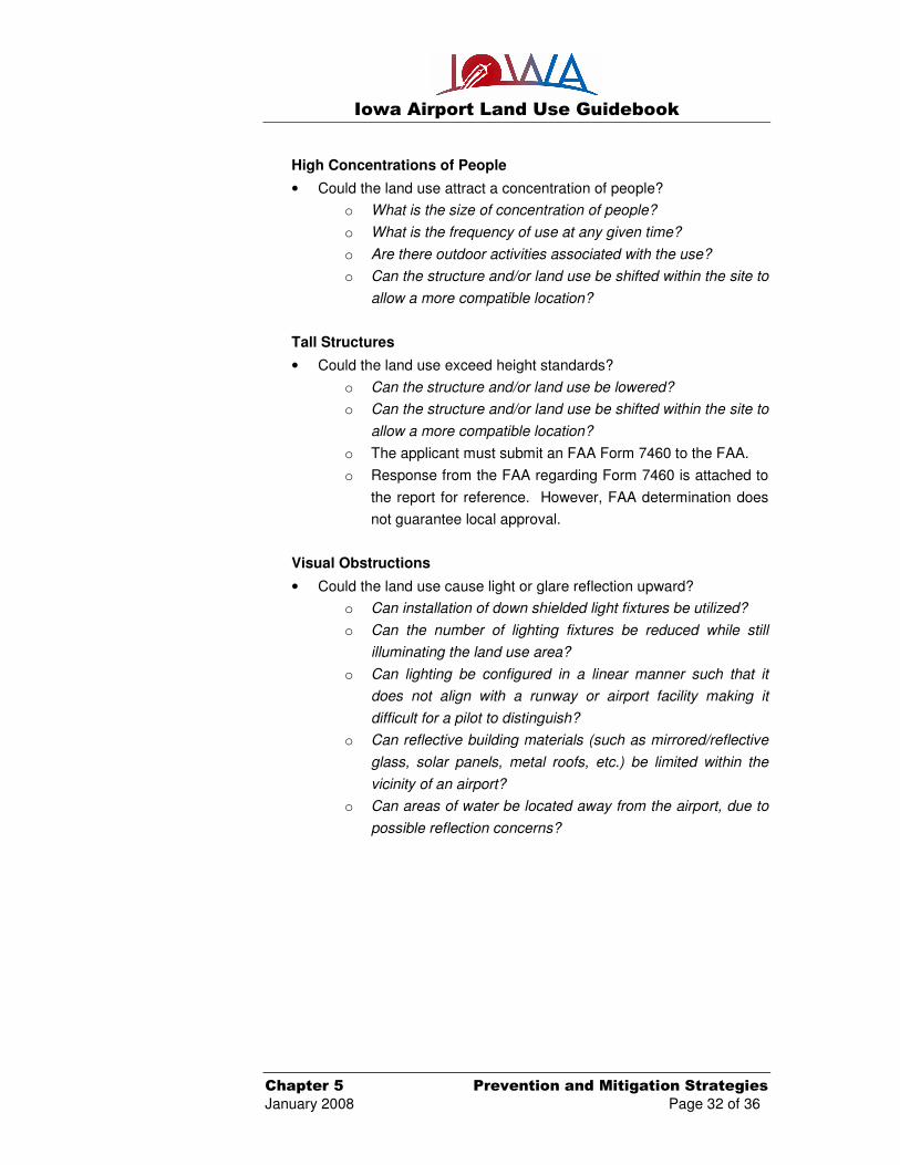
High Concentrations of People
• Could the land use attract a concentration of people?
o What is the size of concentration of people?
o What is the frequency of use at any given time?
o Are there outdoor activities associated with the use?
o Can the structure and/or land use be shifted within the site to
allow a more compatible location?
Tall Structures
• Could the land use exceed height standards?
o Can the structure and/or land use be lowered?
o Can the structure and/or land use be shifted within the site to
allow a more compatible location?
o The applicant must submit an FAA Form 7460 to the FAA.
o Response from the FAA regarding Form 7460 is attached to
the report for reference. However, FAA determination does
not guarantee local approval.
Visual Obstructions
• Could the land use cause light or glare reflection upward?
o Can installation of down shielded light fixtures be utilized?
o Can the number of lighting fixtures be reduced while still
illuminating the land use area?
o Can lighting be configured in a linear manner such that it
does not align with a runway or airport facility making it
difficult for a pilot to distinguish?
o Can reflective building materials (such as mirrored/reflective
glass, solar panels, metal roofs, etc.) be limited within the
vicinity of an airport?
o Can areas of water be located away from the airport, due to
possible reflection concerns?

Iowa Airport Land Use Guidebook
Chapter 5 Prevention and Mitigation Strategies
January 2008 Page 33 of 36
• Could the land use create or emit smoke, steam, or dust?
o Can the structure and/or land use be shifted within the site
so that the prevailing wind directions carries the smoke,
steam, or dust, away from the airport to allow a more
compatible land use?
o Can the land use activity be changed to reduce/limit
emissions of smoke, steam, etc.?
o Land uses that create or emit smoke and steam generally
contain stacks that could also be a height concern.
Wildlife and Bird Attractants
• Could the land use have or create areas of standing water?
o Does the standing water have wildlife controls in place such
as wires, balls, etc., across the water body that detracts
birds from landing, roosting, or resting in the vicinity of an
airport?
o Can the detention area be constructed in such a manner that
standing water is dispersed within 48 hours?
o If the standing water is associated with a detention area, can
the detention area be located under ground or have the
depth increased to reduce surface area?
Additional Considerations
• Could the land use contain flammable substances or materials?
o Can the structure and/or land use be shifted within the site to
allow a more compatible location?
• Could the land use cause a source of electrical, navigation, or radio
interference?
o Has the applicant coordinated with the FAA, through the
FAA Form 7460 to evaluate potential concerns?
o Has the response from the FAA regarding Form 7460 been
received? (Note: attach to report for reference)
(FAA determination does not guarantee local approval)
Iowa Airport Land Use Guidebook
Chapter 5 Prevention and Mitigation Strategies
January 2008 Page 34 of 36
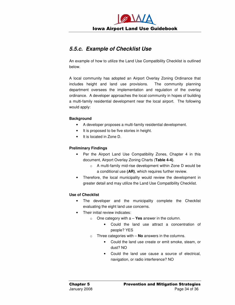
5.5.c. Example of Checklist Use
An example of how to utilize the Land Use Compatibility Checklist is outlined
below.
A local community has adopted an Airport Overlay Zoning Ordinance that
includes height and land use provisions. The community planning
department oversees the implementation and regulation of the overlay
ordinance. A developer approaches the local community in hopes of building
a multi-family residential development near the local airport. The following
would apply:
Background
• A developer proposes a multi-family residential development.
• It is proposed to be five stories in height.
• It is located in Zone D.
Preliminary Findings
• Per the Airport Land Use Compatibility Zones, Chapter 4 in this
document, Airport Overlay Zoning Charts (Table 4-4).
o A multi-family mid-rise development within Zone D would be
a conditional use (AR), which requires further review.
• Therefore, the local municipality would review the development in
greater detail and may utilize the Land Use Compatibility Checklist.
Use of Checklist
• The developer and the municipality complete the Checklist
evaluating the eight land use concerns.
• Their initial review indicates:
o One category with a – Yes answer in the column.
• Could the land use attract a concentration of
people? YES
o Three categories with – No answers in the columns.
• Could the land use create or emit smoke, steam, or
dust? NO
• Could the land use cause a source of electrical,
navigation, or radio interference? NO

Iowa Airport Land Use Guidebook
Chapter 5 Prevention and Mitigation Strategies
January 2008 Page 35 of 36
• Could the land use contain flammable substances or
materials? NO
o Three categories with – Maybe answers in the columns.
• Could the land use exceed compatible DNL noise
levels of 65 or greater? MAYBE
• Could the land use exceed height standard? MAYBE
• Could the land use cause light or glare obstructing
visibility? MAYBE
Based upon the evaluation, it can be demonstrated that there are some
concerns which should be further evaluated. For example:
Noise Sensitivity Related Issues
If the apartment building has outdoor facilities such as balconies, tennis
courts, swimming pools or general recreational areas, aircraft and airport
operational noise impacts may be a concern. Mitigation measures may be
necessary for building materials or practices to reduce potential noise
concerns.
High Concentration of People
The number of units associated with the structure should be evaluated to
determine the size of concentrations of people in proximity to the airport. If
the complex is to have five stories and only four units per story with an
average occupancy of two persons, this would be a density of 40 persons. If
the complex is to have five stories with 20 units per story and an average
occupancy of two persons, this would result in density of 200 persons which
is considerably more than the first scenario. The first scenario may be
determined to be acceptable, while the second option may be deemed to
have too significant of a density.
Iowa Airport Land Use Guidebook
Chapter 5 Prevention and Mitigation Strategies
January 2008 Page 36 of 36
Tall Structures
Typically a five story building in Zone D would not be a height concern,
however, without additional review, this would not be readily determined.
Assuming a standard of 10 feet of height per floor, the building would be
approximately 50 feet in height and the typical allowable height in Zone D is
150 feet above the established airport elevation. However, if the topography
is such that the property is elevated (i.e. located on a hill), the height of the
structure would increase relative to allowable height limitations, and could
therefore be a height concern. Consequently, indicating the existing ground
elevation at the proposed development site, relative to the established airport
elevation, is critical.
Visual Obstructions
The builder would need to supply a list of building materials to prevent the
creation of light or glare that could obstruct the visibility of the pilot. For
example, use of reflective glass should be discouraged or prohibited.
Summary of Findings
It is the municipality’s decision to approve or deny the proposed project
based upon an evaluation that attempts to limit, minimize, or mitigate the
degree of impacts and concerns relating to airport operations and safe
navigation of aircraft.
5.6 Summary
Many communities have some form of existing incompatible land use in
proximity to a local airport. It is important to develop strategies to mitigate
incompatibilities in order to maintain the safe and efficient use of airports, as
well as protect the safety of local citizens on the ground. It is essential to
provide an airport with a variety of mitigation and preservation techniques
because each airport has its own unique set of land use issues. This effort
begins with a solid understanding of the existing and future needs of the local
airport as well as the local community. Using this assessment as a
foundation, the airport sponsor and impacted jurisdictions can move forward
to develop complementary comprehensive plans and airport master
plans/airport layout plans which can guide the development of airport
compatible land use that utilizes a number of techniques, including planning,
zoning, land acquisition, and natural features mitigation.