IOC Strategic Plan for Oceanographic data and...
56
IOC Strategic Plan for Oceanographic data and Information Management (2013-2016) UNESCO Manuals and Guides 66
Transcript of IOC Strategic Plan for Oceanographic data and...
IOC Strategic Plan for Oceanographic data and Information Management (2013-2016)
UNESCO
Manuals and Guides 66

Manuals and Guides 66
UNESCO 2013
IOC Strategic Plan for Oceanographic data and Information Management (2013-2016)

IOC Manuals and Guides, 66 30 August 2013
English/French/Spanish/Russian*
For bibliographic purposes this document should be cited as follows:
Paris. Intergovernmental Oceanographic Commission of UNESCO. 2013. IOC Strategic Plan for Oceanographic data and Information Management (2013-2016). (IOC Manuals and Guides, 66) 54 pp. (English/French/Spanish/Russian) (IOC/2013/MG/66)
� UNESCO 2013
* An executive summary of the strategic plan for 2013–2016 and the text of the IOC Oceanographic Data Exchange Policy (Box 1) are also available in French, Russian and Spanish in the publication.

IOC Manuals and Guides, 66 page (i)
TABLE OF CONTENTS
page
Executive Summary .............................................................................................................. iii Résumé exécutif .................................................................................................................... v Resumen dispositivo ............................................................................................................. ix Рабочее резюме ................................................................................................................ xiii
1. INTRODUCTION ............................................................................................................ 1
2. OCEANOGRAPHIC DATA AND INFORMATION MANAGEMENT AND EXCHANGE IN THE IOC ....................................................................................... 3
2.1. The IOC Oceanographic Data Exchange Policy .................................................. 4 2.2. International Oceanographic Data and Information
Exchange Programme (IODE) ............................................................................ 6 2.2.1 IODE Quality Management Framework ............................................................ 7 2.3. JCOMM Data Management ................................................................................. 7 2.4. IOC Capacity Development for Data and Information Management .................... 9
3. THE STRATEGIC PLAN .............................................................................................. 11 3.1. Strengthening Existing Data and Information Systems ...................................... 11 3.2. The Need for a Strategy .................................................................................... 12 3.3. Vision ................................................................................................................ 13 3.4. Objectives ......................................................................................................... 13 3.5. Scope ............................................................................................................... 13
4. IMPLEMENTING THE STRATEGY .............................................................................. 13 4.1. Structure and Governance – Advisory Group .................................................... 13 4.2. Data Centres ..................................................................................................... 14 4.3. IODE Ocean Data Portal ................................................................................... 17 4.4. Marine SCIENCE Libraries ................................................................................ 18 4.5. Ocean Biogeographic Information System (OBIS) ............................................ 19 4.6 Standards and Best Practices ........................................................................... 20 4.7 Data and Information Products .......................................................................... 21 4.8 Capacity Development ...................................................................................... 22 4.9 Communication and Outreach ........................................................................... 24
ANNEXES I. DATA AND INFORMATION MANAGEMENT IN IOC
AND OTHER INTERNATIONAL PROGRAMMES
II. LIST OF ACRONYMS
Boxes 1. IOC Oceanographic Data Exchange Policy (2003) ....................................................... 4
2. The Ocean Data and Information Network for Africa (ODINAFRICA) ........................................ 10

IOC Manuals and Guides, 66 page (iii)
EXECUTIVE SUMMARY
The IOC Data and Information Management Strategy is for all data collected in IOC programmes. The vision is for
“A comprehensive and integrated ocean data and information system, serving the broad and diverse needs of IOC Member States, for both routine and scientific use.”
The concept of delivering a data and information service for the “global ocean commons” (i.e. global public good) is central to this vision. The objectives of the Strategy are to:
� Facilitate and promote the exchange of oceanographic data and information in compliance with the IOC Oceanographic Data Exchange Policy;
� Deliver a comprehensive distributed data system that can receive data collected by all IOC programmes and projects, as well as other marine science programmes, and deliver them in a uniform and transparent way to all users; and
� Deliver a system that can collect bibliographic and factual information from all IOC programmes, as well as other marine science programmes, and projects and deliver them in a uniform and transparent way to all users.
The IOC Data and Information Management system resulting from this strategy will deliver:
� Assembled, quality controlled and archived data on a diverse range of variables according to scientifically sound and well-documented standards and formats;
� Timely dissemination of data on a diverse range of variables (observations and model outputs) both on real-time and delayed modes depending on the needs of user groups and their technical capabilities (automatic dissemination as well as “on demand”); and
� Easy discovery and access to data and information on a diverse range of variables and derived products (including forecasts, alerts and warnings) by users who have a broad range of capabilities.
The IOC Data and Information system will provide seamless access to the real-time and delay-mode oceanographic data and services across all IOC and related programmes, handling data from the point of collection, through processing and quality control, to archival and dissemination. The IODE developed Ocean Data Portal (ODP) will facilitate the exchange and dissemination of data and services from these systems and will be a key component to deliver the objectives of the IOC Data and Information Strategy. Data, metadata and information will be fully interoperable with the WMO Information System (WIS) and the ODP will function as a WIS Data Collection or Production Centre (DCPC) providing oceanographic data and services.
To ensure its success, the IOC Data and Information Strategy must achieve strong awareness, involvement, acceptance and recognition within and between IOC programmes, and with IOC partners. Efficient communication and outreach remain key elements of the Strategy. Information about the IOC Data and Information Strategy, its development, data and information centres, standards, and implementation progress must be made available in an easy to understand form. By reaching out and serving user communities (scientists, policy makers, managers, educators, students, industries and businesses) will make data and information, including derived products, easily discoverable and accessible, so they can be used in the most efficient and user-friendly way.

IOC Manuals and Guides, 66 page (iv)
The IODE capacity development strategy, implemented as Ocean Data and Information Networks or ODIN, provides a cost-effective and sustainable model for capacity building at the regional level. ODINs develop networks for managing and exchanging oceanographic data and information within the regions including contributing to ocean sciences, operational oceanography development and integrated coastal management and disaster reduction programmes at the regional level. ODINs also contribute to improving the provision of oceanographic data and information products and services to different users by sharing of expertise, knowledge transfer and capacity building and aim to become useful platforms for other IOC programmes. It is recommended to utilize the ODIN model as the capacity building mechanism for the IOC Data and Information Management Strategy.
The major elements of the Strategy are:
� Adhere to the IOC Oceanographic Data Exchange Policy;
� Ensure the long-term archival, management and services of oceanographic data and information;
� Recommended standards and best practice for management and exchange of oceanographic data;
� Acceptance and implementation of a set of interoperability arrangements, including technical specifications for collecting, processing, storing, and disseminating shared data, metadata and products;
� Discovery, access and retrieval of data from IOC programmes, as well as from programmes and organizations collaborating with IOC, through the Ocean Data Portal (ODP), OceanDocs and the Ocean Biogeographic Information System (OBIS) ;
� Continued development of Ocean Data and Information Networks (ODINs) backed up by OceanTeacher as a capacity building tool, whilst extending OceanTeacher through cooperation with JCOMM and others as appropriate;
� Development of appropriate metrics to help evaluate the data and information system;
� Provide the crucial link between data, information and the dissemination of knowledge through the management of marine information by marine librarians;
� Facilitate proper citation of datasets by providing all the required elements of a citation including a persistent identifier (an unambiguous, unchanging reference); and
� Governance by an Advisory Group represented by experts nominated by the governing bodies of IOC programmes.
The greatest challenge to be faced in developing and implementing the IOC Data and Information Management Strategy is one of coordination and cooperation among Member States, partners and user communities. There are currently still major barriers to the efficient use and re-use of data, i.e. Open Data, and to overcome these, and make the best use of the new technologies available, a culture change is required. The information technology required to meet most of the requirements of the strategy, whilst challenging, can be developed from existing capabilities through relatively straightforward software engineering. But the strategy will only succeed if all participants actively use the data and metadata standards, communications protocols, software, and policies that will knit the parts into a fully integrated system.

IOC Manuals and Guides, 66 page (v)
RESUMÉ EXÉCUTIF
PLAN STRATEGIQUE DE LA COI POUR LA GESTION DES DONNEES ET DE L'INFORMATION OCEANOGRAPHIQUES (2013-2016)
La Stratégie de la COI pour la gestion des données et de l'information concerne toutes les données collectées dans le cadre des programmes de la COI. La vision du Plan est celle d'un
« système complet et intégré de données et d'information océanographiques répondant aux besoins globaux et diversifiés des États membres de la COI, pour les tâches courantes et à des fins scientifiques ».
L'idée de fournir un service de données et d’information pour l’« indivis océanique mondial » (c'est-à-dire le bien public mondial) occupe une place centrale dans cette conception. La Stratégie a pour objectifs :
� de faciliter et promouvoir l’échange de données et d’information océanographiques conformément à la Politique de la COI en matière d'échange de données océanographiques ;
� de mettre en œuvre un système global de données dispersées susceptible de recevoir des données collectées par tous les programmes et projets de la COI, ainsi que d’autres programmes d’océanographie, et de les communiquer, de manière uniforme et transparente, à tous les utilisateurs ; et
� de fournir un système capable de collecter des informations bibliographiques et factuelles venant de tous les programmes et projets de la COI, ainsi que d’autres programmes d’océanographie, et de les communiquer, de manière uniforme et transparente, à tous les utilisateurs.
Le Système de gestion des données et de l'information de la COI découlant de la Stratégie apportera ce qui suit :
� des données concernant une grande diversité de variables, rassemblées, archivées et dont la qualité a été contrôlée, conformément à des normes et formats scientifiquement rationnels et bien documentés ;
� la diffusion en temps voulu de données concernant toute une série de variables (observations et résultats obtenus au moyen de modèles), en temps réel et en « différé », en fonction des besoins des groupes d'utilisateurs et de leurs capacités techniques (diffusion automatique et « à la demande ») ; et
� un repérage et un accès plus faciles aux données et à l’information concernant toute une série de variables et de produits dérivés (y compris des prévisions, des alertes et des avis) pour les utilisateurs dotés de vastes compétences.
Le système de la COI pour les données et l'information offrira un accès fluide, en temps réel et en différé, aux données et services océanographiques de tous les programmes de la COI et autres programmes connexes, gérant les données depuis la collecte jusqu'à l'archivage et la diffusion, en passant par le traitement et le contrôle de la qualité. Le Portail des données océanographiques (ODP), conçu par l’IODE, facilitera l’échange et la diffusion des données et services de ces systèmes et sera une composante essentielle de la réalisation des objectifs de la Stratégie de la COI pour la gestion des données et de l'information. Les données, métadonnées et informations seront entièrement interopérables avec le Système d'information de l'OMM (SIO) et l’ODP fonctionnera comme un centre de collecte ou de production de données du SIO fournissant données et services océanographiques.

IOC Manuals and Guides, 66 page (vi)
Pour que son succès soit garanti, la Stratégie de la COI pour la gestion des données et de l'information doit être bien connue, susciter la participation et l’acceptation et acquérir la reconnaissance au sein des programmes de la COI et entre eux ainsi qu’auprès des partenaires de la COI. Une communication et une information efficaces demeurent des éléments essentiels de la Stratégie. Les informations concernant la Stratégie de la COI pour la gestion des données et de l'information, sa mise au point, ses centres de données et d’information, ses normes et les progrès accomplis dans sa mise en œuvre doivent être communiquées de manière facilement compréhensible. Se tourner vers les communautés d’utilisateurs (scientifiques, décideurs, gestionnaires, éducateurs, étudiants, industries et entreprises) et les servir rendra les données et l’information, y compris les produits dérivés, faciles à trouver et accessibles, de sorte qu’elles puissent être utilisées de la manière la plus efficace et la plus simple possible.
La Stratégie de renforcement des capacités de l’IODE, mise en œuvre en tant que réseaux de données et d'information océanographiques ou ODIN, offre un modèle de renforcement des capacités d’un bon rapport coût-efficacité et durable à l’échelle régionale. Les ODIN établissent des réseaux pour la gestion et l'échange des données et de l'information océanographiques dans les régions, notamment en contribuant aux sciences de la mer, au développement de l'océanographie opérationnelle, ainsi qu'aux programmes de gestion intégrée des côtes et de réduction des effets des catastrophes au niveau régional. Les ODIN contribuent également à améliorer les produits et services de données et d'information océanographiques fournis à différents utilisateurs grâce au partage des compétences, au transfert de connaissances et au renforcement des capacités et visent à devenir des plates-formes utiles à d'autres programmes de la COI. Il est recommandé d'utiliser le modèle ODIN comme mécanisme de renforcement des capacités dans la Stratégie de la COI pour la gestion des données et de l'information.
Les principaux éléments de la Stratégie sont les suivants :
� adhérer à la Politique de la COI en matière d'échange de données océanographiques ;
� assurer à long terme l'archivage, la gestion et les services relatifs aux données et informations marines ;
� normes recommandées et meilleures pratiques de gestion et d’échange des données océanographiques ;
� acceptation et mise en œuvre d'un ensemble de dispositions en matière d'interopérabilité, y compris des spécifications techniques pour la collecte, le traitement, le stockage et la diffusion des données, métadonnées et produits partagés ;
� recherche, consultation et extraction de données des programmes de la COI, ainsi que de programmes et d’organisations collaborant avec elle, par le biais du Portail des données océanographiques (ODP), d’OceanDocs et du Système d'informations biogéographiques relatives aux océans (OBIS) ;
� poursuite de la mise en place de réseaux de données et d'information océanographiques (ODIN) s'appuyant sur OceanTeacher comme outil de renforcement des capacités, tout en développant OceanTeacher grâce à la coopération avec la JCOMM et d'autres programmes si nécessaire ;
� élaboration de méthodes de mesure appropriées pour favoriser l'évaluation du système de données et d'information ;
� constituer le lien essentiel entre les données, l'information et la diffusion des connaissances grâce à la gestion de l’information marine par les bibliothécaires spécialisés ;
IOC Manuals and Guides, 66 page (vii)
� faciliter la citation correcte de séries de données en donnant tous les éléments requis, y compris un identifiant permanent (une référence sans ambiguïté et invariable) ; et
� gouvernance assurée par un groupe consultatif représenté par des spécialistes nommés par les organes directeurs des programmes de la COI.
Le plus grand défi à relever dans l'élaboration et la mise en œuvre de la Stratégie de la COI pour la gestion des données et de l'information réside dans la coordination et dans la coopération entre les États membres, les partenaires et les communautés d'utilisateurs. Il reste encore des obstacles majeurs à l'utilisation et à la réutilisation efficaces des données (données libres) et, pour les surmonter et tirer le meilleur parti des nouvelles technologies disponibles, un changement culturel s'impose. Même si elles posent quelques difficultés, les technologies de l'information nécessaires pour répondre à la plupart des besoins figurant dans la Stratégie peuvent être développées à partir des capacités existantes grâce à des activités de génie logiciel relativement simples. Néanmoins, la Stratégie ne sera un succès que si tous les participants utilisent véritablement les normes, protocoles de communication, logiciels et politiques en matière de données et de métadonnées qui uniront les différentes parties en un système pleinement intégré.
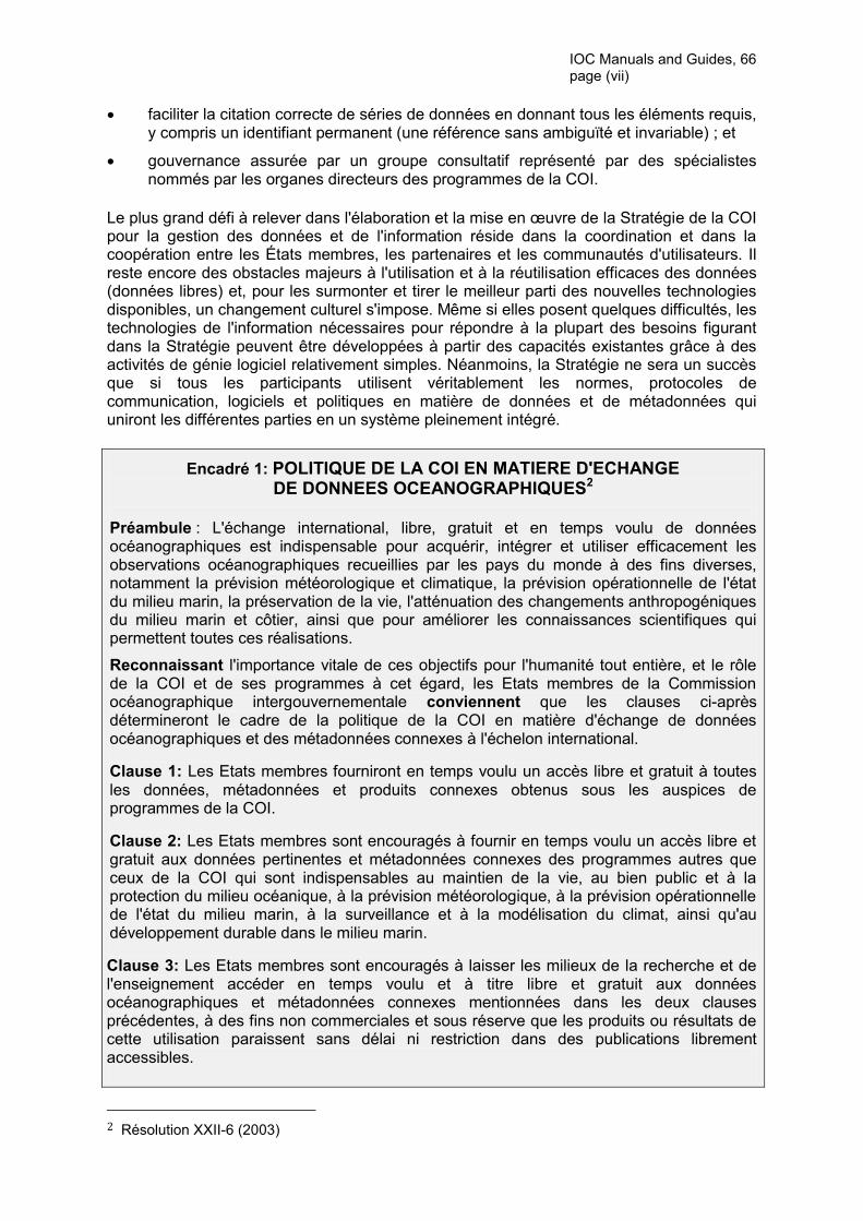
Encadré 1: POLITIQUE DE LA COI EN MATIERE D'ECHANGE DE DONNEES OCEANOGRAPHIQUES2
Préambule : L'échange international, libre, gratuit et en temps voulu de données océanographiques est indispensable pour acquérir, intégrer et utiliser efficacement les observations océanographiques recueillies par les pays du monde à des fins diverses, notamment la prévision météorologique et climatique, la prévision opérationnelle de l'état du milieu marin, la préservation de la vie, l'atténuation des changements anthropogéniques du milieu marin et côtier, ainsi que pour améliorer les connaissances scientifiques qui permettent toutes ces réalisations.
Reconnaissant l'importance vitale de ces objectifs pour l'humanité tout entière, et le rôle de la COI et de ses programmes à cet égard, les Etats membres de la Commission océanographique intergouvernementale conviennent que les clauses ci-après détermineront le cadre de la politique de la COI en matière d'échange de données océanographiques et des métadonnées connexes à l'échelon international.
Clause 1: Les Etats membres fourniront en temps voulu un accès libre et gratuit à toutes les données, métadonnées et produits connexes obtenus sous les auspices de programmes de la COI.
Clause 2: Les Etats membres sont encouragés à fournir en temps voulu un accès libre et gratuit aux données pertinentes et métadonnées connexes des programmes autres que ceux de la COI qui sont indispensables au maintien de la vie, au bien public et à la protection du milieu océanique, à la prévision météorologique, à la prévision opérationnelle de l'état du milieu marin, à la surveillance et à la modélisation du climat, ainsi qu'au développement durable dans le milieu marin.
Clause 3: Les Etats membres sont encouragés à laisser les milieux de la recherche et de l'enseignement accéder en temps voulu et à titre libre et gratuit aux données océanographiques et métadonnées connexes mentionnées dans les deux clauses précédentes, à des fins non commerciales et sous réserve que les produits ou résultats de cette utilisation paraissent sans délai ni restriction dans des publications librement accessibles.
2 Résolution XXII-6 (2003)
IOC Manuals and Guides, 66 page (viii)
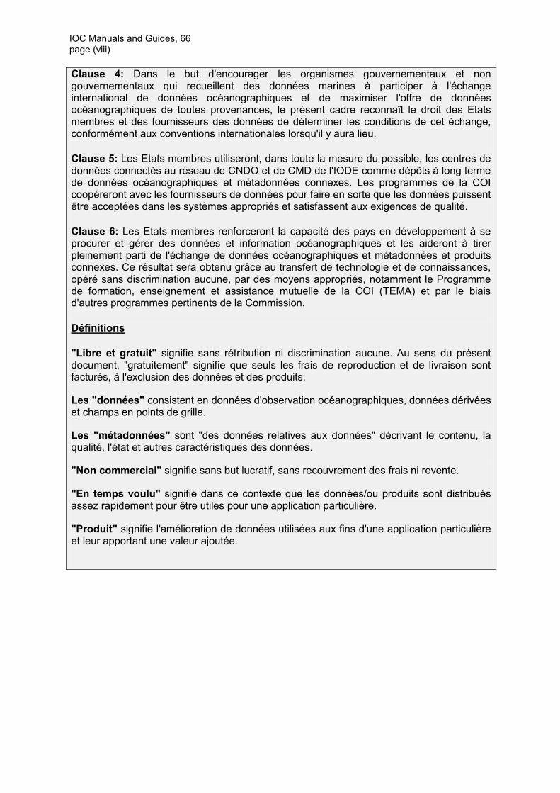
Clause 4: Dans le but d'encourager les organismes gouvernementaux et non gouvernementaux qui recueillent des données marines à participer à l'échange international de données océanographiques et de maximiser l'offre de données océanographiques de toutes provenances, le présent cadre reconnaît le droit des Etats membres et des fournisseurs des données de déterminer les conditions de cet échange, conformément aux conventions internationales lorsqu'il y aura lieu.
Clause 5: Les Etats membres utiliseront, dans toute la mesure du possible, les centres de données connectés au réseau de CNDO et de CMD de l'IODE comme dépôts à long terme de données océanographiques et métadonnées connexes. Les programmes de la COI coopéreront avec les fournisseurs de données pour faire en sorte que les données puissent être acceptées dans les systèmes appropriés et satisfassent aux exigences de qualité.
Clause 6: Les Etats membres renforceront la capacité des pays en développement à se procurer et gérer des données et information océanographiques et les aideront à tirer pleinement parti de l'échange de données océanographiques et métadonnées et produits connexes. Ce résultat sera obtenu grâce au transfert de technologie et de connaissances, opéré sans discrimination aucune, par des moyens appropriés, notamment le Programme de formation, enseignement et assistance mutuelle de la COI (TEMA) et par le biais d'autres programmes pertinents de la Commission.
Définitions
"Libre et gratuit" signifie sans rétribution ni discrimination aucune. Au sens du présent document, "gratuitement" signifie que seuls les frais de reproduction et de livraison sont facturés, à l'exclusion des données et des produits.
Les "données" consistent en données d'observation océanographiques, données dérivées et champs en points de grille.
Les "métadonnées" sont "des données relatives aux données" décrivant le contenu, la qualité, l'état et autres caractéristiques des données.
"Non commercial" signifie sans but lucratif, sans recouvrement des frais ni revente.
"En temps voulu" signifie dans ce contexte que les données/ou produits sont distribués assez rapidement pour être utiles pour une application particulière.
"Produit" signifie l'amélioration de données utilisées aux fins d'une application particulière et leur apportant une valeur ajoutée.

IOC Manuals and Guides, 66 page (ix)
RESUMEN DISPOSITIVO
PLAN ESTRATÉGICO DE LA COI PARA LA GESTIÓN DE DATOS E INFORMACIÓN OCEANOGRÁFICOS (2013–2016)
La estrategia de Gestión de Datos e Información de la COI es aplicable a todos los datos recopilados en los programas de la COI. Su visión consiste en:
“Un sistema completo e integrado de datos e información sobre los océanos, que atiende las amplias y variadas necesidades de los Estados Miembros de la COI, para usos tanto de rutina como científicos".
La prestación de un servicio de datos e información para el "condominio oceánico mundial" (es decir, el patrimonio público mundial) es un concepto esencial en esa visión. Los objetivos de la Estrategia consisten en:
�� Facilitar y promover el intercambio de datos e información oceanográficos en cumplimiento de la Política de Intercambio de Datos Oceanográficos de la COI;
�� Proporcionar un sistema completo de datos distribuidos capaz de recibir datos obtenidos de todos los programas y proyectos de la COI, así como de otros programas de ciencias marinas, y entregarlos de manera uniforme y transparente a todos los usuarios; y
�� Proporcionar un sistema capaz de recopilar información bibliográfica y constatable de todos los programas y proyectos de la COI, así como de otros programas de ciencias marinas, y entregarlos de manera uniforme y transparente a todos los usuarios.
El sistema de Gestión de Datos e Información de la COI resultante de esa estrategia permitirá:
�� Recopilar, someter a control de la calidad y archivar datos sobre diversas variables con arreglo a normas y formatos científicamente fundados y bien documentados;
�� Distribuir puntualmente datos sobre diversas variables (observaciones y productos de modelos) en tiempo real y diferido en función de las necesidades de los grupos de usuarios y sus capacidades técnicas (difusión automática y a pedido); y
�� Facilitar el descubrimiento y la consulta de datos sobre una gama de variables y productos derivados (comprendidas predicciones, avisos y alertas) por parte de usuarios que disponen de una amplia gama de capacidades.
El sistema de datos e información de la COI permitirá acceder sin discontinuidad a los datos y servicios oceanográficos en tiempo real y diferido respecto de todos los programas de la COI y similares, gestionando los datos desde el momento de su obtención hasta su archivado y difusión, pasando por el procesamiento y el control de la calidad. El Portal de Datos Oceanográficos (ODP) desarrollado por el IODE facilitará el intercambio y difusión de datos y servicios de esos sistemas, y será un componente clave para la consecución de los objetivos de la Estrategia de Datos e Información de la COI. Los datos, los metadatos y la información serán enteramente compatibles con el Sistema de información de la OMM (DCPC), y el ODP actuará como Centro de Recopilación o Producción de Datos (DCPC) del SIO, proporcionando datos y servicios oceanográficos.
Para dar buenos resultados, la Estrategia de Datos e Información de la COI deberá lograr una decidida sensibilización, participación, aceptación y reconocimiento, tanto de los

IOC Manuals and Guides, 66 page (x)
programas de la COI como entre éstos y con los colaboradores de la COI. La eficacia en la comunicación y en la divulgación sigue siendo un elemento clave de la Estrategia. La información sobre la Estrategia de Datos e Información de la COI, su desarrollo, los centros de datos e información, las normas y los progresos en su ejecución deberán estar disponibles en términos fáciles de comprender. Dándose así a conocer y prestando servicio a las comunidades de usuarios (científicos, responsables de políticas, gestores, educadores, estudiantes, industrias y negocios), los datos y la información, incluidos los productos derivados, serán fáciles de reconocer y accesibles, de modo que puedan ser utilizados de la manera más eficaz y cómoda para los usuarios.
La estrategia de desarrollo de capacidad del IODE, aplicada en forma de Redes de Datos e Información Oceanográficos (ODIN), ofrece un modelo eficaz en relación con los costos y sostenible para el desarrollo de capacidades a nivel regional. Las ODIN establecen redes para la gestión e intercambio de datos e información oceanográficos en las regiones, contribuyendo en particular a las ciencias oceánicas, al desarrollo de la oceanografía operacional y a los programas de gestión integrada de las zonas costeras y de reducción de desastres a nivel regional. Las ODIN contribuyen también a mejorar la aportación de productos y servicios de datos e información oceanográficos a diferentes usuarios mediante el intercambio de recursos expertos, la transferencia de conocimientos y el desarrollo de capacidades, y se proponen constituir plataformas útiles para otros programas de la COI. Se recomienda utilizar el modelo ODIN como mecanismo de desarrollo de capacidad para la Estrategia de Gestión de Datos e Información de la COI.
Los principales elementos de la Estrategia consisten en:
�� Adoptar la interoperabilidad de la Política de Intercambio de Datos Oceanográficos de la COI;
�� Encargarse del archivado, la gestión y la prestación de servicios en relación con los datos e información oceanográficos a largo plazo;
�� Normas recomendadas y mejores prácticas para la gestión e intercambio de datos oceanográficos;
�� Aceptar y adoptar una serie de medidas de interoperabilidad, y en particular especificaciones técnicas para recopilar, procesar, almacenar y difundir datos, metadatos y productos compartidos;
�� El descubrimiento, acceso y recuperación de datos de los programas de la COI y de los programas y organizaciones que colaboran con ella mediante el Portal de Datos Oceanográficos (ODP), OceanDocs y el Sistema de Información Biogeográfica de los Océanos (OBIS);
�� Seguir desarrollando Redes de Datos e Información Oceanográficos (ODIN) con la ayuda de OceanTeacher como herramienta de desarrollo de capacidades, y conseguir una mayor utilización de OceanTeacher gracias a la cooperación con la JCOMM y con otras entidades, según proceda;
�� Desarrollar una métrica apropiada que ayude a evaluar el sistema de datos e información;
�� Establecer el vínculo esencial entre los datos, la información y la difusión de conocimientos mediante la gestión de la información marina por los responsables de las bibliotecas sobre las ciencias del mar;
�� Facilitar la mención correcta de los conjuntos de datos aportando todos los elementos necesarios para ello, y en particular un identificador persistente (es decir, una referencia inequívoca e invariable); y
�� Gobernanza a cargo de un Grupo Consultivo integrado por expertos designados por los órganos rectores de los programas de la COI.

IOC Manuals and Guides, 66 page (xi)
El principal problema que se plantea a la hora de elaborar y aplicar la Estrategia de Gestión de Datos e Información de la COI es el de la coordinación y cooperación entre los Estados Miembros, los copartícipes y las comunidades de usuarios. Subsisten importantes obstáculos a la utilización y reutilización eficiente de los datos (datos libres), y para superarlas y aprovechar lo mejor posible las nuevas tecnologías disponibles se precisa un cambio cultural. La tecnología de la información necesaria para responder a la mayor parte de los requisitos de la estrategia plantea un reto considerable, pero puede desarrollarse a partir de las capacidades existentes gracias a una ingeniería de programación informática relativamente sencilla. Pero la estrategia dará resultados solamente si todos los participantes utilizan activamente las normas de datos y metadatos, los protocolos de comunicación, los programas informáticos y las políticas que estructurarán las partes en un sistema integrado.
Recuadro 1: POLÍTICA DE INTERCAMBIO DE DATOS OCEANOGRÁFICOS DE LA COI3
Preámbulo: El intercambio internacional oportuno, gratuito y sin restricciones de datos oceanográficos es esencial para la adquisición, integración y utilización eficientes de las observaciones del océano recopiladas por los países del mundo con una amplia variedad de fines, entre ellos los pronósticos meteorológicos y climáticos, la predicción operacional del medio marino, la preservación de la vida, la mitigación de los cambios de origen humano en el medio marino y costero, y el avance del conocimiento científico que lo hace posible.
Reconociendo: la importancia vital de estos objetivos para toda la humanidad y la función que cumplen la COI y sus programas a este respecto, los Estados Miembros de la Comisión Oceanográfica Intergubernamental convienen en que en las cláusulas que siguen quedará formulada la política de intercambio internacional de datos oceanográficos y metadatos conexos de la COI.
Cláusula 1: Los Estados Miembros facilitarán acceso oportuno, gratuito y sin restricciones a todos los datos, metadatos conexos y productos generados bajo los auspicios de los programas de la COI.
Cláusula 2: Se alienta a los Estados Miembros a facilitar acceso oportuno, gratuito y sin restricciones a los datos y metadatos conexos pertinentes de programas que no son de la COI, indispensables para aplicaciones relacionadas con la preservación de la vida, los usos en beneficio público y la protección del medio ambiente oceánico, los pronósticos meteorológicos, la predicción operacional del medio marino, la vigilancia y la modelización del clima, y el desarrollo sostenible en el medio marino.
Cláusula 3: Se alienta a los Estados Miembros a facilitar el acceso oportuno, gratuito y sin restricciones a los datos oceanográficos y metadatos conexos a que se refieren las Cláusulas 1 y 2, para usos no comerciales de las comunidades de investigación y educación, siempre que los productos o resultados de esos usos aparezcan en documentos públicos sin dilación ni restricciones.
Cláusula 4: Con objeto de alentar la participación de órganos gubernamentales y no gubernamentales de acopio de datos oceanográficos en el intercambio internacional de dichos datos y potenciar al máximo la contribución de los datos oceanográficos procedentes de todas las fuentes, en esta política se reconoce el derecho de los Estados Miembros y de los productores de datos de determinar las condiciones de tal intercambio,
3 Resolución XXII-6 (2003)

IOC Manuals and Guides, 66 page (xii)
en congruencia con las convenciones internacionales, cuando proceda.
Cláusula 5: En toda la medida de lo posible, los Estados Miembros recurrirán a centros de datos vinculados a los NODC del IODE y a las redes de centros mundiales de datos como depósitos a largo plazo de datos oceanográficos y metadatos conexos. Los programas de la COI cooperarán con los proveedores de datos a fin de garantizar que éstos pueden ser aceptados en los sistemas correspondientes y cumplen los requisitos de calidad.
Cláusula 6: Los Estados Miembros aumentarán la capacidad de los países en desarrollo para obtener y administrar datos e información oceanográficos y les ayudarán a aprovechar plenamente el intercambio de datos oceanográficos, metadatos conexos y productos. Este objetivo se logrará mediante la transferencia sin discriminación de tecnología y conocimientos recurriendo a los medios apropiados, entre ellos el programa de Capacitación, Enseñanza y Asistencia Mutua (TEMA) de la COI, así como a otros programas pertinentes de la COI.
Definiciones
“Gratuito y sin restricciones” significa sin discriminación y sin gastos. “Sin cargo”, en el contexto de esta resolución, significa sólo el costo de la reproducción y entrega, sin gastos por los datos y productos propiamente dichos.
“Datos”: comprenden los datos de observaciones oceanográficas, los datos derivados y los campos reticulados.
“Metadatos” son “datos sobre datos”, que describen el contenido, la calidad, la condición y otras características de los datos.
“No comercial” significa que no tiene objetivos de lucro, de recuperación de costos o de venta.
“Oportuno” en este contexto se refiere a la distribución de datos y/o productos con la rapidez suficiente para que puedan ser utilizados en determinadas aplicaciones.
“Productos” son datos con valor añadido utilizados para una aplicación determinada.

IOC Manuals and Guides, 66 page (xiii)
РАБОЧЕЕ РЕЗЮМЕ
СТРАТЕГИЧЕСКИЙ ПЛАН МОК ПО УПРАВЛЕНИЮ ОКЕАНОГРАФИЧЕСКИМИ ДАННЫМИ И ИНФОРМАЦИЕЙ
(2013-2016 гг.)
Стратегия МОК по управлению данными и информацией охватывает все данные, собираемые в рамках программ МОК. Видение этой стратегии состоит в следующем:
«Создание всеобъемлющей и комплексной системы океанических данных и информации, обслуживающей широкие и разнообразные потребности государств – членов МОК и используемой как в практических, так и в научных целях».
Центральным аспектом этой концепции является предоставление услуг в отношении данных и информации применительно к «Мировому океану как всеобщему достоянию» (то есть глобальному общественному благу). Стратегия имеет следующие цели:
• поддержка и поощрение обмена океанографическими данными и информацией в соответствии с Политикой МОК в области обмена океанографическими данными;
• обеспечение всеобъемлющей системы распределенных данных, способной получать данные, собираемые в рамках всех программ и проектов МОК, а также других программ по морской науке, и предоставлять их всем пользователям на единой и транспарентной основе;
• обеспечение системы, способной собирать библиографическую и фактологическую информацию в рамках всех программ и проектов МОК, а также других программ по морской науке, и предоставлять их всем пользователям на единой и транспарентной основе.
Система МОК по управлению данными и информацией, разработанная в соответствии с этой стратегией, будет обеспечивать следующее:
• скомпонованные, прошедшие контроль качества и архивированные данные по широкому кругу переменных параметров в соответствии с научно обоснованными и отраженными в соответствующих документах стандартами и форматами;
• своевременное распространение данных по широкому кругу переменных параметров (наблюдения и результаты моделирования) как в реальном времени, так и в отсроченном режиме в зависимости от потребностей групп пользователей и их технических возможностей (распространение на автоматической основе, а также «по требованию»);
• обеспечение несложных методов обнаружения и доступа к данным и информации по широкому кругу переменных параметров и производных продуктов (включая прогнозы, оповещения и предупреждения) для пользователей, располагающих широким кругом возможностей.
Система данных и информации МОК будет давать беспрепятственный доступ к океанографическим данным и услугам в реальном времени и в отсроченном режиме в рамках всех программ МОК и смежных программ, обеспечивая работу с данными, начиная со сбора, обработки и контроля качества и кончая архивацией и распространением. Разработанный в рамках МООД Портал океанических данных (ПОД) будет содействовать обмену и распространению данных и услуг, обеспечиваемых этими системами, и станет одним из ключевых компонентов для

IOC Manuals and Guides, 66 page (xiv)
достижения целей Стратегии МОК в области данных и информации. Данные, метаданные и информация будут также обладать полной оперативной совместимостью с Информационной системой ВМО (ИСВ), и ПОД будет функционировать как Центр ИСВ по сбору или производству данных (ЦСПД) в деле предоставления океанографических данных и услуг.
Для обеспечения успеха необходимо добиться широкого осознания, поддержки, принятия и признания Стратегии МОК в области данных и информации внутри программ МОК и между ними, а также в среде партнеров Комиссии. Эффективная коммуникация и информационно-разъяснительная работа остаются ключевыми элементами стратегии. Необходимо обеспечить предоставление в понятной форме сведений о Стратегии МОК в области данных и информации и ее развитии, о центрах данных и информации, стандартах и ходе практической работы. Благодаря информационно-разъяснительной работе и обслуживанию сообществ пользователей (ученых; лиц, ответственных за политику; менеджеров; педагогов; студентов; представителей промышленности и предпринимателей), станет легче отыскивать данные и информацию, включая производные продукты, и получать к ним доступ, поэтому они смогут использоваться наиболее эффективным и удобным для пользователя способом.
Стратегия МООД в области развития потенциала, реализуемая с помощью Сетей по океаническим данным и информации (ОДИН), служит экономически эффективной и устойчивой моделью для наращивания потенциала на региональном уровне. В рамках проекта ОДИН развиваются сети по управлению и обмену океанографическими данными и информацией в регионах, включая вклад в науки об океане и развитие оперативной океанографии, а также в комплексное управление прибрежными районами и программы уменьшения опасности бедствий на региональном уровне. Кроме того, сети ОДИН способствуют улучшению предоставления продуктов и услуг, касающихся океанографических данных и информации, для различных пользователей путем обмена опытом, передачи знаний и создания потенциала, а также имеют целью стать полезными платформами для других программ МОК. Рекомендуется использовать модель ОДИН в качестве механизма создания потенциала для Стратегии МОК по управлению данными и информацией.
Стратегией предусматриваются следующие основные элементы:
• соблюдение Политики МОК в области обмена океанографическими данными;
• обеспечение долгосрочной архивации, управления и услуг применительно к океанографическим данным и информации;
• использование рекомендованных стандартов и наилучшей практики для управления и обмена океанографическими данными;
• принятие и реализация комплекса механизмов по обеспечению операционной совместимости, включая технические спецификации для сбора, обработки, хранения и распространения совместно используемых данных, метаданных и продуктов;
• поиск, получение доступа и извлечение данных в рамках программ МОК, а также программ и организаций, сотрудничающих с Комиссией, с использованием Портала океанических данных (ПОД), проекта «Океан-Документация» и Океанической биогеографической информационной системы (ОБИС);

IOC Manuals and Guides, 66 page (xv)
• дальнейшая разработка Сетей океанографических данных и информации (ОДИН) с опорой на проект «Океан-Инструктор» как на механизм создания потенциала с его одновременным расширением на основе сотрудничества со СКОММ и, по мере необходимости, другими соответствующими организациями;
• разработка соответствующих метрик для содействия оценке системы данных и информации;
• обеспечение важнейшей взаимосвязи между данными, информацией и распространением знаний с помощью управления информацией о морской среде, осуществляемого морскими библиотеками;
• содействие правильному цитированию наборов данных путем обеспечения всех необходимых элементов цитирования, включая постоянные идентификаторы (однозначные, неизменные ссылки);
• управление с помощью Консультативной группы в составе экспертов, назначаемых руководящими органами программ МОК.
Основной вызов, связанный с разработкой и осуществлением Стратегии МОК по управлению данными и информацией, состоит в координации и сотрудничестве между государствами-членами, партнерами и сообществами пользователей. Сегодня сохраняются серьезные препятствия на пути эффективного первичного и вторичного использования данных, например открытых данных, и для их преодоления и оптимального применения новых имеющихся технологий потребуется изменение культуры. При всей сложности информационной технологии, необходимой для удовлетворения большинства требований этой стратегии, ее можно разработать на основе имеющихся возможностей посредством создания сравнительно простого программного обеспечения. Однако эта стратегия окажется успешной только в том случае, если все участники будут активно использовать стандарты, коммуникационные протоколы, программное обеспечение и политику в области данных и метаданных, что позволит объединить различные элементы в рамках полностью интегрированной системы.
Вставка1: ПОЛИТИКА МОК В ОБЛАСТИ ОБМЕНА ОКЕАНОГРАФИЧЕСКИМИ ДАННЫМИ4
Преамбула: Своевременный, свободный и неограниченный международный обмен океанографическими данными необходим для эффективного поиска, интеграции и использования результатов океанических наблюдений, полученных странами мира, в целях решения широкого круга задач, включая прогнозирование погоды и климата, оперативное прогнозирование состояния морской среды, сохранение жизни, смягчение последствий изменений, вызванных деятельностью человека в морской и прибрежной среде, а также для прогресса научных знаний, которые лежат в основе всей этой деятельности.
Признавая: жизненно важное значение решения этих задач для всего человечества и ту роль, которую играют МОК и ее программы в этом отношении, государства - члены Межправительственной океанографической комиссии соглашаются принять изложенные ниже положения, определяющие рамки политики МОК в области международного обмена океанографическими данными и связанными с ними метаданными.
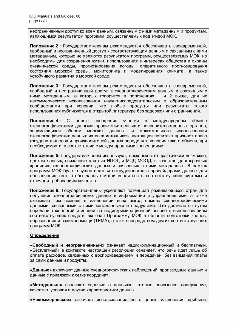
Положение 1 : Государства-члены обеспечивают своевременный, свободный и
4 Резолюция XXII-6 (2003)
IOC Manuals and Guides, 66 page (xvi)
неограниченный доступ ко всем данным, связанным с ними метаданным и продуктам, являющимся результатом программ, осуществляемых под эгидой МОК.
Положение 2 : Государствам-членам рекомендуется обеспечивать своевременный, свободный и неограниченный доступ к соответствующим данным и связанным с ними метаданным, которые не являются результатом программ, осуществляемых МОК, но необходимы для сохранения жизни, использования в интересах общества и охраны океанической среды, прогнозирования погоды, оперативного прогнозирования состояния морской среды, мониторинга и моделирования климата, а также устойчивого развития в морской среде.
Положение 3 : Государствам-членам рекомендуется обеспечивать своевременный, свободный и неограниченный доступ к океанографическим данным и связанным с ними метаданным, о которых говорится в положениях 1 и 2 выше, для их некоммерческого использования научно-исследовательским и образовательным сообществами при условии, что любые продукты или результаты такого использования публикуются в открытой литературе без задержек или ограничений.
Положение 4 : С целью поощрения участия в международном обмене океанографическими данными правительственных и неправительственных органов, занимающихся сбором морских данных, и максимального использования океанографических данных из всех источников настоящая политика признает право государств-членов и производителей данных определять условия такого обмена, при необходимости, в соответствии с международными конвенциями.
Положение 5: Государства-члены используют, насколько это практически возможно, центры данных, связанные с сетью НЦОД и МЦД МООД, в качестве долгосрочных хранилищ океанографических данных и связанных с ними метаданных. В рамках программ МОК будет осуществляться сотрудничество с провайдерами данных для обеспечения того, чтобы данные могли вводиться в соответствующие системы и отвечали требованиям качества.
Положение 6: Государства-члены укрепляют потенциал развивающихся стран для получения океанографических данных и информации и управления ими, а также оказывают им помощь в извлечении всех выгод обмена океанографическими данными, связанными с ними метаданными и продуктами. Это достигается путем передачи технологий и знаний на недискриминационной основе с использованием соответствующих средств, включая Программу МОК в области подготовки кадров, образования и взаимопомощи (ТЕМА), а также посредством других соответствующих программ МОК.
Определения
«Свободный и неограниченный» означает недискриминационный и бесплатный. «Бесплатный» в контексте настоящей резолюции означает, что речь идет лишь об оплате расходов, связанных с воспроизведением и передачей, без взимания платы за сами данные и продукты.
«Данные» включают данные океанографических наблюдений, производные данные и данные с привязкой к сетке координат.
«Метаданные» означают «данные о данных», которые описывают содержание, качество, условия и другие характеристики данных.
«Некоммерческое» означает использование не с целью извлечения прибыли,

IOC Manuals and Guides, 66 page (xvii)
покрытия расходов или перепродажи.
«Своевременный» в данном контексте означает, что распространение данных и/или продуктов осуществляется достаточно быстро, с тем чтобы сохранить их ценность для определенного вида использования.
«Продукт» означает данные с добавленной стоимостью, используемые для конкретных целей.

IOC Manuals and Guides, 66
Within the context of IOC the following definitions for data and information are used:
� Data: consists of oceanographic observation data, derived data and gridded fields (IOC Oceanographic Data Exchange Policy)
� Information: includes factual (e.g. directories of experts) and textual (literature) information that may be the outcome or product of scientific research. (IODE GEMIM)
1. INTRODUCTION
The Intergovernmental Oceanographic Commission (IOC) of UNESCO provides its Member States with an essential mechanism for global cooperation in the study of the ocean. The IOC promotes international cooperation and coordination of programmes in research, observing systems and services, and capacity-building, in order to learn more about the nature and resources of the ocean and coastal areas and to apply that knowledge for the improvement of management, sustainable development, the protection of the marine environment, and the decision making processes of its Member States.
The function of data collection, through the IOC networks of ocean observations, is fundamental and underpins current research efforts on climate and the development of ocean services. Consistent with its international public service mission, all data collected by Member States as part of IOC Programmes and activities are subject to free and open exchange under the current IOC Data Policy. New automated systems deployed over the World oceans are providing a data stream never attained before in history. Organizing the necessary technological networks, collaborating with WMO and using its GTS system, IOC has significantly closed the gap between the traditional delayed mode exchange of data (weeks to months) and real-time exchange of data. Current IOC programmes provide the necessary data, information and knowledge to contribute to services needed to effectively address ocean issues.
Oceanographic data and information underpin many of the activities we undertake encompassing scientific research, modelling, monitoring and assessment. These data are precious; they are fundamental to the understanding of the processes that control our natural environment. The data held provide answers to both local questions (such as the likelihood of coastal flooding) and global issues (such as the prediction of the impact of global warming). The better we can predict these events, the better we can protect ourselves into the future. This not only affects us, but the quality of the lives of future generations.
Additionally, whilst the data collected will be used operationally or manipulated by the scientist or researcher to provide material for scientific publication, the data are a resource in their own right. Properly managed and preserved, they can potentially be re-used by future researchers, and exploited commercially or educationally. Such further uses, often not envisaged in the first instance, will make an additional contribution to scientific advance and knowledge.
Oceanographic data are obtained by diverse means: nets are dragged, traps are set; instruments are lowered from ships, set adrift, or moored on cables and platforms, satellites scan the oceans from space, and laboratories are constructed on the seafloor. Measurements are made for a wide variety of purposes by individuals and sensors supported by many different kinds of institutions, including governments, commercial operations and non-governmental organizations. These data come in many different forms,

IOC Manuals and Guides, 66 page 2
from a single variable measured at a single point (e.g., a species name) to multivariate, four-dimensional collections of data that may be many terabytes in size.
These data are often irreplaceable; they are always unique, if only in the timing of collection. Even when considering all of the data collected, spatial and temporal coverage is quite sparse. Oceanographic data can also be extremely expensive to collect. Over many years a variety of databases have been compiled bringing together data from many different sources. More recently there has been need for access to more multidisciplinary and integrated datasets to further our knowledge and understanding and to better manage the marine environment, including taking an ecosystem approach. In addition there is an increasing requirement for operational data in near-real-time for forecasting marine conditions.
Marine Science Libraries and Information Centres play an important role in promoting information about the marine environment. Scientific knowledge is exchanged primarily through scientific publications; information provision to the policy makers is crucial in order to enable them to make the best decisions regarding the protection and use of the marine environment; marine research information contributes to educating the next generation of environmental stewards; research literature and public information tools attract a future environmentally concerned workforce and generates an ocean literate public that understands the value of the ocean and can make appropriate decisions to protect it.
Research literature is increasingly produced and disseminated electronically (e-journals and e-repositories). Marine Science Libraries are at the forefront of open access to scientific publications and datasets. This creates challenges to the traditional publishing model but provides easier access to information to more people. Similarly, marine science libraries utilize web based environments to operate as clearinghouse systems and disseminators for factual information (e.g. online atlases, visualization products, databases of institutions and researchers, etc.) On an international scale, networks of IODE Marine Information Management (MIM) Centres collaborate to develop products such as online repositories of marine and aquatic information, and services such as data links to scientific literature, data citation and standardized metadata, taxonomies and ontologies that will strengthen our global understanding of ocean processes and conditions. The Marine Information Management activities and its main expert base, i.e. the Marine Science Librarians, play a vital role in this knowledge cycle.
The scope of this Data and Information Strategy is comprehensive and across all of the disciplines within the mandate of IOC. There is no a priori separation of functions based on the lead time for data delivery (e.g., real-time versus delayed mode) or in the type of data. Different strategies might be employed to satisfy global, regional and local requirements, and to meet timeliness needs.
This strategy has been developed to ensure that all projects and programmes which come under the auspices and guidance of IOC are covered by a common set of goals. It contributes to all the High-Level Objectives of the IOC (2008-2013) which address:
(i) Prevention and reduction of the impacts of natural hazards;
(ii) Mitigation of the impacts of and adaptation to, climate change and variability;
(iii) Safeguarding the health of ocean ecosystems; and
(iv) Management procedures and policies leading to the sustainability of coastal and ocean environment and resources.
It will focus on implementing, maintaining and developing data and information management and exchange by better engaging all Member States. It also takes into account those
IOC Manuals and Guides, 66 page 3
strategies already developed or under development, by for example, global GOOS, coastal GOOS and the Joint WMO/IOC Technical Commission for Oceanography and Marine Meteorology (JCOMM). In addition, programmes and projects sponsored or co-sponsored by IOC, which have developed data and information strategies have also been taken into account. The strategy covers all aspects of oceanographic data and information management including marine information management undertaken by marine science librarians, which provides the crucial link between data, information and the dissemination of knowledge.
The information technology required to meet most of the requirements of the IOC Data and Information Strategy, whilst challenging, can be developed from existing capabilities through relatively straightforward software engineering. The greatest challenge to be faced is one of coordination and cooperation among partners and user communities. It can succeed only if the participants actively use data and metadata standards, communications protocols, software, and policies that will knit the parts into an integrated whole. The creation of a successful international data and information system will require a sustained effort, a commitment across the marine community, and continual coordination with other international bodies.
This document outlines the strategy for the period 2013-2016 and will be reviewed after four years with progress evaluation mid-term.
2. OCEANOGRAPHIC DATA AND INFORMATION MANAGEMENT AND EXCHANGE IN THE IOC
This Strategic Plan covers a wide diversity of data and information over a range of spatial and temporal scales, including operational data flows to the latest scientific research. It also covers a diverse array of Member States ranging from the highly technically developed to those that may have little infrastructure for managing and utilizing data, data products and information.
Over the history of the IOC, many ocean science and observation programmes and projects have been established. In 1961, the IOC established the IODE programme. Whereas the IODE, and especially its network of National Oceanographic Data Centres (NODCs), has assumed responsibility for the data management tasks of many national and international ocean science and observation programmes and projects, many programmes and projects have developed their own data and information management activities, often without linkages to the IODE and its NODCs. In addition, other international organizations, programmes and projects have also developed data and information management programmes and activities with national, regional or global focus, often in isolation.
All programmes within IOC should have a data and information management component, developed within the programme and implemented in close collaboration and consultation with the IODE and its NODCs and Marine Information Centres, so the considerable expertise available in these national structures, can be fully exploited. The IOC Data and Information Management Strategy provides the framework in which these plans can be developed, and recommends the use of standards and the data centres where the data can reside.
The Framework for Ocean Observing (FOO), which has been developed as an outcome of OceanObs09, is a framework for planning an enhanced global sustained ocean observing system over the next decade, integrating new physical, biochemical, biological observations while sustaining present observations. The Framework identifies the requirements, priorities, implementation and costs for obtaining the highest-priority global ocean observations

IOC Manuals and Guides, 66 page 4
essential for both research and societal needs. The Framework encompasses a collection of processes that provide a roadmap of organization, communication, best practices, and systems engineering to foster improved interfaces and integration of ocean observing efforts into an optimal global system and endorses a concept of Essential Ocean Variables (EOVs). Data management across all IOC programmes incorporates activities discussed in the FOO and the IOC Data and Information Management Strategy will deliver an effective data management system to ensure the needs of the ocean observing community are addressed.
The task of building a global, distributed oceanographic data system is complex and requires a culture change leading to a greater level of international cooperation. Every participant will need to make changes in their present practices to conform to the larger view. But the payoff will be large and shared by all. The key to this process is agreement on standard practices and protocols. Starting afresh is not an option, and the current systems need to evolve into an interoperable system. New technologies and ideas will be exploited to handle and deliver data to a wide range of users or clients.
Annex I lists a (non-exhaustive) number of IOC programmes and related organizations that play a role in the collection and management of oceanographic data and information.
2.1. THE IOC OCEANOGRAPHIC DATA EXCHANGE POLICY
The IOC Data and Information Management Strategy builds on the IOC Oceanographic Data Exchange Policy (see Box 1), which promotes the free and open access to data, metadata and products. This Strategy is also compatible with other relevant international data exchange policies which promote free and open access to data, for example, WMO Resolution 40 which provides for the free and unrestricted sharing of meteorological data, the ICSU WDS Data Policy, the ICES Data Policy, the IPY Data Policy and the GEOSS Data Sharing Principles.
A variety of other programme, project, national and organizational data exchange policies also exist and as far as possible they should be encouraged to provide free and open access to data. Argo is a good example of a project with free and open access to all the data collected; real-time data are available within 24 hours and quality controlled data on a longer time scale. However, it is important to ensure intellectual property rights are not compromised in the data and in scientific papers produced by those responsible for the data collection. In addition, it is important to give proper credit to the data creators and data must be properly referenced or cited. The IODE is working closely with SCOR and MBLWHOI to promote the publishing of datasets within repositories as unique objects with data citations to improve data flow.
BOX 1: IOC OCEANOGRAPHIC DATA EXCHANGE POLICY5 Preamble: The timely, free and unrestricted international exchange of oceanographic data is essential for the efficient acquisition, integration and use of ocean observations gathered by the countries of the world for a wide variety of purposes including the prediction of weather and climate, the operational forecasting of the marine environment, the preservation of life, the mitigation of human-induced changes in the marine and coastal environment, as well as for the advancement of scientific understanding that makes this possible.
Recognising the vital importance of these purposes to all humankind and the role of IOC and its programmes in this regard, the Member States of the Intergovernmental Oceanographic Commission agree that the following clauses shall frame the IOC policy for 5 Resolution XXII-6 (2003)

IOC Manuals and Guides, 66 page 5
the international exchange of oceanographic data and its associated metadata.
Clause 1: Member States shall provide timely, free and unrestricted access to all data, associated metadata and products generated under the auspices of IOC programmes.
Clause 2: Member States are encouraged to provide timely, free and unrestricted access to relevant data and associated metadata from non-IOC programmes that are essential for application to the preservation of life, beneficial public use and protection of the ocean environment, the forecasting of weather, the operational forecasting of the marine environment, the monitoring and modelling of climate and sustainable development in the marine environment.
Clause 3: Member States are encouraged to provide timely, free and unrestricted access to oceanographic data and associated metadata, as referred to in Clauses 1 and 2 above, for non-commercial use by the research and education communities, provided that any products or results of such use shall be published in the open literature without delay or restriction.
Clause 4: With the objective of encouraging the participation of governmental and non-governmental marine data-gathering bodies in international oceanographic data exchange and maximising the contribution of oceanographic data from all sources, this Policy acknowledges the right of Member States and data originators to determine the terms of such exchange, in a manner consistent with international conventions, where applicable.
Clause 5: Member States shall, to the best practicable degree, use data centres linked to IODE’s NODC and WDC network as long-term repositories for oceanographic data and associated metadata. IOC programmes will co-operate with data contributors to ensure that data can be accepted into the appropriate systems and can meet quality requirements.
Clause 6: Member States shall enhance the capacity in developing countries to obtain and manage oceanographic data and information and assist them to benefit fully from the exchange of oceanographic data, associated metadata and products. This shall be achieved through the non-discriminatory transfer of technology and knowledge using appropriate means, including IOC’s Training Education and Mutual Assistance (TEMA) programme and through other relevant IOC programmes.
Definitions “Free and unrestricted” means non-discriminatory and without charge. “Without charge”, in the context of this resolution, means at no more than the cost of reproduction and delivery, without charge for the data and products themselves.
“Data” consists of oceanographic observation data, derived data and gridded fields.
“Metadata” is "data about data" describing the content, quality, condition, and other characteristics of data.
“Non-commercial” means not conducted for profit, cost-recovery or re-sale.
“Timely” in this context means the distribution of data and/or products sufficiently rapidly to be of value for a given application.
“Product” means a value-added enhancement of data applied to a particular application.

IOC Manuals and Guides, 66 page 6
2.2. INTERNATIONAL OCEANOGRAPHIC DATA AND INFORMATION EXCHANGE PROGRAMME (IODE)
The IOC International Oceanographic Data and Information Exchange (IODE) was established in 1961 to “enhance marine research, exploitation and development by facilitating the exchange of oceanographic data and information between participating Member States and by meeting the needs of users for data and information products”. Formally the IODE started out as a Working Group on Oceanographic Data Exchange which was created by the First IOC Assembly (19-27 October 1961) through Resolution I-9. The Working Group became a Working Committee in 1973 through Resolution VIII-31, adopted by the 8th Session of the IOC Assembly (5-17 November 1973).
The IODE system forms a worldwide service oriented network of National Oceanographic Data Centres (NODCs) and Marine Science Libraries and Information Centres and it collaborates closely with the ICSU World Data System (WDS) resulting in IODE acceptance as a network member of WDS. During the past 50 years, IOC Member States have established 80 oceanographic data centres and 55 National Centres for Marine Information in IOC Member States (Figure 1). At its twenty-second session the IODE Committee established the IODE Associate Data Unit (ADU) as a structural element of IODE to include the wider ocean research and observation community as key stakeholders of the IODE. ADUs will contribute to the objectives of NODCs by (i) improving the completeness of data coverage of NODCs; (ii) ensuring the long-term archival and preservation of ADU data by NODCs; and (iii) increasing awareness amongst the ocean research and observation community of the importance of professional data management through IODE NODCs.
Figure 1: The IODE network (2012)
The objectives of the IODE programme (revised through Recommendation IODE-XXII.15) are:
(i) To facilitate and promote the discovery, exchange of, and access to, oceanographic data and information including metadata, products and information in real-time, near real time and delayed mode, through the use of international standards, and in compliance with the IOC Oceanographic Data Exchange Policy for the ocean research and observation community and other stakeholders;
(ii) To encourage the long term archival, preservation, documentation, management and services of all oceanographic data, data products, and information;

IOC Manuals and Guides, 66 page 7
(iii) To develop or use existing best practices for the discovery, management, exchange of, and access to oceanographic data and information, including international standards, quality control and appropriate information technology;
(iv) To assist Member States to acquire the necessary capacity to manage marine research and observation data and information and become partners in the IODE network;
(v) To support international scientific and operational marine programmes, including the Framework for Ocean Observing for the benefit of a wide range of users.
The IODE network has been successful in collecting, controlling the quality of, and archiving millions of ocean observations, and making these available to Member States. Whereas in the past IODE data centres focused mainly on physical oceanography data, the IODE programme now gives attention to all ocean related data including physical oceanography, chemical, biological, etc. IODE closely collaborates with, and services the needs of the other IOC and related programmes such as Ocean Sciences, Ocean Observations (including JCOMM) and Capacity Development. Another major and long-term commitment of the IODE programme is the long-term accessibility and archival of oceanographic data, metadata and information to safeguard present and future holdings against loss or degradation.
IODE Quality Management Framework
The IODE Committee has long held the view that there is a need for a quality management framework to confirm that NODCs are established and operate according to defined principles, including adherence to agreed standards and best practices and the requirements of the IOC Oceanographic Data Exchange Policy. This will ensure NODCs are able to provide quality data to meet the requirements of a broad community of users.
The IODE Quality Management Framework (IODE-QMF) provides the overall strategy, advice and guidance to design and implement quality management systems for the successful delivery of oceanographic and related data, products and services. The main objectives of the IODE-QMF are:
� To initiate and review existing standards, manuals and guides with respect to the inclusion of quality management procedures and practices;
� To provide assistance to NODCs in establishing organizational quality management systems;
� To promote accreditation of NODCs according to agreed criteria; and
� To provide regular feed-back to the IODE Committee.
To ensure NODCs are able to provide quality data to meet the requirements of a broad community of users, an accreditation process will be introduced by IODE. NODCs will be required to fulfil a minimum set of requirements to ensure compliance with IODE standards and to establish a mechanism to regularly monitor and assess the quality of data and service of a NODC.
The IODE-QMF will be an integral component of the IOC Data and Information Management Strategy and will ensure the identified Strategic Plan deliverables are met.
2.3. JCOMM DATA MANAGEMENT
JCOMM was formed in 1999 by its parent organizations, the World Meteorological Organization and the Intergovernmental Oceanographic Commission (of UNESCO), with the

IOC Manuals and Guides, 66 page 8
merging of the activities of the WMO Commission for Marine Meteorology (CMM) and the Joint IOC/WMO Committee for the Integrated Global Ocean Services System (IGOSS) with the scope to coordinate worldwide marine meteorological and oceanographic services and their supporting observational and data management programmes.
The stated long-term objectives for JCOMM are: (i) to enhance the provision of marine meteorological and oceanographic services; (ii) to coordinate the enhancement and long-term maintenance of an integrated global marine meteorological and oceanographic observing and data management system; (iii) to coordinate and regulate the maintenance and expansion of a comprehensive database of marine meteorological, oceanographic and sea ice data; and (iv) to manage the evolution of an effective and efficient programme through the selective incorporation of advances in meteorological and oceanographic science and technology.
JCOMM is structured into three Programme Areas (PAs), the Observations, Data Management, and Services and Forecasting Systems. The Data Management Programme Area (DMPA), in close cooperation with IODE, acts as a bridge between the JCOMM activities assisting in the specification and implementation of data management requirements, with the overall goal of integrating data management into an overall end-to end data management system.
JCOMM has published its Data Management Plan (http://www.jcomm.info) which covers elements in common with the IOC Data and Information Management Strategy, for example, data and information exchange, data processing and data access. The close collaboration between JCOMM and IODE ensures that there is no duplication of effort and synergies are developed by sharing their experience and knowledge. Nevertheless there is still a need to optimize data management between marine meteorology and oceanographic communities. The establishment of the new Marine Climate Data System (MCDS) and its network of WMO-IOC Centres for Marine-meteorological and Oceanographic Climate data (CMOCs) as joint activities of marine meteorology and oceanographic services could be a way to improve the current situation.
The MCDS will replace the Marine Climatological Summaries Scheme and its goal is to develop a standardized international data management system with responsibilities for integrating, collecting, rescuing, quality controlling, formatting, archiving, exchanging, and accessing marine-meteorological and oceanographic real-time and delayed-mode data and associated metadata. In particular, oceanographic data requirements for long-term climate monitoring, and climate services will be addressed. Aggregating and blending of the relevant data and metadata and the resulting high quality products for end users will be the key-functions of CMOCs activities. IODE will undertake full partnership together with JCOMM and provide synergies and activities for the implementation of the new MCDS. In doing so, IODE Ocean Data Portal (ODP) will play a central role. In addition IODE ODINs will have an active role within the new system.
JCOMM also promotes the development of a global network of WMO-IOC Regional Marine Instrument Centres (RMICs) as a means to integrate instrument best practices and related standards among the marine meteorological and oceanographic communities. RMICs will facilitate the adherence of observational data, metadata, and processed observational products to a higher level of standards for instruments and methods of observation, by providing: (i) facilities for the calibration and maintenance of marine instruments and the monitoring of instrument performance; and (ii) assistance for instrument intercomparisons, as well as appropriate training facilities complementing that of the instrument manufacturers.
IOC Manuals and Guides, 66 page 9
2.4. IOC CAPACITY DEVELOPMENT FOR DATA AND INFORMATION MANAGEMENT
IOC develops leadership capacity, including fund-raising, team building, and decision-making skills to strengthen scientific, legal and institutional structures. The vision of IOC capacity-building is:
“to establish networks of scientists, managers and other practitioners working within regional and other cooperative, mechanisms to create demand-driven science, enhance protection of the marine environment, and provide operational oceanographic services for the benefit of all humanity”
Much regard is given to Africa as well as small island developing States where livelihoods depend heavily on marine resources. The IOC Capacity Development programmes empower developing countries to sustainably use their coastal and marine resources by encouraging self-driven capacity-development. The IOC’s self-driven capacity-building approach aims to reduce the continuous dependence on aid by empowering countries to address their own problems through science-based strategies. The role of IOC capacity development is described in detail in the document IOC Principles and Strategy for Capacity Building (IOC/INF-1211).
Since its creation in 1961, IODE has developed a strong focus on capacity building. The lack of formal training possibilities in oceanographic data management has traditionally resulted in the in-house acquisition of data management expertise in the NODCs. In contrast, information management training is part of Librarian’s formal education, but this formal training is not always available in developing countries. Training of national experts has been the driving force that has resulted in the establishment of 80 NODCs as well as the nomination of 55 National Coordinators for Marine Information Management, associated with national marine libraries.
Traditionally IODE undertook capacity building through the organization of national, regional or global training courses; through the funding of internships and the funding of participation in international conferences and workshops related to oceanographic data and information management. Since the late 1990s IODE has introduced a new capacity development strategy based upon four elements:
- providing equipment
- providing training
- providing seed funding for operational activities of newly created data centres and marine libraries
- working in a regional context, addressing common regional as well as national goals
The IODE capacity development strategy has been implemented as Ocean Data and Information Networks or ODIN. The first region where the new strategy was implemented was Africa (ODINAFRICA) (See Box 2). Similar networks in the Caribbean/South America (ODINCARSA), Central Indian Ocean (ODINCINDIO), European countries in economic transition (ODINECET), Western Pacific (ODINWESTPAC) and Black Sea region (ODINBlackSea) have subsequently been established.
It is important to note that ODINs do not focus only on the development of oceanographic data and information management capacity. ODINs are end-to-end capacity development platforms which seek close collaboration with IOC ocean observation programmes (GOOS), IOC ocean science (Harmful Algal Bloom programme), IOC coastal management (ICAM), as
IOC Manuals and Guides, 66 page 10
BOX 2: THE OCEAN DATA AND INFORMATION NETWORK FOR AFRICA (ODINAFRICA)
The Ocean Data and Information Network for Africa (ODINAFRICA) brings together more than 40 marine related institutions from twenty five (25) Member States of the Intergovernmental Oceanographic Commission of UNESCO from Africa. The initial focus of ODINAFRICA was enabling member states from Africa to get access to data available in other data centres and scientific literature, develop skills for manipulation of data and preparation of data and information products, and develop infrastructure for archival, analysis and dissemination of the data and information products. Each of the participating institutions has developed a suite of data and information products that have been quality controlled, merged and availed through project website (www.odinafrica.org). These include: Directories of marine and freshwater professionals, Catalogues of marine related data sets, Marine Species data bases, library catalogues, catalogue of marine related publications from/about Africa and participation in an online repository of marine literature
The network has now broadened its scope to encompass upgrading of the coastal observation network, though installation of sea level stations, as well as development of data and information products required to address the key coastal management issues that have been identified by countries participating in the initiative. These include (i) coastal erosion, (ii) management of key ecosystems and habitats, (iii) pollution, (iv) sustainable use of living resources, and (v) tourism. Specialized training has been organized to equip the staff of the data centres with skills in the use of decision support tools such as modelling, remote sensing and GIS to develop scenarios and display results of data analyses. The African Marine Atlas (www.africanmarineatlas.net) provides substantial maps, images, data and information to coastal resource managers, planners and decision-makers from various administrative institutions and specialized agencies in Africa
The current phase (ODINAFRICA-IV) focuses on strengthening the Pan-African network of National Oceanographic Data and Information Centres and marine related institutions as a sustained mechanism for application of data, information and products for marine and coastal management in Africa.
ODINAFRICA has harnessed the expertise available in the IODE network of data and information centres, together with the generous support provided by the Government of Flanders, Belgium to develop a network of data and information centres in Africa addressing the needs of a diverse user community.
well as with JCOMM and regional programmes such as NEPAD, CPPS and the GOOS regional alliances.
ODINs can be medium to large-scale projects that take 5-10 years to develop and come to fruition, and are dependent on extra-budgetary support from IOC Member States (both in- and outside the region) as well as donors. ODINAFRICA has received considerable financial support from the Government of Flanders (Belgium).
Training activities of the IODE Programme are organized either at the IOC Project Office for IODE in Ostend (Belgium) or can be hosted by IOC Member States who then often cover a substantial part of the cost.
The success of the ODIN projects is widely recognized as an excellent model for capacity building at the regional level. It is therefore recommended to utilize the ODIN model as the capacity building mechanism for the IOC Data and Information Management Strategy, supplementing and contributing to the “IOC Principles and Strategy for Capacity Building” (IOC/INF-1211).

IOC Manuals and Guides, 66 page 11
3. THE STRATEGIC PLAN
There are a number of shortfalls within the existing systems to deal with the broad range of applications, the operational requirements for data and information, the integration of satellite and in situ data, and an increased variety of physical, chemical, and biological parameters.
3.1. STRENGTHENING EXISTING DATA AND INFORMATION SYSTEMS
In order to strengthen existing data and information systems the following requirements must be met:
(i) Improve our ability to integrate regional and global data systems;
(ii) Improve the capability and functionality of systems in the centres managing oceanographic data and information. This includes the continuing capacity development of staff in these centres;
(iii) Exploit more sophisticated algorithms and software technologies to increase the amount of automation for data processing and quality control;
(iv) Address the needs of both the scientific users and society at large for the demand for access to quality data and information, including the needs identified by the Framework for Ocean Observing (FOO).
Some of the issues which need to be addressed to strengthen existing data and information systems include:
(i) A common way to discover data of interest so that users can exploit the full extent of knowledge embodied in these data;
(ii) Data and information are duplicated when it is exchanged so that users may receive the same data from different sources;
(iii) A common way to assess or indicate the quality of data in our archives and to make information about quality assessment procedures available to allow users to better judge the quality of the data;
(iv) A common way to designate variables and attributes of data using common terminology so that exchanged data has consistent labels and users are not forced to reconcile these differences in order to use the data;
(v) A common way to handle data from the same or different disciplines so that exchanged data and information from common instruments across data centres have common format structures;
(vi) Use of common standards for metadata, data formats, quality control procedures, etc.
IODE is taking a highly active role in expanding the capabilities and role of the existing systems by:
� Developing cooperative programmes with the research community to implement end-to-end systems for all the modules of GOOS;
� Working with the ocean observing community to deliver needed physical, biogeochemical, and biological data to answer societal issues and scientific inquiry;
� Working more closely with remote sensing agencies, preparing integrated data products, implementing improved metadata directories and improved services on the web; and

IOC Manuals and Guides, 66 page 12
� Developing improved capacity building programmes in cooperation with other international agencies such as the World Bank, UNEP, and UNDP.
3.2. THE NEED FOR A STRATEGY
Why is a strategy needed? There is a need to address the requirements and needs identified within the scope of data and information management for all IOC programmes to:
� Ensure IOC Member States have the ability to comply with the terms of the IOC Oceanographic Data Exchange Policy;
� Meet the data and information needs to achieve the IOC High-Level Objectives;
� Provide well described and accessible scientific data and information on ocean, coastal waters and ecosystems in support of integrated resource management and conservation and sustainable use of marine resources;
� Support the data and information requirements for marine services, transportation, ocean forecasts, climate change and variability studies, scientific research and navigation;
� Establish and enhance cooperation within and between IOC programmes and IOC partners towards the creation of a unique data system;
� Ensure connectivity of, and encourage synergies between regional and global initiatives in data and information management; and
� Undertake marine assessments and routinely provide indices on the “health” of the marine environment;
What does the strategy deliver? The IOC Data and Information Management System resulting from the strategy will deliver the following:
� Support for IOC’s commitment to its Member States and international organizations;
� Deliver timely access to assembled, quality controlled and archived data on a diverse range of variables according to scientifically sound and well-documented standards and formats;
� Facilitate easy and equitable discovery and access to data and information on a diverse range of variables and derived products;
� Integration of diverse datasets;
� Ensure long-term and reliable data preservation, archiving and accessibility;
� Collaboration with other organizations to ensure greater flexibility in timely and cost-effective access to data and information;
� Reliable long-term access to marine science literature representative of Member States and beyond;
� Advice and assistance in the development of information products and new information technologies;
� Promote marine science and oceanography research at the global level; and
� Facilitate publishing of research findings by scientists (with special attention to scientists in developing countries).
In a practical sense, the objective should be to ensure the IOC oceanographic data and information management system is the system of choice for all ocean activities, particularly

IOC Manuals and Guides, 66 page 13
those of research programmes. It is essential that the system is built around already existing and operational national, regional, and international systems.
3.3. VISION
The vision is of the IOC Data and Information Management Strategy is: “A comprehensive and integrated ocean data and information system, serving the broad and diverse needs of IOC Member States, for both routine and scientific use”.
Data and information management is a crucial cross cutting and underpinning activity across a broad range of the environmental sciences. Mutual benefit is gained from cooperation and interaction and therefore harmonization of this Strategy with non-IOC projects and activities is essential.
3.4. OBJECTIVES
The objectives of the Strategy are to:
� Facilitate and promote the exchange of oceanographic data and information in compliance with the IOC Oceanographic Data Exchange Policy;
� Deliver a comprehensive distributed data system that can receive data collected by all IOC programmes and projects and deliver them in a uniform and transparent way to all users; and
� Deliver a system that can collect bibliographic and factual information from all IOC programmes and projects and deliver them in a uniform and transparent way to all users.
3.5. SCOPE
The scope of the IOC Data and Information Management Strategy is comprehensive and covers all of disciplines within the mandate of IOC. All types of data and all time scales for data delivery (e.g. real-time versus delayed mode) are included. Different strategies might be employed to satisfy global, regional and local requirements, and to meet timeliness needs. We must move towards a coherent data management and information management communications strategy to enable us to integrate the wide variety of complex marine environmental measurements and observations across disciplines, institutions, and temporal and spatial scales.
4. IMPLEMENTING THE STRATEGY
4.1. STRUCTURE AND GOVERNANCE – ADVISORY GROUP
The IOC Data and Information Management Strategy provides the mechanism for seamless interoperability of the dispersed oceanographic data management activities. The Strategy recognizes a broad set of requirements from the IOC and as such will need careful guidance, both in terms of management and in terms of technical and scientific guidance. The future oceanographic data and information system is ambitious and will need access to expert advice.
As the Strategy seeks to cover all data and information collected by IOC programmes it is crucial that there is input on the progress towards delivery of the strategic objectives from IOC Member States and IOC Programmes.

IOC Manuals and Guides, 66 page 14
The IOC Data and Information Management Strategy Advisory Group has responsibility for overseeing the implementation of this Strategy. The Advisory Group will review and endorse the activities of data and information management components of all IOC programmes and will be responsible for both the development and execution of the Strategy. In order to be efficient the Advisory Group will be a small representative group able to draw on additional expertise as required. Membership of the Group will comprise representatives nominated by the governing bodies of each IOC programme and chaired by the IODE Co-chair.
The Advisory Group will operate as an electronic discussion group and meet regularly by email or web conferencing, thus avoiding costly meetings. It is recommended the Advisory Group meets every six months to discuss specific programme issues related to data and information management.
Coordination and support for the implementation of the Data and Information Strategy will be provided by the IOC Project Office for IODE. A staff member of the Project Office will be included in the Advisory Group to act as Secretary to the Group, to ensure smooth dissemination of Advisory Group meeting reports, information on progress in implementing the strategy, metrics, etc.
The Advisory Group may seek expert advice on technical issues relating to standards, interoperability, web services, transport protocols and formats, metadata, vocabularies and ontologies, quality control, etc. A number of activities are already underway within the IODE programme to improve the efficiency and effectiveness of data management and IODE has technical working groups (e.g. ETDMP, GE-BICH, GE-MIM, SG-OBIS, SG-OceanTeacher, SG-OceanDocs) which can carry out specific tasks as required to contribute to the implementation of the Data and Information Management Strategy.
4.2. DATA CENTRES
National Oceanographic Data Centres (NODCs) form the backbone of the IODE system, and act as the national focal points for archiving, stewardship and dissemination of oceanographic data. The NODC system has contributed greatly to the management of oceanographic data. NODCs can be either centralized or distributed facilities. Although they operate to a set of common principles, the NODCs have widely varying national remits and vary in size considerably. According to IOC Manuals and Guides No.5, the mission of a NODC is:
“to provide access and stewardship for the national resource of oceanographic data. This effort requires the gathering, quality control, processing, summarization, dissemination, and preservation of data generated by national and international agencies”
NODCs have responsibilities to both the national and international communities that include:
� Receiving data from researchers, performing quality control, and archiving;
� Receiving data from buoys, ships and satellites on a daily basis, processing the data in a timely way, and providing outputs to various researchers, forecasters, experiment managers, or to other centres participating in the data management plan for the data in question;
� Reporting the results of quality control directly to data collectors as part of the quality assurance process;
IOC Manuals and Guides, 66 page 15
� Participating in the development of data management plans and establishing systems to support major experiments, monitoring systems, fisheries advisory systems, etc;
� Disseminating data on the Internet and through other means, such as CDROM, DVD, etc.;
� Publishing statistical studies and atlases of oceanographic variables; and
� Providing indicators for the different types of data being exchanged in order to track progress.
Traditionally there has been a single NODC in each country. Since the decision to incorporate OBIS into IOC, as an activity under its IODE Programme, taken during the 25th session of the IOC Assembly in 2009, discussions have been held on ways to integrate OBIS centres into the IODE network. OBIS has its own structure based on "nodes" (see also 4.5) and work is underway to integrate these nodes into a comprehensive IODE data centre architecture.
The decision by IODE-XXII (2013) to establish Associated Data Units (ADU) will further expand the network of data centres to include ocean research and observation programmes and projects.
Accreditation of NODC, as recommended by the IODE Quality Management Framework, will ensure quality data and products will be available to meet the requirements of a broad community of users.
Within the framework of JCOMM, a network of Centres for Marine-Meteorological and Oceanographic Climate Data (CMOCs) will be established as an outcome of the Marine Climatological Summaries Scheme modernization. Met-ocean climate datasets of known quality collected from multiple sources will be served on a free and unrestricted basis to the end users through a global network of CMOCs. This network of data centres will work closely with the existing network of IODE NODCs and will cooperate in the rescue, exchange, processing, and archival of marine-meteorological and oceanographic data and metadata, to ensure that the data and products offered from the CMOC network is mutually consistent. Data, metadata and information will be fully interoperable with the IOC Ocean Data Portal (ODP) and WMO Information System (WIS). This system is expected to improve timescales for met-ocean climate data availability, and facilitate the exchange of historical met-ocean climate datasets between countries, and thereby increase the amount of ocean observations eventually made available to the relevant end user applications. All data, metadata, and products falling within the scope of the CMOC network will be freely and openly available to the international research community in a way consistent with the IOC Oceanographic Data Exchange policy and WMO Resolution 40.
Regional aspects of data and information management are also important and there may be a need to establish regional and specialized centres for both data collection and assembly and product and information distribution. There are a number of different drivers for creating regional and specialized data and information centres:
� To serve the data and information management requirements of a GOOS Regional Alliance;
� To satisfy the requirements of an IOC-defined region or Regional Subsidiary Body;
� To satisfy the data and information requirements of other regional programmes, e.g. a Large Marine Ecosystems (LME) or Regional Seas program;
IOC Manuals and Guides, 66 page 16
� To satisfy a specialist requirement, e.g. a science programme, a specific data service (e.g. OBIS, sea level);
� Geopolitical, geographic or other forms of regional affinity (as noted in the UNESCO approach).
The challenge for the Data and Information Strategy is to determine an approach that is optimal in terms of regional effectiveness and efficiency. IOC could use its regional groups (regional subsidiary bodies, GOOS regional alliances, and/or ODINs) as a way of organizing a regional approach, implementing procedures similar to those used by WMO. Under such an arrangement, there would be increased responsibility compared with the present circumstances and, all data and information management activities would be provided for within this structure.
At the global level, the World Data System will provide the permanent, long-term archive as created by the International Council for Science (ICSU) to safeguard a wide range of data for use by future generations. The former World Data Centres for Oceanography: Obninsk (Russia), Silver Spring (USA) and Tianjin (China) are now members of WDS. These centres receive oceanographic data and inventories from IODE NODCs, marine science organizations, and individual scientists which are submitted voluntarily from national programmes, or from international co-operative ventures. The WDS system will provide a common globally interoperable distributed data system for the permanent (long-term) archive of oceanographic data.
Final data archives should be identified for all datasets whilst establishing the end-to-end data management systems, whether for operational data streams or research project data. As far as possible pre-existing centres should be built upon; this includes IODE NODCs, ICSU World Data System and the Data Assembly Centres established by various programmes. If no suitable centres are available, then new data centres can be established, according to pre-established guidelines and standards for data assembly (including metadata), quality control, archiving, and data dissemination (including data transport). Data can be of any type, i.e. not restricted to biological, chemical or physical, and of any latency although not all data centres will handle all types or latency of data.
Development of common archiving practices and standards by IODE, JCOMM and the ICSU WDS will ensure IOC data and information are available for future needs. Archive centres will be expected to take on the responsibility for the medium to long-term and will need to meet the IODE data centre accreditation requirements for NODCs, or similar certification criteria.
Any permanent archive should be able to meet the IODE accreditation requirements, described in detail in the IODE Quality Management Framework for National Oceanographic Data Centres, which cover:
- organizational framework
- quality control and maintenance
- user access and communication, and
- technical infrastructure.
A goal for the IOC Data and Information Strategy is to provide permanent long-term data archiving centres for all data, which operates to agreed standards. Those accepting the responsibility of permanent archives should adhere to a recognized Data Archive Policy.

IOC Manuals and Guides, 66 page 17
4.3. IODE OCEAN DATA PORTAL
The IODE has developed the Ocean Data Portal (ODP) to facilitate and promote the exchange and dissemination of oceanographic data and services for both routine and scientific use on global, regional and national levels. The ODP is a key component to deliver the objectives of the IOC Data and Information Strategy and serves as a multipurpose and multidisciplinary standards-based infrastructure for interconnection and seamless access to the real-time and delay-mode oceanographic data and services across all IOC and related programmes.
The Ocean Data Portal provides on-line access to the oceanographic data and information resources of the participating data centres including:
- operational and delayed-mode data
- data and services from the oceanographic and marine meteorological domains
- data from multiple source formats and local data systems (DBMS, data files, GIS, electronic documents)
- data from multiple providers in different geographic regions, and
- information on appropriate publications and experts linking to IODE OceanExperts, OceanDocs, Published Ocean Data and other IODE GE-MIM information products and services.
The IODE ODP has been developed, and is managed by, IOC member states through the IODE NODCs with contributions from the data management components of IOC programmes, as well as from programmes and organizations collaborating with IOC. The ODP will contribute oceanographic data and services to the WMO Information System (WIS) and will function as a WIS Data Collection or Production Centre (DCPC). ODP has been developed in close cooperation with existing and developing initiatives such as SeaDataNet, Australian Ocean Data Network, Russian State System for Information on the World Ocean (ESIMO) and others.
Participating data centres and systems contributing to ODP are required to implement a set of agreed interoperability arrangements including the technical specifications and web services for the integration and shared use of the metadata, data and services These interoperability arrangements follows international standards, such as those approved by the International Organization for Standardization (ISO) and the Open Geospatial Consortium (OGC), as well as defined best practices of IOC and JCOMM. It is not a requirement, however, for data providers to change their internal data management systems. Participating centres must also comply with the terms of the IOC Oceanographic Data Exchange Policy which apply to all resources of ODP.
The functional structure of ODP operates a series of nodes, as illustrated in Figure 2. These nodes are global, regional or specialized, and national.
The Global ODP node operates from the IOC Project Office for IODE and the main task is coordination of the operation of the IOC distributed oceanographic data and information system including the monitoring system performance, dissemination of system statistics and reports. The Global ODP node has responsibility for back-up of synchronized catalogues and for managing and disseminating the common controlled dictionaries and other cross-system metadata and data to other nodes.
Regional or Specialized ODP nodes are based around the ODIN network and IOC regional programmes, such as regional GOOS and HAB, and with other specialized centres such as
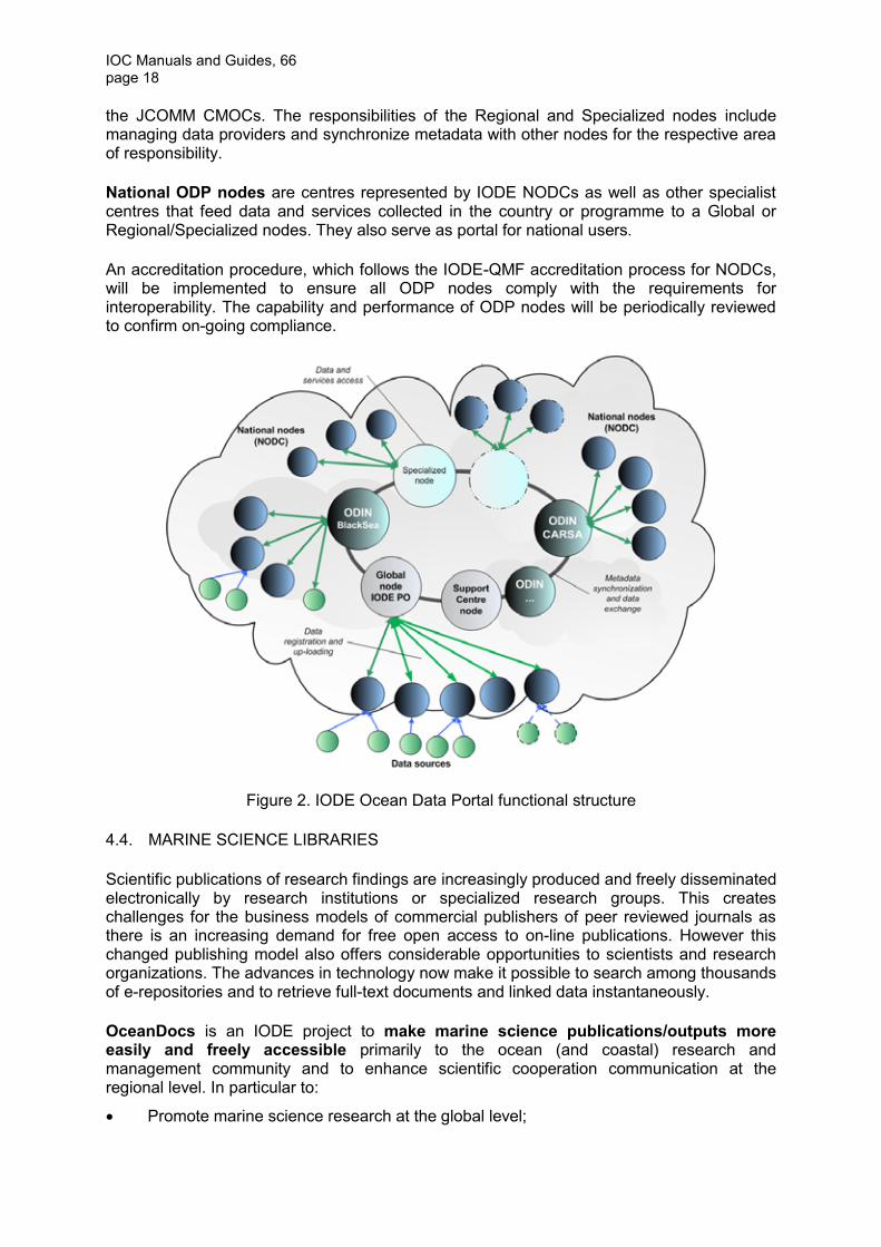
IOC Manuals and Guides, 66 page 18
the JCOMM CMOCs. The responsibilities of the Regional and Specialized nodes include managing data providers and synchronize metadata with other nodes for the respective area of responsibility.
National ODP nodes are centres represented by IODE NODCs as well as other specialist centres that feed data and services collected in the country or programme to a Global or Regional/Specialized nodes. They also serve as portal for national users.
An accreditation procedure, which follows the IODE-QMF accreditation process for NODCs, will be implemented to ensure all ODP nodes comply with the requirements for interoperability. The capability and performance of ODP nodes will be periodically reviewed to confirm on-going compliance.
Figure 2. IODE Ocean Data Portal functional structure
4.4. MARINE SCIENCE LIBRARIES
Scientific publications of research findings are increasingly produced and freely disseminated electronically by research institutions or specialized research groups. This creates challenges for the business models of commercial publishers of peer reviewed journals as there is an increasing demand for free open access to on-line publications. However this changed publishing model also offers considerable opportunities to scientists and research organizations. The advances in technology now make it possible to search among thousands of e-repositories and to retrieve full-text documents and linked data instantaneously.
OceanDocs is an IODE project to make marine science publications/outputs more easily and freely accessible primarily to the ocean (and coastal) research and management community and to enhance scientific cooperation communication at the regional level. In particular to:
� Promote marine science research at the global level;

IOC Manuals and Guides, 66 page 19
� Facilitate publishing of research findings by scientists (with special attention to scientists in developing countries); and
� Ensure secure archival of marine science publications/output.
OceanDocs enables researchers to deposit the full text of their works: articles, conference papers, technical reports, working papers, thesis and more. The information managers and librarians of the participating institutes will help the researchers with the submission of their publications. OceanDocs is a service to enhance scientific communication in marine science and will not interfere with the classical book and journal publishing methods. Researchers can publish in a scientific journal and at the same time submit their publication to OceanDocs. Nearly 90% of the international scientific journals accept the posting of the author’s version of an article on a personal or institutional website even after it is accepted for publication. OceanDocs is developed as a distributed network of national repositories, hosted by Member States, as well as regional or international repositories (e.g. Aquatic Commons developed by IAMSLIC hosted by IODE) and harvesters. Technical advice on requirements, implementation and training for management of these regional repositories is provided by the IODE’s GE-MIM. Collaborative software development to enhance OceanDocs with FAO Agris is underway: AgriOceanDocs.
E-repositories are extremely powerful tools to expose the wealth of information prepared by researchers in developing countries but which often has not been published in widely available journals. Capacity building to create the necessary expertise in all Member States to create institutional, national or regional e-repositories will be provided through ODINs trained through OceanTeacher.
The OpenScienceDirectory (http://www.opensciencedirectory.net/) is a service that provides access to scientific literature to developing countries at no charge. The Open Science Directory provides a comprehensive search tool for all open access and special programme journal titles. Designed to enhance access to these collections by providing direct links to journals and articles in the EBSCO A-to-Z title database, the Open Science Directory offers immediate access to approximately 13,000 scientific journal titles, with an objective of 20,000 titles midway through development. OpenScience now also provides access to the special programmes Hinari, Agora and OARE.
4.5. OCEAN BIOGEOGRAPHIC INFORMATION SYSTEM (OBIS)
The Ocean Biogeographic Information System (OBIS) is a global network of marine biodiversity scientists collaborating to mobilise, integrate and publish primary data about life in the oceans. OBIS provides datasets that are integrated and searchable by species name, higher taxonomic level, geographic area, depth, and time. In 2009 the IOC (IOC-XXV) agreed to accept OBIS within the IODE Programme and to integrate the functions of OBIS into IOC.
OBIS comprises a global system of data providers that work to meet regional and thematic needs within a global data architecture. The result is a global database to support research as well as management of marine resources and ecosystems. OBIS data are taxonomically and geographically resolved and are checked for errors and inconsistencies before being incorporated into the data holdings. OBIS seeks to absorb, integrate, and assess isolated datasets into a larger, more comprehensive pictures of life in our oceans and offers quality control for biogeographic data and through creation of standardized metadata, facilitates data discovery and access The system hopes to stimulate research about our oceans to generate new hypotheses concerning evolutionary processes, species distributions, and roles of organisms in marine systems on a global scale. The abstract maps that OBIS
IOC Manuals and Guides, 66 page 20
generates are maps that contribute to the ‘big picture’ of our oceans: a comprehensive, collaborative, world-wide view of our oceans.
4.6 STANDARDS AND BEST PRACTICES
The success of the IOC Data and Information Strategy depends on the acceptance and implementation of a set of interoperability arrangements, including technical specifications for collecting, processing, storing, and disseminating shared data, metadata and products. Interoperability should be based on non-proprietary standards, with preference given to formal international standards. The IOC Data and Information Management Strategy encourages the adoption of community wide standards for management and exchange of oceanographic data to improve the efficiency of data exchange and to support broader data and information interoperability and usability.
The IODE, jointly with JCOMM, has developed the Ocean Data Standards (ODS) process (see www.oceandatastandards.org) to accept, evaluate and recommend proposals for community wide standards. ODS is coordinated by the Expert Team on Data Management Practices (ETDMP) with teams formed as required from IODE and JCOMM members to evaluate submitted proposals. Member States and other groups are encouraged to submit standards proposals to the ODS for community evaluation and recommendation. The Ocean Data Standards process seeks to gain broad agreement and commitment to adopt a number of standards related to oceanographic data management and exchange which will be promoted by this Strategy. These include:
� Quality Control procedures. Quality control is a fundamental component of any oceanographic data distribution system because using erroneous data can cause incorrect conclusions, but rejecting extreme data can also lead to erroneous results by missing important events or anomalous features. The challenge of quality control is to check the input data against a pre-established "ground truth". Best practice for quality control, documented (including a standard suite of automatic quality control tests), scientific (agreed by appropriate experts) quality control and a single quality flag scheme) that is easily accessible and available is a goal for the IOC Data and Information Management Strategy.
� Data transport protocols. Various mechanisms are available or under development for data transfer and access via the internet. Improved handling of data and information is still required with better tools to manage received data. Computer security and firewalls are still an issue as is bandwidth and management of large data files.
� Web services. The development of a distributed network of oceanographic data centres will provide access to existing datasets in an interoperable environment using web services. Web services provide a standards-based interface for automated machine-to-machine, customized requests for access to distributed datasets. These standards include the Web Map Service (WMS) to compose and display map images from underlying data sources, as well as the Web Feature Service (WFS) and Web Coverage Service (WCS) to provide direct access to oceanographic data. The deployment of web services will provide seamless integration of data across a wide range of data providers.
� Discovery Metadata. The importance of metadata attached to the observations in long-term datasets has been recognized for some time. Most observation programmes now provide for metadata that describe data collection methods, instruments, quality control procedures applied, analyses done, etc. Metadata must be stored with the data and included when the data are provided to users. The development of effective metadata standards has been much improved by having both the scientists and data mangers involved in their specification. “Parent-child” hierarchies of metadata must be

IOC Manuals and Guides, 66 page 21
supported, since oceanographic data are often managed as collections of observations that require description both as inventories and as individual observations. The IOC Data and Information Management Strategy promotes standardization of discovery metadata, converging to the use of ISO19115/19139, and recommend suitable metadata tools.
� Common vocabularies/ontologies. Controlled keywords (standardized topic names) and controlled vocabularies (standardized technical terminology) need to be adopted or developed. The breadth of scientific disciplines that are covered by the IOC Data and Information Management Strategy guarantees the existence of overlapping terminology, and therefore tools and techniques to perform translation among these controlled vocabularies are needed. The Strategy promotes the use of common standardized vocabularies and ontologies.
� Formats for data delivery. At present there are many data formats and more are created as required. The same data can appear in different forms with varied content. There is no “universal” data structure which impedes combining different data in cross discipline analyses. However there is evidence of a slow convergence to a small number of data structures. Thus closer cooperation between different programmes is required and this will foster more rapid convergence of data structures. The need is to converge to a small number of “capable” data formats. The IOC Data and Information Management Strategy promotes exchange of data in an agreed small number of formats (e.g. netCDF, BUFR for GTS, ASCII, XML and OGC compliant web service output).
IODE, together with JCOMM, has prepared and published an online Catalogue of Practices and Standards for integrating of instrument best practices and related standards among the marine meteorological and oceanographic communities (http://bestpractice.iode.org/).The web site provides access to over 60 publications of WMO and IOC. These publications will be reviewed and updated or new publications developed where required.
4.7 DATA AND INFORMATION PRODUCTS
The IODE data and information centres, including the OBIS nodes, are responsible for the development of national, regional and global products.
The internationally recognized World Ocean Database is a project established by the IOC and endorsed by the IODE, under the leadership of the US NODC. This project has stimulated international exchange of oceanographic data and encourages the development of regional oceanographic databases as well as the implementation of regional quality control procedures. The World Ocean Atlas, a gridded climatology of observed oceanographic profile data interpolated to standard depth levels, is a global analysis of the World Ocean Database measurements.
The International Coastal Atlas Network (ICAN) has been accepted provisionally by the IOC as an IODE Pilot Project. The strategic goal of IODE ICAN is to encourage and help facilitate the development of digital atlases of the global coast, based on the principle of distributed, high-quality data and information. These atlases can be local, regional, national or international in scale and can be achieved by sharing knowledge and experience among atlas developers in order to find common solutions for web atlas development whilst ensuring maximum relevance and added value for the users. These atlases will play an important role in informing national and regional decision- and policy-making across several themes. Currently IODE supports two regional atlas projects – African Marine Atlas and Caribbean Marine Atlas.

IOC Manuals and Guides, 66 page 22
The African Marine Atlas is a regional product which has been developed collaboratively by ODINAFRICA to provide maps, images, data and information to coastal resource managers, planners and decision-makers from various administrative institutions and specialized agencies in Africa (see http://africanmarineatlas.org/).
The Caribbean Marine Atlas is a joint initiative of nine countries in the Caribbean region which aims to identify, collect and organize available geo-spatial datasets into an atlas of environmental themes for the region as a support service to the sustainable development and integrated management of marine and coastal areas in the region. The project is supported by the IODE and is being developed within the framework of ODINCARSA (see http://www.caribbeanmarineatlas.net/).
4.8 CAPACITY DEVELOPMENT
Capacity building and sustainability are important aspects of the IOC Data and Information Strategy and the IODE Programme has a long and respected track record in capacity building, including the building of ODINs in various regions. Through the use of low-cost, mass-market technology for linking components (with an emphasis on "main-stream" rather than "special purpose" or "cutting edge research") the IODE can leverage technology to assure the cost-effectiveness and sustainability of project implementations via the ODIN system. ODINs provide a valuable mechanism for assessing the current and potential state of development of national data centres and creating the means for mutual capacity building in a region. ODINs develop a cooperation network for managing and exchanging oceanographic data and information within the regions including contributing to ocean sciences, operational oceanography development and integrated coastal management and disaster reduction programmes at the regional level. ODINs also contribute to improving the provision of oceanographic data and information products and services to different users by sharing of expertise, knowledge transfer and capacity building and aim to become useful platforms for other programmes and organizations such as GOOS (including GOOS Regional Alliances), GCOS, LME, IAMSLIC, IAI, CPPS, JCOMM, ASFA and ICAM. They form the basis of a regional distributed data and information centre.
It is therefore recommended to utilize the ODIN model as the capacity building mechanism for the IOC Data and Information Management Strategy, supplementing and contributing to the IOC principles and strategy for capacity-building.
Fundamental to the IODE capacity building activities is OceanTeacher (http://www.oceanteacher.org) which provides training tools for oceanographic data and information management. These tools are used traditionally during IODE training courses but can also be used for self-training and continuous professional development. The IOC Project Office for IODE in Ostend, Belgium, provides excellent facilities for capacity building activities and its use should be encouraged for capacity building activities across IOC programmes and its collaborators.
OceanTeacher has evolved into an integrated learning system with the following components:
� OceanTeacher Digital Library is a collection of oceanographic data and information management materials, including software, quality control and analysis strategies, specifications for data storage in standard formats, etc. The Digital Library provides a broad spectrum of background information on global data and information archiving activities, training manuals and relevant IOC documents.

IOC Manuals and Guides, 66 page 23
� OceanTeacher OpenCourseWare is a collection of outlines, notes, examples, and miscellaneous documents used in conjunction with the Digital Library to organize training programmes in oceanographic data and information training.
� OceanTeacher Video Library is a series of video recordings from training courses which can be used by the trainees to consolidate their knowledge and by other audiences for self-learning purposes.
When the Digital Library and OpenCourseWare are used together for a training event it is called an OceanTeacher Classroom and a collection of all training instances constitutes the OceanTeacher Academy as shown in Figure 3. OceanTeacher content is freely and openly available and access does not require registration.
Figure 3. Schematic of the OceanTeacher structure
Distance learning has been identified as a priority for OceanTeacher and the IODE has developed the concept of the OceanTeacher Global Classroom to provide distance learning using available communication tools (video/teleconferencing, etc.) that will enable interaction amongst the participants. Lectures will be conducted from one teaching location to several classrooms in different regions. This distance-distributed learning model will allow OceanTeacher to increase its target audience (to better ensure a long-term impact of the training effort) and should also increase the number of experts available to lecture during training events, with special attention to local experts. In addition this approach will allow an increased and customized focus on local issues. This model was first used during 2012 with a joint training course with the Indian National Centre for Ocean Information Services (INCOIS) in Hyderabad, India.
OceanTeacher Academy has recognized the importance of creating awareness of oceanographic data management and marine information management for university students to ensure that they will contribute quality data during their future career. University student awareness courses have been developed in OceanTeacher, aimed at providing university students (Master programme, Ph.D.) with the necessary background to manage their research data and to produce basic data products for their research projects. University accredited courses in oceanographic data management have been provided at several universities in Europe and at the Nippon Foundation-POGO Centre of Excellence in Observational Oceanography. Further efforts will be made to promote the use of OceanTeacher by marine science students at universities.
New emerging needs within IOC programmes, such as ocean biodiversity data management, marine spatial planning, Ocean Data Portal implementation and use, and quality management leading to accreditation, will be included in future training activities. Partnerships with other ocean-related initiatives will also be continued and further developed.
IOC Manuals and Guides, 66 page 24
4.9 COMMUNICATION AND OUTREACH
For the IOC Data and Information Strategy to succeed, it must achieve strong awareness, involvement, acceptance and recognition within and between IOC programmes, and with IOC partners. Hence, efficient communication and outreach remain key elements in the Strategy.
Cooperation and collaboration with other organizations with similar interests and goals is essential to ensure interoperability between systems and promote further system integration rather than the current multitude of systems. In order to reach the highest possible effectiveness and impact, it will be appropriate to create partnerships with these organizations (governmental, non-governmental and international), and recognize each other’s roles, contributions and responsibilities.
To strengthen and further expand the data providers and data and information user communities, clear and understandable communication is needed. This can be achieved by providing a comprehensive but easy to understand document explaining the strategy, objectives and structures (including how one can become involved). Outreach and information products can also showcase the benefits and relevance of the activities, so others are convinced and become interested in participating.
Communication and outreach can be achieved through: � Better interaction, cooperation and collaboration, especially with those not yet involved
in data and information management activities;
� Clear, understandable communication and outreach by:
- creating an information package, summarizing main objectives, structures, and plans (targeted to newcomers)
- creating information products, to showcase the relevance of activities
- Using communication channels: website, mailing lists, e-newsletters, meetings (personal contacts)
- explaining how people can become involved
- listing advantages of becoming involved
- creating partnerships, recognition of each other’s roles and contributions
- ensuring easy access to data and information, so data can be discovered, exchanged and used, in a user-friendly way (recognizing the data providers), and
- providing support to the user community at all levels (collaboration, data and information management, capacity building, training, access to data, …).
Because gentle persuasion is often the most effective mechanism, it will be important for representatives to attend meetings of other organizations undertaking similar initiatives. In this way it will be possible to encourage even greater cooperation and to promote the IOC Data and Information Strategy.
The Strategy also requires reaching out and serving the data user communities (scientists, policy makers, managers, educators, students, industries and businesses) to make data and information, including derived products, easily discoverable and accessible, so they can be used in the most efficient and user-friendly way.
IOC Manuals and Guides, 66 Annex I
ANNEX I
DATA AND INFORMATION MANAGEMENT IN IOC AND OTHER INTERNATIONAL PROGRAMMES
International Oceanographic Data and Information Exchange (IODE)
The International Oceanographic Data and Information Exchange (IODE) programme has established 80 National Oceanographic Data Centres (NODC) and 55 National Centres for Marine Information since it was established in 1961. Although they operate to a set of common principles, the NODCs have widely varying national remits and vary in size from one person to well over one hundred. The NODC system has contributed greatly to the management of oceanographic data and information. Most NODCs receive data from government and academic agencies and a smaller proportion also receive data from privately funded research institutions and/or from industry. Most centres provide quality controlled delayed-mode data with many of these data available on-line. NODCs are increasingly handling a wide range of data types, including physical, chemical and biological data, marine meteorology and atmospheric data, geological and geophysical data including real-time data and data relevant to GOOS. (URL: http://www.iode.org)
Ocean Data and Information Networks (ODINs)
Since the late 1990s a new IODE capacity building strategy was developed: the Ocean Data and Information Network (ODIN). The ODINs bring together marine institutions from a region, to provide capacity building, establishing and maintaining national oceanographic data and information centres and improving collaboration. ODINs link training, equipment and operational support in a regional context and provide a regional networking platform that can be used by IOC programmes, such as, GOOS, IODE, ICAM, tsunami, HAB, etc. ODINs are highly focused on the development of data and products and involve a multi-stakeholder approach. In most instances they exist along with Marine Information Systems that have developed interoperable literature- repositories and integrated library catalogues. Websites link to electronic scientific literature. There is also a strong focus on the end-to-end process linking observations, data management and product development ensuring that the data centres fill existing needs. In addition, there is a focus on inter-personal and institutional networking. Communication and outreach play a significant role.
Global Ocean Observing System (GOOS)
The global module of GOOS is a sustained ocean climate observing system, designed to provide data and information products for: climate monitoring and forecasting, climate assessment, and climate research. It is also the foundation for global operational oceanography, including global weather prediction and marine forecasting, global and coastal ocean prediction and marine environmental monitoring. Data management systems exist for a number of the data streams for GOOS. Examples include the ship of opportunity programme (including GTSPP), data buoys (through DBCP), sea level (through GLOSS) and Argo.
Global Temperature Salinity Profile Programme (GTSPP). The Global Temperature Salinity Profile Program (GTSPP) is a joint IOC/WMO programme to develop and maintain a global ocean temperature-salinity (T-S) resource with data that are both up-to-date and of the highest quality. Contributions to the data management component of GTSPP are provided by Australia, Canada, France, Germany, Japan and the USA. Both real-time data transmitted over the GTS and delayed-mode data received by the US NODC are acquired and incorporated into a continuously managed database. (URL: http://www.nodc.noaa.gov/GTSPP/)

IOC Manuals and Guides, 66 Annex I - page 2
Data Buoy Cooperation Panel (DBCP). The Data Buoy Cooperation Panel (DBCP), a joint body of the WMO and the IOC, is an international programme coordinating the use of autonomous data buoys to observe atmospheric and oceanographic condition. The primary objective of the DBCP is to maintain and coordinate all components of the network of over 1250 drifting buoys and 400 moored buoys, which provide measurements such as sea-surface temperature, surface current velocity, air temperature and wind speed and direction. This data is useful for Weather and Ocean Forecasts and research and additionally can be used to complement or validate remotely-sensed data and operational models. The DBCP also explores and evaluates new technologies and uses those which prove successful to improve operations. Drifting buoy data is distributed in real time on the Global Telecommunications System of the WMO and data is archived by Integrated Science Data Management, Department of Fisheries and Oceans, Canada. (URL: http://www.jcommops.org/dbcp/
Global Sea Level Observing System (GLOSS). The Global Sea Level Observing System (GLOSS) is a joint programme of IOC and WMO to establish high quality global and regional sea level networks for application to climate, oceanographic and coastal sea level research. GLOSS, in collaboration with IODE, has initiated a data archaeology project aimed at the data rescue of sea level information available only in paper form and its conversion into computer-accessible form. (URL: http://www.gloss-sealevel.org/)
Argo. Argo is an international project to collect information on the temperature and salinity of the upper part of the world's oceans. Argo uses a global array of 3000 robotic floats to measure temperature and salinity and to provide a quantitative description of the evolving state of the upper ocean and the patterns of ocean climate variability. Argo has an international Steering Team and a Data Management Team made up of scientists from countries involved in Argo. The Argo Information Centre is a source of information about the development and performance of the global array and the national programmes that contribute to it. (URLs: http://www.argo.ucsd.edu/ [Argo Project Office]; http://argo.jcommops.org/ [Argo Information Centre])
Global Ocean Surface Underway Data (GOSUD) An initiative of the IODE to develop and implement a data system for ocean surface data, to acquire and manage these data and to provide a mechanism to integrate these data with other types of data collected in the world oceans. The main objective of GOSUD is to collect, process, archive and disseminate in real time and delayed mode, sea surface salinity and other variables collected underway, by research and opportunity ships. (URL: http://www.gosud.org/) Coastal GOOS
The coastal module of GOOS contributes to the understanding of the effects of human activity, climate change and natural disasters in coastal systems through the gathering and interpretation of relevant data. Coastal GOOS addresses six goals for the public good: Improving capacity to detect and predict the effects of global climate change on coastal ecosystems, improving the safety and efficiency of marine operations, controlling and mitigating the effects of natural disasters more effectively, and restoring and sustaining living marine resources more effectively. The coastal module of GOOS is currently advised by the GOOS Scientific Steering Committee (GSSC) and implemented through member states and participating organizations usually cooperating through GOOS regional alliances. (URL: http://www.ioc-goos.org/index.php?option=com_content&view=article&id=14&Itemid=28)

IOC Manuals and Guides, 66 Annex I - page 3
The IOC Harmful Algal Bloom Programme (HAB)
The Harmful Algal Bloom Programme (HAB) seeks to foster the effective management of, and scientific research on, harmful algal blooms in order to understand their causes, predict their occurrences, and mitigate their effects. Over the past 10 years, IOC HAB has established a number of data products including (i) Harmful Algal Event Database (HAE-DAT), (ii) IOC Taxonomic Reference List of Toxic Plankton Algae, (iii) International Directory of Experts in Harmful Algae and Their Effects on Fisheries and Public Health, and (iv) IOC Bibliographic HAB Database. These data products are since 2009 under the umbrella of the joint IODE-IPHAB Harmful Algal Information System (HAIS). (URL: http://ioc-unesco.org/hab/ and http://haedat.iode.org/)
World Climate Research Programme (WCRP)
The World Climate Research Programme (WCRP) is sponsored by ICSU, WMO and IOC. The two main objectives of the WCRP are (i) to determine the predictability of climate; and (ii) to determine the effect of human activities on climate. The WCRP covers studies of the global atmosphere, oceans, sea- and land-ice, the biosphere and the land surface. WCRP has established a task force on data management to develop common data management activities, to ensure availability of data for assimilation, and to develop new assimilation techniques. (URL http://wcrp-climate.org/)
Ocean Observations Panel for Climate (OOPC)
The Ocean Observations Panel for Climate (OOPC) is a joint panel of GCOS, GOOS, and the WCRP. It develops recommendations for a sustained global ocean observing system in support of climate objectives, helps develop on-going evaluation and evolution, and supports global ocean observing activities through liaison and advocacy. (URL: http://ioc-goos-oopc.org/
International Ocean Carbon Coordination Project (IOCCP)
The International Ocean Carbon Coordination Project (IOCCP), co-sponsored by IOC and SCOR, promotes the development of a global network of ocean carbon observations for research through technical coordination and communication services, international agreements on standards and methods, advocacy, and links to the global observing systems. (URL: http://www.ioccp.org/)
International Ocean Colour Coordinating Group (IOCCG)
International Ocean Colour Coordinating Group (IOCCG) is made up of an international Committee of experts comprising representatives from both the provider (Space Agencies) and user communities (scientists, managers). The objectives of the IOCCG are to develop consensus and synthesis at the world scale in the subject area of satellite ocean colour radiometry (OCR). Specialized scientific working groups are established to investigate various aspects of ocean-colour technology and its applications, and their findings are published in the highly-acclaimed IOCCG Report Series. Continuity of ocean colour radiance datasets is addressed through the CEOS OCR-Virtual Constellation. The IOCCG also has a strong interest in capacity building, and conducts and sponsors advanced training courses on applications of ocean-colour data in various countries around the world. (URL: http://www.ioccg.org/)
Integrated Coastal Area Management (ICAM)
Integrated Coastal Area Management (ICAM) is an interdisciplinary activity where natural and social scientists, coastal managers and policy makers focus on how to manage the diverse problems of coastal areas. The objectives of ICAM are to address coastal zone

IOC Manuals and Guides, 66 Annex I - page 4
problems through activities of a more cooperative, coordinated and interdisciplinary nature, and ensure good coordination among existing IOC efforts related to the coastal zone. The activities of the IOC/ICAM programme includes the support to the IOC /LOICZ / SCOR Study Group on the Assessment and Management Implications of Submarine Groundwater Discharge into the Coastal Zone; IOC/ICAM is a sponsor of the LOICZ Basins Project which is looking at the evaluation of the role of catchment basins in cycling of nutrients, sediments, water, in coastal areas and the development of indicators of environmental change and sustainability. The programme is serving as secretariat for the Coastal Ocean Advanced Science and Technology Studies (COASTS) which will produce volumes 12 & 13 of The Sea. The programme is a co-sponsor of the ICM Global Web Service – a coastal area management information clearinghouse.
Joint IOC/WMO Technical Commission for Oceanography and Marine Meteorology (JCOMM)
The Joint IOC/WMO Technical Commission for Oceanography and Marine Meteorology (JCOMM) coordinates, regulates and manages a fully integrated marine observing, data management and services system that uses state-of-the-art technologies and capabilities, is responsive to the evolving needs of all users of oceanographic data and products, and includes an outreach programme to enhance the national capacity of all maritime countries. It works closely with partners including IODE, GOOS and GCOS. The Data Management Programme Area (DMPA) implements and maintains a fully integrated end-to-end data management system across the entire marine meteorology and oceanographic community. The DMPA provides expertise to assist other groups to specify and implement their own data management requirements, with the overall goal of integrating their data management into the E2EDM system. (URL: http://www.jcomm.info/)
WMO Information System (WIS)
The WMO Information system (WIS) is the single coordinated global infrastructure responsible for the telecommunications and data management functions. WIS provides an integrated approach for all WMO Programmes to meet the requirements for routine collection and automated dissemination of observed data and products, as well as data discovery, access and retrieval services for all weather, climate, water and related data produced by centres and Member countries in the framework of any WMO Programme. The IODE Ocean Data Portal is a Data Collection or Production Centre (DCPC) contributing oceanographic data to the WIS. (URL: http://www.wmo.int/pages/prog/www/WIS/index_en.html)
Global Earth Observation System of Systems (GEOSS)
The Group on Earth Observations is coordinating efforts to build a Global Earth Observation System of Systems, or GEOSS. The GEOSS will provide decision-support tools to a wide variety of users through a global network of content providers allowing decision makers to access a range of information. This ‘system of systems’ will link together existing and planned observing systems around the world and support the development of new systems where gaps currently exist. It will promote common technical standards so that data from the thousands of different instruments can be combined into coherent datasets. The ‘GEOPortal’ offers a single Internet access point for users seeking data, imagery and analytical software packages relevant to all parts of the globe connecting users to existing databases and portals. (URL: http://www.earthobservations.org/geoss.shtml)
International Council for Science (including World Data System) (ICSU)
The International Council for Science (ICSU) is a non-governmental organization with a global membership of national scientific bodies (120 Members, representing 140 countries) and International Scientific Unions (31 Members). ICSU’s mission is to strengthen
IOC Manuals and Guides, 66 Annex I - page 5
international science for the benefit of society. ICSU has created the new World Data System (WDS) which builds on the 50-year legacy of the ICSU World Data Centre system (WDC) and the ICSU Federation of Astronomical and Geophysical data-analysis Services. The WDS concept aims at a transition from existing stand-alone WDCs and individual Services to a common globally interoperable distributed data system will build on the potential offered by advanced interconnections between data management components for disciplinary and multidisciplinary applications. WDS will enjoy a broader disciplinary and geographic base than previous ICSU bodies and will strive to become a world-wide 'community of excellence' for scientific data. IODE is a Network member of WDS and represents the network of NODCs. (URL: http://www.icsu-wds.org/)
International Council for the Exploration of the Sea (ICES)
The International Council for the Exploration of the Sea (ICES) coordinates and promotes marine research on oceanography, the marine environment, the marine ecosystem, and on living marine resources in the North Atlantic. Members of the ICES community include all coastal states bordering the North Atlantic and the Baltic Sea. ICES cooperates with organizations and institutes on an international scale. The ICES Data Centre accepts a wide variety of oceanographic data and meta-data types into its databases. The ICES Working Group on Data and Information Management has developed guidelines to assist those involved in the collection, processing, quality control and exchange of various types of (mainly) physical oceanographic data, for example, Moored Current Meter, Shipborne ADCP, Seasoar, Chlorophyll and Nutrient data. These guidelines have been adopted by the ICES Data Centre and are recommended to the ICES Community. The ICES oceanographic database holds more than 100 years of oceanographic data. (URL: http://www.ices.dk/datacentre/)
Global Climate Observing System (GCOS)
GCOS is a joint undertaking of the World Meteorological Organization (WMO), the Intergovernmental Oceanographic Commission (IOC), the United Nations Environment Programme (UNEP) and the International Council for Science (ICSU). Its goal is to provide comprehensive information on the total climate system, involving a multidisciplinary range of physical, chemical and biological properties, and atmospheric, oceanic, hydrological, cryospheric and terrestrial processes. It is built on the WMO Integrated Global Observing System (WIGOS), the IOC-WMO-UNEP-ICSU Global Ocean Observing System (GOOS), the UN Food and Agriculture Organization (FAO)-UNEP-UNESCO-ICSU Global Terrestrial Observing System (GTOS) and a number of other domain-based and cross-domain research and operational observing systems. It includes both in situ and remote sensing components, with its space based components coordinated by the Committee on Earth Observation Satellites (CEOS) and the Coordination Group for Meteorological Satellites (CGMS). GCOS is intended to meet the full range of national and international requirements for climate and climate-related observations. As a system of climate-relevant observing systems, it constitutes, in aggregate, the climate observing component of the Global Earth Observation System of Systems (GEOSS). (URL: http://www.wmo.int/pages/prog/gcos/index.php)
Large Marine Ecosystems (LME)
Large Marine Ecosystems (LME) are regions of ocean and coastal space that encompass river basins and estuaries and extend out to the seaward boundary of continental shelves and the seaward margins of coastal current systems. LMEs have been delineated according to continuities in their physical and biological characteristics, including inter alia: bathymetry, hydrography, productivity and trophically dependent populations. The LME as an organizational unit facilitates management and governance strategies that recognize the ecosystem's numerous biological and physical elements and the complex dynamics that exist amongst and between them. (URL: http://www.lme.noaa.gov/)

IOC Manuals and Guides, 66 Annex I - page 6
Information Management and International Programmes
Aquatic Commons. The Aquatic Commons is a thematic digital e- repository of literature. It is produced by IAMSLIC and hosted by IOC, covering the natural marine, estuarine /brackish and fresh water environments. It includes all aspects of the science, technology, management and conservation of these environments, their organisms and resources, and the economic, sociological and legal aspects. International marine science libraries contribute to the content. The records of this repository are harvested and aggregated for marine and aquatic repositories around the World.
IAMSLIC. International Association of Marine and Aquatic Libraries and Information Centres is an association of individuals and organizations interested in library and information science, especially as these are applied to the recording, retrieval and dissemination of knowledge and information in all aspects of aquatic and marine sciences and their allied disciplines. The association provides a forum for exchange and exploration of ideas and issues of mutual concern.
ASFA. Aquatic Sciences and Fisheries Abstracts is an online literature citation database in the field of aquatic information with input provided by an international network of information centres monitoring over 5,000 serial publications, books, reports, conference proceedings, translations and limited distribution literature: sometimes called grey literature. It is an international cooperative information system which comprises an abstracting and indexing service covering the world's literature on the science, technology, management, and conservation of marine, brackish water, and freshwater resources and environments, including their socio-economic and legal aspects. The Aquatic Commons Repository content is linked to ASFA records.
ASFIS. Aquatic Sciences and Fisheries Information System is the governing Board of ASFA formed by four United Nations agency sponsors FAO, IOC, UN/DALOS, UNEP and a network of international and national library partners.
FAO AGRI-OceanDspace. AgriOcean DSpace (AOD) is a joint initiative of the United Nations agencies of FAO and UNESCO-IOC/IODE to provide a customized version of DSpace 1.7.1 (JSPUI version), an open source, digital repository software. Its main objective is to make scientific literature in the field of oceanography, agriculture and related sciences available in digital form. AgriOcean DSpace is set-up for the digital repository communities of AGRIS (FAO) and ODIN (UNESCO-IOC), but can be downloaded and used by any research institution interested.
IFLA. The International Federation of Library Associations and Institutions is an independent, international, non-governmental, not-for-profit organization which aims to promote high standards of provision and delivery of library and information services, encourage widespread understanding of the value of good library & information services and represent the interests of our members throughout the world. GOAP. UNESCO Global Open Access presents a snapshot of the status of Open Access (OA) to scientific information around the world. IODE is listed as a participating Open Access organization. The Global Open Access Portal (GOAP), launched together with the revamped Open Training Platform (OTP) and the first UNESCO Open Educational Resources (OER) Platform, provides the information for policy-makers to learn about the global OA environment and to view their country’s status, and understand where and why Open Access has been most successful.
Available at http://www.nodc.noaa.gov/OC5/WOD09/pr_wod09.html

IOC Manuals and Guides, 66 Annex II
ANNEX II
LIST OF ACRONYMS
ASCII American Standard Code for Information Interchange ADU Associate Data Unit - a structural element of IODE ASFA Aquatic Sciences and Fisheries Abstracts ASLI Atmospheric Science Librarians International BUFR Binary Universal Form for the Representation of meteorological data CMOC Centres for Marine-meteorological and Oceanographic Climate data
(JCOMM ) CPPS Comisión Permanente del Pacífico Sur/ Permanent Commission for
the South Pacific DBCP Data Buoy Cooperation Panel (JCOMM) DMAC IOOS Data Management and Communications (USA) DMCG JCOMM Data Management Coordination Group DMPA JCOMM Data Management Programme Area E2EDM End-to-end data management ETDMP Joint JCOMM/IODE Expert Team on Data Management Practices FAO Food and Agriculture Organization FOO Framework for Ocean Observing GCOS Global Climate Observing System (WMO) GE-BICH IODE Group of Experts on Biological and Chemical Data
Management and Exchange Practices GE-MIM IODE Group of Experts on Marine Information Management GEOSS Global Earth Observation System of Systems GIS Geographic Information System GLOSS Global Sea Level Observing System (JCOMM) GOAP Global Open Access Platform (UNESCO) GOSUD Global Ocean Surface Underway Data GOOS Global Ocean Observing System GRA GOOS Regional Alliance GSSC GOOS Scientific Steering Committee GTOS Global Terrestrial Observing System GTS Global Telecommunications System (WMO) GTSPP Global Temperature and Salinity Profile Program HAB Harmful Algal Blooms programme IAI Inter-America Institute for Global Change Research IAMSLIC International Association of Aquatic and Marine Science Libraries and
Information Centers ICAM Integrated Coastal Area Management ICAN International Coastal Atlas Network ICES International Council for the Exploration of the Sea ICSU International Council for Science IFLA International Federation of Library Associations and Institutions IGOSS Integrated Global Observing Services System IOC Intergovernmental Oceanographic Commission (of UNESCO) IOCCG International Ocean Colour Coordination Group IOCCP International Ocean Carbon Coordination Project
IOC Manuals and Guides, 66 Annex II - page 2
IODE International Oceanographic Data and Information Exchange IOOS Integrated Ocean Observing System (USA) IPY International Polar Year ISO International Organization for Standardization JCOMM Joint WMO/IOC Technical Commission for Oceanography and Marine
Meteorology LME Large Marine Ecosystem MBLWHOI Marine Biological Laboratory Woods Hole Oceanographic Institution MCDS Marine Climate Data System (JCOMM) MIM Marine Information Management (IODE) NEPAD New Partnership for Africa’s Development netCDF Network Common Data Form NODC National Oceanographic Data Centre (IODE) OBIS Ocean Biogeographic Information System ODIN Ocean Data and Information Network ODINAFRICA Ocean Data and Information Network for Africa ODINBlackSea Ocean Data and Information Network for the Black Sea ODINCARSA Ocean Data and Information Network for the Caribbean and South
America ODINECET Ocean Data and Information Network for European Counties in
Economic Transition ODINCINDIO Ocean Data and Information Network for the Central Indian Ocean ODINWESTPAC Ocean Data and Information Network for the Western Pacific region ODP Ocean Data Portal (IODE) ODS Ocean Data Standards project (IODE/JCOMM) OGC Open Geospatial Consortium OOPC Ocean Observations Panel for Climate QMF Quality Management Framework SCOR Scientific Committee on Oceanic Research (ICSU) SG-OBIS IODE Steering Group for OBIS SG-OceanTeacher IODE Steering Group for the OceanTeacher project TEMA Training Education & Mutual Assistance (IOC) UN/DALOS United Nations Division for Ocean Affairs and the Law of the Sea UNDP United Nations Development Programme UNEP United Nations Environment Programme UNESCO United National Educational, Scientific and Cultural Organization WCRP World Climate Research Programme WCS Web Coverage Service WDC World Data Centre (ICSU) WDS World Data System (ICSU) WFS Web Feature Service WIGOS WMO Integrated Global Observing System WIS WMO Information System WMS Web Map Service WMO World Meteorological Organization

IOC Manuals and Guides
No. Title
1 rev. 2 Guide to IGOSS Data Archives and Exchange (BATHY and TESAC). 1993. 27 pp. (English, French, Spanish, Russian)
2 International Catalogue of Ocean Data Station. 1976. (Out of stock)
3 rev. 3 Guide to Operational Procedures for the Collection and Exchange of JCOMM Oceanographic Data. Third Revised Edition, 1999. 38 pp. (English, French, Spanish, Russian)
4 Guide to Oceanographic and Marine Meteorological Instruments and Observing Practices. 1975. 54 pp. (English)
5 rev. 2 Guide for Establishing a National Oceanographic Data Centre. Second Revised Edition, 2008. 27 pp. (English) (Electronic only)
6 rev. Wave Reporting Procedures for Tide Observers in the Tsunami Warning System. 1968. 30 pp. (English)
7 Guide to Operational Procedures for the IGOSS Pilot Project on Marine Pollution (Petroleum) Monitoring. 1976. 50 pp. (French, Spanish)
8 (Superseded by IOC Manuals and Guides No. 16)
9 rev. Manual on International Oceanographic Data Exchange. (Fifth Edition). 1991. 82 pp. (French, Spanish, Russian)
9 Annex I (Superseded by IOC Manuals and Guides No. 17)
9 Annex II Guide for Responsible National Oceanographic Data Centres. 1982. 29 pp. (English, French, Spanish, Russian)
10 (Superseded by IOC Manuals and Guides No. 16)
11 The Determination of Petroleum Hydrocarbons in Sediments. 1982. 38 pp. (French, Spanish, Russian)
12 Chemical Methods for Use in Marine Environment Monitoring. 1983. 53 pp. (English)
13 Manual for Monitoring Oil and Dissolved/Dispersed Petroleum Hydrocarbons in Marine Waters and on Beaches. 1984. 35 pp. (English, French, Spanish, Russian)
14 Manual on Sea-Level Measurements and Interpretation. (English, French, Spanish, Russian)
Vol. I: Basic Procedure. 1985. 83 pp. (English)
Vol. II: Emerging Technologies. 1994. 72 pp. (English)
Vol. III: Reappraisals and Recommendations as of the year 2000. 2002. 55 pp. (English)
Vol. IV: An Update to 2006. 2006. 78 pp. (English)
15 Operational Procedures for Sampling the Sea-Surface Microlayer. 1985. 15 pp. (English)
16 Marine Environmental Data Information Referral Catalogue. Third Edition. 1993. 157 pp. (Composite English/French/Spanish/Russian)
17 GF3: A General Formatting System for Geo-referenced Data
Vol. 1: Introductory Guide to the GF3 Formatting System. 1993. 35 pp. (English, French, Spanish, Russian)
Vol. 2: Technical Description of the GF3 Format and Code Tables. 1987. 111 pp. (English, French, Spanish, Russian)
Vol. 3: Standard Subsets of GF3. 1996. 67 pp. (English)
Vol. 4: User Guide to the GF3-Proc Software. 1989. 23 pp. (English, French, Spanish, Russian)
Vol. 5: Reference Manual for the GF3-Proc Software. 1992. 67 pp. (English, French, Spanish, Russian)
Vol. 6: Quick Reference Sheets for GF3 and GF3-Proc. 1989. 22 pp. (English, French, Spanish, Russian)
2
No. Title
18 User Guide for the Exchange of Measured Wave Data. 1987. 81 pp. (English, French, Spanish, Russian)
19 Guide to IGOSS Specialized Oceanographic Centres (SOCs). 1988. 17 pp. (English, French, Spanish, Russian)
20 Guide to Drifting Data Buoys. 1988. 71 pp. (English, French, Spanish, Russian)
21 (Superseded by IOC Manuals and Guides No. 25)
22 rev. GTSPP Real-time Quality Control Manual, First revised edition. 2010. 145 pp. (English)
23 Marine Information Centre Development: An Introductory Manual. 1991. 32 pp. (English, French, Spanish, Russian)
24 Guide to Satellite Remote Sensing of the Marine Environment. 1992. 178 pp. (English)
25 Standard and Reference Materials for Marine Science. Revised Edition. 1993. 577 pp. (English)
26 Manual of Quality Control Procedures for Validation of Oceanographic Data. 1993. 436 pp. (English)
27 Chlorinated Biphenyls in Open Ocean Waters: Sampling, Extraction, Clean-up and Instrumental Determination. 1993. 36 pp. (English)
28 Nutrient Analysis in Tropical Marine Waters. 1993. 24 pp. (English)
29 Protocols for the Joint Global Ocean Flux Study (JGOFS) Core Measurements. 1994. 178 pp . (English)
30 MIM Publication Series:
Vol. 1: Report on Diagnostic Procedures and a Definition of Minimum Requirements for Providing Information Services on a National and/or Regional Level. 1994. 6 pp. (English)
Vol. 2: Information Networking: The Development of National or Regional Scientific Information Exchange. 1994. 22 pp. (English)
Vol. 3: Standard Directory Record Structure for Organizations, Individuals and their Research Interests. 1994. 33 pp. (English)
31 HAB Publication Series:
Vol. 1: Amnesic Shellfish Poisoning. 1995. 18 pp. (English)
32 Oceanographic Survey Techniques and Living Resources Assessment Methods. 1996. 34 pp. (English)
33 Manual on Harmful Marine Microalgae. 1995. (English) [superseded by a sale publication in 2003, 92-3-103871-0. UNESCO Publishing]
34 Environmental Design and Analysis in Marine Environmental Sampling. 1996. 86 pp. (English)
35 IUGG/IOC Time Project. Numerical Method of Tsunami Simulation with the Leap-Frog Scheme. 1997. 122 pp. (English)
36 Methodological Guide to Integrated Coastal Zone Management. 1997. 47 pp. (French, English)
37 Post-Tsunami Survey Field Guide. First Edition. 1998. 61 pp. (English, French, Spanish, Russian)
38 Guidelines for Vulnerability Mapping of Coastal Zones in the Indian Ocean. 2000. 40 pp. (French, English)
39 Manual on Aquatic Cyanobacteria – A photo guide and a synopsis of their toxicology. 2006. 106 pp. (English)
40 Guidelines for the Study of Shoreline Change in the Western Indian Ocean Region. 2000. 73 pp. (English)
41 Potentially Harmful Marine Microalgae of the Western Indian Ocean Microalgues potentiellement nuisibles de l'océan Indien occidental. 2001. 104 pp. (English/French)
3
No. Title
42 Des outils et des hommes pour une gestion intégrée des zones côtières - Guide méthodologique, vol.II/ Steps and Tools Towards Integrated Coastal Area Management – Methodological Guide, Vol. II. 2001. 64 pp. (French, English; Spanish)
43 Black Sea Data Management Guide (Cancelled)
44 Submarine Groundwater Discharge in Coastal Areas – Management implications, measurements and effects. 2004. 35 pp. (English)
45 A Reference Guide on the Use of Indicators for Integrated Coastal Management. 2003. 127 pp. (English). ICAM Dossier No. 1
46 A Handbook for Measuring the Progress and Outcomes of Integrated Coastal and Ocean Management. 2006. iv + 215 pp. (English). ICAM Dossier No. 2
47 TsunamiTeacher – An information and resource toolkit building capacity to respond to tsunamis and mitigate their effects. 2006. DVD (English, Bahasa Indonesia, Bangladesh Bangla, French, Spanish, and Thai)
48 Visions for a Sea Change. Report of the first international workshop on marine spatial planning. 2007. 83 pp. (English). ICAM Dossier No. 4
49 Tsunami preparedness. Information guide for disaster planners. 2008. (English, French, Spanish)
50 Hazard Awareness and Risk Mitigation in Integrated Coastal Area Management. 2009. 141 pp. (English). ICAM Dossier No. 5
51 IOC Strategic Plan for Oceanographic Data and Information Management (2008–2011). 2008. 46 pp. (English)
52 Tsunami risk assessment and mitigation for the Indian Ocean; knowing your tsunami risk – and what to do about it. 2009. 82 pp. (English)
53 Marine Spatial Planning. A Step-by-step Approach. 2009. 96 pp. (English). ICAM Dossier No. 6
54 Ocean Data Standards Series:
Vol. 1: Recommendation to Adopt ISO 3166-1 and 3166-3 Country Codes as the Standard for Identifying Countries in Oceanographic Data Exchange. 2010. 13 pp. (English)
Vol. 2: Recommendation to adopt ISO 8601:2004 as the standard for the representation of date and time in oceanographic data exchange. 2011. 17 pp. (English)
55 Microscopic and Molecular Methods for Quantitative Phytoplankton Analysis. 2010. 114 pp. (English)
56 The International Thermodynamic Equation of Seawater—2010: Calculation and Use of Thermodynamic Properties. 2010. 190 pp. (English)
57 Reducing and managing the risk of tsunamis. Guidance for National Civil Protection Agencies and Disaster Management Offices as Part of the Tsunami Early Warning and Mitigation System in the North-eastern Atlantic, the Mediterranean and Connected Seas Region – NEAMTWS. 2011. 74 pp. (English)
58 How to Plan, Conduct, and Evaluate Tsunami Exercises / Directrices para planificar, realizar y evaluar ejercicios sobre tsunamis. 2012. 88 pp. (English, Spanish)
59 Guía para el diseño y puesta en marcha de un plan de seguimiento de microalgas productoras de toxinas. 2011. 70 pp. (Español solamente)
60 Global Temperature and Salinity Profile Programme (GTSPP) — Data user's manual, 1st Edition 2012. 2011. 48 pp. (English)
61 Coastal Management Approaches for Sea-level related Hazards: Case-studies and Good Practices. 2012. 45 pp. (English)

4
No. Title
62 Guide sur les options d’adaptation en zone côtières à l’attention des décideurs locaux – Aide à la prise de décision pour faire face aux changements côtiers en Afrique de l’Ouest / A Guide on adaptation options for local decision-makers: guidance for decision making to cope with coastal changes in West Africa / Guia de opções de adaptação a atenção dos decisores locais: guia para tomada de decisões de forma a lidar com as mudanças costeiras na Africa Ocidental. 2012. 52 pp. (French, English, Portuguese). ICAM Dossier No. 7.
63 The IHO-IOC General Bathymetric Chart of the Oceans (GEBCO) Cook Book. 2012. 221 pp. (English). Also IHO Publication B-11
64 In preparation
65 Tsunami Preparedness Civil Protection: Good Practices Guide. 2013. 57 pp. (English)
66 IOC Strategic Plan for Oceanographic data and Information Management (2013-2016). 2013. 54 pp. (English/French/Spanish/Russian)

IOC Manuals and Guides, 66 Annex II
IOC Manuals andGuides, 66Annex II
Intergovernmental Oceanographic Commission (IOC) United Nations Educational, Scientific and Cultural Organization 1, rue Miollis, 75732 Paris Cedex 15, France Tel: + 33 1 45 68 39 83 Fax: +33 1 45 68 58 12 http://ioc.unesco.org
IOC Project Office for IODE Wandelaarkaai 7/61 8400 Oostende, Belgium Tel: +32 59 34 21 34 Fax: +32 59 34 01 52 http://www.iode.org