Invitation to Contribute - Department of the...
253
Foreword Foreword The Northern Rivers Regional Biodiversity Management Plan (the Plan) constitutes the national regional recovery plan under the Environment Protection and Biodiversity Conservation Act 1999 for threatened species and ecological communities principally distributed in the Northern Rivers Region of NSW. The Plan is part of an Australian Government-funded pilot to trial the integration of regional recovery and threat abatement planning. It provides a regional approach to the delivery of recovery actions necessary to ensure the long-term viability of threatened species and ecological communities in the Region. The Northern Rivers Region is an area relatively rich in biodiversity data. This has allowed for innovative and sophisticated analysis techniques to be used in this Plan for biodiversity assessment and identification of priority areas for conservation works. These outputs will help guide investment by the Australian Government, New South Wales Government and local authorities in the Region. Collaboration and partnerships will be essential for the implementation of the Plan. The Plan considers all threats affecting biodiversity in the Region, including those associated with the potential impacts of climate change. The Plan also incorporates Indigenous cultural values and considerations into biodiversity management in the Region. It is in this context that the Plan, in association with the approved Border Ranges Rainforest Biodiversity Management Plan (DECCW 2010), sets out an overall strategy for the conservation and restoration of biodiversity in the Northern Rivers Region. Northern Rivers Regional Biodiversity Management Plan i
Transcript of Invitation to Contribute - Department of the...

ForewordForewordThe Northern Rivers Regional Biodiversity Management Plan (the Plan) constitutes the national regional recovery plan under the Environment Protection and Biodiversity Conservation Act 1999 for threatened species and ecological communities principally distributed in the Northern Rivers Region of NSW. The Plan is part of an Australian Government-funded pilot to trial the integration of regional recovery and threat abatement planning. It provides a regional approach to the delivery of recovery actions necessary to ensure the long-term viability of threatened species and ecological communities in the Region.
The Northern Rivers Region is an area relatively rich in biodiversity data. This has allowed for innovative and sophisticated analysis techniques to be used in this Plan for biodiversity assessment and identification of priority areas for conservation works. These outputs will help guide investment by the Australian Government, New South Wales Government and local authorities in the Region. Collaboration and partnerships will be essential for the implementation of the Plan.
The Plan considers all threats affecting biodiversity in the Region, including those associated with the potential impacts of climate change. The Plan also incorporates Indigenous cultural values and considerations into biodiversity management in the Region.
It is in this context that the Plan, in association with the approved Border Ranges Rainforest Biodiversity Management Plan (DECCW 2010), sets out an overall strategy for the conservation and restoration of biodiversity in the Northern Rivers Region.
Northern Rivers Regional Biodiversity Management Plani
Contents Contents Foreword................................................................................................iAcknowledgements..............................................................................viiSummary............................................................................................viii1 Introduction...............................................................................1
1.1 Biodiversity............................................................................................................................11.2 Scope of the Plan..................................................................................................................11.3 Vision....................................................................................................................................31.4 Objectives.............................................................................................................................31.5 Legislative context................................................................................................................5
1.5.1 Recovery planning..............................................................................................51.5.2 Conservation advices & priorities action statements..........................................5
1.6 Additional conservation legislation........................................................................................61.7 Interaction with other documents..........................................................................................6
2 Community Involvement.............................................................82.1 Community engagement.......................................................................................................82.2 Indigenous community engagement.....................................................................................92.3 Community implementation................................................................................................10
3 Regional Overview....................................................................113.1 Landscapes.........................................................................................................................113.2 Physical features.................................................................................................................11
3.2.1 Topography.......................................................................................................133.2.2 Geology.............................................................................................................133.2.3 Climate..............................................................................................................143.2.4 Land tenure and landuse..................................................................................18
3.3 Biological features..............................................................................................................213.3.1 Overview...........................................................................................................213.3.2 Ecosystems of the Region................................................................................22
Vegetation communities....................................................................................22Rivers and coastal lakes...................................................................................26Estuarine ecosystems.......................................................................................28Groundwater-dependent ecosystems...............................................................29Fauna habitats..................................................................................................29
3.3.3 Threatened species, populations & ecological communities............................30Threatened ecological communities.................................................................31Endangered populations...................................................................................33Threatened species...........................................................................................33
3.4 The people of the Region...................................................................................................353.4.1 Indigenous communities...................................................................................353.4.2 European settlements.......................................................................................363.4.3 Community involvement....................................................................................38
4 Threats....................................................................................424.1 Identifying threats...............................................................................................................424.2 Ranking threats...................................................................................................................45
4.2.1 Threat categories..............................................................................................454.2.2 Threat activities.................................................................................................45
5 Areas of Importance to Biodiversity...........................................485.1 Priority areas.......................................................................................................................48
5.1.1 Biodiversity Forecasting Tool Conserve & Repair............................................48
Northern Rivers Regional Biodiversity Management Planii

Terrestrial biodiversity.......................................................................................495.1.2 Key habitats for forest fauna.............................................................................555.1.3 Centres of endemism........................................................................................555.1.4 Climate change corridors..................................................................................555.1.5 Locations for specific actions............................................................................57
5.2 Other areas.........................................................................................................................615.2.1 National Reserve System..................................................................................615.2.2 Fauna corridors.................................................................................................645.2.3 Great Eastern Ranges Initiative........................................................................645.2.4 Estuarine and freshwater wetlands...................................................................675.2.5 River reaches and subcatchments....................................................................715.2.6 Forest fruit and nectar vegetation.....................................................................715.2.7 Moist montane forest fauna refugia..................................................................745.2.8 Non-forest fauna habitats..................................................................................765.2.9 Dingo areas.......................................................................................................76
5.3 Limitations of the Plan........................................................................................................796 Recovery Actions......................................................................81
6.1 How to use this section.......................................................................................................816.1.1 Hierarchy of objectives, outcomes and actions.................................................816.1.2 Mapped areas of importance to biodiversity.....................................................82
6.2 Recovery objectives, outcomes and actions......................................................................84Anthropogenic climate change—universal threat..............................................................84Decision making and knowledge gaps—universal threat..................................................87Clearing and fragmentation................................................................................................88Inappropriate fire regimes..................................................................................................94Weeds ..........................................................................................................................97Pests ........................................................................................................................105Forestry ........................................................................................................................118Dieback ........................................................................................................................120Hydrology and water quality.............................................................................................121Diseases and pathogens..................................................................................................126Human interference..........................................................................................................128Livestock ........................................................................................................................133Chemical and waste.........................................................................................................133Demographic effects and small populations....................................................................135Community engagement..................................................................................................138Information collation, monitoring and evaluation..............................................................139
7 Monitoring, evaluation, reporting & improvement....................141Better coordination of recovery efforts across agencies.................................141Better engagement with stakeholders.............................................................141Better delivery of conservation outcomes and actions...................................142
8 Social and Economic Consequences.........................................1438.1.1 Potential partners and affected parties...........................................................143
Northern Rivers Regional Biodiversity Management Planiii

FiguresFiguresFigure 1 Northern Rivers Region and Border Ranges Planning Area.............................................4Figure 2 Interaction between this Plan and other strategies, policies and plans.............................7Figure 3 Landscapes......................................................................................................................12Figure 4 Topography......................................................................................................................15Figure 5 Geology............................................................................................................................16Figure 6 Annual rainfall..................................................................................................................17Figure 7 Land tenure......................................................................................................................19Figure 8 Landuse...........................................................................................................................20Figure 9 Sclerophyll forest growth stages......................................................................................24Figure 10 Vegetation formations......................................................................................................25Figure 11 Rivers and coastal lakes..................................................................................................27Figure 12 2006 population density...................................................................................................37Figure 13 Community involvement..................................................................................................39Figure 14 Indigenous areas.............................................................................................................40Figure 15 Terrestrial Conserve values and priority areas................................................................51Figure 16 Terrestrial Repair values and priority areas.....................................................................52Figure 17 Fauna key habitats and priority areas.............................................................................53Figure 18 Centres of endemism priority areas.................................................................................54Figure 19 Climate change corridors.................................................................................................56Figure 20 Specific action locations # 1............................................................................................58Figure 21 Specific action locations # 2............................................................................................59Figure 22 Travelling stock reserves.................................................................................................60Figure 23 Reservation levels of regional ecosystems in each IBRA subregion..............................63Figure 24 Fauna corridors................................................................................................................65Figure 25 Great Eastern Ranges Initiative.......................................................................................66Figure 26 Wetlands..........................................................................................................................69Figure 27 Coastal lakes...................................................................................................................70Figure 28 Forest fauna fruit resource areas.....................................................................................72Figure 29 Forest fauna nectar resource areas.................................................................................73Figure 30 Moist montane forest fauna refugia.................................................................................75Figure 31 Black-necked Stork and Emu spatial models..................................................................77Figure 32 Dingo areas......................................................................................................................78Figure 33 Location of threatened species under threat from European Red Fox predation..........CDFigure 34 Location of threatened species under threat from feral Pig............................................CDFigure 35 Location of threatened species under threat from feral Goat.........................................CDFigure 36 Riverstyles™ assessment..............................................................................................CDFigure 37 Road barriers to fish passage.........................................................................................CD
Northern Rivers Regional Biodiversity Management Planiv

TablesTablesTable 1 Land tenure statistics (as of December 2008)............................................................18Table 2 Vegetation formations.................................................................................................22Table 3 Extent of estuarine ecosystems by major catchment.................................................28Table 4 Summary of threatened entities covered by this Plan (March 2009)..........................31Table 5 Threatened ecological communities of the Region.....................................................31Table 6 Threatened flora by broad habitat type.......................................................................34Table 7 Threatened fauna by broad habitat type.....................................................................35Table 8 Key threatening processes and threat abatement plan status...................................43Table 9 Northern Rivers threat categories...............................................................................44Table 10 Highest priority threat activities within each threat category.......................................46Table 11 IBRA regions reserve system comprehensiveness and representativeness..............61Table 12 Reserve system representativeness...........................................................................62Table 13 Directory of Important Wetlands in Australia..............................................................67Table 14 Threatened moist montane forest fauna.....................................................................74Table 15 Threat categories and relevant objective....................................................................81Table 16 Mapped areas of importance to biodiversity...............................................................83Table 17 Projected changes in climate and associated attributes.............................................84Table 18 Threatened species under threat from high frequency fires.......................................94Table 19 Threatened forest mammals identified as advantaged or disadvantaged by low
intensity prescribed burns (from Catling 1991)...........................................................95Table 20 Threatened entities potentially under threat from Scotch Broom...............................99Table 21 Exotic perennial grasses in the Region that have the potential to invade native
vegetation..................................................................................................................101Table 22 Exotic vines and scramblers that occur, or have the potential to occur, in the Region102Table 23 Threatened species under threat from Cane Toads.................................................108Table 24 Threatened entities under threat from European Red Fox predation.......................110Table 25 Threatened species under threat from feral Cat predation.......................................112Table 26 Threatened entities under threat from feral Pigs......................................................113Table 27 Threatened entities under threat from feral Goats....................................................115Table 28 Threatened entities under threat from feral Rabbits.................................................116Table 29 Pollution types and examples...................................................................................134
Northern Rivers Regional Biodiversity Management Planv

AppendicesAppendicesAppendix 1 Threatened species, populations and ecological communities addressed by the
Plan...........................................................................................................................145Appendix 2 Threatened species that are addressed only in the Border Ranges Rainforest
Biodiversity Management Plan..................................................................................CDAppendix 3 Recovery plans relevant to the Region......................................................................CDAppendix 4 Summary of conservation legislation.........................................................................CDAppendix 5 Summary of existing strategies, policies and plans...................................................CDAppendix 6 Organisations and individuals consulted during Plan preparation.............................CDAppendix 7 Indigenous community consultation...........................................................................CDAppendix 8 Mechanisms and incentives to implement the Plan...................................................CDAppendix 9 Landscape descriptions.............................................................................................CDAppendix 10 List of public land properties......................................................................................CDAppendix 11 Vegetation formations, classes and communities......................................................CDAppendix 12 Description of threatened ecological communities....................................................CDAppendix 13 Ecological information on threatened entities............................................................CDAppendix 14 Local Aboriginal Land Councils and Indigenous areas..............................................CDAppendix 15 Threat rankings and information................................................................................CDAppendix 16 Terrestrial Biodiversity Forecasting Tool methodology..............................................CDAppendix 17 Regional ecosystems not represented in the reserve system...................................CDAppendix 18 Riverine Biodiversity Forecasting Tool methodology and maps................................CDAppendix 19 Threatened species action summary........................................................................155Appendix 20 List of Bitou Bush priority sites...................................................................................CDAppendix 21 Road barriers to fish passage....................................................................................CD
Northern Rivers Regional Biodiversity Management Planvi

AcknowledgementsAcknowledgements The preparation of this Plan has been a collaborative approach with significant input from a large number of agencies and individuals. The primary agency responsible for the Plan’s preparation is the Department of Environment, Climate Change and Water NSW (DECCW). The Northern Rivers Catchment Management Authority (CMA) has also contributed to the Plan preparation, and funding was provided by the Australian Government as a pilot regional recovery and threat abatement plan.
The Plan has benefited from previous work undertaken in preparing the Lord Howe Island Biodiversity Management Plan (DECC 2007c), Border Ranges Rainforest Biodiversity Management Plan (DECCW 2010), ‘Central Coast Biodiversity Management Plan’ (DECCW in prep. a) and the Regional Recovery Plan for Threatened Species and Ecological Communities of Adelaide and Mount Lofty Ranges, South Australia (Wilson & Bignall 2009). Additionally, the following plans and reports have been used in the preparation of this Plan: Byron Biodiversity Conservation Strategy 2004, Northern Rivers CMA Northern Rivers Pest Animal Management Strategy 2008–2013, Draft Northern Rivers Invasive Plants Action Strategy 2008–2013, DECCW regional pest management strategies 2008–2011 and NSW Bitou Bush Threat Abatement Plan. The Pest Management Unit of DECCW’s Parks and Wildlife Group provided access to the threatened biodiversity dataset.
Northern Rivers Regional Biodiversity Management Plan Project Steering Committee: Julie Woodroffe (Chair), Lynn Baker (DECCW), Royce Bennett (Northern Rivers CMA), Georgia Beyer (Nature Conservation Trust), Ralf Buckley (Gondwana Rainforests of Australia), Peter Christie (DECCW), Rob Dunn (Nature Conservation Trust), Alan Jeffery (DECCW Parks and Wildlife Group), David McPherson (Department of Lands), Jim Morrison (community representative), Hilton Naden (DECCW Culture and Heritage Division), Felix Schlager (Commonwealth Department of the Environment, Water, Heritage and the Arts), Todd Soderquist (DECCW) and Kate Smillie (Nature Conservation Trust).
DECCW Planning Team: Lynn Baker, Andrew Steed, John Turbill, Shane Ruming, Kim Duncan, Claude McDermott, Katrina McKay and Donella Andersen (formerly DECCW).
Thank you to the following people and organisations for their contributions to this Plan.
Mick Andren, James Baldwin, Andy Boleyn, Julie Bourne, Dianne Brown, Aaron Coutts-Smith, Susan Crocetti, Peter Croft, Paul Downey, Michael Drielsma, Emmanuel Fewquandie, Mark Fisher, Paul Houlder, Josh Keating, Stephen King, James Law, Sonia Limeburner, Vicki Logan, Andrew McIntyre, Andy Marshall, Paul Meek, Hilton Naden, Mal Ridges, Paul Sheringham, Pete Turner, Craig Wall (all DECCW). Eren Turak, Rachel Melrose, Glen Manion (Riverine Biodiversity Forecasting Tool team—all DECCW).
Donella Andersen (Nature Edit), Hank Bower (formerly Byron Shire Council), Jackie Bowe (Southern New England Landcare Coordinating Committee), Casino Local Aboriginal Land Council, Kerri Francis (Northern Rivers CMA), Ian Gaskell (Ballina Shire Council), Keith Kendall, Fiona McCullough (Northern River CMA), Peter Metcalfe, David Milledge, Annette McKinley, John Pursey (Department of Industry and Investment), Associate Professor Nick Reed (University of New England), David Scotts, Phil Spark, Sally Wright (Northern Rivers CMA Board), Penny Watson.
Also, thank you to the large number of people who contributed ideas and information through the community consultation process undertaken as part of the preparation of this Plan.
Northern Rivers Regional Biodiversity Management Planvii
SummarySummary The Northern Rivers Regional Biodiversity Management Plan (‘the Plan’) has been prepared by the Department of Environment, Climate Change and Water NSW (DECCW) and supported by the Northern Rivers Catchment Management Authority (CMA). It has been funded by the Australian Government as a pilot regional recovery and threat abatement plan.
The Plan covers the Northern Rivers Region (‘the Region’), an area from Tweed Heads in the north, south to Laurieton, and west to Walcha and the Queensland border north-east of Tenterfield. Whilst this area is biologically very diverse, many areas have experienced significant change since European settlement. This has left some parts of the Region as fragmented landscapes where vegetation is often degraded or occurs as isolated remnants.
The Plan constitutes the national regional recovery plan for federally-listed threatened species and ecological communities, having been prepared in accordance with the Commonwealth Environment Protection and Biodiversity Conservation Act 1999. It also meets the requirements of NSW recovery planning for threatened species, populations and ecological communities. The Plan addresses 298 threatened entities listed on Commonwealth and State legislation (as of March 2009), including 273 species, 5 populations and 20 ecological communities.
A detailed threat analysis identifies the threats acting on biodiversity at both the regional level and for each of the four broad landscape units delineated for the Region: coastal plains, midland hills, escarpment ranges and tablelands. Threats are assessed, grouped into categories and then ranked. Additionally, biodiversity conservation and restoration priority areas are identified using a wide range of spatial data and techniques, including the Biodiversity Forecasting Tool, fauna habitat modelling and expert opinion. Regional, landscape, local and specific recovery actions address the identified threats at the most appropriate geographic or biological scale and location.
Community consultation and engagement was undertaken through provision of a number of newsletters; undertaking a number of expert technical workshops; and establishing a website to provide project information and call for expressions of interest and contributions. Indigenous community engagement was promoted trhough the use of the Indigenous Engagement Toolkit. The preparation of the Plan was also guided by the Project Steering Committee which includes government, non-government and community members.
The Plan, together with the approved Border Ranges Rainforest Biodiversity Management Plan (DECCW 2010), is intended to guide investment planning and biodiversity management by DECCW, the Northern Rivers CMA, and other environmental managers, non-government organisations, councils and planners. It is intended that the Plan will be implemented over a ten-year period.
The Plan is presented in two parts. The first part contains background information, an overview of the Region, information on threats relevant to the recovery of threatened species and ecological communities, areas of importance to biodiversity, and the actions required to achieve the long-term recovery of species and communities. The second part is presented on a compact disk (CD) on the inside back cover of the main document. It provides more expansive background information, including appendices and detailed maps that accompany the main Plan.
Northern Rivers Regional Biodiversity Management Planviii

11 IntroductionIntroduction1.1 BiodiversityBiodiversity is a term used to describe the variety of all life forms: different plants (from the smallest mosses, herbs and grasses, to shrubs and tall trees), animals (invertebrates, fish, amphibians, reptiles, birds and mammals), and fungi; the genes they contain; and the ecosystems in which they live. As such, it is vital in supporting human life on Earth and provides many benefits, including all our food, many medicines and industrial products. It also supplies clean air and water, and fertile soils.
Protecting biodiversity and ecosystem services has invaluable and tangible benefits to humans. Healthy ecosystems provide many of nature’s most vital services, including filtering pollutants from the air, water and soil, and reducing the impacts of disease outbreaks and natural disasters.
Australia has a very rich biodiversity and is recognised as one of the world’s megadiverse countries. (Conservation International, cited in Williams et al. 2001). It is home to more than one million species of plants and animals—many endemic to Australia—with 93% of our frogs, 89% of our reptiles, 45% of our land birds, 82% of our mammals and 85% of our flowering plants found only in Australia (COAG 1996).
The Northern Rivers Region (‘the Region’) is recognised as an extremely biologically rich part of Australia. It includes the ‘Macleay–McPherson Overlap', an area where a combination of climatic and geographic conditions has resulted in the co-occurrence of both temperate and tropical species (Burbidge 1960). The Region contains a large number of endemic species and while the Region occupies just 6.3% of New South Wales (NSW), it supports over 40% of the State’s threatened species, including around 70% of threatened frogs, 75% of threatened birds, 60% of threatened mammals and 40% of threatened plants. In addition, one-fifth of the State’s threatened ecological communities are known to occur in the Region.
Along with its outstanding biodiversity, the Region also supports a large and growing human population. There are a number of urban growth areas along the coastal margins and a high number of rural landholders. Across the Region there is a sound and growing community interest in biodiversity and an expanding body of organisations and volunteers participating in natural resource management projects. This well-developed community interest and capacity allows for highly sophisticated partnerships between government agencies, non-government organisations and the community to implement natural resource management projects.
Conserving the rich biodiversity of the Region will require the continued coordinated and strategic involvement of agencies, organisations and individuals across all land tenures and landscapes. One of the many challenges for this Region and the delivery of effective and successful biodiversity planning and management, is to direct limited available resources to the actions and areas where the greatest possible benefit to species, populations and ecological communities can be achieved. To meet this challenge, this Plan takes a threats-based, multi-species recovery approach and seeks to address threatening processes at a number of landscape scales with most actions intended to benefit multiple species, populations and/or ecological communities. For more information on the importance of biodiversity refer to <http://www.environment.nsw.gov.au/biodiversity/index.htm>.
1.2 Scope of the PlanThe Northern Rivers Regional Biodiversity Management Plan (‘the Plan’) constitutes the national regional recovery plan for federally listed threatened species and ecological communities in the Northern Rivers Region, having been prepared in accordance with the Commonwealth Environment Protection and Biodiversity Conservation Act 1999 (EPBC Act). The Plan also meets the recovery planning requirements for threatened species, populations and ecological communities listed under
Northern Rivers Regional Biodiversity Management Plan1

the NSW Threatened Species Conservation Act 1995 (TSC Act) and Fisheries Management Act 1994 (FM Act).
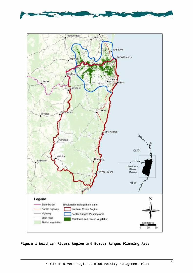
The Region covered by the Plan, as shown in Figure 1, is that area generally within the boundary of the Northern Rivers Catchment Management Authority (CMA). It excludes, however, areas of rainforest and related vegetation within the Border Ranges Planning Area (see Figure 1) that are dealt with in the Border Ranges Rainforest Biodiversity Management Plan (DECCW 2010); marine ecosystems below the mean low water mark; and offshore islands, including Lord Howe Island (see DECC 2007c).
The Plan addresses 298 threatened species, populations and ecological communities (‘threatened entities’) listed under federal and State legislation (as of March 2009), including 273 species, 5 populations and 20 ecological communities. The threatened entities addressed by this Plan, are listed in Appendix 1, and include:
those that are endemic to the Region those that have part of their distribution within the Region those that complete part of their life cycle within the Region (such as marine turtles that nest and
shorebirds that forage along the coastline).
This Plan does not address the 86 threatened species (including 71 plants and 15 animals) that are endemic to the rainforest and related vegetation of the Border Ranges (see Appendix 2, on the enclosed CD) as these are dealt with in the Border Ranges Rainforest Biodiversity Management Plan (DECCW 2010). Nor does the Plan address the majority of threatened marine species, vagrants or occasional migratory visitors to the Region.
Some species and communities addressed in this Plan also occur in locations outside the Region, and recovery actions identified for these species may also be relevant in adjoining areas.
The Plan is a guide to the management of the Region’s biodiversity. It provides an overview of the area’s natural and physical environments, provides maps of areas of importance to biodiversity, and outlines management actions to address threats. This information can help guide the strategic investment of biodiversity conservation funds by federal, State and local governments, and catchment management authorities.
The Plan uses a regional, threat-based, multi-species approach to managing threatened entities, and biodiversity more broadly. It seeks to address threatening processes at the regional scale where any single action may benefit multiple species. However, where threats, threatened entities or significant locations are not able to be adequately addressed at the regional scale, finer-scale or specific actions have been developed.
The information and assessments in the Plan are underpinned by a comprehensive set of spatial and non-spatial datasets pertaining to the natural and built environment. Detailed analysis of these data, by a combination of both expert opinion and sophisticated computer software, has allowed the development of detailed spatial outputs indicating areas of importance for biodiversity, including Conserve and Repair outputs.
A range of recovery actions that vary in their spatial scale, priority and potential benefits to biodiversity are provided. Action priorities may, however, vary at different times within the life of the Plan depending on the availability of resources, opportunistic project proposals and other competing priorities and interests.
Northern Rivers Regional Biodiversity Management Plan2

1.3 VisionThe vision of the Plan is:
“Provide coordinated and strategic outcomes for biodiversity management, underpinned by community involvement and partnerships that guide the protection and recovery of threatened
species, populations, ecological communities and ecological processes across all land tenures in the Region.”
1.4 ObjectivesTo achieve the vision, the Plan has set the following eight objectives:
1. To maintain and improve biodiversity and ecological processes by the rehabilitation and management of native vegetation across all land tenures.
2. To identify and mitigate the impacts of threats acting on threatened species, populations and ecological communities.
3. To mitigate the potential impacts of climate change by increasing landscape connectivity across all habitat types and land tenures.
4. To provide a basis for a consistent, coordinated and prioritised approach to the recovery of terrestrial, freshwater and estuarine threatened species, populations and ecological communities.
5. To improve community awareness and encourage and support landowner and community participation in recovery planning and on-ground activities.
6. To develop partnerships between agencies, organisations, communities and individuals to achieve recovery of threatened species.
7. To recognise and incorporate cultural values into biodiversity landscape planning and encourage ongoing Indigenous engagement.
8. To contribute to targets, priority actions and outcomes of the Northern Rivers Catchment Action Plan, NSW State Plan, federal natural resources management targets, and the NSW Threatened Species Priorities Action Statements.
Northern Rivers Regional Biodiversity Management Plan3

Figure 1 Northern Rivers Region and Border Ranges Planning Area
Northern Rivers Regional Biodiversity Management Plan4

1.5 Legislative contextA range of legislative and strategic planning mechanisms influence biodiversity and natural resource management in the Region. In particular, threatened species conservation and recovery is guided by legislation administered by the Australian and NSW Governments. This section provides a brief summary of the legislative requirements for threatened species recovery planning and outlines other relevant pieces of legislation.
1.5.1 Recovery planningThis Plan has been prepared to comply with the requirements of the Commonwealth EPBC Act, and additionally addresses the requirements of the NSW TSC Act and FM Act.
In accordance with the requirements of the EPBC Act, this Plan was placed on public exhibition as a draft Plan by the Australian Department of the Environment, Water, Heritage and the Arts and comments invited from the public.
Under the EPBC Act, the Minister has the discretion to prepare a recovery plan for a species, which may be a single-species, multi-species, or regional plan. In some cases, a species may be covered by a species-based plan and a regional plan at the same time, but the plans must not be inconsistent with each other. For those species which already have a national recovery plan, consideration may be given to revoking the single-species plans where this regional Plan adequately addresses the threats and actions necessary to protect the species.
All recovery plans are required to be reviewed after a specified period. For those that will be required to be reviewed within the life of this Plan, the intention is to incorporate the species they address into this Plan.
Management actions for species or ecological communities in existing plans are referred to in this Plan where relevant, for example, to guide the spatial extent of action implementation. Existing plans have also been used to guide the prioritisation of actions in this Plan.
Recovery plans prepared under the Commonwealth EPBC Act, NSW TSC Act and FM Act that exist for threatened entities addressed by this Plan are listed in Appendix 3, on the enclosed CD.
1.5.2 Conservation advices & priorities action statementsTo assist in its recovery, a ‘conservation advice’ is developed wherever a species or ecological community is first listed as threatened under the EPBC Act. The advice contains a summary of the key threats and details of local and regional activities that can be undertaken to ensure the conservation of the newly listed entity. Conservation advices are available in the Species Profile and Threats Database which is available at <http://www.environment.gov.au/cgi-bin/sprat/public/sprat.pl>.
Pursuant to the TSC Act and FM Act, a Threatened Species Priorities Action Statement (DECC 2007f) has been prepared that identifies the strategies and specific actions for each threatened species and key threatening process listed in NSW. This Plan informs the Priorities Action Statement in relation to threatened entities addressed by the Plan, and provides for prioritised and integrated implementation of Priorities Action Statement actions.
The NSW TSC Act Threatened Species Priorities Action Statement is available at <http://www.threatenedspecies.environment.nsw.gov.au>.
The NSW FM Act Threatened Species Priorities Action Statement is available at <http://pas.dpi.nsw.gov.au/>.
Northern Rivers Regional Biodiversity Management Plan5

1.6 Additional conservation legislation Additional NSW legislation that is relevant to the protection and management of biodiversity in the Region includes:
Catchment Management Act 2003 Crown Lands Act 1989 Environmental Planning and Assessment Act 1979 Local Government Act 1993 Marine Parks Act 1997 National Parks and Wildlife Act 1974 Native Vegetation Act 2003 Natural Resources Commission Act 2003 Nature Conservation Trust Act 2001 Noxious Weeds Act 1993 Rural Fires Act 1997 Rural Fires and Environmental Assessment Legislation Amendment Act 2002 Rural Lands Protection Act 1998 Water Management Act 2000.
The EPBC Act may also be relevant to those species listed federally, for example, where on-ground rehabilitation works or weed/pest species works may need to be referred to the Department of the Environment, Heritage, Water and the Arts.
A summary of this legislation and how it relates to the Plan is provided in Appendix 4, on the enclosed CD.
1.7 Interaction with other documentsThere are a number of existing strategies, policies and plans at various levels of jurisdiction that relate to this Plan. The Plan does not replace these existing strategies or plans, but complements them by providing a regional context and integrated implementation of biodiversity management. The Plan also contributes to meeting targets outlined in the following key documents:
International Convention on Biological Diversity National Strategy for the Conservation of Australia's Biological Diversity National Biodiversity and Climate Change Action Plan 2004–2007 NSW State Plan NSW Biodiversity Strategy Northern Rivers CMA Catchment Action Plan NSW Threatened Species Priorities Action Statement Federal recovery plans and threat abatement plans NSW recovery plans, threat abatement plans and statements of intent.
A summary of these existing strategies, policies and plans is provided in Appendix 5, on the enclosed CD. The links between existing strategies and this Plan is shown in Figure 2.
Northern Rivers Regional Biodiversity Management Plan6

Figure 2 Interaction between this Plan and other strategies, policies and plans
Northern Rivers Regional Biodiversity Management Plan
Informs and contributes
Local strategies, plans and policies e.g. Parks and Wildlife Group plans of management, development control plans, estuary management plans, local government species plans, biodiversity plans and vegetation plans
Regional strategies, plans and policies e.g. regional conservation plans, Northern Rivers CMA pest and weed management strategies, Parks and Wildlife Group regional pest management strategies and Border Ranges Rainforest Biodiversity Management Plan
NSW strategies, plans and policies e.g. Priorities Action Statement, NSW threat abatement plans, NSW recovery plans, statements of intent
National strategies, plans and policies e.g. national recovery plans, national threat abatement plans
Northern Rivers Regional Biodiversity Management Plan
Implemented by
NSW government agencies
Natural resource managers
Local government agencies
Non-government agencies
Local environment groups
Environmental consultants
Landowners & Aboriginal c
Monitor, Evaluate, Report and Inform
Contributes to targets and objectives
International conventions and obligations
National Strategy for the Conservation of Australia’s
Biological Diversity
NSW State Plan
Northern Rivers CMA Catchment Action Plan
DECCW Corporate Plan
NSW Biodiversity Strategy
Landowners & Aboriginal communities
7

22 Community InvolvementCommunity Involvement Effective stakeholder engagement requires the identification of all existing networks, interested individuals and groups within the Region. These important community networks include Landcare groups, local governments and their extension officers, Northern Rivers CMA community support officers and Aboriginal extension project officers, non-government organisations, environmental consultants, schools and research institutions. Promoting and encouraging partnerships within these existing networks is extremely important to the successful implementation of this Plan. In this respect the Plan seeks to provide guidance on priorities for biodiversity recovery to support existing networks and partners in providing the link between community involvement and appropriate implementation of recovery actions.
2.1 Community engagementDue to the large area covered by this Plan, it was not feasible to engage with the entire community through public meetings. Therefore, a range of approaches was used to inform the community and stakeholders about the Plan, and to encourage their input. This included forming the Northern Rivers Regional Biodiversity Management Plan Steering Committee; holding site visits and meetings with experts and targeted stakeholder groups; distributing media releases and newsletters; preparing electronic audio–visual material; and establishing a dedicated webpage on the Plan. Some of these approaches are briefly described here.
The Steering Committee includes representatives of the Department of the Environment, Water, Heritage and the Arts, DECCW (including the Culture and Heritage Division, Parks and Wildlife Group, Great Eastern Ranges Initiative staff and the Environment Protection and Regulation Group), Northern Rivers CMA, Nature Conservation Trust of NSW, Gondwana Rainforest of Australia World Heritage Area (WHA), Department of Lands, and two community representatives.
The Northern Rivers Regional Biodiversity Management Plan webpage, <http://www.environment.nsw.gov.au/biodiversity/nrrbiomanagemntplan.htm>, was established on the DECCW website to provide a description of the Plan preparation process and other regularly updated information, including the newsletters. Video and PowerPoint™ presentations describing the Plan and background information are linked to this webpage. A video promoting the Plan and community partnerships, and videos of stakeholder testimonials engaged in biodiversity management are linked to the webpage as well as being available on digital versatile disk (DVD).
Three regional biodiversity expert meetings were held to gather additional specific information on threats and locations of important species and habitats in the Region.
Site visits and meetings have also been undertaken with DECCW Parks and Wildlife Group, some pest and weed working groups, local government representatives, Landcare groups and environment groups. These provided opportunities for preliminary work on the Plan to be presented as well as opportunities to receive feedback on relevant issues.
Over the course of preparing the Plan, newsletters were prepared and distributed to a wide group of community stakeholders and were posted on the webpage. A press release was issued early in the process to promote initial awareness of the Plan across the Region, and to invite contributions. The webpage also provided a link for feedback via an email option as well as links to further information on related websites. For those people without internet access, the newsletters and the promotional video were also distributed among community networks in hardcopy form.
During the preparation of the Plan, a total of 325 people from 150 organisations (see Appendix 6, on the enclosed CD) were provided with information and encouraged to provide input. Organisations from different administrative levels and with different interests in natural resource management were consulted, including federal, State, regional and local government agencies, non-government organisations, boards and committees, Indigenous interest groups, private business, community
Northern Rivers Regional Biodiversity Management Plan8

groups, ecological consultants, educational institutions and interested individuals. Further community input was sought during the public exhibition phase of the draft Plan.
2.2 Indigenous community engagementNorth-east NSW supports significant and unique Indigenous cultural values that are continually interconnected to Country through earth, water, plants, animals, knowledge, traditions and stories. These aspects of culture are interwoven and are inseparable. Cultural responsibilities, meaning, associations and understanding are intertwined with the identification of Indigenous knowledge holders and their desire to protect, acknowledge and appreciate cultural values associated with Country.
Within the Region, the main Indigenous organisations with a particular interest in biodiversity and threatened species management fall into the following categories:
Local Aboriginal Land Councils Native Title Groups Traditional Owner Natural Resource Management Groups Indigenous Green Teams.
Within the Region, there are a range of existing Indigenous biodiversity engagement processes, for example, Indigenous Land Use Agreements, Indigenous Protected Areas, regional partnerships, employment by agencies including DECCW, Northern Rivers CMA Indigenous community support officers, and recently the NSW Biobanking Land Alive opportunities. In NSW, Two Ways Together is the State Government’s primary policy initiative for Indigenous communities, providing advice and support to local government in establishing successful partnership arrangements.
The EPBC Act, TSC Act and FM Act require an adequate level of community consultation to be undertaken as part of the preparation of a recovery plan. The objectives of the EPBC Act include:
To promote a cooperative approach to the protection and management of the environment involving government, the community, landholders and Indigenous peoples.
To recognise the role of Indigenous people in the conservation and ecologically sustainable use of Australia’s biodiversity.
To promote the use of Indigenous people’s knowledge of biodiversity with the involvement of, and in cooperation with, the owners of the knowledge.
In particular, any nationally adopted recovery plan needs to consider the role and interests of Indigenous people in the conservation of Australia’s biodiversity. A range of consultation mechanisms have been used to ensure the Plan addresses the EPBC Act requirements, including the extension of innovative approaches trialled initially in the Border Ranges Planning Area (refer DECCW 2010).
Based on previous experience in engaging Indigenous communities on threatened species recovery (e.g. Baker et al. 1993; Baker 1996; Nesbitt et al. 2001; Robinson et al. 2003; English & Baker 2003; Baker 2004), it was considered that undertaking a broad consultation process was unlikely to be effective, and that more engaging, practical mechanisms should be investigated. As the boundaries of the Border Ranges Planning Area and Northern Rivers Region overlap (see Figure 1), and the project time frames overlap, the Indigenous community engagement process was combined. To assist in designing a suitable approach, a south-east Queensland–based Indigenous organisation was engaged to develop an ‘Indigenous Engagement Strategy’ (Eastern Yugambeh Ltd 2006).
Based on the Strategy, a ‘toolkit’ was developed to provide a range of opportunities to involve Indigenous groups in biodiversity planning and management. The key to the toolkit was the recognition that integrating protection and enhancement of culture and biodiversity creates opportunities for Indigenous education, training and employment, and increases the recognition and integration of Indigenous knowledge of Country into biodiversity management.
Northern Rivers Regional Biodiversity Management Plan9
The toolkit identifies mechanisms for participation which can be implemented separately or in combination:
Indigenous property biodiversity restoration and management plans and their implementation community self-consultation ethno-ecological survey cultural landscape mapping cultural connection educational and interpretive materials.
Details of the development of the toolkit and case studies where it has been implemented are provided in Appendix 7, on the enclosed CD.
2.3 Community implementation There are a number of ways governments and agencies encourage community involvement and participation in biodiversity protection and on-ground activities to repair and conserve habitat (Young et al. 1996). These include:
financial incentives covenants and management agreements voluntary conservation agreements education and training federal and state legislation aimed at protecting native vegetation and biodiversity.
Often no single approach is totally effective by itself, and a mix of approaches is required. A summary of these approaches and mechanisms is provided in Appendix 8, on the enclosed CD.
This Plan provides the basis for partners and stakeholders to develop funding applications and seek investment for biodiversity projects from government and non-government funding sources. In this way the Plan provides the strategic platform to steer and guide priority outcomes by building on the extensive existing community capacity and participation in implementing biodiversity conservation in the Region.
To date there has been a number of successful funding applications and delivery of a range of projects across the Region including:
The subcatchment pilot project delivering recovery actions identified in the Border Ranges Rainforest Biodiversity Management Plan (DECCW 2010) and the NSW Threatened Species Priorities Action Statement (DECC 2007f).
A partnership project with Northern Rivers CMA, DECCW and the Nature Conservation Trust to develop opportunities for private land conservation to contribute to the National Reserve System, based on priorities developed in this Plan.
A partnership program with the Great Eastern Ranges Initiative and a range of Border Ranges partners to deliver biodiversity outcomes and conservation covenants.
A successful funding bid by the Ngulingah Local Aboriginal Land Council to implement the Nimbin Rocks Biodiversity Management and Restoration Plan over a five-year period.
A community-led partnership project that delivered 1840 days of on-ground weed control and montitoring and evaluation at 83 lowland rainforest sites involving Big Scrub Landcare; EnviTE Inc.; Tweed, Byron, Ballina and Lismore councils; Richmond, Tweed and Brunswick Valley regional Landcare organisations; Tuckombil Landcare; Rous Water; and more than 50 other landholders.
Northern Rivers Regional Biodiversity Management Plan10

33 Regional OverviewRegional OverviewThis section provides a brief description of the Region, including its:
landscapes (coastal plains, midland hills, escarpment ranges and tablelands) physical features (landform, geology, climate, land tenure and landuse) biological features (ecosystems, threatened species, populations and communities) people (Indigenous community, European settlement and community capacity).
3.1 LandscapesFor the purposes of discussing the Region’s features, and for later analyses and recovery actions, the Region is divided into four broad landscapes. These landscapes reflect broad patterns in topography, human settlement and landuse. The four landscapes, from east to west, are coastal plains, midland hills, escarpment ranges and tablelands (see Figure 3). A detailed description of each landscape is provided in Appendix 9, on the enclosed CD.
The coastal plains landscape encompasses the broad, flat river valleys and floodplains of major rivers, and includes estuaries, beaches, headlands, coastal lakes and coastal sand masses. The majority of urban centres are located in this landscape and other major landuses include cropping and grazing. The midland hills landscape covers the undulating foothills and low ranges west of the coastal plains. Grazing and forestry are the main landuses and there are several large towns, numerous villages and rural residential estates.
The escarpment ranges landscape includes the steep ranges and mountains west of the midland hills, encompassing many rugged gorges and upper catchments of smaller rivers. Nature conservation, forestry and forest grazing are the main landuses, with only a few small towns and villages. The tablelands landscape covers the highest elevations in the west of the Region and consists predominantly of undulating plateaus that form the headwaters of the major river valleys. Sheep and cattle grazing are the main landuses, and there are several large towns and numerous villages.
3.2 Physical featuresIt is beyond the scope of this Plan to describe in detail the natural and physical forces that have shaped the distribution of vegetation and habitats in the Region. More detailed information on the physical and biological attributes is available in the literature, including: the Regional Report of Upper North East New South Wales (RACAC 1996) and the associated Natural Resources Audit Council reports (NPWS 1995a, 1995b; Sheringham & Westaway 1995); various State Forests of NSW environmental impact statements (e.g. SFNSW 1995); the reports prepared for the North East Forests Biodiversity Study (e.g. NPWS 1994) and Comprehensive Regional Assessment of Upper and Lower North East NSW (e.g. NPWS 1999). Additional information on plants and animals of conservation concern can also be found in Gilmore and Parnaby (1994) and Quinn et al. (1995). A description of forest ecosystems of the Region is available (see DEC 2004a), and Floyd (1990), Hunter (2003) and Adam (1994) provide detailed information on rainforests.
The combined effects of geology, landform (topography) and climate have influenced the historic distribution of native vegetation and habitats in the Region. Geology and geomorphology play a pivotal role in the determination of vegetation types across any area due to their influence on soil types. The wide range of elevations in the Region (from 0 to 1500 m above sea level) has a significant impact on the climate, influencing temperature, humidity and rainfall. These variations in climate, in turn, influence the distribution of vegetation communities and habitats. More recent contemporary factors associated with human activities, such as clearing, burning, agriculture and urbanisation, have changed these patterns to create the mosaic of vegetation present today.
Northern Rivers Regional Biodiversity Management Plan11

Figure 3 Landscapes
Northern Rivers Regional Biodiversity Management Plan12

3.2.1 TopographyA major feature encompassed by the tablelands and running north–south through the Region is the Great Dividing Range, which stretches from Victoria to far north Queensland. The Region’s highest point along the Range is 1584 m at Round Mountain, north-east of Armidale.
In the northern part of the Region, the eroded calderas of Mt Warning and Focal Peak form a series of radiating ranges that join with the Great Dividing Range. The extensive floodplains of the Clarence and Richmond rivers encompass a large and ecologically significant portion of the Region. Smaller coastal catchments near Port Macquarie and Coffs Harbour are associated with steep-sided valleys.
The higher elevations of the tablelands and escarpment ranges extend eastwards towards Coffs Harbour. The rugged gorges along the escarpment between Coffs Harbour and Kempsey are associated with the headwaters of the Macleay and Guy Fawkes rivers, and form inaccessible gulfs and extensive cliff lines between 800 and 1000 m elevation. The topography of the Region is illustrated in Figure 4.
3.2.2 GeologyThe Region has a complex geological history that began with the formation of the oceanic crust and deposition of oceanic sediments in the Cambrian to Carboniferous periods (500 to 300 million years ago). The broad geological groupings in the Region, shown in Figure 5, include the following:
acid volcanics—rhyolite and trachyte basic volcanics—basalt granite meta-sediments, including serpentinite sandstone other sedimentary—claystone, conglomerate, limestone, mudstone and siltstone unconsolidated sediments—alluvial, estuarine, coastal barrier sand and undifferentiated sediments
(Troedson et al. 2004).
These geologies were laid down at various times, with younger rocks dominating the north-east (including the Clarence and Richmond valleys), and older rocks dominating the south and west of the Region.
The unconsolidated sediments in the valley floors along the Region’s coast were deposited most recently (from 1.8 million years ago). These consist of alluvial and estuarine deposits on the river floodplains and estuaries, and the coastal sand masses of marine and Aeolian origin. Coastal barrier sand masses have been deposited at times of recent and past changes in sea level. Holocene (more than 10 000 years ago) deposits forming beaches and dunes occur adjacent to the ocean. Adjoining these are older Pleistocene sands, which form dunes, swales strandplains and back-barrier flats.
The broad Clarence–Moreton basin (extending around and north of Grafton) is dominated by sandstone and sedimentary rocks deposited 200 million years ago. This area is characterised by low nutrient, free-draining soils. The volcanics around Lismore resulted from two volcanoes that underwent a series of eruptions 20–30 million years ago creating two significantly different lava flows: acid and basic. The more extensive basic basalts weathered to form the deep, fertile red soils of the Lismore and Springbrook areas. The acidic rhyolite and trachyte form the prominent cliffs and peaks in the Tweed Valley and Border Ranges area. Apart from these relatively young geologies, there is a small area of old meta-sediments in the Burringbar Range area, south-west of Tweed Heads, which were laid down some 300–350 million years ago.
To the south and west of the Clarence basin, the meta-sediments, sandstone and other sedimentary rocks date from 250–550 million years ago. The New England Fold granites, generally dating from 200–300 million years ago, stretch along the western edge of the Region dominating the northern tablelands and forming low nutrient, free-draining soils and prominent rock outcrops such as Bald Rock and Cathedral Rocks. The acid volcanics in the south and west of the Region are 250–300
Northern Rivers Regional Biodiversity Management Plan13

million years old and the Dorrigo Plateau west of Coffs Harbour was formed by the Ebor Volcano, active until about 18 million years ago. The other basic volcanics at Comboyne in the far south of the Region are also relatively recent, being laid down around 30 million years ago, while the basalts of the Guyra to Glen Innes area were laid down less than 50 million years ago. South of Kempsey, a narrow band of limestone runs west and has formed caves, arches and other karst features.
The Demon Fault is a major geological feature, running for around 150 km north from Ebor to east of Tenterfield. It forms the prominent valleys of the Guy Fawkes and upper Timbarra rivers. It was formed in the Triassic Era around 220 million years ago, and shifted the land 25 km north–south.
3.2.3 ClimateNorth-east NSW generally experiences a warm temperate climate. The main atmospheric factors affecting the Region’s climate are the slow easterly-moving high pressure systems, low pressure systems with associated cold fronts, and the very occasional tropical cyclone drifting south to the northern parts of the Region. In summer, easterly to south-easterly winds predominate, resulting in a distinct summer–autumn rainfall maximum and relatively dry springs. In winter, dry westerly to south-westerly winds predominate with a general pattern of fine sunny days and cool nights (NPWS 1995b). The annual rainfall pattern in the Region is shown in Figure 6.
In the Region, rainfall is generally lower the further you move away from the coast. This trend is modified by topography, with higher rainfall in the mountainous areas closest to the coast, and lower rainfall in the tablelands and low-lying valleys and floodplains. Many of the valleys in the lee of the higher elevation ranges and prominent mountains experience rain-shadow effects and have markedly lower rainfall than the adjacent ranges (Adam 1987). The highest rainfall areas are the Tweed and Nightcap ranges in the north, with annual falls over 3000 mm concentrated in summer and autumn.
Temperature across the Region can vary greatly, with mean monthly minimum temperatures of below 0 0C in the western tablelands and mean monthly maximum temperatures up to 31 0C in the northern coastal areas (Commonwealth of Australia 2009).
Northern Rivers Regional Biodiversity Management Plan14

Figure 4 Topography
Northern Rivers Regional Biodiversity Management Plan15

Figure 5 Geology
Northern Rivers Regional Biodiversity Management Plan16

Figure 6 Annual rainfall
Northern Rivers Regional Biodiversity Management Plan17

3.2.4 Land tenure and landuseThe Region encompasses a broad range of land tenures and landuses. The location of various land tenures in the Region is shown in Figure 7 and Table 1 includes area statistics. A full list of public land properties is provided in Appendix 10, on the enclosed CD. Landuse types in the Region are shown in Figure 8.
Table 1 Land tenure statistics (as of December 2008)
Land tenure No. Area (ha) % RegionPrivate freehold na 2 940 697 58.5
Private conservation: 266 57 271 1.0Wildlife refuge 89 30 201 0.6
Property vegetation plan 72 13 455 0.3
Management agreement 42 7 955 0.2
Land for Wildlife 5 516 <0.1
Nature Conservation Trust covenant 17 629 <0.1
Nature Conservation Trust purchase 2 2 440 <0.1
Voluntary conservation agreement 39 2 075 <0.1
National Park and Wildlife estate: 249 1 115 269 22.2National park 77 948 351 18.9
Declared wilderness (#) (10) (501 583) (10.0) World heritage areas (#) (5) (269 577) (5.4)Nature reserve 116 113 424 2.3
State conservation area 45 50 566 1.0
Aboriginal area 5 138 <0.1
Historic site 3 1 222 <0.1
Regional park 1 386 <0.1
Marine park 2 1 182 <0.1
Forest NSW estate: 184 620 968 12.4State forest 167 617 650 12.3
Flora reserve 16 2 209 <0.1
Timber reserve 1 1 109 <0.1
NSW Crown lands: 13 581 255 435 5.1Crown lease 3 955 171 056 3.4
Crown reserve 6 171 27 590 0.5
Crown trust reserve 2 054 20 254 0.4
Travelling stock reserve 743 19 719 0.4
Crown moratorium 381 15 867 0.3
Council reserve 277 949 <0.1
Commonwealth lands: 11 3 768 0.1Airport 5 1 175 <0.1
Defence reserve 1 2 233 <0.1
Education reserve 5 360 <0.1
Water 33 199 0.7
Total 5 026 608
Note: # figures are a subset of the national park category.
Northern Rivers Regional Biodiversity Management Plan18

Figure 7 Land tenure
Northern Rivers Regional Biodiversity Management Plan19
Figure 8 Landuse
Northern Rivers Regional Biodiversity Management Plan20

Nearly two-thirds of the Region is private land supporting a wide variety of landuses. The main landuse is livestock grazing which occupies about one-third of the Region in one form or another. Historically, sheep grazing has predominated on the tablelands, with beef cattle and dairying occurring in the lowlands and escarpment forests.
‘Private forest’ (as shown on Figure 8) covers over 1 million hectares of the Region. As of 2008, approximately 70 000 hectares (ha) was covered by 350 private native forestry property vegetation plans approved under the Native Vegetation Act 2003.
Less widespread, but potentially more intensive, landuses on private land include cropping, horticulture, timber plantations, infrastructure, urban settlements, rural residential and rural lifestyle areas (i.e. small to medium forested or wilderness blocks with isolated residential buildings). Urbanisation is an intensive landuse in coastal centres such as Tweed Heads, Ballina, Coffs Harbour and Port Macquarie. It is expected that demand for new urban and rural residential areas will continue to grow.
The major cropping activity is sugar cane farming on the floodplains north from Grafton, with minor areas of soya beans, tea-tree and other crops generally restricted to the coastal plains. The fertile soils of the basalt plateaus around Lismore, Dorrigo, Comboyne and Guyra support important macadamia, potato and tropical fruit industries. Intensive animal production facilities such as chicken farms and cattle feedlots are not common in the Region. Similarly, mining is restricted to isolated quarries and small mines.
Conservation initiatives on private land cover one per cent of the Region and include formal and informal agreements and covenants, including 89 wildlife refuges.
Just over 20% of the Region lies within the National Park and Wildlife estate with the majority of parks located in the escarpment ranges and along the coast. Nature reserves and state conservation areas cover around three per cent of the Region. Almost a half of the National Park and Wildlife estate is declared wilderness and almost a quarter is Gondwana Rainforests of Australia World Heritage Area (WHA). Information on Aboriginal places and areas is provided in Section 3.4.3.
NSW Crown lands, including leases, reserves, travelling stock reserves and trusts, cover 5% of the Region and are mostly used for grazing. Forest NSW tenure, shown on Figure 8, covers some 12% of the Region and encompasses commercial and non-commercial forestry landuses, including flora reserves and exclusion zones designed to protect important biodiversity and other features. Commonwealth lands include the Gold Coast Airport, education campuses, and the Bundjalung Bombing Range south of Evans Head.
3.3 Biological features
3.3.1 OverviewThe Region intersects with the NSW North Coast, New England Tablelands and South East Queensland biogeographic regions (DEWHA 2008c) and this is reflected in the diverse range of landscapes, ecosystems and species that the Region supports. The distribution and composition of these ecosystems are affected by a variety of factors including unique variations in geology, soils climate and topography.
The Region supports a very high floristic diversity and is of great zoogeographical importance, supporting a diverse number of vertebrate fauna including many endemic and endangered species (Ferrier et al. 2000). There are a number of publicly accessible websites where information on individual species, populations and ecological communities can be obtained, including:
Commonwealth Species Profile and Threats Database <http://www.environment.gov.au/cgi-bin/sprat/public/sprat.pl>
Northern Rivers Regional Biodiversity Management Plan21

Commonwealth list of threatened species and ecological communities <http://www.environment.gov.au/biodiversity/threatened/index.html>
NSW Profiles of threatened species, populations and ecological communities <http://www.threatenedspecies.environment.nsw.gov.au/index.aspx>
NSW Government BioNet system <http://www.bionet.nsw.gov.au/BioNet> Australian Museum Centre for Biodiversity and Conservation Research FaunaNet
<http://faunanet.gov.au/> the Atlas of NSW Wildlife <http://wildlifeatlas.nationalparks.nsw.gov.au/wildlifeatlas/watlas.jsp> Royal Botanic Gardens Plantnet <http://plantnet.rbgsyd.nsw.gov.au/search/simple.htm> NSW Scientific Committee preliminary and final determinations
<http://www.environment.nsw.gov.au/committee/>.
3.3.2 Ecosystems of the Region
Vegetation communitiesThe Region encompasses the Macleay–Macpherson overlap (Burbidge 1960) which is a distinct phyto-geographical zone located between the McPherson Ranges in the north and the Macleay River in the south. This zone supports a great variety of tropical and temperate communities and species, many at the limits of their distributions. Over 4000 different plants have been recorded in the Region, creating a complex mosaic of vegetation communities. The diversity of the Region has been recognised at national and international levels (NPWS 1995a). Around two-thirds of the Region supports native vegetation and three per cent is covered with exotic forests, such as timber plantations or weeds such as Bitou Bush Chrysanthemoides monilifera and Camphor Laurel Cinnamomum camphora forests.
Around 40% of the sclerophyll forests in the Region are ‘candidate’ old growth forest1, more than half of which are within the national parks of the escarpment ranges. Another 20% of the Region’s sclerophyll forests are ‘disturbed’ old growth forests, nearly two-thirds of which occur on private property. The sclerophyll forest growth stages in the Region are shown in Figure 9.
The Region supports 164 native and four exotic vegetation communities (see ELA 2005). In order to illustrate broad vegetation across the Region, these vegetation communities were classified into ‘vegetation formations’ based on Keith (2006). These formations are essentially broad groups of vegetation that are distinguished by their structure and appearance. The Region supports nine of NSW’s 12 native vegetation formations. These vegetation formations are shown in Figure 10 and statistics are provided in Table 2. Over half of the existing native vegetation in the Region is dry sclerophyll forest, nearly a quarter is wet sclerophyll forest, and 10% is rainforest.
These vegetation formations can be subdivided into vegetation classes which have similar structural characteristics but different floristic compositions due to geographic position, climate or soil type. In the Region there are 33 different vegetation classes, with dry sclerophyll forest and rainforest supporting the highest diversity of classes (see Table 2).
Within these vegetation classes, distinct communities can be recognised by the particular assemblage of plants that are dominant in the canopy, understorey and ground cover. These vegetation communities form a complex mosaic pattern throughout the Region in response to subtle changes in soils, slope, aspect, climate, altitude and topographic position. The diversity of communities is highest in the dry and wet sclerophyll forest vegetation formations.
1 ‘candidate’ and ‘disturbed’ old growth forest was mapped during the Comprehensive Regional Assessment and these maps provide an indication of where these forest growth stages occur
Northern Rivers Regional Biodiversity Management Plan22

Table 2 Vegetation formations
Vegetation formation No. of classes
No. of communities
% of existing vegetation
Dry sclerophyll forests 7 60 53.9
Wet sclerophyll forests 4 52 24.6
Rainforests 6 8 10.9
Grassy woodlands 3 16 5.2
Forested wetlands 3 5 2.1
Heathlands 4 13 1.5
Freshwater wetlands 3 7 1.5
Saline wetlands 2 2 0.2
Grasslands 1 1 <0.1
Appendix 11, on the enclosed CD, lists these vegetation formations, classes and communities and provides a description of each vegetation community in the Region. For each vegetation community, the equivalent vegetation type used in the NSW Property Vegetation Plan Developer is provided. A description of each of these types can be found at: <http://www.environment.nsw.gov.au/resources/nature/BioMetric_Vegetation_Type_CMA.xls>.
Four of the six major areas of rainforest in NSW are located in the Region at Richmond–Tweed, Washpool, Dorrigo and Hastings (Floyd 1990). These areas contain outstanding examples of subtropical, warm temperate, cool temperate, dry and littoral rainforest. Although rainforests cover a much smaller area than sclerophyll forests in the Region, they are of outstanding botanical, biogeographical and evolutionary significance (Adam 1987; DASET 1992).
Sclerophyll forests and woodlands comprise around 85% of the remaining native vegetation in the Region. Sclerophyll forests and woodlands of north-east NSW are mostly dominated by eucalypts, with over 120 individual species known from the Region (NPWS 1995a).
Wet sclerophyll forest occurs mainly in the escarpment ranges and the dominant species of these forests are usually determined by climate, soil fertility and drainage. Wet sclerophyll forests occupy soils of higher fertility on the coast and escarpment, with minor extensions onto the tablelands. The canopy is generally 30–60 m tall. Fires are irregular in these forests, and a rainforest understorey often develops in the period between fires. Ecotones between wet sclerophyll forest and rainforest are often dynamic, with fire frequency playing a major role in the location and extent of such ecotones.
Dry sclerophyll forest is the most widespread vegetation formation of the Region, making up more than half of the remaining vegetation. It generally occurs on soils of low fertility, supports a variety of dominant canopy species, and has a grassy or shrubby understorey. The canopy is generally 20–30 m tall. Fire is frequent and many species respond to fire by resprouting or by releasing seed.
Grassy woodlands occur mainly on the tablelands, are dominated by eucalypt species, and have grasses and herbs in the understorey. The canopy, which is more open than sclerophyll forests, is usually 10–30 m tall. Fire is also common, and influences both canopy and understorey floristics and density.
Forested wetlands occur on the coastal floodplains as soil drainage becomes impeded. Dominant species in coastal swamp forests include Swamp Oak Casuarina glauca, Broad-leaved Paperbark Melaleuca quinquenervia, Swamp Mahogany Eucalyptus robusta and Swamp Turpentine Lophostemon suaveolens. There is a complex but gradual transition in these species across the floodplain. All these species commonly co-occur in mixed stands, except in the most saline areas where Swamp Oak dominates.
Northern Rivers Regional Biodiversity Management Plan23

Figure 9 Sclerophyll forest growth stages
Northern Rivers Regional Biodiversity Management Plan24

Figure 10 Vegetation formations
Northern Rivers Regional Biodiversity Management Plan25

Heathlands are dominated by small shrubs up to 2 m tall and are most common in coastal areas, although smaller, locally significant areas occur on the tablelands (Specht 1981). They are generally found on acid soils which are sandy at the surface and very deficient in most mineral nutrients (Groves 1981). Leaves of heath species contain flammable compounds which contribute to the regular fire frequency of most heathlands. After fire, many species regenerate from underground organs such as lignotubers, or from released seed. On coastal sands, areas of open heath or low open banksia or mallee woodland up to 5 m tall and with a diverse sclerophyll shrub layer are often referred to as ‘wallum’ heaths. Wallum is typically dominated by Wallum Banksia Banksia aemula and often occurs in areas where dunes and swales run parallel to the coast. In the swales, freshwater wetlands or wallum swamps occur, providing habitat for threatened frogs and other species (DECC 2008k). Common sedge species in wallum sedgelands are Leptocarpus tenax, Baloskion pallens, Eleocharis sphacelata and Lepironia articulata (Griffith et al. 2003).
Grasslands occur where the growth of woody shrubs is inhibited by strong coastal winds, seasonal or semi-permanent waterlogging, severe frost or cold air drainage (Beadle 1981). The grasslands of the Region are mainly temperate and are dominated by Themeda, Poa and Stipa species. The grass flora exhibits a regional overlap of warm and cool season species, producing probably the greatest diversity of grasses in Australia (Lodge & Walley, cited in NPWS 1994).
Freshwater wetlands are typically vegetated, and include swamps, sphagnum bogs, peatlands, coastal lagoons, sedgelands and freshwater marshes. Wetlands vary in permanency from deep, permanent marshes to shallow, temporary wetlands which may dry out seasonally or in dry years. Wetland vegetation in coastal floodplains is usually dominated by Eleocharis species, and swales in coastal dune systems are usually dominated by Baumea species. On the tablelands, sedgelands dominated by Carex gaudichaudiana form fens when associated with herbs, grasses and species in the Cyperaceae family; or bogs when associated with sphagnum and other Cyperaceae species on more acid soils.
Most wetlands in the Region are listed as threatened ecological communities, including coastal saltmarsh along estuaries; freshwater wetlands on coastal floodplains; and upland wetlands, montane peatlands and swamps on the tablelands. Many wetlands still provide important ecological hydrological functions even if they have been cleared or are surrounded by cleared land.
Rivers and coastal lakesRivers and lakes provide a broad range of habitat for a wide variety of aquatic plant and animal species, as well as supporting varied geomorphic features and a range of ecological processes. The Great Dividing Range defines the major river catchments of the Region, including the major easterly flowing rivers and estuarine systems of the Tweed, Brunswick, Richmond, Clarence, Bellinger, Nambucca, Macleay and Hastings rivers.
The rivers and creeks in the Region support many water-dependent species, including freshwater and estuarine fish, freshwater turtles, frogs, waterbirds and aquatic vegetation such as mangroves, seagrass and freshwater macrophytes. Many of the freshwater rivers and creeks in the Region are influenced by tidal flows which determine the boundary between freshwater and estuarine ecosystems.
Coastal and estuarine lakes and lagoons are open bodies of either salty or brackish water which have a relatively narrow connection to the sea. This connection is open either permanently or intermittently. Many estuarine lakes and lagoons are only open to the sea during floods or at very high tides, although in some cases lagoons may be artificially opened to reduce the impact of flooding on private properties. Many of these lakes are known as ‘intermittently closed and open lakes or lagoons’. The major rivers, catchments and coastal lakes of the Region are shown in Figure 11.
Northern Rivers Regional Biodiversity Management Plan26

Figure 11 Rivers, catchments and coastal lakes
Northern Rivers Regional Biodiversity Management Plan27

Estuarine ecosystemsEstuaries are essential for the survival of many species of flora and fauna. In particular, estuaries provide important feeding and breeding habitat for a wide range of species, including migratory birds listed under various international agreements. The mix of marine and freshwater influences on estuarine systems results in these areas being highly productive.
Around 40 estuaries occur in the Region, ranging from estuaries of large rivers such as the Clarence, to small intermittently opening creeks such as Oyster Creek, north of Valla. These estuaries contain important areas of saline wetlands such as mangroves, seagrasses and saltmarsh. The area of mangrove, saltmarsh and seagrass in the major catchments of the Region is provided in Table 3. Overall, the Hasting River catchment supports the largest area of estuarine vegetation.
Table 3 Extent of estuarine ecosystems by major catchment
Major catchment*
Mangrove Saltmarsh Seagrass TotalArea (ha)
% total mangrove
Area (ha)
% total saltmarsh
Area (ha)
% total seagrass
Area (ha)
% total
Tweed 398 11 76 3 81 5 555 7
Brunswick 170 5 53 2 10 1 233 3
Richmond 643 18 96 4 33 2 772 10
Clarence 765 21 290 13 83 5 1 138 15
Coffs 258 7 223 10 40 3 521 7
Nambucca 149 4 192 9 64 4 404 5
Bellinger 118 3 15 1 13 1 147 2
Hastings 489 13 853 38 1 171 74 2 513 34
Macleay 642 18 440 20 96 6 1 178 16
Total (ha) 3 633 2 238 1 590 7 461
Note: catchments listed north to south; refer to Figure 11 for major catchment boundaries.
Mangroves generally occur in estuarine areas that are subject to tidal flooding, often extending up coastal rivers as far as the tidal limit. The Clarence has the largest area of mangroves, which is to be expected as it is the largest estuary in the Region (Williams et al. 2006). The most diverse mangrove community is in the Tweed River which supports five species of mangrove: Grey Mangrove Avicennia marina, Stilt-rooted Mangrove Rhizophora stylosa, Black Mangrove Bruguiera gymnorhiza, River Mangrove Aegiceras corniculatum and Milky Mangrove Excoecaria agallocha (NPWS 1995a).
Saltmarshes are wetlands that contain communities of plants and animals that can tolerate high soil salinity and periodic inundation by marine or brackish water. They are generally located within estuaries (often on the landward side of mangroves) or along the high tide zones of low energy coastlines. Saltmarshes are important habitats which provide essential feeding, roosting and breeding areas for a large variety of birds, particularly migratory species. These intertidal areas are also important nursery areas for a range of marine organisms. Saltmarshes act as a buffer and filtration system for sediments and nutrients, and also provide important nutrients to estuarine systems. Where inundating water is highly saline, saltmarshes are dominated by succulent herbs and shrubs. The more saline saltmarshes are usually dominated by Sea Rush Juncus kraussii, Sand Couch Sporobolus virginicus (a grass), Sarcocornia (a herb), and Triglochin striatum (a herb). The Hastings River catchment supports the majority (38%) of the Region’s saltmarsh with extensive areas at Lake Innes and Lake Cathie, south of Port Macquarie. The Macleay and Clarence estuaries also support major occurrences of saltmarsh.
Seagrasses form ‘meadows’ in estuaries and other shallow coastal waterbodies with sandy or muddy substrates. Some species, such as Dugong Dugong dugon and Green Turtle Chelonia mydas, feed directly on seagrass. Seagrasses are also important fish nurseries and provide habitat for a range of small and microscopic organisms (e.g. seaweeds, bryozoans, sponges and molluscs) which are a food source for large fish (QEPA 2009). The vast majority (74%) of the Region’s
Northern Rivers Regional Biodiversity Management Plan28

seagrass is in the Hastings River catchment, where extensive meadows occur in Queens Lake south of Port Macquarie. Only small areas of seagrass occur in the Region’s other estuaries.
Groundwater-dependent ecosystemsGroundwater-dependent ecosystems represent a small but diverse and important component of biological diversity. The recognition of these ecosystems as a distinct group is relatively recent and may largely be attributed to work by Hatton and Evans (1998 in Sinclair Knight Merz 2001). Six types of groundwater-dependent ecosystems have been identified, including: terrestrial vegetation, river base flow systems, aquifer and cave ecosystems, wetlands, terrestrial fauna, and estuarine and near-shore marine ecosystems (see Sinclair Knight Merz 2001). Some examples include springs, seeps and underground streams.
Fauna habitatsThe complex and diverse mosaic of vegetation in the Region supports a diverse fauna. Nearly 860 native species have been recorded in the Region, including frogs, reptiles, birds, mammals and invertebrates (Atlas of NSW Wildlife). The area supports unique faunal assemblages and a high number of endemic and endangered species. The Region is a population stronghold for many species and also provides important habitat for transnational migratory birds (Gilmore & Parnaby 1994). It is also significant for nomadic and over-wintering insectivorous birds and microchiropteran bats, as well as nectivorous and frugivorous birds and megachiropteran bats (NPWS 1995b).
The Region is influenced by four zoogeographical zones:
Tumbunan—relictual, mesic, montane and submontane areas of the Great Dividing Range Bassian—temperate eucalypt-dominated forests of southern and eastern Australia Torresian—northern Australia tropical, grassy savannah woodlands Eyrean—semi-arid and arid inland.
Within the Region, 64 frog species have been recorded including 36 ground, 11 stream and 17 tree frogs. These mainly occur in coastal wetlands, and streams and rivers of the escarpment. A number of frogs are very rare or presumed extinct on the tablelands.
The Region supports 130 reptiles (Atlas of NSW Wildlife) including skinks, dragons, goannas, snakes, snake-lizards, blind snakes, and freshwater and marine turtles. The diversity and density of elapid snakes and skinks is particularly high in the Region given its location in the overlap of tropical and temperate zones, and its high overall habitat diversity (NPWS 1995b). There are 23 reptile species considered to be either endemic or having their population stronghold in the Region (Gilmore & Parnaby 1994).
The Region supports more than 487 species of birds (Atlas of NSW Wildlife) with some of the most diverse assemblages occurring in the rainforest – wet sclerophyll ecotone and coastal woodlands. The Tumbunan mesic environments supported Australia’s early rainforest fauna, from which dry-adapted species evolved and dispersed as the continent drifted into more arid latitudes (Schodde & Calaby 1972; Nix 1982; DASET 1992). Today, the moist forests of the Region are refugia for remnant populations of Australia’s ancient rainforest-adapted birds (Schodde 1991).
Over 30 species of honeyeaters inhabit the Region, with the coastal heaths and paperbark forests providing important nectar and insect resources for these species. From April to September, banksias and other winter-flowering plants provide increased nectar for many altitudinal migratory species (NPWS 1995b). The Region is also important for some western species that move to the coast during unfavourable seasonal conditions. The remnant woodlands of the tablelands support over 140 species of birds, a number of which are considered to be in decline. Larger remnants tend to support higher species diversity, however, the birds rely on a habitat mosaic which includes scattered paddock trees, planted windbreaks and woodlots (Debus et al. 2006).
Northern Rivers Regional Biodiversity Management Plan29

The estuaries of the Region are important feeding grounds for some 130 waterbirds, about two-thirds of the national total. Waders are well represented and include numerous transequatorial migrants such as the Common Sandpiper Actitis hypoleucos and Latham's Snipe Gallinago hardwickii (NPWS 1995b).
The Region supports 151 native mammals (Atlas of NSW Wildlife) and is considered a major stronghold for the following: Yellow-bellied Glider Petaurus australis, Koala Phascolarctos cinereus, Parma Wallaby Macropus parma, Hastings River Mouse Pseudomys oralis, Spotted-tailed Quoll Dasyurus maculatus, Brush-tailed Rock-wallaby Petrogale penicillata, Red-necked Pademelon Thylogale thetis, Eastern Freetail-bat Mormopterus norfolkensis, Golden-tipped Bat Kerivoula papuensis, Greater Broad-nosed Bat Scoteanax rueppellii, Eastern Forest Bat Vespadelus pumilus and New Holland Mouse Pseudomys novaehollandiae (Gilmore & Parnaby 1994). Flying-foxes play an important role in the food web of forested areas because they pollinate trees and spread the seeds of rainforest plants, sometimes travelling up to 300 km in a single night while migrating (Billy Roberts pers. comm.). Other nectivorous species such as the Common Blossom-bat Syconycteris australis play an important role in the pollination of species such as banksias and paperbarks (Richards 1983).
Invertebrates comprise by far the greatest number of animal species in the Region, but relatively little is known about the biology and range of the majority of them. It is estimated that there are at least 125 000 Australian insect species, less than half of which are described. The Region is also important for molluscs, including land snails (NPWS 1995b).
The aquatic biodiversity of the Region includes a diverse assemblage of fish species, including the threatened Eastern Cod Maccullochella ikei, Purple Spotted Gudgen Mogurnda adspersa and Oxleyan Pygmy Perch Nannoperca oxleyana. Freshwater fish habitat in the Region encompasses swamps, floodplains, wetlands, streams and major rivers. These broad habitat types provide niche habitats such as deep pools and shallow riffles, gravel beds, boulders, snags (large woody debris), aquatic vegetation, riparian vegetation and riparian overhangs and bank undercuts (DPI 2006). Moreover, the Region supports an array of aquatic macroinvertebrates including insects, prawns, crayfish, and freshwater mussels, as well as three freshwater turtles. In addition, the Region supports Platypus Ornithorhynchus anatinus and Water-rat Hydromys chrysogaster which are mammals specialised for freshwater aquatic habitats. All these aquatic species are dependent on healthy streams and access to diverse habitats for their survival.
3.3.3 Threatened species, populations & ecological communitiesThe diverse range of ecosystems in the Region provides habitat for a large number of threatened species, populations and ecological communities (‘threatened entities’). A summary of the threatened entities (as of March 2009) covered by this Plan is provided in Table 4, and Appendix 1 includes a complete listing. The threatened entities covered by this Plan, include:
those that are endemic to the Region those that have part of their distribution within the Region those that complete part of their life cycle within the Region (such as marine turtles that nest on the
beaches, and shorebirds that forage or nest along the coastline).
This Plan does not cover the 79 threatened species (including 65 plants and 14 animals) that are endemic to the rainforest and related vegetation of the Border Ranges Planning Area (see Appendix 2, on the enclosed CD) as these species are covered by the Border Ranges Rainforest Biodiversity Management Plan (DECCW 2010). Neither does this Plan cover the majority of threatened marine species, vagrants or occasional migratory visitors to the Region.
Northern Rivers Regional Biodiversity Management Plan30

Table 4 Summary of threatened entities covered by this Plan (as of March 2009)
StatusCommonwealth
EPBC Act
NSW
TSC Act FM Act
Ecological communities (total = 20)Critically endangered 2 - -
Endangered 1 17 -
Vulnerable - - -
Populations (total = 5)Endangered na 5 -
Flora (total = 150)Critically endangered - 1 -
Endangered 27 87 -
Vulnerable 45 61 -
Fauna (total = 123)Critically endangered - - -
Endangered 14 25 3
Vulnerable 14 95 -
Threatened ecological communitiesThree threatened communities listed under the Commonwealth EPBC Act occur in the Region (as of March 2009), including two critically endangered and one endangered community. The Region also supports 17 endangered ecological communities listed on the TSC Act. These range from highly restricted communities like Byron Bay Dwarf Graminoid Clay Heath, to widely distributed remnant communities like White Box Yellow Box Blakely’s Red Gum Woodland. Table 5 lists the threatened ecological communities that are known from the Region and the landscapes in which they occur. A full description of each threatened ecological community is provided in Appendix 12, on the enclosed CD.
Table 5 Threatened ecological communities of the Region (as of March 2009)
Community name StatusLandscape
Coastal Midlands Escarpment Tablelands
EPBC Act (total = 3)Littoral Rainforest and Coastal Vine Thickets of Eastern Australia CE
Upland Wetlands of the New England Tablelands and the Monaro Plateau E
White Box-Yellow Box-Blakely's Red Gum Grassy Woodland and Derived Native Grassland CE
TSC Act (total = 17)
Byron Bay Dwarf Graminoid Clay Heath Community E
Coastal Saltmarsh in the NSW North Coast, Sydney Basin and South East Corner Bioregions E
Northern Rivers Regional Biodiversity Management Plan31

Community name StatusLandscape
Coastal Midlands Escarpment Tablelands
Coastal Cypress Pine Forest in the NSW North Coast Bioregion E
Freshwater Wetlands on Coastal Floodplains of the NSW North Coast, Sydney Basin and South East Corner Bioregions
E
Littoral Rainforest in the NSW North Coast, Sydney Basin and South East Corner Bioregions E
Lowland Rainforest in the NSW North Coast and Sydney Basin Bioregions E
Lowland Rainforest on Floodplain in the NSW North Coast Bioregion E
Montane Peatlands and Swamps of the New England Tableland, NSW North Coast, Sydney Basin, South East Corner, South Eastern Highlands and Australian Alps Bioregions
E
New England Peppermint (Eucalyptus nova-anglica) Woodland on Basalts and Sediments in the New England Tableland Bioregion
E
Ribbon Gum, Mountain Gum, Snow Gum Grassy Forest/Woodland of the New England Tableland Bioregion
E
Sub-tropical Coastal Floodplain Forest of the NSW North Coast Bioregion E
Swamp Oak Floodplain Forest of the NSW North Coast, Sydney Basin and South East Corner Bioregions
E
Swamp Sclerophyll Forest on Coastal Floodplains of the NSW North Coast, Sydney Basin and South East Corner Bioregions
E
Themeda Grassland on Seacliffs and Coastal Headlands in the NSW North Coast, Sydney Basin and South East Corner Bioregions
E
Upland Wetlands of the Drainage Divide of the New England Tableland Bioregion E
White Box Yellow Box Blakely’s Red Gum Woodland E
White Gum Moist Forest in the NSW North Coast Bioregion E
Notes: CE = critically endangered.E = endangered.IBRA regions are per Thackaway and Cresswell (1995).
Northern Rivers Regional Biodiversity Management Plan32

Endangered populationsThere are five endangered populations listed on the TSC Act that occur in the Region (as of March 2009):
Diggers Head Zieria Zieria smithii population at Diggers Head—the low-growing form just north of Coffs Harbour
Nambucca Glycine Glycine clandestina (broad-leaf form) population in Nambucca Local Government Area near Scotts Head
Long-nosed Potoroo Potorous tridactylus population at Cobaki Lakes and Tweed Heads West Tusked Frog Adelotus brevis population, Nandewar and New England Tablelands bioregions Emu Dromaius novaehollandiae population in the North Coast Bioregion and the Port Stephens
Local Government Area—in this Region, near Yuraygir and Bundjalung national parks and west to the upper Bungawalbin River valley.
Threatened speciesThis Plan addresses 100 species listed under the EPBC Act, 272 species listed under the TSC Act and three species under the FM Act (as of March 2009). The distribution of these species varies greatly from widely distributed species, such as Yellow-bellied Glider and large forest owls, through to highly restricted species, such as Headland Zieria Zieria prostrata which is known from only four headlands north of Coffs Harbour. Information on the Region’s threatened flora and fauna species is provided in Appendix 13, on the enclosed CD.
Flora
The Region provides habitats for a large number of plant species ranging from common and easily identified trees and shrubs through to rare, highly restricted and cryptic orchid species. The current distribution and abundance of plants is determined by each species’ particular habitat requirements, as well as the impacts of clearing and other human influences on particular vegetation types and ecosystems.
This Plan addresses 72 flora species listed under the EPBC Act and 149 flora species listed under the TSC Act. All species listed under the EPBC Act are also listed under the TSC Act, however, some species may have a different status under the different Acts. Flora species addressed by the Plan include 2 ground ferns, 3 epiphytic orchids, 4 epiphytic ferns, 4 grasses, 5 mallees, 6 vines, 8 ground orchids, 11 shrubs / small trees, 12 trees, 38 herbs and 59 shrubs.
Threatened flora species that are of particular regional conservation significance include:
60 species endemic to the Region 27 species at their eastern range limit 22 species at their northern range limit 40 at their southern range limit 36 species with a highly restricted distribution 11 species with a disjunct distribution in the Region (i.e. where two or more populations are
separated by large distances) 92 species listed as Rare or Threatened Australian Plant (Briggs & Leigh 1996).
Detailed information on each threatened flora species’ regional significance, distribution and habitats is provided in Appendix 13, on the enclosed CD.
Individual flora species addressed by this Plan may occur in a range of broad habitat types, but are assigned here to a dominant habitat as shown in Table 6. The majority of the Region’s threatened flora occur in dry sclerophyll and woodland habitats. Relatively high numbers of threatened flora are also found in rainforest, rocky outcrops and wet sclerophyll forests.
Northern Rivers Regional Biodiversity Management Plan33

Table 6 Threatened flora by broad habitat type
Broad habitat types Threatened floraDry sclerophyll & woodlands 43
Rainforests 22
Heathlands 18
Wet sclerophyll 18
Rocky outcrops 17
Wetlands 12
Riparian 5
Swamp sclerophyll 5
Sclerophyll forests 4
Headlands 3
Littoral 2
Fauna
The Region provides habitat for a diverse range of fauna species, ranging from poorly known invertebrates through to predators such as the Spotted-tailed Quoll. Many fauna habitats, such as montane heathlands, cool temperate rainforest and estuarine ecosystems, may be naturally restricted in their extent, while others, such as the sclerophyll forests and woodlands, are more widespread. Further to this, some habitats are continuous and connected providing movement and dispersal opportunities for fauna, while other habitats are fragmented and isolated. Some fauna species are distributed broadly across the landscape while others may spend their entire life cycle restricted to a small part of the landscape.
This Plan addresses 28 fauna species listed under the EPBC Act, 123 species listed under the TSC Act and three under the FM Act (excluding marine species not covered by the Plan). All species listed under the EPBC Act are also listed under the TSC Act, however, some species may have a different status under different Acts. Threatened fauna species addressed by the Plan include: 5 invertebrates, 3 fish, 14 amphibians, 9 reptiles, 62 birds and 30 mammals. Threatened fauna which are of particular regional conservation significance include:
5 endemic to the Region 3 species at their eastern range limit 5 species at their northern range limit 16 at their southern range limit 3 species with a highly restricted distribution 1 species, the Pouched Frog Assa darlingtoni, with a disjunct distribution.
Detailed information on each threatened fauna species’ regional significance, distribution and habitats is provided in Appendix 13, on the enclosed CD.
Some species listed under the EPBC Act and TSC Act are also listed under international migratory bird agreements with Japan (JAMBA), China (CAMBA), Korea (ROKAMBA) and the Bonn Convention (DEWHA 2008d). The Region provides habitat for 10 threatened birds listed under the three international migratory bird agreements: Black-tailed Godwit Limosa limosa, Broad-billed Sandpiper Limicola falcinellus, Flesh-footed Shearwater Puffinus carneipes, Great Knot Calidris tenuirostris, Greater Sand-plover Charadrius leschenaultii, Lesser Sand-plover Charadrius mongolus, Little Tern Sterna albifrons, Painted Snipe Rostratula benghalensis, Sanderling Calidris alba and Terek Sandpiper Xenus cinereus. Additionally, three migratory threatened reptiles and one bird are listed under the Bonn Convention: Green Turtle, Leathery Turtle Dermochelys coriacea, Loggerhead Turtle Caretta caretta and Osprey Pandion haliaetus.
Northern Rivers Regional Biodiversity Management Plan34

The fauna species addressed by the Plan are associated with a range of broad habitat types as shown in Table 7. While some species may occur in a range of broad habitats, they have been assigned in Table 7 to their main habitat type. Where species occur in a large number of different habitats they have been assigned as ‘various’.
Table 7 Threatened fauna by broad habitat type
Broad habitat types Threatened faunaSclerophyll forests 22
Wet sclerophyll 18
Riparian 13
Littoral 11
Estuarine 11
Dry sclerophyll & woodlands 10
Heathlands 6
Rainforests 2
Swamp sclerophyll 2
Rocky outcrops 1
Various habitats 12
3.4 The people of the Region
3.4.1 Indigenous communitiesIndigenous people have a strong cultural and spiritual connection to their Country which was shaped and created in the Dreamtime by Spirit Ancestors who provided everything necessary for life. Rules for governing interrelationships between people, land and spiritual beliefs were established in the Dreaming, and these are linked to specific geographic areas and Indigenous language groups.
The Region encompasses the traditional lands of six Indigenous language groups, including parts of the Nganyaywana (southern Tablelands), Ngarabal (northern Tablelands), Biripi (Hastings Valley) and Bundjalung (Richmond, Tweed and northern Clarence valleys); and the entire territories of the Dainggatti (Macleay Valley) and Gumbainggir groups (Bellinger and southern Clarence valleys). Each language group has the responsibility to look after their Country, by maintaining the land and all things in it such as air, water, soil, plants, animals and sacred sites. A list of local Aboriginal land councils and a map showing their administrative boundaries is provided in Appendix 14, on the enclosed CD.
Prior to European settlement, the Region supported a high density of Indigenous people (Berndt & Berndt 1964). The oceans, estuaries, rivers and diverse vegetation provided coastal Indigenous language groups with most of their needs. Further inland, Indigenous people hunted and gathered resources from the fertile grassy plains. The coastal and inland groups were linked by trade and a common interest in the landscape (Heritage Office & DUAP 1996).
During European settlement of the Region, around the mid-nineteenth century, local Indigenous groups were subject to violence, including massacre. After these clashes, many Indigenous people were forced from their lands and moved onto missions. Others remained, gaining work on farms, or setting up camps on vacant Crown land (English & Brown 2000).
More recently, the NSW Government has worked towards strengthening relationships with Indigenous people and their connections to Country. Programs and policies such as the Aboriginal Place Program and Indigenous land use agreements have been developed to acknowledge Indigenous connections to Country, improve Indigenous access to public lands, increase Indigenous
Northern Rivers Regional Biodiversity Management Plan35

participation in the management of public lands, and identify opportunities for Indigenous people to derive economic benefits from managing Country.
In the Region, there are many areas and landscape features of important cultural significance to Indigenous people. For example Mount Warning, known as Wollumbin which means ‘cloud catcher’, is a sacred site for the Bundjalung people in the north of the Region.
3.4.2 European settlementsPresent-day population densities reflect patterns in European settlement associated with early penal colonies and industries. A penal settlement was established in Port Macquarie in the early 1820s, having been relocated from Newcastle. Cedar cutters followed the early convict settlements, reaching the Macleay, Clarence and Richmond rivers in the 1830s and 1840s. After 1846, land was opened up to free settlement and this prompted the start of pastoral occupation on the north coast. This pastoral industry formed the basis for several towns such as Casino and Kempsey. Dairying became highly successful from about 1890, gradually expanding from the coastal plains further inland, and supporting many towns in the Region (Heritage Office & DUAP 1996).
More recently, tourism and urban and industrial development have expanded in the Region. Today the most densely populated areas are in the far north-east around Tweed Heads and Lismore, the Coffs Coast, and around the regional centres of Grafton, Kempsey, Port Macquarie and Armidale. The least populated areas are along the escarpment ranges where large areas of rugged land are reserved as national parks. The population of the Region has grown to well over half a million people, with the majority of people living in the coastal plains. The 2006 population density in census collection districts in the Region is shown in Figure 12.
It has been estimated that an additional 30 000 ha of land will be required for urban and rural residential development over the next 25 years (Department of Planning 2006, 2009). Areas expected to sustain the greatest population growth are those in the coastal plains.
Northern Rivers Regional Biodiversity Management Plan36

Figure 12 2006 population density
Northern Rivers Regional Biodiversity Management Plan37

3.4.3 Community involvementThis section of the Plan has been compiled from a wide variety of publicly available information including websites, annual reports and spatial datasets maintained by DECCW and catchment management authorities. While this information may not be complete, it provides an indication of the community’s involvement in environmental projects.
With the growing population, the involvement of the community in a wide range of environmental projects has also increased. In addition to private landowners undertaking rehabilitation works on their properties, there are a variety of organisations implementing conservation-based management activities throughout the Region. It is estimated that around 40 regional community groups coordinate the activities of over 450 local community groups, with 50 Indigenous organisations and 80 schools involved in implementing cultural heritage, education and environmental rehabilitation projects.
Since 2002, over 1900 groups and individuals have received funding to implement 2600 environmental projects (see Figure 13). This has included Indigenous groups, catchment management authorities, local and regional community groups, schools, landholders, local and State governments, and universities. Funding has been provided by the Commonwealth Caring for Our Country and Natural Heritage Trust Envirofund, NSW Environmental Trust, Northern Rivers CMA, Landcare, DECCW and local councils. The vast majority of funded projects (over 2000) have focussed on the protection, rehabilitation and restoration of wetlands, riparian vegetation and rainforest. Other projects involved education (146), cultural heritage (52), agriculture (34), fauna care (24), research (23) and sustainability (8).
Nearly 500 landowners have entered into some form of binding contract or covenant on their land, including 276 conservation agreements, 90 wildlife refuges (DECCW Conservation Partners Program), 90 Bush Recovery Program contracts (Northern Rivers CMA),18 Nature Conservation Trust covenants, and ten property management agreements (DECCW). The Nature Conservation Trust of NSW currently owns two properties in the Region. The Northern Rivers CMA developed over 120 conservation management agreements or property vegetation plans with landholders between 2006 and 2008. Other less formal agreements include five properties registered under the Land for Wildlife scheme (DECCW Conservation Partners Program). The locations of funded environmental projects, covenants and contracts, and informal protective agreements are shown in Figure 13.
There are a number of declared Aboriginal Areas and Aboriginal Places in the Region as well as other forms of Indigenous areas including Indigenous Protected Areas and areas subject to Indigenous Land Use Agreements.
Indigenous Protected Areas are part of the National Reserve System and are based on perpetual conservation agreements. There are currently 36 declared Indigenous Protected Areas in Australia, two of which are located in the Region: Wattleridge, north-east of Guyra, covering nearly 650 ha; and Tarriwa Kurrukun, west of Guyra, covering 930 ha. Both are managed by Banbai Land Enterprises Incorporated. There are three other Indigenous Protected Areas under consultation: Dorodong (Dorrigo), Gumma (Nambucca) (DEWHA 2009a) and Jali (Wardell).
Indigenous Land Use Agreements are voluntary agreements between native title holders and NSW government agencies for the co-management of public land and waters within a claim area. An agreement may be used by native title holders as a step towards obtaining a native title determination. There are three Indigenous Land Use Agreements in the Region: Arakwal (Bundjalung people of Byron Bay), Githabul (in the Kyogle, Woodenbong and Tenterfield area), and Ti Tree Lake (also known as Taylors Lake, south of Byron Bay).
The locations of Indigenous areas including Aboriginal Places, Aboriginal Areas, Indigenous Protected Areas and Indigenous Land Use Agreements are shown in Figure 14 and listed in Appendix 14.
Northern Rivers Regional Biodiversity Management Plan38

Figure 13 Community involvement
Northern Rivers Regional Biodiversity Management Plan39

Figure 14 Indigenous areas
Northern Rivers Regional Biodiversity Management Plan40

A major new government initiative to build on community and landholder involvement is the Great Eastern Ranges Initiative (formerly the Alps to Atherton Initiative). This is a national conservation project intended to connect and conserve ecosystems along the Great Dividing Range, escarpment and associated ranges from the Australian Alps in Victoria to Atherton in Queensland. See also Section 5.2.3 below. The Initiative plans to build on the high levels of community involvement in this Region and has committed to:
providing financial support and assistance to organisations, communities and individuals participating in conservation activities
promoting effective communication with the community engaging stakeholders to donate time and resources to the project.
Northern Rivers Regional Biodiversity Management Plan41

44 ThreatsThreatsThere are a large number of threats to biodiversity in the Region, with many either directly attributable to historic landuses or current human activities. For example, much of the clearing and resulting fragmentation of habitat is historical, although the effects are still impacting on the biota of the Region. As well as this, many of the human-induced threats now operate independently of humans, such as many pest animals and weeds originally introduced by humans that are now able to breed, disperse and persist in the Region largely without human assistance. At a broader scale, the potential effects of anthropogenic climate change represent a major threat to biodiversity, both directly and indirectly.
Threats to biodiversity in the Region have been addressed in three ways: threats were identified, then ranked (see below) to form the focus of recovery action implementation, and finally geographic areas of importance to biodiversity were identified and mapped (see Section 5). In order to provide context to the actions in the Plan, a discussion of major threats is presented in Section 6: Recovery Actions.
When considering the direct and indirect ways in which threats and threat activities affect biodiversity, it is useful to distinguish between the source of a stress upon biodiversity and the actual stress itself. For the purpose of addressing threats in this Plan, the sources of a stress are defined as the threatening processes and activities that cause stress on biodiversity, while the stresses themselves are defined as the actual impacts caused by these threatening processes and activities. Accordingly, the four fundamental stresses on biodiversity have been identified as:
habitat loss habitat modification loss of individuals loss of genetic integrity 2.
4.1 Identifying threatsThreats affecting biodiversity were identified through a combination of expert opinion, published literature and available databases, including Unified Classification of Direct Threats (IUCN & CMP 2006) and Dataset on Threats to Biodiversity Listed under the NSW Threatened Species Conservation Act 1995 and the NSW Fisheries Management Act 1994 (DEC 2006a).
In addition to these data sources, all key threatening processes listed under the EPBC Act, TSC Act and FM Act (as at December 2008) relevant to the Region were included in the list of threats. Table 8 indicates which Act these key threatening processes are listed under and also indicates which of these processes has an ‘approved’ or ‘draft’ threat abatement plan or statement of intent. Threat abatement plans are statutory documents aimed at lessening the impact of a key threatening process. A statement of intent is not a statutory document, however, it presents a strategic framework for a targeted threat abatement program. Table 8 groups key threatening processes under broad headings, but it is recognised that there is some overlap.
As of June 2009, preliminary determinations for two key threatening processes under the TSC Act were being considered for listing by the NSW Scientific Committee: ‘Establishment of escaped exotic garden plants’ (NSW Scientific Committee 2008b) and ‘Predation and hybridisation by feral Dogs Canis lupus familiaris’ (NSW Scientific Committee 2008c).
2 Loss of genetic integrity is also referred to as ‘genetic stochasticity’ (Lindenmayer & Fischer 2006; Ouborg et al. 2006) or ‘genetic deterioration’ (Hobbs & Yates 2003).
Northern Rivers Regional Biodiversity Management Plan42

Table 8 Key threatening processes and threat abatement plan status (as of December 2008)
Key threatening processEPBC
Act TSC Act FM Act
Pest animalsCompetition & grazing by the feral European Rabbit Oryctolagus cuniculus Approved
Competition & habitat degradation by feral Goats Capra hircus Approved
Competition from feral Honeybees Apis mellifera
Herbivory & environmental degradation caused by feral Deer
Importation of Red Imported Fire Ants Solenopsis invicta Approved1
Introduction of the Large Earth Bumblebee Bombus terrestris
Invasion & establishment of the Cane Toad Bufo marinus
Invasion of the Yellow Crazy Ant Anoplolepis gracilipes Approved1
Predation by Plague Minnow Gambusia holbrooki Approved
Predation by European Red Fox Vulpes vulpes Approved Approved
Predation by feral Cat Felis catus Approved
Predation, habitat degradation, competition & disease transmission by feral Pigs Sus scrofa Approved
WeedsInvasion & establishment of exotic vines and scramblers
Invasion & establishment of Scotch Broom Cytisus scoparius
Invasion of native plant communities by Bitou Bush & Boneseed Chrysanthemoides monilifera Approved
Invasion of native plant communities by exotic perennial grasses
Invasion, establishment & spread of Lantana Lantana camara 2
DiseaseEucalypt dieback associated with over-abundant psyllids Glycaspis spp. & Bell Miners Manorina melanophrys
Infection of frogs by amphibian chytrid causing chytridiomycosis Approved
Infection of native plants by Phytophthora cinnamomi Draft 3Approved
statement of intent
Psittacine circoviral (beak and feather) disease Approved
Aquatic & hydrologicalAlteration to natural flow regimes of rivers, streams, their floodplains & wetlands
Degradation of native riparian vegetation along NSW water courses
Entanglement in, or ingestion of anthropogenic debris in marine & estuarine environments Draft
Hook & line fishing in areas important for the survival of threatened fish species
Instream structures & other mechanisms that alter natural flow regimes of rivers and streams
Introduction of fish to waters within a catchment outside their natural range
Removal of large woody debris from NSW rivers & streams Approved
Northern Rivers Regional Biodiversity Management Plan43

Key threatening processEPBC
Act TSC Act FM Act
Clearing, fragmentation & alteration of habitat
Anthropogenic climate change Draft
statement of Intent
Bushrock removalDraft
statement of Intent
Clearing of native vegetation
Ecological consequences of high frequency fire
Loss and/or degradation of sites used for hill-topping by butterflies
Loss of hollow-bearing trees
Removal of dead wood & dead trees
Notes: denotes which Act these key threatening processes are listed under.1 Addressed under a single threat abatement plan.2 A ‘Plan to Protect Environmental Assets from Lantana’ has been prepared.3 Approved threat abatement plan exists (2001) along with current draft (2008).
Approximately 79 individual ‘threat activities’ (i.e. sources of the four fundamental stresses) were identified as having an impact on the biodiversity of the Region, either in the past, present or future. These individual threat activities were grouped into 12 broad ‘threat categories’.
Two threat categories (anthropogenic climate change, and decision making and knowledge gaps) were considered to be ‘universal’ threats because they have overarching impacts of international, national and regional significance. The universal threats were assessed separately due to their overarching nature. A list of the threat categories and the number of individual threat activities each category encompasses is provided in Table 9.
Table 9 Northern Rivers threat categories
Threat category Number of threat activities
Universal threats:Anthropogenic climate change Overarching
Decision making & knowledge gaps Overarching
Regional threats:Clearing and fragmentation 7
Inappropriate fire regimes 1
Weeds 6
Pests 19
Forestry 1
Dieback 3
Hydrology & water quality 9
Disease & pathogens 6
Human interference 20
Livestock 1
Chemicals & waste 4
Demographic & small population effects 2
It should be noted that many of these threat categories and activities are frequently interconnected and can often be exacerbated by each other.
Northern Rivers Regional Biodiversity Management Plan44

4.2 Ranking threats An analysis and ranking of the 12 regional threat categories and the 79 individual threat activities was undertaken. The analysis and ranking were based on best available knowledge and the current understanding of the impacts of individual threats on biodiversity.
4.2.1 Threat categoriesAnalysis of the 12 regional threat categories was performed at the regional level using the threat analysis function in Nature Conservancy’s Conservation Action Planning Resources (Nature Conservancy 2007). Two features were ranked for each threat category:
1. Contribution rank: This refers to each category’s relative contribution to the four fundamental stresses on biodiversity: habitat loss, habitat modification, loss of individuals and loss of genetic integrity. Threats were ranked from very low (low contributor) to very high (very large contributor).
2. Irreversibility rank: This relates to the ability of these stresses, caused by the threat category, to be reversed (Nature Conservancy 2007). Typically this ranking includes an assessment of both the technical difficulty and the economic and/or social cost of restoration. Threats were ranked from very low (easily reversible at relatively low cost) to very high (not reversible).
These rankings were fed into the Conservation Action Planning Tool (Nature Conservancy 2007) in order to calculate the overall rank, or impact, a threat category has on biodiversity. Regional threat categories in order of highest to lowest priority across the Region are presented in Table 9.
4.2.2 Threat activitiesThe 79 threat activities identified as operating in the Region were assessed and ranked using a matrix based on three criteria:
1. Geographic extent: This refers to the areal extent over which the threat activity impacts on biodiversity. Threats were ranked from high (widespread, broad footprint) to very low (very localised, small footprint).
2. Irreversibility rank: This relates to the ability of the stresses, caused by the threat, to be reversed. Typically this ranking includes an assessment of both the technical difficulty and the economic and/or social cost of restoration. Threats were ranked from low (reversible at relatively low cost) to high (not reversible).
3. Impact on biodiversity: This relates to the impact of the threat activity on individual components of biodiversity. Threats were ranked from very low to high.
Each of these three criteria were scored for the four landscapes (coastal plains, midland hills, escarpment ranges and tablelands—see Section 3). These scores were then combined to give a ranking for each threat activity at the regional level. A list of all threat rankings for all threat activities in the Region and each landscape is provided in Appendix 15, on the enclosed CD, together with a brief discussion of the threat activities in each landscape. The highest ranking threat activities within each threat category, at both the Region and individual landscape scales, is provided in Table 10.
As a result of this process, threat rank scores represent an estimate of the impact of each threat activity across an entire landscape or across the entire Region. Accordingly, the scoring of some threat activities may be an underestimate where that threat is more severe at a local level or individual site. For example, bushrock removal, which occurs periodically in some areas, may have the potential to have a high, localised impact on a few species. Overall, however, bushrock removal is considered to have a very low regional impact on biodiversity when its restricted geographical extent is taken into account. The Plan does not seek to downplay or ignore the importance of ameliorating such localised threats and, in these circumstances, specific recovery actions have been developed to ameliorate these impacts where necessary.
Northern Rivers Regional Biodiversity Management Plan45

Table 10 Highest priority threat activities within each threat category
Threat category Threat activity
Regionrank
Landscape rank
Coastal plains
Midland hills
Escarp-ment
rangesTable-lands
Clearing & fragmentation
Agricultural clearing
Clearing associated with urban & industrial development
Clearing associated with rural residential development
Fire Inappropriate fire regimes
Weeds
Weed invasion
Invasion, establishment & spread of Lantana
Invasion & establishment of exotic vines and scramblers
Pests
Competition & predation by the European Red Fox
Competition, predation & disease from feral Cats
Competition, land degradation & grazing from Rabbits
Competition, predation & mortality from ingestion of Cane Toad
Forestry Forestry activities
DiebackBell Miner associated dieback
Tablelands dieback
Hydrology & water quality
Alteration to natural flow regimes of wetlands from habitat modification & degradation
Pollution from stormwater
Activation of acid sulphate soils
Blackwater events 1
Disease & pathogens
Infection of amphibians with chytrid fungus
Dieback caused by Phytophthora cinnamomi
Human interference
Removal of dead wood & dead trees
Irresponsible ownership of domestic pets
Impediments to movement of fish
Livestock Domestic livestock grazing, trampling & competition
Chemicals & waste
Application of, & pollution from, industrial & rural chemicals
Demographic & small population effects
Demographic & small population effects
Notes: Priority ranks are as follows—Very high High Medium Low Very low .1 Blackwater events occur after heavy rain covers vegetation in swampy areas, causing the vegetation to die and rot.
Northern Rivers Regional Biodiversity Management Plan46

55 Areas of Importance to BiodiversityAreas of Importance to BiodiversityAll available data sources were collated and assessed to identify and map ‘areas of importance to biodiversity’ in the Region. Areas considered to be of particular importance were mapped as ‘priority areas’. While these priority areas should be the principal focus for the implementation of most of the recovery actions in this Plan, ‘other areas’ mapped as being of importance to biodiversity should also be considered where appropriate. These ‘other areas’ can be used to guide and refine locations for specific or targeted actions to ensure an integrated approach to the maintenance of biodiversity within the Region.
The identification of priority areas does not necessarily preclude actions being undertaken in other parts of the Region. However, it does seek to assist natural resource management bodies, land managers, community groups and individuals in prioritising decisions on where to invest funds and efforts in implementing the recovery actions in Section 6. It is recognised that there are significant levels of biodiversity conservation work and community ownership of projects currently being undertaken outside of the priority areas identified in this Plan, and that there is likely to be sound justification for continuing to work in these areas. It is also recognised that spatial datasets are not available for all important biodiversity features.
Areas of importance to biodiversity have been identified through several processes, including both computer modelling and community input. A range of important areas have been identified and mapped, including:
Conserve and Repair priority areas key habitats centres of endemism fauna and climate change corridors important estuarine and freshwater wetlands species- and site-specific locations fruit and nectar resource areas non-forest fauna priority areas under-reserved subregions and ecosystems.
The following sections detail the methods and processes used in identifying these areas of importance. The majority of the maps presented in this section are also provided on the enclosed CD in a larger, more detailed format. See Section 6.1.2 for more details.
5.1 Priority areas
5.1.1 Biodiversity Forecasting Tool Conserve & RepairThe Biodiversity Forecasting Tool is a geographic information system-based approach to regional conservation assessment developed within DECCW. The Tool, which provides regional ‘Conserve’ and ‘Repair’ priorities, has been applied to terrestrial biodiversity in the Region.
The biodiversity forecasting approach has been applied to a wide range of assessment and planning activities across NSW during the past five years, including various CMA-related projects (e.g. Border Ranges and Lower Murray Darling), western regional assessments for Brigalow Belt South and Nandewar bioregions, the Comprehensive Coastal Assessment, and multi-species recovery planning for Lord Howe Island, Border Ranges and the NSW Central Coast. The approach is also being used for the development and assessment of local environment plans (e.g. Albury) and in the Great Eastern Ranges Initiative (formerly Alps to Atherton) (DECC 2008d).
The approach evaluates potential consequences for biodiversity persistence as a result of spatially-explicit scenarios of landuse or management within a region of interest (e.g. a catchment, a local
Northern Rivers Regional Biodiversity Management Plan47

government area, or a bioregion). Biodiversity forecasting can be applied to individual species or to communities. This capability can be used to assess the conservation status of a region's biodiversity (given current landuse and management), map priority areas for focusing future change in landuse or management to maximise biodiversity benefits, and compare the effectiveness of specific configurations of proposed actions. Biodiversity forecasting is not a fixed approach to conservation assessment, but rather a flexible approach that can be adapted to address a range of planning problems, using different types of information, and applying varying levels of rigour to the analysis of this information (DECC 2008d).
Terrestrial biodiversity Management priorities for the conservation and repair of terrestrial vegetation communities were modelled and mapped across the Region using the Biodiversity Forecasting Tool. The Tool used the extent, condition and configuration of vegetation to evaluate the likely persistence of terrestrial biodiversity in the Region (see Appendix 16 for more detail). Terrestrial biodiversity forecasting was undertaken using vegetation communities, as well as vegetation structure and condition. This was used as a surrogate for biodiversity in general, as data on individual species in the Region was not sufficiently comprehensive to apply it for all species. Using these surrogates is considered to be indicative of the distribution and abundance of plant and animal species that cannot be measured individually (Ferrier 2005; Lindenmayer & Burgman 2005).
The full range of ‘Conserve’ and ‘Repair’ values in the Region are shown in Figures 15 and 16 respectively. While all remaining extant vegetation should be considered as significant for the long-term persistence of biodiversity, those areas with clusters of higher ‘Conserve’ and ‘Repair’ values were selected as priority areas for implementation of the recovery actions in Section 6. These Conserve and Repair priority areas are also shown in Figures 15 and 16 respectively.
Conserve and Repair priority areas are intended to provide a range of locations for targeting investment in recovery actions to conserve and repair existing vegetation and biodiversity. In some instances, these areas may partially overlap each other and require actions to both restore and protect biodiversity values. A range of mechanisms and incentives is available to implement the Plan (see Appendix 8).
Conserve priority areas
Conserve priority areas are those considered to contain vegetation that, if lost, would have the greatest impact on the biodiversity of the Region. They are areas where stakeholders are likely to achieve a higher investment value through implementation of recovery actions that protect existing vegetation and biodiversity. This could be achieved through a range of mechanisms, including DECCW Conservation Partners Program (e.g. voluntary conservation agreements), Nature Conservation Trust of NSW covenants, property vegetation plans, or the addition of an area to the formal reserve system. Conserve priority areas may also require on-ground works to address existing or potential threats such as weeds, pests, predation or water quality issues. The implementation of such actions would seek to prevent the loss or degradation of biodiversity values.
Around 500 Conserve priority areas have been identified on private and other Crown lands3 (see Figure 15). Areas on Forests NSW and parks and wildlife estate were not identified as these where considered to be adequately protected through the provisions of existing regulations and licences, or through reservation within the formal reserve system.
3 ‘private and other Crown lands’ refers to all lands other than those within Forests NSW or Parks and wildlife estate.
Northern Rivers Regional Biodiversity Management Plan48

Repair priority areas
Repair priority areas are areas of vegetation that, if restored, would achieve the greatest biodiversity gains for the Region. Repair areas are locations where stakeholders are likely to achieve higher investment value through implementation of actions that restore vegetation and biodiversity values, and that improve the condition of existing vegetation. This could be achieved through mechanisms such as revegetation programs, sustainable farming practices, weed control and fire management. It may also be appropriate to consider actions that protect existing vegetation and biodiversity through addition to the reserve system or the negotiation of agreements that preclude expected future threats from operating within these areas.
Around 820 Repair priority areas have been identified, including 500 areas on private and other Crown lands and 320 on Forests NSW and parks and wildlife estate (see Figure 16). These areas are predicted to be under the most threat from activities likely to impact biodiversity.
For Conserve and Repair areas specifically relating to rainforest and associated habitats within the Border Ranges Planning Area, also refer to the approved Border Ranges Rainforest Biodiversity Management Plan (DECCW 2010).
Northern Rivers Regional Biodiversity Management Plan49

Figure 15 Terrestrial Conserve values and priority areas
Northern Rivers Regional Biodiversity Management Plan50

Figure 16 Terrestrial Repair values and priority areas
Northern Rivers Regional Biodiversity Management Plan51

Figure 17 Fauna key habitats and priority areas
Northern Rivers Regional Biodiversity Management Plan52
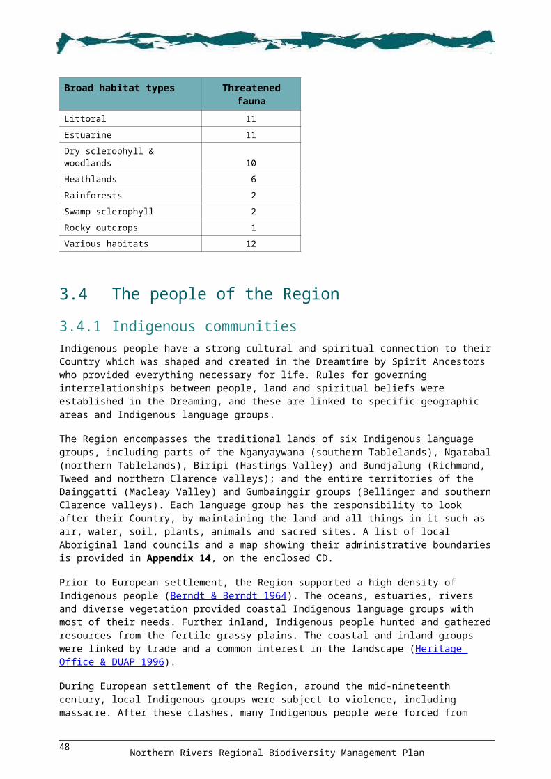
Figure 18 Centres of endemism priority areas
Northern Rivers Regional Biodiversity Management Plan53

5.1.2 Key habitats for forest faunaAs part of the Comprehensive Regional Assessment, digital distribution models of 146 forest-dependent vertebrate fauna were developed to identify areas of habitat significance and habitat quality (NPWS 1999). Since the development of these fauna models in 1998, many have undergone refinement to improve their reliability, and new models for species that are not forest-dependent have also been developed (see below).
In 2003, the Key Habitats and Corridors Project (undertaken by DECCW—see Scotts 2003) summarised and integrated forest-dependent fauna models to produce a landscape framework for regional conservation planning and assessment. The key habitats mapped during this project represent high conservation value forest fauna habitat and, therefore, identify focus areas for the protection, enhancement and restoration of native vegetation (Scotts 2003). The project also delineated centres of fauna endemism and fauna corridors in the Region (see below).
Key habitats refer to areas of predicted high conservation value for forest fauna assemblages, refugia, endemic forest fauna or endemic invertebrates. The mapped key habitats encompass assemblage hubs, hot spots and centres of endemism (Scotts 2003). Assemblages are essentially groups of species displaying similar modelled distributions and are widely used as fundamental conservation planning surrogates.
Key habitats for fauna across all land tenures are shown in Figure 17 with those key habitats on private and other Crown lands being recognised in this Plan as being of particular importance for forest fauna conservation. Accordingly, some 500 key habitat priority areas have been identified on these lands as shown in Figure 17.
5.1.3 Centres of endemismThe outputs of the Key Habitats and Corridors Project were also used in this Plan to identify areas of importance for centres of vertebrate fauna endemism. An endemic species was defined as one for which more than 75% of its range or more than 75% of its total population falls within north-east NSW (Scotts 2003). Centres of endemism are significant as they define locations where groups of endemic species are most likely to occur (i.e. species that are restricted in range and distribution to discrete areas). The identification of centres of endemism has also been extended to include invertebrate and flora species.
Centres of endemism over all tenures for vertebrate fauna, flora and invertebrates are shown in Figure 18. Of particular relevance as areas of importance for biodiversity conservation in this Plan, are centres of endemism on private and other Crown lands of which 300 priority areas have been identified in Figure 18.
5.1.4 Climate change corridors Fauna movement corridors also play an ameliorative role for fauna species responding to predicted impacts of climate change (Scotts 2003). In 2007, DECCW undertook a project for the Northern Rivers CMA to help identify land for strategic conservation efforts to aid adaptation to the potential adverse effects of climate change. It delineated a network of key climatic gradient corridors to provide for three broad fauna assemblages: moist forest, dry forest and coastal complex. Eight different corridor types were mapped during this project. For more information see DECC (2007b).
To provide an appropriate corridor network for all of the three broad fauna assemblages, the identified climate change corridors overlaid large areas of the remaining native vegetation in the Region, as well as some cleared land within corridors (see Figure 19). To assist with on-ground implementation, priority areas within these corridors were identified by the Northern Rivers CMA and DECCW as shown in Figure 19.
Northern Rivers Regional Biodiversity Management Plan54

Figure 19 Climate change corridors
Northern Rivers Regional Biodiversity Management Plan55

5.1.5 Locations for specific actionsIt is recognised that the ranking of some threat activities identified in this Plan as low impact may underestimate potential impacts at a local scale (see Section 4.2.2). In these circumstances, ‘specific actions’ have been devised to ameliorate these impacts as they relate to threatened entities (threatened species, endangered populations and threatened ecological communities), fauna habitat features (e.g. cave roosts), habitat types (e.g. wetlands), important locations (e.g. travelling stock reserves), and particular threat activities (e.g. a weed or pest). The locations presented are based on best available information, and should other locations be known or become relevant, then the appropriate control actions should also be undertaken.
The recommended locations to implement these specific actions have been mapped for the following:
Shorebird and wader habitats and flying-fox camps (Figure 20). Bitou Bush Threat Abatement Plan implementation sites (Figure 20). European Red Fox Threat Abatement Plan implementation sites (Figure 20). Dinner Creek, Demon Nature Reserve, ecological fire management plan implementation sites to
protect the habitat of a range of species, including Brush-tailed Phascogale Phascogale tapoatafa, Eastern Chestnut Mouse Pseudomys gracilicaudatus, Stephens’ Banded Snake Hoplocephalus stephensii and Stuttering Barred Frog Mixophyes balbus (Figure 21).
Cave roosts used by threatened Eastern Cave Bat Vespadelus troughtoni and Little and Eastern Bentwing-bats Miniopterus australis and Miniopterus schreibersii oceanensis (Figure 21).
Hill-topping butterfly congregation sites (Figure 21). Richmond River estuary—important for the protection of Sanderling and Great Knot (Figure 21). Species-specific locations for weed and pest control to protect a variety of species including Byron
Bay Diuris Diuris sp. aff. chrysantha, marine turtles, Pouched Frog, Stinky Lily Typhonium sp. aff. brownii, Black Grass-dart Ocybadistes knightorum and Floyd’s Grass Alexfloydia repens (Figure 21).
In addition, the Plan identifies the need to acquire areas, negotiate covenants, or provide incentives to protect land that supports high conservation value vegetation.
Travelling stock reserves often have high conservation values. These reserves are particularly important on the tablelands as they form an interconnected framework of corridors across a highly cleared and fragmented landscape. Many travelling stock reserves on the tablelands have already been identified as containing significant roadside vegetation and they also have important site-specific values for a range of threatened species such as Austral Toadflax Thesium australe, Pygmy Cypress Pine Callitris oblonga, and Narrow-leaved Black Peppermint Eucalyptus nicholii. Travelling stock reserves are also vulnerable to over-grazing, invasion by weeds and firewood collection, and therefore where conservation actions are not feasible or practical, rehabilitation actions are likely to be highly desirable. The location of travelling stock reserves in the Region is shown in Figure 22.
Northern Rivers Regional Biodiversity Management Plan56

Figure 20 Specific action locations # 1
Northern Rivers Regional Biodiversity Management Plan57

Figure 21 Specific action locations # 2
Northern Rivers Regional Biodiversity Management Plan58
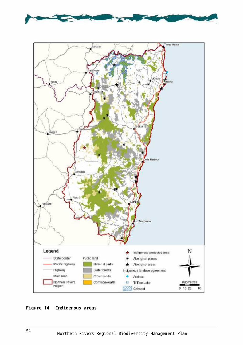
Figure 22 Travelling stock reserves
Northern Rivers Regional Biodiversity Management Plan59
5.2 Other areas
5.2.1 National Reserve SystemA number of targets have been set by the Australian Government to improve the current network of conservation reserves and achieve the goal of a comprehensive, adequate and representative reserve system (see targets in NRPPC 2009). These targets can help focus protective measures in the recovery actions of this Plan and are based on the Interim Biogeographic Regionalisation for Australia or IBRA (Thackway & Creswell 1995).
IBRA provides a broad break-up of the Australian continent and a systematic framework for identifying deficiencies in the existing protected area system (see DEWHA 2008b). The Region encompasses three IBRA regions: 55% of the NSW North Coast; 32% of the New England Tablelands; and 20% of South East Queensland. These IBRA regions are further divided into subregions, based predominantly on patterns of landuse. The Region fully encompasses 19 IBRA subregions and partly encompasses a further 13 subregions (see Figure 23). The quantitative biodiversity reservation targets set by the Australian Government (DEWHA 2009b) and adopted by the NSW Government (DECC 2008h) include the following:
Comprehensiveness: Examples of at least 80% of the number of extant regional ecosystems in each IBRA region are to be represented in the National Reserve System by 2015.
Representativeness: Examples of at least 80% of the number of extant regional ecosystems in each IBRA subregion are to be represented in the National Reserve System by 2020.
An assessment of comprehensiveness and representativeness was undertaken across NSW in 2006 using Mitchell landscapes (see Mitchell 2002 and DEC 2006b for details). Table 11 provides the Region’s current levels of comprehensiveness and representativeness for IBRA regions and the progress towards reaching the 80% targets. It shows that the New England Tablelands IBRA region has the lowest level of progress towards meeting the National Reserve System targets.
Table 11 IBRA regions reserve system comprehensiveness and representativeness
IBRA region nameComprehensiveness Representativeness
Current % Progress % Current % Progress % New England Tablelands 63.6 79.5 42.1 52.7
NSW North Coast 78.9 98.7 74.9 85.1
South East Queensland 85.7 Met 56.6 70.8
Within the Region, a more detailed assessment of representativeness has been undertaken using regional mapping of vegetation communities (or regional ecosystems) to identify those IBRA subregions that do not meet the National Reserve System target for representativeness. While some of the 160 mapped regional ecosystems are quite broad (e.g. subtropical rainforest and coastal complex), analysis of their representativeness in the reserve system within each subregion provides a useful indicator of where efforts could be directed to protect ecosystems.
Table 12 provides the Region’s current levels of representativeness for IBRA subregions, the progress towards reaching the 80% target, and the number of regional ecosystems that are required to be conserved to meet the target. Subregions shown in italics are those that do not currently meet the Australian Government representativeness target. Figure 23 shows target achievement across the subregions. It shows that 12 of the 13 New England Tablelands subregions are under target, with Glen Innes–Guyra Basalts being the most under target. In the South East Queensland region, five subregions are under target, with Southern Coastal Lowlands being the lowest. In the North Coast Region, three subregions are under target, with Cataract being the lowest. A list of the regional ecosystems in each IBRA subregion that are not currently represented in the reserve system is provided in Appendix 17, on the enclosed CD.
Northern Rivers Regional Biodiversity Management Plan60

Table 12 Reserve system representativeness
Map Id
IBRA region / subregion No. RE No. RE reserved
% RE reserved
% progress to target
Required to meet target
South East Queensland 1 Southern Coastal Lowlands 123 75 61.0 76.2 232 Southeast Hills & Ranges,
Murwillumbah154 107 69.5 86.9 16
3 Richmond–Tweed, Scenic Rim 128 90 70.3 87.9 124 Woodenbong 53 38 71.7 89.6 45 Clarence Sandstones 68 54 79.4 99.3 16 Clarence Lowlands 67 56 83.6 met -
NSW North Coast 7 Cataract 53 27 50.9 63.7 158 Rocky River Gorge 49 30 61.2 76.5 99 Washpool 36 33 91.7 met -
10 Dalmorton 80 62 77.5 96.9 211 Guy Fawkes 42 40 95.2 met -
12 Chaelundi 73 63 86.3 met -
13 Yuraygir 48 44 91.7 met -
14 Coffs Coast & Escarpment 80 70 87.5 met -
15 Macleay Hastings 93 82 88.2 met -
16 Carrai Plateau 32 31 96.9 met -
17 Macleay Gorges 44 40 90.9 met -
18 Upper Manning 41 39 95.1 met -
19 Comboyne Plateau 60 48 80.0 met -
New England Tablelands 20 Stanthorpe Plateau 107 59 55.1 68.9 2721 Tenterfield Plateau 73 38 52.1 65.1 2022 Northeast Forest Lands 85 65 76.5 95.6 323 Deepwater Downs 43 9 20.9 26.2 2524 Glen Innes – Guyra Basalts 73 9 12.3 15.4 4925 Nightcap 28 11 39.3 49.1 1126 Wongwibinda Plateau 44 33 75.0 93.8 227 Round Mountain 30 22 73.3 91.7 228 Armidale Plateau 59 31 52.5 65.7 1629 Ebor Basalts 37 30 81.1 met -
30 Moredun Volcanics 33 21 63.6 79.5 531 Yarrowyck – Kentucky Downs 37 11 29.7 37.2 1932 Walcha Plateau 100 76 76.0 95.0 4
Notes: RE = regional ecosystems. Subregions in italics are under target.
Northern Rivers Regional Biodiversity Management Plan61

Figure 23 Reservation levels of regional ecosystems in each IBRA subregion
Northern Rivers Regional Biodiversity Management Plan62
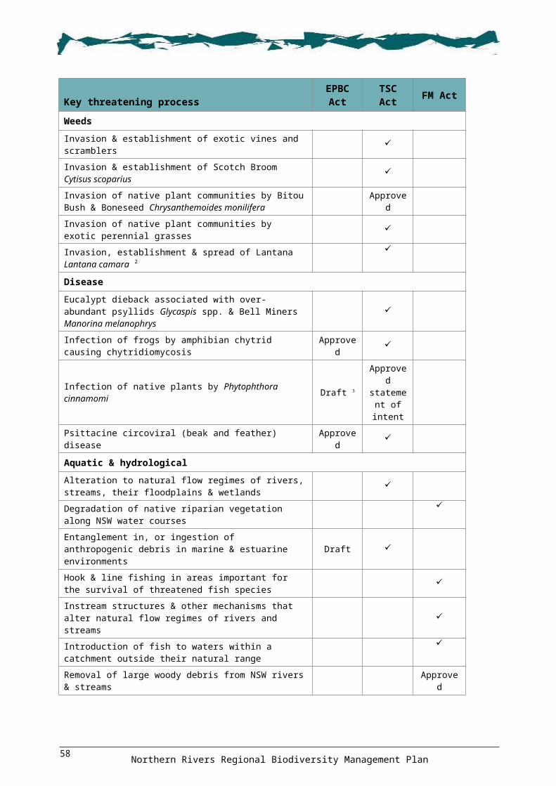
5.2.2 Fauna corridorsThe Key Habitats and Corridors Project defined corridors as regional landscape connections of existing or potential habitats likely to support or provide a movement corridor for populations of certain fauna species (see Scotts 2003). Corridors also supplement habitats of wide-ranging, nomadic and migratory species and provide linkages to facilitate fauna movement within and between areas of habitat. The mapped corridors show those linkages that promote a ‘whole of landscape’ conservation framework. Like key habitats, these corridors form focus areas for the protection, enhancement and restoration of native vegetation.
‘Regional’ fauna corridors are major landscape linkages designed to provide both in situ and dispersal habitat for fauna species. While local circumstances may limit the width and exact location of regional corridors, they are intended to be in the order of kilometres wide. They often link formal reserves to other public lands, key habitats or other corridors; and/or run along major altitudinal or latitudinal gradients. ‘Subregional’ corridors are landscape corridors that serve more as routes for dispersal and movement for fauna, rather than habitats in their own right (Scotts 2003). Regional and subregional fauna corridors are shown in Figure 24.
5.2.3 Great Eastern Ranges InitiativeThe Great Eastern Ranges Initiative (formerly the Alps to Atherton Initiative) is a national conservation project coordinated within NSW by DECCW. The project seeks to connect and conserve ecosystems along the Great Dividing Range, escarpment and associated ranges from the Australian Alps in Victoria to Atherton in Queensland. Overall, the initiative extends over 2800 km along the east coast of Australia covering 14 of Australia’s 85 bioregions, the catchments of 63 of Australia’s easterly and southerly river basins, as well as a variety of ecosystem types, and flora and fauna species.
The area of the Region covered by the Initiative, mainly the escarpment ranges, is shown in Figure 25. It includes numerous national parks, seven world heritage areas, areas of private land, and a diversity of flora and fauna habitats. The Border Ranges Planning Area (see Figure 1) is one of five areas being targeted to implement this Initiative.
Northern Rivers Regional Biodiversity Management Plan63
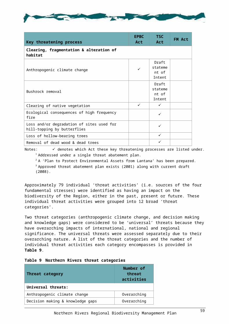
Figure 24 Fauna corridors
Northern Rivers Regional Biodiversity Management Plan64

Figure 25 Great Eastern Ranges Initiative
Northern Rivers Regional Biodiversity Management Plan65

5.2.4 Estuarine and freshwater wetlandsWetlands are ecologically, socially and economically important (Environment Australia 2001a; NSW Government 2008). They provide many ecosystem functions, services and habitats for a wide range of animals (e.g. waterbirds, fish, frogs and invertebrates) and water-dependent plants (e.g. sedges, rushes and various tree species), including many threatened species and ecosystems (NSW Government 2008). Wetlands also provide shelter, breeding grounds and nurseries for a variety of fauna, particularly insects, fish, frogs and waterbirds, including migratory birds listed under various international agreements including the Bonn Convention and the bilateral migratory bird agreements with Japan, China and the Republic of Korea (DEWHA 2008c).
There are 130 000 ha of wetlands in the Region. Some of these are recognised as being of particular importance to biodiversity, and are listed on the register of Ramsar wetlands or the Directory of Important Wetlands in Australia (Environment Australia 2001a). The location of wetlands in the Region is shown in Figure 26.
Wetlands listed on the Directory of Important Wetlands in Australia, including Ramsar wetlands, are considered to be ‘high conservation value aquatic ecosystems’ given their national and international significance (SKM 2007). There are currently no agreed principles for the identification of high conservation value aquatic ecosystems, however, some inventory work has occurred at the regional scale. Additionally, NSW Department of Industry and Investment is developing a set of aquatic decision-support tools to assist in prioritising investment in the conservation and rehabilitation of aquatic ecosystems (SKM 2007).
Little Llangothlin Lagoon, near Armidale, is the only wetland in the Region currently listed as a Ramsar wetland. It is a nature reserve, a high conservation value aquatic ecosystem, and one of the few lagoons that remain in a near-natural condition providing important habitat for threatened species. The reserve contains several plant species that are regionally uncommon and plant communities that are regionally significant. It is an important drought refuge that regularly hosts large numbers of waterbirds and waders, some of which breed there. The lagoon contains the only known location of the genus Rhabdocoel, a planktonic flatworm, and the copepod crustacean Ectocyclops rubescens (DECC 2008f). The reserve’s plan of management was approved in 1998 (NPWS 1998).
There are 22 wetland sites in the Region listed on the Directory of Important Wetlands in Australia (Environment Australia 2001a). Table 13 provides the number and area of these wetlands in each major catchment, with the greatest number and area being associated with the Clarence River floodplain and estuary. Only 20% of the nationally important wetlands in the Region are reserved, and this varies between catchments from over 80% in the Tweed to under 10% in the Clarence and Macleay catchments.
Table 13 Directory of Important Wetlands in Australia
Major catchment No. sites Area (ha) Reserved (ha)
% Reserved
Bellinger River 1 367 60 16
Brunswick River 2 1 327 400 30
Clarence River 8 28 816 2 371 8
Coffs Coastal Catchments 1 337 21 6
Hastings River 2 18 642 7 405 40
Macleay River 4 8 497 502 6
Richmond River 2 1 792 982 55
Tweed River 2 267 225 84
Total 22 60 045 11 966 20
Northern Rivers Regional Biodiversity Management Plan66

The Region supports a number of endangered wetland communities, including montane peatlands and swamps of the New England Tableland, NSW North Coast and other regions. Mapping conducted by Bell et al. (2008) identified 58 montane lagoons on the New England Tablelands: 37 within the Region and 15 within 5 km. Only two of these lagoons are within conservation reserves, only one-third are considered to have intact hydrology and vegetation, and two-thirds are smaller than 10 ha (Bell et al. 2008). Given the extent of degradation to montane lagoons, those that are still relatively intact are likely to be high conservation value aquatic ecosystems. Figure 26 shows the location of montane lagoons in the Region.
Coastal lakes are a particular type of wetland that provide important habitat for a large number of aquatic flora and fauna species. The Region supports a number of coastal lakes, including: Minnie Water, Lake Hiawatha, Lake Innes, Goolawah Lagoon, Deep Creek, Queens Lake, Lake Wooloweyah, Watsons/Taylors Lake, Cobaki–Terranora Broadwater (HRC 2002). Minnie Water and Lake Hiawatha are considered to be in ‘pristine condition’ and three other catchments are considered ‘near pristine’ (Lake Arragan, Lake Hiawatha and Saltwater Lake) (HRC 2002). Other small coastal lakes also considered to be ecologically important include: Wommin Lake south of Tweed Heads, Taylors Lake south of Byron Bay, and Salty Lagoon north of Evans Head. Many, if not all, of these coastal lakes are likely to be high conservation value aquatic ecosystems. Coastal lakes in the Region are shown in Figure 27.
Coastal floodplain wetlands in the Northern Rivers region (many of which have been drained and are now used for grazing) are also important, particularly as the management of these wetlands has a major influence on the health and condition of much of the Region’s coastal biodiversity including waterbirds, invertebrates, aquatic plants, fish and crustaceans. Floodplain wetlands can be large and continuous in their natural form but tend to be fragmented and degraded under historical and some current management practices. These landscapes are highly modified, fragmented and stressed by a range of threats. Water quality issues such as acid sulfate soils and ‘blackwater’ are major issues. Climate change may also have an influence on these low-lying landscapes.
Northern Rivers Regional Biodiversity Management Plan67
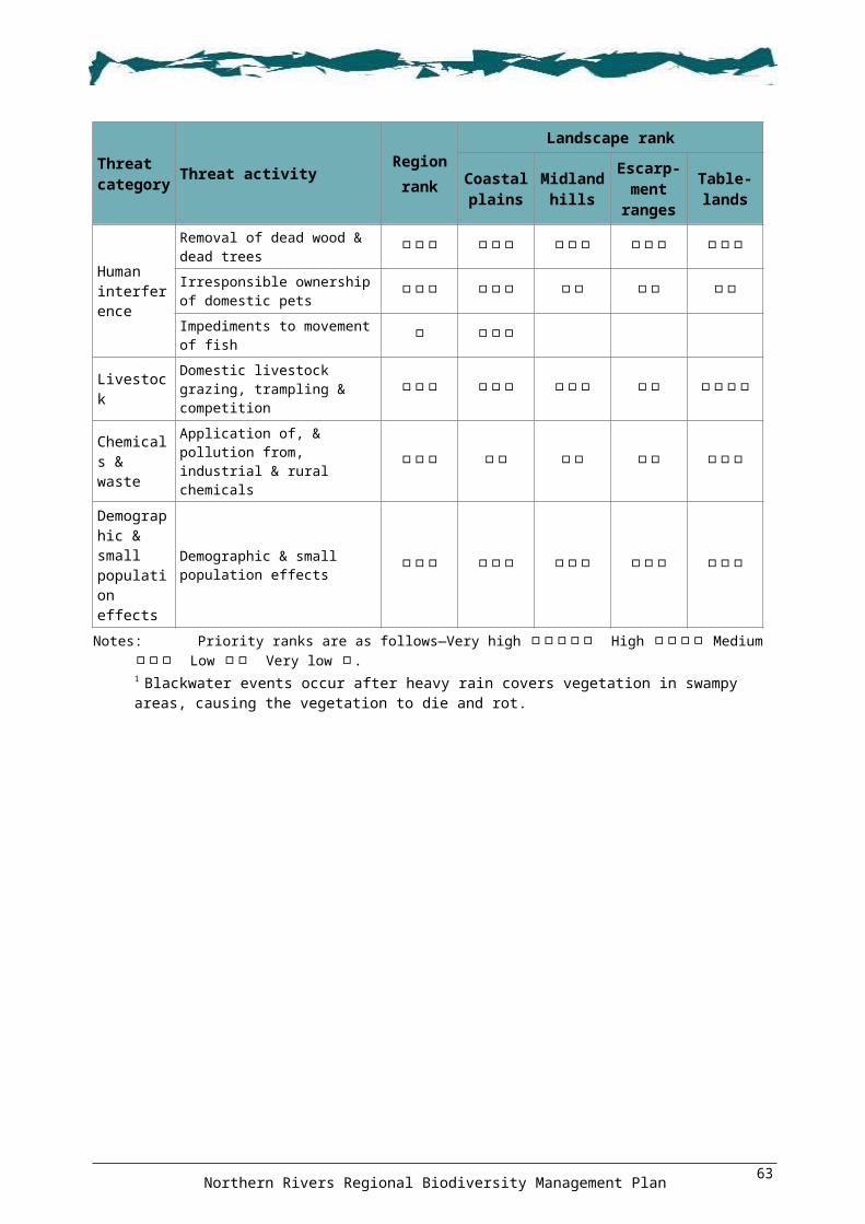
Figure 26 Wetlands
Northern Rivers Regional Biodiversity Management Plan68

Figure 27 Coastal lakes
Northern Rivers Regional Biodiversity Management Plan69

5.2.5 River reaches and subcatchments Riverine ecosystems in the Region were assessed using a Riverine Biodiversity Forecasting Tool developed by DECCW (Turak et al. 2008). The general methodology used was similar to that employed in the terrestrial Biodiversity Forecasting Tool (see above). The detailed methodology and mapped outputs are provided in Appendix 18, on the enclosed CD.
Using this process, the river reaches and subcatchments in the Region were prioritised to ensure the persistence of river biodiversity. The prioritisation process incorporated two main information sources: assessments of the integrity of riverine macroinvertebrate assemblages in the Region (Hose & Turak 2006); and ecological river typology developed for NSW based on aquatic macroinvertebrate, fish and biodiversity data collected from river reference sites (Turak & Koop 2008).
Generally, catchment priorities help identify areas where terrestrial actions will have benefits to aquatic biodiversity. Also, the higher priority catchments, if collectively restored/conserved, would provide the greatest benefit to river biodiversity.
The river section conservation priorities relate to the section of river or river reach within the mapped subcatchment. River reach conservation priorities help identify river sections that have high biodiversity value due to the significance of their biodiversity to the Region. The higher priority river sections should be the focus of efforts to target local restoration or conservation activities, for example, fencing riparian areas, re-snagging rivers and streams, controlling point source pollution, removing obstacles to upstream movement of fauna.
5.2.6 Forest fruit and nectar vegetationVegetation that provides fruit resources during winter, in particular rainforests on the coastal plains and lower midland hills, is critical for fruit-eating fauna, including flying-foxes and fruit-doves.
A ‘forest fruit index’ has been developed by DECCW to provide a relative measure of the proportion of each forest ecosystem that contains fruit-bearing trees, and the value of those trees to fruit-eating fauna. The higher the index value, the greater the value to forest-dependent, fruit-eating fauna. The forest fauna fruit index is shown in Figure 28.
Another critical food resource is nectar. Dependence on nectar by individual animals varies widely, with some species relying almost exclusively on this food source while others use nectar and pollen to supplement their diet at different times of the year. It is important for these animals that a diversity of nectar-producing plants is available throughout different seasons of the year. In particular, it is essential that plants which produce nectar in autumn and winter are available when other food resources become scarce (DECC 2007d).
The ‘forest nectar index’ gives a similar measure to the forest fruit index, providing a relative measure of the proportion of the forest ecosystem that contains nectar-bearing trees, and the value of those trees to nectar-eating fauna. Nectar and pollen from the flowers of eucalypts, banksias, melaleucas and other shrubs provide an important food resource for many insects, birds and mammals—including a number of threatened species, for example, Regent Honeyeater Xanthomyza phrygia, Swift Parrot Lathamus discolour, Yellow-bellied Glider, Squirrel Glider Petaurus norfolcensis, Eastern Pygmy-possum Cercartetus nanus, Grey-headed Flying-fox Pteropus poliocephalus and Common Blossom-bat (DECC 2007d).
Areas with a high forest nectar index such as the Clarence and Bungawalbyn valleys, Macleay–Hastings coast, and the New England Tablelands are considered areas of importance for biodiversity. The forest fauna nectar index is shown in Figure 29.
Northern Rivers Regional Biodiversity Management Plan70

Figure 28 Forest fauna fruit resource areas
Northern Rivers Regional Biodiversity Management Plan71

Figure 29 Forest fauna nectar resource areas
Northern Rivers Regional Biodiversity Management Plan72

5.2.7 Moist montane forest fauna refugiaMoist montane forest fauna refugia are important for a range of species in the Region, including those listed in Table 14. It is considered that conserving and repairing these refugia is important for the biodiversity of the Region. Major moist montane forest fauna refugia have been identified through consultation with experts and analysis of species’ distribution data (see Figure 30). These fauna and their habitat are considered likely to be susceptible to the impacts of climate change associated with increased temperatures. Monitoring the current and future distribution of moist montane forest fauna is considered important to indicate changes that may be occurring, particularly where these may be attributed to climate change impacts.
These refugia encompass areas that support relictual Tumbunan biota that originate from the ancient rainforests of Australia. Tumbunan biota is characterised by fauna with restricted distributions and specialised ecological requirements (Tanton 1996; Landmark et al. 1999). Due to the now relictual nature of the Tumbunan biota, those areas of remaining suitable refugia are important to their persistence in the Region. Milledge (2007) recommended that refugia areas become a focus for revegetating cleared gaps, increasing the size of isolated rainforest remnants (including buffering), linking isolated remnants with larger patches, and generally maintaining or improving overall ecosystem function.
Table 14 Threatened moist montane forest fauna
Common name Scientific name TSC Act DistributionFrogsDavies' Tree Frog Litoria daviesae V Regional at northern limit
Giant Barred Frog Mixophyes iteratus E Widespread
Glandular Frog Litoria subglandulosa V Widespread at southern limit
Pouched Frog Assa darlingtoni V Disjunct at southern limit
Pugh's Frog Philoria pughi E Local and endemic
Sphagnum Frog Philoria sphagnicolus V Regional at northern limit
Stuttering Frog Mixophyes balbus E Widespread
Tusked Frog Adelotus brevis EP Regional at eastern limit
ReptilesStephens' Banded Snake Hoplocephalus stephensii V Widespread
BirdsOlive Whistler Pachycephala olivacea V Widespread
Rufous Scrub-bird Atrichornis rufescens V Widespread
Sooty Owl Tyto tenebricosa V Widespread
MammalsEastern False Pipistrelle Falsistrellus tasmaniensis V Widespread
Parma Wallaby Macropus parma V Widespread at southern limit
Red-legged Pademelon Thylogale stigmatica V Widespread
Notes: E = endangered species.EP = endangered population.V = vulnerable.
Northern Rivers Regional Biodiversity Management Plan73
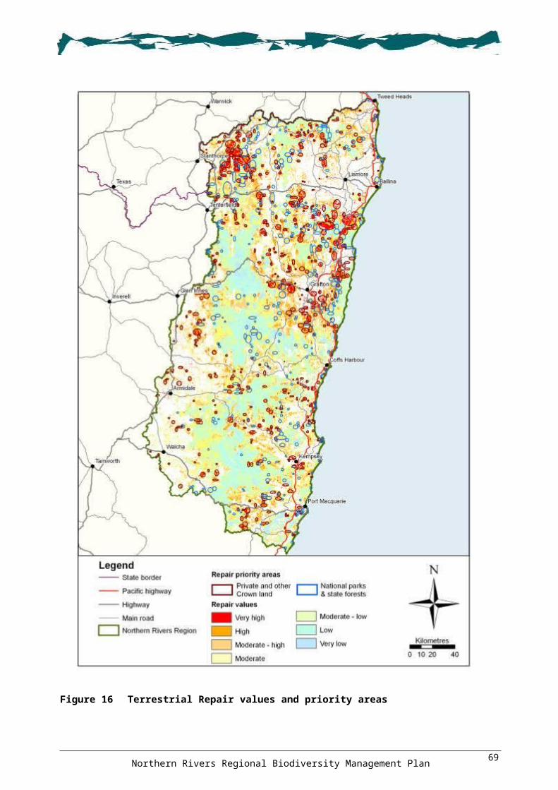
Figure 30 Moist montane forest fauna refugia
Northern Rivers Regional Biodiversity Management Plan74

5.2.8 Non-forest fauna habitatsSpatial models have recently been developed by DECCW for fauna species which are not forest-dependent, particularly coastal species that are considered to be under the most threat from habitat loss. Species modelled include: Olongburra Frog Litoria olongburensis, Wallum Froglet Crinia tinnula, Black-necked Stork Ephippiorhynchus asiaticus, Eastern Ground Parrot Pezoporus wallicus wallicus, Mangrove Honeyeater Lichenostomus fasciogularis, Mangrove Kingfisher Halcyon chloris, Osprey, and coastal populations of the Long-nosed Potoroo and Emu.
These spatial models indicate areas of importance for conservation of these species and may assist in the implementation of actions that will have beneficial outcomes for the habitat of these species. As examples, the Black-necked Stork and Emu spatial models are shown in Figure 31.
5.2.9 Dingo areasManagement of wild Dogs in NSW is administered through the Rural Lands Protection Act 1998. Under this Act, Schedule 2 of the Pest Control Order for wild Dogs identifies areas of public land designated as having conservation significance for Dingo Canis lupus and where wild Dog management plans address conservation and agricultural production objectives (Figure 32).
Although Schedule 2 areas are important in maintaining Dingo populations, recent genetic work within the Region has identified areas where a high proportion of pure Dingoes still occur (Figure 32). These areas do not necessarily coincide with the identified Schedule 2 areas. Dingoes are high-order predators and the protection and management of areas that support pure Dingoes is important for the maintenance of this ecological function.
Northern Rivers Regional Biodiversity Management Plan75

Figure 31 Black-necked Stork and Emu spatial models
Northern Rivers Regional Biodiversity Management Plan76

Figure 32 Dingo areas
Northern Rivers Regional Biodiversity Management Plan77

5.3 Limitations of the PlanThere are several limitations that need to be considered when interpreting and implementing the information and spatial outputs in this Plan. These are outlined below.
The Plan applies only to terrestrial, freshwater and estuarine environments and is not intended to cover marine species and threats.
The threat analysis process has several limitations. As previously noted, the analysis considered the geographic extent and irreversibility of each threat as well as its impact on flora, fauna and the aquatic environment at the regional and individual landscape scale. Thus, the analysis does not necessarily reflect the situation for local areas or individual sites. The regional impact of some threats may, therefore, be an underestimation if the threat is highly localised. Given the regional scale of the Plan, the analysis is intended to guide natural resource managers seeking to address threats, rather than be a prescriptive assessment of the overall impact of each threat upon biodiversity.
The threat analysis divided threats into separate categories, however, many threats are intrinsically interrelated and can be exacerbated by other threats. For example, too-frequent fire regimes may lead to the local extinction of important nectar-producing plants or may provide opportunities for weed invasion. The threat analysis is also limited in its ability to predict the impacts of future threats and while these threats (e.g. new weed invaders or weeds yet to become well established) may currently be ranked low, significant effort may be warranted at a later time to eradicate them.
The extensive gaps in our knowledge, both ecologically and geographically, were limitations in the development of the Plan. The incomplete understanding about the ecology of threatened species in some instances may constitute an impediment to their recovery, however, the precautionary principle should be adopted in these circumstances. The removal of threats from an area may not be sufficient to recover a species if critical components of its ecology have been severely affected. For example, activities that lead to significant invertebrate decline may adversely affect an orchid that requires pollination by a certain species of wasp. Care needs to be taken when implementing actions to ensure that undesirable side effects do not occur to other components of biodiversity in the area.
The digital datasets used in developing maps for the Plan were also limited with respect to geographic coverage, reliability, accuracy and age. The range and quality of geophysical and biodiversity datasets available for this Region is significantly greater than other parts of NSW, however, vegetation mapping for example, is inconsistent across the Region, with the only full coverage available being over ten years old and having a strong emphasis on public land forests. As such, the mapping is sometimes of lower quality in coastal lowland and wetland areas compared with forested lands. Some more recent and detailed vegetation mapping has been undertaken by local councils, but there remains a significant problem with inconsistent classification schemes and mapping scales.
Limitations in digital datasets meant that only clearing, grazing, infrastructure and logging threats were able to be represented spatially for input to the terrestrial Biodiversity Forecasting Tool. Threat mapping is a particularly undeveloped spatial information source in the Region, and this has imposed considerable limitations in both the development and implementation of the Plan. Currently there is no consistent regional mapping of weeds, other than Bitou Bush, which means that priority locations to eradicate problem weeds such as Cat’s Claw Creeper Macfadyena unguis-cati cannot be effectively mapped.
The Biodiversity Forecasting Tool analysis has several limitations. While the use of vegetation is widely accepted as a surrogate for biodiversity at an ecosystem scale, it does not take into account species or genetic components of biodiversity. The vegetation condition mapping is over ten years old and changes may have occurred through changes or intensification of landuse. Generalisations and assumptions have been made in the creation of threat spatial data, for example, grazing is considered more likely to occur on flatter, more fertile soils and logging less likely on steeper slopes.
Northern Rivers Regional Biodiversity Management Plan78

Economic and social factors such as distance to markets and landowner management systems (e.g. rural lifestyle holdings versus timber production) are not taken into account.
Finally, the outputs of the Biodiversity Forecasting Tool are predictive in nature, estimating the most likely scenario 15 years into the future based on the probability of a threat occurring at a given location and the estimated impact of that threat. Despite these limitations, the best available datasets and analysis techniques have been employed in the development of this Plan, and informed application of these in implementation of recovery actions will provide many benefits to the biodiversity of the Region.
Northern Rivers Regional Biodiversity Management Plan79

66 Recovery ActionsRecovery Actions6.1 How to use this sectionIt is recognised that there will be a variety of potential users of the Plan, each with specific information requirements. The following section has been presented so that the user can target their area of responsibility or interest and receive guidance on the relative priority of actions. When using this section, the following points should be noted:
objectives, outcomes and actions are hierarchical and threat-based (i.e. they link directly to the 12 regional threat categories)
actions are generally designed to address threats at the most appropriate scale some actions are linked to mapped priority areas—areas where conservation or restoration
activities should be focussed.
To provide the most effective use of resources and the most beneficial outcomes for biodiversity, the strategic implementation of the Plan across management areas such as subcatchments is recommended. Where possible, an integrated approach to implementation should be undertaken. Also note that additional actions, not included in this Plan, for areas of rainforest and related vegetation in the Border Ranges Planning Area are contained within the approved Border Ranges Rainforest Biodiversity Management Plan (DECCW 2010).
6.1.1 Hierarchy of objectives, outcomes and actionsA total of 14 threat categories, including two ‘universal’ threats and 12 ‘regional’ threats, are recognised in the Plan (see Section 4 for details). For each of the 14 threat categories, there is at least one recovery objective which identifies the desired outcomes and associated actions for the recovery of threatened species, populations and ecological communities (‘threatened entities’) addressed by this Plan. The threat categories and relevant objectives are shown in Table 15. The two universal threats (climate change, and decision making and knowledge gaps) are presented first, not necessarily because they are the highest priority, but because they apply across all other actions in the Plan. Thereafter, the threat-based objectives are presented in decreasing order of priority and severity across the Region.
Table 15 Threat categories and relevant objective
Threat category Objective(s)UniversalAnthropogenic climate change 1
Decision making and knowledge gaps 2
RegionalClearing and fragmentation 3
Inappropriate fire regimes 4
Weeds 5
Pests 6
Forestry 7
Dieback 8
Hydrology and water quality 9, 10
Disease and pathogens 11
Human interference 12
Livestock 13
Chemicals and waste 14, 15, 16
Demographic and small population effects 17
Northern Rivers Regional Biodiversity Management Plan80

Within each objective, the outcomes and actions are presented in a hierarchical framework for delivery at the most appropriate geographical or biological scale. This takes into account the scale at which threats operate on biodiversity. To cater for these differences, three different types of actions have been developed:
‘Region’—actions to address threats that operate across the Region. ‘Landscape’—actions to address threats that are concentrated or restricted to a particular
landscape: coastal plains, midland hills, escarpment ranges and tablelands (see Section 3.1 and Figure 3).
‘Specific’—where it was deemed necessary and appropriate, specific actions were developed to address particular threatened entities, threat activities, fauna habitat features, habitat types or other important locations.
As Table 15 indicates, Objectives 1 to 17 deal with threat categories recognised in the Plan. An additional three objectives (18 to 19) relate to the cultural value of biodiversity, ways to engage the community, and establishment of effective monitoring and biodiversity-related projects.
6.1.2 Mapped areas of importance to biodiversityA number of actions in this section refer to mapped areas of importance to biodiversity, listed in Table 16. These areas fall into two categories: priority areas and other areas. The Table indicates the relevant outcome, the major focus for the action (either conservation or repair), and whether a large format map is provided on the enclosed CD.
While the threat and spatial analyses provide useful indicators of the threats and locations to undertake remedial activities at the regional scale, they do not replace the requirement to conduct site inspections to determine the most appropriate course of action. The mapped areas indicate the general locality or area within which to target activities, but are not intended to identify specific sites (due to data and mapping constraints). Users of the Plan should consider such constraints in regard to interpreting and using the mapped information. In general, the maps should not be used at a scale of less than 1:100 000. Maps and models in the Plan should not be used on their own for locating site-based projects, but rather in combination with finer-scale, site-level assessment and planning.
The large format maps on the enclosed CD are intended to help users of the Plan identify specific locations for implementation of actions. These maps can be viewed on computers using standard software packages for displaying images and pictures. The maps are intended to be displayed using a zoom factor of 100%, which is equivalent to a map scale of approximately 1:150 000. At this scale, sufficient geographic detail should be available to identify the locations for action implementation. The use of Microsoft Office Picture Manager™ to view the maps is suggested because this program allows the user to set the zoom factor.
Depending upon the nature of the action to be implemented, one or more of the mapped areas of importance to biodiversity may be relevant. The Conserve priority areas are where actions should be targeted that protect and enhance areas with existing or potential high conservation value. Similarly, the Repair priority areas are where actions should be targeted that restore, rehabilitate or regenerate areas that are currently degraded but have the potential to provide improvements to overall biodiversity. Actions seeking to protect or restore fauna habitats should target the areas mapped for the various key habitats and corridors themes. Actions for Black-necked Stork or the endangered Emu population in the NSW North Coast Bioregion should target higher quality modelled habitat. In other instances, maps may not be relevant because of the non-spatial or general nature of the action, or the requirement for it to be implemented at locations determined by on-ground assessment.
The maps can also be used to identify subregions or parts of a landscape where clusters of priority areas are apparent. These may form the focus of broader programs which seek to implement a strategic program over a broader area rather than actions at particular sites, such as the Northern Rivers CMA Bush Recovery Program. The map identifying Interim Bioregionalisation of Australia
Northern Rivers Regional Biodiversity Management Plan81

(IBRA) subregions with unreserved regional ecosystems could be used to target actions that improve the reservation status of ecosystems in these areas. At a similar scale, the forest nectar and fruit maps may be used to identify where tree planting projects should aim to include nectar- and fruit-producing species.
Table 16 Mapped areas of importance to biodiversity
Mapped area Figure no.
Large format map
Outcome no. Action focus
Priority areasTerrestrial Conserve 15 1.1, 3.1, 3.3, 3.4, 3.5 Conserve
Terrestrial Repair 16 3.5 Repair
Fauna key habitat 17 3.3, 3.4, 3.5 Conserve &/or Repair
Centres of endemism 18 3.3, 3.4, 3.5 Conserve &/or Repair
Climate change corridors 19 1.1, 3.5 Conserve &/or Repair
Locations for specific actions:
Bitou Bush priority sites 20 5.4 Repair
European Red Fox priority sites 20 6.5 Repair
Flying-fox camps 20 3.5 Conserve & Repair
Shorebird and wader habitat 20 12.4 Conserve & Repair
Site-specific locations 21 3.5, 4.2, 5.4 Conserve &/or Repair
Species-specific locations 21 3.5, 5.4, 12.3 Conserve &/or Repair
Travelling stock reserves 22 3.4, 3.5 Conserve &/or Repair
Other areasUnder-represented ecosystems 23 3.2, 3.4 Conserve
Fauna corridors 24 1.1, 3.3, 3.4, 3.5, 12.1 Conserve &/or Repair
Great Eastern Ranges Initiative 25 1.1, 3.4, 3.5 Conserve &/or Repair
Wetlands 26 1.1, 1.3, 3.4, 10.1 Conserve &/or Repair
Coastal lakes 27 10.4 Conserve &/or Repair
Forest fruit resource areas 28 3.5 Repair
Nectar resource areas 29 3.5 Repair
Moist montane forest fauna refugia 30 1.1, 3.5 Conserve &/or Repair
Black-neck Stork & Emu modelled habitat 31 6.5, 10.1 Conserve &/or Repair
Dingo areas 32 17.5 Conserve
Priority species for Fox control 33 CD 6.5 Repair
Priority species for feral Pig control 34 CD 6.5 Repair
Priority species for feral Goat control 35 CD 6.5 Repair
Riverstyles™ assessment 36 CD 10.2 Repair
Barriers to fish passage 37 CD 12.3 Repair
Appendix 19 identifies the threatened species, populations and ecological communities addressed by each recovery objective. The following link provides species’ profiles, recovery plans and access to the NSW Threatened Species Priorities Action Statement: <http://www.threatenedspecies.environment.nsw.gov.au/tsprofile/index.aspx>.
Some of the actions refer to existing documents that have been prepared by agencies and other organisations. Implementation of these actions may require reference to the document and the responsible authority to determine current programs and priorities to ensure a coordinated and consistent approach.
Northern Rivers Regional Biodiversity Management Plan82

The Plan recognises that there is a significant level of biodiversity conservation work and community ownership of projects currently being undertaken outside the identified priority areas, and that there is likely to be sound justification for continuing this work. The identification of priority areas does not necessarily preclude actions being undertaken in other parts of the Region, but seeks to assist natural resource management bodies, land managers, community groups and landholders in making decisions on where to invest their funds and effort in implementing recovery actions. This Plan does not replace existing plans or threat abatement plans relevant to the Region, and may refer to some of these existing documents and identify additional actions.
6.2 Recovery objectives, outcomes and actions
Anthropogenic climate change—universal threatWarming of the global climate system is unequivocal, as is now evident from observations of increases in global average air and ocean temperatures, widespread melting of snow and ice, and rising global average sea level (IPCC 2007). At a national level, modelled projections of temperature, precipitation, evapo-transpiration and wind indicate that changes to more localised climate systems are probable, which will influence drought and fire weather patterns (Watterson et al. 2007).
Projected changes by 2050 in climate and associated attributes for the Region are summarised in Table 17 on the basis of NSW State Planning Areas that the Region falls within. This information is based on projections contained in a number of recent documents including DECC (2008l, 2008n, 2008o, 2009b).
Table 17 Projected changes in climate and associated attributes
Climatic attribute North Coast component New England / North West
component1
Temperature Daytime maxima projected to increase in all seasons between 1 and 3 °C, with the greatest increases for winter (2 to 3 °C). Overnight minima projected to increase by 2 to 3 °C in all seasons.
Days projected to be hotter in all seasons, with greatest warming in winter (2.5 to 3 °C) and spring (2 to 2.5 °C). Nights projected to be warmer, with mean minima to increase by 2 to 3 °C. Frosts likely to be fewer.
Rainfall Projected to increase slightly in summer and autumn, and decrease slightly in winter.
Projected to increase in spring, summer and autumn by 5% to 20%, but decrease in winter by 5% to 20%. The greatest decrease will be in the west of the State Planning Area outside of the Region.
Evaporation Increased evaporation projected to make all seasons drier, particularly winter and spring.
Conditions projected to be drier in all seasons except summer.
Sea level Projected rise of up to 0.4 m above 1990 mean sea level by 2050 and 0.9 m by 2100.
N/A
Note: 1 Only the eastern portion of the New England / North West Planning Area occurs within the Region.
Any change to the climate of the Region is likely to have significant effects on biodiversity and natural ecosystems (CSIRO 2007). The ecosystems most at risk are those on the coastal lowlands, saline wetlands, and fragmented forests and woodlands in the hinterland. Other ecosystems at risk include those on the tablelands that are already stressed due to fragmentation. Specialised ecosystems which are naturally very limited in distribution are also likely to be at risk of degradation or loss. More widespread and fire-adapted forests are likely to be relatively resilient to climate change and undergo more subtle changes.
On the coast, rising sea levels, increased acidity, increased water temperature, and changes to salinity and invasive animal and plant species are likely to cause widespread impacts on biodiversity along coastal fringes and within estuaries. In the western half of the Region, fauna are likely to be affected by habitat loss, longer periods of hot weather, and a reduction in key habitat resources such as nectar resources. For those species able to cope with a change in the climate itself, a greater
Northern Rivers Regional Biodiversity Management Plan83

impact may occur as a result of the cumulative effects of multiple stresses associated with the exacerbation of other threats.
Increased fire frequencies are also likely to lead to widespread changes across many ecosystems (DECC 2008n, 2008o). The frequency of occurrence of very high or extreme fire risk days is predicted to increase across NSW, and the fire season is likely to be extended across the Region (DECC 2008n, 2008o).
Responses to anthropogenic climate change can occur in two forms. Firstly, via mitigation measures such as the reduction of greenhouse gases through reducing emissions or increasing the capture and storage of emissions. Many of these mitigative measures, however, are beyond the scope of this Plan, although it is recognised that revegetation and restoration works identified in the Plan will contribute to the capture and storage of carbon. The second form of response is through adaptation, which refers to actions taken in anticipation of, or in response to, the climate change impacts that cannot be avoided by mitigation (Garnaut 2008).
The potential effects of climate change on other threats identified in the Plan have been considered within each identified threat category relevant to the Region. It is beyond the scope of the Plan to identify or prioritise each biodiversity unit (i.e. landscape, ecosystem and species) at risk from the cumulative effects of climate change.
OBJECTIVE 1: Improve the resilience of ecosystems and landscapes to the effects of climate change
OUTCOME 1.1: Increased resilience of ecosystems and landscapes through improved connectivity and habitat quality
ACTIONS: Region
1.1.1. Promote private land covenants, incentives and land acquisition within identified climate change corridor (Figure 19) and ‘Conserve’ (Figure 15) priority areas; and Great Eastern Range Initiative (Figure 25), moist montane forest fauna refugia (Figure 30) and wetland (Figure 26) areas.
1.1.2. Undertake targeted management within climate change corridor priority areas (Figure 19) to improve habitat connections for terrestrial and aquatic fauna and flora.
1.1.3. Undertake targeted management to increase vegetation remnant size and connectivity in climate change corridor priority areas (Figure 19).
1.1.4. Remove barriers restricting the movement and dispersal of fauna, including aquatic species, where possible.
1.1.5. Encourage local governments to protect climate change and fauna corridors (Figure 19 and 24) through relevant environmental zoning within local environment plans, development control plans and other planning instruments.
OUTCOME 1.2: Promoted activities that ameliorate the effects of climate change by improving habitat quality
ACTIONS: Region
1.2.1. Undertake appropriate strategic management of existing threats outlined throughout the Plan (e.g. grazing, fire, weeds and pests) to reduce ecosystem stress and to provide ecosystems with the best chance of adapting to the effects of climate change.
1.2.2. Identify and implement habitat protection and enhancement activities that maximise opportunities for biological adaptation to change.
1.2.3. Promote community awareness of climate change–related threats to biodiversity in the Region.
Northern Rivers Regional Biodiversity Management Plan84

1.2.4. Integrate climate change adaptation measures into local government local environmental plans and other planning instruments.
1.2.5. Adapt weed, pest and fire management strategies to account for potential impacts of climate change.
1.2.6. Promote the role of individuals in the mitigation of emissions contributing to climate change (e.g. car-pooling, reduction in energy and water use, planting of trees).
1.2.7. Promote local government, business and community uptake of government incentives in relation to climate change mitigation and adaptation measures.
OUTCOME 1.3: Promoted habitat and vegetation restoration to allow for species adaptation
ACTIONS: Region
1.3.1. Identify areas that allow for wetland and saltmarsh habitats to migrate inland and re-establish as a result of rising sea levels impacting existing areas.
1.3.2. Promote replacement of exotic vegetation using natural regeneration and targeted revegetation to increase habitat diversity and resilience.
1.3.3. Promote establishment of vegetation linkages across cleared or partially cleared landscapes through the use of mixed-species timber plantations, riparian rehabilitation, shelter belts and targeted revegetation programs.
ACTION: Montane peatlands
1.3.4. In recognition of their high vulnerability to the impacts of climate change, identify and prioritise montane peatlands for restoration and private property conservation (see Figure 26).
OUTCOME 1.4: Increased investment in, and communication of, climate change research to improve knowledge of climate change
ACTIONS: Region
1.4.1. Investigate and trial methods of identifying and prioritising landscapes, ecosystems and species at greater risk from climate change–related threats.
1.4.2. Develop strategies for the implementation of climate change mitigation and adaptation activities based on prioritised 'at risk' biodiversity entities in Action 1.4.1.
1.4.3. Investigate local climate change mitigation activities that supplement existing regional and larger-scale climate change initiatives.
1.4.4. Ensure coordination and communication between agencies dealing with climate change mitigating activities, new climate change–related threats, and research findings.
1.4.5. Consider the implications of climate change on fire regimes and incorporate best available knowledge into fire management planning across all land tenures.
1.4.6. Integrate climate change issues into local government strategic planning processes through the development of information and mapping of the impacts of climate change on biodiversity, and the importance of corridors and habitat networks.
1.4.7. Support the undertaking of complete ‘LiDAR’ (light imaging detecting and ranging) mapping of the Region’s coastal margin for use in biodiversity planning for sea level rise impacts on coastal ecosystems.
1.4.8. Undertake detailed analyses to improve mapping of climate change corridors using best available information. Investigate the use of climate and bioclimatic surfaces to identify narrow climatic envelopes that may serve as climate change refugia.
1.4.9. Promote research for improving knowledge on: species’ range contraction, shift of ecosystems and individual species rates of change—extreme events weighed against gradual climate change
Northern Rivers Regional Biodiversity Management Plan85

population size, dispersibility, mobility, trait-based life history and environmental gradients
the identification of climate change refugia.1.4.10. Undertake a gap-filling analysis and remapping of littoral rainforests to maintain accuracy
and completeness of data. This will assist in identifying impacts and monitoring its distribution and health.
1.4.11. Undertake a review of existing wetland mapping utilising a uniform, State-based wetland classification system and improve the resolution, accuracy and consistency of regional mapping of wetlands in the Region. Use outputs for climate change biodiversity planning.
1.4.12. Promote the importance of wetlands as carbon sinks, and link to carbon credits for landholder remuneration for the management and rehabilitation of wetlands.
Decision making and knowledge gaps—universal threatDecision making processes and gaps in knowledge can be an impediment to the successful implementation of conservation management across the Region. The issues considered in this threat category include:
complicated approval processes for environmental management
incompatible agency responsibilities and legislation
differences in State and national species listings
impediments to information sharing within and between agencies due to diverse information sharing licenses, agreements and policies
inability to fully implement recovery initiatives due to a lack of resources
incompatible mapping systems and data management systems
inconsistent reporting requirements
uncoordinated delivery of programs across agencies and groups
lack of funding support for research and monitoring
short funding application timeframes, short-term funding cycles and annual funding expenditure requirements which make implementation difficult or inefficient.
OBJECTIVE 2: To reduce organisational-related impediments to biodiversity conservation
OUTCOME 2.1: Improved communication and information sharing, and streamlined processes between agencies, departments and communities to facilitate improved biodiversity conservation
ACTIONS: Region
2.1.1. Establish a cross-agency working group to: ensure integrated implementation of this Plan plan investment and seek funding opportunities oversee prioritisation and implementation of projects review the progress and outcomes of projects facilitate efficient information sharing arrangements.(Group should include a local government representative from the Northern Rivers Regional Organisation of Councils Natural Resource Managers Group.)
2.1.2. Support and develop partnerships between departments, agencies, community groups and other stakeholders to encourage coordinated cross-tenure management and sharing of resources and information.
Northern Rivers Regional Biodiversity Management Plan86

2.1.3. Encourage a consistent cross-agency approach to protect threatened species habitat and high conservation value vegetation through planning controls and mechanisms.
2.1.4. Encourage funding bodies to provide longer application timeframes, longer-term funding for projects (e.g. greater than one year) and consistent reporting requirements.
2.1.5. Finalise and promote existing guidelines that assist with the simplification of the licensing process required when undertaking weeding and other bush regeneration activities within habitat of threatened entities.
2.1.6. Encourage streamlined licensing for conservation programs, environmental burn operations, pest programs and environmental flows.
2.1.7. Streamline processes for data exchange between agencies, departments and the community.
2.1.8. Establish compatible mapping systems and data management systems including a consistent Northern Rivers CMA area-wide vegetation classification system.
2.1.9. Improve the resolution, accuracy and consistency of vegetation mapping in the Region.2.1.10. Regularly update mapping and biodiversity data that assist with decision making to
improve the accuracy of information on plant and animal species, vegetation communities, maps and models.
2.1.11. Strategically target gaps in vegetation survey and mapping to improve biodiversity surrogate datasets.
ACTION: Brush-tailed Rock-wallaby
2.1.12. Support the establishment of a community support group for the distinctive northern taxonomic group of the Brush-tailed Rock-wallaby (see DECC 2008a).
ACTION: Bush Stone-curlew
2.1.13. Support the establishment of community support groups to undertake habitat management activities, monitoring and surveys.
ACTION: Green and Golden Bell Frog
2.1.14. Encourage the preparation of site management plans for each key Green and Golden Bell Frog Litoria aurea population on the north coast in accordance with the actions in the draft recovery plan for this species (DEC 2005b).
Clearing and fragmentationClearing of native vegetation and increased fragmentation of remnants are the principal factors threatening species and ecosystems in eastern Australia (National Land and Water Resources Audit 2002). Direct impacts include the loss of individuals and habitat, and indirect impacts include increased habitat for invasive species and disruption of ecological functioning (NSW Scientific Committee 2001).
Clearing of native vegetation is listed as a key threatening process at both the State (NSW Scientific Committee 2001) and federal levels (Threatened Species Scientific Committee 2001).
Within the Region, small-scale clearing for urban, industrial, and rural residential development dominates along the coast, while rural-based clearing is more predominant in the escarpment and tablelands (Australian Greenhouse Office 2000). Secondary clearing associated with these activities also occurs within the Region (e.g. under-scrubbing of rural residential blocks and maintenance of asset protection zones for bushfire control).
While clearing is regulated through various pieces of legislation such as the Environmental Planning and Assessment Act 1979, TSC Act and the Native Vegetation Act 2003, vegetation can be removed
Northern Rivers Regional Biodiversity Management Plan87

on rural lands without consent through various routine agricultural management activities permitted under the Native Vegetation Act 2003, and illegal clearing may also occur in some areas.
It is estimated that the population along the coastal growth area of the Region will increase by approximately 154 000 people by 2031, which will require space for up to 110 000 new dwellings (Department of Planning 2006, 2009). This projected growth, and the requirements for associated infrastructure, will place greater pressure on the vegetation and biodiversity in the coastal areas of the Region.
The relationship between vegetation clearing and other threats is reflected in the fact that many of the following threat categories contain threat activities that may cause, or be caused by, vegetation clearing and fragmentation (e.g. forestry and demographic effects). Such threats have been assigned to distinct categories because they are considered to be significant in their own right, and therefore, require their own set of objectives and actions.
OBJECTIVE 3: Protect species and their habitats from the effects of clearing and fragmentation
OUTCOME 3.1: Legislative requirements to protect biodiversity are enforced to their full extent by local, State and Australian Government agencies
ACTIONS: Region
3.1.1. Ensure the Conserve priority areas (Figure 15) are considered in the review or preparation of strategic landuse and environmental planning and impact assessment mechanisms (including regional strategies, regional conservation plans, State environmental protection policies, local environment plans, biodiversity certification, biodiversity banking and offset scheme, and property vegetation plans).
3.1.2. A policy of net biodiversity conservation gain should be applied when assessing and approving applications for any development or activity.
3.1.3. Promote compliance auditing of approval and consent conditions under NSW and Commonwealth development and natural resource management legislation (e.g. consent conditions applied by local government to development application approvals).
ACTIONS: Koala
3.1.4. Encourage local councils to prepare shire-wide or part shire-wide comprehensive Koala plans of management under the provisions of State Environmental Planning Policy No. 44—Koala Habitat Protection, to provide for the protection and management of Koalas and their habitat in the Region.
3.1.5. Encourage the amendment of Schedule 2 (feed tree species) of the State Environmental Planning Policy No. 44 to reflect the regional food tree species identified in the NSW Recovery Plan for the Koala (DECC 2008b).
3.1.6. Update other definitions in State Environmental Planning Policy No. 44, such as potential habitat and core habitat, to ensure that these reflect current scientific knowledge of Koala and their habitat.
OUCOME 3.2: Reserve establishment targets are metACTION: Region
3.2.1. Measures are taken to meet the protected area network targets set out in Department of the Environment, Water, Heritage and the Arts (2009b) and DECC (2008h), particularly in relation to under-represented regional ecosystems (see Figure 23 and Appendix 17).
Northern Rivers Regional Biodiversity Management Plan88

OUTCOME 3.3: Planning controls and assessment processes have been improved to maximise the protection and management of biodiversity values
ACTIONS: Region
3.3.1. Encourage cooperation between government agencies and local councils in the review, refinement and use of best available datasets in regional and local planning processes.
3.3.2. Promote the protection of vegetation within Conserve (Figure 15), key habitats (Figure 17), and centres of endemism (Figure 18) priority areas; and fauna corridor (Figure 24) areas in local environment plans through appropriate environmental zonings and development control plans.
3.3.3. Ensure site surveys, assessment and reporting for proposed developments are consistent with the Draft Threatened Biodiversity Survey and Assessment: Guidelines for Developments and Activities (DEC 2004b) and the Threatened Species Assessment Guidelines - The Assessment of Significance (DECC 2007g).
3.3.4. Ensure proposed developments and activities adjacent to conservation reserves are consistent with the Guidelines for Developments Adjoining Department of Environment and Climate Change Land (DECC 2008e).
3.3.5. Ensure that local councils include the protection of biodiversity values in the development of open space and bushland management plans and other local government management plans and strategies. Refer to <http://www.environment.nsw.gov.au/biodiversity/BiodiversityResources.htm>.
3.3.6. Encourage councils to use tree preservation orders in local environment plans to protect remnant and/or significant trees and important areas of native vegetation (e.g. threatened ecological communities and Koala feed trees).
3.3.7. Ensure that landuse objectives for local environment plan environmental zones (for the types of activities permissible) are compatible with the long-term protection and management of biodiversity values, including corridors, buffers and ecological restoration activities.
3.3.8. Ensure that asset protection zones for new developments are contained within the development proposal area and do not impact on, or require clearing of, adjacent native vegetation.
3.3.9. Support and encourage a change to existing building and development guideline criteria in low-lying coastal environments to take into account sea level rise impacts based on a 0.4 m rise by 2050 (DECC 2009b).
3.3.10. Ensure that clearing for essential infrastructure is minimised by, for example, using existing cleared corridors for new powerlines.
ACTION: Wetlands
3.3.11. Review planning and development zonings and guidelines along coastal foreshore and estuarine environments to allow for the re-establishment and migration of coastal wetland ecosystems required as a result of rising sea levels and storm inundation.
OUTCOME 3.4: Incentive schemes and conservation agreements are promoted to protect areas of importance to biodiversity
Local governments and regional natural resource management bodies are well positioned to promote incentive schemes that encourage private landowners to implement sustainable land management practices and conserve biodiversity. Mechanisms include education and training, property agreements, partnerships and, where possible, financial assistance (Bateson 2000, 2001; Byron Shire Council 2004). See Appendix 8, on the enclosed CD, for information on mechanisms and incentives for implementing the Plan. Incentives can work to integrate planning, regulation and education, and encourage community participation between landholders and government.
Northern Rivers Regional Biodiversity Management Plan89
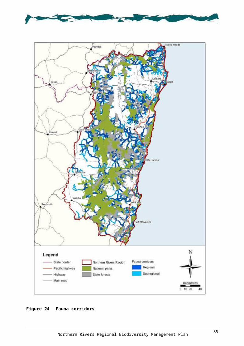
ACTIONS: Region
3.4.1. Encourage local governments and the Northern Rivers CMA to develop partnerships with other agencies that offer voluntary incentive schemes, including the DECCW Conservation Partners Program (conservation agreements, wildlife refuges or property registration) and programs offered through non-government conservancy groups. Target incentives to protect vegetation within Conserve (Figure 15), key habitats (Figure 17), and centres of endemism (Figure 18) priority areas; and under-represented regional ecosystems (Figure 23 and Appendix 17) and fauna corridor (Figure 24) areas.
3.4.2. Encourage local governments to develop and implement a reduced differential rating scheme for lands managed for biodiversity conservation purposes.
3.4.3. Encourage and support local governments in negotiating and implementing conservation agreements on council lands containing vegetation within Conserve (Figure 15), key habitats (Figure 17), and centres of endemism (Figure 18) priority areas; and fauna corridor (Figure 24) areas.
3.4.4. Encourage non-government conservation groups, the Northern Rivers CMA and DECCW to provide covenants, acquire, or provide incentives to private landholders whose land supports vegetation within areas of importance to biodiversity (Section 5). In particular, target Conserve (Figure 15), key habitats (Figure 17), centres of endemism (Figure 18), and travelling stock reserves (Figure 22) priority areas; and fauna corridor (Figure 24), wetland (Figure 26), the Great Eastern Ranges Initiative (Figure 25) areas; and additional areas identified using finer-scale mapping and expert local knowledge.
3.4.5. To achieve improved biodiversity outcomes, encourage the funding of non-financial incentives, such as: provision to landowners of trees, materials for fencing and weed control; off-stream watering points; and extension advice such as delivery of biodiversity-related training.
3.4.6. Encourage public land managers to seek opportunities for partnerships with neighbours across all land tenures to protect vegetation within Conserve (Figure 15), key habitats (Figure 17), and centres of endemism (Figure 18) priority areas; and under-represented regional ecosystems (Figure 23 and Appendix 17) and fauna corridor (Figure 24) areas.
3.4.7. Encourage property owners, through education and extension advice on both the production and biodiversity values of retaining habitat, to retain and manage vegetated areas, older trees with hollows, fallen timber, logs, dead trees and rocks, and to reduce stock numbers and other disturbances within these areas.
3.4.8. Through property management planning and other opportunities, provide extension advice to landowners on the links between productivity gains and the protection of native vegetation and habitat (refer to <http://www.landwaterwool.gov.au/>).
OUTCOME 3.5: Vegetation linkages and habitat are protected and enhancedACTIONS: Region
3.5.1. Implement rehabilitation and restoration activities in vegetation within Conserve (Figure 15), Repair (Figure 16), key habitats (Figure 17), centres of endemism (Figure 18) and climate change corridors (Figure 19) priority areas; and travelling stock reserves (Figure 22), fauna corridor (Figure 24), Great Eastern Ranges Initiative (Figure 25), and moist montane forest fauna refugia (Figure 30) areas; areas identified using finer-scale data and expert local knowledge; and areas identified as having high stakeholder engagement in existing rehabilitation and restoration programs.
3.5.2. Ensure that vegetation within Conserve (Figure 15), Repair (Figure 16), key habitats (Figure 17), and centres of endemism (Figure 18) priority areas; and fauna corridors (Figure 24) are considered in rehabilitation schemes for biodiversity biobanking and offset schemes, local government strategies, planning and market-based instruments.
3.5.3. When undertaking rehabilitation and restoration works within areas identified on the forest fauna fruit and forest fauna nectar maps (Figures 28 and 29 respectively) as having a
Northern Rivers Regional Biodiversity Management Plan90

moderate to very high index, encourage tree planting to include fruit- and nectar-producing species typical of forests in the local area.
3.5.4. Where rehabilitation and restoration works are not achievable due to other management objectives, such as along roadsides and under powerlines, use appropriate wildlife infrastructure such as gliding poles, underpasses and rope crossings to increase landscape connectivity.
3.5.5. Prepare site rehabilitation plans that fully consider potential impacts on local priority species and threatened entities prior to commencement of any works.
3.5.6. Resource and support the provision of biodiversity extension advice and training to landholders.
3.5.7. Prepare and distribute field identification guidelines for threatened ecological communities to landowners to promote their identification, protection and importance (see Appendix 12).
ACTION: Tablelands landscape
3.5.8. Support existing local initiatives and projects in areas that may not be included in the mapping of areas important to biodiversity, such as the Citizens Wildlife Corridors Armidale.
ACTION: Tree hollows
The loss of hollow-bearing trees is a key threatening process in NSW. Lindenmayer and Fischer (2006) identify large, old trees with hollows as keystone habitat resources. Hollows provide critical roosting and nesting habitat for hollow-dependent fauna. Older trees with hollows are a depleted resource throughout much of the Region. It is important to retain and protect old growth hollow-bearing trees and forest as well as trees that have the potential to provide hollows into the future.
3.5.9. Implement an education and awareness campaign for landowners on the biodiversity value of retaining older, hollow-bearing trees and dead trees, as well as other biodiversity features such as retained fallen timber and hollow logs.
ACTIONS: Hill-topping butterflies
The loss and/or degradation of sites used for hill-topping by butterflies is a key threatening process in NSW. Hilltops and ridgetops that are usually higher than the surrounding area provide sites for butterflies to aggregate and mate. These sites are used each year by certain butterfly species to complete their reproductive cycle. Some important butterfly hill-topping sites in the Region are Mt Warning, Razorback Lookout, Lions Lookout (Murwillumbah), Peats Mountain and Mt Ramornie.
3.5.10. Prepare and implement an education and community awareness campaign to increase knowledge on the impacts of loss and/or degradation of butterfly hill-topping sites (see Figure 21 ‘Hill-topping Butterflies’).
3.5.11. Ensure that any developments and activities, such as communication towers, proposed on land at known and potential hill-topping sites (see Figure 21 ‘Hill-topping Butterflies’) are consistent with the State-wide actions identified in the Threatened Species Priorities Action Statement (DECC 2007) and do not adversely impact on hill-topping activities by butterflies.
3.5.12. Work with expert butterfly and moth interest groups to undertake community surveys to identify butterfly hill-topping sites.
ACTIONS: Flying-fox camps
Three species of flying-fox roost in camps within the Region: Grey-headed Flying-fox, Black Flying-fox Pteropus alecto and Little Red Flying-fox Pteropus scapulatus. Although only the Grey-headed Flying-fox is a threatened species, all three play a critical role in maintaining native forests,
Northern Rivers Regional Biodiversity Management Plan91

pollinating plants and dispersing native seeds. Food sources for these species are widespread and vary considerably over different seasons, and although provision of year-round food sources is vital, the most critical habitat resource for flying-foxes is their camps. Camps are where flying-foxes roost during the day, rest when migrating throughout their range, and mate, give birth and raise their young.
3.5.13. Protect and manage flying-fox camps (see Figure 20) in accordance with DECCW's Flying-fox Camp Management Policy (DECC 2007a).
3.5.14. Encourage councils and other authorities to maximise protection and provide buffers to flying-fox camps to avoid landuse conflicts.
3.5.15. Support bushland restoration activities that improve the quality, quantity and integrity of habitat in flying-fox camps and maintain camp function.
3.5.16. Consider the impacts of any ecological burns, particularly in relation to season, on camps. Burns or restoration works should not be undertaken during the breeding season or during extremes of hot or cold weather.
3.5.17. Undertake research into the ecology of flying-foxes and their use (including seasonal usage) of camps, including research into criteria for camp selection.
3.5.18. Undertake community and neighbour awareness programs to educate people on the importance of flying-fox camps and the importance of flying-foxes in maintaining diverse forest and rainforest communities.
ACTION: Long-nosed Potoroo endangered population
3.5.19. Liaise with landholders to reduce the impacts of the Boyd Street connection at Tweed Heads on Long-nosed Potoroo (see Figure 21 ‘LN Potoroo Cobaki – Roadkills’). For example, revegetate cleared areas, restore original hydrology, build suitable underpasses and construct fencing.
ACTION: Marine turtles
3.5.20. Collate records of marine turtle beach nest sites and work with voluntary organisations and groups in providing monitoring, protection and management of sites (see Figure 21 ‘Green Turtle – nests’ and ‘Loggerhead Turtle – nests’).
3.5.21. Prepare and distribute information to raise awareness of the impact on marine turtles of discarded plastic bags and other rubbish.
ACTIONS: Osprey
3.5.22. Identify and protect nest trees (large partly-dead and/or dead trees with large stick nests) as well as surrounding vegetation using appropriate buffer zones (suggested buffer 100 m). The buffer zone should encompass perch (feeding) trees and vegetation surrounding the nest that is used to collect nesting material.
3.5.23. Provide information to landowners and local governments regarding the importance of retaining potential nest trees for Ospreys (large partly-dead and/or dead trees within 3 km of the coast, coastal estuaries or coastal lakes).
3.5.24. Prepare and distribute information to increase awareness of the threats to Ospreys, including discarded fish with fishing tackle attached, fishing line and other rubbish.
3.5.25. Develop protocols for artificial nest design and nest relocation in association with local councils and other authorities such as energy providers.
ACTION: Sanderling and Great Knot
3.5.26. Investigate the feasibility of incorporating important foraging and roosting sites in the Richmond River estuary into the Richmond River Nature Reserve (see Figure 21 ‘Richmond River estuary’).
Northern Rivers Regional Biodiversity Management Plan92

Inappropriate fire regimesFire is an important and natural ecological process in Australian landscapes, and in many ecosystems it represents a major form of disturbance (Lindenmayer & Fischer 2006). Many native species have co-evolved with fire, and a single fire event in itself is not necessarily a major form of mortality or threat. The life cycles and habitats of many species, however, are dependent on certain fire regimes, and when these regimes are altered the ability of a species to persist in a certain area can be disrupted.
A fire regime can be considered ‘inappropriate’ on the basis of one or more aspects that define that particular regime, including the fire’s interval, seasonality and intensity. Vegetation communities may not persist (be able to regrow) if any of these aspects continue to fall outside a particular threshold over a number of fires. Vegetation communities and species in the Region display a wide range of fire regime requirements. For example, some heathland communities require high intensity fires to maintain their diversity, while some forms of rainforest do not tolerate fire at all. Also, certain species within the same vegetation community may have different responses to fire and, therefore, require different regimes.
High frequency fires are a key threatening process in NSW. While this represents only one particular type of inappropriate fire regime, the threat of high frequency fire (relative to the species and vegetation communities these fires occur in) is currently greatest in the coastal and tablelands habitats of NSW as well as in urban areas (NSW Scientific Committee 2000a). Consequently, a number of threatened species addressed by this Plan are identified as being under threat from high frequency fires, including those listed in Table 18.
Table 18 Threatened species under threat from high frequency fires
Common name Scientific namePlantsRupp's Wattle Acacia ruppiiTorrington Pea Almaleea cambageiGranite Rose Boronia repandaPygmy Cypress Pine Callitris oblongaWhite-flowered Wax Plant Cynanchum elegansNarrow-leaved Black Peppermint Eucalyptus nicholiiBanyabba Grevillea Grevillea banyabbaBeadle's Grevillea Grevillea beadleanaBackwater Grevillea Grevillea scortechinii ssp. sarmentosaCrescent-leaved Homoranthus Homoranthus lunatusHairy Melichrus Melichrus hirsutusSouthern Swamp Orchid Phaius australisLady Tankerville’s Swamp Orchid Phaius tankervilleaeMontane Green Five-corners Styphelia perileucaBirdsGlossy Black-cockatoo Calyptorhynchus lathamiEastern Ground Parrot Pezoporus wallicus wallicusMammalsEastern Pygmy-possum Cercartetus nanusEastern Quoll Dasyurus viverrinusKoala Phascolarctos cinereusLong-nosed Potoroo Potorous tridactylusParma Wallaby Macropus parmaRufous Bettong Aepyprymnus rufescens
Northern Rivers Regional Biodiversity Management Plan93

Common name Scientific nameSpotted-tailed Quoll Dasyurus maculatusSquirrel Glider Petaurus norfolcensis
Other forms of inappropriate fire regime also represent a threat to the biodiversity of the Region. For example, Catling (1991) identifies several threatened forest mammals covered by the Plan that are disadvantaged by frequent, low-intensity prescribed burns, and others that are advantaged (see Table 19).
Table 19 Threatened forest mammals identified as advantaged or disadvantaged by low intensity prescribed burns (from Catling 1991)
Common name Scientific nameDisadvantagedEastern Pygmy-possum Cercartetus nanusEastern Quoll Dasyurus viverrinusLong-nosed Potoroo Potorous tridactylusParma Wallaby Macropus parmaRufous Bettong Aepyprymnus rufescensSpotted-tailed Quoll Dasyurus maculatusSquirrel Glider Petaurus norfolcensisAdvantagedBrush-tailed Phascogale Phascogale tapoatafaEastern Chestnut Mouse Pseudomys gracilicaudatusHastings River Mouse Pseudomys oralis
Projected changes to fire intensity and seasonality in many areas due to impacts associated with climate change, such as higher temperatures and drought (see DECC 2008n, 2008o), have the potential to further impact vegetation floristics and diversity as well as disrupt the maintenance of species habitat and life cycle processes.
OBJECTIVE 4: To protect vegetation communities, ecosystems and habitats from inappropriate fire regimes
OUTCOME 4.1: Promoted a consistent and coordinated approach to fire management
ACTION: Region
4.1.1. Develop partnerships between land management agencies, fire management authorities, local government, research institutions and Nature Conservation Council Hotspots Fire Project. Aim to promote a consistent and coordinated approach to fire management for biodiversity across the Region through the creation of a ‘Northern Rivers Fire and Biodiversity Consortium’.
OUTCOME 4.2: Appropriate fire regimes are identified and implementedACTIONS: Region
4.2.1. Promote recognition of biodiversity as an asset to be considered in bushfire risk management plans.
4.2.2. Investigate options for utilising the regional fire thresholds recommended by the Nature Conservation Council Hotspots Fire Project and the Southeast Queensland Fire and
Northern Rivers Regional Biodiversity Management Plan94

Biodiversity Consortium. Recommendations should be used by regional bushfire management committees, DECCW Parks and Wildlife Group and Forests NSW.
4.2.3. Identify ecosystems most vulnerable to degradation from inappropriate fire regimes and encourage fire regimes that promote biodiversity within strategic fire advantage zones and land management zones.
4.2.4. When planning hazard reduction and environmental burns, minimise the impacts of fire on critical terrestrial and aquatic habitat components, including water quality, important refugia and sensitive microhabitats.
4.2.5. When undertaking property fire planning for hazard reduction and environmental burns, incorporate weed management programs.
4.2.6. Review ecological fire requirements (including consideration of the potential effects of climate change) on the threatened entities (species, populations and communities) in the Region, and incorporate these into fire management plans, hazard reduction guidelines and procedures. Species identified as highest priority for review in relation to the NSW Threatened Species Hazard Reduction List are: Barren Mountain Mallee Eucalyptus approximans Beadle's Grevillea Grevillea beadleana Big Nellie Hakea Hakea archaeoides Bordered Guinea Flower Hibbertia marginata Floyd’s Grass Alexfloydia repens Four-tailed Grevillea Grevillea quadricauda Hairy Melichrus Melichrus hirsutus MacNutt's Wattle Acacia macnuttiana Nymboida Babingtonia Babingtonia prominens Noah's False Chickweed Lindernia alsinoides Sweet False Galium Hedyotis galioides Tall Velvet Sea-berry Haloragis exalata subsp. velutina Torrington Pea Almaleea cambagei Wollumbin Zieria Zieria adenodonta Woodland Babingtonia Babingtonia silvestris Pale-headed Snake Hoplocephalus bitorquatus Bush Stone-curlew Burhinus grallarius Red-backed Button-quail Turnix maculosa Red-tailed Black-Cockatoo Calyptorhynchus banksii Eastern Bentwing-bat Miniopterus schreibersii oceanensis Little Bentwing-bat Miniopterus australis.
4.2.7. Undertake research into the fire ecology of threatened plants in the Glenreagh–Coaldale sandstone area.
4.2.8. Ensure that biodiversity assets are also taken into account when determining the location of strategic fire advantage zones.
4.2.9. Investigate ways of factoring in drought and potential climate change impacts into fire management planning and incident response. Review the appropriateness of using rainforest edges and other vegetation features for fire containment, and ensure that fire regimes take into account changes in susceptibility of isolated features such as wetlands and rocky outcrops.
4.2.10. Identify areas to trial high intensity fire regimes as a landscape management tool.4.2.11. Review ecological requirements (in light of climate change impacts and the most up-to-
date research) for species and habitats in fire management plans, hazard reductions plans and procedures.
4.2.12. Research the impacts on aquatic species and habitats (e.g. Eastern Fresh Water Cod breeding habitat) of nutrient spikes and sediment loads caused by fires.
Northern Rivers Regional Biodiversity Management Plan95

4.2.13. Investigate the use of environmental flows, where available, to flush nutrient spikes and sediment loads after high intensity fire events, for example, Toonumbar Dam.
4.2.14. Undertake programs and processes to collate traditional Indigenous and non-Indigenous local and oral history knowledge for incorporation into fire management plans. Consider using local and traditional knowledge to improve current fire management, for example, to reduce the impacts of current hazard reduction burns on the breeding cycle of the endangered Emu population in the NSW North Coast Bioregion and the Themeda grassland on seacliffs and coastal headlands endangered ecological community.
4.2.15. Research the role of fire in maintaining the two existing structural types of wet sclerophyll forest occurring in the Region.
4.2.16. Develop a consistent approach to data collection, collation and preparation of fire strategy maps across all tenures.
4.2.17. Encourage cooperation between neighbouring private and public landholders to prepare and implement compatible fire management plans across groups of properties, rather than individual properties.
4.2.18. Encourage implementation of the Nature Conservation Council’s Hotspots Fire Project for biodiversity across the Region.
4.2.19. Support Indigenous landholders undertake Nature Conservation Council’s ‘Hotspots Fire for Biodiversity’ planning on their land, and incorporate traditional/historical knowledge into fire management plans.
4.2.20. Use fire as a management tool for Bell Miner associated dieback and Lantana control as per the Bell Miner Associated Dieback Action Plan (BMADWG 2004).
4.2.21. Undertake research in fragmented and isolated landscapes on the post-wildfire impacts on the viability of fauna and flora populations.
ACTION: Tablelands landscape4.2.22. Research the impact of fire frequency and intensity on the spread and control of
introduced perennial grasses such as Coolatai grass.
ACTION: Dinner Creek, Demon Nature Reserve
4.2.23. Prepare a fire management plan, incorporating appropriate ecological burns, for Dinner Creek in Demon Nature Reserve (see Figure 21 ‘Demon NR Fire Plan’). The design and implementation of the plan should consider the habitat requirements of Brush-tailed Phascogale, Eastern Chestnut Mouse, Hastings River Mouse, Stephens’ Banded Snake and Stuttering Barred Frog.
WeedsThere are numerous weeds in the Region which are a significant and ongoing threat to biodiversity. Weeds can be grouped into three fundamental threat types: potential new invaders, recently established or emerging weeds, and widespread well-established weeds. A number of weeds that occur in the Region are listed as key threatening processes and these are identified below.
During the preparation of this Plan, a number of regional weed strategies were identified or became available, including:
Draft Northern Rivers Invasive Plants Action Strategy 2008–2013 (Oakwood 2008)
DECCW Parks and Wildlife Group Mid North Coast Region Pest Management Strategy 2008–2011 (DECC 2008g)
DECCW Parks and Wildlife Group North Coast Region Pest Management Strategy 2008–2011 (DECC 2008i)
DECCW Parks and Wildlife Group Northern Rivers Region Pest Management Strategy 2008–2011 (DECC 2007e)
Northern Rivers Regional Biodiversity Management Plan96

DECCW Parks and Wildlife Group Northern Tablelands Region Pest Management Strategy 2008–2011 (DECC 2008j).
These strategies identify the need for prevention, early detection and control of new invaders; for implementation of prioritised and integrated weed control programs; and for collaborative control across tenures. The strategies provide a substantial basis for the strategic delivery of weed control initiatives and actions on private and public lands across the Region. This Plan generally refers to these documents rather than reiterating their recommendations. Additionally, DECCW and the Department of Industry and Investment have been identifying priorities for weed control across the Region (see <http://www.environment.nsw.gov.au/cmaweeds/>).
The potential influence of climate change on the impacts of weeds in the Region will be varied. In some instances, climate change may reduce the impact of weed species. In other instances, climate-based constraints on the growth and spread of weeds may be lessened, resulting in the further spread and increased impact of these weeds on biodiversity. The effective control of noxious and environmental weeds, including those identified as key threatening processes, will require long-term management based on a coordinated and consistent approach.
OBJECTIVE 5: Protect the Region from the impact of weeds
OUTCOME 5.1: Regional weed management strategies are implementedACTIONS: Region
5.1.1. Implement the actions within the Draft Northern Rivers Invasive Plants Action Strategy 2008–2013.
5.1.2. Implement actions in the relevant DECCW Parks and Wildlife Group regional pest management strategies (North Coast, Northern Rivers, Northern Tablelands and Mid North Coast).
5.1.3. Implement relevant actions in the Department of Industry and Investment Forests NSW Weed Management Plan North East Region 2006.
OUTCOME 5.2: Strategic partnerships and alliances are establishedACTIONS: Region
5.2.1. Support integrated programs through regional weed advisory committees.5.2.2. Investigate and develop an integrated NSW-wide geographic information system spatial
mapping database for weed infestations and eradication works.5.2.3. Promote consistent monitoring, evaluating and reporting of weeds and weed control
programs across agencies and tenures.5.2.4. Promote and distribute information to the community on websites that contain information
on weeds and their control.5.2.5. Support weed control eradication training programs and employment opportunities for
landowners and community members, particularly Indigenous people.
OUTCOME 5.3: New and emerging weeds have been prevented from establishingACTIONS: Region
5.3.1. Develop and implement a 'Weed invader alert and rapid response plan' to deal with new invasive weeds which may establish in the Region.
5.3.2. Develop a 'Vehicle and equipment hygiene manual' detailing best practice management to minimise the accidental spread of weeds. Encourage adoption and implementation of the manual by conducting education, field days and extension activities.
Northern Rivers Regional Biodiversity Management Plan97

5.3.3. Conduct training in the identification of weeds for land managers and field staff.5.3.4. Promote awareness of best practice hygiene protocols for limiting the spread of weeds
with tour operators, national park visitors and the general public. Mechanisms include awareness campaigns, pamphlets and signage.
5.3.5. Promote awareness of the negative effects of dumping garden waste in urban and rural residential bushland remnants.
5.3.6. Develop agreements and partnerships with the nursery and fodder industries to implement best practice for reducing the dispersal of environmental weeds.
ACTION: Scotch Broom
Scotch Broom Cytisus scoparius occurs mainly in cool temperate regions at high altitudes where it invades subalpine grasslands, grassy woodlands and associated riparian areas (Hosking et al. 2000; DEC 2005a). The invasion and establishment of Scotch Broom is a key threatening process in NSW (NSW Scientific Committee 2007) and, although the main distribution of the species is further south, there are known infestations within the Region in the tablelands (Oakwood 2008). Threatened entities in the Region identified as being potentially under threat from Scotch Broom are listed in Table 20.
Table 20 Threatened entities potentially under threat from Scotch Broom
Common name Scientific namePlantsBarrington Tops Ant Orchid Chiloglottis platypteraElegant Greenhood Orchid Pterostylis elegansFragant Pepperbush Tasmannia glaucifoliaPolblue Eyebright Euphrasia ciliolataPygmy Cypress Pine Callitris oblongaVeined Doubletail Orchid Diuris venosaEndangered ecological communitiesMontane Peatlands and Swamps of the New England Tableland
New England Peppermint Woodland
Ribbon Gum, Mountain Gum, Snow Gum Grassy Forest/Woodland
5.3.7. Implement the Draft Northern Rivers Invasive Plants Action Strategy 2008–2013.5.3.8. Identify and eradicate new outbreaks in accordance with best practice management.
ACTION: Chinese Tallow
Chinese Tallow Triadica sebifera occurs as a street tree in parts of the Region but is also a potential threat to the freshwater wetlands of the coastal plains landscape. Jabiru-Geneebeinga wetland, Casino, contains the worst known infestation of Chinese Tallow in NSW, with dense thickets covering at least 10 ha (North Coast Weeds Advisory Committee 2004).
5.3.9. Identify and control infestations of Chinese Tallow in freshwater wetland threatened ecological communities in accordance with the Regional Weed Management Plan for Chinese Tallow (North Coast Weeds Advisory Committee 2004).
OUTCOME 5.4: The impact of existing weeds has been reducedACTIONS: Region
5.4.1. Before commencing control programs, ensure site management plans are prepared which adopt best practice weed control and removal practices.
Northern Rivers Regional Biodiversity Management Plan98

5.4.2. Ensure that weed control projects consider and include, where appropriate, funding for primary, secondary and follow-up weed control to manage long-term reinfestation.
5.4.3. Promote participation in land management and bush regeneration certificate courses to ensure bush regenerators who undertake on-ground implementation are fully qualified and experienced in weed control.
5.4.4. Negotiate with tertiary institutions for 'weed spotter training' to be recognised as competencies for appropriate certificates, for example, conservation and land management and/or bush regenerator.
5.4.5. Promote the training of organisations and individuals in accredited weed hygiene practices, for example, RTD2312A 'Inspect machinery for plant, animal and soil material training', and RTD2313A 'Clean machinery of plant, animal and soil material training'.
5.4.6. Promote the delivery of the ‘Weed Warriors’ and ‘Weed Web’ programs in primary and secondary schools.
5.4.7. Integrate weed control programs with bush rehabilitation, regeneration and fire programs.
ACTIONS: Lantana
Lantana Lantana camara is recognised as one of the ten most invasive plants in the world and one of 20 weeds of national significance in Australia (Department of Natural Resources, Mines and Energy 2004).
Lantana readily invades disturbed and intact sites along the east coast of Australia, including rainforests, sclerophyll forests and sclerophyll woodlands, as well as coastal zones and riparian areas (NSW Scientific Committee 2006c). It is present in all rainforest remnants on the north coast of NSW (Department of Natural Resources, Mines and Energy 2004), and is one of the most common weeds in the Region below 800 m altitude (DECC 2007e; DECC 2008g, DECC 2008i).
Established Lantana thickets exclude native species by smothering, allelopathic effects (i.e. toxicity to other plants), dominating understoreys, and potentially increasing the intensity of wildfires (Department of Natural Resources, Mines and Energy 2004). It has also been identified as a possible factor in the cause of Bell Miner associated dieback (DECC 2007e; NSW Scientific Committee 2008a).
In NSW, invasion, establishment and spread of Lantana is a key threatening process (NSW Scientific Committee 2006c). A national ‘Plan to Protect Environmental Assets from Lantana’ is currently being prepared by DECCW and Biosecurity Queensland and, as part of its preparation, the species and ecological communities under threat are being refined and ranked. The Lantana plan will also identify priority sites for Lantana control. Many species, ecological communities and sites identified by the Lantana plan are likely to be relevant to the Region, and once completed, it should direct actions for Lantana control in the Region.
5.4.8. Identify sites for Lantana control based on priority areas in the Bell Miner Associated Dieback Strategy (BMADWG 2004) and the national Plan to Protect Environmental Assets from Lantana (when available).
5.4.9. Implement actions in the relevant DECCW Parks and Wildlife Group regional pest and weed management strategies (North Coast, Northern Rivers, Northern Tablelands and Mid North Coast).
5.4.10. Pouched Frog: Control Lantana in potential and known riparian habitat areas in Washpool National Park (see Figure 21 ‘Pouched Frog – Lantana’).
5.4.11. Glenugie Karaka Corynocarpus rupestris subsp. rupestris: Control Lantana within Glenugie Peak Flora Reserve to protect Glenugie Karaka (see Figure 21 ‘Glenugie Karaka – Lantana’).
5.4.12. Stinky Lily: Control Lantana in Stinky Lily habitat in the Coffs Harbour area (see Figure 21 ‘Stinky Lily – Lantana’).
5.4.13. Creek Triplarina Triplarina imbricata: Control Lantana at known populations of Creek Triplarina.
Northern Rivers Regional Biodiversity Management Plan99

5.4.14. Black Grass-dart and Floyd’s Grass: Control Lantana in Black Grass-dart and associated Floyd’s Grass habitat in the Coffs Harbour area (see Figure 21 ‘Black Grass-dart – Lantana and Paspalum’).
ACTIONS: Exotic perennial grasses
Exotic perennial grasses can invade and establish in native vegetation, particularly following some form of disturbance. Once established, they can alter the fuel load and structure of the vegetation community which can in turn impact on native fauna (NSW Scientific Committee 2003a).
The NSW determination for invasion by exotic perennial grasses identifies several exotic grasses from the Region that have the potential to invade native vegetation (see Table 21). Other exotic perennial grasses with the potential to adversely affect native species and vegetation communities are identified in the Draft Northern Rivers Invasive Plants Action Strategy (Oakwood 2008) and DECCW Parks and Wildlife Group regional pest management strategies (DECC 2007e; DECC 2008g, 2008i).
Table 21 Exotic perennial grasses in the Region that have the potential to invade native vegetation
Common name Scientific nameAfrican Lovegrass Eragrostis curvulaBrowntop Bent Agrostis capillarisChilean Needlegrass Nassella neesianaCoolatai Grass Hyparrhenia hirtaGiant Parramatta Grass Sporobolus fertilisGiants Rat’s Tail Grass Sporobolus natalensisKikuyu Pennisetum clandestinumMolasses Grass Melinis minutifloraPanic Veldtgrass Ehrharta erectaPara Grass Urochloa muticaPhalaris Phalaris aquaticaRhodes Grass Chloris gayanaSerrated Tussock Nassella trichotomaSouth African Pigeon Grass Setaria sphacelataTorpedo Grass Panicum repensVasey Grass Paspalum urvilleiWhisky Grass Andropogon virginicus
5.4.15. Implement the Draft Northern Rivers Invasive Plants Action Strategy 2008–2013, prioritising areas of new infestations.
5.4.16. Implement actions in the relevant DECCW Parks and Wildlife Group regional pest management strategies (Mid North Coast, Northern Rivers and Northern Tablelands).
5.4.17. Implement best practice hygiene protocols for vehicles, equipment and boots when moving from Coolatai grass Hyparrhenia hirta–infested areas to unaffected areas.
5.4.18. Implement strategic control and rapid response to new outbreaks of Coolatai grass in high biodiversity areas such as national parks, travelling stock reserves and properties currently unaffected.
5.4.19. Zieria smithii endangered population: Control Kikuyu Pennisetum clandestinum and Giant Parramatta Grass Sporobolus fertilis in coastal grassy heath areas containing Zieria smithii on Diggers Head, Coffs Harbour (see Figure 21 ‘Zieria smithii – Grasses’).
Northern Rivers Regional Biodiversity Management Plan100

5.4.20. Black Grass-dart and Floyd’s Grass: Control Broad-leaved Paspalum in Black Grass-dart and associated Floyd’s Grass habitat in the Coffs Harbour area (see Figure 21 ‘Black Grass-dart – Lantana and Paspalum’).
ACTIONS: Exotic vines and scramblers
Invasion and establishment of exotic vines and scramblers is a key threatening process in NSW (NSW Scientific Committee 2006b). Exotic vines and scramblers can directly compete with native species for water and nutrients, smother native ground and canopy vegetation, and suppress regenerating native species. Exotic vines and scramblers also increase fuel loads, restrict the movement of native fauna, and alter the biota of the soil and leaf litter (NSW Scientific Committee 2006b).
Many of the Region’s most significant environmental weeds are invasive exotic vines or scramblers that were imported into Australia for horticultural or agricultural purposes. Changes to the climate may result in new tropical exotic vines and scramblers becoming established in the Region, for example, Rubber Vine Cryptostegia grandiflora (NSW Scientific Committee 2006b). Exotic vines and scramblers that are known to occur, or have the potential to occur, in the Region are listed in Table 22. See also the publication Common Weeds of Subtropical Rainforests of Eastern Australia (Big Scrub Rainforest Landcare Group 2008) for weeds occurring in rainforests of the region.
Table 22 Exotic vines and scramblers that occur, or have the potential to occur (#), in the Region
Common name Scientific nameAsparagus Fern Asparagus africanus Bridal Creeper Asparagus asparagoidesAerial Yam (#) Dioscorea bulbiferaAsparagus Fern Asparagus scandensBalloon Vine Cardiospermum grandiflorumBlack-eyed Susan Thunbergia alataBrazilian Nightshade Solanum seaforthianumCape Ivy Delairea odorataCat's Claw Macfadyena unguis-catiClimbing Asparagus Fern Asparagus plumosusCoastal Morning Glory Ipomoea cairicaCommon Passionfruit Passiflora edulisCorky Passion Flower Passiflora suberosaCrab's Eye Vine Abrus precatoriusDutchman's Pipe Aristolochia elegansEnglish Ivy Hedera helixGround Asparagus Asparagus aethiopicusJapanese Honeysuckle Lonicera japonicaKudzu Pueraria lobataMadeira Vine Anredera cordifoliaMoon Flower Ipomoea albaMorning Glory Ipomoea indicaMorning Glory Ipomoea purpureaMoth Vine Araujia sericiferaMysore Thorn Caesalpinia decapetalaNatal Ivy Senecio macroglossusPerennial Soybean Neonotonia wightiiPeriwinkle Vinca major
Northern Rivers Regional Biodiversity Management Plan101

Common name Scientific name
Potato Vine Acetosa sagittataPotato Vine Solanum jasminoidesSicklethorn (#) Asparagus falcatusWandering Jew Tradescantia fluminensisWhite Passionflower Passiflora subpeltata
5.4.21. Implement the Draft Northern Rivers Invasive Plants Action Strategy 2008–2013, giving priority to areas of new infestations.
5.4.22. Implement actions in the relevant DECCW Parks and Wildlife Group regional pest management strategies (Mid North Coast, Northern Rivers, North Coast and Northern Tablelands).
ACTIONS: Bitou Bush
Bitou Bush is identified as a weed of national significance because of its adverse impacts on biodiversity. Over 70% of the NSW coastline contains infestations of Bitou Bush, including both disturbed and undisturbed vegetation communities, to the extent that it sometimes becomes the dominant species (ARMCANZ et al. 2000a).
Invasion by Bitou Bush can alter the structure of a vegetation community, leading to a decline in flora and fauna diversity. Infestations can also harbour pest animals (NSW Scientific Committee 1999b; ARMCANZ et al. 2000a).
The NSW Bitou Bush and Boneseed Threat Abatement Plan (DEC 2006d) identifies and prioritises sites for control works. Of these, 61 high priority (category 1) sites and 24 lesser priority (category 2 to category 5) sites occur within the Region and contain threatened entities covered by this Plan. These include 16 threatened flora species, 2 endangered populations and 5 endangered ecological communities. Figure 20 (‘Bitou TAP sites’) shows the location of these sites.
5.4.23. Undertake control of Bitou Bush at high priority sites in accordance with the Bitou Bush and Boneseed Threat Abatement Plan (DEC 2006d) and Northern Rivers Regional Bitou Bush Management Strategy (DEC 2006c). Priority threat abatement plan sites are shown in Figure 20 and listed in Appendix 20, on the enclosed CD.
5.4.24. Identify any sites containing Dark Greenhood Pterostylis nigricans (see Figure 21 ‘Dark Greenhood – Bitou’), Small Pale Grass-lily Caesia parviflora var. minor and Fraser's Screw Fern Lindsaea fraseri where Bitou Bush control is required.
ACTION: Aquatic weeds
5.4.25. Implement actions in the relevant DECCW Parks and Wildlife Group regional pest management strategies (Mid North Coast and Northern Rivers), in particular, actions relating to Alligator Weed in the Richmond Valley floodplain and control of any outbreaks of Salvinia and Water Hyacinth (both weeds of National Significance).
ACTIONS: Blackberry
Blackberry Rubus fruticosus agg. is a highly invasive weed in agricultural areas and natural ecosystems in temperate Australia that has been identified as a weed of national significance (ARMCANZ et al. 2000b). It can form large thickets that prevent regeneration of native vegetation and restrict movement of native fauna, in particular, access to watercourses. Thickets of Blackberry also provide shelter and food for pest animals.
Northern Rivers Regional Biodiversity Management Plan102
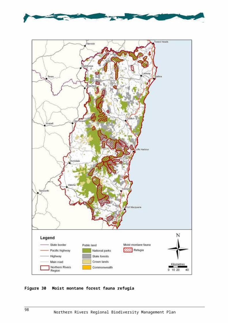
The Draft Northern Rivers Invasive Plants Action Strategy and Northern Tablelands Region Pest Management Strategy identify Blackberry as a widespread problem throughout the tablelands. Also, isolated patches of Blackberry are known to occur in the Kyogle area.
5.4.26. Implement actions in the relevant DECCW Parks and Wildlife Group regional pest management strategies (Northern Rivers and Northern Tablelands).
5.4.27. Control Blackberry along watercourses that support habitat of Tall Velvet Sea-berry (see Figure 21 ‘Sea-berry – Blackberry’).
ACTIONS: Camphor Laurel
Camphor Laurel is an invasive woody weed that is now naturalised in much of the coastal areas of the Region. It is an aggressive invader of disturbed native plant communities, particularly the edges and gaps of remnant rainforest, wet sclerophyll forest and riparian areas. Camphor Laurel can also rapidly colonise areas of cleared land, leading to Camphor Laurel–dominated forests (Far North Coast Weeds 2006; DECC 2007e).
Some large, established stands of Camphor Laurel in the Region have become an important habitat component for some native species, particularly where some native plants still persist. They provide vegetated corridors for movement of species, food resources for large-gaped frugivores, and a suitable microclimate for regeneration of understorey rainforest plants. Camphor Laurel also provides bank stability along degraded waterways. Therefore, in areas where Camphor Laurel is established, any control activities must be undertaken in a staged and systematic way to maintain forest structure and habitat values (Far North Coast Weeds 2006; Kanowski & Catterall 2007). In areas where Camphor Laurel is actively invading native vegetation and in the process of establishing, staged replacement is not recommended.
5.4.28. Implement actions in the relevant DECCW Parks and Wildlife Group regional pest management strategies (Mid North Coast, North Coast and Northern Rivers).
5.4.29. In areas where Camphor Laurel forests are established, undertake a staged regeneration approach as described in Kanowski and Catterall (2007) and Scanlon and Camphor Laurel Task Force (2001). For riparian areas, use best practice control methods to prevent streambank disturbance.
5.4.30. Where appropriate, plant native strangler fig species into Camphor Laurel trees as a long-term strategy for replacement (e.g. heritage streets, public places or large paddock trees).
5.4.31. Develop a resource kit for landowners and land managers detailing best practice Camphor Laurel replacement methods for a range of landforms and forest types.
ACTION: Cave-roosting bats
5.4.32. Undertake non-chemical removal of weeds obstructing entrances to bat roost caves (see Figure 21 ‘Bat Roost Protection’). Undertake works outside of known bat breeding season.
ACTION: Glory Lily and Groundsel Bush
5.4.33. Implement actions in the relevant DECCW Parks and Wildlife Group regional pest management strategies (Mid North Coast, North Coast and Northern Rivers).
ACTION: Mistflower and Crofton Weed
5.4.34. Implement actions in the relevant DECCW Parks and Wildlife Group regional pest management strategies (Northern Rivers, Northern Tablelands and North Coast).
Northern Rivers Regional Biodiversity Management Plan103

ACTIONS: Small and Large Leaf Privet
5.4.35. Implement actions in the relevant DECCW Parks and Wildlife Group regional pest management strategies (Mid North Coast, North Coast, Northern Tablelands and Northern Rivers).
5.4.36. Control Small-leaved Privet at known populations of Creek Triplarina (see Figure 21 ‘Creek Triplarina – Privet’).
ACTION: Wild Watsonia
5.4.37. Control Wild Watsonia Watsonia meriana in known habitat of Byron Bay Diuris (see Figure 21 ‘Byron Bay Diuris – Watsonia’).
ACTION: Willow
Willows Salix spp. are a weed of national significance that pose a major threat to riverine and wetland ecosystems (ARMCANZ et al. 2000c; DECC 2008j). Willows eliminate native riparian, wetland and associated dryland vegetation and fauna habitat by the formation of dense canopies. They also negatively impact stream health and water quality by producing pulses of deciduous leaves in waterways (ARMCANZ et al. 2000c).
5.4.38. Develop and implement local on-ground management strategies in susceptible areas that are currently not infested but have the potential of becoming infested with Willow.
PestsThis threat category includes the numerous, often multiple, effects that pest animal species can have on threatened entities in the Region. These range from the direct effects of herbivory, predation, habitat degradation and competition, through to trampling, wallowing and other forms of disturbance. In the case of the Cane Toad, it also includes poisoning through ingestion.
This Plan refers to a number of existing regional strategies. These provide a substantial basis for the strategic delivery of environmental-based pest control initiatives across the Region. This Plan generally refers to these documents rather than reiterating their recommendations:
Northern Rivers Catchment Pest Animal Management Strategy 2008–2013 (NRCMA 2008)
DECCW Parks and Wildlife Group Mid North Coast Region Pest Management Strategy 2008–2011 (DECC 2008g)
DECCW Parks and Wildlife Group North Coast Region Pest Management Strategy 2008–2011 (DECC 2008i)
DECCW Parks and Wildlife Group Northern Rivers Region Pest Management Strategy 2008–2011 (DECC 2007e)
DECCW Parks and Wildlife Group Northern Tablelands Region Pest Management Strategy 2008–2011 (DECC 2008j).
Many of the pest animal species in the Region are well established and require a coordinated and strategic approach to achieve some level of control (e.g. European Red Fox and feral Cat). Some pest species are expanding their distribution within the Region (e.g. Cane Toad) and others have the potential to become established. The regional strategies account for all three of these scenarios and this Plan reflects this approach.
The potential influence of climate change on the threat posed by pest animals remains unclear, although there is a possibility that flora and fauna species’ range shifts resulting from climate change may facilitate invasions by vertebrate pests (Brook 2008). There may also be instances where native or naturalised species become invasive under projected climate changes (Chambers et al. 2005).
Northern Rivers Regional Biodiversity Management Plan104
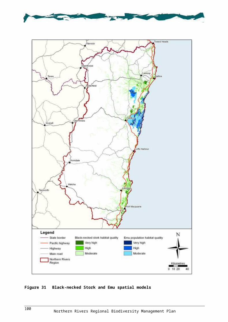
OBJECTIVE 6: Protect the Region from the impact of pestsOUTCOME 6.1: Regional pest management strategies are implementedACTIONS: Region
6.1.1. Implement relevant actions in the Northern Rivers Catchment Pest Animal Management Strategy 2008–2013.
6.1.2. Implement relevant actions in the DECCW Parks and Wildlife Group regional pest management strategies (North Coast, Northern Tablelands, Mid North Coast and Northern Rivers).
6.1.3. Implement relevant actions in the Department of Industry and Investment Forests NSW Pest Animal Management Plan North East Region 2006.
OUTCOME 6.2: Strategic partnerships and alliances are establishedACTIONS: Region
6.2.1. Investigate and develop, in association with other agencies, an integrated NSW-wide geographic information system spatial mapping database for pest species and eradication works.
6.2.2. Support integrated programs through regional pest animal advisory committees.6.2.3. Promote and distribute information to the community on websites that contain information
on pest species and their control.6.2.4. Support pest control eradication training programs and employment opportunities for
landowners and community members, particularly Indigenous people.6.2.5. Promote the consistent monitoring, evaluating and reporting of pest species, and the
undertaking of eradication programs across all agencies and tenures.
OUTCOME 6.3: New and emerging pests are containedACTION: Region
6.3.1. Develop and implement as required, a ‘New pest invader alert and rapid response plan’ for the Region.
ACTIONS: Red-eared Slider Turtle
The Red-eared Slider Turtle Trachemys scripta elegans has been listed by the World Conservation Union as one of the world's 100 worst invaders due to its invasive nature and potential to compete with and prey on aquatic wildlife. The species is also a potential carrier of diseases and pathogens (Bringsøe 2006).
A native of the United States, the Red-eared Slider Turtle is now a well-established pest in many parts of the world. It is known to occur in river systems in central NSW and there has been an unconfirmed report of a small population near Kyogle (DECC 2007e; NRCMA 2008).
6.3.2. Implement relevant actions in the Northern Rivers Catchment Pest Animal Management Strategy 2008–2013.
6.3.3. Implement the actions in relevant DECCW Parks and Wildlife Group regional pest management strategies (Northern Rivers).
6.3.4. Undertake regular surveillance for the Red-eared Slider Turtle in potential habitat in protected areas.
6.3.5. Provide information to the community on how to identify Red-eared Slider Turtle, and the threats it poses. Mechanisms include media campaigns, brochures and regional natural
Northern Rivers Regional Biodiversity Management Plan105

resource management agencies and groups increasing public awareness and encouraging people to report sightings.
6.3.6. Provide information to encourage landholders and local governments to undertake surveillance of Red-eared Slider Turtles on their land.
ACTIONS: Tramp ants
Invasive exotic tramp ants (e.g. Red Imported Fire Ant Solenopsis invicta and Yellow Crazy Ant Anoplolepis gracilipes) are a diverse group of species from around the world. They share genetic, behavioural, and ecological attributes that allow them to establish and spread across the world. Many species of tramp ants have the ability to affect Australia's biodiversity through predation upon, or competition with, native animals. Indirectly, they can modify habitat structure and alter ecosystem processes.
The national tramp ant threat abatement plan (Commonwealth of Australia 2006) establishes a framework to guide and coordinate Australia’s response to tramp ants, and identifies species considered to be under threat from tramp ants. Although no threatened entities in the Region are considered to be under threat, there are a number of other species in the Region that are potentially affected.
Yellow Crazy Ants were detected on Goodwood Island on the Clarence River near Yamba in 2004, but have been subject to targeted control programs. Red Imported Fire Ants have been known from a number of sites in the greater Brisbane area but have also been subject to targeted control programs and, as of 2007, no fire ants have been found in NSW.
6.3.7. Implement relevant actions in the Northern Rivers Catchment Pest Animal Management Strategy 2008–2013.
6.3.8. Implement actions in relevant DECCW Parks and Wildlife Group regional pest management strategies (North Coast and Northern Rivers).
6.3.9. Include the invasion of tramp ants in any pest invader alert and rapid response plan developed for the Region.
6.3.10. Implement relevant sections of the national tramp ant threat abatement plan.6.3.11. Ensure appropriate hygiene and quarantine protocols are implemented for all transport
vehicles and at goods deposition sites, especially when goods are transported from high risk areas.
6.3.12. Target awareness programs towards landholders and local governments in potential tramp ant invasion areas.
ACTIONS: Large Earth Bumblebee
The Large Earth Bumblebee Bombus terrestris is present in Tasmania and New Zealand and, although not currently found on the Australian mainland, there is the potential for accidental introduction. There have also been several requests to legally introduce the species for horticultural purposes. The Large Earth Bumblebee is a specialist pollinator of a number of European plant species and, if introduced, could potentially increase the abundance and distribution of several weed species, including Gorse Ulex europaeus and Scotch Broom, which is a key threatening process in NSW (NSW Scientific Committee 2004c; Threatened Species Scientific Committee n.d.). The introduction of the Large Earth Bumblebee is a key threatening process in NSW. The threatened Barrington Tops Ant Orchid Chiloglottis platyptera is recognised as being under possible threat (NSW Scientific Committee 2004c).
6.3.13. Implement relevant actions in the Northern Rivers Catchment Pest Animal Management Strategy 2008–2013.
6.3.14. Provide information to the community on how to identify Large Earth Bumblebees and the threat they pose. Mechanisms include media campaigns, brochures and regional natural
Northern Rivers Regional Biodiversity Management Plan106

resource management agencies and groups increasing public awareness and encouraging people to report sightings.
OUTCOME 6.4: The spread of invaders has been limitedACTIONS: Cane Toad
The Cane Toad Bufo marinus has a generalist diet and a tolerance for a broad range of environmental and climatic conditions. Impacts on biodiversity occur through direct predation of a wide range of native species, competition for shelter and food, and toxic effects to native predators following ingestion of Cane Toads.
In NSW, Cane Toads are restricted to the north-east part of the State from the Queensland border to Yamba, with isolated populations occurring as far south as Port Macquarie (DECC 2007e, 2008g). Given that individuals have been reported at altitudes above 1100 m (Newell 2007), the prediction that Cane Toad distribution will be restricted by elevation appears to be incorrect, and the potential distribution may be more widespread than previously thought. Climate change may increase its distribution even further (NSW Scientific Committee 2006a).
Cane Toads are a key threatening process at the State and federal levels. Threatened species in the Region that are likely to be potentially adversely affected by Cane Toads include those listed in Table 23 (from NSW Scientific Committee 2006a; DECC 2007e, 2008g, 2008i).
Table 23 Threatened species under threat from Cane Toads
Common name Scientific nameFrogsGiant Barred Frog Mixophyes iteratusGreen and Golden Bell Frog Litoria aureaGreen-thighed Frog Litoria brevipalmataOlongburra Frog Litoria olongburensisWallum Froglet Crinia tinnulaReptilesPale-headed Snake Hoplocephalus bitorquatusStephens’ Banded Snake Hoplocephalus stephensii White-crowned Snake Cacophis harriettaeMammalsCommon Planigale Planigale maculataSpotted-tailed Quoll Dasyurus maculatus
6.4.1. Implement actions within the DECCW Northern Branch Cane Toad Management Strategy.
6.4.2. Implement actions in relevant DECCW Parks and Wildlife Group regional pest management strategies (Mid North Coast, North Coast and Northern Rivers).
6.4.3. Implement relevant actions in the Northern Rivers Catchment Pest Animal Management Strategy 2008–2013.
6.4.4. Ensure that the standard operating procedures for the humane destruction of individual Cane Toads is implemented during eradication programs and activities.
6.4.5. Undertake monitoring in areas that are newly colonised by Cane Toads to determine the impacts on the species listed in Table 23.
ACTIONS: Feral populations of released poultry
The ongoing release of domestic poultry at particular locations in the Region is resulting in the establishment of feral populations (DECC 2007e). Feral poultry can disturb the understorey, spread
Northern Rivers Regional Biodiversity Management Plan107

weeds and compete with native species for food. In the Region, feral poultry populations have been identified as a potential threat to Thorny Pea Desmodium acanthocladum (DECC 2007e).
6.4.6. Implement relevant actions in the Northern Rivers Catchment Pest Animal Management Strategy 2008–2013.
6.4.7. Implement actions in the relevant DECCW Parks and Wildlife Group regional pest management strategy (Northern Rivers).
ACTIONS: Indian Myna
The Indian Myna Acridotheres tristis is an aggressive and adaptable bird that is recognised as one of the world’s most invasive species (Lowe et al. 2000). In south-east Queensland it generally prefers rural and urban environments, although it appears that some form of modification and disturbance of natural environments is an important factor (Spina 2007). Therefore, even though it does not usually enter intact forest (Tidemann 2007), it has the potential to affect forest edges that are fragmented, disturbed or adjacent to urban and rural areas.
The Indian Myna is a relatively new invader in the Region, where it is already becoming widespread in the coastal plains, but less widespread in the tablelands (DECC 2007e, 2008j).
Impacts of Indian Myna on biodiversity are not well quantified in Australia (Tidemann 2007), although the species is likely to have adverse effects on the breeding success of hollow-dependent species, particularly in the woodlands of southern Australia (Pell & Tidemann 1997), and may pose a long-term threat to native birds in urban areas (DECC 2007e).
6.4.8. Implement relevant actions in the Northern Rivers Catchment Pest Animal Management Strategy 2008–2013.
6.4.9. Implement actions in the relevant DECCW Parks and Wildlife Group regional pest management strategies (Mid North Coast, Northern Rivers, North Coast and Northern Tablelands).
6.4.10. Encourage strategic partnerships for coordinated control actions across land tenures.6.4.11. Support the Northern Rivers Indian Myna Action Plan, and the Indian Myna Control
Project for the mid north coast and north coast councils.6.4.12. Investigate opportunities for expanding the NSW North Coast Indian Myna Action Group
across the Region.6.4.13. Develop and distribute a standard operating procedure for the trapping and disposal of
Indian Mynas.6.4.14. Conduct research into the impacts of Indian Mynas on biodiversity.
ACTIONS: Pandanus Plant-hopper
The Pandanus Plant-hopper Jamella australiae is an insect native to northern Queensland that was introduced into south-east Queensland and northern NSW. Extensive infestations occur along the coastline of the Region between Ballina and Tweed Heads (DECC 2007e).
Pandanus Plant-hoppers feed off the sap of the Pandanus Pandanus tectorius plant, which is a distinct natural feature of much of the coastline in the Region. As the Pandanus Plant-hopper is outside its natural range, there are no naturally occurring predators to control outbreaks, and heavy infestations can lead to the death of individual Pandanus.
6.4.15. Implement actions in the ‘Draft Pandanus Dieback Management Strategy for Northeastern NSW’ (Pandanus Planthopper Working Group 2004).
6.4.16. Implement relevant actions in the Northern Rivers Catchment Pest Animal Management Strategy 2008–2013.
6.4.17. Implement actions in relevant DECCW Parks and Wildlife Group regional pest management strategies (Northern Rivers and North Coast).
Northern Rivers Regional Biodiversity Management Plan108

OUTCOME 6.5: Existing pest animals are strategically controlledACTIONS: European Red Fox
Fox Vulpes vulpes occur throughout the Region in both natural and disturbed environments (NRCMA 2008). They are most abundant in fragmented rural areas (DECC 2007e, 2008j) and are probably least numerous in intact, heavily forested areas (Catling & Burt 1995).
Foxes prey on a wide variety of small to medium sized ground and semi-arboreal vertebrates as well as invertebrates (NSW Scientific Committee 1998; NPWS 2001b; Johnson & Isaac 2009). They may also compete with native carnivores (DECC 2008j) and frugivores, and have a role in the dispersal of weeds such as Bitou Bush and Blackberry (Meek 1998).
Threatened entities in the Region that are likely to be adversely affected by European Red Fox predation include those listed in Table 24. This includes ground-nesting birds, mid-sized mammals, and reptiles and invertebrates (NSW Scientific Committee 1998; NPWS 2001b; DECC 2007e, 2007f, 2008g, 2008i, 2008j; DEWHA 2008g).
Table 24 Threatened entities under threat from European Red Fox predation
Common name Scientific nameFrogsGreen and Golden Bell Frog Litoria aureaYellow-spotted Bell Frog Litoria castaneaReptilesBellinger River Emydura Emydura macquarii (Bellinger River Form)
Border Thick-tailed Gecko Underwoodisaurus sphyrurusGreen Turtle Chelonia mydasLeathery Turtle Dermochelys coriaceaLoggerhead Turtle Caretta carettaWhite-crowned Snake Cacophis harriettaeBirdsAustralasian Bittern Botaurus poiciloptilusBeach Stone-curlew Esacus neglectusBlue-billed Duck Oxyura australisBrolga Grus rubicundaBush Hen Amaurornis olivaceusBush Stone-Curlew Burhinus grallariusComb-crested Jacana Irediparra gallinaceaEastern Ground Parrot Pezoporus wallicus wallicusEmu population in the NSW North Coast Bioregion
Dromaius novaehollandiae
Flesh-footed Shearwater Puffinus carneipesGould’s Petrel Pterodroma leucoptera leucopteraLittle Tern Sterna albifronsPied Oystercatcher Haematopus longirostrisTurquoise Parrot Neophema pulchellaMammalsBrush-tailed Phascogale Phascogale tapoatafaBrush-tailed Rock-wallaby Petrogale penicillataCommon Planigale Planigale maculataEastern Bentwing-bat and Little Bentwing-bat (maternity caves and hibernation sites)
Miniopterus schreibersii oceanensis and M. australis
Northern Rivers Regional Biodiversity Management Plan109
Common name Scientific nameHastings River Mouse Pseudomys oralisLong-nosed Potoroo Potorous tridactylusParma Wallaby Macropus parmaRed-legged Pademelon Thylogale stigmaticaRufous Bettong Aepyprymnus rufescensSpotted-tailed Quoll Dasyurus maculatus
Predation by European Red Fox has been listed as a key threatening process at both the federal and State levels, and threat abatement plans have been prepared (see DEWHA 2008g and NPWS 2001b). During preparation of the NSW threat abatement plan, fauna species were prioritised according to their ecology and susceptibility to Fox predation. Sites for priority fauna species were identified and, as part of an experimental design, were either baited or not baited. Originally, sites for Rufous Bettong Aepyprymnus rufescens, Pied Oystercatcher Haematopus longirostris, Bellinger River Emydura Emydura macquarii (Bellinger River Form), Beach Stone-curlew Esacus neglectus, Brolga Grus rubicunda and Little Tern were chosen within the Region (see Figure 20 ‘Fox TAP sites’). Some of the original sites and species have been removed from the experimental program as appropriate, for example, species that do not appear to be impacted by Fox predation. The current program is under review and some of the methodologies, priority species or priority sites may change further.
6.5.1. Implement Fox control actions for the most current priority species and sites identified as part of the NSW Fox Threat Abatement Plan program. Figure 20 shows the general location of these sites. Refer to the threat abatement plan (NPWS 2001b).
6.5.2. Implement relevant actions in the Northern Rivers Pest Animal Management Strategy.6.5.3. Implement actions in relevant DECCW Parks and Wildlife Group regional pest
management strategies (North Coast, Northern Tablelands, Mid North Coast and Northern Rivers).
6.5.4. Investigate Fox control priorities for species not currently covered by the NSW threat abatement plan, including those listed in Table 24. Based on Atlas of NSW Wildlife records, these locations are depicted in Figure 33, on the enclosed CD.
6.5.5. In accordance with the Recovery Plan for the Brush-tailed Rock-wallaby (DECC 2008a), develop a predator management network across the NSW component of the Northern Evolutionary Significant Unit and implement programs at selected sites.
6.5.6. Assess and develop requirements for off-label permits to be issued to undertake 1080 baiting for priority threatened fauna at locations where fox baiting is currently not permitted (e.g. Bush Stone-curlew in rural residential areas).
ACTIONS: Feral Cats
With the exception of some of the wettest rainforest areas, feral Cat Felis catus are found in all habitats on mainland Australia, Tasmania and many offshore islands (DEWHA 2008h). They affect biodiversity directly through predation and competition, and can also transmit diseases and parasites to native fauna (Dickman 1996).
Dickman (1996) has identified areas of Australia containing species at high risk of being impacted by feral Cat, including the coast of northern NSW and southern Queensland. Threatened species in the Region that are under particular threat from feral Cats include those listed in Table 25 (from DECC 2007e, 2008g, 2008i, 2008j; DEWHA 2008h). Many other fauna species in the Region are negatively affected by the effects of feral Cats and any form of abatement would benefit these species as well.
Table 25 Threatened species under threat from feral Cat predation
Common name Scientific nameFrogsGreen and Golden Bell Frog Litoria aurea
Northern Rivers Regional Biodiversity Management Plan110

Common name Scientific name
ReptilesBorder Thick-tailed Gecko Underwoodisaurus sphyrurusBirdsGould’s Petrel Pterodroma leucoptera leucopteraEastern Ground Parrot Pezoporus wallicus wallicusGrass Owl Tyto capensisLittle Shearwater Puffinus assimilisLittle Tern Sterna albifronsRegent Honeyeater Xanthomyza phrygiaSwift Parrot Lathamus discolorMammalsBrush-tailed Rock-wallaby Petrogale penicillataHastings River Mouse Pseudomys oralis
Predation by feral Cats has been listed as a key threatening process at both the federal and State levels, and a national threat abatement plan has been prepared (DEWHA 2008h). A NSW threat abatement plan is also being developed, which will identify species and sites for control, and suitable techniques for control (DECC 2007e). Any broadscale control of feral Cats is problematic as they avoid human contact, are hard to trap, and do not readily take baits (DECC 2007e). Available methods are also expensive and labour intensive (DEWHA 2008a). Trials involving various baiting methods continue in an attempt to develop a cheap, effective broadscale method of feral Cat control.
6.5.7. Implement relevant actions in the Northern Rivers Catchment Pest Animal Management Strategy 2008–2013.
6.5.8. Implement actions in relevant DECCW Parks and Wildlife Group regional pest management strategies (Mid North Coast, North Coast, Northern Tablelands and Northern Rivers).
6.5.9. Investigate and implement best practice feral Cat control measures including a joint approach across all land tenures, and prioritisation of lands adjoining conservation reserves.
6.5.10. Implement relevant actions in the national Threat Abatement Plan for Predation by Feral Cats (DEWHA 2008h).
6.5.11. Support finalisation of a NSW feral Cat threat abatement plan and prioritise the implementation of actions.
6.5.12. Undertake research on the impact of feral Cat predation on Hastings River Mouse, including the establishment of experimental trial enclosures in small core breeding areas.
6.5.13. Identify areas supporting species at risk from Cat predation and conduct targeted control programs at those locations.
6.5.14. Undertake monitoring to determine the response of target species to the feral Cat control program.
6.5.15. Support the trial of Cat baits, when available, in targeted locations.
ACTIONS: Feral Pigs
Feral Pig Sus scrofa are widely distributed in the Region. Direct impacts from feral Pigs include predation and habitat destruction, and indirect impacts include the spreading of disease and pathogens (e.g. Phytophthora cinnamomi).
Threatened entities in the Region that are likely to be potentially adversely affected by feral Pigs include those listed in Table 26 (from DEH 2005b; DECC 2007f).
Northern Rivers Regional Biodiversity Management Plan111

Table 26 Threatened entities under threat from feral Pigs
Common name Scientific namePlantsBarrington Tops Ant Orchid Chiloglottis platypteraBird Orchid Chiloglottis anaticepsBackwater Grevillea Grevillea scortechinii subsp. sarmentosaBluegrass Dichanthium setosumElegant Greenhood Pterostylis elegansLady Tankerville’s Swamp Orchid Phaius tankervilleaeMountain Wax-flower Philotheca myoporides subsp. obovatifoliaMontane Green Five-corners Styphelia perileucaNew England Gentian Gentiana wissmanniiSouthern Swamp Orchid Phaius australisTenterfield Eyebright Euphrasia orthocheila subsp. perasperaTorrington Pea Almaleea cambageiVeined Dovetail Diuris venosaWarra Broad-leaved Sally Eucalyptus camphora subsp. relictaWhite-flowered Wax Plant Cynanchum elegansInvertebratesGiant Dragonfly Petalura giganteaCoastal Petaltail Dragonfly Petalura litoreaFrogsGiant Barred Frog Mixophyes iteratusGlandular Frog Litoria subglandulosaOlongburra Frog Litoria olongburensisWallum Froglet Crinia tinnulaReptilesGreen Turtle Chelonia mydasLeathery Turtle Dermochelys coriaceaLoggerhead Turtle Caretta carettaThree-toed Snake-tooth Skink Coeranoscincus reticulatusBirdsBrolga Grus rubicundaEmu population in the NSW North Coast Bioregion
Dromaius novaehollandiae
Turquoise Parrot Neophema pulchellaFreckled Duck Stictonetta naevosaMammalsLong-nosed Potoroo Potorous tridactylusThreatened ecological communitiesCoastal Saltmarsh in the NSW North Coast, Sydney Basin & South East Corner Bioregions
Freshwater Wetlands on Coastal Floodplains of the NSW North Coast, Sydney Basin & South East Corner Bioregions
Littoral Rainforest in the NSW North Coast, Sydney Basin & South East Corner Bioregions
New England Peppermint Eucalyptus nova-anglica Woodland on basalts & sediments in the New England Tableland Bioregion
White Box Yellow Box Blakely’s Red Gum Woodland
Northern Rivers Regional Biodiversity Management Plan112

The Australian Government has prepared a Threat Abatement Plan for Predation, Habitat Degradation, Competition and Disease transmission by Feral Pigs (DEH 2005b).
6.5.16. Implement relevant actions in the Northern Rivers Catchment Pest Animal Management Strategy 2008–2013.
6.5.17. Implement actions in relevant DECCW Parks and Wildlife Group regional pest management strategies (Mid North Coast, North Coast, Northern Tablelands and Northern Rivers).
6.5.18. Implement actions in the national feral Pig threat abatement plan (DEH 2005b). 6.5.19. Develop and implement feral Pig control programs across all land tenures, including
private land. Where possible, locations for control should include areas that support the threatened entities listed in Table 26. Based on Atlas of NSW Wildlife records, species locations are depicted in Figure 34, on the enclosed CD (see also Figure 31 for modelled Emu habitat).
6.5.20. Develop and implement public awareness campaigns on the impacts of feral Pigs, and discourage the reintroduction of feral Pigs.
6.5.21. Provide information to the community on the impacts of feral Pigs and the importance of not reintroducing feral Pigs. Mechanisms include media campaigns, brochures and signage.
ACTIONS: Feral Deer
Six species of deer have established feral populations in NSW, including Rusa Deer Cervus timorensis, Red Deer C. elaphus, Sambar Deer C. unicolor, Chital Deer Axis axis, Hog Deer A. porcinus, and Fallow Deer Dama dama (Moriarty 2004). There are considerable populations of feral Deer within the Region (NRCMA 2008), and Deer have been identified as the most important emerging pest animal threat in NSW (West & Saunders 2006).
The impacts caused by deer are related mostly to degradation of native vegetation and habitat through overgrazing, browsing, trampling, ringbarking, antler rubbing, dispersal of weeds, creation of trails, concentration of nutrients and acceleration of erosion (Clarke et al. 2000; NPWS 2002; Keith & Pellow 2004; Moriarty 2004; Dolman & Wäber 2008).
A number of threatened ecological communities are at risk from feral deer populations, including: littoral rainforest, montane peatlands and swamps, and swamp sclerophyll forest (NPWS 2002; NSW Scientific Committee 2004b).
6.5.22. Implement relevant actions in the Northern Rivers Catchment Pest Animal Management Strategy 2008–2013.
6.5.23. Implement actions in relevant DECCW Parks and Wildlife Group regional pest management strategies (Mid North Coast, North Coast and Northern Tablelands).
6.5.24. Provide information to the community on the impacts of feral deer and how to identify feral deer species in the Region. Mechanisms include information packages, media campaigns, brochures and signage.
6.5.25. Investigate the potential impact of feral deer on biodiversity, in particular in areas of high biodiversity.
6.5.26. Monitor the impacts of feral deer on threatened ecological communities, including montane peatlands and swamps, littoral rainforest, and swamp sclerophyll forest, and undertake appropriate control measures.
ACTIONS: Feral Goats
Feral Goat Capra hircus have a scattered distribution throughout the Region. They are generalist herbivores that potentially graze and browse on a large number of native plant species. Along with the potential to consume a wide range of plants, they can also cause significant habitat degradation
Northern Rivers Regional Biodiversity Management Plan113

through trampling, overbrowsing, and competing with native fauna for food and shelter (NSW Scientific Community 2004a).
Habitat degradation and competition by feral Goats is a key threatening process at both the federal and State levels. A national threat abatement plan for unmanaged Goats has been prepared (DEWHA 2008f). Threatened entities in the Region that are likely to be potentially adversely affected by feral Goats include those listed in Table 27 (DECC 2007f; DEWHA 2008f).
Table 27 Threatened entities under threat from feral Goats
Common name Scientific namePlantsBeadle’s Grevillea Grevillea beadleanaBluegrass Dichanthium setosumCoolabah Bertya Bertya sp. Cobar-Coolabah
Floyd’s Zieria Zieria floydiiGorge Hakea Hakea fraseriMacNutt’s Wattle Acacia macnuttianaNarrow-leaved Bertya Bertya ingramiiPygmy Cypress Pine Callitris oblongaScrambling Lignum Muehlenbeckia costataTall Velvet Sea-berry Haloragis exalata subsp. velutinaTenterfield Eyebright Euphrasia orthocheila subsp. perasperaWhite-flowered Wax Plant Cynanchum elegansBirdsFreckled Duck Stictonetta naevosaPainted Snipe Rostratula benghalensisTurquoise Parrot Neophema pulchellaMammalsBrush-tailed Rock-wallaby Petrogale penicillataEastern Cave Bat Vespadelus troughtoniLarge-eared Pied Bat Chalinolobus dwyeriLittle Bentwing-bat Miniopterus australisThreatened ecological communitiesNew England Peppermint Eucalyptus nova-anglica Woodland on basalts & sediments in the New England Tableland Bioregion
6.5.27. Implement relevant actions in the Northern Rivers Catchment Pest Animal Management Strategy 2008–2013.
6.5.28. Implement actions in relevant DECCW Parks and Wildlife Group regional pest management strategies.
6.5.29. Develop and implement feral Goat control programs across all land tenures, including promoting and encouraging control on private land. Where possible, locations for control should include areas that support the threatened entities listed in Table 27. Based on Atlas of NSW Wildlife records, species locations are depicted in Figure 35, on the enclosed CD.
6.5.30. Public park and reserve managers should liaise regularly with neighbours who keep Goats, with the aim being to minimise the potential for escape of domestic Goats into the wild.
Northern Rivers Regional Biodiversity Management Plan114

ACTIONS: Feral Rabbit
Feral Rabbit Oryctolagus cuniculus occur at differing densities across the Region. The highest densities of feral Rabbits occur on the tablelands, where they are widespread in open and semi-open agricultural land (DECC 2008j). Areas in the coastal plains also support high numbers, particularly the interface between some rural and urban or rural residential areas (DECC 2007e; NRCMA 2008).
Rabbits have a significant impact on native vegetation and compete with native fauna. They also contribute to erosion and can make up a significant component of the diet of Foxes and feral Cats (NSW Scientific Committee 2002b).
Competition and grazing by feral Rabbits is a key threatening process at both the federal and State level. A national threat abatement plan to manage feral Rabbits has been prepared (see DEWHA 2008e). Threatened entities in the Region that are likely to be potentially adversely affected by feral Rabbits include those listed in Table 28 (from DECC 2007f; DEWHA 2008e).
Table 28 Threatened entities under threat from feral Rabbits
Common name Scientific namePlantsAromatic Peppercress Lepidium hyssopifoliumAustral Toadflax Thesium australeBluegrass Dichanthium setosumHeath Wrinklewort Rutidosis heterogamaNew England Gentian Gentiana wissmanniiScrambling Lignum Muehlenbeckia costataWhite-flowered Wax Plant Cynanchum elegansBirdsRegent honeyeater Xanthomyza phrygiaMammalsBrush-tailed Rock-wallaby Petrogale penicillataThreatened ecological communitiesNew England Peppermint Eucalyptus nova-anglica Woodland on basalts & sediments in the New England Tableland Bioregion
Upland Wetlands of the Drainage Divide of the New England Tableland Bioregion
6.5.31. Implement relevant actions in the Northern Rivers Catchment Pest Animal Management Strategy 2008–2013.
6.5.32. Implement actions in relevant DECCW Parks and Wildlife Group regional pest management strategies (Mid North Coast, Northern Rivers and Northern Tablelands), with reference to the national Threat Abatement Plan for Competition and Land Degradation by Feral Rabbits (DEWHA 2008d).
ACTIONS: Plague Minnow
The Plague Minnow Gambusia holbrooki is a small freshwater fish introduced into Australia in the 1920s. The species is an aggressive predator and research has shown it can have serious impacts on native fish, invertebrates and frogs (NPWS 2003). Due to predation or competition, Plague Minnow may also influence the distribution and abundance of particular native fish in areas where they co-occur (Arthington & Lloyd 1989). The decline in Purple Spotted Gudgeon Mogurnda adspersa (an endangered species that occurs in the Region north of the Clarence River catchment) may be due, in part, to predation by introduced fish such as Plague Minnow (Fisheries Scientific Committee 2008).
Northern Rivers Regional Biodiversity Management Plan115

6.5.33. Implement relevant actions in the Northern Rivers Catchment Pest Animal Management Strategy 2008–2013 and the NSW Plague Minnow threat abatement plan (NPWS 2003).
6.5.34. In areas where the complete removal of Plague Minnow is not considered practical, assess opportunities for the creation of supplementary Plague Minnow-free habitat for the following species: Oxleyan Pygmy Perch, Green and Golden Bell Frog, Giant Barred Frog Mixophyes iteratus, Booroolong Frog Litoria booroolongensis, Tusked Frog endangered population, Wallum Froglet and Olongburra Frog.
6.5.35. Implement ongoing surveys to monitor the impacts of Plague Minnow predation at sites containing high risk frog and fin-fish populations, for example, habitats of Green and Golden Bell Frog, Wallum Froglet and Oxleyan Pygmy Perch.
6.5.36. Provide information to the community on the impacts of releasing Plague Minnow into the environment and ways to help prevent further human dispersal of the species. Mechanisms include information packages, media campaigns and brochures.
ACTIONS: Feral fish
The introduction of fish to a river catchment outside their natural range is identified as a key threatening process under the FM Act. Although the precise mechanisms of impact are not always known, negative impacts of introduced fish can occur via predation, competition, hybridisation, habitat disruption, and the introduction of exotic parasites and diseases. Introduced fish in the Region include Plague Minnow (see above), Redfin Perch Perca fluviatilis, Carp Cyprinus carpio, Eight-banded Jack Dempsey Cichlid Cichlasoma octofasciatum, Goldfish Carassius aurafus, Green Swordfish Xiphophorus heller and Banded Grunter Amniataba peroides (NRCMA 2008).
6.5.37. Implement relevant actions in the Northern Rivers Catchment Pest Animal Management Strategy 2008–2013.
6.5.38. Implement actions in relevant DECCW Parks and Wildlife Group regional pest management strategies (Mid North Coast).
6.5.39. Implement Goal 1 of the NSW Freshwater Fish Stocking Fishery Management Strategy (DPI 2005) to manage and minimise the impact of fish stocking on aquatic biodiversity, including threatened species and genetic resources.
6.5.40. Undertake research on the interactions between introduced and native introduced fish species in or near waterbodies occupied by Oxleyan Pygmy Perch.
ACTIONS: Feral cattle
Feral cattle are present in low numbers in some parts of the Region. Their impacts are similar to domesticated livestock and some of the actions proposed in Objective 13 will reduce impacts caused by feral cattle.
6.5.41. Implement relevant actions in the Northern Rivers Catchment Pest Animal Management Strategy 2008–2013.
6.5.42. Implement actions in relevant DECCW Parks and Wildlife Group regional pest management strategies.
6.5.43. Public park and reserve managers should liaise regularly with neighbours who keep cattle, with the aim being to minimise the potential for escape of domestic cattle into the wild.
ACTIONS: Feral Dogs
In NSW, predation and hybridisation (of Dingoes) by feral Dogs is a key threatening process. Fauna species at risk of predation by feral Dogs include a number of threatened species in the Region: Koala, Eastern Ground Parrot and Pied Oystercatcher (NSW Scientific Committee 2008c).
6.5.44. Implement relevant actions in wild Dog management plans and the Northern Rivers Catchment Pest Animal Management Strategy 2008–2013.
Northern Rivers Regional Biodiversity Management Plan116

6.5.45. Monitor species at risk from predation to determine their response to control programs.
ACTIONS: Feral Honeybees
Feral Honeybees Apis mellifera are bees that occur in colonies independent of hives managed by beekeepers. Competition from feral Honeybees is listed as a key threatening process in NSW because Honeybees compete with native fauna for tree hollows and plant resources, such as pollen and nectar (NSW Scientific Committee 2002a).
6.5.46. Implement relevant actions in the Northern Rivers Catchment Pest Animal Management Strategy 2008–2013.
6.5.47. Implement actions in relevant DECCW Parks and Wildlife Group regional pest management strategies.
6.5.48. Implement best practice management of feral Honeybees. Refer to Paton (1996).6.5.49. Dorrigo Daisy Bush Olearia flocktoniae: Undertake research on the potential for
pollination disturbance by feral Honeybees.
ACTIONS: Feral Horses
The impacts of feral Horses include grazing and trampling of native plants, competition with macropods for food, dispersal of weed species, acceleration of soil erosion and degradation of waterholes. In the Region, feral Horses are established in Yuraygir, Guy Fawkes River and Oxley Wild Rivers national parks (DECC 2008g, 2008i, 2008j).
6.5.50. Implement actions in relevant DECCW Parks and Wildlife Group regional pest management strategies (Mid North Coast, North Coast and Northern Tablelands).
6.5.51. Implement relevant actions in the Northern Rivers Catchment Pest Animal Management Strategy 2008–2013.
6.5.52. Implement the Guy Fawkes River National Park Horse Management Plan (NPWS 2006b) and Oxley Wild Rivers National Park Feral Horse Management Plan (NPWS 2006a).
ACTIONS: Introduced rodents
6.5.53. Implement actions in the Northern Rivers Catchment Pest Animal Management Strategy 2008–2013.
6.5.54. Implement actions in relevant DECCW Parks and Wildlife Group regional pest management strategies (Mid North Coast and North Coast).
ForestryForestry activities in NSW are underpinned by the principles of ecologically sustainable forest management and the National Forest Policy Statement (Commonwealth 1992). In line with these polices, forestry on private lands in the Region is regulated by the legislative requirements of the Private Native Forestry Code of Practice under the Native Vegetation Act 2003. The Integrated Forestry Operations Approvals under the Forestry and National Parks Estate Act 1998 provides the legislative backing for forestry operations on public lands. A number of forestry plans have been developed for forestry operations on public lands within the Region. These plans set out the broad strategies, performance criteria and outcomes for forestry management and pest animal and weed control on Forests NSW estate. These plans cover the upper north east and lower north east forestry regions (refer to Forests NSW 2005, 2006a, 2006b).
Forestry is major landuse on both private and public land in the Region. Forests provide a number of important values including timber products, such as sawlogs, veneer logs, poles, girders, piles and pulp logs; and non-wood values, such as carbon sequestration, salinity mitigation, biodiversity protection, and water quality protection. Forestry involves a number of practices including tree harvesting (single tree selection or gapping); silvicultural activities such as thinning and removal of
Northern Rivers Regional Biodiversity Management Plan117

non-commercial species; and construction of roads, snig tracks and log dumps. Associated impacts include simplification of forest structure and diversity, temporary or permanent loss of individual plant and animal species, increased pest and weed species invasion and fire hazard, and a range of secondary threats such as sedimentation of streams, reduced water quality, and potential spread of disease and pathogens.
Impacts on biodiversity from forestry can be directly linked to harvesting intensity and frequency. The protection of non-wood biodiversity values requires a balance between maximum potential harvest regimes and the retention and management of key biodiversity features within the landscape.
Native timber and softwood plantations are also an increasing landuse on farmland and public lands in the Region. While they are principally established to provide an economic investment potential for landholders, plantations can also provide some environmental and social values, such as carbon sequestration. The establishment and harvesting of plantations on private lands is regulated through the Plantations and Reafforestation Act 1999. Impacts on biodiversity associated with plantations can include those associated with chemical spray drift on to adjoining native habitat, increased weed and pest species invasion, invasion of native or non-native plantation species into the neighbouring environment, and the introduction of pathogens or disease.
OBJECTIVE 7: Reduce the impacts of native forestry and timber plantations
OUTCOME 7.1: Impacts of forestry operations on biodiversity are minimisedACTIONS: Region
7.1.1. Encourage managers of public and private timber plantations to implement best practice management, retain native vegetation (including buffers along riparian areas, and habitat and recruitment trees), and manage these areas for biodiversity outcomes.
7.1.2. Encourage the use of ecologically sustainable forest management practices to protect biodiversity and other non-wood values during forestry operations on private lands.
7.1.3. Promote the full range of non-wood values of forests with respect to biodiversity, water capture and storage, and carbon sequestration, and provide incentives for landholders to manage their forests for these values.
7.1.4. Develop criteria and indicators to measure, monitor and report on ecologically sustainable forest management practices for forestry operations on private lands, to ensure sustainability of the full range of wood and non-wood values of forests.
7.1.5. Develop appropriate criteria and indicators to review the effectiveness of threatened species protection measures currently employed in public and private native forestry activities. Strengthen threatened species protection measures where they are shown to be inadequate.
DiebackDieback is a term used to describe tree death or premature and often rapid decline in condition of a large number of trees at once (Nadolny 2002). It is caused by natural or human-induced changes to the environment that place unusual and excessive stress on trees.
In the Region, there are four main forms of dieback impacting on biodiversity: Bell Miner associated dieback, ‘Tablelands dieback’, dryland salinity and Phytophthora root rot. Each of these forms is caused by a different factor or combination of factors, and as such, are addressed under separate outcomes below. Phytophthora root rot dieback is caused by a fungal disease and is therefore addressed by Objective 11: Disease and Pathogens.
Northern Rivers Regional Biodiversity Management Plan118

OBJECTIVE 8: Strategic management of diebackOUTCOME 8.1: The Bell Miner Associated Dieback Strategy is implementedBell Miner Manirina melanophrys associated dieback is associated with the decline of wet and dry sclerophyll forests in the Region. Factors that contribute to the spread of this form of dieback include psyllid infestation, weed invasion, drought, logging, road construction, pasture improvement, biodiversity loss, soil nutrient changes, and changing fire and grazing regimes. Although most of these factors have been identified as threats in their own right, Bell Miner associated dieback is identified as a particular threat activity due to the complicated interrelation of these factors that see a normally positive interaction between sap-feeding psyllids and the native Bell Miner become a major cause of forest decline (BMADWG 2004).
The Bell Miner Associated Dieback Strategy (BMADWG 2004) identifies forests most susceptible to dieback as those dominated by White Gum Eucalyptus dunni, Sydney Blue Gum E. saligna, Flooded Gum E. grandis, Grey Ironbark E. siderophloia, Narrow Leaved White Mahogany E. acmenoides, Grey Gum E. punctata, and Grey Ironbark E. paniculata. It also notes that some normally non-susceptible dry sclerophyll forests, such as Spotted Gum E. maculata and Blackbutt E. pilularis, may be affected when they occur alongside susceptible forest types.
In NSW, forest eucalypt dieback associated with over-abundant psyllids and Bell Miners is a key threatening process. It is considered to be a threat to the White Gum Moist Forest in the NSW North Coast Bioregion Endangered Ecological Community (NSW Scientific Committee 2008a).
ACTIONS: Region
8.1.1. Support implementation of the Bell Miner Associated Dieback Strategy (BMADWG 2004).8.1.2. Implement an 'alert system' so that new outbreaks are reported to the Bell Miner
Associated Dieback Working Group.8.1.3. Promote ongoing mapping, surveying and assessment of the extent of dieback within the
Region.8.1.4. Develop guidelines which may be implemented by landholders and government agencies
for the restoration of sites severely affected by dieback.8.1.5. Undertake targeted surveys and monitoring of Bell Miners, rapid census of native bird
species and vegetation condition assessment at priority locations to determine potential dieback sites.
8.1.6. Implement Lantana removal trials within areas affected by dieback.8.1.7. Continue to trial integration of fire and weed control using hot fires to kill Lantana in
dieback infected sites.
OUTCOME 8.2: Impacts of ‘Tablelands dieback’ are mitigated and areas of vegetation are restored and linked
‘Tablelands dieback’ describes dieback caused by repeated insect defoliation, and is associated with the tablelands landscape. This form of dieback became severe in the 1970s when land management practices led to the loss of native vegetation remnants, the build up of insect populations, increased sensitivity of improved pastures to drought, and loss of natural controls for insect pests (Reid et al. 1997; Nadolny 1998). Tablelands dieback has contributed to the decline of the New England Peppermint Woodland Endangered Ecological Community (NSW Scientific Committee 2003b).
ACTIONS: Tablelands landscape
8.2.1. Encourage landowners to implement best practice land management. Mechanisms include education and awareness campaigns, field days, brochures and Landcare groups.
8.2.2. Provide incentives to landowners to protect and manage remnant native vegetation from the causal factors of dieback.
Northern Rivers Regional Biodiversity Management Plan119

OUTCOME 8.3: Areas of dryland salinity are identified and rehabilitatedIn the Region, dryland salinity is mainly restricted to the tablelands landscape. The formation of saline/alkaline scalds is the result of excess water seeping down into the underlying rock, and dissolving soluble salts along the way. The water containing these soluble salts then resurfaces at specific locations and leaves behind a high concentration of soluble salt in the soil surface layer. The problem is exacerbated by livestock that further weaken the soil profile through trampling and grazing (Murray & Whalley 1997).
ACTION: Region
8.3.1. Identify areas of dryland salinity and encourage landowners to undertake appropriate rehabilitation/avoidance measures.
Hydrology and water qualityHistorically, human activities in the Region, such as agriculture, forestry, fishing, mining and urbanisation, have had a range of impacts that pose threats to the biodiversity of aquatic habitats. These impacts, occurring broadly and at specific locations, include alteration to natural flow regimes, alteration of groundwater hydrology, sedimentation, pollution via run-off, and activation of acid sulphate soils. These impacts are evident in all aquatic ecosystems: wetlands, rivers, streams, floodplains, coastal lakes and estuaries. A range of plans and strategies that relate to water, wetlands and estuaries in the Region are summarised in Appendix 5.
OBJECTIVE 9: Maintain and improve water qualityThe highly modified nature of catchments in the Region presents many challenges in the way water quality can be managed. Within the Region, a range of indicators have been used to assess the environmental condition of rivers including bank and bed erosion, riparian vegetation, landuse, fish barriers, water quality (total phosphorus, turbidity, salinity, acidity), macro-invertebrates, algal blooms, fish kills, point source discharges, levee banks and acid run-off. Of the Region’s 205 subcatchments, more than 50% are identified as being under high environmental stress, and another 30% under medium stress. Additionally, 18 of the 31 subcatchments identified as high conservation value are regarded as highly stressed (DLWC 1998).
A study of aquatic macro-invertebrates in the Region found that waterways in the coastal plains are in poor health, with those in the eastern fringe being the poorest (Turak et al. 2000). Waterways of the midland hills are in better condition and those in the escarpment ranges are near to optimal condition. Waterways in the tablelands (which reflected the regional average) are less healthy than those in the escarpment ranges.
OUTCOME 9.1: Pollution from stormwater has been appropriately managedACTIONS: Region
9.1.1. Encourage water management authorities to prepare, adopt and implement integrated water cycle management strategies.
9.1.2. Ensure water storage detention devices are installed as part of developments to control stormwater run-off and mitigate water turbidity and flow rates.
9.1.3. Encourage the wider adoption of existing water quality educational and monitoring programs (e.g. Waterwatch).
9.1.4. Promote public awareness of the impacts of stormwater run-off on water quality and biodiversity.
9.1.5. Encourage local governments to establish stormwater recycling and wetland management of stormwater.
Northern Rivers Regional Biodiversity Management Plan120

OUTCOME 9.2: Impacts of high nutrient loads, sediment loads, contaminant loads and thermal pollution are reduced
ACTIONS: Region
9.2.1. Identify and report on landuse activities contributing to poor water quality and direct management actions to improve outcomes.
9.2.2. Ensure best practice management of thermal pollution is implemented by water supply managers and industry.
9.2.3. Use educational material and incentives to promote riparian revegetation projects as a way of providing buffer and filtration zones in intensive agricultural and horticultural areas.
9.2.4. Encourage local councils to regularly audit the efficiency of septic tank systems in rural and rural residential areas to minimise detrimental impacts on surface and groundwater systems.
OBJECTIVE 10: Protect and improve aquatic habitatsAquatic habitat rehabilitation, in particular reinstating stream connectivity, is essential for maintaining aquatic biodiversity and protecting the integrity of rivers, lakes and wetlands. Management of landscape features associated with aquatic biodiversity, such as floodplains, riparian areas and acid sulphate soils, is crucial for maintaining and improving the quality of aquatic habitats.
OUTCOME 10.1: Wetlands are protected from habitat modification and degradation
Wetlands play an important role in maintaining biological diversity. They also perform vital functions such as water purification, nutrient retention, maintenance of water tables, storm protection, flood mitigation, shoreline stabilisation, erosion control, and groundwater recharge. Wetlands also have important social and cultural values and, if managed wisely, can provide economic benefits. The special values and functions of wetlands can only be maintained if ecological processes are allowed to continue to function. Wetlands are amongst the most threatened ecosystems worldwide due largely to destructive practices such as draining, in-filling, pollution and over-exploitation of their resources (Environment Australia 2001a). Many of NSW’s wetlands are highly degraded from:
river regulation and water diversion works that reduce the timing and volumes of water to wetlands
catchment-scale disturbances that affect the quality of water and ecosystem functioning
native vegetation clearing, especially of forested wetlands
pests and weeds that outcompete native wetland species and habitats (Kingsford et al. 2005).
ACTIONS: Region
10.1.1. Develop and distribute educational material to promote biodiversity values and best practice management of wetlands.
10.1.2. Encourage local councils to provide appropriate zoning of wetlands in local environmental plans, including provision of buffers to maintain viability and connectivity (see Figure 26).
10.1.3. Identify wetlands meeting the criteria for potential listing as either Australian Government Directory of Important Wetlands in Australia or Ramsar wetlands of international importance.
10.1.4. Instigate the removal or modification of barriers to natural flows.10.1.5. Target and resource private land conservation mechanisms towards the management of
wetlands (see Figure 26) for revegetation, fencing, improved stock management and hydrological management.
10.1.6. Target wetlands listed on the Australian Government Directory of Important Wetlands in Australia (see Figure 26) for implementation of on-ground works to retain and improve their important values.
Northern Rivers Regional Biodiversity Management Plan121
ACTION: Upland wetlands
10.1.7. Continue restoration projects (weed spraying, improved stock management, tree planting and fire prevention) at Racecourse Lagoon Voluntary Conservation Agreement site.
ACTIONS: Montane lagoons
10.1.8. Avoid damaging vegetation and peat in montane lagoons by, for example, excluding stock from deep mud or peat in shallow basins (see Figure 26 ‘Montane lagoons’).
10.1.9. Undertake weed management to control native invasive species, such as Carex fascicularis, and exotic weed species, such as Ranunculus sceleratus.
10.1.10. Liaise with landowners to restore the natural hydrology of montane lagoons (see Figure 26 ‘Montane lagoons’).
10.1.11. Undertake research on the hydrology and vegetation of montane lagoons and monitor the potential impacts of climate change.
10.1.12. Implement actions in the Little Llangothin Lagoon Plan of Management (NPWS 1998) to conserve and manage the Ramsar values of the site.
ACTION: Coastal freshwater and floodplain wetlands
10.1.13. Encourage best practice management of coastal freshwater wetlands (wallum swamps), especially in areas of Wallum Froglet, Olongburra Frog and Oxleyan Pygmy Perch habitat. This could include retaining vegetation surrounding and linking waterbodies, minimising impacts on stream flow, reducing nutrient run-off into wetland areas, excluding cattle, controlling feral Pigs, and preventing earthworks from affecting soil hydrology and water quality.
10.1.14. Encourage best practice management of floodplain wetlands including reinstating natural flow regimes, removing or modifying floodgates to allow fish passage and tidal movement, modifying artifical drainage to reduce impacts from acid sulphate soils, and encouraging adoption of wet pasture management to promote use of native wetland grasses and sustainable grazing of wetlands.
ACTIONS: Black-necked Stork
10.1.15. Promote the Black-necked Stork as an icon species for the conservation of floodplain wetlands and educate the community on important habitat areas, habitat requirements and threats to its habitat (see Figure 31).
10.1.16. Identify nest sites and promote protection through landowner education and awareness.
10.1.17. Research the impact of powerline strike on the species and recommend mitigation measures to reduce the impacts.
OUTCOME 10.2: Riverine ecosystems are protected from habitat modification and degradation
The Region contains some of the largest coastal rivers in NSW. Agricultural landuses have led to the degradation of many rivers, with the loss and degradation of riparian vegetation causing stream-bank collapse, siltation and increased turbity. A geomorphic assessment of the major rivers in the Region (Riverstyles™) found that around 20% of the rivers have signs of continued degradation, such as accelerated sedimentation or erosion, and therefore a low recovery potential. The majority of these rivers are in the tablelands and coastal plains landscapes. A further 40% of the rivers require improvements to river structure and vegetation, and have a moderate recovery potential. These are dispersed throughout the Region (Cohen & Brierley 1999; Cohen et al. 1998; Ferguson et al. 1999a, 1999b, 1999c, 1999d; Goldrick et al. 1999; Lampert et al. 1999a, 1999b).
Northern Rivers Regional Biodiversity Management Plan122

Around 10% of the rivers of the Region are considered to have a high recovery potential, where minimally invasive rehabilitation strategies based on management of riparian vegetation should help recover these reaches. These rivers are located mostly in the escarpment ranges and midland hills landscapes. Nearly 30% of the Region’s major rivers are considered to be minimally disturbed. These are the least disturbed parts of the catchment where river structure and vegetation associations are relatively intact and only require conservation management strategies. The majority of these are within the escarpment ranges landscape (Cohen & Brierley 1999; Cohen et al. 1998; Ferguson et al. 1999a, 1999b, 1999c, 1999d; Goldrick et al. 1999; Lampert et al. 1999a, 1999b).
ACTIONS: Region
10.2.1. Promote and support restoration, rehabilitation and conservation projects in riverine ecosystems identified in the Riverine ‘Conserve’ and ‘Repair’ outputs (Appendix 18) and the Riverstyles™ assessment (see Figure 36, on the enclosed CD).
10.2.2. Investigate declaring high conservation value rivers within conservation reserves as ‘wild rivers’ under the National Parks and Wildlife Act 1974. Protected area plans of management should reflect and protect the values of declared wild rivers.
10.2.3. Ensure activities within the catchments of declared wild rivers comply with the relevant plans of management.
OUTCOME 10.3: Floodplains are protected from habitat modification and degradation
In NSW, all the remaining native vegetation on coastal floodplains has been listed as a threatened ecological community, including lowland rainforest, subtropical coastal floodplain forest, swamp sclerophyll forest, Swamp Oak forest and freshwater wetlands. Land clearing continues to threaten native vegetation on the coastal floodplains, where most of the remaining vegetation is located on productive agricultural land or in close proximity to urban or rural centres.
Remaining remnant stands of floodplain vegetation are severely fragmented, and are threatened by continuing fragmentation and degradation. For example, converting farms from grazing to cropping often involves the removal of isolated paddock trees and disturbed patches of vegetation. In some situations these remnants may be the only remaining patch of a particular vegetation type in that locality. Other threats include: flood mitigation and drainage works; land filling and earthworks associated with urban and industrial development; pollution from urban and agricultural run-off; weed invasion; inappropriate grazing, trampling and other soil disturbance caused by domestic livestock and feral animals including pigs; activation of acid sulfate soils; blackwater events; and rubbish dumping. Anthropogenic climate change may also threaten native vegetation on the coastal floodplains if future flooding regimes are affected. Localised areas, particularly those within urbanised regions, may also be exposed to frequent burning which reduces the diversity of woody plant species.
ACTION: Coastal landscape
10.3.1. Target private land conservation mechanisms towards protecting floodplain threatened ecological communities.
10.3.2. Investigate and implement best practice management to reduce the impacts of blackwater events on aquatic species.
OUTCOME 10.4: Coastal lakes and estuaries are protected from habitat modification and degradation
The many lakes along the Region’s coast generate ecological, social and economic benefits that are enjoyed by the whole community, as well as by the local communities that live, work or play near them. Unfortunately, one of the features common to coastal lakes is the increasingly intolerable demands being placed upon them. Many are now highly degraded while few remain in a truly pristine condition. It is not only the environmental values of coastal lakes that are being threatened,
Northern Rivers Regional Biodiversity Management Plan123

but also human activities that depend on healthy lakes, such as tourism, fishing and oyster growing (HRC 2002).
ACTIONS: Coastal landscape
10.4.1. Implement the recommendations of the Healthy Rivers Commission report (HRC 2002) (see Figure 27).
10.4.2. Implement appropriate management of intermittently closing and opening lake and lagoon systems to maintain biodiversity and water quality in coastal lakes, rivers and lagoons (see Figure 27).
10.4.3. Investigate the potential for the establishment of habitat sanctuary zones in coastal lakes and estuarine habitats (see Figure 27).
10.4.4. Support the implementation of actions in estuary management plans that promote biodiversity conservation, including actions relating to tourism (e.g. recreational boating), commercial and recreational fishing, erosion, sedimentation, nutrient enrichment and community education.
10.4.5. Undertake a systematic process of identifying the current condition and key threats to seagrass, saltmarsh and mangrove habitat, and develop specific recovery actions to address these threats.
10.4.6. Promote the use of rock ‘fillets’ in riverbank and estuarine erosion control to allow for mangrove establishment to restore bank stability and promote fish habitat.
OUTCOME 10.5: Impacts from acid sulfate soils are minimisedAcid sulfate soils are widespread along the margins of the coast in estuarine floodplains and coastal lowlands, including urban areas, farmland, mangrove tidal flats, saltmarshes and tea-tree swamps. The term ‘acid sulfate soils’ encompasses those soils that are currently producing sulphuric acid, and those that have the potential to produce acid. Potential acid sulfate soils are naturally occurring soils containing iron sulphides, that when dried, become acid-producing soils. This usually occurs as a result of human activity, including inappropriate drainage and excavation for urban development and agriculture. Appropriate planning and management of urban and agricultural land to prevent damage associated with acid sulfate soils is now recognised as an important landuse issue for the Region (DNR 2008).
ACTIONS: Coastal landscape
10.5.1. Implement the Acid Sulfate Soils Remediation Guidelines for Coastal Floodplains in NSW (Tulah 2007). For management of site specific actions refer to the Acid Sulfate Soil Manual (Stone et al. 1998).
10.5.2. Identify those areas of acid sulfate soils that are potentially at risk of being inundated by climate change-induced sea level rise.
OUTCOME 10.6: Groundwater-dependent ecosystems are protectedGroundwater-dependent ecosystems are communities of plants, animals and other organisms whose distribution and life processes are dependent on groundwater. Ecosystems vary dramatically in how they depend on groundwater, from having occasional or no apparent dependence, through to being entirely dependent. Groundwater extraction by humans disrupts the hydrological cycle by lowering and altering the natural variability of groundwater levels. This, in turn, alters the timing of availability and volume of groundwater available to dependent ecosystems. Groundwater-dependent ecosystems are also threatened by contamination and over-extraction. Particular threats include urban development, contamination from industry, intensive irrigation, salinisation, clearing of vegetation, and filling or draining of wetlands (DWE 2008).
Northern Rivers Regional Biodiversity Management Plan124

ACTIONS: Region
10.6.1. Resource the monitoring of licensed and unlicensed water extraction in high-use (over allocated) aquifers.
10.6.2. Undertake research into sustainability of groundwater aquifer extraction in the Region to determine any impacts on groundwater-dependent ecosystems.
Diseases and pathogensDiseases and pathogens currently impact on, or have the potential to impact upon, a range of flora and fauna species in the Region. Potentially threatening fauna diseases include chlamydiosis and retrovirus in Koalas; and pathogens include amphibian chytrid fungus Batrachochytrium dendrobatidis, psittacine circoviral (beak and feather) disease, spironucleosis, toxoplasmosis, hydatid disease and sarcoptic mange. Potentially threatening flora diseases and pathogens include Phytophthora cinnamomi dieback, exotic red pored fungi and lethal yellowing.
OBJECTIVE 11: Protect the Region from the impact of disease and pathogens
OUTCOME 11.1: New and emerging diseases and pathogens are preventedACTIONS: Region
11.1.1. Ensure that all existing appropriate hygiene and quarantine protocols are implemented, including the provision of educational material and resources.
11.1.2. Prepare a single, overall hygiene protocol that incorporates the hygiene requirements for known pathogen and disease risks to flora and fauna in the Region. This should incorporate relevant information from existing protocols, threat abatement plans and recovery plans and, where possible, should also incorporate other hygiene-related issues such as weed and pest dispersal.
11.1.3. Provide training for land managers and field staff in the identification of diseases and pathogens and the implementation of hygiene protocols.
11.1.4. Promote the use of hygiene protocols with tour operators, national park visitors and forestry operators. Mechanisms include information pamphlets and signage.
11.1.5. Promote consistent monitoring, evaluating and reporting of diseases and pathogens across all agencies and tenures.
11.1.6. Support opportunities and funding for research into the impact of diseases such as chlamydiosis and Koala retrovirus on the Region’s koalas, including a coordinated reporting database.
ACTION: Exotic red pored fungi Phellus noxious and lethal yellowing
11.1.7. Implement relevant actions in the Northern Rivers Region Pest Management Strategy 2008–2011.
ACTION: Spironucleosis
11.1.8. Conduct research to determine whether spironucleosis is a threat to the Eastern Ground Parrot.
OUTCOME 11.2: Existing diseases and pathogens are managedACTION: Region
11.2.1. Incorporate monitoring for disease and pathogens in the Gondwana Rainforests of Australia World Heritage Area monitoring strategy.
Northern Rivers Regional Biodiversity Management Plan125

ACTIONS: Chytrid fungus
All native species of amphibians are potentially susceptible to chytridiomycosis caused by the chytrid fungus. The national Threat Abatement Plan for Infection of Amphibians with Chytrid Fungus Resulting in Chytridiomycosis (DEH 2006b) identifies the infection status of threatened frog species in the wild. Of those that occur in the Region, chytrid is endemic in the eastern NSW populations of the Giant Barred Frog, Stuttering Barred Frog, and Green and Golden Bell Frog. Chytrid is also known to affect, and has been identified as one of the threats, to the endangered Tusked Frog population of New England Tableland and Nandewar (NSW Scientific Committee 2000b).
The relationship between the chytrid fungus and climate change is the subject of ongoing research around the world (see Laurance 2008; Pounds et al. 2006). Opinions are divided on the potential effects that climate change may have on the spread of the fungus.
11.2.2. Implement relevant actions identified in the national Threat Abatement Plan for Infection of Amphibians with Chytrid Fungus Resulting in Chytridiomycosis (DEH 2006b) and the NSW ‘Statement of Intent: Infection of Frogs by Amphibian Chytrid Causing the Disease Chytridiomycosis’ (DECCW in prep. b).
11.2.3. Ensure that strict hygiene conditions are included in research permits for research on frogs or tadpoles; and for projects routinely coming into contact with waterbodies. All eggs, tadpoles or adult frogs removed from a site must be assumed to be carriers of the disease, unless testing shows otherwise.
11.2.4. Support research into the epidemiology of the disease, its impacts on amphibian populations, and the means of managing its impact on wild populations.
11.2.5. Implement the Hygiene Protocol for the Control of Disease in Frogs (NPWS 2001a).
ACTIONS: Phytophthora cinnamomi
Phytophthora cinnamomi is a soil-borne pathogen recently discovered to be infecting plants in several national parks in the Region, including Werrikimbe National Park (DECC 2008i), Nightcap National Park and Whian Whian State Conservation Area (DECC 2007e). There is no known mechanism to eradicate P. cinnamomi once it has established, so minimising the spread is a key component of its management. Although the pathogen itself is widespread in eastern NSW, actual disease expression is rare, and recognition of vegetation that potentially has the disease can be important in minimising its spread. Therefore, a precautionary approach to the monitoring of sites where the pathogen may establish is required (McDougall & Summerell 2003).
A national threat abatement plan addressing P. cinnamomi was prepared in 2001 (Environment Australia 2001b). The plan does not identify any nationally listed threatened species of the Region as being under threat from P. cinnamomi. The NSW Statement of Intent: Infection of Native Plants by Phytophthora cinnamomi (DECC 2008m) identifies two threatened fauna species of the Region as being potentially under threat: Hastings River Mouse and Eastern Ground Parrot.
11.2.6. Implement actions in relevant DECCW Parks and Wildlife Group regional pest management strategies (North Coast, Northern Tablelands and Northern Rivers Regions), including the preparation of containment strategies for affected areas to prevent further spread.
11.2.7. Adapt and apply the national risk assessment model for P. cinnamomi to assess the level of risk that the disease poses to species, populations and communities in the Region. See Management of Phytophthora cinnamomi for Biodiversity Conservation in Australia (DEH 2006a).
11.2.8. Where infection of species or sites by P. cinnamomi is detected, implement relevant actions for on-ground management in the national Threat Abatement Plan for Disease Caused by the Root-rot fungus Phytophthora cinnamomi (Environment Australia 2001b) and the NSW Statement of Intent: Infection of Native Plants by Phytophthora cinnamomi (DECC 2008m).
Northern Rivers Regional Biodiversity Management Plan126
ACTIONS: Psittacine circoviral disease
Psittacine circoviral (beak and feather) virus is present in wild and captive parrot populations throughout Australia, however, most populations thrive despite its presence. The virus is known to be present in common parrot species that occur within the Region including the Sulphur-crested Cockatoo Cacatua galerita, Galah Cacatua roseicapillus and rosellas Platycerus spp. (DEH 2005a). Of the threatened parrot species in the Region, beak and feather disease is known to occur in Australian populations of the following species: Glossy Black-Cockatoo Calyptorhynchus lathami, Red-tailed Black Cockatoo Calyptorhynchus banksii, Superb Parrot Polytelis swainsonii and Swift Parrot (DEH 2005a).
11.2.9. Determine if Psittacine circoviral disease poses a threat to parrot diversity within the Region.
11.2.10. If Psittacine circoviral disease is identified as a threat to parrot diversity, implement relevant actions in the national Threat Abatement Plan for Beak and Feather Disease Affecting Endangered Psittacine Species (DEH 2005a).
Human interferenceThis category includes direct threats to species, populations and ecological communities, as well as secondary threats that occur as a result of negative impacts of certain landuses or management activities. Particular threats that fall within this category include:
road and traffic impacts (i.e. road kills or injuries) uncontrolled domestic pet killings or harassment culling, hunting, persecution, fishing, collection, electrocution and interference unmanaged tourism and recreation activities, for example, bushwalking, off-road vehicles, trail
bikes, rock climbing and other visitor-based activities.
OBJECTIVE 12: Minimise human-induced disturbance and mortality of species
OUTCOME 12.1: Human-induced disturbance and mortality of species are reduced
ACTIONS: Road mortality
12.1.1. Identify wildlife road kill black spots in the Region and seek funding to establish wildlife movement infrastructure such as exclusion fencing, underpasses and overpasses.
12.1.2. Ensure best practice roadway design and wildlife movement infrastructure (including exclusion fencing, underpasses and overpasses) are implemented for all new main roads which intersect wildlife habitat.
12.1.3. Ensure installation of roadside signage and, where appropriate, traffic calming features (including appropriate speed limits, speed cameras, and/or speed humps) at key wildlife crossing points. These measures are particularly important where identified habitat corridors cross major roads (see Figure 24).
12.1.4. Ensure the proper maintenance and management of wildlife movement infrastructure on roads, for example, exclusion fencing, underpasses and overpasses.
12.1.5. Ensure roadside signs with wildlife carer group hotline contact numbers are installed at wildlife crossing black spots.
ACTIONS: Hunting and fishing
12.1.6. Continue targeted education campaigns to promote awareness and compliance with current fish bag limits, closures and species restrictions (e.g. Eastern Cod).
Northern Rivers Regional Biodiversity Management Plan127

12.1.7. Ensure adequate policing and enforcement of hunting is undertaken in declared hunting areas within State forests.
12.1.8. Implement relevant actions identified in the Eastern Freshwater Cod Recovery Plan (NSW Fisheries 2004) and the Department of Industry and Investment Fisheries Threatened Species Priorities Action Statement.
12.1.9. Provide appropriate educational and awareness material for hunters to ensure compliance with hunting restrictions on public and private land.
ACTIONS: Human-induced mortality
12.1.10. Develop and implement a grower-based program to record damage of horticultural crops by flying-foxes, and use the results to monitor the effectiveness of existing crop protection measures.
12.1.11. To reduce the incidence of collision, encourage the use of screens and other visible devices on glass windows that are in potential flight paths of birds.
12.1.12. Promote the use of quoll-proof poultry housing and aviaries.12.1.13. Encourage councils to enforce the provisions of the Companion Animals Act 1998 with
respect to responsible ownership of Cats and Dogs, including enclosing Cats and Dogs at night and de-sexing domestic Cats and Dogs. Investigate options for a subsidised de-sexing program.
12.1.14. Encourage local government to adopt covenants banning Cats and Dogs from bushland subdivisions.
12.1.15. Use targeted education programs to reduce the deliberate killing and persecution of fauna (such as snakes).
12.1.16. Encourage councils to use the provisions of the Companion Animals Act 1998 to exclude Dogs from open space or other council-managed habitat areas, for example, Koala habitat and beaches with nesting birds.
12.1.17. Provide public awareness material on the negative effects of abandoning pets and other introduced animals, particularly Cats, poultry, aquarium fish and turtles.
ACTIONS: Entanglement or ingestion of man-made debris
Entanglement in, or ingestion of, man-made debris in marine or estuarine environments is a key threatening process at the State and federal levels. Fishing gear and packaging materials, such as plastic bags, are human-generated objects that commonly entangle or are ingested by species in estuaries.
12.1.18. Develop and implement litter education and awareness programs and provide signage at boat ramps, jetties and other recreational fishing locations.
12.1.19. Promote anti-littering programs such as the ‘Clean Up Australia Day’ campaign.
ACTIONS: Electrocution and fencing
12.1.20. Monitor the impacts on flying-fox populations of electrocution on powerlines and entanglement in barbed wire fences. In locations of high mortality, promote the use of powerline spreaders and the replacement of the top barbed wire strand on fences with non-barbed wire.
12.1.21. Reduce the occurrence of bird electrocution by using bird diverters or deterrents on powerlines, particularly in the vicinity of nests and flyways of larger species, for example, Osprey, White-bellied Sea Eagle and Black-necked Stork.
12.1.22. Encourage powerline providers to avoid locating new powerlines over or near nests of large bird species such as Osprey, White-bellied Sea Eagle and Black-necked Stork.
Northern Rivers Regional Biodiversity Management Plan128

ACTION: Boat mortality
12.1.23. Support the implementation of biodiversity conservation actions in estuary management plans that relate to minimising the impacts of recreational and commercial boating and fishing.
OUTCOME 12.2: Human-induced collection is minimisedACTIONS: Illegal collection
12.2.1. Develop targeted education and awareness programs highlighting the threats to native flora and fauna from illegal collecting, including advice that native plants and animals should only be purchased from licensed premises.
12.2.2. Discourage commercial tourism activities from habitat that contains sensitive or collectible species.
12.2.3. Ensure that all collectible and harvestable threatened species are included on the Threatened Species Information Disclosure Policy (DEC 2004c) under a category appropriate to the risk of collection to maintain site confidentiality.
12.2.4. Re-route walking tracks away from collectible threatened flora species and flora listed on Schedule 13 of the National Park and Wildlife Act 1974.
12.2.5. Support current licensing programs for the sustainable collection of wild fruit and threatened flora species’ propagation material.
ACTIONS: Bushrock removal
The removal of bushrock is a key threatening process in NSW. Bushrock provides a range of resources for flora and fauna, including habitat, shelter, refuge (e.g. from weather extremes, fire and predators), hunting areas and nest sites. Bushrock also prevents soil erosion, reduces the scope and intensity of fires and preserves soil moisture (NSW Scientific Committee 1999a).
12.2.6. Instigate an awareness campaign on the impacts of bushrock removal, targeting potential suppliers and consumers, including the landscape and gardening industries.
12.2.7. Encourage local governments to review provisions of local environmental plans to require development consent for commercial bushrock collection on private land.
OUTCOME 12.3: Human-induced interference to habitat features is minimisedACTIONS: Removal of dead wood and dead trees
The removal of dead wood and dead trees is a key threatening process in NSW. Dead wood and dead trees provide important habitat for a variety of vertebrate and invertebrate fauna, and their removal may affect the long-term viability and availability of this habitat (NSW Scientific Committee 2004d).
12.3.1. Instigate a landholder education and awareness campaign on the production and biodiversity benefits of retaining fallen timber and standing dead trees (for further info refer to <http://www.landwaterwool.gov.au>).
12.3.2. Discourage the collection of firewood and fencing material in travelling stock reserves and roadside reserves by erecting signage that explains the importance of dead and fallen timber to biodiversity.
12.3.3. Prepare and implement appropriate controls for commercial firewood collection.12.3.4. To reduce the amount of dead wood collected for heating purposes, promote alternatives
to wood-burning fires and stoves and/or the efficient use of wood-burning fires and stoves.
Northern Rivers Regional Biodiversity Management Plan129

ACTIONS: Removal, degradation and disturbance of nests and roosts
12.3.5. Undertake an assessment of artificial structures that may provide roosting habitat for threatened species prior to any works or the removal of these structures (e.g. road culverts, old buildings and derelict mines).
12.3.6. Reduce human access to bat roosting, hibernation and maternity sites, for example, by gating the entrances to sites.
12.3.7. Reduce human disturbance of fauna roosts, nest sites and other critical habitat resources through targeted education programs and signage at areas such as flying-fox camps, shorebird breeding sites, marine turtle nest sites (see Figure 21 ‘Green Turtle – Nests’ and ‘Loggerhead Turtle – Nests’) and threatened frog breeding habitats.
12.3.8. Beach Stone-curlew: Protect Beach Stone-curlew habitat at breeding sites in the Bellinger, Red Rock, Corindi, Sandon and Wooli estuaries (see Figure 21 ‘Beach Stone-curlew – Nests’ north of Coffs Harbour).
12.3.9. Beach Stone-curlew: Discourage the construction of any further river training walls on the Corindi River, the southern side of Nambucca River, or the entrance to Farquhar Inlet (see Figure 21 ‘Beach Stone-curlew – Nests’ south of Coffs Harbour).
12.3.10. Identify important shorebird roost, foraging and nesting sites within coastal beaches and estuaries and promote protection of these areas through local councils and public awareness (see Rohweder 2009).
ACTION: Impediments to fish migration
Waterway crossings can affect the health of aquatic habitat and fish populations in several ways. Structures such as causeways, weirs, flood levy banks and pipe and box culverts can prevent the passage of fish because they totally block passage of water, or increase flow velocities and lower water depths. This effectively segregates upstream and downstream populations and habitats. Moreover, some structures can adversely affect fish by altering natural flow patterns, disrupting localised erosion and sedimentation processes, and affecting the condition of instream habitat. In the Region, 524 (or 20%) of all waterway crossings are identified as obstructions to fish passage, with 40 being a high priority for site remediation (DPI 2006).
12.3.11. Undertake remediation of high priority barriers to fish passage (see Appendix 21 and Figure 37, on the enclosed CD, for information on road barriers to fish passage).
ACTION: Dead wood removal from streams
Removal of large woody debris from rivers and streams is a key threatening process in NSW, under the Fisheries Management Act 1994, and a threat abatement plan has been prepared (DPI 2007). Large woody debris consists of large masses of trees or shrubs that have fallen or been washed into rivers and streams and onto floodplains. Woody debris is a significant ecological and structural component of streams and rivers, and forms essential habitat for aquatic and terrestrial organisms. The Eastern Cod is a threatened species in the Region that is adversely impacted by the removal of dead wood from rivers and streams (DPI 2007).
12.3.12. Implement the actions in the Threat Abatement Plan – Removal of Woody Debris from NSW Rivers and Streams (DPI 2007).
ACTIONS: Vandalism
12.3.13. Provide educational material to schools and the public to promote the biodiversity values of vegetation and discourage damage or vandalism of native vegetation.
12.3.14. Develop educational material to discourage the lopping or killing of trees within coastal threatened ecological communities. Where such illegal clearing has taken place, install artificial sight barriers.
Northern Rivers Regional Biodiversity Management Plan130

OUTCOME 12.4: Impacts of recreational activities are minimisedACTIONS: Off-road vehicle use
12.4.1. Promote the responsible use of off-road vehicles through education and signage.12.4.2. Use bollards, fencing and/or signage to restrict vehicle access to sites where soil
compaction and/or other vehicle damage may impact on flora and fauna or cause erosion.
ACTIONS: Roadside and track maintenance
12.4.3. Review existing roadside marking systems across the Region and encourage implementation of a standardised roadside marking system for threatened entities and their habitats.
12.4.4. Ensure local governments, relevant State agencies and utility service providers have access to threatened species records and use these to modify roadside and utility corridor maintenance practices to protect threatened entities and their habitat.
12.4.5. Ensure that best practice methods are used to control sedimentation and erosion resulting from maintenance activities.
12.4.6. Undertake an assessment of threatened species roosts or nests prior to commencement of any bridge maintenance work.
12.4.7. Ensure adequate information regarding the location of threatened flora species is available to staff prior to commencement of any roadside and/or service corridor maintenance.
12.4.8. Where feasible, close and revegetate unused roads and tracks to reduce ingress of pest animals and weeds, and vehicles.
ACTIONS: Visitor-based impacts
There are a number of indirect impacts caused by visitor-based activities (Buckley & Pannell 1990; Buckley 2001). Impacts resulting from the provision of infrastructure for tourism can alter ecosystem function in a way that may disadvantage native plant species already under threat. For example, compaction of soil, changes in drainage patterns, collection of firewood, and nutrient amplification associated with run-off from landscaping can all adversely affect native vegetation. The flow-on effects of introduced feral animals, weeds and pathogens resulting from tourism activities and infrastructure can also adversely affect vulnerable taxa (Buckley & Pannell 1990; Buckley 2001).
12.4.9. Consider the location of threatened entities when undertaking tourist-based activities in conservation reserves.
12.4.10. Minimise visitor-based impacts in conservation reserves by, for example, providing educational signage, instigating appropriate litter management, and using raised boardwalks in sensitive areas to avoid soil compaction and direct visitors away from sensitive flora and fauna habitat.
12.4.11. Minimise visitor-based disturbances at shorebird nesting, roosting, fledging and feeding sites in estuaries, beaches and lake openings (see Figure 20 – ‘Shorebird and wader habitat’).
LivestockThe effects of domesticated livestock are a particular form of habitat loss or modification related to a particular landuse, that overlap with individual threats in other threat categories. Threat activities that fall within this category include grazing, trampling, soil compaction, erosion of riparian edges, reduction of water quality, and stream-bed disturbance (Lindenmayer & Fischer 2006; Steinfeld et al. 2006; Tasker & Bradstock 2006). Management activities associated with livestock grazing can also exacerbate other threats through native vegetation clearing, pasture burning regimes and weed dispersal.
Northern Rivers Regional Biodiversity Management Plan131

OBJECTIVE 13: Reduce the impacts of domestic livestock on the natural environment
OUTCOME 13.1: Native vegetation and waterbodies are protected from grazing and trampling by domestic livestock
ACTIONS: Region
13.1.1. Provide information to rural landholders to raise awareness of the impacts of livestock grazing on biodiversity values.
13.1.2. Protect and manage the habitat values of riparian vegetation and wetlands by restricting or excluding domestic livestock by erecting fencing, providing off-stream watering points and implementing appropriate weed management.
13.1.3. Erect and maintain adequate stock-proof fencing along conservation reserve boundaries.13.1.4. Encourage appropriate cell grazing regimes to minimise impacts of stock and decrease
land degradation (refer <http://www.landwaterwool.gov.au> for further information).13.1.5. Encourage collaborative research between landowners and research institutions on
adaptive measures for livestock grazing that reduce greenhouse emissions and the potential impacts of climate change.
13.1.6. Encourage the exclusion, or careful management, of stock from roadsides, Crown lands and travelling stock reserves that contain threatened plants, rare vegetation types or threatened ecological communities.
13.1.7. Exclude livestock from saltmarsh to enable its adaptation to rising sea levels.
ACTIONS: Coastal landscape
13.1.8. Promote and support graziers to adopt improved management techniques such as wet pasture management which will protect wetland biodiversity on productive grazing land.
ACTIONS: Tablelands landscape
13.1.9. Provide information to landholders regarding sustainable stocking rates, based on land capability, to minimise land and habitat degradation such as erosion, soil compaction and loss of ecological values (refer to <http://www.landwaterwool.gov.au> for examples).
13.1.10. Provide information to landholders on the production and biodiversity benefits of fencing off areas that support threatened entities or high conservation value vegetation (refer to <http://www.landwaterwool.gov.au> for examples).
Chemical and wasteThe extensive and increasing use of chemicals, landfill and the illegal and legal dumping of waste has the potential to contribute to the loss of species, populations and communities in the Region. Table 29 lists the major pollution types and some examples.
Table 29 Pollution types and examples
Pollution type
Examples
Poisons Chemicals, solvents, detergents, pesticides*, herbicides, fungicides, heavy metals, petrochemicals, oils etc. Includes sunscreens, insect repellents and secondary effects such as spray drift and run-off, leaching, spillages, waste disposal.
Nutrients Fertilisers, sewage (on-site systems, treatment plants, animals), intensive animal husbandry, soil erosion, discharge/release of poor quality water (including untreated stormwater, water with low oxygen and acid sulphates).
Other pollution Litter, building, industrial, garden waste, discarded fishing tackle, cigarette butts, emissions (methane, carbon dioxide, hydrocarbons), noise, light.
Northern Rivers Regional Biodiversity Management Plan132

*In NSW, the definition of a pesticide under the Pesticides Act 1999 includes herbicides, insecticides, fungicides and rodenticides. Under this Act it is an offence to use a pesticide in a way that causes harm to a non-target plant or animal. There are exceptions to this, although these exceptions do not apply to wilful or negligent misuse that significantly harms a threatened or protected animal.
The Hydrology and Water Quality section above contains information on the impact on the Region’s water quality of stormwater and thermal pollution, and high nutrient, sediment and contaminant loads.
OBJECTIVE 14: Protect ecosystems from chemical pollution
OUTCOME 14.1: The effects of urban, industrial and rural chemical pollution are mitigated
ACTIONS: Region
14.1.1. Ensure the enforcement of statutory and regulatory requirements to minimise contaminated run-off from rural, urban or industrial areas into natural or artificial waterways.
14.1.2. Ensure industry and landholders implement best practice measures to prevent chemical pollution, including spray drift, and to report all incidents to DECCW’s environment line (Phone 131 555 or visit DECCW website at <http://www.environment.nsw.gov.au/pollution/>).
14.1.3. Establish vegetated buffers adjoining agricultural and horticultural land to prevent chemical contamination of nearby waterways and native vegetation remnants.
14.1.4. Implement minimal and targeted use of fertilisers to reduce the incidence of eutrophication in waterways, nutrient enrichment of native vegetation on low nutrient soils, and potential for weed establishment.
14.1.5. Discourage the use of surfactants in weed and fire control operations near waterbodies.14.1.6. Provide information to land managers and landholders on the responsible use of
pesticides and herbicides.
ACTION: Bush Stone-curlew
14.1.7. Investigate the potential impacts of the application of agricultural chemicals on Bush Stone-curlew, particularly population-level impacts.
OBJECTIVE 15: Protect non-target species from pest control
OUTCOME 15.1: Best practice pest control measures are implemented to minimise impacts on non-target species
ACTIONS: Region
15.1.1. Ensure best practice vertebrate control techniques are used to minimise potential impacts on non-target species. Ensure best practice techniques are continually reviewed and modified as required.
15.1.2. Undertake monitoring of pest control programs to measure legislative compliance and the response of non-target species.
Northern Rivers Regional Biodiversity Management Plan133

OBJECTIVE 16: Minimise the impact of waste disposal on biodiversity
OUTCOME 16.1: Measures to minimise the impacts of illegal waste dumping on biodiversity are implemented
ACTIONS: Region
16.1.1. Ensure regulatory powers of the Protection of the Environment Operations Act 1997 are enforced to deter illegal waste dumping.
16.1.2. Identify likely illegal waste dumping sites and provide control measures such as gates, barriers and appropriate signage.
16.1.3. Use education and awareness campaigns to encourage the disposal of waste at approved collection facilities.
16.1.4. Develop and implement an education program to raise awareness of the impacts of illegal waste dumping on biodiversity.
OUTCOME 16.2: The effects of approved waste disposal and landfill facilities are minimised
ACTION: Region
16.2.1. Ensure best practice measures are implemented in the management of waste disposal and landfill sites.
Demographic effects and small populationsDemographic-related threats are those largely associated with population biology and genetics, and how they affect species viability. This includes potential threats such as genetic pollution, loss of genetic variation and inbreeding depression, as well as a range of other effects associated with life history and reduced fitness (Brook et al. 2002; Frankham 2005). These effects can increase the susceptibility of a population or species to the detrimental impacts associated with demographic and environmental stochasticity. In this regard, many of the threats in this category relate to individual species, particularly those that occur in small populations, have highly restricted distributions, or are in rapid decline. Climate change is likely to exacerbate this threat, for example, through contraction of some vegetation communities, changes to carbon dioxide levels affecting plant physiology, and disruption between breeding events and food availability.
OBJECTIVE 17: Maintain the viability and evolutionary potential of species and populations
OUTCOME 17.1: The viability and evolutionary potential of species and populations are maintained in situ
ACTIONS: Region
17.1.1. Ensure that regeneration and rehabilitation projects incorporate the principles of genetic diversity into their design and implementation, including the genetic provenance of plants and natural regeneration in preference to replanting.
17.1.2. Threatened plants should not be included in regeneration and rehabilitation projects unless consistent with an approved program.
17.1.3. To minimise the risk of hybridisation, ensure that there are appropriate buffers between naturally-occurring threatened plant populations and closely related taxa used for domestic, horticultural or agricultural purposes.
17.1.4. Identify threatened plants that require enhancement or supplementation of existing small or isolated populations.
Northern Rivers Regional Biodiversity Management Plan134

ACTION: Scented Acronychia
Due to the relatively recent evolution of Scented Acronychia Acronychia littoralis, it is unknown whether the species is still capable of cross-fertilisation with parent species (White Aspen A. oblongifolia, Silver Aspen A. wilcoxiana or Logan Apple A. imperforata). Cross-fertilisation could potentially result in ‘introgression’, where the uniqueness of Scented Acronychia is lost due to genetic ‘swamping’ by the more common parent taxa. If the number of plants of an individual taxa at a site is changed, the effect may be enhanced, which could lead to the loss of Scented Acronychia at a site over time. This is more likely to occur in Form 1 of the species, as Form 2 is not known to reproduce sexually. This has implications for revegetation works carried out in Scented Acronychia habitat.
17.1.5. Pending further clarification of the potential for introgression of the two forms of Scented Acronychia, ensure that White Aspen, Silver Aspen and Logan Apple are not used in replantings or rehabilitation programs in Scented Acronychia habitat.
OUTCOME 17.2: Ex situ conservation and translocation programs are undertaken as appropriate
ACTIONS: Region
17.2.1. Identify species that require ex situ conservation and assess the need for translocation. Consideration should be given to those situations that are able to combine multiple species and sites into a single program.
17.2.2. Prior to undertaking ex situ conservation, collate information on the identification and origin of all current ex situ collections.
17.2.3. If a flora species requires translocation, develop proposals in accordance with the Guidelines for the Translocation of Threatened Plants in Australia (Vallee et al. 2004).
17.2.4. In accordance with Action 17.2.1 above, establish and maintain live ex situ collections with appropriate botanic gardens and/or nurseries.
17.2.5. Develop propagule collection programs in collaboration with botanic gardens. Consideration should be given to those situations that are able to combine multiple species and sites into a single program.
17.2.6. Where propagule collection is not possible or practical, collect and store other genetic material.
OUTCOME 17.3: Existing species or populations undergoing decline or under threat from stochastic events are monitored
ACTIONS: Region
17.3.1. Identify species or populations undergoing decline or under threat from stochastic (i.e. one-off) events and undertake monitoring of their viability. Priority species are those that occur in small and/or isolated populations, are dispersal-limited, have low breeding rates, or are under most threat from stochastic events or climate change.
17.3.2. Investigate, and use where appropriate, the Victorian framework for establishing indicators, setting targets, monitoring and reporting on outcomes for threatened species and threatened ecological communities (see Duncan & Coates 2006).
17.3.3. Undertake surveys to identify new populations of species identified in Action 17.3.1 above.
Northern Rivers Regional Biodiversity Management Plan135

OUTCOME 17.4: Research that assists in the management of genetic viability is undertaken
ACTIONS: Region
17.4.1. Prioritise and undertake integrative research of species identified in Outcome 17.3 based on demographic, genetic and breeding ecology information.
17.4.2. If required, undertake research into propagation techniques of flora species identified in Outcome 17.2.
OUTCOME 17.5: Ecosystem function of Dingoes as high-order predators is maintained
DECCW recognises that the pure-bred Dingo is a native high-order predator and that viable Dingo populations have value in enhancing ecological function (DECC 2009a). The effects of feral Dogs and hybrids in replacing Dingoes in this role is uncertain, although differences in densities, social structure and hunting behaviour between the two taxa may mean that this ecological function is not maintained in areas where pure-bred Dingoes are under threat (Glen et al. 2007; NSW Scientific Committee 2008c). Although widespread hybridisation occurs, there are areas within the Region that maintain high levels of Dingo purity and removal of feral Dogs is an important aim in conserving this high level of purity.
ACTIONS: Region
17.5.1. Support the conservation of Dingoes in Schedule 2 areas identified in the Pest Control Order for wild Dogs.
17.5.2. Undertake genetic sampling of wild Dogs in the Region to assess the impact of hybridisation.
17.5.3. Undertake targeted control (e.g. trapping) of feral Dogs to reduce the impact of hybridisation in areas identified as important to pure-bred dingoes (see Figure 32).
17.5.4. Support research into the ecological role of Dingoes in the Region (see Glen et al. 2007).
Community engagement
OBJECTIVE 18: To recognise the cultural value of biodiversity to the Indigenous community and engage the Indigenous community in the protection and enhancement of biodiversity and associated cultural values
OUTCOME 18.1: Continued development and implementation of the Indigenous Engagement Toolkit
ACTIONS: Region
18.1.1 Provide support to Indigenous communities to undertake biodiversity and cultural values property management planning on community-owned properties.
18.1.2 Provide support to Indigenous communities to undertake training and implement fire management for biodiversity through the Nature Conservation Council’s Hotspots Fire Program for biodiversity programs.
18.1.3 Seek funding to support training and employment for Indigenous community members in biodiversity management and in the preparation and implementation of the plans from Actions 18.1.1 and 18.1.2 above.
Northern Rivers Regional Biodiversity Management Plan136

18.1.4 Seek partnerships between Indigenous communities and groups and government agencies, organisations and research bodies in integrated threat management programs. Where possible, build on existing programs or networks, for example, Indigenous Green Teams.
18.1.5 Encourage Indigenous communities to collect historical and ethno-ecological knowledge through oral history and written interviews with community knowledge-holders and Elders, and integrate this information into biodiversity management plans (where culturally appropriate).
18.1.6 Use spatial mapping systems to map biodiversity and cultural landscapes (where culturally appropriate).
18.1.7 Develop and disseminate culturally appropriate educational material for schools and communities.
OUTCOME 18.2: The implementation of Indigenous land use agreements and Indigenous protected areas are supported
ACTION: Region
18.2.1 Support the implementation of Indigenous land use agreements and Indigenous protected areas through information provided in this Plan and implementation of the Indigenous Engagement Toolkit.
OBJECTIVE 19: To engage the community and private landholders in biodiversity conservation
OUTCOME 19.1: The broader community is actively engagedACTIONS: Region
19.1.1 Provide assistance to landholders in property management planning, including information and advice on the role of fire in biodiversity management. Promote the inclusion of biodiversity conservation in property management planning.
See Planning for Biodiversity Management – Including Biodiversity in Property Management Plans. Refer to <http://www.environment.nsw.gov.au/resources/nature/PlanningBiodiversityManagementWorkshopPre.pdf>.
Promote community training programs such as Nature Conservation Council’s Hotspots fire projects and WetlandCare Australia’s Wetland Assessment Technique.
19.1.2 Support extension officers in the implementation of education programs and provision of on-ground advice.
19.1.3 Seek partnerships between government agencies, organisations, research bodies and private landholders in integrated threat management programs (e.g. rainforest fire risk, weeds). Where possible, build on existing programs or networks.
19.1.4 Support regional natural resource management bodies and local governments in the delivery of biodiversity extension services, including but not be limited to: property-based biodiversity assessments advice on threatened species management and provision of background information advice on weed management, bush regeneration, revegetation and animal pest
control property planning advice provision of available data and assistance in the preparation of property
management plans
Northern Rivers Regional Biodiversity Management Plan137
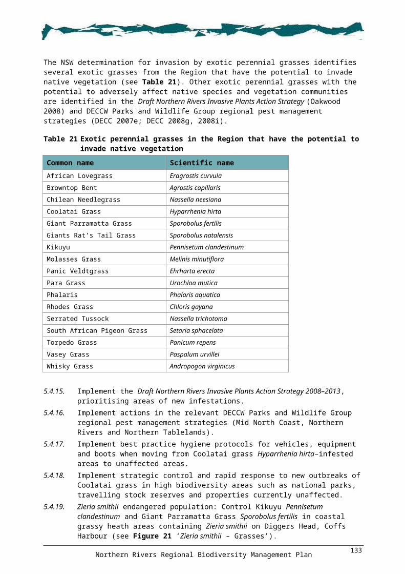
advice on forms of assistance available to landowners to manage biodiversity values (see Appendix 8 on the enclosed CD)
vegetation and other constraint mapping.
19.1.5 Support local governments’ employment of biodiversity education officers to deliver education programs, including but not limited to: provision of information to the community on the benefits of conserving biodiversity
and how groups and individuals can conserve, survey, monitor and sustainably utilise biodiversity in their own area
development of educational materials on best practice guidelines for weed identification, management and control of fire, establishing farm forestry plantations, environmental restoration and threatened species.
19.1.6 Offer training workshops on bush regeneration and biodiversity management to encourage greater community involvement in restoration actions on private and public land.
19.1.7 Develop education and training programs with a focus toward developing community partnerships.
19.1.8 Encourage community groups to consider projects that address multiple species or have connections with other natural resource issues.
Information collation, monitoring and evaluationThe delivery of long-term biodiversity conservation outcomes is reliant upon a number of factors. These include improving the knowledge and understanding of biodiversity throughout the general community; establishing effective monitoring and review processes to ensure that changes in data and knowledge are captured; and ensuring that appropriate research is prioritised to fill data and knowledge gaps.
Various spatial analysis tools, such as DECCW’s Biodiversity Forecasting Tool, have the potential to be used as a monitoring and reporting tool. For example, as updated spatial information becomes available it can be reanalysed to determine the effectiveness of on-ground delivery and prioritisation of areas (provided that on-ground programs are recorded spatially by implementers). These layers can be linked to a data spreadsheet so that the Tool’s spatial outputs and the associated spreadsheet can be used for monitoring, reporting and evaluation. Depending on the availability of data. the Tool also has a function that could be trialled which allows for different management scenarios to be costed and analysed to provide a cost-benefit analysis for the best biodiversity outcome for a given funding allocation.
As part of implementation of this Plan, partners will be encouraged to use standard reporting proformas for on-ground projects and spatial mapping of projects. Accordingly, suitable mechanisms for sharing information on funding, implementation and outcomes of projects are required. The Threatened Species Priorities Action Statement could be used for centralised reporting.
OBJECTIVE 20: To establish effective monitoring of biodiversity-related projects
OUTCOME 20.1: Monitoring and evaluation programs for all biodiversity projects undertaken as part of this Plan are established
ACTIONS: Region
20.1.1 All on-ground projects implemented as part of this Plan should be mapped in a format compatible with geographic information system analysis to allow for updating and re-evaluating of priorities through the Biodiversity Forecasting Tool and also for providing feedback to partners and stakeholders.
Northern Rivers Regional Biodiversity Management Plan138

20.1.2 Outcomes of actions implemented as part of the Plan should be documented and reported to the relevant management body so that adaptive management can be used to improve the success of Plan implementation. The outcomes should also be provided to broader management initiatives such as the NSW Threatened Species Priorities Action Statement, Property Vegetation Plan Developer and Biobanking. Reporting can potentially be part of existing arrangements (e.g. State of the Environment reporting).
20.1.3 Encourage and provide training on survey and monitoring techniques to regional natural resource management staff and local government staff, community groups, landholders and schools.
20.1.4 Develop and assess cultural indicators as part of monitoring the implementation of this Plan.
20.1.5 When developing monitoring and evaluation requirements, take into account existing processes such as Natural Resource Council targets, regional natural resource management reporting requirements, and local, State and Australian government agency reporting requirements.
Northern Rivers Regional Biodiversity Management Plan139

77 Monitoring, evaluation, reporting & improvementMonitoring, evaluation, reporting & improvement Monitoring, evaluation, reporting and improvement (MERI) needs to be an integral component of biodiversity conservation and recovery if intended goals of biodiversity sustainability and improved habitat condition are to be achieved. MERI assists program managers determine if planning goals are being fulfilled by providing feedback which directs improvements in planning, management and implementation, and assists funding bodies to determine whether their resources are being used effectively.
The Plan details performance criteria (see below) that are intended to set a benchmark for implementation of the Plan across three broad categories and to achieve the intended objectives of the Plan listed in Section 1.4. Funding bodies, program managers, implementation groups and the community can use the performance criteria to set MERI questions for projects related to implementing the Plan. Planning processes and programs such as program logic and Miradi™, and websites such as the Nature Conservancy, can assist in developing a MERI program.
Better coordination of recovery efforts across agenciesObjectives / Outcomes
Performance criteria
1.42.13.3, 3.44.1, 4.25.26.2, 6.4, 6.511.1
1. Cross-agency working group is established within one year.2. Formal communication links and information sharing processes have been established
within two years.3. Licensing and approval processes for ecological restoration and environmental burns are
streamlined within five years.4. Resolution, accuracy and consistency of vegetation mapping improved within the life of
the Plan.5. Partnership processes between government agencies, organisations, research bodies
and private landholders have been sought throughout the life of the Plan.6. An integrated spatial pest and weed database has been developed for the Region within
five years of plan commencement.7. A Northern Rivers Fire and Biodiversity Consortium to be established within two years.8. Integrated, efficient, strategic and cross-tenure processes for recovery implementation
have been established during the life of the Plan.
Better engagement with stakeholdersObjectives / Outcomes
Performance criteria
1.12.13.4, 3.54.25.2, 5.3, 5.46.2, 6.3, 6.510.112.118.1, 18.219
9. The number of Indigenous groups implementing the Indigenous Engagement Tool kit increases throughout the life of the Plan.
10. The number of Indigenous groups engaged in Indigenous land use agreements and Indigenous protected areas increases throughout the life of the Plan.
11. The number of Indigenous people engaged in training and employment in biodiversity and cultural management increases throughout the life of the Plan.
12. The number of landholders engaged in private land conservation initiatives increases throughout the life of the Plan.
13. Education programs and provision of on-ground advice are supported throughout the life of the Plan.
14. The uptake of private land conservation mechanisms and incentives increases throughout the life of the Plan.
15. Extent of private land conservation expansion has been mapped and used to reassess priorities after five years from the commencement of the Plan.
Northern Rivers Regional Biodiversity Management Plan140
Better delivery of conservation outcomes and actionsObjectives / Outcomes
Performance criteria
1.1, 1.2, 1.3, 1.43.1, 3.2, 3.3, 3.420.1
1. Conservation and rehabilitation programs within identified priority areas have been undertaken throughout the life of the Plan.
2. Sites to improve flora and fauna connectivity within climate change linkages/corridors are identified and management actions implemented throughout the life of the Plan.
3. Climate change-adaptive management projects are developed and undertaken throughout the life of the Plan.
4. Monitoring programs for planning and implementation strategies, to achieve biodiversity sustainability, have been established within five years.
5. Research programs to inform management of biodiversity have commenced within five years.
6. Government agencies have utilised statutory instruments and this Plan to protect biodiversity and related habitat throughout the life of the Plan.
7. Strategies, plans and market-based initiatives include priority areas, landscapes and features, throughout the life of the Plan.
8. No net loss of biodiversity occurs within the Region during the life of the Plan. 9. No new weeds, pests or diseases establish in the Region during the life of the Plan.
In addition, where any Caring for Our Country funding is obtained to implement actions in the Plan, MERI plans will be prepared and implemented in accordance with the requirements outlined in the Caring for Our Counctry MERI Strategy (see <http://www.nrm.gov.au/public-submissions/draft-strategy.html>).
Northern Rivers Regional Biodiversity Management Plan141
88 Social and Economic ConsequencesSocial and Economic ConsequencesThis regional recovery plan takes into account all listed threatened entities in the Region as described in Section 1.2 and, as such, is a far better and more efficient use of resources in terms of plan preparation and implementation than multiple single-species plans. The Plan not only deals with existing listed threatened entities but also has the potential for future listings to be included through the addition of an addendum to the Plan. This requires minimal additional work to meet the recovery plan requirements of any newly-listed species.
The Plan benefits listed threatened entities in the Region as well as biodiversity more broadly. Actions from this Plan may also be applicable to biodiversity bordering or outside the Region and may assist in recovery programs elsewhere in the State. The approach taken in the preparation of this Plan follows on from the methods used for the Lord Howe Island Biodiversity Management Plan (DECC 2007c), the approved Border Ranges Rainforest Biodiversity Management Plan (DECCW 2010) and ‘Central Coast Biodiversity Management Plan’ (DECCW in prep. a). This has resulted in a cost effective and efficient program for the preparation of this Plan.
It is intended that the Plan be implemented over a ten-year period and the Australian Government will review the Plan after five years. Implementation of priority actions will be guided by a business plan which will be developed after the Plan is formally approved. It is not practical at this point to provide meaningful costing figures for actions given the regional nature of the Plan, the wide scope, and number of actions, the ten-year timeframe, and the fact that funding of actions will be subject to successful funding applications.
The Plan focuses on promoting partnerships and voluntary participation in biodiversity management and is not prescriptive. It is therefore anticipated that there will be no significant adverse social or economic costs associated with the implementation of the Plan, and that the overall benefits of implementation will outweigh any specific costs to society.
8.1.1 Potential partners and affected partiesDeveloping strong partnerships will be a key requirement to the successful implementation of the Plan. Support and assistance from Commonwealth, State and local government agencies, non-government organisations (e.g. Landcare and Coastcare), other community groups, landholders, industry bodies, education institutions, the private sector and individuals with interests in biodiversity conservation will be required. This support will be realised through the partnerships and the provision of services, participation in training and public awareness programs, liaison with other organisations or other relevant contributions.
Such an approach is critical to achieving the objectives of the Plan and to maximising the effectiveness of responses/actions taken individually by each group. Regular communication through the Northern Rivers Regional Steering Committee with representatives of the community, conservation groups, Indigenous groups, scientific interests and other government agencies will be integral to reviewing progress of the Plan.
Developing, supporting and fostering partnerships through implementation strategies and policies with individuals and organisations involved in natural resource management in the Region will assist in the implementation of the Plan. Potential partners include:
Caring for Our Country Industry organisations Environment Trust Local government Non-government organisations, such as Nature Conservation Trust of NSW, EnviTE, Worldwide
Fund for Nature, Conservation Volunteers Australia, Nature Conservation Council, Greening Australia, Landcare and community groups
Northern Rivers Regional Biodiversity Management Plan142

Educational institutions Private landholders and leaseholders Indigenous community groups Local and regional businesses.
Northern Rivers Regional Biodiversity Management Plan143

Appendix 1: Threatened species, populations and Appendix 1: Threatened species, populations and ecological communities addressed by the Planecological communities addressed by the PlanThe tables below list the threatened species, populations and ecological communities covered by this Plan. The status of each threatened species and ecological community relates to its listing under one or more of the following pieces of legislation:
Commonwealth Environment Protection and Biodiversity Conservation Act 1999 (EPBC Act)
NSW Threatened Species Conservation Act 1995 (TSC Act)
NSW Fisheries Management Act 1994 (FM Act).
Abbreviations used to define status are as follows: CE = critically endangered, E = endangered, EP = endangered population and V = vulnerable
Flora
Common name Scientific nameThreatened status
EPBC Act TSC Act FM ActHerb (38): Ancistrachne maidenii Ancistrachne maidenii V
Aromatic Peppercress Lepidium hyssopifolium E E
Austral Toadflax Thesium australe V V
Bailey's Indigo Indigofera baileyi E
Barrington Tops Ant Orchid Chiloglottis platyptera V
Bird Orchid Chiloglottis anaticeps E
Border Ranges Daisy Brachyscome ascendens E
Byron Bay Diuris Diuris sp. aff. chrysantha E
Hawkweed Picris evae V V
Heath Wrinklewort Rutidosis heterogama V V
Large-leafed Monotaxis Monotaxis macrophylla E
Maundia triglochinoides Maundia triglochinoides V
Metcalfe's Greenhood Pterostylis metcalfei E
Mountain Angelica Gingidia montana E E
Mueller's Eyebright Euphrasia collina subsp. muelleri E E
Native Milkwort Polygala linariifolia E
New England Gentian Gentiana wissmannii V V
Noah's False Chickweed Lindernia alsinoides E
Pink Nodding Orchid Geodorum densiflorum E
Polblue Eyebright Euphrasia ciliolata V
Pygmy Bishop's Hat Mitrasacme pygmaea E
Rotala tripartita Rotala tripartita E
Sand Spurge Chamaesyce psammogeton E
Silky Swainson-pea Swainsona sericea V
Silver Sword Lily Neoastelia spectabilis V V
Small Pale Grass-lily Caesia parviflora var. minor E
Small Snake Orchid Diuris pedunculata E E
Square-stemmed Spike-rush Eleocharis tetraquetra E
Stinky Lily Typhonium sp. aff. brownii E
Northern Rivers Regional Biodiversity Management Plan144

Common name Scientific nameThreatened status
EPBC Act TSC Act FM ActSwamp Foxglove Centranthera cochinchinensis E
Sweet False Galium Hedyotis galioides E
Tall Knotweed Persicaria elatior V V
Tangled Bedstraw Galium australe E
Tenterfield Eyebright Euphrasia orthocheila subsp. peraspera E
Trailing Woodruff Asperula asthenes V V
Water Nutgrass Cyperus aquatilis E
Waterwheel Plant Aldrovanda vesiculosa E
Willawarrin Doubletail Diuris disposita E
Ground orchid (8):Brown Fairy-chain Orchid Peristeranthus hillii V
Dark Greenhood Pterostylis nigricans V
Elegant Greenhood Pterostylis elegans V
Lady Tankerville’s Swamp Orchid Phaius tankervilleae E E
Leafless Tongue Orchid Cryptostylis hunteriana V V
Red-flowered King of the Fairies Oberonia titania V
Southern Swamp Orchid Phaius australis E E
Veined Doubletail Diuris venosa V V
Ground fern (2):Fraser's Screw Fern Lindsaea fraseri E
Slender Screw Fern Lindsaea incisa E
Grass (4):Bluegrass Dichanthium setosum V V
Floyd's Grass Alexfloydia repens E
Hairy Jointgrass Arthraxon hispidus V V
Lemon-scented Grass Elyonurus citreus E
Shrub (58):Acalypha Acalypha eremorum E
Backwater Grevillea Grevillea scortechinii subsp. sarmentosa V V
Banksia conferta subsp. conferta Banksia conferta subsp. conferta CE
Banyabba Grevillea Grevillea banyabba V V
Beadle's Grevillea Grevillea beadleana E E
Biconvex Paperbark Melaleuca biconvexa V V
Big Nellie Hakea Hakea archaeoides V V
Bordered Guinea Flower Hibbertia marginata V V
Brush Sauropus Phyllanthus microcladus E
Chambigne Bertya Bertya sp. (Chambigne NR, M. Fatemi 24) E
Coast Headland Pea Pultenaea maritima V
Creek Triplarina Triplarina imbricata E E
Crescent-leaved Homoranthus Homoranthus lunatus V V
Dorrigo Daisy Bush Olearia flocktoniae E E
Dracophyllum macranthum Dracophyllum macranthum V
Floyd's Zieria Zieria floydii E E
Four-tailed Grevillea Grevillea quadricauda V V
Northern Rivers Regional Biodiversity Management Plan145

Common name Scientific nameThreatened status
EPBC Act TSC Act FM ActFragrant Pepperbush Tasmannia glaucifolia V V
Gibraltar Grevillea Grevillea rhizomatosa V V
Gorge Hakea Hakea fraseri V V
Granite Babingtonia Babingtonia granitica V V
Granite Rose Boronia repanda E E
Green Waxberry Gaultheria viridicarpa subsp. viridicarpa V V
Guthrie's Grevillea Grevillea guthrieana E E
Hairy Melichrus Melichrus hirsutus E E
Headland Zieria Zieria prostrata E E
Heart-leaved Star Hair Astrotricha cordata E
Hibbertia superans Hibbertia superans E
Johnson’s Cycad Macrozamia johnsonii E
MacNutt's Wattle Acacia macnuttiana V E
Mason's Grevillea Grevillea masonii E E
Montane Green Five-corners Styphelia perileuca V V
Moonee Quassia Quassia sp. 'Moonee Creek' E E
Mountain Wax-flower Philotheca myoporoides subsp. obovatifolia E
Nabiac Casuarina Allocasuarina simulans V V
Narrow-leaf Melichrus Melichrus sp. 'Gibberagee' E E
Narrow-leaved Bertya Bertya ingramii E E
Narrow-leaved Plectranthus Plectranthus alloplectus E
Native Justicia Calophanoides hygrophiloides E
Nymboida Babingtonia Babingtonia prominens E
Orara Boronia Boronia umbellata V V
Oval-leafed Pseudanthus Pseudanthus ovalifolius E
Pultanea campbellii Pultanea campbellii V
Rainforest Cassia Senna acclinis E
Rupp's Wattle Acacia ruppii E E
Scant Pomaderris Pomaderris queenslandica E
Shannon Creek Boronia Boronia hapalophylla E
Singleton Mint Bush Prostanthera cineolifera V V
Slender Marsdenia Marsdenia longiloba V E
Soft Grevillea Grevillea mollis E E
Spiny Mint-bush Prostanthera spinosa V
Square-stemmed Olax Olax angulata V V
Swamp Mint-bush Prostanthera palustris V V
Tall Velvet Sea-berry Haloragis exalata subsp. velutina V V
Thorny Pea Desmodium acanthocladum V V
Torrington Pea Almaleea cambagei V E
Wollumbin Zieria Zieria adenodonta E
Woodland Babingtonia Babingtonia silvestris E
Small tree (11):Coolabah Bertya Bertya sp. Cobar-Coolabah (Bertya
opponens) V V
Dwarf Heath Casuarina Allocasuarina defungens E E
Glenugie Karaka Corynocarpus rupestris subsp. V V
Northern Rivers Regional Biodiversity Management Plan146

Common name Scientific nameThreatened status
EPBC Act TSC Act FM Actrupestris
Grove's Paperbark Melaleuca groveana V
North Brother Wattle Acacia courtii V V
Pygmy Cypress Pine Callitris oblonga V V
Rusty Plum Amorphospermum whitei V
Silverbush Sophora tomentosa subsp. australis E
Tree Guinea Flower Hibbertia hexandra E
Weeping Paperbark Melaleuca irbyana E
Willi Willi Zieria Zieria lasiocaulis E E
Mallee (5):Barren Mountain Mallee Eucalyptus approximans V
Border Mallee Eucalyptus microcodon E
Gibraltar Mallee Eucalyptus dissita V
Northern Blue Box Eucalyptus magnificata E
Warra Broad-leaved Sally Eucalyptus camphora subsp. relicta E
Tree (12):Banyabba Shiny-barked Gum Eucalyptus pachycalyx subsp.
banyabba E E
Blackbutt Candlebark Eucalyptus rubida subsp. barbigerorum V V
Green-leaved Rose Walnut Endiandra muelleri subsp. bracteata E
Narrow-leaved Black Peppermint Eucalyptus nicholiiV V
Newry Golden Wattle Acacia chrysotricha E
Red Boppel Nut Hicksbeachia pinnatifolia V V
Sandstone Rough-barked Apple Angophora robur V V
Scented Acronychia Acronychia littoralis E E
Slaty Red Gum Eucalyptus glaucina V V
Square-fruited Ironbark Eucalyptus tetrapleura V V
Stinking Cryptocarya Cryptocarya foetida V V
Wallangarra White Gum Eucalyptus scoparia V E
Vine (5):Cryptic Forest Twiner Tylophora woollsii E E
Milky Silkpod Parsonsia dorrigoensis E V
Scrambling Lignum Muehlenbeckia costata V
Tinospora Vine Tinospora smilacina E
White-flowered Wax Plant Cynanchum elegans E E
Epiphytic fern (4):Basket Fern Drynaria rigidula E
Flat Fork Fern Psilotum complanatum E
Lesser Creeping Fern Arthropteris palisotii E
Narrow-leaf Finger Fern Grammitis stenophylla E
Epiphytic orchid (3):Brown Butterfly Orchid Sarcochilus dilatatus E
Ravine Orchid Sarcochilus fitzgeraldii V V
Spider orchid Dendrobium melaleucaphilum E
Northern Rivers Regional Biodiversity Management Plan147

Fauna
Common name Scientific nameThreatened status
EPBC Act TSC Act FM ActINVERTEBRATES 5:
Dragonfly (2):Coastal Petaltail Dragonfly Petalura litorea E
Giant Dragonfly Petalura gigantea E
Moth (3):Black Grass-dart Ocybadistes knightorum E
Laced Fritillary Argyreus hyperbius E
Pink Underwing Moth Phyllodes imperialis southern subspecies E E
FISH 3:
Freshwater fish (3):Eastern Cod Maccullochella ikei E E
Oxleyan Pygmy Perch Nannoperca oxleyana E E
Purple Spotted Gudgen Mogurnda adspersa E
AMPHIBIANS 14:
Ground frog (7):Green and Golden Bell Frog Litoria aurea V E
Green-thighed Frog Litoria brevipalmata V
Olongburra Frog Litoria olongburensis V V
Philoria pughi Philoria pughi E
Pouched Frog Assa darlingtoni V
Sphagnum Frog Philoria sphagnicolus V
Wallum Froglet Crinia tinnula V
Stream frog (7):Booroolong Frog Litoria booroolongensis E E
Davies Tree Frog Litoria daviesae V
Giant Barred Frog Mixophyes iteratus E E
Glandular Frog Litoria subglandulosa V
Peppered Frog Litoria piperata V V
Stuttering Barrred Frog Mixophyes balbus V E
Yellow-spotted Bell Frog Litoria castanea E E
REPTILES 9:
Freshwater turtle (1):Bellinger River Emydura Emydura macquarii (Bellinger River
Form) V V
Lizard (2):Border Thick-tailed Gecko Underwoodisaurus sphyrurus V V
Three-toed Snake-tooth Skink Coeranoscincus reticulatus V V
Marine turtle (3):Green Turtle Chelonia mydas V V
Leathery Turtle Dermochelys coriacea E V
Northern Rivers Regional Biodiversity Management Plan148

Common name Scientific nameThreatened status
EPBC Act TSC Act FM ActLoggerhead Turtle Caretta caretta E E
Snake (3):Pale-headed Snake Hoplocephalus bitorquatus V
Stephens' Banded Snake Hoplocephalus stephensii V
White-crowned Snake Cacophis harriettae V
BIRDS 62:
Forest bird (13):Barred Cuckoo-shrike Coracina lineata V
Collared Kingfisher Todiramphus chloris V
Glossy Black-cockatoo Calyptorhynchus lathami V
Mangrove Honeyeater Lichenostomus fasciogularis V
Olive Whistler Pachycephala olivacea V
Painted Honeyeater Grantiella picta V
Red-tailed Black-Cockatoo Calyptorhynchus banksii E V
Regent Honeyeater Xanthomyza phrygia E E
Rose-crowned Fruit-dove Ptilinopus regina V
Rufous Scrub-bird Atrichornis rufescens V
Superb Fruit-dove Ptilinopus superbus V
White-eared Monarch Monarcha leucotis V
Wompoo Fruit-dove Ptilinopus magnificus V
Ground bird (4):Beach Stone-curlew Esacus neglectus E
Bush Stone-curlew Burhinus grallarius E
Bush-hen Amaurornis olivaceus V
Eastern Ground Parrot Pezoporus wallicus wallicus V
Marine bird (9):Flesh-footed Shearwater Puffinus carneipes V
Gould's Petrel Pterodroma leucoptera leucoptera E E
Grey Ternlet Procelsterna cerulea V
Little Shearwater Puffinus assimilis V
Little Tern Sterna albifrons E
Pied Oystercatcher Haematopus longirostris V
Sooty Oystercatcher Haematopus fuliginosus V
Sooty Tern Sterna fuscata V
White Tern Gygis alba V
Nocturnal raptor (5):Barking Owl Ninox connivens V
Grass Owl Tyto capensis V
Masked Owl Tyto novaehollandiae V
Powerful Owl Ninox strenua V
Sooty Owl Tyto tenebricosa V
Raptor (4):Grey Falcon Falco hypoleucos V
Osprey Pandion haliaetus V
Red Goshawk Erythrotriorchis radiatus V E
Northern Rivers Regional Biodiversity Management Plan149

Common name Scientific nameThreatened status
EPBC Act TSC Act FM ActSquare-tailed Kite Lophoictinia isura V
Wading bird (7):Black-tailed Godwit Limosa limosa V
Broad-billed Sandpiper Limicola falcinellus V
Great Knot Calidris tenuirostris V
Greater Sand-plover Charadrius leschenaultii V
Lesser Sand-plover Charadrius mongolus V
Sanderling Calidris alba V
Terek Sandpiper Xenus cinereus V
Wetland bird (11):Australasian Bittern Botaurus poiciloptilus V
Black Bittern Ixobrychus flavicollis V
Black-necked Stork Ephippiorhynchus asiaticus E
Blue-billed Duck Oxyura australis V
Brolga Grus rubicunda V
Comb-crested Jacana Irediparra gallinacea V
Cotton Pygmy-goose Nettapus coromandelianus E
Freckled Duck Stictonetta naevosa V
Magpie Goose Anseranas semipalmata V
Painted Snipe Rostratula benghalensis V E
Red-backed Button-quail Turnix maculosa V
Woodland bird (9):Black-chinned Honeyeater (eastern subspecies)
Melithreptus gularis gularis V
Brown Treecreeper (eastern subspecies)
Climacteris picumnus victoriae V
Diamond Firetail Stagonopleura guttata V
Grey-crowned Babbler (eastern subspecies)
Pomatostomus temporalis temporalis V
Hooded Robin (south-eastern form) Melanodryas cucullata cucullata V
Speckled Warbler Pyrrholaemus sagitatus V
Superb Parrot Polytelis swainsonii V V
Swift Parrot Lathamus discolor E E
Turquoise Parrot Neophema pulchella V
MAMMALS 30:
Aboreal mammal (4):Eastern Pygmy-possum Cercartetus nanus V
Koala Phascolarctos cinereus V
Squirrel Glider Petaurus norfolcensis V
Yellow-bellied Glider Petaurus australis V
Bat (15):Beccari's Freetail-bat Mormopterus beccarii V
Common Blossom-bat Syconycteris australis V
Eastern Bentwing-bat Miniopterus schreibersii oceanensis V
Eastern Cave Bat Vespadelus troughtoni V
Eastern False Pipistrelle Falsistrellus tasmaniensis V
Northern Rivers Regional Biodiversity Management Plan150

Common name Scientific nameThreatened status
EPBC Act TSC Act FM ActEastern Freetail-bat Mormopterus norfolkensis V
Eastern Long-eared Bat Nyctophilus bifax V
Golden-tipped Bat Kerivoula papuensis V
Greater Broad-nosed Bat Scoteanax rueppellii V
Grey-headed Flying-fox Pteropus poliocephalus V V
Hoary Wattled Bat Chalinolobus nigrogriseus V
Large-eared Pied Bat Chalinolobus dwyeri V V
Large-footed Myotis Myotis adversus V
Little Bentwing-bat Miniopterus australis V
Yellow-bellied Sheathtail-bat Saccolaimus flaviventris V
Dasyurid (4):Brush-tailed Phascogale Phascogale tapoatafa V
Common Planigale Planigale maculata V
Eastern Quoll Dasyurus viverrinus E
Spotted-tailed Quoll Dasyurus maculatus E V
Macropod (5):Brush-tailed Rock-wallaby Petrogale penicillata V E
Long-nosed Potoroo Potorous tridactylus V V
Parma Wallaby Macropus parma V
Red-legged Pademelon Thylogale stigmatica V
Rufous Bettong Aepyprymnus rufescens V
Rodent (2):Eastern Chestnut Mouse Pseudomys gracilicaudatus V
Hastings River Mouse Pseudomys oralis E E
Populations
Common name Scientific nameThreatened status
EPBC Act TSC Act FM ActZieria smithii population at Diggers Head
Zieria smithii population at Diggers Head EP
Nambucca Glycine population in the Nambucca LGA
Glycine clandestina population in the Nambucca LGA EP
Tusked Frog population in the Nandewar and New England Tablelands Bioregions
Adelotus brevis population in the Nandewar and New England Tablelands Bioregions
EP
Emu population in the NSW North Coast Bioregion and Port Stephens LGA
Dromaius novaehollandiae population in the NSW North Coast Bioregion and Port Stephens LGA
EP
Long-nosed Potoroo population at Cobaki Lakes and Tweed Heads West
Long-nosed potoroo population at Cobaki Lakes and Tweed Heads West
EP
Northern Rivers Regional Biodiversity Management Plan151

Ecological communities
Common nameThreatened status
EPBC Act TSC Act FM ActByron Bay Dwarf Graminoid Clay Heath Community E
Coastal Cypress Pine Forest in the NSW North Coast Bioregion E
Coastal Saltmarsh in the NSW North Coast, Sydney Basin and South East Corner Bioregions E
Freshwater wetlands on Coastal Floodplains of the NSW North Coast, Sydney Basin and South East Corner Bioregions E
Littoral Rainforest and Coastal Vine Thickets of Eastern Australia CE
Littoral Rainforest in the NSW North Coast, Sydney Basin and South East Corner Bioregions E
Lowland Rainforest in NSW North Coast and Sydney Basin Bioregion E
Lowland Rainforest on Floodplain in the NSW North Coast Bioregion E
Montane Peatlands and Swamps of the New England Tableland, NSW North Coast, Sydney Basin, South East Corner, South Eastern Highlands and Australian Alps Bioregions
E
New England Peppermint (Eucalyptus nova-anglica) Woodland on Basalts and Sediments in the New England Tableland Bioregion E
Ribbon Gum, Mountain Gum, Snow Gum Grassy Forest/Woodland of the New England Tableland Bioregion E
Sub-tropical Coastal Floodplain Forest of the NSW North Coast Bioregion E
Swamp Oak Floodplain Forest of the NSW North Coast, Sydney Basin and South East Corner Bioregions E
Swamp Sclerophyll Forest on Coastal Floodplains of the NSW North Coast, Sydney Basin and South East Corner Bioregions E
Themeda Grassland on Seacliffs and Coastal Headlands in the NSW North Coast, Sydney Basin and South East Corner Bioregions E
Upland Wetlands of the Drainage Divide of the New England Tableland Bioregion E
Upland Wetlands of the New England Tablelands and the Monaro Plateau E
White Box Yellow Box Blakely's Red Gum Woodland E
White Box – Yellow Box – Blakely's Red Gum Grassy Woodland and Derived Native Grassland CE
White Gum Moist Forest in the NSW North Coast Bioregion E
Northern Rivers Regional Biodiversity Management Plan152

Appendix 19 Threatened species action summaryAppendix 19 Threatened species action summaryThis table summarises which objectives address recovery actions for the listed threatened species, populations and communities addressed by this Plan. Note that Objectives 18, 19 and 20 address all listed entities and therefore are not included on the table.
Flora1
Clim
ate
chan
ge2
Dec
isio
n m
akin
g3
Cle
arin
g an
d fr
agm
enta
tion
4 Fi
re re
gim
es5
Wee
ds6
Pest
s7
Fore
stry
8 D
ieba
ck9
Wat
er q
ualit
y10
Aqu
atic
hab
itats
11 D
isea
se a
nd p
atho
gens
12 H
uman
dis
turb
ance
13 D
omes
tic li
vest
ock
14 C
hem
ical
pol
lutio
n15
Pes
t con
trol
16 W
aste
mat
eria
l17
Dem
ogra
phic
Effe
cts
Herb (38): Ancistrachne maidenii Ancistrachne maidenii x x x x x xAromatic Peppercress Lepidium hyssopifolium x x xAustral Toadflax Thesium australe x x x x x x xBailey's Indigo Indigofera baileyi x x x x x xBarrington Tops Ant Orchid Chiloglottis platyptera x x x x xBird Orchid Chiloglottis anaticeps x x x x x x x xBorder Ranges Daisy Brachyscome ascendens x x x x x xByron Bay Diuris Diuris sp. aff. chrysantha x x x x x x x xHawkweed Picris evae x x x xHeath Wrinklewort Rutidosis heterogama x x x x x xLarge-leafed Monotaxis Monotaxis macrophylla x x x xMaundia triglochinoides Maundia triglochinoides x x x x x xMetcalfe's Greenhood Pterostylis metcalfei x x x xMountain Angelica Gingidia montana x x x xMueller's Eyebright Euphrasia collina subsp.
muelleri x
Native Milkwort Polygala linariifolia x x x x x x x x xNew England Gentian Gentiana wissmannii x x x x x xNoah's False Chickweed Lindernia alsinoides x x x x x xPink Nodding Orchid Geodorum densiflorum x x x x x xPolblue Eyebright Euphrasia ciliolata x x x x x xPygmy Bishop's Hat Mitrasacme pygmaea x x x x xRotala tripartita Rotala tripartita x x x x x xSand Spurge Chamaesyce psammogeton x x x xSilky Swainson-pea Swainsona sericea x x x x x xSilver Sword Lily Neoastelia spectabilis x x x xSmall Pale Grass-lily Caesia parviflora var. minor x x x x x x x xSmall Snake Orchid Diuris pedunculata x x x x x x x xSquare-stemmed Spike-rush Eleocharis tetraquetra x x x x x x x x
Northern Rivers Regional Biodiversity Management Plan153

FloraObjective
1 2 3 4 5 6 7 8 9 10 11 12 13
Stinky Lily Typhonium sp. aff. brownii x x x x x xSwamp Foxglove Centranthera cochinchinensis x x x x xSweet False Galium Hedyotis galioides x x x x x xTall Knotweed Persicaria elatior x x x xTangled Bedstraw Galium australe x x x x xTenterfield Eyebright Euphrasia orthocheila subsp.
peraspera x x x x x
Trailing Woodruff Asperula asthenes x x x x xWater Nutgrass Cyperus aquatilis x x x xWaterwheel Plant Aldrovanda vesiculosa x x x x x x xWillawarrin Doubletail Diuris disposita x x x x x x x
Ground orchid (8):Brown Fairy-chain Orchid Peristeranthus hillii x x x xDark Greenhood Pterostylis nigricans x x x x xElegant Greenhood Pterostylis elegans x x x x x x xLady Tankerville’s Swamp Orchid
Phaius tankervilleae x x x x x x x
Leafless Tongue Orchid Cryptostylis hunteriana x x x xRed-flowered King of the Fairies
Oberonia titania x x x x
Southern Swamp Orchid Phaius australis x x x x x x xVeined Doubletail Diuris venosa x x x x
Ground fern (2):Fraser's Screw Fern Lindsaea fraseri x x x x x xSlender Screw Fern Lindsaea incisa x x x x x x x
Grass (4):Bluegrass Dichanthium setosum x x x x x x xFloyd's Grass Alexfloydia repens x x x x x x x xHairy Jointgrass Arthraxon hispidus x x x x x xLemon-scented Grass Elyonurus citreus x x x x x x x
Shrub (58):Acalypha Acalypha eremorum x x x x x xBackwater Grevillea Grevillea scortechinii subsp.
sarmentosa x x x x x x x
Banksia conferta subsp. conferta
Banksia conferta subsp. conferta x x x x
Banyabba Grevillea Grevillea banyabba x x x xBeadle's Grevillea Grevillea beadleana x x x x x xBiconvex Paperbark Melaleuca biconvexa x x x x x x xBig Nellie Hakea Hakea archaeoides x x x xBordered Guinea Flower Hibbertia marginata x x x x x x xBrush Sauropus Phyllanthus microcladus x x x x x x
Chambigne Bertya Bertya sp. (Chambigne NR, M. Fatemi 24) x x x x x
Northern Rivers Regional Biodiversity Management Plan154

FloraObjective
1 2 3 4 5 6 7 8 9 10 11 12 13
Coast Headland Pea Pultenaea maritima x x x x xCreek Triplarina Triplarina imbricata x x x x x x xCrescent-leaved Homoranthus
Homoranthus lunatus x x x x x
Dorrigo Daisy Bush Olearia flocktoniae x x x x x x x xDracophyllum macranthum Dracophyllum macranthum x x x x x x xFloyd's Zieria Zieria floydii x x x x xFour-tailed Grevillea Grevillea quadricauda x x x x xFragrant Pepperbush Tasmannia glaucifolia x x x x x x x x x xGibraltar Grevillea Grevillea rhizomatosa x x x xGorge Hakea Hakea fraseri x x x x xGranite Babingtonia Babingtonia granitica x x x x xGranite Rose Boronia repanda x x x xGreen Waxberry Gaultheria viridicarpa subsp.
viridicarpa x x x x
Guthrie's Grevillea Grevillea guthrieana x x x x xHairy Melichrus Melichrus hirsutus x x x x xHeadland Zieria Zieria prostrata x x x x xHeart-leaved Star Hair Astrotricha cordata x x x x xHibbertia superans Hibbertia superans x x x xJohnson’s Cycad Macrozamia johnsonii x x x x xMacNutt's Wattle Acacia macnuttiana x x x x x xMason's Grevillea Grevillea masonii x x x x x xMontane Green Five-corners Styphelia perileuca x x x x x x xMoonee Quassia Quassia sp. 'Moonee Creek' x x x x x xMountain Wax-flower Philotheca myoporoides
subsp. obovatifolia x x x x
Nabiac Casuarina Allocasuarina simulans x x x x xNarrow-leaf Melichrus Melichrus sp. 'Gibberagee' x x x x x xNarrow-leaved Bertya Bertya ingramii x x x x xNarrow-leaved Plectranthus Plectranthus alloplectus x x x x x xNative Justicia Calophanoides hygrophiloides x x x x x xNymboida Babingtonia Babingtonia prominens x x x x x xOrara Boronia Boronia umbellata x x x x x xOval-leafed Pseudanthus Pseudanthus ovalifolius x x x x xPultanea campbellii Pultanea campbellii xRainforest Cassia Senna acclinis x x x x xRupp's Wattle Acacia ruppii x x x x xScant Pomaderris Pomaderris queenslandica x x x xShannon Creek Boronia Boronia hapalophylla x x x x xSingleton Mint Bush Prostanthera cineolifera x x x xSlender Marsdenia Marsdenia longiloba x x x x x x xSoft Grevillea Grevillea mollis x x x xSpiny Mint-bush Prostanthera spinosa x x x x x xSquare-stemmed Olax Olax angulata x x x x x xSwamp Mint-bush Prostanthera palustris x x x xTall Velvet Sea-berry Haloragis exalata subsp.
velutina x x x x x
Northern Rivers Regional Biodiversity Management Plan155

FloraObjective
1 2 3 4 5 6 7 8 9 10 11 12 13
Thorny Pea Desmodium acanthocladum x x x x x xTorrington Pea Almaleea cambagei x x x x x x xWollumbin Zieria Zieria adenodonta x x x x xWoodland Babingtonia Babingtonia silvestris x x x x x x
Small tree (11):Coolabah Bertya Bertya sp. Cobar-Coolabah
(Bertya opponens) x x x x x x x
Dwarf Heath Casuarina Allocasuarina defungens x x x xGlenugie Karaka Corynocarpus rupestris
subsp. rupestris x x x x x
Grove's Paperbark Melaleuca groveana x x x x x xNorth Brother Wattle Acacia courtii x x x x xPygmy Cypress Pine Callitris oblonga x x x x x x x x xRusty Plum Amorphospermum whitei x x x x x xSilverbush Sophora tomentosa subsp.
australis x x x x x
Tree Guinea Flower Hibbertia hexandra x x x x xWeeping Paperbark Melaleuca irbyana x x x x x x xWilli Willi Zieria Zieria lasiocaulis x x x x x x x
Mallee (5):Barren Mountain Mallee Eucalyptus approximans x x x x xBorder Mallee Eucalyptus microcodon x x x x xGibraltar Mallee Eucalyptus dissita x x x x xNorthern Blue Box Eucalyptus magnificata x x x x xWarra Broad-leaved Sally Eucalyptus camphora subsp.
relicta x x x x x x
Tree (12):Banyabba Shiny-barked Gum Eucalyptus pachycalyx subsp.
banyabba x x x x
Blackbutt Candlebark Eucalyptus rubida subsp. barbigerorum x x x x x
Green-leaved Rose Walnut Endiandra muelleri subsp. bracteata x x x x x
Narrow-leaved Black Peppermint
Eucalyptus nicholii x x x x x x x
Newry Golden Wattle Acacia chrysotricha x x x x x xRed Boppel Nut Hicksbeachia pinnatifolia x x x x xSandstone Rough-barked Apple
Angophora robur x x x x x
Scented Acronychia Acronychia littoralis x x x x x xSlaty Red Gum Eucalyptus glaucina x x x x xSquare-fruited Ironbark Eucalyptus tetrapleura x x x x x x xStinking Cryptocarya Cryptocarya foetida x x x x x xWallangarra White Gum Eucalyptus scoparia x x x x
Vine (5):Cryptic Forest Twiner Tylophora woollsii x x x x x x x x xMilky Silkpod Parsonsia dorrigoensis x x x x xScrambling Lignum Muehlenbeckia costata x x x x x
Northern Rivers Regional Biodiversity Management Plan156

FloraObjective
1 2 3 4 5 6 7 8 9 10 11 12 13
Tinospora Vine Tinospora smilacina x x x x x xWhite-flowered Wax Plant Cynanchum elegans x x x x x x x x
Epiphytic fern (4):Basket Fern Drynaria rigidula x x x x x xFlat Fork Fern Psilotum complanatum x x x xLesser Creeping Fern Arthropteris palisotii x x x xNarrow-leaf Finger Fern Grammitis stenophylla x x x
Epiphytic orchid (3):Brown Butterfly Orchid Sarcochilus dilatatus x x x x x xRavine Orchid Sarcochilus fitzgeraldii x x x x xSpider orchid Dendrobium melaleucaphilum x x x x x x
Fauna
Objective
1 C
limat
e ch
ange
2 D
ecis
ion
mak
ing
3 C
lear
ing
and
frag
men
tatio
n4
Fire
regi
mes
5 W
eeds
6 Pe
sts
7 Fo
rest
ry8
Die
back
9 W
ater
qua
lity
10 A
quat
ic h
abita
ts11
Dis
ease
and
pat
hoge
ns12
Hum
an d
istu
rban
ce13
Dom
estic
live
stoc
k14
Che
mic
al p
ollu
tion
15 P
est c
ontr
ol16
Was
te m
ater
ial
17 D
emog
raph
ic E
ffect
s
Invertebrates (5):Dragonfly (2):Coastal Petaltail Dragonfly Petalura litorea x x x x xGiant Dragonfly Petalura gigantea x x x x x
Moth (3):Black Grass-dart Ocybadistes knightorum x x x x x x xLaced Fritillary Argyreus hyperbius x x x x xPink Underwing Moth Phyllodes imperialis southern
subspecies x x x x x
Fish (3):Freshwater fish (3):Eastern Cod Maccullochella ikei x x x x x x xOxleyan Pygmy Perch Nannoperca oxleyana x x x x x x x
Northern Rivers Regional Biodiversity Management Plan157

FaunaObjective
Purple Spotted Gudgen Mogurnda adspersa x x x x x x
Amphibians (14): Ground frog (7):Green and Golden Bell Frog Litoria aurea x x x x x xGreen-thighed Frog Litoria brevipalmata x x x x x x xOlongburra Frog Litoria olongburensis x x x x x xPhiloria pughi Philoria pughi x x x x x x x x xPouched Frog Assa darlingtonii x x x x x xSphagnum Frog Philoria sphagnicolus x x x x xWallum Froglet Crinia tinnula x x x x x x x
Stream frog (7):Booroolong Frog Litoria booroolongensis x x x x x xDavies Tree Frog Litoria daviesae x x x x x x x xGiant Barred Frog Mixophyes iteratus x x x x x x xGlandular Frog Litoria subglandulosa x x x x x x xPeppered Frog Litoria piperata x x x x xStuttering Barrred Frog Mixophyes balbus x x x x x x xYellow-spotted Bell Frog Litoria castanea x x x x x
Reptiles (9):Freshwater turtle (1):Bellinger River Emydura Emydura macquarii (Bellinger
River Form) x x x x
Lizard (2):Border Thick-tailed Gecko Underwoodisaurus sphyrurus x x x x x xThree-toed Snake-tooth Skink Coeranoscincus reticulatus x x x x x x
Marine turtle (3):Green Turtle Chelonia mydas x x x x xLeathery Turtle Dermochelys coriacea x x x x xLoggerhead Turtle Caretta caretta x x x x x
Snake (3):Pale-headed Snake Hoplocephalus bitorquatus x x x x x x x xStephens' Banded Snake Hoplocephalus stephensii x x x x x x x xWhite-crowned Snake Cacophis harriettae x x x x x x x
Birds (62):Forest bird (13):Barred Cuckoo-shrike Coracina lineata x x x x xCollared Kingfisher Todiramphus chloris x x x x x xGlossy Black-cockatoo Calyptorhynchus lathami x x x x x x x xMangrove Honeyeater Lichenostomus fasciogularis x x x x x xOlive Whistler Pachycephala olivacea x x x x x xPainted Honeyeater Grantiella picta x x x x xRed-tailed Black-Cockatoo Calyptorhynchus banksii x x x x x x xRegent Honeyeater Xanthomyza phrygia x x x x x
Northern Rivers Regional Biodiversity Management Plan158

FaunaObjective
Rose-crowned Fruit-dove Ptilinopus regina x x x x x xRufous Scrub-bird Atrichornis rufescens x x x x x x x xSuperb Fruit-dove Ptilinopus superbus x x x x x xWhite-eared Monarch Monarcha leucotis x x x x x xWompoo Fruit-dove Ptilinopus magnificus x x x x x x
Ground bird (4):Beach Stone-curlew Esacus neglectus x x x x xBush Stone-curlew Burhinus grallarius x x x x x x xBush-hen Amaurornis olivaceus x x x x x x x xEastern Ground Parrot Pezoporus wallicus wallicus x x x x x x x
Marine bird (9):Flesh-footed Shearwater Puffinus carneipes x x xGould's Petrel Pterodroma leucoptera
leucoptera x x x
Grey Ternlet Procelsterna cerulea x x xLittle Shearwater Puffinus assimilis x x xLittle Tern Sterna albifrons x x x x x xPied Oystercatcher Haematopus longirostris x x x x xSooty Oystercatcher Haematopus fuliginosus x x x x xSooty Tern Sterna fuscata x xWhite Tern Gygis alba x x x x
Nocturnal raptor (5):Barking Owl Ninox connivens x x x x x x xGrass Owl Tyto capensis x x x x x x xMasked Owl Tyto novaehollandiae x x x x x xPowerful Owl Ninox strenua x x x x x x xSooty Owl Tyto tenebricosa x x x x x x x
Raptor (4):Grey Falcon Falco hypoleucos x x x x xOsprey Pandion haliaetus x x x xRed Goshawk Erythrotriorchis radiatus x x x x x x xSquare-tailed Kite Lophoictinia isura x x x x x x
Wading bird (7):Black-tailed Godwit Limosa limosa x x x x xBroad-billed Sandpiper Limicola falcinellus x x x x xGreat Knot Calidris tenuirostris x x x x x x xGreater Sand-plover Charadrius leschenaultii x x x x x x xLesser Sand-plover Charadrius mongolus x x x x x x xSanderling Calidris alba x x x x x x xTerek Sandpiper Xenus cinereus x x x x x
Wetland bird (11):Australasian Bittern Botaurus poiciloptilus x x x x x x x xBlack Bittern Ixobrychus flavicollis x x x x x xBlack-necked Stork Ephippiorhynchus asiaticus x x x x x x xBlue-billed Duck Oxyura australis x x x x x x x xBrolga Grus rubicunda x x x x x x x
Northern Rivers Regional Biodiversity Management Plan159

FaunaObjective
Comb-crested Jacana Irediparra gallinacea x x x x x xCotton Pygmy-goose Nettapus coromandelianus x x x x x x xFreckled Duck Stictonetta naevosa x x x x x xMagpie Goose Anseranas semipalmata x x x x x x x xPainted Snipe Rostratula benghalensis x x x x x x x xRed-backed Button-quail Turnix maculosa x x x x x x x x
Woodland bird (9):Black-chinned Honeyeater (eastern subspecies)
Melithreptus gularis gularis x x x x x
Brown Treecreeper (eastern subspecies)
Climacteris picumnus victoriae x x x x x x x x
Diamond Firetail Stagonopleura guttata x x x x x x xGrey-crowned Babbler (eastern subspecies)
Pomatostomus temporalis temporalis x x x x x x
Hooded Robin (south-eastern form)
Melanodryas cucullata cucullata x x x x x x
Speckled Warbler Pyrrholaemus sagitatus x x x x x xSuperb Parrot Polytelis swainsonii x x x x x xSwift Parrot Lathamus discolor x x x x xTurquoise Parrot Neophema pulchella x x x x x x
Mammals (30):Aboreal mammal (4):Eastern Pygmy-possum Cercartetus nanus x x x x x x x xKoala Phascolarctos cinereus x x x x x x x x xSquirrel Glider Petaurus norfolcensis x x x x x x xYellow-bellied Glider Petaurus australis x x x x x x x
Bat (15):Beccari's Freetail-bat Mormopterus beccarii x x x x x x x xCommon Blossom-bat Syconycteris australis x x x x xEastern Bentwing-bat Miniopterus schreibersii
oceanensis x x x x x x x
Eastern Cave Bat Vespadelus troughtoni x x x x x x x x xEastern False Pipistrelle Falsistrellus tasmaniensis x x x x x xEastern Freetail-bat Mormopterus norfolkensis x x x x x x xEastern Long-eared Bat Nyctophilus bifax x x x x x x x xGolden-tipped Bat Kerivoula papuensis x x x x x xGreater Broad-nosed Bat Scoteanax rueppellii x x x x x x xGrey-headed Flying-fox Pteropus poliocephalus x x x x xHoary Wattled Bat Chalinolobus nigrogriseus x x x x x x x xLarge-eared Pied Bat Chalinolobus dwyeri x x x x x x x xLarge-footed Myotis Myotis adversus x x x x x x x xLittle Bentwing-bat Miniopterus australis x x x x x x xYellow-bellied Sheathtail-bat Saccolaimus flaviventris x x x x x
Dasyurid (4):Brush-tailed Phascogale Phascogale tapoatafa x x x x x x x xCommon Planigale Planigale maculata x x x x x xEastern Quoll Dasyurus viverrinus x x
Northern Rivers Regional Biodiversity Management Plan160

FaunaObjective
Spotted-tailed Quoll Dasyurus maculatus x x x x x x x
Macropod (5):Brush-tailed Rock-wallaby Petrogale penicillata x x x x x x xLong-nosed Potoroo Potorous tridactylus x x x x x x x x xParma Wallaby Macropus parma x x x x x x xRed-legged Pademelon Thylogale stigmatica x x x x x x xRufous Bettong Aepyprymnus rufescens x x x x x x x
Rodent (2):Eastern Chestnut Mouse Pseudomys gracilicaudatus x x x x x xHastings River Mouse Pseudomys oralis x x x x x x x x x
Populations
Objective
1 C
limat
e ch
ange
2 D
ecis
ion
mak
ing
3 C
lear
ing
and
frag
men
tatio
n4
Fire
regi
mes
5 W
eeds
6 Pe
sts
7 Fo
rest
ry8
Die
back
9 W
ater
qua
lity
10 A
quat
ic h
abita
ts11
Dis
ease
and
pat
hoge
ns12
Hum
an d
istu
rban
ce13
Dom
estic
live
stoc
k14
Che
mic
al p
ollu
tion
15 P
est c
ontr
ol16
Was
te m
ater
ial
17 D
emog
raph
ic E
ffect
s
Zieria smithii population at Diggers Head
Zieria smithii population at Diggers Head x x x x x x x
Nambucca Glycine population in the Nambucca LGA
Glycine clandestina population in the Nambucca LGA
x x x x x x
Tusked Frog population in the Nandewar and New England Tablelands Bioregions
Adelotus brevis population in the Nandewar and New England Tablelands Bioregions
x x x x x x x
Emu population in the NSW North Coast Bioregion and Port Stephens LGA
Dromaius novaehollandiae population in the NSW North Coast Bioregion and Port Stephens LGA
x x x x x x
Long-nosed potoroo population at Cobaki Lakes and Tweed Heads West
Long-nosed potoroo population at Cobaki Lakes and Tweed Heads West
x x x x x x
Northern Rivers Regional Biodiversity Management Plan161

Ecological communities
Objective
1 C
limat
e ch
ange
2 D
ecis
ion
mak
ing
3 C
lear
ing
and
frag
men
tatio
n4
Fire
regi
mes
5 W
eeds
6 Pe
sts
7 Fo
rest
ry8
Die
back
9 W
ater
qua
lity
10 A
quat
ic h
abita
ts11
Dis
ease
and
pat
hoge
ns12
Hum
an d
istu
rban
ce13
Dom
estic
live
stoc
k14
Che
mic
al p
ollu
tion
15 P
est c
ontr
ol16
Was
te m
ater
ial
17 D
emog
raph
ic E
ffect
s
Byron Bay Dwarf Graminoid Clay Heath Community x x x x x x x xCoastal Cypress Pine Forest in the NSW North Coast Bioregion x x x x x x
Coastal Saltmarsh in the NSW North Coast, Sydney Basin and South East Corner Bioregions x x x x x x x x x x
Freshwater wetlands on coastal floodplains of the NSW North Coast, Sydney Basin and South East Corner Bioregions x x x x x x x x x x x
Littoral Rainforest and Coastal Vine Thickets of Eastern Australia x x x x x x x x x x
Littoral Rainforest in the NSW North Coast, Sydney Basin and South East Corner Bioregions x x x x x x x x x x
Lowland Rainforest in NSW North Coast and Sydney Basin Bioregion x x x x x x x x
Lowland Rainforest on Floodplain in the New South Wales North Coast Bioregion x x x x x x x x x x
Montane Peatlands and Swamps of the New England Tableland, NSW North Coast, Sydney Basin, South East Corner, South Eastern Highlands and Australian Alps
x x x x x x x x x x x
New England Peppermint (Eucalyptus nova-anglica) Woodland on Basalts and Sediments in the New England Tableland Bioregion
x x x x x x x x
Ribbon Gum, Mountain Gum, Snow Gum Grassy Forest/Woodland of the New England Tableland Bioregion x x x x x x x x
Sub-tropical Coastal Floodplain Forest of the NSW North Coast Bioregion x x x x x x x x x x
Swamp oak floodplain forest of the NSW North Coast, Sydney Basin and South East Corner Bioregions x x x x x x x x x x x x
Swamp sclerophyll forest on coastal floodplains of the NSW North Coast, Sydney Basin and South East Corner Bioregions x x x x x x x x x x x x
Themeda grassland on seacliffs and coastal headlands in the NSW North Coast, Sydney Basin and South East Corner Bioregions
x x x x x
Upland Wetlands of the Drainage Divide of the New England Tableland Bioregion x x x x x x x x x x x
Upland Wetlands of the New England Tablelands and the Monaro Plateau x x x x x x x x x x x
White Box Yellow Box Blakely's Red Gum Woodland x x x x x x x xWhite Box-Yellow Box-Blakely's Red Gum Grassy Woodland and Derived Native Grassland x x x x x x x x
White Gum Moist Forest in the NSW North Coast Bioregion x x x x x x x x x
Northern Rivers Regional Biodiversity Management Plan162

Acronyms and key termsAcronyms and key termsCAMBA China–Australia Migratory Bird Agreement
CD Compact disk
CMA Catchment management authority
DECCW Department of Environment, Climate Change and Water (NSW)
DVD Digital versatile disk
EPBC Act Environment Protection and Biodiversity Conservation Act 1979
FM Act Fisheries Management Act 1994
ha hectare
IBRA Interim bioregionalisation for Australia
JAMBA Japan–Australia Migratory Bird Agreement
NSW New South Wales
ROKAMBA Republic of Korea–Australia Migratory Bird Agreement
TAP Threat abatement plan
TSC Act Threatened Species Conservation Act 1995
WHA World heritage area
‘the Plan’ the Northern Rivers Regional Biodiversity Management Plan
‘the Region’ the Northern Rivers Region (as defined in Section 1.2)
‘threatened entities’ threatened species, populations and ecological communities
‘private and other Crown lands’ all lands other than that within Forests NSW or National Parks and Wildlife estate
Northern Rivers Regional Biodiversity Management Plan163

ReferencesReferencesAdam, P 1987, New South Wales Rainforests: the Nomination for the World Heritage List, New
South Wales National Parks and Wildlife Service, Sydney.
Adam, P 1994, Australian Rainforests, Oxford University Press, Melbourne.
Agriculture and Resource Management Council of Australia and New Zealand, Australian and New Zealand Environment and Conservation Council, and Forestry Ministers 2000a, Weeds of National Significance Bitou Bush and Boneseed (Chrysanthemoides Monilifera ssp. rotundata and monilifera) Strategic Plan, National Weeds Strategy Executive Committee, Launceston.
Agriculture and Resource Management Council of Australia and New Zealand, Australian and New Zealand Environment and Conservation Council, and Forestry Ministers 2000b, Weeds of National Significance Blackberry (Rubus fruticosus L. agg.) Strategic Plan, National Weeds Strategy Executive Committee, Launceston.
Agriculture and Resource Management Council of Australia and New Zealand, Australian and New Zealand Environment and Conservation Council, and Forestry Ministers 2000c, Weeds of National Significance Willow (Salix taxa, excluding S. babylonica, S. x calodendron and S. x reichardtii) Strategic Plan, National Weeds Strategy Executive Committee, Launceston.
ARMCANZ – see Agriculture and Resource Management Council of Australia and New Zealand.
Arthington, AH & Lloyd, LN 1989, ‘Introduced Poeciliids in Australia and New Zealand’, in GK Meffe, FF Snelson (eds), Ecology and Evolution of Live-bearing Fishes (Poeciliidae), Prentice Hall, New Jersey.
Australian Greenhouse Office 2000, Land Clearing: A Social History, National Carbon Accounting System, Technical Report No. 4, Commonwealth of Australia, Canberra.
Baker, LM 1996, ‘The Distribution, Habitat Requirements and Status of the Mulgara (Dasycercus cristicauda, Krefft)’, Master of Resource Science Thesis, University of New England, Department of Ecosystem Management.
Baker, LM 2004, ‘Outcomes from the Aboriginal Communities Involvement in Threatened Species Recovery Projects in North-East NSW Workshop’, Department of Environment and Climate Change, Coffs Harbour.
Baker, L, Woenne-Green, S & the Mutitjulu Community 1993, ’Anangu Knowledge of Vertebrates and the Environment’ in JR Reid, JA Kerle & SR Morton (eds), Uluru Fauna: the Distribution and Abundance of Fauna of Uluru (Ayers Rock-Mount Olga) National Park, N.T. Kowari 4. Australian National Parks and Wildlife Service, Canberra.
Bateson, P 2000, Incentives for Sustainable Land Management: Community Cost Sharing to Conserve Biodiversity on Private Lands - A Guide for Local Government, Environment Australia, Canberra and Environs Australia, Melbourne.
Bateson, P 2001, Incentives for Sustainable Land Management: Community Cost Sharing to Conserve Biodiversity on Private Lands - A Guide for Local Government, Revised Edn, Environment Australia, Canberra and Environs Australia, Melbourne.
Beadle, NCW 1981, The Vegetation of Australia, Cambridge University Press, Cambridge.
Bell, DM, Hunter, JT & Haworth, RJ 2008, ‘Montane Lakes (Lagoons) of the New England Tablelands Bioregion’, Cunninghamia, vol. 10, no. 3, pp. 475–492. Available at: http://www.rbgsyd.nsw.gov.au/__data/assets/pdf_file/0005/94640/Cun103475Bel.pdf
Bell Miner Associated Dieback Working Group 2004, ‘Bell Miner Associated Dieback Strategy’, BMADWG and Department of Environment and Conservation, Coffs Harbour. Available at: http://www.bmad.com.au
Berndt, RM & Berndt, CH 1964, The World of the First Australians: An Introduction to the Traditional Life of the Australian Aborigines, Ure Smith, Sydney.
Northern Rivers Regional Biodiversity Management Plan164

Big Scrub Rainforest Landcare Group 2008. Common Weeds of Subtropical Rainforests of Eastern Australia, 3rd Edition, Big Scrub Rainforest Landcare Group, Lismore. Available at http://www.brunswickvalleylandcare.org.au/bookshop.html
BMADWG – see Bell Miner Associated Dieback Working Group.
Briggs, JD & Leigh, JH 1996, Rare or Threatened Australian Plants, Revised Edn, CSIRO Publishing, Collingwood.
Bringsøe, H 2006, Invasive Alien Species Fact Sheet – Trachemys scripta, North European and Baltic Network on Invasive Alien Species, viewed 17 March 2009, http://www.nobanis.org.
Brook, BW 2008, ‘Synergies Between Climate Change, Extinctions and Invasive Vertebrates’, Wildlife Research, vol. 35, pp. 249-252.
Brook, BW, Tonkyn, DW, O'Grady, JJ & Frankham, R 2002, ‘Contribution of Inbreeding to Extinction Risk in Threatened Species’, Conservation Ecology, vol. 6, no. 1, pp. 1-16. Available at: http://www.consecol.org/vol6/iss1/art16/
Buckley, R 2001, ‘The Environmental Impacts of Ecotourism’, in DB Weaver (ed), The Encyclopedia of Ecotourism, CAB International, Wallingford, UK.
Buckley, R & Pannell, J 1990, ‘Environmental Impacts of Tourism and Recreation in National Parks and Conservation Reserves’, Journal of Tourism Studies, vol. 1, no. 1, pp. 24–32.
Burbidge, NT 1960, ‘The Phytogeography of the Australian Region’, Australian Journal of Botany, vol. 8, pp. 75-212.
Byron Shire Council 2004, Byron Biodiversity Conservation Strategy 2004, Byron Shire Council, Mullumbimby. Available at: http://www.byron.nsw.gov.au/files/publications/Biodoversity_Conservation_Strategy_2004.pdf
Catling, P 1991, ‘Ecological Effects of Prescribed Burning Practices on the Mammals of Southeastern Australia’, in D Lunney (ed), Conservation of Australia’s Forest Fauna, Royal Zoological Society of NSW, Mosman.
Catling, PC & Burt, RJ 1995, ‘Why are Red Foxes Absent from Some Eucalypt Forests in Eastern New South Wales?’, Wildlife Research, vol. 22, pp. 535-546.
Chambers, LE, Hughes, L & Weston, M 2005, ‘Climate Change and Its Impacts on Australia’s Avifauna’, Emu, vol. 105, pp. 1-20.
Clarke, GM, Grosse, S, Matthews, M, Catling, P, Baker, B, Hewitt, C, Crowther, D & Sadlier, S 2000, Environmental Pest Species in Australia, Department of the Environment and Heritage, Canberra.
Cohen, T & Brierley, G 1999, River Styles™ in the Hastings Basin, Mid North Coast NSW, report prepared for the NSW Department of Land and Water Conservation, Sydney.
Cohen, T, Brierley, G & Reinfelds, I 1998, River Styles™ in Bellinger-Kalang Catchment, report prepared for the NSW Department of Land and Water Conservation, Sydney.
Commonwealth of Australia 1992, National Forest Policy Statement: A New Focus for Australia’s Forests, Commonwealth of Australia, Canberra. Available at: http://www.daff.gov.au/__data/assets/pdf_file/0019/37612/nat_nfps.pdf
Commonwealth of Australia 2006, Threat Abatement Plan to Reduce the Impacts of Tramp Ants on Biodiversity in Australia and Its Territories, Department of the Environment and Heritage, Canberra.
Commonwealth of Australia 2008, Caring for Our Country Business Plan 2009-10, Commonwealth of Australia, Canberra. Available at: http://www.nrm.gov.au/publications/books/business-plan.html
Commonwealth of Australia 2009, Bureau of Meteorology: Climate Statistics for Australia Locations, Commonwealth of Australia, Canberra, viewed 27 February 2009, http://www.bom.gov.au/climate/averages.
Northern Rivers Regional Biodiversity Management Plan165
Commonwealth Scientific and Industrial Research Organisation 2007, Climate Change in the Northern Rivers Catchment, NSW Government & CSIRO, Australia.
Council of Australian Governments 1996, National Strategy for the Conservation of Australia's Biological Diversity, Department of the Environment, Sport and Territories, Canberra.
CSIRO - see Commonwealth Scientific and Industrial Research Organisation.
DASET – see Department of the Arts, Sport, the Environment and Territories.
Debus, SJS, Ford, HA & Page, D 2006, ‘Bird Communities in Remnant Woodland on the New England Tablelands, New South Wales’, Pacific Conservation Biology, vol. 12, pp. 50-63.
DEC – see Department of Environment and Conservation.
DECC – see Department of Environment and Climate Change.
DEH – see Department of the Environment and Heritage.
Department of Environment and Climate Change n.d., Northern Branch Cane Toad Management Strategy, DECC, Coffs Harbour.
Department of Environment and Climate Change 2007a, Flying-fox Camp Management Policy, DECC, Sydney. Available at: http://www.environment.nsw.gov.au/resources/threatenedspecies/ffcmp07281.pdf
Department of Environment and Climate Change 2007b, ‘Landscape Selection Process - Key Altitudinal, Latitudinal and Coastal Corridors for Response to Climate Change’, report prepared for the Northern Rivers Catchment Management Authority, Coffs Harbour.
Department of Environment and Climate Change 2007c, Lord Howe Island Biodiversity Management Plan, DECC, Sydney. Available at: http://www.environment.nsw.gov.au/resources/threatenedspecies/ffcmp07281.pdf.
Department of Environment and Climate Change 2007d Nectar Feed Trees, Private Native Forestry Advisory Note No. 4, DECC, Sydney. Available at: http://www.environment.nsw.gov.au/resources/pnf/07356nectartrees.pdf
Department of Environment and Climate Change 2007e, Northern Rivers Region Pest Management Strategy 2008-2011, DECC, Sydney.
Department of Environment and Climate Change 2007f, NSW Threatened Species Priorities Action Statement Database, DECC, Sydney, viewed 29 January 2009, http://www.threatenedspecies.environment.nsw.gov.au/tsprofile/home_PAS_new.aspx
Department of Environment and Climate Change 2007g, Threatened Species Assessment Guidelines: The Assessment of Significance, DECC, Sydney. Available at: http://www.environment.nsw.gov.au/threatenedspecies/tsaguide.htm
Department of Environment and Climate Change 2008a, Approved NSW Recovery Plan for the Brush-tailed Rock-wallaby (Petrogale penicillata), DECC, Sydney. Available at: http://www.environment.nsw.gov.au/resources/threatenedspecies/08138btrw.pdf
Department of Environment and Climate Change 2008b, Approved NSW Recovery Plan for the Koala (Phascolarctos cinereus), DECC, Sydney. Available at: http://www.environment.nsw.gov.au/resources/threatenedspecies/08450krp.pdf
Department of Environment and Climate Change 2008c, Atlas of NSW Wildlife, DECC, Sydney, viewed 1 September 2008, http://deccnet/operations/Wildlifeatlas.htm.
Department of Environment and Climate Change 2008d, Biodiversity Forecasting Framework. Available at: http://downloads.biodiversityforecasting.info/BF_Info_V01.pdf
Department of Environment and Climate Change 2008e, Guidelines for Developments Adjoining Department of Environment and Climate Change Land, DECC, Sydney. Available at: http://www.environment.nsw.gov.au/resources/protectedareas/080290devadjoindecc.pdf.
Northern Rivers Regional Biodiversity Management Plan166

Department of Environment and Climate Change 2008f, Little Llangothlin Nature Reserve - Little Llangothlin Lagoon Ramsar Site, DECC, Sydney. Available at: http://www.environment.nsw.gov.au/NationalParks/parkRamsar.aspx?id=N0531.
Department of Environment and Climate Change 2008g, Mid North Coast Region Pest Management Strategy 2008-2011, DECC, Sydney.
Department of Environment and Climate Change 2008h, New South Wales National Parks Establishment Plan 2008: Directions for Building a Diverse and Resilient System of Parks and Reserves Under the National Parks and Wildlife Act, DECC, Sydney. Available at: http://www.environment.nsw.gov.au/resources/protectedareas/0852npestplan.pdf
Department of Environment and Climate Change 2008i, North Coast Region Pest Management Strategy 2008-2011, DECC, Sydney.
Department of Environment and Climate Change 2008j, Northern Tablelands Region Pest Management Strategy 2008-2011, DECC, Sydney.
Department of Environment and Climate Change 2008k, Overview of the Wallum Sand Heaths, DECC, Sydney. Available at: http://www.threatenedspecies.environment.nsw.gov.au/tsprofile/veg2_details.aspx?name=Wallum%20Sand%20Heaths&parent=Heathlands
Department of Environment and Climate Change 2008m, Statement of Intent 1: Infection of Native Plants by Phytophthora cinnamomi, DECC, Sydney. Available at: http://www.environment.nsw.gov.au
Department of Environment and Climate Change 2008n, Summary of Climate Change Impacts: New England / North West NSW Region, DECC, Sydney. Available at: http://www.environment.nsw.gov.au/climatechange/regionsummary.htm
Department of Environment and Climate Change 2008o, Summary of Climate Change Impacts: North Coast Region, DECC, Sydney. Available at: http://www.environment.nsw.gov.au/climatechange/regionsummary.htm
Department of Environment and Climate Change 2009a, Cascade National Park, Juny Juluum National Park and Cascade State Conservation Area Draft Plan of Management, DECC, Dorrigo.
Department of Environment and Climate Change 2009b, Scientific Basis of the 2009 Sea Level Rise Benchmark, Draft Technical Note, DECC, Sydney.
Department of Environment and Conservation 2004a, ‘A Field Key for Forest Ecosystems’, DEC, Coffs Harbour.
Department of Environment and Conservation 2004b, Threatened Biodiversity Survey and Assessment: Guidelines for Developments and Activities, DEC, Sydney. Available at: http://www.environment.nsw.gov.au/resources/nature/TBSAGuidelinesDraft.pdf.
Department of Environment and Conservation 2004c, Threatened Species Information Disclosure Policy, Version 3, DEC, Sydney. Available at: http://www.environment.nsw.gov.au
Department of Environment and Conservation 2005a, Scotch Broom Fact Sheet, DEC, Hurstville.
Department of Environment and Conservaton 2005b, Draft Green and Golden Bell Frog Litoria aurea Recovery Plan, DEC, Sydney. Available at: http://www.environment.nsw.gov.au/resources/nature/recoveryplanGreenGoldBellFrogDraft.pdf.
Department of Environment and Conservation 2006a, Dataset on Threats to Biodiversity Listed Under the NSW Threatened Species Conservation Act 1995 and the NSW Fisheries Management Act 1994, DEC, Hurstville.
Department of Environment and Conservation 2006b, Long-term Goals for Building the NSW Terrestrial Reserve System: A Framework for Setting Realistic, Long-term, Coarse-level, State-wide Quantitative Reservation Targets, Technical Paper, DEC, Hurstville. Available at: http://deccnet/operations/resources/TargetTechnicalPaper_Part2_21mar2007.pdf
Northern Rivers Regional Biodiversity Management Plan167
Department of Environment and Conservation 2006c, ‘Northern Rivers Regional Bitou Bush Strategy 2007-2012’, Parks and Wildlife Group, Alstonville.
Department of Environment and Conservation 2006d, NSW Threat Abatement Plan - Invasion of Native Plant Communities by Chrysanthemoides monilifera (Bitou Bush and Boneseed), DEC, Sydney. Available at: http://www.environment.nsw.gov.au/threatenedspecies/ThreatAbatementPlansByDoctype.htm
Department of Environment, Climate Change and Water in prep. a, ‘Draft Central Coast Biodiversity Management Plan’, DECCW, Sydney.
Department of Environment, Climate Change and Water in prep. b, ‘Statement of Intent: Infection of Frogs by Amphibian Chytrid Causing the Disease Chytridiomycosis’, DECCW, Sydney.
Department of Environment, Climate Change and Water 2010, Border Ranges Rainforest Biodiversity Management Plan: NSW and Queensland, DECCW, Sydney.
Department of Land and Water Conservation 1998, Stressed Rivers Assessment Report: NSW State Summary 1998, Report No. HO/17/98, DLWC, Sydney. Available at: http://www.naturalresources.nsw.gov.au/water/pdf/stressedrivers.pdf
Department of Natural Resources 2008, Soils: Acid Sulfate Soil, DNR, NSW, viewed 2 February 2009, http://www.waterweek.nsw.gov.au/soils/sulfate.shtml
Department of Natural Resources, Mines and Energy 2004, Lantana Control Manual: Current Management and Control Options for Lantana (Lantana camara) in Australia, Department of Natural Resources, Mines and Energy, Brisbane.
Department of Planning 2006, Far North Coast Regional Strategy, Department of Planning, Sydney.
Department of Planning 2009, Mid North Coast Regional Strategy, Department of Planning, Sydney.
Department of Primary Industries 2005, The NSW Freshwater Fish Stocking Fishery Management Strategy, DPI, NSW. Available at: http://www.dpi.nsw.gov.au/__data/assets/pdf_file/0020/224291/NSW-Freshwater-Fish-Stocking-FMS-2005.pdf
Department of Primary Industries 2006, Reducing the Impact of Road Crossings on Aquatic Habitat in Coastal Waterways: Northern Rivers, NSW, report prepared for the New South Wales Environmental Trust, DPI, Wollongbar, NSW. Available at: http://www.dpi.nsw.gov.au/__data/assets/pdf_file/0008/186812/impact-of-road-crossings-northern-rivers.pdf
Department of Primary Industries 2007, Threat Abatement Plan: Removal of Large Woody Debris from NSW Rivers and Streams, DPI, Orange, NSW.
Department of the Arts, Sport, the Environment and Territories 1992, Nomination of Central Eastern Rainforests of Australia for Inscription in the World Heritage List, DASET, Canberra.
Department of the Environment and Heritage 2005a, Threat Abatement Plan for Beak and Feather Disease Affecting Endangered Psittacine Species, DEH, Canberra. Available at: http://www.environment.gov.au/biodiversity/threatened/tap.html
Department of the Environment and Heritage 2005b, Threat Abatement Plan for Predation, Habitat Degradation, Competition and Disease Transmission by Feral Pigs, DEH, Canberra. Available at: http://www.environment.gov.au/biodiversity/threatened/publications/tap/pubs/feral-pig-tap.pdf
Department of the Environment and Heritage 2006a, Management of Phytophthora cinnamomi for Biodiversity Conservation in Australia, DEH, Canberra. Available at: http://www.environment.gov.au/biodiversity/invasive/publications/p-cinnamomi.html
Department of the Environment and Heritage 2006b, Threat Abatement Plan for Infection of Amphibians with Chytrid Fungus Resulting in Chytridiomycosis, DEH, Canberra. Available at: http://www.environment.gov.au/biodiversity/threatened/tap.html
Northern Rivers Regional Biodiversity Management Plan168

Department of the Environment, Water, Heritage and the Arts 2008a, Background Document for the Threat Abatement Plan for Predation by Feral Cats, Commonwealth of Australia, Canberra. Available at: http://www.environment.gov.au/biodiversity/threatened/tap.html
Department of the Environment, Water, Heritage and the Arts 2008b, Interim Biogeographic Regionalisation of Australia, Version 6.1, DEWHA, Canberra. Available at: http://www.environment.gov.au/parks/nrs/science/bioregion-framework/ibra/index.html
Department of the Environment, Water, Heritage and the Arts 2008c, Migratory Species in Australia: International Conventions and Agreements, Commonwealth of Australia, Canberra. Available at: http://www.environment.gov.au/biodiversity/migratory/index.html
Department of the Environment, Water, Heritage and the Arts 2008d, Threat Abatement Plan for Competition and Land Degradation by Rabbits, Commonwealth of Australia, Canberra. Available at: http://www.environment.gov.au/biodiversity/threatened/tap.html
Department of the Environment, Water, Heritage and the Arts 2008e, Threat Abatement Plan for Competition and Land Degradation by Unmanaged Goats, Commonwealth of Australia, Canberra. Available at: http://www.environment.gov.au/biodiversity/threatened/publications/tap/pubs/tap-goat-report.pdf
Department of the Environment, Water, Heritage and the Arts 2008f, Threat Abatement Plan for Predation by the European Red Fox, Commonwealth of Australia, Canberra. Available at: http://www.environment.gov.au/biodiversity/threatened/tap.html
Department of the Environment, Water, Heritage and the Arts 2008g, Threat Abatement Plan for Predation by Feral Cats, Commonwealth of Australia, Canberra. Available at: http://www.environment.gov.au/biodiversity/threatened/tap.html
Department of the Environment, Water, Heritage and the Arts 2009a, Ownership of Protected Areas, DEWHA, Canberra, viewed 27 February 2009, http://www.environment.gov.au/parks/nrs/about/ownership.html
Department of the Environment, Water, Heritage and the Arts 2009b, Australia’s Strategy for the National Reserve System 2009 – 2030. National Reserve System Task Group. Commonwealth of Australia, Canberra.
Department of Water and Energy 2008, Advice to Water Management Committees: No. 9 Groundwater Dependent Ecosystems, NSW Government, NSW. Available at: http://www.naturalresources.nsw.gov.au/water/pdf/policy_advice_9-gwdependenteco.pdf
DEWHA – see Department of the Environment, Water, Heritage and the Arts.
DEWR – see Department of the Environment and Water Resources.
Dickman, CR 1996, Overview of the Impacts of Feral Cats on Australian Native Fauna, Australian Nature Conservation Agency, Canberra. Available at: http://www.environment.gov.au/index.html
DLWC – see Department of Land and Water Conservation.
DNR – see Department of Natural Resources.
Dolman, PM & Wäber, K 2008, ‘Ecosystem and Competition Impacts of Introduced Deer’, Wildlife Research, vol. 35, pp. 202-214.
DPI – see Department of Primary Industries.
Duncan, M & Coates, F 2006, Monitoring Nationally Threatened Flora in Victoria, Draft Version, Department of Sustainability and Environment, Melbourne.
DWE – see Department of Water and Energy.
Eastern Yugambeh Ltd 2006, ‘Proposed Process for Indigenous Engagement: Multi-species Recovery Plan’, report prepared for the Department of Environment and Conservation, Eastern Yugambeh Ltd, Coorparoo, Qld.
Northern Rivers Regional Biodiversity Management Plan169

Eco Logical Australia 2005, ‘A Vegetation Map for the Northern Rivers Catchment Management Authority to Support the Application of the BFT’, Project No. 99-01, report prepared for the Northern Rivers Catchment Management Authority, Eco Logical Australia, Sutherland, NSW.
ELA – see Eco Logical Australia.
English, A & Baker, LM 2003, ‘Aboriginal Community Involvement in Threatened Species Recovery Planning’, Department of Environment and Conservation, NSW. Available at: www.environment.nsw.gov.au/chpublications/index.htm/ planning Aboriginal involvement
English, A & Brown, C 2000, It’s a Part of Us: Aboriginal People’s Perspectives on the Cultural Values of Biodiversity in NSW, report prepared for National Parks and Wildlife Service, NPWS, Hurstville.
Environment Australia 2001a, A Directory of Important Wetlands in Australia, 3rd Edn, Environment Australia, Canberra. Available at: http://environment.gov.au/water/publications/environmental/wetlands/pubs/directory.pdf
Environment Australia 2001b, Threat Abatement Plan for Dieback Caused by the Root-rot fungus Phytophthora cinnamomi, Environment Australia, Canberra.
Far North Coast Weeds 2006, Camphor Laurel Control Strategy, North Coast Weeds Advisory Committee, NSW.
Ferguson, R, Lampert, G & Brierley, G 1999a, River Styles™ in the Coffs Harbour Catchment, North Coast NSW, report prepared for Department of Land and Water Conservation, Macquarie Research Limited, Sydney.
Ferguson, R, Lampert, G & Brierley, G 1999b, River Styles™ in the Clarence Catchment, North Coast NSW, report prepared for Department of Land and Water Conservation, Macquarie Research Limited, Sydney.
Ferguson, R, Lampert, G & Brierley, G 1999c, River Styles™ in the Macleay Catchment, North Coast NSW, report prepared for Department of Land and Water Conservation, Macquarie Research Limited, Sydney.
Ferguson, R, Lampert, G & Brierley, GJ 1999d, River Styles™ in the Mann and Guy Fawkes catchments, NorthCoast NSW, report prepared for Department of Land and Water Conservation, Macquarie Research Limited, Sydney.
Ferrier, S 2005, ‘An Integrated Approach to Addressing Terrestrial Biodiversity in NRM Investment Planning and Evaluation Across the State, Catchment and Property Scales’, Department of Environment and Conservation, NSW. Available at: http://www.nrc.nsw.gov.au/content/documents/Submission%20-%20ST%20-%20DEC%20Biodiversity.pdf
Ferrier, S, Brown, D, Hines, H, Scotts, D, Griffiths, S & Hunter, J 2000b, ‘Establishment of a Biological Information Base for Regional Conservation Planning in North-east New South Wales, Phase 1 (1991–1995)’, in D Brown, H Hines, S Ferrier and K McKay (eds), Occasional Paper No. 26, National Parks and Wildlife Service, Sydney, NSW.
Fisheries Scientific Committee 2008, Final Determination: Mogurnda adspersa - Purple Spotted Gudgeon, of the NSW’s Fisheries Management Act 1994. Available at: http://www.dpi.nsw.gov.au/__data/assets/pdf_file/0003/251337/FD35-purple-spotted-gudgeon.pdf
Floyd, AG 1990, Australian Rainforests in New South Wales, Vol. 1, Surrey Beatty and Sons in association with National Parks and Wildlife Service, Chipping Norton, NSW.
Forests NSW 2005, Ecologically Sustainable Forestry Management Plan – Lower North East NSW, Department of Primary Industries – Forests NSW, Sydney, NSW.
Forests NSW 2006a, Pest Animal Management Plan – North East Region, Department of Primary Industries – Forests NSW, Sydney, NSW.
Forests NSW 2006b, Weed Management Plan – North East Region, Department of Primary Industries – Forests NSW, Sydney, NSW.
Northern Rivers Regional Biodiversity Management Plan170

Frankham, R 2005, ‘Genetics and Extinction’, Biological Conservation, vol. 126, pp. 131-140.
Garnaut, R 2008, The Garnaut Climate Change Review, Cambridge University Press, Melbourne.
Gilmore, A & Parnaby, H 1994, ‘Vertebrate Fauna of Conservation Concern in North-east NSW Forests’, North East Forests Biodiversity Study Report No. 3e, National Parks and Wildlife Service, Coffs Harbour, NSW.
Glen, AS, Dickman, CR, Soule, ME & Mackey, BG 2007, ‘Evaluating the Role of the Dingo as a Trophic Regulator in Australian Ecosystems’, Austral Ecology, vol. 32, pp. 492-501.
Goldrick, G, Brierley, G & Fryirs, K 1999, River Styles™ in the Richmond Catchment, report prepared for Department of Land and Water Conservation, Macquarie Research Limited, Sydney.
Griffith, SJ, Bale, C, Adam, P & Wilson, R 2003, ‘Wallum and Related Vegetation on the NSW North Coast: Description and Phytosociological Analysis’, Cunninghamia, vol.8, pp. 202-252. Available at: http://www.rbgsyd.nsw.gov.au/__data/assets/pdf_file/0003/58926/Cun8Gri202.pdf
Groves, RH 1981, ‘Heathland Vegetation: Conservation Implications’, in C Haigh (ed), Heaths in New South Wales, National Parks and Wildlife Service, Sydney, NSW.
Healthy Rivers Commission of New South Wales 2002, Independent Inquiry into Coastal Lakes, Final Report, Healthy Rivers Commission of New South Wales, Sydney. Available at: http://www.begavalley.nsw.gov.au/environment/estuaries/pdfs/Healthy_Rivers.pdf
Heritage Office & DUAP – see Department of Urban Affairs and Planning 1996, Regional Histories: Regional Histories of New South Wales, DUAP, Sydney.
Hobbs, RJ & Yates, CJ 2003, ‘Impacts of Ecosystem Fragmentation on Plant Populations: Generalising the Idiosyncratic’, Australian Journal of Botany, vol. 51, pp. 471–488.
Hose, G, & Turak, E 2006, River Health in the New South Wales Lower North Coast, Hunter and Central Coast Catchments, River Health Bioassessment Report No. 41, Department of the Environment and Heritage & Department of Environment and Conservation, NSW.
Hosking, JR, Sheppard, AW & Smith, JMB 2000, Best Practice Management Guide: Broom Cytisus scoparius, Cooperative Research Centre for Weed Management Systems, Adelaide.
HRC – see Healthy Rivers Commission of New South Wales.
Hunter, J 2003, World Heritage and Associative Natural Values of the Central Eastern Rainforest Reserves of Australia, National Parks and Wildlife Service, Hurstville, NSW.
Intergovernmental Panel on Climate Change 2007, Climate Change 2007, The Physical Science Basis: Summary for Policy Makers, IPCC Working Group I Fourth Assessment Report, World Meteorological Organization, Switzerland.
International Union for Conservation of Nature & Conservation Measures Partnership 2006, Unified Classification of Direct Threats, Version 1.0, IUCN. Available at: http://www.iucn.org/themes/ssc/sis/classification.htm
IPCC – see Intergovernmental Panel on Climate Change.
IUCN & CMP – see International Union for Conservation of Nature & Conservation Measures Partnership.
Johnson, CN & Isaac, JL 2009, ‘Body Mass and Extinction Risk in Australian Marsupials: The “Critical Weight Range” Revisited’, Austral Ecology, vol. 34, pp. 35-40.
Kanowski, J & Catterall, CP 2007, Converting Stands of Camphor Laurel to Rainforest: What are the Costs and Outcomes of Different Control Methods?, Griffith University, Nathan, Qld.
Keith, DA 2006, Ocean Shores to Desert Dunes the Native Vegetation of New South Wales and the ACT, Department of Environment and Climate Change, Hurstville.
Northern Rivers Regional Biodiversity Management Plan171

Keith, D & Pellow, B 2004, ‘Effects of Javan Rusa Deer (Cervus timorensis) on Native Plant Species in the Jibbon-Bundeena Area, Royal National Park, New South Wales’, Proceedings of the Linnean Society of New South Wales, vol. 126, pp. 99-110.
Kingsford, RT, Dunn, H, Love, D, Nevill, J, Stein, J & Tait, J 2005, Protecting Australia’s Rivers, Wetlands and Estuaries of High Conservation Value, Department of Environment and Heritage Australia, Canberra. Available at: http://environment.gov.au/water/publications/environmental/pubs/protecting-rivers.pdf
Lampert, G, Ferguson, R & Brierley, G 1999a, River styles™ in the Nambucca Catchment, North Coast NSW, report prepared for Department of Land and Water Conservation, Macquarie Research Limited, Sydney.
Lampert, G, Ferguson, R & Brierley, G 1999b, River styles™ in the Tweed and Brunswick Catchments, North Coast NSW, report prepared for Department of Land and Water Conservation, Macquarie Research Limited, Sydney.
Landmark Ecological Services, Ecograph & Terrafocus 1999, Byron Flora and Fauna Study, report prepared for Byron Shire Council, Byron Shire Council, Byron Bay. Available at: www.byron.nsw.gov.au/pdfs/pub_comm_plan/studies/Byron_flora_and_fauna.pdf
Laurance, WF 2008, ‘Global Warming and Amphibian Extinctions in Eastern Australia’, Austral Ecology, vol. 33, pp. 1-9.
Lindenmayer, D & Burgmann, MA 2005, Practical Conservation Biology, CSIRO Publishing, Collingwood, Vic.
Lindenmayer, D & Fischer, J 2006, Habitat Fragmentation and Landscape Change: An Ecological and Conservation Synthesis, Island Press, Washington DC.
Lowe, S, Browne, M, Boudjelas, S & De Poorter, M 2000, 100 of the World’s Worst Invasive Alien Species: A Selection from the Global Invasive Species Database, The Invasive Species Specialist Group, Updated November 2004.
McDougall, KL & Summerell, BA 2003, ‘The Impact of Phytophthora cinnamomi on the Flora and Vegetation of New South Wales: a Re-appraisal’, in J McComb, G Hardy & I Tommerup (eds), Phytophthora in Forests and Natural Ecosystems, Proceedings of the Second Meeting of the International Union of Forestry Research Organizations, Western Australia.
Meek, P 1998, ‘Weed Seeds and Whoopsie Daisies: Viability of Bitou Bush Chrysanthemoides monilifera Seeds in Fox (Vulpes vulpes) Scats’, Plant Protection Quarterly , vol. 13, pp. 21–23.
Milledge, D 2007, ‘Comments on the Border Ranges Cross Regional Biodiversity Hotspots Project’, Department of Environment and Climate Change, NSW.
Mitchell, PB 2002, ‘NSW Ecosystems Study: Background and Methodology’, report prepared for National Parks and Wildlife Service, Hurstville, NSW.
Moriarty, A 2004, ‘The Liberation, Distribution, Abundance and Management of Wild Deer in Australia’, Wildlife Research, vol. 31, pp. 291–299.
Murray, J & Whalley, RDB 1997, Salinity/Alkalinity in the Uralla-Walcha District on the Northern Tablelands of New South Wales, Technical Booklet, Federal Government’s National Landcare Program and NSW Salt Action Fund.
Nadolny, C 1998, ‘Towards Integrating Farming and Conservation: the Role of Native Pastures’, Pacific Conservation Biology, vol. 4, pp. 70-78.
Nadolny, C 2002, Dieback and What to Do About It, Department of Land and Water Conservation, Sydney.
National Land and Water Resources Audit 2002, Australian Terrestrial Biodiversity Assessment 2002, Commonwealth of Australia, Canberra.
National Parks and Wildlife Service 1994, ‘Fauna of North-east NSW Forests’, North East Forests Biodiversity Study Report No. 3, NPWS, Hurstville, NSW.
Northern Rivers Regional Biodiversity Management Plan172
National Parks and Wildlife Service 1995a, Vegetation Survey and Mapping of Upper North East New South Wales, report prepared for the Natural Resources Audit Council, NPWS, Coffs Harbour, NSW.
National Parks and Wildlife Service 1995b, Vertebrates of Upper North East New South Wales, report prepared for the Natural Resources Audit Council, NPWS, Hurstville, NSW.
National Parks and Wildlife Service 1998, Little Llangothlin Nature Reserve Plan of Management, NPWS, Hurstville, NSW. Available at: http://www.environment.nsw.gov.au/resources/parks/pomfinallittlellangothlin.pdf
National Parks and Wildlife Service 1999, Forest Ecosystem Classification and Mapping for the Upper and Lower North East CRA Regions, Project Undertaken for the Joint Commonwealth NSW Regional Forest Agreement Steering Committee, Project No. NA35/EH, Northern Zone NPWS, Hurstville, NSW. Available at: http://www.daffa.gov.au/__data/assets/word_doc/0020/50717/nsw_ne_na35eh.doc
National Parks and Wildlife Service 2001a, Hygiene Protocol for the Control of Disease in Frogs, Information Circular No. 6, NPWS, Hurstville, NSW.
National Parks and Wildlife Service 2001b, Threat Abatement Plan for Predation by the Red Fox (Vulpes vulpes), NPWS, Hurstville, NSW. Available at: http://www.environment.nsw.gov.au/threatenedspecies/RedFox-FinalThreatAbatementPlan.htm
National Parks and Wildlife Service 2002, Deer Management Plan for Royal National Park and NPWS Reserves in the Sydney South Region, NPWS and the Royal National Deer Working Group, Sydney.
National Parks and Wildlife Service 2003, NSW Threat Abatement Plan: Predation by Gambusia holbrooki – The Plague Minnow, NPWS, Hurstville, NSW. Available at: http://www.environment.nsw.gov.au/threatenedspecies/ThreatAbatementPlansByDoctype.htm
National Parks and Wildlife Service 2006a, Feral Horse Management Plan for Oxley Wild Rivers National Park, Department of Environment and Conservation, Sydney South, NSW.
National Parks and Wildlife Service 2006b, Guy Fawkes River National Park: Horse Management Plan, Department of Environment and Conservation NSW, Sydney South.
Natural Resource Policies and Program Committee 2009, Australia’s Strategy for the National Reserve System 2009–2030, prepared by the National Reserve System Task Group convened under the Natural Resource Policies and Program Committee May 2009, Commonwealth of Australia, Canberra.
Nature Conservancy 2007, Conservation Action Planning Resources: Planning Software, Sample Workbooks, Handbooks, and Related Papers, Nature Conservancy. Available at: http://conserveonline.org/workspaces/cbdgateway/cap/resources
Nesbitt, B, Baker, L, Copley, P, Young, F & Anangu Pitjantjatjara Land Management 2001, ‘Cooperative Cross-cultural Biological Surveys in Resource Management: Experiences in the Anangu Pitjantjatjara Lands’ in R Baker, J Davies & E Young (eds), Working on Country: Contemporary Indigenous Management of Australia’s Lands and Coastal Regions, Oxford University Press, Melbourne.
Nix, HA 1982, ‘Environmental Determinants of Biogeography and Evolution in Terra Australis’, in WR Barker & PJM Greenslade (eds.), Evolution of the Flora and Fauna of Australia, Peacock Publishers, Frewville, South Australia.
North Coast Weeds Advisory Committee 2004, 'Chinese Tallow – Triadica Sebifera (Formerly Sapium Sebiferum): Regional Weed Management Plan', NSW Agriculture, NSW. Available at: http://www.northcoastweeds.org.au/site-files/docs/chinesetallow_rcp.pdf
NPWS – see National Parks and Wildlife Service.
NRCMA – see Northern Rivers Catchment Management Authority 2008, Northern Rivers Catchment Pest Animal Management Strategy, 2008-2013, NRCMA, Grafton.
Northern Rivers Regional Biodiversity Management Plan173

NRPPC – see Natural Resource Policies and Program Committee.
NSW Fisheries 2004, Eastern (Freshwater) Cod (Maccullochella ikei) Recovery Plan, NSW Fisheries, Nelson Bay. Available at: http://www.dpi.nsw.gov.au/__data/assets/pdf_file/0010/230302/Eastern-Freshwater-Cod-Recovery-Plan.pdf
NSW Government 2008, Draft New South Wales Wetlands Policy, NSW Government, Sydney.
NSW Scientific Committee 1998, Final Determination to List ‘Predation by the European Red Fox Vulpes vulpes’ as a Key Threatening Process, Schedule 3 of the NSW’s Threatened Species Conservation Act 1995. Available at: http://www.environment.nsw.gov.au/committee/FinalDeterminations.htm
NSW Scientific Committee 1999a, Final Determination to List ‘Bushrock Removal’ as a Key Threatening Process, Schedule 3 of the Threatened Species Conservation Act.
NSW Scientific Committee 1999b, Final Determination to List ‘Invasion of Native Plant Communities by Chrysanthemoides monilifera’ as a Key Threatening Process, Schedule 3 of the Threatened Species Conservation Act.
NSW Scientific Committee 2000a, Final Determination to List ‘High Frequency Fire Resulting in the Disruption of Life Cycle Processes in Plants and Animals and Loss of Vegetation Structure and Composition’ as a Key Threatening Process, Schedule 3 of the Threatened Species Conservation Act.
NSW Scientific Committee 2000b, Final Determination to List ‘Tusked Frog, Adelotus brevis (Gunther 1863), Population in the Nandewar and New England Tablelands Bioregions’ as an Endangered Population, Part 2 of Schedule 1 of the Threatened Species Conservation Act.
NSW Scientific Committee 2001, Final Determination to List ‘Clearing of Native Vegetation’ as a Key Threatening Process, Schedule 3 of the Threatened Species Conservation Act.
NSW Scientific Committee 2002a, Final Determination to List ‘Competition from Feral Honeybees Apis mellifera‘ as a Key Threatening Process, Schedule 3 of the Threatened Species Conservation Act.
NSW Scientific Committee 2002b, Final Determination to List ‘Competition from Grazing by the Feral European Rabbit’ as a Key Threatening Process, Schedule 3 of the Threatened Species Conservation Act.
NSW Scientific Committee 2003a, Final Determination to List ‘Invasion of Native Plant Communities by Exotic Perennial Grasses‘ as a Key Threatening Process, Schedule 3 of the Threatened Species Conservation Act.
NSW Scientific Committee 2003b, Final Determination to List ‘New England Peppermint (Eucalyptus nova-anglica) Woodland on Basalts and Sediments in the New England Tableland Bioregion, as an Endangered Ecological Community, Part 3 of Schedule 1 of the Threatened Species Conservation Act.
NSW Scientific Committee 2004a, Final Determination to List ‘Competition and Habitat Degradation by Feral Goats , Capra hircus’ as a Key Threatening Process, Schedule 3 of the Threatened Species Conservation Act. Available at: http://www.environment.nsw.gov.au/committee/FinalDeterminations.htm
NSW Scientific Committee 2004b, Final Determination to List ‘Herbivory and Environmental Degradation Caused by Feral Deer’ as a Key Threatening Process, Schedule 3 of the Threatened Species Conservation Act. Available at: http://www.environment.nsw.gov.au/committee/FinalDeterminations.htm
NSW Scientific Committee 2004c, Final Determination to List ‘Introduction of the Large Earth Bumblebee, Bombus terrestris‘ as a Key Threatening Process, Schedule 3 of the Threatened Species Conservation Act.
Northern Rivers Regional Biodiversity Management Plan174

NSW Scientific Committee 2004d, Final Determination to List ‘Removal of Dead Wood and Dead Trees’ as a Key Threatening Process, Schedule 3 of the Threatened Species Conservation Act. Available at: http://www.environment.nsw.gov.au/committee/FinalDeterminations.htm
NSW Scientific Committee 2006a, Final Determination to List ‘Invasion and Establishment of the Cane Toad Bufo marinus‘ as a Key Threatening Process, Schedule 3 of the Threatened Species Conservation Act.
NSW Scientific Committee 2006b, Final Determination to List ‘Invasion and Establishment of Exotic Vines and Scramblers‘ as a Key Threatening Process, Schedule 3 of the Threatened Species Conservation Act.
NSW Scientific Committee 2006c, Final Determination to List ‘Invasion, Establishment and Spread of Lantana (Lantana camara L. sens. lat’‘ as a Key Threatening Process, Schedule 3 of the Threatened Species Conservation Act.
NSW Scientific Committee 2007, Final Determination to List ‘Invasion and Establishment of Scotch Broom, Cytisus scoparius‘ as a Key Threatening Process, Schedule 3 of the Threatened Species Conservation Act.
NSW Scientific Committee 2008a, Final Determination to List ‘Forest Eucalypt Dieback Associated with Over-abundant Psyllids and Bell Miners‘ as a Key Threatening Process, Schedule 3 of the Threatened Species Conservation Act.
NSW Scientific Committee 2008b, Preliminary Determination to List ‘Invasion and Establishment of Escaped Exotic Garden Plants‘ as a Key Threatening Process, Schedule 3 of the Threatened Species Conservation Act.
NSW Scientific Committee 2008c, Preliminary Determination to List ‘Predation and Hybridisation by Feral Dogs (Canis lupus familiaris)‘ as a Key Threatening Process, Schedule 3 of the Threatened Species Conservation Act.
Oakwood, M 2008, Draft Northern Rivers Invasive Plants Action Strategy 2008-2013, Northern Rivers Catchment Management Authority, Grafton.
Ouborg, NJ, Vergeer, P & Mix, C 2006, ‘The Rough Edges of the Conservation Genetics Paradigm in Plants’, Journal of Ecology, vol. 94, pp. 1233-1248.
Pandanus Planthopper Working Group 2004, Draft Pandanus Dieback Management Strategy for Northeastern NSW 2005-2008, Department of Environment and Conservation, NSW.
Paton, D 1996, Overview of the Impacts of Managed and Feral Honeybees in Australia, Australian Nature Conservation Agency, Canberra.
Pell, AS & Tidemann, CR 1997, ‘The Impact of Two Exotic Hollow-nesting Birds on Two Native Parrots in Savannah and Woodland in Eastern Australia’, Biological Conservation, vol. 79, pp. 145-153.
Pounds, AJ, Bustamante, MR, Coloma, LA, Consuegra, JA, Fogden, MPL, Foster, PN, la Marca, E, Masters, KL, Merino-Viteri, A, Puschendorf, R, Ron, SR, Sanchez-Azofeifa, GA, Still, CJ & Young, BE 2006, ‘Widespread Amphibian Extinctions from Epidemic Disease Driven by Global Warming’, Nature, vol. 439, pp. 161-167.
QEPA – see Queensland Environmental Protection Agency.
Queensland Environmental Protection Agency 2009, Seagrass, QEPA, Queensland, viewed 5 January 2009, http://www.epa.qld.gov.au/nature_conservation/habitats/marine_habitats/seagrass/
Quinn, FC, Williams, JB, Gross, CL & Bruhl, JJ 1995, Report on Rare and Threatened Plants of North-eastern New South Wales, report prepared for National Parks and Wildlife Service and Australian Nature Conservation Agency, University of New England, Armidale.
RACAC – see Resource and Conservation Assessment Council.
Northern Rivers Regional Biodiversity Management Plan175
Reid, N, Boulton, A, Nott, R & Chilcott, C 1997, ‘Ecological Sustainability of Grazed Landscapes on the Northern Tablelands of New South Wales (Australia)’, in N Klomp & I Lunt (eds), Frontiers in Ecology: Building the Links, Elsevier, Oxford.
Resource and Conservation Assessment Council 1996, Regional Report of Upper North East New South Wales: Volumes 1-6, RACAC, Sydney.
Richards, G 1983, ‘The Queensland Blossom-bat’, in R Straham (ed), The Australian Museum Complete Book of Australian Mammals, Angus and Robertson, Sydney.
Robinson, AC, Copley, PB, Canty, PD, Baker, LM & Nesbitt, BJ (eds) 2003, A Biological Survey of the Anangu Pitjantjatjara Lands South Australia 1991-2001, Department of Environment and Heritage, South Australia.
Rohweder, D 2009, ‘Shorebird Data Audit Northern New South Wales’, unpublished report to Department of Environment, Climate Change and Water, Coffs Harbour.
Scanlon, T & Camphor Laurel Task Force 2001, Camphor Laurel Kit: Everything You Need to Know About Camphor Laurel and Its Control, North Coast Weeds Advisory Committee, NSW.
Schodde, R 1991, ‘Concluding Remarks: Origins and Evolution of the Australasian Avifauna’, in BD Bell, RO Cossee, JEC Flux, BD Heather, RA Hitchmough, CJR Robertson & MJ Williams (eds), Acta XX Congressus Internationalis Ornithologici, vol. 1, pp. 413-416.
Schodde, R & Calaby, JH 1972, ‘The Biogeography of the Australo-Papuan Bird and Mammal Faunas in Relation to Torres Strait’ in D Walker (ed), Bridge and Barrier: The Cultural History of Torres Strait, Australian National University, Canberra.
Scotts, D 2003, Key Habitats and Corridors for Forest Fauna: A Landscape Framework for Conservation in North-east New South Wales, NPWS Occasional Paper no. 32, National Parks and Wildlife Service, Sydney, NSW.
SFNSW - see State Forests of NSW.
Sheringham, P & Westaway, J 1995, Significant Vascular Plants of Upper North East New South Wales, report prepared for the Natural Resources Audit Council, National Parks and Wildlife Service, Hurstville, NSW.
Sinclair Knight Merz, 2001, Environmental Water Requirements of Groundwater Dependent Ecosystems, Technical Report No. 2, Sinclair Knight Mertz for Environment Australia, Malvern, Vic.
Sinclair Knight Merz 2007, High Conservation Value Aquatic Ecosystems Project: Identifying, Categorising and Managing High Conservation Value Aquatic Ecosystems, report prepared for the Department of the Environment and Water Resources, SKM, Malvern, Vic. Available at: http://www.environment.gov.au/water/publications/environmental/ecosystems/hcvae.html
SKM – see Sinclair Knight Merz.
Specht, RL 1981, ‘Heathlands’, in RH Groves (ed), Australian Vegetation, Cambridge University Press, Cambridge.
Spina, G 2007, ‘The Flying Cane Toad: City Slicker or Urban Cowboy’, Proceedings of the NSW North Coast Indian Myna Workshop, Department of Environment and Climate Change, Coffs Harbour, NSW.
State Forests of NSW 1995, Proposed Forestry Operations in the Walcha- Nundle and Styx River Management Areas, State Forests of NSW, Pennant Hills.
Steinfeld, H, Gerber, P, Wassenaar, T, Castel, V, Rosales, M & de Haan, C 2006, Livestocks Long Shadow: Environmental Issues and Options, Food and Agricultural Organisation of the United Nations, Rome.
Stone, Y, Ahern, C & Blunden, B 1998, Acid Sulfate Soil Manual, Acid Sulfate Soil Management Advisory Committee, Wollongbar, NSW.
Tanton, MT 1996, Murwillumbah Management Area: Proposed Forestry Operations – Environmental Impact Statement, Volume C, State Forests of NSW, Sydney.
Northern Rivers Regional Biodiversity Management Plan176
Tasker, EM & Bradstock, RA 2006, ‘Influence of Cattle Grazing Practices on Forest Understorey Structure in North-eastern New South Wales’, Austral Ecology, vol. 31, pp. 490-502.
Thackaway, R & Cresswell, ID 1995, An Interim Biogeographic Regionalisation for Australia: A Framework for Establishing the National System of Reserves, Version No. 4, Australian Nature Conservation Agency, Canberra.
Threatened Species Scientific Committee n.d., Changes to Plant-pollinator Associations Caused by Bumblebees, Bombus spp. - Advice to the Minister for Environment and Heritage from the Threatened Species Scientific Committee on a Public Nomination of a Key Threatening Process, Environment Protection and Biodiversity Conservation Act 1999, Department of the Environment, Water Heritage and the Arts, viewed 9 February 2009, http://www.environment.gov.au/biodiversity/threatened/ktp/bumblebees.html
Threatened Species Scientific Committee 2001, Land Clearance - Advice to the Minister for the Environment and Heritage on a Public Nomination of a Key Threatening Process, Environment Protection and Biodiversity Conservation Act, Department of the Environment, Water Heritage and the Arts, viewed 9 February 2009, http://www.environment.gov.au/biodiversity/threatened/ktp/clearing.html
Tidemann, CR 2007, ‘The Indian Myna, Acridotheres tristis: Biology, Impacts and Management’, Proceedings of the NSW North Coast Indian Myna Workshop, Department of Environment and Climate Change, Coffs Harbour, NSW.
Troedson, A, Hashimoto, TR, Jaworska, J, Malloch, K & Cain, L 2004, New South Wales Coastal Quaternary Geology, report prepared for the Department of Planning, NSW Department of Primary Industries & Mineral Resources, Maitland, NSW.
Tulau, MJ 2007, Acid Sulfate Soils Remediation Guidelines for Coastal Floodplains in New South Wales, Department of Environment and Climate Change, NSW. Available at: http://www.environment.nsw.gov.au/publications/20070321acidsulfatesoils.htm
Turak, E, Ferrier, S, Barrett, T, Mesley, E, Drielsma, M, Manion, G, Doyle, G & Stein, J 2008, ‘Planning for Persistence of River Biodiversity: Exploring Alternative Futures Using Process-Based Scenario Modelling’, Freshwater Biology, Special Issue, 1-48.
Turak, E, Hose, G, & Waddell, N 2000, Australia-Wide Assessment of River Health: New South Wales Bioassessment Report (NSW Final Report), Monitoring River Heath Initiative Technical Report No. 2a, Commonwealth of Australia and NSW Environment Protection Authority, Canberra and Sydney. Available at: http://www.environment.gov.au/water/publications/environmental/rivers/nrhp/nsw/index.html
Turak, E & Koop, K 2008, ‘A Multi-attribute Ecological River Typology for Assessing River Condition and Conservation Planning’, Hydrobiologia, vol. 603, pp. 83-104.
Vallee, L, Hogbin, T, Monks, L, Makinson, B, Matthes, M & Rossetto, M 2004, Guidelines for the Translocation of Threatened Plants in Australia, Australian Network for Plant Conservation, Canberra.
Watterson, I, Whetton, P, Moise, A, Timbal, B, Power, S, Arblaster, J & McInness, K 2007, ‘Regional Climate Change Projections’, in Climate Change in Australia: Technical Report 2007, CSIRO. Available at http://www.climatechangeinaustralia.gov.au/resources.php
West, P & Saunders, G 2006, Pest Animal Survey: A Review of the Distribution, Impacts and Control of Invasive Animals Throughout NSW and the ACT, Department of Primary Industries, NSW. Available at http://www.dpi.nsw.gov.au/
Williams, J, Read, C, Norton, A, Dovers, S, Burgman, M, Proctor, W & Anderson, H 2001, Biodiversity, Australia State of the Environment Report 2001 (Theme Report), CSIRO Publishing, Canberra.
Williams, RJ, West, G, Morrison D & Creese, RG 2006, Estuarine Resources of New South Wales, report prepared for the Department of Planning, Department of Primary Industries, Port Stephens, NSW.
Northern Rivers Regional Biodiversity Management Plan177
Wilson, A & Bignall, J 2009, Regional Recovery Plan for Threatened Species and Ecological Communities of Adelaide and the Mount Lofty Ranges: South Australia, Department for Environment and Heritage, South Australia.
Young, MD, Gunningham, N, Elix, J, Lambert, J, Howard, B, Grabosky, P & McCrone, E 1996, Reimbursing the Future: An Evaluation of Motivational, Voluntary, Price-based, Property-right, and Regulatory Incentives for the Conservation of Biodiversity, report prepared for the Biodiversity Unit of the Department of Environment, Sport and Territories, Commonwealth of Australia, Canberra. Available at: http://www.environment.gov.au/biodiversity/publications/series/paper9/index.html
Northern Rivers Regional Biodiversity Management Plan178