Investigation of 38HR139, Horry County, South Carolina 523 - 38HR139.pdf · investigation of...
34
INVESTIGATION OF 38HR139, HORRY COUNTY, SOUTH CAROLINA CHICORA RESEARCH CONTRIBUTION 523
Transcript of Investigation of 38HR139, Horry County, South Carolina 523 - 38HR139.pdf · investigation of...
INVESTIGATION OF 38HR139, HORRY COUNTY, SOUTH CAROLINA
CHICORA RESEARCH CONTRIBUTION 523
INVESTIGATION OF 38HR139, HORRY COUNTY, SOUTH CAROLINA
Prepared By: Michael Trinkley, Ph.D., RPA
and Nicole Southerland
Prepared For: Mr. Chuck Doby
Cavendish Properties, LLC 4484 Barcelona Lane Little River, SC 29566
CHICORA RESEARCH CONTRIBUTION 523 Chicora Foundation, Inc.
PO Box 8664 Columbia, SC 29202-8664 803/787-6910 www.chicora.org
January 15, 2010
This report is printed on permanent paper ∞
©2010 by Chicora Foundation, Inc. All rights reserved. No part of this publication may be reproduced, stored in a retrieval system, transmitted, or transcribed in any form or by any means, electronic, mechanical, photocopying, recording, or otherwise without prior permission of Chicora Foundation, Inc. except for brief quotations used in reviews. Full credit must be given to the authors, publisher, and project sponsor.
i
ABSTRACT
This study reports on the testing of 38HR139 to determine the extent of the site on the Good Shepherd Assisted Living Complex property in Little River, South Carolina. The work was conducted to assist Mr. Chuck Doby and Cavendish Properties, LLC determine if the site required further investigation or avoidance.
The surrounding area along Highway 17 is already highly developed into residential and commercial properties. One of the few undeveloped areas is that in the immediate vicinity of the project area. Even here, however, much of the project tract has been extensively altered.
For this investigation the current property area was examined in an attempt to locate any other information concerning 38HR139. Analysis of Archsite showed the site at the northeastern portion of the project area along the western portion of a pond. However, the original site form, by Tommy Charles in 1985, failed to provide any UTM information or a detailed locational map. As a result, the precise location of the site could not be determined.
Regional aerial photographs were
examined at the Map Repository in the Thomas Cooper Library on the University of South Carolina campus. These maps were used to check for any other land-altering activity that may have affected the integrity of the immediate area.
The investigation included shovel testing along the western boundary of the current project area and to the east along the ridge saddle (and more probably area for the site). A pedestrian survey was also implemented to attempt to identify any surface artifacts or shell concentrations. In addition, we spoke to Mr. John
Willis, who originally discovered the site and who was the informant listed on the site form, to gain some insight on what he found.
The combination of oral history and
archaeological research was able to identify the correct, original location of 38HR139, about 500 feet southwest of where it has been identified on the SCIAA GIS (Archsite). The topography in the area is rolling with site 38HR139 located on a ridge saddle and slope. While the current property has already been grubbed, graded, panned, and partially filled, portions of the surrounding area are either developed or still in stands of mixed pines and hardwoods.
As a result of these investigations only
three shovel tests were positive, producing small potsherds. Some small amounts of shell were found, but no concentrations that would indicate a midden. Due to the large amount of land-altering activities on the tract, the portion of 38HR139 on the project area is barely visible. No additional work is needed on the current property, however, the portion of the site that extends to the west off the property was not assessed, so we do not know the condition of that portion of 38HR139.

ii
iii
TABLE OF CONTENTS List of Figures iv Introduction 1 Natural Environment 5 Physiographic Province 5 Geology and Soils 5 Climate 6 Floristics 6 Prehistoric and Historic Synopsis 9 Previous Research 9 Prehistoric Overview 9 Historic Synopsis 13 Research Methods and Findings 17 Archaeological Field Methods and Findings 17 Site Evaluation and Findings 10 Conclusions 21 Sources Cited 23
iv
LIST OF FIGURES Figure 1. Project vicinity in Horry County 1 2. Project area with location of 38HR139 as shown by Archsite 2 3. View of the former ground surface showing the large amount of soil displaced 5 4. View of project area near 38HR139, having been removed of all vegetation 6 5. Generalized cultural sequence for South Carolina 10 6. Portion of Mills’ Atlas showing the project vicinity 13 7. Portion of the 1918 Horry County Soil Survey showing the project area 15 8. Portion of the 1939 General Highway and Transportation Map of Horry County 16 9. Topographic map showing the location of positive shovel tests at 38HR139 17 10. View of roads and utilities already put in the project area 18 11. Shovel testing in the project area 18 12. Sketch map showing placement of shovel tests in the project area 19 13. Modern aerial photograph showing 38HR139 located by and Archsite and actual location 20
INTRODUCTION
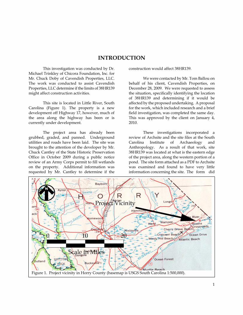
This investigation was conducted by Dr. Michael Trinkley of Chicora Foundation, Inc. for Mr. Chuck Doby of Cavendish Properties, LLC. The work was conducted to assist Cavendish Properties, LLC determine if the limits of 38HR139 might affect construction activities.
This site is located in Little River, South Carolina (Figure 1). The property is a new development off Highway 17, however, much of the area along the highway has been or is currently under development.
The project area has already been grubbed, graded, and panned. Underground utilities and roads have been laid. The site was brought to the attention of the developer by Mr. Chuck Cantley of the State Historic Preservation Office in October 2009 during a public notice review of an Army Corps permit to fill wetlands on the property. Additional information was requested by Mr. Cantley to determine if the
construction would affect 38HR139.
We were contacted by Mr. Tom Ballou on behalf of his client, Cavendish Properties, on December 28, 2009. We were requested to assess the situation, specifically identifying the location of 38HR139 and determining if it would be affected by the proposed undertaking. A proposal for the work, which included research and a brief field investigation, was completed the same day. This was approved by the client on January 4, 2010.
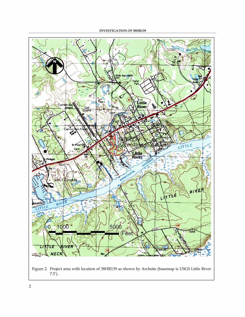
These investigations incorporated a review of Archsite and the site files at the South Carolina Institute of Archaeology and Anthropology. As a result of that work, site 38HR139 was located at what is the eastern edge of the project area, along the western portion of a pond. The site form attached as a PDF to Archsite was examined and found to have very little information concerning the site. The form did
1
Figure 1. Project vicinity in Horry County (basemap is USGS South Carolina 1:500,000).
INVESTIGATION OF 38HR139
2
Figure 2. Project area with location of 38HR139 as shown by Archsite (basemap is USGS Little River
7.5’).
INTRODUCTION
3
provide a UTM, a potentially eligible status, and the archaeological components found at the site. The original site form (by Tommy Charles in 1985) was then examined and found to contain much more detailed information, but was lacked UTM coordinates or any definitive location. The site form only specified that the site was found in the vicinity of Mr. John Willis’ trailer and that it had been encountered during the clearing of the lot.
Archival and historical research incorporated a review of secondary sources available in the Chicora Foundation files. In addition, aerial photographs were examined at the map repository of the Thomas Cooper Library at the University of South Carolina campus. An interview with Mr. John Willis, who originally identified the site on his property, was also undertaken in an attempt to narrow down locational information.
The field investigation was conducted on January 10, 2010 by Ms. Nicole Southerland and Mr. Travis Woods under the direction of Dr. Michael Trinkley. This report details the investigation of 38HR139 undertaken by Chicora Foundation and the results of that investigation.

INVESTIGATION OF 38HR139
4
5
NATURAL ENVIRONMENT Physiographic Province
The project area is situated in eastern Horry County, in the town of Little River. The level topography in the region is interrupted by only occasional marsh sloughs and small wetland depressions. The dominating feature is the Waccamaw River to the west, which meanders, forming large cutoffs or lakes, as well as much swamp and the Little River/Intracoastal Waterway to the south.
In general, the topography of the study tract is slightly undulating, with land sloping down to the southeast toward the Little River. The Waccamaw essentially bisects the county into east and west halves and drains numerous swamps between the river and the Atlantic Ocean. On a regional scale the topography slopes either southeast toward the Waccamaw or northwest toward smaller drainages such as Maple Swamp.
Horry County is bounded to the north by Brunswick and Columbus counties, North Carolina, to the east by the Atlantic Ocean, to the south by Georgetown County, and to the west by Dillon and Marion counties. It lies within the Lower Coastal Plain, which is made up of fluvial deposits that contain varying amounts of sand, silt, and clay (Dudley 1986). This is also the area known as the Atlantic Coast Flatwoods which extends from the sea shore inland about 30 to 70 miles. The
area is characterized by broad flats and depressions. While there are areas of well drained soils, much of the flatwoods consist primarily of poorly drained soils with clay subsoils, especially near the coast and in the project area (Ellerbe 1974:18).
Elevations may range from sea level to about 100 feet above mean sea level in the Lower Coastal Plain. In the project area there are no areas where the land is higher than about 35 feet above mean sea level (AMSL), and some of the area is lower toward the wetlands, most of which occur in the southern portion of the tract. A noticeable characteristic of this physiographic area is how gradually the flat lands seem to grade into either freshwater marshes, savannahs, or swamps. Geology and Soils
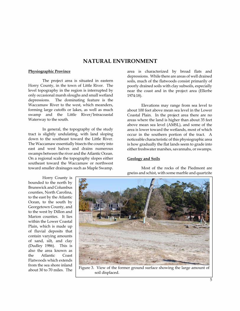
Most of the rocks of the Piedmont are gneiss and schist, with some marble and quartzite
Figure 3. View of the former ground surface showing the large amount of
soil displaced.
INVESTIGATION OF 38HR139
6
(Hasselton 1974). Some less intensively metamorphosed rocks, such as slate, occur along the eastern part of the province from southern Virginia into Georgia. This area, called the Slate Belt, is characterized by slightly lower ground with wider river valleys. Consequently, the Slate Belt has been favored for reservoir sites (Johnson 1970), as well as prehistoric occupation (see Coe 1964). In York County, many of the Piedmont soils are weathered from argillites rich in silica and alumina. Other soils are formed in sapprolite that weathered from crystalline rocks and “Carolina Slates.” Soils from the river floodplains formed in sediment that washed from the uplands of the Piedmont province.
Although four soil types (Blanton, Bohicket, Johnston, and Suffolk) are found over the entire project tract, only two of these soils (Blanton and Johnston) were found in the area of 38HR139. Blanton soils range from excessively drained to moderately well drained and have an Ap horizon of gray (10YR6/1) fine sand to 0.6 foot in depth to a very pale brown (10YR7/3) fine sand
that occurs to 3.1 feet in depth. Johnston soils
are very poorly drained and generally consist of black (10YR2/1) mucky loam to 2.5 feet in depth over a dark gray (10YR4/1) loamy fine sand to 2.8 feet in depth. As previously mentioned, the project area has been altered by land moving activities enough that these general soil profiles are no longer present. At least two feet of soil has been removed from the ground surface (see Figure 3) and redeposited elsewhere in the project area. Some profiles evidence gravel fill to a foot in depth, while most of the other soil profiles appeared to be a dark grayish brown (10YR4/2) sand to 1.4 feet in depth over a yellowish brown (10YR5/8) sand to
1.8 feet in depth. In some instances, the pale brown (10YR6/3) or very pale brown (10YR7/3) sands could still be found below 2.0 feet, however no artifacts were found in this horizon. Climate
Elevation, latitude, and distance from the coast work close together to affect the climate of South Carolina, although Horry is clearly dominated by its maritime location. Much of the weather is controlled by the proximity of the Gulf Stream, about 50 miles offshore. In addition, the more westerly mountains
block or moderate many of the cold air masses that flow across the state from west to east. Even the very cold air masses that cross the mountains are warmed by compression before the descent on the coast.
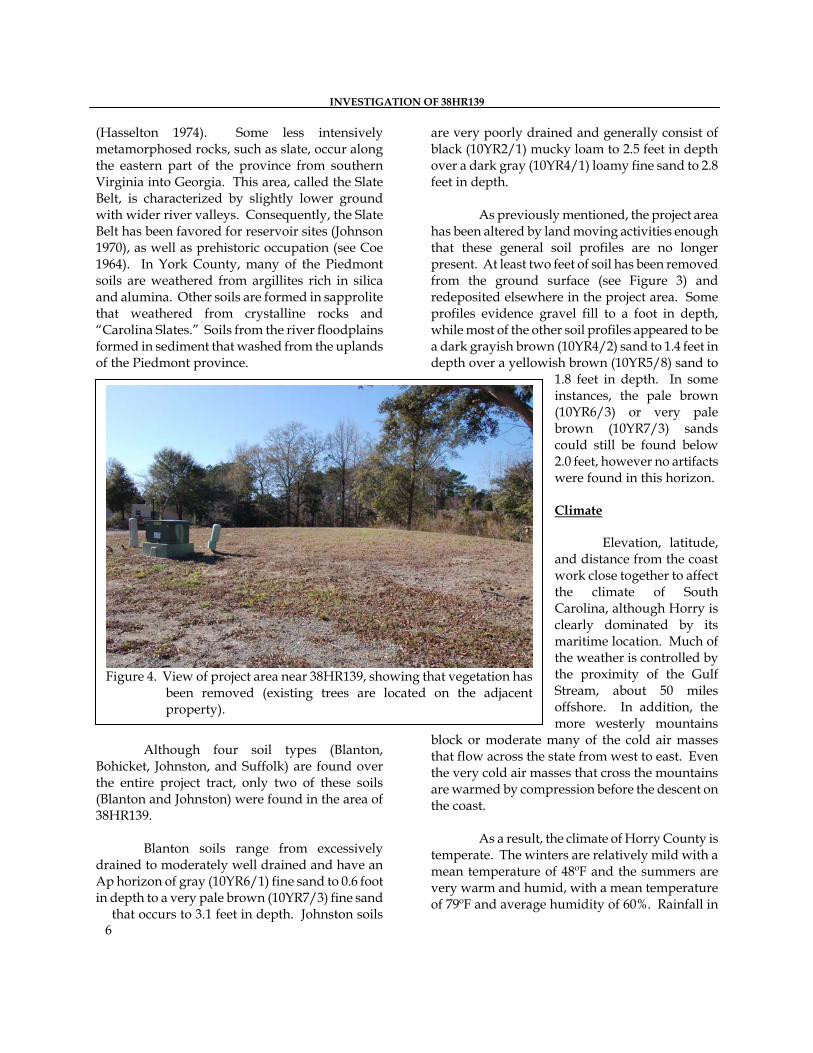
Figure 4. View of project area near 38HR139, showing that vegetation has
been removed (existing trees are located on the adjacent property).
As a result, the climate of Horry County is
temperate. The winters are relatively mild with a mean temperature of 48ºF and the summers are very warm and humid, with a mean temperature of 79ºF and average humidity of 60%. Rainfall in
7
the amount of about 51 inches is good for a broad range of crops. About 31 inches (or 60% of the total) occurs during the growing season, with until relatively recent periods of drought not being particularly common. Of course, there have been statewide droughts, such as the one in 1845, but more often the threat to Horry crops was flooding. Major floods have occurred in 1855, 1924, 1928, 1959, 1961, and 1973, with the September 1928 flood the largest known, reaching a stage of 12.75 feet above mean sea level (U.S. Army Corps of Engineers 1973:9).
The average growing season is about 234 days, although early freezes in the fall and late frosts in the spring can reduce this period by as much as 30 or more days (Dudley 1986:97). Consequently, most cotton planting, for example, did not take place until early May, avoiding the possibility that a late frost would damage the young seedlings. Floristics
Vegetation in Horry County is characterized in relation to the previously broad topographic patterns of poorly drained floodplains and lowlands, and the well drained uplands.
The vegetation in Horry County has been classified by Küchler (1964) as part of the Oak-Hickory-Pine forest, based on potential natural vegetation. This would consist of medium tall to tall forests of broadleaf deciduous and needleleaf evergreen trees. More specifically, however, the floodplains are covered by mixed hardwoods, including bald cypress, tupelo gum, and black gum. Less water tolerant trees, such as pines, occur on the uplands or on better-drained slopes. Also found in the bottomlands, floodplains, and Carolina bays are red maple, ash, water oak, elm, and sweet gum. On the better-drained uplands, pine dominates, with loblolly and longleaf pines being indigenous and the slash pine introduced.
In 1826 Mills in describing the Horry District vegetation, notes:
The long leaf pine abounds, also the cypress, live oak, water oak, white oak, &c. The fruit trees are, peaches, apples, pears, plums, cherries, figs; besides strawberries, which grow wild, whortleberries, &c. The forest trees begin to bud in the latter part of March, and the fruit trees in April. The pine and cypress are mostly used for buildings (Mills 1972[1826]:582).
The poorly drained swamps and flatwoods of Horry County were not particularly attractive to early settlers and much of the area was not actively farmed for a number of years. The current project area was once covered in a mixed pine and hardwood forest, but has been recently cleared, grubbed, and graded for construction. The southern portion of the tract is wetland. A former landowner adjacent to the tract reports that a portion of the property was once used to grow peanuts (John Willis, personal communication 2010). This is verified by the 1949 aerial photograph, which does show a small cultivated field in this area.

INVESTIGATION OF 38HR139
8
9
PREHISTORIC AND HISTORIC SYNOPSIS Previous Research
Horry has received rather spotty archaeological attention. Derting and his colleagues, for example, list only 67 reports associated with the county, with 41 of these (or 61%) representing highway or sewer surveys (Derting et al. 1991). Although dated, this indicates that the attention has been focused on relatively narrow, contained corridors, with only minor attention devoted to the area’s rich prehistoric and protohistoric resources.
Considerable, primarily unpublished, research took place in the Myrtle Beach area during the 1960s at the Ellsworth Site by Erika Fogg-Amed, then a student of Reinhold Englemyer at USC-Conway. Several test units were placed within the site which yielded Stallings, Thom’s Creek, Hanover, and Cape Fear sherds, as well as a Morrow Mountain component (Fogg-Amed n.d. a). No site boundaries were established and, in fact, no site form has ever been filed.
Fogg-Amed also tested the “Coates Site,” located about 10 miles north of Myrtle Beach on a high bluff overlooking a freshwater pond. Testing at this site yielded a dense shell midden that produced only lithic debitage (Fogg-Amed n.d. b). Again, no site form was filed.
Closer to the survey tract at least four project areas have been surveyed. All four involve housing developments (Sanders 2001; Reid 2004; Trinkley and Southerland 2005, and Trinkley and Southerland 2006) and all failed to identify any archaeological sites, showing the sparse prehistoric and historic resources in the area.
In the 1980s, Tommy Charles of the South
Carolina Institute of Archaeology and
Anthropology, did a collections survey by enlisting private collectors from across the state to provide details of what they found and where they found it. Included in this study was 38HR139, found on the current project tract. Brief descriptions of some of these sites can be found in the SCIAA Notebook (see for example Pinson 1985). Prehistoric Overview
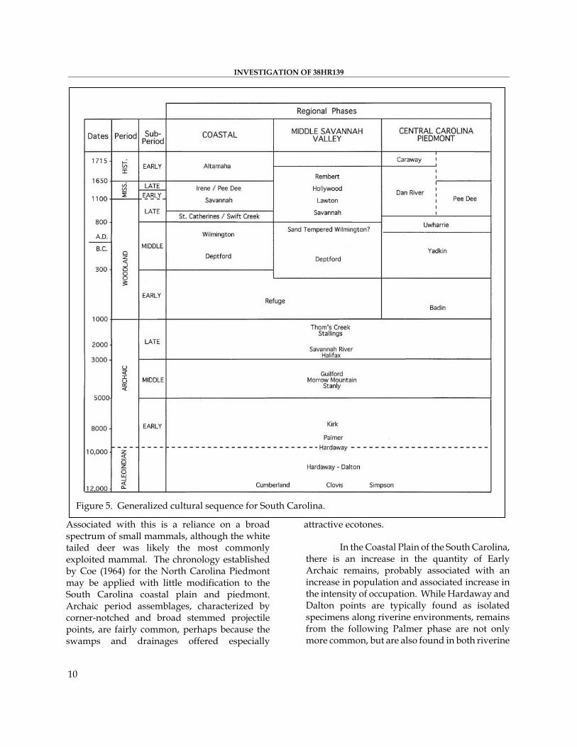
The Paleoindian period, lasting from 12,000 to 8,000 B.C., is evidenced by basally thinned, side-notched projectile points; fluted, lanceolate projectile points; side scrapers; end scrapers; and drills (Coe 1964; Michie 1977; Williams 1968). The Paleoindian occupation, while widespread, does not appear to have been intensive. Artifacts are most frequently found along major river drainages, which Michie interprets to support the concept of an economy “oriented towards the exploitation of now extinct mega-fauna” (Michie 1977:124).
Unfortunately, little is known about Paleoindian subsistence strategies, settlement systems, or social organization. Generally, archaeologists agree that the Paleoindian groups were at a band level of society (see Service 1966), were nomadic, and were both hunters and foragers. While population density, based on the isolated finds, is thought to have been low, Walthall suggests that toward the end of the period, “there was an increase in population density and in territoriality and that a number of new resource areas were beginning to be exploited” (Walthall 1980:30).
The Archaic period, which dates from 8000 to 2000 B.C., does not form a sharp break with the Paleoindian period, but is a slow transition characterized by a modern climate an increase in the diversity of material culture.
INVESTIGATION OF 38HR139
10
Associated with this is a reliance on a broad spectrum of small mammals, although the white tailed deer was likely the most commonly exploited mammal. The chronology established by Coe (1964) for the North Carolina Piedmont may be applied with little modification to the South Carolina coastal plain and piedmont. Archaic period assemblages, characterized by corner-notched and broad stemmed projectile points, are fairly common, perhaps because the swamps and drainages offered especially
attractive ecotones.
Figure 5. Generalized cultural sequence for South Carolina.
In the Coastal Plain of the South Carolina,
there is an increase in the quantity of Early Archaic remains, probably associated with an increase in population and associated increase in the intensity of occupation. While Hardaway and Dalton points are typically found as isolated specimens along riverine environments, remains from the following Palmer phase are not only more common, but are also found in both riverine
PREHISTORIC AND HISTORIC SYNOPSIS
11
and interriverine settings. Kirks are likewise common in the coastal plain (Goodyear et al. 1979).
The two primary Middle Archaic phases found in the coastal plain are the Morrow Mountain and Guilford (the Stanly and Halifax complexes identified by Coe are rarely encountered). Our best information on the Middle Woodland comes from sites investigated west of the Appalachian Mountains, such as the work in the Little Tennessee River Valley. The work at Middle Archaic river valley sites, with their evidence of a diverse floral and faunal subsistence base, seems to stand in stark contrast to Caldwell’s Middle Archaic “Old Quartz Industry” of Georgia and South Carolina, where axes, choppers, and ground and polished stone tools are very rare.
The Late Archaic is characterized by the appearance of large, square stemmed Savannah River projectile points (Coe 1964). These people continued the intensive exploitation of the uplands much like earlier Archaic groups. The bulk of our data for this period, however, comes from work in the Uwharrie region of North Carolina.
The Woodland period begins, by definition, with the introduction of fired clay pottery about 2000 B.C. along the South Carolina coast (the introduction of pottery, and hence the beginning of the Woodland period, occurs much later in the Piedmont of South Carolina). It should be noted that many researchers call the period from about 2500 to 1000 B.C. the Late Archaic because of a perceived continuation of the Archaic lifestyle in spite of the manufacture of pottery. Regardless of terminology, the period from 2500 to 1000 B.C. is well documented on the South Carolina coast and is characterized by Stallings (fiber-tempered) pottery. The subsistence economy during this early period was based primarily on deer hunting and fishing, with supplemental inclusions of small mammals, birds, reptiles, and shellfish.
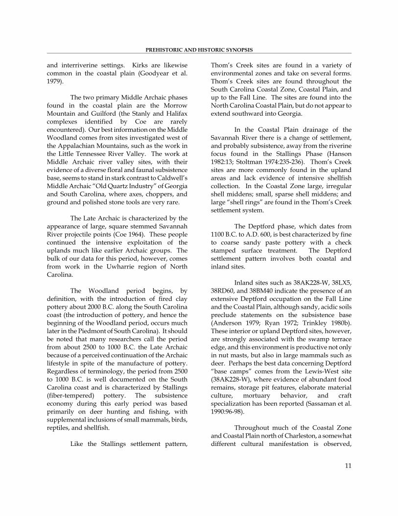
Like the Stallings settlement pattern,
Thom’s Creek sites are found in a variety of environmental zones and take on several forms. Thom’s Creek sites are found throughout the South Carolina Coastal Zone, Coastal Plain, and up to the Fall Line. The sites are found into the North Carolina Coastal Plain, but do not appear to extend southward into Georgia.
In the Coastal Plain drainage of the Savannah River there is a change of settlement, and probably subsistence, away from the riverine focus found in the Stallings Phase (Hanson 1982:13; Stoltman 1974:235-236). Thom’s Creek sites are more commonly found in the upland areas and lack evidence of intensive shellfish collection. In the Coastal Zone large, irregular shell middens; small, sparse shell middens; and large “shell rings” are found in the Thom’s Creek settlement system.
The Deptford phase, which dates from 1100 B.C. to A.D. 600, is best characterized by fine to coarse sandy paste pottery with a check stamped surface treatment. The Deptford settlement pattern involves both coastal and inland sites.
Inland sites such as 38AK228-W, 38LX5, 38RD60, and 38BM40 indicate the presence of an extensive Deptford occupation on the Fall Line and the Coastal Plain, although sandy, acidic soils preclude statements on the subsistence base (Anderson 1979; Ryan 1972; Trinkley 1980b). These interior or upland Deptford sites, however, are strongly associated with the swamp terrace edge, and this environment is productive not only in nut masts, but also in large mammals such as deer. Perhaps the best data concerning Deptford “base camps” comes from the Lewis-West site (38AK228-W), where evidence of abundant food remains, storage pit features, elaborate material culture, mortuary behavior, and craft specialization has been reported (Sassaman et al. 1990:96-98).
Throughout much of the Coastal Zone and Coastal Plain north of Charleston, a somewhat different cultural manifestation is observed,
INVESTIGATION OF 38HR139
12
related to the “Northern Tradition” (e.g., Caldwell 1958). This recently identified assemblage has been termed Deep Creek and was first identified from northern North Carolina sites (Phelps 1983). The Deep Creek assemblage is characterized by pottery with medium to coarse sand inclusions and surface treatments of cord marking, fabric impressing, simple stamping, and net impressing. Much of this material has been previously designated as the Middle Woodland “Cape Fear” pottery originally typed by South (1976). The Deep Creek wares date from about 1000 B.C. to A.D. 1 in North Carolina, but may date later in South Carolina. The Deep Creek settlement and subsistence systems are poorly known, but appear to be very similar to those identified with the Deptford phase.
The Deep Creek assemblage strongly resembles Deptford both typologically and temporally. It appears this northern tradition of cord and fabric impressions was introduced and gradually accepted by indigenous South Carolina populations. During this time, some groups continued making only the older carved paddle0stamped pottery, while others mixed the two styles, and still others (and later all) made exclusively cord and fabric stamped wares.
The Middle Woodland in South Carolina is characterized by a pattern of settlement mobility and short-term occupation. On the southern coast it is associated with the Wilmington phase, while on the northern coast it is recognized by the presence of Hanover, McClellanville or Santee, and Mount Pleasant assemblages. The best data concerning Middle Woodland Coastal Zone assemblages comes from Phelps’ (1983:32-33) work in North Carolina. Associated items include a small variety of the Roanoke Large Triangular points (Coe 1964:110-111), sandstone abraders, shell pendants, polished stone gorgets, celts, and woven marsh mats. Significantly, both primary inhumation and cremations are found.
On the Coastal Plain of South Carolina, researchers are finding evidence of a Middle Woodland Yadkin assemblage, best known from
Coe’s work at the Doerschuk site in North Carolina (Coe 1964:25-26). Yadkin pottery is characterized by a crushed quartz temper and cord marked, fabric impressed, and linear check stamped surface treatments. The Yadkin ceramics are associated with medium-sized triangular points, although Oliver (1981) suggests that a continuation of the Piedmont Stemmed Tradition to at least A.D. 300 coexisted with this Triangular Tradition. The Yadkin series in South Carolina was first observed by Ward (1978, 1983) from the White’s Creek drainage in Marlboro County, South Carolina. Since then, a large Yadkin village has been identified by DePratter at the Dunlap site (38DA66) in Darlington County, South Carolina (Chester DePratter, personal communication 1985) and Blanton et al. (1986) and have excavated a small Yadkin site (389SU83) in Sumter County, South Carolina. Research at 38FL249 on the Roche Carolina tract in northern Florence County revealed an assemblage including Badin, Yadkin, and Wilmington wares (Trinkley et al. 1993:85-102). Anderson et al. (1982:299-302) offer additional typological assessments of the Yadkin wares in South Carolina.
Over the years, the suggestion that Cape Fear might be replace by such types as Deep Creek and Mount Pleasant has raised considerable controversy. Taylor, for example, rejects the use of the North Carolina types in favor of those developed by Anderson et al. (1982) from their work at Mattassee Lake in Berkeley County (Taylor 1984:80). Cable (1991) is even less generous in his denouncement of ceramic constructs developed nearly a decade ago, also favoring adoption of the Mattassee Lake typology and chronology. This construct, recognizing five phases (Deptford I-III, McClellanville, and Santee I), uses a type variety system.
Regardless of terminology, these Middle Woodland Coastal Plain and Coastal Zone phases continue the Early Woodland Deptford pattern of mobility. While sites are found all along the coast and inland to the Fall Line, shell midden sites evidence sparse shell and artifacts. Gone are the abundant shell tools, worked bone items, and clay
PREHISTORIC AND HISTORIC SYNOPSIS
13
balls. Recent investigations at Coastal Zone sites such as 38BU747 and 38BU1214, however, have provided some evidence of worked bone and shell items at Deptford phase middens (see Trinkley 1990).
In many respects, the
South Carolina Late Woodland may be characterized as a continuation of previous Middle Woodland cultural assemblages. While outside the Carolinas there were major cultural changes, such as the continued development and elaboration of agriculture, the Carolina groups settled into a lifeway not appreciably different from that observed for the previous 500 to 700 years (cf. Sassaman et al. 1990:14-15). This situation would remain unchanged until the development of the South Appalachian Mississippian complex (see Ferguson 1971).
The South Appalachian Mississippian
period, from about A.D. 1100 to A.D. 1640, is the most elaborate level of culture attained by the native inhabitants and is followed by cultural disintegration brought about largely by European disease. The period is characterized by complicated stamped pottery, complex social organization, agriculture, and the construction of temple mounds and ceremonial centers. The earliest phases include the Savannah and Pee Dee (A.D. 1200 to 1550). Historic Synopsis
The earliest activity in the Horry County area may have been the Spanish Ayllon movement from Rio Jordon (Cape Fear River) to San Miguel de Gualdape, 45 leagues distant. Some have argued that Fort San Miguel may have been at the mouth of Winyah Bay, although Paul Hoffman has recently suggested the fort was in Beaufort
County, South Carolina or Chatham County, Georgia.
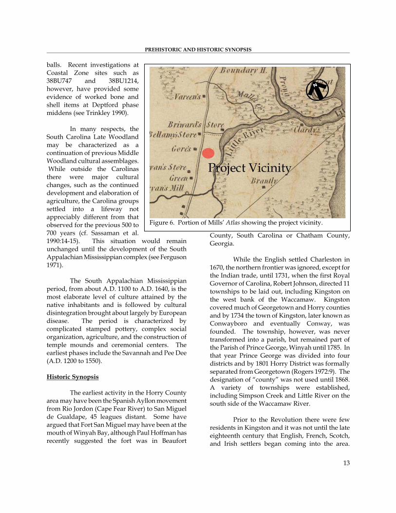
Figure 6. Portion of Mills’ Atlas showing the project vicinity.
While the English settled Charleston in
1670, the northern frontier was ignored, except for the Indian trade, until 1731, when the first Royal Governor of Carolina, Robert Johnson, directed 11 townships to be laid out, including Kingston on the west bank of the Waccamaw. Kingston covered much of Georgetown and Horry counties and by 1734 the town of Kingston, later known as Conwayboro and eventually Conway, was founded. The township, however, was never transformed into a parish, but remained part of the Parish of Prince George, Winyah until 1785. In that year Prince George was divided into four districts and by 1801 Horry District was formally separated from Georgetown (Rogers 1972:9). The designation of “county” was not used until 1868. A variety of townships were established, including Simpson Creek and Little River on the south side of the Waccamaw River.
Prior to the Revolution there were few residents in Kingston and it was not until the late eighteenth century that English, French, Scotch, and Irish settlers began coming into the area.
INVESTIGATION OF 38HR139
14
Many settlers in the early nineteenth century came from North Carolina and the northern seaboard states.
In spite of Horry’s coastal plain situation, the area developed along vastly different lines than its southern neighbors Georgetown and Charleston. Horry District was always isolated from the remainder of South Carolina and had much stronger connections with North Carolina (Rogers 1972:3). The major traffic artery was the Waccamaw River and this reliance on river transport did not change until the highway development of the 1930s. Subsistence farming was the main occupation in the early 1800s and the farms were small, specializing in peas, wheat, rice, cotton, and corn, most for home consumption (Rogers 1972:5). Mills notes that the population was,
mostly engaged in cultivating the soil. There are a few mechanics, such as blacksmiths, shoemakers, taylors [sic], halters, etc. (Mills 1972[1826]:583).
For Mills’ Atlas of 1826, the Horry District
was surveyed by Harlee in 1820. No settlements are shown in the project area (Figure 6). The absence of houses surrounding the project area may not so much indicate sparse settlement as it may reflect the subscription basis of Mills’ Atlas. The subsistence farmers of Horry District may either have been unable to subscribe or may have had no need to let others know their location. The 1860 census for Horry District indicates that many of the farmers in Kingston, for example, could neither read nor write, further reducing the benefits of listing in an atlas.
The emphasis on subsistence farming appears to be the result of topography. Only 20% of the land is subject to the type of tidal overflow necessary for wet cultivation of rice. Mills (1972[1826]:581) notes that the river floodplain soil was productive where it could be reclaimed by drainage, while the upland soils were much less productive. This difference in quality is reflected
in the prices for the land. Mills states that,
the low land swamps, when secured from the freshets, will sell for 40 or $50 an acre. The uplands are valued at from $4 down to 25 cents per acre (Mills 1972[1826]:581).
Interestingly, the price of “improved farms” ranged from $20 to $50 an acre as late as 1918 (Tillman et al. 1919:340). The few plantations found in Horry District were primarily located in All Saints Parish, east and south of the Waccamaw River. It was from this area that a small quantity of rice was exported throughout the nineteenth century (Rogers 1972:13).
Because the soils of Horry District were not able to support plantation agriculture a unique distribution of population and a very low percentage of slaves were found in the region. Horry County also continued to play a minor role in state politics. The area, prior to the Civil War, was oriented to smaller farmers and never developed an aristocratic plantation society with political and economic powers. Most of the farms, including the larger ones, were situated in Kingston Township. The 1860 census indicates that of the 782 farms, 560 were in Kingston (Rogers 1972:12). In 1860, the population was 2,606 and there were only 708 slaves. This ratio of 70% white and 30% blacks has not only remained stable into the twentieth century, but also stands in contrast to Georgetown District where about 12% of the population was white and 88% was black until the 1880 census, when the white population increased to about 20% (Rogers 1972).
By the 1830s, a new industry was competing with farming in the Horry area. Northern immigrants from Maine, coupled with “pine woods speculators” from North Carolina began to exploit the forest products of both the uplands and swamp areas (Tillman et al. 1919:330; Berry 1970; Rogers 1972:14). The Horry District was the leading turpentine producer in South Carolina by 1860, producing products valued at

PREHISTORIC AND HISTORIC SYNOPSIS
15
$392,643. The lumber and turpentine industry continued to grow rapidly after the Civil War. Tobacco was introduced about 1850, but was not an important crop until after the Civil War, lead by the Green Sea Township.
Horry District never sided with the radical
secessionists, possibly because of the influence of northern immigrants or because of the resentment of the political and economic power of slave owners. In any event, Horry County responded “enthusiastically” to the call for volunteers at the outbreak of the Civil War (Rogers 1972:35).
Horry District saw little involvement in the Civil War, although 925 of the 1,000 men in the voting population volunteered for duty and served (Rogers 1972:35). Fort Randell was established at Clardy’s Point on the Little River and saw skirmishes in 1863 and 1865. The salt works of Peter Vaught, Sr. at Singleton Swash were raided in April 1864, and in 1865 a Union expedition was led up the Waccamaw to destroy ferries at Bull Creek and Yahannah (Rogers 1972:35-38).
After the Civil War, Horry was part of the Military District of Eastern South Carolina, but the
Federal stay was short and by 1866 military troops had left Horry County. This absence of Federal troops continued throughout Reconstruction and the Democrats maintained political control throughout the period. Further, there was no land distribution in Horry County, possibly because there was really no land worth distributing (Rogers 1972:47). Following the Civil War a number of changes began to affect the Horry area. Tobacco began to be a more important crop, the first county bank was organized in 1880, the railroad and telegraph arrived in 1887, and in 1869 a regular weekly county newspaper appeared (the Horry Weekly News,
which published until 1877). Conwayboro was changed to Conway in 1883 and the only other “major” town continued to be Little River.
Figure 7. Portion of the 1918 Horry County Soil Survey showing
the project area.
The turpentine business boomed in the
1870s and by 1880 there were 21 operators in the county, producing $181,400 annually (Rogers 1972:50). Farming, however, continued to be important. In 1870 there were 1,300 farms averaging 50 acres in size. The major crops were still subsistence items such as corn, sweet potatoes, and rice. Few wage employees were found in Horry (Rogers 1972:58). The Socastee and Little River townships had the richest farms and the five largest farms also produced turpentine in 1870 (Rogers 1972:60). The Grange movement arrived in Horry County relatively late, never organized in many areas, and failed by the late 1870s.
By 1910, the County population had increased to almost 27,000 but there was no town, including Conway, with a population of at least 2,500. Conway continued, however, to have strong lumbering and mercantile interests. With the gradual decline of lumbering and the turpentine industry, farming was once again the dominant activity in the county. The period from
INVESTIGATION OF 38HR139
16
1880 to 1910 saw corn acreage increase 140%, cotton acreage increase 90%, and tobacco acreage increase from 19 to 5,347 acres. During the same time rice production fell from 747,689 to 1,210 pounds (Tillman et al. 1919:333). By 1919 the chief money crops were corn, cotton, and tobacco, although corn was largely used to supply the home and fatten stock. After 1895, tobacco began to replace cotton as a prime money crop and by 1910 was “grown more or less generally over a county by small farmers who live on their farms and superintend the work” (Tillman et al. 1919:335).
The 1918 soil survey map fails to show any structures in the survey area (Figure 7).
In the early twentieth century, hogs were the principle source of livestock income. These animals were usually slaughtered in the fall for home use or sale on the local market. Cattle were mostly scrub stock and dairying was neglected. Farm equipment was largely inadequate in the early 1900s and most of the plowing was done with one ox or mule. On many small farms the adequacy of farm equipment did not appreciably
improve into the 1940s, when the probate inventory for one small Horry farmer listed only one mule, a one-horse wagon, one disc, four plows, one lot hoes, one guano distributor, a tobacco sprayer, and a corn planter (Trinkley and Caballero 1983:8). Tillman et al. (1919:338) indicate that in the early 1900s plowing was seldom more than 2 to 3 inches deep because of the poor machinery. It is suggested that this lack of equipment was not entirely related to a lack of prosperity, but rather was largely the result of cheap labor. Tillman et al. report that, “negro men receive 75 cents to $1.25 a day . . . while negro women are paid 50 to 65 cents a day” (Tillman et al. 1919:340).
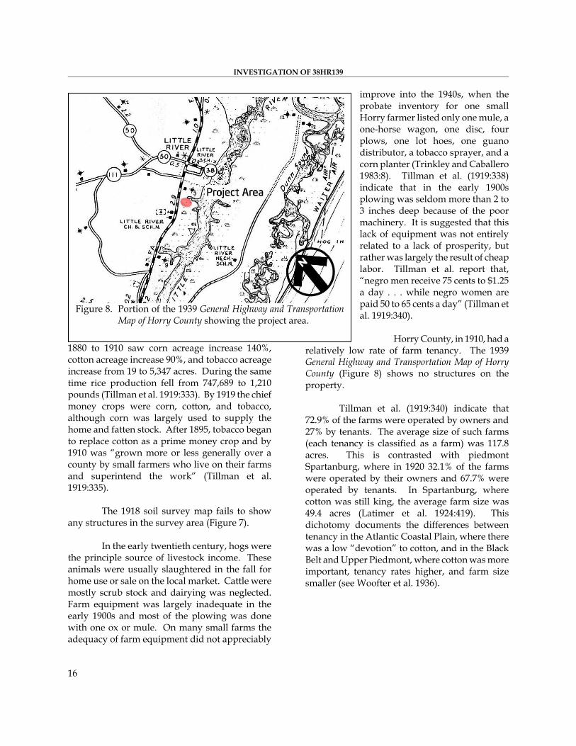
Horry County, in 1910, had a relatively low rate of farm tenancy. The 1939 General Highway and Transportation Map of Horry County (Figure 8) shows no structures on the property.
Figure 8. Portion of the 1939 General Highway and Transportation
Map of Horry County showing the project area.
Tillman et al. (1919:340) indicate that
72.9% of the farms were operated by owners and 27% by tenants. The average size of such farms (each tenancy is classified as a farm) was 117.8 acres. This is contrasted with piedmont Spartanburg, where in 1920 32.1% of the farms were operated by their owners and 67.7% were operated by tenants. In Spartanburg, where cotton was still king, the average farm size was 49.4 acres (Latimer et al. 1924:419). This dichotomy documents the differences between tenancy in the Atlantic Coastal Plain, where there was a low “devotion” to cotton, and in the Black Belt and Upper Piedmont, where cotton was more important, tenancy rates higher, and farm size smaller (see Woofter et al. 1936).
RESEARCH METHODS AND FINDINGS Archaeological Field Methods and Findings
The initially proposed field techniques involved relocating 38HR139 and determining the extent of the site on the current project area. This would be accomplished by performing shovel tests at 50-foot intervals to the north, south, and east from the western edge of the property where the site was originally noted.
17
All soil would be screened through ¼-
inch mesh with the test taken to a depth of at least 1.0 foot or until subsoil was encountered. All cultural remains would be collected. Notes would be maintained for the profiles from the unit.
The GPS position would be taken with a WAAS enabled Garmin 76 rover that tracks up to twelve satellites, each with a separate channel that is continuously being read. The benefit of parallel
channel receivers is their improved sensitivity and ability to obtain and hold a satellite lock in difficult situations, such as in forests or urban environments where signal obstruction is a frequent problem. WAAS or Wide Area Augmentation System, is a system of satellites and ground stations that provide GPS signal corrections, yielding higher position accuracy – generally and accuracy of 10 feet or better 95% of
the time. With no dense tree cover or tall buildings to obstruct views, satellite reception was good.
Before visiting the
site, background research was performed in order to have an idea of where 38HR139 was located and what might be found at the site. This involved looking at Archsite, a comprehensive map of archaeological and architectural sites for South Carolina. The location of 38HR139 was found at what would be the northeastern portion of the project area on the western edge of a pond. A PDF version of the site form was printed off
Archsite, which had limited information, but included UTM coordinates (720076E 3750377N), National Register of Historic Places status (potentially eligible), and archaeological components found at the site (Middle-Late Archaic, and Early-Late Woodland).
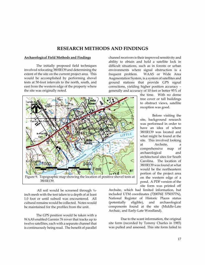
Figure 9. Topographic map showing the location of positive shovel tests at
38HR139.
Due to the scant information, the original
site form (recorded by Tommy Charles in 1985) was pulled and assessed. This site form failed to
INVESTIGATION OF 38HR139
18
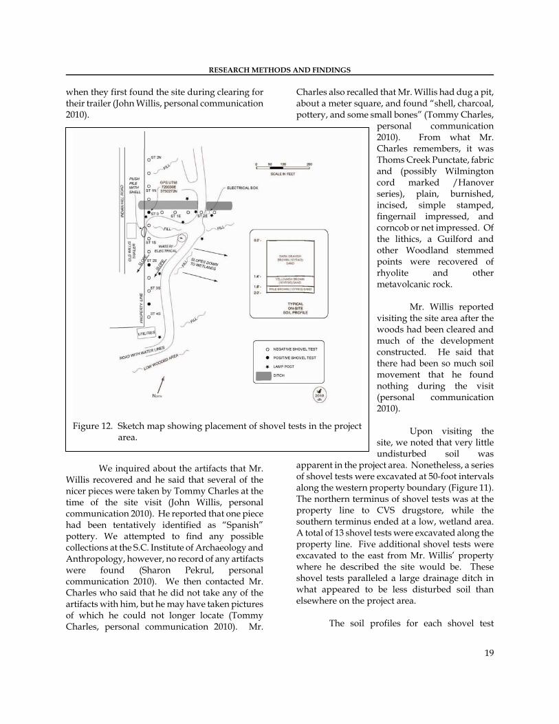
provide any UTM coordinates. Locational information was provided, but was generally vague, making it difficult to determine the site location, especially 25 years after its discovery. The site was described as being on a “low hill top” that overlooked “a small freshwater creek on the north side.” The site had been identified by John Willis who found artifacts while clearing the lot for his trailer. Mr. Willis had found potsherds, lithics, and a possible shell midden. Tommy Charles visited the site and recommended shovel testing since the site “appear[ed] to be little disturbed and should have some depth and integrity.”
To try to narrow down the site location, we contacted John Willis, who still lives in the, although the trailer referenced on the site form has been sold. Mr. Willis again described what he found while clearing the lot – much of
the information was consistent to what he told Tommy Charles in 1985. Mr. Willis explained that the artifacts extended onto the current project tract (east) about 50 to 100 feet further past the property line (John Willis, personal communication 2010). He also described finding shells on his property that appeared to be piled on top of each other and mixed with bones, consistent with a midden. Mr. Willis also noted that once word got out in the community about pottery and arrowheads being unearthed, there was significant pot hunting and
looting at the site (John Willis, personal communication 2010). In fact, he described people “carrying off buckets of pottery.” It was revealed that a portion of the site was once in a cultivated peanut field. While it may seem interesting that the site is located on Indian Hill Road, Mr. Willis explained that he and his wife named the road
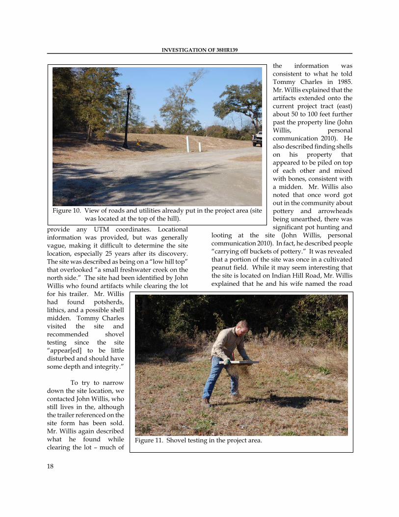
Figure 10. View of roads and utilities already put in the project area (site
was located at the top of the hill).
Figure 11. Shovel testing in the project area.
RESEARCH METHODS AND FINDINGS
19
when they first found the site during clearing for their trailer (John Willis, personal communication 2010).
We inquired about the artifacts that Mr.
Willis recovered and he said that several of the nicer pieces were taken by Tommy Charles at the time of the site visit (John Willis, personal communication 2010). He reported that one piece had been tentatively identified as “Spanish” pottery. We attempted to find any possible collections at the S.C. Institute of Archaeology and Anthropology, however, no record of any artifacts were found (Sharon Pekrul, personal communication 2010). We then contacted Mr. Charles who said that he did not take any of the artifacts with him, but he may have taken pictures of which he could not longer locate (Tommy Charles, personal communication 2010). Mr.
Charles also recalled that Mr. Willis had dug a pit, about a meter square, and found “shell, charcoal, pottery, and some small bones” (Tommy Charles,
personal communication 2010). From what Mr. Charles remembers, it was Thoms Creek Punctate, fabric and (possibly Wilmington cord marked /Hanover series), plain, burnished, incised, simple stamped, fingernail impressed, and corncob or net impressed. Of the lithics, a Guilford and other Woodland stemmed points were recovered of rhyolite and other metavolcanic rock.
Mr. Willis reported
visiting the site area after the woods had been cleared and much of the development constructed. He said that there had been so much soil movement that he found nothing during the visit (personal communication 2010).
Upon visiting the
site, we noted that very little undisturbed soil was
apparent in the project area. Nonetheless, a series of shovel tests were excavated at 50-foot intervals along the western property boundary (Figure 11). The northern terminus of shovel tests was at the property line to CVS drugstore, while the southern terminus ended at a low, wetland area. A total of 13 shovel tests were excavated along the property line. Five additional shovel tests were excavated to the east from Mr. Willis’ property where he described the site would be. These shovel tests paralleled a large drainage ditch in what appeared to be less disturbed soil than elsewhere on the project area.
Figure 12. Sketch map showing placement of shovel tests in the project
area.
The soil profiles for each shovel test
INVESTIGATION OF 38HR139
20
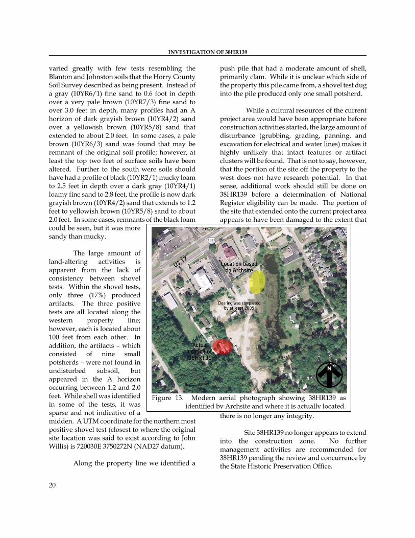
varied greatly with few tests resembling the Blanton and Johnston soils that the Horry County Soil Survey described as being present. Instead of a gray (10YR6/1) fine sand to 0.6 foot in depth over a very pale brown (10YR7/3) fine sand to over 3.0 feet in depth, many profiles had an A horizon of dark grayish brown (10YR4/2) sand over a yellowish brown (10YR5/8) sand that extended to about 2.0 feet. In some cases, a pale brown (10YR6/3) sand was found that may be remnant of the original soil profile; however, at least the top two feet of surface soils have been altered. Further to the south were soils should have had a profile of black (10YR2/1) mucky loam to 2.5 feet in depth over a dark gray (10YR4/1) loamy fine sand to 2.8 feet, the profile is now dark grayish brown (10YR4/2) sand that extends to 1.2 feet to yellowish brown (10YR5/8) sand to about 2.0 feet. In some cases, remnants of the black loam could be seen, but it was more sandy than mucky.
The large amount of
land-altering activities is apparent from the lack of consistency between shovel tests. Within the shovel tests, only three (17%) produced artifacts. The three positive tests are all located along the western property line; however, each is located about 100 feet from each other. In addition, the artifacts – which consisted of nine small potsherds – were not found in undisturbed subsoil, but appeared in the A horizon occurring between 1.2 and 2.0 feet. While shell was identified in some of the tests, it was sparse and not indicative of a midden. A UTM coordinate for the northern most positive shovel test (closest to where the original site location was said to exist according to John Willis) is 720030E 3750272N (NAD27 datum).
Along the property line we identified a
push pile that had a moderate amount of shell, primarily clam. While it is unclear which side of the property this pile came from, a shovel test dug into the pile produced only one small potsherd.
While a cultural resources of the current
project area would have been appropriate before construction activities started, the large amount of disturbance (grubbing, grading, panning, and excavation for electrical and water lines) makes it highly unlikely that intact features or artifact clusters will be found. That is not to say, however, that the portion of the site off the property to the west does not have research potential. In that sense, additional work should still be done on 38HR139 before a determination of National Register eligibility can be made. The portion of the site that extended onto the current project area appears to have been damaged to the extent that
there is no longer any integrity.
Figure 13. Modern aerial photograph showing 38HR139 as
identified by Archsite and where it is actually located.
Site 38HR139 no longer appears to extend
into the construction zone. No further management activities are recommended for 38HR139 pending the review and concurrence by the State Historic Preservation Office.
21
CONCLUSIONS
This study involved the examination of site 38HR139 in Horry County. The area is being developed for an assisted living facility. This work, conducted for Mr. Chuck Doby of Cavendish Properties, LLC examined the site and its potential to affect current construction activities. The site was relocated and shovel testing was conducted to determine boundaries on the current project tract. Due to significant land-altering activities that have already taken place, only three positive shovel tests were encountered, all along the property edge. Shovel testing failed to identify any intact features or clusters of artifacts. Construction activities have severely affected the integrity of the site. The portion of 38HR139 on the adjacent property to the west may still retain integrity,
additional survey on that side should be performed before a determination of eligibility can be made.
Construction activities should be allowed to proceed; however, it is possible that archaeological remains may be encountered during construction activities. As always, contractors should be advised to report any discoveries of concentrations of artifacts (such as shell or projectile points) to the project engineer, who should in turn report the material to the State Historic Preservation Office, or Chicora Foundation (the process of dealing with late discoveries is discussed in 36CFR800.13(b)(3)). No further land altering activities should take place in the vicinity of these discoveries until they have been examined by an archaeologist and, if necessary, have been processed according to 36CFR800.13(b)(3).

INVESTIGATION OF 38HR139
22
23
SOURCES CITED Anderson, David G.
1979 Excavations at Four Fall Line Sites: The Southeastern Beltway Project. Commonwealth Associates, Inc., Jacksonville, Michigan. Submitted to the South Carolina Department of Highways and Public Transportation, Columbia.
Anderson, David G., Charles E. Cantley, and A. Lee Novick
1982 The Mattassee Lake Sites: Archaeological Investigations Along the Lower Santee River in the Coastal Plain of South Carolina. Commonwealth Associates, Jackson, Michigan.
Berry, C.B.
1970 The Colonial Period. Independent Republic Quarterly 9(1):13-15.
Blanton, Dennis B., Christopher T. Espenshade, and Paul E. Brockington, Jr.
1986 An Archaeological Study of 38SU83: A Yadkin Phase Site in the Upper Coastal Plain of South Carolina. Garrow and Associates, Inc., Atlanta.
Cable, John
1991 Archaeological Test Excavations on the Northeastern Perimeter of the Buck Hall Site (38CH644), Francis Marion National Forest, South Carolina. New South Associates, Irmo, South Carolina.
Caldwell, Joseph R.
1958 Trend and Tradition in the Prehistory of the Eastern United States. Memoirs of the American
Anthropological Association 88. Coe, Joffre L.
1964 The Formative Cultures of the Carolina Piedmont. Transactions of the American Philosophical Society 54(5).
Derting, Keith M., Sharon L. Pekrul, and Charles J. Rinehart
1991 A Comprehensive Bibliography of South Carolina Archaeology. Research Manuscript 211. South Carolina Institute of Archaeology and Anthropology, University of South Carolina, Columbia.
Dudley, Travis A.
1986 Soil Survey of Horry County, South Carolina. U.S. Department of Agriculture, Soil Conservation Service, Washington, D.C.
Ellerbe, Clarence M.
1974 South Carolina Soils and Their Interpretations for Selected Uses. S.C. Land Resources Commission, Columbia.
Ferguson, Leland G.
1971 South Appalachian Mississippian. Ph.D. dissertation, University of North Carolina, Chapel Hill. University Microfilms, Ann Arbor, Michigan.
Fogg-Amed, Erika
n.d. a Sites dug Summer of 1964 (and Fall, 1963), Summer of 1965. Field notes on file, S.C. Institute of Archaeology and Anthropology, University of South Carolina,
INVESTIGATION OF 38HR139
24
Columbia.
n.d. b Notes on Archaeological Work Done on the Northeast Coast of South Carolina, 1963-1965. Field notes on file, S.C. Institute of Archaeology and Anthropology, University of South Carolina, Columbia.
Goodyear, Albert C., John H. House, and Neal W. Ackerly
1979 Laurens-Anderson: An Archaeological Study of the Inter-Riverine Piedmont. Anthropological Studies 4, Occasional Papers of the Institute of Archaeology and Anthropology, University of South Carolina, Columbia.
Hanson, Glen T., Jr.
1982 The Analysis of Late Archaic-Early Woodland Adaptive Change Along the Middle Savannah River: A Proposed Study. South Carolina Institute of Archaeology and Anthropology Notebook 14:1-38.
Hasselton, George M.
1974 Some Reconnaissance Geomorphological Observations in Northwestern South Carolina and Adjacent North Carolina. Geologic Notes 18(4):60-67.
Johnson, Thomas F.
1970 Paleoenvironmental Analysis and Structural Petrogenesis of the Carolina Slate Belt near Columbia, South Carolina. Unpublished M.S. Thesis, Department of Geology, University of South Carolina, Columbia.
Küchler, A.W.
1964 Potential Natural Vegetation of the
Conterminous United States. Special Publication No. 36. American Geographical Society, New York.
Latimer, W.J., E.B. Deeter, S.O. Perkins, W. Edward Hearn, and C. van Duyne
1924 Soil Survey of Spartanburg County, South Carolina. Bureau of Soils, United States Department of Agriculture, Washington, D.C.
Michie, James L.
1977 The Late Pleistocene Human Occupation of South Carolina. Unpublished Honor's Thesis, Department of Anthropology, University of South Carolina, Columbia.
Mills, Robert
1972 [1826]Statistics of South Carolina. Hurlbut and Lloyd, Charleston, South Carolina. 1972 facsimile ed. The Reprint Company, Spartanburg, South Carolina.
Oliver, Billy L.
1981 The Piedmont Tradition: Refinement of the Savannah River Stemmed Point Type. Unpublished Master’s thesis, Department of Anthropology, University of North Carolina, Chapel Hill.
Phelps, David A.
1983 Archaeology of the North Carolina Coast and Coastal Plain: Problems and Hypotheses. In The Prehistory of North Carolina: An Archaeolgical Symposium, edited by Mark A. Mathis and Jeffrey J. Crow, pp. 1-52. North Carolina Division of Archives and History, Department of Cultural Resources, Raleigh.

SOURCES CITED
25
Pinson, Kenn, editor 1985 Notebook. Volume 17, April-June
1985, S.C. Institue of Archaeology and Anthropology, Columbia, SC.
Reid, Dawn 2004 Archaeological Survey of the Bay
Tree Golf Plantation Development Tracts. Archaeological Consultants of the Carolinas, Inc.
Rogers, James S., III
1972 The History of Horry County, South Carolina, 1850-1876. Unpublished M.A. Thesis, Department of History, University of South Carolina, Columbia.
Ryan, Thomas M.
1972 Archaeological Survey of the Columbia Zoological Park, Richland and Lexington Counties, South Carolina. Research Manuscript Series 37. South Carolina Institute of Archaeology and Anthropology, University of South Carolina, Columbia.
Sanders, Joseph 2001 Cultural Resources Survey of the
Stephens Crossroads Tract. Brockington and Associates, Charleston.
Sassaman, Kenneth E., Mark J. Brooks, Glen T. Hanson, and David G. Anderson
1990 Native American Prehistory of the Middle Savannah River Valley. Savannah River Archaeological Research Papers 1. South Carolina Institute of Archaeology and Anthropology, University of South Carolina, Columbia.
Service, E.M.
1966 The Hunters. Prentice-Hall, Englewood Cliffs.
South, Stanley A. 1976 An Archaeological Survey of
Southeastern North Carolina. South Carolina Institute of Archaeology and Anthropology Notebook 93.
Stoltman, James B.
1974 Groton Plantation: An Archaeological Study of a South Carolina Locality. Monographs of the Peabody Museum 1, Harvard University, Cambridge.
Taylor, Richard L., editor
1984 Cultural Resources Survey of the Proposed Pee Dee Electric Generating Facility in Florence County, South Carolina. Commonwealth Associates, Jackson, Michigan.
Tillman, B.W., W.E. McLendon, H.H. Krusehopf, A.C. Anderson, Cornelius Van Duyne, and W.J. Latimer
1919 Soil Survey of Horry County, South Carolina. Field Operations of the Bureau of Soils 1918:329-376.
Trinkley, Michael
1980a Additional Investigations at 38LX5. South Carolina Department of Highways and Public Transportation, Columbia.
1980b Investigation of the Woodland Period
Along the South Carolina Coast. Ph.D. dissertation. Department of Anthropology, University of North Carolina, Chapel Hill.
1990 An Archaeological Context for the
South Carolina Woodland Period. Chicora Foundation Research Series 22. Chicora Foundation, Inc., Columbia, S.C.
Trinkley, Michael and Olga M. Caballero
1983 Additional Archaeological,
INVESTIGATION OF 38HR139
26
Historical, and Architectural Evaluation of 38HR127 and 38HR131, Horry County, South Carolina. S.C. Department of Highways and Public Transportation, Columbia.
Trinkley, Michael and Nicole Southerland
2005 Cultural Resources Survey of the Hidden Lakes – Phase IV Tract, Horry County, South Carolina. Chicora Research Contribution 435. Chicora Foundation, Inc., Columbia.
2006 Cultural Resources Survey of the
Carriage Lakes Extension Tract, Horry County, South Carolina. Chicora Research Contribution 447. Chicora Foundation, Inc., Columbia.
Trinkley, Michael, Debi Hacker, and Natalie Adams
1993 Life in the Pee Dee: Prehistoric and Historic Research on the Roche Carolina Tract, Florence County, South Carolina. Research Series 39. Chicora Foundation Inc., Columbia.
U.S. Army Corps of Engineers
1973 Flood Plain Information B Waccamaw River, Kingston Lake Swamp, Crab Tree Swamp, City of Conway, South Carolina. Charleston District, Corps of Engineers, Charleston, South Carolina.
Walthall, John A.
1980 Prehistoric Indians of the Southeast: Archaeology of Alabama. University of Alabama Press, University.
Ward, Trawick
1978 The Archaeology of Whites Creek, Marlboro County, South Carolina.
Research Laboratories of Anthropology, University of North Carolina, Chapel Hill.
1983 Whites Creek: The Second Time
Around. South Carolina Antiquities 15:63-65.
Williams, Stephen B., editor 1968 The Waring Papers: The Collected
Works of Antonio J. Waring, Jr. Papers of the Peabody Museum of Archaeology and Ethnoloby 58.
Woofter, T.J., Jr. 1936 Landlord and Tenant of the Cotton
Plantation. Research Monograph 5. Division of Social Research, Works Progress Administration, Washington, D.C.

Archaeological Investigations
Historical Research
Preservation
Education
Interpretation
Heritage Marketing
Museum Support
Programs
Chicora Foundation, Inc. PO Box 8664 ▪ 861 Arbutus Drive Columbia, SC 29202-8664 Tel: 803-787-6910 Fax: 803-787-6910 Email: [email protected] www.chicora.org