4 th PHASE Liquid Crystal Concentrate 4 th PHASE Liquid Crystal Concentrate Water Purification.
Determining the source of the water in Crystal Rock and Brewery Caves, northwest Margaretta Twp., Erie County, Ohio, U.S.A.
Michael James Norrocky
162 Duchess St.
Vickery, OH 43464 U.S.A.
WATER SOURCE IN ERIE COUNTY, OHIO CAVES, U.S.A.
Abstract
Crystal Rock Cave and Brewery Cave are in a Put-In-Bay dolomite outcrop near Crystal
Rock, northwest Margaretta Twp., Erie County, Ohio, U.S.A. The outcrop is surrounded by the
north end of the Bellevue - Castalia karst region. The karst is characterized by sinkholes in the
southern part and springs in the northern part. The Put-In-Bay dolomite is also found on Catawba
Island peninsula and South Bass Island in Lake Erie. Previous studies have documented that the
water level in several of the caves on South Bass Island varies with the water level of Lake Erie.
Chemical analyses, specific conductance, or water levels were used to compare the water
found in the caves near Crystal Rock to various parameters of water from surrounding wells,
issuing from nearby springs or in Seneca Caverns at the southern end of the karst region. The
results of these comparisons suggest that, even though surrounded by the karst, Crystal Rock
Cave and Brewery Cave aquifers are not connected to the aquifer(s) in the Bellevue - Castalia
karst region and the water level in the caves near Crystal Rock do not fluctuate with Lake Erie's
water level. The structure(s) that separate the cave water directly from the lake or the karst aquifer
was not determined.
Introduction
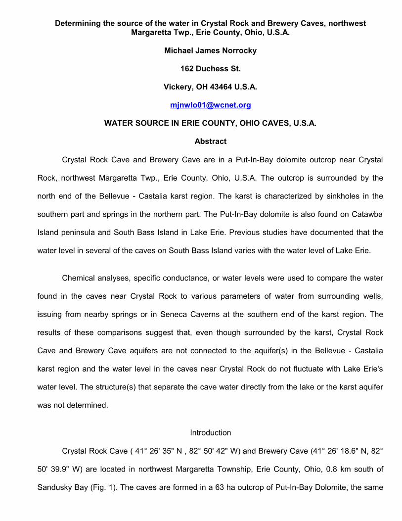
Crystal Rock Cave ( 41° 26' 35" N , 82° 50' 42" W) and Brewery Cave (41° 26' 18.6" N, 82°
50' 39.9" W) are located in northwest Margaretta Township, Erie County, Ohio, 0.8 km south of
Sandusky Bay (Fig. 1). The caves are formed in a 63 ha outcrop of Put-In-Bay Dolomite, the same
formation found on Catawba Island peninsula (Sparling, 1970) and South Bass Island in Lake Erie,
22 km to the north (Sparling, 1970; Verber and Stansbery, 1953; White, 1926). The top of the
outcrop is 190 m above sea level but drops abruptly 9 m on the north and east sides. The land then
slopes 7 m to Sandusky Bay at 174 meters above mean sea level (msl) (Fig. 1).
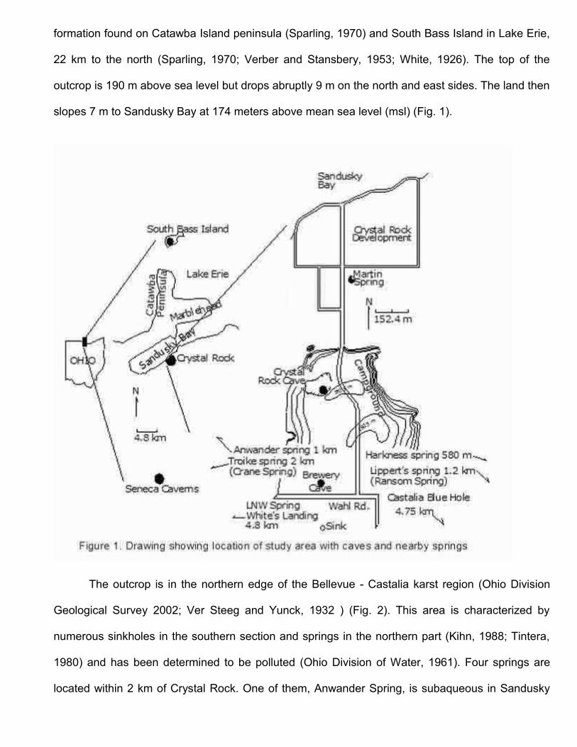
The outcrop is in the northern edge of the Bellevue - Castalia karst region (Ohio Division
Geological Survey 2002; Ver Steeg and Yunck, 1932 ) (Fig. 2). This area is characterized by
numerous sinkholes in the southern section and springs in the northern part (Kihn, 1988; Tintera,
1980) and has been determined to be polluted (Ohio Division of Water, 1961). Four springs are
located within 2 km of Crystal Rock. One of them, Anwander Spring, is subaqueous in Sandusky
Bay, 1.5 km SW of Crystal Rock development (Fig. 1) and at least 5 springs are subaqueous at
White’s Landing, 4.8 km west (Fig. 2). The Castalia Blue Hole, at one time a well know tourist
attraction, is 5 km southeast and has been reported in the local newspaper as a possible source of
the water in the caves at Crystal Rock. Troike Spring and Lippert Spring (Fig. 1) were Crane Spring
and Ransom Spring, respectively, in Kihn (1988). Crystal Rock Cave is owned by the author,
Brewery Cave is owned by Jim and Dian Winkel and is partially under the Winkel's house.
Water level in Kindt's Cave, Perry's Cave, and Mammoth Cave on South Bass Island rises
and falls with the level of Lake Erie (Author observation at Perry’s Cave, 2009; Newberry, 1874;
Verber and Stansbery, 1953; White, 1926). One objective of this study was to show that the
aquifers in the Crystal Rock area caves are not affected by changes in the level of Lake Erie as

recorded for the water in caves on South Bass Island. Another goal was to show that the water in
the Crystal Rock area caves, even though surrounded by the Bellevue - Castalia karst, is not
connected to the aquifer(s) in the karst region.
Methods and Materials
Direct measurements and Stevens Type F recorders were used to document changes in the
level of the water in Crystal Rock Cave and Brewery Cave. At Crystal Rock Cave the recorder was
set on the top of the casing for a 0.2 m X 20.4 m deep well drilled into the cave aquifer (Fig. 3). The
well was installed by a previous owner for personal use. The well was used due to the difficulty of
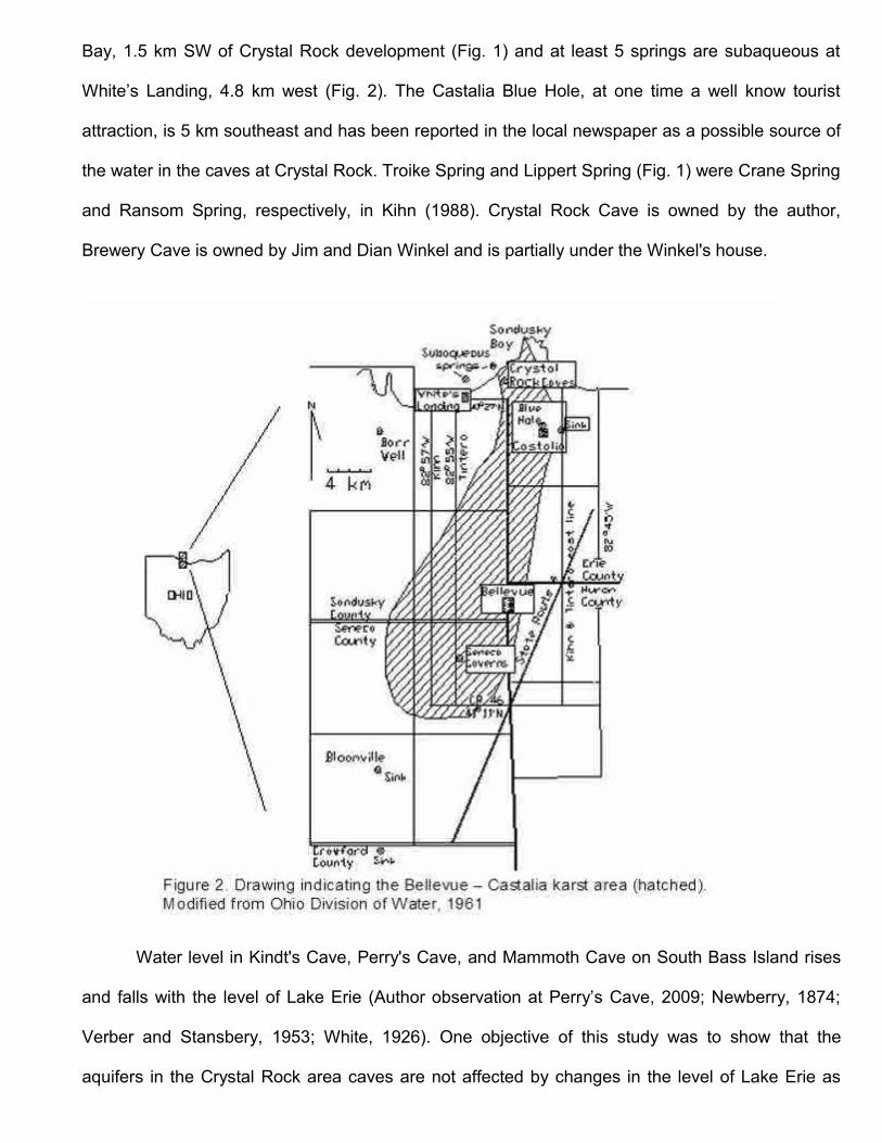
placing the Stevens recorder at the water inside the cave. At Brewery Cave a platform had to be
constructed to support the recorder over the water (Fig. 4). Note the float in the water below the
recorder.
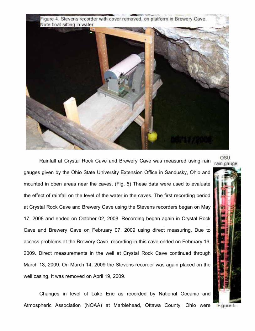
Rainfall at Crystal Rock Cave and Brewery Cave was measured using rain
gauges given by the Ohio State University Extension Office in Sandusky, Ohio and
mounted in open areas near the caves. (Fig. 5) These data were used to evaluate
the effect of rainfall on the level of the water in the caves. The first recording period
at Crystal Rock Cave and Brewery Cave using the Stevens recorders began on May
17, 2008 and ended on October 02, 2008. Recording began again in Crystal Rock
Cave and Brewery Cave on February 07, 2009 using direct measuring. Due to
access problems at the Brewery Cave, recording in this cave ended on February 16,
2009. Direct measurements in the well at Crystal Rock Cave continued through
March 13, 2009. On March 14, 2009 the Stevens recorder was again placed on the
well casing. It was removed on April 19, 2009.
Changes in level of Lake Erie as recorded by National Oceanic and
Atmospheric Association (NOAA) at Marblehead, Ottawa County, Ohio were
obtained from their website at: http://tideandcurrents.noaa.gov/ (accessed November 24, 2008).
These changes were compared to the changes in level recorded at Crystal Rock Cave and
Brewery Cave.
Martin Bailey, the scuba diving instructor at Ohio State University, has made several
surveys of the underwater portion at Brewery Cave. He has been able to dive to depths 7 m below
the level of the cave water (Personal Communication). The cave extended deeper but because of
the size of the opening he was unable to go deeper.
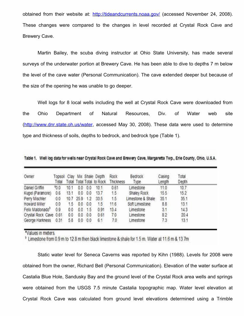
Well logs for 8 local wells including the well at Crystal Rock Cave were downloaded from
the Ohio Department of Natural Resources, Div. of Water web site
(http://www.dnr.state.oh.us/water, accessed May 30, 2008). These data were used to determine
type and thickness of soils, depths to bedrock, and bedrock type (Table 1).
Static water level for Seneca Caverns was reported by Kihn (1988). Levels for 2008 were
obtained from the owner, Richard Bell (Personal Communication). Elevation of the water surface at
Castalia Blue Hole, Sandusky Bay and the ground level of the Crystal Rock area wells and springs
were obtained from the USGS 7.5 minute Castalia topographic map. Water level elevation at
Crystal Rock Cave was calculated from ground level elevations determined using a Trimble
Pathfinder Pro XL GPS unit, accurate to within 15.2 cm.
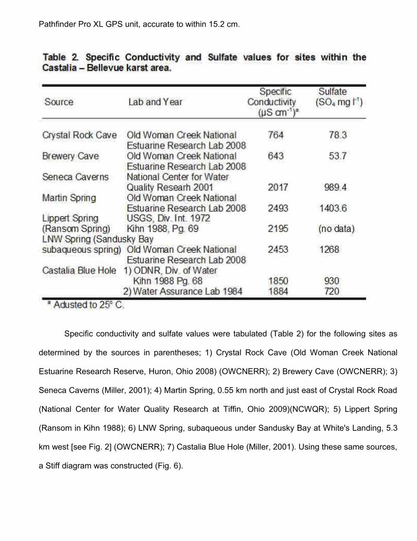
Specific conductivity and sulfate values were tabulated (Table 2) for the following sites as
determined by the sources in parentheses; 1) Crystal Rock Cave (Old Woman Creek National
Estuarine Research Reserve, Huron, Ohio 2008) (OWCNERR); 2) Brewery Cave (OWCNERR); 3)
Seneca Caverns (Miller, 2001); 4) Martin Spring, 0.55 km north and just east of Crystal Rock Road
(National Center for Water Quality Research at Tiffin, Ohio 2009)(NCWQR); 5) Lippert Spring
(Ransom in Kihn 1988); 6) LNW Spring, subaqueous under Sandusky Bay at White's Landing, 5.3
km west [see Fig. 2] (OWCNERR); 7) Castalia Blue Hole (Miller, 2001). Using these same sources,
a Stiff diagram was constructed (Fig. 6).

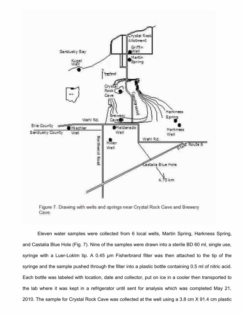
Eleven water samples were collected from 6 local wells, Martin Spring, Harkness Spring,
and Castalia Blue Hole (Fig. 7). Nine of the samples were drawn into a sterile BD 60 ml, single use,
syringe with a Luer-Loktm tip. A 0.45 µm Fisherbrand filter was then attached to the tip of the
syringe and the sample pushed through the filter into a plastic bottle containing 0.5 ml of nitric acid.
Each bottle was labeled with location, date and collector, put on ice in a cooler then transported to
the lab where it was kept in a refrigerator until sent for analysis which was completed May 21,
2010. The sample for Crystal Rock Cave was collected at the well using a 3.8 cm X 91.4 cm plastic
bailer (Forestry Suppliers, Inc., PVC Bailer # 79010). The samples at Martin Spring and Castalia
Blue Hole were collected in a copper tube rinsed in distilled water and attached to a long handle.
Each of these samples was poured into a 60 ml syringe and then treated like the other samples.
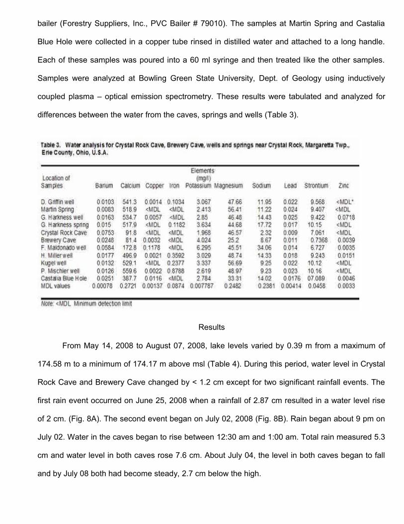
Samples were analyzed at Bowling Green State University, Dept. of Geology using inductively
coupled plasma – optical emission spectrometry. These results were tabulated and analyzed for
differences between the water from the caves, springs and wells (Table 3).
Results
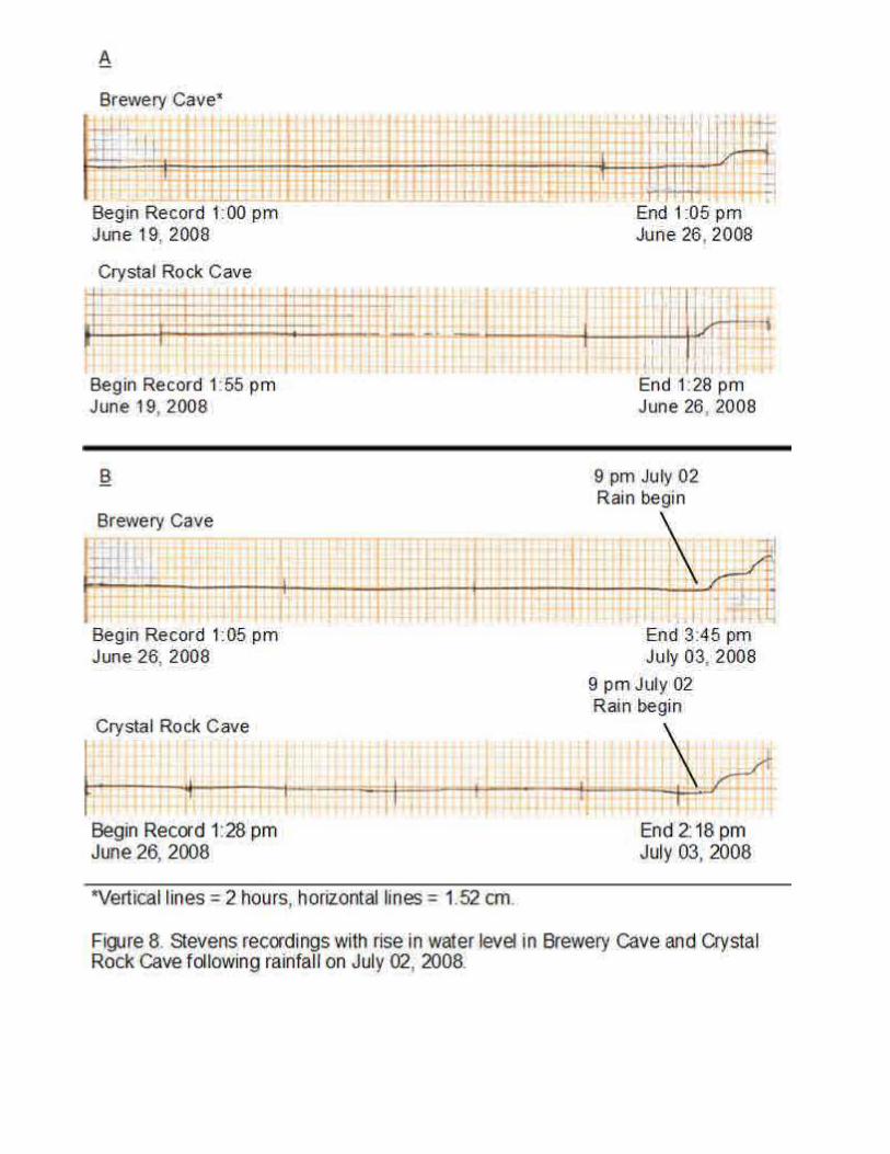
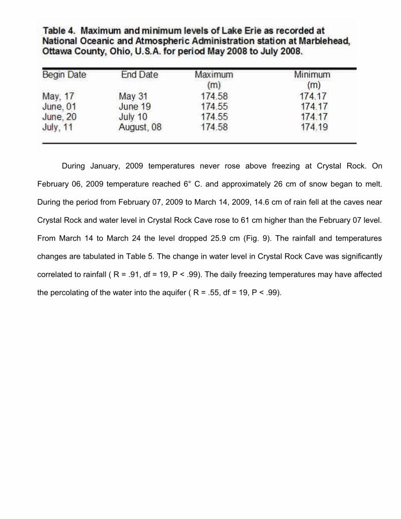
From May 14, 2008 to August 07, 2008, lake levels varied by 0.39 m from a maximum of
174.58 m to a minimum of 174.17 m above msl (Table 4). During this period, water level in Crystal
Rock Cave and Brewery Cave changed by < 1.2 cm except for two significant rainfall events. The
first rain event occurred on June 25, 2008 when a rainfall of 2.87 cm resulted in a water level rise
of 2 cm. (Fig. 8A). The second event began on July 02, 2008 (Fig. 8B). Rain began about 9 pm on
July 02. Water in the caves began to rise between 12:30 am and 1:00 am. Total rain measured 5.3
cm and water level in both caves rose 7.6 cm. About July 04, the level in both caves began to fall
and by July 08 both had become steady, 2.7 cm below the high.
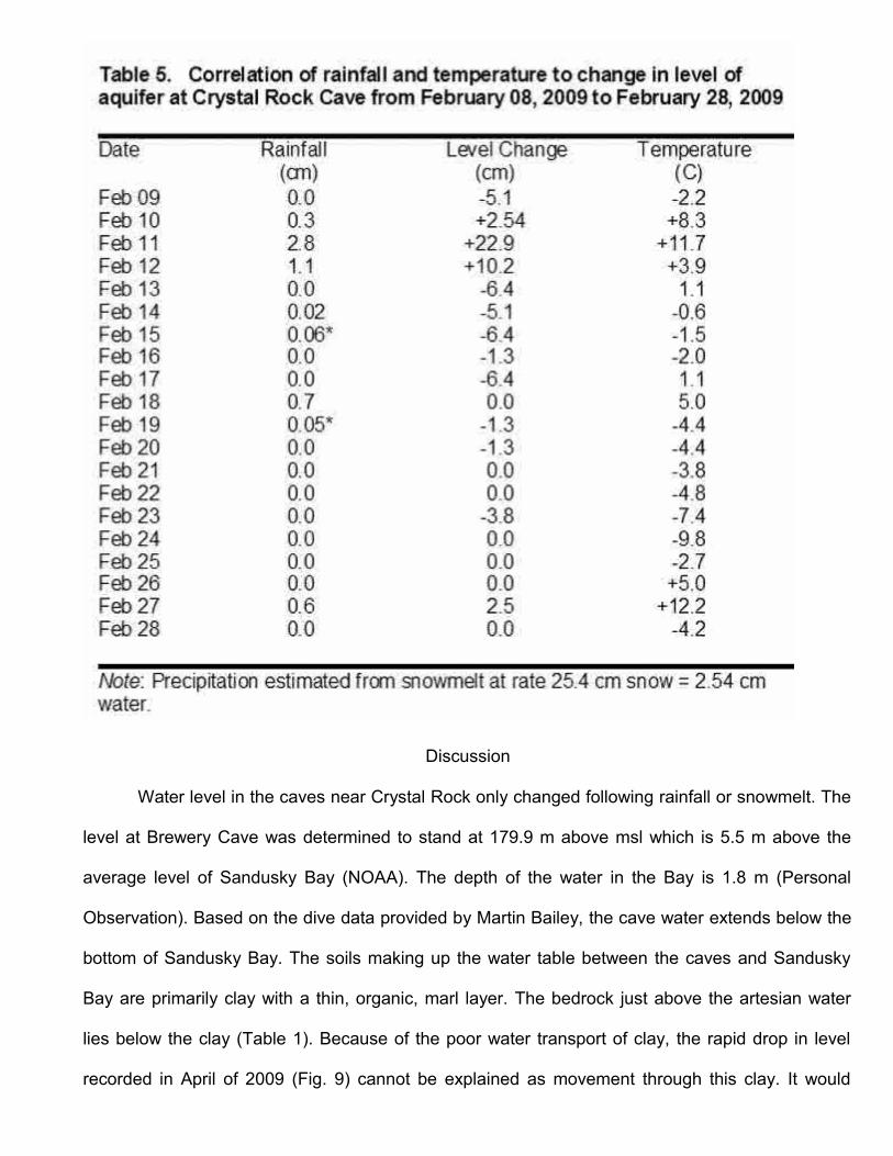
During January, 2009 temperatures never rose above freezing at Crystal Rock. On
February 06, 2009 temperature reached 6° C. and approximately 26 cm of snow began to melt.
During the period from February 07, 2009 to March 14, 2009, 14.6 cm of rain fell at the caves near
Crystal Rock and water level in Crystal Rock Cave rose to 61 cm higher than the February 07 level.
From March 14 to March 24 the level dropped 25.9 cm (Fig. 9). The rainfall and temperatures
changes are tabulated in Table 5. The change in water level in Crystal Rock Cave was significantly
correlated to rainfall ( R = .91, df = 19, P < .99). The daily freezing temperatures may have affected
the percolating of the water into the aquifer ( R = .55, df = 19, P < .99).
Discussion
Water level in the caves near Crystal Rock only changed following rainfall or snowmelt. The
level at Brewery Cave was determined to stand at 179.9 m above msl which is 5.5 m above the
average level of Sandusky Bay (NOAA). The depth of the water in the Bay is 1.8 m (Personal
Observation). Based on the dive data provided by Martin Bailey, the cave water extends below the
bottom of Sandusky Bay. The soils making up the water table between the caves and Sandusky
Bay are primarily clay with a thin, organic, marl layer. The bedrock just above the artesian water
lies below the clay (Table 1). Because of the poor water transport of clay, the rapid drop in level
recorded in April of 2009 (Fig. 9) cannot be explained as movement through this clay. It would
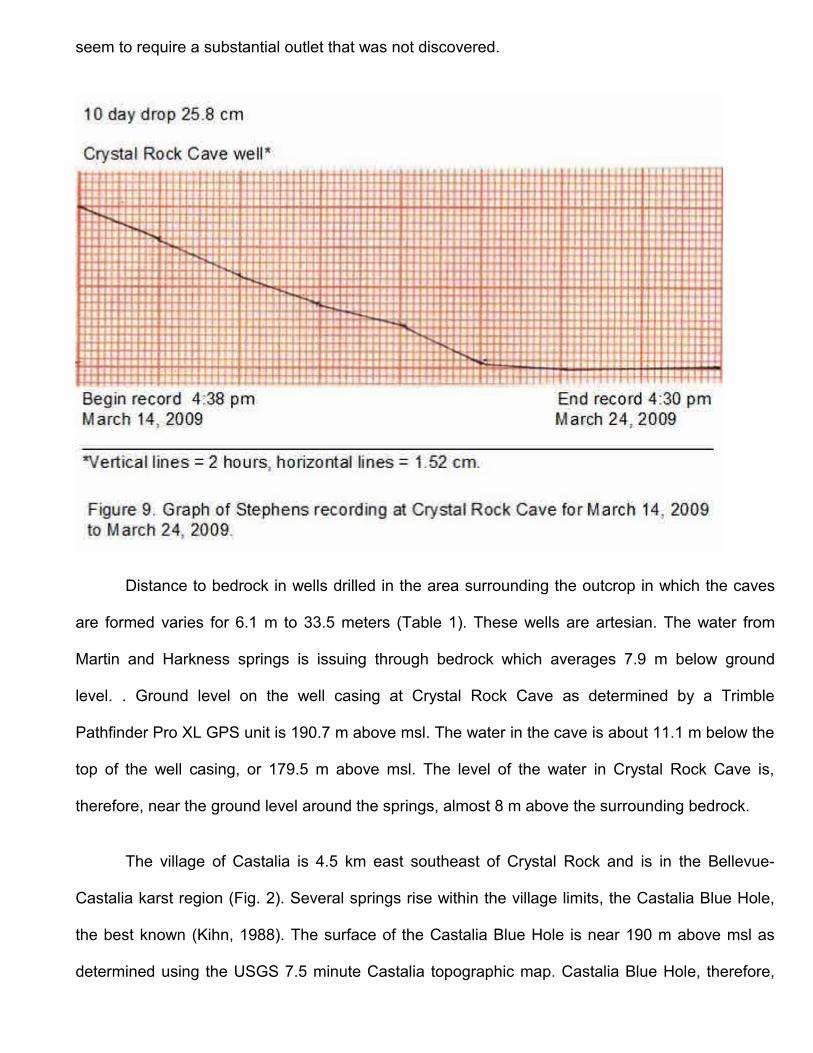
seem to require a substantial outlet that was not discovered.
Distance to bedrock in wells drilled in the area surrounding the outcrop in which the caves
are formed varies for 6.1 m to 33.5 meters (Table 1). These wells are artesian. The water from
Martin and Harkness springs is issuing through bedrock which averages 7.9 m below ground
level. . Ground level on the well casing at Crystal Rock Cave as determined by a Trimble
Pathfinder Pro XL GPS unit is 190.7 m above msl. The water in the cave is about 11.1 m below the
top of the well casing, or 179.5 m above msl. The level of the water in Crystal Rock Cave is,
therefore, near the ground level around the springs, almost 8 m above the surrounding bedrock.
The village of Castalia is 4.5 km east southeast of Crystal Rock and is in the Bellevue-
Castalia karst region (Fig. 2). Several springs rise within the village limits, the Castalia Blue Hole,
the best known (Kihn, 1988). The surface of the Castalia Blue Hole is near 190 m above msl as
determined using the USGS 7.5 minute Castalia topographic map. Castalia Blue Hole, therefore,
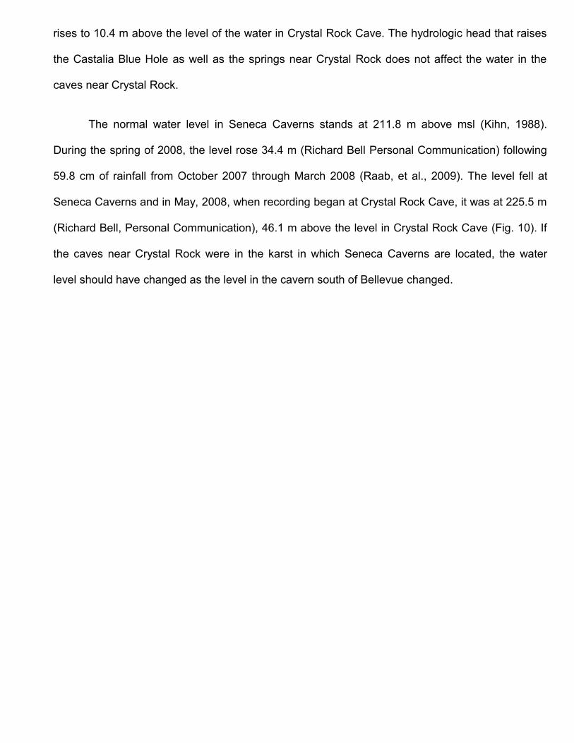
rises to 10.4 m above the level of the water in Crystal Rock Cave. The hydrologic head that raises
the Castalia Blue Hole as well as the springs near Crystal Rock does not affect the water in the
caves near Crystal Rock.
The normal water level in Seneca Caverns stands at 211.8 m above msl (Kihn, 1988).
During the spring of 2008, the level rose 34.4 m (Richard Bell Personal Communication) following
59.8 cm of rainfall from October 2007 through March 2008 (Raab, et al., 2009). The level fell at
Seneca Caverns and in May, 2008, when recording began at Crystal Rock Cave, it was at 225.5 m
(Richard Bell, Personal Communication), 46.1 m above the level in Crystal Rock Cave (Fig. 10). If
the caves near Crystal Rock were in the karst in which Seneca Caverns are located, the water
level should have changed as the level in the cavern south of Bellevue changed.
Rockwell Springs Trout Club is 4.5 km south of Crystal Rock Cave and 3.5 km southwest of
Castalia (Fig. 2). The 18 year average flow in April – May, reported in 2008, was about 6 cubic
meters per minute (cmm ) (Raab et al., 2009). Because of the increased rainfall in late 2007, the
flow in March – April 2008 was about 28 cmm. The increased hydrologic pressure on the aquifer
increased the flow measured at this spring, yet had no effect on the water in the caves near Crystal
Rock as would be expected if they shared the same aquifer.
Chemical analyses of water from nearby springs and wells (Tables 2 and 3) suggests the
separation of the water in Crystal Rock and Brewery caves from the Bellevue – Castalia karst
aquifer. These data also suggest that the caves are not in the same aquifer. Most notable are the
calcium, sodium and strontium levels (Table 2).The Winkel house which uses the Brewery Cave
water for geothermal heating and their septic system located in a mound system in front of their
house and near the cave, could be affecting the water in this cave.
Graphically, the Stiff diagram (Fig. 6), shows the unique chemistry of Crystal Rock Cave
compared to area springs and Seneca Caverns. The diagram is based on 6 ion values from each
of the following: 1) Crystal Rock Cave (OWCNERR 2008); 2) Seneca Caverns (Miller 2001); 3)
Castalia Blue Hole (Miller 2001); 4) LNW Spring (Klarer, OWCNERR 2008) and expressed as
milliequivalents per milligram. The LNW Spring, which is subaqueous under Sandusky Bay is just
off shore at White's Landing (Fig. 2).
Time of year would affect temperature and vegetation that could take water from the soil
through transpiration. The campground located across the street (Fig. 1) is seasonal and was open
for business during the recording period in 2008. However, no changes in level were recorded that
could be attributed to either of these factors. The data collected during this study suggests that the
water level in Crystal Rock Cave and Brewery Cave fluctuates independently of Lake Erie's water
level. Even though surrounded by the Bellevue – Castalia karst aquifer, these data also suggest
that the water in Crystal Rock Cave and Brewery Cave is not from the karst aquifer and is due to
rainfall and snowmelt. The mechanism that isolates the two aquifers was not determined.
Acknowledgements
The author is grateful to Jim and Dian Winkel for allowing access to Brewery Cave; Dave
Klarer at Old Woman Creek National Estuarine Research Reserve, Huron, Ohio, Ken Kreiger,
Nancy Miller and Jack Kramer at the National Center for Water Quality Research at Tiffin, Ohio,
and Charles Onasch, Bowling Green State University, Dept of Geology for water analyses; Barry
Brunner, Mgr. Castalia Trout Club for access to Castalia Blue Hole for water analysis sample; Dave
Cashell, Ohio Dept. Natural Resources, Div. of Water, for use of the Stevens recorders and helpful
suggestions; Steve Sabo for Trimble GPS elevation values; Bob Haag, Haag Environmental, for
helpful suggestions; Jeral McMillan for help in setting up the recorders; anonymous reviewers for
helpful suggestions.
Literature Cited
Kihn, G., 1988, Hydrogeology of the Bellevue-Castalia area, North-Central Ohio, with an emphasis on Seneca Caverns. [Master's Thesis]: University of Toledo, Ohio, 163 p.
Miller, B., 2001, A Comparative Study of Groundwater Chemistry along a Flow Path in Northwest Ohio. Heidelberg University, Tiffin, Ohio Research Paper WTR 393 Research II, 24 p.
Newberry, J. S., 1874, Report on the geology of Erie County and the Islands. Geological Survey Ohio, 2(1):183-205.
Ohio Division of Geological Survey, 2002, Ohio Karst Areas: Ohio Department of Natural Resources, Division of Geological Survey 1 p.
Ohio Division of Water, 1961, Contamination of underground water in the Bellevue area, Ohio Water Commission, Ground-water Geology Section, Ohio Division of Water, Department of Natural Resources, 28 p.
Raab J, Haiker B, Jones W, Angle M, Pavey, R, Swinford M, Powers D., 2009, Ground water induced flooding in the Bellevue, Ohio, area--spring and summer 2008: Ohio Department of Natural Resources, Division of Water Technical Report of Investigation 2009-1, 19 p.
Sparling, Dale R., 1970, The Bass Islands formation in Its type region. Ohio Journal of Science, 70(1): 1-33
Tintera, John J., 1980, The identification and interpretation of karst features in the Bellevue-Castalia region of Ohio. [Master's Thesis]: Bowling Green State University, Bowling Green, Ohio, 110 p.
Ver Steeg, K. and Yunck, G., 1932, The Blue Hole of Castalia. Ohio Journal of Science 32(5): 405-435.
Verber, J. L. and Stansbery, D. H., 1953, Caves in the Lake Erie's Islands. Ohio Journal of Science, 53(6): 358-362.
White, G. W., 1926, The limestone caves and caverns of Ohio. Ohio Journal of Science, 26:79-86.