Investigating the Oxbows and Testing Metal Detector Efficiency · Investigating the Oxbows and...
41
Investigating the Oxbows and Testing Metal Detector Efficiency at Little Bighorn Battlefield National Monument, Montana By Douglas D. Scott Report completed in partial compliance with Purchase Order R1380109202 Lincoln, Nebraska September 2010
-
Upload
nguyendung -
Category
Documents
-
view
218 -
download
0
Transcript of Investigating the Oxbows and Testing Metal Detector Efficiency · Investigating the Oxbows and...

Investigating the Oxbows and Testing Metal Detector Efficiency
at Little Bighorn Battlefield National Monument, Montana
By
Douglas D. Scott
Report completed in partial compliance with Purchase Order
R1380109202
Lincoln, Nebraska
September 2010

i
Executive Summary
The oxbow inventory found no archeological materials predating the late nineteenth century in
any of the three oxbows within the Custer battlefield area. All late nineteenth and early twentieth
century artifacts were found on relatively stable landforms near the mouths of ravines or just
below the steep slopes of the main battlefield. Dense vegetation prevented intensive metal
detecting of the actual oxbows, but where opportunistic sampling did occur only artifacts dating
to the mid to late twentieth century were found, and those usually buried between 25 and 30cm.
The river bank was also visually inspected where it was accessible and visible. No culturally
deposited soil strata were observed. The soil depositional sequence observed in the river bank
appeared to be water laid deposits. This suggests that modern sedimentation associated with
periodic modern flooding of the floodplain has scoured out the 1876 period surface or buried the
1876 era level well beyond the potential level of metal detecting capability of either VLF or PI
metal detectors.
A preliminary assessment of various historic maps was conducted to determine which may be the
most reliable in depicting the 1876 river channel. The method involved georeferencing the
historic maps to the modern topographic and aerial photography and establishing a root mean
square error calculation. This objective analysis was coupled with a subjective analysis of the
river channel and terrain features depicted on the subject map. A preliminary assessment of the
historic maps suggests that Maguire Map 8 and the Norris map have potential to aid in sorting
out the 1876 river channel if used judiciously. The 1883 Blake map may show the river
meanders most accurately in the area of the Custer field than other maps preceding or post-dating
it. The 1891 topographic map seems to be generally correct except for the location of the
southernmost oxbow at Custer field, which is the one currently threaten by erosion.
The absence of metal in the detectable range and the preliminary assessment of the historic maps
suggest the oxbows are not likely to contain archeological evidence of the battle. However, no
formal geomorphological investigation of the river channel, abandoned river channels, or the
oxbows has been undertaken to date. It is recommended, before determining if additional
mitigation measures are required a professional geomorphological study of the river channel is
done. Such a study has the potential to posit chronological changes in the riverbed and more
accurately define the 1876 channel, as well as determine if historic surfaces may still exist as
buried soil horizons.
Since field time permitted a more formal test of the capability of the VLF and PI metal detectors
was undertaken. Two previously inventoried areas were redetected. One test area encompassed a
known warrior fighting position and the other was a known soldier position. Each area yielded
additional artifacts. Fifty-seven percent of the artifacts were not battle-related, 43% were battle-
related, 90% were found by the VLF machines, and 10% were found by the PI metal detector
alone. The test indicates the 1984 sample strategy was sound in that it did recover a
representative sample of the range of artifact types present. The PI metal detector did find about
10% more than the VLF machines. Most of those items were either deeper than the capability of
the VLF machines or were items that were very small and were missed by the VLF machines.
The test grids indicate the PI metal detector has the potential to increase artifact recovery in areas
where materials may include very small or deeply buried artifacts.

ii
Acknowledgements
The oxbow investigation was funded by the Little Bighorn Battlefield from National Park
Service funds and the Friends of the Little Bighorn Battlefield through a private donation for
which I am very grateful. I would like to thank the entire staff at Little Bighorn Battlefield
National Monument for their assistance during the at the site. Superintendent Kate Hammond,
natural resource specialist Melana Stichman, and chief historian John Doerner are especially
acknowledged for their assistance and comments. Jim Bradford, Archeologist for the
Intermountain Region facilitated the process and brought me up to date on a variety of current
compliance regulations and guidelines. The field crew was composed of Chris Adams from the
USFS in New Mexico ably operating the Pulse Induction detector, Charles Haecker on loan from
NPS Santa Fe, volunteers Mike Clark, Mike Donahue, Tom Frew, and Larry Gibson whose
labors are gratefully acknowledged. Thank you to one and all, you made the project go very
smoothly.

iii
Table of Contents
Executive Summary……………………………………………………………………………… i
Acknowledgements………………………………………………………………………………ii
Introduction……………………………………………………………………………………… 1
Environmental and Historical Background……………………………………………………… 3
Brief Historical Overview………………………………………………………………… 4
Brief Review of Archeological Investigations……………………………………………. 5
The Oxbow Archeological Inventory…………………………………………………………… 6
Archeological Investigation Methods…………………………………………………… 6
Metal Detector Technology Summary…………………………………………………... 8
Oxbow Metal Detecting Results………………………………………………………… 9
Preliminary Assessment of Historic Maps………………………………………………………14
Maguire Maps……………………………………………………………………………15
P. H. Norris Map………………………………………………………………………...19
John Blake Map………………………………………………………………………....19
Thompson, Tweedy, Marshall Map……………………………………………………..24
Preliminary Map Analysis Summary……………………………………………………24
VLF Versus PI Metal Detector Test…………………………………………………………….27
Summary of VLF and PI Metal Detector Test………………………………………….31
Summary and Conclusions……………………………………………………………………...32
References Cited………………………………………………………………………………..34

iv
List of Figures
1. The oxbow areas in relation to the Little Bighorn River……………………………………… 1
2. A comparison between a 1935 aerial photograph and a 2005 image of Custer Battlefield… 2
3. Chris Adams holding the Minelab GPX 4000 pulse induction metal detector…………………7
4. Eroding neck of southern most or upper oxbow looking west………………………………..10
5. Metal detector team at work at the mouth of Deep Ravine…………………………………..11
6. Metal detector team at work on the northern most oxbow in tall grass……………………….13
7. Lt. Edward Maguire 1876 map 1 overlaid over Maguire’s 1881 printed map (map 8)……..16
8. The 1881 Maguire map (Map 8) overlaid on the 2005 orthophotograph……………………..18
9. The P. H. Norris map overlaid on the 2005 orthophotograph………………………………...20
10. The 1883 Blake map overlaid on the 1967 topographic map……………………………… 21
11. The 1901 Sampson map overlaid on the 1967 topographic map…………………………...22
12. Aerial photograph of the entire battlefield taken in 1954…………………………………23
13. The 1891 topographic map overlaid on the 2005 orthophotograph………………………25
14. The 1891 river course in green overlaid on the 2005 orthophotograph…………………..26
15. Location of metal detector test grids and finds on Greasy Grass Ridge and Finley-Finckle..28
16. Metal detector targets marked by pin flags on Greasy Grass Ridge………………………..29
17. Metal detector targets marked by pin flags in the Finley-Finckle area……………………..30

1
Introduction
Preliminary indications are that climate variability is accelerating the natural process of a
meandering river evolution on the Little Bighorn River. Those changes are affecting at least one
oxbow that forms the southwest boundary of Little Bighorn Battlefield National Monument
(LIBI). The park river boundary is 3.2 miles long and contains 3 river meanders (oxbows)
(Figure 1), one of which is threatened to be cut off by the river, potentially affecting the ability of
the National Park Service to manage the area (Figure 2). The purpose of this project is to
determine if historic archeological metal artifacts are present on the oxbow, and determine if
their potential loss would be a significant impact to the park’s archeological resources. The
project is also intended to provide the information necessary for park mangers to determine
appropriate mitigation measures, should they be required.
Figure 1. The oxbow areas in relation to the Little Bighorn River.
The Little Bighorn Battlefield National Monument was set aside to preserve, protect, and
interpret the historic, cultural, and natural resources including lands and artifacts pertaining to
the Battle of the Little Bighorn. Although it is a managed system, the Little Bighorn River is still

2
Figure 2. A comparison between a 1935 aerial photograph and a 2005 image of Custer Battlefield
illustrating the change in the configuration of the Deep Ravine or middle oxbow and the upper or
southern oxbow where there is now significant erosion of the oxbow evident. Image courtesy Little
Bighorn Battlefield National Monument.
dynamic enough to threaten irreplaceable battle artifacts. Warmer temperatures and subsequent
alterations in stream flow appear to be markedly changing the system by increasing erosion,
accelerating the river channel movement, impacting native vegetation species, and accelerating
the spread of invasive species.
This report details the methods and results of a metal detecting effort to locate and document
artifacts on the threatened oxbow as well as the two other oxbows located on the Little Bighorn
River. In addition this report also details the finding of a test of the capability of the new pulse
induction metal detector technology. Time was available upon completion of the oxbow
investigations to establish two small test plots on a previously identified warrior position and a
soldier position on the Custer field. The two locations were metal detected in 1984 and in 2004,
and re-detected using current VLF and Pulse Induction metal detectors to determine the
effectiveness of each metal detector type. All artifacts from the oxbow inventory and the test
locations were uncovered, identified, and reburied in-place.

3
Environmental and Historical Background
Little Bighorn Battlefield National Monument is located within the Crow Indian Reservation in
Big Horn County, southeast Montana, at Interstate 90 and Highway 212 junction, on the right
bank (east side) of the Little Bighorn River, about fifteen miles east of Hardin. The monument
comprises 765.34 acres divided into two separate parcels of land: Custer Battlefield and the
Reno-Benteen defense site located about five miles south consisting of 162 acres. The land
between the two battlefields is in private ownership or Crow Tribal allotments.
The battlefield consists of natural hills and hogback ridges cut by ravines and coulees which lead
to natural fords of the Little Bighorn River. Outside of these natural fords the river on the east
(battlefield) side is lined with steep bluffs and three oxbows or river meander bends. The Little
Bighorn battlefield lies within the Central Grasslands vegetative zone (Payne 1973) and in the
geological formations of late Cretaceous sandstone and shale (Alt and Hyndman 1986). The soils
range from sandy and gravelly along streams and rivers to heavy alluvial clays with a grayish
brown topsoil on the upland areas. The Monument has two distinct ecological and topographic
zones, the dry uplands and the Little Bighorn River floodplain, with an elevation range of 3,000
to 3,400 feet. The uplands are formed from the Bearpaw and Judith River formations. The
floodplain is a Quaternary alluvium.
Climatically, the park is characterized by a dry continental type of extreme fluctuations in
temperature and moisture. The topography is rolling plains that feature a variety of grasses and
sagebrush. While Big sagebrush has not returned since the battlefield was burned in the 1983 and
1991 fires, it remains the predominate specie in the unburned areas, about 10% of the park.
Silver sagebrush is the predominate specie in the burned areas. Western snowberry, chokecherry
and wild rose commonly found in better moisture conditions such as coulee bottoms. Common
grasses and shrubs are Sandberg bluegrass, green needlegrass, bluebunch wheatgrass, northern
reedgrass, prairie junegrass, mountain muhly, prickly pear cactus, and fringed sagewort.
Animal species were once quite diverse, before the Euro-American ranching era. Today horses
and domestic cattle dominate the grazing species, but at one time the area supported bison, bear,
and elk. Current animals include deer, rabbit, fox, coyote, badgers, pronghorn antelope, and the
ubiquitous prairie dog among other species. Small mammals are regularly seen in the park
including the northern grasshopper mouse, thirteen-lined ground squirrel, and northern pocket
gopher. A variety of birds have been observed in and around the park, including the western
kingbird, American goldfinch, western meadowlark, and Golden and Bald eagles. The park
forms a small wildlife refuge in the midst of the intensely grazed Crow Reservation.
The north-northwest and northwest oriented Little Bighorn River is the major Bighorn River
tributary. The Little Bighorn River originates in the northern Bighorn Mountains and flows
northeast and northwest to join the Bighorn River at Hardin, Montana. The Bighorn River
originates in northwestern Wyoming. After flowing north-northwest to the Montana state line the
Bighorn River turns to flow northeast through the Bighorn Canyon National Recreation Area and
then north-northeast to join the northeast-oriented Yellowstone River. The Yellowstone River
flows in a northeast direction to Miles City and northeasterly to join the Missouri River near the
Montana and North Dakota border. Based on evidence from topographic and geomorphic

4
landform evidence the origin of the Bighorn and Little Bighorn River and valleys is interpreted
in the context of an immense southeast-oriented flood flowing across the area and which was
systematically captured and diverted northeast by headward erosion of deep valleys eroded into
topographic surfaces found at the highest elevations. The Little Bighorn valley, through which
the river flows is primarily covered with alluvium derived from numerous geologic and flood
events dating back to at least the Quaternary era. Tributary water sources usually carry large
volumes of water and sediment into the Little Bighorn as a result of snow melt in the spring, and
the Little Bighorn source likewise contributes similar amounts of water and sediment. Prior to
intense irrigation and flood control on the Little Bighorn the river irregularly inundated the
valley floodplain (Thom et al. 1935:20-30). Flooding resulted in scouring of some areas and
fluvial deposits in others, varying from place to place and from flood event to flood event.
Brief Historical Overview of the Battle
The history of the battle is well documented in a variety of publications (Gray 1976; 1991;
Kuhlman 1951; Utley 1988; Graham 1953). Previous archeological investigations are
summarized in Scott and Fox (1987), Scott et al. (1989), Fox (1993), Scott, Willey and Connor
(1998), Scott and Bleed (1997), and Scott (2010).
In the spring of 1876, a three-pronged campaign was launched to shepherd the Sioux and
Cheyenne back to the reservation. The first column, under Colonel John Gibbon, marched east
from Fort Ellis (near present-day Bozeman, Montana). The second column, led by General
Alfred Terry (and including Custer) headed west from Fort Abraham Lincoln near Bismarck,
North Dakota. The third column consisted of General George Crook's men moving north from
Fort Fetterman, Wyoming (near modern Douglas) into Montana. These three columns were to
meet near the end of June in the vicinity of the Little Bighorn.
Unknown to Terry and Gibbon, Crook encountered the Indians near Rosebud Creek in southern
Montana, and was defeated by them about a week before Custer's battle (Vaughn 1956; 1987a).
After this, his force withdrew to Wyoming, breaking one side of the triangle. Meanwhile, Terry
was moving west up the Yellowstone River to the Little Bighorn. The Seventh Cavalry, under
Custer, was to scout ahead and departed Terry's command on June 22. On the morning of the
25th, the Seventh Cavalry was at the divide between the Rosebud and the Little Bighorn Rivers.
From a spot known as the Crow's Nest, army scouts observed a large Indian camp.
Worried the Indians might escape; Custer decided to attack and descended into the valley of the
Little Bighorn. Captain Frederick Benteen was ordered to travel southwest with three companies
to search for Indians and block a possible southern escape route. A few miles from the Little
Bighorn, Custer again divided his command, as Major Marcus Reno was ordered to advance with
three companies along the river bottom and attack the Indian village on its southern end. The
remaining five companies would follow Custer in support of Reno.
Custer took the remaining five companies along the east side of the river to an ephemeral
tributary of the Little Bighorn. He must have finally realized the gravity of the situation as the
north end of the village came into view. From here, he sent a message back to Benteen:

5
"Benteen, Come on. Big village, be quick, bring packs. P.S. Bring pacs [sic]. W.W. Cooke."
The messenger, Trumpeter John Martin, was the last soldier to see Custer and his command
alive.
Custer and five companies rode to their fate. Custer apparently further divided his command in
the lower reaches of Medicine Tail Coulee sending one wing of two companies to the ford at the
mouth of the coulee where it debouches into the Little Bighorn River. Custer and the other three
companies held higher ground to the east, now known as Nye-Cartwright Ridge. Whether due to
increasing warrior pressure on the wing at the mouth of Medicine Tail Coulee or because of
pressure on his wing, Custer apparently ordered a withdrawal from the coulee with the five
companies rejoining at the southern end of what is now called Custer or Battle Ridge and
Calhoun Hill. There Custer evidently deployed Lieutenants James Calhoun and John J.
Crittenden with two companies of soldiers to hold the position while he rode to the north with
the remaining three companies. Custer’s goal may have been to move further north and cross the
river with the intent of attacking the village from the north and relieving the pressure on Reno’s
command. Custer likely deployed Captain Myles Keogh about 300 yards in the rear of Calhoun
and Crittenden’s position while he moved on to the north with two companies, E and F. Some of
Custer’s command seemingly did move to the northwest along a spur of land or an extension of
Custer or Battle Ridge, now just outside the park boundary, but at some point was forced back to
take positions at Last Stand Hill. The command was under attack by increasing numbers of
Cheyenne and Lakota warriors who soon outnumbered, outgunned, and outfought Custer and his
men, destroying the command to a man by late that Sunday afternoon.
In the meantime, Indian warriors had forced Reno and his men to retreat across the river and up
the bluffs to a defensible position. Reno and the men on the hilltop were joined by Benteen's
forces and the pack train, both following along Custer's line of march in order to bring up the
ammunition packs. The Indians pinned down all until June 27th
, when the village broke up into
small groups that withdrew as Terry’s and Gibbon’s combined column arrived. For that day and
a half, Reno, Benteen and the men fought to keep their defensive position and wondered when
Custer would relieve them. Reno sent two men to meet the advancing column, and they found
Terry and Gibbon near the abandoned Indian village. Here, a scout brought the news. Custer and
his men lay dead on a ridge above the Little Bighorn.
Brief Review of Archeological Investigations at Little Bighorn Battlefield
Archeological investigations at the site of the Battle of the Little Bighorn, Montana have yielded
thousands of artifacts in earlier investigations (Scott and Fox 1987; Scott et al. 1989; Scott and
Bleed 1997; Scott 2010). Systematic archeological research began in the park in 1984 and 1985
(Scott and Fox 1987; Scott et al. 1989) with a park-wide metal detector and visual sampling
based inventory. In 1994 the first systematic inventories of non-National Park Service lands were
undertaken (Scott and Bleed 1997). This effort was followed by additional investigations on
Crow Tribal allotments in 1996 (Scott 1996), 1998 (Scott 1998), and other private lands in 1999
(Scott 2000). The purpose of those archeological investigations was to determine the extent that
battle-related remains might extend on to non-NPS owned lands. Each of the projects was

6
successful in its own right yielding over 5000 artifacts that have aided in reshaping the story of
the battle (Scott 2010).
The earlier archeological metal detector inventories employed a sampling methodology using 3
meter wide transects that covered the entire park acreage and 1200 additional acres outside the
park boundaries. The 3 meter wide transect approach employing metal detectors was determined
to have sampled approximately 35% of the area creating a statistically valid sample of the buried
and subsurface metal artifact distribution (Scott and Fox 1987; Scott et al. 1989; Scott 2010).
The metal detecting work recovered over 5000 artifacts related to the history of the site. The
sampling approach, while providing significant insight into the battle, left in place a major
portion of the archeological deposits. The artifact types recovered include cartridge cases,
bullets, iron arrowheads, personal adornment items, army equipment, firearms parts, buttons, and
even fragments of uniform and underwear cloth as well as human skeletal elements from the
soldiers’ remains (Scott, Willey, and Connor 1998). These objects and their provenience
information constitute the physical evidence of the battle and represent the positions and
movements of the individual participants.
The national significance of Little Bighorn Battlefield National Monument has long been
established under Criteria A, B, and C for the National Register. The results of archeological
investigations (Fox 1983; Scott and Connor 1986; Scott and Fox 1987; Scott et al. 1989) of the
battlefield document an added dimension of the site's national significance and supported its
inclusion on the National Register under Criterion D as well.
The Oxbow Archeological Inventory
Previous archeological inventory included only small portions of the Little Bighorn River
oxbows, although a portion of one oxbow, the northern most one, was detected in 1999 (Scott
1999) as part of the compliance for construction of a new gauging station on the river. The
current project was designed to determine if historic or recent archeological materials are located
on the river oxbows that are within the park boundary, and in particular determine if any in situ
archeological materials are significant and threatened by active river erosion.
The objectives of this research were to document additional evidence of the Battle of the Little
Bighorn and/or other use and occupation of the landscape by conducting close interval metal
detecting of the affected oxbows to insure there will be no loss of archeological data without
appropriate documentation and mitigation.
Archeological Investigation Methods
The oxbow mitigation efforts took place on three Little Bighorn River oxbows located in
Sections 18, 19, and 20, T3S, R35E as depicted on the Crow Agency, Montana 7.5 minute, 1967
USGS topographic quadrangle map.

7
The fieldwork consisted of close order metal detecting and visual inventory of the three oxbows.
The field investigations were conducted between July 12 and 14, 2010. Personnel included Chris
Adams using a Minelab GPX 4000 pulse induction metal detector (Figure 3), volunteers Tom Frew
and Larry Gibson using Tesero Lobo Super TRAQ VLF metal detectors, and archeologists Charles
Haecker and Douglas Scott using Minelab Explorer II VLF metal detectors that operate on 28
frequencies simultaneously. The metal detector team was assisted by Mike Clark and Michael
Donahue on July 12 and 13 who aided in excavating metal target locations. Park natural resource
specialist Melana Stichman observed and assisted the team on July 12.
Figure 3. Chris Adams holding the Minelab GPX 4000 pulse induction metal detector. Note the operator
must be as metal free as possible to deploy the machine. The battery is carried in a separate case strapped to
the back of the operator.
Standard archeological data recording methods were used in each phase of the operation.
Individual artifacts, spatially discrete clusters of identical specimens, or associated dissimilar
specimens received field identifiers as they were recorded. Field notes and a Trimble
GeoExplorer II GPS unit were used to record field data. The GPS data was differentially
corrected when it was downloaded from the data collector. Selected in-place artifact specimens
and topography were photographed and recorded in digital format.

8
Metal detecting operations were designed to locate subsurface metallic items with the use of
electronic metal detectors. Visual inspection of the surface was carried out concurrently with the
metal detector survey. VLF detector operators proceeded in line, using a sweeping motion to
examine the ground. The 2 meter detector operator interval allowed for slight overlap among
operators insuring as complete as coverage as possible. The selected interval has been shown to
be effective in similar mitigation situations (Garrow et al. 2000; Connor and Scott 1998) A pin
flag was placed at each target located by an operator. As soon as the location was pinned, the
operator continued along the transect. The PI detector operator followed the VLF machines
working the same areas independently to ensure complete coverage and determine if metal
targets deeper than the range of the VLF machines were present.
Hand tools, such as shovels and trowels, were utilized to expose subsurface artifacts. The
recorder assigned a record number generated by the GPS unit, made a field identification of the
artifact, photographed the item if warranted, and also backfilled the holes upon completion of the
recording process. All data was collected using differentially corrected UTM coordinates using
the NAD 1983 datum that is compatible with previous archeological inventories in the park and
the park-wide GIS database.
Metal Detector Technology Summary
The two metal detector types employed in the Oxbow survey were VLF (very low frequency)
and PI (pulse induction). The VLF concept is based on sending an electrical current in to the
ground to determine if materials that are conductive (also called inductance) or resistive to
electrical current are present. VLF technology relies on the principle of phase shift, which is the
difference in timing between the transmitter coil's frequency and the frequency of the target
object. The difference is a result of its conductivity (inductance) or its resistance to electricity.
An object that conducts electricity easily (inductive) is slow to react to changes in the current.
An object that does not conduct electricity easily (resistive) is quick to react to changes in the
current. Essentially, this means that an object with high inductance is going to have a larger
phase shift, because it takes longer to alter its magnetic field. An object with high resistance is
going to have a smaller phase shift.
Phase shift provides VLF-based metal detectors with its discrimination capability. Since most
metals vary in both inductance and resistance, a VLF metal detector examines the amount of
phase shift, using a pair of electronic circuits called phase demodulators, and compares it with
the average for a particular type of metal. The detector then provides an audible tone or visual
indicator as to what range of metals the object is likely to be in.
PI technology sends powerful, short bursts (pulses) of current through a coil of wire. Each pulse
generates a brief magnetic field. When the pulse ends, the magnetic field reverses polarity and
collapses very suddenly, resulting in a sharp electrical spike. This spike lasts a few microseconds
(millionths of a second) and causes another current to run through the coil. This current is called
the reflected pulse and is extremely short, lasting only about 30 microseconds. Another pulse is
then sent and the process repeats. A PI-based metal detector sends about 100 pulses per second,

9
ranging from several dozen pulses per second to over a thousand, depending on the model or
brand.
A sampling circuit in the metal detector is set to monitor the length of the reflected pulse. By
comparing it to the expected length, the circuit can determine if another magnetic field has
caused the reflected pulse to take longer to decay. If the decay of the reflected pulse takes more
than a few microseconds longer than normal, there is probably a metal object at that location.
The sampling circuit sends the tiny, weak signals that it monitors to a device called an integrator.
The integrator reads the signals from the sampling circuit, amplifying and converting them to
direct current (DC). The direct current's voltage is connected to an audio circuit, where it is
changed into a tone that the metal detector uses to indicate that a target object has been found.
PI metal detectors are poor at discrimination because the reflected pulse length of various metals
is not easily separated. However, they are useful in many situations in which VLF-based metal
detectors would have difficulty, such as in areas that have highly conductive material in the soil
or general environment. PI systems detect metal much deeper in the ground than other systems.
The detectors employed during the oxbow inventory and the field test included two models of
VLF machines and one PI machine. One VLF machine was the Tesoro Super TRAQ with a 10
inch concentrically wound elliptical coil. The Super TRAQ operates on the 17.8 kHz frequency.
The machines were operated in all metal mode. The other VLF machine type was the Minelab
Explorer II that operates on 28 frequencies simultaneously, 1.5 kHz to 100 kHz. One Explorer II
used a 10.5 inch double D wound coil and the other a Coiltek Joey 10 inch elliptical double D
wound coil. The double D coil technology is essentially two D-shaped windings set side by side.
The double D coil form minimizes ground mineralization allowing for greater depth and clearer
signal return. The machines were operated in all metal mode. The PI machine was a Minelab
GPX 4000 using a Coiltek Wallaby 17 inch elliptical mono coil.
Oxbow Metal Detecting Results
The southern or upper oxbow (Figure 4), the one that is threatened to be cut off by the river, was
the first area metal detected. A narrow and actively eroding strip or neck of land connects the
oxbow to the higher terraces along the park boundary fence. The neck is vegetated with grasses
and sagebrush and was relatively easy to detect. The main oxbow element is a roughly oval
shaped piece of land around which the Little Bighorn River meanders in a broad loop. The
oxbow is a floodplain, and in geomorphologic terms a T-0 terrace. It is densely vegetated with
low brush and cottonwoods. There is significant deadfall in the brushy areas. The dense
vegetation precluded all but the most random metal detector sweeps as the team could not swing
the detectors nor reach the ground surface with the coils in most areas. The random detector
sweeps of the heavily vegetated areas produced no metal targets with the VLF or PI machines.
The metal detector sweeps of the neck produced all of the metal finds on the southern oxbow.
The items found were near surface, ranging in depth from surface to buried about 6cm, and all
were located with both the VLF and PI machines. The finds were 1 .30-30-caliber Remington
unfired cartridge, 2 .30-30-caliber fired Remington cartridge cases, 1 .25-caliber Automatic
pistol fired cartridge case. No headstamp was present on the .25-Auto cartridge case. In addition

10
Figure 4. Eroding neck of southern most or upper oxbow looking west. Not the dense vegetation in the
background. The orange pin flags denote artifact find locations.
6 .22-caliber fired cartridge cases were found. The .30-30-caliber was introduced in 1894 by
Winchester and is still loaded today (Barnes 2006:56). The .25-Auto was introduced in 1908 and
is still loaded today (Barnes 2006:287). The .22-caliber cases were headstamped with an
impressed diamond design. The Diamond was the logo for the Western Cartridge Company from
1908-1926 when they merged with Winchester. All the finds post-date the battle by at least 20
years and probably reflect twentieth century hunting episodes.
The middle oxbow is associated with the mouth of Deep Ravine. The ravine mouth beyond the
boundary fence is relatively steep walled and about 4 meters deep and nearly flat bottomed. The

11
ravine opens on to a broad floodplain that is covered in sagebrush and grasses (Figure 5). This
sagebrush flat fades into a densely vegetated rather large oxbow that is irregularly shaped by
river meanders. The dense vegetation is composed of thick underbrush, cottonwood trees, and a
good deal of fallen or down trees and large tree limbs.
Figure 5. Metal detector team at work at the mouth of Deep Ravine. Note the dense vegetation on the main
oxbow to the left of the sagebrush area.
The sagebrush flat and the mouth of the ravine were inventoried in 1984 with no battle-related
items recovered in this area (Scott and Fox 1987). The Deep Ravine oxbow was detected in a
manner similar to that of the south oxbow. The sagebrush flat yielded an unidentified iron bar, 11
.22-caliber fired cartridge cases, 2 .22-caliber bullets, and a .45-70-caliber cartridge case with a
WRA headstamp. The .22-caliber cartridge cases were headstamped with an impressed U or a
diamond. The U stands for Union Metallic Arms Company and is still used today by their
successor Remington Arms. The impressed U was first used in the 1880s but became common
on .22-caliber ammunition after 1910 when Remington purchased UMC, and the U became their
logo. The WRA headstamp is for Winchester Repeating Arms and was their headstamp from
1929 to 1978 (Shuey 1999:9-12).
The dense vegetation precluded all but the most random metal detector sweeps as the team could
not swing the detectors nor reach the ground surface with the coils in most areas. The random
detector sweeps of the heavily vegetated areas produced two metal targets found with PI

12
machine. Both targets were found on the river bank at the southwest side of the oxbow. Both
targets were modern aluminum beer cans, and both were located at depths between 25 and 30cm.
The north oxbow is the site of the park water pumping station. An in-stream gauge to measure
stream flow in the Little Bighorn River was located on the north oxbow 1999-2007. The gauge
site was inventoried visually and with metal detectors in 1999 (Scott 1999). The project required
a trench, one to two feet deep, be dug from the edge of the river for a 2.5 inch diameter pipe to
connect the water level sensor in the river to the data collection equipment located 75 feet away
on the riverbank.
Approximately 7 acres were visually inventoried in 1999 by Scott and metal detected by the
volunteer crew. The area was walked in a series of 2 meter wide transects although thick brush
interfered in several areas, until it was completely covered. The area had also been inventoried
during the 1984 archeological investigations of then Custer Battlefield National Monument
(Scott and Fox 1984). The only things found at that time in the floodplain were relatively modern
debris. No nineteenth century artifacts were located during the 1984 work.
Scott (1999) reported no prehistoric or historic sites, features, or objects were found during the
gauge inventory effort. The metal detectors found numerous objects dating to the post-1950 use
of the area as a water treatment facility buried in the floodplain. The metal objects were buried to
depths of 8-10 inches. The river bank was also visually inspected at the time and no cultural soil
strata were observed. The soil depositional sequence observed in the river bank was obviously all
water laid deposits. This suggests that modern sedimentation associated with periodic modern
flooding of the floodplain has scoured out the 1876 period surface or buried the 1876 era level
well beyond the potential level of construction disturbance.
The northern oxbow area lies below a sloping terrace at the north end of the park. The inventory
area is adjacent to the high terraces that comprise the main battlefield, but lies below these
eroded slopes. The oxbow is heavily vegetated with brush and cottonwood trees (Figure 6).
There are some relatively open glades in the oxbow and near the eroded slopes there is an open
grassy area bisected by a vehicle service road that provides access to the park pump station.
The grassy area was metal detected at 2 meter intervals as were the open glades. The densely
vegetated areas were opportunistically sampled where the metal detectors could swing their
machines and reach the ground surface.
An open glade south of the pump house and the grassy area yielded the only artifacts recovered
in the densely vegetated area. The open glade yielded 12 artifacts including an unidentified piece
of oxidized iron, a pair of fencing pliers, a flat file, an unidentified pipefitting, six pieces of one
or more sanitary (modern) tin cans, part of an aluminum can, and a pair of broken and bent sheep
shears. The material all appears to be twentieth century in origin and the area appears to be
littered in a light trash scatter. The material probably represents items lost by maintenance
personnel and deposited during flood events, such as the cans.
The grassy area yielded 19 excavated items and a large number of additional metal targets that
were not dug. The 19 excavated items covered the sagebrush area south of the vehicle trail. Items

13
Figure 6. Metal detector team at work on the northern most oxbow in tall grass.
located include 3 cut nails, a tinned beer can, a fragment of clear glass associated with a wire
nail, 2 wire nails, 2 nuts for bolts, an unidentified piece of strap iron, an unidentified iron
collapsible frame, a 3-tine fork with wooden handle, a 10 gauge shotshell base headstamped
UMC/New Club, a 10 gauge shotshell base headstamped WRA, a .45-70-caliber cartridge
headstamped WRA, an unidentified cast iron fragment, unidentified electrical splicing device, a
tin can, and a copper harness rivet. The finds ranged in depth from surface to 25cm with most
being found around 3-5cm below surface.
The cut nails probably date after 1880 and the wire nail was not commonly in production until
after 1890. The 3-tined fork is similar in style to ones found in late nineteenth century mail order
catalogs. The shotshells and .45-70 cartridge were manufactured after 1929 and before 1978 as
noted earlier. The material found in the grassy area appears to be a light scatter of late
nineteenth and early twentieth century trash. The area may have once functioned as a disposal or
discard area for the War Department administrators and later the National Park Service.
The dense vegetation precluded all but the most random metal detector sweeps as the team could
not swing the detectors nor reach the ground surface with the coils in most areas. The random
detector sweeps of the heavily vegetated areas produced no metal targets with the VLF or PI
machines.

14
Preliminary Assessment of Historic Maps and the 1876 River Channel Depictions
Changes to the Little Bighorn landscape have a long history beginning with the aftermath of the
battle and later construction of the monuments, access and tour roads, creation of Custer
Battlefield National Cemetery, construction of the park visitor center and infrastructure, building
of the interstate and highway, gas stations, restaurants, motels, museums, gravel mining
operations, and changes in the river channel which have all had an impact on the terrain
(Donahue 2008a, b; Scott and Donahue 2010). One cannot employ a historic map to argue how
the terrain or river has changed unless its accuracy can be reasonably established. If the map is
shown to be simply a representational sketch of important features and events instead of a
proportionally correct rendering of a landscape as it once existed, then its value to arguments
about change or lack of change can be more reasonably assessed in historic and modern contexts.
Maps and mapmaking have evolved through time with changes in theoretical and scientific
understanding of the world and how to represent it in two-dimensional space (Scott and Donahue
2010). Assessing the planimetric accuracy of historic maps is not a new endeavor, but it is often
done with transparent overlays and a narrative description. With the advent of computer based
Geographic Information Systems (GIS) there is now electronic means to assess the spatial
accuracy of those early maps. Not all maps can be assessed in a GIS system, particularly those
that lack a scale and clearly defined points of reference like many of the individual soldier and
Indian sketch maps recorded by early researchers. However, the Edward Maguire, P. H. Norris,
early USGS maps, and early General Land Office Survey maps are amenable to assessment in
GIS as they appear to be based on some type of measured and scaled effort. These maps are the
basis for most other sketch maps of the battlefield and are regularly employed by researchers
today.
The selected maps were electronically scanned into a tiff or jpeg file. The desired scanned
historic map was brought into the GIS program creating a rectified or georeferenced layer
composed of the historic map. Where possible corresponding points such as the park boundary
corners, the monument at Last Stand Hill, or the juncture of Medicine Tail Coulee with the Little
Bighorn River were used to georeference the map in question. The GIS program performs a
series of mathematical calculations and “fits” the historic map to the modern map, thus rectifying
the two maps. The difference between the distances derived from the modern source map and the
calculated distances on the historic map for those same points provides a basis to calculate its
accuracy via a Root Mean Square Error (RMSE) mathematical function. The RMSE result gives
a difference in the measurement unit used (e.g. feet or meters) between the modern source map
and that of the historic map, and from this the error in the historic map can be calculated.
Ideally there is no error or a 1 to 1 correlation is the result. A 2% to 4% error can be expected
using the less controlled points in this example. Nevertheless, the results of these maps matching
efforts provide a reasonable calculation of the accuracy of the historic maps relative to the well
defined and survey controlled modern base maps. The goodness of fit between the maps can be
assessed by looking at the depiction of the terrain, location of major features, and the accuracy or
changes in the Little Bighorn River channel from map to map and over time.

15
The eight Lt. Edward Maguire maps were selected along with the P. H. Norris map, John T.
Blake map, and the Thompson, Tweedy, Marshall 1891 USGS topographic map (Donahue
2008b). Each map was scanned and georeferenced to the current rectified USGS topographic and
orthophotographic imagery as taken from the Seamless Data Distribution site on the USGS
internet site. The maps were brought into and analyzed in the Geographic Information System
program, ArcGIS Map, version 9.3.
Maguire Maps
The earliest maps of the battlefield are those done by Lt. Edward Maguire, Lt. Edward
McClernand, and Sgt. C. Becker (Donahue 2008a, b). On June 27, 1876 they measured and
sketched the battlefield creating a sketch map that in turn resulted in a series of maps that are not
only of interest but controversial as well due to the many changes evident from the first field
sketch map to the finished product used in Maj. Marcus Reno’s Court of Inquiry in 1879.
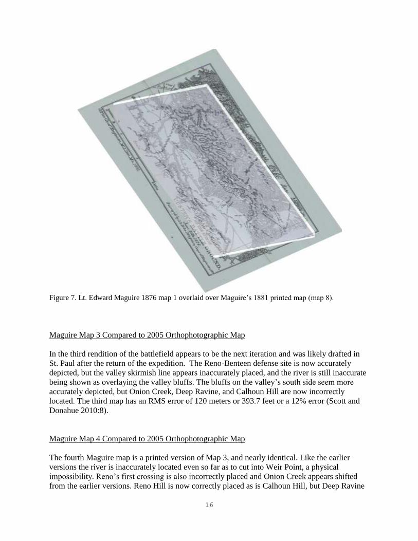
Maguire Map 1 Compared to Maguire Map 8
It is clear that earliest Maguire’s small sketch map is truly a field sketch and not meant to give
anything more than a mere suggestion of the field in general terms, and it was done at an
extremely large scale of 1 inch equals 1 mile which does not allow for drawing detailed
definition. It is likely the map, made in the field and coupled with notes and other information, is
the basis for the subsequent seven known variations and renditions of the battlefield map (Figure
7). Compared to the modern maps and aerial imagery the river meanders are simplified and not
as accurate as the last or published (Map 8) 1881 rendition. The river appears out of place as it
overlays the modern bluff area and it is obvious the orientation is skewed. The distance to Reno
Hill from Last Stand Hill is shortened relative to the final map (Map 8) and the modern imagery
as well. Onion Creek appears in both the field sketch and the last map, although it is simply
noted and alluded to in the sketch. Maguire Map 1 has an RMS error value of 162.8 meters
(534.1 feet), or a 16% error value, a significant error (Scott and Donahue 2010:7).
Maguire Map 2 Compared to 2005 Orthophotographic Map
Maguire Map 2 appears to be a revised and inked rendering of the field sketch map that
accompanied his preliminary report to the Chief Engineer. Onion Creek’s location matches well
with the current topographic map and the intermittent drainages current course on 2005 aerial
photography. The river on the Maguire Map 2 is incorrectly placed and shows being in the bluffs
on the modern map as well as on Maguire Map 8. Map 2 also incorrectly places the Reno-
Benteen defense site; however, Reno’s second crossing site appears to be more accurately
depicted. The bluffs in the valley appear to be inaccurately depicted on the south side of the
valley. The second map has an RMS error value of 128.8 meters (422.6 feet) or a 13% error,
another significant error between the maps (Scott and Donahue 2010:7-8).
16
Figure 7. Lt. Edward Maguire 1876 map 1 overlaid over Maguire’s 1881 printed map (map 8).
Maguire Map 3 Compared to 2005 Orthophotographic Map
In the third rendition of the battlefield appears to be the next iteration and was likely drafted in
St. Paul after the return of the expedition. The Reno-Benteen defense site is now accurately
depicted, but the valley skirmish line appears inaccurately placed, and the river is still inaccurate
being shown as overlaying the valley bluffs. The bluffs on the valley’s south side seem more
accurately depicted, but Onion Creek, Deep Ravine, and Calhoun Hill are now incorrectly
located. The third map has an RMS error of 120 meters or 393.7 feet or a 12% error (Scott and
Donahue 2010:8).
Maguire Map 4 Compared to 2005 Orthophotographic Map
The fourth Maguire map is a printed version of Map 3, and nearly identical. Like the earlier
versions the river is inaccurately located even so far as to cut into Weir Point, a physical
impossibility. Reno’s first crossing is also incorrectly placed and Onion Creek appears shifted
from the earlier versions. Reno Hill is now correctly placed as is Calhoun Hill, but Deep Ravine

17
and the valley’s southern bluff line appears incorrect. Map 4 has an RMS error factor of 110.8
meters or 363.5 feet or about a 11% error (Scott and Donahue 2010:8-9).
Maguire Map 5 Compared to 2005 Orthophotographic Map
Map 5 is a revised tracing done on September 19, 1876, in St. Paul and shows a significant
number of changes probably based on field notes. That said this map shows the second poorest
accuracy of any of the Maguire maps relative to the modern maps. Maguire’s fifth map has an
RMS error of 142.8 meters or 468.5 feet, or about 14% error, a major error rate (Scott and
Donahue 2010:9).
Maguire Map 6 Compared to 2005 Orthophotographic Map
Map 6 is a corrected version of Map 5. The river west of Last Stand Hill appears incorrect and
Onion Creek is likewise incorrectly located. Deep Ravine is skewed as well as Last Stand Hill
itself. The Reno-Benteen defense site, Reno’s first crossing, and the southern valley bluff line
have very poor accuracy, but the river meanders near Reno and Reno’s second crossing site seem
to have a greater correlation to the modern maps. The sixth map has the highest RMS error of
196.4 meters or 644.4 feet of all the maps or about 19% error, which shows a growing error rate
in the revision and editing process (Scott and Donahue 2010:9). This map was used during the
Reno Court of Inquiry in June 1879, and was repeatedly and vigorously criticized for its
inaccuracy at the time (Nichols 1992), a fact that can now be mathematically documented.
Maguire Map 7 Compared to 2005 Orthophotographic Map
Map 7 was created in 1879 as part of a package to support a proposal to designate some portion
of the battlefield as a National Cemetery (Donahue 2008b:50-53). In this map Last Stand Hill
and Reno Hill are fairly accurately portrayed, and the river meanders appear more correct as
well. Onion Creek is correctly rendered and Squaw Creek appears for the first time and is
accurately rendered. This is the first map to have a reasonably low RMS error and that is 96.8
meters or 317 feet, or about a 10% error (Scott and Donahue 2010:9).
Maguire Map 8 Compared to 2005 Orthophotographic Map
This final Maguire map was completed in 1881 and was intended to convey the boundaries of the
new Custer Battlefield National Cemetery, although the depicted boundaries were never actually
authorized (Greene 2008:19-37). This map has the highest correlation and lowest RMS error of
any of the Maguire maps (Scott and Donahue 2010:10) (Figure 8). It undoubtedly reflects the
unhurried and careful production of a map employing all of his field notes, sketches, and perhaps
even new information from Fort Custer. Squaw Creek and Onion Creek are accurately depicted
as are the southern valley bluff lines. Reno Hill and Last Stand Hill and most other topographic

18
Figure 8. The 1881 Maguire map (Map 8) overlaid on the 2005 orthophotograph. Note the southern oxbow
and the bluffs appear to be located further west into the Little Bighorn valley than is likely physically possible
even in 1876.
entities are reasonably accurate. It is interesting to note the route of the stage road to Fort
McKinney is roughly mimicked by today’s Interstate 90 right-of-way. The northern ford noted
on this and other maps also corresponds to the site of the interstate bridge location today. The
RMS error for this final map is the lowest of the group at 77.6 meter or 254.6 feet or about 8%
error, which is the lowest error for any map, but still reasonably high.
The river channel is variable in its depiction on the map. The northern oxbow is represented by a
very small river meander bend, but it does correlate well with the modern oxbow location. The
Deep Ravine or middle oxbow is shown as a large randomly looping meander. Although in the
correct location relative to the modern map, the oxbow is shaped somewhat differently. It cannot
be reliably determined if Maguire depiction is accurate or not, but at least the spatial placement
is in concert with the modern map. The southern oxbow is shown as a large open meander on the
Maguire 8 map, but the river channel is shown farther southwest on the map as compared to the
modern river channel. The modern river channel is in the bluffs on the Maguire 8 map, a
physical impossibility, however it is imprudent to dismiss the idea that the river channel was

19
further southwest in 1876 or 1877 than it is today. Old meander scars are clear on the 2005
orthophotograph of the valley between Deep Ravine and Medicine Tail Coulee suggesting the
river flowed further southwest at one time in the past. The problem with this interpretation is that
the bluffs and river banks in this same area are also shown as reaching farther southwest on this
Maguire map. Erosion of nearly a quarter mile from a high bluff to open flat valley seems
unlikely in less than 100 years. The river configuration at the Custer field was documented in an
aerial photograph taken in 1935 which is the earliest aerial photography of the river that is
known. Although there are some differences in the river channel and particularly the size and
configuration of the lower oxbows between the 1935 aerial imagery and the 2005 imagery, there
are no significant channel changes. It seems appropriate to suggest that the river channel
depicted on the Maguire 8 map between Deep Ravine and Medicine Tail Coulee is in part in
error. This subjective assessment is in concert with the high RMS error rate for the map.
P. H. Norris Map Compared to 2005 Orthophotographic Map
Philetus Norris visited the battlefield and recovered the skeletal remains of Charley Reynolds in
July 1877. Norris is supposed to have created a map of the battlefield at that time, but it was lost
in the mail and never arrived at the New York Herald newspaper. Norris apparently redrew the
map and it was printed in 1884 (Donahue 2008b:50-53). The Norris published map appears to be
a simplification of a Maguire map with additions by Norris from his own observations and those
of Fred Gerard. The Norris map is one of the better early maps (Figure 9) in terms of a low RMS
error value compared to the 2004 imagery of the battlefield. The land features, some river
meanders, and battlefield features seem to align quite well. Squaw Creek is not quite accurate,
but he does note a slough in the valley that corresponds to the Pretty White Buffalo Woman Map
and such a feature still exists today (Scott and Donahue 2010:10). The Norris map has a 100-
meter RMS error or about 330 feet. It is consistent with the Maguire maps from which it was
likely copied in part. The Norris map depicts the river channel that runs along the Custer field
area in nearly the same configuration as the Maguire 8 map, and the comments on its’ accuracy
in this area are the same as for the Maguire 8 map.
John Blake (1883) and Eugene Sampson (1901) Maps Compared to 1967 Topographic Map
John Blake was a contract General Land Officer surveyor who was hired to map the internal
cadastral divisions of Township 3 South and Range 35 East, as well as record the arable land in
the Little Bighorn River valley. His1883 map notes Fort Custer used some of the valley land as
hayfields for it livestock forage (Donahue 2008b:254-256) and it charts the river location with its
attendant meanders (Figure 10). In 1901 Eugene Sampson resurveyed the township (Figure 11).
Sampson notes on the map state he took the river meanders from another source, likely Blake’s
1883 map, making the accuracy of the river depiction in 1901 questionable to some degree. The
Blake and Sampson maps and the 2005 imagery match very well (Figure 10, 11), reflecting the
quality of the work the surveyors did with their chain and optical transits that were the tools of
the day for the western land surveyor. The RMS error for the maps is 8.4 and 14.6 meters (27.5
and 47.9 feet respectively) or well within tolerance of a line width or a point on a map, about a

20
Figure 9. The P. H. Norris map overlaid on the 2005 orthophotograph. Like the Maguire map in Figure 8 the southern
oxbow and the bluffs appear to be located further west into the Little Bighorn valley than is likely physically possible
even in 1883.
1% to 1.5% error rate. Essentially these two maps a one to one correlation with about a 1% error,
The river channel and oxbows depicted on the two maps closely match many of the oxbows and
abandoned meander scars on the 2005 imagery. These two maps may be among the closest to
approximating the 1876 river channel or certainly the channel in 1883.
Sampson’s map, based on Blake’s 1883 river survey shows the three oxbows or meanders that
are the focus of this report in nearly the same spatial positions which they occupy today. The size
and configuration of the meanders compared to the modern maps shows some variation, but

21
Figure 10. The 1883 Blake map overlaid on the 1967 topographic map. The river and oxbows appear to be relatively
correct. Some variation is noted in the Reno Valley fight area which may show the degree of channel change since 1883.
.
suggests that Blake may have captured the correct meander configuration along the Custer
battlefield segment of the river in 1883. His depictions of the remainder of the river meanders,
particularly in the vicinity of the Reno-Benteen area show more variation suggesting the river
course has changed since 1883. In a recent article Pitsch and Wert (2007) assessed the river
changes in the Reno valley area. They suggest the Reno Valley fight river meanders have
changed through time, but do not suggest that the river has moved to a significant degree from

22
Figure 11. The 1901 Sampson map overlaid on the 1967 topographic map. Sampson used Blake’s 1883 river meanders
as the basis for depicting the river channel in 1901. As with the Blake map the river and oxbows appear to be relatively
correct. Some variation is noted in the Reno Valley fight area which may show the degree of channel change since 1883.
that depicted on the 1883 Blake map. The discrepancies between river channels in the Reno
Valley fight area as depicted on the 1883 Blake map and the 1901 Sampson maps compared to
the 1954 aerial photograph (Figure 12) river channel need to be resolved with further analysis.

23
Figure 12. Aerial photograph of the entire battlefield taken in 1954. Old meander scars are clearly evident
in the Reno Valley Fight area showing the river changed course in the past. Courtesy Little Bighorn
Battlefield National Monument.

24
Thompson, Tweedy, Marshall Maps Compared to the 2005 Orthophotographic Map
The Thompson/Tweedy/Marshall Maps are the famous USGS cartographic maps so many
researchers rely upon as the earliest accurate depiction of the battlefield. Until the 1960s it was
the only topographic map readily available to most researchers. The field data was collected in
1891 and the map first printed for the public in 1908, and it has been in print ever since
(Donahue 2008b:257-263). As printed in 1908 the map has two parts, the upper section is a
topographic map of the Custer battlefield south to Reno Creek done at a scale of 1 inch equals
2000 feet with contour interval of 25 feet. The boundaries of the Custer battlefield are noted,
probably the fence line that set the battlefield apart from the surrounding range land, and within
the boundary there are black dots representing the marble markers that were placed on the field
earlier in 1891 by Capt. Owen Sweet. The second map below the topographic map is more
detailed rendering of the Custer battlefield with only the marble markers noted and annotated.
The scale of the marker map is 1 inch equals 440 feet. True north and magnetic north are
indicated for the first time on any map.
The 1891 topographic map matches the modern topographic map very well (Figure 13). The
1891 map has less detail and precision compared to the modern maps. This is expected given the
map making theory and methods used at the time the 1891 map was made. All major topographic
features match as do stream and drainage locations. There appear to be major changes in the
river valley southwest of Last Stand Hill where the river has now shifted creating steep bluff
areas that were once less steep grades. Likewise there are changes in the valley below Weir Point
where the river has eroded and changed the bluff configuration to some extent, as well as the
river channel itself. These changes are documented in Jason Pitsch and Keith Wert (2007) on the
river and land changes in the area of the Reno Valley fight. The overall RMS error for the 1891
topographic component is 4.6 meter RMS error or 15 feet indicating a less than 1% correlation
error between it and the modern imagery (Scott and Donahue 2010:11-12).
The 1891 map depicts all three oxbows adjacent to Custer field, but their configuration is at odds
with the earlier maps and the modern river meander locations (Figure 14). The northern oxbow is
in the correct spatial location, but is larger and shown flowing further west than earlier maps and
the modern channel. The Deep Ravine or middle oxbow is shown in the same location as early
maps and the modern river channel, but it is depicted as a more open U-shape than the
convoluted meander depicted on earlier maps and the current channel. The southern oxbow is
also shown on the 1891 map, but it is a broad U-shaped meander located further south and east
than the current oxbow. The modern aerial imagery does not show visible meander scars in the
valley where the 1891 map shows the meander, so this location should be considered
questionable until a professional geomorphologic study of the river can be undertaken.
Preliminary Map Analysis Summary
It is clear that many of the early maps made of the Custer battlefield proper and its environs
have varying degrees of error inherent within and among them when compared to the highly
precise modern aerial imagery and planimetrically correct USGS topographic maps. Excusably
and perhaps the worst of these were the early Lt. Edward Maguire maps, which were hurriedly

25
Figure 13. The 1891 topographic map overlaid on the 2005 orthophotograph. The topographic features
and river generally align with the modern map indicating the map is reasonably accurate.

26
Figure 14. The 1891 river course in green overlaid on the 2005 orthophotograph. Note the river course
generally corresponds to the modern river course. The upper or southern oxbow at Custer battlefield is of
questionable accuracy on the 1891 topographic map as there are no modern meander scars that match its
placement. The white dots denote the location of marble markers on the battlefield.
made under stressful conditions in less than a day and a half immediately following the battle.
Maguire redeemed himself in 1879 by creating a thorough survey of the ground and rendering a
fairly accurate battlefield map in preparation for the setting the boundary of the proposed
National Cemetery. Following on Maguire’s coat tails was Philetus Norris, who relied heavily on
one of Maguire’s maps, probably the early printed version, Map 4. However, Norris revised the
map noting many other landmarks and making notations that place him on the list of better map
makers.
The survey maps of 1883 and 1891 created by trained surveyors are remarkable in their notation
of fence lines and topographic features. The John Blake map of 1883 was an astute effort. By
1891 the USGS surveyors (Thompson, Tweedy, and Marshall) made the transition from
simplistic hachure marks denoting hills and valleys to a more accurate system of topographic
contour lines. Despite the relative topographic accuracy of the 1891 map, its marker locations are

27
decidedly in error, even those depicted as a detail of the same map, and the river channel seems
to be smoothed or only roughly depicted as far as the river channel is concerned.
Each of the maps has their positive elements and their faults. It is recommended that a detailed
analysis of each of the historic maps be undertaken and coupled with a professional
geomorphologic analysis of the river channel and its abandoned meanders. An analysis of the
historic maps will likely yield a composite map of the approximate 1876 channel.
Geomorpholoigcal work could then refine the posited channel and clarify the accuracy of the
various maps and mapmakers.
VLF Versus PI Metal Detector Test
Field time permitted the opportunity to test the effectiveness of new VLF metal detectors relative
to the PI metal detector on two previously inventoried areas. Two areas were chosen for the test,
an identified warrior position on Greasy Grass Ridge and a soldier position, known as the Finley-
Finckle or Company C position which includes the locations of five marble markers (Figure 15).
Both areas were metal detected in 1984 during the initial park-wide inventory that employed a
three meter spacing that was designed to achieve an approximately 35% statistically valid sample
of the park (Scott and Fox 1987). Each area was subsequently metal detected again at two meter
intervals during the Tour Road mitigation project (Scott 2006).
The Greasy Grass area was laid out as a 25 meter wide, east to west, and 35 meter long, north to
south, grid. The long axis of the grid was established to cover both sides of the ridge to insure
that the warrior position on the military crest of the ridge was included as well as the side open to
return fire from the soldiers. The Finley-Finckle position was laid out as a 25 meter long,
roughly north to south, and 15 meter wide, east to west. This soldier position grid was oriented
parallel to the tour road alignment in such a manner as to include the locations of marble markers
139 through 142 and well up the slight slope to the its top.
The Greasy Grass grid area was detected using 1 ½ meter intervals running north to south and
then east to west using the VLF machines with one Tesoro Lobo Super TRAQ on each end of the
transect and the two Minelab Explorer II detectors in between the Tesoros. The PI machine was
then run in a similar manner independently across the same grid. The VLF sweeps yielded 14
artifacts and three additional targets were identified by the PI sweep (Figure 16). Each target was
checked with the two VLF machine types and all machines signaled on the PI find locations
before excavation.
The finds included a fence staple, a piece of unidentified iron rod, a horseshoe nail, a .22-caliber
bullet, a lead fragment, a .45-405-caliber bullet, a Benet cup primer, 2 .45-55-caliber cartridge
cases, five .44-caliber Henry cartridge cases, 2 .44-caliber Model 1872 Colt Opentop cartridge
cases, a 56-50-caliber Spencer cartridge case, and a .50-caliber Ballard cartridge case. One .45-
55-caliber cartridge case, the Benet primer, and a .44-caliber Henry cartridge case found at a
depth of 14cm were found by the PI machine. Depths of the artifact finds ranged from 2cm to

28
Figure 15. Location of metal detector test grids (in red) and finds (in yellow) on Greasy Grass Ridge and
Finley-Finckle area.

29
Figure 16. Metal detector targets marked by pin flags on Greasy Grass Ridge. Looking west southwest
14cm with most being found about 3-5cm below surface. Of the 17 artifacts found in the grid
only the iron rod, fence staple, and .22-caliber bullet are not battle-related.
The 1984 inventory work located and recorded four battle-related artifacts in the area grid area.
One item was a .45-55-caliber cartridge case, another item was a .50-70-caliber cartridge case,
and two were .44-caliber Henry cartridges cases. The 2004 Tour Road project located and
recovered five additional battle-related finds in the same area: a .50-70-cartridge case, a. 44-40-
caliber cartridge case, a .44-77-caliber cartridge case, and two 56-50-caliber Spencer cartridge
cases. The 1984 sample constitutes a 44% recovery of the items found between 1984 and 2004,
and a 15% sample of all 26 items found in the three separate detector sweeps. Combining the
1984 and 2004 samples compared to the total recovery of 26 artifacts yields a 35% find rate for
the two separate inventories.
The Finley-Finckle grid was detected in a similar manner (Figure 17), with one exception. The
initial transect, located parallel to the road was done independently and over the same ground by
each detector operator using his machine. The first two transects were done by the Tesoro
operators, then the two Minelab operators, and finally by the PI operator. The initial Tesoro

30
Figure 17. Metal detector targets marked by pin flags in the Finley-Finckle area. Looking east southeast.
transect located seven targets. The second Tesoro transect located the same seven targets but
added two additional targets with the first sweep finding 78% of the targets. The difference may
be due to individual variation in the manner of sweeping a transect or the vagaries of individual
operators or machine functioning. The same transects were then swept with a Minelab with a
Joey 10 inch elliptical coil. The operator found all but one of the same targets as the Tesoro
operators and added two additional targets. The second Minelab was swept over the transect
using a 10.5 double D coil. All but two of the previous targets were identified and three
additional targets were located. The PI machine was then swept over the area. The two targets
not found by the Minelab were not located by the PI machine, but all others were relocated and
the PI operator located an three additional targets. The two targets not located by the second
Minelab and the PI machine were examined. Both were adjacent to Marker 141 and were
determined to be brick rubble. The Tesoro and the Minelab with the Joey coil were apparently
detecting the mineralization in the fired brick; where as the second Minelab with the larger coil
and the PI were able to discriminate the ground mineralization better.
The Tesoros found 50% and 64% respectively of the VLF total target number. Comparing the
VLF machines to the PI the VLF machines found 82% of the total target number in the test

31
sweeps. Factoring out the Tesoro false signals the VLF machines found 80% of all targets
located in the initial sweeps regardless of target size or depth.
The remainder of the grid was then detected in a manner similar to the Greasy Grass grid. The
VLF machines located a total of 30 artifacts and the PI eleven additional targets. The PI targets
were then checked with the VLF machines and all but four gave signals on the Tesoros and all
signaled with the Minelabs. The targets were then dug to determine type and depth. The targets
were all found from surface to a depth of 12cm. The four targets not found by the Tesoro
detectors were two very small pieces of wire and two very small pieces of foil from gum
wrappers or cigarette package liners. All four were found within 1 or 2cm of the surface.
The 1984 metal detecting inventory found no targets employing the 3 meter wide survey
transects in this area. The 2004 Tour Road project found and recovered six objects, a .45-55-
caliber cartridge case, a .45-405-caliber bullet, a gun screw, a general service button, a wire
handle, and an iron arrowhead. The 2004 field effort did not record or collect post-battle items.
The Finley-Finckle area produced a total of 41 targets with 30 found by the VLF machines and
eleven by the PI machine or 26% more found by the PI machine than the VLF. When each VLF
machine checked the eleven PI found targets the Minelab machines were able to locate those
targets and the Tesoro machines all but four, which translates to roughly 10% of the targets could
not be located by the Tesoro machines. The variation in total number of targets found by each
machine type is likely due to vagaries in individual operators transect sweep technique and or
individual machine function.
The 41 targets found are: a 1986 penny, a paper staple, 3 .22-caliber cartridge cases, 3 pieces of a
modern shirt snap, 9 pieces of very small wire, 4 pieces of foil from gum wrappers or cigarette
package liners, 4 wire nails, 2 cut nails, a crown type bottle cap, a brass grommet from a rubber
blanket or poncho, a horse-shoe shaped tobacco tag, a .50-450-caliber modern bullet, a 50-450-
caliber bullet, a 50-70-calbier Martin primed cartridge case, a .44-caliber bullet, a .44-caliber
round ball, a.42-caliber Smith bullet, 3 .45-55-caliber cartridge cases, and a general service cuff
or forage cap button. Of this total only latter eleven objects date to the battle, the remainder is
late nineteenth century or twentieth century in origin.
Comparing the Finley-Finckle area among the three detecting episodes provides a surprising
result. The 1984 inventory recorded no metal objects in this area. The 2004 Tour Road project
recorded and recovered six items or a 600% increase in finds compared to 1984. The 2010 test
area located 41 targets new targets or an 700% increase over 2004. The six finds of 2004
constitute a 12.8% sample of the total of 47 targets found in the Finely-Finckle area during all
three metal detecting operations. If the post-battle items are removed from the total then the 2004
number constitutes a 35% sample of the total battle-related finds.
Summary of VLF and PI Metal Detector Test
The VLF machines found 83% of all targets located during the test sweeps on Greasy Grass
Ridge. Likewise the VLF machines found 80% of all targets on the sweeps on the Finley-Finckle

32
area for an average of 81.5% find rate compared to the PI machine. When the PI targets not
initially located during the initial sweeps on Greasy Grass Ridge were checked with the VLF
machines all targets signaled. In the Finley-Finckle grid the recheck of targets found by the PI
machine and not located by the VLF machines in the initial sweeps 97.5% were confirmed with
the VLF machines.
Summary and Conclusions
The oxbow inventory found no archeological materials predating the late nineteenth century in
any of the three oxbows within the Custer battlefield area. All late nineteenth and early twentieth
century artifacts were found on relatively stable landforms near the mouths of ravines or just
below the steep slopes of the main battlefield. Dense vegetation prevented intensive metal
detecting of the actual oxbows, but where opportunistic sampling did occur only artifacts dating
to the mid to late twentieth century were found, and those usually buried between 25 and 30cm.
The river bank was also visually inspected where it was accessible and visible. No culturally
deposited soil strata were observed. The soil depositional sequence observed in the river bank
appeared to be water laid deposits. This suggests that modern sedimentation associated with
periodic modern flooding of the floodplain has scoured out the 1876 period surface or buried the
1876 era level well beyond the potential level of metal detecting capability of either VLF or PI
metal detectors.
An assessment of various historic maps was conducted to determine which may be the most
reliable in depicting the 1876 river channel. The method involved georeferencing the historic
maps to the modern topographic and aerial photography and establishing a root mean square
error calculation. This objective analysis was coupled with a subjective analysis of the river
channel and terrain features depicted on the subject map. A preliminary assessment of the
historic maps suggests that the 1881 Maguire Map 8 and the 1883 Norris map have potential to
aid in sorting out the 1876 river channel if used judiciously. The 1883 Blake map and the 1901
Sampson map may show the river meanders most accurately in the area of the Custer field than
other maps preceding or post-dating it. The 1891 topographic map seems to be generally correct
except for the location of the southernmost oxbow at Custer field, which is the one currently
threatened by erosion.
The absence of metal in the detectable range and the preliminary assessment of the historic maps
suggest the oxbows are not likely to contain archeological evidence of the battle. However, no
formal geomorphological investigation of the river channel, abandoned river channels, or the
oxbows has been undertaken to date. It is recommended, before determining if additional
mitigation measures are required, a professional geomorphological study of the river channel is
done. Such a study has the potential to posit chronological changes in the riverbed and more
accurately define the 1876 channel, as well as determine if historic surfaces may still exist as
buried soil horizons.
As field time permitted, a more formal test of the capability of the VLF and PI metal detectors
was undertaken. Two previously inventoried areas were redetected. One test area encompassed a
known warrior fighting position and the other was a known soldier position. Each area yielded

33
additional artifacts. Fifty-seven percent were not battle-related, 43% were battle-related, 90%
were found by the VLF machines, and 10% were found by the PI metal detector alone. The test
indicates the 1984 sample strategy was sound in that it did recover a representative sample of the
range of artifact types present. The PI metal detector did find about 10% more than the VLF
machines. Most of those items were either deeper than the capability of the VLF machines or
were items that were very small and were missed by the VLF machines. The test grids indicate
the PI metal detector has the potential to increase artifact recovery in areas where materials may
include very small or deeply buried artifacts.

34
References cited:
Alt, D. and D. W. Hyndman
1986 Roadside Geology of Montana. Mountain Press Publishing, Missoula, MT.
Barnes, Frank C.
2006 Cartridges of the World, 10th edition, edited by Stan Skinner. DBI Publishing, Northbrook,
IL.
Connor, Melissa and Douglas D. Scott
1998 Metal Detector Use in Archaeology: An Introduction. Historical Archaeology 32(4):73-82.
Donahue, Michael
2008a A Closer Look at the Maps of Edward Maguire. The Brian C. Pohanka 21st Annual
Symposium, Custer Battlefield Historical and Museum Association, pp 9-30. Custer Battlefield
Historical and Museum Association, Hardin, MT.
2008b Drawing Battle Lines: The Map Testimony of Custer’s Last Fight. Upton and Sons, El
Segundo, CA.
Fox, Richard A., Jr.
1993 Archaeology, History, and Custer's Last Battle. University of Oklahoma Press,
Norman.
Garrow, Patrick H., Jeffery L. Holland, and Larissa A. Thomas
2000 Camp Lincoln of the Army of Southeastern Missouri, Historical and Archaeological
Studies of 23CT355, Van Buren, Missouri. TRC Garrow and Associates, Atlanta, GA.
Graham, W. H.
1953 The Custer Myth: A Source Book. Bonanza Books, New York.
Gray, John
1976 Centennial Campaign: The Sioux War of 1876. Old Army Press, Fort Collins, CO.
1991 Custer's Last Campaign: Mitch Boyer and the Little Bighorn Reconstructed. University of
Nebraska Press, Lincoln.
Greene, Jerome A.
2008 Stricken Field, Little Bighorn: The Little Bighorn Since 1876. University of Oklahoma
Press, Norman.
Kuhlman, Charles
1951 Legend into History. Stackpole Books, Harrisburg, PA.
Nichols, Ronald H. (ed.)
1992 Reno Court of Inquiry. Custer Battlefield Museum and Historical Association, Hardin, MT.

35
Payne, G. F.
1973 Vegetative Rangeland Types in Montana. Montana Agricultural Experiment Station Bulletin
671, Bozeman, MT.
Pitsch, Jason and Keith T. Werts
2007 The Reno Valley Fight: Assessing River and Land Changes. Greasy Grass, 23:3-15.
Scott, Douglas D.
1998 Archeological Inventory of the Western Portion of the Irons Property and the Stops
Property, Bighorn County, Montana. Ms on file, Midwest Archeological Center, Lincoln, NE.
1999 Archeological Inventory of the Site of a Water Gauging Station on the Little Bighorn
River, Montana. Ms on file, Midwest Archeological Center, Lincoln, NE.
2000 Outside the Boundaries: The 1999 Archeological Inventory of Properties Near the Little
Bighorn Battlefield National Monument, 24BH2175. Midwest Archeological Center, Lincoln,
NE.
2002 Archeological Investigations of the “Horse Cemetery” Site, Little Bighorn Battlefield
National Monument. Midwest Archeological Center, National Park Service, Lincoln, NE.
2006 Archeological Mitigation of the Federal Lands Highway Program Plan to Rehabilitate Tour
Road, Route 10, Little Bighorn Battlefield National Monument, Montana. Midwest
Archeological Center Technical Report 94, National Park Service, Lincoln, NE.
2010 Uncovering History: The Legacy of Archeological Investigations at the Little Bighorn
Battlefield National Monument, Montana. Midwest Archeological Center, National Park Service,
Lincoln, NE.
Scott, Douglas and Richard Fox, Jr.
1987 Archeological Insights into the Custer Battle: A Preliminary Assessment. University
of Oklahoma Press, Norman.
Scott, Douglas D., Richard A. Fox, Jr., Melissa A. Connor, and Dick Harmon
1989 Archaeological Perspectives On the Battle of the Little Bighorn. University of Oklahoma
Press, Norman.
Scott, Douglas D. and Peter Bleed
1997 A Good Walk Around the Boundary: Archeological Inventory of the Dyck and other
Properties Adjacent to Little Bighorn Battlefield National Monument. Special Publication of the
Nebraska Association of Professional Archeologists and the Nebraska State Historical Society,
Lincoln, NE.
Scott, Douglas D., P. Willey, and Melissa Connor
1998 They Died With Custer: The Soldiers’ Skeletons From The Battle of the Little Bighorn.
University of Oklahoma Press, Norman.

36
Scott, Douglas D. and Michael Donahue
2010 Little Bighorn Historic Map: How Accurate Are They? Greasy Grass 26:3-16.
Shuey, Daniel L.
1999 W.R.A. Co. Headstamped Cartridges and Their Variations, Volume I. WCF Publications,
Rockford, IL.
Stewart, Edgar I.
1955 Custer's Luck. University of Oklahoma Press, Norman.
Thom, W. T., Jr., G. M. Hall, C. H. Wegemann, and G. F. Moulton
1935 Geology of the Big Horn County and the Crow Indian Reservation Montana. Bulletin 856,
U.S. Geological Survey, Government Printing Office, Washington, DC.
Utley, Robert
1988 Cavalier in Buckskin: George Armstrong Custer and the Western Military Frontier.
University of Oklahoma Press, Norman.