Investigating the Causes and Impacts of Gully Erosion in ... · reclamation measures, deliberate...
13
_____________________________________________________________________________________________________ *Corresponding author: Email: [email protected]; Journal of Geography, Environment and Earth Science International 4(4): 1-13, 2016; Article no.JGEESI.22582 ISSN: 2454-7352 SCIENCEDOMAIN international www.sciencedomain.org Investigating the Causes and Impacts of Gully Erosion in Auchi, Nigeria Umar Kadiri Afegbua 1* , Justin Uwazuruonye 2 and Braimoh Jafaru 3 1 Center for Geodesy and Geodynamics, Toro, Bauchi State, Nigeria. 2 National Emergency Management Agency (NEMA), Abuja, Nigeria. 3 Federal Polytechnic, Auchi, Edo State, Nigeria. Authors’ contributions This work was carried out in collaboration between all authors. Author UKA designed the study, wrote the literature, parts of geology, participated in the field data analysis and wrote the first draft of the manuscript. Author JU performed the analyses of the remote-sensed data as well as the GIS work, and participated in the literature section. Author BJ actively participated in the field work and analysis of the semi-structures questionnaires, and contributed in the geology section. All authors read and approved the final manuscript. Article Information DOI: 10.9734/JGEESI/2016/22582 Editor(s): (1) Wael Abdel Kawy, Department of Soil Science, Cairo University, Giza, Egypt. Reviewers: (1) Artemi Cerda, University of Valencia, Spain. (2) Dipak Kumar Sahoo, Iowa State University, Ames Iowa, USA. (3) Surendra Singh Bargali, Kumaun University, Nainital, India. Complete Peer review History: http://sciencedomain.org/review-history/12672 Received 12 th October 2015 Accepted 27 th November 2015 Published 15 th December 2015 ABSTRACT The causes and impacts of the gully erosion menace in the Auchi community of Edo State, Nigeria, have been investigated. It was established that various factors bordering on anthropogenic and natural causes which include excessive rainfall, underlying geology of Auchi, nature of the soil at the affected sites, deforestation, practices by residents in the area that encourage run-off, lack of good drainage systems, absence of tangible erosion control measures by Governments at various levels, were major causes of the gullying in the Auchi gully sites; that have led to the death of several people and destruction of settlements and other facilities. But the natural causes of the gullying far outweigh the anthropogenic ones. Three methods of data collection were adopted in this study. These are the remote sensed data, data acquired from field observations and responses from questionnaires. Digital Elevation Model data was also used to delineate the boundary of the Original Research Article
Transcript of Investigating the Causes and Impacts of Gully Erosion in ... · reclamation measures, deliberate...

_____________________________________________________________________________________________________ *Corresponding author: Email: [email protected];
Journal of Geography, Environment and Earth Science International
4(4): 1-13, 2016; Article no.JGEESI.22582 ISSN: 2454-7352
SCIENCEDOMAIN international www.sciencedomain.org
Investigating the Causes and Impacts of Gully Erosion in Auchi, Nigeria
Umar Kadiri Afegbua1*, Justin Uwazuruonye2 and Braimoh Jafaru3
1Center for Geodesy and Geodynamics, Toro, Bauchi State, Nigeria. 2National Emergency Management Agency (NEMA), Abuja, Nigeria.
3Federal Polytechnic, Auchi, Edo State, Nigeria.
Authors’ contributions
This work was carried out in collaboration between all authors. Author UKA designed the study, wrote
the literature, parts of geology, participated in the field data analysis and wrote the first draft of the manuscript. Author JU performed the analyses of the remote-sensed data as well as the GIS work,
and participated in the literature section. Author BJ actively participated in the field work and analysis of the semi-structures questionnaires, and contributed in the geology section. All authors read and
approved the final manuscript.
Article Information
DOI: 10.9734/JGEESI/2016/22582 Editor(s):
(1) Wael Abdel Kawy, Department of Soil Science, Cairo University, Giza, Egypt.
Reviewers: (1) Artemi Cerda, University of Valencia, Spain.
(2) Dipak Kumar Sahoo, Iowa State University, Ames Iowa, USA. (3) Surendra Singh Bargali, Kumaun University, Nainital, India.
Complete Peer review History: http://sciencedomain.org/review-history/12672
Received 12th October 2015 Accepted 27
th November 2015
Published 15th
December 2015
ABSTRACT The causes and impacts of the gully erosion menace in the Auchi community of Edo State, Nigeria, have been investigated. It was established that various factors bordering on anthropogenic and natural causes which include excessive rainfall, underlying geology of Auchi, nature of the soil at the affected sites, deforestation, practices by residents in the area that encourage run-off, lack of good drainage systems, absence of tangible erosion control measures by Governments at various levels, were major causes of the gullying in the Auchi gully sites; that have led to the death of several people and destruction of settlements and other facilities. But the natural causes of the gullying far outweigh the anthropogenic ones. Three methods of data collection were adopted in this study. These are the remote sensed data, data acquired from field observations and responses from questionnaires. Digital Elevation Model data was also used to delineate the boundary of the
Original Research Article

Afegbua et al.; JGEESI, 4(4): 1-13, 2016; Article no.JGEESI.22582
2
contributing watershed upstream of the site. After appraising the causes of gullying in Auchi and its impacts on the residents, recommendations which include adoption of concerted measures by Governments at all levels to address erosion menace in the area, enactment of relevant laws to discourage factors that promote erosion and expanding gullying in Auchi, putting in place specific reclamation measures, deliberate efforts by the relevant Federal Ministries to refill and construct a proper drainage system for the area that will be channelled to a safe discharge points down steam, among other feasible recommendations, have been proffered to curb the menace of gully erosion and its ravaging impacts on the community.
Keywords: Auchi community; gully erosion; causes and impacts of erosion; mitigation measures.
1. INRODUCTION
Gully erosion is a highly visible form of soil erosion that affects soil productivity, restricts land use and can threaten roads, fences, buildings and human life [1]. Gully erosion enthrones deprivation in its process and this affects soils in many parts of the world [2]. It is a serious form of soil degradation often involving an initial incision in to the subsurface, by concentrated runoff along lines or zones of weakness such as tension and desiccation fractures [3]. Multiple on-site and off-site effects of gully erosion threaten sustainable development, which is especially evident in dryland environments [4].
Gully erosion often indicates extreme land degradation. Gully erosion is an cutting-edge stage of rill erosion where surface channels have been eroded to the point where they cannot be smoothened over by normal tillage works [5]. It reduces agricultural productivity by destroying valuable land resources, increases sediment concentrations, reduces water quality, and fills up reservoirs; its rehabilitation has proven to be challenging especially in the high-rainfall areas [6]. In the highlands of Ethiopia for instance, wide and deep gullies are common features, significantly affecting land used for agriculture [7]. The effect of soil erosion on bare and vegetated soil had been studied using rainfall simulation experiments by [8,9]. The results showed a negligible sediment yield, runoff and erosion in the vegetated soils, while the bare slope experienced remarkable runoff rates. In the Mediterranean countries, reservoir siltation is
highly practiced to boost economic and agricultural development [10].
Population exploration as well as the attendants increasing human activities which include but not limited to deforestation, ever increasing developmental facilities and many other human factors/activities, have had negative impacts on the slope failures and subsequently resulted in gullying in many places, [11,12]. Recent efforts geared towards better understanding of the dynamics of gully erosion suggested that, the phenomenon could be further branded and studied using its relevant parameters like the mean equivalent width and depth and its length [13]. The surface geology, soil cover and prevailing environmental surface processes of an area greatly influence mechanism of gully erosion [14]. The efficacy of soils to function as a filter from polluting substances largely depends on the behaviour of pollutants in the soil and the hydrological transport processes as demonstrated by [15].
Earlier studies like that of [16], indicated that the nature of the underlying geology contribute significantly to the origin and spread of gullies. Their findings are summarized in Table 1. Most observations from gully erosion studies in Nigeria have also established that the menace principally occurs in the sedimentary landscapes of the country and in some cases, in areas where basement/sediment contact occur [14].
Table 1. Gully types, modes and conditions of formation and common advance mechanism, [16]
Gully type Modes and condition of formation Common advance mechanism Base level Groundwater flow Slope undermine, sliding and slumping Scarp Runoff and slope change Slope undermining, sliding/slumping, toppling Fracture Runoff and shrinkage fracture Collapsing, also block failure Incidental Runoff concentration and vulnerable
soil exposure by man Common sliding/slumping

Afegbua et al.; JGEESI, 4(4): 1-13, 2016; Article no.JGEESI.22582
3
Although, the major causes of gully erosion are not well-understood; the dynamics involved in its progression and ruin are obvious [17]. For instance vegetation on land-side slopes protects embankments from erosion resulting from heavy rains or overtopping waves, particularly in many estuarine areas around the world [18]. Gullies can be categorized as active and inactive [14]. Active gullies move up in the affected site by head-cut movement [19]. The morphological evidences of past soil erosion can be easily inferred from the visible impacts of environmental variations in the landscape [20]. Most of the available erosion research could not provide adequate knowledge of gully erosion in the past as it concerned the gauging methods, creation of gully erosion models, and workable preventive and mitigating actions, which are certainly known challenges facing gully erosion research today [20]. Many parts in Nigeria, especially in the South-eastern region of the country are under serious threats of the gully erosion and its attendants consequences. The feasible causes of this unbelievable trait are traceable to both man-made and anthropogenic roots. However, the geology of the site where gully erosion is prevalent and the severity of attendant surface processes, are majorly the known causes. Study had proved that steep landscapes are commonly susceptible to slope failure under the influence of various factors already documented in this work [21]. Soil erosion is a major environmental problem in Nigeria. Auchi is one of the cities in Nigeria that are worst hit by this ecological hazard. According to previous reports, gullying processes at some sites in Auchi have narrow incisions which are then broadened and extended by sidewall processes fractures as the gully erosion progresses [3]. The problem of soil erosion in Auchi has been on for more than 13 years. It had claimed over 20 lives, displaced more than 300 persons and has destroyed properties worth millions of naira. Prominent sites in the study area (Figs. 1 and 6) include Egelessor, Gaz Momoh, Oben Zogo, Iyekhin and Akpekpe Grammar school road, pose serious threats to human habitation, transportation, agriculture and other forms of land use. As gullying is a serious menace and complex too, three-dimensional photo-reconstruction (PR)
techniques as suggested by [22], is very apt for the production of high-resolution surface models for different applications and over different spatial scales. This straightforward image collection and processing approach can be of great benefit for non-expert users working on gully erosion assessment. A holistic understanding of the formation and mechanism of gully erosion should therefore, involve collaborative inputs from experts in diverse fields like biologists, chemists, geologists, physicists, anthropologists, economists, engineers, medical professionals, military professionals, sociologists, and even artists amongst others as suggested by [23]. The objectives of this study therefore is to investigate the causes and impacts of erosion menace in Auchi community, map out erosion hot spots in the area, and recommend measures that will strengthen mitigation strategies and reduce risks.
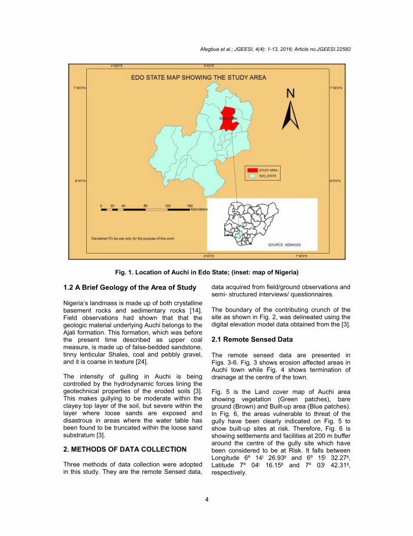
1.1 Location of the Study Area Geographically, Auchi is located in the Southern part of Nigeria on Latitude 7.07259º North and Longitude 6.26566º East, on altitude of 164 m. It is a very important settlement in Edo State because the administrative headquarters of Etsako West local government is located there. Apart from this, it has an estimated population of 100,000 who are majorly farmers. Its undulating landscape is deeply incised by a runoff from upland to the stream valley, where the erosive action of running water is less. The soil in this area is mostly sandy with high iron content. The sands are loose and easily eroded when exposed to erosion. Fig. 1 shows the location of Auchi in Edo State. Auchi is the second most urbanised city in Edo State, after the state capital, Benin City. The town has been described by many as the fastest growing town in the country. With respect to the physiographic settings of the area of study, Auchi is located in the equatorial region with average annual maximum temperature varying from 31ºC and average annual minimum from 23ºC [1]. The annual average rainfall is between 2000 mm and 3000 mm. Also as previously reported, the landscape of Auchi is steep with mean elevation of 200 meters. The observed minimum and maximum elevations at Auchi are respectively 110 and 290 meters [3].
Afegbua et al.; JGEESI, 4(4): 1-13, 2016; Article no.JGEESI.22582
4
Fig. 1. Location of Auchi in Edo State; (inset: map of Nigeria)
1.2 A Brief Geology of the Area of Study Nigeria’s landmass is made up of both crystalline basement rocks and sedimentary rocks [14]. Field observations had shown that that the geologic material underlying Auchi belongs to the Ajali formation. This formation, which was before the present time described as upper coal measure, is made up of false-bedded sandstone, tinny lenticular Shales, coal and pebbly gravel, and it is coarse in texture [24]. The intensity of gulling in Auchi is being controlled by the hydrodynamic forces lining the geotechnical properties of the eroded soils [3]. This makes gullying to be moderate within the clayey top layer of the soil, but severe within the layer where loose sands are exposed and disastrous in areas where the water table has been found to be truncated within the loose sand substratum [3].
2. METHODS OF DATA COLLECTION Three methods of data collection were adopted in this study. They are the remote Sensed data,
data acquired from field/ground observations and semi- structured interviews/ questionnaires.
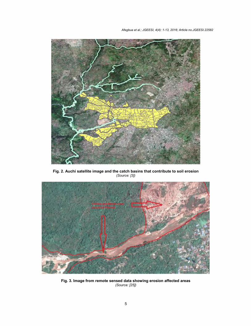
The boundary of the contributing crunch of the site as shown in Fig. 2, was delineated using the digital elevation model data obtained from the [3].
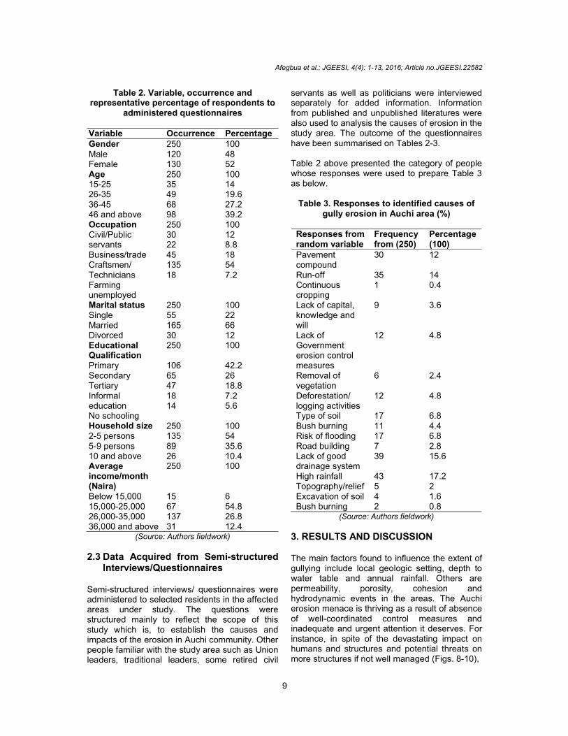
2.1 Remote Sensed Data The remote sensed data are presented in Figs. 3-6. Fig. 3 shows erosion affected areas in Auchi town while Fig. 4 shows termination of drainage at the centre of the town. Fig. 5 is the Land cover map of Auchi area showing vegetation (Green patches), bare ground (Brown) and Built-up area (Blue patches). In Fig. 6, the areas vulnerable to threat of the gully have been clearly indicated on Fig. 5 to show built-up sites at risk. Therefore, Fig. 6 is showing settlements and facilities at 200 m buffer around the centre of the gully site which have been considered to be at Risk. It falls between Longitude 6º 14ˡ 26.93ˡˡ and 6º 15ˡ 32.27ˡˡ, Latitude 7º 04ˡ 16.15ˡˡ and 7º 03ˡ 42.31ˡˡ, respectively.
Afegbua et al.; JGEESI, 4(4): 1-13, 2016; Article no.JGEESI.22582
5
Fig. 2. Auchi satellite image and the catch basins that contribute to soil erosion (Source: [3])
Fig. 3. Image from remote sensed data showing erosion affected areas (Source: [25])

Afegbua et al.; JGEESI, 4(4): 1-13, 2016; Article no.JGEESI.22582
6
Fig. 4. Synoptic view from remote sensed data showing termination of drainage at the center of the town
(Source: [25])
Fig. 5. Land cover map of Auchi area showing vegetation (green patches), bare ground (brown) and built-up area (blue patches)
2.2 Field/Ground Observation The investigation also utilized personal observation methods and some pictures were
taken to demonstrate the reality of erosion menace in the study area, and are presented in Figs. 8-10.

Afegbua et al.; JGEESI, 4(4): 1-13, 2016; Article no.JGEESI.22582
7
Fig. 6. Risk map of Auchi showing the centre of the gully (red thin line) within the gully site
Fig. 7. Buildings about to be swallowed by gully erosion in Auchi

Afegbua et al.; JGEESI, 4(4): 1-13, 2016; Article no.JGEESI.22582
8
Fig. 8. A deep gully located within the study area
Fig. 9. Buildings under the threat of gully erosion in Auchi
Afegbua et al.; JGEESI, 4(4): 1-13, 2016; Article no.JGEESI.22582
9
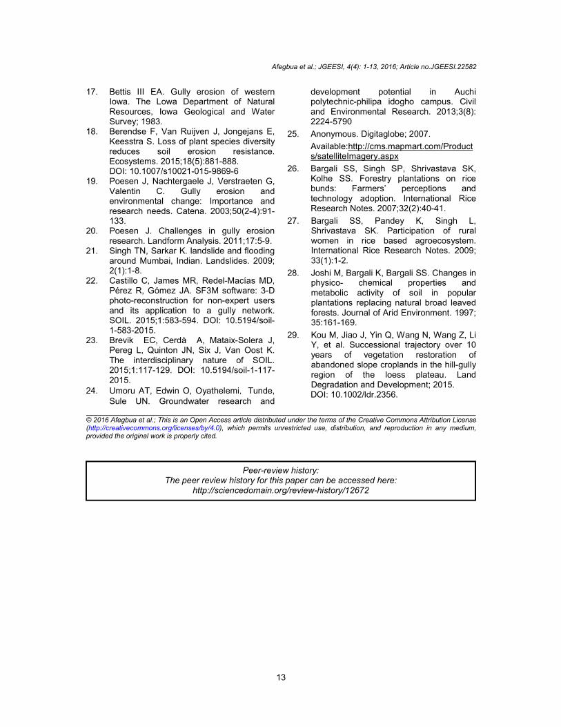
Table 2. Variable, occurrence and representative percentage of respondents to
administered questionnaires Variable Occurrence Percentage Gender 250 100 Male Female
120 130
48 52
Age 250 100 15-25 26-35 36-45 46 and above
35 49 68 98
14 19.6 27.2 39.2
Occupation 250 100 Civil/Public servants Business/trade Craftsmen/ Technicians Farming unemployed
30 22 45 135 18
12 8.8 18 54 7.2
Marital status 250 100 Single Married Divorced
55 165 30
22 66 12
Educational Qualification
250 100
Primary Secondary Tertiary Informal education No schooling
106 65 47 18 14
42.2 26 18.8 7.2 5.6
Household size 250 100 2-5 persons 5-9 persons 10 and above
135 89 26
54 35.6 10.4
Average income/month (Naira)
250 100
Below 15,000 15,000-25,000 26,000-35,000 36,000 and above
15 67 137 31
6 54.8 26.8 12.4
(Source: Authors fieldwork)
2.3 Data Acquired from Semi-structured
Interviews/Questionnaires Semi-structured interviews/ questionnaires were administered to selected residents in the affected areas under study. The questions were structured mainly to reflect the scope of this study which is, to establish the causes and impacts of the erosion in Auchi community. Other people familiar with the study area such as Union leaders, traditional leaders, some retired civil
servants as well as politicians were interviewed separately for added information. Information from published and unpublished literatures were also used to analysis the causes of erosion in the study area. The outcome of the questionnaires have been summarised on Tables 2-3. Table 2 above presented the category of people whose responses were used to prepare Table 3 as below.
Table 3. Responses to identified causes of gully erosion in Auchi area (%)
Responses from random variable
Frequency from (250)
Percentage (100)
Pavement compound
30 12
Run-off 35 14 Continuous cropping
1 0.4
Lack of capital, knowledge and will
9 3.6
Lack of Government erosion control measures
12 4.8
Removal of vegetation
6 2.4
Deforestation/ logging activities
12 4.8
Type of soil 17 6.8 Bush burning 11 4.4 Risk of flooding 17 6.8 Road building 7 2.8 Lack of good drainage system
39 15.6
High rainfall 43 17.2 Topography/relief 5 2 Excavation of soil 4 1.6 Bush burning 2 0.8
(Source: Authors fieldwork)
3. RESULTS AND DISCUSSION The main factors found to influence the extent of gullying include local geologic setting, depth to water table and annual rainfall. Others are permeability, porosity, cohesion and hydrodynamic events in the areas. The Auchi erosion menace is thriving as a result of absence of well-coordinated control measures and inadequate and urgent attention it deserves. For instance, in spite of the devastating impact on humans and structures and potential threats on more structures if not well managed (Figs. 8-10),

Afegbua et al.; JGEESI, 4(4): 1-13, 2016; Article no.JGEESI.22582
10
Fig. 10. A building damaged by gully in Auchi
the synoptic view of the affected area (Fig. 4) showed a deliberate and dangerous termination of a drainage right at the center of Auchi town. Although there are a number of modern buildings erected by a few well-to-do persons in the erosion ravaging areas, most people living in the area were not wealthy. Findings (Table 2) from the survey revealed that lack of knowledge, will and capital to address the problem adequately has further aggravated erosion menace. Table 2 also showed that most respondents to the questionnaires are farmers, married, mostly adults of 36 years and above, with primary education and low income earners. Run-off played significant role in gullying in the study area, although this is represented by 14% in Table 3. However, the major causes of gully erosion from the survey were high rainfall (17.2%), lack of good drainage system (15.6%), self-effort by residents towards erosion control like pavement of their compounds (12%), indiscriminate logging activities (4.8%), lack of or inconsistent implementation of erosion control measures by Governments at all levels (4.8%) etc. Although this is not true representation of the reality on ground as shown in the percentage of responses in (Table 3), the soil in the study area is now susceptible to erosion due to removal of vegetation from the area and other human activities.
In addition to the responses from semi-structured questionnaires, field observations also revealed that there was poor land use planning in the study area, drainages are not channelled to the appropriate discharge points such as Streams and Rivers, Government erosion control measures are inconclusive, thereby aggravating the problem. In spite of warnings from various authorities, people residing in the affected houses have refused to relocate because they have limited means of relocation. In some of the sites visited, there were evidences of community efforts to divert the runoffs but were overwhelmed by the severity of the problem. The human factors cannot be separated from the erosion menace in Auchi. But the natural causes far outweigh the anthropogenic ones. For instance, the local geologic setting, depth to water table and annual rainfall, as well as permeability, porosity, cohesion and hydrodynamic events in the study areas, are the main factors influencing extent of gullying in Auchi. The history of the problem shows that the area became distressed from land use activities. As these areas lie on sloppy land, the porous red soil and heavy rainfall is natural causative agent for gully erosion. Slope failures in Auchi go through four stages of flowage, gliding, tumbling and falling over. The

Afegbua et al.; JGEESI, 4(4): 1-13, 2016; Article no.JGEESI.22582
11
rates of the failures are more pronounced during heavy precipitation than during the dry season. From the field observations and semi-structured questionnaires, runoff was established as the main contributor of gully erosion in Auchi.
During the peak of rainy season at Auchi which usually resulted in the flooding of the soils, much of the rainfall flows as runoff, causing remarkable damages to regions with lose sands towards the foot of the slope. This is because of the rise in volume of the flood and its increased velocity and density as it moves downward the slope, below the clayey top strata found in the upper regions of the site. Such type of evidences abound in other parts of the world and have been presented in the works of [26,27,28].
Field observations by this study showed that local geology, run-off as encouraged by the residents of community in the affected areas, nature of the soil porosity and loose sands, as well as the condition of groundwater at the sites were prominent contributors to the rates and magnitude of gullying in parts of Auchi community. These observations confirmed earlier results by [3]. The risk map, Fig. 5 clearly showed settlements and facilities at 200 m buffer around the centre of the gully site which have been considered to be at Risk. It falls between Longitude 6º 14ˡ 26.93ˡˡ and 6º 15ˡ 32.27ˡˡ, Latitude 7º 04ˡ 16.15ˡˡ and 7º 03ˡ 42.31ˡˡ, respectively.
4. RECOMMENDATIONS
(a) There should be deliberate efforts by the Ministry to refill and construct a proper drainage system that will be channelled to a safe discharge points down steam.
(b) The local government authorities and the vulnerable communities should imbibe the culture of planting trees such as Bamboo and Cashew, in the affected areas, as vegetation cover will slow the rate of runoff as well as soil loss. This effort should be encouraged and supported by State and Federal Ministry of Agriculture.
(c) The town planning department should not approve construction of buildings along water ways.
(d) They should also recommend and prohibit new developers not to cement their compounds and also advise them to embark on rainfall harvesting.
For a holistic understanding of this disasters and provision of solution, understanding the factors responsible for its inception and development is imperative. That means, more detailed studies about causative agents of gully erosion in parts of Auchi community is highly desirable. Efforts should be made to also know in details, the type of erosion that exists in that region and its spatial distribution. Therefore, studies should be undertaken in details on the adopted control measures in order to comprehend the extent of their individual contributions to the gullying phenomenal with a view to proffering tangible and workable solutions to the respective contributing factors. For instance, a detailed investigation could be carried out to determine the possible effect of lowering the porosity of the eroded soils in Auchi would have on the permeability and possibly and the cohesive strengths. Some feasible measures to be could be considered include afforestation, discouraging residents of the affected areas from using tiles in their compounds and surroundings to reduce run-off, design a measure to control groundwater and increase sand cohesion, etc. As for Design Flood Return Period, a 5 years return storm is recommended for the purpose of estimating the peak discharges and for sizing the drainage facilities. The design of culverts should be able to meet certain conditions that would prevent habits of washing, scrubbing and burnishing at the culverts outlet. Recent research by [4] suggested how soil erosion could be controlled effectively by gullying using very low permeability synthetic membrane barrier or dam to reduce subsurface flow in soil pipes near gullies. [29] also pointed out in this study the relevance of revegetation as the primary management approach for solving the problems caused by severe soil erosion in the Loess Plateau. Depending on their applicability and peculiarity, recent findings by [4,29] could also be of relevance towards addressing challenges posed by the gully erosion in Auchi community.
5. CONCLUSION The causes and impacts of gully erosion in Auchi had been investigated using various techniques highlighted in this work and others from previous works on gully erosion in Auchi. It was observed that both anthropogenic and the human-induced

Afegbua et al.; JGEESI, 4(4): 1-13, 2016; Article no.JGEESI.22582
12
factors were responsible for the phenomenal, which has resulted in devastating impacts on the residents, property and their environment. Field observations by this study had shown that local geology, run-off as encouraged by most residents of community in the affected areas, nature of the soil porosity and loose sands, as well as the condition of groundwater at the sites were prominent contributors to the rates and magnitude of gullying in parts of Auchi community. By way of proffering tangible measures that would help in no small measures in tackling the menace of gully erosion in Auchi community, Governments at all levels should collaborate to find a lasting solution to the phenomenal by adopting recommendations contained in this study as well as integrating other ones not mentioned here but would complement the efforts of an holistic tackling of the menace. If the recommendations advanced in this work are fully and carefully implemented, it is hoped that the incidence of gully erosion in parts of Auchi would be drastically reduced and the security of the lives of residents and their properties will be guaranteed.
COMPETING INTERESTS Authors have declared that no competing interests exist.
REFERENCES 1. Anonymous. Gully. Wiki Love Africa.
Wikipedia, the free encyclopaedia; 2015. Available:http://en.wikipedia.org/wiki/Gully
2. Le Roux JJ, Sumner PD. Factors controlling gully development: Comparing continuous and discontinuous gullies. Land Degradation & Development. 2012;23:440- 449. DOI: 10.1002/ldr.1083
3. Anonymous. Auchi drainage system and erosion control; 2010. Available:www.siraj-int.com/pdf/auchi.pdf
4. Frankl A, Deckers J, Moulaert L, Van Damme A, Haile M, Poesen J, Nyssen J. Integrated solutions for combating gully erosion in areas prone to soil piping: Innovations from the drylands of northern Ethiopia. Land Degradation and Development; 2014. DOI: 10.1002/ldr.2301
5. Hilborn D. Gully erosion control, Ontario ministry of agriculture. Food and Rural Affairs; 1985.
6. Ayele GK, Gessess AA, Addisie MB, Tilahun SA, Tebebu TY, Tenessa DB, et al. A biophysical and economic assessment of a community-based rehabilitated gully in the Ethiopian highlands. Land Degrad. Develop; 2015. DOI: 10.1002/ldr.2425
7. Yitbarek TW, Belliethathan S, Stringer LC. The onsite cost of gully erosion and cost-benefit of gully rehabilitation: A case study in Ethiopia. Land Degradation & Development. 2012;23:157-166. DOI: 10.1002/ldr.1065
8. Cerdà A. The influence of aspect and vegetation on seasonal changes in erosion under rainfall simulation on a clay soil in Spain. Canadian Journal of Soil Science. 1998;78(2):321-330.
9. Cerdà A. Soil water erosion on road embankments in eastern Spain. Science of the Total Environment. 2007;378(1-2):151-155. DOI: 10.1016/j.scitotenv.2007.01.041
10. Slimane B, Raclot A, Evrard D, Sanaa O, Lefevre M, Le Bissonnais LY. Relative contribution of rill/interrill and gully/channel erosion to small reservoir siltation in mediterranean environments. Land Degradation and Development; 2015. DOI: 10.1002/ldr.2387
11. Rajbhandari PCL, Alam BM, Akther MS. Application of GIS (Geographical Information System) for landslide hazard zonation and mapping disaster Prone area: A study of Kulekhani watershed, Nepal. Plan Plus. 2002;1(1):117-123.
12. Monkhouse FJ, Small JA. Dictionary of the natural environment, London: Arnold; 1978.
13. Casalí J, Giménez R, Campo-Bescós MA. Gully geometry: what are we measuring? 2015; SOIL 1, 509-513. doi:10.5194/soil-1-509-2015.
14. Abdulfatai IA, Okunlola WG, Akande LO, Momoh, Ibrahim KO. Review of gully erosion in Nigeria: Causes, impacts and possible solutions. Journal of Geosciences and Geomatics. 2004;2(3):125-129.
15. Keesstra SD, Geissen V, Moses K, Piirannen S, Scudiero E, Leistra M, Van Schaik L. Soil as a filter for groundwater quality. Current Opinion in Environemental Sustainability. 2012;4(5):507-516.
16. Ezechi JI, Okagbue CA. Genetic classification of gullies in eastern Nigeria and its implication on control measure. Journal of African Earth Science. 1989; 8:716.
Afegbua et al.; JGEESI, 4(4): 1-13, 2016; Article no.JGEESI.22582
13
17. Bettis III EA. Gully erosion of western Iowa. The Lowa Department of Natural Resources, Iowa Geological and Water Survey; 1983.
18. Berendse F, Van Ruijven J, Jongejans E, Keesstra S. Loss of plant species diversity reduces soil erosion resistance. Ecosystems. 2015;18(5):881-888. DOI: 10.1007/s10021-015-9869-6
19. Poesen J, Nachtergaele J, Verstraeten G, Valentin C. Gully erosion and environmental change: Importance and research needs. Catena. 2003;50(2-4):91-133.
20. Poesen J. Challenges in gully erosion research. Landform Analysis. 2011;17:5-9.
21. Singh TN, Sarkar K. landslide and flooding around Mumbai, Indian. Landslides. 2009; 2(1):1-8.
22. Castillo C, James MR, Redel-Macías MD, Pérez R, Gómez JA. SF3M software: 3-D photo-reconstruction for non-expert users and its application to a gully network. SOIL. 2015;1:583-594. DOI: 10.5194/soil-1-583-2015.
23. Brevik EC, Cerdà A, Mataix-Solera J, Pereg L, Quinton JN, Six J, Van Oost K. The interdisciplinary nature of SOIL. 2015;1:117-129. DOI: 10.5194/soil-1-117-2015.
24. Umoru AT, Edwin O, Oyathelemi,Tunde, Sule UN. Groundwater research and
development potential in Auchi polytechnic-philipa idogho campus. Civil and Environmental Research. 2013;3(8): 2224-5790
25. Anonymous. Digitaglobe; 2007.
Available:http://cms.mapmart.com/Products/satelliteImagery.aspx
26. Bargali SS, Singh SP, Shrivastava SK, Kolhe SS. Forestry plantations on rice bunds: Farmers’ perceptions and technology adoption. International Rice Research Notes. 2007;32(2):40-41.
27. Bargali SS, Pandey K, Singh L, Shrivastava SK. Participation of rural women in rice based agroecosystem. International Rice Research Notes. 2009; 33(1):1-2.
28. Joshi M, Bargali K, Bargali SS. Changes in physico- chemical properties and metabolic activity of soil in popular plantations replacing natural broad leaved forests. Journal of Arid Environment. 1997; 35:161-169.
29. Kou M, Jiao J, Yin Q, Wang N, Wang Z, Li Y, et al. Successional trajectory over 10 years of vegetation restoration of abandoned slope croplands in the hill-gully region of the loess plateau. Land Degradation and Development; 2015. DOI: 10.1002/ldr.2356.
_________________________________________________________________________________ © 2016 Afegbua et al.; This is an Open Access article distributed under the terms of the Creative Commons Attribution License (http://creativecommons.org/licenses/by/4.0), which permits unrestricted use, distribution, and reproduction in any medium, provided the original work is properly cited.
Peer-review history: The peer review history for this paper can be accessed here:
http://sciencedomain.org/review-history/12672