INVENTORY OF PLANNING/ MANAGEMENT/MONITORING TOOLS …
44
CEETO Deliverable D.T1.2.1 Ver. 2.1 03 2018 INVENTORY OF PLANNIN G / MANAGEMENT/MONITORING TOOLS AND SUCCESS STORIES FOR SUSTAINABLE TOURISM IN P ROTECTED A REA S
Transcript of INVENTORY OF PLANNING/ MANAGEMENT/MONITORING TOOLS …

CEETO Deliverable D.T1.2.1 Ver. 2.1 03 2018 INVENTORY OF PLANNING/ MANAGEMENT/MONITORING TOOLS AND SUCCESS STORIES FOR SUSTAINABLE TOURISM IN PROTECTED AREAS

CEETO - Central Europe Eco-Tourism: tools for nature protection Page 1
1. Introduction This inventory presents planning/management/monitoring tools and success stories for sustainable tourism learned from the experiences of different Protected Areas in Europe. This inventory is primarily addressed to the partners of CEETO Project (Central Europe Eco-Tourism), but in general to the managers of Protected Areas (local, regional or national public entities, competent agencies) and their stakeholders such as NGOs, research centres and universities or SMEs that might be interested in the interconnection between environmental and biodiversity conservation and development of sustainable tourism strategies. In the first part, the inventory provides an overview of the main methodologies used which, monitoring and analysing tourist flows, allow managers of the Protected Areas to take strategic decisions in order to guarantee the objectives of biodiversity conservation and, at the same time, planning of sustainable tourism able to enhance the natural heritage, contributing to its protection and to the well-being of local communities living in those territories. In the second part, a collection of good practices exemplifies how some European Protected Areas have applied in the field the methodologies described above, highlighting their characteristics and results, so as to be able to both inspire the partners of the CEETO Project in the development of subsequent actions planned, and provide users of the Handbook with a practical contextualization of the methods analysed. The final result is a tool useful also outside the CEETO Project, as the collection of methodologies and good practices can be suitable in a transversal way to anyone interested in monitoring and management of tourist flows within protected areas or territories with a high naturalistic value. In order to realise the inventory of the main methodologies for the analysis of tourist flows in protected areas, a bibliographic research was carried out on studies and projects within the European Protected Areas based on existing literature and which could be freely available. For this reason, one of the main pillars on which the research is built was the Monitoring and Management of Visitors in Recreational and Protected Areas (MMV). 2. Choice of the methodology In order to better understand which methodology/tool to use and how to implement the planning/management/monitoring tools activity, it is useful to remember some important aspects. First of all, the first question to be answered is why managers need to monitor. It should be clearly defined what the objective of monitoring is, because each objective may involve a different mix of techniques. Defined the objective, the next question to be asked is what it is necessary to monitor in order to achieve that purpose, what information is required: for example if the precise number of visitors, the flows or the activities they carry out within the Park, etc. Closely connected to what is necessary there is who should be monitored. This is because not all the people entering a Park are automatically visitors. In fact, in addition to the Park's staff, it should be kept

CEETO - Central Europe Eco-Tourism: tools for nature protection Page 2
in mind that agriculture and breeding activities are often carried out in these areas and therefore these workers should not be considered as visitors. In other cases, roads used by those who live there pass through the Park and therefore these should not be included in the visitor count too. Moreover, not all visitors are the same. If I want to understand the impact on the biodiversity of mountain biking, people picnicking should not be considered. To have a correct data, which will no over- or underestimate the final result, it is important to choose where the monitoring activity should be carried out. It is crucial to have the objective in mind because if the interest is knowing the relationship between visitors and nature it should be considered monitoring activities in the core areas of the Park; while if the aim is having a view of tourist flows it will be more useful to adopt counting points. Finally, the when. Although it is more complex and expensive, both in terms of time and money, proper monitoring should be carried out over a long period of time and possibly covering all seasons. It is also important is to collect external information such as weather conditions, holidays and national festivities, etc. After being able to answer these questions for an efficient and effective monitoring, managers can start to consider which technique can be used to provide more support in making decisions.1 3. Synoptic diagram of the main methodologies The methodologies identified are a mix of well-consolidated methods, which have been used for many years, and innovative methods, which are gaining importance and credibility in recent years. By doing so it is possible to present a complete overview of tools, able to adapt to the needs of each Protected Area. The following synoptic scheme can be considered a starting point, which can be further enhanced and developed by introducing other techniques or transformations of the existing ones as they will improve. 4. Methodologies identified In this section we introduce with a short explanation the different methodologies identified to monitor tourist flows in PAs to have an overview of what can be done and that will be more specified in the next part of the inventory. St. Gallen Method The St. Gallen Method allows to analyse the strategic flows of visits starting from the knowledge of the stakeholders who design and describe them on maps that are then combined and overlapped to identify the routes made by tourists and, as a consequence, the tourist products that they seek in the territory. From a practical point of view, to implement this methodology are necessary: • Multi-scale maps of the territory • Orthophotos 1 Monitoring and Management of Visitor Flows in Recreational and Protected Areas Conference Proceedings ed by A. Arnberger, C. Brandenburg, A. Muhar 2002, pages 1-6. http://mmv.boku.ac.at/refbase/files/muhar_andreas_arnb-2002-methods_for_visitor.pdf

CEETO - Central Europe Eco-Tourism: tools for nature protection Page 3
Car counting This method is based on counting cars passing through established "check points" and helps to know the level of traffic within a given area, as well as how the level varies over a period of time. In order to implement this methodology, counting tools (pyroelectrics, tickets, parking lots, video cameras, photocells) are required. Person counting This method is based on counting people passing through established "check points" and enables to know how many people enter a certain area, as well as how the level varies over a period of time. To implement this methodology are quines required counting tools (pyroelectric, pressure, optical, infrared or magnetic meters, entrance tickets, video cameras, turnstiles). Telephone cells This method is based on Big Data, using data normally collected by telephone cells and analysed to obtain information on the movements that visitors make within the Protected Area (anonymously because the data are analysed in an aggregated way). A geo-referenced database provided by a telephone operator is required to implement this technique. Interview This is one of the most commonly used methods because it allows to have specific information about the visitor, outlining it in base of his preferences and needs. It is sufficient a recorder for this methodology. Survey Like interviews, it is one of the most commonly used methods when it is necessary to collect visitors' preferences in order to apply appropriate management strategies. For this technique, since it is possible to realize it either online or live, it should be provided internet forms or paper cards. GPS It is one of the techniques that has become more widespread because it allows to "follow" visitors inside the Park, getting to know the favourite routes and the most visited places. GPS trackers are required in order to use this technique. Social Media The use of the large amount of data and information that can be provided by Social Media is one of the methodologies that are most successful because it allows managers to know trends, preferences and behaviours of visitors in a very easy way by checking what they post on the web. Statistical models Statistical models are all that set of statistical tools, more or less elaborated, to be used to obtain an estimate of the object of study, in this case the flows of visitors when there are not all the information available or when some changes should be studied.

CEETO - Central Europe Eco-Tourism: tools for nature protection Page 4
Focus Group The focus group is a useful technique to deepen a theme or particular aspects of a topic, interviewing a homogeneous group of people. Video camera Using cameras at the entrance of the Parks, or at some focal points may be useful to gather information about the number, flow and behaviour of visitors within the Area. For this methodology, camcorders and, if available, frame analysis software are needed, which would otherwise have to be done manually in person. Bioacoustic Bioacoustics is a branch of zoology, strictly related to ethology, that investigates sound production and reception in animals, including man, and how animals communicate by means of sound2. To implement this technique is necessary: • Microphone/hydrophone • Recorder • Computer with all necessary programmes to elaborate sounds 5. Analysis of the methodology The analysis of the different techniques starts from the strengths and weaknesses of each methodology, based on the aspects that distinguish them, trying to report practical and useful aspects for the purpose of choice. The complexity and costs are analysed below. Complexity includes aspects related to the implementation of each methodology (installing a sensor, a video camera, implementing participatory processes, etc.), data analysis (data is immediately available or if it has to be processed) and finally costs both in terms of time (considering all the phases to be implemented to arrive at the final information) and money. The field of applicability represents the limits that a methodology may have. For example, counting cars simply requires a passing road, while GPS needs a clear signal. The applicability field is not inserted in the synoptic table because it is an element that must be evaluated case by case. An important aspect is related to visitor profiling, i.e. the characteristics, preferences, needs and opinions of people visiting the Protected Area. Profiling is an important aspect in determining the choices to be made because they also depend on the profile of the visitor (in the Park are mainly families or organized groups? Are hikers, mountain bikers or picnicking? What are the services that visitors are looking for?). The quality of the collected data represents the amount of information it returns compared to the decision to be taken, so for example, the number of people is qualitatively lower than the questionnaire which allows a complete knowledge of the visitor. Precision is the correctness of the data in relation to reality, so people's counting is technically more accurate than telephone cells that may have a certain degree of error. 2 Source: http://atbi.eu/summerschool/files/summerschool/Pavan_Syllabus.pdf

CEETO - Central Europe Eco-Tourism: tools for nature protection Page 5
Flexibility is linked to how much the method can be adapted and modified according to the needs of the analyst. For example, the counting of people is less flexible than a questionnaire because the former only collects a certain type of data, while the latter can potentially investigate different aspects and areas. The possible combination of the method with others presented has also been included because their complementary use can provide useful information for a more complete reading of the flow and behaviour of visitors. Precisely because it represents suggestions, it has not been inserted in the synoptic table. Finally, the usefulness of the method was assessed. With this section we wanted to provide a simple overview of how the information obtained with a given technique can be read.

CEETO - Central Europe Eco-Tourism: tools for nature protection Page 6
6. Methodology fact sheets SAINT GALLEN METHOD Strengths This method allows to collect a large amount of information involving the stakeholders of the territory that with their knowledge deriving from their relationship with tourists can draw on maps the movements they make within an area. They can provide both qualitative information such as the characteristics of visitors, their reasons for travelling and quantitative data such as numbers and seasonal flows. Moreover, due to the direct contact they have with and knowledge of the territory they can also express evaluations such as the criticality of a given sector (ranging from transport to the situation of paths, etc.) or on the general tourist situation. It is useful when investigating large areas. Weaknesses In order to make this method work and give results, it requires a good knowledge of tourist by local stakeholders. In fact, without this element, the ability to describe what the tourist's preferences and needs are, strategies and products consistent with the reality cannot be elaborated. In addition, it can take a long time for the final processing of the results because it is necessary to analyse and overlap many data at the same time to get to have what are called product platforms. Complexity and costs It requires the structuring of a series of focus group on the territory to collect information from stakeholders and the subsequent elaboration. Field of applicability It is a method that has no spatial or other constraints. Visitor profiling It allows a good tourist profiling because it let to know characteristics, preferences and needs. Data quality High Possible combination with other methods The method could be combined with other tools such as questionnaires to get a better knowledge of visitors' characteristics or, for example, with GPS/telephone cells to have more details on the movements that the visitor makes in the territory. Utility in planning sustainable tourism strategies of conservation measures The method is functional to know the behaviour and interests of tourists through which it is possible to identify the tourist flows present in the territory. Knowing the tourist flows is fundamental because knowing the push factor of a tourist destination is useful to choose which flows to promote in terms of environmental sustainability. Flexibility The method can be adapted to better meet the information needs of the decision-maker based on the specificity of the questions asked to stakeholders.

CEETO - Central Europe Eco-Tourism: tools for nature protection Page 7
COUNTING CAR Strengths Using auto counting as a monitoring tool is useful when searching for a continuous method over time, because it can be done consistently throughout the year. In addition, knowing the average number of people per vehicle makes it possible to estimate the number of visitors. In this way it is also possible to identify the seasonality of visits throughout the year. It is a fairly simple method to implement and maintain, giving immediate and easy to read data. Weaknesses The first point of weakness is linked to the fact that it is connected to the presence of roads where cars can arrive. It requires instruments that require a certain level of calibration and maintenance, although not particularly complex. It also has minimal dependence on energy sources. It does not allow a precise counting of people but only an estimate. Complexity and costs The complexity and cost depend on the accuracy of the collection and processing of the date and the technology used for counting. Field of applicability It is bound to the presence of public roads and a minimum dependence on energy sources. Visitor profiling It does not allow the profiling of visitors. Data quality Low Possible combination with other methods The method can be easily combined with other tools, in particular questionnaires and interviews, which allow information on visitors to be collected. Utility in planning sustainable tourism strategies of conservation measures The method is useful to have a knowledge of the trends of visitor flows within the Park, as well as to set access limits in order to respect the conservation objectives of the ecosystem of the area, while reducing at the same time the impacts that these flows cause on the environment. Flexibility The method has no flexibility because the data that it is possible to collect is only the number of passages in the car.

CEETO - Central Europe Eco-Tourism: tools for nature protection Page 8
COUNTING PERSON Strengths It is a simple and fast method to apply, useful when you want to carry out a continuous monitoring over time and you are in the absence of an entrance ticket. It can be applied and moved on different points, thus being able to study and analyse different areas of the Protected Area. It is also resistant to different climatic conditions and can be remotely controlled. Weaknesses It is a method that requires calibration and maintenance and can give errors in counting e. g. with the passage of large groups or for weather conditions. Complexity and costs It is a relatively inexpensive method both in terms of time and money. Moreover, returning just a type of data it is not particularly complex. Field of applicability It has no restrictions or limitations on use, other than those related to the energy source. Visitor profiling It does not allow the profiling of visitors. Data quality Low. Possible combination with other methods The method can be easily combined with other tools, in particular questionnaires and interviews, which allow information on visitors to be collected, especially if one considers the use of access gates, for example. Utility in planning sustainable tourism strategies of conservation measures Evaluate the number of tourists and the seasonality of the flows, the direction, identify the critical points for the number of visitors that may require an intervention of regulation and protection. It is useful to direct resources for more qualified infrastructure or, on the contrary, to intervene if these flows conflict with conservation objectives. Flexibility The method does not have flexibility because the fact that it is possible to collect is only the number of passages of people.

CEETO - Central Europe Eco-Tourism: tools for nature protection Page 9
TELEPHONE CELLS Strengths It is a useful method when you want to investigate visitors' movements on large areas as parks and it is quite precise in terms of their position. Accuracy that increases as it provides a huge amount of data. It can potentially be a continuous method of analysis because it allows to visualize the trend of tourists throughout the year. Provides more information about visitors than overnight stays. Weaknesses It depends on the telephone coverage of a certain territory and may present some errors in the location of visitors based on the positioning of repeaters and proximity to borders with other countries. The data must be purchased by a telephone company that makes them available in raw form. Complexity and costs Complexity is closely related to the processing of data and extraction of information that may be most useful to the subject. The cost is linked to the purchase of data from telephone companies. Field of applicability It is affected by the coverage of the telephone signal. Visitor profiling Profiling of the tourist by origin and movement within the area of interest thanks to the passage of the telephone cells. Data quality It depends on the processing level. Possible combination with other methods It can be combined with questionnaires and interviews to get more information for visitor profiling or with GPS to verify the accuracy of travel. Utility in planning sustainable tourism strategies of conservation measures Highlight the routes made by tourists and identify the most popular and visited places so as to be able to intervene also with actions of protection. In addition, discover the provenance of visitors to direct investments in marketing. In addition, it is possible to identify critical points within the area considered and, if necessary, to implement restrictions for the use of areas that are particularly sensitive. Flexibility The method does not allow much flexibility with regard to the database available.

CEETO - Central Europe Eco-Tourism: tools for nature protection Page 10
INTERVIEW Strengths It is a simple method that can be easily applied and replicated in different situations. It adapts to the information needs of the PAS managers. They allow the collection of both quantitative and qualitative information. They can be structured on several degrees of difficulty. Weaknesses It takes time to collect data and process information. If you commission it can become expensive. They require interaction between interviewer and interviewee, so you have to do it in person or on the phone and there may be some discretion of the interviewer in collecting and processing information. It requires statistical knowledge. Complexity and costs The complexity is linked to the type and structure of the interview that it is intend to carry out and therefore to the type of information that it is wanted to collect. The cost is mainly in terms of time for collection and processing, but also if done internally or externally. Field of applicability There are no restrictions or constraints. Visitor profiling It allows an excellent profiling of the tourist. Data quality High Possible combination with other methods It can be combined with any of the methodologies presented because it can be used to complement them. For example, associated with the GPS method so that you can also track the route taken by visitors. Utility in planning sustainable tourism strategies of conservation measures Have a complete visitor profile, investigating their preferences and needs. Allows visitors to locate their favourite places. It can be useful to test the acceptability of solutions to be adopted for some issues and aspects such as the introduction of an entrance ticket or the closure of a path. Obtain a complete vision on various aspects of interest for the Park to support managerial decisions and a management of flows in order to guarantee the satisfaction of the needs of these and respect the nature conservation objectives. Flexibility The method can be adapted to the PAs.

CEETO - Central Europe Eco-Tourism: tools for nature protection Page 11
SURVEYS Strengths It is a simple method that can be easily applied and replicated in different situations. It adapts to the information needs of the managers of the Protected Areas. They allow the collection of both quantitative and qualitative information. They can be structured on several degrees of difficulty. They can also be run remotely (online). Weaknesses The difficulty for the respondent changes as the required information increases. It may take time to collect and process responses. It requires statistical knowledge regarding sampling. Complexity and costs The complexity is linked to the type and structure of the questionnaire to be carried out and therefore to the type of information to be collected. The cost is mainly in terms of time for data collection and processing. Field of applicability There are no restrictions or constraints. Visitor profiling It allows an excellent profiling of the tourist. Data quality High Possible combination with other methods It can be combined with any of the methodologies presented because it can be used to complement them. For example, associated with the GPS method so that you can also track the route taken by visitors Utility in planning sustainable tourism strategies of conservation measures To have a complete visitor profile, investigating their preferences and needs. Allows visitors to locate their favourite places. It can be useful to test the acceptability of solutions to be adopted for some issues and aspects such as the introduction of an entrance ticket or the closure of a path. Obtain an accurate view on various aspects of interest for the Park in the taking of managerial decisions and a management of flows in order to guarantee the satisfaction of the needs of these and respect the objectives of nature conservation. Flexibility The method can be adapted to the PAs.

CEETO - Central Europe Eco-Tourism: tools for nature protection Page 12
GPS TRACKING Strengths It is a simple and precise method that can be easily applied and replicated in different situations and moments. It allows you to identify the most widely used routes and thus direct your investment choices. It allows to identify critical points on a route. Simple application because a GPS device is enough Weaknesses It may have problems with receiving the signal. It can be considered invasive by visitors because they are actually followed. It can be expensive if you choose particularly advanced instruments. Specific programmes are needed for route planning. It may be necessary to build a sample of visitors from the Protected Area to get more complete and correct data. Complexity and costs The complexity is related to the processing of the collected GPS data. The cost, on the other hand, to the type of instrument you decide to use. Field of applicability The only constraint for this methodology is the GPS signal strength. Visitor profiling It does not allow for visitor profiling. Data quality High Possible combination with other methods This technique can be combined with any of the methodologies presented. For example, combined with interviews and questionnaires to obtain more information for visitor profiling. Utility in planning sustainable tourism strategies of conservation measures Understand the route taken by tourists inside the Park, which are the routes and preferred places, any safety critical points, directing investment decisions and monitor the possible impacts on nature, limiting fruition to the use in some particularly sensitive areas... Flexibility The method is not very flexible because there are few data that can be collected.

CEETO - Central Europe Eco-Tourism: tools for nature protection Page 13
SOCIAL MEDIA Strengths It is an excellent method to be used in a complementary way to others for the collection and integration of information on visitors to a Protected Area. It can be used as a continuous monitoring method, being able to collect information about new trends. A large amount of information is available for the use of this methodology. Weaknesses It is problematic with a low number of social media interactions. It is closely related to the willingness of those who post on social media to tag or geotagged the post. Low telephone line coverage in some parts of the Park may discourage loading onto social networks. It depends on the social activity of those who visit the Park. Complexity and costs Complexity is closely linked to the information you want to collect. From a cost point of view, these are generally very low because potentially a computer with an internet connection is sufficient, but they can increase if you outsource the service. Field of applicability It depends on the number of interactions, on the skills and knowledge of those who work there and on the presence of tools that favour this type of analysis. Visitor profiling Allows a good level of profiling of the tourist, knowing its characteristics and preferences. Data quality High Possible combination with other methods It can be combined with any of the methodologies presented, especially in a complementary way. For example, combined with interviews to obtain more information for visitor profiling. Or associated with the GPS method so you can also track your route. Utility in planning sustainable tourism strategies of conservation measures To understand the places preferred by visitors, their origins, their movements, the activities carried out and their behaviours to guide investments and communication and marketing initiatives. Moreover, it can helps on identifying characteristics, from the weather, to some more specific elements as the state of the environment. Flexibility The method is flexible because it can be adapted to the information required by Protected Area managers.

CEETO - Central Europe Eco-Tourism: tools for nature protection Page 14
STATISTICAL MODELS Strengths It is a method that allows to have correct estimates of the elements analysed and researched, which can be carried out continuously over time and specially to analyse different possible scenarios. It is a cost-effective technique because it can start from information that the Protected Area already has at its disposal, such as the number of people entering. It also requires less fieldwork than is strictly necessary to calculate the estimation parameters. Weaknesses It can be a complex method to implement because it requires statistical and computational expertise for the basic structure and assumptions of the model to be implemented. In addition, specific data analysis programmes are required. To identify the parameters, it is necessary to deep know the territory of the Protected Area and its characteristics. It requires knowledge of the characteristics of visitors and, if not available, they should be investigated. It may require the search of some specific elements useful for the definition of the parameters if not available such as the number of visitors, their characteristics or preferences to set the estimative model (therefore their profiling). If the parameters are not calculated correctly, this can lead to errors in the analysis, which requires a lot of accuracy. Complexity and costs The complexity depends on the structure of the estimative model realized, but it is still quite high. On the contrary, costs can also be low, especially if the Protected Area already has some of the necessary data available. Field of applicability The model has no limitations or constraints of applicability. However, statistical knowledge is needed. Visitor profiling It does not allow the profiling of visitors. Data quality With correct parameters, the data quality is high. Possible combination with other methods This methodology can be combined with other methods, especially questionnaires for the correct profiling of visitors in order to know their characteristics and preferences, activities carried out etc., or with techniques such as the counting of people or cars for the identification of parameters. Utility in planning sustainable tourism strategies of conservation measures It is a method that, if properly implemented, is efficient and effective in making decisions because it can be used: To know the current situation when only some information is available and complete monitoring cannot be applied for complete information. To draw future scenarios for possible impacts on biodiversity or activities within the Protected Area as some variables change.

CEETO - Central Europe Eco-Tourism: tools for nature protection Page 15
Flexibility The method is extremely flexible because it can be adapted to all the information needs of the Protected Area. FOCUS GROUP Strengths It is a participatory process that is easy to apply if the subjects and an experienced facilitator are available. This is useful when you are looking for information on specific and punctual topics. It can be used in parallel with quantitative procedures. It highlights social and behavioural elements. Weaknesses Focus groups are especially suitable for territories that are not very large in order to maintain high quality data (e. g. the core area of a Park). It may require the collaboration of parties outside the Park as experts or stakeholders. It takes a lot of time for its implementation. There is a risk of ineffective information. Complexity and costs The complexity and cost depend on the information to be gathered and the outsourcing of the facilitation service. Field of applicability There are no limits or constraints. Visitor profiling It allows a good profiling of the tourist. Data quality Low Possible combination with other methods It can be combined with any of the methodologies presented in order to cross the answers with more complete information. For example, combined with interviews to get more information for profiling visitors. Or associated with the GPS method so you can track your route. Utility in planning sustainable tourism strategies of conservation measures It allows to have a complete visitor profile, investigating their preferences and needs and knowing their favourite places within the PAs. It can be useful to test the acceptability of solutions to be adopted for some issues and aspects such as the introduction of an entrance ticket or the closure of a path. Flexibility The method can be adapted to the needs of the Protected Area Manager.

CEETO - Central Europe Eco-Tourism: tools for nature protection Page 16
VIDEO CAMERAS Strengths It is a simple and immediate method that can be easily applied and replicated at different points in the Park to have a complete view of its entire area. It can be used continuously throughout the year. It can be used remotely and continuously. It can be easily applied at different points. Weaknesses Loses effectiveness in areas too large. It takes time to process frames. Attention should be paid to privacy issues and therefore the cameras should be positioned and calibrated in a certain way. It can become expensive in terms of purchase and maintenance. Need for a form of energy. Feasibility diminishes moving away from physical places. Complexity and costs The method is not particularly complex but takes time to analyse video frames and can be expensive based on the technology used and its maintenance. Field of applicability The main constraint is related to the power source for the cameras. Visitor profiling It allows a low level of profiling of the tourist. Data quality Quite good. Possible combination with other methods It can be combined with any of the methodologies presented. For example combined with interviews to get more information for profiling visitors. Or associated with the GPS method so you can also track your route. Utility in planning sustainable tourism strategies of conservation measures To know the quantity, preferences and behaviours of tourists, as well as the activities they carry out, in order to direct investment decisions and nature conservation actions such as limiting the use of sensitive areas. In addition, their usefulness in monitoring animal species can be considered. Flexibility The method is not particularly flexible because the information that can be gathered from frames is few: number of people, activities carried out,....

CEETO - Central Europe Eco-Tourism: tools for nature protection Page 17
BIOACOUSTIC Strengths It is a practical and immediate method that can be easily applied and replicated at different points of the Park to have a complete view of its entire area. It can be used continuously throughout the year. It allows to assess the presence and impact that visitors can have on biodiversity. It can also distinguish different sounds according to activities if correctly positioned and calibrated. Low environmental impact in the sense that the microphone can be placed anywhere and not interfere with normal life in the environment. Weaknesses It loses effectiveness in areas too large. It takes time to process the collected tracks if no dedicated software is available. It can become expensive in terms of purchase and maintenance. Need for a form of energy. Feasibility decreases, moving away from physical points. Complexity and costs The method is not particularly complex but takes time to analyse video frames and can be expensive based on the technology used and its maintenance. Field of applicability The main constraint is that connected to the power source for microphones. Visitor profiling It allows a low level of profiling of the tourist. Data quality Good data quality. Possible combination with other methods It can be combined with any of the methodologies presented. For example combined with interviews to get more information for profiling visitors. Or associated with the GPS method so you can also track your route. Utility in planning sustainable tourism strategies of conservation measures It allows to detect the presence of visitors even in more remote areas and possibly also in areas where it is not allowed to enter. This system can be used to monitor certain types of activities such as hunting. It is also useful to assess what impact tourists can have on biodiversity based on the level of the item. In addition, their usefulness in monitoring animal species can be considered. Flexibility The method is not particularly flexible as there is little information that can be gathered from records.

CEETO - Central Europe Eco-Tourism: tools for nature protection Page 18
7. Synoptic table Tool Strengths Weaknesses Functional to sustainable tourism St. Gallen Methods • Participatory process • Surveys wide areas • Influenced by the knowledge of tourists by operators
• Long time needed • Knowing the behaviour and interests of tourists • Identification of tourist flows and choice of which one promotes in the perspective of sustainability Car counting • Continuous analysis
• Simplicity • Little precise data • Needs calibration and maintenance • Where the machines arrive • Knowing the seasonality of flows
• Limit use in sensitive areas • Reduction of environmental impacts Person counting • Continuous analysis
• Simplicity • Needs calibration and maintenance • Counting tourists • Identify critical points • Limit use in sensitive areas Telephone cells • Continuous analysis
• Investigates large areas • Accuracy • Large amount of data • Influenced by signal coverage
• Purchase of data • Knowing where tourists come from • Knowing the movements of tourists • Improving communication • Identify critical points • Limit use in sensitive areas Interview • Simplicity
• Adaptive • Different types of information collected • Long time needed
• Interviewer discrepancy • Sampling required • Visitors profile
• Know favourite places • Assessing the acceptability of the solutions to be adopted Surveys • Simplicity
• Adaptive • Different types of information collected • Long time needed
• Interviewer discrepancy • Sampling required • Visitors profile
• Know favourite places • Assessing the acceptability of the solutions to be adopted

CEETO - Central Europe Eco-Tourism: tools for nature protection Page 19
Tool Strengths Weaknesses Functional to sustainable tourism GPS • Simplicity • Accuracy • Influenced by signal coverage
• Privacy • Sampling required • Get travel information
• Identify critical points • Limit use in sensitive areas Social media • Integrates existing information
• Continuous analysis • Information on new trends • Large amount of data • Influenced by the number of interactions
• Influenced by signal coverage • Influenced by the digital profile of the average tourist • Get travel information
• Get information about favourite places • Have information on behaviour and activities Statistical models • Corrected estimates of the elements analysed
• Continuous analysis • Cost-effective • Statistical competences
• Influenced by knowledge of the territory and visitors • Calibrate the analysis parameters • Know the current situation when only a few elements are available
• Verify impacts on biodiversity and visitor flows as some variables change Focus group • Simplicity • Valid for specific information and tips • Long time needed
• Risk of information effectiveness • Not suitable for general information • Visitors profile
• Know favourite places • Assessing the acceptability of the solutions to be adopted Video camera • Continuous analysis • Not suitable for monitoring on large areas
• Privacy issues • Counting tourists • Have information on behaviour and activities • Limit use in sensitive areas Bioacoustic • Continuous analysis
• Practical to place and move • No impact on the environment • Long time needed • Presence of visitors in wild areas of the PAs
• Impact on biodiversity of visitor activities • Monitor biodiversity

CEETO - Central Europe Eco-Tourism: tools for nature protection Page 20 Legend:
• Very easy to do • High level of profiling, data quality, accuracy and flexibility • Easy to do
• Good level of profiling, data quality, accuracy and flexibility • Quite easy to do • Medium level of profiling, data quality, accuracy and flexibility • Difficult to do
• Low level of profiling, data quality, accuracy and flexibility • Very difficult to do • A bad level of profiling, data quality, accuracy and flexibility
Tool Complexity Profiling Data quality Possible combination Flexibility St. Gallen Method Car counting Person counting Telephone cells Interview Surveys GPS Social media Statistical models Focus group Video camera Bioacoustic

CEETO - Central Europe Eco-Tourism: tools for nature protection Page 21
8. Good practices Mobile Big Data in the Gran Paradiso National Park (ITA) to identify tourist presences and flows in order to understand movements on the territory. Methodology: Telephone cells Description Gran Paradiso National Park is an alpine protected area, situated between Val d’Aosta and Piemonte and made up of 6 valleys. The mountains we see today are have been cut and modelled in the past by giant glaciers and by streams which have created the valleys. The most common trees are larches, mixed with spruces, Swiss stone pines and more rarely silver firs in the valley. While, higher up the slopes the trees gradually disappear and replaced for vast alpine pastures, rich with flowers in late spring. Rising even more up until 4061 m of the Gran Paradiso the landscape is characterize rocks and glaciers. The fauna has its emblem in the alpine ibex, symbol of the Park. The Gran Paradiso National Park Authority had the need to implement the tourist turnout data already in its possession, integrating the existing ones with other types of data that allow to count also visitors who do not stay at any accommodation facilities. This was the method that best accomplish this aim and that allowed to obtain information useful to implement sustainable tourism strategies in coherence with the characteristic of the territory and tourist flows. Methodology The study focuses on the Park area and not on the whole territory of the park municipalities. The analysis is based on data from a well-known Italian telephone network, anonymized aggregated and processed with ad hoc algorithms. In full compliance with the regulations on privacy and protection of personal data, the data used are anonymous and aggregated. The information used relates exclusively to aggregate movement on the network: no information used can be associated directly, indirectly or in any other way with any user of the network. Results An analysis of the context was carried out which considered the main tourism indicators: • Presence and intensity of the visit • Structure by regional/national origin • Permanence Source: http://www.parks.it/parco.nazionale.gran.paradiso/par.php

CEETO - Central Europe Eco-Tourism: tools for nature protection Page 22
• Repeatability. An analysis of the dynamics was carried out to highlight the connections and flows between the places of the region: • Connectivity between places (total and distinct for North and South) • Focus on the dynamics of Lombard tourists. Segment analysis to identify how tourists divide the territory according to their behaviour: • Partitions characterised by a high homogeneity of visits • Networks of interconnection between park and neighbouring areas Analysis of experiences, to verify the centrality of places in the overall visitor experience: • Overall territorial preferences • Territorial preferences for visitors from Valle d'Aosta, Piedmont, Liguria and Lombardy All these results are useful and functional in the first place to orient marketing strategies so that they are consistent with the target audience of visitors to the Park. In particular, the combination with the questionnaire helps to better profile visitors, their needs and preferences by providing more customized services. To know more on this good practice: http://www.pngp.it/notizie/sviluppo-e-strategie-turistiche-nel-parco-i-risultati-dello-studio-con-i-big-data Italian tourist flow during Region of provenience of Italian visitors

CEETO - Central Europe Eco-Tourism: tools for nature protection Page 23
Counting cars realised in the Veluwe natural area (NL) by using gateways to monitor and reduce traffic in the area Methodologies: car counting and questionnaires Contest Great attention has been paid to solutions for threats to natural resources and recreational uses arising from traffic congestion and parking problems caused by large numbers of visitors in the De Hoge Veluwe National Park. Veluwe is one of the largest natural areas in the Netherlands and is located in the centre of the country. The area includes several villages, campsites and restaurants, agricultural areas, natural areas and two national parks. The area is mainly visited for its landscapes and natural beauty, attracting up to 30 million visitors per year during the analysis period. Car traffic had therefore become a major problem because it contrasted with the expectations of tourists and nature conservation objectives. The province of Gelderland, within which the Veluwe is located, had already implemented in the past strategies to reduce traffic, for example by closing roads, very low speed limits and, finally, gateways. The gateways were born within the EU Interreg IIIB project “Boundless Parks Naturally!” Currently tourists visiting the Veluwe use many of the parking lots scattered around the area to park their cars. This has led to a good compromise with traffic on the roads in the area. However, the portals are intended to attract visitors by having them park near the Veluwe border and letting them spend their time there or explore the area by other means of transport. The gateways are located near motorways and railway stations and offer a variety of services such as restaurants, tourist information offices, visitor centres, and bike or horse riding routes. The purpose of these facilities is to attract the majority of visitors, concentrating traffic near gateways and reducing the number of cars within the area. In addition, gateways will also offer new opportunities for the tourism sector. The concentration of tourist facilities in a specific location should attract new tourists and offer additional opportunities for the provision of commercial services. Methodology Two different access points were used to study the recreational use of gateways in Veluwe, Nunspeet and Posbank. In particular, since detailed information on car park behaviour and leisure activities was needed, a visitor monitoring programme was implemented in these Source: https://www.flickr.com/photos/fdiotalevi/2811120375 Source: http://www.raoulbeunen.nl/pubs/Veluwetransferium%20Posbank.pdf

CEETO - Central Europe Eco-Tourism: tools for nature protection Page 24
two access areas, combining mechanical traffic counting and visitor questionnaires. In order to study the potential role of a gateway, it was necessary to deepen the recreational use of the areas. Therefore, information was collected on the number of visitors, their background and their recreational behaviour. The visitor monitoring program in Nunspeet took place 18 months after the official inauguration of the portal, while the one in the Posbank area was conducted as part of the visitor monitoring program implementation process. In both locations the mechanical traffic count was made for 1 year. The mechanical traffic counting program not only made it possible to determine the number of cars, but also their fluctuations in time and distribution in the area. This information was important to determine the extent of the traffic problems and when they occurred. Additional manual counting was carried out to determine the accuracy of the mechanical counting and to determine the average occupancy of the vehicle. The latter was also used to estimate the number of visitors. The surveys were used to study the behaviour, requests and expectations of visitors and to provide information on the wishes and needs of visitors, as well as the purpose, frequency and appreciation of their visits. Surveys also included questions about why visitors crossed the area, why they parked their cars in a specific car park and how they perceived traffic problems. The surveys were aimed at people arriving in the car. Results Take measures to influence visitor behaviour, such as access restrictions and road tolls, but also measures to promote the use of alternative means of transport such as public transport and footpaths. The aim is to encourage people to behave actively, without compromising (and in some cases even improving) visitor satisfaction. The goal of the gateways is precisely to encourage people to visit a specific place, leaving the car at that point, and going around in other ways, walking, different means of transports, without access restrictions. The access gates are therefore oriented to the target of traffic and visitors, leaving outside the Park in structures that can become real destinations, so that the visitor is more easily attracted. For this reason, it is necessary to implement some services that can meet the needs and preferences of visitors themselves. To know more on this good practice: http://www.raoulbeunen.nl/?page_id=32 Source: http://www.raoulbeunen.nl/pubs/Veluwetransferium%20Nunspeet.pdf

CEETO - Central Europe Eco-Tourism: tools for nature protection Page 25
Harz National Park (DE) used visitor counting to develop a trail management plan. Methodologies: person counting and surveys Description Harz National Park covers an area which goes from the low mountain range near Herzberg in the southern part of the mountains, across the Harz massif to its northern slopes near Bad Harzburg and Ilsenburg. Here visitors can find a high variety of characteristic ecological systems, variations in height, slopes and rocks. The Park offers an ecologically complex landscape and contains different vegetation zones. The Harz National Park needed a monitoring programme to develop a new general management plan and a trail management plan within the next three years, based on validated empirical data on visitors “visits and recreational use”. Methodology The concept is based on automated counting ("Visitor Counting") and questionnaires ("visitor survey"). Both elements have been subdivided into modules to allow maximum flexibility with the monitoring concept. Technically, visitor counting was based on the combination of pyroelectric meters. In addition, traffic counters were installed to check the relationship between traffic and actual visitors. Positions for all counters were selected on the basis of an ad hoc workshop with park rangers who have extensive knowledge in the field, having information derived from their experience on what are the most frequented areas. The basic layout for continuous visitor counts includes 25 locations in the national park where: • 21 are permanent • 4 seasonal during the summer • all 25 locations will record hikers. • 17 locations recorded mountain-bikers, • 11 location skiers. The survey is also divided into several modules under which data could be collected separately and tailored to need. The basic modules include demographic data, visitor interests, and knowledge about the park. Additional modules include visitor satisfaction with trails, interpretive exhibits and information, and socio-economic data.
Source:https://www.nationalpark-harz.de/de/der-nationalpark-harz/lebensraeume/fliessgewaesser/ Source: https://commons.wikimedia.org/wiki/File:First_Generation_Infrared_Beam_Counter.jpg
CEETO - Central Europe Eco-Tourism: tools for nature protection Page 26
Results The data needed to develop these plans required a multi-stage approach, using different, mainly quantitative, methods to generate data providing information on: • Number of total visits throughout the park, • Preferred uses by visitors, • Distribution of visitors throughout the park, • Potential conflicts between visitor use and conservation objectives. To know more on this good practice: http://mmv.boku.ac.at/refbase/files/von_ruschkowski_eic-2008-designing_a_visitor.pdf

CEETO - Central Europe Eco-Tourism: tools for nature protection Page 27
Tatra National Park (PL) developed a system to monitor skitoures by GPS tracking. Methodology: GPS tracking Description The nature of ski touring is to penetrate wild spaces and to move freely in open terrain covered with snow, which could lead to conflicts in the areas where many species of wild fauna can be met. These conflicts between recreational use of protected areas and nature conservation have been reported worldwide as well as in Tatra National Park (TNP) in Poland. TNP offers a unique opportunity for skitourers being the only Alpine-like mountains within the whole country (culminating at 2499 meters above the sea level). Its size (21 164 ha) and very high visitation number (approx. 3,000,000 per year) are often a cause for exceeding its carrying capacity. Along with its Slovak side, the High Tatras constitute the UNESCO Biosphere Reserve since 1993. Ski touring traffic is concentrating during the spring due to a longer day, sunny weather, low avalanche risk and sufficient snow cover. The peak months are March and April. Total number of skitourers’ visits to TNP have recently reached 10 000 (December through May). Ski touring popularity has been growing in Tatras rapidly, which is a great concern for the park management since it tends to spread above the timber line in an uncontrolled manner. On the other hand, TNP regulations strictly define rules and trials designated for skitourers. Some incidents of illegal trespassing have been reported by the Park staff (TNP unpublished data, 2013) but no statistics on spatial nor temporal distribution has been provided. Methodology In order to create a digital map of skitourers’ activity within TNP, GPS loggers were distributed at four Park’s entry points throughout the winter season of 2011. When the snow cover was melting down during the late spring, distribution points were moved to mountain huts located higher above the sea level. The position of the skitourers was registered every 120 sec. and/or every 50 meters. GPS loggers were collected into boxes attached at the entry/exit points in the Park that allowed for 24-hour return time. A total number of 343 tracks were successfully downloaded to a PC, and only 31 GPS tracks failed to be red. Subsequently, it was necessary to clear some artefacts, which occurred as a result of GPS signal reflection, which took place at the moment of starting up in deep mountain valleys. These kinds of artefacts were also observed when a skitourer stood still for a longer time. Results In this study the authors attempted to use the GPS devices in order to recognize the spatial and temporal distribution of skitourers in TNP. This led to the creation of a digital density maps, which allowed to Source: https://www.flickr.com/photos/polandmfa/6126997458

CEETO - Central Europe Eco-Tourism: tools for nature protection Page 28
define park areas with high concentration of skitourers as well as to estimate potential threats to natural environment such as crossing of wild fauna territories. Furthermore, due to the Park internal regulations it was important to identify the percentage of ski touring traffic outside the designated trials (illegal dispersion). Notes GPS data can be combined with, for example, graph theory which helps to understand the degree of connectivity existing in the path network. It is believed that the high connectivity of paths contributes to an efficient flow of individuals between different locations. Assessing the relative importance of network nodes is particularly important from a trail management perspective. Information about key nodes in the trail network can support the design and allocation of signposts, on-site maps, interpretative trails and other infrastructure. Also, visitor counting devices in the course of a monitoring program would typically be installed on such nodes. Node centralities calculated for the functional network simultaneously take into account visitor use and the topological relationships between network components. Therefore, this indication of the most important nodes in the trail network can be particularly valuable. Information about the directions of visitor flows at specific path segments can also support decisions concerning infrastructure as well as social conflict management. It has been shown that the direction of movement has a significant influence on crowding perception. To obtain GPS data can be considered also Voluntary Geographic Information available on platform such as: GPSies, Wikiloc, Geobserver, etc. in order to analyse the number, distribution (space and time), profile and preferences of trail users. To know more on this good practice: http://mmv.boku.ac.at/refbase/files/2014-Bielanski_et_al_Usefulness_of_gps_tracking.pdf

CEETO - Central Europe Eco-Tourism: tools for nature protection Page 29
Interviews to detect preferences in Tatra National Park (SK) Methodology: interviews Description Source: https://pixabay.com/it/tatry-alti-tatra-il-parco-nazionale-2768121/ The National Park of High Tatras (TANAP) was the first established in Slovakia and along with its Polish part, the High Tatras constitute the UNESCO Biosphere Reserve since 1993. The TANAP contains mountain and high-mountain plants such as dwarf pine, pine woods and a wide variety of flora. Rare animal species such as the eagle, bear, or marmot live here as well. The chamois is the symbol of Tatras. The tallest mountain of Slovakia is one of the peaks of the High Tatras - Gerlachovský štít (2,655 m). Symbol of the country though is the mountain Kriváň. The Park contains more than 100 alpine lakes and several waterfalls. The biggest and deepest lake of the Tatras is the Veľké Hincovo pleso, while the one situated highest is the lake Modré pleso (2,192 metres above sea level). The most visited lakes are the Štrbské pleso and Popradské pleso. In 2015 they have evaluated “social norms” of hikers for preferred and acceptable environmental and social conditions in two nature reserves in Tatra National Park (TANAP) in Slovakia, which are among the most crowded during summer seasons. Information on visitors to TANAP is available mainly in a quantitative form (the number of overnight stays, parking and cable car tickets, etc.). The total number of visitors to TANAP can be only estimated since no complex visitor monitoring system exists. This information is useful to implement strategies of sustainable tourism that can both meet the expectations of visitors and the objective of natural conservation. Methodology The survey was carried out on randomly visitors who were proposed to take part in an anonymous on-site face-to-face interview. The main survey lasted 65 days from late May – September in 2012 and 2013, including weekends and public holidays (9 a.m. – 5 p.m.). The questionnaire was structured in order to obtain information on different topics relevant to visitor management. Social norms of visitors can be measured by aggregating data received from visitors in a survey and calculated for mean (average) or median values. Acceptability to respondents (visitors) of conditions represented by a set

CEETO - Central Europe Eco-Tourism: tools for nature protection Page 30
of photographs can be presented in a graph. The photographs are rated using a Likert-type scale, where the conditions under evaluation are displayed on the horizontal axis (i.e. the number of people on the photograph) and the Likert-type scale on the vertical axis. Subsequently the average score of each photograph is then displayed in a graph. The resulting line (connecting the average scores), in the literature referred to as the norm curve, can be interpreted in terms of range of acceptable conditions (positive scores), normative standards (minimum acceptable conditions, where the norm curve cuts the horizontal axis) and unacceptable conditions of visitor impact (negative scores). The level of consensus about a social norm (the dispersion of data around the points defining the curve) is referred to as crystallization. In order to establish such norm curves for crowding and vegetation loss TANAP has created a set of photographs showing an increasing number of people at Skok waterfall and at the waterfalls of Studený stream. Similarly, another set of photographs was created to show vegetation loss as a result of trampling in Mlynická Valley. They used a long question format (e. g. we asked the respondents to rate the acceptability of every photograph in each set) by using a seven-point Likert-type scale, where +3 = very acceptable condition (optimum) and −3 = very unacceptable condition. The results were interpreted as graphs in terms of preferred (optimum) conditions, normative standard (minimum acceptable condition), range of acceptable conditions and unacceptable conditions requiring management action. For norm crystallization they calculated standard deviations of scores per photograph. In addition, they asked the respondents how many people they had encountered on their trip, which was then compared with the results of visual simulations. Results The management result of this type of study were to set up standards for recreational use should be set in the future with regard to both social and ecological carrying capacities and the aims of park management of preserving nature. By knowing the preferences of visitors, the Park can structure a series of initiatives to direct them also in other part of the Park. Moreover, by comparing tourist carrying capacity and nature carrying capacity, the Park can implement all the actions to maintain the equilibrium and the preservation objectives. To know more on the research: http://www.austriaca.at/0xc1aa5576%200x0031dc91.pdf A set of two photos presented to visitors among they have to choose

CEETO - Central Europe Eco-Tourism: tools for nature protection Page 31
Methodologies: surveys and GPS tracking Description Průhonice Park, classified as UNESCO World Heritage site since 1992, is one of the most important Czech Republic’s national historical parks and represents an exceptional example among its style. Covering an area of about 250 hectares, 30 km of trails, the park is situated in a strategical position, just 15 kilometres southeast of Prague city centre, making it easily accessible and a perfect destination both for domestic and international visitors. The park has one of the most unique and interesting characters of landscape in the country, standing out for its special combination of ecological and cultural values, together with an important outdoor recreational component. Methodology The research combined a system approach consisting of two parts: questionnaires and a GPS survey, which in turn was structurally divided into three main phases: data collection, survey analysis and data synthesis. In eleven random days in June 2012, visitors were asked to take part in the research survey at the main entrance of the park before registration. If visitors decided to participate, they were introduced the research purposes and asked to fill in a questionnaire, which took between 5 and 10 minutes. After that, a GPS-units was delivered to respondents and they were asked to carry it during the rest of their visit. Once they finished their visit, the GPS-units were returned and all data was recorded into a Geographic Information System (GIS), to be able to conduct all necessary spatial and temporal analyses. A total of 112 visitor surveys were completed. Afterwards, the GPS dataset was linked to equivalent questionnaires, more specifically visitor profile was related to the visit information, such as most popular places visited, preferred routes, time spent at each attraction, and the length and speed of travelling. In the end, results were overlapped with a GIS inventory of Průhonice Park, containing different values, attractions and facilities. Results The findings allowed understanding that Průhonice Park is mostly used near the main entrance and visitors tend to spend between one and two hours in the park, covering an average distance of 4.2 km per visit. The highest visitor use was found near important cultural and natural attractions, such as the castle complex, podzamecký pond, alpine and botanical garden. Therefore, it was possible to identify different park areas according to their susceptibility of being crowded and zones where potential ecological impacts can appear due to human activities and relate them with the different visitor profiles. With the surveys they used to profile visitors understanding types and needs. Surveys combined with GPS tracks in the UNESCO World Heritage Průhonice Park (CZ) to profile visitors.
Source:https://www.prague.eu/en/object/places/2350/pruhonice-park-pruhonicky-park

CEETO - Central Europe Eco-Tourism: tools for nature protection Page 32
This can allow to realise investment directed to protect or restore nature and satisfying tourists preferences increasing the satisfaction. To know more on this good practice http://mmv.boku.ac.at/refbase/files/2014-Monteiro_Monitoring_the_patterns_of_visitor_use.pdf Source: https://www.prague.eu/en/object/places/2350/pruhonice-park-pruhonicky-park

CEETO - Central Europe Eco-Tourism: tools for nature protection Page 33
Source: http://en.parcoalpimarittime.it/ The Saint Gallen Method to analyse cross-border strategic tourist flows in the Maritime Alps Natural Park (IT) and Parc National du Mercatour (FRA) Methodology: Saint Gallen Method Contest The Saint Gallen Method was used within the Strategic Tourism Plan of the Mediterranean Alps as part of the Cross-Border Cooperation Programme "Interreg V-A France - Italy (Alcotra) 2014 - 2020" between the Maritime Alps Natural Park and the Parc National du Mercantour. In particular, a strategic analysis of the visit flows was required in order to identify the market segments, their products and the most appropriate marketing actions to apply to attract these segments. Aiming to achieve this result, the St. Gallen Method was used, which provides the identification of visiting flows starting from those who know them best, tourist operators. Through this model it has been possible to draw the flows of strategic visits, i.e. a space area defined by the tourist, able to generate business, which has a strategic importance for the destination. This method allow to put attention on the type of tourism is preferred, sustainable tourism in this case, identifying way to implement it and supporting those that already exist. Methodology To implement the Saint Gallen Method, it was decided to involve a good representation of the operators of the offer, trying to give space to the different sectors and trades of tourism: accommodation facilities, shelters, restaurants, guides, transport, trade, tourist reception agencies, municipal administrators. In several focus groups, maps of the territory have been distributed to the participants on different scales in order to give the possibility to represent both the "macro" flows, which cross a very large territory (such as long distance itineraries, or bike and e-bike tours) and the "micro" flows, that is to say those that concern very precise portions of the territory Source:http://www.mercantour.eu/index.php/nature-et-culture/vallees-et-villages/vallee-du-haut-verdon

CEETO - Central Europe Eco-Tourism: tools for nature protection Page 34
and are linked to very specific activities or resources (e.g. the "micro" flows, the "micro"): visiting a castle, climbing cliffs, visiting a biotope, events, etc.). For each flow, the participants described the geographical locations involved, the resources and territorial services requested by guests, actors and operators involved in the provision of the services, but also the challenges related to that particular flow and the possible interventions to improve the territorial experience. For each flow it was also reported the level of maturity (development, maturity, decline) to understand what strategic expedients are necessary, that is whether to support their development or manage their maturity, trying out forms of innovation in the product. Then, similar maps were aggregated to build a homogenous product platform such as bike tours, hiking trails etc. Results With this methodology, 75 tourist operators from different sectors and skills (accommodation structures, shelters, guides, restaurants...) were involved, who shared their knowledge of the tourism phenomenon by collecting 130 strategic flows that then allowed the construction of six "product platforms" collected in three macro-groups: Outdoor (Alpin and Active&Family), Nature (Tourism and Natural Wellness) and Heritage (Rurality and History and Culture). For each product platform, detailed data sheets have been produced for the main experience-products. Each sheet contains the information obtained from the flow analysis: potential, problems, priority interventions and system heads or subjects involved in the project. For each platform, in fact, different actions and consequently different tasks and responsibilities are identified throughout the marketing process, which can be entrusted to one or more subjects based on the skills and availability of the subject in question, but also based on the type of activity to be performed. There are also products that require interventions at the strategic level, for which it is necessary a strong direction and coordination in the hands of a supra-territorial body, which can manage and direct the process of creation of the offer. Platforms are design containers in which relevant information, key actors, promotional actions, are brought together and systematized to provide decision makers of the destination with a control panel for the purpose of: Here a tourist flow identify from the stakeholder that represent a specific treck near the town of Entracque. Here all the tourist flow identified from the stakeholder representing all the trecks near the town of Entracque

CEETO - Central Europe Eco-Tourism: tools for nature protection Page 35
1. develop the desired tourism products 2. to improve the tourist experience through structural measures or on services linked to the flow of visits 3. more effectively define marketing actions related to the product 4. increase awareness and knowledge of the product through the various online / offline channels 5. define for each product the most appropriate channels of trade to access the demand concerned by the purchase To know more on this good practice: http://it.marittimemercantour.eu/media/b7d23fa.pdf

CEETO - Central Europe Eco-Tourism: tools for nature protection Page 36
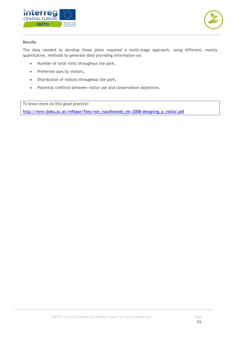
Social media used to identify preferred places in Pallas-Yllästunturi National Park (FIN) Methodology: social media Description User-generated content is rapidly being recognized as a complementary source of data for traditional spatial datasets. Location-based social media provide constant feeds of content-rich data generated by users of different platforms sharing their experiences and observations online. These data have the potential to enrich existing data collection methods for mapping spatio-temporal activity patterns and location-based experiences of people. By using as case study area the most popular national park in Finland, Pallas-Yllästunturi National Park (PY), researchers have examined the potential of social media data in providing relevant information about visitation to a national park. Pallas-Yllästunturi National Park is a conservation site for a major part of the Western Lapland Great Fells chain, the forests and mires which surround the fells. There are almost 100 km of fell chain in the National Park. The study’s objective was to compare social media data content and the results derived from traditional national park visitor surveys. Moreover, they find out complementary information that could be derived from social media data regarding visitation patterns and activities in the park. In addition this method has proved to be economic e time consuming efficient. Methodology Datas for geotagged social media posts were collected from the Instagram API (www.instagram.com/developer) using as media search endpoint spring 2016. Data collection was conducted using a customized tool written for the Python programming language. All publicly available posts geotagged within a 10km buffer zone of the Pallas-Yllästunturi National Park from the period of January 2014–May 2016 were requested from the API using the center points of 2x2 km grid cells (collection centroids) as input coordinates in the query. All posts geotagged inside or within 100m radius from the National Park border were taken into account for within park analysis and were subject to manual classification. In addition, there were 246 posts geotagged to location ‘Pallas-Yllästunturin kansallispuisto/Pallas-Yllästunturi National Park’ which was attached to coordinates 4 km outside the park borders. These posts were included in park-level statistics, but filtered out when detecting most tagged sub-regions within the park. The location information of the Instagram posts at the time of data collection was attached to pre-defined points-of-interest. In practice, Instagram-users have chosen a predefined location from a list when geotagging their photo and thus, the exact coordinates in the dataset are aggregated to these points-of-interest. Instagram was chosen as the source of social media data because of its popularity in the study area and data availability at the time of designing the study. Then, geotagged social media data were aggregated to surveyed sub-regions based on their coordinates. The content of pictures posted on Instagram was manually classified according to main subject of the picture: • Relevance for the study;
Source: https://en.wikipedia.org/wiki/Pallas-Yll%C3%A4stunturi_National_Park
CEETO - Central Europe Eco-Tourism: tools for nature protection Page 37
• Classified according to six main categories defined by the presence or absence of people, activities, landscape, animals and infrastructure. • Sub-classification of these categories, for example single person, couple, group, people doing activities, etc. Results The comparison between visitations surveys and the amount of social media posts from the same areas has showed the possibility to identify most popular areas in the park from social media data. In less-popular sub-regions, the number of social media users was relatively small compared to the two most popular sub-regions. Social media data has proved to be able to reflect the overall monthly variation in the amount of visitors in the park, and also to reflect the temporal patterns of activities. Social media content revealed similar temporal patterns for the most popular activities; snow sports were most popular in winter, hiking during summer. In addition to surveyed activities, social media data contained seasonal information of the observed environment, for example, the presence/absence of snow in the landscape. In this study researchers found that social media data can potentially have important implications in informing visitor monitoring and protected area management and provide a rapid and cost-efficient alternative to traditional surveys in a continuous and repetitive way. Continuous monitoring of social media would, for example, allow conservation authorities to better understand spatio-temporal changes in visitor preferences; help assess visitors’ profiles and socio-economic backgrounds; understand visitors’ sentiments via content analysis; and identify emerging activities, which cannot be captured by pre-defined surveys. Notes Social media can be used to estimate the number of visitors when the Park has a big number of datas, but, in general, they are useful to understand the flow of tourist during the year. Social media can be used also to send online survey by ads, if you can segment people by where they are/were. To know more on this good practice: http://www.mdpi.com/2220-9964/6/3/85 Most popular activities as resulted from social media data. Official visitor counts and active daily users in Instagram.
CEETO - Central Europe Eco-Tourism: tools for nature protection Page 38
Using time-lapse video recording to count visitors and understand recreational uses in the Danube Floodplains National Park (AT). Methodology: videocameras Description The Danube Floodplains National Park is situated in the east of Austria and stretches from the city of Vienna, along the Danube River to the Slovakian border. In 1996, the area was declared as a National Park. The National Park covers an area of about 9300 hectares. The Lobau, the Viennese section of the National Park, covers an area of 2400 hectares. Since several decades, the Lobau has been a traditional recreational area for the Viennese population as well as for the inhabitants of the surrounding communities. Visitor counting resulted in an annual use estimate of around 0.60 million (2007) visits to the Lobau. Methodology The video monitoring unit consisted of a weatherproof black-and-white video camera with integrated heating and two timelapse video recorders. In order to avoid vandalism the video camera was fixed to a fenced building inaccessible for visitors. The time-lapse video recorder took images of the trail every 1.6 seconds during daylight. With the low resolution of the black and-white camera and a minimum distance between visitor and camera ensured the anonymity. Data were captured and recorded on a MSExcel spreadsheet: date and day of the week, time of visit, direction of movement, number of persons, group size, activity type and number of dogs. Results With a well-structured monitoring strategy with videocameras, park management can identify: • Amount of public use • Temporal distribution of public use • Spatial distribution of public use • Length of routes • Influence of weather Moreover management can control and study some specific type of public use such as, dog walker, or bike, etc. To know more on this good practice: http://mmv.boku.ac.at/refbase/files/kahler_albert_arnb-2008-a_comparison_of_pass.pdf
Source: https://www.donauauen.at/?language=english Source:https://pixabay.com/it/fotocamera-rotante-monitoraggio-1316677/

CEETO - Central Europe Eco-Tourism: tools for nature protection Page 39
Estimating flows by using geotagged photos and gravity theory in the Dolomites UNESCO WHS (IT) Methodology: statistical model Description The Dolomites UNESCO World Heritage Site, located in north eastern Italy, was recognized in 2009 for the aesthetic and geomorphologic value of dolomitic mountains, it is composed of nine different units for a total surface of 141,903 ha and an additional 89,267 ha of buffer areas. The site presents 18 peaks over 3000 m of elevation and beautiful mountain landscapes characterised by vertical walls and deep valleys. In Dolomites people can find a very extended trail network (hundreds of kilometres), well maintained and infrastructure. Every year it is explored by hundreds of thousands of visitors, though numbers vary greatly both between and within units. Presences are mostly concentrated in July and August (which corresponds to high season), while it is much lower in June and September (low season). Dolomites UNESCO WHS has no systematic monitoring programme although some visitor flows are measured at some locations, where visitor counters are installed. Methodology This technique uses a GIS-based methodology to estimate visitor flows in natural areas exploiting geotagged photographs to identify popular destinations, and a gravity model to approximate flow volumes as a function of access and destination points’ popularity, and taking in to account the effort required to go from one point to another. Gravity model: assumptions used in this example state that visitors generally move from various access points (parking lots or bus stops) to a broad spectrum of destinations (natural attractions, huts, etc.). Moreover, the volume of this movement is supposed to be: • proportional to the tourist presence at the access point and the attractiveness of the destination, • inversely proportional to the distance between the access point and the destination (metric value, effort needed, etc). The application of this equation is not straightforward in the context of natural area management due to some peculiar features of visitor movement in natural areas: the wide range of routes; the variety of potential access points and destinations; and the complexity of the terrain. In particular, the approach presents four main challenges: • the identification of access points and destinations (for this study access points were identified by roads as well as cable car and chairlift mountain stations); • the estimation of the popularity of access points (number of beds in the municipality where the access point was situated and the adjacent municipalities) and destinations (density of geotagged photographs); • the estimation of travel times that is to say the time required to go from the point of departure to the point of arrival depending on the characteristics of the trail. • the calibration of the model’s parameters.
Source: https://pixabay.com/it/dolomiti-montagne-italia-alto-adige-2348579/

CEETO - Central Europe Eco-Tourism: tools for nature protection Page 40
The geotagged photograph database for the study area included 3656 images available on Panoramio and posted on Google Earth. Photographs were downloaded individually and checked for geographical consistency. The number of visitors moving on a path is assumed to be proportional to the population at the starting point and the popularity of the destination point (as measured by density of geotagged photographs), and inversely proportional to the travel time between those points, by means of constants k and α (source: http://mmv.boku.ac.at/refbase/files/mmv6_392_393.pdf). Results The main result of this analysis is a map showing which are the expected level of crowding in the different section of a path network. Although numbers reported in the map don’t represent real numbers, they provide a correct picture of expected visitor flows. This can be useful to park managers to identify which overcrowded areas which need proper measures of visitor flows redirecting so that standards of quality are met. The advantage of the methodology used in this case deals with its simplicity and minimal requirement of data from field works. For this reason it is suitable for large natural areas where data collection can be expensive and time consuming. To know more on this good practice: http://mmv.boku.ac.at/refbase/files/mmv6_392_393.pdf

CEETO - Central Europe Eco-Tourism: tools for nature protection Page 41
Using bioacoustic to detect human activities in natural environments. Methodology: bioacoustic Description This case study was elaborated in the LIFE+ Program AMIBIO “Automatic Acoustic Monitoring and inventorying of Biodiversity” in order to detect human activities in natural environments by analysing their acoustic emission. With this methodology researchers wanted to propose a technic able to carry out a systematic and non-intrusive audio surveillance exploiting remote monitoring station. The aim of their work was to detect sound of human activities such as speech, gunshot, car and motorcycle in natural reserves based on the signal captured by a single microphone. Moreover they considered also bird-call, rain and wind sounds. Methodology3 Parametrization Parametrization following three groups of acoustic parameters: a) Mel Frequency Cepstral Coefficients (MFCC) b) MPEG-7 Audio Standard Low Level Descriptors c) Perceptual Wavelet Packet integration (PWP) Sound recognition Sound recognition is based on the assumed that each sound source has a proper acoustic pattern with a specific way of distributing its energy and its frequency content. This inimitable pattern can be discovered and modelled using a statistical pattern recognition algorithms. For this study researches has followed HMM approach where each state is modelled by a Gaussian mixture model (GMM) with a diagonal covariance matrix. Model test In order to find the topology which offers the highest classification accuracy, they designed an experiment consisting of two phases. Initially they utilized the MFCCs and conducted a simple experiment with respect to two different classification topologies: 1. The first one is consisted of one-stage and the second one uses an hierarchical schema which first discriminates the sound events which appear in the case of human presence vs the rest. 2. Then another stage follows where the exact class of the novel sound event is predicted. The motivation behind experimenting with the two-stage approach lies in the fact that it limits the problem space as well as that the division is in line with the scope of this work as regards to identifying sound events related to human activities. One of the main burdens that sound recognition systems have to face is the decrease in their performance as the number of categories increases. Using the two-stage topology the largest number of categories that the system has to identify is four while in the case of the one-stage topology the corresponding number of classes is seven. Simulation Situations which include human activities in natural environments were artificially created by merging the corresponding audio signals. The merging of the audio signals was conducted at different energy ratios in order to observe the way that the system responds even at particularly difficult conditions. After merging 3 Ntalampiras S., Potamitis I., fakotakis N.; Acoustic Detection of Human Activities in Natural Environments, Journal of Audio Engineering Society, 2012

CEETO - Central Europe Eco-Tourism: tools for nature protection Page 42
each output is normalized by its maximum value in order to adjust the overall volume of the specific recording so that the strongest peak is at full level (gain normalization). Subsequently the respective sequence of feature coefficients is extracted and fed to the statistical models which provided the highest recognition accuracy during the previous experimental phase. The detection experiment was conducted in the following manner: they merged every recording which is associated with human activities with a part of an environmental sound of equal size which is chosen randomly from the respective sound classes. This process is repeated 50 times for each recording so that all the recordings are merged with different and dissimilar parts of environmental sounds (for example for the motorcycle class they have 79x50=3950 different test samples). This ensures that the results are reliable and representative of the detection capabilities of the proposed system. The Detection Error Trade-off (DET) curves which comprise an adapted version of Receiver Operating Characteristic (ROC) curves were used for evaluation. DET curves try to present the trade-off between missed detections and false alarms. The point where the average of the missed detection and false alarm rates is minimized is the optimal point, i.e. the one that should be used during the operation of the system. When a large number of target events (in our case human activities) is available in combination with an almost equal amount of non-target events (environmental sounds), the performance of the system is demonstrated accurately. During the first phase of the simulation experiments, target and non-target events were given as input to the two stage probabilistic framework and the log-likelihoods outputted by the human activities Hidden Markov Model used for designing the respective DET plot. The specific plot is illustrated in Figure 2 for different SNR values and provides a picture of the detection capabilities of the system for all the sound events which are indicative of human activities (car, motorcycle, speech and gunshot) when merged with all the kinds of environmental noise (bird call, rain, wind). They observe that even under extremely noisy conditions (SNR=0dB), the proposed framework demonstrates quite good performance. As the SNR increases the detection rate is rapidly increased. By conducting listening tests with respect to the merged signals, it was derived that when the SNR is equal to 5dB, the real-world conditions are represented adequately. At the particular ratio, our system provided a relatively low EER which shows reliable detection of the sound events of interest. They conclude that the results analysed are very encouraging and underline the importance of the selected statistical architecture in which features that capture diverse aspects of the audio structure were incorporated. Results Detection of human activities like trespassing, hunting, etc., in natural environments can play a very important role toward their preservation. They analysed a methodology for automatic acoustic detection of human presence in the specific type of environment. To know more on this good practice http://citeseerx.ist.psu.edu/viewdoc/download?doi=10.1.1.653.448&rep=rep1&type=pdf

CEETO - Central Europe Eco-Tourism: tools for nature protection Page 43
Focus group to identify VERP principles in Gesaeuse National Park (AT) Methodology: focus groups Description The National Park is located in the Ennstaler Alpen, which are part of the North eastern Limestone Alps in Austria. With an area of 11,054 hectares, the Gesaeuse National Park is the third largest of the six Austrian National Parks. The size of the planning area comprises 12,400 hectares and the Natura 2000 site consists of 14,500 hectares. 86 % of the National Park is designated 'Natural Zone', where the virgin landscape is subject to nature protection. The rest is a so-called 'Conservation Zone'. Here the central protective concern is an area of natural land which has been cultivated by man. The objective of the visitor management was the conservation of characteristic animals and plants of the region, the maintenance of a favourable conservation status of Natura 2000 habitats and species as well as a high quality of visitor experience on recreation and education are the main purposes of the National Park. Methodology The visitor management concept is mainly based on the VERP – Visitor Experience and Resource Protection Framework - principles currently used in many US National Parks, but was adapted to the needs of the National Park Gesaeuse, considering the legal situation of the protected area, as well as the resource and tourist background. In addition, the Natura 2000 standards have to be included. On this behalf the risk analysis concept for Natura 2000 species and habitats of PROEBSTL et al. (2007) was adapted. VERP is a process which deals with the carrying capacity concerning the natural resources and the quality of visitor experience. It contains standards for desired future conditions of resource and tourism and defines which intensities of use are appropriate where, when and why. Results The National Park management plan is an instrument to fulfil the strategies and goals of the National Park, which includes all aspects of management. For this reason, the visitor management concept takes into account all other plans for the National Park, i. e. wildlife management, research, education, etc. With this method they were able to: • Description of visitor experience and resource conditions • Impact assessment of visitor use on sensitive habitats and species (risk analysis) • Designation of management zones and areas of conflicts • Definition of indicators and standards for each zone • Definition of management actions • Monitoring of resource and social indicators These elements are useful to implement a successful visitor management plan that can promote strategies of ecotourism. Source: ZECHNER, L. (2007): Visitor Management in the National Park Gesaeuse. A Mixed Method Approach Including a Checklist. Thesis, Klagenfurt, 162 p. Source:https://www.flickr.com/photos/bernd_thaller/29401870764