Introductions to Heritage Assets - Medieval Settlements · Medieval Settlements . On 1st April 2015...
9
Medieval Settlements On 1st April 2015 the Historic Buildings and Monuments Commission for England changed its common name from English Heritage to Historic England. We are now re-branding all our documents. Although this document refers to English Heritage, it is still the Commission's current advice and guidance and will in due course be re-branded as Historic England. Please see our website for up to date contact information, and further advice. We welcome feedback to help improve this document, which will be periodically revised. Please email comments to [email protected] We are the government's expert advisory service for England's historic environment. We give constructive advice to local authorities, owners and the public. We champion historic places helping people to understand, value and care for them, now and for the future. HistoricEngland.org.uk/advice
Transcript of Introductions to Heritage Assets - Medieval Settlements · Medieval Settlements . On 1st April 2015...
Medieval Settlements
On 1st April 2015 the Historic Buildings and Monuments Commission for England changed its common name from English Heritage to Historic England. We are now re-branding all our documents. Although this document refers to English Heritage, it is still the Commission's current advice and guidance and will in due course be re-branded as Historic England.
Please see our website for up to date contact information, and further
advice.
We welcome feedback to help improve this document, which will be periodically revised. Please email comments to [email protected]
We are the government's expert advisory service for England's historic environment. We give constructive advice to local authorities, owners and the public. We champion historic places helping people to understand, value and care for them, now and for the future.
HistoricEngland.org.uk/advice
Introductions to Heritage Assets
MedievalSettlements
May 2011
2Introductions to Heritage AssetsEnglish Heritage Medieval Settlements
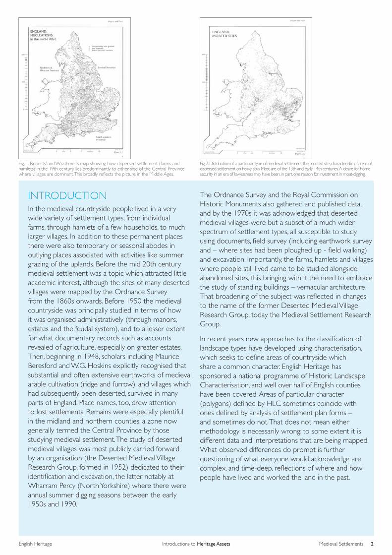
Fig. 1. Roberts’ and Wrathmell’s map showing how dispersed settlement (farms and hamlets) in the 19th century lies predominantly to either side of the Central Province where villages are dominant. This broadly reflects the picture in the Middle Ages.
Fig. 2. Distribution of a particular type of medieval settlement, the moated site, characteristic of areas of dispersed settlement on heavy soils. Most are of the 13th and early 14th centuries. A desire for home security in an era of lawlessness may have been, in part, one reason for investment in moat-digging.
INTRODUCTIONIn the medieval countryside people lived in a very wide variety of settlement types, from individual farms, through hamlets of a few households, to much larger villages. In addition to these permanent places there were also temporary or seasonal abodes in outlying places associated with activities like summer grazing of the uplands. Before the mid 20th century medieval settlement was a topic which attracted little academic interest, although the sites of many deserted villages were mapped by the Ordnance Survey from the 1860s onwards. Before 1950 the medieval countryside was principally studied in terms of how it was organised administratively (through manors, estates and the feudal system), and to a lesser extent for what documentary records such as accounts revealed of agriculture, especially on greater estates. Then, beginning in 1948, scholars including Maurice Beresford and W.G. Hoskins explicitly recognised that substantial and often extensive earthworks of medieval arable cultivation (ridge and furrow), and villages which had subsequently been deserted, survived in many parts of England. Place names, too, drew attention to lost settlements. Remains were especially plentiful in the midland and northern counties, a zone now generally termed the Central Province by those studying medieval settlement. The study of deserted medieval villages was most publicly carried forward by an organisation (the Deserted Medieval Village Research Group, formed in 1952) dedicated to their identification and excavation, the latter notably at Wharram Percy (North Yorkshire) where there were annual summer digging seasons between the early 1950s and 1990.
The Ordnance Survey and the Royal Commission on Historic Monuments also gathered and published data, and by the 1970s it was acknowledged that deserted medieval villages were but a subset of a much wider spectrum of settlement types, all susceptible to study using documents, field survey (including earthwork survey and – where sites had been ploughed up - field walking) and excavation. Importantly, the farms, hamlets and villages where people still lived came to be studied alongside abandoned sites, this bringing with it the need to embrace the study of standing buildings – vernacular architecture. That broadening of the subject was reflected in changes to the name of the former Deserted Medieval Village Research Group, today the Medieval Settlement Research Group.
In recent years new approaches to the classification of landscape types have developed using characterisation, which seeks to define areas of countryside which share a common character. English Heritage has sponsored a national programme of Historic Landscape Characterisation, and well over half of English counties have been covered. Areas of particular character (polygons) defined by HLC sometimes coincide with ones defined by analysis of settlement plan forms – and sometimes do not. That does not mean either methodology is necessarily wrong: to some extent it is different data and interpretations that are being mapped. What observed differences do prompt is further questioning of what everyone would acknowledge are complex, and time-deep, reflections of where and how people have lived and worked the land in the past.

3Medieval SettlementsIntroductions to Heritage AssetsEnglish Heritage
Fig. 3. Roberts’ and Wrathmell’s mapping of place-names indicating greens, again characteristic of areas of dispersed settlement. Many greens were enclosed in the post-medieval centuries.
Fig. 4. The plan of Yarwell, Norhamptonshire, redrawn from a map of 1778. An example of a planned village with a double row of tofts and crofts fronting the east-west road, with church and manor at one end. Dating such places is difficult, although what evidence there is for such villages in Rockingham Forest suggests a pre-, rather than post-, Norman Conquest date.
DESCRIPTION Fifty years of study have produced an immense amount of data and interpretation, enabling patterns of settlement types to be mapped. Brian Roberts and Stuart Wrathmell have produced the most systematic plotting (Figures 1-3) although the methodology employed – systematically classifying settlement types as shown on mid 19th-century Ordnance Survey maps – has attracted criticism as places inevitably changed over the three to four hundred years before 1850. Nevertheless, distinct spatial patterning can often be seen across England, much of it demonstrably of medieval origin. The most basic settlement division is between the Central Province, where relatively large and compact (or nucleated, to use the geographers’ term) villages predominate, and the hillier upland counties of the north and west (and also the Wealden and surrounding landscapes of the south-east) where hamlets and single farms (dispersed settlement) are the norm. Within each of these two main landscape and settlement divisions there is a wide variety of forms. Especially distinctive among villages, for instance, are the regular or planned types found especially in northern England, while the moats dug around isolated farmstead in the 13th and early 14th centuries, especially in counties with heavy soils such as Essex and Suffolk, are one of the more immediately recognisable elements of dispersed settlement (Figure 2). Sometimes these East Anglian moats lie within areas where greens were historically a common feature: extensive areas of rough grazing with cottages around their edge, very different from the classic village green of popular imagination (Figure 3). The transition from one settlement type to another can be very clear (an analogy may be made with vernacular architecture, where the traveller will enter an area where, say, ironstone buildings suddenly appear), capable of delineation as a hard line on a map: a good example is in Warwickshire where there is a clear divide between the Felden (arable) region where villages predominate and the Arden (woodland) one where hamlets and farms are the norm. Sometimes a reason for this can be plausibly suggested (in the Warwickshire case, a divide between the Felden’s relatively light, easily worked soils supporting extensive arable agriculture, and the Arden’s heavy clay soils which were only gradually cleared of woodland during the Middle Ages). More often, why a particular settlement type
predominates remains elusive even when study has specifically addressed the question (see, for instance, work cited below by Lewis, Mitchell-Fox and Dyer, and that by Jones and Page). That quest for understanding of settlement forms remains a constant of modern research.
But whatever the settlement type, the basic components of the individual family holdings – peasant farms - tend to be fairly consistent. The house and usually some barns or sheds for crops and animals stood within a hedged or walled plot typically called a toft (although there is rich variety in regional terminology). Behind was an often lengthy garden for vegetable cultivation and other agricultural or industrial/craft activity, usually termed a croft. In a regular or planned village (as in a post-medieval estate village), or in a planned extension to a pre-existing one, these tofts and crofts would be of the same size, and share common front and rear boundaries. Smaller places, or ones with a more organic form, lack this regularity but still tend to be groupings of tofts and crofts although there are regions (like the south-west) where hamlets have farmsteads whose yards and gardens are clustered more irregularly around the dwellings. Like all specialist subjects, medieval settlement attracts and requires a specialist vocabulary. For instance, relatively large, irregular, places are said to be ‘agglomerated’, while settlements which comprise clusters of houses strung together (sometimes with suffixes like ‘End’, as in Duck End, or Parva [Little] and Magna [Great]) have been termed polyfocal villages: here Wollaston (Northamptonshire) is the type site. The work of Professor Brian Roberts is rich in such terminology (Figure 5).
Standing somewhat separate from villages, hamlets and farms (although in some ways allied to the last) are specialist outlying centres of agricultural production, such as sheep cotes (bercarie) on the Cotswold and the cattle farms (vaccaries) found, for instance, in the Yorkshire Dales. Shielings, temporary habitations associated with the seasonal upland grazing of animals, are the subject of a separate Introduction to Heritage Assets note. The best known, and generally largest of such centres with chambers for accommodation of a permanent workforce, barns, and beast houses, are the granges via which Cistercian monasteries exploited their outlying estates and lands from the 12th century onwards. Some of these survive as farms today, while others have been deserted to remain only as archaeological sites.

Introductions to Heritage AssetsEnglish Heritage 4Medieval Settlements
Fig. 5. Brian Roberts’ classification of English village forms. As he would stress, within and between these types there is considerable variation.

Introductions to Heritage AssetsEnglish Heritage 5Medieval Settlements
Fig. 6. Wharram Percy, North Yorkshire. The site has been much investigated by excavation and survey, but even so its origins and development remain debated. Its principal components (other than the valley-bottom church) were three rows of houses, each of which appears to have planned aspects: a long west row (here running down the centre of the photo) set along the crest of the valley above the church; a shorter north row partly taken over by the late medieval North Manor complex (bottom of photo), and a short east row in the valley bottom (to the left).
CHRONOLOGY Two key questions about medieval settlement remain when and why villages became established over much of midland England. Thanks to archaeological excavation and fieldwalking since the late 1970s an approximate answer can be given to the first, and the 9th and 10th centuries AD appear to be the peak centuries for village formation (Figure 4). Whether this was due to organic processes of change, or community-led initiatives, or as a result of rural reorganisation by kings and thegns intent on increasing revenue (put crudely, people being moved to same-sized plots and farms each owing the same rent) is unclear. Later, especially after the Harrying of the North by William the Conqueror in the winter of 1069-70 when he razed the countryside after Northumbria revolted, villages were re-established under seigneurial (lordly) control with planned layouts integrating same-size tofts and crofts running back from a main road, often with a back lane linking the rear of the crofts, and typically with the church and manor house in larger compartments at the end of the village. The landscapes where individual farms and hamlets predominate, notably to the west and north, have always been thought to be longer established, and Oliver Rackham has labelled these the Ancient Countryside. But while these may not have seen the massive change which the midland countryside did in the century or two before 1066, or parts of the north did after that, we must not assume settlements and field systems in these huge areas of England have been fixed and immutable: many saw considerable modification in the 18th and 19th centuries, and of course the 20th.
Fifty years ago investigation focussed on when and why so many villages were deserted in the Middle Ages. Old notions that the Black Death of 1348-9 or warfare and famines had been responsible were replaced with a general explanation which laid the blame on the 15th- and 16th-century graziers who contemporary, Tudor, writers claimed had systematically depopulated villages and put their arable fields down to grass to create extensive and profitable sheep pastures. While this undoubtedly did occur, the modern orthodoxy now sees settlements of all periods as often fluid entities, being created and disappearing, expanding and contracting, and sometimes gradually shifting. In some cases that is in response to particular
circumstances, and in others to longer-term trends whether social, economic or even climatic: Hound Tor (Devon), for instance, is one of many upland settlements where the climatic downturn of the 12th/13th century may have led to a place being abandoned. In other words, while there are undoubtedly regional and local trends of continuity and change, each particular place has its own history of origin, occupation and sometimes abandonment which demands individual investigation and explanation.
DEVELOPMENT OF THE ASSET TYPE AS REVEALED BY INVESTIGATIONMost analysis of settlement types and patterns has been morphological, using plan forms and patterning visible on maps, air photos and via earthwork survey. Documentary sources can add to the picture, but most medieval settlement formation took place well before written record keeping became common in the 13th century. Excavation (increasingly hand-in-hand with geophysical survey) has the potential to reveal early settlement layouts, for instance Raunds (Northants), but by definition such investigations are extremely extensive and unusual – although uniquely valuable when they are possible. What excavation has revealed over the last fifty years is something of the wide variety of peasant house types found in medieval England, and pointers towards broad trends of development. The latter include the move in clayland areas (as at Barton Blount, Derbyshire, and Goltho, Lincolnshire) from buildings constructed with earth-fast posts (that is, timber uprights sunk directly in holes in the ground) to ones where a sill beam or dwarf stone wall was used to raise or underpin the main structural timbers where there was wet, rotting, ground. In terms of house types, long houses (people at one end, animals at the other) seem to have been more geographically widespread than in more modern times. Sometimes there are clear and illuminating tie-ins between the evidence of excavations, of documents, and of standing buildings.

Introductions to Heritage AssetsEnglish Heritage 6Medieval Settlements
Fig. 7. A recent reconstruction of Wharram Percy, from the same viewpoint as Figure 6 but omitting the North Manor.
Fig. 8. Gainsthorpe, Lincolnshire: an example of a large, irregular-plan, village of stone-built houses. This was already deserted by 1616 when it was observed ‘there is nowe neyther tofte, tenemente or cottage standinge… it keepes neer 1500 sheepe.’
For instance, on the Yorkshire Wolds, while there are no standing cruck buildings, proof of their survival into the 19th century was found in documentary records: that discovery prompted the reinterpretation of previously-excavated later medieval long houses at Wharram Percy, initially thought to be flimsily framed and short-lived, as substantial and long-lived cruck-built structures (Figures 6 and 7). In terms of other types of houses, in several parts of England (Thrislington, Durham; West Whelpington, Northumberland; Burton Dassett, Warwickshire) abutting houses like linear terraces have been found. In many parts of England, as farms with larger acreages emerged after the mid 14th century, courtyard groupings of house and farm buildings around a farmyard began to become commonplace. What remain more archaeologically elusive are the houses of the poorest in medieval society, the widows and cottagers who documents show living in small dwellings on the corner of tofts occupied by their children or on the periphery of villages, or on the wayside.
ASSOCIATIONS While the investigation of standing buildings, especially local ‘vernacular’ houses, has not always been integrated with the study if the places they lie in (a notable exception is Shapwick, cited below), this is increasingly seen as mutually beneficial: both together lie at the heart of what gives local and regional distinctiveness. English Heritage’s selection guide on Vernacular Houses sets out current understanding and designation thresholds. Church and churchyard are often core elements of settlements; the Places of Worship selection guide treats the former, and that on Commemorative Structures the monuments within the latter.
Settlements had a fundamental relationship with the field systems around them (Figures 8-11); especially in the areas of ‘ancient countryside’ these sometimes survive little altered (although this always needs to be proved, rather than assumed). In the Central Province there has typically been far more change, and especially late (18th- and 19th-century) enclosure can have eradicated almost all traces of earlier open fields.
However, elsewhere either fossilized curvilinear strip and furlong boundaries or the earthworks of ridge and furrow ploughing capture important aspects of medieval field systems. English Heritage’s Introduction to Heritage Assets (IHA) description of Field Systems provides a broad overview, while the IHA on Animal Management discusses some of the ways in which lords engaged in more specialist means of exploitation via fishponds, rabbit warrens and deer parks. Watermills were associated with most villages or estates (windmills were much rarer); many lay on a stream some way away, connected to the villagers’ houses by roads and tracks. Many villagers had part-time or seasonal work outside agriculture in some form of industry (potting, iron making, the extractive industries, woodland exploitation), or especially around the coast, fishing. All these things may leave visible or archaeological remains in or around the settlement.
FURTHER READING There are a number of general overviews of medieval settlement which are accessible to the non-specialist: C Lewis, P Mitchell-Fox, and C Dyer, Village, Hamlet and Field Changing Medieval Settlements in Central England (1997) Chapter one, ‘The Study of Villages and Landscapes in Medieval England’ and its notes provide one overview of the subject and its literature. A more concise survey, by Chris Gerrard, appears as chapter one of Guy Beresford, Caldecote: The Development and Desertion of a Hertfordshire Village (2009), while useful broad summaries of recent work on medieval settlement are provided by Mark Gardiner’s ‘Review of Medieval Settlement Research, 1996-2006’, Medieval Settlement Research Group Annual Report 21 (2006), 22-8, and by several of the chapters in Chris Dyer and Richard Jones, Deserted Villages Revisited (2010). Grenville Astill and Annie Grant, The Countryside of Medieval England (1988) is an extensive and thorough multi-author study, and includes both settlements and the exploited landscapes (fields, woods and so on) around them.
Introductions to Heritage AssetsEnglish Heritage 7Medieval Settlements
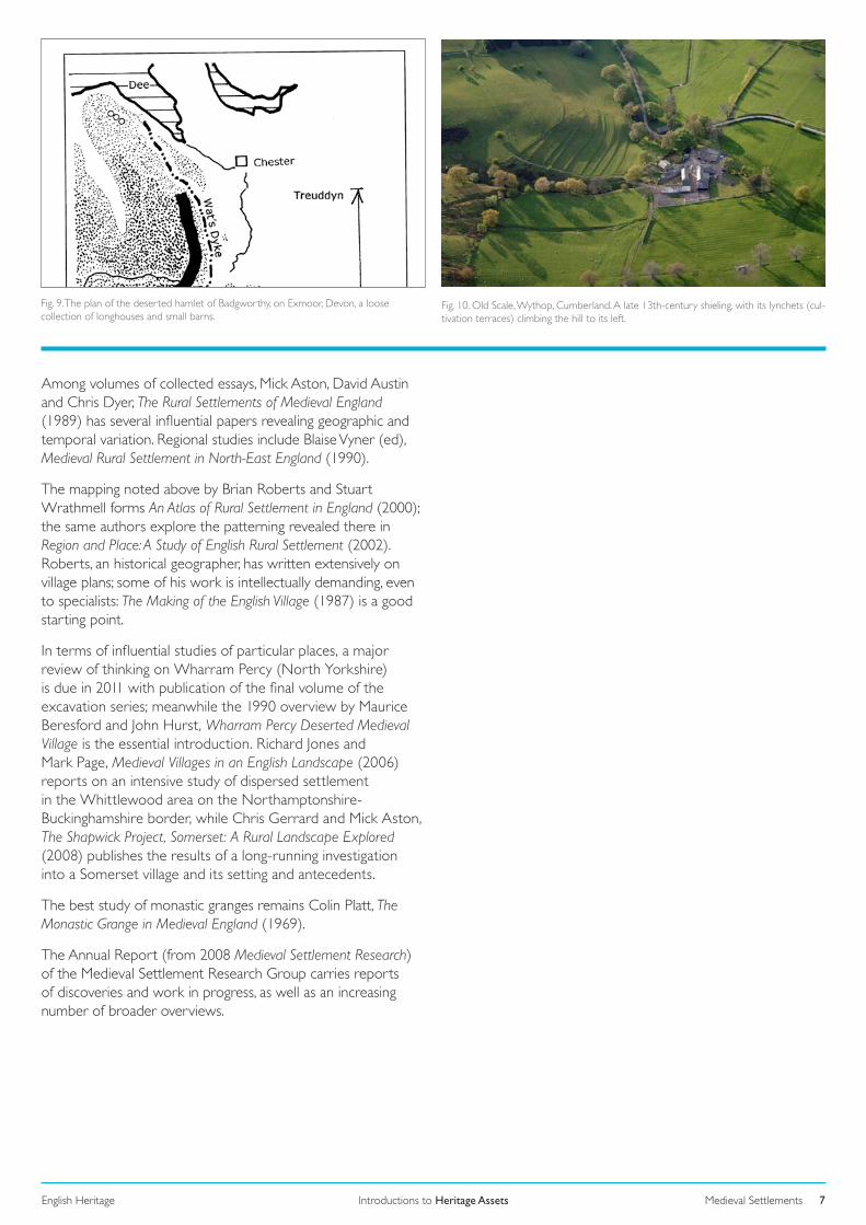
Fig. 9. The plan of the deserted hamlet of Badgworthy, on Exmoor, Devon, a loose collection of longhouses and small barns.
Fig. 10. Old Scale, Wythop, Cumberland. A late 13th-century shieling, with its lynchets (cul-tivation terraces) climbing the hill to its left.
Among volumes of collected essays, Mick Aston, David Austin and Chris Dyer, The Rural Settlements of Medieval England (1989) has several influential papers revealing geographic and temporal variation. Regional studies include Blaise Vyner (ed), Medieval Rural Settlement in North-East England (1990).
The mapping noted above by Brian Roberts and Stuart Wrathmell forms An Atlas of Rural Settlement in England (2000); the same authors explore the patterning revealed there in Region and Place: A Study of English Rural Settlement (2002). Roberts, an historical geographer, has written extensively on village plans; some of his work is intellectually demanding, even to specialists: The Making of the English Village (1987) is a good starting point.
In terms of influential studies of particular places, a major review of thinking on Wharram Percy (North Yorkshire) is due in 2011 with publication of the final volume of the excavation series; meanwhile the 1990 overview by Maurice Beresford and John Hurst, Wharram Percy Deserted Medieval Village is the essential introduction. Richard Jones and Mark Page, Medieval Villages in an English Landscape (2006) reports on an intensive study of dispersed settlement in the Whittlewood area on the Northamptonshire-Buckinghamshire border, while Chris Gerrard and Mick Aston, The Shapwick Project, Somerset: A Rural Landscape Explored (2008) publishes the results of a long-running investigation into a Somerset village and its setting and antecedents.
The best study of monastic granges remains Colin Platt, The Monastic Grange in Medieval England (1969).
The Annual Report (from 2008 Medieval Settlement Research) of the Medieval Settlement Research Group carries reports of discoveries and work in progress, as well as an increasing number of broader overviews.

Introductions to Heritage AssetsEnglish Heritage 8Medieval Settlements
Fig. 11. Reconstruction of a 15th-century or earlier farmstead with open-hall farmhouse and barn at Middle Halsway on the Quantock Hills of Somerset.
CREDITSAuthor: Paul Stamper
Cover : As Figure 7
Figure 1: Source: Region and Place (2002), 53.Figure 2: Source: Region and Place (2002), 57.Figure 3: Source: Region and Place (2002), 55.Figure 4: Source: B.K. Roberts, Village Plans (1982), 10.Figure 5: Source: G. Foard, D. Hall and T.Partida, Rockingham Forest: An Atlas of the Medieval and Early Modern Landscape (2010), 305.Figure 6: © English Heritage. Figure 7: © English Heritage.Figure 8: Source: D. Stocker, England’s Landscape:The East Midlands (2006), 78/NMR 17389/23Figure 9: Source: H. Riley and R. Wilson-North, Exmoor (2001), 94.Figure 10: Source: A. Winchester, England’s Landscape:The North-West (2006), 79/NMR 20249/003Figure 11: Source: H. Riley, The Historic Landscape of the Quantock Hills (2006), 108.
If you would like this document in a different format, please contact our Customer Services department:
Telephone: 0870 333 1181
Fax: 01793 414926
Textphone: 01793 414878
E-mail: [email protected]