Introduction - University of Wyominggeoweb.uwyo.edu/geol2100/Aeolian.pdf · The Buntsandstein...
11
258 Chapter 8 I Continental (Terrestrial) Environments medium to fine sandstone with a few conglomerate and mudstone beds. The for- mation is made up of six multilateral, multistory sandstone sheet complexes, which are the main architectural units that build up the sheetlike sandstone for- mation. Most of the sandstone units display planar or trough cross-bedding. Some are marked by rippled surfaces, and a few are parallel laminated. Plant remains are scattered through the formation. The Cailizar Formation is interpreted as the deposits of a braided-river system with dominant bedload transport. The main fa- cies formed as channel transverse bars, composite bars, and sandflat complexes. Lateral accretion was common on the bars. The Buntsandstein facies as a whole displays gradation upward from coarse, braided-river deposits (Boniches Formation) through multistory, meandering- river sand bodies enclosed in floodplain muds (Alcotas Formation), to multistory sand sheets deposited in a braided-river system. The fluvial system flowed south- east through an asymmetrical graben (the Iberian Basin) in central Spain. 8.3 EOLIAN DESERT SYSTEMS Introduction Deserts cover broad areas of the world today, particularly within the latitudinal belts of about 10-30 degrees north and south of the equator, where dry, descend- ing air masses create prevailing wind systems that sweep toward the equator. Deserts also lie in the interiors of continents and in the rain shadows of large mountain ranges where they are cut off from moisture from the oceans. Deserts are areas in which potential rates of evaporation greatly exceed rates of precipita- tion. They cover about 20-25 percent of the present land surface. Because of their generally low rainfall, commonly less than about 25 em/ yr, we tend to think of deserts as extremely dry areas dominated by wind activity and covered by sand. In reality, a variety of subenvironments exist within deserts, such as alluvial fans; ephemeral streams that run intermittently in response to occa- sional rains; ephemeral saline lakes, also called playas or inland sabkhas; sand- dune fields; interdune areas covered by sediments, bare rocks, or deflation pavement; and areas around the fringe of deserts where windblown dust (loess) accumulates. Large areas of the desert environment may indeed be carpeted by windblown, or eolian, sand. Such areas that cover more than about 125 km 2 are called sand seas or ergs (Fig. 8.14); smaller areas are called dune fields. Ergs and dune fields cover about 20 percent of modern deserts or about 6 percent of the global land surface. The remaining areas of deserts are covered by eroding moun- tains, rocky areas, and desert flats. The largest desert in the world, the Sahara (7 million km 2 ), contains several ergs arranged in belts. The larger belts cover areas as extensive as 500,000 krn 2 . ltansport and Depositional Processes in Deserts Most deserts are characterized by extreme fluctuations in temperature and wind, on both a daily and a seasonal basis. Rainfall rates are low, as mentioned, and the rains are very sporadic. Vegetation is generally extremely sparse. When rains do come, they tend, owing to the lack of vegetative cover, to create flash floods. Rain- water typically drains toward the centers of desert basins, where playas or inland sabkhas may develop and become sites of deposition of carbonate and evaporite minerals. Because periodic rains create flash floods and ephemeral streams and mobilize debris flows and mudflows, they are extremely important agents of sed- iment transport in deserts. Nonetheless, much of the time water plays a relatively small role in sediment transport in deserts. Most of time, wind is the dominant
Transcript of Introduction - University of Wyominggeoweb.uwyo.edu/geol2100/Aeolian.pdf · The Buntsandstein...
258 Chapter 8 I Continental (Terrestrial) Environments
medium to fine sandstone with a few conglomerate and mudstone beds. The formation is made up of six multilateral, multistory sandstone sheet complexes, which are the main architectural units that build up the sheetlike sandstone formation. Most of the sandstone units display planar or trough cross-bedding. Some are marked by rippled surfaces, and a few are parallel laminated. Plant remains are scattered through the formation. The Cailizar Formation is interpreted as the deposits of a braided-river system with dominant bedload transport. The main facies formed as channel transverse bars, composite bars, and sandflat complexes. Lateral accretion was common on the bars.
The Buntsandstein facies as a whole displays gradation upward from coarse, braided-river deposits (Boniches Formation) through multistory, meanderingriver sand bodies enclosed in floodplain muds (Alcotas Formation), to multistory sand sheets deposited in a braided-river system. The fluvial system flowed southeast through an asymmetrical graben (the Iberian Basin) in central Spain.
8.3 EOLIAN DESERT SYSTEMS
Introduction Deserts cover broad areas of the world today, particularly within the latitudinal belts of about 10-30 degrees north and south of the equator, where dry, descending air masses create prevailing wind systems that sweep toward the equator. Deserts also lie in the interiors of continents and in the rain shadows of large mountain ranges where they are cut off from moisture from the oceans. Deserts are areas in which potential rates of evaporation greatly exceed rates of precipitation. They cover about 20-25 percent of the present land surface.
Because of their generally low rainfall, commonly less than about 25 em/ yr, we tend to think of deserts as extremely dry areas dominated by wind activity and covered by sand. In reality, a variety of subenvironments exist within deserts, such as alluvial fans; ephemeral streams that run intermittently in response to occasional rains; ephemeral saline lakes, also called playas or inland sabkhas; sanddune fields; interdune areas covered by sediments, bare rocks, or deflation pavement; and areas around the fringe of deserts where windblown dust (loess) accumulates. Large areas of the desert environment may indeed be carpeted by windblown, or eolian, sand. Such areas that cover more than about 125 km2 are called sand seas or ergs (Fig. 8.14); smaller areas are called dune fields. Ergs and dune fields cover about 20 percent of modern deserts or about 6 percent of the global land surface. The remaining areas of deserts are covered by eroding mountains, rocky areas, and desert flats. The largest desert in the world, the Sahara (7 million km2), contains several ergs arranged in belts. The larger belts cover areas as extensive as 500,000 krn2.
ltansport and Depositional Processes in Deserts Most deserts are characterized by extreme fluctuations in temperature and wind, on both a daily and a seasonal basis. Rainfall rates are low, as mentioned, and the rains are very sporadic. Vegetation is generally extremely sparse. When rains do come, they tend, owing to the lack of vegetative cover, to create flash floods. Rainwater typically drains toward the centers of desert basins, where playas or inland sabkhas may develop and become sites of deposition of carbonate and evaporite minerals. Because periodic rains create flash floods and ephemeral streams and mobilize debris flows and mudflows, they are extremely important agents of sediment transport in deserts. Nonetheless, much of the time water plays a relatively small role in sediment transport in deserts. Most of time, wind is the dominant

8.3 Eolian Desert Systems 259
Figure 8.14 Spaceborne radar image of part of the vast Namib Sand Sea on the west coast of southern Africa, just northeast of the city of Luderitz, Namibia, showing a variety of dune shapes and sizes. NASA image acquired by spaceborne imaging radar on board the space shuttle Endeavour, April 11, 1994. Downloaded from the Web 1 /1 3/2000.
agent of sediment transport and deposition. Wind is much less effective than water as an agent of erosion, but it is an extremely effective medium of transport for loose sand and finer sediment. Not only does it account for the transport of vast quantities of siliciclastic sand in deserts, but it is also responsible for sediment transport in glacial environments, on river flood plains, and along many coastal areas, where both carbonate and siliciclastic sands may be transported inland. The windblown deposits of these latter environments are quite small compared to the sand seas of desert areas. Wind storms, or dust storms, may also carry silt and clay far from their sources and are responsible for transporting much of the pelagic sediment to deep ocean basins.
Wind transports sediment in much the same way as water, separating the sediment into three transport populations: traction, saltation, and suspension. Transport of grains by wind is initiated when wind strength rises to the fluid threshold and also when wind blowing at greater than threshold speed over an immobile surface encounters the leading edge of a deposit of loose, mobile material. Direct dislodgment by wind may also play a role in grain transport (Anderson, Sorenson, and Willets, 1991). Grain motion appears to cascade rapidly as those grains most susceptible to direct dislodgment collide (downwind) with and disturb less susceptible grains. The rapidity of the dislodgment depends upon the grain size, shape, sorting, and packing. At scattered locations, almost random, near-bed turbulence causes the wind flow to be seeded with low-energy ejected grains. Many of these grains translate downwind at a range of speeds, dislodging other grains as they go. A single flurry, therefore, tends to give rise to a translating and dispersing sequence of dislodgments. At a particular locality undergoing threshold wind flow, many such dislodgment sequences may be superimposed to produce overall entrainment and transport.
Wind effectively separates sediment finer than about 0.05 mm from coarser sediment and transports this fine sediment long distances in suspension. Except at unusually high wind velocities, coarser sediment travels by traction and saltation close to th~ ground. Saltation is a particularly important mode of wind transport, aided by downslope creep of grains owing to the impact of saltating grains as they strike the bed. Wind appears to be especially effective in transport of medium to fine sand and finer sediment, but coarse particles (up to 2 mm or somewhat larger) may also undergo transport by rolling and surface creep under high-velocity

260 Chapter 8 I Continental (Terrestrial) Environments
winds. The transporting and sorting action of wind tends to produce three kinds of deposits: dust (silt) deposits, sometimes referred to as loess, that commonly accumulate far from the source; sand deposits, which are commonly well sorted; and lag deposits, consisting of gravel-size particles that are too large to be transported by wind and that form a deflation pavement.
Wind transport and deposition generates many of the same kinds of bedforms and sedimentary structures-such as ripples, dunes, and cross-beds-as those produced by water transport. The bedforms that develop during wind transport range from ripples as small as 0.01 m long and a few millimeters in height to dunes 500-600 m long and 100m high. Less commonly, gigantic bedforms called draas that may have wavelengths measured in kilometers (up to 5.5 km) and heights up to 400 m may also form by wind transport (Wilson, 1972; McKee, 1982). The wave length of wind-transported bedforms increases with increasing wind velocity, and wave height tends to increase with increasing grain size. Under a given set of conditions of grain size and wind velocity, ripples, dunes, and draas can coexist. Thus, dunes exist on the backs of draas, and ripples are created on the backs of dunes.
Bagnold's (1954) study dealing with the physics of blown sand remains the classic piece of research in the field of eolian sediment transport and deposition; however, more recent workers continue to investigate this subject (e.g., BarndorffNielsen and Willets, 1991; McEwan and Willets, 1993; Gilette, 1999). An interesting research trend is the use of computer modeling and simulation to generate data that can be compared to experimental observations from field and wind tunnel (e.g., McEwan and Willets, 1993).
Deposits of Modern Deserts
Eolian sediments accumulate in a variety of small-scale settings in deserts and even in shoreline environments; however, the major areas of accumulation are in ergs (sand seas). Ergs form under prevailing wind systems, primarily in arid regions, where copious supplies of fine sediment are present. Noteworthy presentday ergs include those of the Saharan and Arabian deserts of northern Africa, the Namib Desert of southern Africa (Fig. 8.14), the Mojave and Sonoran deserts of southwestern North America, and the Australian Desert of central Australia. Sediment supply, availability, and wind energy play major roles in determining the geomorphology of ergs. Dune patterns in sand seas are the product of (1) regional changes in wind regimes that promote the formation of dunes of different morphological types, and (2) temporal changes in sand supply, availability, and mobility that give rise to the generation of multiple episodes of dune formation (Lancaster, 1999).
The various environments of deserts can be grouped in to three main subenvironments: dune, interdune, and sand sheet (Ahlbrandt and Fryberger, 1982; Fig. 8.15). The dune environment is primarily the site of wind transport and deposition of sand, which accumulates in a variety of dune forms, many having steeply dipping slip faces or avalanche faces. Interdune areas can receive both windblown sediment and sediment transported and deposited by ephemeral streams in stream floodplains or playa lakes. The sheet-sand environment exists around the margins of dune fields. The deposits of this environment form a transitional facies between dune and interdune deposits and deposits of other environments.
Dunes
Many types of dunes (e.g., Fig. 8.16) occur in the sand seas and dune fields of modern deserts, ranging from those with no slip faces to those with three or more
0 ® Grainfall laminae
Avalanche lamina
Lag gravel Erosional surfaces Lag gravel Ripples
Inverse graded laminae
Lag gravels
Ripples
EOLIAN FLUVIAL-EOLIAN
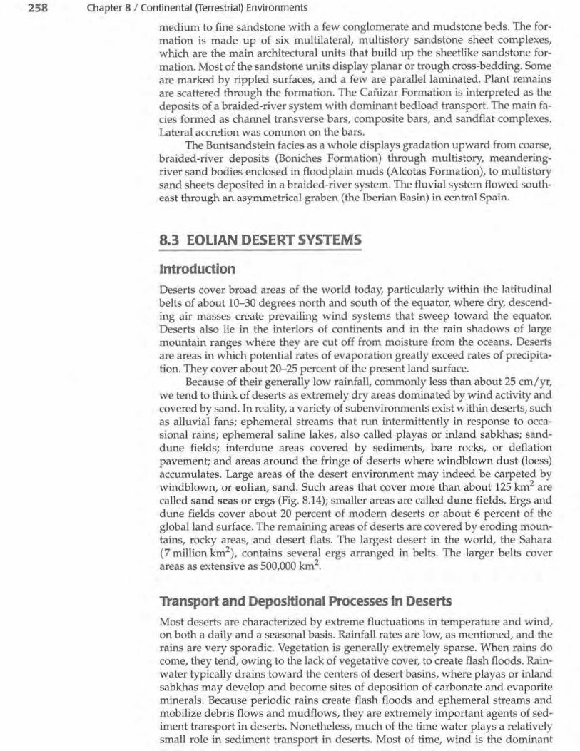
8.3 Eolian Desert Systems 261
Figure 8.15 Areal distribution and stratigraphic relationships of sheet sands and eolian dune sands. Column A
Eolian cross-bedding shows cross-lamination and other Water ripples with typical bedding features, including
mud drapes on top lag gravels on erosional surfaces, in an eolian succession deposited
Climbing ripples (water) in a dune environment. Column B depicts a fluvial-eolian succession formed in an eolian sand-sheet en-
Pebbles on upper vironment. [After Fryberger, S. G., eolian cross-beds T. S. Ahlbrandt, and S. Andrews,
1979, Origin, sedimentary tea-Water-deposited tures, and significance of low-sand
angle eolian "sand sheet" deposits, Great Sand Dunes Na-
Mud layer (water) tional Monument and vicinity, Col-orado: jour. Sed. Petrology, v. 49,
Parallel laminae (wind) Fig. 12, p. 745, reprinted by per-
Wadi (dry wash) gravel mission of Society of Economic Pa-leontologists and Mineralogists, Tulsa, Okla.]
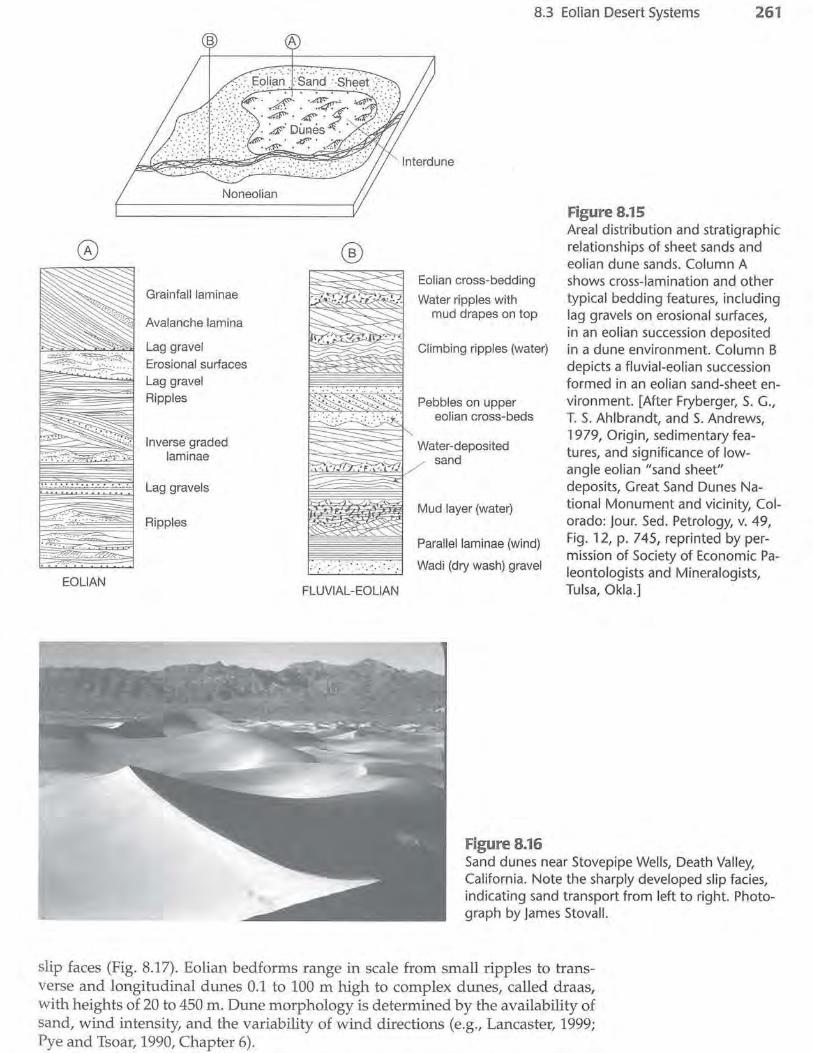
Figure 8.16 Sand dunes near Stovepipe Wells, Death Valley, California. Note the sharply developed slip facies, indicating sand transport from left to right. Photograph by james Stovall.
slip faces (Fig. 8.17). Eolian bedforms range in scale from small ripples to transverse and longitudinal dunes 0.1 to 100m high to complex dunes, called draas, with heights of 20 to 450 m. Dune morphology is determined by the availability of sand, wind intensity, and the variability of wind directions (e.g., Lancaster, 1999; Pye and Tsoar, 1990, Chapter 6).

262 Chapter 8 I Continental (Terrestrial) Environments
Figure 8.17 Basic eolian dune forms grouped by number of slip faces. [After Ahlbrandt, T. S., and S. G. Fryberger, 1982, Introduction to eolian deposits, in Scholle, P. A., and D. Spearing (eds.), Sandstone depositional environments: Am. Assoc. Petroleum Geologists Mem. 31, Fig. 3, p. 14, reprinted by permission of AAPG, Tulsa, Okla.]
Number of slipfaces
0
~if Barchan dune
vegetation
1 ~~'\, or w~...:::)..''~~ ......... more \'\~
Blowout dune
Time 1 wind reversal
·~ Reversing dune
3 or more
Star dune
Dome dune
arr~ ~;-:7·~~
~ ·~e
Winds from several directions during
the year
Basic Eolian Forms
Compound dunes are those In which similar dunes are superimposed-e.g., small barchan on large barchan dune.
Complex dunes are those in which dissimilar dunes are superrmposed-e.g., star on top of linear dunes.
Dune deposits commonly consist of texturally mature sands that are well sorted and well rounded; however, considerable textural variation can occur. They are also typically quartz rich, although many coastal dune deposits contain high concentrations of heavy minerals and unstable rock fragments. Coastal dunes in some tropical areas may consist largely of ooids, skeletal fragments, or other carbonate grains, and dunes composed of gypsum occur in some desert areas, such as White Sands, New Mexico. Eolian dunes are characterized particularly by large-scale cross-bedding (e.g., Fig. 4.18). Several kinds of small-scale internal structures may also be present, such as plane-bed laminae, rippleform laminae, ripple-foreset cross-laminae, climbing ripples, grainfall laminae, and sandflow cross-strata (e.g., Hunter, 1977). Migration of dunes generates a vertical succession of sandy facies that may display many of these structures (e.g., Fig. 8.15).
Owing to the variety of dune types that can form under different wind conditions, local paleocurrent vectors derived from eolian cross-bed data can range from unimodal to polymodal. Paleocurrent data may thus show a high degree of scatter that complicates calculation of ancient prevailing sediment transport directions. On a regional scale, eolian paleocurrent patterns are reported to swing over hundreds of miles around high-pressure wind systems.
Interdunes
Interdune areas occur between dunes and are bounded by dunes or other eolian deposits such as sand sheets (Fig. 8.15). Interdunes may be either deflationary (erosional) or depositional. Very little sediment accumulates in most deflationary interdunes except coarse, granule-size lag sediments that may show rippled surfaces and inverse grading. Deflationary interdunes are preserved in the rock record as a disconformity overlain by thin, discontinuous, winnowed lag deposits. Sediments deposited in depositional interdunes can include both subaqueous and

8.3 Eolian Desert Systems 263
subaerial deposits depending upon whether they are deposited in wet, dry, or evaporite interdunes (Ahlbrandt and Fryberger, 1981). All interdune deposits are characterized by low-angle stratification ( < "'10°), because they are formed by processes other than dune migration, although many deposits may be almost structureless owing to secondary processes, largely bioturbation, that destroy stratification.
Dry interdunes or interdunes that are wetted only occasionally are most common. Deposits in dry interdunes are generated by ripple-related wind-transport processes, grainfall in the wind shadow in the lee of dunes, or sandflow (avalanching) from adjacent dunes. The deposits tend to be relatively coarse, bimodal, and poorly sorted, with gently dipping, poorly laminated layers. They are also commonly extensively bioturbated by both animals and plants.
Wet interdune areas are the sites of lakes or ponds where silts and clays are trapped by semipermanent standing bodies of water rather than being deflated and removed. These sediments may contain freshwater species of organisms such as gastropods, pelecypods, diatoms, and ostracods. They are also commonly bioturbated and may contain vertebrate footprints. Some wet interdune sediments become contorted owing to loading by dune sediments.
Evaporite interdunes, or inland sabkhas, occur where drying of shallow ephemeral lakes or evaporation of damp surfaces causes precipitation of carbonate minerals, gypsum, or anhydrite. Growth of carbonate minerals or gypsum in sandy sediment tends to disrupt and modify primary depositional features. Desiccation cracks, raindrop imprints, evaporite layers, and pseudomorphs may characterize these sediments (e.g., Lancaster and Teller, 1988).
Sheet Sands
Sheet sands are flat to gently undulating bodies of sand that commonly surround dune fields. They are typically characterized by low to moderately dipping (0-20°) cross-stratification and may be interbedded in some parts with ephemeral stream deposits (Fig. 8.15). Sheet-sand deposits may also contain gently dipping, curved, or irregular surfaces of erosion several meters in length; abundant bioturbation traces formed by insects and plants; small-scale cut-and-fill structures; gently dipping, poorly laminated layers resulting from adjacent grainfall deposition; discontinuous, thin layers of coarse sand intercalated with fine sand; and occasional intercalations of high-angle eolian deposits (e.g., Ahlbrandt and Fryberger, 1982; Kocurek and Nielson, 1986; Schwan, 1988).
Kinds of Eolian Systems Desert systems can be characterized as wet, dry, or stabilized (Kocurek and Havholm, 1993; Kocurek, 1996). Dry systems are those in which the water table and its capillary fringe lie at depth below the depositional surface. Therefore, the water table has no stabilizing effect on the surface and near-surface sediment. The aerodynamic configuration or shape of the sediment surface (e.g., dune shape) alone determines whether sediment is deposited or simply moves across the surface (bypass) or, alternatively, if erosion of previously deposited sediment takes place. In wet systems, the water table or its capillary fringe is at or near the depositional surface. Therefore, deposition, bypass, and erosion along the substrate are controlled by the moisture content of the substrate as well as by its aerodynamic shape. Stabilized systems are those in which factors such as vegetation, surface cementation, or mud drapes play a significant stabilizing role and thus influence the behavior of the accumulating surface. Major eolian environments such as the Sahara may show a full range of these three kinds of eolian systems (Kocurek, 1996).
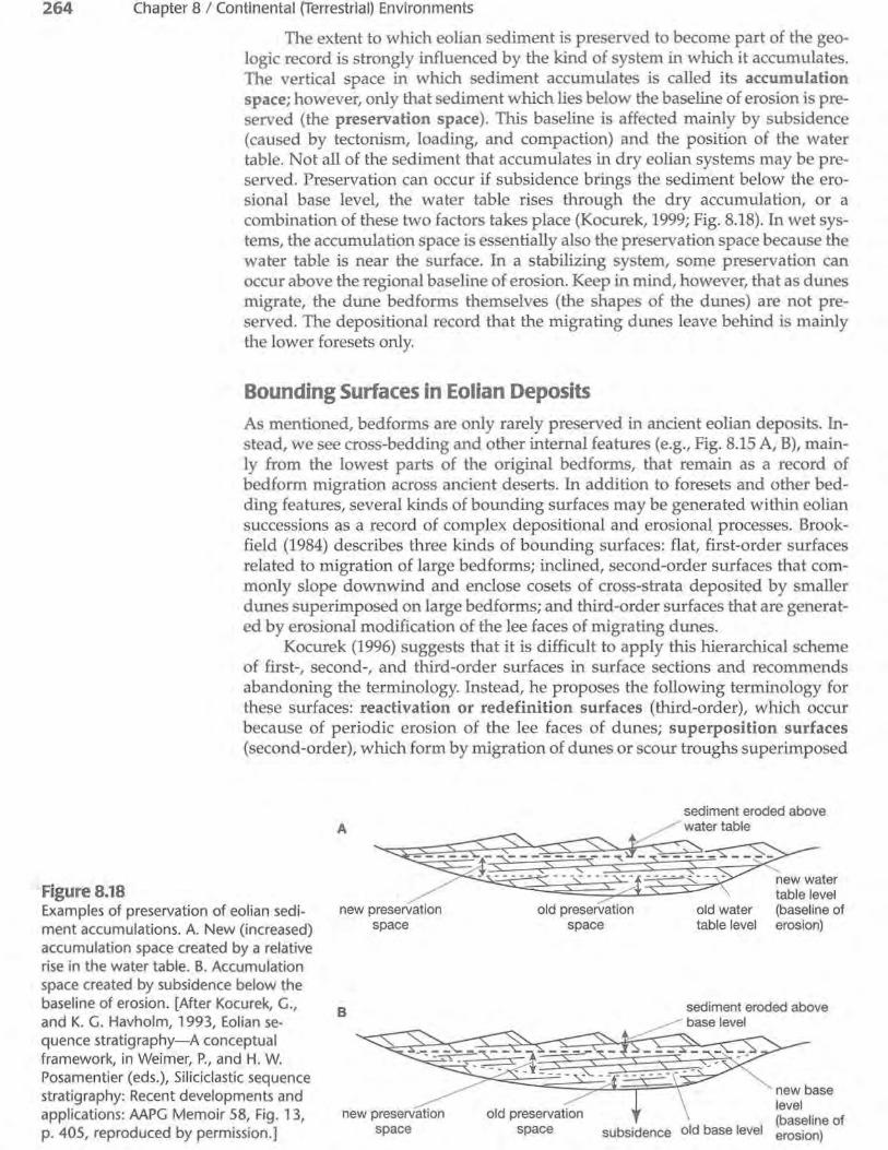
264 Chapter 8 I Continental (Terrestrial) Environments
Figure 8.18
The extent to which eolian sediment is preserved to become part of the geologic record is strongly influenced by the kind of system in which it accumulates. The vertical space in which sediment accumulates is called its accumulation space; however, only that sediment which lies below the baseline of erosion is preserved (the preservation space). This baseline is affected mainly by subsidence (caused by tectonism, loading, and compaction) and the position of the water table. Not all of the sediment that accumulates in dry eolian systems may be preserved. Preservation can occur if subsidence brings the sediment below the erosional base level, the water table rises through the dry accumulation, or a combination of these two factors takes place (Kocurek, 1999; Fig. 8.18). In wet systems, the accumulation space is essentially also the preservation space because the water table is near the surface. In a stabilizing system, some preservation can occur above the regional baseline of erosion. Keep in mind, however, that as dunes migrate, the dune bedforms themselves (the shapes of the dunes) are not preserved. The depositional record that the migrating dunes leave behind is mainly the lower foresets only.
Bounding Surfaces in Eolian Deposits As mentioned, bedforms are only rarely preserved in ancient eolian deposits. Instead, we see cross-bedding and other internal features (e.g., Fig. 8.15 A, B), mainly from the lowest parts of the original bedforms, that remain as a record of bedform migration across ancient deserts. In addition to foresets and other bedding features, several kinds of bounding surfaces may be generated within eolian successions as a record of complex depositional and erosional processes. Brookfield (1984) describes three kinds of bounding surfaces: flat, first-order surfaces related to migration of large bedforms; inclined, second-order surfaces that commonly slope downwind and enclose cosets of cross-strata deposited by smaller dunes superimposed on large bedforms; and third-order surfaces that are generated by erosional modification of the lee faces of migrating dunes.
Kocurek (1996) suggests that it is difficult to apply this hierarchical scheme of first-, second-, and third-order surfaces in surface sections and recommends abandoning the terminology. Instead, he proposes the following terminology for these surfaces: reactivation or redefinition surfaces (third-order), which occur because of periodic erosion of the lee faces of dunes; superposition surfaces (second-order), which form by migration of dunes or scour troughs superimposed
Examples of preservation of eolian sediment accumulations. A. New (increased) accumulation space created by a relative rise in the water table. B. Accumulation space created by subsidence below the baseline of erosion. [After Kocurek, G., and K. G. Havholm, 1 993, Eolian sequence stratigraphy-A conceptual framework, in Weimer, P., and H. W. Posamentier ( eds.), Siliciclastic sequence stratigraphy: Recent developments and applications: AAPG Memoir 58, Fig. 1 3, p. 405, reproduced by permission.]
B
subsidence old base level
new base level (baseline of erosion)

e>Vl ..... ~ Cl)(f) roO roO. .... C1) Cl"O
G>UJ c~ :J VI "00 d,O. _G) 0."0
.5 e> C/)(1)
8.3 Eolian Desert Systems 265
Reactivation surface (R)
. . . . . ... , ', .... _-.. ..... ~-. . . . . . . . . . ; . . :ek:-s ::-_--_:: . .": ~ Super surface (S)
r ·. ·.. : · ~ .-. J.:· .. ~Sp. ·. _ ·- .. · ·!· .. R · .~P-:-. ·...:.. 4- Interdune ~ . . . . · .. _ · .. _--. _ .· ... _ · .. _. ·. -~-. ·-. _ · _ :' •.. -.. ·- .. ·- surface (I) . . . . ~-/. ... · ·. ·. · . ...;.1.,:.. . · ~j .· Sp-·-......,...._
~·.:_ :: .: ~·~· ·::· .sp· >->:- -~---R):>.: ___ ·.-_- ... ··_-·-.. _ ... ~ .. ·. · ·-: · ·: ·. _· · :.- · ·'>· · · · · ·,~ 1 ~ • • •. •• ·-. Sp . ·- · ·. ~ Superpos1t1on
· · · · · · · - · ·. · ·. ·. ·. ·. ·. ·. · :" R · - . · ·. · · . · · . ' surface (Sp)
.7. .':···- ~~·:···.-_./·>~·:.·.::_::·:·::· .. · .... :·.:.;:.~·~-':_- ~~-- - .:: .:.·_. ·- .. ~ > _-.: : · . '-: '-: _· . . ·. . S ; : · · · . · · . · . · . · · . · · · . · · · . · ·,- . ·_- : · ~ Super surface (S) . . . . . . . . . . . . .......... -_. ~IF:-_ .
.· ... ·.•.·:. . . : • . • ~~~~-:- -~;~·. ~~-. :_;..: :~-.. -. .;._·_~·_. __ .:.;·.~~- -~ .. ::..-.. ~(.;.o:_:-:-:: :~: .~·:-_~--~----~- -~. -~· _ ... _ .~. ~- -~. -~ · · Foresets (dashed)
Figure 8.19 Bounding surfaces in eolian deposits. Note that superposition and reactivation surfaces are contained within cross-bed sets or cosets bounded by interdune surfaces, and that super surfaces (unconformities) can truncate interdune surfaces and entire erg successions. [Modified from Kocurek, G., 1988, First-order and super bounding surfaces in eolian sequences-Bounding surfaces revisited: Sedimentary Geology, v. 56, Fig. 2, p. 195, reproduced by permission of Elsevier Science Publishers.]
on the lee face of the main bedform; and interdune surfaces (first-order) formed between sets or cosets of cross-strata and that separate accumulations of the different bedforms (Fig. 8.19).
In addition to the above surfaces, regional unconformities may be present within eolian successions that mark the end of a major episode of eolian deposition. Such unconformities are referred to as super surfaces (Kocurek, 1996). They signify regional interruption of sand-sea deposition and develop in response to changes in sediment supply, climate, or possibly sea level in some cases. They may be surfaces of erosion, where sediment has deflated down to the water table, or surfaces of bypassing. On a bypassing surface, there is no net erosion or sediment accumulation. Sediment is simply transported across the surface to other areas.
Ancient Desert Deposits
Navajo/Nugget Sandstone
The Jurassic Navajo Formation of the southwestern United States is one of the thickest, most widespread, and best exposed ancient eolian (erg) depositional systems in the world (Kocurek, 2003). The Navajo, and its lateral equivalent Nugget Sandstone, reach nearly 700 m in thickness and extend over 265,000 km2 over portions of five states (Fig. 8.20). The original extent of the Navajo sand seas was about 2.5 times as large as the present outcrop (Marzolf, 1988).
The Navajo has been suggested in the past to be a marine deposit; however, few geologists today doubt its eolian origin. Petrologically, it consists of fine- to medium-size quartz grains that are generally well rounded and commonly frosted. The most striking feature of the Navajo is the presence of huge tabular crossbed sets that display sweeping foresets (Fig. 8.21). Dips of foresets commonly exceed 20°, and individual cross-bed sets range in thickness from about 5 m to almost 35m. Freshwater invertebrate fossils (ostracods and crustaceans) have been reported from the Navajo, as well as dinosaur and pteropod tracks and skeletons of bipedal dinosaurs and early mammals. Slump structures such as contorted

266 Chapter 8 I Continental (Terrestrial) Environments
-- --- i daho '. ..,. __ __ -
Figure 8.20
Colorado
New Mexico
Estimates of the minimum and maximum areas of deposition of the Navajo Sandstone and its lateral equivalents. [After Marzolf, J. E., 1988, Controls on late Paleozoic and early Mesozoic deposition of the western United States: Sedimentary Geology, v. 56, Fig. 6, p. 179, reproduced by permission.]
I
I I ..~:·-· ___ J._ ,--- ' ,
APPROXIMATE ORIGINAL DEPOSITIONAL LIMITS
~ PRESENT LIMITS OF NUGGET AND NAVAJO SANDSTONES
Figure 8.21 Navajo Sandstone (Jurassic) in Zion National Park, Utah, showing large sets of cross strata generated by migration from left to right of ancient eolian sand dunes. Note the prominent interdune bounding surfaces (see Fig. 8.19) between cross-bed sets.
bedding, which are reported from modern dune sands that have been wetted, are also common.
As described in preceding paragraphs, sediment deposited during migration of dunes across a desert may be preserved in part, commonly the lower part of the foresets, owing to rise in water table, basin subsidence, or both. Succeeding,