
Introduction to UC Davis TERC Education and...
30
Introduction to UC Davis TERC Education and Outreach The UC Davis Tahoe Environmental Research Center education and outreach coordinator is responsible for developing a strategy to provide effective outreach to the public, contribute measurably to the education of students, residents and visitors, and offer maximum exposure for the UC Davis Tahoe Environmental Research Center and the Thomas J. Long Foundation Education Center (Education Center). As a leader in research at Lake Tahoe and manager of the only science-based education center in the region, TERC has a role in shaping people’s understanding of dynamic lake ecosystems, sharing the current state of research in the region, and relaying the importance of protecting fresh water resources, particularly Lake Tahoe. Vision People are inspired by environmental science to actively conserve and protect freshwater resources throughout the Lake Tahoe Basin. We envision an environmentally-literate public who: • Understand environmental issues, • Know that environmental quality is impacted by human decisions, • Understand the science that provides the basis for our understanding of ecosystems, and • Use this knowledge to make informed, well-reasoned, science-based choices that consider future generations. TERC Mission The Tahoe Environmental Research Center (TERC) is dedicated to research, education and public outreach on lakes and their surrounding watersheds and airsheds. Lake ecosystems include the physical, biogeochemical and human environments, and the interactions among them. The Center is committed to providing objective scientific information for restoration and sustainable use of the Lake Tahoe Basin. Education Center Mission We provide engaging exhibits, interactive hands-on educational activities, and conduct effective outreach to draw student groups, residents and visitors to our facilities. Our education programs inspire an interest in environmental sciences, stimulate curiosity, and motivate active conservation and preservation of freshwater resources. Tactics - Education • TERC will provide hands-on, informal, science-education activities for students, residents and visitors. Student Activities and Science Standards Page 1
-
Upload
hoangduong -
Category
Documents
-
view
220 -
download
5
Transcript of Introduction to UC Davis TERC Education and...
Introduction to UC Davis TERC Education and Outreach
The UC Davis Tahoe Environmental Research Center education and outreach coordinator is responsible for developing a strategy to provide effective outreach to the public, contribute measurably to the education of students, residents and visitors, and offer maximum exposure for the UC Davis Tahoe Environmental Research Center and the Thomas J. Long Foundation Education Center (Education Center).
As a leader in research at Lake Tahoe and manager of the only science-based education center in the region, TERC has a role in shaping people’s understanding of dynamic lake ecosystems, sharing the current state of research in the region, and relaying the importance of protecting fresh water resources, particularly Lake Tahoe.
Vision
People are inspired by environmental science to actively conserve and protect freshwater resources throughout the Lake Tahoe Basin. We envision an environmentally-literate public who:
• Understand environmental issues, • Know that environmental quality is impacted by human decisions, • Understand the science that provides the basis for our understanding of ecosystems, and • Use this knowledge to make informed, well-reasoned, science-based choices that consider
future generations.
TERC Mission
The Tahoe Environmental Research Center (TERC) is dedicated to research, education and public outreach on lakes and their surrounding watersheds and airsheds. Lake ecosystems include the physical, biogeochemical and human environments, and the interactions among them. The Center is committed to providing objective scientific information for restoration and sustainable use of the Lake Tahoe Basin.
Education Center Mission
We provide engaging exhibits, interactive hands-on educational activities, and conduct effective outreach to draw student groups, residents and visitors to our facilities. Our education programs inspire an interest in environmental sciences, stimulate curiosity, and motivate active conservation and preservation of freshwater resources.
Tactics - Education
• TERC will provide hands-on, informal, science-education activities for students, residents and visitors.
Student Activities and Science Standards Page 1
• TERC will maximize the number of fifth- and sixth-grade science teachers and classrooms in the region that visit the Education Center.
• TERC will collaborate with strategic partners to plan special events and bring student and community groups to our facilities.
• TERC will build an active, self-sustaining volunteer docent program. • TERC will seek external funding to cover all education program costs. • TERC will conduct outcomes evaluation to evaluate educational programs, exhibits, and
activities. • TERC will provide innovative exhibits and rotate temporary exhibits (in-house or
traveling) as opportunities and resources permit.
Tactics – Outreach
• TERC will maintain regular communication with donors and collaborators through a newsletter and maintained website.
• TERC will develop an ongoing strategic communications plan for the Education Center, focusing on media relations, partnership development, and marketing efforts to raise visibility for the Center.
• TERC will collaborate with strategic partners, plan special events, and conduct media outreach to generate national and local media placement for the new Tahoe Center for Environmental Sciences and Tahoe City Field Station (“Historic Fish Hatchery”) facilities.
• TERC will conduct research to ensure that the appropriate target audiences, specifically residents and visitors to the North Tahoe area, are aware of our facilities and programs.
• TERC will conduct outreach to agencies and other academics by publishing fact-sheets, reports, and host workshops and symposiums.
Assumptions
• We do not have time to do everything that needs to be done all at once. • To support education programs, our staff consists of one full-time education and outreach
coordinator, one 50% administrative assistant and three part-time Americorps members. • Existing financial support will not fund all planned projects. • External funding will need to cover all educational program costs. (All education
programs must be self-sufficient.) • Projects will need to be phased in over time and phasing may be dependent upon
funding. • TERC has a long history in the Tahoe Basin and it is well-known and respected as an
objective source of scientific information.
Guiding Principles
• Lake Tahoe is a very special place that deserves to be protected and preserved for future generations.
• Our primary role is translation of science and science-based information.
Student Activities and Science Standards Page 2
• We value outdoor education and stewardship; however, this is not the primary focus of the education center (although we hope to inspire students and adults to action).
• We value collaboration. We are part of a network of education programs that creates exceptional learning opportunities in the Tahoe Basin.
Tahoe/Truckee Student Field Trips to Education Center
In addition to our regular drop-in visitors, one of TERC’s priority education goals is to bring fifth- and sixth-grade students to the Education Center. Connecting with local middle school students provides the best opportunity to affect behaviors by creating a “sense of place” and value for their local watershed. We intend to provide students with supplementary environmental literacy and science curriculum including programs in general science, earth science, watershed processes and geology.
One long term goal is to bring all of the sixth-grade science classes (approximately 32 classes) in the Tahoe and Truckee region to the Tahoe Center so that all local students have an opportunity to learn about the special place that is their home and about the research activities occurring in their backyard. This program requires extensive resources to work with teachers, coordinate with state curriculum, organize activities, purchase activity consumables, and coordinate several docent volunteers for assistance with larger groups.
Goal of Environmental Education
The ultimate goal of environmental education (EE) is the development of an environmentally literate citizenry. Environmentally literate individuals understand environmental issues and how environmental quality is impacted by human decisions. In addition, they use this knowledge to make informed, well-reasoned choices that also take social and political considerations into account.
Environmental education often begins close to home, encouraging learners to understand and forge connections with their immediate surroundings. The environmental awareness, knowledge, and skills needed for this localized learning provide a basis for moving out into larger systems, broader issues, and a more sophisticated comprehension of causes, connections, and consequences.
Whether working with adults or children, environmental education is learner-centered and provides participants with opportunities to construct their own understanding through hands-on, minds-on investigations. Engaged in direct experiences, learners are challenged to use higher order thinking skills. Environmental education provides real-world contexts and issues from which concepts and skills can be learned.
Source: NAAEE, Environmental Education Materials: Guidelines for Excellence, http://www.naaee.org/npeee/materials.php
Student Activities and Science Standards Page 3
The Value of Field Trips
“The school science program must extend beyond the walls of the school to the resources of the community.” – National Science Education Standards
Field trips are a key component of school instruction. They are not an add-on, not something that can be eliminated or reduced without serious consequences for student academic achievement.
The value of field trips includes:
• museums, zoos, aquaria, science centers, and natural areas offer resources that are simply not available in the classroom, including hands-on experiences, real artifacts, original sources, and more up-to-date information than is available in textbooks
• well-designed field trips result in higher student academic performance in all subject areas • students are motivated for classroom learning by real world application of what they are
learning • low-income and English language learner students make connections between community
resources and opportunities, and their family and culture, leading to higher involvement in the classroom
• the civic engagement mission of schools is met when students use their learning to benefit their community through service learning projects, and to practice the skills of citizenship
• experiences match the variety of learning styles and intelligences, allowing all students to succeed
The professional staff at many field trip destinations have a level of training equal to classroom teachers, but specialize in creating highly effective informal learning experiences. State and national professional organizations and conferences work to enhance non-formal programs to more effectively meet school objectives.
Using the Environment as an Integrating Context for Learning (EIC) research documents the benefits to academic performance, improved discipline, attendance, thinking skills, and interpersonal abilities of using the community and natural environment as a focus of learning in all subject areas.
Research on the benefits of field trips to informal learning environments such as museums and science centers demonstrates a positive effect on student’s scientific thinking abilities, documented in Gerber, 2001, and many others.
Student Activities and Science Standards Page 4
Using Place-Based Environmental Education to Engage Students Making Science More Interesting and Relevant By Heather M. Segale, M.S. Education and Outreach Coordinator, UC Davis TERC
• How do we get students excited about learning? • Do students care about the place they call home? • What do students know about the issues in their community? • Do students feel empowered that they can make a difference? • Are students being prepared to become good stewards and citizens within their community?
One of the fundamental purposes of general education is to increase internal motivation to learn and to encourage students to generate learning for the sheer satisfaction in growing. Internal motivation is more powerful than any external influence or external motivation, and motivation results in increased learning rates and retention of information and skills (Joyce, Weil & Calhoun, 2004). We need to make certain that our science education programs are engaging and motivating! Lake Tahoe is an interesting place and our local students should know more about the place they live. The 5E's of Teaching Science The 5E’s Learning Cycle is a method of structuring a science lesson that is based upon constructivist learning theory, research-based best practices in science pedagogy and cognitive psychology. It is a recursive cycle of distinctive cognitive stages of learning that include: engage, explore, explain, extend, and evaluate.
(1) Engage - Activity which will focus student's attention, stimulate their thinking, and access prior knowledge.
(2) Explore - Activity which gives students time to think and investigate/test/make decisions/problem solve, and collect information.
(3) Explain - Activity which allows students to analyze their exploration. Student's understanding is clarified and modified because of a reflective activity.
(4) Extend - Activity which expands and solidifies student thinking and/or apply it to a real-world situation.
(5) Evaluate - Activity which allows the teacher to assess student performance and/or understandings of concepts, skills, processes, and applications.
In the 5E Teaching Model, the teacher/presenter begins the lesson with a motivational engagement, preferably one that is tied to something in everyday life. “Using everyday events as starters for teaching science is known as the engagement and it can be used to motivate students to learn science by creating interest and relevance when a new topic is presented… Students must be motivated to focus on the problem and learn from the activity” (Robinson, 2004).
Student Activities and Science Standards Page 5
One such model that seeks to do just this is “place-based education,” “place-based learning” or “using the environment as an integrating context for learning” (EIC™). While place-based education tries hard not to be labeled as just a science education initiative (Sobel, 2004), using the local “place” as the engagement to motivate students is gaining acceptance. By using the student’s local environment, science education can be made more relevant to the student’s lives. What we’re calling place-based education teaches about both the natural and built environments and nearly every one of the science standards is in some way related to the environment. Background Since 1983, when A Nation at Risk was published, Americans have been engaged in a journey toward creating schools that are more effective. The school reform movement is calling for well-educated individuals who have a deep and abiding knowledge of the world in which they live (Environment-based Education: Creating High Performance Schools and Students, September 2000). With numerous, growing and complex environmental problems, the need for the preparation of problem-solvers is greater than ever. Recent No Child Left Behind legislation has required an increased focus on standards-based education and national performance testing. Administrators and teachers alike are looking for ways to improve student standardized test scores, while at the same time, not losing sight of the need to educate students to be more than just good test-takers. History of Environmental Education The roots of this environmental education movement extend back to the nature study movement during the late 1800s and early 1900s (Athman and Monroe). The conservation education movement began in response to the soil erosion, dust storms and flooding disasters of the 1930s (Athman and Monroe). The 1950s gave rise to outdoor education where learning takes place outside the school building (Athman and Monroe). After the nuclear testing of the 50s and Rachel Carson’s book Silent Spring (1962), the environmental movement added a human element to the evolution of environmental education, helping people realize the impact humans have on the natural and built environment. After the first photos of the earth from space and the first Earth Day celebration, a transition happened from “education about the environment and in the environment to education for the environment” (Athman and Monroe). In 1972, the United Nations Conference on the Human Environment, held in Stockholm, Sweden, recommended the establishment of environmental education programs on an international level. Following this recommendation, the United Nations Educational, Scientific, and Cultural Organization (UNESCO) sponsored a series of international environmental education workshops and conferences. The Belgrade Charter was adopted at a United Nations conference in the former Yugoslavia in 1975 to define environmental education and establish its basic objectives (NAAEE, 1996).
Student Activities and Science Standards Page 6
In 1977, a United Nations conference held in Tbilisi, the former Soviet Republic of Georgia, led to the Tbilisi Declaration, which stated “the important role of environmental education in the preservation and improvement of the world’s environment, as well as in the sound and balanced development of the world’s communities,” (Wisconsin Department of Public Instruction, 1994). Beyond establishing the overall goals of environmental education, the Tbilisi Declaration established the following objectives of environmental education:
• Awareness – to acquire an awareness and sensitivity to the total environment and its allied problems;
• Knowledge – to gain a variety of experiences in and acquire a basic understanding of, the environment and its associated problems;
• Attitudes – to acquire a set of values and feelings of concern for the environment and motivation for actively participating in environmental improvement and protection;
• Skills – to acquire the skills for identifying and solving environmental problems; and • Participation – to encourage citizens to be actively involved at all levels in working toward
resolution of environmental problems (UNESCO, 1978). The Belgrade Charter and the Tbilisi Declaration are considered founding documents of the field and provide the foundation for much of what has been done in the field since 1978 (NAAEE, 1996). Environmental education is not the presentation of information. Environmental education helps learners achieve environmental literacy, which has attitude and behavior components in addition to a knowledge component (Athman and Monroe). Elements of Effective Environmental Education Programs Good environmental education programs are relevant and meaningful to student’s everyday lives. Information and ideas must be presented in a way that is relevant to the learners (NAAEE, 1996). Content is more effectively conveyed when embedded in a local context, giving learners a chance to explore and experience what is around them. Other elements of effective environmental education programs include:
• Effective environmental education programs involve stakeholders in all stages of the program, from the development of the program to its evaluation.
• Effective environmental education programs empower learners with skills to help prevent and address environmental issues and with a sense of personal and civic responsibility.
• Effective environmental education programs are accurate and balanced, incorporating multiple perspectives and interdisciplinary aspects.
• Effective environmental education programs are instructionally sound, using “best practices” in education.
• Effective environmental education programs are evaluated with appropriate tools. (Athman and Monroe).
Student Activities and Science Standards Page 7
Place-Based Education Defined Place-based education is a relatively new term, appearing only recently in the education literature. However, progressive educators have promoted the concept for more than 100 years. According to Woodhouse and Knapp (2000), the essential characteristics of place-based education include:
• It emerges from the particular attributes of a place. The content is specific to the geography, ecology, sociology, politics, and other dynamics of that place. This fundamental characteristic establishes the foundation of the concept.
• It is inherently multidisciplinary. • It is inherently experiential. In many programs, this includes a participatory action or service-
learning component; in fact, some advocates insist that action must be a component if ecological and cultural sustainability are to result.
• It connects place with self and community. Because of the ecological lens through which place-based curricula are envisioned, these connections are pervasive. These curricula include multigenerational and multicultural dimensions as they interface with community resources.
“Place-based education represents a recent trend in the broad field of outdoor education. It recaptures the ancient idea of “listening to the land” and living and learning in harmony with the earth and with each other. As society becomes increasingly urbanized and technologized, educators must continue to adopt and adapt more of the goals, theory, and practice of place-based education” (Woodhouse and Knapp, 2000). Using the Environment as an Integrating Context for learning (EIC) defines a framework for education: a framework for interdisciplinary, collaborative, student centered, hands-on, and engaged learning. It has begun to transform curricula in a growing number of schools across the United States and may have the potential to significantly improve K-12 education in America. EIC-based learning is not primarily focused on learning about the environment, nor is it limited to developing environmental awareness. It is about using a school’s surroundings and community as a framework within which students can construct their own learning, guided by teachers and administrators using proven educational practices. EIC programs typically employ the environment as a comprehensive focus and framework for learning in all areas: general and disciplinary knowledge; thinking and problem-solving skills, and basic life skills, such as cooperation and interpersonal communications. The observed benefits of EIC programs are both broad ranging and encouraging.
Student Activities and Science Standards Page 8
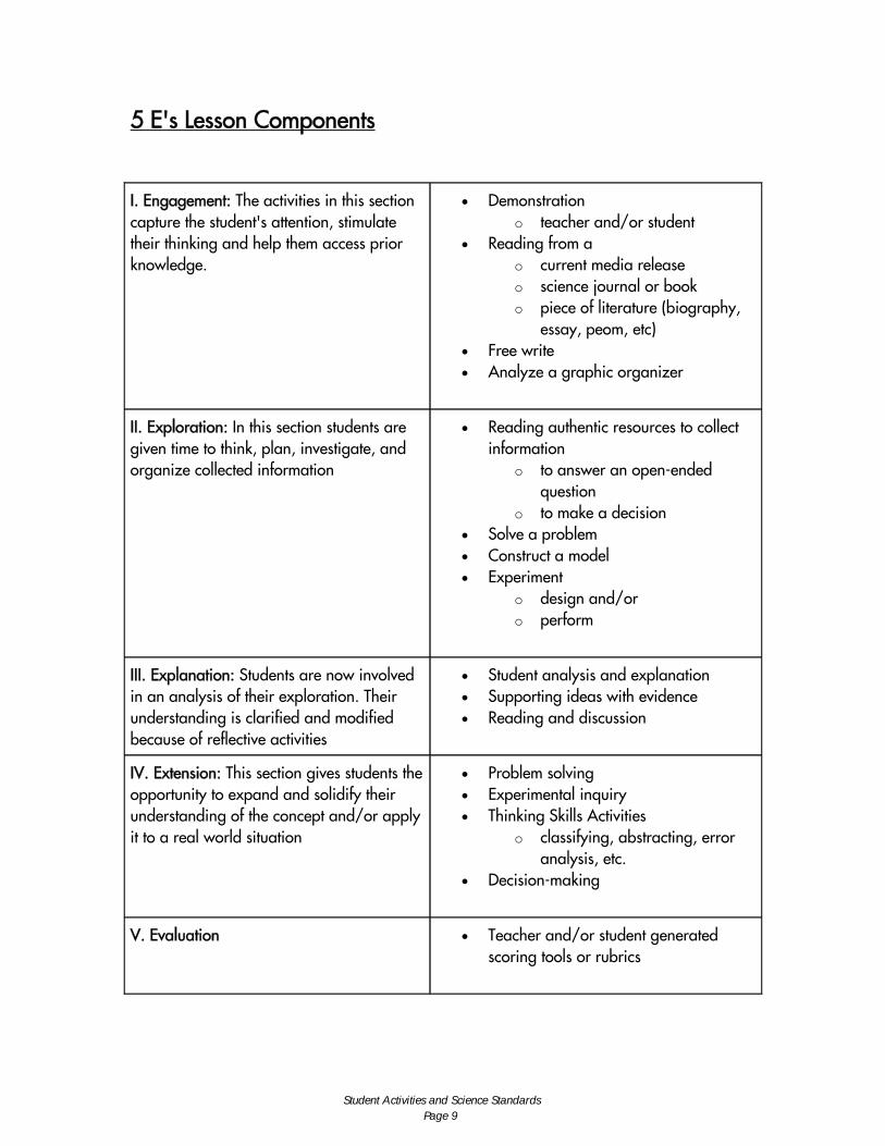
5 E's Lesson Components
I. Engagement: The activities in this section capture the student's attention, stimulate their thinking and help them access prior knowledge.
• Demonstration o teacher and/or student
• Reading from a o current media release o science journal or book o piece of literature (biography,
essay, peom, etc) • Free write • Analyze a graphic organizer
II. Exploration: In this section students are given time to think, plan, investigate, and organize collected information
• Reading authentic resources to collect information
o to answer an open-ended question
o to make a decision • Solve a problem • Construct a model • Experiment
o design and/or o perform
III. Explanation: Students are now involved in an analysis of their exploration. Their understanding is clarified and modified because of reflective activities
• Student analysis and explanation • Supporting ideas with evidence • Reading and discussion
IV. Extension: This section gives students the opportunity to expand and solidify their understanding of the concept and/or apply it to a real world situation
• Problem solving • Experimental inquiry • Thinking Skills Activities
o classifying, abstracting, error analysis, etc.
• Decision-making
V. Evaluation • Teacher and/or student generated scoring tools or rubrics
Student Activities and Science Standards Page 9
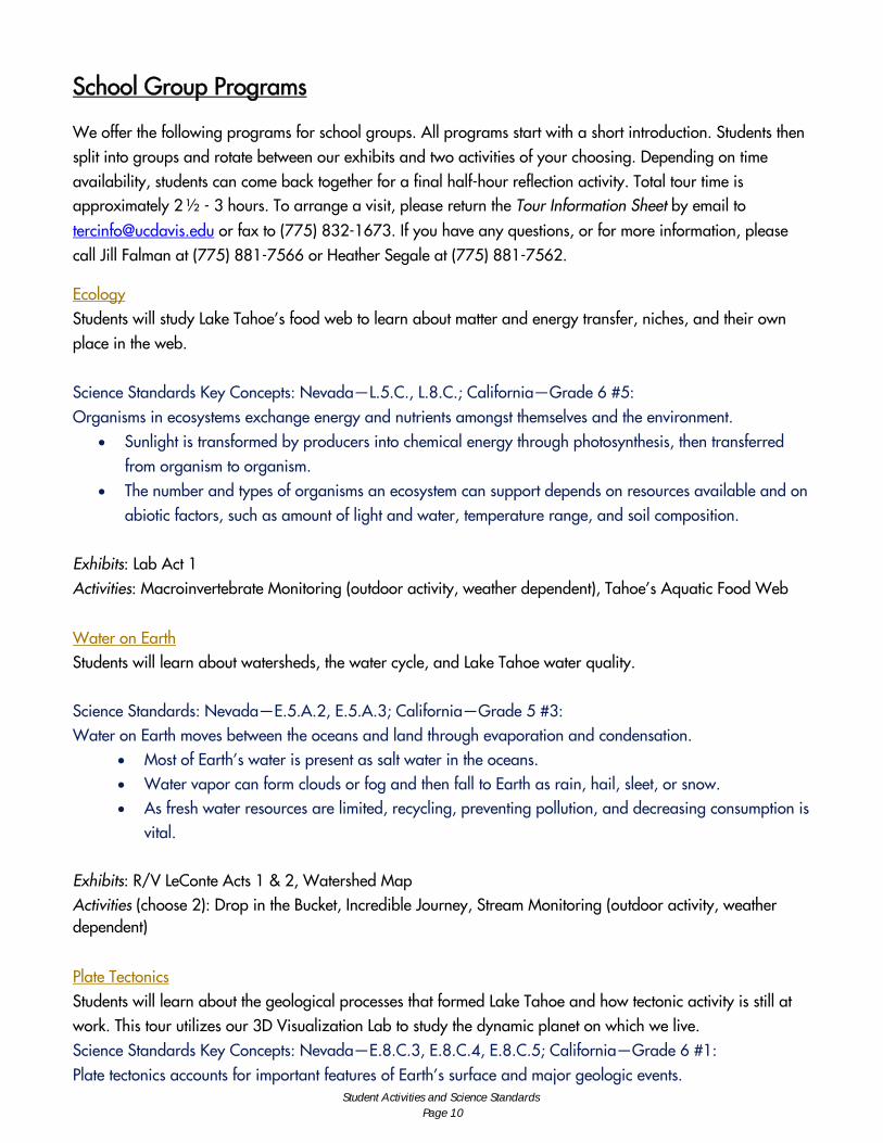
School Group Programs
We offer the following programs for school groups. All programs start with a short introduction. Students then split into groups and rotate between our exhibits and two activities of your choosing. Depending on time availability, students can come back together for a final half-hour reflection activity. Total tour time is approximately 2 ½ - 3 hours. To arrange a visit, please return the Tour Information Sheet by email to
[email protected] or fax to (775) 832-1673. If you have any questions, or for more information, please call Jill Falman at (775) 881-7566 or Heather Segale at (775) 881-7562.
Ecology Students will study Lake Tahoe’s food web to learn about matter and energy transfer, niches, and their own place in the web. Science Standards Key Concepts: Nevada—L.5.C., L.8.C.; California—Grade 6 #5: Organisms in ecosystems exchange energy and nutrients amongst themselves and the environment.
• Sunlight is transformed by producers into chemical energy through photosynthesis, then transferred from organism to organism.
• The number and types of organisms an ecosystem can support depends on resources available and on abiotic factors, such as amount of light and water, temperature range, and soil composition.
Exhibits: Lab Act 1 Activities: Macroinvertebrate Monitoring (outdoor activity, weather dependent), Tahoe’s Aquatic Food Web
Water on Earth Students will learn about watersheds, the water cycle, and Lake Tahoe water quality. Science Standards: Nevada—E.5.A.2, E.5.A.3; California—Grade 5 #3: Water on Earth moves between the oceans and land through evaporation and condensation.
• Most of Earth’s water is present as salt water in the oceans. • Water vapor can form clouds or fog and then fall to Earth as rain, hail, sleet, or snow. • As fresh water resources are limited, recycling, preventing pollution, and decreasing consumption is
vital. Exhibits: R/V LeConte Acts 1 & 2, Watershed Map Activities (choose 2): Drop in the Bucket, Incredible Journey, Stream Monitoring (outdoor activity, weather dependent)
Plate Tectonics Students will learn about the geological processes that formed Lake Tahoe and how tectonic activity is still at work. This tour utilizes our 3D Visualization Lab to study the dynamic planet on which we live. Science Standards Key Concepts: Nevada—E.8.C.3, E.8.C.4, E.8.C.5; California—Grade 6 #1: Plate tectonics accounts for important features of Earth’s surface and major geologic events.
Student Activities and Science Standards Page 10
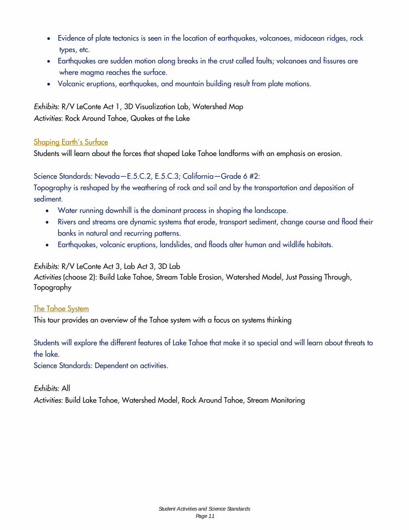
• Evidence of plate tectonics is seen in the location of earthquakes, volcanoes, midocean ridges, rock types, etc.
• Earthquakes are sudden motion along breaks in the crust called faults; volcanoes and fissures are where magma reaches the surface.
• Volcanic eruptions, earthquakes, and mountain building result from plate motions. Exhibits: R/V LeConte Act 1, 3D Visualization Lab, Watershed Map
Activities: Rock Around Tahoe, Quakes at the Lake
Shaping Earth’s Surface Students will learn about the forces that shaped Lake Tahoe landforms with an emphasis on erosion. Science Standards: Nevada—E.5.C.2, E.5.C.3; California—Grade 6 #2: Topography is reshaped by the weathering of rock and soil and by the transportation and deposition of sediment.
• Water running downhill is the dominant process in shaping the landscape. • Rivers and streams are dynamic systems that erode, transport sediment, change course and flood their
banks in natural and recurring patterns. • Earthquakes, volcanic eruptions, landslides, and floods alter human and wildlife habitats.
Exhibits: R/V LeConte Act 3, Lab Act 3, 3D Lab Activities (choose 2): Build Lake Tahoe, Stream Table Erosion, Watershed Model, Just Passing Through, Topography The Tahoe System This tour provides an overview of the Tahoe system with a focus on systems thinking Students will explore the different features of Lake Tahoe that make it so special and will learn about threats to the lake. Science Standards: Dependent on activities. Exhibits: All
Activities: Build Lake Tahoe, Watershed Model, Rock Around Tahoe, Stream Monitoring
Student Activities and Science Standards Page 11

Student Field Trip Activity Descriptions Build Lake Tahoe: Students decide how they would develop their own piece of Tahoe lakefront property, then learn what impact this might have on the environment.
Drop in the Bucket: Students will estimate then calculate the percent of available fresh water on Earth in order to understand how limited a resource fresh water is.
Incredible Journey: Students roll dice that represent different stages of the water cycle, simulating the movement of water molecules from clouds to rivers to animals to plants, and so on.
Just Passing Through: In this whole-body activity, students recreate the movement of water over land surfaces with and without vegetation, thus learning about erosion and BMPs.
Macroinvertebrate Monitoring: Students will collect and observe samples of stream-dwelling macroinvertebrates such as aquatic worms, stoneflies, mayflies, etc., and learn what these species signify for water quality.
Quakes at the Lake: Students learn about the mechanics earthquakes by modeling the motion of P-waves and S-waves through both earth and water using slinkies.
Rock Around Tahoe: Students will roll dice at different stations representing various kinds of rocks and stages of the rock cycle, learning how things such as volcanic activity and sedimentation have shaped Tahoe.
Stream Monitoring: Students will learn how researchers monitor water quality by testing a stream for temperature, dissolved oxygen, pH and conductivity.
Stream Table: Students learn about how water shapes the landscape by observing a mini river and identifying landforms.
Topography: This activity develops concepts of physical geography and mapping. Students make and use topographic maps that describe landforms.
Watershed Model: Students get to place different kinds of pollutants onto a model landscape, then by using spray bottles to represent rain, they see how pollution drains into Lake Tahoe.
More detailed activity descriptions, summary and procedures are available in the Activity Manual available in the Docent Room. Presenters will be trained on these activities before being asked to conduct them with school groups.
Student Activities and Science Standards Page 12
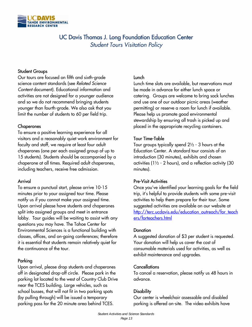
UC Davis Thomas J. Long Foundation Education Center Student Tours Visitation Policy
Student Groups Our tours are focused on fifth and sixth-grade science content standards (see Related Science Content document). Educational information and activities are not designed for a younger audience and so we do not recommend bringing students younger than fourth-grade. We also ask that you limit the number of students to 60 per field trip. Chaperones To ensure a positive learning experience for all visitors and a reasonably quiet work environment for faculty and staff, we require at least four adult chaperones (one per each assigned group of up to 15 students). Students should be accompanied by a chaperone at all times. Required adult chaperones, including teachers, receive free admission. Arrival To ensure a punctual start, please arrive 10-15 minutes prior to your assigned tour time. Please notify us if you cannot make your assigned time. Upon arrival please have students and chaperones split into assigned groups and meet in entrance lobby. Tour guides will be waiting to assist with any questions you may have. The Tahoe Center for Environmental Sciences is a functional building with classes, offices, and on-going conferences; therefore it is essential that students remain relatively quiet for the continuance of the tour. Parking Upon arrival, please drop students and chaperones off in designated drop-off circle. Please park in the parking lot located to the west of Country Club Drive near the TCES building. Large vehicles, such as school busses, that will not fit in two parking spots (by pulling through) will be issued a temporary parking pass for the 20 minute area behind TCES.
Lunch Lunch time slots are available, but reservations must be made in advance for either lunch space or catering. Groups are welcome to bring sack lunches and use one of our outdoor picnic areas (weather permitting) or reserve a room for lunch if available. Please help us promote good environmental stewardship by ensuring all trash is picked up and placed in the appropriate recycling containers. Tour Time-Table Tour groups typically spend 2½ - 3 hours at the Education Center. A standard tour consists of an introduction (30 minutes), exhibits and chosen activities (1½ - 2 hours), and a reflection activity (30 minutes). Pre-Visit Activities Once you’ve identified your learning goals for the field trip, it’s helpful to provide students with some pre-visit activities to help them prepare for their tour. Some suggested activities are available on our website at http://terc.ucdavis.edu/education_outreach/for_teachers/forteachers.html Donation A suggested donation of $3 per student is requested. Your donation will help us cover the cost of consumable materials used for activities, as well as exhibit maintenance and upgrades. Cancellations To cancel a reservation, please notify us 48 hours in advance. Disability Our center is wheelchair assessable and disabled parking is offered on-site. The video exhibits have
Student Activities and Science Standards Page 13

captioning in English and in Spanish for the hearing impaired or English-language learners. Please let us know prior to the start of your visit whether the captions are needed. Weather If you have an outside activity planned, please make sure students are dressed appropriately for weather conditions. As a rule of thumb, if local schools are closed due to hazardous weather conditions, our
center will be closed as well. If you are concerned about driving conditions and feel you will not make your tour, please try to notify us as soon as possible. Contact If you have questions regarding reservations or need to cancel a trip, please contact Jill Falman at (775) 881-7566 or [email protected] or Heather Segale at (775) 881-7562 or [email protected].
Student Activities and Science Standards Page 14
Relevant Science Content Standards California Standards – 6th Grade Plate Tectonics
• 1a Students know evidence of plate tectonics is derived from the fit of the continents; the location of earthquakes, volcanoes, and midocean ridges; and the distribution of fossils, rock types, and ancient climatic zones.
• 1d Students know that earthquakes are sudden motions along breaks in the crust called faults and that volcanoes and fissures are locations where magma reaches the surface.
• 1e Students know major geologic events, such as earthquakes, volcanic eruptions, and mountain building, result from plate motions.
• 1f Students know how to explain major features of California geology (including mountains, faults, volcanoes) in terms of plate tectonics.
• 11.6.3 (Nevada) Investigate, design and use various kinds of maps.
Shaping earth’s surface
• 2a Students know water running downhill is the dominant process in shaping the landscape, including California's landscape.
• 2b Students know rivers and streams are dynamic systems that erode, transport sediment, change course, and flood their banks in natural and recurring patterns.
• 2d Students know earthquakes, volcanic eruptions, landslides, and floods change human and wildlife habitats
• 1.6.1 (Nevada) Investigate and describe the concept that some objects move so slowly or so rapidly that their motion is difficult to detect.
Ecology
• 5a Students know energy entering ecosystems as sunlight is transferred by producers into chemical energy through photosynthesis and then from organism to organism through food webs.
• 5b Students know matter is transferred over time from one organism to others in the food web and between organisms and the physical environment.
• 5c Students know populations of organisms can be categorized by the functions they serve in an ecosystem.
• 5d Students know different kinds of organisms may play similar ecological roles in similar biomes.
Student Activities and Science Standards Page 15
• 5e Students know the number and types of organisms an ecosystem can support depends on the resources available and on abiotic factors, such as quantities of light and water, a range of temperatures, and soil composition.
Investigation & Experimentation
• 7a Develop a hypothesis.
• 7b Select and use appropriate tools and technology (including calculators, computers, balances, spring scales, microscopes, and binoculars) to perform tests, collect data, and display data.
• 7c Construct appropriate graphs from data and develop qualitative statements about the relationships between variables.
• 7d Communicate the steps and results from an investigation in written reports and oral presentations.
• 7e Recognize whether evidence is consistent with a proposed explanation.
• 7f Read a topographic map and a geologic map for evidence provided on the maps and construct and interpret a simple scale map.
• 7g Interpret events by sequence and time from natural phenomena (e.g., the relative ages of rocks and intrusions).
• 18.6.5 (Nevada) Identify and describe various technological tools that scientists use to help them do their work.
• *19.6.3 (Nevada) Investigate and describe the components of systems (including processes or parts.)
• *20.6.2 (Nevada) Analyze data to predict likely outcomes (e.g. how temperature range can affect the survival rate of a species.)
• 24.6.1 (Nevada) Use safety equipment and attire. * Standards 19.6.3(Nevada) and 20.6.2(Nevada) will be met using classroom kits acquired by teachers at pre-visit training.
Student Activities and Science Standards Page 16
National Science Content Standards for Grade Six
The science curriculum in grade six emphasizes the study of earth sciences. Students at this age are increasing their awareness of the environment and are ready to learn more. The standards in grade six present many of the foundations of geology and geophysics, including plate tectonics and earth structure, topography, and energy. The material is linked to resource management and ecology, building on what students have learned in previous grades. Unless students take a high school earth science class, what they learn in grade six will be their foundation for earth science literacy.
I. Plate Tectonics and Earth’s Structure Plate tectonics is a unifying geologic theory that explains the formation of major features of Earth’s surface and important geologic events. Although most scientists today consider Alfred Wegener to be the pioneer of the modern continental drift theory, he died with very little recognition for his accomplishment. Wegener asserted that evidence on Earth’s surface indicated that the continents were once attached as an entire land mass. He theorized that this land mass broke up into pieces that subsequently drifted apart. Today, geologists know that plate tectonic processes are responsible for most of the major features of Earth’s crust (including continental configuration, mountains, island arcs, and ocean floor topography) and are an important contributor to the recycling of material in the rock cycle. Driven by the flow of heat and material within Earth, these processes cause stresses in Earth’s crust that are released through earthquakes and volcanic activity. Mountain building counters the constant destructive effects of weathering and erosion that eventually wear down Earth’s surface features.
How Lake Tahoe was formed and potential earthquake activity Lake Tahoe was formed by graben faulting and volcanic activity which damned the water within the Basin About 5 million years ago, the Carson Range on today’s east shore, and the Sierra Block on today’s west shore had risen many thousands of feet in elevation. Another enormous block between these sank downward creating a trough thousands of feet deep. Volcanoes built high mountains across the north end of the trough, creating a natural dam. Mount Watson, Mount Pluto and Martis Peak the remnant cores of these volcanoes. Over time, waters filled the trough, and created Lake Tahoe. Over the next 3 million years, a series of ice ages created huge snowpacks, thousands of feet thick. Over time, these snowpacks grew into glaciers, and then melted, only to grow into giants once more. Slowly flowing rivers of ice ground their way from the Sierra crest to the lowlands, and some reached into the young Lake Tahoe. Emerald Bay is the footprint of such a glacier.
Student Activities and Science Standards Page 17
The summits and ridgelines of the Carson Range on Tahoe’s east side received less snow than the Sierra Range to the west, just as they do now. They appear graceful and rounded in contrast to the shapes of Mount Tallac, Squaw Peak, and other west shore peaks, which were sculpted into their present shapes by the scour of millions of tons of moving ice. Twelve thousand years ago, the glaciers melted, leaving boulders called “erratics” scattered about the landscape.
1. Plate tectonics accounts for important features of Earth’s surface and major geologic events. As a basis for understanding this concept:
Evidence of past plate tectonic movement is recorded in Earth’s crustal rocks, in the topography of the continents, and in the topography and age of the ocean floor. Continental edges reflect that they were once part of a single large supercontinent that Wegener named Pangaea. Upon the breakup of this supercontinent, the individual continents were moved to their present locations by the forces that drive plate tectonics. When the continental plates of today are returned to their super-continent positions (through computer modeling), the fossil and sedimentary evidence of ancient life distributions and climate becomes coherent, providing strong support for the existence of Pangaea. As plates move in relation to one another, landforms and topographic features, such as volcanoes, mountains, valleys, ocean trenches, and midocean ridges, are generated along plate boundaries. Those regions are also frequently associated with geothermal and seismic activity. There is strong evidence that the divergence and convergence of the lithospheric plates did not begin and end with Pangaea but have been going on continually for most of the history of Earth.
Students should read and discuss expository texts that explain the process of continental drift and study maps that show the gradual movement of land masses over millions of years. Students may then model the process by cutting out continental shapes from a map of Earth and treating these continents as movable jigsaw puzzle pieces. Students read about the underlying evidence for continental drift and determine that the best-supported model of Pangaea shows a continuation of major geologic features and fossil trends across continental margins. The “broken” pieces of Pangaea can be gradually moved into their modern-day continental and oceanic locations. In doing this, students should think carefully about the rate and time scale of the movement. This would be a good point in the curriculum to introduce the differing compositions of the denser ocean floor (basaltic) rock and less-dense continental (granitic) rocks. Students can also learn why most modern-day earth-quakes and volcanoes occur at the “leading edges” of the moving continents.
a. Students know evidence of plate tectonics is derived from the fit of the continents; the location of earthquakes, volcanoes, and midocean ridges; and the distribution of fossils, rock types, and ancient climatic zones.
Student Activities and Science Standards Page 18
Most (but not all) earthquakes and volcanic eruptions occur along plate boundaries where the plates are moving relative to one another. The movement is never smooth; it may produce fractures or faults and may also generate heat. The sudden shift of one plate on another plate along faults causes earthquakes. Volcanic eruptions may occur along faults in which one plate slides under another and sinks deep enough to melt part of the descending material. This process of one plate sliding under another is called subduction. Great mountain-building episodes occur when two continental plates collide. The collision (although slow) is enormously powerful because of the mass of the continents. Over long periods of time, this process may crumple and push up the margins of the colliding continents.
Students may use a large map of the world or of the Pacific Ocean (including the entire Pacific Ocean Rim) to plot the locations of major earthquakes and volcanic eruptions during the past ten to 100 years. The locations of those tectonic events may be found on the Internet or in various library resources. Different symbols may be used to represent different depths or magnitudes of events. In studying such a map, students should note that tectonic events form a “ring” that outlines the Pacific Plate and that there is a Hawaiian “hot spot.” Landforms associated with the plate boundaries include mountain belts, deep ocean trenches, and volcanic island arcs.
Most of California resides on the North American lithospheric (continental) plate, one of the several major plates, and many smaller plates that together form the lithosphere of Earth. A small part of California, west of the San Andreas Fault, lies on the adjacent Pacific (oceanic) Plate. Geologic interactions between these two plates over time have created the complex pattern of mountain belts and intervening large valleys that make up the current California landscape. Large parts of the central and southern parts of California were once covered by a shallow sea. Inter-actions with the Pacific Plate during the past few million years have compressed, fractured, and uplifted the area. This tectonic deformation has buckled the lithosphere upward to create the high-standing coastal and transverse mountain ranges and downward to form the lower-lying Central Valley, Los Angeles Basin, and Ventura Basin.
Topographic mapping activity
1. e. Students know major geologic events, such as earthquakes, volcanic eruptions, and mountain building, result from plate motions.
1. f. Students know how to explain major features of California geology (including mountains, faults, volcanoes) in terms of plate tectonics.
11.6.3 Investigate, design and use various kinds of maps.
Student Activities and Science Standards Page 19

II. Shaping Earth’s Surface Over long periods of time, many changes have occurred in Earth’s surface features. Forces related to plate tectonics have elevated mountains. Atmospheric constituents (mostly water, oxygen, and carbon dioxide) have interacted with minerals and rocks at Earth’s surface, weakening them and breaking them down through a process called chemical weathering. Physical processes involving, for ex-ample, the growth of plants, the release of pressure as overlying material is eroded, and the repeated freezing and thawing of water in cracks, have also helped to break down rocks. Fragments are transported downslope by wind, water, and ice. Gravity by itself moves material by way of landslides and slumps (called mass wasting). The ultimate destination of most of the products of weathering is the ocean. These products arrive in the form of marine sediment deposits. In time, the mountains are laid low, the rivers change their courses and disappear, and lakes and seas expand or dry up. Eventually sediments, which have found their way to the oceans along continental margins, are compacted and changed to rock, then uplifted by continental collision or subducted and melted under the crust. New mountains are formed, and the cycle (called the geologic cycle) begins anew. Each cycle takes tens of millions of years. Lake Tahoe Watershed 63 streams (sub-watersheds) flow into Lake Tahoe and only one, the Truckee River, flows out. Erosion Affecting Lake Tahoe Over millions of years, nature has created an extraordinary place, the Tahoe Basin, and set the conditions for its famously clear waters. The natural and undisturbed watersheds at Lake Tahoe prevented large quantities of nutrients or sediments from being carried into the lake. Erosion and disturbance have always been a part of the forces that have shaped the Tahoe Basin. In the past, change was slower; nature and time allowed the lake to recover from such disturbances. However, human changes to the Tahoe ecosystem are not measured in geologic time. Since settlement and development began in the mid 19th century, we have become the single most important force that can either break or restore the ecosystem and determine the fate of the lake. Our region is called the Lake Tahoe Basin because the water that fills our spectacular lake comes entirely from precipitation that falls within our watershed as rain or snow. The high peaks and ridgelines surrounding our communities form a huge bowl. They act like a local continental divide, separating Tahoe’s water from the water that flows to the Carson River, the American River, Steamboat Creek, and Martis Creek, near the town of Truckee. Our entire continent is made up of watersheds, which often contain smaller subwatersheds. In nearly all watersheds that have not been disturbed by heavy natural resource use or urbanization, natural filtration processes tend to keep the water that is in streams, lakes and
Student Activities and Science Standards Page 20
underground clean. Watersheds naturally adjust to their climate and soil characteristics over time, and collect, store and safely release clean water. Catastrophic floods occur much less frequently in undisturbed watersheds than in those with urban development and many roads. Understanding the watershed concept is useful because the main way to stop the decline in Tahoe’s water quality is to prevent pollution from many small soil disturbances, and to repair those disturbances by restoring or mimicking natural watershed functions. Since Lake Tahoe has no factories or wastewater treatment plants that discharge polluted water inside the watershed, most of the pollution entering the lake comes from many small, seemingly insignificant disturbances to the natural watershed. We call these small disturbances – a little eroded soil here, a little spilled fertilizer there – nonpoint sources of pollution. Even water pollution caused by poor air quality or atmospheric deposition can be reduced if the watershed’s natural filtration processes are functioning properly.
Since the 63 Tahoe subwatersheds sometimes carry dirty water to the lake, all these small impacts (plus atmospheric deposition directly into the lake) add up to what we call the cumulative impacts to the lake. These can be tracked over time, and the results can be displayed with graphs, such as the UC Davis Tahoe Research Group’s Secchi Depth Chart. This chart tracks the average water clarity of Lake Tahoe – the distance you can see objects below the lake’s surface. It shows that Lake Tahoe’s clarity has decreased from 105 feet in 1968 to about 65 feet to 70 feet today. The cloudiness in the lake’s water is caused by a combination of small soil particles, called suspended sediments, and tiny single-cell algae plants that also remain suspended in the water. They are too small to settle out, but numerous enough to block the light. Best management practices (BMPs) are basically repairs that prevent pollution by restoring our residential lots, so they act more like a natural watershed. We want rain and snowmelt to soak into the soil, not run off. Runoff collects and carries tiny soil particles and phosphorus, the most harmful of the nutrients that feed the single-cell algae plants in the lake. Properly installed and maintained BMPs can prevent small amounts of pollution from leaving our properties throughout the watershed and entering the Lake. When our repairs outweigh our adverse cumulative impacts, our lake’s water quality will slowly return.
2. Topography is reshaped by the weathering of rock and soil and by the transportation and deposition of sediment. As a basis for under-standing this concept:
a. Students know water running downhill is the dominant process in shaping the landscape, including California’s landscape.
Student Activities and Science Standards Page 21
Water contributes to two processes that help shape the landscape—the break-down of rock into smaller pieces by mechanical and chemical weathering and the removal of rock and soil by erosion. Water is the primary agent in shaping California’s landscape. Surface water flow, glaciers, wind, and ocean waves have all been and continue to be active throughout California and the rest of the world in shaping landscapes.
A “stream table” may be used to demonstrate the effectiveness of running water as an erosion agent. Stream tables can be easily made from plastic bins or dishpans filled with sand or gravel. The water source may be a hose, a siphon that draws from a cup, or even a drip system. Students may use either gradient or water flow rate as the independent variable. Rates of settling of different sizes of sediment through water may be demonstrated through the use of a sediment jar.
The energy of flowing water is great enough to pick up and carry sediment, thereby lowering mountains and cutting valleys. Sediment carried by a stream may be directed against solid rock with such force that it will cut or abrade the rock. The steeper the slope and the greater the volume-flow of water, the more energy the stream has to erode the land. The flow of water usually varies seasonally. At times of heavy rainfall in a watershed, a stream may flood and overflow its banks as the volume of water exceeds its containment capacity. Flooding may cause a stream to change its path. A stream bank, which consists of sediment or bedrock, may collapse and change the water’s course. One example of this is a stream’s tendency to shorten its length by forming oxbow lakes. This redirection of the stream’s course usually takes place in natural and recurring patterns year after year.
Earthquakes can collapse structures, start fires, generate damaging tsunamis, and trigger landslides. Landslides can destroy habitats by carrying away plants and animals or by burying a habitat. Volcanic eruptions can bury habitats under lava or volcanic ash, ignite fires, and harm air quality with hot toxic gases. Floods can bury or wash away habitats.
Lives may be lost and property damaged when humans get in the way of those powerful natural processes. Although construction (and human habitation) in areas prone to natural disasters is
2. b. Students know rivers and streams are dynamic systems that erode, transport sediment, change course, and flood their banks in natural and recurring patterns.
2. d. Students know earthquakes, volcanic eruptions, landslides, and floods change human and wildlife habitats.
Student Activities and Science Standards Page 22
often impossible to avoid, understanding the likelihood of such disasters and taking steps to mitigate the potential effects would be wise. Moreover, no construction too close to known hazards (e.g., on floodplains) would be advisable. Certainly, the frequency (probability) and severity of flooding, land-slides, and earthquakes must be considered when one decides on land use. Making those decisions should be done after consideration of many factors, including the use of scientific evidence to predict catastrophic events and the local impacts. Although catastrophic events are usually adverse in the short term, some of them may be beneficial in the long term. For example, river floods may deliver new, nutrient-enriched soil for agriculture. Other catastrophic changes may introduce new habitats, allow fresh minerals to surface, change climates, or give rise to new species.
V. Ecology (Life Sciences)
All living organisms are a part of dynamic systems that continually exchange energy. These systems are regulated by both biotic and abiotic factors. Nutrients needed to sustain life in an ecosystem are cycled and reused, but the energy that flows through the ecosystem is lost as heat and must constantly be renewed. Green plants are the foundation of the energy flow in most ecosystems because they are capable of producing their own food by photo-synthesis. Because energy is either used by consumers or depleted in a logical progression, it can be said to flow through a food web (also known as a food chain). A food web may be represented as an energy pyramid with green plants as a base, midlevel consumers in the middle, and a few top-level predators at the apex. Scavengers and decomposers are the final members of an energy pyramid as they clean up the environment and return matter (nutrients) to Earth. A food web can also show the various roles played by plants and animals as producers, consumers, and decomposers.
Food Web of Lake Tahoe
Human impacts over the past 135 years have caused changes in the vegetation and biota of the watershed. These disturbances play a role in the current decline in clarity of the lake as well as changes in the food web within the lake. Species diversity in Lake Tahoe has been greatly affected by the intentional and unintentional introduction of exotic species, and many communities of both plant and animal life have undergone significant change since studies began. In the case of phytoplankton and zooplankton, these communities have a direct impact on lake clarity. For other species, changes have affected the lake’s food web and consequently have altered its fishery. Many fish and invertebrate species have been introduced into Lake Tahoe and surrounding waters, most with limited success. These non-natives cause changes in the food web and in food web energetics. Several species of non-natives and their impacts on Lake Tahoe’s aquatic ecosystem could be discussed, with focus on the introduction of Mysis relicta.
Student Activities and Science Standards Page 23
5. Organisms in ecosystems exchange energy and nutrients among themselves and with the environment. As a basis for understanding this concept:
A food web depicts how energy is passed from organism to organism. Plants and photosynthetic microorganisms, or producers, are the foundation of a successful food web because they do not need to consume other organisms to gain energy. Instead, they gain their energy by transforming solar energy through photosynthesis into chemical energy that is stored in their cells.
Energy and matter are transferred from one organism to another organism through consumption. Plants are eaten by primary consumers (herbivores); most herbivores are eaten by secondary consumers (carnivores); and those consumers are eaten by tertiary consumers (often top-level predators). At the microscopic scale photosynthetic bacteria (cyanobacteria) and protists or single-celled eukaryotic organisms (e.g., dinoflagellates) are consumed by heterotrophic protists (e.g., amoebae and ciliates), which are also called protozoans. Protozoans are consumed by other larger protozoans and by small animals such as cnidarians, arthropods, and nematodes. Energy is transferred from organisms (microorganisms, plants, fungi, and animals) to the physical environment through heat loss. Carbon is returned to the physical environment as airborne carbon dioxide through the respiration of organ-isms. Water is also cycled. Students may use science texts and other library materials to research organisms included in the food webs of particular ecosystems. Students can draw model food webs to demonstrate how food energy is transferred from plants to consumers and from consumer to consumer through predation. Students can also depict the hierarchy of consumers and the transfer and loss of energy from herbivores through secondary consumers to the top carnivores in a food web or energy pyramid. Students should know that energy is lost to the physical environment at every hierarchical level.
Organisms in a population may be categorized by whether they are producers of chemical energy from solar energy (e.g., plants and photosynthetic microorganisms) or consumers of chemical energy (e.g., animals, fungi, and heterotrophic protists) and, if they are consumers, whether they are predators, scavengers, or decomposers. Many consumers may be categorized in multiple ways, such as omnivores that eat both plants and animals and opportunistic
a. Students know energy entering ecosystems as sunlight is transferred by producers into chemical energy through photosynthesis and then from organism to organism through food webs.
5. b. Students know matter is transferred over time from one organism to others in the food web and between organisms and the physical environment.
5. c. Students know populations of organisms can be categorized by the functions they serve in an ecosystem.
Student Activities and Science Standards Page 24
consumers that act as both predators and scavengers. Teachers may provide the class with a nonordered, noncategorized list of four or five plants, eight to ten consumers (four or five primary consumers, three or four secondary consumers, and one or two tertiary consumers [or top-level predators]), one or two decomposers, and one or two scavengers. Using a science text or appropriate research materials from the school library, students can identify the organisms by food web order and ecological function. Students can then arrange the organisms into an energy pyramid with the decomposers and scavengers identified and noted separately. The final task is to draw arrows between members of the pyramid to depict the predation sequence.
Ecological roles are defined by the environment and not by any particular organism. For example, Australia has plants that are unique to that continent yet play the same role as other kinds of plants in similar environments elsewhere. In the rain forests of South America, the mammalian consumers and predators are placental (nonmarsupial) sloths, deer, monkeys, rodents, and cats. In the rain forests of Australia, marsupial kangaroos, wallabies, bandicoots, and so forth play the same ecological roles. Students may be assigned or may choose to research specific organisms that occupy similar biomes in widely separated geographic locales. Students should be encouraged to use a variety of library resources, such as expository texts, the Internet, CD-ROM reference materials, videos, laser programs, or periodicals.
There is a greater variety of types of organisms in temperate or tropical environments than in deserts or polar tundra. The number of organisms supported by an ecosystem also varies from season to season. More organisms thrive during temperate summers than can survive icy winters. More organisms can multiply during a desert’s cooler, wetter winters than can live through its hotter, drier summers. Students should understand that the richness of plant growth controls the diversity of life types and number of organisms that can be supported in an ecosystem (the base of the pyramid). Richness of plant growth depends on abiotic factors, such as water, sunlight, moderate temperatures, temperature ranges, and composition of the soils. To support vigorous growth, soils must contain sufficient minerals (e.g., nitrogen, phosphorus, potassium) and humus (decomposed organic materials) without excess acidity or alkalinity. The teacher may point out that the number of plant-eating animals in an ecosystem depends directly on the available edible plants, and the number of predators in a system depends on the available prey.
5. d. Students know different kinds of organisms may play similar ecological roles in similar biomes.
5. e. Students know the number and types of organisms an ecosystem can support depends on the resources available and on abiotic factors, such as quantities of light and water, a range of temperatures, and soil composition.
Student Activities and Science Standards Page 25
VII. Investigation and Experimentation
Students are expected to formulate a hypothesis for the first time. A hypothesis is a proposition assumed as a basis for reasoning and often subject to the testing of its validity. The scientific hypothesis provides an explanation of a set of observations and may incorporate observations, concepts, principles, and theories about the natural world. Hypotheses lead to predictions that can be tested. If the predictions are verified, the hypothesis is provisionally corroborated. If the predictions are incorrect, the original hypothesis is proved false and must be abandoned or modified. Hypotheses may be used to build more complex inferences and explanations. Hypotheses always precede predictions. However, for simple investigations the hypothesis that led to a prediction may not be easily identified because of its simplicity or its complexity. Prediction follows observation in grades three to five. After grade six students should recognize and develop a hypothesis as a part of their experimental design. In grade six, the focus on earth science can provide many opportunities in the Investigation and Experimentation standards to develop students’ ability to design experiments and to select and use tools for measuring and observing. Examples of experiments conducted by UC Davis researchers including a presentation of how these investigations were performed and why they are significant. Indian Creek Reservoir was shown to turn from blue in color to green within one year of receiving treated sewage pumped from the Tahoe basin. This treated sewage had previously been disposed within the basin. Lake Tahoe Topographic Map (available in 3-D) Sedimentation measured over time by taking cores from the bottom of the lake Stream Erosion Causes Changes in Water Clarity
Student Activities and Science Standards Page 26
7. Scientific progress is made by asking meaningful questions and conducting careful investigations. As a basis for understanding this concept and addressing the content in the other three strands, students should develop their own questions and perform investigations. Students will:
Sources: http://www.cde.ca.gov/re/pn/fd/documents/science-framework-pt3.pdf http://www.cde.ca.gov/be/st/ss/scgrade6.asp
a. Develop a hypothesis. b. Select and use appropriate tools and technology (including calculators, computers, balances, spring scales, microscopes, and binoculars) to perform tests, collect data, and display data. c. Construct appropriate graphs from data and develop qualitative statements about the relationships between variables. d. Communicate the steps and results from an investigation in written reports and oral presentations. e. Recognize whether evidence is consistent with a proposed explanation. f. Read a topographic map and a geologic map for evidence provided on the maps and construct and interpret a simple scale map. g. Interpret events by sequence and time from natural phenomena (e.g., the relative ages of rocks and intrusions).
18.6.5 Identify and describe various technological tools that scientists use to help them do their work.
19.6.3 Investigate and describe the components of systems (including
processes or parts.) 20.6.2 Analyze data to predict likely outcomes (e.g. how temperature range
can affect the survival rate of a species.) 24.6.1 Use safety equipment and attire.
Student Activities and Science Standards Page 27
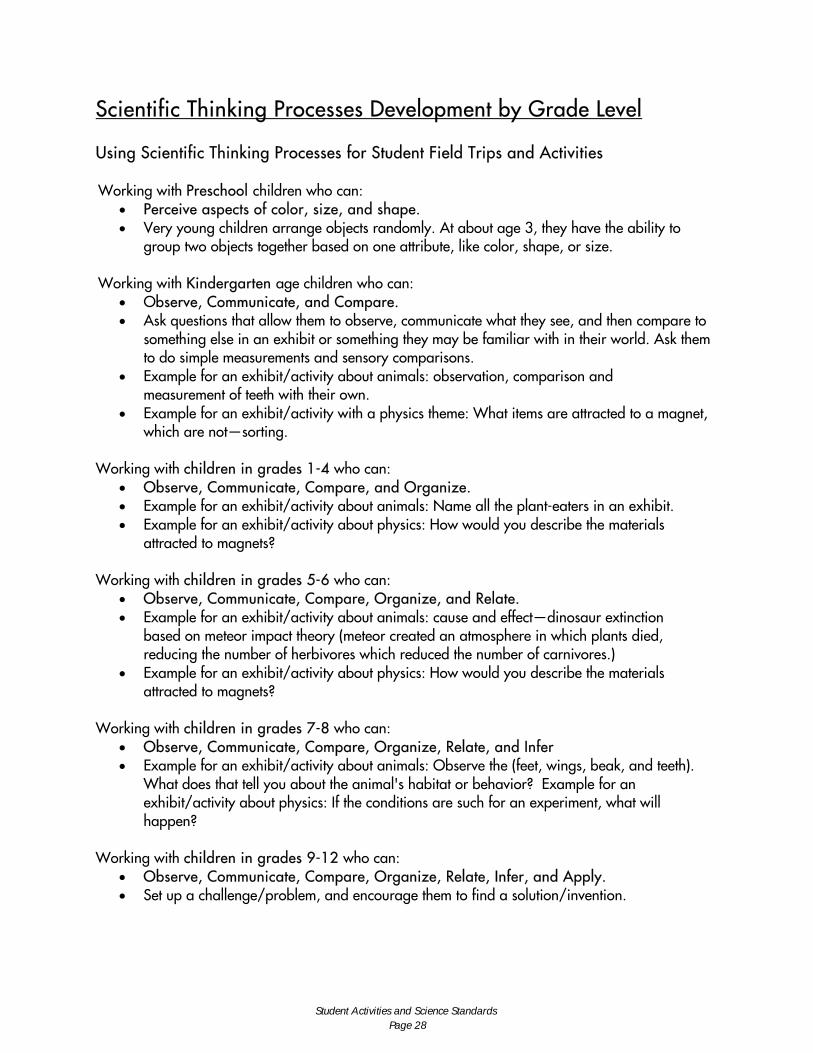
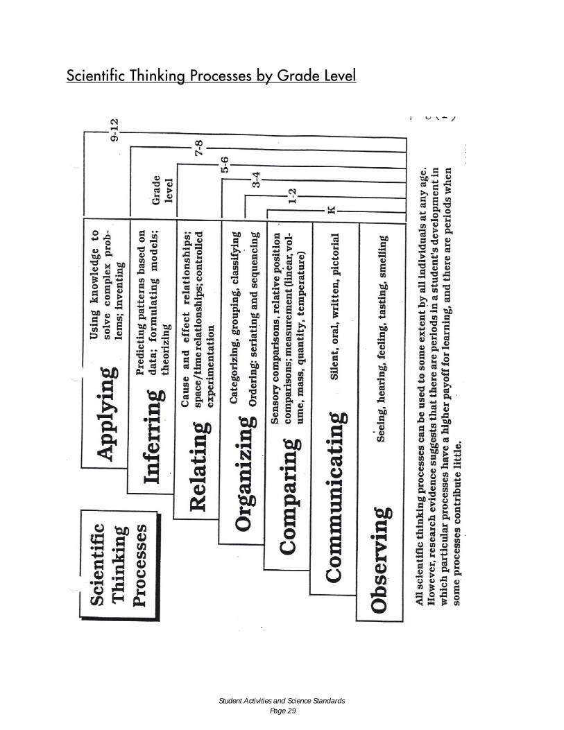
Scientific Thinking Processes Development by Grade Level Using Scientific Thinking Processes for Student Field Trips and Activities
Working with Preschool children who can:
• Perceive aspects of color, size, and shape. • Very young children arrange objects randomly. At about age 3, they have the ability to
group two objects together based on one attribute, like color, shape, or size. Working with Kindergarten age children who can:
• Observe, Communicate, and Compare. • Ask questions that allow them to observe, communicate what they see, and then compare to
something else in an exhibit or something they may be familiar with in their world. Ask them to do simple measurements and sensory comparisons.
• Example for an exhibit/activity about animals: observation, comparison and measurement of teeth with their own.
• Example for an exhibit/activity with a physics theme: What items are attracted to a magnet, which are not—sorting.
Working with children in grades 1-4 who can:
• Observe, Communicate, Compare, and Organize. • Example for an exhibit/activity about animals: Name all the plant-eaters in an exhibit. • Example for an exhibit/activity about physics: How would you describe the materials
attracted to magnets? Working with children in grades 5-6 who can:
• Observe, Communicate, Compare, Organize, and Relate. • Example for an exhibit/activity about animals: cause and effect—dinosaur extinction
based on meteor impact theory (meteor created an atmosphere in which plants died, reducing the number of herbivores which reduced the number of carnivores.)
• Example for an exhibit/activity about physics: How would you describe the materials attracted to magnets?
Working with children in grades 7-8 who can:
• Observe, Communicate, Compare, Organize, Relate, and Infer • Example for an exhibit/activity about animals: Observe the (feet, wings, beak, and teeth).
What does that tell you about the animal's habitat or behavior? Example for an exhibit/activity about physics: If the conditions are such for an experiment, what will happen?
Working with children in grades 9-12 who can:
• Observe, Communicate, Compare, Organize, Relate, Infer, and Apply. • Set up a challenge/problem, and encourage them to find a solution/invention.
Student Activities and Science Standards Page 28
Scientific Thinking Processes by Grade Level
Student Activities and Science Standards Page 29
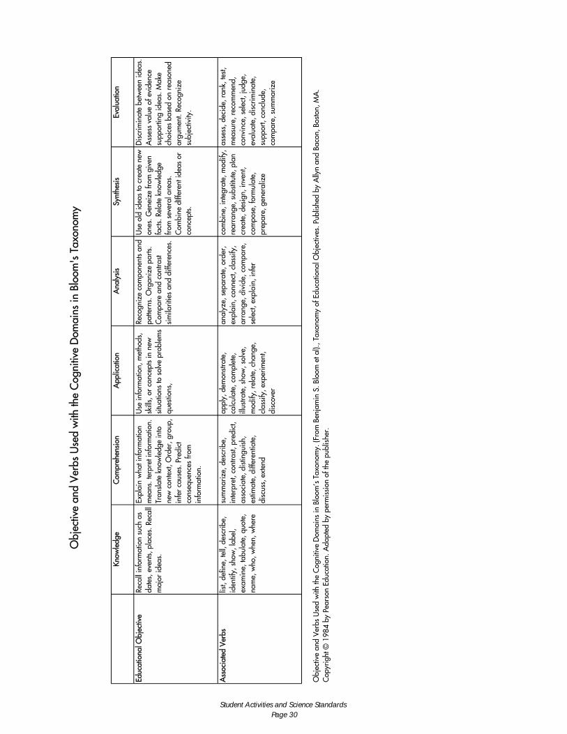
Obj
ectiv
e an
d V
erbs
Use
d w
ith th
e C
ogni
tive
Dom
ains
in B
loom
's T
axon
omy
Know
ledg
e C
ompr
ehen
sion
A
pplic
atio
n A
naly
sis
Synt
hesi
s Ev
alua
tion
Educ
atio
nal O
bjec
tive
Reca
ll in
form
atio
n su
ch a
s da
tes,
eve
nts,
pla
ces.
Rec
all
maj
or id
eas.
Expl
ain
wha
t inf
orm
atio
n m
eans
. ter
pret
info
rmat
ion.
Tr
ansla
te k
now
ledg
e in
to
new
con
text
, Ord
er, g
roup
, in
fer
caus
es. P
redi
ct
cons
eque
nces
from
in
form
atio
n.
Use
info
rmat
ion,
met
hods
, sk
ills,
or
conc
epts
in n
ew
situ
atio
ns to
sol
ve p
robl
ems
ques
tions
,
Reco
gniz
e co
mpo
nent
s an
d pa
ttern
s. O
rgan
ize
parts
. C
ompa
re a
nd c
ontra
st si
mila
ritie
s an
d di
ffere
nces
.
Use
old
idea
s to
cre
ate
new
on
es. G
enei
ze fr
om g
iven
fa
cts.
Rel
ate
know
ledg
e fro
m s
ever
al a
reas
. C
ombi
ne d
Iffer
ent i
deas
or
conc
epts.
Dis
crim
inat
e be
twee
n id
eas.
A
sses
s va
lue
of e
vide
nce
supp
ortin
g id
eas.
Mak
e ch
oice
s ba
sed
on r
easo
ned
argu
men
t. Re
cogn
ize
subj
ectiv
ity.
Ass
ocia
ted
Ver
bs
list,
defin
e, te
ll, d
escr
ibe,
id
entif
y, s
how
, lab
el,
exam
ine,
tabu
late
, quo
te,
nam
e, w
ho, w
hen,
whe
re
sum
mar
ize,
des
crib
e,
inte
rpre
t, co
ntra
st, p
redi
ct,
asso
ciat
e, d
istin
guis
h,
estim
ate,
diff
eren
tiate
, di
scus
s, e
xten
d
appl
y, d
emon
strat
e,
calc
ulat
e, c
ompl
ete,
ill
ustra
te, s
how
, sol
ve,
mod
ify, r
elat
e, c
hang
e,
clas
sify
, exp
erim
ent,
disc
over
anal
yze,
sep
arat
e, o
rder
, ex
plai
n, c
onne
ct, c
lass
ify,
arra
nge,
div
ide,
com
pare
, se
lect
, exp
lain
, inf
er
com
bine
, int
egra
te, m
odify
, re
arra
nge,
sub
stitu
te, p
Ian
crea
te, d
esig
n, in
vent
, co
mpo
se, f
orm
ulat
e,
prep
are,
gen
eral
ize
asse
ss, d
ecid
e, r
ank,
test,
m
easu
re, r
ecom
men
d,
conv
ince
, sel
ect,
judg
e,
eval
uate
, dis
crim
inat
e,
supp
ort,
conc
lude
, co
mpa
re, s
umm
ariz
e
Ob j
ectiv
e an
d V
erbs
Use
d w
ith th
e C
ogni
tive
Dom
ains
in B
loom
’s T
axon
omy.
(Fro
m B
enja
min
S. B
loom
et a
l)., T
axon
omy
of E
duca
tiona
l Obj
ectiv
es. P
ublis
hed
by A
llyn
and
Baco
n, B
osto
n, M
A.
Cop
yrig
ht ©
198
4 by
Pea
rson
Edu
catio
n. A
dapt
ed b
y pe
rmis
sion
of t
he p
ublis
her.
Student Activities and Science Standards Page 30


![THE IMPACT OF UC DAVIS’ EARLY ACADEMIC · PDF fileTHE IMPACT OF UC DAVIS’ EARLY ACADEMIC OUTREACH PROGRAM ON DEGREE ATTAINMENT [Single Space the Title] Timoteo Rico B.S., University](https://static.fdocuments.in/doc/165x107/5ab826b37f8b9ac10d8ca759/the-impact-of-uc-davis-early-academic-impact-of-uc-davis-early-academic.jpg)


