Introduction to the River-Dominated Shelf Sediments of · PDF fileIntroduction to the...
8
Introduction to the River-Dominated Shelf Sediments of the East Asian Seas PETER D. CLIFT 1 *, JAN HARFF 2,3 , JIAXUE WU 4 & YAN QIU 5 1 Department of Geology and Geophysics, Louisiana State University, Baton Rouge, LA 70803, USA 2 University of Szczecin, Institute of Marine and Coastal Sciences, Mickiewicza 18, PL-70-383 Szczecin, Poland 3 Leibniz Institute for Baltic Sea Research, Seestrasse 15, D-18119 Rostock – Warnemu ¨nde, Germany 4 Centre of Coastal Ocean Science and Technology, Sun Yat-Sen University, Guangzhou 510275, China 5 Guangzhou Marine Geological Survey, China Geological Survey, Guangzhou 510760, China *Corresponding author (e-mail: [email protected]) Gold Open Access: This article is published under the terms of the CC-BY 3.0 license. Asian shelves as environmental recorders The marginal seas of eastern Asia are supplied by some of the largest, and most sediment-rich, rivers on Earth. Many of these rivers have their original sources on the Tibetan Plateau and are fed by the rains of the summer monsoon that are especially intense around the edge of the plateau (Fig. 1). In turn, the climate and tectonically generated topogra- phy account for the high sediment loads of the rivers that subsequently construct a number of giant deltas across the region and result in the construction of some of the widest continental shelves seen any- where globally. Understanding the marine sedimen- tary records of the East Asian marginal seas has been a focus for geologists for many years. This is because the sediments can be used to constrain the origin of the sedimentary basins themselves, via subsidence analysis, and because the sediments can be used to reconstruct sedimentary conditions onshore in the terrestrial basins at the time of their deposition. Theoretically, the weathering condi- tions, floral assemblages, and both erosion rates and patterns within the drainage basin might be reconstructed from the sediment deposited within the deltas and under the shelves. Although, sediment storage and recycling may result in the loss of erosional signals in many larger river floodplains (Castelltort & Van Den Driessche 2003; Jerolmack & Paola 2010), at least over time- scales of less than 1 myr, it has also been recognized that there is a response to climate change in the sup- ply of sediment to the ocean both in terms of volumes and composition over millennial timescales in several east and south Asian river systems (Good- bred & Kuehl 2000; Clift et al. 2008; Hu et al. 2013). There is a climatic response in most river sys- tems to even seasonal discharge cycles, where floods linked to the wet season (summer monsoon in East Asia) will tend to dominate the clastic flux to the ocean over discharge during drier times and to over- whelm the effects of sediment transport by tidal cur- rents (Gugliotta et al. 2016; Hoitink & Jay 2016). The resultant chronological archive of terrestrial environmental conditions could be used to address outstanding questions in Asian marine and geosci- ences, such as the history of the Asian monsoon, and the timing and patterns of topographical uplift in the Tibetan Plateau and surrounding areas, as well as the environmental responses to climatic and tec- tonic forcing factors. Shelf sediments might be used to test models for drainage evolution onshore in the global type area for tectonically induced head- water capture (Brookfield 1998; Clark et al. 2004), since large-scale transfer of drainage between neigh- bouring river basins must have an impact on the rate of sediment delivery and on the provenance of the clastic materials reaching the coastal ocean. Transport on the shelf Any interpretation of sediment preserved on the continental shelf requires us to understand how sedi- ment is transported after its arrival in the marine environment (Fig. 2). The same would be true con- cerning deciphering the records of sediments accu- mulating on the continental slope and abyssal From:Clift, P. D., Harff, J., Wu, J. & Yan, Q. (eds) River-Dominated Shelf Sediments of East Asian Seas. Geological Society, London, Special Publications, 429, http://doi.org/10.1144/SP429.15 # 2016 The Author(s). Published by The Geological Society of London. Publishing disclaimer: www.geolsoc.org.uk/pub_ethics by guest on June 22, 2016 http://sp.lyellcollection.org/ Downloaded from
Transcript of Introduction to the River-Dominated Shelf Sediments of · PDF fileIntroduction to the...

Introduction to the River-Dominated Shelf Sediments
of the East Asian Seas
PETER D. CLIFT1*, JAN HARFF2,3, JIAXUE WU4 & YAN QIU5
1Department of Geology and Geophysics, Louisiana State University,
Baton Rouge, LA 70803, USA2University of Szczecin, Institute of Marine and Coastal Sciences,
Mickiewicza 18, PL-70-383 Szczecin, Poland3Leibniz Institute for Baltic Sea Research, Seestrasse 15, D-18119
Rostock–Warnemunde, Germany4Centre of Coastal Ocean Science and Technology, Sun Yat-Sen
University, Guangzhou 510275, China5Guangzhou Marine Geological Survey, China Geological Survey, Guangzhou 510760, China
*Corresponding author (e-mail: [email protected])
Gold Open Access: This article is published under the terms of the CC-BY 3.0 license.
Asian shelves as environmental recorders
The marginal seas of eastern Asia are supplied bysome of the largest, and most sediment-rich, riverson Earth. Many of these rivers have their originalsources on the Tibetan Plateau and are fed by therains of the summer monsoon that are especiallyintense around the edge of the plateau (Fig. 1). Inturn, the climate and tectonically generated topogra-phy account for the high sediment loads of the riversthat subsequently construct a number of giant deltasacross the region and result in the construction ofsome of the widest continental shelves seen any-where globally. Understanding the marine sedimen-tary records of the East Asian marginal seas hasbeen a focus for geologists for many years. This isbecause the sediments can be used to constrain theorigin of the sedimentary basins themselves, viasubsidence analysis, and because the sedimentscan be used to reconstruct sedimentary conditionsonshore in the terrestrial basins at the time of theirdeposition. Theoretically, the weathering condi-tions, floral assemblages, and both erosion ratesand patterns within the drainage basin might bereconstructed from the sediment deposited withinthe deltas and under the shelves.
Although, sediment storage and recycling mayresult in the loss of erosional signals in many largerriver floodplains (Castelltort & Van Den Driessche2003; Jerolmack & Paola 2010), at least over time-scales of less than 1 myr, it has also been recognizedthat there is a response to climate change in the sup-ply of sediment to the ocean both in terms of volumesand composition over millennial timescales in
several east and south Asian river systems (Good-bred & Kuehl 2000; Clift et al. 2008; Hu et al.2013). There is a climatic response in most river sys-tems to even seasonal discharge cycles, where floodslinked to the wet season (summer monsoon in EastAsia) will tend to dominate the clastic flux to theocean over discharge during drier times and to over-whelm the effects of sediment transport by tidal cur-rents (Gugliotta et al. 2016; Hoitink & Jay 2016).The resultant chronological archive of terrestrialenvironmental conditions could be used to addressoutstanding questions in Asian marine and geosci-ences, such as the history of the Asian monsoon,and the timing and patterns of topographical upliftin the Tibetan Plateau and surrounding areas, as wellas the environmental responses to climatic and tec-tonic forcing factors. Shelf sediments might beused to test models for drainage evolution onshorein the global type area for tectonically induced head-water capture (Brookfield 1998; Clark et al. 2004),since large-scale transfer of drainage between neigh-bouring river basins must have an impact on the rateof sediment delivery and on the provenance of theclastic materials reaching the coastal ocean.
Transport on the shelf
Any interpretation of sediment preserved on thecontinental shelf requires us to understand how sedi-ment is transported after its arrival in the marineenvironment (Fig. 2). The same would be true con-cerning deciphering the records of sediments accu-mulating on the continental slope and abyssal
From: Clift, P. D., Harff, J., Wu, J. & Yan, Q. (eds) River-Dominated Shelf Sediments of East Asian Seas.Geological Society, London, Special Publications, 429, http://doi.org/10.1144/SP429.15# 2016 The Author(s). Published by The Geological Society of London. Publishing disclaimer:www.geolsoc.org.uk/pub_ethics
by guest on June 22, 2016http://sp.lyellcollection.org/Downloaded from
plain, because such sediments must necessarily passthrough the shelf zone on their way to deep-waterdepocentres. High-energy conditions are commonon continental shelves, which facilitates the disper-sal of sediment from river mouths, as well as thereworking and mixing of new sediment with mate-rial already on the shelf. Such currents also controlthe form and location of shelf depocentres (Xuet al. 2012). Furthermore, longshore currents cantransport sediment great distances parallel to thecoastline, resulting in additional signal scrambling(Liu et al. 2009). Continental shelves are swept bypowerful bottom currents, which may redistributematerial across and along the shelf.
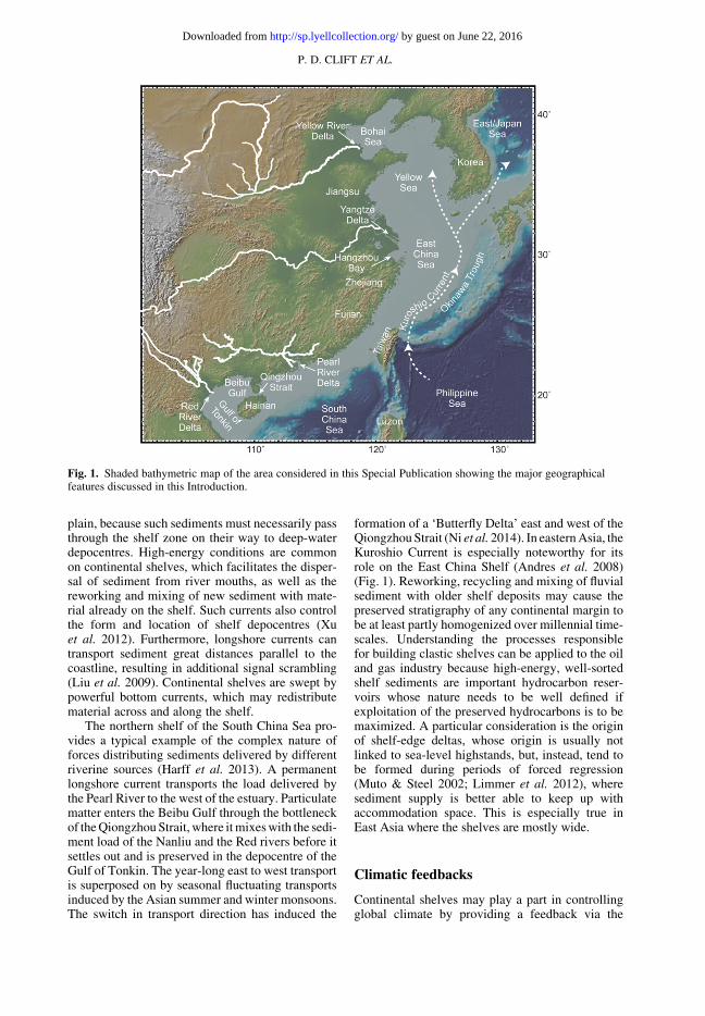
The northern shelf of the South China Sea pro-vides a typical example of the complex nature offorces distributing sediments delivered by differentriverine sources (Harff et al. 2013). A permanentlongshore current transports the load delivered bythe Pearl River to the west of the estuary. Particulatematter enters the Beibu Gulf through the bottleneckof the Qiongzhou Strait, where it mixes with the sedi-ment load of the Nanliu and the Red rivers before itsettles out and is preserved in the depocentre of theGulf of Tonkin. The year-long east to west transportis superposed on by seasonal fluctuating transportsinduced by the Asian summer and winter monsoons.The switch in transport direction has induced the
formation of a ‘Butterfly Delta’ east and west of theQiongzhou Strait (Ni et al. 2014). In eastern Asia, theKuroshio Current is especially noteworthy for itsrole on the East China Shelf (Andres et al. 2008)(Fig. 1). Reworking, recycling and mixing of fluvialsediment with older shelf deposits may cause thepreserved stratigraphy of any continental margin tobe at least partly homogenized over millennial time-scales. Understanding the processes responsiblefor building clastic shelves can be applied to the oiland gas industry because high-energy, well-sortedshelf sediments are important hydrocarbon reser-voirs whose nature needs to be well defined ifexploitation of the preserved hydrocarbons is to bemaximized. A particular consideration is the originof shelf-edge deltas, whose origin is usually notlinked to sea-level highstands, but, instead, tend tobe formed during periods of forced regression(Muto & Steel 2002; Limmer et al. 2012), wheresediment supply is better able to keep up withaccommodation space. This is especially true inEast Asia where the shelves are mostly wide.
Climatic feedbacks
Continental shelves may play a part in controllingglobal climate by providing a feedback via the
Fig. 1. Shaded bathymetric map of the area considered in this Special Publication showing the major geographicalfeatures discussed in this Introduction.
P. D. CLIFT ET AL.
by guest on June 22, 2016http://sp.lyellcollection.org/Downloaded from

processes of chemical weathering. When sea levelfalls as glaciers expand, wide areas of sediment areexposed and potentially made available for chemi-cal weathering by direct interaction with the atmo-sphere, as well as via groundwater flow under theexposed shelf. Although work in high latitudessuggests no net change in weathering flux becauseof the reduced rates of weathering (Foster & Vance2006), it is unclear whether the low latitude shelvesof East Asia operate in a similar fashion. This isbecause of their great expanse compared to mostAtlantic Ocean examples and because the tempera-ture variations during glacial times at low latitudesmay not be as great at high latitudes (deMenocalet al. 2000; Lea et al. 2003), so that the reductionsin chemical weathering rates are not so great.
Eustacy and stratigraphy
The wide continental shelves of East Asia are alsoideal natural laboratories for the study of how sea-level rises have influenced shelf stratigraphy. Tradi-tional sequence stratigraphy is based on data derivedfrom basins and continental margins surroundingthe North Atlantic and Gulf of Mexico (Vail et al.1977), but it is open to question as to whethersuch models are generally applicable. Deltas feed-ing the wide shelves around East Asia have fargreater volumes of accommodation to fill beforethey would be able to regain a connection withtheir deep-water depositional systems followinga transgressive period (Liu et al. 2004). This con-sideration must be balanced by the accelerated
Fig. 2. Schematic block model showing the different processes that can affect fluvial sediment on its way fromsource to sink in East Asia. Modified from Fagel et al. (1994).
INTRODUCTION
by guest on June 22, 2016http://sp.lyellcollection.org/Downloaded from

sediment delivery during highstands that typifiesthose drainages fed by regions influenced by anintensified summer monsoon. The summer monsoontends to intensify as the global climate warms andsea levels rise because this is primarily controlledby solar insolation (Clemens et al. 2010).
This collection has been brought together tohighlight recent developments in our understandingof how fluvial sediment has been delivered to themarginal seas of eastern Asia and to show whatthese deposits can tell us about the various proces-ses mentioned above. The collection represents thefinal product of a special session on this topicconvened at the 2012 International Geological Con-gress (IGC) in Brisbane, Australia, and an interna-tional follow-up workshop held at Sun Yat-SenUniversity, Guangzhou, China, in 2013.
Provenance
Provenance reconstructions are a major driver in thestudy of East Asian shelf sediments. This problem isnow addressed by integration of geochemical andmineral proxies, and by thermochronological meth-ods, especially the increasing popular U–Pb datingof detrital zircons. Clift (2015) reviewed the generalapplication of such methods to the tracing of sedi-ments in the South China Sea where materialmay be delivered from a series of diverse tectonicblocks. This study highlights the issue that anthro-pogenic disruption of the landscape since the estab-lishment of agriculture means that modern rivercompositions may make poor fingerprints for trac-ing the effects of a given river in the geologicalpast because sediment tends to be more altered inthe modern day compared to the recent past. Thepopular provenance-related Nd and Sr isotope sys-tems work best at identifying sediment flux fromyounger volcanic islands, especially Luzon, but areproblematic when attempting to separate the fluxfrom other continental blocks around the basin.Instead, differential exhumation rates, traced bylow-temperature thermochronometers, in differentpossible source terrains proved more effective asdiscriminants. Apatite fission track, in particular,was highlighted as being more effective than eitherU–Pb zircon or Ar/Ar muscovite dating.
Shao et al. (2015) applied some of these prove-nance methods when they analysed sedimentaryrocks from Pearl River Mouth Basin, offshore south-ern China, as well as from various parts of the PearlRiver Basin. This study considered the bulk sedi-ment geochemistry, and also looked at the heavymineral suites in both the depocentres and sourcerivers. They were able to show that the Pearl RiverBasin can be divided into three regions – east, cen-tral and west – and that each region generated
sediment with a distinctive fingerprint. Comparisonwith offshore deposits indicates that in the EarlyOligocene sediment sources were close to, orwithin, the basin, but had expanded to the coastalgranites of southern China by the end of the Oligo-cene. After the regional 23 Ma unconformity, theriver appears to have widened through time.Although the palaeo-Pearl River continued to sup-ply sediments to most parts of the northern SouthChina Sea during the Early Miocene, the southernpart of the Baiyun Sag, a particularly deep continen-tal margin sub-basin, was affected by basic volcanicsources close to this depression.
Chemical weathering
Geochemical proxies are also used to reconstruct theintensity of chemical weathering, but it is not alwaysclear which proxies are the most effective andwhether any of these have universal applicability.This issue was addressed by Hu et al. (2015), whocompared bulk sediment geochemical ratios andclay mineral proxies from the Pearl River delta, aswell as from Ocean Drilling Program sites 1144and 1146 (Fig. 1). Comparison with speleothemrainfall records since the Younger Dryas (c. 12 ka)indicates that K/Al tracks variations in precipitationmost closely and out-performs the widely usedChemical Index of Alteration (CIA). Correlationof K/Al and kaolinite/illite indicates that this clayratio is also an effective proxy of weathering inten-sity across all sites and timescales. In contrast, whilekaolinite/smectite, and smectite/(illite + chlorite),are also indicative of weathering intensity, theyshow more scatter between sites that may be linkedto provenance effects.
Geochemical proxies were also applied byCui et al. (2015) to investigate Holocene envi-ronmental conditions in the Tonkin Gulf, in theNW South China Sea. Changing values of Al/Ti,K/Al and Mg/Al were used to reconstruct the inten-sity of chemical weathering in the source regions.Zr/Ti and SiO2/Al2O3 are believed to reflect thesand content of the sediment, and thus, potentially,record the history of current velocity. La/Co andLa/Sc values coupled with rare earth element char-acteristics were used to argue that Hainan Islandwas the main source of the sediment to the basinduring the Holocene. Based on these results, theauthors divided the Holocene into four phases of cli-matic development. At 10.1–6.5 ka, sea level roseas the climate warmed. From 6.5 to 4.3 ka, the dep-ositional environment was stable, but the local cli-mate became colder and drier. From 4.3 to 3.5 ka,the currents changed following the opening of theQiongzhou Strait between Hainan and the LeizhouPeninsula, thus also affecting sediment provenance.
P. D. CLIFT ET AL.
by guest on June 22, 2016http://sp.lyellcollection.org/Downloaded from
Since 3.5 ka, the depositional environment appearsto have been relatively stable.
Sea-level rise and sediment storage
Closer to the Qiongzhou Strait, Ni et al. (2016) forthe first time report on a shelf mud accumula-tion within the Beibu Gulf known as the SouthernBeibu Gulf Mud Depocentre (SBGMD). Identifica-tion was based on high-resolution sub-bottomprofiles. The SBGMD lies in water depths of 50–80 m, and covers an area of more than 11 000 km2.The SBGMD is imaged as a homogenous seismicunit surrounded by an erosive area of gullies andsand/mud waves. The SBGMD unconformablyoverlies a parallel-bedded seismic unit. Lithologicaland geochemical analysis of a core within the highsedimentation rate area of the SBGMD shows thatbefore 17.0 ka this area was exposed and had a ter-restrial, fluvial environment. From 17.0 to 11.6 kaBP, conditions appear to have been brackish andlacustrine. Subsequently (11.6–8.4 ka), the area ex-perienced marine transgression, followed by contin-uous shallow-marine conditions to the present day.
Further to the south, Chen et al. (2015) investi-gated the relationship between sea-level changesduring the Last Glacial Cycle and stratigraphicsequences offshore western Hainan using a combi-nation of coring and high-resolution seismic reflec-tion data. An age model was developed from AMS14C, optically stimulated luminescence (OSL) andd18O dates, spanning 110 ka in a 88.3 m-long core.Correlation with a sediment core in the adjacentbasin allows identification of Marine Isotope Stages(MIS) 1–5e. They identify unconformities that sep-arate seven sea-level cycles preserved within thestudy area, and which correlate with regional andglobal sea-level change models. Seismic imagingindicates a primary control by sea-level change onthe shelf stratigraphy, modified by sediment fluxand tectonic uplift. High sediment discharge, aswell as tectonically driven uplift of Hainan, mayhave resulted in the development of prograding low-stand delta wedges on the shelf margin that tookplace during MIS 5–2.
Recent sediments on the northern margin of theSouth China Sea were considered by Zong et al.(2015). This review paper identified two marinesuccessions offshore of the Song Hong (Red) River,Han River and Pearl River deltas. These two aredated as younger than the Last Glacial Maximum(c. 20 ka) and spanning the period 120–126 ka.The authors proposed that all these marine basinsare bounded by active faults and because the oldermarine succession is recorded at a minimum of215 m below present sea level, this requires activetectonic subsidence to account for the marine
conditions after accounting for the difference in sealevel at 120–126 ka and the present day. Zong et al.(2015) linked these vertical motions to the long-termthermal subsidence of the northern South ChinaSea continental shelf, but noted that active faultinghas enhanced local subsidence, resulting in marineinundation during interglacial high sea levels.
The fate of late Quaternary sediment delivered bythe Yangtze to the East China Sea was considered byYang et al. (2015). Most Yangtze sediment has beenpreserved on the outer shelf and in the OkinawaTrough during the last glacial maximum, which isnot surprising given the lowstand of sea level. Duringthe deglacial marine transgression, the gently dip-ping shelf was rapidly inundated and strong tides pre-vented fine-grained sedimentation on the open shelf,resulting in the development of a unique tidal sand-ridge system. As sea level stabilized close to themodern level, most Yangtze sediment accumulatedin its estuary where it then built a large delta, withonly a fraction reaching the inner shelf and coastalembayments. Source to sink transport of sediment inthe East China Sea is heavily controlled by sea level,although monsoon-modulated sediment flux andbottom-current activity also plays a role in control-ling the fate of Yangtze sediment reaching the ocean.
Sediment transport
Sediment dispersal in the Yangtze offshore regionswas investigated by Wu et al. (2015), who focusedon the large-scale mud belt on the inner shelfdeveloped south of the river mouth. The processesresponsible for sediment transport in this area wereinvestigated by field observations during the 2013monsoon season, with special attention paid to shelfcirculation currents and their interaction with theYangtze river outflow, as well as small- and meso-scale processes, including bottom boundary-layerflows, stratification, mixing and upwelling. Therole of river-borne sediment-gravity and contourcurrents were also considered. Turbidity maximawithin the estuary trap sediment suspensions nearthe seafloor and move these downslope to formsediment-gravity currents that are strengthened bytidal currents. In contrast, the buoyant coastal cur-rent is not a controlling factor in the formation ofthe mud belt. Long-distance dispersal of materialto the mud belt is made possible by near-bed sedi-ment transport along the shelf, together with a poten-tially significant contour-parallel sediment channel.
Anthropogenic impacts
The more recent and future evolution of the PearlRiver delta were considered by Jia et al. (2016).
INTRODUCTION
by guest on June 22, 2016http://sp.lyellcollection.org/Downloaded from

These workers compared two marine geophysicalsurveys from 2003 to 2012 across LingdingyangBay, the estuary in front of the Pearl River deltafront. Within this area, they mapped three shoalsand two channels that appear to be heavily impactedby anthropogenic activities. In the four river mouthsthat empty into Lingdingyang Bay, the sedimentdispersal is controlled by tides, discharge strengthand the presence of islands. The surveys showthat, in the recent past, these outlets have becomenarrower, so that the water area of the bay is dimin-ishing. Sediment flux into the bay is reducing andbecoming finer grained because shoals and islandsare blocking marine currents, so that sediments areeasier to deposit as the energy in the water reduces.At the same time, water exchange between the innerbay and the open South China Sea is decreasingbecause of unrestricted anthropogenic activities.Without better management the bay will eventuallysediment up and infill, resulting in potential hazardsin the form of flooding and tides.
Further north, the Yellow River currently has thehighest sediment load of any single river on Earth.The offshore growth of the Yellow Delta was con-strained by Wang et al. (2015), who used coreswithin the Diaokou lobe of the Yellow Delta todate the construction of this feature. This lobe wasespecially active during the period 1964–76, afterthe river changed its course to the present location.This study used grain-size data, magnetic propertydata and AMS 14C dating of cores across the Diao-kou lobe to define the Holocene stratigraphy. Theyidentified a clear upwards succession from shallow-marine, to river and lake, to salt-marsh and, finally,to delta facies. This area started to receive deltaicdeposits in 1855, and has experienced prodelta,delta-front and delta-plain environments. Duringthe formation of the Diaokou lobe sediment trans-port was first by dispersed-flow deposition, thenby single-channel deposition, followed by diversiondeposition, and then culminated in abandonmentand erosion.
Environmental impacts
Monsoon conditions since 290 ka were recon-structed by Zhou et al. (2015) using a benthic fora-miniferal record from the northern continentalslope of the South China Sea. Changes in oxygena-tion and types of organic matter reflect the palaeo-productivity linked to monsoon variability. Fourassemblages, characterizing different palaeoenvir-onmental changes, were recognized. These showthat interglacial periods MIS 7, MIS 5 and MIS 3were associated with well-oxygenated bottom-waterenvironments linked to a weak East Asian WinterMonsoon (EAWM). Foraminifera that depend on
seasonal supplies of more altered organic matterare mainly found in interglacial periods (MIS 5,MIS 3 and MIS 1), suggesting highly seasonal palae-oproductivity associated with the intensification ofthe EAWM. Times of increased river run-off andincreased primary productivity correlate with anenhanced EAWM, and have lead to severe bottom-water oxygen depletion. In contrast, during MIS 4,MIS 5, MIS 7 and MIS 8, there is evidence of anenhanced EAWM with low seasonality of palaeo-productivity. Changes in bottom-water environ-ments of the northern South China Sea since290 ka are proposed to have been driven by the fluc-tuating palaeoproductivity linked to the variabilityof the EAWM.
Palaeo-environmental reconstructions can alsobe achieved using other types of microfossil, suchas diatoms. Zhang et al. (2015) employed Paraliasulcata for this task because it is often well pre-served in siliciclastic sediments. These workerssynthesized the distribution of P. sulcata in sedi-ment cores across the Asian marginal seas. Theyalso noted that P. sulcata is strongly variable inabundance through time over glacial cycles, withlower abundances during the last glacial maximumand higher values during deglaciation within theSouth China Sea. This diatom is very common at8–11 ka, a phenomenon linked to the opening ofthe Taiwan Strait to more flow, as well as to thegeneral coastal water circulation pattern associatedwith the deglaciation process. In contrast, P. sulcatais less abundant in the East China Sea during theHolocene, but more common during the Last Gla-cial Maximum and especially during 11–15 ka.
Gao et al. (2015) considered the wider region ofthe Bohai, Yellow and East China seas as a singlewide continental shelf environment. Holocene sedi-ment distribution, composition and deposition ratesare related to active sediment transport processesincluding tides, waves and shelf currents, as wellas sediment gravity flows. Theoretically, the sedi-ments in any one place should contain a record ofhigh temporal resolution, but each site would onlyhave limited duration. Gao et al. (2015) argue thatif these records are connected, then they may forma complete archive for environmental change stud-ies. Mid-Holocene coastal deposits on the Jiangsucoast and early–middle Holocene sequences inHangzhou Bay, as well as the Holocene mud depos-its off the Zhejiang–Fujian coasts, are of importancein process–product relationship studies. Sedi-ment may be supplied to the shelf both from seabedreworking during times of sea-level rise and fromenhanced river discharges.
This collection highlights some of the complex-ities of fluvial sediment transport on continentalshelves, demonstrating what can and cannot bededuced from such deposits in the geological record.
P. D. CLIFT ET AL.
by guest on June 22, 2016http://sp.lyellcollection.org/Downloaded from

The scale of sediment flux in East Asia, reflectingthe size of the rivers and the intensity of the summermonsoon, makes this region an ideal place to workon sediment transport issues. While these studieshave advanced the science by a significant degree,they also show how much we still have to learnand so provide a stimulus for further studies.
References
Andres, M., Wimbush, M. et al. 2008. Observations ofKuroshio flow variations in the East China Sea. Jour-nal of Geophysical Research, 113, C05013, http://doi.org/10.1029/2007JC004200
Brookfield, M.E. 1998. The evolution of the great riversystems of southern Asia during the CenozoicIndia-Asia collision; rivers draining southwards. Geo-morphology, 22, 285–312.
Castelltort, S. & Van Den Driessche, J. 2003. Howplausible are high-frequency sediment supply-drivencycles in the stratigraphic record? Sedimentary Geol-ogy, 157, 3–13.
Chen, H., Harff, J. et al. 2015. Last Glacial Cycle andseismic stratigraphic sequences offshore western Hai-nan Island, NW South China Sea. In: Clift, P.D.,Harff, J., Wu, J. & Qui, Y. (eds) River-DominatedShelf Sediments of East Asian Seas. Geological Soci-ety, London, Special Publications, 429. First publishedonline December 1, 2015, updated January 28 and May26, 2016, http://doi.org/10.1144/SP429.9
Clark, M.K., Schoenbohm, L.M. et al. 2004. Surfaceuplift, tectonics, and erosion of eastern Tibet fromlarge-scale drainage patterns. Tectonics, 23, TC1006,http://doi.org/10.1029/2002TC001402
Clemens, S.C., Prell, W.L. & Sun, Y. 2010. Orbital-scale timing and mechanisms driving Late PleistoceneIndo-Asian summer monsoons: reinterpreting cavespeleothem ∂18O. Paleoceanography, 25, PA4207,http://doi.org/10.1029/2010PA001926
Clift, P.D. 2015. Assessing effective provenance meth-ods for fluvial sediment in the South China Sea. In:Clift, P.D., Harff, J., Wu, J. & Qui, Y. (eds) River-Dominated Shelf Sediments of East Asian Seas. Geo-logical Society, London, Special Publications, 429.First published online September 3, 2015, updatedMay 26, 2016, http://doi.org/10.1144/SP429.3
Clift, P.D., Giosan, L. et al. 2008. Holocene erosion ofthe Lesser Himalaya triggered by intensified summermonsoon. Geology, 36, 79–82, http://doi.org/10.1130/G24315A.1
Cui, Z., Hou, Y., Xia, Z., Liang, K., Xue, Q. & Zhang,L. 2015. Geochemical characteristics and palaeoenvir-onmental reconstruction of the sediments from theGulf of Tonkin, South China Sea. In: Clift, P.D.,Harff, J., Wu, J. & Qui, Y. (eds) River-DominatedShelf Sediments of East Asian Seas. Geological Soci-ety, London, Special Publications, 429. First publishedonline December 9, 2015, updated March 3 and May26, 2016, http://doi.org/10.1144/SP429.12
deMenocal, P., Ortiz, J., Guilderson, T. & Sarn-
thein, M. 2000. Coherent high- and low-latitude cli-mate variability during the Holocene Warm Period.
Science, 288, 2198–2202, http://doi.org/10.1126/science.288.5474.2198
Fagel, N., Debrabant, P. & Andre, L. 1994. Clay sup-plies in the Central Indian Basin since the Late Mio-cene: climatic or tectonic control? Marine Geology,122, 151–172, http://doi.org/10.1016/0025-3227(94)90209-7
Foster, G. & Vance, D. 2006. Negligible glacial–interglacial variation in continental chemical weather-ing rates. Nature, 444, 918–921, http://doi.org/10.1038/nature05365
Gao, S., Wang, D. et al. 2015. Holocene sedimentarysystems on a broad continental shelf with abundantriver input: process–product relationships. In: Clift,P.D., Harff, J., Wu, J. & Qui, Y. (eds) River-Dominated Shelf Sediments of East Asian Seas. Geo-logical Society, London, Special Publications, 429.First published online September 7, 2015, updatedMay 26, 2016, http://doi.org/10.1144/SP429.4
Goodbred, S.L. & Kuehl, S.A. 2000. Enormous Ganges–Brahmaputra sediment discharge during strengthenedearly Holocene monsoon. Geology, 28, 1083–1086.
Gugliotta, M., Kurcinka, C.E., Dalrymple, R.W.,Flint, S.S. & Hodgson, D.M. 2016. Decoupling sea-sonal fluctuations in fluvial discharge from the tidalsignature in ancient deltaic deposits: an examplefrom the Neuquen Basin, Argentina. Journal of theGeological Society, London, 173, 94–107, http://doi.org/10.1144/jgs2015-030
Harff, J., Leipe, T., Waniek, J. & Zhou, D. (eds). 2013.Depositional Environments and Multiple ForcingFactors at the South China Sea’s Northern Shelf. Jour-nal of Coastal Research, Special Issue, 66, 1–90.
Hoitink, A.J.F. & Jay, D.A. 2016. Tidal river dynamics:implications for deltas. Reviews of Geophysics, 54,240–272, http://doi.org/10.1002/2015RG000507
Hu, D., Clift, P.D. et al. 2013. Holocene evolution inweathering and erosion patterns in the Pearl Riverdelta. Geochemistry, Geophysics, Geosystems, 14,2349–2368, http://doi.org/10.1002/ggge.20166
Hu, D., Clift, P.D., Wan, S., Boning, P., Hannigan, R.,Hillier, S. & Blusztajn, J. 2015. Testing chemicalweathering proxies in Miocene–Recent fluvial-derivedsediments in the South China Sea. In: Clift, P.D.,Harff, J., Wu, J. & Qui, Y. (eds) River-DominatedShelf Sediments of East Asian Seas. Geological Soci-ety, London, Special Publications, 429. First publishedonline December 11, 2015, updated May 26, 2016,http://doi.org/10.1144/SP429.5
Jerolmack, D.J. & Paola, C. 2010. Shredding of envi-ronmental signals by sediment transport. Geophysi-cal Research Letters, 37, L19401, http://doi.org/10.1029/2010GL044638
Jia, P., Xia, Z., Yin, Y. & Xue, Q. 2016. LingdingyangBay, Pearl River Estuary (China): geomorphologicalevolution and hydrodynamics. In: Clift, P.D.,Harff, J., Wu, J. & Qui, Y. (eds) River-DominatedShelf Sediments of the East Asian Seas. GeologicalSociety, London, Special Publications, 429. First pub-lished online May 31, 2016, http://doi.org/10.1144/SP429.14
Lea, D.W., Pak, D.K., Peterson, L.C. & Hughen, K.A.2003. Synchroneity of Tropical and High-LatitudeAtlantic Temperatures over the Last Glacial
INTRODUCTION
by guest on June 22, 2016http://sp.lyellcollection.org/Downloaded from

Termination. Science, 301, 1361–1364, http://doi.org/10.1126/science.1088470
Limmer, D.R., Henstock, T.J., Giosan, L., Ponton, C.,Tabrez, A.R., Macdonald, D.I.M. & Clift, P.D.2012. Impacts of sediment supply and local tectonicson clinoform distribution: the seismic stratigraphy ofthe mid Pleistocene-Holocene Indus Shelf. MarineGeophysical Research, 33, 251–267, http://doi.org/10.1007/s11001-012-9160-6
Liu, J.P., Milliman, J.D., Gao, S. & Cheng, P. 2004.Holocene development of the Yellow River’s subaqu-eous delta, North Yellow Sea. Marine Geology, 209,45–67.
Liu, J.P., Xue, Z., Ross, K., Wang, H.J., Yang, Z.S., Li,A.C. & Gao, S. 2009. Fate of sediments delivered tothe sea by Asian large rivers: long-distance transportand formation of remote alongshore clinothems. TheSedimentary Record, 7, 4–9.
Muto, T. & Steel, R.J. 2002. In defense of shelf-edgedelta development during falling and lowstand of rela-tive sea level. Journal of Geology, 110, 421–436,http://doi.org/10.1086/340631
Ni, Y., Endler, R. et al. 2014. The ‘butterfly delta’system of Qiongzhou Strait: morphology, seismicstratigraphy and sedimentation. Marine Geology,355, 361–368.
Ni, Y., Harff, J., Xia, Z., Waniek, J.J., Endler, M. &Schulz-Bull, D.E. 2016. Post-glacial mud depo-centre in the southern Beibu Gulf: acoustic featuresand sedimentary environment evolution. In: Clift,P.D., Harff, J., Wu, J. & Qui, Y. (eds) River-Dominated Shelf Sediments of East Asian Seas. Geo-logical Society, London, Special Publications, 429.First published online March 14, 2016, updated May26, 2016, http://doi.org/10.1144/SP429.13
Shao, L., Qiao, P., Zhao, M., Li, Q., Wu, M., Pang, X. &Zhang, H. 2015. Depositional characteristics of thenorthern South China Sea in response to the evolutionof the Pearl River. In: Clift, P.D., Harff, J., Wu, J. &Qui, Y. (eds) River-Dominated Shelf Sediments of EastAsian Seas. Geological Society, London, SpecialPublications, 429. First published online November12, 2015, updated May 26, 2016, http://doi.org/10.1144/SP429.2
Vail, P.R., Mitchum, R.M. et al. 1977. Seismic stratig-raphy and global changes of sea-level. In: Payton,C.E. (ed.) Seismic Stratigraphy – Applications toHydrocarbon Exploration. American Association ofPetroleum Geologists, Memoirs, 26, 49–212.
Wang, Y., Liu, X., Li, G. & Zhang, W. 2015. Strati-graphic variations in the Diaokou lobe area of the Yel-low River delta, China: implications for anevolutionary model of a delta lobe. In: Clift, P.D.,
Harff, J., Wu, J. & Qui, Y. (eds) River-DominatedShelf Sediments of East Asian Seas. Geological Soci-ety, London, Special Publications, 429. First publishedonline October 2, 2015, updated May 26, 2016, http://doi.org/10.1144/SP429.8
Wu, J., Ren, J., Liu, H., Qiu, C., Cui, Y. & Zhang, Q. 2015.Trapping and escaping processes of Yangtze River-derived sediments to the East China Sea. In: Clift,P.D., Harff, J., Wu, J. & Qui, Y. (eds) River-Dominated Shelf Sediments of East Asian Seas. Geolog-ical Society, London, 429. First published onlineAugust 27, 2015, updated May 26, 2016, http://doi.org/10.1144/SP429.7
Xu, K.H., Li, A.C. et al. 2012. Provenance, structure, andformation of the mud wedge along inner continentalshelf of the East China Sea: a synthesis of the Yangtzedispersal system. Marine Geology, 291–294, 176–191,http://doi.org/10.1016/j.margeo.2011.06.003
Yang, S., Bi, L., Li, C., Wang, Z. & Dou, Y. 2015. Majorsinks of the Changjiang (Yangtze River)-derived sedi-ments in the East China Sea during the late Quaternary.In: Clift, P.D., Harff, J., Wu, J. & Qui, Y. (eds)River-Dominated Shelf Sediments of East Asian Seas.Geological Society, London, Special Publications,429. First published online October 2, 2015, updatedMay 26, 2016, http://doi.org/10.1144/SP429.6
Zhang, J., Tomczak, M., Li, C., Witkowski, A., Qiu, Y.,Chen, H. & Gao, H. 2015. Significance of the Paraliasulcata fossil record in palaeoenvironmental recon-structions of the SE Asia marginal seas over the LastGlacial Cycle. In: Clift, P.D., Harff, J., Wu, J. &Qui, Y. (eds) River-Dominated Shelf Sediments ofEast Asian Seas. Geological Society, London, 429.First published online December 9, 2015, updatedMay 26, 2016, http://doi.org/10.1144/SP429.11
Zhou, Y., Chen, F., Wu, C., Yu, S. & Zhuang, C. 2015.Palaeoproductivity linked to monsoon variability inthe northern slope of the South China Sea from thelast 290 kyr: evidence of benthic foraminifera fromCore SH7B. In: Clift, P.D., Harff, J., Wu, J. &Qui, Y. (eds) River-Dominated Shelf Sediments ofEast Asian Seas. Geological Society, London, SpecialPublications, 429. First published online November 6,2015, updated May 26, 2016, http://doi.org/10.1144/SP429.10
Zong, Y., Huang, G., Li, X.Y. & Sun, Y.Y. 2015. LateQuaternary tectonics, sea-level change and lithostratig-raphy along the northern coast of the South China Sea.In: Clift, P.D., Harff, J., Wu, J. & Qui, Y. (eds)River-Dominated Shelf Sediments of East Asian Seas.Geological Society, London, Special Publications,429. First published online September 3, 2015, updatedMay 26, 2016, http://doi.org/10.1144/SP429.1
P. D. CLIFT ET AL.
by guest on June 22, 2016http://sp.lyellcollection.org/Downloaded from