
Introduction to ILWIS
22
ISL 2004 International Institute for Geo-Information Science and Earth Observation (ITC) Introduction Introduction to ILWIS to ILWIS Source: Cees van Westen Associated Institute of the
-
Upload
duongtuyen -
Category
Documents
-
view
282 -
download
8
Transcript of Introduction to ILWIS

ISL 2004
International Institute for Geo-Information Science and Earth Observation (ITC)
Introduction Introduction to ILWISto ILWIS
Source:Cees van Westen
Associated Institute of the

ISL 2004
International Institute for Geo-Information Science and Earth Observation (ITC)
What is ILWIS?What is ILWIS?• PC-based GIS & Remote
Sensing package
• Developed by ITC
• A complete package:• image processing
• spatial analysis
• digital mapping
• Easy to learn and use:• full on-line help
• extensive tutorials for direct use in courses
• 25 case studies of various disciplines

ISL 2004
International Institute for Geo-Information Science and Earth Observation (ITC)
Key features (1)Key features (1)• Integrated raster and vector
design
• Import and export of widely-used data formats
• On-screen and tablet digitizing
• Comprehensive set of image processing tools
• Orthophoto, image georeferencing, transformation and mosaicking

ISL 2004
International Institute for Geo-Information Science and Earth Observation (ITC)
Key features (2) Key features (2) • Advanced modeling and
spatial analysis
• 3D visualization with interactive editing for optimal view finding
• Rich projection and coordinate system library
• Geo-statistical analyses, with krigingand co-kriging for improved interpolation

ISL 2004
International Institute for Geo-Information Science and Earth Observation (ITC)
Unique concepts (1)Unique concepts (1)• Object oriented
approach• data objects: raster or
vector maps and tables• service objects:
coordinate systems, georeference, representation, domain
– objects may be shared: all maps of the same area use the same coordinate system
ISL 2004
International Institute for Geo-Information Science and Earth Observation (ITC)
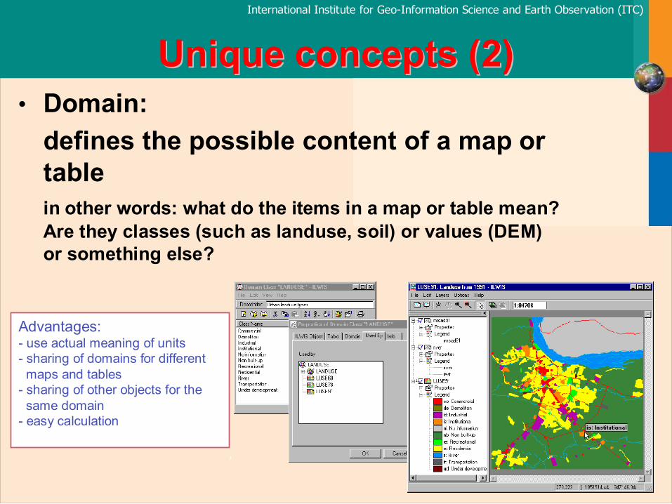
Unique concepts (2)Unique concepts (2)• Domain:
defines the possible content of a map or tablein other words: what do the items in a map or table mean? Are they classes (such as landuse, soil) or values (DEM) or something else?
Advantages:- use actual meaning of units- sharing of domains for different
maps and tables- sharing of other objects for the
same domain- easy calculation

ISL 2004
International Institute for Geo-Information Science and Earth Observation (ITC)
Unique concepts (3)Unique concepts (3)• Dependency link is stored:
the link between data objects, derived from other data objectsmaps and table which are original are called source objects, those that are made from them are called dependent objects
Advantages:- easy update- easy change of calculation
formulas- minimum use of disk-space- data retrieval without actual
calculation

ISL 2004
International Institute for Geo-Information Science and Earth Observation (ITC)
ILWIS Beginner’s Guide Introducing the basic concepts, essential ILWIS techniques and the main ILWIS- operations.
ILWIS Reference Guide Detailed description of the functionality of ILWIS including its window types, objects, operations.
ILWIS User’s Guide Training the skills you need in ILWIS, including explanations and procedures for first time users in addition to topics for advanced users.
ILWIS Applications Guide Advanced procedures to work with ILWIS, providing case studies for various research disciplines
Teaching GuidesTeaching Guides

ISL 2004
International Institute for Geo-Information Science and Earth Observation (ITC)
Change directory
Command lineChange drive
Menu bar
Catalog
Title bar
Button bar
Operation list
Scroll bars
Status line
ILWIS Main WindowILWIS Main Window
ISL 2004
International Institute for Geo-Information Science and Earth Observation (ITC)
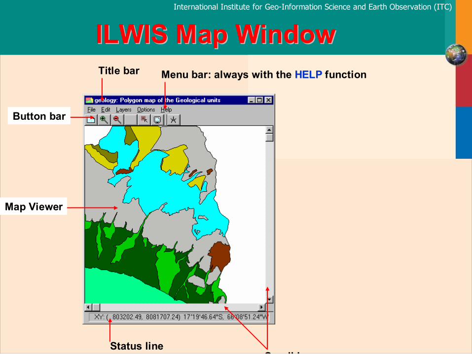
Title bar Menu bar: always with the HELPHELP function
Button bar
Map Viewer
Status lineS ll b
ILWIS Map WindowILWIS Map Window

ISL 2004
International Institute for Geo-Information Science and Earth Observation (ITC)
Command line
Record view buttons
Status line
Scroll bars
Data viewer
Title bar
Menu barChange column properties buttons
Table WindowTable Window

ISL 2004
International Institute for Geo-Information Science and Earth Observation (ITC)
Pixel Information WindowPixel Information Window

ISL 2004
International Institute for Geo-Information Science and Earth Observation (ITC)
Raster maps
Polygon maps
Segment maps
Point maps
Map list
Tables
Data objects:
Service objects:
Domain
Representation
Georeference
Coordinate System
Map views
Histogram
Sample sets
2-dimensional tables
Matrices
Filters
Functions
Scripts
Special objects:
ILWIS objects
ISL 2004
International Institute for Geo-Information Science and Earth Observation (ITC)
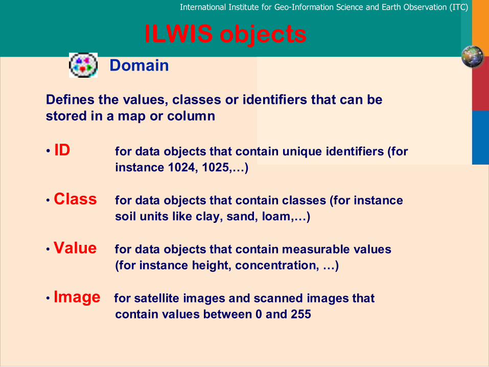
Domain
Defines the values, classes or identifiers that can be stored in a map or column
• ID for data objects that contain unique identifiers (for instance 1024, 1025,…)
• Class for data objects that contain classes (for instance soil units like clay, sand, loam,…)
• Value for data objects that contain measurable values (for instance height, concentration, …)
• Image for satellite images and scanned images that contain values between 0 and 255
ILWIS objects

ISL 2004
International Institute for Geo-Information Science and Earth Observation (ITC)
Coordinatesystem
Point map
Segment map
Polygon map
Attribute table
Class domain Representation
Class Maps
Coordinatesystem
Point map
Segment map
Polygon map
Attribute table
Identifier domain ID Maps
Coordinatesystem
Point map
Segment map
Polygon mapValue domain Representation Gradual or Value
Value Maps

ISL 2004
International Institute for Geo-Information Science and Earth Observation (ITC)
Coordinatesystem
Raster map
Attribute table
Class domain Representation
Class Maps
Coordinatesystem
Raster map
Attribute table
Identifier domain
ID MapsGeoreference
Georeference
Coordinatesystem
Raster map Value domain Representation Gradual or Value
Value Maps
Georeference

ISL 2004
International Institute for Geo-Information Science and Earth Observation (ITC)
Point map
Segment map
Polygon map
Raster map
Spatial data
Attribute table
domain
Class
Identifier
+Column1 Column2 Column3
Attribute data
Class domain ID domain Value domain
Class repr. Class repr. Value repr.

ISL 2004
International Institute for Geo-Information Science and Earth Observation (ITC)
Domain: Landuse
Input map: Landuse
Rocks=iff(landuse="bare rocks", landuse, "?")
Ouput map: Rocks
Ouput map: Lands
Bare rocks
Pasture
Lake
Domain: lands
Ouput map: Pastarea
Domain: bit
Pastarea = landuse = "pasture"
Water
LandLand
water
Pasture
Lake
Lands=iff((landuse="pasture")or(landuse="bare rocks"),"land","water")
Bare rocks
0
1
1 0
0
0
000
0 0
0 0 0
000
0 0
0 00
11
1
1 1 1
1 1
11
1 1 1
1
Bare rocks ?? ?
?????
?
? ?
?
???? ? ???
??? ?
?
Map Calculation

ISL 2004
International Institute for Geo-Information Science and Earth Observation (ITC)
Cityblocks Landuse
001 Institutional 002 Commercial 003 Commercial 004 Residential 005 Residential 006 Residential 007 Industrial 008 Residential 009 Industrial 010 Industrial 011 Residential 012 Industrial 013 Residential 014 Residential 015 Residential
Map: City blocks
Attribute map: Land Use
Attribute table: City blocks
Reclassifying a mapwith attribute data

ISL 2004
International Institute for Geo-Information Science and Earth Observation (ITC)
MapC = MapA +10
MapA
MapC1 = MapA + MapB
MapB
MapC2 = ((MapA - MapB)/(MapA + MapB))*100
MapC1
MapC2MapC
5 5 2
5 5 5
6
6
2 2
6 6
2
6
2
2
4 84
84
1
1
4 4
8
1 1 8
1 8 8
15 12
16
15
15 15 15
12
12
121212
16 16 16 16
9 10
7
9
9 9 9
10
10
1033
7 7 14 14 11 -60
71
11
11 11 11
-60
-60
-603333
71 71 -14 -14
Arithmetic operationsdomain value

ISL 2004
International Institute for Geo-Information Science and Earth Observation (ITC)
MapB
F
F
F F
F
F F
F F
F
F
FF
6
4
7
4 4 4 4
444
7 7 7 7
7 7 7
6 6
6 6 6 6
4
4
1
1
0
0 0 1 0
000
1 1 1 0
1 1 0
0 0
0 0 0 1
1
1
1
0
0
0 0 0 0
000
1 1 1 0
1 1 0
0 0
0 0 0 1
0
0
MapD1 = (MapA = "forest") or (MapB < 500)
MapD3 = (MapA = "forest") and not (MapB < 500)
MapD
MapD1
MapD2
MapD3
0
0
0
1 1 0 1
111
0 0 0 0
0 0 0
0 0
0 0 0 0
0
0MapD = (MapA = "forest") and (MapB < 500)
MapD2 = (MapA = "forest") xor (MapB < 500)
1
1
0
1 1 1 1
111
1 1 1 0
1 1 0
0 0
0 0 0 1
1
1
MapA
F = forest
7 = 700 m.
6 = 600 m.
4 = 400 m.
Logical operationsdomain class and value

ISL 2004
International Institute for Geo-Information Science and Earth Observation (ITC)
MapB
F
F
F F
F
F F
F F
F
F
FF
6
4
7
4 4 4 4
444
7 7 7 7
7 7 7
6 66 6 6 6
4
4MapC1 = iff ((MapA = "forest") and (MapB = 700), 1, 0)
MapC
MapC1
MapC = iff ( MapA = "forest", 1, ?)
MapA
F = forest7 = 700 m.6 = 600 m.4 = 400 m.
1
?
?
1 1 ? 1
111
1 1 1 ?
1 1 ?
? ?
? ? ? 1
?
?
0
0
0
0 0 0 0
000
1 1 1 0
1 1 0
0 0
0 0 0 0
0
0
Conditional functionsdomain class and value


