
Introduction to GIS Theory
67
Introduction to GIS Theory Research Computing Services Sept. 10, 2021 Dennis Milechin, P.E. [email protected] Please fill out tutorial evaluation: http://rcs.bu.edu/eval
Transcript of Introduction to GIS Theory

Introduction to GIS Theory
Research Computing Services
Sept. 10, 2021
Dennis Milechin, P.E.
Please fill out tutorial evaluation: http://rcs.bu.edu/eval

Introduction to GIS Theory
2
9/10/2021
Housekeeping
- This session is recorded.
- Will be published here:https://www.bu.edu/tech/support/research/training-consulting/access-training-materials/
Link to Presentation:http://rcs.bu.edu/examples/gis/tutorials/gis_theory/intro_to_gis_theory.pdf

Introduction to GIS Theory
3
9/10/2021
Outline
- What is GIS?
- Datum
- Geographic Coordinate System
- Projections
- Common Spatial Data Models
- Data Layers
- Spatial Data Storage
- Example Workflow
- Sample GIS Software

Introduction to GIS Theory
4
9/10/2021
What is GIS?- Most of us are familiar with tabular data.

Introduction to GIS Theory
5
9/10/2021
What is GIS?- Import tabular data into GIS.

Introduction to GIS Theory
6
9/10/2021
What is GIS?- Import tabular data into GIS.

Introduction to GIS Theory
7
9/10/2021
What is GIS?- Import tabular data into GIS.

Introduction to GIS Theory
8
9/10/2021
What is GIS?
- Geographic Information System
“A geographic information system (GIS) is a system designed to
capture, store, manipulate, analyze, manage, and present spatial
or geographic data”
https://en.wikipedia.org/wiki/Geographic_information_system

Introduction to GIS Theory
9
9/10/2021
What is GIS?
- Typical functions of GIS software
- Read/write spatial data
- Maintain spatial meta data
- Apply transformations for projections
- Apply symbology based on attribute table
- Allow layering of data
- Tools to query/filter data
- Spatial analysis tools
- Exporting tools for printing maps or publish web maps

Introduction to GIS Theory
10
9/10/2021
Datum
Datum
Introduction to GIS Theory
11
9/10/2021
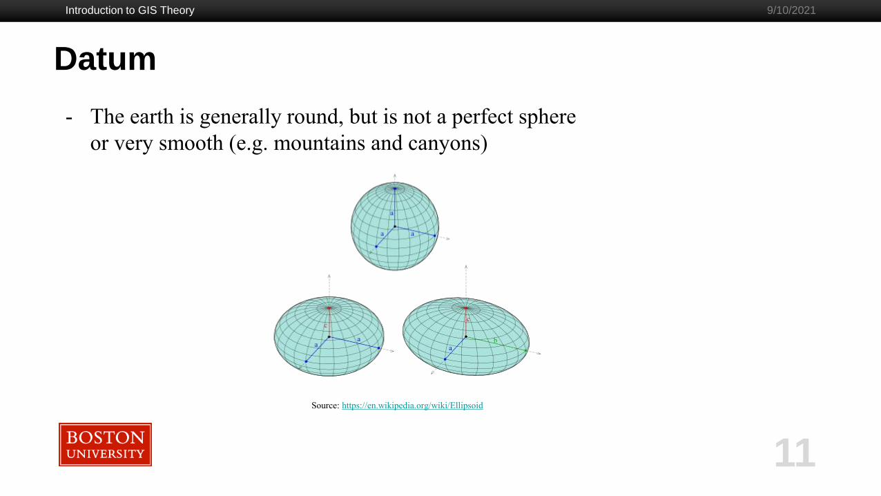
- The earth is generally round, but is not a perfect sphere
or very smooth (e.g. mountains and canyons)
Source: https://en.wikipedia.org/wiki/Ellipsoid

Introduction to GIS Theory
12
9/10/2021
Geographic Coordinate System (GCS)

Introduction to GIS Theory
13
9/10/2021
Geographic Coordinate System
- How do I tell a computer where we are located on earth?
My office
(42.350083 N, -71.104168 W)

Geographic Coordinate System
Introduction to GIS Theory
14
9/10/2021
GCS
Source: https://www.e-education.psu.edu/natureofgeoinfo/c2_p10.html
Cartesian Coordinate System
Source: http://desktop.arcgis.com/en/arcmap/10.3/guide-books/map-projections/geographic-coordinate-
system.htm
Source: http://desktop.arcgis.com/en/arcmap/10.3/guide-books/map-projections/about-geographic-coordinate-systems.htm
(50 E, 40 N)
Point (2,2)

Introduction to GIS Theory
15
9/10/2021
Units Short Hand Compass Example +/- Example
Degrees Minutes
Seconds
dddº mm′ ss.s″ 45º 36′ 23″ N, 122º46′ 18.4″ W 45º 36′ 23″ , -122º46′ 18.4″
Degrees Decimal
Minutes
dddº mm.mmm′ 45º 36.38′ N, 122º 46.31′ W 45º 36.38′ , -122º 46.31′
Decimal Degrees ddd.ddddddº 45.6064º N 122.7718º W 45.6064º, -122.7718º
Additional Reading:
http://geokov.com/education/latitude-longitude.aspx
Geographic Coordinate System
(-)
(-)
(+)
(+)

Introduction to GIS Theory
16
9/10/2021
Additional Reading:
https://en.wikipedia.org/wiki/Decimal_degrees
Geographic Coordinate System
Decimal places and accuracy of position.

Geographic Coordinate System
Introduction to GIS Theory
17
9/10/2021
- There are many GCSs.
- They are updated occasionally.
- North American Datum (NAD)
- NAD 27
- NAD 83 (with 5 updates)
- New Datum in 2022!
Source: https://en.wikipedia.org/wiki/Ellipsoid
List of GCS supported by ArcGIS:
https://desktop.arcgis.com/en/arcmap/latest/map/projections/pdf/geographic_coordinate_sy
stems.pdf

Introduction to GIS Theory
18
9/10/2021
Geographic Coordinate SystemNAD 1927 NAD 1983
Coordinates are associated with a specific GCS. Above
is an outline of Boston City Hall. The same coordinates
were used to plot the outlines in two different GCSs.

Introduction to GIS Theory
19
9/10/2021
Projections

Projections
Introduction to GIS Theory
20
9/10/2021
What is wrong with this map?
Country Area ( mi ^2)
Africa 11,730,000
Antarctica 5,405,000
Greenland 836,300
Greenland
Antarctica
Africa

Projections
Introduction to GIS Theory
21
9/10/2021
Source: https://www.youtube.com/watch?v=CPQZ7NcQ6YQ
Additional Reading:
https://laughingsquid.com/world-mercator-projection-map-country-size/

Introduction to GIS Theory
22
9/10/2021
Projections
- Allow creation of flat maps.
- At expense of distorting:
- Shape
- Area
- Direction
- Distance
- Coordinates are typically in feet, or meters, and positive values
- e.g (114564 ft, 53746 ft)
Fun Read: “America Has Two Feet. It’s About to Lose One of Them.”
https://www.nytimes.com/2020/08/18/science/foot-surveying-metrology-dennis.html

Introduction to GIS Theory
23
9/10/2021
Projections
Cylindrical
Conical
Planar
Source: https://docs.qgis.org/3.10/en/docs/gentle_gis_introduction/coordinate_reference_systems.html#id1

Introduction to GIS Theory
24
9/10/2021
Projections
Equal Area
Conformal
Equidistant
Source and Additional Reading:
http://geokov.com/education/map-projection.aspx
Tissot's Indicatrix

Introduction to GIS Theory
25
9/10/2021
ProjectionsSource and Additional Reading:
http://downloads2.esri.com/support/documentation/ao_/710Understanding_
Map_Projections.pdf
Introduction to GIS Theory
26
9/10/2021
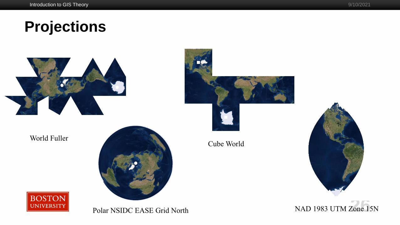
NAD 1983 UTM Zone 15N
Cube World
Polar NSIDC EASE Grid North
World Fuller
Projections

Universal Transverse Mercator (UTM)
Introduction to GIS Theory
27
9/10/2021
Projections
Source and Additional Reading:
https://www.e-education.psu.edu/natureofgeoinfo/c2_p22.html
https://gisgeography.com/utm-universal-transverse-mercator-projection/
UTM Zones for USsource: https://gisgeography.com/utm-universal-transverse-mercator-projection/
source: https://gisgeography.com/utm-universal-transverse-mercator-projection/
Source: https://www.e-education.psu.edu/natureofgeoinfo/c2_p22.html

Introduction to GIS Theory
28
9/10/2021
Projections
- What projection/GCS do I choose?
- Institutions or Organization may select a standard coordinate system.
- Choose one that minimizes distortion characteristics important for your analysis.
- When to select/change GCS or projections in GIS?
- Importing raw data into GIS
- Georeferencing images or old maps.
- Importing CSV files
- Spatial processing of two layers.
- Some GIS tools expect projected data.
Many GIS packages takes care of the math. Phew!
NAD 1927 NAD 1983

Introduction to GIS Theory
29
9/10/2021
ProjectionsTypes of Projection Definitions
- EPSG
- Well Known Text as HTML
- Human-Readable OGC WKT
- Proj (formerly proj4)
- OGC WKT
- JSON
- GML
- ESRI WKT
- .PRJ File
- USGS
- MapServer Mapfile | Python
- Mapnik XML | Python
- GeoServer
- PostGIS spatial_ref_sys INSERT
statement
- Proj4js format

Introduction to GIS Theory
30
9/10/2021
Projections
Definition Type Example
EPSG 2249
Proj4 +proj=lcc +lat_1=42.68333333333333 +lat_2=41.71666666666667 +lat_0=41
+lon_0=-71.5 +x_0=200000.0001016002 +y_0=750000 +ellps=GRS80
+datum=NAD83 +to_meter=0.3048006096012192 +no_defs
.prj PROJCS["NAD83 / Massachusetts Mainland
(ftUS)",GEOGCS["GCS_North_American_1983",DATUM["D_North_American_1983",S
PHEROID["GRS_1980",6378137,298.257222101]],PRIMEM["Greenwich",0],UNIT["De
gree",0.017453292519943295]],PROJECTION["Lambert_Conformal_Conic"],PARAME
TER["standard_parallel_1",42.68333333333333],PARAMETER["standard_parallel_2",
41.71666666666667],PARAMETER["latitude_of_origin",41],PARAMETER["central_me
ridian",-
71.5],PARAMETER["false_easting",656166.667],PARAMETER["false_northing",24606
25],UNIT["Foot_US",0.30480060960121924]]
Sample Projection Definitions for NAD83 / Massachusetts Mainland (ftUS)

Introduction to GIS Theory
31
9/10/2021
Projections
Definition Type Example
Well Known
Text (WKT)
PROJCS["NAD83 / Massachusetts Mainland (ftUS)", GEOGCS["NAD83",
DATUM["North_American_Datum_1983", SPHEROID["GRS
1980",6378137,298.257222101, AUTHORITY["EPSG","7019"]],
AUTHORITY["EPSG","6269"]], PRIMEM["Greenwich",0,
AUTHORITY["EPSG","8901"]], UNIT["degree",0.01745329251994328,
AUTHORITY["EPSG","9122"]], AUTHORITY["EPSG","4269"]], UNIT["US survey
foot",0.3048006096012192, AUTHORITY["EPSG","9003"]],
PROJECTION["Lambert_Conformal_Conic_2SP"],
PARAMETER["standard_parallel_1",42.68333333333333],
PARAMETER["standard_parallel_2",41.71666666666667],
PARAMETER["latitude_of_origin",41], PARAMETER["central_meridian",-71.5],
PARAMETER["false_easting",656166.667], PARAMETER["false_northing",2460625],
AUTHORITY["EPSG","2249"], AXIS["X",EAST], AXIS["Y",NORTH]]
Sample Projection Definitions for NAD83 / Massachusetts Mainland (ftUS)

Introduction to GIS Theory
32
9/10/2021
Projections
- http://geokov.com/education/map-projection.aspx
- https://www.axismaps.com/guide/general/map-projections/
- https://alastaira.wordpress.com/2011/01/23/the-google-maps-bing-
maps-spherical-mercator-projection/
- http://bl.ocks.org/syntagmatic/raw/ba569633d51ebec6ec6e/
Additional Reading
- https://desktop.arcgis.com/en/arcmap/latest/map/projections/pdf/project
ed_coordinate_systems.pdf
Projected Coordinate Systems supported by ArcGIS Pro
Projection Definition Lookup reference
- https://spatialreference.org/ref/epsg/

Introduction to GIS Theory
33
9/10/2021
Review
1. To plot spatial data we need Datum and Geographic Coordinate System (GCS).
2. Use GCS to assign coordinates to data.
3. To make a flat map, need to apply a projection.
Source: http://desktop.arcgis.com/en/arcmap/10.3/guide-books/map-projections/about-geographic-coordinate-systems.htm
Source: http://desktop.arcgis.com/en/arcmap/10.3/guide-books/map-projections/geographic-coordinate-system.htm
40º 00′ 00″ N, 50º 00′ 00″ E
14572818.92E, 21094356.67N feet
Introduction to GIS Theory
34
9/10/2021
Common Spatial Data Models
Common Spatial Data Models
Introduction to GIS Theory
35
9/10/2021
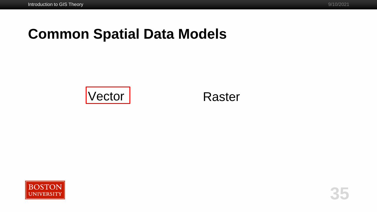
Vector Raster
Common Spatial Data Models - Vector
Introduction to GIS Theory
36
9/10/2021
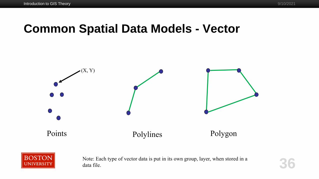
Points
(X, Y)
Polylines Polygon
Note: Each type of vector data is put in its own group, layer, when stored in a
data file.
Common Spatial Data Models - Vector
Introduction to GIS Theory
37
9/10/2021
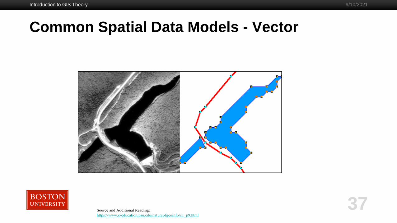
Source and Additional Reading:
https://www.e-education.psu.edu/natureofgeoinfo/c1_p9.html

Common Spatial Data Models- Vector
Introduction to GIS Theory
38
9/10/2021

Common Spatial Data Models - Vector
Introduction to GIS Theory
39
9/10/2021
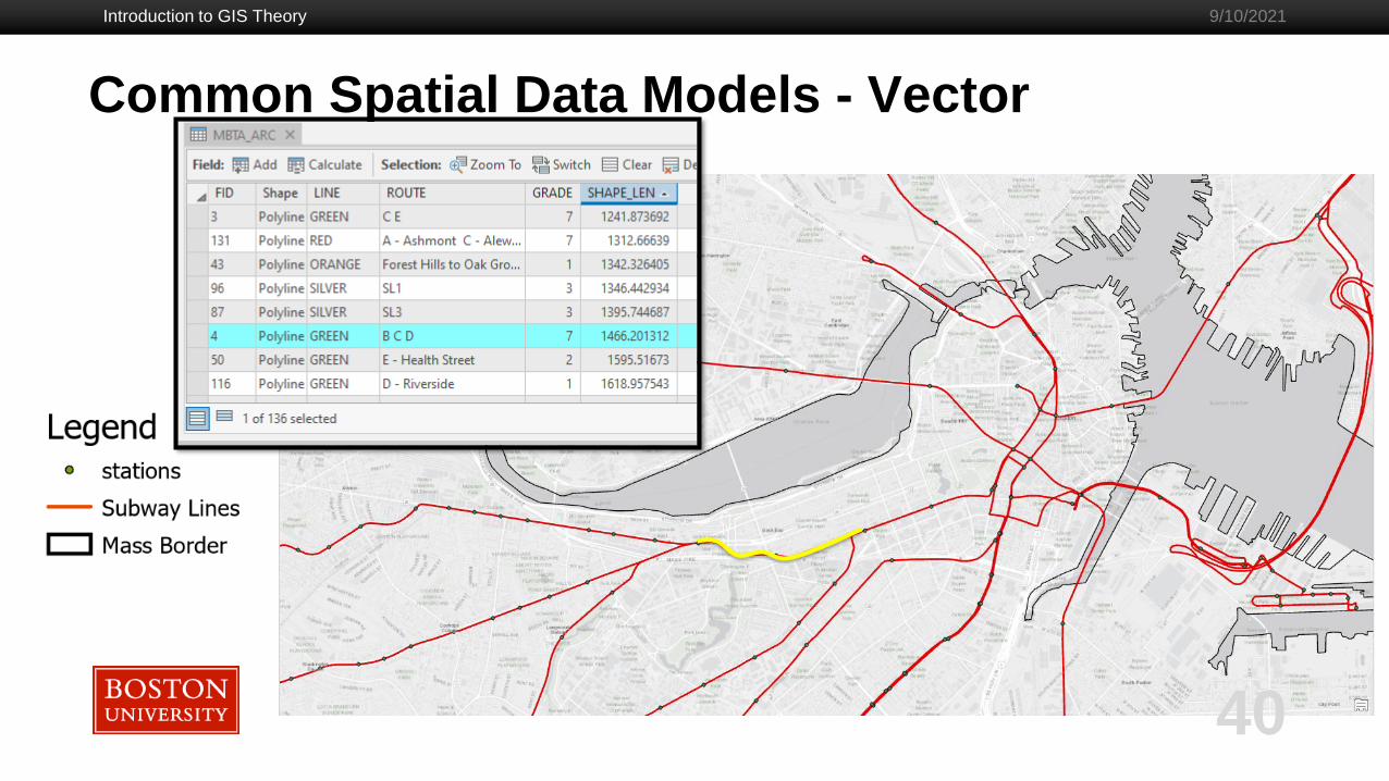
Common Spatial Data Models - Vector
Introduction to GIS Theory
40
9/10/2021
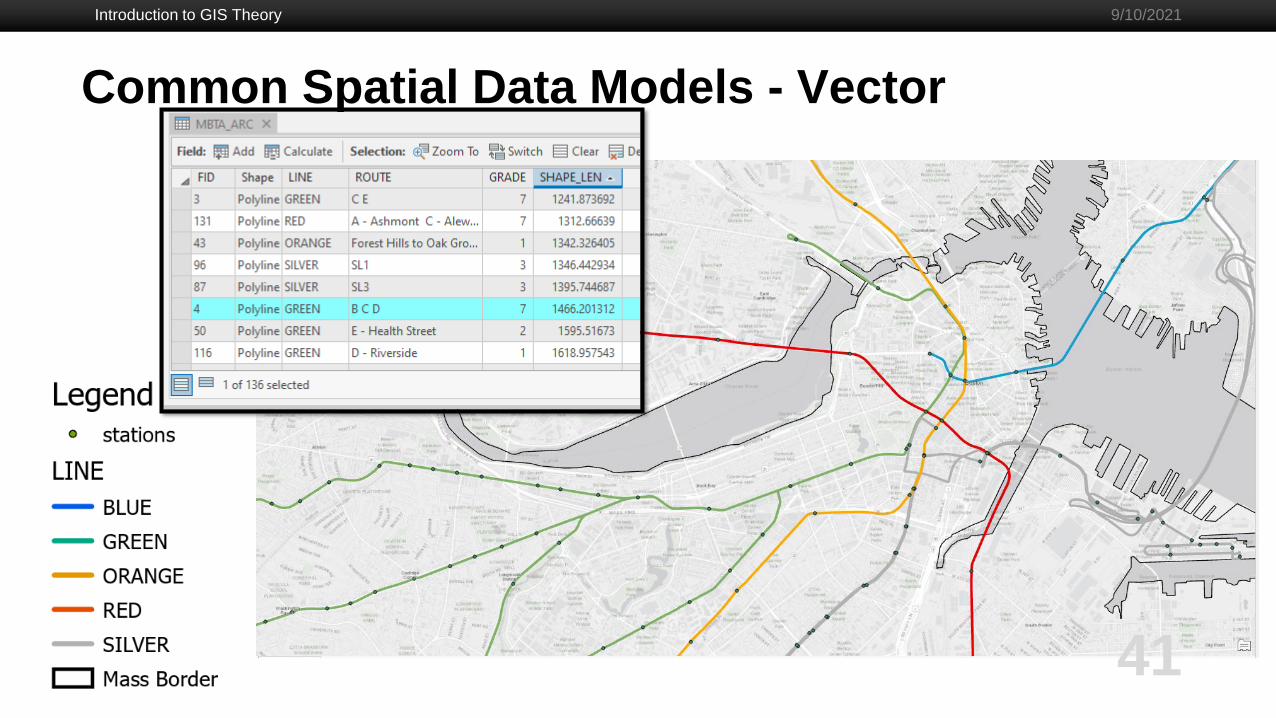
Common Spatial Data Models - Vector
Introduction to GIS Theory
41
9/10/2021

Common Spatial Data Models - Vector
Introduction to GIS Theory
42
9/10/2021
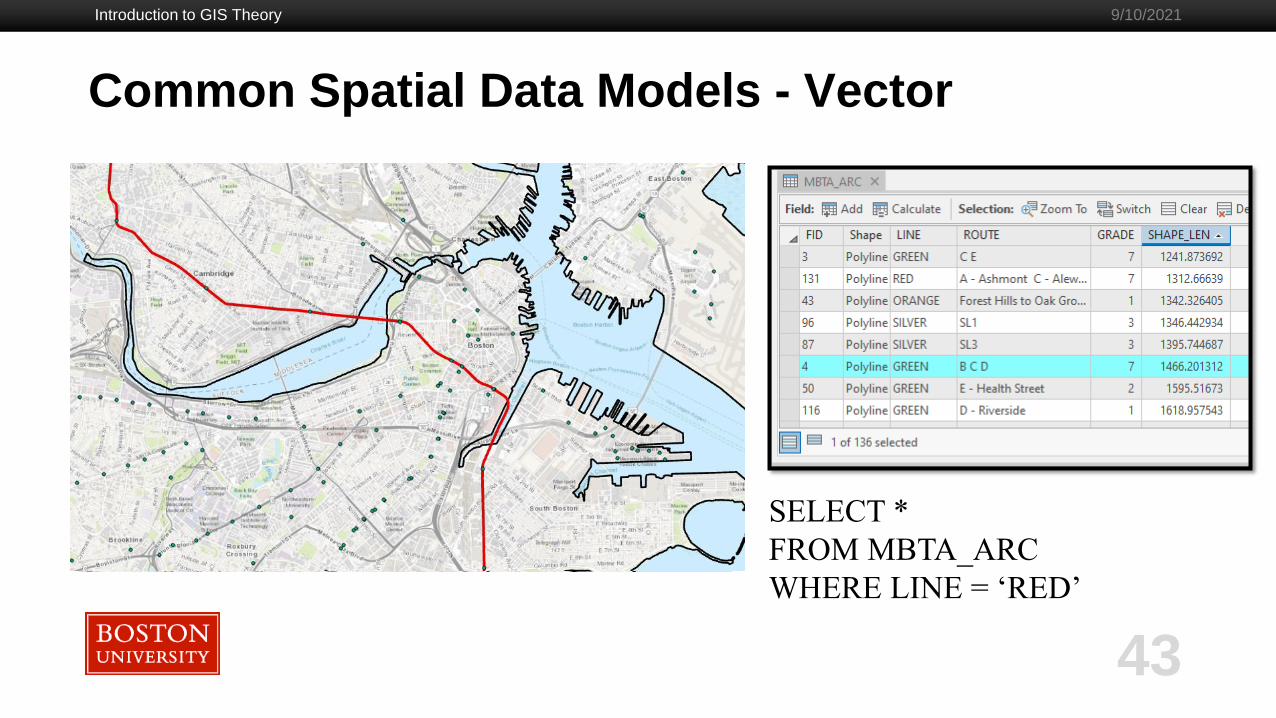
- Filtering data one common option is Structured Query Language (SQL)
Additional Reading:
https://www.w3schools.com/sql/
SELECT <COLUMN(s)> FROM <TABLE NAME> WHERE <COLUMN> = “<VALUE>”
Common Spatial Data Models - Vector
Introduction to GIS Theory
43
9/10/2021
SELECT *
FROM MBTA_ARC
WHERE LINE = ‘RED’

Common Spatial Data Models – Vector (Other)
- Topological Constraints
Additional Reading:
http://resources.arcgis.com/en/help/main/10.2/01mm/pdf/topology_rules_poster.pdf
Introduction to GIS Theory
44
9/10/2021

Common Spatial Data Models – Vector (Other)
- Network Model
- Collection of arcs and nodes
- Also include topological constraints
- Answers questions such as:
- How to get from point A to point B
- Shortest path from point A to point B
Source and Additional Reading:
https://desktop.arcgis.com/en/arcmap/latest/extensions/network-
analyst/what-is-a-network-dataset.htm
Introduction to GIS Theory
45
9/10/2021

Common Spatial Data Models
Introduction to GIS Theory
46
9/10/2021
Vector Raster
Common Spatial Data Models - Raster
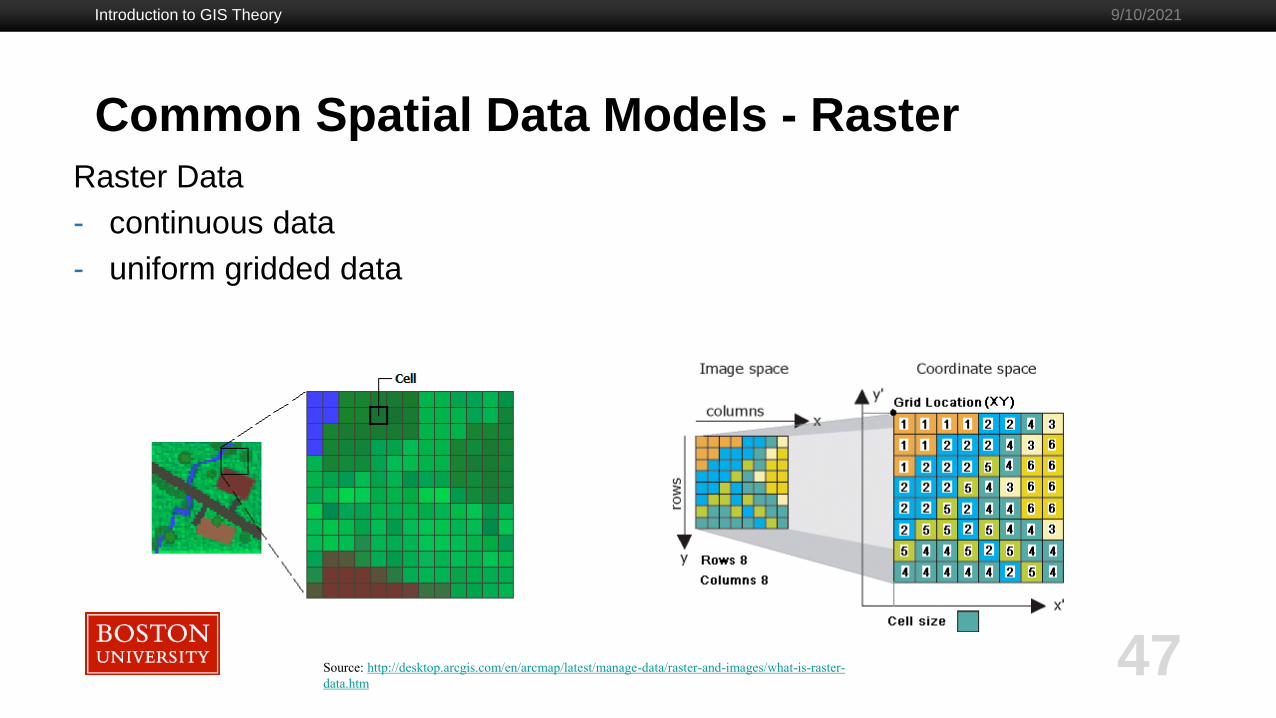
Raster Data
- continuous data
- uniform gridded data
Introduction to GIS Theory
47
9/10/2021
Source: http://desktop.arcgis.com/en/arcmap/latest/manage-data/raster-and-images/what-is-raster-
data.htm

Common Spatial Data Models - Raster
Examples of Raster Data
Introduction to GIS Theory
48
9/10/2021
Source: http://desktop.arcgis.com/en/arcmap/latest/manage-data/raster-and-images/what-is-raster-
data.htm

Common Spatial Data Models - Review
Introduction to GIS Theory
49
9/10/2021
Source and Additional Reading:
https://www.e-education.psu.edu/natureofgeoinfo/c1_p9.html

Common Spatial Data Models - Raster
Raster Data - Bands
Introduction to GIS Theory
50
9/10/2021
- For color image need red,
green, and blue bands.
- Remote sensing data can
contain up to 8 bands of data
representing a signal response
from a sensor.
Source and Additional Reading:
http://gsp.humboldt.edu/olm_2016/courses/GSP_216_Online/lesson3-1/bands.html
Common Spatial Data Models – Raster (Other)
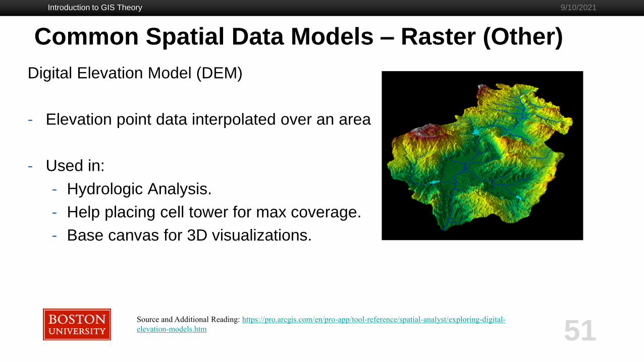
Digital Elevation Model (DEM)
- Elevation point data interpolated over an area
- Used in:
- Hydrologic Analysis.
- Help placing cell tower for max coverage.
- Base canvas for 3D visualizations.
Introduction to GIS Theory
51
9/10/2021
Source and Additional Reading: https://pro.arcgis.com/en/pro-app/tool-reference/spatial-analyst/exploring-digital-
elevation-models.htm

Common Spatial Data Models - Review
Introduction to GIS Theory
52
9/10/2021
Vector Raster- Attribute Table
- Labeling
- Filtering
- Symbology
- Topological Constrains can be applied.
- Network Model
- Continuous data
- Color coding by cell, by numeric
value
- Data source may contain
multiple bands
- Digital Elevation Model (DEM)
Source and Additional Reading:
https://www.e-education.psu.edu/natureofgeoinfo/c1_p9.html;https://pro.arcgis.com/en/pro-app/tool-reference/spatial-analyst/exploring-digital-elevation-models.htm
;https://desktop.arcgis.com/en/arcmap/latest/extensions/network-analyst/what-is-a-network-dataset.htm ;http://resources.arcgis.com/en/help/main/10.2/01mm/pdf/topology_rules_poster.pdf

Introduction to GIS Theory
53
9/10/2021
Data Layers
Data Layers
Introduction to GIS Theory
54
9/10/2021
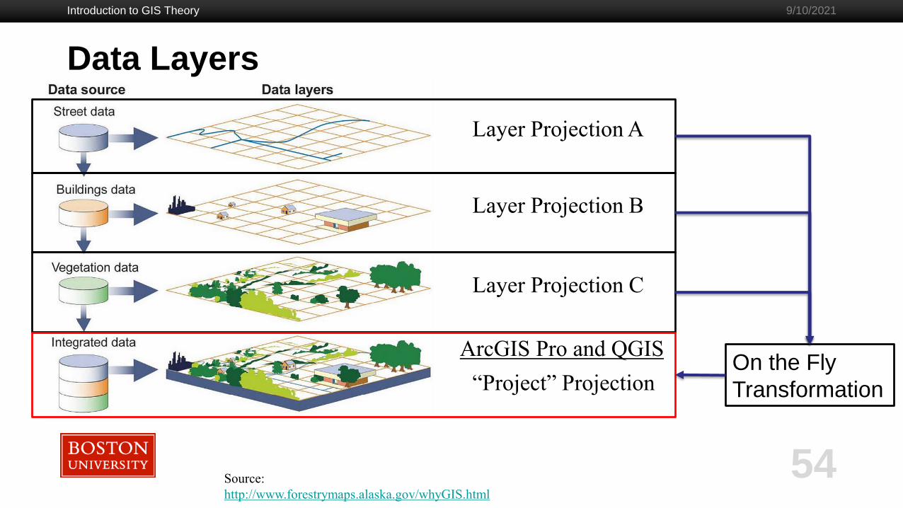
Source:
http://www.forestrymaps.alaska.gov/whyGIS.html
Layer Projection A
Layer Projection B
Layer Projection C
“Project” Projection
ArcGIS Pro and QGISOn the Fly
Transformation
Introduction to GIS Theory
55
9/10/2021
Spatial Data Storage

Introduction to GIS Theory
56
9/10/2021
Spatial Data Storage
How is spatial data stored?
AmigoCloud
ESRI ArcObjects
Arc/Info Generate
Arc/Info Binary Coverage
Arc/Info E00 (ASCII) Coverage
Atlas BNA
AutoCAD DWG
Carto
Cloudant
CouchDB/GeoCouch
Comma Separated Value (.csv)
OGC CSW (Catalog Service for the Web)
DB2 Spatial
Microstation DGN
Microstation DGN v8
DODS/OPeNDAP
AutoCAD DWG
AutoCAD DXF
EDIGEO
Google Earth Engine Data API
Elasticsearch: Geographically Encoded
Objects for Elasticsearch
ESRIJSON / FeatureService driver
ESRI File Geodatabase (FileGDB)
FlatGeobuf
FMEObjects Gateway
GeoConcept text export
GeoJSON
GeoJSONSeq: sequence of GeoJSON features
Geomedia MDB database
GeoRSS : Geographically Encoded Objects for RSS feeds
Geography Markup Language
Geography Markup Language (GML) driven by application schemas
GMT ASCII Vectors (.gmt)
GeoPackage vector
GPSBabel
GPS Exchange Format
GRASS Vector Format
GPS TrackMaker
Hydrographic Transfer Format
IDB
Idrisi Vector (.VCT)
“INTERLIS 1” and “INTERLIS 2” drivers
“INTERLIS 1” and “INTERLIS 2” drivers
INGRES
JML: OpenJUMP JML format
Keyhole Markup Language
LIBKML Driver (.kml .kmz)
Dutch Kadaster LV BAG 2.0 Extract
MapML
Access MDB databases
Memory
MapInfo TAB and MIF/MID
MongoDB
MongoDBv3
Microsoft SQL Server Spatial Database
MVT: Mapbox Vector Tiles
MySQL
ALKIS
Vector
NextGIS Web
UK .NTF
OGC API - Features
Oracle Spatial
ODBC RDBMS
Open Document Spreadsheet
OGDI Vectors
OpenAir Special Use Airspace Format
ESRI File Geodatabase (OpenFileGDB)
OpenStreetMap XML and PBF
Geospatial PDF
Planetary Data Systems TABLE
PostgreSQL / PostGIS
PostgreSQL SQL Dump
ESRI Personal GeoDatabase
PLScenes (Planet Labs Scenes/Catalog API)
IHO S-57 (ENC)
ESRI ArcSDE
SDTS
SEG-P1 / UKOOA P1/90
SEG-Y / SEGY
Selafin files
ESRI Shapefile / DBF
Norwegian SOSI Standard
SQLite / Spatialite RDBMS
Tim Newport-Peace’s Special Use Airspace
Format
Scalable Vector Graphics
SXF
U.S. Census TIGER/Line
TopoJSON driver
VDV-451/VDV-452/INTREST Data Format
Czech Cadastral Exchange Data Format
Virtual Format
Walk Spatial Data
WAsP .map format
OGC WFS service
MS Excel format
MS Office Open XML spreadsheet
X-Plane/Flightgear aeronautical data
Vector Data Source: https://gdal.org/drivers/vector/index.html

Introduction to GIS Theory
57
9/10/2021
Spatial Data StorageHow is spatial data stored?
Raster Data
Arc/Info ASCII Grid
ACE2
ADRG/ARC Digitized Raster Graphics (.gen/.thf)
Arc/Info Binary Grid
AIRSAR Polarimetric Format
Azavea Raster Grid
Bathymetry Attributed Grid
Magellan BLX Topo File Format
Microsoft Windows Device Independent Bitmap
Better Portable Graphics
Maptech/NOAA BSB Nautical Chart Format
VTP .bt Binary Terrain Format
Natural Resources Canada’s Geoid file format (.byn)
AutoCAD DWG raster layer
CALS Type 1
CEOS Image
DRDC COASP SAR Processor Raster
Cloud Optimized GeoTIFF generator
TerraSAR-X Complex SAR Data Product
Convair PolGASP data
CTable2 Datum Grid Shift
USGS LULC Composite Theme Grid
DAAS (Airbus DS Intelligence Data As A Service driver)
DB2 raster
DirectDraw Surface
Derived subdatasets driver
Spot DIMAP
ELAS DIPEx
OPeNDAP Grid Client
First Generation USGS DOQ
New Labelled USGS DOQ
Military Elevation Data
Arc/Info Export E00 GRID
ECRG Table Of Contents (TOC.xml)
Enhanced Compressed Wavelets (.ecw)
Google Earth Engine Data API Image
ESRI .hdr Labelled
Erdas Imagine Raw
Earth Resources Laboratory Applications Software
ENVI .hdr Labelled Raster
Wavelet compressed images
ERMapper .ERS
Envisat Image Product
Extended Dynamic Range Image File Format
EOSAT FAST Format
FIT
Flexible Image Transport System
Fuji BAS Scanner Image
Generic Binary (.hdr labelled)
Oracle Spatial GeoRaster
Sandia National Laboratories GSAT File Format
Graphics Interchange Format
GMT Compatible netCDF
GeoPackage raster
GRASS Raster Format
GRASS ASCII Grid
WMO General Regularly-distributed Information in Binary form
Golden Software Surfer 7 Binary Grid File Format
Golden Software ASCII Grid File Format
Golden Software Binary Grid File Format
GSC Geogrid
Generic Tagged Arrays
GeoTIFF File Format
Grid eXchange File
Hierarchical Data Format Release 4 (HDF4)
Hierarchical Data Format Release 5 (HDF5)
HF2/HFZ heightfield raster
Erdas Imagine .img
Image Display and Analysis
Idrisi Raster Format
IGN-France height correction ASCII grids
Raster Map
Intergraph Raster Format
Vaisala’s weather radar software format
ISCE
International Service for the Geoid
USGS Astrogeology ISIS Cube (Version 2)
USGS Astrogeology ISIS Cube (Version 3)
Japanese DEM (.mem)
ERDAS JPEG2000 (.jp2)
JPEG-2000 (based on Kakadu)
JPEG2000 driver based on Lurawave library
JPEG2000 via MrSID SDK
JPEG2000 driver based on OpenJPEG library
JPEG JFIF File Format
Implementation of the JPEG-2000 part 1
JPEGLS
JPIP Streaming
KEA
KMLSuperoverlay
KOLOR Raw format
NOAA Polar Orbiter Level 1b Data Set (AVHRR)
Erdas 7.x .LAN and .GIS
FARSITE v.4 LCP Format
Daylon Leveller Heightfield
NADCON .los/.las Datum Grid Shift
OziExplorer .MAP
Meta Raster Format
MBTiles
In Memory Raster
Vexcel MFF Raster
Vexcel MFF2 Image
MrSID/MG4 LiDAR Compression / Point Cloud View
files
Multi-resolution Seamless Image Database
Meteosat Second Generation
Meteosat Second Generation (MSG) Native Archive
Format (.nat)
NLAPS Data Format
NetCDF: Network Common Data Form
NOAA NGS Geoid Height Grids
NextGIS Web
National Imagery Transmission Format
NTv1 Datum Grid Shift
NTv2 Datum Grid Shift
Northwood/Vertical Mapper File Format
Northwood/Vertical Mapper File Format
OZF2/OZFX3 raster
JAXA PALSAR Processed Products
PCI .aux Labelled Raw Format
PCI Geomatics Database File
PCRaster raster file format
Geospatial PDF
Planetary Data System v3
NASA Planetary Data System (Version 4)
PLMosaic (Planet Labs Mosaics API)
Portable Network Graphics
Netpbm (.pgm, .ppm)
PostGIS Raster driver
PHOTOMOD Raster File
R Object Data Store
Rasdaman GDAL driver
Rasters in SQLite DB
Rasters in SQLite DB
RDA (DigitalGlobe Raster Data Access)
RIEGL Database
Swedish Grid Maps
Raster Matrix Format
ROI_PAC
Raster Product Format/RPF (a.toc)
R Raster
RadarSat 2 XML Product
Sentinel-1 SAFE XML Product
CEOS SAR Image
SAGA GIS Binary Grid File Format
ESRI ArcSDE Raster
USGS SDTS DEM
Sentinel-2 Products
SGI Image Format
Scaled Integer Gridded DEM
Snow Data Assimilation System
Standard Product Format (ASRP/USRP) (.gen)
SRTM HGT Format
Terragen™ Terrain File
EarthWatch/DigitalGlobe .TIL
TileDB
TerraSAR-X Product
USGS ASCII DEM (and CDED)
VICAR
GDAL Virtual Format
OGC Web Coverage Service
WEBP
Web Map Services
OGC Web Map Tile Service
X11 Pixmap
ASCII Gridded XYZ
ZMap Plus Grid
Source: https://gdal.org/drivers/raster/index.html#
Introduction to GIS Theory
58
9/10/2021
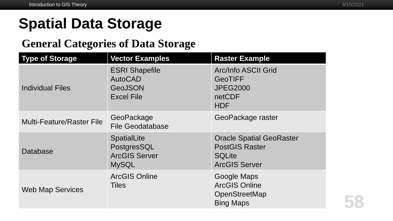
Spatial Data Storage
General Categories of Data Storage
Type of Storage Vector Examples Raster Example
Individual Files
ESRI Shapefile
AutoCAD
GeoJSON
Excel File
Arc/Info ASCII Grid
GeoTIFF
JPEG2000
netCDF
HDF
Multi-Feature/Raster FileGeoPackage
File Geodatabase
GeoPackage raster
Database
SpatialLite
PostgresSQL
ArcGIS Server
MySQL
Oracle Spatial GeoRaster
PostGIS Raster
SQLite
ArcGIS Server
Web Map Services
ArcGIS Online
Tiles
Google Maps
ArcGIS Online
OpenStreetMap
Bing Maps

Introduction to GIS Theory
59
9/10/2021
Spatial Data Storage
What is stored in these files?- Geographic coordinate system definition
- Projection definition
- Attribute Table
- Meta data
- Feature type and properties
- Coordinate points for features
- Various internal tables (such as spatial indexing)

Introduction to GIS Theory
60
9/10/2021
Example Workflow

Introduction to GIS Theory
61
9/10/2021
Example Workflow
1. Collect field data with coordinates, or download it. https://www.mass.gov/service-details/massgis-data-layers
2. Import data into GIS software.
3. Clean and condition the data.
4. Explore the data.
5. Use spatial analysis tools.
6. Apply symbology.
7. Publish/share map/results with others.

Introduction to GIS Theory
62
9/10/2021
Sample of GIS Software
Sample of GIS Software
Introduction to GIS Theory
63
9/10/2021
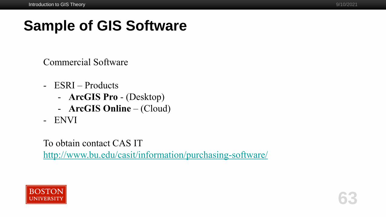
Commercial Software
- ESRI – Products
- ArcGIS Pro - (Desktop)
- ArcGIS Online – (Cloud)
- ENVI
To obtain contact CAS IT
http://www.bu.edu/casit/information/purchasing-software/

Sample of GIS Software
Introduction to GIS Theory
64
9/10/2021
Programming Languages
- Python - gdal, geopandas, pangeo
- R – sf, rgdal, raster
Libraries/Command Line Tools
- GDAL
- Geos
- Proj
- Spatialite
Open Source - Free
Software
- QGIS
- GrassGIS
- Saga
- Google Maps/Earth

Sample of GIS Software
Introduction to GIS Theory
65
9/10/2021
Build Your Own GIS Toolbox
My toolbox:
- Organizing data - OGR/GDAL
- Data storage - GeoPackage or PostgresSQL w/PostGIS
- GIS Task Automation - R or Python
- Visualizations for Reports - QGIS or ArcGIS Pro
- Visualization for Web Maps - ArcGIS Online

Introduction to GIS Theory
66
9/10/2021
GIS Data Sources
I have compiled an informal GIS source list here:
https://github.com/milechin/gis_data_sources/wiki/GIS-Data-Resources

Questions
Introduction to GIS Theory
67
9/10/2021
Please fill out tutorial evaluation:
http://rcs.bu.edu/eval
Email me at: