INTRODUCTION THOROUGHFARE SYSTEM ... INTRODUCTION A thoroughfare system is intended to provide an...
13
10.1 INTRODUCTION A thoroughfare system is intended to provide an effective means of moving vehicles within and through a city. The thoroughfare plan will assist public officials in the development of a specialized system for efficient and safe movement of vehicular traffic while minimizing potential conflicts with other forms of transportation. Acting as a framework, the thoroughfare system ties the various neighborhoods and parts of the city together and helps direct where present and future development will occur. THOROUGHFARE SYSTEM CLASSIFICATIONS Thoroughfare classifications usually carry with them a set of suggested minimum design standards which are in keeping with the importance of the system and are governed by the specific transportation services the system is to perform. The principal consideration for designating roads into systems are the travel desires of the public, land-access requirements based upon existing and future land use, and continuity of the system. Major and Minor Arterials Major and minor arterial streets primarily function is to move large volumes of traffic. Access to abutting property may be in conflict with the primary function of a major arterial street which is to move traffic as efficiently and safely as possible. The same characteristics define the minor arterial except that traffic volumes are generally lower and through traffic is discouraged. Parking should generally be prohibited along major arterials except in areas with low traffic volumes. Collector Streets Collector streets are intended to collect and move traffic safely and efficiently. Land access and parking are of secondary importance in collector street function. The function of the collector street in residential areas is to collect traffic from local streets in the interior of the neighborhood and distribute it to the arterial street system. This allows local streets to remain quiet and congestion free which in turn enhances the living environment of the neighborhood. Collector streets in business and industrial areas serve as collector and distributor routes for traffic around heavy traffic generators such as the downtown area, schools, or industrial areas which have higher truck traffic volumes. Traffic safety is an important design consideration for the collector street. Whenever possible and practical, buildings should not front on the collector street and driveways should be prohibited. In the interior of the neighborhood, local streets should connect in "T" intersections. This kind of intersection is superior from the standpoint of traffic safety since there are fewer turning conflicts. The spacing of collector streets is often influenced by land use, density of development, and land use traffic generating characteristics. A spacing of one-fourth to one-half mile intervals is a reasonable standard where conditions are such that it can be achieved.
Transcript of INTRODUCTION THOROUGHFARE SYSTEM ... INTRODUCTION A thoroughfare system is intended to provide an...

10.1
INTRODUCTION A thoroughfare system is intended to provide an effective means of moving vehicles within and through a city. The thoroughfare plan will assist public officials in the development of a specialized system for efficient and safe movement of vehicular traffic while minimizing potential conflicts with other forms of transportation. Acting as a framework, the thoroughfare system ties the various neighborhoods and parts of the city together and helps direct where present and future development will occur.
THOROUGHFARE SYSTEM CLASSIFICATIONS Thoroughfare classifications usually carry with them a set of suggested minimum design standards which are in keeping with the importance of the system and are governed by the specific transportation services the system is to perform. The principal consideration for designating roads into systems are the travel desires of the public, land-access requirements based upon existing and future land use, and continuity of the system. Major and Minor Arterials Major and minor arterial streets primarily function is to move large volumes of traffic. Access to abutting property may be in conflict with the primary function of a major arterial street which is to move traffic as efficiently and safely as possible. The same characteristics define the minor arterial except that traffic volumes are generally lower and through traffic is discouraged. Parking should generally be prohibited along major arterials except in areas with low traffic volumes. Collector Streets Collector streets are intended to collect and move traffic safely and efficiently. Land access and parking are of secondary importance in collector street function. The function of the collector street in residential areas is to collect traffic from local streets in the interior of the neighborhood and distribute it to the arterial street system. This allows local streets to remain quiet and congestion free which in turn enhances the living environment of the neighborhood. Collector streets in business and industrial areas serve as collector and distributor routes for traffic around heavy traffic generators such as the downtown area, schools, or industrial areas which have higher truck traffic volumes. Traffic safety is an important design consideration for the collector street. Whenever possible and practical, buildings should not front on the collector street and driveways should be prohibited. In the interior of the neighborhood, local streets should connect in "T" intersections. This kind of intersection is superior from the standpoint of traffic safety since there are fewer turning conflicts. The spacing of collector streets is often influenced by land use, density of development, and land use traffic generating characteristics. A spacing of one-fourth to one-half mile intervals is a reasonable standard where conditions are such that it can be achieved.
10.2
Local Streets The primary purpose of the local street system is to provide access to property abutting the right-of-way. A secondary purpose of local streets is to move traffic because traffic generated by abutting land use is generally light. Through traffic is discouraged from using the local street, except where such a street is located in an industrial or commercial area. Local street right-of-way also serve to provide easements as access for public utilities such as waterlines. The local street is a major element in the design composition of the city, providing space for plantings, and arranging properties in various sizes and shapes of blocks with an irregular or rectangular street pattern.
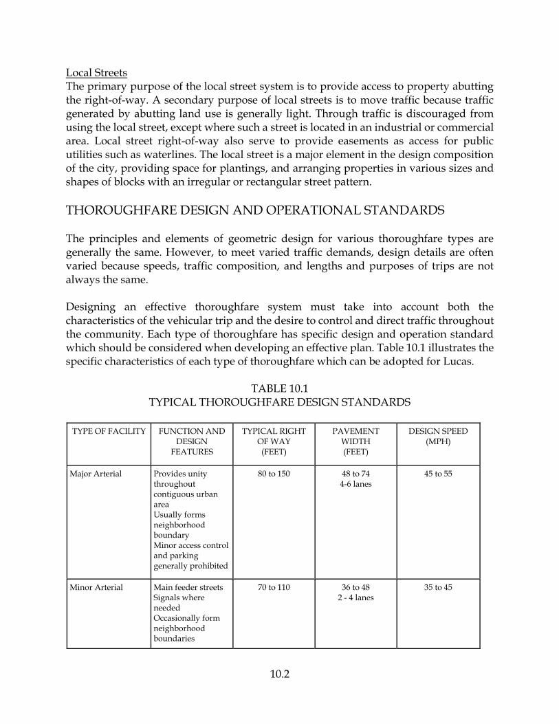
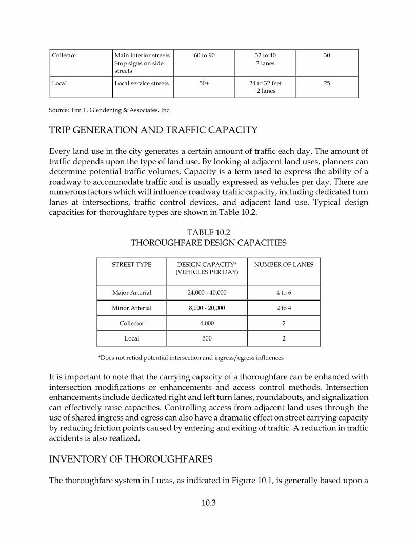
THOROUGHFARE DESIGN AND OPERATIONAL STANDARDS The principles and elements of geometric design for various thoroughfare types are generally the same. However, to meet varied traffic demands, design details are often varied because speeds, traffic composition, and lengths and purposes of trips are not always the same. Designing an effective thoroughfare system must take into account both the characteristics of the vehicular trip and the desire to control and direct traffic throughout the community. Each type of thoroughfare has specific design and operation standard which should be considered when developing an effective plan. Table 10.1 illustrates the specific characteristics of each type of thoroughfare which can be adopted for Lucas.
TABLE 10.1 TYPICAL THOROUGHFARE DESIGN STANDARDS
TYPE OF FACILITY FUNCTION AND DESIGN
FEATURES
TYPICAL RIGHT OF WAY (FEET)
PAVEMENT WIDTH (FEET)
DESIGN SPEED (MPH)
Major Arterial Provides unity throughout contiguous urban area Usually forms neighborhood boundary Minor access control and parking generally prohibited
80 to 150 48 to 74 4-6 lanes
45 to 55
Minor Arterial Main feeder streets Signals where needed Occasionally form neighborhood boundaries
70 to 110 36 to 48 2 - 4 lanes
35 to 45
10.3
Collector Main interior streets Stop signs on side streets
60 to 90 32 to 40 2 lanes
30
Local Local service streets 50+ 24 to 32 feet 2 lanes
25
Source: Tim F. Glendening & Associates, Inc.
TRIP GENERATION AND TRAFFIC CAPACITY Every land use in the city generates a certain amount of traffic each day. The amount of traffic depends upon the type of land use. By looking at adjacent land uses, planners can determine potential traffic volumes. Capacity is a term used to express the ability of a roadway to accommodate traffic and is usually expressed as vehicles per day. There are numerous factors which will influence roadway traffic capacity, including dedicated turn lanes at intersections, traffic control devices, and adjacent land use. Typical design capacities for thoroughfare types are shown in Table 10.2.
TABLE 10.2 THOROUGHFARE DESIGN CAPACITIES
STREET TYPE DESIGN CAPACITY* (VEHICLES PER DAY)
NUMBER OF LANES
Major Arterial 24,000 - 40,000 4 to 6
Minor Arterial 8,000 - 20,000 2 to 4
Collector 4,000 2
Local 500 2
*Does not retied potential intersection and ingress/egress influences
It is important to note that the carrying capacity of a thoroughfare can be enhanced with intersection modifications or enhancements and access control methods. Intersection enhancements include dedicated right and left turn lanes, roundabouts, and signalization can effectively raise capacities. Controlling access from adjacent land uses through the use of shared ingress and egress can also have a dramatic effect on street carrying capacity by reducing friction points caused by entering and exiting of traffic. A reduction in traffic accidents is also realized.
INVENTORY OF THOROUGHFARES The thoroughfare system in Lucas, as indicated in Figure 10.1, is generally based upon a


10.4
modified grid-type system. The full hierarchy of thoroughfare types exists in Lucas, with some streets clearly functioning as arterials and collectors. Table 10.3 identifies arterial streets in Lucas.
TABLE 10.3 CITY OF LUCAS
EXISTING ARTERIAL STREET SYSTEM
ARTERIAL TYPE FUNCTION AVERAGE DAILY TRAFFIC VOLUMES*
(VEHICLES)
Country Club Road/Southview Drive
(FM 1378)
Major Provides north/south access through central portion of Lucas
4,400 to 9,200
E Lucas Road (FM 3286)
Major Provides east/west access through central portion of Lucas; traverses Lake
Lavon
6,000 to 9,200
Angel Parkway (FM 2551)
Major Provides north/south access along western edge of Lucas
4,600 to 5,900
Parker Road (FM 2514)
Major Provides east/west access along southern edge of Lucas
8,200
Estates Parkway (FM 2170)
Minor Provides an east/west link between Country Club Road and Angel Parkway
3,300
* 2002 Texas Department of Transportation traffic volumes
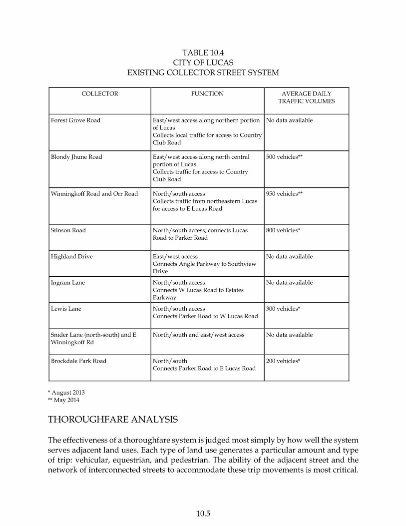
The collector street system in Lucas is not as clearly defined as the arterial system. However, based upon locally perceived travel patterns and traffic volumes, the collector street system for Lucas has been identified in Table 10.4.
10.5
TABLE 10.4 CITY OF LUCAS
EXISTING COLLECTOR STREET SYSTEM
COLLECTOR FUNCTION AVERAGE DAILY TRAFFIC VOLUMES
Forest Grove Road East/west access along northern portion of Lucas Collects local traffic for access to Country Club Road
No data available
Blondy Jhune Road East/west access along north central portion of Lucas Collects traffic for access to Country Club Road
500 vehicles**
Winningkoff Road and Orr Road North/south access Collects traffic from northeastern Lucas for access to E Lucas Road
950 vehicles**
Stinson Road North/south access; connects Lucas Road to Parker Road
800 vehicles*
Highland Drive East/west access Connects Angle Parkway to Southview Drive
No data available
Ingram Lane North/south access Connects W Lucas Road to Estates Parkway
No data available
Lewis Lane North/south access Connects Parker Road to W Lucas Road
300 vehicles*
Snider Lane (north-south) and E Winningkoff Rd
North/south and east/west access
No data available
Brockdale Park Road North/south Connects Parker Road to E Lucas Road
200 vehicles*
* August 2013 ** May 2014
THOROUGHFARE ANALYSIS The effectiveness of a thoroughfare system is judged most simply by how well the system serves adjacent land uses. Each type of land use generates a particular amount and type of trip: vehicular, equestrian, and pedestrian. The ability of the adjacent street and the network of interconnected streets to accommodate these trip movements is most critical.

10.6
When trips generated by an adjacent land use have adequate ingress and egress and can move throughout the immediate area and the city overall, at a safe and optimal speed and without restrictions or impediments to flow caused by physical constrictions, then the thoroughfare system is meeting its intended function. In the analysis of 2004 thoroughfare system, three factors are to be examined to determine their impact on the system and its ability to meet the needs of the community. These factors include (1) major traffic generators; (2) traffic speed or level of service; and (3) alignments, intersections’ and system connectivity. Trip Generation Each type of land use creates or generates a certain amount of traffic. The Institute of Transportation Engineers (ITE) has compiled a comprehensive tabulation and analysis of various land use types and the number of vehicle trips generated. Following is a sampling of various land use types which can be found in Lucas and the corresponding trip generation rate as compiled by ITE:
TABLE 10.5 TRIP GENERATION RATES FOR SELECTED LAND USES
LAND USE TYPE UNIT AVERAGE DAILY TRIP RATE
Single- Family Dwelling dwelling unit 10.0
Apartment dwelling unit 6.1
Motel occupied room 10.14
Elementary School per student 1.02
High School per student 1.39
Hospital per bed 11.4
Nursing Home per employee 4.0
General Office per 1,000 square feet 17.7
Super Market per 1,000 square feet 125.5
Convenience Store per 1,000 square feet 322.6
Service Station per pump 133
Restaurant per 1,000 square feet 164.4
Source: Trip Generation, Institute of Transportation Engineers
In 2004, only Hart Elementary School can be considered a significant traffic generator which has an impact on the circulation system. Although all land uses generate varying

10.7
amounts of traffic, it is only the significant generators which should be considered when analyzing thoroughfare system because they can directly affect local circulation patterns. Table 10.6 identifies the major 2004 traffic generators, together with the estimated traffic generation rate based upon standards established by the Institute of Transportation Engineers. Lovejoy High School is a planned facility with an estimated eventual enrollment of 1,500 students. All traffic impact data is based upon this assumption.
TABLE 10.6 2004 MAJOR TRAFFIC GENERATORS
LAND USE STREETS AFFECTED AVERAGE DAILY TRAFFIC GENERATED
PEAK HOUR TRAFFIC GENERATED
Hart Elementary School Country Club Road and Estelle Lane
561 trips 143 AM trips
Lovejoy High School* Estate Parkway* 2,085 trips* 450 AM trips*
* Projected impact Source: Based upon ITE trip generation rates using facility sizes
Speed and Level of Service Once traffic volumes based upon trip generation rates have been determined, the speed of vehicular travel on streets and the corresponding level of service must be calculated. As previously mentioned, each type of thoroughfare has a specific design capacity. The design capacity is the theoretical volume of traffic which a street could accommodate in free flow conditions at the posted speed limit. A means to measure how effective a street is accommodating vehicular volumes has been developed and is referred to as level of service (LOS). The LOS for thoroughfares ranges from "A" for uninterrupted, free flow at posted speed limits to "D" which denotes extremely heavy congestion with very low operational speeds. In 2004 streets operate generally at LOS C or better except for occasional congestion around the school and at major intersections during peak morning and afternoon travel times. Because the system operates at such a high level, there can be a corresponding problem associated with higher than desirable vehicle speeds. Alignments, Intersections, Operations, and System Connectivity Street intersections with off-set approaches can create traffic circulation problems. While there are some off-set intersections in Lucas, present traffic flows at these intersections are low and the potential for conflict is somewhat limited. However, if vehicle accidents become frequent at any of these intersections, such as Lucas Road/Southview Drive, then some alignment adjustments or traffic controls will need to be investigated. In the future, street intersections should have all approaches at 90 degree angles with clear alignments. Any off-set, if necessary, should have a minimum spacing of at least 200 feet.

10.8
The absence of signalized intersection traffic control devices at many intersections greatly reduces the carrying capacity of the entire thoroughfare segment. Signalization, roundabouts, and intersection enhancements using dedicated right and left turn lanes, will be required in the future in order to improve traffic flow and reduce the potential for accidents.
GOALS AND OBJECTIVES The following goals and objectives have been developed for the Thoroughfare Plan: Goal: Ensure adequate right-of-way to enable future street improvements. Objective: Enforce the Subdivision Ordinance which specifies minimum rights-of-way
during the platting process. Objective: As opportunities arise during replatting or from outright purchase, acquire
needed right-of-way near intersections where realignments are needed to eliminate any substandard approach angles or future intersection enhancements are planned.
Goal: Maximize the ability of existing thoroughfares to accommodate traffic flow. Objective: Encourage "point enhancements" at major intersections rather than
thoroughfare widening in order increase capacities while minimizing impacts on adjacent neighborhoods.
Objective: During the development/platting process, require the preparation of a traffic plan to minimize site ingress/egress locations along major thoroughfares.
Goal: Improve the overall circulation efficiency of the thoroughfare system. Objective: Ensure that no arterial or collector streets are deadended. Objective: Eliminate intersections with substandard alignments. Objective: For future developments, require a 90 degree approach at all intersections. Goal: Use thoroughfares where feasible to transition/buffer. Objective: Require dedication of right-of-way for new thoroughfares where enhanced
access is desirable and to separate potentially incompatible land uses. Goal: Improve the operational safety of the thoroughfare system. Objective: Continue speed limit enforcement Objective: Install traffic control devices where needed. Goal: Obtain funding for needed thoroughfare improvements. Objective: Request financial assistance from Collin County and the Texas Department
of Transportation to address any problem intersections at county/state highways.

10.9
Goal: Effectively integrate all modes of transportation. Objective: Negotiate the use of utility easements/rights-of-way for installing
pedestrian, equestrian, and bicycle trails. Objective: Where possible, route through traffic around schools and park areas to
minimize automobile/pedestrian conflicts.
2014 MASTER THOROUGHFARE PLAN The 2014 Master Thoroughfare Plan for Lucas has been developed to guide the implementation of improvements needed to improve and enhance traffic flow and maintain the rural feel of Lucas. The plan identifies the standard segment expansions accomplished through street widening, along with less intrusive intersection enhancement such as signalization, roundabouts, and dedicated left and right turn lanes. The plan will enable Lucas to address system deficiencies in a comprehensive manner. The 2014 Master Thoroughfare Plan will need regular review to ensure that as circumstances change, so will the goals, objectives, and recommendations for thoroughfare improvements. The designation of future thoroughfares in Lucas is not based upon the Collin County Mobility Plan. This mobility plan proposes a very ambitious program for the widening of major and collector streets throughout Collin County. However, to (1) preserve and maintain the present rural feel of Lucas, (2) minimize the intrusiveness on neighborhoods caused by high volumes of through traffic, and (3) because future traffic volumes are not expected to approach the levels projected in the county plan, the following thoroughfare standards have been established for Lucas:
TABLE 10.7 CITY OF LUCAS
THOROUGHFARE DESIGN STANDARDS
THOROUGHFARE TYPE
RIGHT-OF-WAY PAVEMENT WIDTH (FEET)
NUMBER OF LANES
Major Arterial (Type A) 120 78 6 divided
Minor Arterial (Type B) 90 64 4 undivided
Collector (Type C) 60 34 2 undivided
Type D (not shown) 50 24 2 undivided
The assignment of thoroughfare design standards for future thoroughfares in Lucas is depicted on the 2014 Master Thoroughfare Plan in Figure 10.2.

LegendSolid lines are thoroughfares within the city.
Dashed lines are thoroughfares outside the city.
Blue lines are proposed thoroughfares.
Blue dots are proposed roundabout locations.
Thoroughfare name is followed by thoroughfare type.
No. of
Lanes
Divided
Roadway
Right-of-
Way Width
(Feet)
Six Yes 120
Four No 90
Two No 60
Two No 50
2014 Master Thoroughfare Plan (Figure 10.2.1)
Thoroughfare
Type
D (Not Shown)
A
B
C
Pavement Width
(Feet)
78Plus a 16-Foot Median
64
34
24
PARKER RD - A
HIGHLAND DR - C
W LUCAS RD - B
ESTATES PKWY - B
FOREST GROVE RD - C
E WINNINGKOFF RD - C
E LUCAS RD - B
AN
GEL
PK
WY
-A
BROCKDALE PARK RD - C
SOU
THV
IEW
DR
-B
EDG
EWO
OD
DR
-C
STIN
SON
RD
-C
CO
UN
TRY
CLU
BR
D -
B
LEW
IS L
N -
C
OR
R R
D -
CW
INN
ING
KO
FF R
D -
C
SNID
ER L
N -
C
MAIN ST - A
BETHANY RD - A
DIL
LEH
AY
DR
-A
ALL
ISO
N L
N -
C
ING
RA
M L
N -
C
B
B
A


10.10
Since it will certainly be a costly and long-term process to implement all thoroughfare improvements shown on the 2014 Master Thoroughfare Plan, Lucas in the short-term should focus instead on various point enhancements to the existing thoroughfare system as a means of improving carrying capacity and reducing traffic accidents on roadways. As previously discussed, point enhancements include intersection signalization, roundabouts, and/or dedicated turn lanes construction. These types of improvements are much less intrusive on adjacent properties, less costly, and have the potential to increase traffic carrying capacities which should satisfy the traffic circulation needs of the community for the foreseeable future. Funding for future thoroughfare improvements can be provided from the Texas Department of Transportation, Collin County, City Funds, and, where there are issues regarding school safety, the Lovejoy Independent School District. Any and all thoroughfare improvements should be closely coordinated with other public improvement projects to minimize conflict and take advantage of the possibility of combining projects such as water and drainage improvements.