Introduction - University of Cambridge · Introduction. Introduction
Upload
lana-mccallCategory
view
20download
0description
1
Introduction
20 Years of Restoration
in the Carmel
River Introduction

Mission Statement
PENINSULA WATER RESOURCES
Monterey Peninsula
Water Management District
BALANCE COMMUNITY AND
ENVIRONMENTAL WATER NEEDSby
MANAGING
PROTECTING
and
AUGMENTING

MPWMD BOUNDARY
Carmel River Watershed

MPWMD Service AreaMonterey Peninsula
Water Management District
Monterey Bay
MontereyCarmel-by-the-Sea
Carmel River
Carmel Highlands
SeasideDel Rey Oaks
Sand CityPacific Grove
Carmel Valley Village
Pebble Beach
San Clemente Dam
Los Padres Dam

Current Water Sources
7
Monterey PeninsulaWater Management District
Current Sources of Our Water
Carmel River69% of Supply
Miscellaneous6% of Supply
MontereySanta Cruz
Oakland
Seaside Basin25% of Supply
Carmel River70% of Supply
Miscellaneous5% of Supply
Monterey
San J ose
Groundwater Aquifer
San ClementeDam
Los Padres Dam
Drainage Basin

Order 95-10
In 1995, the State limited the amount of water that can be pumped from under the Carmel River by Cal-Am, which supplies most of the water on the Monterey Peninsula, and declared the alluvial aquifer to be fully appropriated during the dry season.
Past Use Current Limit
Future Limit
14,106 acre-feet (AF), average Carmel River
production in 1980s
11,285 AF, temporary
permission to use this much water
3,376 AF, Cal-Am’s
recognized water right
State Cuts Cal-Am Supplies

LEFT – THE RIVER RISES RAPIDLYIN RESPONSE TO WINTER RAINS. THIS PHOTO, TAKEN MARCH 10, 1995 AT THE BORONDA ROAD BRIDGE, SHOWS THE RIVER AT APPROXIMATELY 15,000 CUBIC FEET PER SECOND. IN JUST TWO DAYS (MARCH 10 & 11, 1995), THIS STORM EVENT PRODUCED ENOUGH RUNOFF TO SUPPLY MONTEREY PENINSULA WATER NEEDS FOR A YEAR.
Carmel River Flow
RIGHT – PHOTO TAKEN IN MAY 2002 AT THE SAME LOCATION AT A FLOW OF ABOUT 20 CUBIC FEET PER SECOND (CFS). FLOW AT THIS SITE DROPS TO AS LITTLE AS FIVE CFS IN THE DRY SEASON.

San Clemente Dam and Reservoir
FEBRUARY 9, 1998
JULY 1982
TWO MAIN STEM RESERVOIRSSTORE LESS THAN 3% OF ANNUAL FLOW FOR SUMMER RELEASE (NOTE – ONLY ONE RESERVOIR IS SHOWN HERE). INFLOWING SEDIMENT HAS REDUCED SURFACE STORAGE AND CONTRIBUTED TO CHANNEL DEGRADATION AND STREAMBANK EROSION DOWNSTREAM.
ABOVE – DEBRIS CLOGS RESERVOIR PORTS DURING HIGH FLOWS IN FEBRUARY 1998. WORKERS SPENT THREE MONTHS CUTTING WOOD AND SENDING PIECES DOWNSTREAM.
RIGHT – LOOKING UPSTREAM AT THE DAM FACE

San Clemente ReservoirForeset Slope
January 2003
April 2001
TWO VIEWS LOOKING UPSTREAM FROM THE DAM FACE AT THE FORESET SLOPE CREEPING DOWNSTREAM AS SEDIMENT FILLS THE RESERVOIR. LESS THAN 10% OF THE ORIGINAL STORAGE VOLUME REMAINS.
July 1982500 feetupstream
December 2003
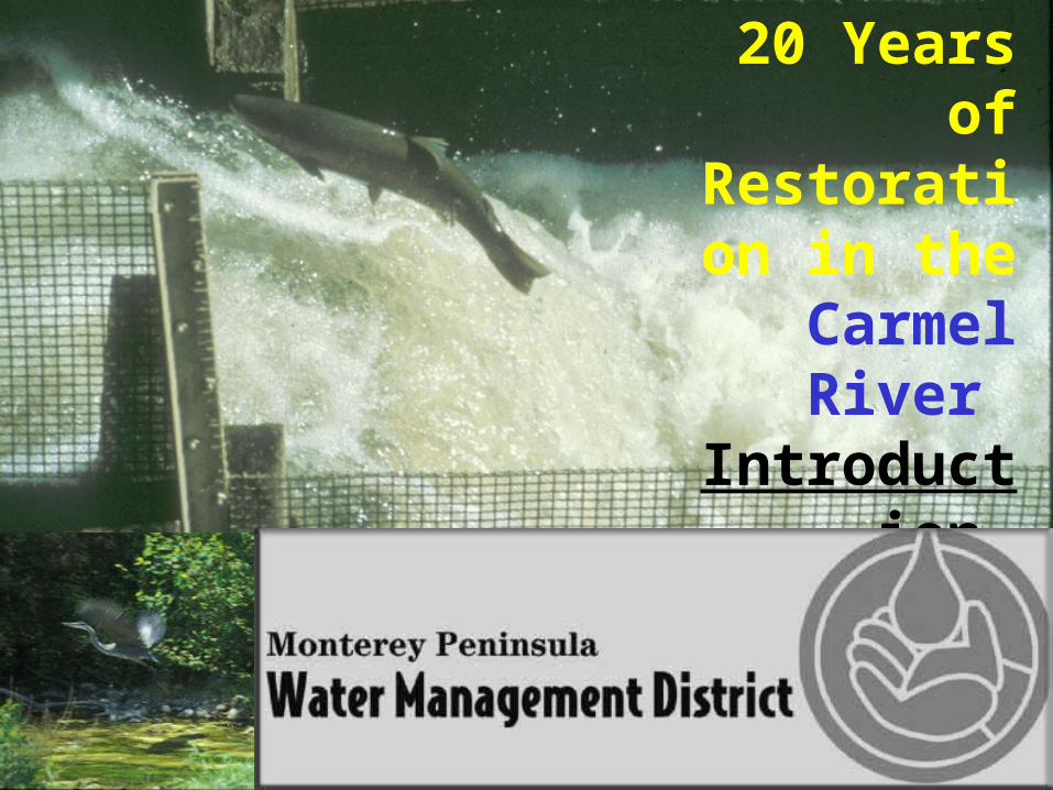
San Clemente Reservoir Drawdown Project
July 2003
To reduce the potential for catastrophic dam failure during an earthquake or very large flood, six ports were installed through the dam, 10 feet below the spillway level in June 2003 (lower center of photo). During low flow periods, the water level is drawn down to relieve pressure on the dam. The foreset slope (the leading edge of the sediment) can be seen in the center of the photograph. Silt and sand is expected to advance toward the dam and begin spilling in the very near future.

Except in extremely wet years, groundwater pumping causes a portion of the river to dry up annually. Here, in this 1980 photo, a well was located in the bottom of the channel (note the flow in the center of the photo), nine miles upstream of the ocean. Up to 15 miles were annually dewatered. After the addition of wells closer to the end of the river, pumping was shifted downstream, resulting in fewer miles of river going dry.
Groundwater Extraction

Steelhead Migration Impacted
April 30, 1987
Low flows in late spring combined with groundwater extraction leads to stranding of adults, smolts, and fingerling steelhead. Groundwater pumping lowers water levels, which ultimately dries up the river and results in dead and dying fish. Since 1984, MPWMD has annually rescued stranded fish from drying sections in the main stem. Depending on life cycle stage, fish are transferred either to the ocean or to perennial sections. This is a kelt, which is an adult returning to the ocean, that either evaded capture or died of natural causes.

Carmel River Restoration
January 10, 1982
Degradation of the riparian corridor culminated in an episode of erosion that scoured the channel and streambanks between 1978 and 1983. Faced with destroyed streambanks, a precipitous drop in the steelhead run, and an almost complete loss of streamside vegetation, property owners and concerned environmental groups demanded – and received - a restoration program. The program, which began in 1984 with funding from riverfront property owners and District water users, continues today.
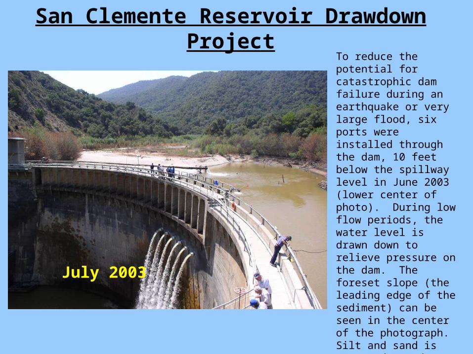
Left – looking upstream from the Schulte Bridge area. Prior to 1978, this reach was a single-thread channel, flanked by a dense riparian corridor. By the spring of 1982, erosion had transformed the reach into a braided, meandering channel with virtually no streamside cover.
Schulte Restoration Project
1983 1982
Left – looking downstream to Schulte Bridge.MPWMD carried out a pilot project in 1986 to restore this area using biotechnical methods (see Schulte Restoration Project). MPWMD continues protection and restoration work in the Carmel River under the District’s Mitigation Program.
Right – looking upstream from Schulte Bridge. With no streamside vegetation to hold the banks together, streambanks are prone to scour and slumping. Most of the concrete rubble seen here was placed on the streambank in 1982, washed out in 1983, and was replaced by tires banded together (see photo below). Prior to rules prohibiting the use of deleterious materials, property owners placed whatever material they could afford to on streambanks to prevent additional loss.

Mitigation Program
Fisheries
MITIGATION PROGRAM ANNUAL REPORT
(July 1, 2001 - June 30, 2002)
MPWMDhomepage
Carmel RiverRestoration Projects
In 1990, MPWMD certified the Water Allocation Program Environmental Impact Report, which officially recognized that water extraction practices were causing environmental damage. To mitigate for the damage, MPWMD enacted the Mitigation Program, which combined the District’s fisheries, riparian corridor irrigation, and river restoration programs into a single integrated approach to water supply and resource management. Because water extraction practices are still impacting the environment, the program continues today.
Please visit the links below for more information about MPWMD’s activities in the Carmel River and around the District.