INTRODUCTION - Shodhgangashodhganga.inflibnet.ac.in/bitstream/10603/120377/6/06_chapter 1.pdf ·...
45
CHAPTER-I INTRODUCTION The phenomenon of migration in society is universal and is applicable to all stages of human life. Any movement of people from the place of origin to another of settling down is generally known as migration Kaul, (2005). 1 The United Nations (1984) 2 defines migration as a change of residence from one civil division to another, with an intention to stay relatively permanently. Migration is also defined as a geographic movement of people involving a change from the usual place of residence for a particular period of time Rao (1986). 3 Migration, like fertility and mortality, holds a place of prominence in a geographical analysis of population change in any area Trewartha (1969). 4 Migration cannot be considered a mere shift of people from one place to another, as it is most fundamental to the understanding of continuously changing space-content and space-relationships of an area Gosal (1961). 5 The first and foremost aspect of the study is to know and understand the origin and trend of migration leading to the present distributional pattern of the Mizos in North East India. Moreover, it is also an attempt to ascertain the causes of migration responsible for the predominance of Migration Selection by various clans of the Mizos during the later part of 19 th century and early part of the 20 th century. In this regards, the classification will be based on Peterson‟s classification who adopted a variety of criteria, the most important being the distinction between migration which is undertaken in order to change the way of life (innovative) and that which helps to preserve it(conservative), Peterson (1948). 6 The purpose of the study is to examine the changing socio-cultural and politico-economic life of the Mizos in North East India, from their early days to the present day, which had developed slowly with the introduction of Christianity during the later part of 19 th century and early part of the 20 th century. The changes in their mosaic of cultures were unprecedented after India‟s attained her independence in 1947. These changes were indeed unprecedented since the launching of the First Five Year Plan in 1950-51. It paved the way for the Mizos to change for the better. The changes are visible in the educational, political, social and economic life of the people. The aspects of change studied here are both qualitative and quantitative in nature. The qualitative change includes changes 1
Transcript of INTRODUCTION - Shodhgangashodhganga.inflibnet.ac.in/bitstream/10603/120377/6/06_chapter 1.pdf ·...

CHAPTER-I
INTRODUCTION
The phenomenon of migration in society is universal and is applicable to all stages of human life.
Any movement of people from the place of origin to another of settling down is generally known as
migration Kaul, (2005).1 The United Nations (1984)
2 defines migration as a change of residence
from one civil division to another, with an intention to stay relatively permanently. Migration is
also defined as a geographic movement of people involving a change from the usual place of
residence for a particular period of time Rao (1986).3 Migration, like fertility and mortality, holds a
place of prominence in a geographical analysis of population change in any area Trewartha (1969).4
Migration cannot be considered a mere shift of people from one place to another, as it is most
fundamental to the understanding of continuously changing space-content and space-relationships
of an area Gosal (1961).5
The first and foremost aspect of the study is to know and understand the origin and trend of
migration leading to the present distributional pattern of the Mizos in North East India. Moreover, it
is also an attempt to ascertain the causes of migration responsible for the predominance of
Migration Selection by various clans of the Mizos during the later part of 19th
century and early part
of the 20th century. In this regards, the classification will be based on Peterson‟s classification who
adopted a variety of criteria, the most important being the distinction between migration which is
undertaken in order to change the way of life (innovative) and that which helps to preserve
it(conservative), Peterson (1948).6
The purpose of the study is to examine the changing socio-cultural and politico-economic life of the
Mizos in North East India, from their early days to the present day, which had developed slowly
with the introduction of Christianity during the later part of 19th
century and early part of the 20th
century. The changes in their mosaic of cultures were unprecedented after India‟s attained her
independence in 1947. These changes were indeed unprecedented since the launching of the First
Five Year Plan in 1950-51. It paved the way for the Mizos to change for the better. The changes are
visible in the educational, political, social and economic life of the people. The aspects of change
studied here are both qualitative and quantitative in nature. The qualitative change includes changes
1

in the tools and artifacts; modes of socialization, in their language and in their moral concepts. The
quantitative changes are the changes in different aspects of population composition, education,
political organizations and occupational structure of the people.
Soja (1980)7 the organization use and meaning of space is a product of social transformation,
translation and experience. Organization of space is a social product. It arises from purposeful
social practice. Raza and Ahmad (1977)8 Space and spatial organization are concepts that are basic
to geography. Spatial organization is the sum total and result of spatial process and structure.
Structure and process are cartulary causal and result in the evolution of particular spatial
organization. People generate spatial processes in order to satisfy their needs and desires and these
processes create spatial structures, which in turn influence and modify spatial processes. Activities
of the people generated by different processes interact with each other depending on the different
attributes of places and distance is the key determining factor in the generation of such processes
and evolution and spread of activities in space.
The organization of space in tribal regions may, thus, be seen as a manifestation of the ways of
adaptation to the environmental setting. These are determined by the historical process of peopling
of the traditional habitats by homogenous clan and kinship groups. As a result of their initial
occupancy of the habitats, clusters tribal hamlets acquired the character of a monolithic tribal core
region. A hill range served as a boundary separating the core region of one tribal group from the
other. Mackenzie (1988)9 the placement of tribes in spatial segments may be an outcome of a social
history of contact, confrontation and contestation between the ethnically differentiated tribes and
between them and the peasant groups, who hastened the process of their displacement from the
river valleys. Any understanding of social change remains incomplete without a proper
conceptualization of its spatial parameters.
Chandra (1991)10
it is a common place of understanding that the nature, direction and pace of social
change are never uniform in its spatial coverage. The organized and socially concretized space
provides friction to a uniform spread of social change; thereby making social transformation
spatially fragmented response. The geographical distribution of different social categories
differentiates the impact of social change as diverse categories have different capacities to respond
2

to the changes affecting them. Thus, the rate of social change may be phenomenal in areas which
have experienced large scale agrarian development historically, whereas, the dominantly tribal areas
have been only marginally exposed to such changes. However, a geographical variation in social
transformation depends to a great extent on the policy measures in developmental interventions. But
these changes have neither been uniform in social coverage nor in spatial extent. The pace and
direction of social change would be determined to a great extend by the limits imposed by the
nature or human freedom and the capacity of man to overcome such constraints through his own
creativity and dynamism.
In order to make the study more comprehensive and inclusive, the indigenous social structure of the
Mizos in various regions are analyzed and presented as a common platform to understand the
present form of adaptations by the people themselves. The indigenous social structure such as
family, religion, political, economic and the overall social institutions of the Mizos, as it existed
during the pre-Christian era is studied to know and understand the degree of adaptations in various
environments or habitats. In fact, in dealing with the present, we cannot ignore the past, because the
present life of the Mizos is the outcome of the past which had witnessed a series of change in the
process of their adaptations historically in time and space. Unless this is done, the focus of the
present study will remain vague and inadequate.
1.1: The People:
The term Mizos is a generic name given to a particular group of people inhabiting north eastern
part of the Indian sub-continent. The area includes parts of India‟s north east, extreme East of
Bangladesh and western part of Myanmar. In India these groups of people are concentrating mainly
in Mizoram, Manipur, Assam and Tripura. Sangkima (1992)11
the term „Mizo‟ is a generic term and
as such the different tribes or clans who inhabit the entire perimeter of the present Mizoram and
whose culture, traditions, dialects, etc. are similar are commonly designated by the term „Mizo‟.
The word „Mizo‟ is a compound of „Mi‟ and „Zo‟ and is generally translated as hillmen.12
But this
translation is not quite satisfactory because the word „Zo‟ as hill or mountain is not accepted by all
scholars of the Mizo people. For instance, according to Vumson, “The oral genealogy of Zo claims
that a man named Zo was the originator of all Zo people. So, the generic name „Zo‟ howsoever it is
3

being perceived has no relation with the geographical-climatic conditions of any region or
country”.13
Thus, from the above brief discussion, it is clear that it would be wrong to interpret the word Mizo
as Mi-“Man” and Zo-“highlands‟ thus people of high and cold place. It is rather a generic name by
which all the tribes under the Mizos are known in Mizoram and elsewhere in the world.14
However,
„Zo‟ commonly appears as an inclusive name among these peoples. With this consciousness of
commonness, the majority of the people call themselves „Zo‟, „Zomi‟, or „Mizo‟. According to
general understanding Mi simply means people, and Zo means hill. Thus it could mean either Mizo
(ethnic-base name) or Zomi (geographical-base name).15
However, in this study, the term „Mizos‟
is taken as a generic name by which all the tribes variously known as Kuki/Chin/Mizo/Zomi are
known all over the world.
The term Zo or Jo was mentioned as name of a people in a few historical publications of the Indo-
Burman peoples. Fanch‟o16
a diplomat of the Tang dynasty of China mentioned in 862 A.D. a
kingdom in the Chindwind Valley whose princes and chiefs were called „Zo‟. In 1783, Father
Sangermo17
mentioned in his book titled “A Descriptive of the Burmese Empire” the petty nation
called „Jo‟. G.A. Grierson recorded in 1904 “The name is not used by the tribes themselves, who
used titles such as Zo, Yo or Sho‟‟.18
Vanchhunga who had intensive investigations on all the Mizos
in Burma, claims that the forefathers of the Mizos used the phrase Keini Mizote chuan meaning
“We the people of Mizos”.19
However, the Mizos were known in early times to the British and others by various names such as
“Kuki”, “Chin” and “Lushai”. Mizos were first known as “Kuki” because they were the first batch
to have arrived in Mizoram. They were found during the reign of the Tipeperah Raja Chachag who
flourished about A.D. 1512. The name Kuki is given to the hill men by the Bengalis literally meant
„Wild hill people‟.20
“Chin” is another term by which the Mizos were known in Burma (now
Myanmar). It is believed to be a corruption of the Chinese word of Jin or yen meaning “Man”.
Grierson says that „Chin‟ in Burmese denotes all hill tribes living in the bordering region between
Burma and Assam.21
4

Finally, when the British intensified their intervention in Mizoram; they were called “Lushai”.
Theword “Luchye” a variant of Lushai, first occurs in a “Report of 1853” by Colonel Lister.22
The people of Mizoram disliked being called “Kukis”, or “Chin” and called themselves “Mizo”.
Similarly, the northen Zos in the northern part of Chin Hills and southern part of Manipur called
themselves “Zo, Zou or Zomi”. However, there is an exception to this acceptance and variations in
the generic name of the people. For instance, the Thado speaking group of Manipur accepted
“Kuki” as their nomenclature probably due to political advantages they are entitled by the
governments. Whatever may be the case, the term “Kuki” or “Chin” is a word unknown to the
people until recent times. These words are alien to the people themselves. T. Gougin rightly
observes: “the words like Kuki, Chin and Lushai are foreign words for the express reasons that
these words are completely alien to the language of the Zomis(Mizos).23
1.2. Racial Stock:
Racially the Mizos belong to the Tibeto-Chinese race. Lalthangliana (2000)24
claims that, “the
Mizos are the Assam-Burman sub-groups of the Tibeto-Chinese race. MIZOS are of the Assam-
Burman sub-group that branches from the Tibeto- Burman group of the main Tibeto-Chinese race.
The following diagram would make this point more clear.25
Tibeto-Chinese
Man Karen Tibeto-Burman Tai- Chinese
Tibeto-Himalayan Assam- Burman North Assam Mishmi
Naga Sak Burmese Mizo Kachin(Jinphaw) Lolo
Fanai (13)
Chawhte (10)
Ralte (45)
Chin (43)
Lusei (79)
5

Hmar (89)
Khawlhring (8)
Chawngthu (9)
Khiangte (7)
Ngente (6)
Tlau (4)
Vangchhia (3)
Renthlei (8)
Numerals written after the clan names show how much each clan was divided into sub-clans.
They belong to the Chin/Kuki family according to many scholars. Kunsstadter, (1967)26
Mizos are
grouped as part of the Tibeto-Burman family. They speak the Tibeto-Burman language.27
1.3. Classification of Mizos:
According to Nag (1993),28
“The word „Mizo‟, if taken liberally, will include all the hill people,
but it still does not identify a particular race. But, if the word „Mizo‟, is used in the restricted sense
to cover only those hill people who came together to this land and have same origin, similar
language, culture, cult and way of life, then the name bears significance. It is therefore concluded
that the word, „Mizo‟ is chosen in the restricted sense to mean the identity of the race”.
In this study, the term „Mizos‟ is taken and used as a generic name of the people who belonged to
the Tibeto-Burman race and speaking Tibeto-Burman Languages variously known as
Kuki/Chin/Mizo/Zomi in various part of North Eastern Indian Sub-Continent. Thus, in a nutshell,
the people considered „Mizos‟ exclusively include the ethnic tribes who are commonly called
„Chin‟ in Myanmar, Kuki, Zomi and Lushai in Manipur, Kukis under else while Tripura Halam-
Kuki Socio-Culture and Linguistic Organization (THKSCALO) in Tripura, Kuki and Mizo in
Assam, Meghalaya and Nagaland and „Lusei, Ralte, Mara, Hmar, Pawi, Paite, Thado, Vaiphei as
Mizo‟ in Mizoram.
The above descriptions of identifying the Kuki/Chin/Mizo/Zomi group of people proved beyond
doubt that these groups of people belong to one family tracing to one origin. They share many
things in common which make them inseparable as one people having the same traditions and
6

cultures in all aspects of life. These groups of people are also closely connected linguistically. The
general classification of the Mizos is highly complex and no all scholars agreed to the different
principles of classifying them.
The researcher has classified this group of people based on field survey, geographical locations,
languages and the lists of scheduled tribes of India recognized under various States‟ governments.
This classification is most acceptable by the different linguistic groups from various geographical
locations. So, the researcher has classified the „Mizos‟ on the basis of geographical locations and
Linguistic similarities based on his experiences and field visits to the length and breadth of their
occupied territory. Moreover, this classification is also done taking into consideration their
migration pattern, language affinity and their distribution over space and time; and the generic term
„Mizos‟ is used in a restricted sense. The following are four groups of Mizos on regional basis;
1.4. The Northern Groups:
The Northern Groups of the Mizos belong to various tribes and clans of the Chin/Kuki/Mizo racial
group of Tibeto-Burman, speaking Assam-Burman languages. These groups of people are scattered
in all the districts of different states, north of Mizoram. They are mostly concentrated in the
southern districts of Manipur. The state of Manipur is their main concentration areas and spread in
all neighbouring districts of Assam and Nagaland. The Chin-Kuki-Mizo groups of people of
Manipur and adjoining regions are the most diverse groups known and recognized under various
Scheduled Tribes of India among the Mizos. They depict the highest diversity due to many reasons.
The most notable reasons may be attributed to their entry into their present settlements in the long
process of their migration pattern. It is also highly attributed to the policy of successive
governments in Manipur from the very beginning of princely Monarch and Kings. According to the
Scheduled Tribe lists of Manipur, there are 35 recognized tribes of which more than half belongs to
the Chin-Kuki-Mizo groups. The Northern Groups of the Mizos are mainly known by the term
Kukis since time immemorial. They were indeed identified by this generic name since the time they
came into contact with other more advanced form of civilizations in North Eastern part of India.
The Kuki groups are classified and identified on the basis of the name they bear from the time they
have settled in this part of their settlement. It would not be wrong to say that they were called Kukis
from the very beginning they came in contact with the Princely Monarch of Bengal, Cachar,
7

Tripura and Manipur. It is this reason, the name bears significance. The Kuki groups can be divided
into two main branches on the basis of their migration pattern and present site of their settlements.
They are the old Kukis and the new Kukis. The old Kukis includes the following main tribes;
1. Anal. 2. Aimol. 3. Kom. 4. Chothe. 5. Lamkang. 6. Monsang 7.Chiru. 8. Purum 9.
Mirawng or Milawng. 10. Maring.
Most of tribes and clans of the old Kukis,(excepting some clans of Aimol, Kom and Chiru) have
accepted the nomenclature of Naga as their new racial identity. They joined the Nagafold in recent
times due to political and economic reasons only. They had accepted their new identity with a sense
of pride and dignity.
The New Kukis: The new Kukis includes mainly the Thadou-Speaking groups accepting the
nomenclature of Kuki as their generic name. They are recognized under the Thado-Kuki tribes in
Manipur and Kuki elsewhere in North East India. It includes the following tribes, sub tribes and
clans;
1. Baite/Biete 2. Chansan 3. Chongloi 4. Doungel 5. Guite ( vuite) 6. Hanneng 7.
Houkip/ Haupit 8. Haulai 9. Hengen 10. Hongsungh 11. Hrangkhol or Rangkhol 12. Jongte
13. Khawchung 14. Khawthlang 15. Khothalong 16. Khelma 17. Kholhou 18. Kipgen 19.
Lengthang 20. Thlangawm 21. Lhoujem 22. Lhouvum 23. Lupheng 24. Mangjel 25. Missao
26. Saihrem 27. Selnam 28. Singson 29. Sitlhou 30. Thadau 32. Thangngeu 33. UIbuh
34. Mate 35. Lhungdim 36. Khongsai 37. Gangte 38. Vaiphei 39. Simte and others.
Among the new Kukis whom people have known them as Kukis are few tribes who do not want to
be called and identified as Kukis. These groups of people are known by their brethren Lushai
(Mizo) as „the Hmar and the Paite‟. They include; 1. Hmar and their many clans. 2. Paite and their
many clans. 3. Vaiphei and their many clans. 4. Simte and their many clans. 5. Tedim-Chin and
their many clans. 6. Zo/Zou and their many clans.
1.5. The North Western Groups:
The North Western groups mainly comprise of Hallam-Kuki groups linguistically belonging to the
Kuki-Chin language family. The Chin-Kuki-Mizo groups are numerically insignificant but depict
the largest variations in dialects and languages. According to scheduled tribe list of Tripura, there
are three main tribes of the Kuki-Chin origin and their sub-clans. They can be classified on these
8

three main groups namely, the Hallams, the Kukis and the Lushais. The Hallams are also known as
Mila Kuki and are divided into several sub-clans which is refered as “Barki Hallam”. The Major
sub-clans of Hallams are; Kaloi, Kov-Bong, kaipeng, bong, Sakachep, Thangachep, Dab, Bongser,
Molsum, Rupini, Rangkhawr, Chorai, Langai, Kaireng, Ranglong, Naveen and Murasing. Among
Hallams; Kolai, Murasing and Rupini speak in Kok-Borok and their social and religious culture
also similar with Tripuri. They can be excluded from the Hallam Kuki groups.
The Kukis of Tripura includes the following twenty six sub-clans; Paitu, Chotlang, Khareng,
Baibek, Amrai, Chamlen, Batle, Riyete, Balta, Rangchon, Rangchia, Chhailoi, Jangtei, Pailai,
Beltu, Paite, Phun, Phuntei, Lentai, Hraltei, Sowailai, Powaktu, Dhum,Burdoia, Chhaljen and
Rangte. Thirdly, Lushais are another tribe under Kuki-Chin groups of tribes in Tripura. They live in
the Jampui range of the State. The Lushai groups or the Mizo will be included in the Central
Groups owing to their language and distribution over space and time. Thus, the North Western
Groups include the tribes and sub-tribes of Hallam and Kuki origin.They belong to the old kuki
tribes according to many scholars in India. The Hallam-Kukis of Tripura includes the following
tribes and sub-tribes;
1. a). Molson (b). Kaipeng (c). Hrangkhawl (d). Bongcher
e). Darlong (f). Ranglong (g). Dab (h). Halam (Khoknu/Nabin)
(i). Cholai (j). Longhai (k). Morsophang (l). Korbong
(m). Saihmar (n). Sahkachep (o). Thangachep (p). Bong
2. Biate. 3. Langrawng. 4. Bawng. 5. Bawm. 6. Pangkhaw. 7. Mawk.
In Tripura, there has been a conscious effort by the various Kuki tribes/sub-tribes to mould unity
through an acceptable language of common usage and, to this effect, they are organized under the
umbrella of the Tripura Halam-Kuki Socio-Culture and Linguistic Organization (THKSCALO).
Under the aegis of THKSCALO, the constitution Drafting Committee, with Pu. B.K. Hrangkhawl
as its Chairman and Pu. H.T. Kluma Darlomg and Pu. S.K. Darlong as members, drafted a booklet
entitled „Constitution / By -Law of the Tripura Halam-Kuki Socio-Culture and Linguistic
Organization‟. This booklet was approved and adopted on the 31st of May 1992 by the Central
Executive Committee of THKSCALO.29
9

The Kuki tribes of Tripura organized under THKSCALO are as under;
a). Molson (b). Kaipeng (c). Hrangkhawl (d). Bongcher
e). Darlong (f). Ranglong (g). Dab (h). Halam (Khoknu/Nabin)
(i). Cholai (j). Longhai k). Morsophang (l). Korbong
(m). Saihmar (n). Sahkachep (o). Thangachep (p). Bong
1.6. The Southern Groups:
The southern region comprises of two districts namely, Saiha and Lawngtlai districts. These two
districts are inhabited by distinctive tribes originated from the east and the west. The district of
Saiha is inhabited by mostly of the Mara people popularly known as the Lakhers. On the other
hand, the district of Lawngtlai is inhabited by mostly of two big tribes namely, the Pawis and the
Chakmas. Both of these two districts are in fact an autonomous districts council of the state of
Mizoram.
The district of Saiha is an autonomous district Council of the Mara people. The Maras are largely
homogenous. They consist of five principle sub-groups or clans. These are the Tlosaih-Siaha,
Zyhno, Hawthai, Chapi and Vytu. All these sub-clans of the Maras occupied separate territory of
their own right from the very beginning of occupying the present Maraland. Each and every group
speaks a dialect of their own with slight variant from other sub-groups. But all of them can
understand each other. The Tlosaih, one among the languages is the official language among the
Maras. It is the language which unites the Maras as one people having one ethnic identity.
The district of Lawngtlai is inhabited by two major tribes. These two tribes inhabit their own land
and having distinct traditions and cultures. They are the Pawis or the Lais in the east and the North
East and the Chakmas in the western fringe of the district. The respective lands of the Pawis and the
Chakmas are indeed an autonomous region under Mizoram. The Pawis as they called themselves
consist of various clans having distinct way of life. They were largely concentrated in and around
two big towns of Lawngtlai and Sagou in the North East, north of Kolodyne River. They were
originally from the Chin Hills and known to be one of the strongest as well as ferocious tribe of the
Mizos. They had originated from Chin Hills in Myanmar somewhere in the later part of the
seventeenth century.
10
1.7. The Central Groups:
The Central groups include a homogeneous groups belonging to various tribe and clan groups of
the Chin/Kuki stock. This region is taken as the Central and core region because these districts are
more or less inhabited by numerous clan groups who are identifying themselves by a common
nomenclature „Mizo‟ which is a unifying entity for all the Mizos in the world. This region also can
be identified as one linguistic region speaking in Duhlian dialect popularly known as the Mizo.
They are the most numerous among all other tribes. They are indeed belonging to all tribes and
clans included under various Chin/Kuki Clans in the distant past. But at present, these various
groups of Chin/Kuki clans accepted and identified themselves as „Mizo‟ which becomes a national
symbol of pride for all people alike in Mizoram and elsewhere.
Among these various groups, the Lushai groups owing to their big numbers, diplomacy and power
exerted their influence over other smaller tribes in the then Mizoram. Some of the tribes and clans
belonging to Kukis were pushed westward and northward by the powerful Sailo‟s Chiefs. Many of
them were conquered and subjugated by them and became one with them. It would not be out of
text to mention that the smaller tribes and clans subjugated under the Sailo‟s Chiefs were
assimilated and their dialects went to oblivion due to disuse for a very long time. But, these groups
of people maintained their distinct traditions and cultures in one form or the other. However, at
present, all the good traditions and cultures of all the tribes and clans are interwoven as the cultures
of the Mizos.
The intermingling of traditions and cultures became a potent force of transformation within the
Mizo society. In fact, the Northern and North Western groups are highly influenced by the Lushai
Chiefs in the past. This has led to the evolution of similar traditions and cultures throughout the
length and breadth of their Land. This also became a living testimony to prove that they belong to
one people having similar traditions and cultures. It can also be seen by the presence of common
clan groups among the Mizos of the present with their brethren outside Mizoram. They are in fact,
who originated from Chin Hills in Myanmar at around 1700 A.D. This points out that, these groups
of migrants belong to the third wave of the Mizos to the present settlement in India‟s North East. As
has been mentioned at the outset, they belong to the Lushai groups who pushed westward and
northward to the old and new kukis as they were known. The Mizo/Duhlian speaking group of
11

people originated from Seipui Village in Chin Hills of Myanmar in the beginning of 17th century.
The Mizos in the Central Groups comprise of a number of tribes which may be broadly divided into
five major and eleven minor sub-tribes. This classification of the Tribes, Sub-Tribes and Clans are
based entirely on Liangkhai‟s “History of Lushai” (2002 ), Vanchhunga‟s “Lusei leh a vela Hnam
dangte Chanchin” (1955 ) and Zatluanga‟s “Mizo Channchin” is as under;30
The five major tribes are;
1. Lusei
2. Ralte
3. Hmar
4. Paite and
5. Pawi
The eleven minor sub-tribes are known under a common name of AWZIA.
Lusei:
The Lusei consists of ten commoners and six chiefs‟ clans. These are Pachuau, Chhangte,
Chawngte, Hauhnar, Chuaungo, Chuauhang, Hrahsel, Tochhawng, Vanchhawng and Chhakchhuak.
The chiefs‟ clans are Zadeng, Palian, Thangluah, Rivung, Rokhum and Sailo.
Ralte:
This is the sub-tribe, which according to the legend produced a couple who made such loud noise
that the guardian-god of the cave closed the cave stopping all further exit of human beings to the
surface from under the earth. The clans under Ralte are Khelte, Siakeng, Relhchhun and Kawlni.
Hmar:
Hmars are one of the most numerous. They are as many as thirteen clans. These are Lawitlang
(Hrangchal), Zote, Khawbung, Ngurte, Thiak, Leiri, Lungtau, Banzang, Pakhuang, Darngawn,
Biate, Hrangkhawl and Hmar-Lusei. The last one is so named because they are the descendents of
Chuauhanga Lusei who lost his way and joined hands with the Hmars.
Paite:
The Paites trace their descent from the sun. The Legendary Liandova and his brother are said to be
their fore-fathers. The most powerful clan amongst them is the Suktes who had been upholding the
chieftainship among them.
12

Pawi:
There are three main divisions among them. The first are those descended from Hringluma; the
second are those who stayed back at Falam area of Burma and the third are the Fanais.
Awzia:
Under this common name, there are as many as eleven sub-tribes. They had either lost their
distinctive dialects or forgotten them as a result of disuse when they mingled with the larger groups.
They have not, however, lost their separate identities. Some of the most notable characters in the
ancient history of the Mizo people belonged to some of these minor sub-tribes. These sub-tribes are
Chawngthu, Chawhte, Ngente, Khawlhring, Khiangte, Pautu, Rawite, Renthlei, Tlau, Vangchhia
and Zawngte.
The above classification by famous Mizo Historians are accepted and authenticated by the
researcher and taken as a basis of classification of the Mizos in Central Regions. The classification
in the Central Regions is all encompassing and inclusive of all various cognate tribes of the Mizos
all over the world. Indeed, it was this reason the need for a common nomenclature was felt first in
the present Mizoram as early as the 1950s. The people of Mizoram at this time were simply known
as the Lushai and the government of India wanted to recognize them as „Lushai Tribe‟. But, it
would not represent all the clans belonging to various tribes at that time. Thus, the word „Mizo‟ was
chosen and preferred by the people to represent all cognate tribes in Mizoram.
Finally, the movement for changing the name from „Lushai‟ to Mizo as the racial identity took its
stand in the Parliament of India and in consequence, the name „Mizo‟ rather than „Lushai‟ as the
racial identity came into force with effect from 1.9.1954 by the Act 18 of 195431
. The term „Mizo‟
by the Act 18 of 1954 is most inclusive and applied to all tribes, sub-tribes and clans of the
Chin/Kuki/Mizo/Zomi groups of people. Thus, the racial identity „Mizo‟ recognized by the
Government of India stands for all tribes of Mizoram belonging to various clans of the so called
Chin/Kuki/Mizo/Zomi family. It should also be mentioned that the sub-groups of different regions
are the branches of the main tree. These groups and sub-groups will be regarded and addressed as
Mizos hereafter. Thus, the study will relate to the Mizos of the above four geographical locations
which nearly fit Linguistic Regions of all the Mizo Tribes.
13

The above description of classifying the Mizos is only a view of the author which needs to be
studied and researched more closely. This does not necessarily express the view of others or
contradicts other scholars of other allied disciplines. It is an attempt to highlight the Mizos as one
people having same, similar or common cultures and traditions occupying one contiguous territory
in the Indian Sub-Continent.
1.8. Waves of Migration from Chin Hills:
According to Thanga, (1970)32
who wrote a book in Lushei dialect on the ancient history and the
culture of the Mizo people, „they came to the Chindwin belt about 996 A.D. They lived here barely
two hundred years. According to Mizo historians, the first stage of halt in the migration from
Kabaw Valley was at Len Tlang (or Inbuk Tlang) west of Manipur River, a long range of hills
running north-south parallel to Manipur River. The approximate year of occurrence is about 1466
A.D. According to Zawla (1970)33
down from the Kabaw Valley to the Chin Hills that is
specifically „the Len Tlang range‟ the tribes were said to have settled down for few centuries. They
formed themselves into clans and established villages where they lived clan wise. Sangkima,
(1992)34
they established villages and settled down clan-wise and gave clan‟s name to the villages.
Accordingly, Lusei settled at Seipui, Khawkawk and Khawrua; Ralte clans at Suaipui and Saihmun.
The movement of the people started to be based on tribes and clans from the said Len Tlang range.
The migration from here took place in three different phases.
The so-called old Kukis were the first to migrate from the Chin Hills. These groups of people were
identified as the Rangkhol, Bete, Hallam, Langrong, Aimol, Anal, Chiru, Hiroi-Lamgang, Koiren,
Kom, Purum, Hmar, and Cha.35
They were the first group to reach Mizoram and pushed further to
Tripura by the new Kukis. It should be mentioned that the Raja Gobind Chandra, (Raja Govind
Chunder in his feud with Senaputty), the Raja of Cachar employed them in his armies in the year
1828 to 1829.36
From here they moved to North-Cachar Hills of Assam. The other group of old
Kukis who were pushed to Manipur included the Anals, Chothe, Aimol, Chiru, Kom, Monsang,
Lamkang etc.
The second wave of migration started with the new Kukis. The new Kukis of Changsen, Thado,
14

Hawkips, Shingson etc. migrated and trailed to Tripura. But they were pushed back by Col. Lister
for creating troubles in British frontiers.37
From here they moved to North-Cachar Hills of Assam.
Finally they entered to Manipur trailing some groups of one branch of old Kukis.
The third and final wave of migration was by the Lushai. The „Lushai‟ group came to the present
habitat in the beginning of the 18th century after driving out the new Kukis. The „Lushai‟ group also
composed of various clans and the most prominent of them was the Sailo clan whose origin may be
traced back to Thangura, one of the six sons of the pedigree of Sailo clan, called Zahmuaka. The
other sons were Zadenga, Paliana, Thangluaha, Rivunga and Rokhuma whose descendants formed
separate clans after their names.38
The migration pattern and their distribution will be dealt in
greater detail in the subsequent chapters.
1.9. Salient Features of the Land:
The land they occupy extends approximately from latitude of about 20o 30‟ to 25
o 30‟ north
latitudes and longitude extends of 92o 10‟ east to 94
o 20‟ east longitudes
39. The majority of the
people occupy the Indo-Burma ranges, a series of parallel mountain chains running north-south
along the Indo-Burma boundary. The mountain ranges are a continuation of the Naga and Patkoi
hills, extending as far south as Arakan Yomas.
The Land they inhabited in the Indian administered region is bounded by States of Nagaland and
Assam in the north, in the East and South by Myanmar and in the West by Bangladesh. The salient
features of their land as observed by the researcher relate to the physiographic features and the
climates. The study of the climates relate to only the core regions where the Mizos are in majority
and generalized to represent the whole territory. It will comprise of all the districts of Mizoram and
southern districts of Manipur. The other areas will be generalized with the core regions as these
areas are located in the peripheral areas contiguous with other lands belonging to separate
jurisdictions of different States. This is decided due to its sensitivity on the issue of Land in North
East India.
The land is mainly a continuous Mountain chains running north to south. These mountain ranges
are parallel ranges separated by narrow river valleys and intermontant valleys. Based on the relief
the Political division of the study area is shown on Map-2 in the following page;
15

16

The Relief in Mizoram and Adjoining Areas:
Mizoram lies in between 21o 56‟ N – 24
o 31‟N latitudes and 92
o 16‟ E-93
o 26‟E longitudes.
40 The
whole of Mizoram is continuous mountain ranges of the great Himalayan ranges. The mountain
ranges run from north to south and tend to grow higher in the eastern side and taper off to the north
and south. The ranges are separated from one another by rivers which flow either to the north or
south creating deep gorges between the hill ranges, with only very small patches of plains.41
The
physiographic divisions of Mizoram can be broadly classified into the following units.42
(A). The Mountain Ranges:
The eastern half of the state can be classified as mountainous terrain province. The overall relief in
this province is higher and the slopes are much steeper than in the western half. The altitude here
scales from 400 to 2157 meters. The high points are generally over 1000 meters. Average elevation
in this province is in the order of 1500 meters. The slopes are very steep and elevation difference
between the ridge top and the valley varies between 200 to 600 meters. The ranges are aligned
mostly in north-south direction.
(B). The Ridge and Valley Province:
The western part of mizoram depicts characteristic ridge and valley type of topography. This
province covers nearly half of the area of the state. The relief in this province varies between 40 to
1550 meters and the average elevation is 700 meters. The relief is low in the western part and rises
higher towards the east. The hill trend is approximately NNW-SSE to NNE – SSW direction, higher
in the central part and tapering towards north and south. The slopes are generally steep on the
western side of the ridge; and elevation difference is between valley floor and hill top is in the order
of 100 to 200 meters. Yet, conspicuous mountain ranges are observed in this province. They are
Mamit range and Hachhek ranges in the western part of the state.
(C). The Champhai Flat Uplands:
There are only few patches of flat lands in Mizoram. They are mostly intermontant plains located in
the midst of hills and narrow valleys. These plains are believed to have been formed in the beds of
silted-up lakes as they are covered by rich alluvial soils. The largest plain in Mizoram is located at
Champhai. Champhai flat uplands43
have a length of only 11.27 kilometers and the widest part is
17

4.83 kilometers across. The second largest plain like topography is situated at north Vanlaiphai in
the south eastern corner of Aizawl district and Thenzawl in the southern part of Aizawl district.
Mention also may be made to numerous small plains at Tuisenhnar near Khawzawl in the east,
Zawlpui by the side of Mat River, Phaisen and Chhimluang, west of Bilkhawthlir village in the
north, Hortoki and Bairabi along the Tlawng River in the western part and Ngengpuiphai by the
side of river Ngengpui. There is also a vast plain area called Chamdur in the western part of
Chhimtuipui district, which at present is thickly vegetated.
(D). The North Tripura Hills:
The land is mainly a continuous Mountain chains running north to south. These mountain ranges
are parallel ranges separated by narrow river valleys and intermontant valleys. The topography is
sloping towards the western part. Based on the physiography, the relief can be broadly divided into
the following divisions;
The Eastern part of the topography is higher in compare to the western part. This region is having
an elevation of 1000 to 2000 meters above mean sea level. It is continues mountain ranges
interrupted by few valley type topography.
The western part of the topography is dissected by more valleys which make the topography look
undulating.
The Relief in Manipur and Adjoining Areas:
The Mountain Topography:
The Mountain topography in the Northen Regions can be mainly studied under two Mountainous
belts. These mountainous belts are in fact a mountain chains formed separately during the past
geological period. These two mountain belts can be broadly studied under two separate mountain
systems. These are;
(A). The Manipur Hills:
The ranges in parts of Manipur are divided into two parts by the majestic Manipur River. The
eastern ranges fall in Chandel, Senapati (Sadar Hills) and Ukhrul districts of the state. On the other
hand, the western part of the ranges fall under Churachanpur and parts of Tamenglong and Senapati
(Sadar Hills) districts. The mountain ranges in the east slopes towards the south. The average height
18

of the topography ranges from 600meters to 1600meters. The highest mountain peak in this region
is found at the border with Myanmar in the extreme south of Manipur. This mountain peak is
known as Khuangtal Phuaipi with an altitude of 1600 meters above mean sea level. The relief of the
eastern ranges is interrupted by the presence of river valleys depending on the drainage system in
the area. There are four important river systems that drain the region. These river systems are the
Kangpokpi River in the north, the Chakpi River and Tera River in the central part and the Kana
River in the south. These river systems produce their respective fertile alluvial plains becoming the
hub of human habitations. These river valleys are highly productive and support more than 80
percent of the population in their respective regions. In other words, these river valleys are the life
support base of the people. On the basis of the drainage systems, the following river valley plains
can be studied in detail:
(B). The Kangpokpi Valley:
The Kangpokpi Plain is situated to the north of Imphal Valley. It is located on the banks of the
northern part of river Imphal. It is an elongated valley all along the river valley. It is approximately
20 kilometers long and having a widest expand of almost 8 kilometers near Kangpokpi town. It
slopes towards the south and connects the Imphal valley north of Sekmai Township. It has an
approximate gradient of 250 meters to 400 meters in the north. It is one of the most fertile lands in
the area accommodating 80 percent of Sadar Hills‟ population. This plain is extensively cultivated
and becomes the granary of Senapati district as a whole. Rice is a major crop of the region. It is
grown in 90 per cent of the crop area. The other major crops include maize, bajra, mustard and all
types of vegetables.
The biggest settlement in the valley is the Kangpokpi Township. It is inhabited mainly by the
Thadou-Kuki communities. These groups belong to the new Kuki group of the Mizos. The other
important villages include Motbung, Maphou and others.
(C). The Chandel Valley:
The Chandel Valley also known as the valley of life is situated at the heart of Chandel district. It is
located on the banks of Chakpi River. It is the northern most alluvium deposited at the foothills of
the mountain. It is so to say alluvial fan or cone type of sediments deposited at the foothills. It is
19

oval in shape with approximately 20 – 30 square kilometers. This plain in reality is not a continuous
plain but undulating plain. It is interrupted by the presence of small hills as well as ridge type of
topography. This plain is also extensively cultivated in both seasons of kharif and Rabi. The major
crops of Kharif are rice, maize, bajra and vegetables. The Rabi crops include mustard, potato,
cabbage and others.
The biggest settlement in the valley is the Chandel Township. It is inhabited mainly by the Anal,
Monsang, Lamkang, Chothe, Maring communites. These groups are the old Kuki groups of the
Mizos. The other villages surrounding are Pangpung, Kajeng Khuanou and others.
(D). The Chakpi River Valley:
The Chakpi River Valley in the south is situated in the Chakpikarong Sub-Division of Chandel
district. It is located 15 kilometers south of the Chandel Valley. It is found at the mouth of Chakpi
River just before joining the Imphal River at Serou town. It is the most extensive river valley in the
district. It extends from Serou to as far north as Tuinou village near the foothills. This river valley
also slopes towards the north till it joins the Imphal River. This river valley is basically formed by
two biggest rivers of the district. These rivers are the Chakpi River and the Tera River. The plain
has an approximate length of 15 kilometers. The widest part of the plain is located in the meeting
point of the two big rivers namely; Chakpi and Tera Rivers at Chakpikarong Township.
On the basis of its gradient, this valley can be divided into three parts. The northern most part is the
Tera plain which is primarily formed by the two rivers. It is almost triangular in shape with the apex
in the south. The base of the plain is formed by the foothills. The central plain is the Nungpan plain
stretching from Chapikarong town to Nungpan village. It is mostly located on right bank of the
Chakpi River. The southern most part of the plain is Toupokpi-Singtom plain. This area is quite
extensive due the extension of Imphal valley. It is in this part of the river valley that we can see the
changing nature of river course in the flood plain. This part is marked by the presence of various
types of ox-bow lakes. One such prominent lake is the Siamkhoninglhi south of Singtom village.
This plain is also extensively cultivated in both seasons of kharif and Rabi. The major crops of
Kharif are rice, maize, bajra and vegetables. The Rabi crops include mustard, potato, cabbage and
other crops.
20

The biggest settlement is the valley is the township of Chakpikarong with 2000 households. It is
inhabited mainly by the Anal community. The other villages surrounding are Salluk, Nungpan,
Toupokpi, Sigtom and other villages.
(E). The Sachich Tampak:
The Sachich Tampak also known as Kana Area is a crescent shape river valley formed by the Kana
River and its tributaries. It is relatively a narrow plain with only 5 kilometers width in its widest
expands at Gelngai village. Nevertheless, the plain is having a length of approximately 20
kilometers. It extends from the north in Moulnuam village to as far south at Old Kanan villge. This
plain is also sloping towards the north until it joins the Imphal River in between Moultom village
and Singheu village of Churachanpur district. It is one of the most fertile lands in the area
accommodating 90 percent of the Kana Area‟s population. This plain is extensively cultivated and
becomes the granary of the area.. Rice is a major crop of the region. It is grown in 90 percent of the
crop area. The other major crops include maize, bajra, mustard and all types of vegetables.
The biggest settlement in the area is Sachhih village with 400 households. It is inhabited by the
Zou community. The other villages surrounding are Kholian, Kathuang, Paldai, Phuaikon, Salem,
Thingsen, Haika, Luangza, Gelngai and other villages.
The topography in parts of Churachanpur district is also a parallel mountain ranges running north to
south. The mountain ranges in the west slopes towards the south. The average height of the
topography ranges from 600 meters to 1600 meters. The highest mountain peak in this region is
found south of the Churachanpur town known as Singbung Mual. This mountain peak with an
altitude of 1700 meters above mean sea level has many Mythical stories of the local populace. The
relief of the western ranges is interrupted by the presence of river valleys depending on the drainage
system in the area. These ranges are also interrupted by river valleys with fertile alluvial plains. The
most notable river plains include:
(F). The Churachandpur Plain:
The Churachanpur plain is an oval shape valley formed by river Tuivai and its tributaries. It is
relatively a small valley which is roughly about 10 sq. kilometers in area. The plain is situated at a
distance of 20 kilometers south of Moirang Township. The district headquarter Churachanpur is
21

located at the western part of this plain. Churachanpur Township by the local populace is known as
Lamka. The literal meaning of the term Lamka means meeting place of many roads. It is the most
productive region of the district. As in the case of other areas this plain is also extensively
cultivated. The major crops are rice, mustard, vegetables etc.
The biggest settlement is the area is the town of Churachanpur with an approximate population of
one lakh. It is inhabited by the Zo communities. The other villages surrounding the town are
Rengkai, Thingkanphai, Phaisen and others.
(G). The Tuining-Sangaikot Valley:
The Tuining-Sangaikot valley is located in between Sugnu and Churachanpur. It is practically filled
up sediments between two mountain ranges running north to south. The plain is bounded in the
north by the Thangzing Mountain range south of the Imphal Valley, in the west by the Khuainuai
Mountain range, in the east by the Sangaikot range. The Valley merges with the continuous
mountain ranges of the south near Saiboh Village. It is the most productive region of the area. As in
the case of other areas this plain is also extensively cultivated. The major crops are rice, mustard,
vegetables etc.
The biggest settlement is the area is Tuining village with 300 households. It is inhabited by the Zou
community. The other villages are Sangaikot, Kanan, Saiboh, Gangpimoul and other villages.
(H). The Moultom-Singheu Plains on the Banks of Imphal River:
The Moultom-Singheu plain on the west bank of Imphal River is basically the southern most part of
the Manipur or Imphal valley. It is formed mainly by the sediments brought down by the Imphal
River. It is located 15 kilometers south of the Serou town of Thoubal district. It is narrow elongated
valley all along the Imphal River. It is highly fertile and productive. It is from Singheu village
where the Imphal River enters the mountainous part of Manipur to continue its journey to the Chin
Hills of Myanmar. As in the case of other areas this plain is also extensively cultivated. The major
crops are rice, mustard, vegetables etc.
The biggest settlements in the area include Singheu, Moultom, Khuainuai and others. with an
approximate of 300 households. It is inhabited by the Zou community.
22

The Dima Hasao Hills:
The land is mainly a continuous Mountain chain. It is part of the Barail range running south-west
to north-east direction. It mainly forms the southern part of the Barail range. The southern part is
the broadest and merges with the Mismi hills near Haflong Township. The northern part of the
range merges with the Naga Hills at south of Dimapur town.
This region is having an elevation of 1000 meters to 2000 meters above mean sea level. It is
continues mountain ranges interrupted by few valley type topography. The Haflong region is
dissected by more valleys which make the topography look undulating.
1.10. Climate:
The climate of the region is primarily tropical in nature. The tropic of cancer passes through
Thenzawl south of Aizawl. This has a tremendous impact on the climate of the region. In all parts
of the region, the four seasons can be experienced at right intervals. The climate thus, is basically
characterized by the South west Monsoon wind of the Bay of Bengal branch. The climate
throughout the region though similar in all respects, is neither very hot nor too cold throughout the
year. The climate is humid tropical, characterized by cold and dry winter, long summer with
moderate to heavy rainfall in the valley and the mountain ranges. The highest temperature is
observed during the summer months with an average monthly temperature of 27º Celsius.
Thereafter, the onset of monsoon brings down the temperature. In autumn, the temperature is
usually between 20º C to 30º C. In winter, temperature records normally 10º C to 25º C.
The study area enjoys a moderate climate. It is neither very hot nor too cold throughout the year.
The climate is humid tropical, characterized by short winter, long summer with heavy rainfall.
The western part is usually hotter than the eastern part. The eastern part is pleasant and cool even in
summer. The climatic conditions are largely influenced by the Monsoon winds.44
The salient
thermo characteristics of Mizoram and adjoining regions are that temperatures do not fluctuate
much throughout the year, excepting in the low-lying valley sites. The highest temperature is
observed during May, June and July. Thereafter, the onset of monsoon brings down the
temperature. The temperature continuous to fall with the break of the monsoon rains, and it is
lowest in December and January. In autumn, the temperature is usually between 19º C to 25º C. On
the other hand, the winter temperature records normally 11º C to 23º C and the summer temperature
23

usually between 21º C and 31ºC. During the last twenty years or so steady increase in temperature
has been noticeable as felt in the global context, mainly due to the large-scale degradation of
vegetation and mismanagement of environment.45
The variations in temperature in the core regions of concentrations from the monthly average
temperature recorded in eight districts of the study area. These included all the districts of Mizoram
and Churachandpur district of Manipur. However, the study would be based on different years due
to availability of temperature and rainfall data in the region. These regions are taken as a nodal
region representing the whole areas under the study. The following table represents the average
monthly temperature and rainfall in Mizoram for the years of 2006 and 2007.
Table 1.1: Monthly Average Temperature of (in ºC) and Rainfall (in mm) in Mizoram.
Sl.NO.
Months
2006 2007
Temp’ Rainfall Temp’ Rainfall
1. January 18.13 0.13 17.31 0.00
2. February 20.67 1.04 17.48 59.85
3. March 22.68 2.98 21.46 23.94
4. April 23.46 22.47 22.48 217.16
5. May 22.70 432.55 23.90 376.15
6. June 22.41 557.96 23.98 506.21
7. July 23.98 426.36 23.29 433.04
8. August 23.79 286.13 23.81 462.42
9. September 23.65 223.90 23.88 602.32
10. October 23.01 123.52 18.77 212.54
11. November 20.83 4.88 20.81 122.81
12. December 18.55 0.00 18.38 1.25
13. Average 21.98 2081.92 21.29 3017.69
Source: Statistical Handbook of Mizoram-2008, Directorate of Economics and Statistics,
Mizoram.
24

The temperature and rainfall data of these two years can be represented in line and bar diagrams as
under;
Figure 1.1: Average Monthly Temperature in ºC of 2006 and 2007.
Figure 1.2: Monthly Rainfall in (mm)
25
0
5
10
15
20
25
30
Monthly Average Temperature in ºC - 2006 & 2007
2006
200
7
0
100
200
300
400
500
600
700
Monthly Rainfall in Millimeter
2006 2007

The area under study is under the direct influence of monsoon. It rains heavily from May to
September. The average rainfall is 251.47 mm per annum in 2007. The north western part of the
state receives highest rainfall i.e., more than 350 mm per annum. The rainfall also increases
southward with increase in humidity. Precipitation is heavy in summer, normally from May to
September, and lasts till late October. Normally, July and August are the rainiest months, while
December and January are the driest months. There is not much areal variation of rainfall in the
Region, though southern part gets relatively more rainfall than the north.
Table 1.2: Annual Average Rainfall (in mm):
Sl.No Districts 2006 2007 2008 2009
1. Aizawl 1824.30 2776.94 1790.24 1676.49
2. Lunglei 2206.90 3435.47 1861.07 2313.80
3. Mamit 2215.00 2795.33 2189.25 2662.07
4 Serchip 1849.50 2942.55 1868.84 1486.52
5. Champhai 1970.75 2874.93 1764.33 1566.18
6. Kolasib 2452.67 2919.00 2020.95 1710.40
7. Lawngtlai 2133.00 2986.60 1929.20 2098.45
8. Saiha 2534.50 3410.71 1983.40 3244.90
Source: Statistical Handbook of Mizoram-2010, Directorate of Economics and Statistics, Mizoram.
The average monthly temperature conditions in Churachandpur at Tinsong centre is represented
with maximum and minimum values in the year 2001 and 2002 respectively. The average minimum
temperature recorded in the year 2001 was 10.0º C which has shown a decline of 3º C in 2001 with
a minimum of 7.0º C. The average maximum temperature recorded in both of these years also
showed a decline of 2º C where the average maximum in 2001 was 39.0º C and 37.0º C in 2002. In
both of these years, the average maximum temperature is recorded during the summer months
where diurnal range is very less. On the other hand, the lowest temperature is recorded in the
months of December, January and February only. The following table shows the average monthly
temperature in Churachandpur at Tinsong centre and is represented by a line graph as below;
26

Table 1.3: Monthly Average Temperature (in ºC ) in Churachandpur at Tinsong centre.
Sl.NO.
Months
2001 2002
Min. Max. Min. Max.
1. January 10.0 34.0 8.0 32.2
2. February 10.0 35.0 7.0 30.0
3. March 10.0 35.0 7.0 19.0
4. April 14.0 34.0 15.0 30.0
5. May 10.0 34.0 15.0 37.0
6. June 15.0 34.0 16.0 30.0
7. July 18.0 30.0 20.0 30.0
8. August 18.0 30.0 20.0 30.0
9. September 18.0 30.0 20.0 30.0
10. October 10.0 38.0 20.0 32.0
11. November 14.0 39.0 15.0 28.0
12. December 11.0 36.1 11.0 23.0
13. Average 10.0 39.0 7.0 37.0
Source: Statistical Handbook of Manipur, 2002; IFCD, Manipur; Directorate of Agriculture,
Manipur and Directorate of Horticulture, Manipur.
Figure 1.3: Monthly Temperature in C showing Minimum and Maximum of 2001 and 2002
27
05
1015202530354045
Monthly Temperature in ºC
2001MinimumMaximum
2002Minimum Maximum

The average monthly rainfall conditions in Churachandpur at Tinsong centre shows highly
variability in the district. The rainfall is mostly concentrated during the months of June to October.
The rainfall decreases with the beginning of winter months in the district. Therefore minimum
rainfall is received during the winter seasons and spring seasons. The following table shows the
average monthly rainfall in millimeters;
Table 1.4: Monthly Average Rainfall (in Centimetre) in Churachandpur at Tinsong centre.
Sl.No. Months 2001 2002 2003
1. January Nil 1.20 Nil
2. February 2.10 Nil 1.60
3. March 9.80 3.70 5.00
4. April 33.10 6.80 24.60
5. May 12.30 3.40 17.15
6. June 54.30 65.40 51.72
7. July N.A 49.80 67.57
8. August N.A 57.00 62.07
9. September N.A 44.60 66.70
10. October N.A 59.80 24.90
11. November N.A 5.80 NIL
12. December N.A 9.30 NIL
13. Average N.A 306.80 321.28
Source: Statistical Handbook of Manipur, 2002; IFCD, Manipur; Directorate of Agriculture,
Manipur and Directorate of Horticulture, Manipur.
The above table indicates the rainfall received has shown a decreasing trend from the year 2001.
The rainfall received in the month of February in 2001 was 2.10 cm, which was decreased to 1.60
cm. in the same month in year 2003. The rainfall recorded in the month of June, 2001 was 54.30
cm. But, in the year 2003 the rainfall recorded in the same month was 51.72 cm. However, in the
month of May, 2001 and 2003, the rainfall recorded has shown an increasing trend from 12.30 to
17.15 cm. Nevertheless, the average rainfall received in 2003 was 321.28 cm which has shown an
increased from 306.80 cm. in the year 2002.
28

The average monthly rainfall at Tinsong Centre in Churachandpur district is also represented by a
line graph as shown below;
Figure 1.4: Monthly Average Rainfall in millimeters
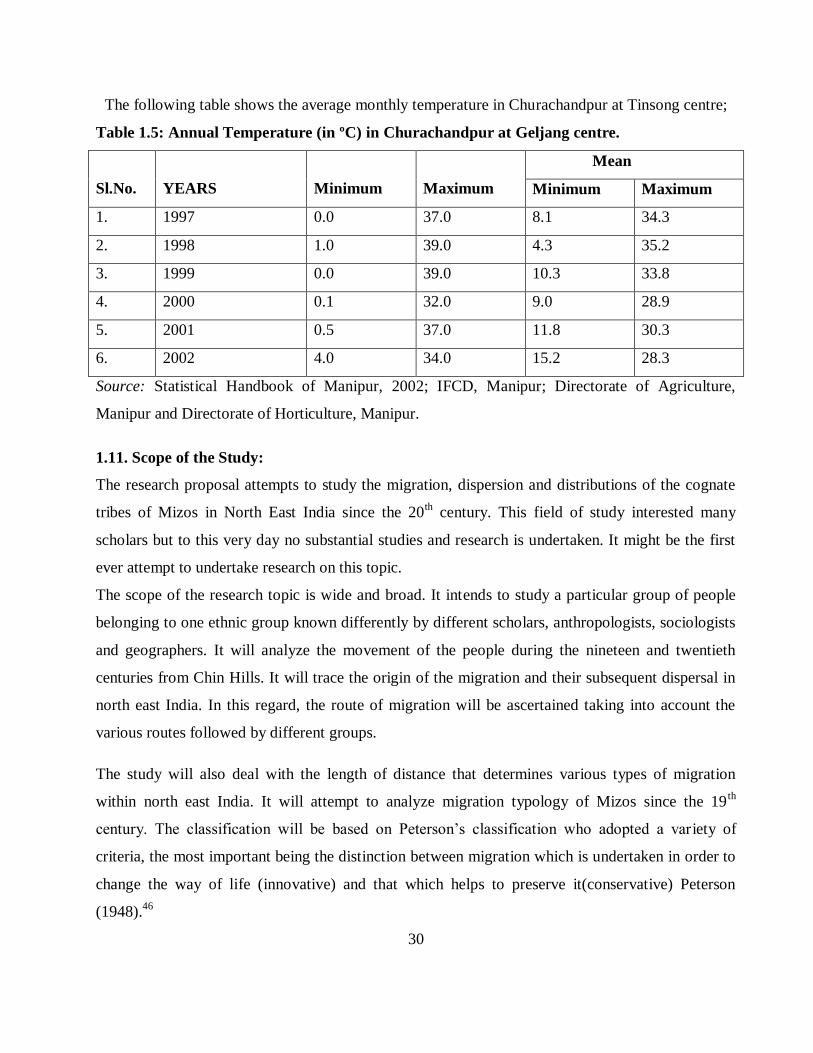
The average annual temperature conditions in Churachandpur at Geljang centre is represented with
maximum and minimum values for the years 1997 to 2002 to show the trends in the change in
Temperature of the district. The average mean minimum and maximum temperatures from 1997 to
2002 were also shown to indicate the changes in temperature conditions in the district. The
minimum and maximum temperature recorded since 1997 to 2002 had shown a range from 0.0º C
to 39.0º C. But, the increase in temperature is seen from the range of temperature in the year 2002
with a minimum of 4.0º C to a maximum of 34º C. Another very interesting change in temperature
is also seen on the mean average temperature since 2000 A.D. The mean minimum temperature
recorded in the year 2000 was 9.0º C which was increased to 15.2º C in the year 2002. This has
shown an increased of 6.2º C between 2000 and 2002 A.D.
29
0
10
20
30
40
50
60
70
80
RA
INF
AL
L I
N C
EN
TIM
ET
ER
S
AVERAGE MONTHLY RAINFALL IN CENTIMETERS
RAINFALL IN 2001 RAINFALL IN 2002
The following table shows the average monthly temperature in Churachandpur at Tinsong centre;
Table 1.5: Annual Temperature (in ºC) in Churachandpur at Geljang centre.
Sl.No.
YEARS
Minimum
Maximum
Mean
Minimum Maximum
1. 1997 0.0 37.0 8.1 34.3
2. 1998 1.0 39.0 4.3 35.2
3. 1999 0.0 39.0 10.3 33.8
4. 2000 0.1 32.0 9.0 28.9
5. 2001 0.5 37.0 11.8 30.3
6. 2002 4.0 34.0 15.2 28.3
Source: Statistical Handbook of Manipur, 2002; IFCD, Manipur; Directorate of Agriculture,
Manipur and Directorate of Horticulture, Manipur.
1.11. Scope of the Study:
The research proposal attempts to study the migration, dispersion and distributions of the cognate
tribes of Mizos in North East India since the 20th century. This field of study interested many
scholars but to this very day no substantial studies and research is undertaken. It might be the first
ever attempt to undertake research on this topic.
The scope of the research topic is wide and broad. It intends to study a particular group of people
belonging to one ethnic group known differently by different scholars, anthropologists, sociologists
and geographers. It will analyze the movement of the people during the nineteen and twentieth
centuries from Chin Hills. It will trace the origin of the migration and their subsequent dispersal in
north east India. In this regard, the route of migration will be ascertained taking into account the
various routes followed by different groups.
The study will also deal with the length of distance that determines various types of migration
within north east India. It will attempt to analyze migration typology of Mizos since the 19th
century. The classification will be based on Peterson‟s classification who adopted a variety of
criteria, the most important being the distinction between migration which is undertaken in order to
change the way of life (innovative) and that which helps to preserve it(conservative) Peterson
(1948).46
30

The dispersal and the distributions of the people will be again the subject-matter of the research. In
this context, the state of Mizoram is taken as the nodal point of dispersal region whereby the people
occupied different parts of the region. The study area will cover Mizoram, hill areas of Tripura,
north cachar district of Assam and southern districts of Manipur. Its area of study will be at
destination rather than its origin. The study primarily concerns with Indian administered regions.
“Due to the absence of authentic record before 18th century, there could be no consensus in
connection with the origin and migration of the Mizo. Chawngsailova (2007)47
Therefore, the
chronological history of their true origin and migration cannot be highlighted” So, the migration
prior to the British period will be heavily depending on legends, folksongs, folktales and oral
traditions.
The second limitation is that the Mizos did not form a homogeneous group with a single culture.
This also creates an immense problem in the study of their early history. Each and every tribe and
clan follow different routes and in some cases, the movement of clans and sub-clans were often
done in perfect secrecy.
The third problem in the study is the fragmentation of their territory under different administrative
units. This proves to be a grave hindrance to fully understand and collect information from different
administrative units. This led to the haphazard incorporation of tribes in relevant schedule of the
Indian constitution especially in respect of the various Kuki tribes of the North Eastern States. No
specific definition or pattern appears to be adopted Haokip (1998).48
This act as a divisive force
among the people as well as an identity crisis has crept in the minds of the people in general.
1.12. Objectives of the Study:
The study is intended to be carried out with the following objectives;
1. To study the areas of migration and its causes.
2. To identify the areas where the migrants migrated to; and
3. To study the process of adaptation of the migrants to the new areas.
31

1.13. Review of Literature:
There are several reasons why geographers devote attention to the study of migration; for one, the
territorial redistribution of population is an attractive subject for a spatially oriented discipline. The
dynamic aspects have attracted more attention and at the present time interest in spatial interaction
is of more concern in modern geography than a concern with spatial pattern. Since 1885, when
Ravenstein first formulated the migration laws, substantial literature has appeared concerned with
the spatial mobility of population.49
Zelinsky (1971)50
, the term mobility is perhaps the most general concept in migration studies. It
includes all kinds of movements, both temporary and permanent. Migration is much more restricted
and related to a permanent change of residence. A migrant is defined as a person who moves from
one administrative unit to another. It can also be defined as a person who moves with the intention
of establishing a new residence in a different country or region.
Eisenstadt (1953)51
we define migration as the physical transition of an individual or a group from
one society to another. The transition usually involves abandoning one social setting and entering
another one, and different one. According to Bogue (1959)52
, “the term „migration‟ is reserved for
those changes of residence that involve a complete change and readjustment of the community
affiliation of the individual”. Migration is also defined as a geographic movement of people
involving a change from the usual place of residence for a particular period of time Rao (1986).53
Literally, the term migration means settlement or shifting of an individual or a group of individuals
from one cultural area or physical space to another, more or less permanently Kaul (2005).54
Mandal (1981)55
Migration takes place when an individual decides that is preferable to move rather
than to stay and when the difficulties of moving seem to be more than offset by the expected
rewards. To explain the mechanism of migration, we have to consider the decision-making process.
The concept helps best to understand this mechanism is that of push and pull. It is believed that,
needs can no longer be satisfied at this place then a move somewhere else may have been
considered, if psychological strain is to be avoided. Here push factors appear. Real life examples
are loss of employment, racial, religious or political persecution, social, cultural or personal
alienation from the community, social or natural disaster. Otherwise, an individual can be satisfied
32

with the present situation but new information may persuade that a move elsewhere will offer new
and attractive opportunities. This can be termed the pull factor and examples include better
political, economic and social opportunities and increased amenities.
Genuine migration obviously means the perceptible and simultaneous shifts in both spatial and
social locus, so that we cannot realistically measure one kind of movement while ignoring the other.
Ideally, we should observe shifts in both varieties of space in random but given the dearth of
techniques and data for handling purely social movement, we are forced to rely solely on territorial
movement as a clumsy surrogate for total mobility. When a truly serviceable index of mobility is
fabricated, it will certainly be composite bringing together measures of several dimensions. The
problem is comparable to those gauging general socio- economic advancements; no single number
will do; a variety of indicators must be viewed simultaneously Zelinsky (1971).56
Centlivers and Centlivers (1988)57
have studied Afghan refugees in Pakistan and the role of
Pakistan government in managing the structure of asylum for millions of displaced people. They
found that the Afghan tragedy has caused the weakening of ethnic and clan ties of these displaced
persons. Koser and Black, (1995)58
have studied temporary stay of Bosnian immigrants in European
states and also explored the causes and consequences of their migration. They have focused on the
welfare benefits given to the displaced people in these states and found them inadequate. Goldstein
and Goldstein (1999)59
have studied the Jewish community and their migratory patterns. They
found that there is low level of integration with the former Jewish community, i.e., those who have
migrated to this area before them.
The phenomenon of migration in society is universal and is applicable to all stages of human life.
Any movement of people from the place of origin to another of settling down is generally known as
migration Kaul (2005).60
The United Nations (1984)61
defines migration as a change of residence
from one civil division to another, with an intention to stay relatively permanently. Migration is
also defined as a geographic movement of people involving a change from the usual place of
residence for a particular period of time Rao (1986).62
Migration, like fertility and mortality, holds a
place of prominence in a geographical analysis of population change in any area Trewartha
(1969).63
33

Migration cannot be considered a mere shift of people from one place to another, as it is most
fundamental to the understanding of continuously changing space-content and space-relationships
of an area Gosal (1961).64
Bogue (1969)65
considers a movement of people as an instrument of cultural diffusion and social
integration that result into more meaningful distribution of population. The migration of rural
people having blood relations over certain space is known as spatial diffusion of clan rural
population in a region Mandal (1981).66
Chandna (1986)67
the concept of population distribution is location basis. It refers to the spatial
pattern in which the population finds its location such as linear, dispersed, nucleated, agglomerated
etc. Thus, when one is dealing with distribution, the concern is more for the pattern of spread of
population. Distribution of the number of humans reflects the relative spacing of such humans over
the earth‟s surface and attempts to seek explanations for the nature of spacing. (Kaul, 2005),68
in his
study on the socio-demographic attributes of the Kashmiri migrants in Jammu states that
distribution of the numbers of humans reflects the relative spacing of such humans over the earth‟s
surface and attempts to seek explanations for the nature of spacing. For a social scientist, diversity
in population characteristics is the reflection of the social spectrum, economic mosaic and cultural
amalgam of a settlement.
In India also, the issue of forced migration has been of immense interest to scholars from various
disciplines and quite a number of studies have been conducted in this regards. (Saxena, 1961)69
studied displaced Punjabi families in Dehradun and also concentrated upon social attitudes of the
migrants as well as the host society. He concluded that refugees had to face many problems at the
place of their destination. (Kaul, 2005)70
studied the Kashmiri migrants and stated that the decision
to migrate from Kashmir hinged upon a combination of factors. Nearly, 32 per cent of the
respondents left the Valley due to feeling of threat to life and property, 30 per cent due to threat to
family members and 26 per cent due to feeling of insecurity, particularly among women.
The colossal work of Kingsley Davis on population of India first woke us up to realize the
importance of the study, bringing about the valuable progeny of further works of various authors,71
such as Chandrasekhar (1956),72
(1961)73
and (1967)74
, Zachariah (1969),75
Bose (1970),76
Bhate
34

and Kumudini (1971),77
Chand (1972),78
Desai (1975),79
Verma (1977)80
and others.
The North Eastern region of India, located away from the mainland of India prominently
characterized by rugged terrain has long been suffering from want of information in most of the
fields. Among the few works on population problems, the work of Srivastava, (1987)81
is a
commendable one. Recently, Goel, (1983),82
carried out a research work on demographic structure
of North East India covering Assam, Arunachal Pradesh, Nagaland, Manipur, Mizoram, Tripura
and Meghalaya presenting a comparative study of the areas. The recent publication of Tribal
Demography and Development in North East India, edited by Bose. et. al, (1990)83
has a
remarkable significance as it contained the scholarly views on the demographic attributes and tribal
development of the north east India in particular. Various scholars like Karna, (1990)84
Nunthara,
(1990),85
Xaxa, (1990),86
Imchen, (1990)87
Burman, (1990)88
Gogoi, (1990)89
Pathak, (1990)90
and
Ganguly, (1990)91
have presented their views on the problems and prospects of development of
tribal population and its allied attributes.
King (1969)92
Dispersion analysis of several attributes is influenced by physico-cultural
environment and evolutions with the changing pattern of socio-economic forces working with the
development of science and technology. The actual distribution of settlements can be predicted
through any statistical analysis with every unit having its own trend and identity considering the
distributional pattern is termed as „Dispersion Analysis‟.
By diffusion, population or clan groups will not only leave the settlement, but there are people who
will also enter the settlement from the surrounding areas. Thus, there is a flow of population
through the settlement in both directions, inward and outward. A similar study has been conducted
by Mandal (1981)93
for the Village Kharsam. The rate of population diffusion is estimated below
for the village as sample study:
Settlement area of Kharsam village - 8 hectares
Population 1971 - 762 total
Outward migration (1972-75) - 87 persons
Inward migration (1971- 75) - 45 persons
Therefore, the rate of migration per annum is: 87-45/4= 10.50
The density of population is 96 persons.
35

Therefore, the rate of diffusion is: 1
rd
= 1.08
As regards migration of the Mizo people to Mizoram Thanga (1978)94
has summarized nicely after
referring to different authoritative books. His words are quoted below which are self explanatory;
“That the Mizos belonged to a Mongoloid stock is not disputed. That they came from the east is not
disputed, that their original home was Mekong Valley was further corroborated by many including
an old Burmese priest at Mandalay to Mizo historians who had visited that place to trace the history
of their origin and migration. According to him, the ancestors of the Mizos came from Shanghai,
possibly in the tenth century. By which route they came, and how long they took to reach Hukwang
Valley in Burma is now lost in obscurity.......”.
The Linguistic Survey of India is one of the earliest pieces of literature to mention the „Zo‟ people
in India and Myanmar. The survey marks the following statement;
The words Kuki and Chin are synonymous and are both used for many of the hill tribes in question.
Kuki is an Assamese or Bengali term, applied to various hill tribes, such as the Lushais, Lakhers,
Rangkhols, Thados, etc.95
Chin is a Burmese word used to denote the various hill tribes living in the
country Burma and the provinces of Assam and Bengal. It is written and directly pronounced
Khyang. The name is not used by the tribes themselves, who use titles such as Zo or Yo and Sho.96
James G. Scott (1921)97
once stated the thirty six clans of Zo, in which the name have been
preserved, no longer exist or exist any longer. Carey and Tuck (1976)98
stated, Those of the Kuki
tribes which we designate as „Chins‟ do not recognize that name, which is said to be a Burmese
corruption of the Chinese „Jin or „Yen‟ meaning man. The northern Chins called themselves „Yo;
the Thashons, Haka and more southern tribes, Lai, while the Chins of the lower Burma give their
name as Oatts (1926)99
who was an army commander in Chin Hill before World War II, noted, The
Chins do not know themselves by that name, which seems to have been given to them by the British
– possibly owing to their Mongolian type of countenance. They consisted of numerous warlike
races which has little or nothing in common; the Siyins and the Soktes in the north, between the
upper Chindwin and Manipur state; the Khongsais and Zahows in the center around Falam; and
Hakas, the most warlike of them all in the south.
36

According to Lehman (1980)100
who studied the structure of the Chin Society, „No single Chin
word has explicit reference to all the peoples we customarily call Chin but all- or nearly all- of the
people have a special word for themselves and those of their congeners with whom they are in
regular contact. This word is almost always a variant form of single root, which appears as Zo, Yo,
Ksau, and the like.
According to Zawla (1970)101
who wrote a book in Lushei dialect on the ancient history on the
ancient history and culture of the Mizo people, they came to the Chindwin belt by about 996 A.D.
They lived here barely two hundred years. Then a cruel Chief ruled over them and they wanted to
go away from him....... They emigrated from here into two groups one went north and the other
south west through which they entered India. In fact most of the tribes and sub-tribes now
identifying as Mizo trace back their linage to a place called Lentlang. It was from Lentlang that
these group of tribes known as Mizos migrated to what is known as Mizoram today probably
around 1700 to 1730 A.D.
According to Liankhaia,( )102
“the ancestors of the Mizos lived in this area for about 200 years.
“But Vanchhuanga ( )103
mentions that “they had stayed in Len Tlang area, west of Laiva and Tlang
Tlang (or Klang Klang -RT 8703) for not less than 300 years and not exceeding 400 years.
However, all Mizo historians place the Mizo migration to Lushai hills from area west of Len Tlang
from 1700 to 1780 A.D. According to Lalnithanga (2005)104
the Mizos moved westward from
Burma in the beginning of the eighteen century towards India, the main reasons for the migration
being diminishing jhum areas for the growing population. He further stated that in the move to
present Mizoram from the east to west and again from the south to the north within Mizoram, the
earlier settlers were defeated and driven out of the north to Manipur and Cachar and to the west to
Tripura. The last tribe driven out of the Mizo Hills by the Lusheis was the Thado tribe.
Sangkima (2004)105
the migration of the Mizos from Burma to the North-East took place in three
phases and as such, the people were for the sake of convenience identified under the three names as
„Old Kuki‟, „New Kuki‟, and the „Lushai‟. The „Old Kuki‟ of Hrangkhawl, Biate, Langrawng,
Pangkhua, and Mug (Mawk) were the first batch in migration. They were followed by the so called
„New Kuki‟ and the „Lushai‟ followed them as the third batch in migration. The first two batches
37

were pushed further west to the state of Tripura and Bangladesh and finally to Cachar Valley and as
far as Manipur.Verghese, and Thangzawma, (1997)106
Taking into account the places of their origin
and migration route, the following chronological events will help us in projecting time and space of
their movement.
1. 1283 A.D: Ancestors of Mizos abandoned in a hurry in two groups. One group reached Seithei
Mual (hill range, west of Manipur River in area south of Lenikot (RP 2353). The other group
moved on the hill range of Letha or Tang Tlang, east of river Run or Manipur.
2. 1706 - 1730 : Mizos (Lushais) migrated west due to wars with the Soktes, Pawis and Tlang Tlang
(Lakhers) who were having larger number of guns and few cannons. Lushais in turn, forced the
Thados and Biates then living in Lushai hills to migrate to Tripura and Cachar district.
3. 1765 A.D.: Lallula and other Sailo chiefs crossed river Tyao due to fear of Pawis of Falam.
Lallula established his new village Zopui.
4. 1780 A.D.: The migration of the Mizos (Lushai) in large numbers across rivers Tyao and Tuipui
from areas west of Tlang Tlang due to fight with the Tlang Tlangs (shendus and Lakhers).
5. 1820 - 1825 A.D.: Old Kukis came to Cachar in aid of Raja Gobin Chandra of Cachar.
6. 1851 -1852 A.D.: A large group of Kukis migrated to Cachar from Lushai hills due to fight with
the Sailo chiefs. Approximately, 8000 persons were said to have migrated
The places where they settled first in the present state of Mizoram can also be traced with the help
of Megaliths spotted all over the state. These can be the only archaeological evidences that will
project their movement in time and space. The following memorial stones (lungphun) are seen even
today. These Megaliths with their places of erection and time according to Lalthanliana, (2000)107
can be presented as;
1. Thlahtea Lungphun, A.D. 155O.
2. Zathanga Lungphun, A.D. 1700.
3. Mangkhaia Lungphun A.D. 1760-70, Champhai
38

4. Lalvunga Lungphun, A.D.1780, Farzawl Khua.
5. Darthiangi Lungphun, A.D. 1860-90, Farkawn Daiah
6. Sibuta Lung, A.D. 1890, Tachhipah, Aizawl Chhim lam.
Carey and Tuck, (1976)108
As far as the Chins are concerned, we know from our own experience, as
well as from the records of Manipur, that the drift of migration has changed and is now towards the
north. The Nwite, Vaipe, and Yo Chins, who within the memory of man resided in the Northern
Chin Hills, have now almost entirely re-crossed the northern border either into the Hills belonging
to Manipur or to the South of Cachar, and their old village sites are now being occupied by the
Kanhow clan of Sokte Chins, which also is steadily moving northwards.
39

REFERENCE:
1. R. K. Kaul (2005): Migration and Society, Rawat Publications, New Delhi, p.1.
2. United Nations (1984): Population Distribution, Migration and Development.
Proceedings of the Experts Group (Tunisia), 21-25 March, United Nations, New York.
3. Rao M.S.A. (1986): Studies in Migration: Internal and International Migration in India,
Manohar Publications, Delhi, , Pp. 1-45.
4. G.T.Trewartha (1969): A Geography of Population: world Pattern, John Wiley and Sons,
Inc., New York, p.137.
5. G.S Gosal (1961): Internal Migration in India- A Regional Analysis, Indian Geographical
Journal, Vol. 36, p.106.
6. W. Peterson (1948): A general typology of migration, American Sociological Review,
No.23, pp. 256-265.
7. W.E. Soja (1980): Socio-Spatial Dialectic in Annals of the Association of American
Geographers, June 70(2), pp. 208-225.
8. Raza Moonis & A.Ahmad (1977): The Tribal Populatin of India-Spatial pattern of
Clustering and Concentrations, (Occasional papers), Centre for Regional Development,
No.5, JNU, New Delhi.
9. A. Mackenzie (1988): The North East Frontier”, Mittal Publications, New Delhi.
10. S. Chandra (1991): Population Pattern and Social Change in India, Chugh
Publications, Allahabad.
11. Sangkima (1992): Mizos: Society and Social Change, Spectrum Publications
Guwahati, p.3.
12. Chawngsailova (2007): Ethenic National Movement in the role of MNF, Mizoram
Publication Board Aizawl, p.6.
13. Vumson, Zo History, p.1
14. Sangkima (2004): Essays on the History of the Mizos, Spectrum Publication,
Guwahati/Delhi, p.17.
15. John Hamlet Hlychho (2009): The Maras Head-Hunters to Soul-Hunters, published
by ISPCK, Post Box 1589, Delhi.
16. Fanch‟o was the diplomat of the Tan Dynasty and the book was written in A.D 862.
Vumson; „Zo History‟, Venghlui, Aizawl, 1986, p.1.
40

17. Fr. Sangermano was an Italian Ctholic Missionary who worked in Burma from A.D.
1783 to 1807 during the reign of King Bodaw – Paya ( A.D.1782–1819), He wrote a number
of books on Burma. A Descriptive of the Burmese Empire is one of them. Vumson Ibid
18. G.A. Gierson (1967): Linguistic Survey of India, Vol. III, Part III, Motilal
Banarsidas, Delhi (Reprint), p.2.
19. Vanchhunga (1955):Lusei leh a vel a Hnam dangte, Zoram Printing Press, Aizawl,
p.1.
20. G.A. Gierson; op. cit., p.1.
21. G.A. Gierson; op cit., p. 2
22. Alexander Mackenzie (1979): The North-East Frontier of India, Mittal Publications
(Reprint) Delhi, p.292.
23. T. Gougin (1980): The Disovery of Zoland, Zomi Press, Churachanpur, pp.2-3.
24. B. Lalthangliana (1977): History of Mizo in Burma, edited by R.L. Rina, Published
by Zawlbuk Agencies, Aizawl, (Mandaly, 1977), pp. 1&2.
25. B. Lalthangliana; op cit., pp.1&2
26. Peter Kunstadter (1967): Editor, South-East Asian Tribes, Minorities and Nations,
Vol.1. Princton, Pp.79-84.
27. A.H. Keane (2004): Man- Past and Present, Cambridge, 1900, p. 193 and also A.G.
McCall; Lushai Chrysalis, London, 1949, Pp.25-26. Reprint,Spectrum Publications,
Guwahati/Delhi.
28. C. R. Nag (1993): The Mizo Society in Transition Vikas Publishing House Pvt. Ltd,
New Delhi, Pp. 6-7.
29. P.S. Haokip (1998): Zalengam the Kuki Nation, KNO Publication, Zalengam,
Pp.60-68
30. As quoted by L.B Thanga (1978): The Mizos: A Study in Racial Personality, United
Publishers, Guwahati, pp.5-7.
31. Census of India, 1961, Assam, District and Census Handbook, Mizo Hills, p.5.
32. L. B. Thanga (1978): The Mizos: Astudy in Racial Personality, United Publishers,
Guwahati, p.2.
33. K. Zawla, (1970): Mizo Pi Pute leh an Thlahte Chanchin, Gosen press, Aizawl, Pp.
1-122.
41

34. Sangkima, op cit., p.18.
35. G.A. Gierson (1967): Linguistic Survey of India, Vol. III, Part III, Motilal
Banarsidas, Delhi (Reprint), pp.1-2.
36. Alexander Mackenzie (1979): The North-East Frontier of India, Mittal Publications
(Reprint) Delhi, p.146. And also, John Butler; Travels and Adventures in the Province of
Assam, Vikas Publishing Co., Delhi, 1978, Reprint, p.79.
37. Edward Balfour (1976): Encyclopaedia Asiatica, Vol.IV, Cosmo Publications, New
Delhi, (Reprint), p.618.
38. Sangkima, op cit., p.19-20.
39. Times Book, The Times Atlas of the World, London, Printed in G.Britain, in
collaboration with John Bartholomew & Sons Limited, Plate-28.
40. Rintluanga Pachuau (1993), “Khawiahnge Mizoram in Dah?” Mizoram Science
Journal (In Mizo), August, pp.11-15.
41. Government of Mizoram (1989), Mizoram – Era of Peace and Process, Published by
Directorate of Information and Public Relation, Mizoram, p.1.
42. Rintluanga Pachuau (1994): Geography of Mizoram, R.T.Enterprise, Aizawl, pp.4-6.
43. Rintluanga Pachuau (2009): Mizoram – A Study in Comprehensive Geography,
Published by Northern Book Centre, New Delhi, p.35.
44. B.S. Kailiana (1980): Economy of Mizoram, in T. Mathew (ed), Tribal Economy of
North Eastern Region, Spectrum Publications, Guwahati, p. 174.
45. Rintluanga Pachuau (1994), Op. Cit., pp.41-42.
46. W. Peterson (1948): A general typology of migration, American Sociological
Review, No.23, pp. 256-265.
47. Chawngsailova (2007): Ethnic National Movement in the role of the MNF,
MizoramPublication Board, Aizawl, P.9
48. P.S.Haokip, op cit., P.63.
49. R.B. Mandal (1981): Frontiers in Migration Analysis, Concept Publication
Company, New Delhi, p.29.
50. W. Zelinsky (1971): The hypothesis of the mobility transition, Geographical
Review, 61, Pp. 219-49.
42

51. S.N.Eisenstadt (1953): The Absorption of Immigrants, Routledge and Kegan Paul,
London, p.1
52. Bogue, J. Donald (1969): Principles of Demography, New York, John Wiley & Sons
Inc., New York, p.752.
53. Rao M.S.A. (1986): Studies in Migration: Internal and International Migration in
India, Manohar Publications, Delhi, Pp. 1-45.
54. Ravender Kumar Kaul, op cit., p.17.
55. R.B. Mandal, op cit., Pp.31-32.
56. W. Zelinsky (1971): The hypothesis of the mobility transition, Geographical
Review, 61, p.224.
57. Centlivers, Pierre and Micheline,Centlivers Demont, (1988): Socio-Political
Adjustment among Afghan Refugees in Pakistan, Migration World Magazine, Vol. 15,
No.4, Pp.14-21.
58. As Quoted by R. K. Kaul (2005): Migration and Society, Rawat Publications, New
Delhi, p.39.
59. Goldstein, Sidney and Alice, Goldstein (1999): Jews on the move: Implication for
the Jewish Identity, Journal of Social Forces, Vol. 77, No. 3, p.1210.
60. R. K. Kaul, op cit., p.1.
61. United Nations (1984): Population Distribution, Migration and
Development.Proceedings of the Expert Group (Tunisia), 21-25 March, United Nations,
New York.
62. Rao M.S.A. (1986): Studies in Migration: Internal and International Migration in
India, Manohar Publications, Delhi, Pp. 1-45.
63. G.T. Trewartha (1969): A Geography of Population: world Pattern, John Wiley
and Sons, Inc., New York, p.137.
64. G.S. Gosal, op cit., p.106
65. Bogue, J. Donald (1969): Principles of Demography, New York, John Wiley &
Sons Inc., New York, p.752.
66. R.B. Mandal, op cit., p.167.
67. R.C. Chanda (1986): Geography of Population, Kalyani publishers, Ludhiana,
Pp.1-207.
43

68. R. K. Kaul, op cit., p.72.
69. R.N. Saxena (1961): Refugees, Asia Publication, Bombay , p.56.
70. R. K. Kaul, op cit., p.53.
71. A. Bhattacharya (1978): Population Geography of India, New Delhi, p. v.
72. S. Chandrasekhar (1956): Hungry People and Empty Lands, George Allen and Unwin Ltd.
73. S. Chandrasekhar (1961): Population and Planned Parenthood, George Allen and Unwin
Ltd.
74. S. Chandrasekhar (1967): Asia‟s Population Problem, George Allen and Unwin Ltd.
75. K.C. Zachariah (1968): A Historical Study of Internal Migration in Indian Sub-Continent
1901-1931, Asia Publishing House.
76. Bose, Ashish, P.B. Desai and S.P. Jain (1970): Studies in Demography, George Allen and
Unwin Ltd.
77. Bhate, Vijayanti and Dandekar Kumudini (1971): Prospects of Population Control
Evaluation of Contraceptive Activity, Gokhale Institute of Politics and Economics, Poona.
78. Chand Gyan (1972): Population in Perspective, Orient Longman.
79. P.B. Desai (1975): A summary of Research in Demography, Popular Prakashan, Bombay.
80. K.K. Verma (1977): Culture and Ecology and Population, National Publishing House,
New Delhi.
81. S.C. Srivastava (1987): Demographic Profiles of N.E. India.
82. N.P. Goel (1983): Demographic Structure of North East India, Ph. D. Thesis, Geography
Department, NEHU, (Unpublished).
83. Bose, Ashish, Tiplut Nongbri, and Niklesh Kumar (Eds.) (1990):Tribal Demography and
Development in North East India, Indian Association for the study of Population, Delhi.
84. M.N. Karna (1990): Aspects of Tribal Development in North Eastern India, in Bose et al.
(eds.), Pp.5-23.
85. C. Nunthara (1990): Social Aspects of Tribal Development, in Bose et al., p. 31-38.
86. V. Xaxa (1990): Tribal Development in the North East: Trends and Perspectives, in Bose
et al. (eds), Pp. 25-30.
87. C.L. Imchen (1990): Issues in Tribal Development, in Bose et al., Pp.39-46
88. Burman, B.K. Roy (1990): Tribal Population and Development, in Bose et al., Pp. 67-83.
89. Gogoi, Jayanta Kumar (1990): Tribal Demography in North East India: Some Preliminary
Observations , in Bose et al., Pp.85-94
90. Pathak, Lalit (1990): Socio-Economic Characteristics of Tribal Rural Settlements, in Bose
et al. (eds.), Pp.95-105.
44

91. J.B. Ganguly (1990): Pattern and Occupational Structure of Tribal Population in Tripura,
in Bose et al. (eds.), Pp.103-190.
92. L.J. King (1969): The Analysis of Spatial form and its Relation to Geographic Theory,
Annals of the Association of American Geographers, vol,59, Pp. 573-595.
92. R.B. Mandal(Edited), op cit., p.172.
93. L.B Thanga, op cit., pp.5-7..
94. G.A. Grierson, Linguistic survey of India. P.1.
95. G.A. Grierson, Linguistic survey of India. P.2.
96. James G Scott (1921): Burma, A Hand Book for Practical Information, London; Daniel
O‟Connor, p.108.
97. Betram S Carey and H. Tuck (1976): The Chin Hills; A History of the People, Their
Customs, Manners and Our Dealing With Them, Culcutta; Tribal Research Institute, p.3.
98. Bafour Oatts (1962): The Jungle Army, London, William Kimber and Company, p.33.
99. Frederic K. Lehman (1980): The Structure of Chin Society, Aizawl, Mizoram; Firma KLM
Private Ltd, p.3.
100. K. Zawla (1970): Mizo Pi Pute leh an Thlahte Chanchin, Gosen press, Aizawl, Pp. 1-122
101. Liankhaia (2002): MIZO CHANCHIN (Bu I & II hmun Khatah), Fifth Edition, L.T.L.
Publications, Aizawl.
102. Vanchhunga (1955): Lusei leh a vel a Hnam dangte, Zoram Printing Press, Aizawl, p.1
103. P. Lalnithanga (2005): Emergence of Mizoram, Published by P.Lalnithanga IAS(Retd),
Aizawl, Pp.4-6.
104. Sangkima, op cit., p.52.
105. C.G. Brigadier Verghese and R.C. Thanzawna (1997): A History of the Mizos, Vol-1, Vikas
Publishing House Pvt. Ltd, Pp.146-154.
106. Lalthanliana (2000): Mizo Chanchin (Kum 1900 Hma lam), Mizoram Publication board,
Aizawl.
107. Bertam S. Carey & H. N. Tuck (1976): The Chin Hills, Vol. 1, Firma KLM, Calcutta, ,
reprint, p.2.
45