INTERSTATE 5 COLUMBIA IVER CROSSING
66
I NTERSTATE 5 C OLUMBIA R IVER C ROSSING Navigation Technical Report May 2008
Transcript of INTERSTATE 5 COLUMBIA IVER CROSSING

IN T E R S TAT E 5 C O L U M B I A R I V E R C R O S S I N G
Navigation Technical Report
May 2008


1 OF 2
360/737-2726 503/256-2726 WWW.COLUMBIARIVERCROSSING.ORG 700 WASHINGTON STREET, SUITE 300, VANCOUVER, WA 98660
TO: Readers of the CRC Technical Reports
FROM: CRC Project Team
SUBJECT: Differences between CRC DEIS and Technical Reports
The I-5 Columbia River Crossing (CRC) Draft Environmental Impact Statement (DEIS) presents information summarized from numerous technical documents. Most of these documents are discipline-specific technical reports (e.g., archeology, noise and vibration, navigation, etc.). These reports include a detailed explanation of the data gathering and analytical methods used by each discipline team. The methodologies were reviewed by federal, state and local agencies before analysis began. The technical reports are longer and more detailed than the DEIS and should be referred to for information beyond that which is presented in the DEIS. For example, findings summarized in the DEIS are supported by analysis in the technical reports and their appendices.
The DEIS organizes the range of alternatives differently than the technical reports. Although the information contained in the DEIS was derived from the analyses documented in the technical reports, this information is organized differently in the DEIS than in the reports. The following explains these differences. The following details the significant differences between how alternatives are described, terminology, and how impacts are organized in the DEIS and in most technical reports so that readers of the DEIS can understand where to look for information in the technical reports. Some technical reports do not exhibit all these differences from the DEIS.
Difference #1: Description of Alternatives
The first difference readers of the technical reports are likely to discover is that the full alternatives are packaged differently than in the DEIS. The primary difference is that the DEIS includes all four transit terminus options (Kiggins Bowl, Lincoln, Clark College Minimum Operable Segment (MOS), and Mill Plain MOS) with each build alternative. In contrast, the alternatives in the technical reports assume a single transit terminus:
• Alternatives 2 and 3 both include the Kiggins Bowl terminus
• Alternatives 4 and 5 both include the Lincoln terminus
In the technical reports, the Clark College MOS and Mill Plain MOS are evaluated and discussed from the standpoint of how they would differ from the full-length Kiggins Bowl and Lincoln terminus options.
Difference #2: Terminology
Several elements of the project alternatives are described using different terms in the DEIS than in the technical reports. The following table shows the major differences in terminology.
DEIS terms Technical report terms Kiggins Bowl terminus I-5 alignment Lincoln terminus Vancouver alignment Efficient transit operations Standard transit operations Increased transit operations Enhanced transit operations

DIFFERENCES BETWEEN CRC DEIS AND TECHNICAL REPORTS
2 OF 2
360/737-2726 503/256-2726 WWW.COLUMBIARIVERCROSSING.ORG 700 WASHINGTON STREET, SUITE 300, VANCOUVER, WA 98660
Difference #3: Analysis of Alternatives
The most significant difference between most of the technical reports and the DEIS is how each structures its discussion of impacts of the alternatives. Both the reports and the DEIS introduce long-term effects of the full alternatives first. However, the technical reports then discuss “segment-level options,” “other project elements,” and “system-level choices.” The technical reports used segment-level analyses to focus on specific and consistent geographic regions. This enabled a robust analysis of the choices on Hayden Island, in downtown Vancouver, etc. The system-level analysis allowed for a comparative evaluation of major project components (replacement versus supplemental bridge, light rail versus bus rapid transit, etc). The key findings of these analyses are summarized in the DEIS; they are simply organized in only two general areas: impacts by each full alternative, and impacts of the individual “components” that comprise the alternatives (e.g. transit mode).
Difference #4: Updates
The draft technical reports were largely completed in late 2007. Some data in these reports have been updated since then and are reflected in the DEIS. However, not all changes have been incorporated into the technical reports. The DEIS reflects more recent public and agency input than is included in the technical reports. Some of the options and potential mitigation measures developed after the technical reports were drafted are included in the DEIS, but not in the technical reports. For example, Chapter 5 of the DEIS (Section 4(f) evaluation) includes a range of potential “minimization measures” that are being considered to reduce impacts to historic and public park and recreation resources. These are generally not included in the technical reports. Also, impacts related to the stacked transit/highway bridge (STHB) design for the replacement river crossing are not discussed in the individual technical reports, but are consolidated into a single technical memorandum.
Title VI The Columbia River Crossing project team ensures full compliance with Title VI of the Civil Rights Act of 1964 by prohibiting discrimination against any person on the basis of race, color, national origin or sex in the provision of benefits and services resulting from its federally assisted programs and activities.
Americans with Disabilities Act (ADA) Information If you would like copies of this document in an alternative format, please call the Columbia River Crossing project office at (360) 737-2726 or (503) 256-2726. Persons who are deaf or hard of hearing may contact CRC using Telecommunications Relay Service by dialing 7-1-1.
¿Habla usted español? La informacion en esta publicación se puede traducir para usted. Para solicitar los servicios de traducción favor de llamar al (503) 731-3490.

This page intentionally left blank.
Interstate 5 Columbia River Crossing Navigation Technical Report
May 2008
Cover Sheet Interstate 5 Columbia River Crossing Navigation Technical Report:
Submitted By:
Matt Deml
Parsons Brinckerhoff

Interstate 5 Columbia River Crossing Navigation Technical Report
May 2008
This page intentionally left blank.

Interstate 5 Columbia River Crossing Navigation Technical Report
Table of Contents May 2008 i
TABLE OF CONTENTS 1. SUMMARY...............................................................................................................................1-1
1.1 Introduction.....................................................................................................................................1-1 1.2 Description of the Alternatives ........................................................................................................1-1
1.2.1 System-Level Choices................................................................................................................1-1 1.2.2 Segment-Level Choices .............................................................................................................1-2 1.2.3 Full Alternatives..........................................................................................................................1-4
1.3 Long-Term Effects ..........................................................................................................................1-5 1.3.1 North Portland Harbor - All Alternatives......................................................................................1-5 1.3.2 Columbia River - Replacement Alternatives ...............................................................................1-5 1.3.3 Columbia River - Supplemental Alternatives ..............................................................................1-6 1.3.4 River Crossing Alternative and Capacity: How does the supplemental crossing compare
to the replacement crossing? ................................................................................................1-6 1.3.5 Transit Mode: How does BRT compare to LRT?........................................................................1-7
1.4 Temporary Effects ..........................................................................................................................1-7 1.4.1 North Portland Harbor ................................................................................................................1-7 1.4.2 Columbia River ...........................................................................................................................1-7
1.5 Mitigation ........................................................................................................................................1-7 1.5.1 Mitigation for Temporary Effects.................................................................................................1-7 1.5.2 Mitigation for Long-Term Effects ................................................................................................1-8
2. METHODS ...............................................................................................................................2-1 2.1 Introduction.....................................................................................................................................2-1 2.2 Study Area......................................................................................................................................2-1 2.3 Effects Guidelines...........................................................................................................................2-2 2.4 Data Collection Methods ................................................................................................................2-3 2.5 Analysis Methods ...........................................................................................................................2-3
3. COORDINATION.......................................................................................................................3-1 3.1 Boat Survey....................................................................................................................................3-1
3.1.1 Boat Survey validation................................................................................................................3-1 3.2 USCG meetings..............................................................................................................................3-1 3.3 Coordination that is still to occur.....................................................................................................3-2
4. AFFECTED ENVIRONMENT .......................................................................................................4-1 4.1 Introduction.....................................................................................................................................4-1 4.2 Regional Conditions .......................................................................................................................4-1
4.2.1 North Portland Harbor ................................................................................................................4-1 4.2.2 Existing Interstate Bridges..........................................................................................................4-2
5. LONG-TERM EFFECTS.............................................................................................................5-1 5.1 How is this Section Organized?......................................................................................................5-1 5.2 Regional and System-wide Impacts ...............................................................................................5-1
5.2.1 No-Build Alternative....................................................................................................................5-1 5.2.2 Replacement Crossing ...............................................................................................................5-2 5.2.3 Supplemental Crossing ............................................................................................................5-11
6. TEMPORARY EFFECTS.............................................................................................................6-1 6.1 Introduction.....................................................................................................................................6-1
Interstate 5 Columbia River Crossing Navigation Technical Report
ii May 2008
6.2 Regional and System-wide Impacts............................................................................................... 6-1 6.2.1 North Portland Harbor................................................................................................................ 6-1 6.2.2 Columbia River .......................................................................................................................... 6-1
7. CUMULATIVE EFFECTS ............................................................................................................7-1 7.1 Introduction .................................................................................................................................... 7-1 7.2 Cumulative System-wide and Regional Effects ............................................................................. 7-1
8. MITIGATION FOR LONG-TERM EFFECTS....................................................................................8-1 8.1 Introduction .................................................................................................................................... 8-1 8.2 Mitigation Common to All Build Alternatives .................................................................................. 8-1
8.2.1 North Portland Harbor................................................................................................................ 8-1 8.2.2 Columbia River Bridge............................................................................................................... 8-1
9. MITIGATION FOR TEMPORARY EFFECTS ...................................................................................9-1 9.1 Introduction .................................................................................................................................... 9-1 9.2 Mitigation Common to All Build Alternatives .................................................................................. 9-1
9.2.1 North Portland Harbor Bridge .................................................................................................... 9-1 9.2.2 Replacement Columbia River Bridge......................................................................................... 9-1
10. REFERENCES........................................................................................................................10-1
11. PERMITS AND APPROVALS ....................................................................................................11-1 11.1 Federal......................................................................................................................................... 11-1
List of Exhibits Exhibit 1-1. Full Alternatives......................................................................................................................... 1-4 Exhibit 2-1. API for Navigation ..................................................................................................................... 2-1 Exhibit 4-1. North Portland Harbor Vessel Count ......................................................................................... 4-2 Exhibit 4-2. Existing Columbia River Navigation Clearances ....................................................................... 4-3 Exhibit 4-3. Existing Columbia River Navigation Channels .......................................................................... 4-3 Exhibit 4-4. Columbia River Vessel Count ................................................................................................... 4-4 Exhibit 4-5. USACE Columbia River at Vancouver Water Level Data (1987-2006) ..................................... 4-5 Exhibit 4-6. Existing Columbia River Navigation Channels .......................................................................... 4-5 Exhibit 5-1. Proposed Replacement Columbia River Bridge Clearances ..................................................... 5-3 Exhibit 5-2. Proposed Replacement Alignment Clearances for 300 feet width (top), 100 feet width
(center), and 50 feet width (bottom)........................................................................................ 5-5 Exhibit 5-3. Proposed Replacement Alternative Pier Locations and Navigation Channels .......................... 5-9 Exhibit 5-4. Proposed Supplemental Alignment Columbia River Bridge Clearances ................................. 5-11 Exhibit 5-5. Proposed Supplemental Alignment Clearances for 200 feet width (top), 100 feet width
(center), and 50 feet width (bottom)...................................................................................... 5-13 Exhibit 5-6. Proposed Supplemental Alternative Pier Locations and Navigation Channels........................ 5-15 Exhibit 9-1. Proposed Replacement Columbia River Bridge Construction Sequence.................................. 9-5

Interstate 5 Columbia River Crossing Navigation Technical Report
Acronyms May 2008 iii
ACRONYMS Acronym Description ADA Americans with Disabilities Act
API Area of Potential Impact
BNSF Burlington Northern Santa Fe Railroad
BPA Bonneville Power Administration
BRT Bus Rapid Transit
COE U.S. Army Corps of Engineers
CRC Columbia River Crossing
DEIS Draft Environmental Impact Statement
EIS Environmental Impact Statement
NEPA National Environmental Policy Act
RM River Mile
ROW Right-of-way
USCG U.S. Coast Guard
WSDOT Washington State Department of Transportation

Interstate 5 Columbia River Crossing Navigation Technical Report
Acronyms iv May 2008
This page intentionally left blank.

Interstate 5 Columbia River Crossing Navigation Technical Report
Summary May 2008 1-1
1. Summary
1.1 Introduction
The I-5 bridge crosses both the main channel of the Columbia River and a channel on the south side of Hayden Island known as North Portland Harbor. Both channels are designated Federally Navigable Waterways. The height and alignment of the existing crossing creates difficulties for navigation. This report examines the existing conditions and uses of the river, and how the CRC alternatives would affect river navigation.
1.2 Description of the Alternatives
The alternatives being considered for the CRC project consist of a diverse range of highway, transit and other transportation choices. Some of these choices – such as the number of traffic lanes across the river – could affect transportation performance and impacts throughout the bridge influence area or beyond. These are referred to as “system-level choices.” Other choices – such as whether to run high-capacity transit (HCT) on Washington Street or Washington and Broadway Streets – have little impact beyond the area immediately surrounding that proposed change and no measurable effect on regional impacts or performance. These are called “segment-level choices.” This report discusses the impacts from both system- and segment-level choices, as well as “full alternatives.” The full alternatives combine system-level and segment-level choices for highway, transit, pedestrian, and bicycle transportation. They are representative examples of how project elements may be combined. Other combinations of specific elements are possible. Analyzing the full alternatives allows us to understand the combined performance and impacts that would result from multimodal improvements spanning the bridge influence area.
Following are brief descriptions of the alternatives being evaluated in this report, which include:
• System-level choices,
• Segment-level choices, and
• Full alternatives.
1.2.1 System-Level Choices
System-level choices have potentially broad influence on the magnitude and type of benefits and impacts produced by this project. These options may influence physical or operational characteristics throughout the project area and can affect transportation and other elements outside the project corridor as well. The system-level choices include:
• River crossing type (replacement or supplemental)
• High-capacity transit mode (bus rapid transit or light rail transit)
• Tolling (no toll, I-5 only, I-5 and I-205, standard toll, higher toll)

Interstate 5 Columbia River Crossing Navigation Technical Report
Summary 1-2 May 2008
This report compares replacement and supplemental river crossing options. A replacement river crossing would remove the existing highway bridge structures across the Columbia River and replace them with three new parallel structures – one for I-5 northbound traffic, another for I-5 southbound traffic, and a third for HCT, bicycles, and pedestrians. A supplemental river crossing would build a new bridge span downstream of the existing I-5 bridge. The new supplemental bridge would carry southbound I-5 traffic and HCT, while the existing I-5 bridge would carry northbound I-5 traffic, bicycles, and pedestrians. The replacement crossing would include three through-lanes and two auxiliary lanes for I-5 traffic in each direction. The supplemental crossing would include three through-lanes and one auxiliary lane in each direction.
Two types of HCT are being considered – bus rapid transit and light rail transit. Both would operate in an exclusive right-of-way through the project area, and are being evaluated for the same alignments and station locations. The HCT mode – LRT or BRT – is evaluated as a system-level choice. Alignment options and station locations are discussed as segment-level choices. BRT would use 60-foot or 80-foot long articulated buses in lanes separated from other traffic. LRT would use one- and two-car trains in an extension of the MAX line that currently ends at the Expo Center in Portland.
Under the efficient operating scenario, LRT trains would run at approximately 7.5 minute headways during the peak periods. BRT would run at headways between 2.5 and 10 minutes depending on the location in the corridor. BRT would need to run at more frequent headways to match the passenger-carrying capacity of the LRT trains. This report also evaluates performance and impacts for an increased operations scenario that would double the number of BRT vehicles or the number of LRT trains during the peak periods.
1.2.2 Segment-Level Choices
1.2.2.1 Transit Alignments
The transit alignment choices are organized into three corridor segments. Within each segment the alignment choices can be selected relatively independently of the choices in the other segments. These alignment variations generally do not affect overall system performance but could have important differences in the impacts and benefits that occur in each segment. The three segments are:
• Segment A1 – Delta Park to South Vancouver
• Segment A2 – South Vancouver to Mill Plain District
• Segment B – Mill Plain District to North Vancouver
In Segment A1 there are two general transit alignment options - offset from, or adjacent to, I-5. An offset HCT guideway would place HCT approximately 450 to 650 feet west of I-5 on Hayden Island. An adjacent HCT guideway across Hayden Island would locate HCT immediately west of I-5. The alignment of I-5, and thus the alignment of an adjacent HCT guideway, on Hayden Island would vary slightly depending upon the river crossing and highway alignment, whereas an offset HCT guideway would retain the same station location regardless of the I-5 bridge alignment.
Interstate 5 Columbia River Crossing Navigation Technical Report
Summary May 2008 1-3
HCT would touch down in downtown Vancouver at Sixth Street and Washington Street with a replacement river crossing. A supplemental crossing would push the touch down location north to Seventh Street. Once in downtown Vancouver, there are two alignment options for HCT – a two-way guideway on Washington Street or a couplet design that would place southbound HCT on Washington Street and northbound HCT on Broadway. Both options would have stations at Seventh Street, 12th Street, and at the Mill District Transit Center between 15th and 16th Streets.
From downtown Vancouver, HCT could either continue north on local streets or turn east and then north adjacent to I-5. Continuing north on local streets, HCT could either use a two-way guideway on Broadway or a couplet on Main Street and Broadway. At 29th Street, both of these options would merge to a two-way guideway on Main Street and end at the Lincoln Park and Ride located at the current WSDOT maintenance facility. Once out of downtown Vancouver, transit has two options if connecting to an I-5 alignment: head east on 16th Street and then through a new tunnel under I-5, or head east on McLoughlin Street and then through the existing underpass beneath I-5. With either option HCT would connect with the Clark College Park and Ride on the east side of I-5, then head north along I-5 to about SR 500 where it would cross back over I-5 to end at the Kiggins Bowl Park and Ride.
There is also an option, referred to as the minimum operable segments (MOS), which would end the HCT line at either the Mill Plain station or Clark College. The MOS options provide a lower cost, lower performance alternative in the event that the full length HCT lines could not be funded in a single phase of construction and financing.
1.2.2.2 Highway and Bridge Alignments
This analysis divides the highway and bridge options into two corridor segments, including:
• Segment A – Delta Park to Mill Plain District
• Segment B – Mill Plain District to North Vancouver
Segment A has several independent highway and bridge alignment options. Differences in highway alignment in Segment B are caused by transit alignment, and are not treated as independent options.
The replacement crossing would be located downstream of the existing I-5 bridge. At the SR 14 interchange there are two basic configurations being considered. A traditional configuration would use ramps looping around both sides of the mainline to provide direct connection between I-5 and SR 14. A less traditional design could reduce right-of-way requirements by using a “left loop” that would stack both ramps on the west side of the I-5 mainline.

Interstate 5 Columbia River Crossing Navigation Technical Report
Summary 1-4 May 2008
1.2.3 Full Alternatives
Full alternatives represent combinations of system-level and segment-level options. These alternatives have been assembled to represent the range of possibilities and total impacts at the project and regional level. Packaging different configurations of highway, transit, river crossing, tolling and other improvements into full alternatives allows project staff to evaluate comprehensive traffic and transit performance, environmental impacts and costs.
Exhibit 1-1 summarizes how the options discussed above have been packaged into representative full alternatives.
Exhibit 1-1. Full Alternatives
Packaged Options
Full Alternative
River Crossing
Type HCT Mode
Northern Transit
Alignment TDM/TSM Type Tolling
Methoda
1 Existing None N/A Existing None 2 Replacement BRT I-5 Aggressive Standard Rate 3 Replacement LRT I-5 Aggressive Two optionsb 4 Supplemental BRT Vancouver Very Aggressive Higher rate 5 Supplemental LRT Vancouver Very Aggressive Higher rate
a In addit ion to d i fferent to l l ing rates, th is report evaluates opt ions that would to l l only the I -5 r iver crossing and opt ions that would
to l l both the I -5 and the I -205 crossings. b
Al ternat ive 3 is evaluated with two di fferent to l l ing scenarios, to l l ing and non-to l l ing.
Modeling software used to assess alternatives’ performance does not distinguish between smaller details, such as most segment-level transit alignments. However, the geographic difference between the Vancouver and I-5 transit alignments is significant enough to warrant including this variable in the model. All alternatives include Transportation Demand Management (TDM) and Transportation System Management (TSM) measures designed to improve efficient use of the transportation network and encourage alternative transportation options to commuters such as carpools, flexible work hours, and telecommuting. Alternatives 4 and 5 assume higher funding levels for some of these measures.
Alternative 1: The National Environmental Policy Act (NEPA) requires the evaluation of a No-Build or “No Action” alternative for comparison with the build alternatives. The No-Build analysis includes the same 2030 population and employment projections and the same reasonably foreseeable projects assumed in the build alternatives. It does not include any of the I-5 CRC related improvements. It provides a baseline for comparing the build alternatives, and for understanding what will happen without construction of the I-5 CRC project.
Alternative 2: This alternative would replace the existing I-5 bridge with three new bridge structures downstream of the existing bridge. These new bridge structures would carry Interstate traffic, BRT, bicycles, and pedestrians. There would be three through-lanes and two auxiliary lanes for I-5 traffic in each direction. Transit would include a

Interstate 5 Columbia River Crossing Navigation Technical Report
Summary May 2008 1-5
BRT system that would operate in an exclusive guideway from Kiggins Bowl in Vancouver to the Expo Center station in Portland. Express bus service and local and feeder bus service would increase to serve the added transit capacity. BRT buses would turn around at the existing Expo Station in Portland, where riders could transfer to the MAX Yellow Line.
Alternative 3: This is similar to Alternative 2 except that LRT would be used instead of BRT. This alternative is analyzed both with a toll collected from vehicles crossing the Columbia River on the new I-5 bridge, and with no toll. LRT would use the same transit alignment and station locations. Transit operations, such as headways, would differ, and LRT would connect with the existing MAX Yellow Line without requiring riders to transfer.
Alternative 4: This alternative would retain the existing I-5 bridge structures for northbound Interstate traffic, bicycles, and pedestrians. A new crossing would carry southbound Interstate traffic and BRT. The existing I-5 bridges would be re-striped to provide two lanes on each structure and allow for an outside safety shoulder for disabled vehicles. A new, wider bicycle and pedestrian facility would be cantilevered from the eastern side of the existing northbound (eastern) bridge. A new downstream supplemental bridge would carry four southbound I-5 lanes (three through-lanes and one auxiliary lane) and BRT. BRT buses would turn around at the existing Expo Station in Portland, where riders could transfer to the MAX Yellow Line. Compared to Alternative 2, increased transit service would provide more frequent service. Express bus service and local and feeder bus service would increase to serve the added transit capacity.
Alternative 5: This is similar to Alternative 4 except that LRT would be used instead of BRT. LRT would have the same alignment options, and similar station locations and requirements. LRT service would be more frequent (approximately 3.5 minute headways during the peak period) compared to 7.5 minutes with Alternative 3. LRT would connect with the existing MAX Yellow Line without requiring riders to transfer.
1.3 Long-Term Effects
The I-5 Columbia River Crossing (CRC) project will have significant long-term effects on navigation of the Columbia River. Effects vary greatly between the replacement and supplemental alternatives, but do not vary at all between the BRT or LRT transit modes.
1.3.1 North Portland Harbor - All Alternatives
Navigation effects on North Portland Harbor will be similar between the replacement and supplemental alternatives; both will maintain or slightly improve navigation conditions when compared with the existing condition.
1.3.2 Columbia River - Replacement Alternatives
Vessel operators currently avoid delays associated with using the Primary Channel and its lift span by opting to travel through the Interstate Bridges’ Barge or Alternate Barge Channels as vertical clearance allows. The use of these channels requires a more complex
Interstate 5 Columbia River Crossing Navigation Technical Report
Summary 1-6 May 2008
maneuver than the straight route through the Primary Channel and requires the vessel to navigate an “S” curve path in the relatively short distance between the Interstate Bridges and the BNSF Bridge. The “S” curve is required in order to line up with and pass through the BNSF swing span.
Replacement alternatives increase navigation safety by eliminating the need for vessels to navigate the “S” curve, which is used to avoid the existing lift spans. A more direct route to the BNSF railroad bridge swing span will be available through the location of the existing lift spans. This more direct route will not be inhibited by lift spans and their associated restrictions, as is the case today.
The navigation clearances beneath replacement structures will allow the overwhelming majority of vessels passage. A boat survey and public comments have indicated that a few tall sailboats and marine contractors will not be able pass beneath the replacement structures with out partial dismantling or some other reduction in height.
A replacement alternative will beneficially effect navigation on the Columbia River when compared to the existing condition.
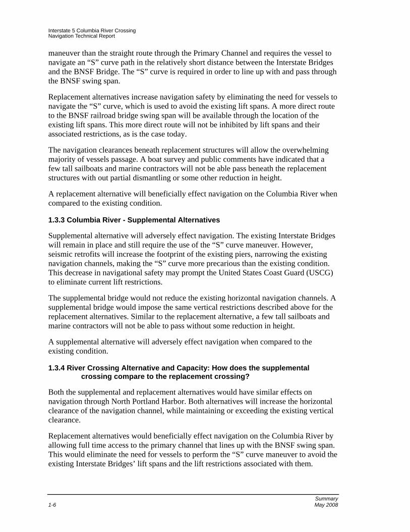
1.3.3 Columbia River - Supplemental Alternatives
Supplemental alternative will adversely effect navigation. The existing Interstate Bridges will remain in place and still require the use of the “S” curve maneuver. However, seismic retrofits will increase the footprint of the existing piers, narrowing the existing navigation channels, making the “S” curve more precarious than the existing condition. This decrease in navigational safety may prompt the United States Coast Guard (USCG) to eliminate current lift restrictions.
The supplemental bridge would not reduce the existing horizontal navigation channels. A supplemental bridge would impose the same vertical restrictions described above for the replacement alternatives. Similar to the replacement alternative, a few tall sailboats and marine contractors will not be able to pass without some reduction in height.
A supplemental alternative will adversely effect navigation when compared to the existing condition.
1.3.4 River Crossing Alternative and Capacity: How does the supplemental crossing compare to the replacement crossing?
Both the supplemental and replacement alternatives would have similar effects on navigation through North Portland Harbor. Both alternatives will increase the horizontal clearance of the navigation channel, while maintaining or exceeding the existing vertical clearance.
Replacement alternatives would beneficially effect navigation on the Columbia River by allowing full time access to the primary channel that lines up with the BNSF swing span. This would eliminate the need for vessels to perform the “S” curve maneuver to avoid the existing Interstate Bridges’ lift spans and the lift restrictions associated with them.

Interstate 5 Columbia River Crossing Navigation Technical Report
Summary May 2008 1-7
Supplemental alternatives would adversely effect navigation on the Columbia River. Seismic retrofit of the existing Interstate Bridges will likely increase the footprint of the existing bridge piers, reducing the horizontal clearance available making the “S” curve maneuver more dangerous compared with the existing condition.
1.3.5 Transit Mode: How does BRT compare to LRT?
The transit mode used on the river crossing has no effect of navigation on the Columbia River or North Portland Harbor. Both transit modes can use almost identical river crossing structure types.
1.4 Temporary Effects
Temporary effect to navigation on North Portland Harbor and Columbia River will be dependant on the construction methods and staging.
1.4.1 North Portland Harbor
Select structure types, such as concrete segmental, coupled with careful staging could minimize temporary effect to navigation of North Portland Harbor. While temporary encroachments into the navigation channel are inevitable, North Portland Harbor will be available for vessel traffic, sometimes with a reduced capacity, throughout construction. Temporary effects to navigation on North Portland Harbor due to construction will be similar in nature and duration, regardless of the alternative selected (supplemental or replacement).
1.4.2 Columbia River
The structure type, span configuration, and construction staging will determine the temporary effects the I-5 CRC project will have on navigation. At least one of the three navigation channels could be open to river traffic at all times during construction. This will be possible for both the supplemental and replacement options. For the supplemental alternative, there will likely be times when the lift span will be inoperable and therefore the maximum vertical clearance will be unavailable. This will occur when the retrofit of the lift span, lift span towers, and foundation of piers adjacent to the lift span strengthening are underway. However, the maximum clearance can be made available at all times during construction of the replacement options.
1.5 Mitigation
Mitigation of temporary effects, due almost exclusively to construction, will be accomplished through careful staging of the bridge construction.
1.5.1 Mitigation for Temporary Effects
It is possible to develop construction staging schemes that minimize intrusion into North Portland Harbor’s single navigation channel. Temporary partial obstructions of the navigation envelop are inevitable, but it will be possible to keep North Portland Harbor
Interstate 5 Columbia River Crossing Navigation Technical Report
Summary 1-8 May 2008
open to the recreational and other small crafts that make up the majority of users of North Portland Harbor.
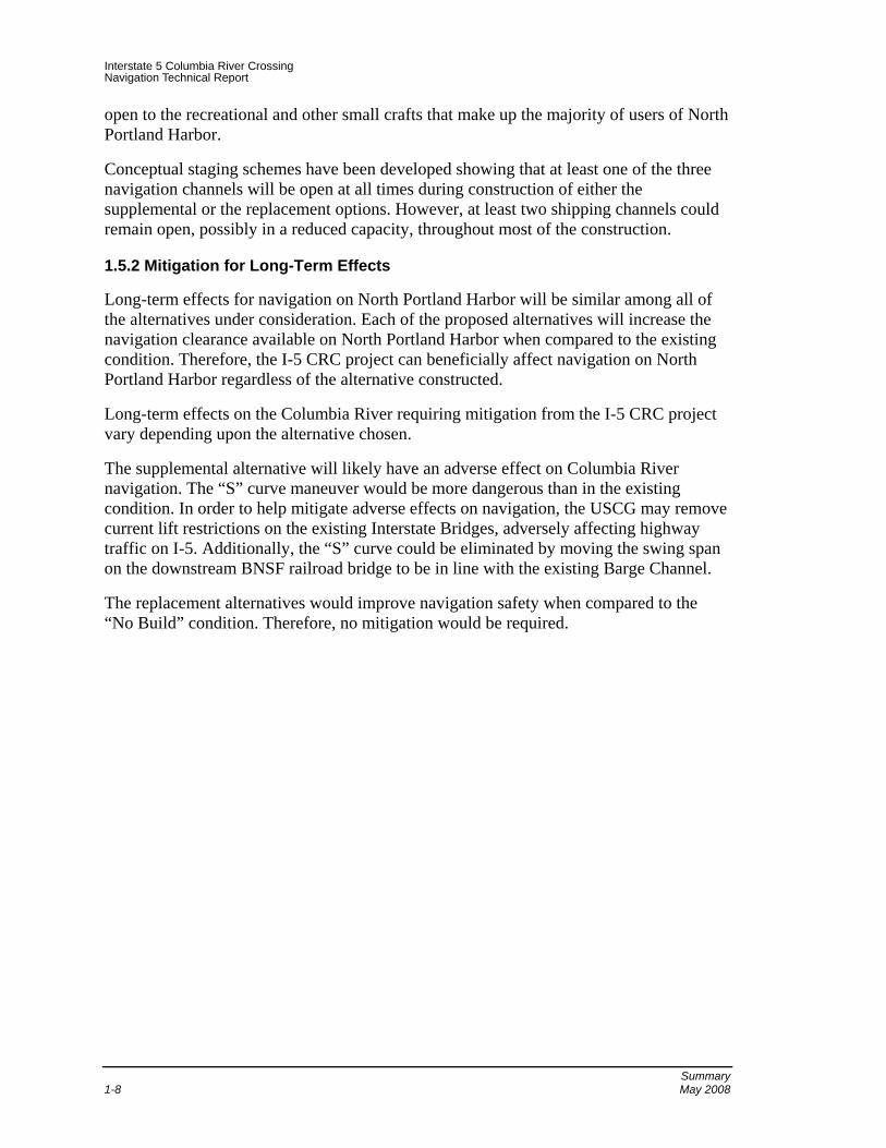
Conceptual staging schemes have been developed showing that at least one of the three navigation channels will be open at all times during construction of either the supplemental or the replacement options. However, at least two shipping channels could remain open, possibly in a reduced capacity, throughout most of the construction.
1.5.2 Mitigation for Long-Term Effects
Long-term effects for navigation on North Portland Harbor will be similar among all of the alternatives under consideration. Each of the proposed alternatives will increase the navigation clearance available on North Portland Harbor when compared to the existing condition. Therefore, the I-5 CRC project can beneficially affect navigation on North Portland Harbor regardless of the alternative constructed.
Long-term effects on the Columbia River requiring mitigation from the I-5 CRC project vary depending upon the alternative chosen.
The supplemental alternative will likely have an adverse effect on Columbia River navigation. The “S” curve maneuver would be more dangerous than in the existing condition. In order to help mitigate adverse effects on navigation, the USCG may remove current lift restrictions on the existing Interstate Bridges, adversely affecting highway traffic on I-5. Additionally, the “S” curve could be eliminated by moving the swing span on the downstream BNSF railroad bridge to be in line with the existing Barge Channel.
The replacement alternatives would improve navigation safety when compared to the “No Build” condition. Therefore, no mitigation would be required.

Interstate 5 Columbia River Crossing Navigation Technical Report
Methods May 2008 2-1
2. Methods
2.1 Introduction
This section describes the assessment method that was used to identify and evaluate potential effects of replacement and supplemental alternatives for the I-5 CRC project on navigation of the Columbia River and North Portland Harbor (Oregon Slough). The Columbia River Bridge includes the northbound highway, southbound highway and combined high capacity transit, bicycle and pedestrian structures. North Portland Harbor Bridges consist of at least four structures; the I-5 mainline bridge, two ramp structures, and one combined high capacity transit, bicycle, and pedestrian bridge.
2.2 Study Area
The analysis area was limited to the primary Area of Potential Impact (API) for navigation, which is the Columbia River section, between the Burlington Northern Santa Fe (BNSF) Railroad Bridge and the Interstate Bridges (see Exhibit 2-1). Within this section, there are two bodies of water that have been declared Federally Navigable Waters: the Columbia River and North Portland Harbor (also known as the North Portland Harbor).
Exhibit 2-1. API for Navigation

Interstate 5 Columbia River Crossing Navigation Technical Report
Methods 2-2 May 2008
2.3 Effects Guidelines
The Federally Navigable Waterways designation of the Columbia River and North Portland Harbor signifies that all construction or alteration of bridges crossing these waterways must first be approved by the U.S. Coast Guard (USCG).
The USCG is responsible for the regulation of drawbridge operations to balance both land and marine transportation needs. Part of the USCG mission, as outlined in their mission statement, is to: “Facilitate maritime commerce and eliminate interruptions and impediments to the efficient and economical movement of goods and people, while maximizing recreational access to and enjoyment of the water.”
The USCG is the permitting authority for all new bridge crossings. Agreements between the USCG and the Federal Highway Administration require that the potential effects of bridge projects on navigable waterways be evaluated through the National Environmental Policy Act (NEPA) process.
This document investigates how project alternatives may effect navigation on the Columbia River and North Portland Harbor. Additionally, the temporary river navigation effects, due to bridge construction are also evaluated. Both beneficial and adverse effects are presented.
An assessment of the impacts to river navigation for each Bridge has been performed, using the river navigation data collected, on the following:
• The location of new bridge piers in relation and whether they maintain or enhance the navigation and safety levels for vessels and their impact on the “S” curve maneuver (described below).
• The new bridge’s vertical and horizontal clearances and any possible impact to vessels.
To aid in the assessment, each bridge alternative was developed using MicroStation (a computer-aided drafting software program) and presented on a Plan and Elevation plot. The Plan view was overlaid on a color ortho-rectified aerial photograph showing existing pertinent features such as highways, existing bridges, and the proposed bridge plan. The corresponding Elevation view shows features such as the proposed roadway profile, and vertical and horizontal navigation clearances and pier locations.
The following list contains applicable Federal regulations and brief description of each;
• 33 CFR 114, “General,” and 33 CFR 115, “Bridge Locations and Clearances; Administrative Procedures,” Code of Federal Regulations. Rules and regulations governing the USCG bridge permit program are listed in Parts 114 and 115.
• 33 CFR 116, “Alteration of Unreasonably Obstructive Bridges,” Code of Federal Regulations. This section describes the process taken to alter obstructive bridges. It also includes the application process for funding under the Truman-Hobbs Act.

Interstate 5 Columbia River Crossing Navigation Technical Report
Methods May 2008 2-3
• 33 CFR 117, “Drawbridge Operation Regulations,” Code of Federal Regulations. Columbia River. The draws of the Interstate 5 Bridges, mile 106.5, between Portland, OR, and Vancouver, WA, shall open on signal except that the draws need not be opened for the passage of vessels from 6:30 a.m. to 9 a.m. and from 2:30 p.m. to 6 p.m. Monday through Friday except federal holidays.
• 33 CFR 118.140, “Painting bridge piers,” Code of Federal Regulations. The District Commander may require painting the sides of bridge channel piers below the superstructure facing traffic white or yellow when they are significantly darkened by weathering or other causes so as to be poorly visible against a dark background.
• 33 CFR 118.160, “Vertical clearance gauges,” Code of Federal Regulations. When necessary for reasons of safety of navigation, the District Commander may require or authorize the installation of clearance gauges. Clearance gauges must indicate the vertical distance between ``low steel'' of the bridge channel span and the level of the water, measured to the bottom of the foot marks, read from top to bottom. Each gauge must be installed on the end of the right channel pier or pier protection structure facing approaching vessels and extend to a reasonable height above high water so as to be meaningful to the viewer. Other or additional locations may be prescribed by the District Commander if particular conditions or circumstances warrant.
2.4 Data Collection Methods
The primary sources of data used for the assessment of each proposed bridge included vertical clearance data gathered from the Boat Survey (Parsons Brinckerhoff Inc. 2004), Boat Survey validation meetings, and telephone calls conducted by the agencies with key stakeholders, such as vessel operators and the USCG.
A list of vessels traveling this river section was assembled, analyzed, and summarized in the 2006 Boat Survey Technical Memorandum. This study provided valuable information on the types of vessels traveling the Columbia River, their clearance requirements, and was used as a basis for determining vertical clearances for the new bridges. The data in this Technical Memorandum was verified in 2006 through a series of discussions with vessel operators.
2.5 Analysis Methods
There are many factors that are evaluated in determining the “S” curve path that a vessel pilot will take between the Interstate Bridges and the BNSF bridge. Some of these factors include the gross weight and dimensions of the vessel, river water elevation, and river velocity. As such, there isn’t an exact path that vessel pilots use to traverse the “S” curve; they must rely primarily on their experience. The evaluation of the impact of new bridge pier locations on river navigation, to a large part, depends on the anecdotal input provided by vessel pilots.

Interstate 5 Columbia River Crossing Navigation Technical Report
Methods 2-4 May 2008
The USCG is the permitting agency, and they have stated navigation through this section of the Columbia River cannot be made worse than the existing condition. To that end, piers for a supplemental structure must align with the existing bridges’ piers. Similarly, the piers of replacement bridges must line up with the existing Interstate Bridges’ piers to maintain adequate navigation channels during construction and ultimately improve navigation once the existing Interstate Bridges are removed. “As-Built” drawings of the Interstate Bridges were used to accurately locate the new bridge piers in relation to the existing bridge piers for the evaluation of construction staging and temporary impacts.
Comments generated from USCG preliminary hearings provided key input and aided in the evaluation of a proposed bridge’s effect on river navigation.

Interstate 5 Columbia River Crossing Navigation Technical Report
Coordination May 2008 3-1
3. Coordination
The following section briefly discusses external coordination that has occurred with other groups.
3.1 Boat Survey
A list of vessels traveling this river section was assembled, analyzed, and summarized in the Boat Survey Technical Memorandum. This study provided valuable information on the types of vessels traveling this river section and their clearance requirements and was used as a basis for determining vertical clearances for the new bridges. The data in this Technical Memorandum was verified in 2006 through a series of discussions with vessel operators.
3.1.1 Boat Survey validation
The 2004 boat survey was revisited in 2006 by the I-5 CRC Project. Interviews were conducted with key stakeholders such as vessel operators and the U.S. Coast Guard. From these interviews, it was concluded that the information presented in the Boat Survey is still valid.
Open House and Public Hearing – September 21, 2006
The public hearing was held in order to give all interested parties an opportunity to state their views regarding the impacts of the proposed project.
3.2 USCG meetings
September 7, 2005 meeting with USCG
This initial meeting with the USCG presented project history, an initial schedule, and determined the points of contact at both the USCG and CRC project team. Design requirements, applicable criteria, and the processes for major project decisions were all discussed.
May 18, 2006 CRC meeting with USCG
USCG said they have jurisdiction over all bridges over navigable waterways with or without piers in the waterway or officially marked and maintained channels. There were also discussions regarding construction. The USCG indicated that tug assistance could be used during construction, and short closure periods have been used in the past. They also asked that project be sensitive to shipments and consider water levels.

Interstate 5 Columbia River Crossing Navigation Technical Report
Coordination 3-2 May 2008
January 25, 2007 CRC meeting with USCG
USCG has jurisdiction over channel modifications. They agreed that 95 feet of clearance above zero (Columbia River Datum) CRD was in the ballpark of what may be acceptable. The USCG cannot accept or reject proposed clearances until a Record of Decision (ROD) is issued for the project. Recreational vessels that cannot meet this clearance at all times of year must justify why they need to have this clearance at all times of year. Likewise, cranes unable to make the proposed clearance must justify why they need clearance all times of the year.
3.3 Coordination that is still to occur
As project alternatives are refined and narrowed down to a locally preferred alternative, the USCG will be given regular updates. As previously mentioned, the USCG has stated that they cannot accept or reject any CRC project alternative until a ROD is issued. However, the USCG will be regularly presented with current information so that they are aware of what the recommended alternative is and its associated effect on navigation.

Interstate 5 Columbia River Crossing Navigation Technical Report
Affected Environment May 2008 4-1
4. Affected Environment
4.1 Introduction
The I-5 CRC project may affect navigable waters in two distinct areas; the Columbia River, north of Hayden Island and North Portland Harbor, south of Hayden Island. The following discussion identifies the navigational characteristics of these two navigable waters.
4.2 Regional Conditions
4.2.1 North Portland Harbor
Use of North Portland Harbor can be characterized in two distinctive portions: the eastern portion, which contains moorages for floating homes and recreational vessels and the western portion, which services the Port of Portland facility.
4.2.1.1 North Portland Harbor - Eastern Portion
Two bridges span over North Portland Harbor in the eastern portion; the BNSF Bridge and North Portland Harbor Bridge. North Portland Harbor Bridge carries I-5 and connects Marine Drive with Hayden Island and points north. The I-5 CRC project will likely replace North Portland Harbor Bridge and therefore affect navigation on that body of water.
Although previous studies have not defined vessel heights and types that use this portion of the slough, some conclusions can be drawn from the surroundings and the existing constraints. As previously mentioned, the eastern portion of the slough contains moorages for floating homes and recreational vessels. The existing North Portland Harbor Bridge has fixed spans and provides one navigation channel with a navigation clearance of 215 feet wide with a variable height of 35 feet to 40 feet. Existing clearance under the bridge and the surrounding moorages indicate that the dominant vessel type is recreational (requiring less than 40 feet of vertical clearance).
Further toward the west, vessels pass under the BNSF Railroad Bridge. Similar to the situation on the Columbia River, a BNSF Railroad Bridge is located approximately one mile downstream and accommodates vessels in excess of a 35 foot height through a movable swing span. From aerial photos, it appears that the swing span provides a horizontal navigation clearance of roughly 150 feet.
4.2.1.2 North Portland Harbor - Western Portion
Vessels traveling the western portion of North Portland Harbor appear to be primarily associated with the Port of Portland facility. This facility receives ocean going vessels (large tankers and cargo ships) containing automobiles and shipping containers.

Interstate 5 Columbia River Crossing Navigation Technical Report
Affected Environment 4-2 May 2008
Vessel count information for North Portland Harbor is available through the Department of the Army Corps of Engineers, some of which is presented in the Exhibit 4-1.
Exhibit 4-1. North Portland Harbor Vessel Count
North Portland Harbor 2000 2001 2002 2003 2004 Cargo 1558 1365 1252 1097 1097 Tanker 5 1 1 1 0
Passenger 436 384 351 382 321
Dow
nbou
nd
Total 1999 1750 1604 1480 1418
Cargo 1602 1355 1294 1100 1135 Tanker 3 0 1 1 0
Passenger 441 400 348 385 326
Upb
ound
Total 2046 1755 1643 1486 1461
Data obtained for Exhibit 4-1 does not state whether these vessel trip totals are reflective of the entire length of North Portland Harbor or specific portions. The vessel counts are similar in magnitude to those on the Columbia River, which indicate that they are more closely related to the western portion (Port of Portland) than the eastern portion (floating homes and recreational vessels). The similarity of North Portland Harbor vessel counts with Columbia River Vessel counts along with the limitations of navigational clearances beneath the I-5 North Portland Harbor Bridge indicate larger commercial vessels do not use the navigation channels of the I-5 North Portland Harbor Bridge.
4.2.2 Existing Interstate Bridges
Vessels that currently travel this portion of the Columbia River pass three bridges: the Northbound and Southbound structures of the Interstate Bridges and the BNSF Railroad Bridge.
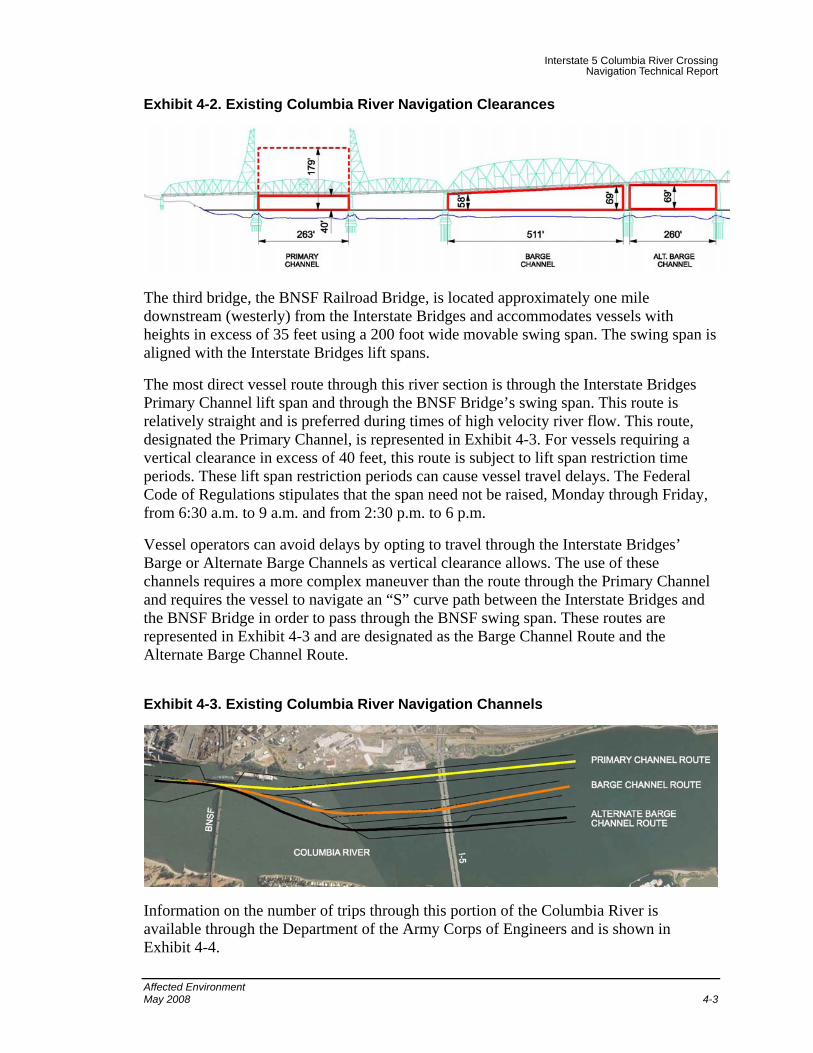
Under the Interstate Bridges, vessels pass through one of three channels: the Primary Channel, the Barge Channel and the Alternate Barge Channel (see Exhibit 4-2).
The Primary Channel lies under the bridges’ lift spans and has a horizontal clearance of 263 feet and a vertical clearance of 40 feet in the closed position and 179 feet in the raised position. The Barge Channel lies under the wide spans of the bridges and has a horizontal clearance of 511 feet and a vertical clearance ranging from 58 feet to 69 feet. The Alternate Barge Channel occupies the span directly to the south of the wide span and has a horizontal clearance of 260 feet and a vertical clearance of 69 feet.
Interstate 5 Columbia River Crossing Navigation Technical Report
Affected Environment May 2008 4-3
Exhibit 4-2. Existing Columbia River Navigation Clearances
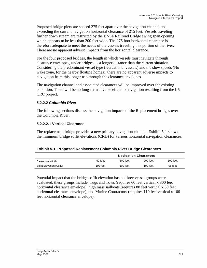
The third bridge, the BNSF Railroad Bridge, is located approximately one mile downstream (westerly) from the Interstate Bridges and accommodates vessels with heights in excess of 35 feet using a 200 foot wide movable swing span. The swing span is aligned with the Interstate Bridges lift spans.
The most direct vessel route through this river section is through the Interstate Bridges Primary Channel lift span and through the BNSF Bridge’s swing span. This route is relatively straight and is preferred during times of high velocity river flow. This route, designated the Primary Channel, is represented in Exhibit 4-3. For vessels requiring a vertical clearance in excess of 40 feet, this route is subject to lift span restriction time periods. These lift span restriction periods can cause vessel travel delays. The Federal Code of Regulations stipulates that the span need not be raised, Monday through Friday, from 6:30 a.m. to 9 a.m. and from 2:30 p.m. to 6 p.m.
Vessel operators can avoid delays by opting to travel through the Interstate Bridges’ Barge or Alternate Barge Channels as vertical clearance allows. The use of these channels requires a more complex maneuver than the route through the Primary Channel and requires the vessel to navigate an “S” curve path between the Interstate Bridges and the BNSF Bridge in order to pass through the BNSF swing span. These routes are represented in Exhibit 4-3 and are designated as the Barge Channel Route and the Alternate Barge Channel Route.
Exhibit 4-3. Existing Columbia River Navigation Channels
Information on the number of trips through this portion of the Columbia River is available through the Department of the Army Corps of Engineers and is shown in Exhibit 4-4.

Interstate 5 Columbia River Crossing Navigation Technical Report
Affected Environment 4-4 May 2008
Exhibit 4-4. Columbia River Vessel Count
North Portland Harbor 2000 2001 2002 2003 2004 Cargo 1495 1356 1083 1540 1466 Tanker Passenger 412 536 28 3 0
Dow
nbou
nd
Total 1907 1892 1111 1543 1466
Cargo 1526 1285 1173 1540 1579 Tanker Passenger 418 531 26 3 0
Upb
ound
Total 1944 1816 1199 1543 1579
Tugs and tows are the predominant users, and in 2004 accounted for 100% of the recorded self-propelled vessel trips in both the upbound and downbound directions. Recreational vessels appear not to have been counted.
4.2.2.1 Horizontal Navigation Clearance
The horizontal navigation clearance through this portion of the river is controlled by the BNSF Railroad Bridge downstream of the Interstate Bridges and the Glenn Jackson Bridge upstream of the Interstate Bridges.
The BNSF Railroad Bridge, to the west, accommodates vessels through a 200 foot wide swing span. From existing plans, the 200 foot dimension appears to be measured to the face of the pier. The Glenn Jackson Bridge lies to the east and provides a 300 foot horizontal navigation channel. From these horizontal dimensions, it is reasonable for a new bridge to provide a minimum of 300 feet of horizontal navigation clearance. The USCG has requested that a 300 foot horizontal clearance be provided.
4.2.2.2 Vertical Navigation Clearance
Two key factors must be evaluated in order to set a rational vertical navigation clearance: the water level of the river at any given time and the vertical clearance requirements of the vessels that frequently pass under the bridge.
4.2.2.3 Water Level
The U.S. Army Corps of Engineers (USACE) has a Columbia River recording station at Vancouver and records the water level several times each day. Both the minimum and maximum recorded daily water levels are available.
From this data, a 20-year sampling (1987-2006) was taken and Exhibit 4-5 was developed, which depicts the average monthly minimum and maximum water levels over this time period.

Interstate 5 Columbia River Crossing Navigation Technical Report
Affected Environment May 2008 4-5
Exhibit 4-5. USACE Columbia River at Vancouver Water Level Data (1987-2006)
6.175.78
5.475.65
7.39
6.91
3.22
1.93
1.171.50
3.23
5.18
7.847.59
6.927.18
8.638.43
5.74
4.81
4.26 4.38
5.58
7.02
0.00
1.00
2.00
3.00
4.00
5.00
6.00
7.00
8.00
9.00
10.00
J F M A M J J A S O N D
Months
Elev
atio
n (C
RD
)
Min. Water LevelMax. Water Level
4.2.2.4 Vessel Requirements
A previous study was conducted that provides information on the types of vessels that travel through this portion of the Columbia River, their clearance requirements and their frequency of travel. Exhibit 4-6 shows the finding of the study.
Both factors (Columbia River water levels and the vessel vertical clearance requirements) were thoroughly evaluated before determining the vertical navigation clearance for new bridge proposals.
Exhibit 4-6. Existing Columbia River Navigation Channels
Vessel Type Clearance Requirement Approximate Annual Frequency
Tugs and Tows 49 feet to 58 feet > 500 trips
Sailboats/Recreation 76 feet to 88 feet 24 trips Marine Contractors 100 feet to 110 feet Infrequent Marine Industrial 65 feet 6 trips Cruise/Passenger 50 feet to 60 feet 25 trips
Within the 300 foot horizontal navigation clearance, a vertical dimension of 95 feet (minimum) was established from 0.00 CRD to the soffit (bottom) of the bridge. The term “minimum” for the vertical dimension value refers to the fact that the soffits of proposed

Interstate 5 Columbia River Crossing Navigation Technical Report
Affected Environment 4-6 May 2008
bridges are not flat, but rather, has a haunch. This haunch provides some additional vertical clearance toward the mid-point of the bridge span. The additional vertical clearance can be utilized by reducing the horizontal navigation clearance. Varying vertical clearances associated with smaller horizontal clearances will be discussed in a later section.

Interstate 5 Columbia River Crossing Navigation Technical Report
Long-Term Effects May 2008 5-1
5. Long-Term Effects
The I-5 CRC project will have significant long-term effects on navigation of the Columbia River. However, the I-5 CRC project will have minimal long-term effect on navigation North Portland Harbor. The following sections discuss the long-term navigation effects associated with the I-5 CRC project.
5.1 How is this Section Organized?
This chapter describes the long-term impacts that would be expected from the project alternatives and options. We first describe impacts at the larger scale, including the region and corridor. We then focus on impacts that would occur with specific options in each of the corridor’s segments. This two part approach helps to inform the range of questions that need to be answered in order to make the key decisions for this proposed project, including: What are the impacts of the different alternatives and options at the regional or system level, and what are their impacts at the local, neighborhood, property and individual resource level. It addresses both direct and indirect long-term impacts.
5.2 Regional and System-wide Impacts
This section describes the impacts from a range of system-wide combinations of highway, river crossing, transit alternatives and options. These system-wide combinations were constructed to represent the range of project choices that most affect system-wide performance, impacts and costs.
5.2.1 No-Build Alternative
5.2.1.1 North Portland Harbor
The existing North Portland Harbor Bridge has been in service for nearly 23 years and spans over North Portland Harbor, carrying I-5. No functional or operational deficiencies have been identified for this bridge.
The No Build Alternative would involve continued maintenance for this bridge. This Alternative would not change the existing navigational clearance envelope or any limitations experienced by vessel traffic today. Under normal conditions, there are no apparent adverse impacts to navigation from the No Build Alternative.
A catastrophic event could create an adverse impact to navigation. A seismic evaluation has not been performed on the existing North Portland Harbor Bridge. However, due to the close proximity of this structure with the Interstate Bridges, it is possible that this structure is also founded on highly liquefiable soils. If this were the case, a major seismic event could liquefy the soils and collapse a span into the navigation channel, disrupting river navigation for an unspecified amount of time.

Interstate 5 Columbia River Crossing Navigation Technical Report
Long-Term Effects 5-2 May 2008
5.2.1.2 Columbia River Bridge
The No Build Alternative involves continued maintenance and normal operation of the existing Interstate Bridges. This Alternative does not change the navigational restrictions nor does it adversely or affect the current navigation path through the Interstate Bridges and the BNSF Railroad Bridge.
Although the No Build Alternative does not adversely affect navigational safety, it does not improve the current situation either. As previously mentioned, travel delays from lift span restriction periods are avoided by vessel pilots choosing to use the Barge Channel or the Alternate Barge Channel under the Interstate Bridges. These routes require traversing an “S” curve between the Interstate Bridges and the downstream BNSF Railroad Bridge’s swing span. Although there is not a significant accident history for these “S” curve routes, navigation safety is compromised somewhat. The lack of significant accident history is possibly attributed more to the experience of the barge pilots than the ease of traversing the route.
5.2.1.3 Catastrophic Event Considerations
It is important to note that key components of the existing bridges are considered vulnerable to severe damage and/or collapse in a major seismic event.
In August 2006, the CRC Project Team convened a panel of seismic bridge design experts to qualitatively assess the vulnerability of the existing Interstate Bridges in a major seismic event. A critical issue discussed was the determination (through geotechnical testing) that the bridges are founded on soil that could liquefy in a major seismic event. This situation would render the existing foundations ineffective in resisting seismic forces.
The “No Build” scenario coupled with a major seismic event could result in the bridges sustaining severe damage (including collapse). If a seismic event were to cause spans to collapse, they could collapse in one or several of the navigation channels and disrupt river navigation for an unspecified amount of time.
5.2.2 Replacement Crossing
5.2.2.1 North Portland Harbor
The existing North Portland Harbor Bridge is proposed to be replaced with four new bridges; one carrying mainline I-5, two carrying ramps, and one combined transit and pedestrian bridge. The mode of transit used (LRT or BRT) will not influence how a replacement bridge affects navigation.
The proposed North Portland Harbor navigation vertical clearance envelope will meet or exceed the existing clearance envelope. There are no apparent adverse long-term effects to vertical clearance.
Interstate 5 Columbia River Crossing Navigation Technical Report
Long-Term Effects May 2008 5-3
Proposed bridge piers are spaced 275 feet apart over the navigation channel and exceeding the current navigation horizontal clearance of 215 feet. Vessels traveling further down stream are restricted by the BNSF Railroad Bridge swing span opening, which appears to be less than 200 feet wide. The 275 foot horizontal clearance is therefore adequate to meet the needs of the vessels traveling this portion of the river. There are no apparent adverse impacts from the horizontal clearance.
For the four proposed bridges, the length in which vessels must navigate through clearance envelopes, under bridges, is a longer distance than the current situation. Considering the predominant vessel type (recreational vessels) and the slow speeds (No wake zone, for the nearby floating homes), there are no apparent adverse impacts to navigation from this longer trip through the clearance envelopes.
The navigation channel and associated clearances will be improved over the existing condition. There will be no long-term adverse effect to navigation resulting from the I-5 CRC project.
5.2.2.2 Columbia River
The following sections discuss the navigation impacts of the Replacement bridges over the Columbia River.
5.2.2.2.1 Vertical Clearance
The replacement bridge provides a new primary navigation channel. Exhibit 5-1 shows the minimum bridge soffit elevations (CRD) for various horizontal navigation clearances.
Exhibit 5-1. Proposed Replacement Columbia River Bridge Clearances
Navigation Clearances
Clearance Width 50 feet 100 feet 200 feet 300 feet
Soffit Elevation (CRD) 102 feet 102 feet 100 feet 95 feet
Potential impact that the bridge soffit elevation has on three vessel groups were evaluated, these groups include: Tugs and Tows (requires 60 feet vertical x 300 feet horizontal clearance envelope), high mast sailboats (requires 88 feet vertical x 50 feet horizontal clearance envelope), and Marine Contractors (requires 110 feet vertical x 100 feet horizontal clearance envelope).

Interstate 5 Columbia River Crossing Navigation Technical Report
Long-Term Effects 5-4 May 2008
Exhibit 5-2 shows the available vertical clearance for each of the three vessel groups described above. The green zone represents vertical clearances available at the average maximum water level. The red zones indicate that the clearance is not available and the yellow band indicates the range of what may or may not be available due to variation in water elevation. From these graphs the following observations were made;
• Tugs and Tows, with a 60 feet vertical clearance requirement, are well within the Green zone and can pass under the bridge during all months of the year.
• High mast sailboats, with an 88 feet vertical clearance requirement can pass under the bridge during all months of the year.
• Marine Contractors, with a 110 feet vertical clearance requirement cannot pass under the bridge without partial disassembly of their loads.

Interstate 5 Columbia River Crossing Navigation Technical Report
Long-Term Effects May 2008 5-5
Exhibit 5-2. Proposed Replacement Alignment Clearances for 300 feet width (top), 100 feet width (center), and 50 feet width (bottom)
Tugs & Tows (300' Horiz. Cl.)
82.0
84.0
86.0
88.0
90.0
92.0
94.0
96.0
J F M A M J J A S O N DMonths
Ava
ilabl
e Ve
rtic
al C
lear
ance
Marine Contractors (100' Horiz. Cl.)
88.0
90.0
92.0
94.0
96.0
98.0
100.0
102.0
J F M A M J J A S O N DMonths
Ava
ilabl
e Ve
rtic
al C
lear
ance
High Mast Sailboats (50' Horiz. Cl.)
88.0
90.0
92.0
94.0
96.0
98.0
100.0
102.0
J F M A M J J A S O N DMonths
Ava
ilabl
e Ve
rtic
al C
lear
ance

Interstate 5 Columbia River Crossing Navigation Technical Report
Long-Term Effects 5-6 May 2008
Cranes typically used by marine contractors may not be able to pass under the bridge year round. However, the Boat Survey indicated that Marine Contractor vessels travel under the Interstate Bridges infrequently and, in the future, it may be possible for them to lower or disassemble crane gantries, reducing their height meet clearances. This same vessel may be able to pass under the bridge, during a mid-June through mid-November time period, if a 100 feet wide navigation channel is acceptable and reduce the required vertical clearance to 100 feet. Additionally, if this vessel’s load was dismantled such that it only required a clearance of 93 feet, it could pass all year around.
A new replacement bridge, with a minimum proposed navigation clearance envelope of 300 feet wide by 95 feet high (from 0.00 CRD), provides passage for nearly all vessels traveling under the Interstate Bridges, during most portions of the year. Only Marine Contractors, which travel this portion of the river infrequently, may have vertical height requirements greater than the available clearance. Interviews with some Marine Contractors suggest there is a possibility they can disassemble their equipment, at a cost, such that they are able to meet the available vertical clearance. Other marine contractors have said that they cannot dismantle their loads.
Based on the navigation clearances established for this project and the preceding discussion, there are no apparent significant adverse impacts from the vertical clearance.
5.2.2.2.2 Horizontal Clearance
The Replacement Alternative provides a span over the new Primary Channel with a clear span of approximately 500 feet and the piers which are spaced wide enough to accommodate the minimum navigation horizontal clearance envelope of 300 feet.
Similar to the Glenn Jackson Bridge, which provides a span of 445 feet for a horizontal navigation clearance of 300 feet; this span width is adequate to meet the needs of all vessels traveling this portion of the river.
Based on the navigation clearances established for this project and the preceding discussion, there are no apparent significant adverse impacts from the vertical clearance.
5.2.2.2.3 Pier Locations
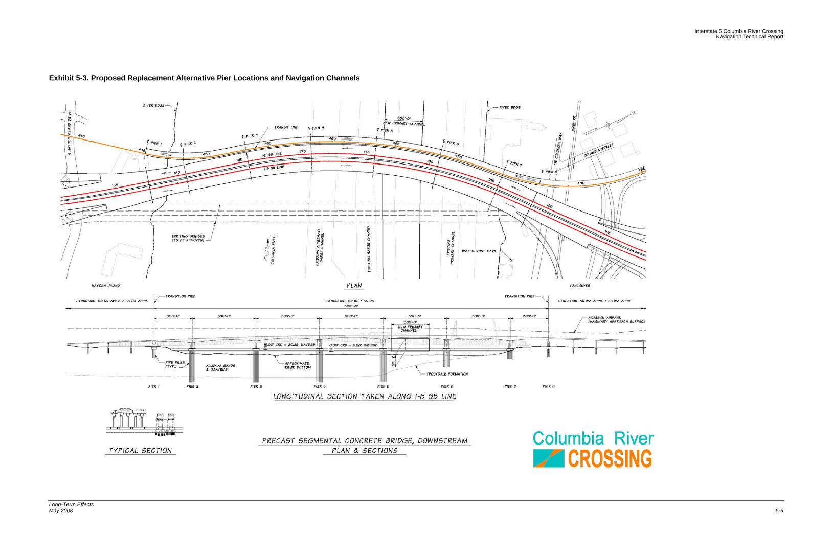
Testimonials provided to the USCG, expressed a concern that pier locations for a Replacement alternative could negatively affect the already difficult "S" curve maneuver for downbound vessels. As the permitting agency, they have stated that piers for all adjacent new structures must align with the piers on the existing I-5 Interstate Bridges and North Portland Harbor bridges.
Impacts to the vessel route of permanent pier locations are discussed below while temporary impacts for navigation during construction are addressed in a later section.
The Replacement Alternative provides a new Primary channel that is positioned between the existing Primary and Barge channels (see Exhibit 5-3). Although further toward the middle of the river, due to a slight bend in the river, this new position improves the alignment with the downstream BNSF Railroad bridge swing span and eases the

Interstate 5 Columbia River Crossing Navigation Technical Report
Long-Term Effects May 2008 5-7
difficulty of the “S” maneuver. Additionally, vessels can pass under the span directly north, which is the approximate location of the existing Primary channel.
The piers flanking the new Primary channel are oriented in a radial manner with the alignment of the curved bridge. This orientation reduces the potential for pier-vessel conflict.
In summary, the proposed pier locations ease the difficulty of the “S” maneuver. As such, there is no apparent adverse impact to the route that vessel pilots must take to traverse this portion of the Columbia River.

Interstate 5 Columbia River Crossing Navigation Technical Report
Long-Term Effects 5-8 May 2008
This page intentionally left blank.
Interstate 5 Columbia River Crossing Navigation Technical Report
Long-Term Effects May 2008 5-9
Exhibit 5-3. Proposed Replacement Alternative Pier Locations and Navigation Channels

Interstate 5 Columbia River Crossing Navigation Technical Report
Long-Term Effects 5-10 May 2008
This page intentionally left blank.
Interstate 5 Columbia River Crossing Navigation Technical Report
Long-Term Effects May 2008 5-11
5.2.2.2.4 Navigation Safety Impact
Features of the replacement bridge improve navigation safety by:
• Reducing the number of piers in the water. The alternative reduces the number of piers (obstacles) in the water from nine to a maximum of six.
• Simplifying the decision making process for vessel pilots. Today, vessel operators have three possible routes under the Interstate Bridges (Primary, Barge and Alternate Barge Channels). The route choice is made only after evaluating many factors, including the gross weight and dimensions of his vessel, river water elevation, and river velocity. The proposed fixed span bridge offers one primary navigation channel which (as stated above) meets the clearance envelope needs of nearly all vessels. Navigation safety will be improved by making the vessel pilot’s decision on which path to traverse less dependent on the river elevation at the time.
• Eliminating the lift span. Navigation safety is improved by eliminating the dependency on lift span operations and the navigational constraint of lift span restriction periods.
• Realigning the navigation channel. Navigation safety is further enhanced by locating the primary navigation channel in better alignment with the downstream BNSF Railroad Bridge swing span than the Barge and Alternate Barge Channel routes. Relocating the primary navigation channel to reduce the “S” curve path will improve navigation safety.
5.2.3 Supplemental Crossing
A supplemental crossing will be downstream of the existing Interstate Bridges.
5.2.3.1 Vertical Clearance
A supplemental bridge maintains the three existing navigation channels. The piers supporting the supplemental bridge’s 600 foot spans line up with existing navigation channels. Exhibit 5-4 shows the supplemental alternative’s vertical clearances, above CRD, for various channel widths.
Exhibit 5-4. Proposed Supplemental Alignment Columbia River Bridge Clearances
Navigation Clearances
Clearance Width 50 feet 100 feet 200 feet 300 feet
Soffit Elevation (CRD) 107 feet 106 feet 100 feet NA
It is important to note that the supplemental alternative appears to have a greater available clearance than the replacement alternatives, even though the supplemental has longer spans. This is slightly misleading. Further investigation has shown that the roadway

Interstate 5 Columbia River Crossing Navigation Technical Report
Long-Term Effects 5-12 May 2008
design of the supplemental alternative is approximately four feet higher than the replacement alternatives.
Potential effects that the bridge soffit elevation has on three vessel groups were evaluated, these groups include: Tugs and Tows (requires 60 feet vertical x 300 feet horizontal clearance envelope), high mast sailboats (requires 88 feet vertical x 50 feet horizontal clearance envelope), and Marine Contractors (requires 110 feet vertical x 100 feet horizontal clearance envelope).
Exhibit 5-5 shows the available vertical clearance through the primary channel, for each of the three vessel groups described above. The green zone represents vertical clearances available at the average maximum water level. The red zones indicate that the clearance is not available and the yellow band indicates the range of what may or may not be available due to variation in water elevation. As indicated in Exhibit 5-5, the maximum horizontal clearance available through the primary channel is approximately 200 feet as, constrained by the existing Interstates Bridges’ retrofitted piers, so that was the maximum width investigated for the supplemental alternative. The vertical clearance is dictated by the soffit of the supplemental bridge.

Interstate 5 Columbia River Crossing Navigation Technical Report
Long-Term Effects May 2008 5-13
Exhibit 5-5. Proposed Supplemental Alignment Clearances for 200 feet width (top), 100 feet width (center), and 50 feet width (bottom)
Primary Channel Max Clearance (200' Horiz. Cl.)
86.0
88.0
90.0
92.0
94.0
96.0
98.0
100.0
J F M A M J J A S O N D
Months
Ava
ilabl
e Ve
rtic
al C
lear
ance
Marine Contractors (100' Horiz. Cl.)
94.0
96.0
98.0
100.0
102.0
104.0
106.0
J F M A M J J A S O N D
Months
Ava
ilabl
e Ve
rtic
al C
lear
ance
High Mast Sailboats (50' Horiz. Cl.)
94.0
96.0
98.0
100.0
102.0
104.0
106.0
108.0
J F M A M J J A S O N D
Months
Ava
ilabl
e Ve
rtic
al C
lear
ance

Interstate 5 Columbia River Crossing Navigation Technical Report
Long-Term Effects 5-14 May 2008
Exhibit 5-5 shows the available vertical clearance for each of the three vessel groups described above. The Green zone represents vertical clearances available at the average maximum water level. From these graphs the following observations were made;
• Tugs and Tows only have an available horizontal width of 200 feet, instead of the 300 feet available for the replacement alternatives. Using the reduced 200 feet horizontal clearance, 60 feet of vertical clearance will be available at all times of year.
• High mast sailboats, with an 88 foot vertical clearance requirement can pass under the bridge during all months of the year.
• Marine Contractors, with a 110 foot vertical clearance requirement cannot pass under the bridge.
5.2.3.2 Horizontal Clearance
A Supplemental Bridge Alternative provides a span over each of the existing navigation channels. While the spans of the supplemental bridge will be approximately 600 feet, the navigation channels will be constrained by the existing Interstate bridge piers. The existing horizontal clearance available for navigation is 263 feet. The existing horizontal clearance may be further reduced, resulting from the seismic foundation retrofit of the Interstate Bridges. As preciously mentioned, the available horizontal clearance will be about 200 feet. Therefore, the supplemental bridge alternative, including a seismic retrofit will adversely affect navigation on the Columbia River.
5.2.3.3 Pier Locations
Testimonials provided to the USCG, expressed a concern that pier locations for a supplemental downstream bridge alignment could negatively affect the already difficult "S" curve maneuver for downbound vessels. As the permitting agency, they have stated that piers for all adjacent new structures must align with the piers on the existing I-5 Interstate Bridges.
The supplemental bridge alternative would continue to use the existing navigation channels (see Exhibit 5-6). Piers for the new supplemental bridge would be placed outside of the existing navigation channels. However, seismic retrofit of the existing bridge would increase the footprint of the existing Interstate Bridges’ piers, making navigation through the S-curve more difficult than the existing condition.

Interstate 5 Columbia River Crossing Navigation Technical Report
Long-Term Effects May 2008 5-15
Exhibit 5-6. Proposed Supplemental Alternative Pier Locations and Navigation Channels

Interstate 5 Columbia River Crossing Navigation Technical Report
Long-Term Effects 5-16 May 2008
This page intentionally left blank.
Interstate 5 Columbia River Crossing Navigation Technical Report
Long-Term Effects May 2008 5-17
5.2.3.4 Navigation Safety Impact
Features of the supplemental bridge adversely affect navigation on the Columbia River by:
• Increasing the number of piers in the water. The supplemental bridge’s piers would be clear on the existing navigation channel. This alternative will reuse the existing navigation channels, with all associated hazards, plus add piers for the supplemental bridge.
• Seismic retrofit of the existing piers will increase the footprint of the piers and encroach into the existing navigation channels, making navigation worse.
• The lift spans would still be required to use the primary channel and may be increasingly used due to increased difficulty of maneuvering the “S”-curve through narrower navigation channels.
Interstate 5 Columbia River Crossing Navigation Technical Report
Long-Term Effects 5-18 May 2008
This page intentionally left blank.

Interstate 5 Columbia River Crossing Navigation Technical Report
Temporary Effects May 2008 6-1
6. Temporary Effects
6.1 Introduction
The following section discusses likely construction sequences that may minimize adverse effects on navigation on North Portland Harbor and Columbia River during construction.
The discussion below presents a possible range of effects on navigation. Actual construction methods may vary from what is described below, and result in different effects on navigation. The USCG prefers the continuous passage of tugs and tows throughout the construction process. Due to the possibility of alternate construction staging being used, the USCG will separately evaluate construction operations for their effects on navigation.
6.2 Regional and System-wide Impacts
6.2.1 North Portland Harbor
6.2.1.1 All Alternatives
It is likely that the bridge will consist of structure type that can clear span over the navigation channel and match or exceed, in height, the existing vertical clearance. Short duration in-water work windows and constructability issues suggest that the new North Portland Harbor Bridge would, most likely, incorporate bridge elements that use prefabricated superstructure elements such as steel girders or precast segmental girders. These types of construction would eliminate the need for extensive supports in the slough. However, some temporary restrictions may be necessary due to barges and cranes used to lift bridge segments into place. Since extensive temporary supports are not likely, the navigation clearance will not be significantly reduced from today’s clearance envelope, therefore navigation will not be adversely affected.
6.2.2 Columbia River
6.2.2.1 Replacement Alternatives
Replacement bridges over the Columbia River must be constructed in stages because they occupy some of the same area the existing bridge occupies. Over the existing navigation channel, the pier locations for the new bridge will be further apart than the existing bridges. Although vessels will navigate, temporarily, through a longer clearance envelope, it is not anticipated that this will create an adverse impact to navigation or safety levels.
The impact to navigation during the construction of the bridges is also of key interest. Due an anticipated length of construction of several years, it is imperative to accommodate frequent users, such as Tugs and Tows, during construction. The USCG

Interstate 5 Columbia River Crossing Navigation Technical Report
Temporary Effects 6-2 May 2008
has stated that, if necessary, it may be possible to temporarily restrict infrequent or recreational vessels.
During construction the height and width of the navigation envelope will be reduced. Reductions will be due to construction equipment and pier placement prior to removal of the existing Interstate Bridges. A temporary construction navigation envelope of 75 feet (vertical) by 200 feet (horizontal) may be provided at all times, which meets the vessel clearance needs of the Tugs and Tows. The length of the navigation channel underneath structures will temporarily increase when the new Columbia River Bridge is under construction and the existing Interstate Bridges are still in use. A potential construction staging sequence is presented in Section 9 that maintains the required temporary construction clearance envelope. The replacement bridges do not overlap the existing bridges adjacent piers, enabling the piers of adjacent bridges to be construction together, reducing construction time.
6.2.2.2 Supplemental Alternative
Similar to the replacement alternatives, a supplemental alternative will need to be constructed in stages. Navigation channels will be closed for periods of time and will be subject to reductions in available clearance.
Unlike the replacement alternatives, the supplemental alternative will have periods of time when the maximum clearance will not be available to vessels. This will occur when seismic rehabilitation work is being done on the existing bridges. During rehabilitation of foundations adjacent to the lift spans, the lift span towers, and the lift spans themselves, it may not be possible to access or operate the lift spans.
Due to the length of construction and the possibility of significantly reduced clearance because of an inoperable lift span, the supplemental will have greater temporary effects on navigation than the replacement alternatives.

Interstate 5 Columbia River Crossing Navigation Technical Report
Cumulative Effects May 2008 7-1
7. Cumulative Effects
7.1 Introduction
Several cumulative effects resulting from the various I-5 CRC alternatives are possible. The following section is a brief presentation of these cumulative effects.
7.2 Cumulative System-wide and Regional Effects
The supplemental alternative has the greatest potential for cumulative effects. Previous discussions have illustrated that the supplemental alternative will adversely affect navigation on the Columbia River. If navigational safety becomes worse, it may prompt the USCG to remove lift restrictions for the existing Interstate Bridges. Removal of the lift restrictions could cause significant congestion and delay to northbound traffic.

Interstate 5 Columbia River Crossing Navigation Technical Report
Cumulative Effects 7-2 May 2008
This page intentionally left blank.

Interstate 5 Columbia River Crossing Navigation Technical Report
Mitigation for Long-Term Effects May 2008 8-1
8. Mitigation for Long-Term Effects
8.1 Introduction
Long-term effects vary significantly depending upon the alternative. A replacement alternative will improve navigation conditions and accommodate almost all vessels which use the Columbia River. A supplemental alternative will adversely affect navigation and require mitigation. The section below describes the mitigation required for each alternative.
8.2 Mitigation Common to All Build Alternatives
8.2.1 North Portland Harbor
8.2.1.1 All Alternatives
The minimum navigation clearance envelope for any new crossings of North Portland Harbor will match this existing minimum vertical navigation clearance and exceed the existing horizontal clearance. The existing horizontal clearance is 215 feet, the proposed clearance will be approximately 275 feet. Given the proposed clearance, a new bridge over North Portland Harbor will beneficially affect navigation by opening the channel more than the existing condition.
North Portland Harbor bridges may be required to have navigation aids such as vertical clearance gauges, lighting, or other navigation aids, as determined by the USCG.
8.2.2 Columbia River Bridge
8.2.2.1 Replacement Alternatives
A Columbia River Bridge replacing the existing Interstate Bridges will reduce the maximum available horizontal clearance through the primary channel from 179 feet to approximately 102 feet using a 50 foot horizontal envelope. The Replacement will provide a minimum 95 foot vertical clearance with a 300 feet wide horizontal envelope. The maximum clearance of the existing bridges with the draw spans in the down position is 40 feet. The proposed clearance will be fixed, not subject to lift restrictions, and accommodate all recreational and commercial vessels. Infrequent trips of marine contractor’s cranes will not be accommodated. Their cranes or cargo may be broken down, at a cost, to meet proposed clearances.
Reduced clearances resulting from a replacement bridge will be mitigated by significantly improved navigational safety. The need for pilots to use the “S” curve will be eliminated. The more direct route through the primary channel, where the existing lift span is, will be available for use at all times without restriction.

Interstate 5 Columbia River Crossing Navigation Technical Report
Mitigation for Long-Term Effects 8-2 May 2008
Replacement Columbia River bridges may be required to have navigation aids such as vertical clearance gauges, lighting, or other navigation aids, as determined by the USCG.
8.2.2.2 Supplemental Alternatives
The supplemental alternatives would adversely affect navigation on the Columbia River. Horizontal clearances will be reduced from what currently exists. Furthermore, vessels will have to navigate greater distance under both the Interstate Bridges and supplemental bridge before starting the “S” curve. This will increase the difficulty of the “S” curve maneuver, which may discourage vessels from navigating the “S” curve, and increase use of the lift span. Increased use of the lift span may prompt a repeal of the current lift restrictions to mitigate decreased navigational safety. The USCG has already stated that if navigation conditions were adversely affected as a result of the I-5 CRC project, they may ask for lift restrictions to be removed.
The supplemental and existing Interstate Bridges may be required to have navigation aids such as vertical clearance gauges, lighting, or other navigation aids, as determined by the USCG.

Interstate 5 Columbia River Crossing Navigation Technical Report
Mitigation for Temporary Effects May 2008 9-1
9. Mitigation for Temporary Effects
9.1 Introduction
Mitigation for temporary effects on navigation will be addressed, in large part, by the construction methods and staging. The following sections describe several of many possible construction staging schemes that could be used to construct the bridges while maintaining sufficient clearance to minimize adverse effects on navigation.
9.2 Mitigation Common to All Build Alternatives
9.2.1 North Portland Harbor Bridge
All Alternatives and Alignments have similar temporary effects to navigation on North Portland Harbor.
Construction staging schemes can be devised that minimize adverse effects to navigation on North Portland Harbor. However, construction activities will temporarily reduce available clearances. It will be essential to communicate restrictions or temporary closures of the navigation channel to the surrounding homes and moorages as these are the primary users of North Portland Harbor at this crossing.
9.2.2 Replacement Columbia River Bridge
A construction staging scheme can be developed in which it may be possible to provide a 200 feet wide and 75 feet tall navigation at all times, which meets the vessel clearance needs of the Tugs and Tows.
The construction staging for the replacement alternative generally is as follows:
Phase I - Construct all new Columbia River Bridges (NB, SB, and HCT) to the west of the existing bridges. Exhibit 9-1 illustrates the construction sequence.
Stage 1- Construct Piers 2, 3, 4 for all bridges
• Existing Primary Channel- In service, no navigation encroachment
• Existing Barge Channel – In service, no navigation encroachment
• Existing Alt. Barge Channel- Out of service due to adjacent pier construction
The Alternate Barge Channel is out of service due to the adjacent construction of Pier 4. This may cause some inconvenience, however both existing Primary and Barge Channels are in full service. The impact to vessel navigation is considered minimal.
Stage 2- Construct Piers 6, 7, Spans at Piers 2,3,4,7 for all bridges
• Existing Primary Channel- In service, some navigation encroachment
• Existing Barge Channel – In service, no navigation encroachment

Interstate 5 Columbia River Crossing Navigation Technical Report
Mitigation for Temporary Effects 9-2 May 2008
• Existing Alt. Barge Channel- In service, some navigation encroachment
Both the existing Primary and Alternate Barge channels have construction activity overhead and vessels may experience some inconvenience. With the Barge channel in full service, the impact to vessel navigation is considered minimal.
Stage 3- Construct the remainder of the piers and spans: Pier 5, Spans at Piers 5, 6 for all bridges
• Existing Primary Channel- In service, some navigation encroachment
• Existing Barge Channel – Out of service, significant navigation encroachment
• Existing Alt. Barge Channel- In service. Existing piers are in line with new Pier 4, but vessels should be angling away from Pier 4 as they start to align with the BNSF Railroad swing span.
Both the existing Primary and Alternate Barge channels are in service. The existing Primary channel has some overhead construction activity, but it is not anticipated to interrupt service. The construction of Pier 5 eliminates the use of the Barge channel. Vessels that cannot (or choose not to) use the Alternate Barge channel may experience some delays, as the lift span restriction periods are still present.
At the conclusion of Stage 3, all of the Columbia River Bridges are fully constructed.
Phase II - Traffic switched to new bridges, demolish and remove existing bridges.
Stage 4 - Demolition and removal of existing Interstate Bridge piers between new Piers 5 and 6.
• Until the existing piers between the new Piers 5 and 6 are completely removed, the impact to vessel navigation is the same as construction Stage 3.
• Once the existing piers between the new Piers 5 and 6 are removed, the new Primary Channel is in full service and the existing channels can be removed from “official” service.
In summary, the locations of the proposed piers cause no apparent significant adverse impact to the route that vessel pilots must take to traverse this portion of the Columbia River during the construction of the permanent bridges. This is possible because all of the in-water work could be completed at once without complicated staging.
In addition to construction staging, communication of closures and clearance restrictions will users will be critical reduce impacts on users.
Additional tugs may be needed to assist vessels through areas of reduced clearance, especially during times of high water.
9.2.2.1 Supplemental Alternative
As discussed previously, this alternative has the greatest potential for temporary construction impacts. The greatest of these impacts will be during the rehabilitation of the

Interstate 5 Columbia River Crossing Navigation Technical Report
Mitigation for Temporary Effects May 2008 9-3
lift span and foundation surrounding the lift span. During this time the lift span will not be operable. When the lift span is fixed, the maximum available clearance would be 69 feet, through the existing Barge Channel.
Effective communication with the Columbia River users will be critical to ensure minimal impacts to vessels. Assist tugs may also be required, especially during high water periods, to help vessels safely navigation through the construction zone, around equipment and through areas of reduced clearance.

Interstate 5 Columbia River Crossing Navigation Technical Report
Mitigation for Temporary Effects 9-4 May 2008
This page intentionally left blank.

Interstate 5 Columbia River Crossing Navigation Technical Report
Mitigation for Temporary Effects May 2008 9-5
Exhibit 9-1. Proposed Replacement Columbia River Bridge Construction Sequence

Interstate 5 Columbia River Crossing Navigation Technical Report
Mitigation for Temporary Effects 9-6 May 2008
This page intentionally left blank.

Interstate 5 Columbia River Crossing Navigation Technical Report
References May 2008 10-1
10. References
BNSF Railroad. 1911. General Elevation drawing (Railroad Bridge over the Columbia River).
BRW Inc. 2001. I-5 Trade Corridor Project, Design Criteria, Data Collection.
Code of Federal Regulations (CFR) Title 33. 2005. Navigation and Navigable Waters
Department of the Army Corps of Engineers, Institute for Water Resources, 2005. Waterborne Commerce of the United States, Part 4.
National Oceanic and Atmospheric Administration, U.S. Department of Commerce. 2005. Port of Portland Including Vancouver, Map #18526, 57th ed.
Oregon Department of Transportation. 1977. I-205 Columbia River Bridge, General Plan and Elevation, Drawing #32004.
Oregon Department of Transportation. 1984. As Constructed Bridge Plan and Elevation (Drawing #39607).
Parsons Brinckerhoff, Inc. 2004. I-5 Columbia River Crossing Partnership: Conceptual Engineering & Environmental Analysis, Boat Survey, Technical Memorandum No. B.3.4. Portland, OR.
http://www.boatoregon.com/Guides/FedNav.pdf
http://www.nwd-wc.usace.army.mil/
http://www.uscg.mil/hq/g-cp/comrel/factfile/index.htm

Interstate 5 Columbia River Crossing Navigation Technical Report
References 10-2 May 2008
This page intentionally left blank.

Interstate 5 Columbia River Crossing Navigation Technical Report
Permits and Approvals May 2008 11-1
11. Permits and Approvals
11.1 Federal
The Federally Navigable Waterways designation of the Columbia River and North Portland Harbor signifies that all construction or alteration of bridges crossing these waterways must first be approved by the 13th Coast Guard District, Aids to Navigation and Waterway Management Branch, Seattle, WA.

Interstate 5 Columbia River Crossing Navigation Technical Report
Permits and Approvals 11-2 May 2008
This page intentionally left blank.


![CROSSING STATE LINES: ISSUES AND SOLUTIONS IN INTERSTATE GUARDIANSHIPS · CROSSING STATE LINES: ISSUES AND SOLUTIONS IN INTERSTATE GUARDIANSHIPS Sally Balch Hurme ... 2007] Issues](https://static.fdocuments.in/doc/165x107/5aca51f47f8b9aa3298d845a/crossing-state-lines-issues-and-solutions-in-interstate-state-lines-issues-and.jpg)