Interpretion of the fault system in a hydrocarbon source … · Faults at Clavell’s Hard were...
28
Interpretation of the fault system in a hydrocarbon source rock: The Kimmeridge Clay Formation in the North Sea, UK. Miguel Guerrero-Muñoz 1, 2 1 Instituto Mexicano del Petroleo, Programa de Simulacion Molecular, Eje Central Lazaro Cardenas 152, Edificio 19 (SIIPI), P. B., Oficina 117 A, Col. San Bartolo Atepehuacan, Deleg. G. A. Madero, C. P. 07730, Mexico, D. F. E-mail:[email protected] 2 Department of Earth Sciences, University of Manchester, Oxford Road, Manchester M13 9PL, UK. ABSTRACT The Kimmeridge Clay Formation is widely regarded as the predominant source rock of the North Sea oil. However, in the Wessex Basin it is not the major source to known hydrocarbons, not because of its lithology and organic matter content, but because of its low maturity, a function of its maximum burial depth. The organic matter in the Kimmeridge Clay Formation of the Wessex Basin is dominantly marine type II kerogen with only a minor contribution of terrestrial material. The Kimmeridge Bay Field (discovered in 1959) produces from fractures in the middle Jurassic Cornbrash limestones and Oxford Clay, being sourced from the Lias. Oil in the field was being generated by and migrating during the Early Cretaceous, with peak generation in the Late Cretaceous. The migration of oil from the area of generation to the Kimmeridge Bay Field reservoir must involve faults as well as a component of lateral migration through carrier bed formations. The continued replenishment of the Kimmeridge Bay Field suggests that some faults are still open. Over 25 years this field has produced 2.5 x 10 6 bbl without decline. This seems more than the fracture system in the closure can contain and suggests that the field is being constantly replenished from a deeper reservoir. Small N-S faults in the Kimmeridge Clay Formation east of Kimmeridge Bay, Dorset, southern England, are all normal. Conjugate faults formed during overpressure generation during burial in the late Jurassic and early Cretaceous, by a process comparable to fluid pressure hydrofracturing. They are not related to compressional tectonics associated with the formation of the Kimmeridge Bay anticline. Faults at Clavell’s Hard were examined in detail, these faults have arrays of smaller displacement faults associated with them that cluster either side of the main fault, defining a damage zone in the mudstones. The extent and symmetry of the damage zone was investigated by measuring the abundance of small faults in a series of traverses across these faults. The faults and associated calcite-filled veins are considered from outcrop evidence to be entirely enclosed within the Kimmeridge Clay Formation and were the conduits for intraformational fluids that were expelled upwards. As such they are ideal for investigating the nature and composition of fluids generated in this mudstone sequence during early burial. Applications to the petroleum industry are obvious, these faults at small scale (even veins) increase permeability in reservoirs. Investigation of this effects are crucial and bring gradually to the process of understand the migration pathways, compartmentalization patterns and oil traps.
Transcript of Interpretion of the fault system in a hydrocarbon source … · Faults at Clavell’s Hard were...

Interpretation of the fault system in a hydrocarbon source rock: The Kimmeridge ClayFormation in the North Sea, UK.
Miguel Guerrero-Muñoz1, 2
1Instituto Mexicano del Petroleo, Programa de Simulacion Molecular, Eje Central Lazaro Cardenas152, Edificio 19 (SIIPI), P. B., Oficina 117 A, Col. San Bartolo Atepehuacan, Deleg. G. A. Madero,C. P. 07730, Mexico, D. F. E-mail:[email protected]
2Department of Earth Sciences, University of Manchester, Oxford Road, Manchester M13 9PL, UK.
ABSTRACT
The Kimmeridge Clay Formation is widely regarded as the predominant source rock of the NorthSea oil. However, in the Wessex Basin it is not the major source to known hydrocarbons, notbecause of its lithology and organic matter content, but because of its low maturity, a function of itsmaximum burial depth. The organic matter in the Kimmeridge Clay Formation of the Wessex Basinis dominantly marine type II kerogen with only a minor contribution of terrestrial material.
The Kimmeridge Bay Field (discovered in 1959) produces from fractures in the middleJurassic Cornbrash limestones and Oxford Clay, being sourced from the Lias. Oil in the field wasbeing generated by and migrating during the Early Cretaceous, with peak generation in the LateCretaceous. The migration of oil from the area of generation to the Kimmeridge Bay Field reservoirmust involve faults as well as a component of lateral migration through carrier bed formations. Thecontinued replenishment of the Kimmeridge Bay Field suggests that some faults are still open. Over25 years this field has produced 2.5 x 10⁶ bbl without decline. This seems more than the fracturesystem in the closure can contain and suggests that the field is being constantly replenished from adeeper reservoir.
Small N-S faults in the Kimmeridge Clay Formation east of Kimmeridge Bay, Dorset,southern England, are all normal. Conjugate faults formed during overpressure generation duringburial in the late Jurassic and early Cretaceous, by a process comparable to fluid pressurehydrofracturing. They are not related to compressional tectonics associated with the formation ofthe Kimmeridge Bay anticline. Faults at Clavell’s Hard were examined in detail, these faults havearrays of smaller displacement faults associated with them that cluster either side of the main fault,defining a damage zone in the mudstones. The extent and symmetry of the damage zone wasinvestigated by measuring the abundance of small faults in a series of traverses across these faults.The faults and associated calcite-filled veins are considered from outcrop evidence to be entirelyenclosed within the Kimmeridge Clay Formation and were the conduits for intraformational fluidsthat were expelled upwards. As such they are ideal for investigating the nature and composition offluids generated in this mudstone sequence during early burial.
Applications to the petroleum industry are obvious, these faults at small scale (even veins)increase permeability in reservoirs. Investigation of this effects are crucial and bring gradually to theprocess of understand the migration pathways, compartmentalization patterns and oil traps.

2
INTRODUCTIONThe succession of sedimentary rocks investigated is entirely marine, deposited relatively rapidly
within an extensional basin setting, is organic matter-rich and contains much carbonate, some of
which is undoubtedly of diagenetic origin (Irwin et al., 1977). The Kimmeridge Clay Formation
succession exposed at Clavell’s Hard on the South Dorset coast, including clay-rich mudstones,
organic matter-rich mudstones and coccolith limestones, is cross cut by a series of small, N-S
oriented normal faults, each containing multiple generations of carbonate cements. On the basis of
structural relationships, fractures propagate upwards (extensional fractures) as a result of excess
pore pressures. In effect, they are hydrofractures (Secor, 1965; Secor and Pollard, 1975; Sibson,
1981; Roberts et al., 1996).
The field-scale faults, have displacements of a few centimetres to 11m (Hunsdale and
Sanderson, 1998) and although the exposure is restricted to the cliff section and the foreshore
between high and low tides, the small size of the faults (a few metres displacement) compared to the
maximum thickness of the Kimmeridge Clay Formation at this locality (approx. 500 m) strongly
suggests that these veins are entirely contained within the Kimmeridge Clay Formation. Detailed
structural arguments to further support this case are presented in Guerrero-Munoz (1999). Given
the thickness of the formation at this locality these faults and associated calcite-filled veins have
therefore most probably trapped fluids that were expelled upwards from within the Kimmeridge
Clay Formation.
Depth-related reactions based on oxidation of organic matter within the mudstones
potentially have profound effects on the composition of the pore fluids, particularly during early
diagenesis (Scotchman, 1993). Oxic and post-oxic reaction zones occur beneath the sediment-water
interface and conditions rapidly became anoxic where sulphate reduction predominates. With anoxic
depositional waters, the sulphate reduction zone occurs directly beneath the sediment-water

3
interface and generally prevails down to depths of a few centimetres to several tens of metres
(Scotchman, 1989). Beneath, a transition occurs into the methanogenesis zone, with reactions
persisting to depths of about 1km where temperatures become too high for most bacteria to survive.
Thereafter, a transition to decarboxylation zone take place (approx. 1.5 km), where catagenic
hydrocarbon-generating reactions occur, a function of the temperature the sediments attain and their
residence time at any particular temperature. The oil ‘window’ is generally recognised as occurring
at temperatures of around 70° whilst gas generation dominates at temperatures exceeding 110°C
(Tissot and Welte, 1984). More generally, as moderate burial processes overlap with hydrocarbon
generation, and the Kimmeridge Clay Formation is both the major source rock and regional caprock
in many Mesozoic sedimentary basins around the United Kingdom Continental Shelf (UKCS), the
results may be relevant to both primary hydrocarbon migration processes and seal integrity.
Conjugate normal fault systems are important in hydrocarbon exploration and production in
different range of scales, they may produce barriers to lateral and vertical flow or increase
permeability during deformation processes, including hydrofracturing during palaeofluid expulsion
from hydrocarbon source rocks. Set of fractures may control migration and the interpretation is very
important in correlation of source(s), migration pathways, reservoir and seal. Small displacements in
faults may originate compartmentalization of a reservoir, seminal factor to be consider in order to
optimise a field development. Ferril et al. (2000) have cited the effects of crossing normal faults in
permeability anisotropy, they found greatest permeability parallel with the line of fault intersection.
GEOGRAPHICAL LOCATION OF THE STUDY SECTION
Field work was undertaken at the Kimmeridge Clay Formation of Late Kimmeridgian to Tithonian
age, east of Kimmeridge Bay along the south Dorset coast, UK. (Figure 1), where some 40 small
scale normal faults cut the upper part of the succession, here approximately 500m in total thickness

4
(Arkell, 1947), although the exposed upper part of Kimmeridge Clay Formation is approximately
only 80m thick. Extensive mudstone succesions are exposed, the mudstones are cut by faults
containing multiple generations of fractures and veins.
Figure 1. Location of outcrop section of the Kimmeridge Clay Formation, east of Kimmeridge Bayat Clavell’s Hard, Dorset coast, UK.
GEOLOGICAL BACKGROUND TO THE KIMMERIDGE CLAY FORMATION
Geological setting
The Dorset coast is located in the south-western part of the petroliferous Wessex Basin. Coastal
exposures provide an opportunity to analyse the petroleum geology of this basin, including source
rocks, carrier bed systems, a variety of reservoirs, live oil seeps, seal rocks and petroleum-trapping
structures (Underhill and Stoneley, 1998; Buchanan, 1998; Butler, 1998). The Wessex Basin, a post-
Variscan extensional structure initiated in the Permian, formed in response to a north-south
extension along east-west Hercynian thrust faults, and now occupies 80 000 km2 across southern
England extending into northern France (Hamblin et al., 1992; Hawkes et al., 1998). The Mesozoic
geological history of the area was dominated by extensional faulting, with Permian and Triassic

5
continental desert deposition being widespread across the basin. Up to 3 km of Permian to Triassic
sediments were deposited in the basin during the immediate post-Carboniferous subsidence
(Chadwick, 1986; Underhill and Stoneley, 1998). Basin subsidence continued throughout the
Jurassic and Early Cretaceous with deposition of an estuarine, coastal system, the Wealdan. In the
Jurassic, sedimentation changed from continental to shallow marine with cycles of shale, fine grained
sandstone and mudstone defined by Arkell (1947). Continental sedimentation returned to the north
in the Early Cretaceous. The Kimmeridge Clay Formation comprises a transgressive, cyclic sequence
of organic-rich and calcareous mudstone deposited during a period of maximum eustatic rise and
tectonic subsidence (Scotchman, 1991). Although deposition took place in a relatively uniform
environment, mudstone facies changes along the outcrop from dominantly organic-rich mudstones to
calcareous mudstones and thickness variations within the beds are apparent. The sedimentation rate
and the oxygenation of the water influenced the preservation of organic matter within the sediments
and therefore influenced the course and duration of the early diagenetic reactions within the
mudstones as well as any future hydrocarbon potential (Didyk et al. 1978).
The Mesozoic sequence of the area comprises a predominantly marine Jurassic series, and
includes a varied succession of mudstones, limestones and subordinate sandstones. Below the
Jurassic, in the Lyme Regis borehole (Warrington and Scrivener, 1980) encountered a sequence of
continental Triassic deposits beneath an unconformity. The Triassic sequence is basically non-
marine with exception of the marine Rhaetic beds near the top. The Sherwood Sandstone Group
belongs to this period and it is economically important because it is the reservoir rock for the lower
trap in the Wytch Farm oilfield in Dorset. The boundary between the Triassic and Jurassic periods
is defined by the ammonite Psiloceras. Jurassic and Cretaceous rocks are predominantly marine
excepting the Purbeck and Wealden beds (Figure 2). Ammonites from the marine Rhaetic beds
indicate a late Triassic age (Arkell, 1956) and mark the beginning of the Mesozoic transgression.

6
The whole formation has been subdivided into 48 beds on palaentological and lithological
grounds (Cox and Gallois, 1981) that can be correlated over wide areas based on the ammonite
content. The macro-fossil fauna is dominated by ammonites and bivalves.
Figure 2. Schematic representation of the Mesozoic stratigraphic sequence along Dorset coast.Modified from House, 1993; Scotchman, 1987 and 1989 with additions.

7
Sedimentation appears to have been closely controlled by subsidence as indicated by the
close relationship between tectonic structure, the lithological character of the sediments and their
lateral persistence. In the tectonically stable areas, the carbonate-rich nature of the mudstones
suggest that the sedimentation rate generally equalled the subsidence rate, the organic-rich
mudstones of the basins indicate water deepening when subsidence rate considerably exceeded
sedimentation rate.
Source Rock Potential of the Kimmeridge Clay in the Wessex Basin
The Kimmeridge Clay Formation is widely regarded as the predominant source rock of the North
Sea oil (Barnard and Cooper, 1981). However, in the Wessex Basin it is not the major source to
known hydrocarbons, not because of its lithology and organic matter content, but because of its low
maturity, a function of its maximum burial depth.
The organic matter in the Kimmeridge Clay Formation of the Wessex Basin is dominantly
marine type II kerogen with only a minor contribution of terrestrial material (Farrimond et al.,
1984). Extracts from the Kimmeridge Clay Formation of the Wessex Basin show typical alkane
populations, although the lipid concentrations are unusual (Farrimond et al., 1984). Total organic
carbon (TOC) contents range from 0.9 to 57.2%, and are generally high, being highest in the
laminated mudstones (the so-called oil shales). The coccolith limestones and diagenetic cementstones
have the lowest amounts of TOC. The Kimmeridge Clay Formation exhibits a wide range of organic
maturity levels in north-west Europe, ranging from immature in UK onshore section (Gallois, 1979a;
Williams and Douglas, 1981) to the dry-gas generating stage in the central parts of the North Sea
Viking and Central grabens (Baird, 1986). According to Scotchman (1987), the vitrinite reflectance of
the onshore Kimmeridge Clay Formation ranges from 0.3% to 0.6%, while the Rock-Eval pyrolysis
T max. values lie between 412 and 437 ˚ C, indicating the samples to be immature and to lie within
the incipient zone of oil generation, as defined by Lewan (1985).
8
Organic geochemical studies along the Kimmeridge Bay outcrop show that along the Dorset
coast the Kimmeridge Clay Formation is immature (VR% 0.36% for the Whitestone Band and
0.31% for the Blackstone Band; Farrimond et al., 1984) although the Whitestone Band contains an
in situ partially degraded mature oil (Farrimond et al., 1984). There are several seeps (Mupe Bay,
Lulworth Cove, Osmington Mills and Durdle Door; Miles et al., 1993; Bigge and Farrimond, 1998)
and oil fields (Wytch Farm, Wareham, Kimmeridge Bay, Humbly Grove) in the Wessex Basin, and
most of these appear to have been sourced from the Lower Liassic mudstones, although possible
minor additions to the seeps and charges may have been derived from the Oxford Clay (Selley and
Stoneley, 1987). The Kimmeridge Bay Field (discovered in 1959) produces from fractures in the
middle Jurassic Cornbrash limestones and Oxford Clay, being sourced from the Lias (Evans et al.,
1998). Oil in the field was being generated by and migrating during the Early Cretaceous, with peak
generation in the Late Cretaceous (Selley and Stoneley, 1987). The migration of oil from the area of
generation to the Kimmeridge Bay Field reservoir must involve faults as well as a component of
lateral migration through carrier bed formations. The change in the faults from open migration
pathways to seals may reflect the onset of compression at the beginning of the Tertiary Period. The
oil was therefore in place at that time. However, the oil migrating up these pre-Albian faults would
have escaped to the surface, were they not covered and sealed by Upper Cretaceous strata at that
time. The continued replenishment of the Kimmeridge Bay Field suggests that some faults are still
open. The reservoir is provided by fractures in the Cornbrash limestone and Oxford Clay. Over 25
years this field has produced 2.5 x 10⁶ bbl without decline. This seems more than the fracture
system in the closure can contain and suggests that the field is being constantly replenished from a
deeper reservoir (Selley and Stoneley, 1987).
9
THE KIMMERIDGE CLAY FORMATION AND ASSOCIATED FAULTS AT CLAVELL’S
HARD, DORSET COAST, UK.
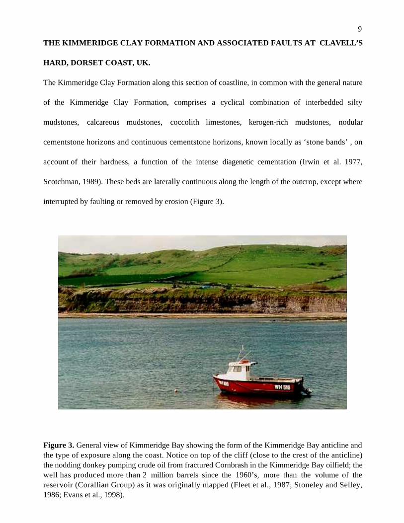
The Kimmeridge Clay Formation along this section of coastline, in common with the general nature
of the Kimmeridge Clay Formation, comprises a cyclical combination of interbedded silty
mudstones, calcareous mudstones, coccolith limestones, kerogen-rich mudstones, nodular
cementstone horizons and continuous cementstone horizons, known locally as ‘stone bands’ , on
account of their hardness, a function of the intense diagenetic cementation (Irwin et al. 1977,
Scotchman, 1989). These beds are laterally continuous along the length of the outcrop, except where
interrupted by faulting or removed by erosion (Figure 3).
Figure 3. General view of Kimmeridge Bay showing the form of the Kimmeridge Bay anticline andthe type of exposure along the coast. Notice on top of the cliff (close to the crest of the anticline)the nodding donkey pumping crude oil from fractured Cornbrash in the Kimmeridge Bay oilfield; thewell has produced more than 2 million barrels since the 1960’s, more than the volume of thereservoir (Corallian Group) as it was originally mapped (Fleet et al., 1987; Stoneley and Selley,1986; Evans et al., 1998).

10
The section investigated is exposed approximately for 1km east of Kimmeridge Bay between
the low tide ridges (known locally as ‘ledges’) at Yellow Ledge and Clavell’s Hard. Based on its
ammonite fauna, the succession has been divided into two major units: the Upper and Lower
Kimmeridge Clay (Blake, 1875; Arkell, 1947; House, 1993). The sequence exposed extends from the
Yellow Ledge Stone Band (Bed 37 of Cox and Gallois, 1981; Pectinatites scitulis zone) to the
Freshwater Steps Stone Band (Bed 48 of Cox and Gallois, 1981; Pectinatites pectinatus zone), all
within the Upper Kimmeridgian (Figure 4). The upper part of Kimmeridge Clay Formation is
approximately 80m thick in the study area. The sequence is dominated by various silty and
calcareous shales, typically comprising masive grey to dark grey mudstones, with compacted, well
laminated, (10-20 cm.) interbedded calcareous mudstones with abundant pyrite. A brownish-grey
bituminous mudstone horizon in the upper part of the sequence, known as the Blackstone Band or
Kimmeridge oil shale, varies laterally in thickness from 80 cm to 85 cm, is the major source rock
within the Kimmeridge Clay Formation. Thin bands of muddy dolomitic limestone (called
cementstone) occur at many levels, usually enclosed within the pale grey calcareous mudstone. The
sequence of Kimmeridge Clay Formation sediments exposed at Clavell’s Hard is summarised in
Figure 4 and is illustrated in Figure 5.
Five types of sediments are recognised on the basis of their outcrop characteristics and
known petrographic lithological fabrics (Macquaker and Gawthorpe, 1993):
1. Clay-rich mudstones, which are generally massive, rarely displaying sedimentary structures
except for occasional shell-lag deposits;
2. Silt-rich mudstones are characteristic by relic laminations and bioturbated fabrics, and are
typically pale grey in colour, and contain a low diversity fauna of ammonites and benthic bivalves;

11
3. Nannoplankton-rich mudstones dominated by coccoliths and form the well cemented ledges that
stand out from the adjacent mudstones. These are the so called ‘cementstone bands’ and are the
most competent mudstones in the succession;
4. Laminated mudstones are easily recognised on the basis of their dark brown colour, well
developed millimetric laminations and low density, as result of the extremely high organic matter
contents. Pyrite is also abundant.
5. Concretionary carbonate horizons composed of iron-rich carbonates (ferroan calcite and ankerite)
that are diagenetic in origin. These also form competent horizons in the mudstone sequence.
These are all mudstones, but differ in the proportions of clay, quartz silt and carbonate they
contain. The clay-rich and silty mudstones are typically massive and unlaminated, with a variable
content of shell material and are the softest mudstones in the succession. Organic matter-rich
laminated mudstones conspicuous by their dark grey to black or brown colour, and obvious
presence of organic matter and pyrite in hand specimen, form an intermediate degree of hardness.
The carbonate cemented nannoplankton mudstones and concretionary carbonate horizons are both
very hard and brittle with little or no remaining porosity, and are laterally continuous.

12
Figure 4. Schematic graphic sedimentary log of the Kimmeridge Clay Formation exposed along thecliffs east of Kimmeridge Bay towards Clavell’s Hard, based on field description and Scotchman(1989).

13
Figure 5. Photograph of the Kimmeridge Clay Formation exposed at Clavell’s Hard showing thecyclical sequence of interbedded calcareous mudstones and cementstone bands. The BlackstoneBand is the prominent dark grey mudstone horizon that intersects the cliff top at the base of thevalley to the left of the photograph.

14
The faults
The section for study selected at Clavell’s Hard is cut by several small normal faults, each
associated with extensive calcite veining (Figure 6), 7 normal faults, with little or no evidence for
reverse reactivation, are well exposed. Displacements on these faults range from 0.05-2.5m.
Figure 6. Map of the normal faults present in the cliffs and foreshore at Clavell’s Hard.
All the faults are normal and the dominant direction of displacement is parallel to the dip of
the fault plane (i.e. dip-slip faults). The faults all trend essentially north-south and dip to the west,
with dips typically of 45-80˚, averaging 60˚. Faults 3 and 4 form a conjugate set, formed of two
intersecting, opposed-dipping normal faults developed by incidental intersection (Nicol et al., 1995).
Only two faults (Fault 4 and Fault 5) dip to the east. Results of measurements and displacement of
studied faults are listed in Table 1.

15
Table 1. List of measurements and displacement of studied faults.
Fault Number Dip Strike Displacement (m)
F1 52˚ W 2˚ N 2.50F2 78˚ W 356˚ N 0.05F3 74˚ W 358˚ N 1.04F4 46˚ E 358˚ N 0.35F5 82˚ E 8˚ N 0.10F6 56˚ W 358˚ N 0.10F7 52˚ W 12˚ N 2.80
Fault morphology as observed at outcrop is strongly dependent on the nature of the host
Kimmeridge Clay Formation lithology that the faults cross-cut. Dependent on the competence of
the host mudstone, a variety of deformation features are recognised. These features are summarised
in Figure 7.
Within the clay and silt-rich mudstones the fault trace is always simple, with a single or
multiple slip surface often (but not always) associated with single or few carbonate vein fills. In
these weak mudstone horizons, carbonate vein fills are sometimes not present and the fault may be
represented by only a single slip plane surface. In the laminated mudstones and as the mudstones
become more cemented with carbonate (calcareous mudstones to cementstones) the complexity of
the fault zone increases. Calcareous mudstones and cementstones commonly display a complex
fault zone, several cm wide, with multiple slip surfaces, and several generations of carbonate veining.
Where significant competence contrasts are developed, large dilational jogs and pull-aparts are
present, up to 10’s of cm wide, with significant vuggy porosity and brecciation of both the host
mudstones and earlier vein material. Extension in the cemented layers is produced by inclined tensile
fractures, that refract with changing mudstone competence, to produce complex dilatational jogs and
pull-aparts.

16
Figure 7. Schematic illustration of the fault-geometry and its relationship to host Kimmeridge Claylithologies (based partly on Hunsdale and Sanderson, 1998), showing the development of veining,damage zones and dilational jogs.
A damage zone, composed of disturbed and faulted mudstone, with abundant tensile splay
fractures, is developed adjacent to the main fault slip surface. These splay fractures curve away
from the main fault surface at angles of 20-30°, and are commonly also carbonate cemented. This
damage zone also varies in thickness depending upon the lithology of the host sediment. In the
more massive, less competent clay rich and silty mudstones, the damage zone is absent or poorly
developed, and comprises only few sub-parallel splay fractures. In the more competent horizons
(such as the cementstones), the damage zone extends for many cm beyond the fault zone and
significant fracturing and brecciation of these layers is present outside of the fault zone, commonly
with zones of hydro-brecciation and veining. Where well developed, these splay fractures typically
bifurcate at their tips into several smaller strands. Examination of these structures in thin section
indicates that they propagate as very discrete planar fractures with finite widths of ca. 30um. A

17
common feature of the fault geometry and damage zone development is the concentration of veining,
brecciation and other damage zone features into the hangingwall of the faults.
Displacements on all the faults are small, ranging from a few millimetres up to 2.8 metres
(Figure 8). On some faults displacement decreases up the cliff from a maximum near the base,
suggesting that the faults are contained completely within the Kimmeridge Clay Formation, although
the displacement variation with increasing depth is not known. Further details of the fault
displacements and scaling relationships are given by Hunsdale and Sanderson (1998).
Figure 8. Sketch map of the displacements of the normal faults at Clavell’s Hard.
The abundance of small faults is clearly asymmetric. In most of the cases the number of
small faults is greater in the hanging-wall nearest to the main fault plane but falls away very rapidly.
This “clustering” effect results in narrow bands of intense deformation in the foot-wall very close to
the fault plane (within 20 cm). In the hanging-wall, small faults are less clustered and more spread
out than in the foot-wall. Therefore, examining in detail these deformation zones, the broader
damaged zone is in the hanging-wall and there is only one symmetric arrange across Fault 4. A
second series of small faults trend approximately east-west, displacement in these faults is minor,
typically less than 1 cm.
Faults F1 to F7 (Figure 6) were examined in detail. These faults have arrays of smaller
displacement faults associated with them that cluster either side of the main fault, defining a damage

18
zone in the mudstones. The extent and symmetry of the damage zone was investigated by measuring
the abundance of small faults in a series of traverses across these faults (Described as T in Figure 6).
The results of these traverses are listed in Table 2.
Table 2. Distance of extent of damage zone in faults examined
Fault and Deformation in Deformation in TotalTraverse foot-wall (cm) hanging-wall (cm) Deformation (cm)
F1(T4) 160 160 320F2(T1) 40 80 120F3(T2) 100 140 240F4(T2) 100 140 240F5(T5) 40 60 100F7(T3) 60 100 160
In order to define the width of the deformation zone, vein populations were counted in the
foot-wall and hanging-wall in a series of traverses at right angles to the fractures, results of these
traverses are reported in tables, and plotted in figures as histograms (See Table 3 and Figure 9 as
examples).
In all cases, the width of the damage zone does not exceed 4-10cm, although discrete clusters
of splay faults related but distinct from the damage zone may be developed up to 20cm away from
the fault slip surface. Variation in width of the damage zone is primarily a function of of lithology,
with the widest damage zones being developed in the most competent lithologies.

19
Table 3. Results of vein populations counted in foot-wall and hanging-wall. Traverses at right angle to fault number 1.
Number of interval Vein populations Vein populations (every 20 cm) in foot-wall in hanging-wall
1 (0-20) 31 132 (20-40) 3 23 (40-60) 4 134 (60-80) 2 125 (80-100) 2 76 (100-120) 2 67 (120-140) 3 78 (140-160) 3 89 (160-180) 1 310 (180-200) 3 211 (200-220) 2 212 (220-240) 1 213 (240-260) 1 114 (260-280) 1 215 (280-300) 0 0
1 2 3 4 5 6 7 8 9 10 11 12 13 14 150
5
10
15
20
25
30
35
Frequency
1 2 3 4 5 6 7 8 9 10 11 12 13 14 15
Number of interval (every 20 cm)
Vein populations infoot-wall
Vein populations inhanging-wall
Figure 9. Fault No 1, histogram of vein populations.

20
The calcite cemented vein systems in the faults
All faults examined are pervasively cemented with white coloured, sparry calcite, that is largely
undeformed; breccias are rarely developed, indicating that for the majority of faults, displacement on
any single surface took place before calcite cementation. The calcite cement forms large, elongate,
euhedral crystals that nucleate on fracture walls and grow towards the fault plane centres (Figure
10). In most cases, calcite fills the fracture; larger fractures maintain vuggy porosity in their centres.
The growth of euhedral, largely undeformed calcite crystals indicates that the fault fractures formed
open cavities during cementation; calcite cemented a cavity and did not grow displacively. Where the
faults cut lithologies of different competence (such as carbonate cemented horizons) dilational jogs
and pull-aparts are developed. These irregularities in the fault surface result in large cavities that are
filled with several generations of calcite cement. Occasionally, walls to dilational jogs are brecciated,
with fault plane rugosity being smoothed, and fragments of early cement generations being included
within the breccia.
Figure 10. Fractures along Fault 3 at Clavell’s Hard, showing open fractures partially filled withlarge, euhedral calcite crystals that nucleate on fracture wall and grow towards fault plane centres.Note abrupt fracture wall boundary.

21
Although individual veins show little evidence of deformation subsequent to calcite
precipitation, multiple generations of calcite veining are clearly present (Figure 11). Later calcite
veins do not occur within or re-open earlier calcite veins, but develop adjacent to earlier formed
veins, indicating that the process of faulting and calcite precipitation results in strain hardening, i.e.
that the earlier formed cement veins are more competent than the host lithology. Where the fault
surface has rugosity, many veins of calcite (10’s to 100’s) are developed.
Figure 11. Cemented fault plane in massive clay-rich mudstones at Clavell’s Hard. Note thenarrow width of the damaged zone and the multiple generations of calcite veins indicatingdisplacement took place before calcite cementation, and that strain hardening has taken place.
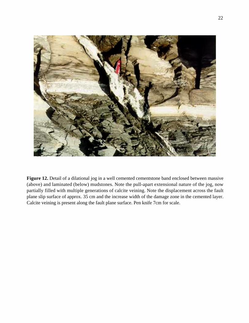
The sequence of cementation is from the rock-wall to the middle of the fracture, where in
some cases a cavity exists, showing euhedral crystals. Well cemented dilational jogs appear in the
vertical exposure (Figure 12) and scarce cataclastic events (brecciation) remain transverse to the
hanging-wall in the northern direction.
22
Figure 12. Detail of a dilational jog in a well cemented cementstone band enclosed between massive(above) and laminated (below) mudstones. Note the pull-apart extensional nature of the jog, nowpartially filled with multiple generations of calcite veining. Note the displacement across the faultplane slip surface of approx. 35 cm and the increase width of the damage zone in the cemented layer.Calcite veining is present along the fault plane surface. Pen knife 7cm for scale.

23
Sampling
After mapping, faults and veins were photographed and representative samples were systematically
collected along different points of the fault system encompassing all the variability observed at the
outcrop (See figure 13 as example for location), including fault surfaces, small veins, dilational jogs,
breccias, and any cross-cutting relationships. Special care was taken to check that veins of all sizes
and faults of variable displacements were appropriately sampled.
Figure 13. Location of samples collected from conjugated fault (Faults number 3 and 4).

24
Conclusions of the fault system
The N-S faults described in the Kimmeridge Clay Formation are all normal, conjugate faults with a
mean strike of 10° and a mean dip of 60°, and are spatially restricted to an area south of the
Purbeck-Isle of Wight inversion monocline (Arkell, 1947; Hunsdale and Sanderson, 1998), with
similar fault orientations and characteristics being recognised in the adjacent offshore Kimmeridgian
sediments (Donovan and Stride, 1961).
There are 3 possible tectonic settings in which these faults could have formed:
1. During overpressure generation whilst the Kimmeridge Clay Formation was undergoing burial in
the late Jurassic early Cretaceous, comparable to hydrofracturing (Cartwright, 1995);
2. During compressional tectonics associated with the formation of the Kimmeridge Bay anticline in
the hangingwall of the Purbeck Monocline (Arkell, 1936; Phillips, 1964; Bevan, 1985) comparable
to structures described for the Liassic sequence on the margins of the Bristol Channel (McGrath and
Davison, 1995); and
3. During overpressure related to the inversion and removal of the Cretaceous-Tertiary cover
sequence, similar to inversion hydrofracturing reported by Sibson (1995).
The focussing of the damage zone deformation within the hangingwall indicates that as the
faults propagated, extensional tensile stresses were asymmetrically distributed at the front of
upward-propagating fault tips, and that the Present Day coastal section represents a high level
tectonic window on the fault systems. The extensional nature of the faulting, absence of reactivation
structures and upward-propagating nature of the faults is consistent with a explosive hydrofracture
origin.
The scale of the faulting, despite its high level nature, and the presence of conjugate fault
networks, suggests that these faults do not penetrate for significant depths beneath the Present Day
exposure. Given the thickness of the Kimmeridge Clay Formation at this locality, these faults and

25
associated calcite-filled veins have therefore most probably trapped fluids that were expelled
upwards from within the Kimmeridge Clay Formation and are thus ideal for investigating the nature
and composition of fluids generated in this mudstone sequence during early burial.
REFERENCES
Arkell, W. J. 1936. The Corallian Beds of Dorset. Proceedings of the Dorset Natural History andArchaeological Society, 57, p.59-93.
Arkell, W. J. 1947. The geology of the country around Weymouth, Swanage, Corfe and Lulworth.Memoir Geogical Survey. p. 25-58.
Arkell, W. J. 1956. Jurassic Geology of the World . Ed. Oliver and Boyd Ltd. p. 58-123.
Baird, R. A. (1986). Maturation and source rock evaluation of Kimmeridge Clay, Norwegian NorthSea. American Association of Petroleum Geologists Bulletin 70, p. 1-11.
Barnard, P. C. and Cooper, B. S. (1981). Petroleum Geology of the continental shelf of North WestEurope. Ed. Illing, L. V. and Hobson, G. D. Institute of Petroleum. London. p. 169-175.
Bevan, T. G. 1985. A reinterpretation of fault systems un the Upper Cretaceous rocks of theDorset coast, England. Proc. Geol. Ass. 96 (4), p. 337-342.
Bigge, M. A. and Farrimond, P. (1998). Biodegradation of seep oils in the Wessex Basin-acomplication for correlation. In: Underhill, J. R. (ed.) Development, Evolution and PetroleumGeology of the Wessex Basin, Geological Society, London, Special Publications, 133, p. 373-386.
Blake, J. F. 1875. On the Kimmeridge Clay of England. Quart. Jour. Geol. Soc. 31, 196-233. InFarrimond, P., Comet, P., Eglinton, G., Evershed, R. P., Hall, M. A., Park, D. W. and Wardroper,M. K. 1984. Organic geochemical study of the Upper Kimmeridge Clay of the Dorset type area.Marine Petroleum Geology 1, p. 340-354.
Buchanan, J. G. 1998. The exploration history and controls on hydrocarbon prospectivity in theWessex basins, southern England, UK. In: Underhill, J. R. (ed.) Development, Evolution andPetroleum Geology of the Wessex Basin, Geological society, London, Special Publications, 133, p.19-37.
Butler, M. 1998. The geological history of the southern Wessex Basin- a review of new informationfrom oil exploration. In: Underhill, J. R. (ed.) Development, Evolution and Petroleum Geology ofthe Wessex Basin, Geological Society, London, Special Publications, 133, p. 67-86.
Cartwright, J. A. 1995. Episodic basin-wide fluid expulsion from geopressured shale sequences inthe North Sea basin. Geology, 22, p. 447-450.

26
Chadwick, R. A. 1986. Extension tectonics in the Wessex Basin, southern England. Journal of theGeological Society of London. 143, p. 465-488.
Cox, B. M. and Gallois, R. W. 1981. The stratigraphy of the Kimmeridge Clay of the Dorset typearea and its correlation with some other Kimmeridgian sequences. Rep. Inst. Geol. Sci. 80/4. p. 5-18.
Didyk, B. M. , Simoneit, B. R. T. , Brassell, S. C. and Eglinton, G. 1978. Organic geochemicalindicators of palaeo-environmental conditions of sedimentation. Nature, 272, p. 216-222.
Donovan, D. T. and Stride, A. H. 1961. An acoustic survey of the sea floor south of Dorset and itsgeological interpretation. Philosophical Transactions of the Royal Society of London, 244, p. 299-330.
Evans, J., Jenkins, D. and Gluyas, J. 1998. The Kimmeridge Bay Oilfield: an enigma demystified. In:Underhill, J. R. (ed.) Development, Evolution and Petroleum Geology of the Wessex Basin,Geological Society, London, Special Publications, 133, p. 407-413.
Farrimond, P., Comet, P., Eglinton, G., Evershed, R. P., Hall, M. A., Park, D. W. and Wardroper,M. K. 1984. Organic geochemical study of the Upper Kimmeridge Clay of the Dorset type area.Marine Petroleum Geology 1, p. 340-354.
Ferril, D. A., Morris, A. P., Stamatakos, J. A. and Sims, D. W. 2000. Crossing conjugate normalfaults. AAPG Bulletin, v.84, No 10, p. 1543-1559.
Fleet, A.J., Clayton, C. J., Jenkyns, H. C. and Parkinson, D. N. 1987. Liassic source-rockdeposition in western Europe. In: Brooks, J. and Glennie, K. W. (eds), Petroleum Geology of NorthWest Europe, Graham and Trotman, London, p. 59-70.
Gallois, R. W. 1979a. Oil Shale Resources in Great Britain. Institute of Geological Sciences. OpenFile Report, 2 Vols. p.15-38.
Guerrero-Munoz, M. 1999. Fluid expulsion from hydrocarbon source rocks: A stable isotope studyof hydrofracture cements in the Kimmeridge Clay Formation at Clavell’s Hard, Dorset Coast, UK.PhD thesis, University of Manchester. 388pp.
Hamblin, R. J. O., Crosby, A., Balson, P. S., Jones, S. M., Chadwick, R. A., Penn, I. E. and Arthur,M. J. 1992. United Kingdom offshore regional report: the geology of the English Channel. HMSO,London. p.18-38.
Hawkes, P. W., Fraser, A. J. and Einchcomb, C. C. G. 1998. The tectono-stratigraphic developmentand exploration history of the Weald and Wessex basins, Southern England. In: Underhill, J. R. (ed.)Development, Evolution and Petroleum Geology of the Wessex Basin, Geological society, London,Special Publications, 133, p. 39-65.
House, M. R. 1993. Geology of the Dorset Coast. Second edition. Geologists’ Association Guide22. The Geologists’ Association. 164 pp.

27
Hunsdale, R. and Sanderson, D. J. 1998. Fault size distribution analysis-an example fromKimmeridge Bay, Dorset, UK. In: Underhill, J. R. (ed.) Development, Evolution and PetroleumGeology of the Wessex Basin, Geological Society, London, Special Publications, 133, p. 299-310.
Irwin, H., Curtis, C. and Coleman, M. 1977. Isotopic evidence for source of diagenetic carbonatesformed during burial of organic-rich sediments. Nature 269, p. 209-213.
Lewan, M. D. (1985). Evaluation of petroleum generation by hydrous pyrolysis experimentation.Philosophical Transactions Royal Society. London, A 315, p. 123-134.
Macquaker, J. and Gawthorpe, 1993. Mudstone lithofacies in the Kimmeridge Clay Formation,Wessex Basin, Southern England: implications for the origin and controls of the distribution ofmudstones.Journal of Sedimentary Petrology, p. 1129-1143.
McGrath, A. G. and Davison, I. 1995. Damage zone geometry around fault tips. Journal ofStructural Geology 17, p.1011-1024
Miles, J. A., Downes, C. J. and Cook, S. E. (1993). The fossil oil seep in Mupe Bay, Dorset: amyth investigated. Marine and Petroleum Geology, 10, p. 58-70.
Nicol, A., Walsh, J. J., Watterson, J. and Bretan, P. G. 1995. Three-dimensional geometry andgrowth of conjugate normal faults. Journal of Structural Geology, 17, p. 847-862.
Phillips, W. J. 1964. The structures in the Jurassic and Cretaceous rocks on the Dorset coastbetween White Nothe and Mupe Bay. Proceedings of the Geologists’ Association, 75, p. 373-406.
Roberts, S. J., Nunn, J. A., Cathles, L. and Cipriani, F. D. 1996. Expulsion of abnormally pressuredfluids along faults. Journal of Geophysical Research, 101, No B12, p. 28 231-28 252.
Scotchman, I. C. 1987. Relationship between clay diagenesis and organic maturation in theKimmeridge Clay Formation, onshore UK. In Brooks, J. and Glennie, K. (eds.) Petroleum Geologyof North West Europe. p. 251-261.
Scotchman, I. C. 1989. Diagenesis of the Kimmeridge Clay Formation, onshore UK. Journal of theGeological Society of London 146, p.285-303.
Scotchman, I. C. 1991. The geochemistry of concretions from the Kimmeridge Clay Formation ofsouthern and eastern England. Sedimentology 38, p.79-106.
Scotchman, I. C. (1993). Diagenetic pore fluid evolution in the Kimmeridge Clay Formation: fromconcretions to sandstone cements. In Manning, D. A. C. , Hall, P. L. and Hughes, C. R. (eds.)Geochemist of Clay-Pore Fluid Interactions. Chapman and Hall, London, p. 127-159.
Secor, D. T. 1965. Role of pore pressure in jointing. American Journal of Science, 263, p. 633-646
Secor, D. T. and Pollard, D. D. 1975. On the stability of open hydraulic fractures in the earth’scrust. Geophysical Research Letters, 2, No 11, p. 510-513.

28
Selley, R. C and Stoneley, R. 1987. Petroleum habitat in south Dorset. In Brooks, J. and Glennie,K. (eds.) Petroleum Geology of North West Europe. p. 139-148.
Sibson, R. H. 1981. Controls on low-stress hydro-fracture dilatancy in thrust, wrench and normalfault terrains. Nature, 289, p. 665-667.
Stoneley, R. and Selley, R. C. 1986. A Field Guide to the Petroleum Geology of the Wessex Basin.Imperial College, London. p.14-39.
Tissot, B. P. and Welte, D. H. (1984). Petroleum Formation and Ocurrence. Springer-Verlag, Berlin.699 pp.
Underhill, J. R. and Stoneley, R. 1998. Introduction to the development, evolution and petroleumgeology of the Wessex Basin. In: Underhill, J. R. (ed.) Development, Evolution and PetroleumGeology of the Wessex Basin, Geological Society, London, Special Publications, 133, p. 1-18.
Warrington, G. and Scrivener, R. C. 1980. Lyme Regis (1901). Borehole succesion and itsrelationship to the Triassic sequence of the east Devon coast. Proceedings Ussher Society 5, p. 24-32. In House, M. R. 1993. Geology of the Dorset Coast. Second edition. Geologists’ AssociationGuide 22. The Geologists’ Association.
Williams, P. F. V. and Douglas, A. G. (1981). Kimmeridge oil shale: a study of organic maturation.In Brooks, J. (Ed.). Organic Maturation Studies and Fossil Fuel Exploration. Academic Press.London, p. 255-269.