INTERNATIONAL TRIBUNAL FOR THE LAW OF THE SEA · 2018-01-29 · at the International Tribunal for...
45
English Version ITLOS/PV.17/C23/1/Rev.1 INTERNATIONAL TRIBUNAL FOR THE LAW OF THE SEA 2017 Public sitting held on Monday, 6 February 2017, at 10 a.m., at the International Tribunal for the Law of the Sea, Hamburg, President of the Special Chamber, Judge Boualem Bouguetaia, presiding DISPUTE CONCERNING DELIMITATION OF THE MARITIME BOUNDARY BETWEEN GHANA AND CÔTE D’IVOIRE IN THE ATLANTIC OCEAN (Ghana/Côte d’Ivoire) Verbatim Record
Transcript of INTERNATIONAL TRIBUNAL FOR THE LAW OF THE SEA · 2018-01-29 · at the International Tribunal for...

English Version ITLOS/PV.17/C23/1/Rev.1
INTERNATIONAL TRIBUNAL FOR THE LAW OF THE SEA
2017
Public sitting
held on Monday, 6 February 2017, at 10 a.m.,
at the International Tribunal for the Law of the Sea, Hamburg,
President of the Special Chamber, Judge Boualem Bouguetaia, presiding
DISPUTE CONCERNING DELIMITATION OF THE MARITIME BOUNDARY BETWEEN GHANA AND CÔTE D’IVOIRE IN THE ATLANTIC OCEAN
(Ghana/Côte d’Ivoire)
Verbatim Record

ITLOS/PV.17/C23/1/Rev.1 ii 06/02/2017 a.m.
Special Chamber
of the International Tribunal for the Law of the Sea
Present: President Boualem Bouguetaia
Judges Rüdiger Wolfrum
Jin-Hyun Paik
Judges ad hoc Thomas A. Mensah
Ronny Abraham
Registrar Philippe Gautier
ITLOS/PV.17/C23/1/Rev.1 iii 06/02/2017 a.m.
Ghana is represented by: Ms Gloria Afua Akuffo, Attorney-General and Minister for Justice, as Agent; Mrs Helen Ziwu, Solicitor-General, as Co-Agent; and
Mr Daniel Alexander QC, 8 New Square, London, United Kingdom, Ms Marietta Brew Appiah-Opong, former Attorney-General, Ms Clara E. Brillembourg, Foley Hoag LLP, Washington DC, United States of
America, Professor Pierre Klein, Centre of International Law, Université Libre de
Bruxelles, Brussels, Belgium, Ms Alison Macdonald, Matrix Chambers, London, United Kingdom, Mr Paul S. Reichler, Foley Hoag LLP, Washington DC, United States of
America, Professor Philippe Sands QC, Matrix Chambers, London, United Kingdom, Ms Anjolie Singh, Member of the Indian Bar, New Delhi, India, Mr Fui S. Tsikata, Reindorf Chambers, Accra, as Counsel and Advocates; Ms Jane Aheto, Ministry of Foreign Affairs and Regional Integration, Ms Pearl Akiwumi-Siriboe, Attorney-General’s Department, Mr Anthony Akoto-Ampaw, Adviser to the Attorney-General, Mr Godwin Djokoto, Faculty of Law, University of Ghana, Accra, Ms Vivienne Gadzekpo, Ministry of Petroleum, Mr Godfred Dame, Adviser to the Attorney-General, Professor H. Kwasi Prempeh, Adviser to the Attorney-General, Mr Nicholas M. Renzler, Foley Hoag LLP, Washington DC, United States of
America, Dr Alejandra Torres Camprubí, Foley Hoag LLP, Paris, France, as Counsel; Mr Kwame Mfodwo, Maritime Boundaries Secretariat, Ms Azara Prempeh, Ghana Maritime Authority and Ghanaian Representative
to the International Maritime Organisation, London, United Kingdom, Ms Adwoa Wiafe, Ghana National Petroleum Corporation, Accra,
as Legal Advisers;
Ms Peninnah Asah Danquah, Attorney-General’s Department,

ITLOS/PV.17/C23/1/Rev.1 iv 06/02/2017 a.m.
Mr Samuel Adotey Anum, Chargé d’affaires, Embassy of Ghana to the Federal Republic of Germany, Berlin, Germany, Mr Michael Nyaaba Assibi, Counsellor, Embassy of Ghana to the Federal Republic of Germany, Berlin, Germany, Dr. K.K. Sarpong, Ghana National Petroleum Corporation, Accra,
as Advisers; Mr Nii Adzei-Akpor, Petroleum Commission, Mr Theo Ahwireng, Petroleum Commission, Mr Lawrence Apaalse, Ministry of Petroleum, Mr Ayaa Armah, University of Ghana, Accra, Mr Michael Aryeetey, GNPC-Explorco, Accra, Mr Nana Boakye Asafu-Adjaye, former Chief Executive, Ghana National Petroleum Corporation, Accra,
Dr Joseph Asenso, Ministry of Finance, Dr Robin Cleverly, Marbdy Consulting Ltd, Taunton, United Kingdom, Mr Scott Edmonds, International Mapping, Ellicott City, MD, USA, Ms Vicky Taylor, International Mapping, Ellicott City, MD, USA, Dr Knut Hartmann, EOMAP GmbH & Co, Munich Germany, Mr Daniel Koranteng, Ghana National Petroleum Corporation, Accra, Mr Thomas Manu, Ghana National Petroleum Corporation, Accra, Mr Kwame Ntow-Amoah, Ghana National Petroleum Corporation, Accra, Mr Nana Poku, Ghana National Petroleum Corporation, Accra, Mr Sam Topen, Petroleum Commission,
as Technical Advisers;
Ms Elizabeth Glusman, Foley Hoag LLP, Washington DC, United States of
America, Ms Nonyeleze Irukwu, Institut d’études politiques de Paris, Paris, France, Ms Nancy Lopez, Foley Hoag LLP, Washington DC, United States of America, Ms Lea Main-Klingst, Matrix Chambers, London, United Kingdom, Ms Lara Schiffrin-Sands, Institut d’études politiques de Paris, Paris, France,
as Assistants.
Côte d’Ivoire is represented by:
Mr Adama Toungara, Minister, Head of Delegation,
as Agent; Dr Ibrahima Diaby, Director-General of PETROCI,
ITLOS/PV.17/C23/1/Rev.1 v 06/02/2017 a.m.
as Co-Agent; and
Mr Thierry Tanoh, Minister of Petroleum, Energy and the Development of Renewable Energy,
Mr Adama Kamara, Avocat, Côte d’Ivoire Bar, Partner, ADKA, Special Adviser to the Prime Minister,
Mr Michel Pitron, Avocat, Paris Bar, Partner, Gide Loyrette Nouel, Mr Alain Pellet, Professor of Law (emeritus), former Chairman of the
International Law Commission, Sir Michael Wood, K.C.M.G., Member of the International Law Commission,
Member of the English Bar, Ms Alina Miron, Professor of International Law, Université d’Angers, as Counsel and Advocates; Ms Isabelle Rouche, Avocate, Paris Bar, Gide Loyrette Nouel, France, Mr Jean-Sébastien Bazille, Avocat, Paris Bar, Gide Loyrette Nouel, France, Ms Lucie Bustreau, Avocate, Gide Loyrette Nouel, France, Mr Jean-Baptiste Merlin, PhD, Université de Paris Ouest, Nanterre La Défense,
France, Ms Tessa Barsac, Master, Université de Paris Ouest, Nanterre La Défense,
France, as Counsel; H.E. Mr Léon Houadja Kacou Adom, Ambassador of Côte d’Ivoire to the
Federal Republic of Germany, Berlin, Germany, Mr Lucien Kouacou, Engineer in the Directorate-General of Hydrocarbons, Ms Nanssi Félicité Tezai, Assistant to the Agent,
as Advisers.

ITLOS/PV.17/C23/1/Rev.1 1 06/02/2017 a.m.
THE PRESIDENT OF THE SPECIAL CHAMBER (Interpretation from French): 1 Ladies and gentlemen, first of all, I would like to welcome all the delegations, the 2 delegation of Côte d’Ivoire and the delegation of Ghana, but I would also like to take 3 this opportunity to welcome two newcomers here: Her Excellency Ms Gloria Afua 4 Akuffo, Attorney-General and Minister for Justice of the Republic of Ghana, and His 5 Excellency Mr Thierry Tanoh, Minister for Petroleum, Energy and the Development 6 of Renewable Energy of the Republic of Côte d’Ivoire. 7 8 I would also like to congratulate them on their appointment to their respective 9 governments and I wish them every success in their new functions. 10 11 The Special Chamber of the Tribunal formed pursuant to article 15, paragraph 2, of 12 the Statute of the Tribunal is meeting today to hear the arguments of the Parties in 13 the Dispute Concerning Delimitation of the Maritime Boundary between Ghana and 14 Côte d’Ivoire in the Atlantic Ocean (Ghana/Côte d’Ivoire). 15 16 It should be recalled that, by Special Agreement concluded on 3 December 2014, 17 the representatives of the Republic of Ghana and the Republic of Côte d’Ivoire 18 agreed to submit their dispute concerning delimitation of the maritime boundary in 19 the Atlantic Ocean to a special chamber of the Tribunal to be formed pursuant to 20 article 15, paragraph 2, of the Statute of the Tribunal. 21 22 Notification of the Special Agreement was given on 3 December 2014 and the 23 Chamber was created by an Order of the Tribunal on 12 January 2015. The case 24 was entered as No. 23 in the List of Cases. 25 26 On 27 February 2015, Côte d’Ivoire submitted a Request for the prescription of 27 provisional measures to the Special Chamber in accordance with article 290, 28 paragraph 1, of the United Nations Convention on the Law of the Sea and, on 29 25 April 2015, the Special Chamber delivered its Order on the prescription of 30 provisional measures. 31 32 I now give the floor to the Registrar to summarize the procedure in this case 33 subsequent to adoption of that Order. 34 35 THE REGISTRAR: Thank you, Mr President. 36 37 By Order dated 24 February 2015, the President of the Special Chamber fixed the 38 time-limits for the filing of the written pleadings in the case, namely 4 September 39 2015 for the Memorial of Ghana, and 4 April 2016 for the Counter-Memorial of Côte 40 d’Ivoire. These pleadings were filed within the prescribed time-limits. 41 42 By Order dated 16 March 2016, the Special Chamber authorised the submission of a 43 Reply by Ghana and a Rejoinder by Côte d’Ivoire and fixed the time-limits for the 44 filing of these written pleadings. 45 46 Further to a request by Ghana, these time-limits were extended, by an Order of the 47 President dated 25 April 2016, to 25 July 2016 for the Reply of Ghana and 48 14 November 2016 for the Rejoinder of Côte d’Ivoire. The Reply and the Rejoinder 49 were filed within the prescribed time-limits. 50

ITLOS/PV.17/C23/1/Rev.1 2 06/02/2017 a.m.
1 Mr President, I shall now read the submissions of the Parties. 2 3 In its Memorial and Reply, Ghana requested the Special Chamber to adjudge and 4 declare that: 5 6
1) Ghana and Côte d’Ivoire have mutually recognized, agreed, and 7 applied an equidistance-based maritime boundary in the territorial sea, 8 EEZ and continental shelf within 200 M. 9 10
2) The maritime boundary in the continental shelf beyond 200 M follows 11 an extended equidistance boundary along the same azimuth as the 12 boundary within 200 M, to the limit of national jurisdiction. 13 14
3) In accordance with international law, by reason of its representations 15 and upon which Ghana has placed reliance, Côte d’Ivoire is estopped 16 from objecting to the agreed maritime boundary. 17 18
4) The land boundary terminus and starting point for the agreed maritime 19 boundary is at Boundary pillar 55 (BP 55). 20 21
5) As per the Parties’ agreement in December 2013, the geographic 22 coordinates of BP 55 are 05° 05’ 28.4” N and 03° 06’ 21.8” W (in World 23 Geodetic System 1984 datum). 24 25
6) Consequently, the maritime boundary between Ghana and Côte 26 d’Ivoire in the Atlantic Ocean starts at BP 55, connects to the customary 27 equidistance boundary mutually agreed by the Parties at the outer limit 28 of the territorial sea, and then follows the agreed boundary to a distance 29 of 200 M. Beyond 200 M, the boundary continues along the same 30 azimuth to the limit of national jurisdiction. The boundary line connects 31 the following points, using loxodromes. 32
33 A table with the list of the coordinates for each of these points is reproduced in the 34 submissions contained in the Reply of Ghana, at pages 163 and 164. 35 36 (Interpretation from French) Mr President, in the submissions in its Rejoinder, whose 37 content reflects the submissions set out in its Counter-Memorial, Côte d’Ivoire 38 requests the Special Chamber to: 39 40
reject all Ghana’s requests and claims, and to declare and adjudge that 41 42 1) the sole maritime boundary between Ghana and Côte d’Ivoire follows 43
the 168.7° azimuth line, which starts at boundary post 55 and extends 44 to the outer limit of the Ivorian continental shelf; 45
46 2) the activities undertaken unilaterally by Ghana in the Ivorian maritime 47
area constitute a violation of: 48 49
(i) the exclusive sovereign rights of Côte d’Ivoire over its continental 50 shelf, as delimited by this Chamber; 51 52

ITLOS/PV.17/C23/1/Rev.1 3 06/02/2017 a.m.
(ii) the obligation to negotiate in good faith, pursuant to article 83, 1 paragraph 1, of UNCLOS and customary law; 2 3 (iii) the obligation not to jeopardize or hamper the conclusion of an 4 agreement, as provided for by article 83, paragraph 3, of UNCLOS; 5 and; 6
7 3) Ghana has violated the provisional measures prescribed by this 8
Chamber by its Order of 25 April 2015; 9 10 4) and consequently to declare and adjudge that: 11 12
(a) Ghana is obliged to transmit to Côte d’Ivoire all the documents and 13 data relating to the oil exploration and exploitation activities which 14 it has undertaken, or which have been undertaken with its 15 authorization, in the Ivorian maritime area, including the oil transport 16 and development operations, including those listed in 17 paragraphs 9.29 and 9.31 of Côte d'Ivoire's Counter-Memorial; 18
19 (b) Ghana is obliged to ensure the non-disclosure, by itself and by its 20
co-contractors, of the information mentioned in paragraph (4) (a) 21 above; 22
23 (c) Côte d’Ivoire is, moreover, entitled to receive compensation for the 24
damages caused it by Ghana's internationally wrongful acts; and to 25 26
invite the Parties to carry out negotiations in order to reach agreement 27 on this point, and 28
29 to state that, if they fail to reach an agreement on the amount of this 30 compensation within a period of six (6) months as from the date of the 31 Order to be delivered by the Special Chamber, said Chamber will 32 determine, at the request of either Party, the amount of this 33 compensation on the basis of additional written documents dealing with 34 this subject alone. 35
36 With its Order of 15 December 2016, the Special Chamber fixed 6 February 2017 as 37 the date for the opening of the hearing. 38 39 Pursuant to the Rules of the Tribunal, copies of the written pleadings have been 40 made accessible to the public today and will be placed on the Tribunal’s website. 41 42 Thank you, Mr President. 43 44 THE PRESIDENT OF THE SPECIAL CHAMBER (Interpretation from French): 45 Thank you, Mr Registrar. 46 47 Today’s sitting, in the course of which Ghana will present the first part of its 48 statement, will last until one o’clock and, as usual, there will be a 30-minute break 49 between 11.30 and midday. 50 51 (Continued in English) I note the presence of the Agent, Co-Agent, Counsel and 52 Advocates of the Republic of Ghana at the hearing. I now invite the Agent of Ghana, 53

ITLOS/PV.17/C23/1/Rev.1 4 06/02/2017 a.m.
Minister Gloria Afua Akuffo, to introduce the delegation of Ghana. You have the floor, 1 Madam Minister. 2 3 MS AFUA AKUFFO: Mr President, Members of the Special Chamber, the delegation 4 of Ghana includes Co-Agent Mrs Helen Ziwu, Solicitor-General of the Republic of 5 Ghana. 6 7 Also in the delegation are counsel and advocates Ms Marietta Brew Appiah-Opong, 8 who is the immediate past Attorney-General and Minister for Justice of the Republic 9 of Ghana. We also have Professor Philippe Sands QC of Matrix Chambers, London; 10 Mr Paul S. Reichler of Foley Hoag LLP, Washington; Mr Fui Tsikata of Reindorf 11 Chambers, Accra, Ghana; Professor Pierre Klein of the Centre of International Law, 12 Brussels, Belgium; Ms Clara E. Brillembourg of Foley Hoag LLP, Washington, USA; 13 Ms Anjolie Singh of New Delhi, India; Mr Daniel Alexander QC of 8 New Square, 14 London; and Ms Alison Macdonald, also of Matrix Chambers, London. 15 16 THE PRESIDENT OF THE SPECIAL CHAMBER: Thank you, Madam Minister. 17 18 (Interpretation from French) I also note the presence at the hearing of the Agent, 19 Co-Agent and Counsel and Advocates for Côte d’Ivoire. 20 21 I now give the floor to the Agent for Côte d’Ivoire, Minister Adama Toungara, to 22 introduce his delegation. 23 24 MR TOUNGARA (Interpretation from French): Mr President, Members of the Special 25 Chamber, allow me to introduce to you the members of the delegation of the 26 Republic of Côte d’Ivoire, which I am honoured to lead. 27 28 - I am Minister Adama Toungara, Agent for the Republic of Côte d’Ivoire; 29 30 - Mr Thierry Tanoh is Minister for Petroleum and Energy and the Development of 31
Renewable Energy for Côte d’Ivoire; 32 33 - Dr Ibrahima Diaby, Director-General of the national oil company, PETROCI, and 34
Co-Agent for the Republic of Côte d’Ivoire; 35 36 - His Excellency Mr Léon Houadja Kacou Adom, Ambassador of Côte d’Ivoire to 37
Germany; 38 39 - Ms Nanssi Félicité Tezai, Assistant to the Agent. 40 41 Our Counsel and Advocates are: 42 43 - Mr Adama Kamara, Avocat, Côte d’Ivoire Bar, Partner, ADKA, Special Adviser to 44
the Prime Minister; 45 46 - Mr Michel Pitron, Avocat, Paris Bar; 47 48 - Mr Alain Pellet, Professor of Law (emeritus), former Chairman of the International 49
Law Commission; 50

ITLOS/PV.17/C23/1/Rev.1 5 06/02/2017 a.m.
1 - Sir Michael Wood KCMG, Member of the International Law Commission, Member 2
of the English Bar; 3 4 - Ms Alina Miron, Professor of Law. 5 6 Our Counsel are: 7 8 - Ms Isabelle Rouche, Avocate, Paris Bar, Gide Loyrette Nouel; 9 10 - Mr Jean-Sébastien Bazille, Avocat, Paris Bar, Gide Loyrette Nouel; 11 12 - Ms Lucie Bustreau, Avocate, Gide Loyrette Nouel; 13 14 - Mr Jean-Baptiste Merlin, PhD, Université de Paris Ouest, Nanterre La Défense; 15
and 16 17 - Ms Tessa Barsac, Master, Université de Paris Ouest, Nanterrre La Défense. 18 19 Thank you, Mr President. 20 21 THE PRESIDENT OF THE SPECIAL CHAMBER (Interpretation from French): 22 Thank you, Minister. 23 24 (Continued in English) I now give the floor to Ms Marietta Brew Appiah-Opong to 25 begin her statement. Ms Brew Appiah-Opong, you have the floor. 26 27 MS BREW APPIAH-OPONG: Mr President, Members of the Special Chamber, it is 28 my pleasure and privilege to appear before you again on behalf of Ghana. 29 30 As you may be aware, there has been a change of government in Ghana. However, 31 despite that change, the current and former governments have worked together 32 closely to ensure the smooth running and continuity of this case. The current and 33 former government are completely united in their commitment to Ghana’s national 34 interest. This unity is demonstrated by my presence here alongside my successor as 35 Attorney-General, Ms Gloria Afua Akuffo, who is my colleague at the Ghana bar and 36 indeed a good friend. 37 38 Mr President, Members of the Special Chamber, this case is tremendously important 39 to Ghana and, as you know, it has been my privilege to represent Ghana as Agent 40 since the case began in 2014, supported by a team both within Ghana and abroad. 41 42 Today, I am delighted now to hand over the role of Agent to the capable hands of 43 Ms Akuffo for this important final stage of the case, and so, Mr President, it is my 44 humble request to ask you to call on Ms Akuffo to introduce Ghana’s first round of 45 oral submissions. Thank you, Mr President. 46 47 THE PRESIDENT OF THE SPECIAL CHAMBER: I thank Ms Brew Appiah-Opong 48 for her statement. 49 50

ITLOS/PV.17/C23/1/Rev.1 6 06/02/2017 a.m.
I now give the floor to the Agent of Ghana, Ms Gloria Afua Akuffo. Madam Minister, 1 you have the floor. 2 3 MS AFUA AKUFFO: Mr President, Members of the Special Chamber, I bid you good 4 morning again. As part of my responsibilities as Attorney-General and Minister for 5 Justice of the Republic of Ghana, I am privileged to serve as Agent for Ghana in 6 these proceedings, and it is in that capacity that I address you this morning. I am 7 very pleased that my predecessor, Ms Marietta Brew Appiah-Opong, is present with 8 me today as part of Ghana’s team. She has worked tirelessly on this case from its 9 inception, and I would like to acknowledge her tremendous service to Ghana 10 throughout the case. Despite the change of government, she has continued to work 11 closely with me in preparation for this hearing, as well as addressing you today. This, 12 in my respectful view, attests to the stability of our democracy and also underscores 13 the fact that on the matter that brings us before this Special Chamber, Ghana stands 14 united. 15 16 May I also express my gratitude to this Special Chamber of the International Tribunal 17 for the Law of the Sea for the way these proceedings have been conducted. I am 18 advised that since the commencement of this arbitration, the Registry of this Tribunal 19 has managed the case with admirable efficiency. This, together with the commitment 20 of the Special Chamber itself, has ensured an expeditious hearing of this case, to the 21 mutual benefit of both parties. I am certain that, in spite of the differences in the 22 cases of the parties, we stand together, united, in the expression of our gratitude to 23 the Special Chamber. 24 25 Mr President, Members of the Special Chamber, admittedly, it is always preferable 26 that States try to resolve their disagreements through negotiation before recourse to 27 litigation. The referral of disputes to international tribunals cannot and should not be 28 treated lightly, particularly where, as in this instance, the dispute is between two 29 neighbours who, for many decades, have enjoyed close and friendly relations. In 30 spite of the recent disagreement as to the position of our maritime boundary, the 31 relationship between Ghana and Côte d’Ivoire remains cordial, a testament to the 32 strength of our relationship. 33 34 In the spirit of our undoubted commitment to the rule of law and good 35 neighbourliness, Ghana initially tried to resolve issues through negotiations. We 36 invoked the jurisdiction of this authoritative International Tribunal, in the form of this 37 Chamber, only after ten rounds of negotiations proved futile. In turning to this Special 38 Chamber, Ghana’s primary objective and interest is to secure legal certainty and, 39 thereby, bring finality to a dispute with a valued neighbour. 40 41 After decades of shared reliance on the customary equidistance boundary, Ghana 42 was dismayed when, in 2009, Côte d’Ivoire suddenly departed from the common 43 understanding that the Parties had relied on for so long. The stability of that 44 understanding had been to our mutual benefit, as it provided a common basis for the 45 conduct of our respective affairs in the territory in question. The customary 46 equidistance boundary was also the basis for significant investments by third parties 47 on either side of the maritime boundary, all of whom placed justifiable reliance on 48 what Ghana and Côte d’Ivoire had long said and done in their respective territories. 49 Consequently, prior to 2009, there was no dispute between the Parties regarding the 50
ITLOS/PV.17/C23/1/Rev.1 7 06/02/2017 a.m.
location of their maritime boundary. It is therefore particularly unfortunate that Côte 1 d’Ivoire’s new position was first communicated, not to Ghana directly, but to third 2 party operators of concessions offered by Ghana which Côte d’Ivoire had long 3 known about and never previously objected to. 4 5 Ghana’s consistency on the issue of the maritime boundary with Côte d’Ivoire is, in 6 our view, a virtue, which stems from the fact that there has been a long-agreed, 7 mutually-recognized boundary. There is no valid reason to depart from a maritime 8 boundary which the Parties have both long considered as lawful and equitable in its 9 effects. It is for this reason that the Parties, for not less than five decades, accepted 10 an equidistance boundary upon which they have both justifiably relied. It is of note 11 that in all the negotiations before the commencement of this case Côte d’Ivoire did 12 not present, and has still not presented, any reasonable grounds for departing from 13 that shared understanding. 14 15 Notwithstanding Côte d’Ivoire’s deviation from this long-shared understanding, 16 Ghana patiently remained at the negotiating table for over ten rounds of talks. These 17 negotiations yielded some progress. The two countries agreed on the precise 18 coordinates of the land boundary terminus as well as the charts to be used for the 19 selection of the base points. Ghana carefully considered the various shifting 20 positions of Côte d’Ivoire. We responded in detail, both orally and in writing, with a 21 view to achieving a lasting, amicable solution. Unfortunately, nothing more was 22 achieved. Ghana was therefore constrained to resort to arbitration. 23 24 The maritime boundary between these two States is not just an abstract line in the 25 water. Relying on the customary equidistance boundary, both States have spent 26 decades developing their petroleum industries. As you heard at the Provisional 27 Measures stage, and as you have seen in the written pleadings on the merits, the 28 boundary lies in the region of some of the most significant oil reserves in West 29 Africa. In reliance on the agreed boundary, Ghana has licensed a number of oil 30 concessions, and many millions of dollars have been spent on development and 31 active production. These petroleum operations are hugely important to Ghana’s 32 economy. The World Bank estimates that between 2006 and 2012 the national 33 poverty rate in Ghana fell sharply, from 31.9 per cent to 24.2 per cent. In 2014, oil 34 accounted for 9.3 per cent of Ghana’s overall GDP, and 13.5 per cent of domestic 35 revenue.1 Ghana’s oil industry has contributed significantly to this increase in 36 prosperity. 37 38 Côte d’Ivoire accuses Ghana of using the development of its oil industry to annex 39 territory which does not belong to it. With due deference, that is far from the case. 40 The truth is that Ghana developed its oil industry based on a pre-existing maritime 41 boundary as mutually agreed and recognized by both Parties. It is on the basis of 42 this tacit, mutual understanding that over many years Ghana has developed this 43 industry step by step, openly, from the first licensing of blocks, through decades of 44 studies, exploratory drilling and the eventual drilling of wells. Understandably, Ghana 45 was taken aback by Côte d’Ivoire’s demand in 2011 that work should stop in 46 Ghana’s oilfields. 47 48
1 See Written Statement of Ghana, 23 March 2015, para. 53, with citations.

ITLOS/PV.17/C23/1/Rev.1 8 06/02/2017 a.m.
Mr President, Members of the Special Chamber, Professor Philippe Sands will set 1 out the legal issues that lie at the heart of this case in greater detail. It is therefore 2 sufficient for me to give a preview. 3 4 Although the Parties have put before you hundreds of pages of submissions and 5 annexes, the central task that the Special Chamber faces is, we say, quite simple. 6 Ghana respectfully asks you to affirm the customary equidistance boundary as our 7 maritime boundary. In carrying out this task, you are assisted by a wealth of maps 8 and charts which set out this boundary, and which have been made available to you. 9 Primarily, this is not a maritime delimitation case, but rather a request to declare the 10 existence of a boundary which the Parties have themselves long agreed and 11 delimited in practice and in consequence. 12 13 The evidence before this Special Chamber clearly shows that the principle of 14 equidistance ought to be affirmed as the equitable solution because the Parties 15 themselves have adopted an equidistance-based line; but even if they had never 16 considered this matter and the question of delimitation arose for the first time during 17 this case, we submit that equidistance is the principle which ought to be adopted. 18 The geography of the relevant coasts makes it very straightforward to draw an 19 equidistance line. Côte d’Ivoire tries to make this task appear complicated. Indeed, at 20 some points it suggests that it is impossible to draw an equidistance line, but 21 eventually concedes that drawing the equidistance line is indeed straightforward. 22 The Special Chamber would have noted that their provisional equidistance line is in 23 close proximity to the customary equidistance boundary and the provisional 24 equidistance line that we have prepared for the purpose of our alternative argument. 25 Drawing an equidistance line was not complicated in 1957, nor in 1960, nor in 1976, 26 nor in 1988, nor in 2009, and cannot be any more complicated today. Mr Reichler will 27 address you further on this aspect of Ghana’s case. 28 29 The fairness and good sense of equidistance as a method of delimitation in the 30 circumstances of this case make it understandable why the two States adopted it as 31 a basis for their customary boundary. It is impossible to think of a fairer solution. 32 A fairly-drawn agreed line does not suddenly become unfair simply because one 33 State decides that it would be economically more advantageous for it if the line were 34 drawn somewhere else. 35 36 Ghana submits that this case is both unusual and simple. It is unusual because the 37 maritime boundary has already been agreed upon; it is simple because, given the 38 coastal geography, it is a textbook case where equidistance can be easily and 39 conveniently applied to reach a fair resolution. The two approaches, agreement and 40 delimitation, lead to the same result. Ghana asks this Special Chamber not to be 41 swayed by the rather extravagant case Côte d’Ivoire seeks to present here by relying 42 on a bisector theory and its related maps to create a huge area as the so-called area 43 in dispute. Their bisector claim is so unrealistic that it should be dismissed out of 44 hand. After five decades of agreement and reliance, the plausible dispute, if any, is 45 the much narrower dispute between the Parties’ competing equidistance lines. 46 Ghana therefore invites the Special Chamber to uphold what the parties have long 47 observed in practice and under their respective domestic laws. 48 49

ITLOS/PV.17/C23/1/Rev.1 9 06/02/2017 a.m.
Mr President, may I conclude with a brief outline of Ghana’s first round of speeches, 1 and, in so doing, introduce the members of Ghana’s delegation again. 2 3 After Professor Sands, you will hear from Mr Paul Reichler on the coastal geography 4 of the two States. Mr Fui Tsikata will then address the history and conduct of the 5 Parties as reflected in the agreed customary equidistance boundary. 6 7 In our second session tomorrow, Professor Pierre Klein will explain why the 8 customary equidistance boundary reflects a tacit agreement as a matter of 9 international law. Ms Clara Brillembourg will address the land boundary terminus, 10 and Professor Sands will then address the maritime boundary up to 200 nautical 11 miles and why Côte d’Ivoire’s argument for a bisector is incorrect and inappropriate. 12 Mr Reichler will follow and demonstrate to you why, in this case, the location of the 13 customary equidistance boundary as supported by both Parties for five decades is 14 appropriate, correct, and results in the equitable solution required by the Convention 15 and case law. 16 17 Session three, tomorrow afternoon, will be introduced by Ms Anjolie Singh, who will 18 address delimitation beyond 200 nautical miles. She will be followed by Professor 19 Klein, who will present Ghana’s case on why Côte d’Ivoire is estopped from 20 opposing the long-agreed customary equidistance boundary. Mr Daniel Alexander 21 will then explain how Ghana has fully respected this Tribunal’s Provisional Measures 22 Order. Finally, Ms Alison Macdonald will demonstrate that Ghana has fully respected 23 Côte d’Ivoire’s sovereign rights and complied with article 83 of UNCLOS. 24 25 Mr President, Members of the Special Chamber, I thank you for your kind attention 26 and now ask you to call on Professor Philippe Sands. 27 28 THE PRESIDENT OF THE SPECIAL CHAMBER (Interpretation from French): I 29 would like to thank the Agent for Ghana for her presentation. I now give the floor to 30 Professor Phillippe Sands. 31 32 MR SANDS (Interpretation from French): Mr President, Members of the Special 33 Chamber, it is a special honour for me to appear before you on behalf of the 34 Republic of Ghana. My task this morning is to place the case in its context and to 35 briefly reiterate Ghana’s arguments. You yourselves will have noticed, on the basis 36 of the written documents, that Ghana’s submissions are clear and coherent. They 37 are also characterized by consistency, faithfully following the approach developed by 38 Ghana over many decades. Finally, they are wholly consistent with the case law of 39 this Tribunal and with that of other international courts and tribunals. These four 40 features distinguish our approach from that of our eminent opponents. The different 41 points that I will now make will of course be further developed by my colleagues, 42 both today and tomorrow. 43 44 Let me begin with a simple statement, which I would like you to keep in mind. As the 45 written pleadings have demonstrated, Ghana and Côte d’Ivoire have mutually 46 recognized, respected and applied a common maritime boundary, and they done so 47 for more than 50 years. This boundary follows an equidistance line, and that is the 48 correct approach – and in this particular case the only possible approach – to this 49 matter, if regard is had to all the relevant considerations, whether considerations of 50

ITLOS/PV.17/C23/1/Rev.1 10 06/02/2017 a.m.
geography, law or case law. Accordingly, Ghana’s central argument is that the 1 Special Chamber should confirm – confirm – that the customary limit following an 2 equidistance line recognized by both States for more than half a century constitutes 3 the common maritime boundary. 4 5 It is only in the alternative, were the Special Chamber to come to the very unlikely 6 conclusion that there was no customary maritime boundary between the Parties, that 7 Ghana requests the Chamber to proceed to the delimitation of the maritime 8 boundary in accordance with the Montego Bay Convention. In this case, that would 9 lead to the same result that would be arrived at if Ghana’s main argument were 10 followed. You would be required to implement the traditional three-stage method: 11 first of all, to draw a provisional equidistance line; then to ascertain whether there are 12 relevant circumstances that require this line to be adjusted in order to achieve an 13 equitable result; and, finally, to check that that line does not produce a manifest 14 disproportion. The application of this method would lead to the same conclusion, 15 namely an equidistance line that would follow the same course as that recognized by 16 the two Parties in their practice as the maritime boundary for more than five 17 decades. The provisional equidistance line that would be newly constructed would 18 ultimately have to be adjusted in order to take into account 50 years or more of 19 practice, characterized by the agreement, which have led Ghana to place reliance on 20 the representations produced by Côte d’Ivoire, placing Côte d’Ivoire in a situation of 21 estoppel. As you will see, the required adjustment is minimal. 22 23 Thus, all roads lead to a customary boundary following an equidistance line which 24 reflects the actual geographical and legal situation in this case. Any approach other 25 than that of equidistance would place the International Tribunal for the Law of the 26 Sea in a position that is as unreasonable as it is unlikely. At the very time when the 27 Tribunal’s contribution in this area of law is starting to be significant, as is shown by 28 the recourse that other international courts and tribunals are having to its case law, 29 the instant case offers the Tribunal an opportunity further to establish the principles 30 which it has set out, and it is difficult to see why it would wish to take a different 31 approach, unless it wishes to disqualify itself from settling disputes of this kind. 32 33 Côte d’Ivoire is asking you to find that the well-established practice between the 34 Parties and this mutually recognized boundary is merely a figment of Ghana’s 35 imagination. With all due respect, our esteemed opponents are wrong. The 36 recognition and acceptance by the two States of the existence of a common 37 maritime boundary based on equidistance goes back to even before the Convention 38 on the Law of the Sea – it would seem, even before the birth of Côte d’Ivoire, which 39 adopted this approach in 1957 – and has continued for almost three decades after 40 the two States became Parties to the Convention. The two States have largely 41 benefited from the stability generated by this accepted boundary, in particular 42 because it has enabled them to ensure the peaceful development of the exploitation 43 of their natural resources. It was only in 2009 that all this changed. The change took 44 place unilaterally, rejecting fifty years of Ivorian practice. The change took place only 45 after the discovery of oil deposits on the Ghanaian side, near the maritime boundary. 46 Quite clearly, it was not changes in geography or the law that led Côte d’Ivoire to 47 abandon the position which it had maintained for many years; but, more simply, its 48 desire to obtain better access to the natural resources in the area. 49 50

ITLOS/PV.17/C23/1/Rev.1 11 06/02/2017 a.m.
Let us begin with the coastal geography. It is well established that in the area that we 1 are looking at here, the basic principle is that “the land dominates the sea”. A priori 2 this needs no further explanation. However, on reading the written pleadings of the 3 Parties you might think that you are required to take into consideration two 4 completely different coasts. 5 6 As Ghana explained in its Memorial, its coast extends over some 555 kilometres 7 along the Gulf of Guinea from its land boundary terminus with Côte d’Ivoire to the 8 west to its boundary with Togo to the east. Between the boundary with Côte d’Ivoire 9 and Axim, over a distance of 95 kilometres, and before a change in the direction of 10 the coast, Ghana’s coastline follows a south-east axis. Between Axim and the area 11 around Cape Three Points the direction of the coastline is more southward, before 12 changing at Cape Three Points and following a north-easterly direction for 430 13 kilometres up to the border with Togo. 14 15 The Ivorian coast extends over approximately 525 kilometres from the boundary with 16 Ghana in the east to the boundary with Liberia in the west. 17 18 As Ghana explained in its Memorial, the Ivorian coast is quite similar to that of 19 Ghana, at least to the extent that it is wholly lacking in irregularities and anomalies. 20 As you are fully aware, there are no marked changes of direction here, no 21 promontories or peninsulas, nor are there any seaward features such as rocks or 22 islands. 23 24 What is remarkable as far as the relevant coasts of the Parties are concerned is their 25 linearity and their stability. Mr President, this explains why the two States were easily 26 able to adopt a maritime boundary following an equidistance line as far back as the 27 1950s and 1960s, and then to respect that boundary for more than five decades. The 28 attempts by the other Party to represent these coasts as concave or convex and 29 unstable are manifestly unfounded, as Mr Reichler will show shortly. Given the lack 30 of coastal irregularities, agreement was reached at the outset on a maritime 31 boundary following an equidistance line. Such a line could also easily be constructed 32 today, should the Chamber deem it necessary. 33 34 Given the actual geographical situation in the case at hand, it is not surprising that 35 the historical practice of the Parties had been clear and unambiguous up until 2009. 36 Côte d’Ivoire does not really try to call this into question. Numerous elements of this 37 practice, but not all of them, contributed to the oil activities that began in the 1960s, 38 after the two States became independent, even though the first signs of interest in 39 offshore exploitation of natural resources date back to the colonial period. 40 41 In 1952 a first exploration mission was carried out in the territorial waters of what 42 was then the colony of Ivory Coast. Similarly, a first concession was granted to the 43 Gold Coast Gulf Oil Company in 1956 off the coast of what is now Ghana. A first 44 offshore oil concession was awarded off the Ivorian coast in 1957 to Société 45 Africaine des Pétroles. The limit of that concession to the east was the same 46 boundary following an equidistance line that Côte d’Ivoire was to call into question 52 47 years later.1 48
1 Reply of Ghana (25 July 2016) (hereinafter “RG”), para. 2.16.

ITLOS/PV.17/C23/1/Rev.1 12 06/02/2017 a.m.
1 It is important to note that this concession was based on a decree adopted in 1957 2 by the President of the French Council of Ministers on behalf of the colony of Ivory 3 Coast. That decree specified that the eastern limit of the concession identified in 4 article 2 was constituted by “the portion of the limit of the territorial waters of Ivory 5 Coast and of the Gold Coast, and of its possible seaward prolongation, between 6 points E and F defined hereafter.”2 7 8 There was no map accompanying this decree, which, moreover, does not give any 9 precise coordinates for points E and F. The text does, however, provide that the total 10 surface area of the concession is 9,640 square kilometres. Only a maritime boundary 11 following an equidistance line produces that surface area. We have shown points A, 12 B, C, D, E, F and G on our chart. The boundary line EF between Ivory Coast and the 13 Gold Coast is based on equidistance, and you can now see it extended seaward. In 14 other words, the legislation of the time referred to a boundary following an 15 equidistance line and the concession that was granted then followed that maritime 16 boundary. The maritime boundary, as gradually extended seaward, continued to be 17 relied on until 2009. The limits of the concession are not just what Côte d’Ivoire 18 would have you believe. They are in reality a reflection of the conviction of the State 19 regarding the extent of the maritime areas to which it had an entitlement. 20 21 A decade later, in 1968, Ghana divided its maritime territory into 22 blocks of 22 concessions, including a block adjacent to Côte d’Ivoire, bordered to the west by the 23 maritime boundary already identified, following an equidistance line.3 In 1970 24 Mayflower Volta Petroleum started drilling operations in that concession.4 Offshore 25 activities were really ramped up for both countries in the 1970s. Ghana’s offshore 26 activities included the drilling of 14 wells in the two first years. In 1978, 27 wells were 27 drilled on the Ghanaian side.5 In the same period Côte d’Ivoire awarded an offshore 28 licence to a consortium composed of Shell and Esso in 1970. The eastern limit of 29 that concession was, once again, the customary boundary following an equidistance 30 line with which you are now familiar.6 This agreement was renewed with Esso five 31 years later, in 1975. The drilling activities carried out by the Esso consortium led to 32 oil being discovered in the Bélier field in 1974,7 and finally to the drilling of 27 wells. 33 All this practice was based on an agreed maritime boundary, what we call the 34 customary boundary based on an equidistance line. 35 36 Côte d’Ivoire agreed to this for many years. On 14 October 1970, for example, the 37 Ivorian President Felix Houphouët-Boigny confirmed the existence of the customary 38 boundary following an equidistance line when he adopted Presidential Decree 70-39 618. That text expressly recognized the existence out to sea of a “border line 40
2 Counter-Memorial of Côte d’Ivoire (4 Apr. 2016) (hereinafter “CMCI”), Vol. IV, Annex 57 (Décret octroyant à la Société africaine des pétroles un permis général (Decree granting Société africaine des pétroles a general permit) (29 July 1957), article 2, line EF). 3 RG, para. 2.17. 4 Memorial of Ghana (4 Sept. 2015) (hereinafter “MG”), para. 3.16. 5 Ibid., para. 2.26. 6 Ibid., para. 2.32. 7 RG, para. 2.19.

ITLOS/PV.17/C23/1/Rev.1 13 06/02/2017 a.m.
separating the Ivory Coast from Ghana”8 between points K and L, and specified its 1 precise location, in this case following the customary equidistance line.9 Ghana was 2 entirely justified in placing reliance on that decree, and that is what it did, as did 3 various private investors. 4 5 In 1975 Côte d’Ivoire created PETROCI, its wholly state-owned national gas and oil 6 company. Between 1975 and 1990 Ivorian oil activities were numerous and 7 substantial. They all took place on the Ivorian side of the agreed boundary, the 8 customary equidistance line. Many concessions were granted and we would invite 9 our opponents to identify a single one that was on the Ghanaian side of the agreed 10 boundary. More than a hundred offshore wells were drilled at the invitation of Côte 11 d’Ivoire and with the participation of PETROCI. Each of them was drilled on the 12 Ivorian side of the maritime boundary.10 13 14 In 1977 Côte d’Ivoire adopted the Law delimiting the maritime zones placed under 15 the national jurisdiction of the Republic of the Ivory Coast.11 Article 8 of this act, filed 16 with the United Nations Division for Ocean Affairs and the Law of the Sea, explicitly 17 recognized the principle of equidistance as the basis for Ivorian maritime boundaries. 18 This act was consistent with prior practice and was fully respected until 2009; and 19 until this very day it has not been amended or abolished. Indeed, during the 34 years 20 that followed the adoption of this act, each of the oil concessions granted by Côte 21 d’Ivoire in the eastern-most maritime zones, without one single exception until 2011, 22 have been bounded to the east by the customary boundary following an equidistance 23 line. You can see this illustrated on a number of charts and maps. 24 25 For its part, Ghana carried out substantial offshore activities in areas extending 26 beyond its territorial waters during the 1970s and 1980s. These activities led to the 27 first discoveries of oil on its continental shelf. In the 1980s Ghana, in turn, created its 28 own national oil company, GNPC.12 Its exploration activities were ramped up as from 29 the mid-1990s. 30 31 The two States expressly recognized, and in much the same way, the customary 32 boundary following an equidistance line. In 1977, for example, Ghana obtained from 33 Côte d’Ivoire the permission for a vessel carrying out seismic surveys to pass over 34 the customary boundary to enter into Ivorian waters. In their exchanges, the two 35 States recognized the existence of the maritime boundary and its precise location.13 36 This became established practice, and the drilling of the West Tano-1 well, close to 37 the customary maritime boundary based on equidistance, started in 1999, leading to 38
8 CMCI, Vol. IV, Annex 59 (Décret n°70-618 accordant un permis de recherches pétrolières aux sociétés ESSO, SHELL et ERAP (Decree 70-618 Granting An Exclusive Petroleum Exploration Permit To Esso, Shell, & ERAP Group) (14 October 1970)). 9 MG, para. 3.20; RG, para. 2.30. 10 MG, para. 2.34; RG, para. 2.25. 11 CMCI, Vol. III, Annex 2 (Loi n°77-926 portant délimitation des zones marines placées sous la juridiction nationale de la République de Côte d’Ivoire (Law No. 77-926 Delimiting the Maritime Zones placed under the National Jurisdiction of the Republic of Ivory Coast) (17 November 1977)). 12 MG, para. 2.28. 13 Ibid., para. 3.71; for further examples see RG, Chapter 2(III)(B)(2), on requests made in 1997, 2007 and 2008.

ITLOS/PV.17/C23/1/Rev.1 14 06/02/2017 a.m.
the discovery of oil in that area. All of this took place without the shadow of a protest 1 from Côte d’Ivoire.14 2 3 Since the beginning of the 2000s, Ghana's offshore concessions have been the 4 subject of sustained activities and oil deposits have also been discovered in the 5 West Cape Three Points and Deepwater Tano blocks. The same pertains to the 6 Ivorian side: in the 2000s at least 15 wells were drilled in the Côte d’Ivoire offshore 7 concessions, all on the Ivorian side of the customary boundary following an 8 equidistance line.15 9 10 In the middle of the 2000s, Ghana awarded concessions to two consortia led by 11 Kosmos and Tullow, respectively. The activities in relation to these concessions, 12 known and accepted by Côte d’Ivoire without the least objection, led to the discovery 13 of significant quantities of oil in this area in 2007. In the same year, fully aware of the 14 activities being carried out on the Ghanaian side of the boundary, Côte d’Ivoire also 15 granted concessions to Tullow on the Ivorian side of the joint maritime boundary. 16 17 It is also in 2007 that PETROCI presented to the Ghanaian authorities a request for 18 an authorization to cross the customary boundary line following an equidistance line 19 with a view to carrying out seismic surveys.16 These surveys related to concessions 20 granted to YAM’s Petroleum one year earlier. Once again, PETROCI's request 21 illustrates a mutual, explicit recognition by both States of the existence of, and 22 location of, their joint maritime boundary. Both Parties produced representations and 23 both placed reliance on those representations. 24 25 Other governmental activities also show the respect manifested by both Parties with 26 respect to the customary boundary following an equidistance line. In May 2009, Côte 27 d'Ivoire presented its submission to the Commission on the Limits of the Continental 28 Shelf, established by the 1982 Convention. This submission respected the 29 customary boundary based on equidistance. It identified points, as you can see, OL-30 CL-1 to OL-CL-6. You can see them on the screen. These points were wholly 31 consistent with the customary boundary following an equidistance line, which you 32 can now see on your screen. This submission was in existence for seven years and 33 was only withdrawn on 24 March 2016 – 2016, Mr President – only ten days before 34 Côte d'Ivoire filed its Counter-Memorial in the framework of the instant case. I think 35 this speaks volumes. The withdrawal of its initial submission shows that Côte d'Ivoire 36 was fully aware that its current submission was not consistent with prior practice. We 37 shall revisit this point later. Just let me say for the time being that the reasons 38 advanced by the other side to justify the withdrawal of this submission are both 39 artificial in nature and not very convincing. 40 41 (Continued in English) After five decades of consistent practice, Côte d’Ivoire 42 suddenly changed direction. The change that occurred in February 2009 would be 43 the first of many changes of direction. The initial change seems to have been 44 prompted by the discovery of significant oil reserves in Ghana’s Jubilee field. Thus, 45 during a bilateral negotiation, and without any notice, Côte d’Ivoire simply 46 abandoned the long-agreed customary equidistance boundary. In February 2009 it 47 14 MG, para. 3.67; RG, para. 2.68. 15 MG, para. 3.62. 16 RG, para. 2.105.

ITLOS/PV.17/C23/1/Rev.1 15 06/02/2017 a.m.
opted for a “geographic meridian approach”, i.e., a line due north-south.17 The 1 meridian it chose was then changed in May 2010.18 The following year, in November 2 2011, Côte d’Ivoire changed its mind again, now opting for an angle bisector, yet 3 another new direction.19 Then, in May 2014, it changed its mind once more, putting 4 forward a different version of the angle bisector.20 Yet even during this period, as 5 Côte d’Ivoire was communicating its changes of position to Ghana, it continued to 6 offer concession blocks that respected the agreed, customary boundary. 7 8 In light of the decades of the States’ mutual recognition and application of the 9 equidistance boundary described fully in our written pleadings,21 and which I have 10 here briefly summarized, you might now begin to understand why Côte d’Ivoire’s 11 initial change of position in 2009 came as a great surprise to Ghana. Its pleadings 12 are an equally great surprise. Côte d’Ivoire writes that it has in fact been in “constant 13 opposition”22 to the customary equidistance boundary. Where is the evidence of that 14 “constant opposition”, Mr President? There is none before you. Côte d’Ivoire asserts 15 with no evidence to support its claim.23 16 17 In support of that alleged “constant opposition”, Côte d’Ivoire offers information on 18 just two isolated events, years apart and years ago. Mr Tsikata will elaborate on 19 these later this morning, so let me just touch on them briefly. The first is the 15th 20 Ordinary Session of the Joint Commission on Redemarcation of the Ghanaian-21 Ivorian Border, held in Abidjan between 18 and 20 July 1988. Côte d’Ivoire claims 22 that, at that meeting, it proposed an alternative method of delimitation, to replace 23 equidistance. This seems to be a point to which Côte d’Ivoire attaches great 24 importance, yet the evidence before you shows that, following the meeting, the 25 matter was simply never raised again. To the contrary, for the next twenty-one years 26 each State, Côte d'Ivoire and Ghana, continued its activities exactly as it had for the 27 past three decades, recognizing and giving effect to the customary equidistance 28 boundary.24 This is not an example of opposition or of “constant opposition”. This is 29 an example of constant continuation. 30 31 The second event relied upon by Côte d’Ivoire to prove “constant opposition” is said 32 to be found in Ghana’s 1992 invitation to formally delimit their maritime boundary.25 33 Côte d’Ivoire claims that this invitation from Ghana proves the lack of agreement 34 between the two Parties as to an existing maritime boundary, and that the matter 35 remained an open question. To further support this claim of “constant opposition” 36 Côte d’Ivoire invokes its request that activities be suspended in the border area 37 pending final delimitation. But if we look at line 24 of that document, you will see that 38 on its face it does not amount to protest at all. It says (Interpretation from French): 39
17 MG, para. 3.105. 18 Ibid., para. 3.109. 19 Ibid., para. 3.112. 20 Ibid., para. 3.117. 21 See MG Chapter 3; RG Chapter 2. 22 RG, para. 2.10; Rejoinder of Côte d’Ivoire (14 Nov. 2016) (hereinafter “RCI”), para. 6.27. 23 See for example, RG, para. 2.11. 24 MG, para. 3.98. 25 RG, para. 2.49.

ITLOS/PV.17/C23/1/Rev.1 16 06/02/2017 a.m.
“The Ivorian government … hopes therefore that both countries will abstain from 1 drilling ops in the zone whose status remains to be determined.”26 2 3 (Continued in English) It is an expression of hope, and one limited in time, not a 4 protest, and it was never followed up. 5 6 As Ghana has recognized, the customary equidistance boundary has not been the 7 subject of a formal delimitation. Ghana’s invitation was intended to do no more than 8 to formalize that which had already been agreed: a customary boundary based on 9 equidistance that had already been acknowledged, through mutual recognition, by 10 tacit agreement and acquiescence. Yet what is clear on the evidence before you is 11 that the Joint Commission never met again, and that Côte d’Ivoire’s hope faded 12 away and was dropped. The evidence points clearly to the conclusion that neither 13 Party attached importance to the issue in the years that followed. It offers no 14 evidence of opposition from Côte d’Ivoire.27 15 16 Rather, all of the evidence before this Special Chamber makes clear that Côte 17 d’Ivoire was entirely comfortable with the customary equidistance boundary from 18 1957 until 2009, when the discovery of the Jubilee oil reserves came to light. Côte 19 d’Ivoire has nothing substantive to say about its own recognition of the equidistance 20 boundary from the late 1950s to 2009. 21 22 Against that background, let me say something more about Côte d’Ivoire’s approach 23 to the method of delimitation. Having abandoned five decades of adherence to the 24 customary equidistance boundary, as well as its own national law, since 2009 Côte 25 d’Ivoire has advanced a number of different theories as to how it now says the 26 maritime boundary should be delimited afresh. We say you do not have to engage in 27 such an exercise at all, since the Parties have adopted and agreed a customary 28 boundary since at least 1957, and we invite you to confirm the existing boundary. We 29 invite you too to make crystal clear that it is not open to a State to engage in a 30 consistent and constant recognition of a boundary, as Côte d’Ivoire has, on which 31 reliance is placed by the neighbouring State and third parties over an extended 32 period of time, and then simply choose to drop that position. If the Chamber were to 33 reject our invitation, with all it would imply for the stability of relations both in this 34 case and in other situations, any fresh act of delimitation cannot follow the approach 35 proposed to you by Côte d’Ivoire. 36 37 In February 2009 Côte d’Ivoire proposed a delimitation based on a meridian, one 38 that did not even originate at BP 55.28 You can see that in the dotted line on your 39 screen. The following year, in May 2010, it proposed a changed meridian.29 That 40 new approach lasted for just eighteen months: in November 2011 Côte d’Ivoire 41 abruptly changed its position again and you can see the new position on the screen. 42 This is a new theory, namely, angle bisector. Then, a little more than two years later, 43 in May 2014, it abandoned that bisector line for a new and completely revised 44
26 CMCI, Vol. III, Annex 16 (Télégramme du Ministère des Affaires étrangères ivoirien à l’Ambassadeur de Côte d’Ivoire à Accra (1 April 1992)). 27 RG, para. 2.53. 28 MG, para. 3.105. 29 Ibid., para. 3.109.

ITLOS/PV.17/C23/1/Rev.1 17 06/02/2017 a.m.
bisector line.30 If you compare the customary equidistance boundary with Côte 1 d’Ivoire’s first meridian claim, in February 2009, you will see that it originally claimed 2 an additional 25,200 square kilometres. But since February 2009 that claim has 3 changed over and over again. First, it decreased to 14,900 square kilometres, then 4 increased by about double to 26,100 square kilometres, and then in 2014 they added 5 an additional 5,000 square kilometres to their claim. 6 7 As matters stand today, Côte d’Ivoire has sought to increase its maritime entitlement, 8 as you can see on the screen, by 31,100 square kilometres. It has adopted this 9 approach, presumably, in the hope that you, this Tribunal, might somehow “split the 10 cake” in a way that is favourable to them. But the cake created by Côte d’Ivoire is a 11 totally artificial cake. Côte d’Ivoire’s true claim is much smaller: it is the difference 12 between the customary equidistance boundary supported by Ghana, and the 13 provisional equidistance line which Côte d’Ivoire has now presented to you in its 14 written pleadings, on which we will have much more to say. Let us look at both of 15 them on the screen. The difference between these two claims is just 2,416 square 16 kilometres, which is less than one-tenth of its primary claim. If there is a cake to 17 divide – and we say there is not, because there is an agreed customary equidistance 18 boundary, you are looking at it. It is not a big cake. If there is truly a dispute between 19 the Parties – and we say there is not, given the decades of mutually concordant 20 recognition and application of an agreed customary equidistance boundary – then 21 these 2,416 square kilometres represent the only plausible area in dispute; on Côte 22 d’Ivoire’s case, that is the only true difference between where we say the boundary is 23 and has long been, and where Côte d’Ivoire now finally says it should be. 24 25 There will be more to say about the numerous different approaches advanced by 26 Côte d’Ivoire in this case. What all have in common, however, is the disproportionate 27 effect they would have on Ghana’s coastal projection, and the severe diminution they 28 would occasion for Ghana’s maritime entitlement.31 29 30 Even more significantly, the approach finally settled on by Côte d’Ivoire in its written 31 pleadings is internally contradictory. In Chapter 6 of its Counter-Memorial, for 32 example, it argues for a bisector, on the basis that any other approach is unfeasible 33 or inequitable; yet in the very next Chapter – Chapter 7 – it acknowledges at length 34 that an equidistance line is both possible and capable of being equitable in its 35 result.32 Mr President, this seems to be the very first case of maritime delimitation in 36 which a Party advancing a claim makes two contradictory arguments in its first 37 written pleadings. This confirms that the bisector claim is a total artifice. 38 39 There is no escaping what Côte d’Ivoire recognizes: there are “no compelling 40 reasons” to depart from equidistance.33 41 42
30 Ibid., para. 3.117. 31 MG, para. 1.14. 32 CMCI, para. 7.1. 33 Delimitation of the Maritime Boundary between Bangladesh and Myanmar in the Bay of Bengal (Bangladesh/Myanmar), Judgment of 14 March 2012, ITLOS Reports 2012, p. 4, para. 223 (quoting Maritime Delimitation in the Black Sea (Romania v. Ukraine), Judgment, I.C.J. Reports 2009, p. 61, para. 116).

ITLOS/PV.17/C23/1/Rev.1 18 06/02/2017 a.m.
Côte d’Ivoire thus faces considerable difficulties. It is a Party in a maritime boundary 1 case which wishes to disavow five decades of its own legislation and application of a 2 boundary, a Party that concocts a bisector claim whilst simultaneously recognizing 3 that an equidistance line is appropriate and equitable. It comes as no surprise then – 4 even if it is regrettable – that it has had to resort to other artifices: silence, 5 manipulation (both of cartography and geography), invention, contradiction, and 6 inaccuracy. We invite you to treat the pleadings of Côte d’Ivoire with caution, both as 7 to what is said and what is not said. 8 9 Let me offer a few examples. As to silence, we have noted that Côte d’Ivoire had 10 nothing to say in its Rejoinder on the matter of the maps you will recall it filed in the 11 Counter-Memorial and then chose to withdraw. These were the original Annexes C6 12 and C7. By way of example, you can see the original Annex C6 on the left, and the 13 revised Annex C6 on the right. What was changed with the revision? The originals 14 on the left depicted the lines indicating the maritime boundaries claimed by Côte 15 d’Ivoire with both its neighbours, Ghana and Liberia. You can see those lines 16 highlighted in yellow. For obvious reasons, in the revised version the lines were 17 removed, as you can see on the right. Côte d’Ivoire claimed the change – removing 18 lines on a chart – was merely, as it put it, “[t]he correction of a slip or error,” but this 19 is not correct. Original Annex C6 depicts Côte d’Ivoire’s boundary lines to the east 20 and the west not as equidistance lines, as had been the case on both sides, but as 21 bisector lines on both sides. By removing the boundary lines, it appears that Côte 22 d’Ivoire was attempting to hide its true claim and strategy in this and related cases, 23 which is for maritime boundaries to the east and to the west that expand ever more 24 widely as they leave the coast.34 This of course also manifestly contradicts Côte 25 d’Ivoire’s argument about concavity. 26 27 As to manipulation, this has occurred in relation to maps, arguments and evidence, 28 we say with much regret. For example, in relation to the Ivorian decrees of 1970 and 29 1975, Côte d’Ivoire has argued that, following the unambiguous language of Article 8 30 of the 1970 Decree, Article 4 of the 1975 Decree serves as further clarification, as it 31 purportedly offers evidence that the customary equidistance boundary was never 32 accepted as the Parties’ shared maritime boundary. Yet, as we explained in the 33 written pleadings,35 Côte d’Ivoire has ignored the text that immediately precedes 34 what it quotes. That text states, as you can see on your screens (Interpretation from 35 French): “An exclusive licence is granted…whose limits are…the boundary line 36 separating Côte d’Ivoire from Ghana between points K and L.” 36 37 38 (Continued in English) The words removed by Côte d'Ivoire are clear: “the boundary 39 line”. They confirm that we are dealing here with an agreed maritime boundary, and 40 not merely the existence and location of the eastern limit of the concession.37 41 42
34 RG, Vol. II, Figure 3.20; Ghana letter to Registrar 25 April 2016. 35 MG, paras 3.20- 3.24. 36 CMCI, Vol. IV, Annex 59 (Décret n°70-618 accordant un permis de recherches pétrolières aux sociétés ESSO, SHELL et ERAP (14 October 1970)); MG, Vol. IV, Annex 23 (Republic of Côte d’Ivoire, Decree 70-618 granting an exclusive Petroleum Exploration Permit to ESSO, SHELL & ERAP Group (14 October 1970)). 37 RG, para. 2.30.

ITLOS/PV.17/C23/1/Rev.1 19 06/02/2017 a.m.
Another example of manipulation may be found in the references in the Rejoinder to 1 purported examples of State practice that are said to be based on bisector lines.38 I 2 will return to this tomorrow, so today let me be brief: First, it should be noted that 3 seven of the eight agreements Côte d’Ivoire invokes predate the signing of UNCLOS 4 and are far from being representative of the evolution of the Law of the Sea. Second, 5 State practice is of limited general application; States are free to adopt any number 6 of extra legal considerations in reaching a bilateral agreement. Third, Côte d’Ivoire’s 7 sketch maps illustrating the so-called “bisecting lines” seek to create an impression 8 that the boundaries were generated using the bisector methodology. This is plainly 9 incorrect. The examples it provides undermine its case, rather than strengthening it. I 10 will say more on this tomorrow. 11 12 Moreover, Côte d’Ivoire has been selective in its reliance upon the facts of those 13 cases that it does invoke. Over these next two days, Mr Reichler and Professor Klein 14 will provide specific examples of selectivity. 15 16 Similarly, we have noted that Côte d’Ivoire invokes its own internal conflict to try to 17 explain away its consistent practice between 1992 and 2007, when it followed the 18 customary boundary. In that period, as we have shown, there was considerable 19 development in the relevant area, as Côte d’Ivoire introduced legislative changes 20 aimed at its offshore blocks, drilling continued, and a number of concessions were 21 granted and every single one of them respected the customary boundary. Internal 22 conflicts had no impact whatsoever.39 23 24 As if silence and selectivity were not enough, Côte d’Ivoire has even resorted to 25 invention, distorting the geographical reality of the case that is before you. In its 26 Rejoinder, for example, Côte d’Ivoire refers to Ghana’s westernmost district of 27 Jomoro as a “peninsula”.40 The Oxford Dictionary defines a peninsula as “a piece of 28 land almost surrounded by water or projecting out into a body of water.” As you can 29 see on your screens, the Jomoro district in Ghana is not surrounded by water and 30 does not project out into a body of water; it is not a peninsula. The international 31 boundary between the two States was drawn to provide equal access to, and 32 enjoyment of, a major river and lake.41 The Jomoro area is not an anomaly; it is not a 33 peninsula. 34 35 I turn finally to the contradictions. On the screen you can see plates D 3.5 on the left 36 and D 3.6 on the right from the Côte d’Ivoire Rejoinder. As you can see, plate D 3.5 37 is titled (Interpretation from French) “The relevant coasts for applying the 38 equidistance/relevant circumstances method”.42 (Continued in English) On plate 39 D 3.5 you will see the green arrows that indicate Côte d’Ivoire’s view of the projection 40 of Côte d’Ivoire’s entire coast Now, if you look carefully at the most eastern of those 41 green arrows – those on the right-hand side, which are located between Abidjan and 42 the border with Ghana – you will see that they have been prepared on this plate to 43 show Côte d’Ivoire’s coast projecting in a westerly direction, aligning almost perfectly 44
38 RCI, para. 1.8 and foonote 25 with associated sketch maps. 39 See RG, Chapter 2(III). 40 RCI, para. 21 (“péninsule”). 41 RG, para. 3.72. 42 RCI, p. 84, Sketch map D 3.5 (“Les côtes pertinentes pour l’application de la méthode de l’équidistance/circonstances pertinentes”).

ITLOS/PV.17/C23/1/Rev.1 20 06/02/2017 a.m.
with the direction of the pink arrows which are indicative of Ghana’s coastal 1 projection: both sets of arrows point to the west. 2 3 Now let us superimpose on Plate D 3.5 the green arrows that Côte d’Ivoire uses on 4 its next plate, Plate D 3.6, which is entitled (Interpretation from French) “the cut off 5 effect of the line claimed by Ghana.”43 (Continued in English) Removing D 3.5, and 6 using only the arrows as depicted on D 3.6, you see the manifest contradiction. 7 Whereas the green arrows at that location used to point in a westerly direction on 8 Plate D 3.5, they have been shifted in D 3.6 and redirected to project east rather 9 than west. This is supposedly to indicate the projection of Côte d’Ivoire’s coast. 10 There is plainly a contradiction between D 3.5 and D 3.6. Côte d’Ivoire has, in effect, 11 altered the direction of its coast to suit its cartographic needs. This is both 12 contradiction and manipulation. Since both plates cannot be right, we look forward to 13 hearing later in the week which of these two plates Côte d’Ivoire intends to discard. 14 15 Such inconsistencies run like a thread throughout Côte d’Ivoire’s case. After five 16 decades of consistent practice, all of a sudden Côte d’Ivoire changes its position. 17 That change seems to have taken place without the benefit of careful and proper 18 reflection, and the consequence is to be seen in the pleading – a mass of 19 contradictory positions over ten rounds of negotiations that took place between the 20 two Parties between 2009 and 2014. 21 22 The inconsistency persists to this day and into the pleadings. Take a look a 23 paragraph 3.36 of the Rejoinder. Having argued on Plate D 3.5 that an equidistance 24 line has a cut-off effect throughout its maritime area within the whole 200 nautical 25 miles zone, at paragraph D 3.36, Côte d’Ivoire now argues that if there is a cut-off 26 effect such as to adjust an equidistance line – and we say that there is not – it only 27 begins to have an effect “à amputer”, as Côte d’Ivoire puts it – at a point some 28 distance away from the coast. In fact, it is located some 150-plus miles from the land 29 boundary terminus, that is to say at the point of intersection between Côte d’Ivoire’s 30 green easterly-directed arrow and the (Interpretation from French) “customary line 31 claimed by Ghana.” (Continued in English) The customary equidistance boundary, 32 which you can see here in red, cuts off only much further away, far off the coast. The 33 concession made in paragraph 3.36 is significant. 34 35 Mr President, Members of the Special Chamber, this Chamber’s function is to apply 36 the law to the facts. Côte d’Ivoire invites you to disregard all previous case law and 37 come to a conclusion that is anchored neither in geography or in practice but which 38 is somehow said to be “fair and equitable” in all the circumstances. It is not, and it 39 cannot be fair or equitable to depart from an established boundary that has been 40 recognized and respected by both Parties for over 50 years, which has been relied 41 upon by both States to develop their oil industries and is reflected and respected by 42 their own national laws. Côte d’Ivoire has concocted a vast, newly “disputed area”, 43 and it has done so to gain access to natural resources situated in waters which Côte 44 d’Ivoire had, until 2009, long accepted as belonging to Ghana. The maritime 45 boundary is, and has always been, where Ghana says it is. It follows an equidistance 46 line which dates back to at least 1957. That is the maritime boundary we ask you to 47
43 Ibid., p. 88, croquis D 3.6 (“Effet d’amputation de la ligne revendiquée par le Ghana”).

ITLOS/PV.17/C23/1/Rev.1 21 06/02/2017 a.m.
confirm. Any other approach will wreak havoc with the law, the rights of both States, 1 and the rights of third parties, including investors. 2 3 Mr President, Members of the Special Chamber, I thank you for your patient 4 attention, and perhaps this is a convenient moment at which to take a coffee break, 5 whereupon Mr Reichler will be available to address you. 6 7 THE PRESIDENT OF THE SPECIAL CHAMBER (Interpretation from French): 8 Thank you, Professor Sands. It is now 11.32. We will have a coffee break for 9 30 minutes and resume at 12 o’clock. 10 11 I draw the Ghanaian delegation’s attention to the following. Apparently there are still 12 two speakers left and there is only one hour available. We might be able to offer you 13 an extra five minutes if we are feeling generous, so please try to restrict your 14 interventions after the coffee break to 30 minutes plus five. Thank you. 15 16
(Break) 17 18 THE PRESIDENT OF THE SPECIAL CHAMBER (Interpretation from French): We 19 resume our session with the first speaker, Mr Reichler. The Chamber has calculated 20 the remaining speaking time and the Ghanaian delegation will be able to speak until 21 13.05. 22 23 MR REICHLER: Mr President, Members of the Special Chamber, good morning. 24 25 It is an honour for me to appear before you in these proceedings, and to serve as 26 counsel for the Republic of Ghana. 27 28 As is customary at the outset of the oral hearings, I will set the stage by setting out 29 the geographical circumstances of this case. As you will be aware from the written 30 pleadings, the Parties take markedly different approaches to these geographical 31 circumstances. Of course, geography is a given. It is a gift of Mother Nature, which 32 neither Party is permitted to change or refashion; but in this case each of the Parties 33 has emphasized different aspects of the given geography in order to support its own 34 conclusion as to where the boundary lies. For that reason, I think it might be most 35 helpful to you if today I were to call your attention in particular to the differences in 36 the approaches that the Parties have taken in their respective presentations of what 37 they each regard as the geographical circumstances pertinent to this case. 38 39 However, before addressing the differences between the Parties, I would like to 40 highlight three very significant points of agreement on matters of geography. First, 41 the Parties are agreed on the precise geographic coordinates of the land boundary 42 terminus, at boundary post 55, and that it is the starting point for the maritime 43 boundary.1 Second, the Parties agree that the coastline in the vicinity of BP 55, on 44 both the Ghanaian and Ivorian sides of it, is almost perfectly straight. Relatedly, they 45 agree that there are no significant geographic features interrupting that straightness 46 1 See Memorial of Ghana (4 Sept. 2015) (hereinafter “MG”), paras 2.2, 3.116, 4.13-4.14; Counter-Memorial of Côte d’Ivoire (4 Apr. 2016) (hereinafter “CMCI”), paras 2.29, 7.28; Reply of Ghana (25 July 2016) (hereinafter “RG”), para. 3.94; Rejoinder of Côte d’Ivoire (14 Nov. 2016) (hereinafter “RCI”), para. 2.102.

ITLOS/PV.17/C23/1/Rev.1 22 06/02/2017 a.m.
between Axim on the Ghana side and Abidjan on the Ivorian side, a distance of 1 approximately 200 km.2 Third, the Parties agree that there are no offshore features, 2 such as islands, rocks or cays in this area or, indeed, in any area that might have 3 influence on the course of the boundary.3 4 5 It appears from these agreed geographical facts that the Ghana/Côte d’Ivoire 6 coastline would be a textbook case for the maritime boundary between the two 7 States to follow an equidistance line. A nearly perfectly straight coastline with no 8 offshore features would seem to offer the ideal circumstances for a boundary based 9 on equidistance. Indeed, Ghana has consistently taken that position since it 10 achieved independence in 1957, until negotiations for a formally agreed boundary 11 treaty began with Côte d’Ivoire in 2008. It is the position that Ghana took throughout 12 those negotiations from 2008 until 2014, and throughout these proceedings since 13 2014.4 This was Côte d’Ivoire’s position too, for more than 50 years. Based on this 14 coastal geography, Côte d’Ivoire, like Ghana, recognized that the boundary followed 15 an equidistance line. This was Côte d’Ivoire’s position from even before its 16 independence in 1960 until at least 2009.5 17 18 However, that is not Côte d’Ivoire’s current position. In these proceedings it adopts a 19 very different approach, arguing for the use of an angle bisector.6 Yet, proving that 20 old habits and customs die hard, Côte d’Ivoire also acknowledges that an equitable 21 result can be achieved through equidistance, by starting with a provisional 22 equidistance line and then adjusting it in the light of what Côte d’Ivoire argues to be 23 relevant circumstances.7 The change in position is that Côte d’Ivoire now argues that 24 there is no existing equidistance boundary and that a new provisional equidistance 25 line should be drawn and then radically adjusted so that it follows the same angle 26 bisector that it now invites you to adopt as the boundary.8 27 28 The differences between the Parties’ positions at this time are attributable to four 29 major differences in their approach to the geographic circumstances that form the 30 physical context in which the present case is to be decided. I will address each of 31 these four differences in turn. 32 33 The first concerns the proper geographical scope. Our good friends on the other side 34 now argue that your determination of the boundary between Ghana and Côte d’Ivoire 35 must take into account not just Ghana and Côte d’Ivoire but the entire West African 36 coastline, from Senegal to Gabon9 – a coastline that extends for more than 5,000 km 37 across 14 different States. From this map,10 which is one of theirs, Côte d’Ivoire now 38 argues for what it says is a boundary reflecting the “general direction” of the West 39 African coast, which is said to run from south-west to north-east.11 On this basis, it 40 2 RG, paras 3.21-3.22, 3.51, 3.101; CMCI, para. 6.22; RCI, para. 2.17. 3 RG, paras 3.51. See generally CMCI, paras 1.15-1.34. 4 See MG, paras 2.25-2.31, 3.8-3.17, 3.40-3.52, 3.65-3.69, 3.102, 3.108, 3.110, 3.113; CMCI, paras 2.54, 2.62. 5 See RG, para 2.11 et seq. 6 CMCI, Chapter 6; RCI, Chapter 3. 7 CMCI, para. 7.1. 8 Ibid., para. 7.64; RCI, Chapter 3. 9 CMCI, paras 6.49-6.69; RCI, paras 2.36-2.42, 3.38-3.49. 10 RCI, Croquis D 2.3. 11 See CMCI, para. 6.45; RCI, paras 2.37-2.38.

ITLOS/PV.17/C23/1/Rev.1 23 06/02/2017 a.m.
asserts coastal fronts that are said to project in a south-easterly direction.12 Côte 1 d’Ivoire argues from this premise that the Ghana/Côte d’Ivoire boundary should 2 project seaward in the same direction, that is from north-west to south-east, so that it 3 is “representative” of the entire West African coast.13 4 5 In further support of this approach, Côte d’Ivoire invokes what it calls the “general 6 direction” of the coastlines of Côte d’Ivoire and Ghana taken as a whole, which it 7 depicts in this manner. As presented here by Côte d’Ivoire, this entire length of 8 coastline, extending for nearly 1,000 km, is rendered as though it consists of a 9 single, perfectly straight coastal façade, running from south-west to north-east.14 For 10 Côte d’Ivoire, this entirely artificial straight line is said to demonstrate that the coasts 11 of Côte d’Ivoire and Ghana, like their rendition of the generalized coast of West 12 Africa, project seaward in a south-easterly direction and that the maritime boundary 13 should be drawn in that direction.15 14 15 Ghana submits that Côte d’Ivoire has adopted the wrong approach to the 16 geographical circumstances that guide the determination of the boundary in this 17 case. In fact, Côte d’Ivoire is wrong both on the geography and on the law. It distorts 18 the geography in order to support its pre-determined position on the direction of the 19 boundary, and it invokes circumstances that, under well-established principles 20 derived from the case law, are irrelevant to boundary delimitation. For Côte d’Ivoire, 21 the sea apparently dominates the land: it first decides how much sea it should be 22 entitled to and then it refashions the coastal geography to that end. We trust that the 23 Special Chamber will see this argument for the artifice that it is, as we proceed 24 through the next slides. 25 26 Let us begin with the West African coastline as a whole, from Senegal to Gabon. In 27 the first place, one might ask, what have the coastlines of Senegal and Gabon to do 28 with the determination of the maritime boundary between Côte d’Ivoire and Ghana? 29 The same question might be asked about the coastlines of Gambia, Guinea-Bissau, 30 Guinea, Sierra Leone, Liberia, Togo, Benin, Nigeria, Cameroon, and Equatorial 31 Guinea. What do their coasts have to do with this case? Secondly, it is far from clear 32 that the so-called “general direction” of the West African coast runs from south-west 33 to north-east, or that the coastline generally projects seaward toward the south-east. 34 As you can see on your screens, and at tab 2 of your Judges’ folders, there are 35 significant portions of the coast that project to the west, to the south-west and to the 36 south. In fact, there is no single “general direction” of the seaward projection of the 37 West African coast. But what if there were? There is no precedent in the case law for 38 the proposition that the generalized coast of an entire continental land mass, 39 constituting a multiplicity of national coasts, should predominate over the coasts of 40 the two parties whose boundary is to be determined. 41 42 To the contrary, the rule that has been applied is that each boundary case 43 necessarily involves a separate exercise, one that depends on the 44 geographical circumstances particular to the two parties, and whose result is 45
12 CMCI, Sketch Map 7.9; RCI, para. 2.19, Sketch Map D2.2. 13 See RCI, paras 2.20-2.22, 2.36-2.42. 14 CMCI, Sketch Map 6.7. 15 See ibid., paras 6.45-6.47; RCI, paras 2.36-2.39, 3.12-3.16.

ITLOS/PV.17/C23/1/Rev.1 24 06/02/2017 a.m.
also particular to those parties. As ITLOS observed in Bangladesh v. 1 Myanmar: 2 3
[T]he issue of which method should be followed in drawing the maritime 4 delimitation line should be considered in light of the circumstances of each 5 case. … [It] should be one that, under the prevailing geographic realities and 6 the particular circumstances of each case, can lead to an equitable result.16 7
8 Côte d’Ivoire also falls into error in seeking to argue for, and then invoke, a so-called 9 “general direction” of the Ivorian and Ghanaian coasts, one that is said to extend 10 directly from Côte d’Ivoire’s border with Liberia to Ghana’s border with Togo.17 This is 11 another of their maps.18 They used it in both the Counter-Memorial and the 12 Rejoinder; but no matter how many times they display it, it still misrepresents the 13 actual coasts. The actual coasts cannot be rendered accurately as single straight 14 lines without utterly distorting their directions, or, as shown here on Côte d’Ivoire’s 15 own map, turning more than 13,700 square kilometres of sea into land (on the Côte 16 d’Ivoire side), and transforming 15,700 square kilometres of land into sea (on the 17 Ghana side). Côte d’Ivoire’s “generalized direction” line is plainly a manipulation of 18 the actual geography, one that has been undertaken to create the impression of a 19 coastline that projects seaward to the south-east. However, as you can see, these 20 directional arrows are drawn from Côte d’Ivoire’s fictional, single-direction coasts, not 21 the actual ones. 22 23 If the coasts of Côte d’Ivoire and Ghana are to be depicted as straight lines, this map 24 is a more faithful depiction of them. The three purple lines on the Ivorian side reflect 25 changes of direction near Sassandra and Abidjan. They show that the three different 26 coastal façades project, from left to right on the map, to the south-east, to the 27 south/south-east, and, in the area of the land boundary terminus, to the south-west. 28 29 On the Ghanaian side, also moving from left to right on the map, in green, there are 30 changes of direction at Axim, Cape Three Points, Songor Lagoon, and Cape Saint 31 Paul. The five different coastal façades project, respectively, to the south-west, again 32 to the south-west, to the south-east, to the south, and to the east/south-east. Of 33 greatest significance the coastal façades of both Côte d’Ivoire and Ghana, in the area 34 closest to the land boundary terminus, and for 100 km on either side of it, project 35 seaward in the same direction: to the south-west (not to the south-east, as Côte 36 d’Ivoire would have you believe). This map can be found at tab 3. Rendering all of 37 these different-facing coasts as only a single straight line for each Party, let alone 38 one that projects seaward to the south-east, obscures the fact that they all face 39 different directions, and that the only relevant façades project to the south-west. It is 40 difficult to avoid the conclusion that obscuring this critical geographical circumstance 41 is precisely Côte d’Ivoire’s purpose. 42 43
16 Delimitation of the Maritime Boundary between Bangladesh and Myanmar in the Bay of Bengal (Bangladesh/Myanmar), Judgment of 14 March 2012, ITLOS Reports 2012, p. 4 (hereinafter “Bangladesh v. Myanmar, Judgment”), para. 235. 17 See CMCI, paras 6.32, 6.42-6.46; RCI, paras 3.12-3.13. 18 RCI, Croquis D 3.2.

ITLOS/PV.17/C23/1/Rev.1 25 06/02/2017 a.m.
In its Counter-Memorial, Côte d’Ivoire conspicuously avoided identifying the Parties’ 1 relevant coasts.19 We pointed this out in our Reply.20 Indeed, we gave the matter 2 considerable emphasis; and our argument must have hit home. In the Rejoinder, 3 Côte d’Ivoire evidently decided that it could not for ever remain silent on relevant 4 coasts, and finally identified its approach.21 This is very helpful. 5 6 The Special Chamber will have noted that Côte d’Ivoire agrees with Ghana’s 7 identification of its own relevant coast. Côte d’Ivoire expressly admits, in the 8 Rejoinder, that Ghana’s relevant coast extends only from the land boundary terminus 9 to Cape Three Points, because only that portion “fait face directement à la zone à 10 delimiter.”22 Likewise, Côte d’Ivoire agrees that the Ghanaian coast east of Cape 11 Three Points is not relevant in this case, because it (Interpretation from French) 12 “projects in a south/south-east direction opposite to the area to be delimited.”23 13 (Continued in English) The Parties agree on these key points. 14 15 Where Côte d’Ivoire now differs from Ghana is in the identification of the relevant 16 Ivorian coast. In the Rejoinder, Côte d’Ivoire takes the position that its entire coast is 17 relevant, because, it says, its entire coast faces onto the area to be delimited.24 I will 18 come back to this difference between the Parties tomorrow morning, when I present 19 Ghana’s arguments on the course of the boundary up to 200 nautical miles, but the 20 point I wish to underscore today is that Côte d’Ivoire, in its Rejoinder, has come 21 around to the view that the only coasts relevant to determination of the boundary are 22 those that face directly onto the area where the boundary is to be fixed. Those 23 coasts, or sections of coast, that do not face onto that area, are not relevant. This, of 24 course, is what the case law already says – but we welcome Côte d’Ivoire’s 25 recognition of this reality nonetheless. 26 27 What still troubles us, however, is the inconsistency of Côte d’Ivoire: on the one 28 hand, they say that coastal segments – like those of Ghana between Cape Three 29 Points and its border with Togo – which face away from the boundary area, are 30 irrelevant; on the other hand, they say that the “general direction” of the entire West 31 African coast, or at least of the entire coastline spanning Côte d’Ivoire and Ghana, 32 should somehow be “taken into account” in fixing the boundary in this case.25 This is 33 a glaring contradiction. Côte d’Ivoire admits that the relevant coast for purposes of 34 this case stops in the east at Cape Three Points, but still clings to its argument that 35 the coast extending beyond Cape Three Points to Ghana’s border with Togo, and 36 even beyond, is somehow pertinent. 37 38 The approach is highly problematic. First, it introduces a new concept into the law of 39 maritime boundaries, namely that of the so-called “representative coast”. For Côte 40 d’Ivoire, even the relevant coast becomes irrelevant if it is not “representative” of the 41 entire continental coast.26 This is quite unorthodox. The case law is replete with 42
19 See CMCI, para. 8.48. 20 See RG, para. 3.47. 21 See RCI, paras 3.17-3.32. 22 Ibid., para. 3.26. 23 Ibid. 24 See ibid., paras 3.27-3.29. 25 RCI, paras 2.38-2.39. 26 See id., paras 2.21, 2.36.

ITLOS/PV.17/C23/1/Rev.1 26 06/02/2017 a.m.
references to the concept of relevant coast, and it is well defined; but we have been 1 unable to find any references to “representative coast” or “non-representative coast” 2 outside of Côte d’Ivoire’s pleadings. No court or tribunal appears to have considered 3 this a factor in any prior maritime boundary case. Second, the very concept of 4 “representative coast” inevitably contradicts – and undermines – that of “relevant 5 coast.” For Côte d’Ivoire, a “representative coast” is one that follows what it considers 6 the “general direction” of the entire continental coastline;27 but, by Côte d’Ivoire’s own 7 admission, this includes lengthy segments of coast that face away from the area 8 where the boundary is to be fixed, and which cannot then be considered part of the 9 relevant coast.28 As a consequence, a “representative coast” is necessarily derived 10 from coastal segments that are irrelevant to the case. There is no basis, in either 11 geography or law, for taking such coasts into account. 12 13 We say that, now that Côte d’Ivoire has accepted that the relevant coast, for 14 purposes of this case, runs from its border with Liberia to Cape Three Points in 15 Ghana, and that anything beyond Cape Three Points is irrelevant, it can no longer, 16 with any plausibility, expect the Chamber to take into account the West African coast 17 east of Cape Three Points, or, for that matter, west of its border with Liberia. In fact, 18 for five decades the Parties agreed that only the coasts in the vicinity of the land 19 boundary terminus, which face to the south-west, were relevant, and recognized a 20 customary equidistance boundary based on those coasts. 21 22 The upshot is this: the boundary begins at the land boundary terminus, which is 23 located in the middle of the coastal segment where both relevant coasts face the 24 south-west, and it must extend seaward in that direction, unless or until it is 25 influenced by the other segments of the relevant Ivorian coast farther to the west. As 26 I indicated, I will address these other segments tomorrow, in my presentation of 27 Ghana’s position on the specific course of the boundary up to 200 nautical miles. 28 29 Against this background, I return to the disagreements between the Parties in regard 30 to geography. I have dealt thus far with the first one of them on the proper geographic 31 scope. I can deal with each of the other three disagreements in shorter order. 32 33 The second disagreement is about the significance of the concavity along Côte 34 d’Ivoire’s relevant coast. Côte d’Ivoire insists that this feature be taken into account, 35 either as a reason for employing a delimitation methodology other than equidistance, 36 or as a relevant circumstance that might call for adjustment of a provisional 37 equidistance line.29 Côte d’Ivoire goes so far as to say, that an unadjusted 38 equidistance line “amput[e]”, or amputates, the Ivorian coast from its natural 39 projection into the open sea.30 This was not its position for 50 years before 2009, and 40 it is no more justifiable today. 41 42 This map shows that Côte d’Ivoire’s coast, taken as a whole, is mildly concave; but 43 that, in itself, tells us very little. Concavity does not automatically require a departure 44 from equidistance methodology, or constitute a relevant circumstance, or justify 45 adjustment of an equidistance line. ITLOS made this clear in Bangladesh v. 46 27 See ibid., paras 2.28, 2.34, 2.36, 2.38. 28 See, e.g., ibid., paras 2.19, 2.20, 3.26. 29 See CMCI, paras 6.22, 6.24, 6.37-6.48; RCI, paras 2.18-2.35. 30 RCI, para. 3.34.
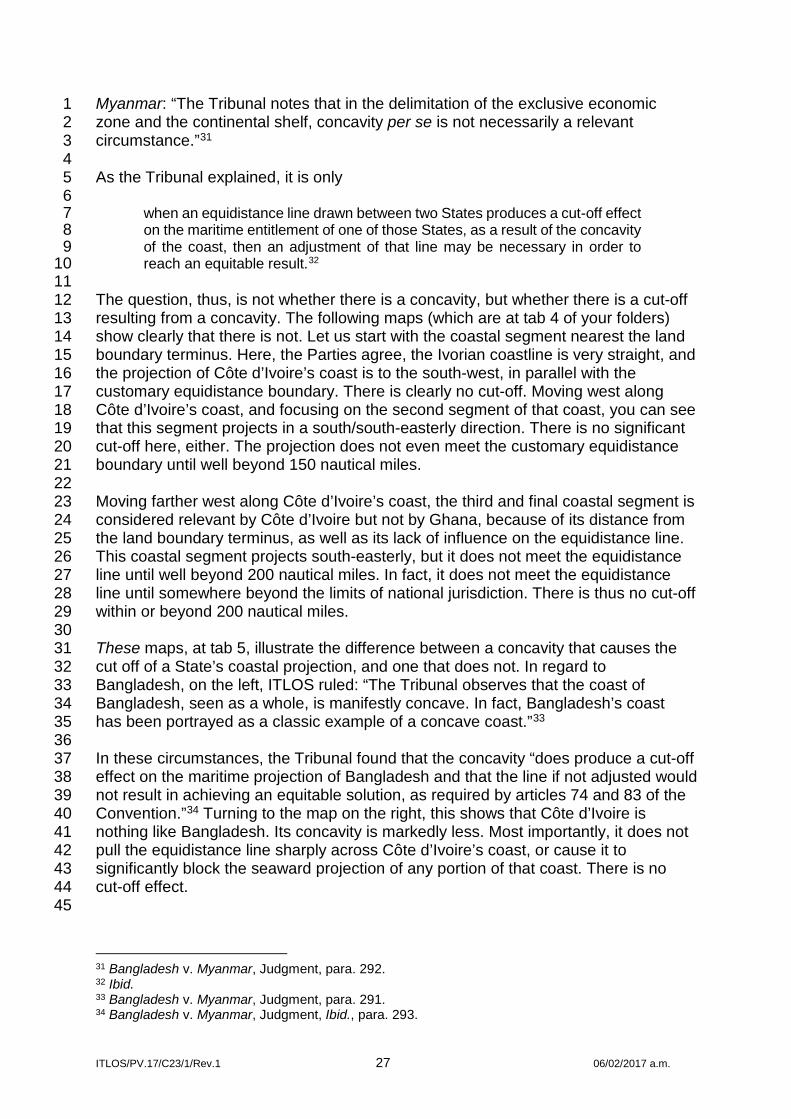
ITLOS/PV.17/C23/1/Rev.1 27 06/02/2017 a.m.
Myanmar: “The Tribunal notes that in the delimitation of the exclusive economic 1 zone and the continental shelf, concavity per se is not necessarily a relevant 2 circumstance.”31 3 4 As the Tribunal explained, it is only 5 6
when an equidistance line drawn between two States produces a cut-off effect 7 on the maritime entitlement of one of those States, as a result of the concavity 8 of the coast, then an adjustment of that line may be necessary in order to 9 reach an equitable result.32 10
11 The question, thus, is not whether there is a concavity, but whether there is a cut-off 12 resulting from a concavity. The following maps (which are at tab 4 of your folders) 13 show clearly that there is not. Let us start with the coastal segment nearest the land 14 boundary terminus. Here, the Parties agree, the Ivorian coastline is very straight, and 15 the projection of Côte d’Ivoire’s coast is to the south-west, in parallel with the 16 customary equidistance boundary. There is clearly no cut-off. Moving west along 17 Côte d’Ivoire’s coast, and focusing on the second segment of that coast, you can see 18 that this segment projects in a south/south-easterly direction. There is no significant 19 cut-off here, either. The projection does not even meet the customary equidistance 20 boundary until well beyond 150 nautical miles. 21 22 Moving farther west along Côte d’Ivoire’s coast, the third and final coastal segment is 23 considered relevant by Côte d’Ivoire but not by Ghana, because of its distance from 24 the land boundary terminus, as well as its lack of influence on the equidistance line. 25 This coastal segment projects south-easterly, but it does not meet the equidistance 26 line until well beyond 200 nautical miles. In fact, it does not meet the equidistance 27 line until somewhere beyond the limits of national jurisdiction. There is thus no cut-off 28 within or beyond 200 nautical miles. 29 30 These maps, at tab 5, illustrate the difference between a concavity that causes the 31 cut off of a State’s coastal projection, and one that does not. In regard to 32 Bangladesh, on the left, ITLOS ruled: “The Tribunal observes that the coast of 33 Bangladesh, seen as a whole, is manifestly concave. In fact, Bangladesh’s coast 34 has been portrayed as a classic example of a concave coast.”33 35 36 In these circumstances, the Tribunal found that the concavity “does produce a cut-off 37 effect on the maritime projection of Bangladesh and that the line if not adjusted would 38 not result in achieving an equitable solution, as required by articles 74 and 83 of the 39 Convention.”34 Turning to the map on the right, this shows that Côte d’Ivoire is 40 nothing like Bangladesh. Its concavity is markedly less. Most importantly, it does not 41 pull the equidistance line sharply across Côte d’Ivoire’s coast, or cause it to 42 significantly block the seaward projection of any portion of that coast. There is no 43 cut-off effect. 44 45
31 Bangladesh v. Myanmar, Judgment, para. 292. 32 Ibid. 33 Bangladesh v. Myanmar, Judgment, para. 291. 34 Bangladesh v. Myanmar, Judgment, Ibid., para. 293.

ITLOS/PV.17/C23/1/Rev.1 28 06/02/2017 a.m.
The geography does not support Côte d’Ivoire’s efforts either to discredit the 1 customary equidistance boundary long applied in practice, or adjust it. The concavity 2 that is present in this case is geographically irrelevant. This is why both Parties 3 agreed on a boundary following an equidistance line for more than five decades. 4 Disagreement on this issue only arose in 2009, as Professor Sands told you, after oil 5 was discovered on Ghana’s side of the customary equidistance boundary. That 6 appears to be what caused Côte d’Ivoire to go to such great lengths to refashion the 7 coastal geography. 8 9 The third disagreement between the Parties is over the stability of the coast in the 10 area of the land boundary terminus. Côte d’Ivoire argues that the coast is too 11 unstable to allow the fixing of base points or the construction of an equidistance 12 line.35 There are at least four reasons why Côte d’Ivoire is wrong. 13 14 First, for five decades the Parties considered the boundary to consist of an 15 equidistance line, and they had no problems with the stability of the coast. 16 17 Second, even in these proceedings, Côte d’Ivoire itself had no difficulty fixing base 18 points along the relevant coasts to construct a new provisional equidistance line.36 19 This is Côte d’Ivoire’s sketch map, which is also at tab 6. It shows that Côte d’Ivoire 20 succeeded in establishing base points and in constructing a provisional equidistance 21 line. In fact, Côte d’Ivoire’s base points are not very different from the ones 22 established by Ghana. 23 24 Third, and for that reason, as you can see on this map and at tab 7, there is only a 25 small difference between the customary equidistance boundary and Côte d’Ivoire’s 26 newly constructed provisional equidistance line. 27 28 Fourth, Côte d’Ivoire has itself demonstrated the stability of this segment of the 29 relevant coast by producing a new chart, based on a data gathered in 2014, where 30 the coastline is very similar to the coastline in British Admiralty Chart 1383, relied on 31 by Ghana, whose underlying data were collected as long ago as the 1840s.37 This is 32 at tab 8. There could be no stronger demonstration of coastal stability than the 33 presentation of two charts, relying on data drawn 165 years apart, which depict no 34 significant changes in the configuration of the coast over that very lengthy period of 35 time. 36 37 Finally, Côte d’Ivoire has submitted no evidence that the coast in the vicinity of the 38 land boundary terminus, where all of the base points have been fixed by both 39 Parties, is or has ever been unstable. Ghana pointed this out in the Reply. Indeed, 40 Ghana showed that the only “study” submitted by Côte d’Ivoire with its Counter-41 Memorial concluded that erosion and accretion along this section of the coast were 42 in equilibrium; hence, there was no instability.38 In the Rejoinder, Côte d’Ivoire 43 devotes just a few short paragraphs to the alleged “instability of the coastlines”.39 In 44 them, Côte d’Ivoire admits that erosion is not an issue, but still insists that there is 45 35 See CMCI, paras 6.25-6.27; RCI, paras 2.43, 2.47. 36 See CMCI, para. 6.16, Sketch Map 6.2. 37 See RG, para. 3.28. 38 See ibid., para. 3.30 39 See RCI, paras 2.43-2.48.

ITLOS/PV.17/C23/1/Rev.1 29 06/02/2017 a.m.
instability due to what they call “longshore drift".40 No studies, reports or other 1 evidence on this point were furnished to support that claim either. There is thus no 2 evidence whatsoever that the coast is too unstable for the fixing of base points or the 3 construction of a provisional equidistance line. 4 5 Here again, a comparison with Bangladesh shows how weak Côte d’Ivoire’s 6 argument is. In its case against Myanmar before ITLOS, and its arbitration against 7 India, Bangladesh argued, as Côte d’Ivoire argues here, that coastal instability 8 rendered the fixing of base points and the drawing of an equidistance line unreliable, 9 requiring resort to an angle bisector.41 Unlike Côte d’Ivoire, Bangladesh 10 demonstrated that the coastline in the Bengal Delta, one of the most morphologically 11 dynamic locations in the world, was constantly changing.42 Nevertheless, both 12 tribunals rejected Bangladesh’s argument, determined that base points could be 13 fixed along the deltaic coast, and constructed equidistance lines in reliance on those 14 base points.43 In contrast with the Bengal Delta, the coast in the vicinity of BP 55 is a 15 model of stability. 16 17 Côte d’Ivoire simply cannot demonstrate that the relevant coasts are unstable, or 18 that equidistance is unfeasible or inappropriate in the geographic circumstances of 19 this case. 20 21 The fourth and final disagreement on geography is over the nature of Ghana’s coast 22 in the vicinity of the land boundary terminus, and whether it should be ignored or 23 given less than full effect in the determination of the maritime boundary, as Côte 24 d’Ivoire argues. This disagreement begins with Côte d’Ivoire’s characterization of 25 Ghana’s coast as the “Jomoro Peninsula”.44 We have highlighted in blue here and at 26 tab 9 the portion of Ghana’s coast that Côte d’Ivoire began to call the “Jomoro 27 Peninsula” in its Rejoinder. There are several problems with this nomenclature. First, 28 this is not a football stadium, to which Ghana, as the owner, has sold the naming 29 rights. Only Ghana gets to name its own territory, and in Ghana’s geographic lexicon 30 there is no such place as the Jomoro Peninsula. 31 32 Second, this territory may be located in Ghana’s Jomoro District, but it is not a 33 peninsula. It is not bounded by water on three sides, as Professor Sands explained, 34 but only on two. As such, it is more properly referred to as an isthmus. One would 35 expect that counsel who have represented Nicaragua for the last 33 years would 36 know the difference. 37 38
40 CMCI, paras 1.21-1.23, 6.26. See also ibid., para. 2.43. 41 Delimitation of the Maritime Boundary between Bangladesh and Myanmar in the Bay of Bengal (Bangladesh/Myanmar), Reply of Bangladesh (15 Mar. 2011), para. 3.104; Bay of Bengal Maritime Boundary Arbitration (Bangladesh v. India), UNCLOS Annex VII Tribunal, Memorial of Bangladesh (31 May 2011) (hereinafter “Bangladesh v. India, Memorial of Bangladesh”), paras 6.75-6.83. 42 See Bangladesh v. India, Memorial of Bangladesh, paras 2.13-2.22; Delimitation of the Maritime Boundary between Bangladesh and Myanmar in the Bay of Bengal (Bangladesh/Myanmar), Memorial of Bangladesh (1 July 2010), paras 2.9-2.16. 43 See Bay of Bengal Maritime Boundary Arbitration between Bangladesh and India, Award of 7 July 2014, paras 327, 346; Bangladesh v. Myanmar, Judgment, para. 266 (utilizing the basepoint about which Bangladesh objected in the construction of its “provisional equidistance line.”). 44 See RCI, paras 9, 1.29, 2.4, 2.51, 2.52, 2.55, 2.56, 2.61, 2.137, 3.13, 3.37.

ITLOS/PV.17/C23/1/Rev.1 30 06/02/2017 a.m.
But, however this area of land is characterized, it is unquestionably Ghanaian and it 1 unquestionably constitutes Ghana’s coast, and Côte d’Ivoire does not disagree. 2 Nevertheless, they argue that it should not be given full effect because, in their 3 words, this part of Ghana’s land territory, in English translation: “blocks the seaward 4 projection of the Ivorian territory”.45 In other words, a landlocked part of Côte d’Ivoire, 5 that has no coast, should be taken into account in the determination of the boundary 6 in this case, because, if Ghana’s coast in this area did not exist, the landlocked area 7 would be the coast. This is an entirely novel argument, never seen before in the 8 annals of maritime boundary delimitation. 9 10 Why should Ghana’s coast be ignored, and Côte d’Ivoire be treated as though it had 11 one? Three reasons are given by our friends on the other side. First, they say that 12 this part of the coast belongs to Ghana by “un accident historique”,46 an accident of 13 history. What does that mean, exactly? A result of history, yes. But an “accident” of 14 history? If so, that is counterfactual. The boundary between Ghana and Côte d’Ivoire 15 was inherited from colonial times. It is the same boundary that was finalized by an 16 agreement between the United Kingdom and France in 1905.47 It follows the Tano 17 River for more than 94 km, until the river debouches into the Tendo Lagoon, which is 18 located directly behind the Ghanaian coast in the vicinity of the land boundary 19 terminus. Just as the boundary follows the middle of the river, it then follows the 20 middle of the lagoon. This was not accidental. It was the deliberate act of colonial 21 powers to divide the waters – which then represented a major means of transport 22 and source of fresh water and fish – equally between the two colonies. Côte d’Ivoire 23 states that it accepts the principle of uti possidetis.48 We take them at their word, and 24 assume this was not a mere accident of pleading – “un accident de plaidoirie”. 25 26 Côte d’Ivoire’s second complaint about this area has to do with its shape. Côte 27 d’Ivoire refers to it as a “langue de terre”,49 a tongue of land, as if that somehow 28 discredits it. They seem to be saying the land dominates the sea, unless it is shaped 29 like a tongue, but there is nothing in the case law to support that concept, and there 30 is nothing in fact so terribly unusual about this sort of geographic configuration. What 31 is Chile, if not an exceedingly long tongue that prevents Argentina from having a 32 Pacific Ocean coast? But for this Eritrean tongue, Ethiopia would have a Red Sea 33 coast, instead of being landlocked. Why not ignore the Gaza Strip, or reduce its 34 effect, so that Israel could have a longer Mediterranean coast? This may be the 35 narrowest tongue of all, or narrowest two tongues. They leave Bosnia completely 36 landlocked, except for its tiny coast at Naum, where the seaward projection is 37 immediately blocked by, speaking of peninsulas, one of Croatia’s. All of these 38 tongues are at tab 10. 39 40 Côte d’Ivoire’s third complaint about this part of Ghana’s land territory is that it is no 41 more than “a barrier beach”.50 I am not sure where they think this characterization 42 gets them. Here again, they invent another exception to the venerable rule that the 43
45 Ibid., para. 2.53. 46 CMCI, paras 6.18, 7.47. 47 See United States Department of State, International Boundary Study No. 138: Côte d’Ivoire (Ivory Coast) – Ghana Boundary (16 July 1973), pp. 2-3. MG, Vol. VI, Annex 82. 48 RCI, para. 2.49. 49 CMCI, para. 7.46; RCI, paras 1.29, 2.4, 2.49, 2.50, 2.53, 2.60, 2.61, 3.33, 3.37. 50 RCI, para. 2.55.

ITLOS/PV.17/C23/1/Rev.1 31 06/02/2017 a.m.
land dominates the sea; apparently they think the land does not, if it is a barrier 1 beach. There is, of course, no such exception. In any event, the Ghanaian land 2 territory in this area cannot properly be characterized as a “barrier beach”. While the 3 land in question includes a narrow beach, it is backed by dense vegetation, between 4 2.5 km and 9 km deep, as is evident from the satellite photo of the area on your 5 screens now, and at Tab 11. 6 7 Mr President, in this case, we are talking about Ivorian land territory that has no 8 coast, and therefore no maritime entitlements. The Ghanaian coast no more blocks 9 the extension of Côte d’Ivoire’s maritime entitlements in the Atlantic Ocean than 10 Chile blocks Argentina’s non-existent entitlements in the Pacific. If anything 11 constitutes an impermissible refashioning of geography, it would be to ignore the 12 coast of one State, which actually has one, in order to create a coast for another 13 State, which does not. Côte d’Ivoire cannot be permitted to change the geographic 14 circumstance to deprive Ghana of its coast, or to reduce the effect of that coast on 15 the determination of the maritime boundary in this case. 16 17 Mr President, in conclusion, this takes us back to where we began. The geographic 18 circumstances that are present here offer a textbook case for an equidistance 19 boundary, especially the remarkably straight and featureless coast, and the absence 20 of any offshore maritime features. The geographic arguments on which Côte d’Ivoire 21 bases its advocacy for abandonment of equidistance, or a radical adjustment of it, 22 are either wrong or irrelevant. The so-called “general direction” of the West African 23 coast is not as Côte d’Ivoire has described it, and is, in any event, not relevant to the 24 boundary between Ghana and Côte d’Ivoire; the concavity along Côte d’Ivoire’s 25 coast does not produce a cut-off effect and is therefore irrelevant; there is no coastal 26 instability in the vicinity of the land boundary terminus; and the misnamed “Jomoro 27 Peninsula” is a part of Ghana’s sovereign land territory whose coastline can neither 28 be ignored nor discounted. 29 30 That is why, as my colleague Mr Fui Tsikata will next explain, both Ghana and Côte 31 d’Ivoire regarded equidistance as the proper basis for their maritime boundary for 32 more than 50 years, and why both Parties – in their laws and decrees, in their 33 concession agreements, in their official maps, and in their formal communications 34 with each other and third parties – consistently referred to, treated and depicted the 35 boundary between the two States as following an equidistance line. That is why, as 36 you have seen in our written pleadings and will hear from my colleagues, Ghana 37 submits that the Special Chamber should confirm and adopt that equidistance line as 38 the maritime boundary. 39 40 Mr President, Members of the Special Chamber, this concludes my presentation on 41 the geographical circumstances. I thank you for your kind courtesy and patient 42 attention, and request that you give the floor to my colleague, Mr Tsikata. 43 44 THE PRESIDENT OF THE SPECIAL CHAMBER (Interpretation from French): 45 Thank you, Mr Reichler, for your presentation. I now give the floor to Mr Fui Tsikata 46 to present his presentation. 47 48 MR TSIKATA: Mr President, distinguished Members of this Special Chamber, it is a 49 special honour for me to appear before you and to address you on behalf of Ghana. 50

ITLOS/PV.17/C23/1/Rev.1 32 06/02/2017 a.m.
1 My task is to demonstrate that the evidence before this Chamber – in the form of 2 laws, maps, concession agreements, official correspondence, reports, and other 3 material – plainly establishes that Ghana and Côte d’Ivoire have long proceeded on 4 the basis that there was a defined and mutually accepted maritime boundary 5 between them. The evidence also shows that they have represented to each other – 6 and to third parties – that that is the case. It further shows that each has placed 7 justifiable reliance on the representations of the other. The course of that boundary is 8 represented in what Ghana has, in these proceedings, called the customary 9 equidistance boundary, because, not accidentally, this mutually agreed maritime 10 boundary is also, in fact, an equidistance-based boundary. 11 12 I would respectfully adopt and commend to the renewed attention of the Chamber 13 the presentations made by Mr Paul Reichler on behalf of Ghana at the hearing of the 14 application by Côte d’Ivoire for Provisional Measures. On that occasion, as Members 15 of this distinguished Chamber will no doubt recall, Mr Reichler set out key elements 16 of the material in considerable detail and responded to the attempts by Côte d’Ivoire 17 to re-interpret them or minimize their significance. Those presentations were, of 18 course, based on Ghana’s written statement, which has since been elaborated upon 19 in the written pleadings.1 20 21 Nothing that Côte d’Ivoire has put before the Chamber undermines Ghana’s case. 22 The response by Côte d’Ivoire has been limited to four points. In essence, it says: 23 (1) that the documents which express and identify a boundary between Côte d’Ivoire 24 and Ghana do not mean what they say; (2) that those who issued these documents 25 had no authority to bind Côte d’Ivoire to a boundary line; (3) that Côte d’Ivoire has 26 occasionally expressed itself as not recognizing that boundary; and (4) that Ghana 27 has made statements showing that it does not think the parties have delimited their 28 maritime boundary. 29 30 I will seek to refresh your memory by drawing your attention to some of the 31 documents on which Ghana relies for its contention that there is a tacit agreement 32 between the Parties on an equidistance-based boundary. I will then ask you to reflect 33 upon – and reject – the propositions made by Côte d’Ivoire in response. I will invite 34 you to hold, first, that when an official document from the Government of Côte 35 d’Ivoire or its state oil corporation says that there is a (Interpretation from French) 36 “boundary line separating Côte d’Ivoire from Ghana” (Continued in English) or draws 37 or marks a line on official maps and puts “Ghana” on the other side of it, in the sea, 38 that can only be interpreted as an acknowledgment of an existing maritime boundary 39 and of Ghana’s sovereign rights on the other side of the line; second, that the 40 belated attempt to distance the Ivorian State from representations by Government 41 officials and PETROCI is untenable; third, that the very limited material Côte d’Ivoire 42 invokes does not come close to providing support for its claim that it has not, over 43 the course of its consistent practice, laws, concession agreements and official 44 statements for more than five decades, agreed to the customary equidistance 45 boundary between it and Ghana. 46 47 1 Memorial of Ghana (4 Sept. 2015) (hereinafter “MG”), Chapters 2 (Sections III, IV), Chapter 3, Chapter 4 (Sections III, IV), paras 5.8-5.35; Reply of Ghana (25 July 2016) (hereinafter “RG”), Chapter 2.

ITLOS/PV.17/C23/1/Rev.1 33 06/02/2017 a.m.
Finally, I will invite you to conclude that the efforts by both Parties to attempt a formal 1 delimitation have been based on recognizing an existing tacitly agreed boundary on 2 which both Parties have placed great reliance over an extended period of time. 3 4 I turn first to a selection of exemplifying documents most of which were issued 5 officially by Côte d’Ivoire. There are many others that you will find in Ghana’s 6 pleadings. 7 8 As Ghana has pointed out repeatedly, the maritime boundary between the two 9 countries dates back to the 1950s. Professor Sands has drawn your attention to the 10 Decree of 29 July 1957 issued on behalf of what was then the colony of Côte d’Ivoire 11 by the President of the Council of Ministers in France.2 This is included in your 12 Judges’ Folder at tab12. It acknowledges the existence of a maritime boundary 13 between Côte d’Ivoire and Ghana dividing their respective territorial seas. 14 15 Professor Sands showed you a modern rendition of the area of the concession as 16 defined in the Decree. Here is a sketch map published in an industry journal in 1959 17 showing the area of the concession. As you can see, it shows the same 18 equidistance-based maritime boundary as Professor Sands showed you. You may 19 also find this at tab 13. 20 21 It should therefore not come as a surprise that subsequent texts from the highest 22 authorities in Côte d’Ivoire maintain exactly the same position. This is the case with 23 Decree No. 70-618 of 14 October 1970, issued 13 years after the 1957 Decree, 24 which grants exclusive exploration rights to Esso, Shell and ERAP Group.3 The 25 original French along with the English translation of this Decree are in tabs 14 and 26 15. 27 28 Decree No. 70-618 also recognizes and explicitly says that there is a maritime 29 boundary between Côte d’Ivoire and Ghana, identifying a line “between points K and 30 L” as the relevant part of that boundary.4 31 32 As you can see from this slide, the concession limit between points K and L follows 33 an equidistance line. This is what is identified in the Decree as (Interpretation from 34 French) “the boundary line separating Côte d’Ivoire from Ghana”.5 (Continued in 35 English) This tracks the same course as the line from the 1957 Decree, which can be 36 found at tab 16. 37 38 In 1975 Côte d’Ivoire renewed that concession. It issued a standard 39 production-sharing contract for offshore concessions and accompanied it with a map 40 2 Republic of Côte d’Ivoire, Décret octroyant à la Société africaine des pétroles un permis général de recherches du type « A » en Côte d’Ivoire pour les substances minérales de la première catégorie (29 July 1957) (CMCI, Vol. IV, Annex 57) 3 Republic of Côte d’Ivoire, Décret No. 70-618 accordant un permis de recherches pétrolières aux sociétés ESSO, SHELL et ERAP (14 Oct. 1970) (CMCI, Vol. IV, Annex 59); Republic of Côte d’Ivoire, Decree 70-618 Granting An Exclusive Petroleum Exploration Permit To Esso, Shell, & ERAP Group (Refers To Areas Granted Under Convention Of 12 October 1970), adopted on of 14 October 1970, reprinted in Basic Oil Laws & Concession Contracts, Supplement No. XLVIII (48) (Barrows, 1977) (hereinafter “Republic of Côte d’Ivoire, Decree 70-618”), MG, Vol. IV, Annex 23. 4 Ibid., art. 1(d). 5 Ibid.; MG, Figure 3.5.

ITLOS/PV.17/C23/1/Rev.1 34 06/02/2017 a.m.
of its oil concessions.6 That map again shows the equidistance line as the boundary 1 with Ghana, depicted by a standard dashed and dotted line extending into the sea 2 beyond what Côte d’Ivoire represents as the limits of its easternmost concession. 3 This is included at tab 17. 4 5 The following year, in 1976, the Ivorian Ministry of Economy and Finance (in 6 conjunction with the Secretariat in Charge of Mines and Hydrocarbons) produced a 7 map7 with the heading (Interpretation from French) “hydrocarbon exploration permit”. 8 (Continued in English) This showed the limits of the Ivorian jurisdiction on the east. 9 The legend of the map again clearly shows the broken/dashed boundary line, and it 10 is labelled “frontière”. This is a clear and unambiguous indication of the furthest 11 extent to the east of Cote d’Ivoire’s maritime jurisdiction. 12 13 I turn now to a map produced by Phillips Petroleum in 1980.8 This shows offshore 14 concessions awarded to it by the Governments of Côte d’Ivoire and Ghana in 1975 15 and 1978, respectively, and which it was holding in 1980. Even though it is a map 16 produced by an oil company, its significance is that it shows a perfect alignment of 17 concessions along the customary equidistance boundary. This map is at tab 19 of 18 your folder. 19 20 In 1990 Côte d’Ivoire’s Ministry of Mines announced the availability of new 21 concession areas in a report that it published in English titled “Côte d’Ivoire 22 Petroleum Evaluation”.9 This included a map of petroleum blocks.10 The eastern 23 blocks, to the right on this map, are bounded by the customary equidistance line, 24 represented once again as a dashed line. On the other side of the line the Ivorian 25 Ministry has written the word “Ghana”, placed in the offshore part of the map. This 26 map can also be found at tab 20. 27 28 A map published the following year, 1991, by Côte d’Ivoire’s Ministry of Industry, 29 Mines and Energy jointly with PETROCI focused on Block CI-06. This repeats the 30 dashed line, and you will see the word “Ghana” on the other side of the line, to the 31 right of the map, again placed in the sea.11 This is included for reference at tab 21. 32 33 Two years later, a 1993 report published by the Ministry of Mines and Energy and 34 PETROCI to announce “the opening of international bidding” for certain blocks12 35 contains a map showing extensive drilling activity on the Ivorian side of the same 36 dashed line.13 Once again, you can see the word “Ghana” on the other side, placed 37 in the sea. This map is at tab 22. 38 39
6 MG, Figure 3.6. 7 MG, Figure 3.7. 8 MG, Figure 3.11. 9 Ministry of Mines of the Republic of Côte d’Ivoire, Côte d’Ivoire: Petroleum Evaluation (1990). MG, Vol. V, Annex 36. 10 MG, Figure 3.15. 11 MG, Figure 3.16. 12 Société Nationale d’Opérations Pétrolières de la Côte d’Ivoire (PETROCI), Côte d’Ivoire 1993 Petroleum Evaluation Concessions (1993), p. 2, MG, Vol. V, Annex 37. 13 MG, Figure 3.17.

ITLOS/PV.17/C23/1/Rev.1 35 06/02/2017 a.m.
In March 2002 PETROCI published a report titled “Exploration Opportunities in Côte 1 d’Ivoire...”.14 This has a map15 with the now familiar dashed line, representing the 2 international boundary between the two States both on land and water, and 3 extending in the sea beyond the southernmost Ivorian blocks. The word “Ghana” 4 once again appears on the other side of the line. This can be found in tab 23 of your 5 Judges’ folder. 6 7 This is repeated in the PETROCI map of 200516 contained in its publication titled 8 “Deep Water Opportunities in Côte d’Ivoire”17 – also at tab 24. 9 10 This set of maps produced by the Ivorian Government shows a consistent pattern. 11 All the maps show an eastern maritime boundary with Ghana depicted by a broken 12 line. This practice is sustained right up to 2009 and, indeed, continues even beyond. 13 14 I think we all agree that these lines on the maps issued by Côte d’Ivoire were not 15 meaningless doodles. What could they be other than representations by Côte 16 d’Ivoire of the international boundary that it believed to exist between the two 17 countries? Côte d’Ivoire is unable to offer a credible alternative meaning for this 18 consistent practice through the decades. 19 20 The attempts by Côte d’Ivoire to repudiate the authority of its maps led to some 21 rather unfortunate statements. In relation to the agreement with the Esso 22 Consortium, Côte d’Ivoire has suggested that the “carte pétrolière” representing the 23 boundary following the equidistance line was prepared by Esso and was no more 24 than that company’s (Interpretation from French) “unilateral security measure that 25 does not engage the responsibility of the Ivorian Government”.18 (Continued in 26 English) The claim here appears to be that the co-ordinates of the concession area 27 which were an essential part of an Agreement signed by Côte d’Ivoire with an 28 international company, and then embodied in a national law as well as a Decree of 29 the founding President, were no more than a unilateral act of a foreign company. The 30 claim that it involves no exercise of authority on the part of the Ivoirian Government 31 is implausible. 32 33
14 Société Nationale d’Opérations Pétrolières de la Côte d’Ivoire (PETROCI), Exploration Opportunities in Côte d’Ivoire….The Next Deep Water Producer in the Gulf of Guinea (2002), p. 3. MG, Vol. V, Annex 38. 15 MG, Figure 3.19. 16 MG, Figure 3.20. 17 Société Nationale d’Opérations Pétrolières de la Côte d’Ivoire (PETROCI), Deepwater Opportunities in Côte d’Ivoire (May 2005), p. 3, MG, Vol. V, Annex 39. 18 Counter-Memorial of Côte d’Ivoire (4 Apr. 2016) (hereinafter “CMCI”), para. 2.101, quoting Minutes of the meetings of the Technical Committee responsible for gathering and updating information on the delimitation of the maritime boundary between Ghana and Côte d’Ivoire, 16-18 March 1992, p. 2, CMCI, Vol. III, Annex 14. (“a unilateral security act for which the Ivorian Government assumed no responsibility”).

ITLOS/PV.17/C23/1/Rev.1 36 06/02/2017 a.m.
Côte d’Ivoire was not terra nullius and Esso was not Cecil Rhodes. 1970 was not the 1 1880s. The Law enacted by Côte d’Ivoire,19 the Decree issued by its President20 as 2 well as its publication in the official Ivorian Gazette21 were self-evidently deliberate 3 acts of organs and officials of the Republic of Côte d’Ivoire. 4 5 As for the argument that maps issued by PETROCI cannot be evidence of tacit 6 agreement, our respected older brother, the Agent of Côte d’Ivoire, M Adama 7 Toungara, has told you that PETROCI is indeed the national oil corporation, which 8 he founded as such.22 My colleague Professor Pierre Klein will address the issue of 9 the role of PETROCI more fully tomorrow. However, it comes as something of a 10 surprise that the Government of Côte d’Ivoire, and especially the Ministry that is 11 charged with the activities of PETROCI, would have allowed PETROCI, whatever its 12 legal status, to issue so many maps over so many years that plainly identify the 13 territory and maritime spaces of Ghana without authority of the Ivorian Government. 14 The idea that PETROCI was somehow off on a frolic is hardly convincing. 15 16 Côte d’Ivoire contends that certain words in some of its decrees and contracts show 17 that it has not tacitly agreed to the customary equidistance line. It refers in particular 18 to expressions that particular coordinates are approximate or indicative, for 19 information purposes, or do not represent the limits of national jurisdiction.23 20 21 I have already referred you to the presidential Decree of October 1970, for example, 22 where the concession area is defined, (Interpretation from French) “in the maritime 23 portion” “by the boundary line separating Côte d’Ivoire from Ghana between points 24 K and L”.24 (Continued in English) Then the Decree gives co-ordinates for all the 25 points that it identifies, noting that (Interpretation from French) “the co-ordinates of 26 points A, B, K, L, M and T are given indicatively”.25 (Continued in English) Coupled 27 with an acknowledgment of boundary lines, this is a suggestion that greater precision 28 as regards points on them may be required. This does not negate the existence of a 29 boundary in the areas identified; nor does it amount to a denial of its location and 30 essential outlines. It says no more than that the precise co-ordinates of that agreed 31 and mutually respected boundary line that you can once again see on the screen 32 may yet have to be more precisely plotted. It does not make those texts irrelevant, 33 inoperative or insignificant in relation to the information that they unambiguously 34 show; and what they show is that the “ligne frontière” follows the customary 35 boundary. This image comes again from tab 16. 36 37
19 Republic of Côte d’Ivoire, Loi No.70-573 autorisant le Président de la République à signer avec le Consortium formé par les Société pétrolières ESSO, SHELL, et ERAP la Convention relative à l’exploration et à la production d’hydrocarbures liquides ou gazeux en Côte d’Ivoire [Law No. 70-573 Authorising the President of the Republic to Sign with the Consortium formed by the Oil Companies ESSO, Shell, and ERAP and the Convention on the Exploration and Production of Oil and Gas in Cote d’Ivoire] (29 Sept. 1970), CMCI, Vol. IV, Annex 58. 20 Republic of Côte d’Ivoire, Decree 70-618, MG Vol. IV, Annex 23. 21 No. 53 of 26 October 1970, ibid. 22 Public Sitting at the International Tribunal for the Law of the Sea, Verbatim Record, TIDM_PV15_A23_3_. Corr.1, p. 24:5-23 (30 March 2015). 23 CMCI, paras 2.102-2.109. 24 Décret No. 70-618 accordant un permis de recherches pétrolières aux sociétés ESSO, SHELL et ERAP (14 Oct. 1970), CMCI, Vol. IV, Annex 59. 25 Ibid.
ITLOS/PV.17/C23/1/Rev.1 37 06/02/2017 a.m.
That Ghana’s practice also reflected acceptance of the customary equidistance 1 boundary is demonstrated by the Phillips Petroleum map published in 1980, 2 identifying its blocks in both Cote d’Ivoire and Ghana which we showed you earlier. If 3 I may remind you, it is at tab 19 of your folder. 4 5 Here is a map showing block demarcations by Côte d’Ivoire and Ghana as at 2009.26 6 It is at tab 26 of your folder. This reflects each country’s understanding of the area 7 over which each is entitled to award concessions. It reflects their mutual practice 8 over many decades as well as the representations they have made to each other 9 and to third parties regarding their acceptance of the customary equidistance 10 boundary. It is supported not only by the maps from Cote d’Ivoire to which we have 11 referred but also by numerous other maps referred to in Ghana’s pleadings.27 12 13 In its Rejoinder, Côte d’Ivoire asserts that Ghana’s position on tacit agreement is 14 undermined by the absence of what it describes as “substantial” drilling in the 15 disputed area before 2009.28 The argument disregards the numerous licences that 16 have been awarded by Ghana pursuant to which various activities have been 17 pursued in the area. The Ivorian assertion ignores all the exploration work 18 undertaken in the area over the decades, including the numerous seismic surveys 19 and the drilling of exploratory wells. 20 21 This slide (also at tab 27) depicts in summary form all the history of drilling activity by 22 grantees of Côte d’Ivoire and Ghana on their respective sides of the customary 23 equidistance boundary from the 1950s up to 2009.29 It shows that over more than 50 24 years of oil activity not once did Cote d’Ivoire ever drill a well or even allocate a block 25 on the side of the customary equidistance boundary that it long regarded as 26 belonging to Ghana and that it now seeks to put in dispute. It is, of course, a basic 27 feature of the oil industry that the largest investments and related field development 28 activities, including the most intense drilling and other activity, follow from and are 29
26 RG, Figure R2.21. 27 MG, para. 3.14, Fig. 3.3, Map of Ghana Showing the 22 Offshore Oil Concessions [in 1968]. MG, Vol. II, Annex M20; Vol. VIII, Annex 95; see also Ghana Geological Survey, Ghanaian Oil Concessions, Offshore & Onshore (SRG/827A) (1975, Ghana);MG, Vol. II, Annex M22; “The Search for Petroleum (Oil) in Ghana”, pp. 7-9, MG, Vol. VIII, Annex 95; MG, para. 3.50, Fig. 3.13, Ghana Production Sharing Contract Areas in Ministry of Fuel and Power, Ghana National Petroleum Corp., Republic of Ghana & Petro-Canada International Assistance Corporation Canada, Opportunities for Petroleum Exploration in the Tano Basin-Ghana (1986, Ghana), p. 4, MG, Vol. II, Annex M26; Vol. III, Annex 15.; MG, para. 3.60, Fig 3.21, Republic of Côte d’Ivoire, Contrat de Partage de Production d’Hydrocarbures avec Vanco Côte d’Ivoire Ltd. et PETROCI HOLDING, Bloc CI-401 [Hydrocarbons Production Sharing Contract with Vanco Côte d’Ivoire Ltd. and PETROCI HOLDING, Block CI-401] (30 September 2005), p. 74, MG, Vol. II, Annex M10; Vol. V, Annex 40; MG, paras 3.51, 3.52, Fig. 3.14, Ghana National Petroleum Corporation (GNPC), Fig. 1 [Map of Petroleum Exploration Opportunities] in Republic of Ghana, Petroleum Exploration Opportunities (18 June 1986, Ghana), p. 2, MG, Vol. II, Annex M27; Vol. III, Annex 14; MG, para. 3.66, Fig. 3.28, Ghana National Petroleum Corporation (GNPC), Ghana Offshore Activity Map (March 2002, Ghana), MG, Vol. II, Annex M32; Ghana National Petroleum Corporation (GNPC), Ghana Offshore Activity Map (August 2006, Ghana); MG, Vol. II, Annex M34; MG, para. 3.61, Fig. 3.22, Bassin Sedimentaire Onshore & Offshore Bloc CI-100 [Sedimentary Block Onshore and Offshore, Block CI- 100] in Republic of Côte d’Ivoire, Contrat de Partage de Production d’Hydrocarbures avec PETROCI et YAM’s PETROLEUM, Bloc CI-100 [Hydrocarbons Production Sharing Contract with PETROCI and YAM’s PETROLEUM, Block CI-100] (23 January 2006, Côte d’Ivoire), p. 74, MG, Vol. II, Annex M11; Vol. V, Annex 41. 28 RCI, para. 4.6. 29 Côte d’Ivoire and Ghana Drilled Wells, up to 2009, RG, Vol. II, Figure R 2.22.

ITLOS/PV.17/C23/1/Rev.1 38 06/02/2017 a.m.
dependent upon decisions based on evaluation of exploratory work done and 1 substantial sums spent during the earlier exploration phase.30In this case all the 2 activities and expenditures were based on governmental representations as to where 3 the boundary is located. 4 5 In its Rejoinder, Côte d’Ivoire seeks to construct from certain internal documents 6 evidence that it did protest the exercise of rights by Ghana in the maritime boundary 7 area. It is significant that at this final stage of these proceedings Côte d’Ivoire has not 8 produced the “proposal” document that it claims to have submitted to Ghana in 1988. 9 The documents that it has produced date to four years later: the minutes of the 1992 10 internal meetings of its own officials, exhibited in Annexes 13-24 of its 11 Counter-Memorial, in which they apparently discussed among themselves the idea 12 of proposing a maritime boundary beginning at boundary pillar 54, going through 13 boundary pillar 55 and extending in a straight line into the sea. 14 15 These minutes show that no copy of that “proposal” was made available even to the 16 officials who attended those internal meetings. In both annexes 13 and 19, 17 documents made available to participants are listed.31 In annex 13, seven 18 documents are listed. None is indicated as having been submitted to Ghana in 1988, 19 or at any other time. Among the documents listed in annex 19 are minutes of a 1988 20 meeting of the Ghana/Côte d’Ivoire Joint Commission, but no document in the form 21 of an Ivorian proposal is mentioned in those minutes. All that there is in the records 22 of those internal meetings, held in 1992, regarding the content of an Ivorian proposal 23 is the recollection by unidentified persons of what was allegedly said four years 24 earlier, in 1988. These unattributed recollections claim that things were said which 25 are not reflected in the official minutes of the joint meeting. This is not evidence on 26 which the Special Chamber can properly rely. But even if it might be, its probative 27 effect is non-existent, given that the proposal was followed by another two decades 28 of practice by Côte d’Ivoire that confirmed the existence of the long-established 29 equidistance boundary with Ghana. 30 31 Moreover, the minutes of the 1988 meeting state its objective as being to (Interpretation 32 from French) “assess the state of progress of the work on re-demarcation of the land 33 boundary between Côte d’Ivoire and Ghana, to examine outstanding issues and to 34 study the possibility of delimiting the maritime and lagoon boundary existing between 35 the two countries”.32 (Continued in English) “Existing”: this is a contemporaneous 36 record. It contradicts Côte d’Ivoire’s claim that there was no identified, existing maritime 37 boundary. It says that the purpose of the meeting was, inter alia, to examine the 38 possibility of delimiting the “existing” maritime boundary between the two States – not a 39
30 See, for example, Frank Jahn et al., Hydrocarbon Exploration and Production, 2nd edition, Chapter 1, especially Fig. 1.1 and Fig. 1.2, Elsevier (2008). 31 Republic of Côte d’Ivoire, Compte-rendu des réunions de la Commission nationale de réabornement des frontiers [Minutes of the Meetings of the National Commision to Redemarcate Borders] (12 & 19 Mar. 1992), p. 1, CMCI, Vol. III, Annex 13; Republic of Côte d’Ivoire, Rapport de synthèse sur les travaux de la Commission de réabornement des frontiers maritimes entre la Côte d’Ivoire et le Ghana [Synthesis Report on the Commission to Redemarcate Maritime Borders between Ghana and Côte d’Ivoire] (1 Sept. 1992), p. 2, CMCI, Vol. III, Annex 19. 32 Republic of Ghana and Republic of Côte d’Ivoire, Procès-verbal de la 15ème session ordinaire de la Commission mixte de réabornement de la frontière ivoiro-ghanéenne [Minutes of the 15th Ordinary Session of the Joint Commission to Redemarcate the Ivorian-Ghanaian Border] (18-20 July 1988), para. 2 (emphasis added), CMCI, Vol. III, Annex 12.
ITLOS/PV.17/C23/1/Rev.1 39 06/02/2017 a.m.
new boundary, not a non-existent boundary –, following work on the re-demarcation of 1 the existing land boundary. 2 3 Annexes 13 to 24 offer evidence of internal preparations by Côte d’Ivoire for purposes 4 of making proposals to Ghana in 1992 or thereafter. The parties are agreed that no 5 proposals were in fact made to Ghana following those preparations. The record of those 6 internal Ivorian discussions confirms the existence of an agreement as to the maritime 7 boundary, and the fact that such a boundary already followed an equidistance line. The 8 discussions were evidently concerned with extending the project of the two countries, 9 which began with the “réabornement” – re-demarcation – of their land boundary to the 10 maritime boundary. That was not a repudiation of the existing maritime boundary. 11 12 Evidently, in 1992, Côte d’Ivoire’s officials thought that certain petroleum-related 13 activities could form a basis for a re-examination of the maritime boundary. Côte 14 d’Ivoire, according to these internal records, expressed the hope that there would be a 15 suspension of petroleum operations around the maritime boundary pending such 16 re-examination. According to annexes 16 and 17, on the instructions of its Ministry of 17 Foreign Affairs, Côte d’Ivoire’s Ambassador to Ghana conveyed that request to his 18 hosts.33 However, there is no indication that the precise area over which operations 19 were to be suspended was identified to the Ghanaian authorities. In any case, no 20 agreement on suspension was reached, and no protest was made. 21 22 Côte d’Ivoire has sought to explain the absence of evidence of protests by it to Ghana’s 23 exercise of sovereign rights in the areas to which it now lays claim by reference to 24 internal crises after 1992. Yet Côte d’Ivoire at all material times engaged in international 25 relations, and its Ministry of Foreign Affairs was functioning throughout. Ivorian 26 authorities continued to offer concessions that followed the customary equidistance 27 boundary during this period. As we have demonstrated in our Reply, its Ministry of 28 Petroleum and national oil company, PETROCI, knew all about Ghana’s activities,34 29 and supported them35 and continued to engage normally with the international 30 petroleum industry and with its counterparts in Ghana, the Ministry of Energy and 31 GNPC.36 32 33 The issue, however, is not one of mere inertia by Côte d’Ivoire. There were numerous, 34 regular, consistent, positive acts of re-affirmation of an existing equidistance-based 35 maritime boundary. We have already referred to maps published by Côte d’Ivoire 36 between 1992 and 2009 on a variety of occasions and in different contexts showing the 37 equidistance line as the boundary between it and Ghana. We have also provided 38 examples of either country’s officials seeking and obtaining permission from the other 39 for vessels to turn around in the latter’s waters (with maps indicating the location of the 40 boundary concerned) for the conduct of seismic surveys. 41 42
33 Telegram from H.E. Amara Essy, Minister of Foreign Affairs of Côte d’Ivoire, to H.E. Konan N’Da, Ambassador of Côte d’Ivoire to Ghana (1 Apr. 1992), CMCI, Vol. III, Annex 16; Telegram from H.E. Konan N’Da, Ambassador of Côte d’Ivoire to Ghana, to H.E. Amara Essy, Minister of Foreign Affairs of Côte d’Ivoire (30 Apr. 1992), CMCI, Vol. III, Annex 17. 34 RG, paras 2.14-2.27, 2.72-2.80, 2.84-2.86, 2.102-2.104. 35 Ibid., paras 2.21-2.27, 2.44-2.48, 2.60-2.80, 2.84-2.86. 36 Ibid., paras 2.66-2.71, 2.85, 2.95, 2.102-2.110.

ITLOS/PV.17/C23/1/Rev.1 40 06/02/2017 a.m.
THE PRESIDENT OF THE SPECIAL CHAMBER (Interpretation from French): 1 Mr Tsikata, I am going to ask you to conclude, please. 2 3 MR TSIKATA: Mr President, if you will permit me, I think I prefer to stop here and finish 4 up tomorrow morning within ten minutes. 5 6 THE PRESIDENT OF THE SPECIAL CHAMBER: As you like. (Interpretation from 7 French) Very good. I would like to thank Mr Tsikata for his presentation. This brings to 8 an end today’s session. Ghana’s pleadings will resume tomorrow morning at 10 a.m. 9 10
(The sitting closed at 1.20 p.m.) 11