
International Regulatory Conference 2015 - aek.mk point for information - Maja... · Public Company...
24
International Regulatory Conference 2015, 19.-20.05. International Regulatory Conference 2015 19.-20.5, Ohrid Creating Efficiencies, Stimulating Growth
Transcript of International Regulatory Conference 2015 - aek.mk point for information - Maja... · Public Company...

International Regulatory Conference 2015, 19.-20.05.
International Regulatory Conference 2015 19.-20.5, Ohrid
Creating Efficiencies, Stimulating Growth

International Regulatory Conference 2015, 19.-20.05.
Single point for information Maja Kostoska / GIS Developer [email protected]

International Regulatory Conference 2015, 19.-20.05.
• Introduction (GDi)
• AEC history (Electronic register of public telecommunication networks)
• AEC Single point for information (SPI)
• Future (INSPIRE)
• Conclusion
Agenda

International Regulatory Conference 2015, 19.-20.05.
GDi: Creating Efficiencies, Stimulating Growth • GDi: a „GIS technical software” leader in central and SE Europe
• 25+ years in business, approx 150 staff, • support successful organizations to create and sustain an even better,
more efficient and agile business - „effective solutions” • leaders in
• GIS and GIS apps • telco VAS&OSS
• almost 1000 users • GDi Conf: 400+ people
• industry recognition • ESNC award • GTB innovation award • Gartner reported

International Regulatory Conference 2015, 19.-20.05.
PORTFOLIO OF SERVICES ... • Distribution of ESRI GIS Software
• Analysis of clients’ requirements and needs
• GIS consulting
• Design and creation of GIS databases
• Working with spatial data (creation – vectorization, conversion, organization, analysis)
• Integration with existing IT systems
• GIS education in ESRI training center
• Development of applicative solutions based on ESRI GIS platform
• Support during use of implemented GIS systems

International Regulatory Conference 2015, 19.-20.05.
ESRI software in the region 1. STATE DEPARTMENTS State Authority for Geodetical Works Department for GIS and Automatic Data Operation JICA Project Global Mapping Project State Statistical Office - Department for Registers 2. MINISTRIES Ministry of Defense - Military Academy - Department for Cartography - Department for GIS Development - Department K-4 Ministry of Economy - Department for Geological Research and Mineral Exploatation Ministry of Interior Ministry of Local Self–Government Ministry of Transport and Communications - Civil Aviation Administration Ministry of Agriculture, Forestry and Water Economy - Phare Project for Water Master Plan Ministry of Environment and Phisical Planning 3. LOCAL GOVERNMENT 1. City of Skopje
4. UNIVERSITY – FACULTIES I. University of "St. Cyril and Methodius" Faculty of Electrical Engineering - KTI Department, Skopje Faculty of Agricultural sciences and food, Skopje - WATERWEB Project Faculty of Philosophy - Archaeology, Skopje Faculty of Natural Sciences and Mathematics, Institute of Geography, Skopje Faculty of Civil Engenering, Skopje 5. PUBLIC ENTERPRISES Public Company for Water Supply and Wastewater, Skopje - Technical Department Public Company for Water Supply and Wastewater, Bitola JPK Proleter- Public Company for Water Supply and Wastewater, Resen Public Companies for Water Supply and Wastewater, MEAP project “Improving Water Distribution” JPKD Komunalec, Strumica JP Vodovod, Kumanovo MJP Proakva, Ohrid MJP Proakva, Struga JP Isar, Štip JP Derven, Veles

International Regulatory Conference 2015, 19.-20.05.
ESRI software in the region •6. TELECOMMUNICATIONS •Macedonian Telecommunications, Skopje •- City Telephone •- Center for Automatic Data Operation •2. COSMOFON, Skopje •3. NEOTEL Skopje •7. AGENCIES •1. Spatial Planing Agency •2. Center for Crisis management •8. INSTITUTES •Institute of Earthquake Engineering and Engineering Seismology •9. ENERGY COMPANIES •ESM Macedonia– Macedonian Electrical Power System Operator •10. PRIVATE COMPANIES •AD Pivara, Skopje •Macedonian Business Systems •11. FOREIGN ORGANIZATIONS IN MACEDONIA •United Nations Development Programe, Skopje •United Nations Children`s Fund, Skopje •GTZ Water Management •DAI – Local government reform project •USAID – Macedonia •- CSHI Louis Berger Grup INC – Local government reform project •United Nations Mine Action Office, Skopje
12. KOSOVO Kosovo Forest Agency Ministry of Health Kosovo Directorate of Mines and Minerals, Prishtine Independent Commission for Mines and Minerals, Prishtine Kosovo Water Utilities Joint Venture, Prishtine Ministry of Transport and Post-Telecommunications, Prishtine Kosovo Regulative Authority of Communications, Prishtine Ministry of Energy and Mining, Prishtina URBAN +, Prishtine Art House, Prishtine 13. ALBANIA
UNDP, Tirana, Albania Ministry of Construction, Urban Planning and Environment, Tirana, Albania Military Institute, Albania Tirana Municipality, Albania Delegation of the European Commission in Albania, Tirana, Albania ALUZNI Albania

International Regulatory Conference 2015, 19.-20.05.
- Electronic Register of Public Telecommunication Networks (2011)
• Modern IT system – GIS platform and an applicative solution “Implementation of an integrated system for electronic register of public telecommunication networks: Existing telecommunication capacities for networks”
First collaboration with the Agency for electronic communications (AEC)
International Regulatory Conference 2015, 19.-20.05.
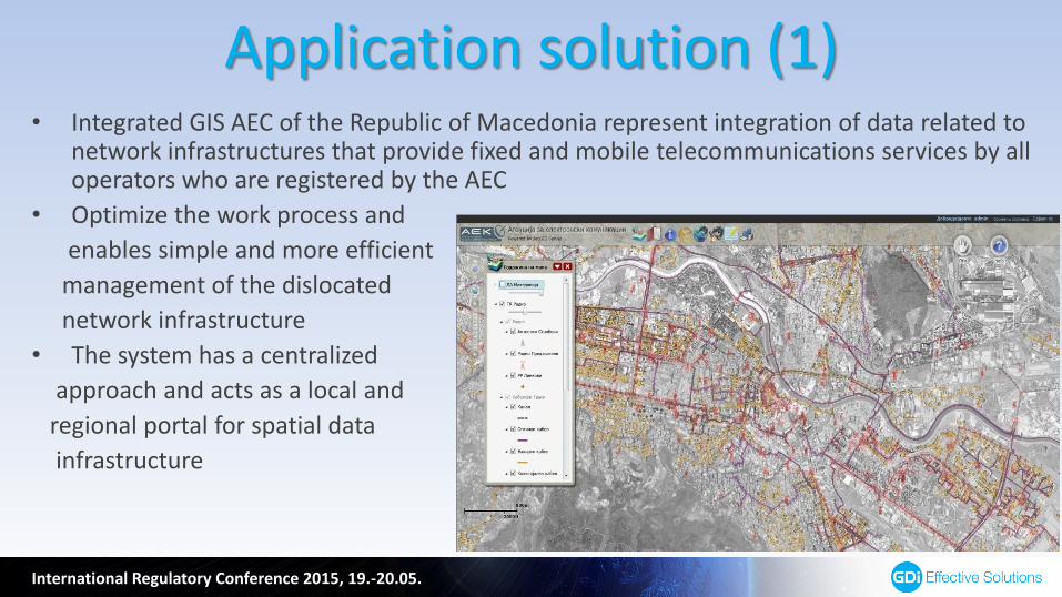
Application solution (1) • Integrated GIS AEC of the Republic of Macedonia represent integration of data related to
network infrastructures that provide fixed and mobile telecommunications services by all operators who are registered by the AEC
• Optimize the work process and
enables simple and more efficient
management of the dislocated
network infrastructure
• The system has a centralized
approach and acts as a local and
regional portal for spatial data
infrastructure

International Regulatory Conference 2015, 19.-20.05.
• Display map with a spatial components for Radio, Telecommunication objects, and cable route
• Visual display of
symbols and status of
elements of the
telecommunications
infrastructure- (TI)
- Existing
- Planned
- Unspecified
- In construction
Application solution (2)

International Regulatory Conference 2015, 19.-20.05.
• Modernization of the activities of public administration (centrally, regionally and locally) encompassed by the project for using modern IT;
• Support in the decision making processes;
• Suitable environment for business investments;
• Time and costs savings by the entities that are using the services of AEC;
• Active participation in the creation of informatics environment, and the e-government activities in Republic of Macedonia
Benefits from the application
International Regulatory Conference 2015, 19.-20.05.
• Combination of geographic data, i.e. spatial elements, different types of information (descriptive elements, spatial attributes)
• Integration of vector data (polygons, polylines and points) with tabular data
• GIS database server GIS central database
• Clients software applications (specific analysis of data, preparation of different print templates, editing and/or changes of data)
• An open structure for possible changes, additional functionalities, connecting and integration with other systems
GIS Technology

International Regulatory Conference 2015, 19.-20.05.
- Supports working with different dates and projections
- Supports “on-the-fly” re-projection
- Offers support for the standard HTTP and TCP/IP protocols
- Supports two-way replication of the geodatabase
- Integration of the geographic web services with services generated from other servers
- Ability for integration of local data from central database with global data (Open Street Map, Bing Maps, Microsoft Virtual Earth)
- Ability for doing geospatial analysis over different types of data and support for the most of GIS formats and functionalities (move, zoom in/out, search, buffer, selection of objects…)
Components of a GIS System – Server GIS software

International Regulatory Conference 2015, 19.-20.05.
• Enabled working with maps
• Working with relational databases
• Spatial and attributes searches
• Data filtering by means of SQL queries
• Data export in different formats
(Shapefile, CAD file, …)
• Data management
• Working with versioned data
• Interactive management with map contents (turning on/off of single data layers)
• Implementation of topological rules
• Working with metadata
Components of a GIS System – Client GIS software

International Regulatory Conference 2015, 19.-20.05.
• New responsibility for AEC according the Law for electronic communications – enabling minimum information about the planned construction of public electronic communication network according Article 67 in the Law for electronic communications
• The information should include: the type of infrastructure, basic technical characteristics, horizontal and vertical position of under- and overground infrastructure objects and the accompanying installation, and also information about the subjects that manage them
• This enables the operators to attain according information on one place during planning and creation of technical documentation for getting a construction permit on public electronic communication network
Single point for information – Why?

International Regulatory Conference 2015, 19.-20.05.
• Minimum data is enabled based on how it is stated in the Law on Real Estate Cadaster; the Agency for Real Estate Cadaster needs to make available all data from the Cadaster of infrastructure objects
• Unless minimum data is enabled through single point of information, the subjects that manage the infrastructure objects stated in the Law on Real Estate Cadaster are obliged to enable access to needed information no later than one month after receiving a written request by any operator (Article 67, par. 4 – Law on electronic communications)
• After a written request by an operator, subject that manages the infrastructure objects stated in the Law on Real Estate Cadaster is obliged to enable the following minimum information regarding current or planned construction work:
- Location and type of construction work;
- Network elements that will be involved in construction work;
- Designated date for start of construction work and its duration;
- Contact persons
Responsibilities of AEC regarding SPI (1)

International Regulatory Conference 2015, 19.-20.05.
• Subject that manages the infrastructure objects stated in the Law on Real Estate Cadaster is obliged to enable the requested information no later than 60 days after receiving the written request, and make the information available to the AEC in order enabling the access through the Single point for information (Article 67, par. 6 – Law on electronic communications)
• The operator of public electronic communication networks (Art. 75, par. 1) is obliged to submit a request for issuing a construction permit no later than 6 months, and to provide to the AEC information about the construction, in order enabling access to those information through the Single point for information according Article 67 (Law on electronic communications)
• Giving additional information and details regarding planned construction of the public electronic communication network and parts of the existing physical infrastructure after a written request by the interested parties; the Agency is obliged to deliver the information no later than 15 days after receiving the written request
Responsibilities of AEC regarding SPI (2)

International Regulatory Conference 2015, 19.-20.05.
• In cooperation with the local government, through the SPI the Agency publishes information on the legal persons that are doing construction works, which are entirely or partially financed with public funds (every legal person is obliged to satisfy all the reasonable requests by the operator for inter-coordination of construction works)
• If an agreement for coordination is not reached within one month after receiving the request, then each of the parties has the right to request from the Agency to resolve the dispute (Art. 68, par. 3 – Law on electronic communications)
Responsibilities of AEC regarding SPI – Coordination of construction works

International Regulatory Conference 2015, 19.-20.05.
• SPI enables the operators that want to build public communication network to get to the information regarding the existing infrastructure objects of other owners in the area of planned construction
• Concurrent access of unlimited number of users and editing of data in multiuser environment
• Enabled standard tools for map navigation (zoom in/out, zoom to a selected infrastructure object or a group of objects, zoom to a given x,y coordinate)
Functionalities of the Single point for information

International Regulatory Conference 2015, 19.-20.05.
• Enabling information to the users, operators and international organizations and bodies
• Enabling support in giving consent for the basic project for construction of public electronic communication network and the accompanying equipment
• Enabling support for giving opinions during preparation of documents for spatial planning
• Enabling support in giving consent for the fulfillment of special conditions regarding construction works in the area of electronic communication network and the accompanying equipment
Supported business processes by the SPI

International Regulatory Conference 2015, 19.-20.05.
• The application enables access to the according legislative, i.e. the following documents can be downloaded:
- Law on electronic communication - Law on construction - Law on spatial and urban planning - Other relevant laws and bylaws
• Minimum data included in the application: Supplied by the Agency for Real Estate Cadaster: Supplied by City of Skopje: - Topographic maps in scale (1:25000) - Address model of city of Skopje - Orthophoto map of Skopje - Satellite image map 2014 - Administrative units - Cadastral parcels - Infrastructure objects
Other functionalities of SPI

International Regulatory Conference 2015, 19.-20.05.
• Based on infrastructures for spatial data founded and managed by 28 EU member countries
• The directive was enforced on 15. May 2007 and it will be implemented in different stages; finished by 2019
• Its purpose is creating an infrastructure of spatial data for the EU
International standards for spatial data – INSPIRE directive

International Regulatory Conference 2015, 19.-20.05.
• Data should be collected only once and be kept where they will be most efficiently maintained;
• It should be possible for the spatial data from different sources throughout Europe to be easily combined and shared between many users and applications;
• It should be possible for data gathered on one scale to be shared on all levels/scales; detailed for thorough researches, general for strategic goals;
• Geographic data should be easily accessible and transparent;
• It should be easy for the user to find which data is available, and how they can be used in order for certain needs to be satisfied
INSPIRE principles

International Regulatory Conference 2015, 19.-20.05.
Thank you for your attention!
Maja Kostoska/GIS Developer