
Interim Geologic Map of the St. George Quadrangle, Washington County,...
47
Interim Geologic Map of the St. George Quadrangle, Washington County, Utah by Janice M. Higgins 1 and Grant C. Willis 2 1995 The views and conclusions contained in this document are those of the authors and should not be interpreted as necessarily representing the official policies, either express or implied, of the U.S. Government. Open-File Report 323 Utah Geological Survey a division of Utah Department of Natural Resources in cooperation with U.S. Geological Survey State Contract 95-0846 STATEMAP Agreement No. 1434-94-A-1256 This open-file release makes information available to the public during the lengthy review and production period necessary for a formal UGS publication. Because the release is in the review process and may not conform to UGS policy and editorial standards, it may be premature for an individual or group to take action based on the contents. This OFR will not be reproduced when the final production has been released. 1 Dixie College, St. George, Utah 2 Utah Geological Survey, Salt Lake City, Utah
Transcript of Interim Geologic Map of the St. George Quadrangle, Washington County,...

Interim Geologic Map of the
St. George Quadrangle,
Washington County, Utah
by
Janice M. Higgins1
and
Grant C. Willis2
1995
The views and conclusions contained in this document are those of the authors andshould not be interpreted as necessarily representing the official policies, either expressor implied, of the U.S. Government.
Open-File Report 323
Utah Geological Surveya division ofUtah Department of Natural Resourcesin cooperation withU.S. Geological Survey
State Contract 95-0846STATEMAP Agreement No. 1434-94-A-1256
This open-file release makes information available to the public during the lengthyreview and production period necessary for a formal UGS publication. Because therelease is in the review process and may not conform to UGS policy and editorialstandards, it may be premature for an individual or group to take action based on thecontents. This OFR will not be reproduced when the final production has beenreleased.
1Dixie College, St. George, Utah2Utah Geological Survey, Salt Lake City, Utah
St. George-1
ABSTRACT
The St. George quadrangle in southwestern Utah is located in the transition zonebetween the Basin and Range Province to the west and the Colorado Plateau Provinceto the east and is famous for its scenic panoramas and recreational opportunities. It sitson an intermediate structural block bounded by down-to-the-west faults. The GrandWash-Gunlock fault is to the west and the Hurricane fault is to the east. TheBloomington dome portion of the northeast-trending Virgin anticline, a late Cretaceousand Paleocene structure, is in the center of the quadrangle. The oldest rock in thequadrangle, the Permian Kaibab Formation, with a thickness of 368 feet (113 m), ispartially exposed in the center of the dome. The Triassic Moenkopi and ChinleFormations unconformably overlie paleotopography eroded on the Kaibab Formation,and are 2,150 feet (650 m) and 800 feet (245 m) thick, respectively. A Jurassic sectionconsisting of the Moenave Formation, 420 feet (127 m) thick, the Kayenta Formation,1,170 feet (355 m) thick, and the basal 200 feet (61 m) of Navajo Sandstone, isexposed on the north limb of the anticline.
Four Late Tertiary to Quaternary sequences of basalt flowed into valleys on thequadrangle from the north. Because of continued uplift and downcutting into adjacentsedimentary rocks, these basalt flows now cap black ridges, forming inverted valleys. This uplift and downcutting is also documented by alluvial-terrace deposits and otherelevated alluvial surfaces with thick pedogenic carbonate development.
Several normal faults displace the rocks of the St. George quadrangle. Only two,both trending north-south, have more than a few tens of feet of offset: the Washingtonfault with about 750 feet (229 m), crosses the northeast corner of the quadrangle; andthe St. George fault, with about 450 feet (138 m), cuts through the north-central part ofthe quadrangle. Both of these are considered late Cenozoic extension faults, butneither offsets surficial deposits in the quadrangle. Most other faults in the quadrangletrend north-northwest, roughly perpendicular to the Virgin anticline. These small faultsgenerally developed in pairs, forming grabens.
Economic resources include gravel from alluvial terrace deposits, gypsum, andstone. Water resources are increasingly important as population growth continues. Flooding; slope failures, including rock falls, landslides, and slumps; expandable,soluble, and collapsible rock and soil; earthquakes, volcanic eruptions and radon are ofincreasing concern as development increases.

St. George-2
TABLE OF CONTENTS
ABSTRACTINTRODUCTIONDESCRIPTION OF MAP UNITS
PermianKaibab Formation
Fossil Mountain Member (Pkf)Harrisburg Member (Pkh)
TriassicMoenkopi Formation
Rock Canyon Conglomerate Member (TRmr)Timpoweap Member (TRmt)Lower red member (TRml)Virgin Limestone Member (TRmv)Middle red member (TRmm) Shnabkaib Member (TRms)Upper red member (TRmu)
Chinle FormationShinarump Conglomerate Member (TRcs)Petrified Forest Member (TRcp)
JurassicMoenave Formation
Dinosaur Canyon Member (Jmd)Whitmore Point Member (Jmw)Springdale Sandstone Member (Jms)
Kayenta FormationLower member (Jkl)Middle member (Jkm)Upper member (Jku)
Navajo Sandstone (Jn)Tertiary
Volcanic RocksWest Black Ridge basalt flows (Tb)
Alluvial DepositsAlluvial gravel beneath basalt flows (Tag)
Quaternary/Tertiary Mixed-environment Deposits
Eolian pedogenic carbonate and alluvial deposits (QTeca)Quaternary
Volcanic RocksAirport basalt flows (Qba)Washington basalt flows (Qbw)Middleton Black Ridge basalt flows (Qbm)
Alluvial DepositsAlluvial gravel beneath basalt flows (Qag)Stream terrace deposits (Qat3-Qat5)Older stream terrace deposits (Qato)Pediment-mantle deposits (Qap)Older alluvial-fan deposit (Qafo)Older alluvial deposits (Qao)Stream deposits (Qal1-Qal2)

St. George-3
Eolian DepositsEolian sand (Qes)
Mass-movement DepositsSlump and landslide deposits (Qms)Talus deposits (Qmt)
Mixed-environment DepositsMixed alluvial and colluvial deposits (Qac)Mixed alluvial and eolian deposits (Qae)Mixed older alluvial and eolian deposits (Qaeo)Mixed eolian and alluvial deposits (Qea)Mixed older eolian and alluvial deposits (Qeao)Mixed colluvial and alluvial deposits (Qca)Mixed pedogenic carbonate and alluvial deposits (Qeca)
STRUCTURERegional settingLate Cretaceous - Paleocene compressional structures
Virgin anticlineBloomington dome
St. George synclineLate Cenozoic extensional structures
Washington faultSt. George fault
ECONOMIC GEOLOGYNon-metals
StoneGypsumGravel
MetalsOil and natural gas
WATER RESOURCESSurface waterGround water
GEOLOGIC HAZARDSEarthquakesSlope failures
Slumps and landslidesRock fall
Problem soil and rockExpansive soil and rockDissolvable soil and rockCollapsible / Compressible soils
FloodingRadonVolcanism
SCENIC AND RECREATIONAL RESOURCESACKNOWLEDGMENTSREFERENCES

St. George-4
INTRODUCTION
The St. George quadrangle is located in south-central Washington County in thesouthwest corner of Utah, just north of the Arizona border. St. George City, one of thefastest growing communities in the nation, is located in the north part of the quadrangle. The 1990 Census reported a population for St. George City of 28,502. With a growthrate of 6% per year, the population of the city is projected to reach 58,000 by the year2003. However, from 1980 through 1989 the growth rate was 86.3% (Horrocks-CarolloEngineers, 1993). This rapid growth has greatly impacted existing infra-structure andheavily taxed the resources needed to meet the needs of the growing population center. An understanding of the geology of this area is vital for wise planning.
Maximum topographic relief is just over 800 feet (245 m) from the base of theVirgin River drainage at 2,500 feet (765 m) above sea level to the top of West BlackRidge north of Devil's Saddle at 3317 feet (1014 m). Several groups of hills withelevations above 3,000 feet (917 m) dot the quadrangle, including: Red Hills, WebbHill, Price City Hills, White Hills, and the north edge of Little Black Mountain in thesoutheast corner. Strata that comprise these hills form two cliff "steps" on the "GrandStaircase" of rock (Hintze, 1988) that stretches across southern Utah and northernArizona, the Shinarump Member of the Chinle Formation, which forms the ChocolateCliffs, and the Kayenta Formation, which forms the Vermillion Cliffs.
The area has the lowest elevation and warmest climate, and the longest growingseason in Utah. The arid area receives an average of only 8 inches (20 cm) ofprecipitation annually (Cordova, 1972). Natural vegetation includes sparse grasses,sagebrush, creosote bush, and several varieties of cactus and yucca. Pioneer settlersbrought a wide variety of plants into the area including cotton and fruit and nut trees.
The groundwork investigation of the geology of southwestern Utah were done bythe U.S. Army Topographical Survey and U.S. Geological Survey during the later half ofthe 19th century (Powell, 1875; Dutton, 1882). Dobbin (1939) made a small-scalegeologic map of the St. George area focused on structural geology. Gregory (1950)mapped the Zion Canyon area to the east and established many of the geologic namesin use today. Cook (1960) completed a map of Washington County that is still the mostdetailed map available for much of the county. Christenson and Deen (1983) mappedthe surficial geology of the St. George area, focusing on engineering aspects of thegeology. Eppinger and others (1990) compiled a 1:250,000-scale map of the CedarCity 1°x2° quadrangle that includes the St. George quadrangle. Hintze and others(1994) mapped the Motoqua and Gunlock quadrangles to the northwest that covermany of the same formations exposed in the St. George quadrangle. Billingsley (1993)mapped four quadrangles south and southwest of the quadrangle at 1:31,680 scale. Willis and Higgins (1995) mapped the Washington quadrangle to the north at 1:24,000-scale as a continuation of this study. Many topical studies have been done on structure,stratigraphy, volcanism, hazards, and economic and water resources of the area.

St. George-5
DESCRIPTION OF MAP UNITS
The oldest rock exposed in the St. George quadrangle, the Late Permian KaibabFormation, forms the Price City Hills in the center of the Bloomington dome, thesouthern-most of three domes in the northeast-trending Virgin anticline. The Triassicsection, including Early Triassic Moenkopi and Late Triassic Chinle Formations, isexposed along both flanks of the anticline. Early Jurassic strata, including theMoenave, Kayenta, and lower part of the Navajo Formations, are exposed north of theanticline.
Four basalt flows, derived from sources north of the quadrangle, range in agefrom 2.24 million years old (Best and others, 1980; Hamblin and others, 1981) to about500,000 years old. Erosion has exhumed more than 600 feet (181 m) of strata sincedeposition of the oldest basalts, leaving the resistant flows standing as high linearridges that form classic examples of inverted topography (Hamblin, 1963, 1987). Theoldest flow now caps the highest black ridge. Continued uplift and downcutting in thisarea is also evidenced by gravel terraces mapped at three levels. Thin alluvial,colluvial, eolian, and mass movement deposits cover much of the quadrangle.
The Permian and Mesozoic strata in the quadrangle were deposited in shallowmarine to low-level terrestrial conditions and lithologies strongly reflect sea-levelflucuations. In the following section rocks are described in relation to this sequencestratigraphic framework (figure 2). Scientists recognize major cycles in the rock recordthat are divided into first order (megasequences) through fifth order (parasequences),depending upon the duration and extent of the cycle (Vail and others, 1977; Mitchumand others, 1977; Van Wagoner and others, 1990). Permian rocks exposed in thequadrangle constitute the end of the Paleozoic megasequence and the Triassic rocksmark the beginning of the Mesozoic/Cenozoic megasequence, (figure 2). After aPermian lowstand between the megasequences that exposed the Kaibab Formation toerosion sea level began to rise. It fluctuated near the high until Early Jurassic, when itdropped to about 500 feet (150 m) below present sea level (Vail and others, 1977). TheTriassic changes in sea level define five supercycles (second order sequences) (VanWagoner and others, 1990). However, only two of the five are documented in rocks inthe quadrangle.
PermianThe Kaibab Formation, the only Permian rock exposed in the quadrangle,
constitutes the top portion of the second-order cycle that began in the early Permian. Itrepresents the highstand systems tract of a third-order sequence, and was deposited asthe rate of sea-level rise slowed so that sedimentation could keep pace (figure 2a). ThePermian lowstand resulted in subaerial exposure and extensive erosion of the KaibabFormation. Erosion completely removed the Harrisburg Member in some places(Jenson, 1984). The Kaibab Formation is late Early Permian to early Late Permian inage. Upper Permian rocks are not present in the quadrangle, so the Late Permian sea-level rise is not documented (figure 2).
Kaibab Formation Fossil Mountain Member (Pkf): The Fossil Mountain Member, the oldest rockexposed in the quadrangle, is exposed in the northeast portion of Bloomington domeand in the bottom of a few deep washes along the southwest edge of the Price CityHills. It consists of yellowish-gray, abundantly fossiliferous, cherty limestone that formsa prominent cliff. The fossils, including corals, brachiopods, crinoids, and bryozoan, aresilicified. The outcrop appears black-banded because of reddish-brown and black chert

St. George-6
that forms irregularly bedded nodules. The base of this member is not exposed. Nielson (1981) measured an incomplete thickness of 68 feet (21 m) in sections 8 and 9,T. 43 S., R. 15 W., near River Road. Four feet (1.2 m) is exposed beneath the RockCanyon Member of the Moenkopi Formation in a wash on the southwest side of thedome (in and near SE1/4 NE1/4, section 24, T.43S., R.16W.). The top contact iscomformable and is drawn at the base of the first massive gypsum bed. Harrisburg Member (Pkh): The Harrisburg Member is well-exposed in Bloomingtondome. It is light-gray, fossiliferous, sandy, fine- to medium-grained limestoneinterbedded with red and gray gypsiferous siltstone, sandstone, and gray gypsum bedsseveral feet thick. Beds of cherty limestone and sandy limestone about 20 feet ( 6 m)thick form resistant cliffs in the upper part of the member. Dissolution of interbeddedgypsum has locally distorted the member. It forms a slope with limestone ledges. Generally, the exposure in Bloomington HIlls is unusal since the member is very poorlyexposed (Billingsley, 1990).
Because of post-depositional, subaerial erosion of several hundred feet duringabout 20 million years of Late Permian and Early Triassic time, this member has beencompletely removed from the southwest part of the Price City Hills. Jenson (1984)described karst topography with local relief of more than 594 feet (180 m) in the BeaverDam Mountains that resulted from this extensive erosion. Locally, where the member iscompletely removed, the Rock Canyon Conglomerate Member of the MoenkopiFormation is deposited directly on the Fossil Mountain Member of the Kaibab Formation(figure 3). Elsewhere, the Harrisburg Member is overlain by the Timpoweap Member ofthe Moenkopi Formation. The upper contact, which is poorly exposed, and highlyvariable, unconformable, is placed above the last pinkish-gray, massive gypsum andbelow alternating, light-yellowish-orange, gypsiferous siltstone, light-reddish-brownsiltstone and very thin-bedded, medium-gray limestone. Thickness of the HarrisburgMember varies from 0 to about 300 feet (0-91 m). Nielson (1981) measured 280 feet(85 m) near the southwest end of the Price City Hills and an incomplete section of 185feet (56 m) near the northeast end.
Triassic
This section consists of Lower Triassic Moenkopi and Upper Triassic ChinleFormations which are separated by an unconformity of about ten million years (figure2a). These formations denote two major second-order supercycles of Vail and others(1977) but a smaller rise and subsequent fall of sea level during middle Triassic time(Paull and Paull, 1994) is not documented in the quadrangle.
Moenkopi Formation The Moenkopi Formation is divided into seven members with a total thickness of
2,150 feet (650 m). The lower three members, Rock Canyon Conglomerate,Timpoweap, and lower red, were measured along the west side of Bloomington dome inthe NE 1/4, section 24, T. 43 S., R 16 W. while the Virgin Limestone Member wasmeasured just to the north, in the SE 1/4, section 13, T. 43 S., R. 16 W. The upperthree members, middle red, Shnabkaib, and upper red were measured in a south-to-north line starting in the NE 1/4, section 18 and ending in the NE 1/4, section 7, T. 43S., R.15 W., between the Price City Hills and Webb Hill. This formation is early tomiddle Triassic in age (late Scythian to early Anisian).
The Moenkopi Formation represents a second-order supercycle that can besubdivided into three distinct third-order sequences that represent smallertransgressive-regressive cycles in an overall sea level rise (figure 2a, 2b). The
St. George-7
Moenkopi was deposited on a very gentle slope where sea level changes of several feettranslated into shoreline changes of many tens of miles. Paull & Paull (1994) statedthat this Early Triassic global rise in sea level from the Permian lowstand was greaterthan 660 feet (200 m). Only the lowest of the three third-order sequences includes alowstand systems tract that is documented within the quadrangle (represented by theRock Canyon Conglomerate). Above the Rock Canyon Conglomerate is thetransgressive systems tract of the Timpoweap Member, which Dubiel (1994) correlatedto the Smithian-age transgression that flooded over this area from the northwest. It isoverlain by the highstand systems tract of the lower red member, correlated toSmithian-Spathian age regression by Dubiel (1994), which completes the lowest third-order sequence. The Virgin Limestone Member and the middle red member,respectively make up the transgressive and highstand systems tracts of the middlethird-order sequence, while the Shnabkaib Member and the upper red member formsimilar systems tracts for the top third-order sequence in the Moenkopi Formation. These two third-order sequences are correlated to early to late Spathian transgressionsand regressions of Dubiel (1994). Paleogeographic maps and time-rock stratigraphycharts in Blakey and others (1993) and Paull & Paull (1994) depict these changes.
Rock Canyon Conglomerate Member (TRmr): The Rock Canyon ConglomerateMember filled paleocanyons eroded into the Kaibab Formation. The only outcrop in thequadrangle is along the southwest edge of the Price City Hills where the HarrisburgMember of the Kaibab Formation was removed by erosion and the conglomeratedirectly overlies the Fossil Mountain Member and abuts against the Harrisburg Member. This member is composed of yellowish-gray to light-olive-gray, poorly to moderatelysorted conglomerate with angular to subrounded clasts. Thick beds, some of which arelenticular and indurated, make this member resistant to erosion, forming a cliff with arough, angular surface. The basal layers include limestone rip-up clasts and blockseroded from the Harrisburg Member as large as 14 inches (35 cm) in diameter that haveundergone several episodes of healing with sparry calcite to form angular, brecciatedclasts. Although rounding varies, in general clasts are more rounded toward the top. Clasts are pebble- to cobble-sized and composed primarily of chert weathered from theKaibab Formation. The conglomerate is clast supported. The unit grades upward intocalcareous, gritty, pebble conglomerate that is poorly sorted and includes somesandstone lenses. The upper contact is conformable where exposed along the westside of the outcrop and is gradational with dark-yellowish-orange to light-pinkish-gray,gritty siltstone beds of the Timpoweap Member. We measured a thickness of 35 feet(10 m) in the NE1/4 SE1/4 NE1/4, section 24, T. 43 S., R. 16 W. Nielson (1981)measured 38 feet (11 m) in the same vicinity.
Timpoweap Member (TRmt): The Timpoweap Member generally overlies theHarrisburg Member of the Kaibab Formation but locally overlies the Rock CanyonConglomerate Member of the Moenkopi Formation. In most exposures it consists ofthin siltstone and limestone with very fine-grained lenticular sandstone near the base. Typically, five distinct 0.25- to 2-inch-thick (0.5-5 cm) beds of medium-gray limestoneand bedded gypsum are separated by alternating bands of dark-yellowish-orange andmoderate-reddish-brown gypsiferous siltstone. This alternating sequence can be tracedalong the north side of Bloomington dome from the southwest corner to River Roadwhere alluvial deposits cover the rocks. The sandstone generally fines upward. Thebedded gypsum is punky and weathers to form a slope covered with crypotgamic soil. The unit does not contain limestone where it overlies the Rock Canyon ConglomerateMember. There the dark-yellowish-orange to light-pinkish-gray, calcareous and friablesandstone is thin-bedded and includes interbeds of medium- to very coarse-grained

St. George-8
sandstone with abundant chert granules. Exposures on the southern side of the domeare very poor.
The total thickness of this member decreases dramatically as the siltstone bedsbetween the limestone intervals thin. Nielson (1981) measured 272 feet (83 m) inNW1/4 NE1/4 NE1/4, section 24, T. 43 S., R. 15 W., but we only measured 110 feet (32m) in the same area. We measured 75 feet (23 m) in SW1/4 SW1/4 SW1/4, section 18,T. 43 S, R 15 W.. The difference is probably due in part to local thinning and in part toselection of differenct upper contacts. We place the contact with the lower red memberat the top of the dark-yellowish-orange, friable sandstone, and below predominantlylight-reddish-brown mudstone. Locally, very thin beds of dark-yellowish-orangesiltstone widely separated by light- to moderate-reddish-brown mudstone and siltstoneare included in the lower red member.
Lower red member (TRml): The lower red member consists of interbedded siltstone,mudstone, and sandstone that form a strike-valley around the edge of the Price CityHills. It is best exposed along the north and west sides of the hills. It consists ofmoderate-reddish-brown siltstone that is generally calcareous and commonly has ripplemarks and small-scale cross-bedding. Dark-yellowish-orange, thin siltstone beds arecommon in the lower half and the mudstone includes thin interbeds and vein stringers ofgypsum. The reddish-brown, calcareous sandstone is very fine grained and thinlybedded. The upper contact with the Virgin Limestone Member is placed at the base ofthe lowest thick limestone ledge. The lower red member varies in thickness from 25feet (8 m) to 300 feet (91 m). The variation is probably due to attenuation faulting,especially in steeply dipping beds on the north side of the Virgin anticline. It is doubtfulthat the thickness change is due to stratigraphic thinning over paleohills of the KaibabFormation, as is the case to the west in the Beaver Dam Mountains (Jenson, 1984),because the Timpoweap Member, which fills most of the paleo-topography, is prevalentthroughout the quadrangle.
Virgin Limestone Member (TRmv): The Virgin Limestone Member is well exposedalong the west and south sides of Bloomington dome where it consists of four distinct,resistant, medium-gray to yellowish-brown, marine limestone ledges interbedded withnonresistant, moderate-yellowish-brown, muddy siltstone and pale-reddish-brownsandstone. This member, together with the middle red member, is a third-ordersequence, but it can be subdivided into four fourth-order sequences. Each of the fourlimestone layers are transgressive systems tracts that are separated from an overlyingmuddy siltstone highstand systems tracts by a maximum flooding surface (figure 2b).
The four limestone beds, which are each about 5 feet (1.5 m) thick, can in turn bedivided into distinct fifth-order parasequences (Van Wagoner and others, 1990). Thelower portion of the each limestone is finer-grained, muddy, and non-fossiliferous,signifying a transgressive systems tract, while the upper portion is a coarserwackystone with birdseye structures and five-sided echinoderm and bivalve shellfragments, signifying a highstand systems tract. The two limestone portions are dividedby about one inch (2.5 cm) of dark-grayish-brown shale, indicative of a maximumflooding surface.
This member is 134 feet (41 m) thick in SE1/4 SW1/4 SE1/4, section 13 ,T. 43S., R. 15 W. Total thickness varies from 225 feet (68 m) on the southwest edge of thePrice City Hills to 25 feet (7.5 m) along the north side of the nearly vertical limb of theVirgin anticline probably because of attenuation faulting. Small bedding plane faults arecommon in that area. However, even with this thinning of incompetent beds, the fourlimestone ledges are preserved. The upper contact with the middle red member and isdrawn at the top of the highest limestone ledge.

St. George-9
Middle red member (TRmm): The middle red member is a slope-forming memberthat is generally not well exposed. The best exposures within the quadrangle are alongthe northwest side of Bloomington dome and next to the White Hills near the south edgeof the quadrangle where the member forms low reddish-colored hills. It is composed ofinterbedded, moderate-red to moderate-reddish-brown siltstone, mudstone, and somevery fine-grained, thin-bedded sandstone. Very thin interbeds and vein stringers ofgypsum that vary in color from greenish-gray to white are locally common. Thethickness is relatively consistent throughout the quadrangle. We measured 372 feet(113 m) along the northeast side of Bloomington dome in the NW1/4 NE1/4, section 18,T. 43 S., R. 15 W. The upper contact is placed where the moderate-red siltstone of themiddle red member gives way to predominantly light-gray, unfossiliferous, dolomiticlimestone beds that mark the base of the Shnabkaib Member.
Shnabkaib Member (TRms): The Shnabkaib Member is exposed between the PriceCity Hills and Webb Hill near the center of the quadrangle and in the White Hills nearthe south edge of the quadrangle. It consists of light-gray to pale-red gypsiferoussiltstone with several thin interbeds of unfossiliferous, dolomitic limestone near thebase. The alternating resistant and nonresistant beds form ledge-slope topography andmake the lower portion slightly more resistant to erosion than the upper portion. Thegypsiferous upper portion weathers into a powdery cryptogamic soil and generally formsa valley except where it is held up by more resistant overlying units. Alternating lightand dark colors give this member a "bacon striped" appearance that shows upespecially well on aerial photographs. The upper contact is gradational and is drawnwhere the greenish-gray, gypsiferous siltstone of the Shnabkaib Member grades intoreddish-brown mudstone of the upper red member. This member is 996 feet (302 m)thick in the SW1/4 SE1/4 and the SW1/4 NE1/4, section 37, T. 43 S., R 15 W.
Upper red member (TRmu): The upper red member of the Moenkopi Formation iswell exposed along both the north and south flanks of the Virgin anticline as a steepslope with at least one prominent sandstone ledge beneath the resistant ledge formedby the Shinarump Conglomerate Member of the Chinle Formation. It consists ofmoderate-reddish-brown, thin-bedded siltstone and very fine-grained sandstone withsome thin gypsum beds. Ripplemarks are common in the siltstone. A massive, pale-reddish-orange, very fine-grained sandstone forms a prominent ledge near the top. Theupper contact is unconformable, representing approximately 10 million years of middleTriassic time, and is mapped at the base of the first coarse-grained, thick-bedded, pale-yellowish-brown sandstone caprock. It is 363 feet (110 m) thick on the south side ofWebb Hill in the SW1/4 NW14 NE1/4, section 7, T.43 S., R.15 W.
Chinle Formation
The Chinle Formation consists of two members in the quadrangle, the ShinarumpConglomerate and the Petrified Forest Members. The Shinarump forms a prominentcuesta cliff in the middle and eastern parts of the quadrangle while the Petrified Forestis nonresistant and forms low hills at the base of a broad dip slope. The ChinleFormation varies in total thickness mostly because of changes in the basal ShinarumpMember, but it averages 800 ft (245 m) thick. It is assigned to the late Carnian to earlyNorian in the late Triassic epoch (Hintze, 1988); however, Dubiel (1994) gives it a muchwider age range from early Carnian to late Norian with an unconformity of severalmillion years separating the two members.
The formation represents the last Triassic second-order supercycle of Vail andothers (1977). The Chinle Formation can be subdivided into two distinct third-order

St. George-10
cycles. The lower third-order cycle consists of the Shinarump Member which consistsof sediment off of the ancestral Uncompahgre highlands to northeast and from amagmatic arc near the continental margin to the southeast (Blakey, 1993). The basalShinarump was deposited in the lowest parts of paleovalleys cut into the upper redmember of the Moenkopi Formation (Dubiel, 1994) which signifies the beginning of baselevel rise. Although the Shinarump grades upward from massive conglomerate, andtabular-planar stratified sandstone at the base to medium-grained, trough cross-stratified sandstone, it represents only a highstand systems tract formed by hinterlandbraided stream deposits. The Petrified Forest Member is the highstand systems tract ofa separate third-order cycle. Its fluvial systems mimicked paleoflow in the lowerShinarump system except that these stream deposits were of much higher sinuosity asevidenced by ample floodplain mudstone (Dubiel, 1994). Abundant bentonitic mudstoneintervals indicate that volcanic ash formed a significant component of sediment supply,most of which was derived from the magmatic arc at the continental margin to thesouthwest (Blakey, 1993).
Shinarump Conglomerate Member (TRcs): The Shinarump Conglomerate Member isvery resistant and forms a dark-brown to moderate-yellowish-brown sandstone cuestaridge that stretches east-west across the middle of the quadrangle on the north limb ofthe Virgin anticline, and in the southeast quadrant on the south limb of the anticline. Itvaries from a grayish-orange to moderate-yellowish-brown, medium- to coarse-grainedsandstone with intermittent gravel conglomerates, across most of the quadrangle, tomoderate-brown, chert pebble and gravel conglomerate in the extreme southeast cornerof the quadrangle. Only in the southeast corner of the quadrangle is this memberentirely a conglomerate. The sandstone contains fragments of petrified wood in someareas. Locally, it has well-developed liesegang bands that give rise to the nicknames of"picture rock" or "landscape stone" (Bugden, 1993).
The Shinarump Conglomerate Member ranges from 5 to 200 feet (1.5-61 m). Itis highly variable in composition and thickness because it represents backfilling ofpaleotopography and braided stream channel deposition. Thickness variations mayalso be due to slumping. Common slickensides with multi-directional lineations at thebase of the sandstone indicate sliding on the upper red member of the MoenkopiFormation. Hintze and Hammond (1994) described several masses of semi-coherentShinarump that slumped or slid in the Shivwits quadrangle, west of the study area. Similar slump blocks on the steeply dipping north limb of the Virgin anticline, such as atWebb Hill, might also partially account for the wide variation in the thickness of thismember. The upper contact is placed at the base of the first variable colored, bentoniticshale of the Petrified Forest Member.
Petrified Forest Member (TRcp): The Petrified Forest Member of the ChinleFormation forms well-developed strike valleys that extend east-west across thequadrangle, adjacent to the more resistant cliffs of the Shinarump ConglomerateMember. It is well exposed only where it is protected from erosion by stream terraces. It consists of light-brownish-gray to grayish-red-purple bentonitic shale and siltstone withseveral lenticular interbeds of pale-yellowish-brown, cross-bedded, thick-bedded,resistant sandstone up to 10 feet (3 m) thick. Shaley beds weather to a "popcorn"surface with abundant mudcracks due to swelling and shrinking of bentonitic clay. Petrified wood is common. The upper contact is placed at the top of the highestpurplish-gray shale and below reddish-brown siltstone of the Dinosaur Canyon Memberof the Moenave Formation. This contact is unconformable and represents about tenmillion years. The member is 700 feet (215 m) thick as estimated from maprelationships.
St. George-11
Jurassic
Three Jurassic formations of Sinemurian, Pliensbachian, and Toarcian age rocksare present in the quadrangle. They form the youngest second-order supercycle in theSt. George quadrangle, and were deposited after sea level dropped dramatically fromsomewhat higher than it is today to 500 feet (150 m) lower than current sea level (figure2a) (Vail and others, 1977). The relatively small second-order base level rise frequentlyplaced by sequence stratigraphers in the late Triassic earliest Jurassic cannot bedocumented in the St. George quadrangle because Hettangian age rocks are notpresent (figure 2a).
Early Jurassic rocks in the quadrangle can be subdivided into two and possiblythree third-order sequences. The lowest one is comprised of the three members of theMoenave Formation. The Dinosaur Canyon Member is the transgressive systems tract,the Whitmore Point Member represents maximum flooding stage, and the SpringdaleSandstone Member comprises highstand systems tract. The middle third-ordersequence involves the Kayenta Formation. The lower member is the transgressivesystems tract with the freshwater dolomite beds designated as the maximum floodingstage; the middle and upper members form the highstand systems tract. The strataabove a possible unconformity in the upper member of the Kayenta Formation, perhapsat the top of an eolian tongue, may be the highstand systems tract of the third third-order sequence.
Moenave FormationMiller and others (1989) assigned this formation to Early Jurassic rather than
Late Triassic age largely because of the presence of fish scales from the holostean fish,Semionotus kanabensis (Hamilton, 1984), and because of Jurassic palynomorphs foundin the Moenave Formation of northern Arizona described by Olsen and Galton (1977). Dinosaur footprints from Warner Valley, just east of the study area, indicate a relativelyadvanced stage of dinosaur development, which also appears suggestive of an EarlyJurassic age (Miller and others, 1989) although no dinosaur footprints have been foundwithin the St. George quadrangle. This formation is divided into three members. Thelower two members, Dinosaur Canyon and Whitmore Point, are Sinemurian age whilethe upper Springdale Sandstone Member is lower Pliensbachian. Thickness in thedrainage east of Middleton Black Ridge near the center of section 28, T. 42 S., R. 15 W.is 420 feet (127 m). Dinosaur Canyon Member (Jmd): The Dinosaur Canyon Member is exposed in thenorthwest corner of the quadrangle where it is protected from erosion by streamterraces and in drainages east and west of Middleton Black Ridge. Excavation forconstruction has revealed much of the section beneath basalt talus along Bluff Street inSt. George. It is comprised of interbedded moderate-red-brown siltstone and very fine-grained, thin-bedded, pale-reddish-brown to grayish-red sandstone with laminatedcrossbeds. It weathers to form ledges and slopes and is similar in composition andappearance to the middle member of the Kayenta Formation. Isolated outcrops aredifficult to distinguish from the Kayenta Formation without knowledge of the adjacentsection. The upper contact is conformable and is placed between the highest, reddish-brown sandstone of the Dinosaur Canyon Member and the purplish-gray-greenclaystone of the Whitmore Point Member. Measured thickness east of Middleton BlackRidge in the E1/2 SW1/4, section 28, T. 42 S., R. 15 W. is 250 feet (76 m).
Whitmore Point Member (Jmw): This member is exposed only in drainages next toMiddleton Black Ridge, beneath a few protective stream terraces, and in construction

St. George-12
excavations along Bluff Street. It is composed of pale-red-purple to greenish-grayclaystone interbedded with pale-brown to pale-red, thin-bedded siltstone. Several 2- to6-inch-thick (0.05-0.15 m) beds of light-greenish-gray dolomitic limestone contain algalstructures and fossil fish scales of Semionotus kanabensis (Hamilton, 1984). Theconformable upper contact is mapped at the base of the massive, cross-beddedSpringdale Sandstone Member. In the drainage east of Middleton Black Ridge in theNE1/4 NE1/4 SE1/4, section 28, T. 42 S., R. 15 W., this member is 55 feet (17 m) thick.
Springdale Sandstone Member (Jms): Because of its resistance to erosion, theSpringdale Sandstone Member of the Moenave Formation forms isolated outcrops thatprotrude from beneath basalt talus along the slopes of the black ridges and iscompletely exposed east and west of Middleton Black Ridge. It is pale-reddish-brown tograyish-yellow, fine- to medium-grained, cross-bedded, ledge-forming sandstone withinterbedded light-purple-gray siltstone near the middle. The upper contact is drawn atthe top of the massive sandstone and at the base of slope-forming, moderate-reddish-brown mudstone of the lower Kayenta Formation. This member is 115 feet (35 m) thickeast of Middleton Black Ridge in the SE1/4 SE1/4 NW1/4, section 28, T. 42 S., R. 15W..
Kayenta Formation The Kayenta Formation is divided into three members that display a general
coarsening upward sequence. It is designated upper Pliensbachian to lower Toarcian inearly Jurassic (Hintze, 1988). Total thickness is 1,170 feet (355 m).
Lower member (Jkl): A complete section of the lower member of the KayentaFormation is naturally exposed in drainages in the northeast part of the quadrangle,west and east of Middleton Black Ridge. Construction excavation along Bluff Streetbetween 600 South and 200 South has also exposed most of the section. Several othersmall outcrops protrude from under the talus along West Black Ridge and MiddletonBlack Ridge and where more resistant terrace deposits have protected parts fromerosion.
This slope-forming unit consists of interbedded, pale-reddish-brown to moderate-reddish-brown, thin-bedded siltstone, very fine-grained, moderately well-sorted, thin-planar- to lenticular-bedded sandstone with climbing ripplemarks, and moderate-purplish-red mudstone that has sericite on some bedding surfaces. The thin sandstonelayers generally pinch out laterally and are typically calcareous. The upper surface istypically bioturbated and mottled. Three thinly laminated beds of light-pinkish-gray tolight-olive-gray, micritic dolomite that weather in blocky chips about 6 inches (15 cm) indiameter, are present 85 feet (26 m), 105 feet (31 m), and 110 feet (33 m) above thebase of the member. They are separated by interbedded siltstone, mudstone, andsandstone. The top of the uppermost dolomite bed marks the conformable contact withthe middle member of the Kayenta Formation. The member is 110 feet (33 m) thick justeast of Middleton Black Ridge in NE1/4 NW1/4, section 28, T. 42 S., R. 15 W. Middle member (Jkm): The middle member is exposed at the base of the Red Hillsalong the north edge of the quadrangle and in small outcrops near West Black Ridgeand Middleton Black Ridge. It consists of moderate-reddish-brown siltstone, light-purplish-red mudstone, and thin ledges of sandstone. The muddy, moderate-reddish-brown siltstone is generally poorly exposed while the very fine-grained, generallycalcareous sandstone forms thin ledges. The sandstone is commonly mottled and varies in color from light-greenish-gray to moderate-reddish-brown. The upper surfaceof the sandstone ledge is commonly bioturbated.

St. George-13
It is difficult to measure a complete section of this member, but piecing togetherthe top and bottom sections across Interstate 15 at Middleton Black Ridge gives athickness of 700 feet (212 m). Just northwest of the study area in the Santa Clara andWashington quadrangles, this member is 677 feet (205 m) thick (Willis and Higgins,1995). The upper contact is tenuous and difficult to correlate across the quadrangle. Itis placed at the base of the first thick, blocky sandstone ledge and is best exposed westof Bluff Street at about 700 North in St. George. A marker bed (mapped as dashed linem1) of orangish-red, planar, blocky sandstone 10 to 20 feet (3 - 6 m) thick is about 20feet (6 m) above the contact.
Upper member (Jku): The upper member of the Kayenta Formation forms the cliffface and top of the Red Hills along the north central edge of the quadrangle. It consistsmostly of pale-reddish-brown to pale-red sandstone but includes thin interbeds of pale-reddish-brown mudstone and siltstone. The planar bedding of these mudstone andsiltstone layers, along with small-scale cross-bedding of the sandstone, indicates alluvialdeposition. However, there is a prominent interval of massively cross-bedded, pale-grayish-orange sandstone, up to 40 feet (13 m) thick, that signifies eolian depositionnear the middle of the section. The top of this eolian tongue is mapped as dashed linem3 on the map. The upper contact with the Navajo Sandstone is gradational and isdrawn at the top of the highest water-lain sandstone, above which the sandstone is amassively cross-bedded, eolian deposit. Measured thickness just north of St. George inthe Washington quadrangle is 382 feet (116 m) (Willis and Higgins, 1995).
Navajo Sandstone (Jn)The Navajo Sandstone is the youngest of the sedimentary sequence in the
quadrangle. Although it is about 2,000 feet (606 m) thick in southwestern Utah, only thebasal 200 feet (61 m) is within the St. George quadrangle. It forms the jointed cliffs andslopes of the upper Red Hills. This massively cross-bedded, eolian sandstone is pale-to moderate-reddish-brown and consists of fine- to medium-grained, well-rounded, well-sorted, frosted quartz grains. It weathers to form sand that accumulates on theoutcrops and is locally blown into crude dune forms.
Quaternary and Tertiary
Volcanic RocksBasaltic lava flows cap four prominent mesas in the quadrangle, West Black
Ridge, "airport" ridge, Middleton Black Ridge, and Washington Black Ridge. One of thecaps, the Middleton, is composed of at least two flows, as exposed in a road cut in theNE1/4 NE1/4, section 20, T. 42 S., R. 15 W. (figure x). The others may also becomposed of multiple flows that are not well exposed. Most of the flows consist of morethan one cooling unit (as used herein, cooling units are lava pulses from the sameeruption separated by short time intervals, whereas flows are from different eruptionsand are separated by enough time for weathering to occur). Though they may becomposed of more than one flow, each cap is referred as a "flow" following establishedconvention (for example Hamblin, 1963; Best and others, 1980). The flows eruptedfrom volcanic vents north of the quadrangle and flowed southward along tributaries ofthe Virgin River (Hamblin, 1963; Willis and Higgins, 1995).
The flows have been described in Hamblin (1963), Best and others (1966, 1969),Hamblin (1970), Lowder (1973), Best and Brimhall (1974), Best and others (1980),Hamblin and others (1981), and Hamblin (1987). Best and Brimhall (1974) and Bestand others (1980) discussed petrogenesis and tectonic setting of the flows. Thecomposition of the flows varies from quartz-bearing basaltic andesite to ankaramite (an
St. George-14
olivine-bearing basalt containing abundant pyroxene and olivine phenocrysts). Table 1contains geochemical analyses of selected samples from the flows.
West Black Ridge basalt flow (Tbwb): This flow caps the inverted valley that nowforms West Black Ridge. It is dark-gray to dark-greenish-gray, quartz-bearing, basalticandesite (table 1) (Best and Brimhall, 1974). It contains abundant large, partiallyresorbed plagioclase phenocrysts and quartz phenocrysts with brown glassy reactionrims, and sparse small olivine and clinopyroxene phenocrysts. It is strongly columnarjointed and weathers to form large, angular, blocky rubble. It is the oldest flow in thequadrangle and has been K-Ar dated at 2.3±0.1 Ma (Best and others, 1980) and at2.24+0.11 Ma (Hamblin and others, 1981). It is currently about 660 feet (200 m) abovethe present Virgin River. It varies from 20 to 80 feet (6-24 m) thick.
Airport basalt flow (Qba): The Airport basalt flow caps a long, narrow ridge in thenorthwest part of the quadrangle and forms the base for the St. George airport. Thisflow is dark-greenish-gray to dark-brownish-gray, quartz-bearing, basaltic andesite(table 1) (Best and Brimhall, 1974). It is has a similar mineral assemblage to the WestBlack Ridge flow but phenocrysts are smaller and sparser. It is strongly weathered,giving samples a mottled texture. Columnar jointing is prevalent, although not as welldeveloped as it is in the older, West Black Ridge flow. Two cooling units are wellexposed along the east side of the flow near the airport. The flow is 330 feet (97 m)above larger active drainages and was K-Ar dated at 1.07±0.04 Ma (Hamblin andothers, 1981). This date conflicts with dates on other basalts in the area. For example,the Middleton flow is dated at 1.5±.1 Ma (Best and others, 1980) and yet is only about200 feet (60 m) above active drainages and the Gunlock basalt (Embree, 1970; Hintzeand others, 1994) is dated at 1.6±0.1 Ma (Best and others, 1980) but is only 300 feet(90 m) above active drainages. One or more of the ages is apparently in error. Thisflow varies from 10 to 50 feet ( 3-15 m) thick.
Washington basalt flow (Tbw): Only a small part of the Washington flow is exposedin the northwest corner of the quadrangle. It can be traced northeast of the quadrangleabout one mile where it makes a sharp bend and continues north about a mile. Thechange in flow direction probably indicates where the flow entered the Virgin Riverchannel. This flow is very dark-greenish-gray ankaramite (table 1) (Best and Brimhall,1974; Best and others, 1980). In hand sample it appears very fine-grained, with sparsevery small phenocrysts of pyroxene and olivine. This flow was dated at 1.7±.1 Ma (Bestand others, 1980). It is 360 feet above the Virgin River about 0.5 miles east of thequadrangle (near the north edge of section 24, T. 42 S., R. 15 W., in the theWashington Dome quadrangle). The part within the St. George and Washingtonquadrangles is only about 280 feet above the river. We attribute 20 to 30 feet of this toQuartenary offset on a splay of the Washington fault, which cuts the flow. We attributethe remianing 50-foot difference to slumping and settling of the basalt, which rests onthe weak, clay-rich Petrified Forest Member. It is strongly jointed and has been quarriedfor building construction just outside of the quadrangle. The thickness varies from 5 to30 feet (2-10 m).
Middleton Black Ridge basalt flow (Qbm): The Middleton flow is exposed in thenorth center of the quadrangle. It now forms a straight narrow ridge about two mileslong where it was confined in a narrow channel and a broad "foot" where it entered themore open channel of the Virgin River. This flow is composed of moderate- to dark-gray to brownish-gray, quartz-bearing, basaltic andesite (table 1) (Best and others,1974). It contains very large (up to 0.4 inch (1 cm)) phenocrysts of partially resorbed
St. George-15
plagioclase, small but prominent quartz, and small pyroxene and olivine. It ismoderately jointed and weathers to a slightly more rounded form than other flows in thequadrangle. This flow stands about 200 feet above the river and has been dated at1.5±.1 Ma (Best and others, 1980). This age conflicts with the ages on the other flowsas described previously. Best and Brimhall (1974) described this flow as a quartz-bearing andesitic basalt. It has promient, partially resorbed plagioclase phenocrystsand is a moderate gray. It is less jointed than other flows and weathers to a morerounded form.
The Middleton Black Ridge basalt flow is perhaps the most intriguing. A road cutalong Middleton Drive near the intersection with Red Rock Road (NE1/4 NE1/4, section20, T. 42 S., R. 15 W.) reveals at least two flows in this sequence (figure x), whereasthe nearby roadcut for Interstate 15 reveals only one flow. In the Middleton Drive cut anolder flow about 5 feet thick overlies alluvial gravel deposited on bedrock. It is overlainby another well-developed alluvial gravel, and then a thicker basalt flow about 20 feet (6m) thick.
Alluvial DepositsAlluvial gravel beneath basalt flows (Tag, Qag): Small, isolated outcrops of streamdeposited, poorly to moderately sorted, clay- to boulder-sized sediment are exposedbeneath basalt flows. Most of the clasts are well-rounded cobbles and small bouldersthat are exotic to the quadrangle, including igneous rocks derived from the the PineValley Mountains. In the Middleton Black Ridge basalt flows, gravel too thin to map arealso exposed between two flows. The best exposures are typically in road cuts. Thickness varies from 0 to 20 feet (0-6 m). The deposits are obivously slightly olderthanthe basalt flows that cover them, the ages of which are discussed above.
Older stream-terrace deposits (Qato): Three, 0- to 10-foot-thick (0-3 m) outcrops ofhigh-level stream-terrace deposits are preserved near the northern edge of thequadrangle. The terrace deposits are small and isolated and cannot be clearly relatedto the current drainage network. An outcrop on the north end of West Black Ridge isabout 450 feet (136 m) above current drainage. It is bracketed in elevation and thus inage between the West Black Ridge and Airport basalt flows. Several nearby terraces,too small to map, were deposited at slightly lower levels as streams cut down from thelevel of West Black Ridge basalt flows to that of the Airport basalt flow. A few wereexposed briefly during construction of homes in the W1/2, section 24, T. 42 S., R. 16 W.during this mapping project.
An outcrop in N1/4, section 20, T. 42 S., R. 15 W. west of Middleton Black Ridge,is about 200 feet (60 m) above current drainages at about the same elevation as theMiddleton basalt flow. It overlies the St. George fault but we were unable to determine ifit had been offset by fault movement since it has been disturbed by quarrying of gravel.
The eastern most of the three outcrops is at the intersection of Red Cliffs Driveand 3050 East (NE1/4 NW1/4, section 22, T. 42 S., R. 15 W.), near the north edge ofthe quadrangle, and is not near a basalt flow. It is not close to a major drainage andthus it is difficult to measure amount of subsequent downcutting, but the downcutting isestimated at 120 feet (36 m). The unit is at the elevation of Qat4 deposits andcorrelates up slope with an old surface in the Washington quadrangle (Willis andHiggins, 1995).
Stream terrace deposits (Qat3-Qat5): Gravel- to cobble-size clasts in a muddy tocoarse sand matrix form a poorly sorted, indurated conglomerate at several levelsabove the present floodplains of Santa Clara River, Virgin River, Fort Pearce Wash, andAtkinville Wash. The clasts are well-rounded and many are exotic to the quadrangle,
St. George-16
indicating a source several miles upstream. Most terraces have a thick pedogeniccarbonate (caliche) with up to Stage VI carbonate development (Birkeland and others,1991). The deposits are correlative with older channels of modern rivers and streams,unlike older stream terrace deposits (Qato). Many terrace levels exist that we combineinto three groups for mapping. Level 3 deposits are 40 to 90 feet (12-27 m) abovepresent channels; level 4 deposits are 90 to 140 feet (27-42 m); and level 5 deposits are140 to 190 feet (42-57 m). Thickness varies from 0 to about 40 feet (0-12 m), except inan area near Fort Pearce Wash where deposits may exceed 100 feet (30 m). Using adowncutting rated 90 meters per million years (Hamblin and others, 1981), level 3deposits are 130,000 to 300,000 years old, level 4 are 300,000 to 470,000 years old,and level 5 are 470,000 to 630,000 years old. These ages can only be consideredapproximate since downcutting rates probably varied and there is some uncertaintyabout the age of the basalts used to determine the downcutting rate (see discussion ofMiddleton basalt flow).
Terraces are most extensive near the Santa Clara River. The river is in a strikevalley developed on the dep slope of the Shinarump Conglomerate Member and cut intothe non-resistant Petrified Forest Member. As the river cut down, it consistentlystepped northeast to cut the softer unit. This left extensive terrace deposits on thesoutheast side of the river. In contrast, the Virgin River has meandered back and forthnear its present channel, cutting away older terraces.
Fort Pearce Wash terraces are unusually thick in the area where they overlie thegypsiferous Shnabkaib Member of the Moenkopi Formation. We hypothesize that asthe fresh stream water flowed over the member, it dissolved the gypsum, causing thearea to subside. Over 100 feet of stream gravel then accumulated in the depression.
Pediment-mantle deposits (Qap): An indurated conglomerate of poorly sorted,subangular- to rounded-clasts, ranging in size from gravel to small boulders, caps abroad northward-inclined bench in the south part of the quadrangle. Clasts arecomprised of a wide variety of rocks, including small boulders of petrified woodpresumably derived from the Petrified Forest Member of the Chinle Formation, smallrounded boulders of basalt derived from older flows south of the quadrangle, andlimestone. Thickness increases southward from 0 to 80 feet (0-24 m).
Older alluvial deposit near Washington (Qaow): A poorly to moderately well-sortedalluvial-fan deposit with clay- to small boulder-sized clasts covers part of an inclinedsurface in the northeast part of the quadrangle (E1/2, section 32, T. 42 S., R. 15 W.). Itcontains a thick pedogenic carbonate (caliche) as well as a variety of rounded basaltand sedimentary clasts. These deposits are one of three types of deposits that coverthe surface. The other types are mixed older alluvial and eolian deposits (map unitsQaco and Qea). The surface is about 60 feet (18 m) above the current drainages andcorrelates with level 3 terrace deposits. It slopes southward toward the Virgin River. Thickness of the alluvial deposit varies from 0 to 20 feet (0-6 m).
Older alluvial deposits (Qao): Remnants of older, mostly locally derived, moderatelysorted of clay- to boulder-sized materials are mapped in many minor drainages. Current drainages incise the deposits 10 to 30 feet (3-10 m). The deposits are 0 to 10feet (0-3 m) thick.
Stream deposits (Qal1-Qal2): Moderately to well-sorted clay to small gravel depositsare mapped in large active drainages, including the Virgin and Santa Clara Rivers,Cotton Mill Creek, and Fort Pearce and Atkinville Washes. Qal1 includes deposits up to20 feet (6 m) above current channels and is 0 to 20 feet (0-6 m) thick. Qal2 is adjacent
St. George-17
to and dissected by drainages containing Qal1. Its upper surface is up to 40 feet (12 m)above active channels. It is also 0 to 20 feet (0-6 m) thick.
Eolian DepositsEolian sand (Qe): Well- to very well-sorted, fine- to very fine-grained, well-rounded,mostly quartz sand has accumulated in irregular hummocky mounds on the lee side ofridges along the top of the Red Hills. Much of the sand was probably derived fromweathering of the Navajo Sandstone and the upper member of the Kayenta Formation,which it now covers. Locally, it forms poorly developed dunes. Thickness varies from 0to 50 feet (0-15 m).
Mass-Movement DepositsSlump and landslide deposits (Qms): Several large landslides and slumps formedon steep slopes held up by basalt flows. The slump and landslide deposits consist ofvery poorly-sorted debris ranging in size from clay to blocks several hundred feetacross, and form chaotic, hummocky mounds. Basal detachments are on the PetrifiedForest Member of the Chinle Formation and the lower member of the MoenaveFormation. The mass-movement involves overlying bedrock formations, talus, andbasalt.
A semi-coherent mass of basalt and sandstone in and near the NE1/4, section35, T. 42 S., R. 16 W. slumped about 330 feet (100 m). The slide movement openedjoints in the basalt, forming 5- to 10-foot blocks. Early settlers took advantage of thisslump. They quarried the blocks of basalt, slung them under their wagons, hauled themalong Temple Trail to the marshy site of the St. George Mormon temple, and poundedthem into the ground with the town cannon to form the footings for the temple (DeMille,1976). The thickness of these deposits is highly variable, but is generally 30 to 40 feet(6-12 m).
Most slumps and landslides are late Pleistocene to early Holocene, but a fewsmall slumps did move historically. Christensen (1992) reported two slumps induced bybuilding construction in Green Valley. Temple Trail is displaced by small slumps in afew places, indicating historic movement.
Talus deposits (Qmt): Talus deposits are very poorly sorted, angular boulders withminor fine-grained interstitial materials that have accumulated on and at the base ofsteep slopes. Most of the talus deposits are blocks of basalt that roll down slopesbeneath the flows as the supporting softer red beds of the Kayenta and MoenaveFormations are eroded away. Similarly, blocks from the Shinarump Member of theChinle Formation accumulate on the upper red member of the Moenkopi Formation andblocks from the Virgin Limestone Member rest on the lower red member. Only largedeposits are mapped, but talus boulders are common on all steep slopes in thequadrangle. Thickness varies from 0 to 20 feet (0-6 m).
Mixed-environment Deposits Mixed pedogenic carbonate and alluvial deposits (QTeca, Qeca): These depositsare pedogenic carbonate soil, alluvial clay to gravel, and minor eolian sand that hasaccumulated on top of the three Quaternary basalt flows. After the basalt flows cooled,streams once again flowed over the top of the basalts and deposited alluvial bouldergravels. As regional downcutting continued, the streams worked to the sides of thebasalts where the Jurassic sedimentary rock is softer and easier to erode. Onceisolated, the upper surfaces of the flows accumulated only eolian carbonate, silt, andsand. Over time, thick eolian deposits have accumulated on the flows, with the thickestdeposits on the oldest flows. The carbonate has developed to Stage VI (Birkeland and

St. George-18
others, 1991), since laminar layers and platy structures with multiple generations ofincipient brecciation and recementation are strongly expressed along with pisoliths. Thethickness varies from 0 to 15 feet (0-18 m).
Mixed older eolian and alluvial deposits (Qeao): These deposits are similar to Qeain that they are both composed of well-sorted eolian sand that includes a minor clay togravel component; however these deposits are older and have developed a thick StageV to VI pedogenic carbonate that is resistant to erosion. This resistance cap preservesthe elevated surface of the racetrack (old landing strip) area in the southeast part of thequadrangle. They are 0- to 20-feet (0-6 m) thick.
Mixed older alluvial and eolian deposits (Qaeo): These deposits are moderately towell-sorted, clay- to sand-sized material of alluvial origin that locally include abundanteolian sand and minor gravel. They are similar to Qae in composition but are older andhave a better developed pedogenic carbonate (caliche) cap. They are mapped on thesame surface as Qaow and in St. George where they form broad, sloping benchesdissected by current drainages. They are mapped in broad, nearly flat areas north ofthe Virgin River and are from 0 to 30 feet (0-9 m) thick.
Mixed eolian and alluvial deposits (Qea): These deposits are composed mostly ofwell-sorted eolian sand but they do include a minor alluvial clay to gravel componentand thick pedogenic carbonate. They have been locally reworked by alluvial processes. They are preserved on surfaces that have been protected from erosion for long periodsof time. They are 0 to 20 feet (0-6 m) thick.
Mixed colluvial and alluvial deposits (Qca): Poorly sorted, angular to rounded, fine-grained to boulder-sized materials on low to moderate slopes are mapped as mixedcolluvial and alluvial deposits. They were deposited mainly by debris flow, slope-creep,and sheet wash processes and lack well-defined drainage patterns. However, locallythey are dissected by washes, the larger of which contain deposits with a greateralluvial component mapped as mixed alluvial and colluvial (Qac) deposits. Locally, theyinclude talus, eolian, sand and silt, or alluvial deposits that are too small to be mappedseparately. They are 0 to 30 feet (0-18 m) thick.
Mixed alluvial and eolian deposits (Qae): These deposits consist of moderately towell-sorted, clay- to sand-sized material of alluvial origin that locally include abundanteolian sand and minor gravel. They are deposited in large, open, nearly flat areas, andhave some pedogenic carbonate (caliche) development. In the Washington fields areathey consist primarily of silt- and clay-sized particles (Christensen and Deen, 1983). The deposits are typically 0 to 30 feet (0-9 m) thick, but locally may be thicker.
Mixed alluvial and colluvial deposits (Qac): Poorly to moderately sorted clay- toboulder-sized material is mapped in minor drainages throughout the quadrangle. It hasa component of both alluvial and colluvial deposits. The alluvial deposits aretransported along the washes by heavy rainstorms while the colluvial material is derivedfrom side slopes along the washes. These deposits are gradational with colluvialdeposits and include level 1 and 2 alluvial deposits (Qal, Qalz) too small to mapseparately. They vary in thickness from 0 to 10 feet (0-3 m).
St. George-19
STRUCTURERegional setting
The St. George quadrangle is in the transition zone between the Basin andRange to the west and the Colorado Plateau to the east. This transition zone is part ofthe active southern segment of the Intermountain seismic belt, which coincides with theboundary between the relatively thin crust and lithosphere of the Basin and RangeProvince and the thicker more stable crust of the Colorado Plateau Province (Arabaszand Julander, 1986). It consists of a series of down-to-the-west normal faults that stepdown from the Colorado Plateau into the Basin and Range Province. The intermediate-level fault block that includes the St. George basin is offset on its eastern edge 6,000 to8,000 feet (1,830-2,440 m) by the Hurricane fault (figure 1) (Hamblin, 1970). It isbounded on the west by the Grand Wash and Gunlock faults. The Gunlock fault attainsa maximum stratigraphic displacement of about 3,000 feet (917 m) near Gunlock andthe Grand Wash fault has a displacement of about 1,500 feet near the Utah-Arizonaborder (Hintze, 1986).
The regional dip of the rocks in the St. George block is to the northeast at 5 to 10degrees. In the St. George basin, rocks have been compressed into the broad north-east-trending St. George syncline and the much tighter Virgin anticline, which includesthe Bloomington, Washington, and Harrisburg domes.
Folds
Virgin Anticline and Bloomington DomeThe dominant structure in the quadrangle is the northeast-trending Virgin
anticline, which affects most of the bedrock in the quadrangle. The anticline is about 30miles long and has three structural culminations, the Harrisburg, Washington, andBloomington domes. Only the southern-most Bloomington dome is in the quadrangle.
The Bloomington dome is asymmetrical; beds on the north side are near-verticalwhile those on the south side dip at low to moderate angles (cross section B-B'). TheTimpoweap, lower red and Virgin Limestone Members of the Moenkopi Formation thindramatically along the north side, but none of the competent beds are missing fromthese thinned strata. There is also evidence of local thickening in the same area. Low-angle reverse faults in incompetent beds locally ramp up into limestone ledges,repeating about half of the thickness of the ledge. Closure around the dome is in themiddle red member of the Moenkopi Formation, although the Shnabkaib Memberprobably closes around the north end beneath the valley alluvium (younger beds flankthe anticline, but do not close around each dome). The Kaibab Formation is exposed inthe center of the dome where beds are involved in complex secondary folding. Deformed gypsum beds in the Kaibab, which are incompetent under stress, complicatethe structure. Subsurface interpretations suggest the core of the structure is cut by asmall back-thrust, opposite the regional southeast-directed thrusting (cross section B-B'). This fault has 900 feet (275 m) of displacement where the Mississippian RedwallLimestone and Devonian Muddy Creek Formations are repeated in the CaliforniaCompany #1 well (Munger, 1963). Another fault zone at the top of the first Redwallencountered in the well suggests the presence of another fault, interpreted by SpenceReber (unpublished data, 1994) as an antithetic fault (cross section B-B').
St. George Syncline
Strata in the northern part of the quadrangle are folded into a very broad, poorlydefined syncline that Cordova (1978) called the St. George syncline (it is called the Pine

St. George-20
Valley Mountain syncline in some publications--for example Hintze, 1986). The fold isbest indicated on the map by the change in strike of the cliffs of the ShinarumpConglomerate Member of the Moenkopi Formation north of the Virgin anticline. Theaxis trends roughly northeastward through Bloomington, beneath the airport basalt flow,and through the Red Hills. A small, low-angle reverse fault in the trough of the synclinenear the corner of sections 1, 2, 11, and 12, T. 43 S., R. 16 W. places beds of thePetrified Forest Member at a high angle on top of gently dipping strata of the samemember. This fault may be caused by compression in the trough of the syncline, or itmay be a gravity-induced slide block.
FaultsWashington Fault Zone
The Washington fault zone is a major down-to-the-west, high-angle normal faultthat trends generally north in northern Arizona and southern Utah (Cook, 1960;Peterson, 1983; Billingsley, 1991). Willis and Higgins (1995) mapped the northernterminus just north of the quadrangle where it bifurcates into a series of smallernorthwest- to northeast-trending faults. According to Peterson (1983), the fault reachesa maximum displacement of 2,200 feet (660 m) about six miles south of the Utah-Arizona state line.
The Washington fault zone has about 700 feet (214 m) of offset where it cutsacross the northeast corner of the St. George quadrangle, based on tenuous projectionsof the Springdale Sandstone Member of the Moenave Formation from outcrops abouttwo miles west of the fault and by projecting a marker bed in the upper member of theKayenta Formation (Willis and Higgins, 1995). A splay of the fault zone cuts theWashington basalt flow in the northeast corner of the quadrangle and late Pleistocenesediments are offset south of the quadrangle (discussed in Anderson and Christenson,1983; Hecker, 1993), indicating that the Washington fault should be considered anactive fault with late Quaternary offset.
St. George FaultThe St. George fault is a north-trending, high-angle, down-to-the-west normal
fault that is poorly exposed in a rock quarry near the center of the northern border of thequadrangle where it offsets the upper Kayenta and Navajo Formations (Willis andHiggins, 1995). Just north of the quadrangle, the St. George fault projects beneath twobasalt flows that are well exposed but are not offset, indicating that latest movementwas at least 1 million years ago. There is no exposed evidence of Quaternary offset inthe St. George quadrangle. This fault has about 400 feet (122 m) of offset based onprojections of the m1 marker bed in the upper member of the Kayenta Formation.
Other High-Angle Faults
Several sets of north-northwest-trending, high-angle normal faults with opposingoffset form small grabens with a few tens of feet of displacement. Most are mapped inoutcrops of the Shinarump Conglomerate Member of the Moenkopi Formation, but twosets are mapped in the Kaibab Formation. A single high-angle normal fault is mappedin the Red Hills on the north edge of the quadrangle. This fault has about 10 feet (3 m)of offset and is probably down-to-the-east, though projection of beds across the fault isdifficult. Cordova (1978) showed this fault with down-to-the-west offset and W.K.Hamblin (unpublished mapping) showed two faults in this location with opposing offsets,forming a small graben similar to other fault sets in the quadrangle. We found noevidence of Quaternary movement on these faults.
St. George-21
Joints and FracturesAll competent bedrock units in the quadrangle are fractured, but the most
prominent joints are in the massive sandstone beds of the upper Kayenta and NavajoFormations. Willis and Higgins (1995) recognized three main types in more extensiveexposures of Navajo in the Washington quadrangle. We recognize two of these typesin the St. George quadrangle. The first type are generally parallel, high-angle, openjoints. Spacing is uniform over large areas, forming a very prominent pattern in therock. The joints trend generally north but they swing slightly northeast or northwest inbroad swatches. They are best exposed in the Red Hills, but are locally prominent inoutcrops of Shinarump Conglomerate. In a few areas these joints form a conjugate setwith northwest- or northeast-trending joints. Joints in this category are generally nothealed or recemented and in many areas they are differentially weathered, formingrepeated straight, narrow gaps in the rock a few inches to several feet wide and locallymore than 50 feet deep.
The second type of fractures are less prominent, but a few are exposed near thenorthern quadrangle border. These joints are widely spaced, high-angle, parallel jointsthat mostly trend northwest. They are distinguished by strong siliceous and calcareousrecementation that is generally more resistant than the country rock, causing them toweather out in relief. There is generally some brecciation near the fracture and in somecases crossbeds in the sandstone are offset up to a few feet.
ECONOMIC GEOLOGY
A variety of geologic resources have been used from the St. George quadrangle. Stone has been quarried for construction and ornamental uses. Massive gypsum hasbeen utilized. Gravel, sand, road fill, and riprap are currently in high demand becauseof rapid growth in the area. No metallic resources are known from the quadrangle, butthe Springdale Sandstone, a known host of silver, copper, and uranium is present.
Building StoneBlocks of sandstone from the Kayenta Formation were quarried by early settlers
to use as construction materials for local landmarks such as the LDS (Mormon) templeand tabernacle and many other buildings. A sandstone quarry is near the north edge ofthe quadrangle in section 19, T. 42 S, R. 15 W. and others are in the Washingtonquadrangle to the north (Willis and Higgins, 1995). Presently, flagstone and crushedstone for landscaping and retaining walls is quarried from the Kayenta Formation in theSW 1/4, section 17, T. 42 S., R. 15 W. where it has been fractured by the St. Georgefault. Early settlers excavated basalt from a slump block in the NE 1/4, section 35, T. 42S., R. 16 W. for use in construction of the Mormon temple. The deposit was favorablebecause slumping had caused many fractures to open, allowing easy removal of theblocks. Large rockfall blocks of Shinarump Conglomerate excavated duringconstruction of homes on hillsides is reused to build retaining walls for the front of thelot.
Ornamental StonePieces of petrified wood from the Petrified Forest Member of the Chinle
Formation are used to construct monuments, decorate rock gardens and fireplacemantles, and sell as curiosities in gift shops. "Picture rock" or "landscape stone" fromthe Shinarump Conglomerate Member of the Chinle Formation is polished into balls,coasters, and clock bases, and is cut into slabs that are mounted in picture frames. Picture rock is well-cemented sandstone with extensive liesegang banding that impartsalternating light-brown, dark-brown, and orangish-brown swirls, bands, and other
St. George-22
patterns in the rock. In cut pieces these complexly intertwined bands resemblelandscape silhouettes. There are currently no quarries for this stone within thequadrangle, but several outcrops of picture rock exist.
GypsumAn inactive gypsum quarry is located in NW1/4 NW1/4, section 19, T. 43 S., R.
15 W. on the south side of the Price City Hills. Massive gypsum was mined from thelower part of the Harrisburg Member of the Kaibab Formation. We found no productionrecords.
Gravel, Roadfill, Riprap, and SandGravel, which is essential for construction, is one of the most important resources
in the quadrangle. It is a concern since it is in limited supply and building constructionon several deposits has effectively prevented them from being used. The primarydeposits in the quadrangle are near the Santa Clara River, Fort Pearce Wash, andAtkinville Wash. Small deposits are present along the Virgin River. Many graveldeposits have the disadvantage that they have a thick pedogenic carbonate (caliche)cement. Most active pits are in the lowest terrace deposits (Qat3), which have lesscarbonate.
The intermittent "down-stepping" to the north of the Santa Clara River left severallarge terrace remnants (Qat3-Qat5) on the Chinle Formation dipslope near the westernedge of the quadrangle. Several large pits have been excavated in the deposits. Thegravel is cleaner than most other deposits in the quadrangle but is higher level and hasmore pedogenic carbonate cement. Several deposits have been covered by recentconstruction and are no longer accessible.
Small terrace gravel deposits were mapped along the Virgin River, but they arenot as extensive as the Santa Clara terraces because the river has meandered backand forth in the same channel and has removed most older deposits.
Most active gravel pits in the quadrangle are along Fort Pearce Wash whereterrace gravels locally exceed 100 feet in thickness, which is unusual for terracedeposits. The gravels are thick only where they overlie the Shnabkaib Member of theMoenkopi Formation. We hypothesize that fresh water from Fort Pearce Washdissolved gypsum in the Shnabkaib, causing local subsidence that was then filled bygravel from the wash. The gravel contains a large percentage of silt and clay ascompared to river terrace gravels, but has less calcium carbonate cement. It requiresextensive screening and washing for most uses.
Some gravel is present along Atkinville Wash in the southern part of thequadrangle. However, in that area the deposits are typically less than 10 feet thick. The contain large percentages of fine-grained materials similar to Pearce Wash. Otherminor deposits are present in Qato and Qaow deposits in the northern part of thequadrangle.
Roadfill has been acquired from the previously described gravel locations andfrom deposits mapped as Qc and Qca. A few other small excavations for limited usesare scattered through other parts of the quadrangle. Large boulders from basalt andShinarump Conglomerate talus is used as riprap along the rivers and washes. Severalpits have been opened adjacent to the basalt-capped ridges. However, like the gravel,many of these sources are being blocked by construction. Sand for local uses has beenobtained from eolian sand deposits (Qe) near the northern edge of the quadrangle.
Metals
No metal mines or prospects are known in the St. George quadrangle. However,
St. George-23
the Springdale Sandstone Member of the Moenave Formation, which is exposed in thequadrangle, produced more than 7 million ounces of silver prior to 1900 at the SilverReef mining district near Leeds, Utah, about 15 miles northeast of St. George (Jamesand Newman, 1986; Proctor and Brimhall, 1986). The sandstone is exposed along thenortheast-trending Virgin anticline, in the quadrangle, a setting similar to the Silver Reefdistrict. At Silver Reef, however, there are two subsidiary folds to the west and the orezone of the sandstone is repeated three times by flank thrust faults (Proctor andBrimhall, 1986). Mines were shallow, with the deepest being only 330 feet (100 m). Ore zones are in unique lense-like bodies related to paleostream channel deposits andcarbonaceous plant remains, and in northerly trending shear and fault zones. Oreminerals, primarily silver halide, were oxidized and concentrated above the water table. Locally the grade was as high as 500 oz/ton, but averaged about 20 to 25 oz/ton(Eppinger and others, 1990). Anomalous concentrations of silver do occur in theSpringdale Sandstone well beyond the boundaries of the mining district and some goldhas been reported, but none of ore grade (Proctor and Brimhall, 1986).
Locally, significant copper and uranium concentrations are present in theSpringdale Sandstone at Silver Reef (James and Newman, 1986). Silver Reef wasonce considered the only commercial-grade uranium-silver ore deposit in the UnitedStates. In 1952, Western Gold and Uranium Company began work on a uranium orebody at Silver Reef. A 200-ton mill was constructed and uranium-silver and copper oreswere shipped to Salt Lake City for processing (Bugden, 1993). The mine only operatedfor a short time.
Oil and Natural Gas
There has been no production of oil or gas in the St. George quadrangle. Thenearest production was from the Virgin oil field, which was first developed in 1907. It is20 miles northeast of St. George, adjacent to Zion National Park. Production through1963 was 195,000 barrels of oil from 30 wells, although over 200 wells were drilled(Eppinger and others, 1990). The field consists of mostly shallow wells around 550 feet(167 m) deep, but depths range from 475 to 800 feet (144-242 m) (Bahr, 1963). Indeeper wells, the oil is associated with gas. Oil was derived from a sandstone andvuggy limestone interval 1 to 8 feet thick in the uppermost part of the TimpoweapMember of the Triassic Moenkopi formation, with minor production from thePennsylvanian Callville Limestone. (The Callville also yielded 1,443 barrels of oil fromtwo wells between 1968 and 1970 in the Anderson Junction field, 10 miles northwest ofthe Virgin field.) The brown to black oil from the Virgin field ranges from 22° API sourcrude at the shallow end of the field, to 32° API at the deeper end to the north. The oilhas a mixed paraffin-asphalt base (Heylmun, 1993). Driscoll (1978) attributed thisvariance in oil characteristics to weathering action at the shallower depths. The fieldlies in a small synclinal pocket near the axis of a broad, low-relief anticline that plungesgently northward. After erosion caused the reservoir pressure to dissipate, the oildrained into small synclinal pockets on the nose. The accumulations were alsocontrolled by local porosity and fracturing (Heylmun, 1993). There is no structuralclosure.
Structural features favoring oil accumulation west of the Hurricane cliffs includethe Harrisburg, Washington, and Bloomington domes all culminations on the Virginanticline. The first two are northeast of the quadrangle and the Bloomington dome is inthe center of the quadrangle. However, the productive stratigraphic interval in the Virginfield, the Timpoweap Member, is missing from the Harrisburg and Washington domesand where it is present on the flanks of Bloomington dome in the St. Georgequadrangle, it contains no shows of oil or asphaltic material (Eppinger and others,
St. George-24
1990). Of the eight wells drilled on Bloomington dome, only three penetrated more than1,000 feet (300m), (table 3). The deepest well, California Oil Co. #1 was drilled in 1951in NW1/4 NW1/4 NE1/4, section 19, T. 43 S., R. 15 W. It penetrated 6,347 feet (1923m) of strata and ended 95 feet (29 m) into the top of the Devonian Muddy PeakDolomite, after repeating the Mississippian Redwall Limestone (Munger, 1963). Drillstem tests recovered only mud and fresh water. No oil shows were noted. It is possiblethat any oil present in the Bloomington dome structure has migrated off of the crest ofthe anticline, in a situation similar to that at the Virgin oil field, a scenario that has notbeen adequately tested.
There are clues within the St. George quadrangle for developing a stratigraphicoil and gas prospect. During the lowstand at the end of the Permian, as canyons werebeing eroded into the Kaibab Formation, a shelf margin wedge was being depositedbasinward. These coarse sediments would be sealed by shales of the lowstandsystems tract creating a stratigraphic trap for oil and gas. Tracing the outcrops of theRock Canyon Conglomerate that filled these paleocanyons should lead to the shelfmargin wedge.
Geothermal Resources
The quadrangle is in a known area of hot water and is about 30 miles south ofthe Newcastle geothermal area (Mabey and Budding, 1985; Budding and Sommer,1986). The quantity of Quaternary basalt vents in the area, some as young as about10,000 years old, also indicate that the area has geothermal potential. However,basalts are generally believed to ascend through relatively small pipes from depths ofseveral miles and there may not be a residual shallow heat source. No hot springs areknown in the quadrangle. Hot springs are present near La Verkin and Newcastle. Awell drilled near the cinder cone in Big Sand flats was reported to have encounteredsteam at about 900 feet (Pete Tolman, personal communication, 1995), but no actualsampling or testing is known to have been done.
WATER RESOURCES
Water is of great importance in the St. George area since the population israpidly increasing and much of the valley receives less than 8 inches of precipitation peryear. Because of its importance to this desert area, water resources have been studiedin considerable detail (Cordova and others, 1972; Cordova, 1978; Clyde, 1987;Horrocks-Carollo Engineers, 1993; draft report by Utah Division of Water Resources,1993). A study begun in July 1995 by the Utah Geological Survey, the Utah Division ofWater Resources, and the U.S. Geological Survey Water Resources Division will studymajor aquifers in greater detail. Only a brief overview is given here.
Surface Water
Cordova and others (1972) and Sandberg and Sultz (1985) summarized flowdata on the three main perennial streams in the quadrangle and reported on surfacewater quality in the upper Virgin River basin. The Virgin River, with an average localannual flow of 145,600 acre-feet, diagonals across the quadrangle and is the primarybase-level control in the area. The Santa Clara River enters the quadrangle near thenorthwest border and flows into the Virgin River near the center of the quadrangle. Ithas an average annual flow of 14,600 acre-feet just west of the quadrangle. FortPearce Wash, with an estimated average annual flow of 2,000 acre-feet, enters the

St. George-25
quadrangle near the southeast corner and also flows into the Virgin River. A few creeksin the northern part of the quadrangle have small perennial spring-fed flows.
Ground Water
The Virgin River forms the major base level in the quadrangle and the unconfinedpotentiometric surface slopes toward the river from both the north and the south(Cordova and others, 1972; Cordova, 1978; Clyde, 1987). Important aquifers in thequadrangle are in the Moenkopi, Chinle, Moenave, Kayenta, and Navajo Formations,and in thin unconsolidated deposits (Cordova, 1972; Clyde, 1987). Of these, the Navajoaquifer (which includes the upper part of the Kayenta Formation) is the most important. Regionally, it consists of about 2,000 feet of porous, well-sorted, fine- to medium-grained sandstone, but only the lower few hundred feet extend into the northern part ofthe quadrangle. The primary recharge area for the Navajo aquifer is limited to theNavajo outcrop area (Freethey, 1993) since the overlying Temple Cap and CarmelFormations form an impervious barrier that seals the Navajo from surface waters. Recharge is from precipitation on the Navajo and from streams crossing the Navajo thatoriginate in the Pine Valley and Bull Valley Mountains to the north and northwest. Wells from the Navajo aquifer north and northwest of the quadrangle are a major sourceof domestic water for the area (Horrocks-Carollo Engineers, 1993; Willis and Higgins,1995).
Several small springs issue near the contact between the middle and uppermembers of the Kayenta Formation in the northern part of the quadrangle. Thisgradational contact separates underlying, low-porosity, muddy siltstone and sandstonefrom overlying, porous sandstone and forms the base of the Navajo aquifer. Thesprings issue where south-flowing water "spills" over this natural threshold. The springwater is primarily used for irrigation. Many small springs are also present in sandyintervals in the lower and middle members of the Kayenta Formation and in theDinosaur Canyon Member of the Moenave Formation.
The water quality in many springs and wells in the quadrangle is reported inCordova and others (1972), Cordova (1978), Clyde (1987), and Freethey (1993). Ingeneral, water is fresh and of high quality in the Navajo and Kayenta aquifers, andgenerally has higher total dissolved solids ranging up to salty in older formations. Quality in unconsolidated sediment aquifers varies considerably depending upon localconditions.
GEOLOGIC HAZARDS
Rapid growth in the St. George area makes proper planning that minimizes theeffects of geologic hazards critical. The quadrangle is in a tectonically active area withseveral faults that could generate large earthquakes. The quadrangle also has manysteep slopes with landslide and rock fall hazards, and it has formations that containexpansive, soluble, or compactable materials and radon-producing uranium. Flashfloods and debris flows are also concerns. St. George City Community DevelopmentDepartment (1994) created a general plan that addresses many of these hazards andgeologic hazard maps covering particular areas of the city are available to the publicthrough the city engineer's office.
EarthquakesThe St. George quadrangle is within the Intermountain seismic belt and the area
has experienced several historic earthquakes of magnitude 4 or greater (Christensonand Deen, 1983; Anderson and Christenson, 1989; Christenson and Nava, 1992;

St. George-26
Hecker, 1993). Historical earthquakes have not exceeded magnitude 6.5 insouthwestern Utah, however geological studies indicate that faults in the region couldproduce earthquakes of magnitude 7 to 7.5 (Arabasz and others, 1992). The largesthistoric earthquake was an estimated magnitude 6.3 event with the epicenter about 20miles north of St. George near the Pine Valley Mountains (Arabasz and others, 1979;Christenson and Deen, 1983). The most recent large earthquake was a 5.8 magnitudeevent on September 2, 1992 with the epicenter about 5 miles east of St. George (Blackand Christenson, 1993). Ground shaking was strongly felt in St. George and causeddamage up to 95 miles (153 km) from the epicenter. Preliminary seismological dataindicate that the earthquake originated at a depth of nine miles (15 km) and was causedby dominantly normal faulting on a north-south trending fault, possibly a subsurface partof the Hurricane fault (Arabasz and others, 1992). Ground acceleration could not bemeasured, so an empirical relationship was used to estimate PHA of 0.21 g for St.George (Black and others, 1992). Ground shaking probably triggered landslides thatdestroyed homes and utilities in Springdale and caused liquefaction in poorly gradedsand along the Virgin River (Black and Christenson, 1993). It also triggered many rockfalls, at least two of which resulted in property damage, and caused a change in flow ofPah Tempe Hot Springs near Hurricane (figure 1). No surface rupture was reported(Black and Christenson, 1993). The quadrangle is in the Uniform Building Code seismiczone 2B, an area of moderate earthquake risk with expected peak horizontal groundacceleration (PHA) of 0.1 to 0.2 g (International Conference of Building Officials, 1991;Christenson and Nava, 1992).
Three large faults zones in the area have documented Quaternary movementand a few smaller faults have possible Quaternary movement (Christenson and Deen,1983; Anderson and Christenson, 1989; Hecker, 1993). The Washington fault crossesthrough the northeastern part of the quadrangle. The Hurricane fault is about 10 mileseast of the quadrangle and the Grand Wash, Reef Reservoir, and Gunlock faults form azone about 10 miles west of the quadrangle (figure 1) (Hammond, 1991; Hintze andHammond, 1994; Hintze and others, 1994).
The Washington fault offsets Quaternary sediments estimated at 10,000 to25,000 years old, up to 3 feet (1 m) south of the quadrangle (study by Earth ScienceAssoicates reported in Christenson and Deen, 1983; and Hecker, 1993). Basalt in thenortheast corner of the quadrangle dated at 1.7 Ma (Best and others, 1980) is offset upto 15 feet by a subisdiary of the Washington fault. However, the basalt is deposited onthe landslide-prone Petrified Forest Member of the Chinle Formation and some of theoffset may be attributed to sliding or slumping.
Earthquakes generate ground shaking and related hazards such as surfacerupture, slope failure, liquefaction, flooding, and tectonic subsidence (Christenson andNava, 1992). Poorly consolidated soil, such as is present in parts of the St. Georgequadrangle, amplifies waves that cause ground shaking, increasing damage. Floodingmay result from failure of nearby dams; diversion or destruction of canals, aqueducts,water lines, or streams; increased ground-water discharge; seiches (huge waves) inlakes and reservoirs; or tectonic subsidence in areas of lakes, reservoirs, or shallowground-water. Movement on a fault sufficient to cause surface rupture would likelydamage many structures, especially older, unreinforced masonry buildings, and mayrupture underground utilities. Rock falls are of increasing concern as developmentencroaches on steep slopes flanking basalt flows and resistant bedrock units.
Slope Failures
Many ridges and benches bounded by steep slopes in the quadrangle haveslumps, landslides, and rock fall hazards. The stability of natural slopes is dependent
St. George-27
on lithology, ground-water conditions, and attitude of bedding or jointing (Christensonand Deen, 1983). The most common causes of slope destabilization include loss ofsupport at the base of the slope because of stream erosion or excavations forconstruction, increasing pore pressure by adding water or increasing the load, groundshaking resulting from earthquakes, or strong vibrations caused by construction. In1992, St. George City enacted a hillside ordinance in an effort to reduce hazards nearsteep slopes and to protect the hillsides.
Slumps and landslidesBasal detachments of slumps and landslides within the quadrangle develop
primarily in the clay-rich Petrified Forest Member of the Chinle Formation. The clayabsorbs moisture, forming a weak, pasty substance (Harty, 1992). Landslides arecommon where the Petrified Forest Member forms bluffs held up by gravel terracedeposits along the Virgin and Santa Clara Rivers and on unstable slopes at thesouthern ends of the black ridges. Most landslides in these areas last moved duringPleistocene time when conditions were wetter than they are today (Christenson, 1992). Although these slopes are apparently stable, they may reactivate if material is removedfrom the base, or if additional water or fill is added by construction on top of the slidemass.
A large slump on the west side of West Black Ridge involves the West BlackRidge basalt flows, the lower member of the Kayenta Formation, and the MoenaveFormation. The mass has rotated along a detachment plane in the Petrified ForestMember and slumped about 330 feet (100 m) so that the West Black Ridge basalt flowsat the top of the block are almost equal in elevation with the Airport basalt flows.
We are aware of three landslides or slumps in the quadrangle with historicmovement. One slump displaces Temple Trail, constructed to quarry the West BlackRidge basalts at the top of the rotational block described above (SE 1/4, SW 1/4,section 25, T 42 S., R. 16 W). Christenson (1992) reported two recent landslides in thePetrified Forest Member within the quadrangle, both of which have been mitigated. Oneoccurred in a road cut near Green Valley and the other is in SW 1/4 SW 1/4, section 26,T. 42 S., R. 16 W. Both were a result of human activity.
Developments on landslides suffered some of the more extensive damage in theSt. George area as a result of the 1992 magnitude 5.8 earthquake. Damage includedshifting of numerous retaining walls, foundation cracks, separated interior walls, andcracks in sheet rock (Summer Roe, resident, personal communication, July, 1992).
Rock fallsSignificant rock falls are common in the quadrangle, as evidenced by abundant
rock debris both on and at the base of steep slopes. Rocks fall naturally when lessresistant rock layers are eroded from beneath more resistant, fractured caprock. Theymay also result from ground shaking caused by earthquakes. Human activities thatartificially increase the natural slope of a hillside, introduce significant moisture tohilltops or add substantial weight to the edge of hilltops also increase the potential forrock falls. Increasing development at the base and top of these steep slopes poses asignificant danger.
Major rock fall hazards in currently developed areas include the basalt-cappedridges, the upper member of the Kayenta Formation along the Red Hills, and the hillscapped with the Shinarump Conglomerate Member of the Chinle Formation in thecentral part of the quadrangle. The Virgin Limestone Member of the Moenkopi is also acandidate for rock falls, but presently there is minor development at the base of theseslopes. However, there is a proposal to build a new airport in that area (AmericanPublic Works Association, 1995b).
St. George-28
Rock falls from the black ridges are particularly dangerous since the basalts aredense and exhibit columnar joints that form equidimensional blocks that roll well anddon't break up during descent. The area immediately west of West Black Ridge is in theprocess of being subdivided and new excavations are being cut into the hillside on theeast side of West Black Ridge along Bluff Street. Christenson (1992) discussed abasalt boulder that narrowly missed an office building on Bluff Street as it rolled downthe hill in 1984 and emphasized that cutting back into the base of the slope increasedthe vulnerability of the building. Extensive development is also in progress nearMiddleton Black Ridge and the Washington basalt flow.
The massive sandstone beds of the upper member of the Kayenta Formationthat forms the Red Hills along the north edge of the quadrangle and the ShinarumpConglomerate Member of the Chinle Formation that caps several hills are broken in twodirections by structural joints. These joints make it easier for blocks of this rock tobecome involved in rock falls. Several sandstone rocks fell from these cliffs during the1992 earthquake, damaging retaining walls and other developments.
Although rock fall hazards exist all along the base of the slopes, site-specificinvestigations indicate that the amount of hazard varies dramatically and is dependantupon several variables. The immediacy of the potential problem depends on thedistance of the site from the base of the slope, the nature and stability of slope debris,the local protection provided by previous rock fall blocks, and the presence of erosionalgulling in the slope which may deflect falling rocks (Christenson, 1992).
Problem Soil and Rock
Damage from problem soil and rock is a concern as development continues tospread. Several highly publicized incidents of structural damage in the area due toimproper construction techniques and the resulting litigation has recently increased localpublic awareness of potential problems (Daily Spectrum newspaper, various issuesfrom 1990 to 1995). City officials, responding to increased concern, now require a siteevaluation and laboratory reports for new subdivisions. Detailed geotechnical studiesare needed to identify and mitigate potential problems and avoid costly correctivemeasures since a wide variety of soil types are present in the area (Mortenson andothers, 1977; Christenson and Deen, 1983). Soil hazards are of three types: expansivesoil, soluble soil, and collapsible/compressible soil.
Expansive soil and rock Bentonitic clay from volcanic ash in the mudstone and shale intervals of the
Petrified Forest Member of the Chinle Formation, commonly known as "blue clay", isresponsible for most of the expansive soil and rock problems. In swell tests using a 60-pounds-per-square-foot (psf) surcharge load, expansion greater than 12 percent isclassified as critical. Clay from the Petrified Forest Member is highly variable buttypically swells 20 percent and some samples have tested as high as 38 percent (JoelMyers, Kleinfelder, personal communication, 1995). It is classified as cH soil, or "fatclay" using Atterburg limit with a plastic index of 7 to 30 and liquid limit of 15 to 40 (RoyJ. Rushing, Delta Geotech, personal communication, 1995). Thick overburden or othermeasures are necessary to protect a structure from this amount of swelling.
The Shnabkaib Member, and, to a lesser degree, mudstone intervals in the VirginLimestone Member and the three red members of the Moenkopi Formation, and theWhitmore Point Member of the Moenave Formation (Christenson and Deen, 1983) alsoexhibit local expansion. In addition, easily eroded, fine-grained soil with moderate swellpotential (4 to 8%) is common on flat to very gentle slopes on flood plains, alluviallowlands, and benches (Christenson and Deen, 1983).
St. George-29
Several design alternatives exist for foundations that combat cumulative effectsof expansive soil, since the traditional slab-on-grade can be disastrous **** (Peterson,1994). If the soil is of very low swell potential, the most common design used is thecontinuous spread footing, perhaps with a perimeter drain to keep water away from thefoundation, that spreads the weight of the structure over a wide area. Soil with low tomoderate swell potential typically requires, at the very least, a post-tension slab that isdesigned to help the structure move as one piece. Extended bearing walls or theinstallation of a collapsible void that concentrates the weight are more effective. Themost generally recommended foundation for soil classified as moderately to highlyexpansive is a drilled pier and grade beam design. A void space beneath the wallsbetween the piers concentrates the weight of the structure on the piers and isolates thewalls from the soil.
Unlike the foundation, which is designed and built to resist pressure, the interiorconstruction should be flexible and able to move with the soil as it expands or shrinks.This is accomplished with a "floating" floor slab which is separated from direct contactwith the walls and other weight-bearing items. Any utilities passing through the slabmust be isolated or flexible. Stairs to the first floor are hinge-connected to the first floorjoists and rest, with no connection, on the slab. Interior non-load-bearing walls andfixtures are hung from the framing above leaving a void space above the floor. Thebenefits of careful engineering can be negated by owners who improperly finishbasements or make other "improvements." Even the addition of a patio cover can havea lever arm effect. Landscaping that alters effective drainage patterns away from thefoundation also has a negative effect.
Common problems are cracked foundations, heaving and cracking of floor slabsand walls and failure of wastewater disposal systems (Mulvey, 1992). Even ifengineering precautions are taken to protect the building, expansive soils can damageneglected sidewalks, roads, porches, garages, driveway and patio slabs, andunderground utilities. Damage can occur quickly. Thompson (1992) found an averagetime lapse of two years and seven months from construction to repairs in similarsettings in the Denver, Colorado area.
Soluble Soil and RockSoluble soil and rock, deposits that contain minerals that dissolve when exposed
to water, are common in the quadrangle. These include gypsiferous deposits,weathered limestone, and pedogenic and ground-water calcium carbonate. TheShnabkaib Member, and to a lesser degree, the red members of the MoenkopiFormation and the lower member of the Kayenta Formation are subject to settlement,collapse, piping, and local heaving problems due to dissolution of gypsum (Christensonand Deen, 1983). Sinkholes probably caused by piping are present east and west ofWest Black Ridge. In some cases, dissolution has created beneficial results. Weattribute unusually thick gravel-terrace deposits near Pearce Wash to infilling ofdepressions caused by dissolution of gypsum in the Shnabkaib Member. These graveldeposits are now the primary source of gravel for construction in the St. George area. However, there are dissolution caverns up to several feet across under the gravel. Inone instance a bulldozer broke through the roof of a cavern and was suspended by itsfront blade and back ripper bar (the company filled the cavern beneath the bulldozerand was able to drive the machine off; J and J Construction Company, personalcommunication, 1995). Honeycomb gypsum and solution cavities, one up to two feet(0.6 m) wide, were reported during recent excavation for a swimming pool in central St.George (Dave Black, Black-Miller and Associates, personal communication, 1995). Asdevelopment surrounds the Price City Hills, weathering limestone and gypsum of theKaibab Formation could pose a problem.

St. George-30
Pedogenic carbonates developed in terrace gravel and older geomorphicsurfaces impede water percolation if undisturbed. However, construction damage mayfracture the seal and increase weathering (Christenson, 1992). Another commonfoundation problem is "water rock", which is strongly cemented gypsum and calciumcarbonate layers in unconsolidated deposits in the shallow subsurface. Blasting ofthese layers is often required during construction. These layers generally mark thewater table and locally may form a confining layer, resulting in artesian conditions thatrequire a drainage system (Christenson, 1992). This problem is evident in aconstruction area east of Middleton Black Ridge (Black-Miller, and Associates, personalcommunication, 1995).
In general, soil whose tests indicate low solubility levels (0 to 3%) should pose noconstruction problems (Wayne Rogers, Southwest Testing, personal communication,1995). Moderate to highly soluble soil (3 to 9%) should be excavated. These canprobably be blended and reused at the construction site. Soil with greater than 9%solubility needs to be excavated and discarded.
Collapsible and Compressible soilThe problem of hydrocompaction occurs in geologically young material (Mulvey,
1992). Subsidence occurs in loose, dry, low-density deposits that decrease in volumeor collapse when they are saturated or loaded. To measure the collapsibility, a sampleis weighted with 1,000 pounds per square foot and then saturated with water. Thepercent of volume change is then calculated. Debris flows deposited at the mouth ofdrainages during flash floods commonly contain collapsible soils. Other low-densitydeposits, such as eolian silt and sand, mainly derived from the middle and uppermembers of the Kayenta Formation and the Navajo Sandstone, are commonly poorlyconsolidated and require compaction prior to construction. Although this problem isrelatively small in areas currently under development, it will increase as developmentspreads.
Flooding and Debris Flows
Floods are probably the most frequent and consistently destructive naturalhazard in this area. Most of the historical record of flooding that was published by UtahDivision of Comprehensive Emergency Management (1981) has been summarized byChristenson and Deen (1983). The high flood hazard results from the complexinteraction of the area's rugged topography and seasonal weather patterns (Lund,1992). Although the conditions that cause flooding are not controllable, the relativehazard they pose is generally manageable with wise planning. The recently developedSt. George City General Plan (1994) calls for development that encouragespreservation of natural flood plains and that discourages man-made channelization anddevelopment within the 100-year flood plain. Options include purchase of flood plainsfor public parks and trail systems and incentives for development projects thatincorporate drainages as open space. In the aftermath of three floods in February andMarch of 1995, St. George Public Works Director, Larry Bulloch stated, "Experience isteaching us that it is unwise to bulldoze fill into areas where flood waters have onceflowed and then build houses on it. We're rethinking our flood control policies. The pastflood season taught us a lot about what works and what doesn't" ( American PublicWorks Association, 1995a).
The most extensive flood of the 1995 spring flood season, on March 13, involvedmost drainages in the area and resulted from extensive rain coupled with meltwaterrunoff. Damage was most extensive along the Virgin and Santa Clara Rivers. In justone storm, the Santa Clara River eroded 120 feet (36 m) into adjacent property. In a
St. George-31
nearby area the river broke through a rip-rap wall protecting townhomes only 10 feet (3m) away from the river's edge. The preliminary damage assessment from the UtahDivision of Comprehensive Emergency Management (May 20, 1995) for St. Georgelisted $50,000 due to mudslides, $250,000 for debris removal, $80,000 for sedimentremoval, $320,000 to re-establish channels, $30,000 in road damage, $130,000 for rivercrossings, $30,400 to re-establish utilities, and $20,000 to restore landscaping for a totalof $1,184,000. When the amount assessed to Santa Clara and Washington County isadded, the grand total rises to $1,454,000. Damage to private property is not included.
The City of St. George has initiated a major drainage study to address its floodcontrol needs (City of St. George Engineering Department, 1995). This study will be acomprehensive effort to establish a master drainage plan of the entire city. The plan willbe used to upgrade areas of the city that are currently experiencing drainage problems. It will also provide tools to predict flood control problems as the city grows. In October1994, the city installed five early warning stations in major river basins to provideadvance flood warning to emergency response teams. Three of these stations measureonly precipitation and water depth in the channel while the other two also measurerelative humidity, temperature, and wind direction, speed, and run. They plan to addtwo more complete weather stations in late 1995. Information from these stations isrelayed to a computer in the city engineering office, where it is monitored and recorded. FEMA offices in Salt Lake City and the National Weather Service both have access tothe data through a computer modem. (Kent Provstgaard, St. George City EngineeringDepartment, personal communication, 1995).
Debris flows are masses of clay- to boulder-sized materials that flow in a muddyslurry. They generally develop after a period of unusually high precipitation as colluviumand other loose deposits become saturated with water and begin to flow. They are aconcern in gullies and washes and in some areas near moderate and steep slopes inmany parts of the quadrangle.
Radon
Radon gas forms as a product of three different radioactive decay series, butmost commonly from decay of uranium-238 (Solomon, 1992a). Alpha particles that areemitted by atoms as they decay are the main danger. Outside the body, alpha particlespose no danger because they cannot penetrate the skin. If radon gas is inhaled,however, these particles can cause serious damage to sensitive cells, eventuallycausing lung cancer (Wilbraham and others, 1990). The U.S. Environmental ProtectionAgency estimated that 8,000 to 40,000 Americans die each year from lung cancercaused by long-term radon inhalation (Schmidt and others, 1990).
Radon can enter homes that are built on soil and rock rich in uranium throughporous building materials, cracks in basement floors, walls or slabs, or other openingsbelow grade. If the home is well insulated, the gas may be trapped inside and inhaledby the occupants. Because radon gas is colorless, odorless and causes no pain when itis inhaled, most people are never aware of its presence in their homes.
Indoor-radon levels measured in the southern St. George basin during a 1988statewide survey conducted by the Utah Division of Radiation Control (UDRC) indicatedlocal high radon levels (Sprinkle and Solomon, 1990). A map of potential radon hazardsin Utah, modified from Sprinkle (1987), shows the St. George area as having a generalelevated indoor radon concentration of 4 to 10 pico curies per liter (pCi/L) of air(Solomon, 1992a), well above the maximum of 4 pCi/L advised by the U.S.Environmental Protection Agency and U.S. Department of Health and Human Services(1986). Above this level, hazard-reduction procedures are recommended. The averageambient outdoor level of radon is 0.2 pCi/L (Monroe and Wicander,1992).
St. George-32
The primary geologic prerequisite for elevated indoor radon levels is uranium inthe soil around building foundations. Solomon (1992b) measured uranium levels in thesouthern St. George basin using gamma-ray spectrometry and found that high uraniumlevels originate from three distinct sources. A local primary source where levels werehighest (up to 6.7 parts per million [ppm]) is the tuffaceous, fine-grained rock andresidual bentonitic soil of the Petrified Forest Member of the Chinle Formation. Levelswere also high (up to 3.4 ppm) in granular soils of the Virgin River flood plain, which arederived in part from Miocene intrusive igneous rocks eroded from the Pine ValleyMountains to the north (Cook, 1957). Secondary uranium mobilization, suggested byhigh uranium/thorium ratios, has resulted in uranium enrichment in local areas of rockand soil.
Two important geologic factors inhibit the ability of radon to migrate intobuildings: shallow groundwater level, since pore water effectively traps radon, andimpermeable soil, since there must be soil pathways through which the gas can migrate. Solomon (1992b) contoured a map of the southern St. George basin showing depth toground water using well data from Cordova and others (1972), and a map of soilpermeability using data from a soil survey made by Mortensen and others (1977). Hethen used a combination of all three factors: uranium concentration, ground-water level,and soil permeability, to derive a map showing the relative potential for elevated indoor-radon levels in the southern St. George basin.
His map indicated the most extensive areas of high hazard potential occur in thesmall hills underlain by the Petrified Forest Member of the Chinle Formation and in thealluvial deposits of the Virgin River flood plain, with small areas of high hazard potentialscattered throughout the southern portion of the study area. It is interesting to note thatthe factor common to areas of high hazard potential is a uranium level greater than 3.0ppm. Permeability varies considerably in these areas, from relatively high in the floodplain to relatively low in the shale of the Petrified Forest Member, but ground water isnowhere less than 10 feet (3 m) deep (Solomon, 1992).
Because of the many non-geologic factors that influence indoor-radon levels, aquantitative relationship between geologic factors and indoor-radon levels does notexist. However, the relative hazard potential can be used to prioritize indoor testing, toindicate the urgency with which homeowners should reduce the potential hazard inexisting buildings, and to evaluate the need for radon-resistant new construction(Solomon, 1992b).
Volcanism
Volcanic hazards in the St. George area are of two main types, ash and lavaflows from local sources, and wind-blown ash and dust from distant sources. SouthwestUtah experienced violent felsic volcanic activity that deposited pyroclastic materialduring mid-Cenozoic time but late Cenozoic eruptions have been smaller, lessdestructive mafic cinder cones and flood basalts that flow down established drainagechannels. The toe of the most recent basalt flow, the Santa Clara flow, is just off thewest edge of the quadrangle. Luedke and Smith (1978) indicated this flow is less than1,000 years old. However, we believe it is 10,000 to 20,000 years old based on amountof downcutting next to the flow and amount of weathering of the basalt. Hazards frompossible future eruptions include damage and injuries from molten lava, explosivelyejected cinders, gas, harmful blockage of transportation corridors, and rivers, disruptionof utilities, and fires (Mabey, 1995).
Even though St. George Basin and the surrounding area are classified as anactive volcanic center (Bugden, 1992), the most imminent and potentially damagingvolcanic hazards come from the effects of remote eruptions. Clouds of fine particles
St. George-33
and volcanic gases from eruptions of distant stratovolcano complexes can travel longdistances and thus constitute a volcanic threat to this area. The 1980 eruption of MountSt. Helens is an example of the distribution potential of volcanic debris. The ejectedpyroclastic material reached an altitude of 63,000 feet (1,910 m) and reached the eastcoast of the United States within three days of the eruption (Bugden, 1992). LongValley, California, which is being monitored by the U.S. Geological Survey, presents asignificant threat of caustic volcanic ash and gases to this area (Miller, 1989). Aneruption may threaten aviation safety, destroy crops, overload machinery filters, burdenroofs, cause respiratory problems, restrict visibility, and initiate weather changes(Bugden, 1992).
SCENIC AND RECREATIONAL RESOURCES
The St. George quadrangle is in the "red rock" country of southwestern Utah andis surrounded by buttes and mesas of red sandstone. Many are capped by blackbasalt, creating a striking visual contrast. The quadrangle is also near the lowestelevation in the state and has the warmest climate. The combination of the strikingscenery and warm climate make the area a popular recreation and retirementdestination. It is near several popular recreation sites, including Snow Canyon StatePark and Zions National Park.
Several roads along the mesas within the qudrangle and along Red Cliffs, northof St. George are popular for their vistas of the valley and of the towering cliffs of ZionsNational Park. Red Hills City Park, on the Red Cliffs, is built around large roundedboulders of Kayenta Sandstone. Their exotic weathering patterns, complete withnarrow joint systems or "chimney cracks" make them popular for exploring and rockclimbing. Other popular sites include Temple Trail, a near-level 3/4-mile trail west of theairport that follows a haul-road constructed by pioneers to a basalt quarry, and bicycletrails between Green Valley and Bloomington and along the Virgin and Santa ClaraRivers. Several short but strenuous climbs up basalt talus on the west side of WestBlack Ridge lead to a close-up view of Anasazi petroglyphs etched in basalt.
ACKNOWLEDGMENTS
Our thanks to Lehi F. Hintze for his mentoring and for sharing his expertiseduring many hours in the field. This study has benefited from numerous discussionsand field trips with Spencer J. Reber and Ward O. Abbott. Officials of St. George City,Larry Bulloch, Director of Public Works; Kent Provstgsard, engineering; and WayneMcArthur, Director of the Water and Power Department willingly provided information. Dave Black of Black, Miller and Associates, Joel Myers of Kleinfelder, Wayne Rodgersof Southwest Testing, and Roy Rushing of Delta Geotechnical Consulting all contributedtheir knowledge of the geologic hazards in the area. Rosenberg Associates graciouslyshared photographs of flooding.

St. George-34
REFERENCES
American Public Works Association (APWA), 1995a, Cities reconsider flood controlPolicies in Southern Utah Branch News: American Public Works Association, 1stedition, p. 2.
American Public Works Association (APWA), 1995b, Is the existing airport adequate forsouthern Utah's future?, in Southern Utah Branch News: American Public WorksAssociation, 1st edition, p. 3.
Anderson, R.E., and Christenson, G.E., 1989, Quaternary faults, folds, and selectedvolcanic features in the Cedar City 1° x 2° quadrangle, Utah: Utah Geologicaland Mineral Survey Miscellaneous Publication 89-6, 29 p.
Arabasz, W.J., and Julander, D.R., 1986, Geometry of seismically active faults andcrustal deformation within the Basin and Range - Colorado Plateau transition inUtah: Geological Society of America Special Paper 208, p. 43-74.
Arabasz, W.J., Pechmann, J.C., and Nava, S.J., 1992, The St. George (WashingtonCounty), Utah, earthquake of September 2, 1992: University of UtahSeismograph Stations Preliminary Earthquake Report, 12:00 MDT, September 6,1992, 6 p.
Bahr, C.W., 1963, Virgin oil field, Washington County, Utah, in Heylmun, E.B., editor,Guidebook to the geology of southwestern Utah - transition between Basin-Range and Colorado Plateau Provinces: Intermountain Association of PetroleumGeologists, Twelfth Annual Field Conference, p. 169-171.
Billingsley, G.H., 1993, Geologic map of the Wolf Hole Mountain and vicinity, MohaveCounty, northwestern Arizona: U.S. Geological Survey MiscellaneousInvestigations Series Map I-2296, scale 1:31,680.
Birkeland, P.W., Machette, M.N., and Haller, K.M., 1991, Soils as a tool for appliedQuaternary geology: Utah Geological and Mineral Survey, MiscellaneousPublication 91-3, 63 p.
Black, B.D., Mulvey, W.E., Lowe, Mike, and Solomon, B.J., 1992, Investigation ofgeologic effects associated with the September 2, 1992, St. George earthquake,Washington County, Utah: Utah Geological Survey Emergency Response, Job92-17, 16 p.
Blakey, R.C., Basham, E.L., and Cook, M.J., 1993, Early and Middle Triassicpaleography of the Colorado Plateau and vicinity, in Morales, M., editor, Aspectsof Mesozoic geology and palentology of the Colorado Plateau: Museum ofNorthern Arizona Bulletin 59, p. 13-26.
Bugden, Miriam, 1992, Volcanic hazards of southwestern Utah, in Harty, K.M., editor,Engineering and environmental geology of southwestern Utah: Utah GeologicalAssociation Publication 21, p. 193-200.
Bugden, Miriam, 1993, Geologic resources of Washington County, Utah: UtahGeological Survey, Public Information Series 20, 25 p.
St. George-35
Christenson, G.E., 1992, Geologic hazards of the St. George area, Washington County,Utah, in Harty, K.M., editor, Engineering and environmental geology ofsouthwestern Utah: Utah Geological Association Publication 21, p. 99-107.
Christenson, G.E., and Deen, R.D., 1983, Engineering geology of the St. George area,Washington County, Utah: Utah Geological and Mineral Survey Special Studies58, 32 p., map scale 1:24,000.
Christenson, G.E., and Nava, S.J., 1992, Earthquake hazards of southwestern Utah, inHarty, K.M., editor, Engineering and environmental geology of southwesternUtah: Utah Geological Association Publication 21, p. 193-200.
City of St. George Engineering Department, 1995, Request for proposals - drainagebasin study and flood control management: City of St. George EngineeringDepartment, 10 p.
Cook, E.F., 1957, Geology of the Pine Valley Mountains, Utah: Utah Geological andMineral Survey Bulletin 58, 111 p.
Cordova, R.M., Sandberg, G.W., and McConkie, Wilson, 1972, Ground-water conditionsin the central Virgin River basin, Utah: Utah Department of Natural ResourcesTechnical Publication 40, 64 p.
DeMille, Janice, 1976, The St. George Temple: the first 100 Years St. George, Utah:Homestead Publishers, 329 p.
Driscoll, P.L., 1978, Virgin field, in Fassett, J.E., editor, Oil and Gas fields of the FourCorners Area: Forn Corners Geological Society, vol. II, p. 712-715.
Dubiel, R.F., 1994, Triassic deposystems, paleography and paleoclimate of the westerninterior, in Caputo, M.V., Peterson, J.A., and Franczyk, K.J., editors, Mesozoicsystems of the Rocky Mountain region, USA: Rocky Mountain Section of Societyof Economic Paleontologists and Mineralogists, p. 132-168.
Eppinger, R.E., Winkler, G.R., Cookro, T.M., Shubat, M.A., Blank, H.R., Crowley, J.K.,Kucks, R.P., and Jones, J.L., 1990, Preliminary assessment of the mineralresources of the Cedar City 1° x 2° Quadrangle, Utah: U.S. Geological SurveyOpen-File Report 90-34, 146 p.
Hamblin, W.K., 1963, Late Cenozoic basalts of the St. George basin, Utah, in Heylmun,E.B., editor, Guidebook to the Geology of Southwestern Utah: IntermountainAssociation of Petroleum Geologists, p. 84-89.
Hamblin, W.K., 1970, Structure of the western Grand Canyon region, in Hamblin, W.K.,and Best, M.G., editors, The western Grand Canyon District: Utah GeologySociety Guidebook to the Geology of Utah, no. 23, p. 3-20.
Hamblin, W.K., Damon, P.E., and Bull, W.B., 1981, Estimates of crustal strains ratesalong the western margins of the Colorado Plateau: Geology, v. 9, p. 293-298.
Hamilton, W.L., 1984, The Sculpturing of Zion: Zion Natural History Association,Springdale, Utah, 131 p.

St. George-36
Harty, K.M., 1992, Landslides distribution and hazard in southwestern Utah, in Harty,K.M., editor, Engineering and environmental geology of southwestern Utah: UtahGeological Association Publication 21, p. 109-118.
Heymun, E.B., 1993, Virgin field, in Hill, B.G., and Bereskin, S.R., editors, Oil and GasFields of Utah: Utah Geological Association Publication, unpaginated.
Hintze, L.F., 1986, Stratigraphy and structure of the Beaver Dam Mountains,southwestern Utah, in Griffen, D.T., and Phillips, W.R., editors, Thrusting andextensional structures and mineralization in the Beaver Dam Mountains,southwestern Utah: Utah Geological Association Publication 15, p. 1-36.
Hintze, L.F., 1988, Geologic history of Utah: Brigham Young University GeologyStudies Special Publication 7, 202 p.
Hintze, L.F. and Hammond, B. J., 1994, Geologic map of the Shivwits quadrangle,Washington County, Utah: Utah Geological Survey Map 153, 21 p., scale1:24,000.
Horrocks-Carollo Engineers, 1993, Culinary water resources Study: St. George CityWater and Power Department, June 1993, 128 p.
James, L.P., and Newman, E.W., 1986, Subsurface character of mineralization at SilverReef, Utah, and a possible model for ore Genesis, in Griffen, D.T., and Phillips,W.R., editors, Thrusting and extensional structures and mineralization in theBeaver Dam Mountains, southwestern Utah: Utah Geological AssociationPublication 15, p. 149-158.
Jenson, John, 1984, Stratigraphy and facies analysis of the upper Kaibab and lowerMoenkopi Formations in southwest Washington County, Utah: Brigham YoungUniversity Geology Studies, v. 33, pt. 1, p. 21-43.
Ludke, R.G., and Smith, R.L., 1978, Map showing distribution, composition, and age oflate Cenozoic volcanic centers in Colorado, Utah, and southwestern Wyoming: U.S. Geological Survey Miscellaneous Investigations Map I-1091B, scale1:100,000.
Lund, W.R., 1992, Flooding in southwestern Utah, in Harty, K.M., editor, Engineeringand environmental geology of southwestern Utah: Utah Geological AssociationPublication 21, p. 159-163.
Mabey, D.R. 1985, Volcanic hazards: Utah Geological and Mineral Survey, SurveyNotes v. 19, no. 3, p.10-11).
Miller, C.D., 1989, Potential hazards from future volcanic eruptions in California: U.S.Geological Survey Bulletin 1847, 17 p.
Miller, W.E., Britt, B.B., and Stadtman, K.L., 1989, Tridactyl trackways from theMoenave Formation of Southwestern Utah, in Gillette, D.D. and Lockley, M.G.,editors, Dinosaur Tracks and traces: Cambridge University Press, p. 209-215.
Monroe, J.S., and Wicander, Reed, 1992, Radon: the silent killer, perspective 9-2, in

St. George-37
Physical geology - exploring the earth: St. Paul, Minnesota, West PublishingCompany, p. 237-242.
Mortensen, V.L., Carley, J.A., Crandall, G.C., Donaldson, K.M., Jr., and Leishman,G.W., 1977, Soil Survey of Washington County area, Utah: U.S. Department ofAgriculture, Soil Conservation Service, and U.S. Department of the Interior,Bureau of Land management and National Park Service, in cooperation withUtah Agricultural Experiment Station, 140 p.
Mulvey, W.E., 1992, Engineering geologic problems caused by soil and rock insouthwestern Utah, in Harty, K.M., editor, Engineering and environmentalgeology of southwestern Utah: Utah Geological Association Publication 21, p.139-144.
Munger, R.D., 1963, Geology of the California Company no. 1 St. George unit - a re-evaluation, in Heylmun, E.B., editor, Guidebook to the geology of southwesternUtah - transition between Basin-Range and Colorado Plateau Provinces: Intermountain Association of Petroleum Geologists, Twelfth Annual FieldConference, p. 181-192.
Nielson, R.L., 1981, Depositional environment of the Toroweap and Kaibab Formationsof southwestern Utah: Salt Lake City, University of Utah, Ph.D. thesis, 495 p.
Olsen, P.E. and Galton, P.M., 1977, Triassic-Jurassic tetrapod extinctions: are theyreal?: Science v. 197 (4307), p. 983-986.
Paull, R.K. and Paull, R.A., 1994, Lower Triassic transgressive-regressive sequences inthe Rocky Mountains, eastern Great Basin, and Colorado Plateau, USA, inCaputo, M.V., Peterson, J.A., and Franczyk, K.J., editors, Mesozoic systems ofthe Rocky Mountain region, USA: Rocky Mountain Section of Socity ofEconomic Paleontologists Mineralogists, p. 169-180.
Peterson, K.L., 1994, Expansive Soils Manual: Denver, Colorado, KLP ConsultingEngineers, Inc., 14 p.
Peterson, S.M., 1983, The tectonics of the Washington fault zone, northern MohaveCounty, Arizona: Brigham Young University Geology Studies, v. 30, pt. 1, p. 83-94.
Proctor, P.D., and Brimhall, W.H., 1986, Silver Reef mining district, revisited,Washington County, Utah, in Griffen, D.T., and Phillips, W.R., editors, Thrustingand extensional structures and mineralization in the Beaver Dam Mountains,southwestern Utah: Utah Geological Association Publication 15, p. 159-177.
Saint George City Community Development Department, 1994, City of St. George -general Plan: Assisted by Winston Associates, Inc., revised draft November 9,1994, 77 p.
Schmidt, Anita, Puskin, J.S., Nelson, Christopher, and Nelson, Neal, 1990, Estimate ofannual radon-induced lung cancer deaths - EPA's approach, in U.S.Environmental Protection Agency, The 1990 international symposium on radonand radon reduction technology, Atlanta, Georgia - Reprints: EnvironmentalProtection Agency/600/9-90/005a, v. 1, p. II-3.

St. George-38
Solomon, B.J., 1992(a), Geology and the indoor-radon hazard in southwestern Utah, inHarty, K.M., editor, Engineering and environmental geology of southwesternUtah: Utah Geological Association Publication 21, p. 164-172.
Solomon, B.J., 1992(b), Environmental geophysical survey of radon-hazard areas in thesouthern St. George basin, Washington County, Utah, in Harty, K.M., editor,Engineering and environmental geology of southwestern Utah: Utah GeologicalAssociation Publication 21, p. 173-191.
Sprinkel, D.A., 1987 (revised 1988), The potential radon hazard map, Utah: UtahGeological and Mineral Survey Open-File Report 108, 4 p., scale 1:1,000,000.
Sprinkel, D.A., and Solomon, B.J., 1990, Radon hazards in Utah: Utah Geological andMineral Survey Circular 81, 24 p.
Thompson, R.W. 1992, Swell testing as a predictor of structural performance, in Wray,W.K., chairman, 7th international conference on expansive soils: AmericanSociety of Civil Engineers, p. 84-88.
U.S. Environmental Protection Agency and U.S. Department of Health and HumanServices, 1986, A citizen's guide to radon: U.S. Environmental ProtectionAgency Report OPA-86-004, 13 p.
U.S. Department of Housing and Urban Development Federal Insurance Administration,1980, Flood hazard boundary map, City of St. George, Utah.
Utah Division of Comprehensive Emergency Management, 1981, History of Utah floods,1947-1981: Floodplain Management Status Report.
Utah Division of Comprehensive Emergency Management, 1995, Preliminary damageassessment for flood fight and restoration, March 20, 1995: Utah Division ofComprehensive Emergency Management, 6 p.
Vail, P.R., Mitchum, R.M., Jr., and Thompson, S. III, 1977, Seismic stratigraphy andglobal changes of sea level, part 4: Global cycles of relative changes of SeaLevel in Payton, C.E., editor, Seismic stratigraphy - applications to hydrocarbonexploration: Anerican Association of Petroleum Geologists, Memoir 26, p. 83-97.
Van Wagoner, J.C., Mitchum, R.M., Campion, K.M., and Rahmanian, V.D., 1990,Siliciclastic sequence stratigraphy in well logs, cores, and outcrops: AmericanAssociation of Petroleum Geologists Methods in Exploration Series, No. 7, 55 p.
Wilbraham, A.C., Staley, D.D., Simpson, C.J., Matta, M.S., 1990, Issues in ChemicalTechnology: Menlo Park, California, Addison-Wesley Publishing Co, Inc, p. 13-14.
St. George-39
List of Figures and Tables
Figures1. Index map.2. Sequence stratigraphy diagram3. Paleotopography of Rock Canyon Conglomerate diagram4. Photo of Rock Canyon Conglomerate on Fossil Mountain Member of Kaibab
Formation5. Photo of Springdale Sandstone6. Photo of channels in middle member of Kayenta Formation7. Photo of upper member of Kayenta and lower Navajo8. Photo of Middleton flow from the air9. Photo of thin flow under Middleton flow10. Photo of thick gravel deposits in J and J pit11. Photo of up-the-syncline thrust12. Photo of rock fall hazard at base of Shinarump
Tables1. Table of geochemistry of basalt flows2. Table showing petroleum exploration drill holes
Figure 1. Index map showing names of quadrangles near the St. George quadrangle,major roads, towns, faults, and basalt flows (gray shading)
Figure 2a. Of the four recognized first-order megadepositional sequences of worldwide sea level rise and fall, Archeozoic, Proterozoic, Paleozoic, and Triassic - Cenozoic,only the end of the Paleozoic and the beginning of the Triassic - Cenozoic first-ordersequences are documented in the St. George quadrangle. Four second-ordersequences are separated by hiatal gaps during which this area under went erosionand/or sediment bypass, so intervening relative sea level rises - falls in the latePermian, Middle Triassic, and earliest Jurassic (shown by the sea level curve) are notdocumented by rock in the quadrangle. The four-second order cycles are divided intonine third-order cycles that document smaller relative changes in sea level. Systemstracts are listed for the third-order cycles. See figure 2b for fourth- and fifth-ordersequences of part of the Moenkopi Formation. Modified from Vail and others (1977),Hintze (1988), and Dubiel (1994). Time scale from Palmer (1983). Vertical scale isbased on time of deposition, not on thickness.
Figure 2b. A) The second-order sequence of the Moenkopi Formation is divided intothree third-order sequences indicating three smaller transgressive-regressivesequences. B) Similarly, the third-order sequence of the Virgin Limestone and middlered member is divided into four fourth-order sequences with transgressive system tracts(T.S.T.) of the limestone ledges separated from the muddy siltstone interbeds of thehighstand systems tract (H.S.T.) by a maximum flooding surface (M.F.S.). C) Eachlimestone ledge is itself a fifth-order parasequence. The lower portion of each ledge isfiner, more muddy, and non-fossiliferous, signifying a transgressive systems tract(T.S.T.), while the upper portion is a coarser wackystone with birdseye structures andfossils, signifying a highstand systems tract (H.S.T.). The two portions are divided byabout 1 inch (2.5 cm) of dark-grayish-brown shale, indicative of a maximum floodingsurface. Modified from Vail and others (1977), Hintze (1988), Dubiel (1994), andadditional work in this project. Vertical scale approximates thicknesses.

St. George-40
St. George Quadrangle--Description of Map Units
QUATERNARY(Number subscripts indicate relative age--1 are the youngest (active) and 5 are theoldest sequentially developed Quaternary deposits.)
Qu Undivided Quaternary deposits: Used in cross sections only.
Alluvial depositsQal1 Younger alluvial stream deposits: Moderately to well-sorted clay to small gravel
deposits of large active drainages; includes benches up to 20 feet (6 m) abovecurrent channels; 0-20 feet (0-6 m) thick.
Qal2 Older alluvial stream deposits: Moderately to well-sorted clay to small graveldeposits adjacent to and dissected by Qal1; upper surface up to 40 feet (12 m)above active channels; 0-20 feet (0-6 m) thick.
Qat3-5 Stream terrace deposits: Gravel to cobble size clasts in a muddy to coarse sandmatrix form a poorly sorted, indurated conglomerate at several levels above thepresent floodplain; clasts are well-rounded and many are exotic to thequadrangle, indicating a source several miles upstream; most levels have a thickpedogenic carbonate (caliche) in laminar layers and with incipient brecciationindicative of up to Stage VI carbonate development; subscripts denote relativeages and heights above the current drainage: level 3 is 40-90 feet (12-27 m);level 4 is 90-140 feet (27-42 m); and level 5 is 140-190 feet (42-57 m) abovepresent channels; 0-40 feet (12 m) thick.
Qato Older stream terrace deposits: Three outcrops, 0-10 feet (3 m) thick, of streamterrace deposits, similar to those described above but not associated with thecurrent drainage system, are preserved near the northern edge of the quadrangleat a level significantly higher in elevation than Qat5: north West Black Ridgeoutcrop is bracketed in age by West Black Ridge and Airport basalt flows and isabout 450 feet (136 m) above current drainage; west of Middleton Black Ridgeoutcrop is about 200 feet (60 m) above current drainage and should be similar inage to Middleton Black Ridge basalt flows; the eastern most of the three outcropsis not near a basalt flow but may be projected up slope to the north to connectwith a terrace surface in the Washington Quadrangle.
Qao Older alluvial deposits: Remnants of older, locally derived and moderately sortedclay to gravel alluvial deposits; are 10-30 feet (3-10 m) higher than, and currentlybeing dissected by minor drainages. 0-10 feet (0-3 m) thick.
Qap Pediment-mantle deposits: Poorly sorted, sub-angular to rounded clasts thatrange in size from gravel to small boulders; form an indurated conglomerate thatcaps a broad northward-inclined bench in the south part of the quadrangle wherethickness increases southward from 0-80 feet (0-24 m).
Qafo Older alluvial fan deposit: Poorly to moderately well-sorted, clay- to smallboulder-sized deposit that caps an older cut surface in the northeast corner nearMillcreek Industrial Park; contains a thick pedogenic carbonate (caliche); slopessouthward toward the Virgin River; 0-20 feet (0-6 m) thick.
Eolian deposits

St. George-41
Qes Eolian sand: Well- to very well-sorted, fine- to very fine-grained, well rounded,mostly quartz sand; commonly deposited in irregular hummocky mounds on thelee side of ridges; locally forms poorly developed dunes; 0-50 feet (0-15 m) thick.
Mass movement depositsQms Slump and landslide deposits: Very poorly sorted clay- to boulder-size debris in
chaotic, hummocky mounds; form on slopes steep slopes at the south end ofeach lava flow; basal detachments developed on Petrified Forest Member;displaces overlying bedrock formations, talus, and basalt flows; thickness highlyvariable.
Qmt Talus deposits: Very poorly sorted, angular boulders with little fine-grainedinterstitial materials; accumulated on and at the base of steep slopes; 0-10 feet(0-3 m) thick.
Mixed environment depositsQac Alluvial and colluvial deposits: Poorly to moderately sorted clay- to boulder-
sized material in minor drainages; gradational with colluvial deposits; includesterrace outcrops too small to map separately; 0-10 feet (0-3 m).
Qae Alluvial and eolian deposits: Moderately to well-sorted, clay- to sand-sizedmaterial; locally includes abundant eolian sand and minor gravel; deposited inlarge, open, nearly flay areas, has thick pedogenic carbonate (caliche)development; 0-30 feet (0-9 m) thick.
Qaeo Older alluvial and eolian deposits: Similar to Qae but is being dissected bycurrent drainages; forms higher bench and has stronger pedogenic carbonate(caliche); mapped in broad, nearly flat areas north of the Virgin River; 0-30 feet(0-9 m) thick.
QcaColluvial and alluvial deposits: Poorly sorted, angular to rounded, fine-grained toboulder-sized material deposited on moderate slopes; lacks well defined drainagepattern; deposited by sheet wash, debris flow, and slope-creep processes; locallyincludes talus, eolian, or alluvial deposits; dissected by washes with Qac deposits; 0-30 feet (0-18 m) thick.
QeaEolian and alluvial deposits: Well-sorted eolian sand with minor alluvial clay togravel; locally reworked by alluvial processes; 0-20 feet (0-6 m) thick.
QeaoOlder eolian and alluvial deposits: Similar to Qea but with Stage V-VI pedogeniccarbonate that is resistant to erosion; preserves the elevated surface of the racetrack(old landing strip) area in the southeast part of the quadrangle; 0-20 feet (0-6 m) thick.
QecaEolian pedogenic carbonate and alluvial deposits: Pedogenic carbonate soil,alluvial deposits, and eolian sand on top of Airport, Middleton, and Washington basaltflows; 0-10 feet (0-3 m) thick.
Basalt flows and related deposits

St. George-42
Four groups of basalt flows ranging in age from approximately half a million to 2.24million years old are present in the quadrangle. Relative age is determined withingroups by superposition and between groups by the height of the inverted topographyabove the current drainage. Columnar jointing is prevalent. Thin alluvial deposits areexposed locally beneath the basalt and, on occasion, between two different flows of thesame group. The airport flow is composed of more than one cooling unit and the othersmay be.
Qbm Middleton flows: Quartz-bearing basaltic andesite; moderate- to dark-gray;phenocrysts are large partially resorbed plagioclase, large quartz, and smallclinopyroxene and olivine; moderately jointed; 200 feet (61 m) above largeractive drainages; age calculated at 1.5±0.1 Ma (Best and others, 1980) but thisage is inconsistent with calculated ages of other flows; 0-20 feet (0-6 m) thick.
Qba Airport flows: Quartz-bearing basaltic andesite; dark-greenish-gray to dark-brownish-gray; large partially resorbed plagioclase, large quartz, and smallclinopyroxene and olivine phenocrysts; moderately jointed; K-Ar dated at1.07+0.04 Ma (Hamblin and others, 1981) but age is inconsistent with calculatedages of other flows; about 330 feet (97 m) above larger active drainages; 10-50feet (3-15 m) thick.
Tbw Washington flows: Dark-greenish-gray to very dark-gray basalt; analyses indicateit is an ankaramite; very fine-grained with tiny clinopyroxene and olivinephenocrysts; strongly jointed; about 360 feet (110 m) above larger activedrainages; K-Ar dated at 1.7±0.1 MA (Best and others, 1980) but age isinconsistent with calculated ages of other flows; 5-30 feet ( 2- 10 m) thick.
Qag Alluvial gravel beneath basalt flows: Small isolated remnants of poorly to
moderately sorted clay- to boulder-sized alluvial materials exposed beneathbasalt flows, and locally, between different flows of the same sequence; 0-20 feet(0-6 m) thick.
QUATERNARY/TERTIARYQTecaEolian pedogenic carbonate and alluvial deposits: Pedogenic carbonate soil,alluvial clay to gravel, and minor eolian sand deposited on top of West Black Ridgebasalt flow; 0-15 feet (18 m) thick.
TERTIARYTbwbWest Black Ridge basalt flows: Quartz-bearing basaltic andesite; dark-gray todark-greenish-gray; phenocrysts are large partially resorbed plagioclase, large quartz,and small clinopyroxene and olivine; strongly columnar jointed; K-Ar dated as 2.24+0.11Ma (Hamblin and others, 1981); about 660 feet (200 m) above the active drainage; 20-80 feet (6-24 m) thick.
TagAlluvial gravel beneath basalt flows: Small isolated remnants of poorly tomoderately sorted clay- to boulder-sized alluvial materials exposed beneath oldestbasalt flow; 0-20 feet (0-6 m) thick.
unconformityJURASSICJnNavajo Sandstone: Pale to moderate-reddish-brown, massively cross-bedded, eolian
St. George-43
sandstone; forms cliff; 2000 feet (606 m) thick but only basal 200 feet (61 m) in thequadrangle.
JkuUpper member of the Kayenta Formation: Pale to moderate-reddish-brown, cross-bedded sandstone with thin interbeds of siltstone and mudstone; forms prominentledges and cliffs; 380 feet (115 m) thick.
JkmMiddle member of the Kayenta Formation: Interbedded reddish-brown siltstone,purplish-red to reddish-brown mudstone, and fine-grained, calcareous, slightly modeledsandstone; punky gypsum in some intervals near the base; generally coarsens upward;forms slopes and small ledges; 680 feet (206 m) thick.
JklLower member of the Kayenta Formation: Pale-reddish-brown to moderate-reddish-brown, thin-bedded siltstone and very fine-grained, planer- to lenticular-beddedsandstone, interbedded with moderate-purple-red mudstone; three interbeds of light-pinkish-gray to light-olive-gray dolomite, each about 6 inches (0.15 m) thick, are presentnear the top; 110 feet (33 m) thick.
JmsSpringdale Sandstone Member of the Moenave Formation: Pale-reddish-brown tograyish-yellow, fine- to medium-grained, cross-bedded, ledge forming sandstone withinterbedded light-purple-gray siltstone near the middle; measured 115 feet (35 m) thick.
JmwWhitmore Point Member of the Moenave Formation: Greenish-gray claystoneinterbedded with pale-brown to pale-red, thin-bedded siltstone with several 2-6 inch(0.05-0.15 m) thick beds of light-greenish-gray dolomitic limestone that contain algalstructures and fossil fish scales of Semionotus kanabensis (Hamilton, 1984);nonresistant and thus poorly exposed; measured 55 feet (17 m) thick.
JmdDinosaur Canyon Member of the Moenave Formation: Interbedded moderate-red-brown siltstone and fine-grained, thin-bedded, pale-reddish-brown to grayish-redsandstone with laminated crossbeds; very similar to the step-slope appearance of themiddle member of the Kayenta Formation; 250 feet (76 m) thick.
unconformityTRIASSICTRcpPetrified Forest Member of the Chinle Formation: Light-brownish-gray to grayish-red-purple bentonitic shale and siltstone with several interbeds of pale-yellowish-brown,crossbedded sandstone up to 10 feet (3 m) thick; petrified wood is common; shalesweather to a "popcorn" surface with abundant mudcracks due to bentonitic clay swellingand shrinking with moisture; forms well developed strike valleys adjacent to the moreresistant cliffs of the Shinarump Conglomerate Member; 700 feet (215 m) thick.
unconformityTRcsShinarump Conglomerate Member of the Chinle Formation: Varies from a grayish-orange to moderate-yellowish-brown, medium- to coarse-grained sandstone with locallywell-developed limonite bands ("picture rock" or "landscape stone") across most of thequadrangle to a moderate-brown, chert pebble and gravel conglomerate in the extremesouthwest corner of the quadrangle; forms a dark-brown to moderate-yellowish-browncaprock above the Moenkopi Formation; variable in composition and thickness becauseit represents stream channel deposition; petrified wood; thickness ranges from 5-200feet (1.5-61 m).
St. George-44
unconformityTRmu Upper red member of the Moenkopi Formation: Moderate-reddish-brown, thin-bedded siltstone and sandstone with some thin gypsum beds; ripplemarks common inthe siltstone; forms a slope with a few minor sandstone ledges; 360 feet (109 m) thick.
TRms Shnabkaib Member of the Moenkopi Formation: Light-gray to pale-redgypsiferous siltstone with several thin interbeds of dolomitic, unfossiliferous limestonenear the base; upper portion is very gypsiferous and weathers into a powdery soil;forms a valley except where held up by more resistant overlying units; 1000 feet (303m) thick.
TRmmMiddle red member of the Moenkopi Formation: Interbedded moderate-red tomoderate-reddish-brown siltstone, mudstone, and thin-bedded sandstone; forms aslope and is generally not well exposed within the quadrangle; 375 feet (114 m) thick.
TRmv Virgin Limestone Member of the Moenkopi Formation: Four distinct medium-gray to yellowish-brown marine limestone ledges interbedded with moderate-yellowish-brown, muddy siltstone and pale-reddish-brown sandstone; limestone beds average 5feet (1.5 m) in thickness and contain five-sided echinoderm and shell fragments; totalthickness varies from 225 feet (68 m) on the southwest edge of the Price City Hills to 25feet (7.5 m) because of attenuation faulting on steeply dipping north side of Bloomingtondome.
TRmlLower red member of the Moenkopi Formation: Moderate-reddish-brown siltstone,mudstone, and fine-grained, slope-forming sandstone; generally calcareous andincludes interbeds and stringers of gypsum; ripple marks and small-scale cross-bedsare common in the siltstone; thickness varies considerably from 300 feet (91 m) to 25feet (8 m) probably because of attenuation faulting. TRmtTimpoweap Member of the Moenkopi Formation: Dark-yellowish-orange to light-pinkish-gray, thin to very thin-bedded, calcareous siltstone with thin limestone beds andvery fine-grained sandstone near the base; gypsiferous near the top with lenses ofgypsum and sandstone; gypsum forms punky surface; poorly lithified and forms slope;measured thickness varies; 10-200 feet (3-61 m).
TRmr Rock Canyon Conglomerate Member of the Moenkopi Formation: Yellowish-gray to light-olive-gray, clast supported, conglomerate with pebble and cobble-sized clasts; basal layers are limestone rip-up clasts and brecciated blocks ofHarrisburg Member healed with sparry calcite; rounding increases upward tosub-rounded, mostly chert clasts; grades to calcareous, gritty, poorly sorted,pebble conglomerate with coarse sandstone lenses; thick, somewhat lenticular,bedding; indurated; cliff forming; filled paleocanyons eroded into the KaibabFormation; thickness 35 feet (10 m).
unconformityPERMIANPkhHarrisburg Member of the Kaibab Formation: Light-gray, fossiliferous, sandy, fine-to medium- grained, limestone interbedded with red and gray gypsiferous siltstone,sandstone, and gray gypsum beds several feet thick; beds of cherty limestone andsandy limestone form about 20 feet ( 6 m) thick, resistant cliff near upper middle;solution of interbedded gypsum causes local distortions; forms slope with limestoneledges; thickness varies greatly due to subaerial erosion; 0-300 feet (0-91 m) thick.

St. George-45
Pkf Fossil Mountain Member of the Kaibab Formation: Yellowish-gray, abundantlyfossiliferous, cherty limestone that forms a prominent cliff; silicified fossils includecorals, brachiopods, crinoids, and bryozoans; reddish-brown and black chertforms irregularly bedded nodules and causes the outcrop to appear black-banded; base is not exposed along the center of the southwest-northeasttrending, Bloomington dome section of the Virgin anticline that forms the PriceCity Hills; incomplete thickness 70 feet (21 m).
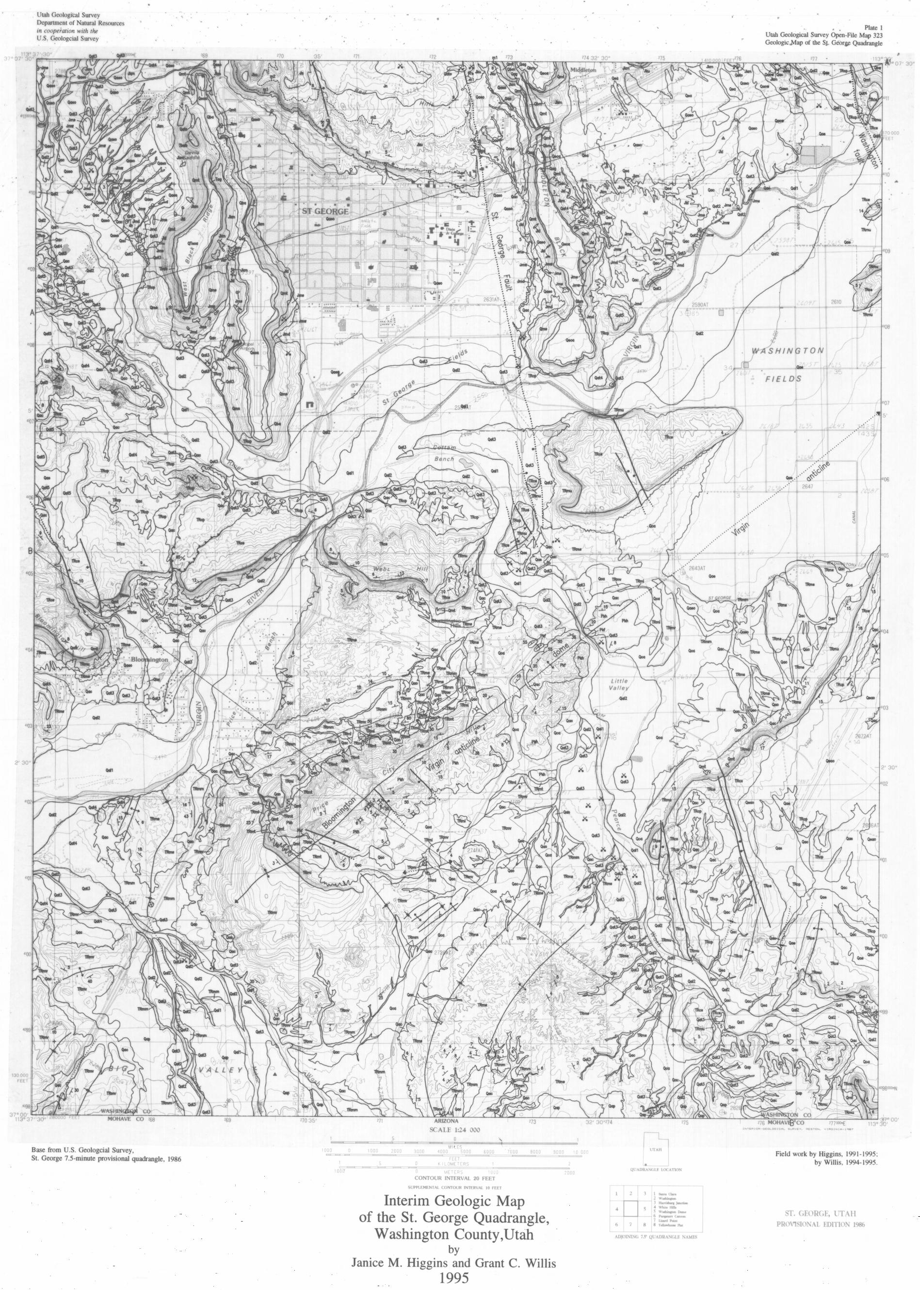


![[PPT]Cost and Supply of Geothermal Power - Utahfiles.geology.utah.gov/emp/geothermal/ugwg/workshop0805/... · Web viewTitle Cost and Supply of Geothermal Power Author Susan Petty](https://static.fdocuments.in/doc/165x107/5ae9830b7f8b9ad73f8bed71/pptcost-and-supply-of-geothermal-power-viewtitle-cost-and-supply-of-geothermal.jpg)


