Intergovernmental Oceanographic Commission Training Course ... · Intergovernmental Oceanographic...
13
Intergovernmental Oceanographic Commission Training Course Reports 41 IOC-Germany Advanced Training Course on Bathymetric Charting in the Western Indian Ocean On board RX METEOR between Durban and Cape Town, South Africa 15-29 December 1995 UNESCO .-
Transcript of Intergovernmental Oceanographic Commission Training Course ... · Intergovernmental Oceanographic...
Intergovernmental Oceanographic Commission Training Course Reports 41
IOC-Germany Advanced Training Course on Bathymetric Charting in the Western Indian Ocean
On board RX METEOR between Durban and Cape Town, South Africa 15-29 December 1995
UNESCO
.-

IOC Training Course Report No. 41
TABLE OF CONTENTS
SUMMARY REI’ORT Page
1.
2.
3.
4.
5.
6.
7.
8.
9.
10.
11.
12.
INTRODUCTION
BACKGROUND
OBJECTIVES
PARTICIPATION
COURSE LEVEL
COURSE OUTLINE
PRE-COURSE ACTIVITIES
COURSE PROGRAMME AND TIME FRAME
8.1 ARRIVAL OF PARTICIPANTS 8.2 OPENING CEREMONY 8.3 LECTURES AND DEMONSTRATIONS 8.4 CLOSING CEREMONY
FINANCIAL ASSISTANCE
CONCLUSION
RECOMMENDATIONS
ACKNOWLEDGEMENTS
ANNEXES
2
2
2
2
4
4
I. Work Programme and Timetable II. List of Participants III. Opening Address IV. Press Release
IOC Training Course Report No. 41
1. INTRODUCTION
The IOC-Germany Advanced Training Course on Bathymetric Charting in the Western Indian Ocean took place in Durban, South Africa, and on board R.V. METEOR during cruise M33/3 from Durban to Cape Town, from 15 to 29 December 1995. It was a follow-up of a similar, more basic course held in Madagascar and on board R.V. METEOR in 1987.
The Course profited from the fact that in 1995 R.V. METEOR spent several months in the Indian Ocean to do research for the World Ocean Circulation Experiment (WOCE) and the Joint Global Ocean Flux Study (JGOFS).
The Course was a contribution of the Government of the Federal Republic of Germany to the Training, Education and Mutual Assistance in the Marine Sciences (TEMA) Programme of the Intergovernmental Oceanographic Commission (IOC) of UNESCO.
The Course was jointly co-ordinated by Dr. Gtinter Giermann, Secretary of the German National IOC Committee, on behalf of the German Government (BMBF) and Dr. Dmitri Travin on behalf of IOC, with the assistance of the scientific Course Leader Dr. Werner Bettac, former member of the German Hydro- graphic Institute in Hamburg. While in Durban, technical assistance was provided by UEC/ADS (a counterpart of Atlas Elektronik, Bremen) and the local representative of Reederei Forschungsgemeinschaft (ship’s agent).
The Course included lectures and demonstrations of instruments on board the vessel.
2. BACKGROUND
Bathymetric charts are a prerequisite for the economic, scientific and technical development of a coastal state. For the region of the Western Indian Ocean appropriate charts are not available. But it is only with their help that an effective exploration and exploitation of a 200 mile Exclusive Economic Zone (EEZ) can take place as required by the new UN Law of the Sea. Therefore the coastal zone, shelf, slope and the adjacent deep-sea bed require comprehensive bathymetric surveys resulting in detailed charts complemented by overlay sheets of different parameters.
As the Indian Ocean sheets of the General Bathymetric Chart of the Oceans (GEBCO) are at a scale of l,OOO,OOO and thus are too small, IOC decided to establish the International Bathymetric Chart of the Western Indian Ocean (IBCWIO) at a scale of l,OOO,OOO, under German leadership with Dr. Werner Bettac as Chief Editor.
The edition of IBCWIO which has not yet been finalized, presents a good example of useful aid to developing countries of a region. Countries were invited to join the charting exercise and to assist, if possible, in the provision of data, in the interpretation of basic sounding material and in the construction of depth contour lines.
Except in South Africa and Mozambique, no hydrographic services exist, therefore the participation in IBCWIO is a new challenge which can lead to the establishment of new structures in some of the countries. It also raises awareness among politicians and managers.
The first training course on bathymetric charting was held from 10 June to 2 July 1987 in Nosy Be Madagascar, and on board R.V. METEOR, and was more basic in its approach. Sixteen trainees from twelve countries participated. Germany financed the course through a voluntary contribution by the Government (BMBF) to the IOC Trust Fund.
In September 1991, Dr. Werner Bettac conducted some training activities in Mauritius, Kenya and Tanzania, of one week duration each, on the subject of “Evaluating plotted depths for the IBCWIO”. This was financed partly by the German Government (BMBF), and partly by IOC.
IOC Training Course Report No. 41 page 2
3. OBJECTIVES
The main objective of the Course was to respond to the urgent needs of the IOC Member States of the Western Indian Ocean region to learn more about bathymetry and morphology and related geological and biological parameters of their coastal zone and adjacent shelf, slope and deep-sea regions, and to get a proper basis for the understanding and protection of the marine environment, and the exploration of nearshore living and non-living resources. The goal of the Course was to get trainees acquainted with modern methods and devices of positioning and sounding, and to show them ways on how to use the newly gained knowledge in their home countries, and how to apply for international aid.
4. PARTICIPATION
The trainees were selected by the representatives of the IOC Secretariat and the Secretariat of the German National IOC Committee with the advice of the scientific course leader.
Thirteen trainees were chosen of whom ten finally participated. They came from Angola, India, Kenya, Mauritius, Mozambique, Pakistan, Seychelles, South Africa and Tanzania(2). Two of them, from Mauritius and Tanzania, had also participated in the first bathymetric course in 1987.
Three German instructors were hydrographers and joined the cruise fulltime, a fourth instructor from a consulting firm only participated in the introductory lectures in Durban (Annex 11).
5. COURSE LEVEL
The Course was essentially based on the 1987 Course, but introduced a much higher level. The Global Positioning System (GPS), Electronic Chart Display and Information Systems (ECDIS), modern sounding devices such as Hydrosweep and Parasound and others were presented. The trainees received detailed written information on all items.
6. COURSE OUTLINE
The Course consisted of two main elements: (i) lecture seminars, and (ii) demonstrations of most modern technologies. Manuscripts of the lectures were made available. For practical work, a canyon was charted.
7. PRE-COURSE ACTIVITIES
Representatives of the IOC Secretariat, the German National IOC Committee and the scientific course leader met on several occasions to select the candidates and to discuss the details of the course programme, and its related logistics. A close contact was maintained with the R.V. METEOR control center in Hamburg.
8. COURSE PROGRAMME AND TIME FRAME
8.1 ARRIVAL OF PARTICIPANTS
The participants were received at Durban airport by a representative of UEC/ADS, and were brought to the hotel. All instructors and trainees stayed in the same hotel to make communications easier.
On the evening of the day of arrival (14 December), a small reception was given by Dr. Giermann, during which participants were introduced to each other, and were informed about the forthcoming programme and timetable.
IOC Training Course Report No. 41 page 3
8.2 OPENING CEREMONY
The Course was officially opened by Dr. Giinter Giermann on board R.V. METEOR on the morning of 17 December 1995. Approximately thirty people were invited to a buffet-reception, among them the German Ambassador Dr. Kaestner, two German Consuls-General from Durban and Cape Town, local authorities and representatives of local universities. The Minister for Art, Culture, Science and Technology, Dr. B. S. Ngubane, regretted that he was unable to attend. The opening statement of Dr.Gilnter Giermann is attached as Annex III. The Captain of the vessel, Martin Kull, his chief officers, the chief scientist of cruise M33/3, Prof. Dr. B. W. Flemming, as well as all instructors and trainees also participated in the reception. The press was also present (Annex IV).
8.3 LECTURES AND DEMONSTRATIONS
Friday, 15 December, was devoted to introductory lectures at the premises of UEC/ADS, in Durban. Mr. Jorg Dux from Hamburg Port Consulting spoke about maintenance of navigable waters and management of ports. As a case study he presented the establishment of a Hydrographic Office in Sri Lanka, and informed about possibilities of receiving international funds from donor agencies and international organizations.
Between Monday, 18 December, and Friday, 29 December, a series of lectures and demonstrations were given on board R.V. METEOR by Dr. Bettac, Mr. Hecht and Dr. Egge, as follows:
After an introduction into classical cartography - a method which is still used for nearly all nautical charts - a detailed description was given of Electronic Chart Display and Information Systems (ECDIS). The state-of-the-art of this new method was presented and future developments indicated, not only in technical, but also administrative respect. It was shown that the new bathymetric charts can serve as a basis for overlay sheets with geological, geophysical or biological parameters (including pollution and resources). Other lectures referred to the Global Positioning System (GPS) which is using satellites, and which more and more becomes the main world-wide positioning device.
Furthermore, the different sounding techniques such as swath sounding and sub-bottom profiling were described and their high precision was emphazised. They included the two systems installed on board, Hydrosweep and Parasound. Both were demonstrated in action while mapping a canyon. The availability of international funds, and the ways and means to get them to build up infrastructure, were discussed at length (Annex I).
8.4. CLOSING CEREMONY
The successful conclusion of the Course was celebrated in the mess of the vessel on the evening of 28 December. The trainees were presented with a certificate.
9. FINANCIAL ASSISTANCE
The Course was financed by the German Government through its Federal Ministry of Education, Science, Research and Technology (BMBF) in Bonn. The German Research Society (DFG) in Bonn offered accomodation on board free of charge.
10. CONCLUSION
The Course was equally a success for the Federal Republic of Germany and the Intergovernmental Oceanographic Commission, who showed great interest in assisting developing countries in the fields of marine science and technology. The trainees paid great attention to the topics presented to them and asked many questions during the lectures. Lively discussions followed the demonstrations and the charting exercise (canyon). This was largely due to the excellent leadership by the instructors. The trainees expressed the wish to see follow-up courses offered. They also wished to stay in contact with the
IOC Training Course Report No. 41 we 4
instructors, as well as among themselves. They invited the instructors to continue to give them advice once they have returned to their countries.
11. RECOMMENDATIONS
The instructors were impressed by the great interest shown by the trainees in bathymetric charting, and recommended that advanced training courses should be held in the future, probably every two years, so that scientists and technicians involved in bathymetry in the countries of the region could regularly update their knowledge and gain experience. This would allow them to propose proper infrastructures and long-term programmes to their respective countries, and would enable them to join regional IOC activities in the field of charting with more competence.
12. ACKNOWLEDGEMENTS
The German project leader and the Executive Secretary IOC expressed their gratitude to all individuals and institutions who assisted in making this Course a successful one. They thanked the German Government for making the course possible through a generous financial contribution to the IOC TEMA Programme. They thanked the Government of South Africa for hosting the first days of the Course in Durban. They also thanked the DFG for putting the R.V. METEOR at the disposal of the Course.
IOC Training Course Report No. 41 Annex I
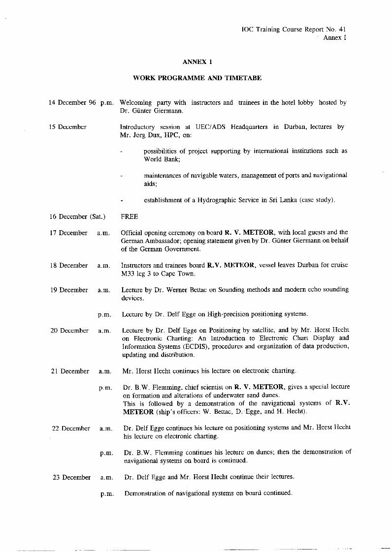
ANNEX1
WORK PROGRAMME AND TIMETABE
14 December 96 p.m. Welcoming party with instructors and trainees in the hotel lobby hosted by Dr. Gtinter Giermamr.
15 December Introductory session at UEC/ADS Headquarters in Durban, lectures by Mr. Jorg Dux, HPC, on:
possibilities of project supporting by international institutions such as World Bank;
maintenances of navigable waters, management of ports and navigational aids;
establishment of a Hydrographic Service in Sri Lanka (case study)
16 December (Sat.) FREE
17 December a.m. Official opening ceremony on board R. V. METEOR, with local guests and the German Ambassador; opening statement given by Dr. Gtinter Giermamr on behalf of the German Government.
18 December a.m. Instructors and trainees board R.V. METEOR, vessel leaves Durban for cruise M33 leg 3 to Cape Town.
19 December a.m. Lecture by Dr. Werner Bettac on Sounding methods and modern echo sounding devices.
p.m. Lecture by Dr. Delf Egge on High-precision positioning systems.
20 December a.m. Lecture by Dr. Delf Egge on Positioning by satellite, and by Mr. Horst Hecht on Electronic Charting: An Introduction to Electronic Chart Display and Information Systems (ECDIS), procedures and organization of data production, updating and distribution.
21 December a.m. Mr. Horst Hecht continues his lecture on electronic charting.
p.m. Dr. B.W. Flemming, chief scientist on R. V. METEOR, gives a special lecture on formation and alterations of underwater sand dunes. This is followed by a demonstration of the navigational systems of R.V. METEOR (ship’s officers: W. Bettac, D. Egge, and H. Hecht).
22 December a.m. Dr. Delf Egge continues his lecture on positioning systems and Mr. Horst Hecht his lecture on electronic charting.
p.m. Dr. B.W. Flemming continues his lecture on dunes; then the demonstration of navigational systems on board is continued.
23 December a.m. Dr. Delf Egge and Mr. Horst Hecht continue their lectures.
p.m. Demonstration of navigational systems on board continued.
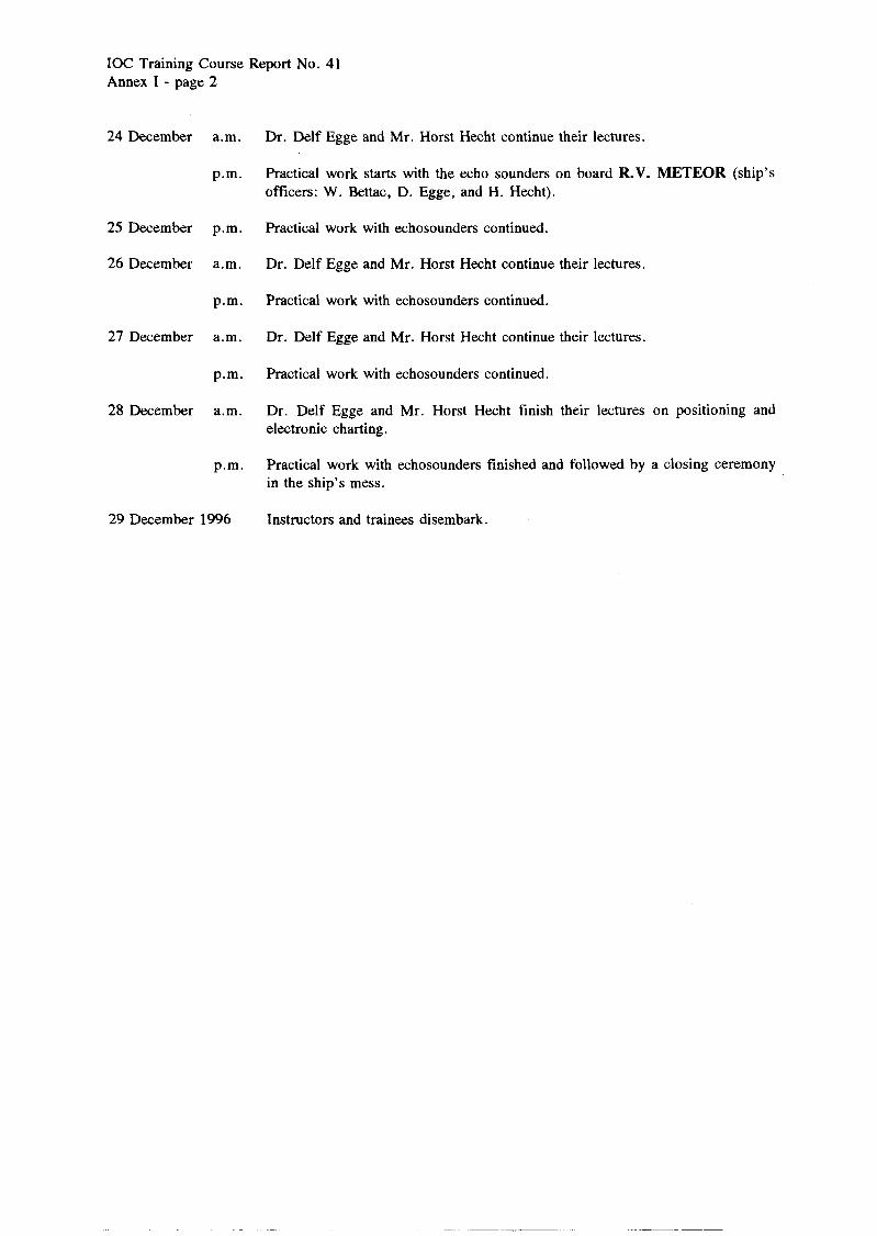
IOC Training Course Report No. 41 Annex I - page 2
24 December a.m.
p.m.
25 December p.m.
26 December a.m.
p.m.
27 December a.m.
p.m.
28 December a.m.
p.m.
29 December 1996
Dr. Delf Egge and Mr. Horst Hecht continue their lectures.
Practical work starts with the echo sounders on board R.V. METEOR (ship’s officers: W. Bettac, D. Egge, and H. Hecht) .
Practical work with echosounders continued.
Dr. Delf Egge and Mr. Horst Hecht continue their lectures.
Practical work with echosounders continued.
Dr. Delf Egge and Mr. Horst Hecht continue their lectures.
Practical work with echosounders continued.
Dr. Delf Egge and Mr. Horst Hecht finish their lectures on positioning and electronic charting.
Practical work with echosounders finished and followed by a closing ceremony in the ship’s mess.
Instructors and trainees disembark.
IOC Training Course Report No. 41 AMeX II
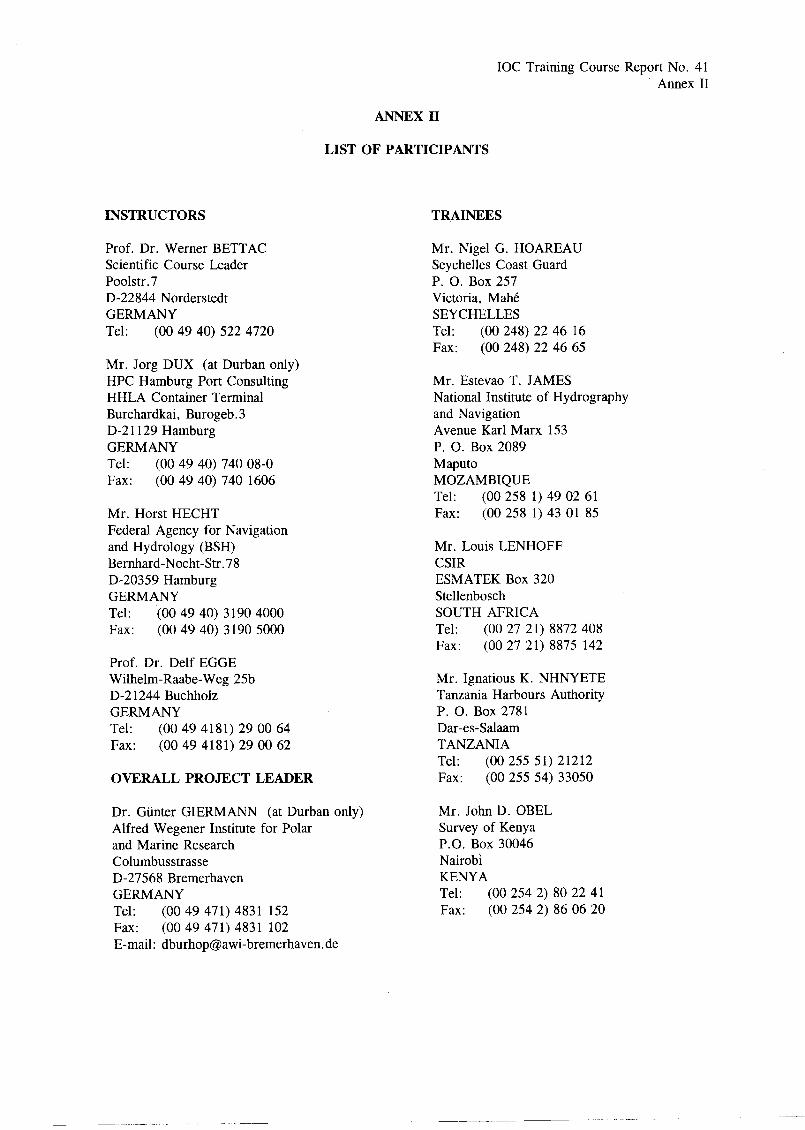
ANNEX II
LIST OF PARTICIPANTS
INSTRUCTORS
Prof. Dr. Werner BETTAC Scientific Course Leader Poolstr. 7 D-22844 Norderstedt GERMANY Tel: (00 49 40) 522 4720
Mr. Jorg DUX (at Durban only) HPC Hamburg Port Consulting HHLA Container Terminal Burchardkai, Burogeb. 3 D-2 1129 Hamburg GERMANY Tel: (00 49 40) 740 08-O Fax: (00 49 40) 740 1606
Mr. Horst HECHT Federal Agency for Navigation and Hydrology (BSH) Bernhard-Nocht-Str. 78 D-20359 Hamburg GERMANY Tel: ‘(00 49 40) 3 190 4000 Fax: (00 49 40) 3 190 5000
Prof. Dr. Delf EGGE Wilhelm-Raabe-Weg 25b D-2 1244 Buchholz GERMANY Tel: (00 49 4181) 29 00 64 Fax: (00 49 4181) 29 00 62
OVERALL PROJECT LEADER
Dr. Gtinter GIERMANN (at Durban only) Alfred Wegener Institute for Polar and Marine Research Columbusstrasse D-27568 Bremerhaven GERMANY Tel: (00 49 471) 4831 152 Fax: (00 49 471) 4831 102 E-mail: dburhopaawi-bremerhaven.de
TRAINEES
Mr. Nigel G. HOAREAU Seychelles Coast Guard P. 0. Box 257 Victoria, MahC SEYCHELLES Tel: (00 248) 22 46 16 Fax: (00 248) 22 46 65
Mr. Estevao T. JAMES National Institute of Hydrography and Navigation Avenue Karl Marx 153 P. 0. Box 2089 Maputo MOZAMBIQUE Tel: (00 258 1) 49 02 61 Fax: (00 258 1) 43 01 85
Mr. Louis LENHOFF CSIR ESMATEK Box 320 Stellenbosch SOUTH AFRICA Tel: (00 27 21) 8872 408 Fax: (00 27 21) 8875 142
Mr. Ignatious K. NHNYETE Tanzania Harbours Authority P. 0. Box 2781 Dar-es-Salaam TANZANIA Tel: (00 255 51) 21212 Fax: (00 255 54) 33050
Mr. John D. OBEL Survey of Kenya P.O. Box 30046 Nairobi KENYA Tel: (00 254 2) 80 22 41 Fax: (00 254 2) 86 06 20
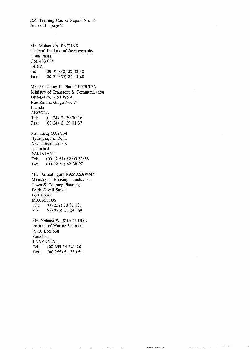
IOC Training Course Report No. 41 Annex II - page 2
Mr. Mohan Ch. PATHAK National Institute of Oceanography Dona Paula Goa 403 004 INDIA Tel: (00 91 832) 22 33 40 Fax: (00 91 832) 22 13 60
Mr. Salustiano F. Pinto FERREIRA Ministry of Transport & Communication DNMMP/CI-IN1 ISNA Rue Rainha Ginga No. 74 Luanda ANGOLA Tel: (00 244 2) 39 30 16 Fax: (00 244 2) 39 01 37
Mr. Tariq QAYUM Hydrographic Dept. Naval Headquarters Islamabad PAKISTAN Tel: (00 92 51) 82 00 32/56 Fax: (00 92 51) 82 88 97
Mr. Darmalingum RAMASAWMY Ministry of Housing, Lands and Town & Country Planning Edith Cave11 Street Port Louis MAURITIUS Tel: (00 239) 20 82 831 Fax: (00 230) 21 29 369
Mr. Yohana W. SHAGHUDE Institute of Marine Sciences P. 0. Box 668 Zanzibar TANZANIA Tel: (00 255 54 321 28 Fax: (00 255) 54 330 50
IOC Training Course Report No. 41 Annex III
ANNEX III
OPENING ADDRESS by Dr. Gtinter Giermann
Secretary of the German National IOC Committee
Ladies and Gentlemen,
I have the pleasure and the honour to welcome you on behalf of the German Government and the Intergovernmental Oceanographic Commission of UNESCO who jointly organized this training course for the countries of the Western and Central Indian Ocean possible. Bathymetric charting is a subject of high interest, particularly for developing countries, since the United Nations Conference on Environment and Development (held in Rio de Janeiro, 1992) and the United Nations Convention on the Law of the Sea (in force since 1994) have opened the 200 mile economic zone for profound research and management of their resources.
The training course is one in a series which Germany, together with the IOC, started decades ago. Already in 1987, one course was held on bathymetry. In previous years, courses held in Manila, Kuala Lumpur, and Karachi concentrated on coastal and nearshore geological phenomena, a field which, without proper charting, cannot be developed. The series will come to an end in 1996 with a course to be held in Bandung, Indonesia, on sea-level changes and the evolution of coastal environments.
I am glad to say that this course is under the competent leadership of Dr. Werner Bettac, a former member of the German Hydrographic Institute. He is assisted on board by two instructors. Twelve trainees from ten countries will participate namely from Angola, South Africa, Mozambique, Tanzania, Kenya, Mauritius, the Seychelles, Pakistan, India and the Maldives.
The Course will end in Cape Town on 29 December 1995. I wish everybody a good cruise and the Captain always four inches of water under the keel.
IOC Training Course Report No. 41 Annex IV
ANNEX IV
PRESS RELEASE
On Sunday, 17 December 1995, at 10.00 a.m. a reception was given on board the German research vessel METEOR officially opening a training course on bathymetric charting which is sponsored by the German Government and the Intergovernmental Oceanographic Commission of UNESCO. Twelve trainees from the following countries: Angola, South Africa, Mozambique, Tanzania, Kenya, Mauritius, the Seychelles, Pakistan, India and the Maldives, as well as three instructors from Germany will participate.
The training course is taking up a subject of the highest interest, in particular, to developing countries, since the United Nations Conference on Environment and Development (held in Rio de Janeiro, 1992) and the United Nations Convention on the Law of the Sea (in force since 1994) have opened the 200 mile economic zone for profound research and management of its resources. It is accompanied by courses on coastal and nearshore geological phenomena including minerals in the Indian and Pacific Oceans, and the construction of an overall bathymetric chart of the Western Indian Ocean, under the auspices of IOC and with the financial assistance of Germany.
The opening ceremony was hosted by the Captain of R.V. METEOR, Martin Kull, the Chief Scientist on board, Dr. B. W. Flemming and the representative of the German Government and IOC, Dr. Giinter K. F. Giermann, who is also the course project leader. The session was attended by the German instructors under the leadership of Dr. Werner Bettac, and the twelve trainees. The following guests were invited: the Minister for Art, Culture, Science and Technology, H. E. Dr. B. S. Ngubane, the German Ambassador, H. E. Dr. Kaestner, Capt. B. H. Teuteberg of the Hydrographic Office of the South African Navy, Mr. G. de Villiers of the Department of Environmental Affairs representing the South African IOC Committee, Mr. Sipho Ngwnya of the Metropolitan Transitional Council, Mr. Johannes Mile of the Central Substructure Council and Capt. M. Cooper, Durban Port Captain. Representatives of Hamburg Port Consulting, Atlas Elektronik Bremen and its Durban counterpart ADS/UEC, the shipping agency Combine Ocean SA and representatives of the press were also inited..
The course will end in Cape Town on 29 December 1995.
By fax to the Natal Mercury and the Daily News