
Intelligent GIS for Spatial Cooperation of Earthquake Emergency Response
6
Intelligent GIS for Spatial Cooperation of Earthquake Emergency Response Reza NOURJOU* and Michinori HATAYMA * PhD Candidate, Graduate School of Informatics, Kyoto University, Japan Synopsis Search and rescue teams are the key field teams in earthquake emergency response. They have to work together and make decisions in order to achieve a high performance. The key challenge which they have is the spatial cooperation problem; therefore they have to determine what team must do what, where, and when. This paper tried to propose an intelligent GIS for solving the cooperation problem in the spatial environment. The spatial cooperation problem can be solved by the method of distributed task allocation and multi-agent systems. In this article we discuss the cooperation problem, its solution, and structure of IGIS. Keywords: GIS, multi-agent systems, task allocation, search and rescue 1. Introduction Relief and rescue (RAR) operations are the key emergency support functions (FEMA, 2008) defined for earthquake emergency response. RAR operations contain five main tasks: 1- loss assessment and data collection; 2- searching and locating victims trapped in collapsed structures; 3- rescuing and extrication; 4- initial life-saving assistances; 5- emergency medical transportation (Provisions of Tehran city council, 2003). Fig.1 shows the structure of RAR operations. Fig. 1 Structure of relief and rescue operations The cooperation problem is the key challenge that field human teams face in disaster affected areas. The objective of tactical decisions is to determine what team must do what task, where, and when in order to increase the efficiency of the organization. Cooperation among teams and coordination of emergency response is a difficult problem (Chen et al., 2008). The main question of this research is that how I can achieve an efficient approach for the spatial cooperation problem (SpCP) by making decision for filed human teams in a spatial and dynamic environment. 1.1 Background Development of emergency response systems is based on the two major approaches: the centralized approach and the distributed or decentralized approach. Multi-agent systems form the second one (Sycara, 1998). Because of characteristics of emergency response, a number of disaster management systems (Fiedrich et al., 2007) have been developed based on multi-agent systems. Techniques and methods of cooperation in multi-agent systems are classified in the categories: (1) task allocation, (2) coalition formation, (3) 京都大学防災研究所年報 第 54 号 B 平成 23 年 6 月 Annuals of Disas. Prev. Res. Inst., Kyoto Univ., No. 54 B, 2011 ― 29 ―
-
Upload
reza-nourjou -
Category
Software
-
view
22 -
download
2
Transcript of Intelligent GIS for Spatial Cooperation of Earthquake Emergency Response

Intelligent GIS for Spatial Cooperation of Earthquake Emergency Response
Reza NOURJOU* and Michinori HATAYMA
* PhD Candidate, Graduate School of Informatics, Kyoto University, Japan
Synopsis
Search and rescue teams are the key field teams in earthquake emergency
response. They have to work together and make decisions in order to achieve a high
performance. The key challenge which they have is the spatial cooperation problem;
therefore they have to determine what team must do what, where, and when. This
paper tried to propose an intelligent GIS for solving the cooperation problem in the
spatial environment. The spatial cooperation problem can be solved by the method of
distributed task allocation and multi-agent systems. In this article we discuss the
cooperation problem, its solution, and structure of IGIS.
Keywords: GIS, multi-agent systems, task allocation, search and rescue
1. Introduction
Relief and rescue (RAR) operations are the key
emergency support functions (FEMA, 2008)
defined for earthquake emergency response. RAR
operations contain five main tasks: 1- loss
assessment and data collection; 2- searching and
locating victims trapped in collapsed structures; 3-
rescuing and extrication; 4- initial life-saving
assistances; 5- emergency medical transportation
(Provisions of Tehran city council, 2003). Fig.1
shows the structure of RAR operations.
Fig. 1 Structure of relief and rescue operations
The cooperation problem is the key challenge
that field human teams face in disaster affected
areas. The objective of tactical decisions is to
determine what team must do what task, where, and
when in order to increase the efficiency of the
organization.
Cooperation among teams and coordination of
emergency response is a difficult problem (Chen
et al., 2008). The main question of this research is
that how I can achieve an efficient approach for the
spatial cooperation problem (SpCP) by making
decision for filed human teams in a spatial and
dynamic environment.
1.1 Background
Development of emergency response systems is
based on the two major approaches: the centralized
approach and the distributed or decentralized
approach. Multi-agent systems form the second one
(Sycara, 1998).
Because of characteristics of emergency
response, a number of disaster management systems
(Fiedrich et al., 2007) have been developed based
on multi-agent systems.
Techniques and methods of cooperation in
multi-agent systems are classified in the categories:
(1) task allocation, (2) coalition formation, (3)
京都大学防災研究所年報 第 54 号 B 平成 23 年 6 月
Annuals of Disas. Prev. Res. Inst., Kyoto Univ., No. 54 B, 2011
― 29 ―

multi-agent planning, (4) communication and data
sharing, and (5) negotiation.
Technique of task allocation among agents is a
method for distributed problem solving.
Distribution of tasks between teams answers “who
must do what?”. Task distribution modes are
classified into two main categories: centralized
allocation and distributed allocation.
An important coordination technique of task
allocation is the contract net protocol (Smith, 1980).
It consists of: (1) problem recognition, (2) tasks
announcement, (3) bidding, and (4) awarding.
In (Nwana et al. 1996), five reasons that
necessitate coordination in multi-agent systems are
stated: (1) preventing anarchy or chaos, (2)
efficiency, (3) meeting global constraints, (4)
distributed information, expertise or resources, and
(5) dependencies between the agents’ actions. In
(Malone et al., 1994), coordination is defined as the
act of managing interdependencies between
activities.
In the recent decade, there have increasing
importance on the role of geographic information
systems (GIS) (Aronoff , 1991), in emergency
management systems (Vafaeinezhad et al., 2009;
Sahana Software Foundation).
1.2 Research objectives
The purpose of the current paper is to propose
an intelligent GIS (IGIS) that human agents use to
make decisions for the cooperation problem in a
spatial environment in order to increase global
efficiency of the organization.
In the real situation, the IGIS is a tablet
computer that includes a spatial distributed
intelligent agent (SDIAgent), GIS, GPS, and
wireless communication. The human agent, who is
coordinator of the filed unit or team, is equipped
with an IGIS to plan emergency operations. The
role of SDIAgent (software agent) is to
communicate with other SDIAgents for cooperation.
The IGIS is an efficient approach that enables
humans collaborates with SDIAgents in order to
overcome challenges regarding the SpCP in a
spatio-temporal environment.
2. Methodology
Defining the SpCP was the most important step
in this research. Fig. 2 shows the organizational
structure of emergency management. As fig.3
shows, RAR teams, RAR tasks, city damaged
buildings, and time constitute components of
tactical plans.
Fig.2 Organizational structure of emergency
operations center
Tactical Decisions(what, who, where)
City Damaged Building
Relief &Rescue Tasks
Field Relief & Rescue Teams
Fig. 3 Structure of a tactical plan
To model the structure of SpCP, I defined the
relationship among tasks and teams. Fig. 4 shows a
simplified structure of SpCP.
One Damage Building
Rescue Task
Rescue Team Rescue Team
or
Search Taskenable
Sum-all
Search Team
or
Search Team
Fig. 4 Structure of SpCP for SAR operations
Search and rescue (SAR) can communicate
directly in an organizational structure. Each
damaged building can have only one search task
and one rescue task. City damaged buildings and
SAR teams disperse in geographical region so they
have geo-referenced locations. Filed teams move
― 30 ―
from one location to another one through street
networks to reach a damage building. One research
team has the capability of doing search tasks and
rescue tasks can be carried out by rescue teams. I
defined an operational region for each team to
control its spatial behaviors. It means that every
team had to do only tasks which are located
geographically within its operational region.
Interdependencies that exist among activities
make emergency response more complex. For that
reason, I modeled the relationship “enable” and
“equality” in the simplified structure of the SpCP.
The relationship “enable” specifies that when an
action is carried out, it makes possibility of
performing another action. As the fig. 4 shows, this
relationship makes dependent a rescue task to a
search task. It implies that after a search team
completes the search task, a rescue team can start
doing the rescue task. The relationship “equality”
means that certain actions are not liked to a specific
team, and can be carried out by another team. Fig. 4
shows this relationship between a rescue task and
several rescue teams for the case of the damaged
building. After a search team finds some trapped
victims under debris, it announces a rescue request
to all rescue teams in order to assign this task to the
most proper one.
2.1 Structure of spatial cooperation problem
solving (SpCPS)
A decentralized approach based on multi-agent
systems was designed for solving the SpCP
discussed before. I selected the method of
distributed task allocation for the SpCP, and then I
tried to deploy it by the contract net protocol. As a
summary, I designed a decentralized approach
based on the contract net mechanism so that search
teams can allocate rescue tasks among rescue teams.
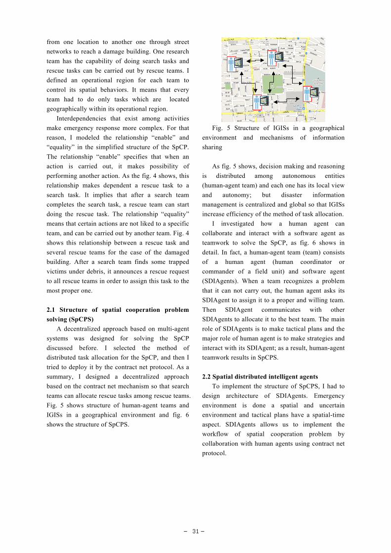
Fig. 5 shows structure of human-agent teams and
IGISs in a geographical environment and fig. 6
shows the structure of SpCPS.
Fig. 5 Structure of IGISs in a geographical
environment and mechanisms of information
sharing
As fig. 5 shows, decision making and reasoning
is distributed among autonomous entities
(human-agent team) and each one has its local view
and autonomy; but disaster information
management is centralized and global so that IGISs
increase efficiency of the method of task allocation.
I investigated how a human agent can
collaborate and interact with a software agent as
teamwork to solve the SpCP, as fig. 6 shows in
detail. In fact, a human-agent team (team) consists
of a human agent (human coordinator or
commander of a field unit) and software agent
(SDIAgents). When a team recognizes a problem
that it can not carry out, the human agent asks its
SDIAgent to assign it to a proper and willing team.
Then SDIAgent communicates with other
SDIAgents to allocate it to the best team. The main
role of SDIAgents is to make tactical plans and the
major role of human agent is to make strategies and
interact with its SDIAgent; as a result, human-agent
teamwork results in SpCPS.
2.2 Spatial distributed intelligent agents
To implement the structure of SpCPS, I had to
design architecture of SDIAgents. Emergency
environment is done a spatial and uncertain
environment and tactical plans have a spatial-time
aspect. SDIAgents allows us to implement the
workflow of spatial cooperation problem by
collaboration with human agents using contract net
protocol.
― 31 ―

They find and locate victims. In fact the team completed the search task of the damaged building.
The team recognizes a rescue task. Therefore , a rescue team is required to do this rescue task. The goal
of the team is to allocate this task to the best proper rescue team. Therefore the team wants to make decide
“who must do this task?”
the human agent (coordinator of team) who uses SDISA locates and selects the building on the GIS map.
The team wants to announce a rescue task. so the human agent inserts the “building ID” into the user
interface and clicks the button “Rescue Task Allocation”
SDIAgent receives a request for rescue announcement from its human agent. It makes a message and sends it
to all of the rescue teams.
SDIAgent waits for a moment to gather proposals (bids) sent by SDIAgents of rescue teams.
SDIAgent assesses the received proposals . It selects the best (minimum bid) one. Then it allocates the
announced rescue task to owner of proposal.
SIAgent sends a message to the SDIAgent of the chosen rescue team. This message informs that the
announced task was allocated to that team.
The SDIAgent updates related information and presents made final result (such as ID of the chosen
rescue team) of task allocation through the user interface for its human agent.
SDIAgent decides whether the team can make a proposal for the announced task. It uses a rule - based
decision -If I have proper capabilities to do the announced task?- if the task is located geographically in my operational region?- if I have proper internal states?
SDIAgent updates the internal state and color of itsshape changes to yellow on the map. SDIAgentcalculates a bid for the announced task. The followinginformation are critical for this calculation:-Travel time between its real time location and task location-Information of the task and its own information
SDIAgent sends its proposal to the initial SIAgent
SDIAgent waits for a moment, maybe it is awarded the task.
SDIAgent adds the new task to its local database, presents updated information to human agent, and updates local knowledge regarding new assigned task.
Now human agent updates information of the selected building in order to share data with other teams, .
SDIAgent shows the information of the selected building via the user interface.
The rescue team is located in the region
SDIAgent connects to global central database. It sends it a query request to get information of building
mentioned in the message .
Yes
members of the team (human agents) search damaged building by damaged building in order to find and
locate victims who are trapped under debris.
No
ICPDid I receiveany proposals?
A Search Team A Rescue Team
Yes
Is the message a task announcement?
SDIAgent of the team received a message
Yes
Can I participate?No
Yes
NoAny reward message ?
Now SDIAgent knows that the rescue task announced for mentioned building was allocated to its team. The team (human member of team) accepts this commitment to go location of the mentioned building and to do it
If (my_rescueLevel== Required_rescueLevel) dt= tCostIf (my_rescueLevel > Required_rescueLevel) dt=tCost/2bid=calculated_travelTime/my_speed + dt
No
Fig. 6 Workflow of allocating a rescue task by a
search team to the most proper rescue team using
the contract net mechanism in the SpCP of SAR
operations
Spatial distributed intelligent agents are
multi-agent systems which are embedded and
distributed in a geographical environment. They are
referenced to a location on the earth. Therefore,
spatial distribution is another characteristic of
multi-agent systems and geospatial information
plays a major role in their architecture for spatial
cooperation. I aimed that multi-agent systems can
get the advantage of GIS. Fig. 7 shows an initial
architecture of SDIAgents that I designed to support
the structure of SpCPS.
3. Geospatial Simulation of
Intelligent GIS
To evaluate the IGISs, I developed a geospatial
simulation. Castle et al. (2006) outlined the
fundamental concepts of the agent-based modeling
paradigm, with particular reference to the
development of geospatial simulations.
Fig. 7 Initial architecture of spatial distributed
intelligent agents
To simulate the structure of SpCPS and to
implement the SDIAgents, I developed a geospatial
simulation using Anylogic simulation software,
Java programming, and ArcGIS desktop. To embed
the SDIAgents in a geographical environment, I
built a global Geodatabase (Zeiler, 2000) containing
city blocks, regions, operational areas, and damaged
buildings data. I selected the district 17 of Tehran
city as the case study region, because it was
assessed as the most vulnerable one (Mansouri et al.,
2010). Fig. 8 shows the geospatial simulation of
IGISs for task allocation in search and rescue
operations. This geospatial simulation allows us to
simulate the structure of SpCPS that was discussed
Fig. 8 Geospatial Simulation of Intelligent GIS
for distributed task allocation of earthquake SAR
teams
The human user of this simulation can select
any team on the map to play its role. As fig. 8
shows, the user decided to be the search team with
ID “122”. Its location is highlighted on the map.
― 32 ―
Furthermore, the user interface displays internal
information of the SDIAgent, so the human user
can update them. Imagine that the team recognizes
a rescue task for the damaged building with ID “53”.
then human agent wanted to identify it on the map
and update its information. He decided to allocate it
to the best rescue team, so he inserts the ID of the
mentioned building on the user interface and asks
its SDIAgent to allocate it. The SDIAgent receives
a request for a rescue task announcement, then it
communicates with other SDIAgents to allocate it
to the best team based on contract net mechanism.
The mentioned task was assigned to the rescue team
with ID “68”. If the user of simulation selects the
rescue team “68”, he will be informed by its
SDIAgent about a made tactical plan .As a result,
the key result was a tactical decision which
determined who should do what, where, and when.
Over time, teams can repeat this mechanism to
make others plans to complete all of RAR task in
the region.
As the geo-simulation shows, decision making
and planning is distributed among teams, indeed a
central planning system dose not exist for allocating
tasks between teams. To increase local view of
SDIAgents, a global spatial database manages
information of damaged buildings.
4. Conclusion
In this paper, I tried to model the structure of a
SpCP which search and rescue team have in
earthquake emergency response. I proposed a
distributed approach based on multi-agent systems
and GIS. I used the method of distributed task
allocation and designed a structure to solve the
problem based on the contract net mechanism. I
introduced the architecture of SDIAgents. I develop
a geospatial simulation to simulate IGISs for
SpCPS. I tried to achieve the objectives defined for
this paper and answer the key questions of this
research. I achieved an initial IGIS for spatial
cooperation in RAR operations.
To achieve a comprehensive SDISA, I should
focus on improvement of the architecture of
SDIAgents. Future woks include the methods of
spatial multi-agent planning
References
Aronoff, S. (1991): Geographic Information
Systems: A Management , Perspective. Wdl Pubns
Castle, C.J.E. and Crooks, A.T. (2006): Principles
and concepts of agent-based modelling for
developing geospatial simulations. Working paper.
CASA Working Papers (110). Centre for
Advanced Spatial Analysis (UCL), London, UK.
Chen, R., Sharman, R., Rao, H.R., Upadhyaya, S. J.
(2008): Coordination in emergency response
management. Communications of the ACM, vol.
51, pp. 66-73.
FEMA (2008): Overview: ESF and Support
Annexes Coordinating Federal Assistance in
Support of the National Response Framework.
Technical report, Federal Emergency Management
Agency,
http://www.fema.gov/pdf/emergency/nrf/nrf-overv
iew.pdf.
Fiedrich, F., Burghardt, P. (2007): agent-based
systems for disaster management.
Communications of the ACM, Volume 50 , Issue
3.
Malone T.W., Crowston, K. (1994): The
interdisciplinary study of coordination. ACM
Computing Surveys, Vol. 26, No. 1.
Mansouri, B., Ghafory-Ashtiany, M.,
Amini-Hosseini, K., Nourjou, R., Mousavi, M.:
Building Seismic Loss Model for Tehran.
Earthquake Spectra Journal, Vol. 26, Issue 1,
pp. 153--168 (2010).
Nwana, H.S., Lee, L.C., Jennings, N. (1996):
Co-ordination in software agent systems, BT
Technol J, 14, No 4, pp. 79--88.
Provisions of Tehran city council (2003): Provision
of Support of Tehran Disaster Management
System (in Persian). Technical report.
Sahana Software Foundation,
http://sahanafoundation.org
Smith, R.G. (1980): The contract net protocol:
high-level communication and control in a
distributed problem solver. IEEE Trans.
Comput., vol. 29 , pp.1104 -- 1113.
Sycara, K.P. (1998): Multiagent Systems. AI
Magazine, Volume 19, Number 2.
Vafaeinezhad, A.R., Asghar Alesheikh, A., Hamrah,
― 33 ―

M., Nourjou, R., Shad, R.: Using GIS to Develop
an Efficient Spatio-Temporal Task Allocation
Algorithm to Human Groups in an Entirely
Dynamic Environment Case Study: Earthquake
Rescue Teams. LNCS, Vol. 5592, pp. 66—78,
Springer (2009).
Zeiler, M. (2000): Modeling our world: the ESRI
guide to geodatabase design. ESRI Press.
地震緊急対応における空間的協力のためのインテリジェントGISの設計
Reza NOURJOU*・畑山満則
*京都大学情報学研究科
要 旨
捜索救助チームは,地震の緊急対応のキーとなる。彼らは高パフォーマンスを達成するために共同作業と意
思決定をしなければならない。彼らの重要な課題は,空間的な協力体制の問題であるため,彼らはチームがど
こで,いつ,何をしなければならないかを決定する必要がある。本稿では,空間的に相関が及ぶ環境下での協
力問題を解決するためのインテリジェントGISを提案する。空間的協力の問題は,分散タスクの割り当てやマ
ルチエージェントシステムにより解決することができる。ここでは,協力問題と,その解決策,およびIGIS
の構造についての議論を展開する。
キーワード: GIS, マルチエージェントシステム, タスク配分, 捜索救難システム
― 34 ―


![Toolkit – Digitalisation in Development Cooperation … · IKT IoT Big Data 3D MOOC GIS App [M-Pesa] 4.0 Toolkit – Digitalisation in Development Cooperation and International](https://static.fdocuments.in/doc/165x107/5bad077e09d3f29b4f8cd2a0/toolkit-digitalisation-in-development-cooperation-ikt-iot-big-data-3d-mooc.jpg)


![L05 Earthquake damage assessment.pptnceg.uop.edu.pk/bgworkshop08/lectureslides/Day9/L05...Microsoft PowerPoint - L05_Earthquake damage assessment.ppt [Compatibility Mode] Author GIS](https://static.fdocuments.in/doc/165x107/603960561a965b0da7056907/l05-earthquake-damage-microsoft-powerpoint-l05earthquake-damage-assessmentppt.jpg)

