Integrating BIM and GIS for large scale (building) asset management
16
Integrating BIM and GIS for large-scale facilities asset management: a critical review Zhang, X, Arayici, Y, Wu, S, Abbott, C and Aouad, GF Title Integrating BIM and GIS for large-scale facilities asset management: a critical review Authors Zhang, X, Arayici, Y, Wu, S, Abbott, C and Aouad, GF Type Conference or Workshop Item URL This version is available at: http://usir.salford.ac.uk/id/eprint/11418/ Published Date 2009 USIR is a digital collection of the research output of the University of Salford. Where copyright permits, full text material held in the repository is made freely available online and can be read, downloaded and copied for non-commercial private study or research purposes. Please check the manuscript for any further copyright restrictions. For more information, including our policy and submission procedure, please contact the Repository Team at: [email protected] .
Transcript of Integrating BIM and GIS for large scale (building) asset management

Integrating BIM and GIS for large-scalefacilities asset management: a critical
reviewZhang, X, Arayici, Y, Wu, S, Abbott, C and Aouad, GF
Title Integrating BIM and GIS for large-scale facilities asset management: a critical review
Authors Zhang, X, Arayici, Y, Wu, S, Abbott, C and Aouad, GF
Type Conference or Workshop Item
URL This version is available at: http://usir.salford.ac.uk/id/eprint/11418/
Published Date 2009
USIR is a digital collection of the research output of the University of Salford. Where copyright permits, full text material held in the repository is made freely available online and can be read, downloaded and copied for non-commercial private study or research purposes. Please check the manuscript for any further copyright restrictions.
For more information, including our policy and submission procedure, pleasecontact the Repository Team at: [email protected].

Paper for CC2009: first draft 30th March 2009 Page 1 of 15
C:\DOCUME~1\UIS816\LOCALS~1\TEMP\INTEGRATING_GIS_AND_BIM_FOR_LARGE_SCALE_ASSET_MANAGEMENT.DOCX.DOC
X Zhang March 2009
Integrating BIM and GIS for large scale (building) asset management: a critical review
X. Zhang, Y. Arayici, S. Wu, C. Abbott, G. Aouad
School of the Built Environment, University of Salford
1. Introduction Widely-dispersed assets such as buildings, equipment, roads and bridges present local governments as well as big organizations with a number of asset management challenges. Recently financial sustainability and competitiveness have put more pressures on owner/managers to minimize asset total cost of ownership and streamline their asset management operations. In general asset management operation is the systematic process of maintaining, upgrading and operating physical assets. In this paper, our focus is on building assets as they often present some of the most complicated asset management problems (Eastman et al., 2008; more references). And building assets management is specified in this paper to include all the intricate tasks in all levels of the asset life-cycle, e.g. encompassing the development of new properties, maintaining and redeveloping existing estates and strategically disposing of individual buildings. Typically, the asset management tools in current use today deal with individual projects or facilities (Vanier and Danylo, 1998). The study undertook by the National Institute of Standards and Technology (NIST, United States) has reported that there are the huge annual cost ($15.8 billion in 2002) associated with inadequate interoperability among computer-aided design (CAD), engineering and software systems used in capital facilities management (NIST, 2002). Now large asset owners are becoming aware of the benefits of moving IT tools from specific applications towards more comprehensive solutions (Howard and Björk, 2008). The implementation of more integrated information technology (IT) could lead to better deployment of service and maintenance resources for work on the right asset at the correct location therefore reduces costly maintenance mistakes, and increases the quality of service. In particular, substantial benefits can be achieved through the implementation of Geographic Information System (GIS) that is integrated with an asset management system (Lemer 1998; Kyle et al., 2006). By spatially enabling the representation of the entire infrastructure in map-based views, and by utilizing tools to analyse spatial relationships, tremendous improvements in efficiency, cost containment, and better decision-making can be realized. Rundell (2006) suggested that owners and operators can mitigate their portion of the cost by using the high-quality building information from a Building Information Modelling (BIM) design process during the longer, more expensive maintenance and operation phase of the building's lifecycle. A good example is that BIM may allow asset managers to enter the decision-making process at a much earlier stage, where they can influence the design and construction (Azhar et al., 2008). However there is still lack of clear evidence on whether and how BIM could benefit the decision-making in building asset management.

Paper for CC2009: first draft 30th March 2009 Page 2 of 15
C:\DOCUME~1\UIS816\LOCALS~1\TEMP\INTEGRATING_GIS_AND_BIM_FOR_LARGE_SCALE_ASSET_MANAGEMENT.DOCX.DOC
X Zhang March 2009
This paper provides a review of the use of CAD, BIM and GIS in building asset management. Based on the analysis of four previous developments in this area, the main objective of the paper is to identify main benefits of GIS and BIM, if any exist, for asset management and to explore aspects where further research and development are needed. The paper firstly elaborates a set of key questions for asset management which are then mapped with the strengths of GIS and BIM tools. This is followed with a critical explanation of four case studies of large scale asset management. Based on the experience and lessons learnt from those case studies, the paper summarises the main benefits of the two technologies and argues the issues and challenges related to integrate the two. Finally the paper concludes with a brief vision and recommendation on further research and development on GIS and BIM implementation for asset management. 2. BIM and GIS: the similarity and difference
2.1 BIM BIM is a digital representation of physical and functional characteristics of a facility (NIBS, 2008). A BIM is a shared knowledge resource for information about a facility forming a reliable basis for decisions during its life-cycle; defined as existing from earliest conception to demolition. It is considered as one of the most promising developments in the AEC industry (Sheer and Smith, 2007; Eastman et al., 2008) and will become the facilitators of integration, interoperability and collaboration in the future of AEC industry (Davis, 2003; Cruz, 2008; Isikdag et al., 2008). As architects move more rapidly to BIM, the opportunities to leverage digital design data for downstream building asset and facilities management become more prevalent (Bernstein and Pittman, 2004). BIM in its present state is commonly used on complex projects such as high-rise buildings, bridges, arts centres, stadiums, and medical facilities. The term is most commonly applied for planning, design, construction, and management of buildings; however, its capabilities are being extended to challenging and complex civil engineering projects. 3D modelling is just one aspect of BIM that has hogged the limelight, but its real strength and power lies in the knowledge database, which can be used in conjunction with other software to deliver quick and reliable information in areas of sustainability, estimating, structural analysis, demolition and reconstruction (Sah and Cory, 2008).
2.2 GIS A GIS is defined as “an information system that is designed to work with data referenced by spatial or geographic coordinates” (Huxhold, 1991). Thus, a GIS is both a database system with specific capabilities for spatially referenced data, as well as a set of operations for working with the data. It has been adopted widely in support of planning, agriculture, infrastructure maintenance, and many other fields for its power to hand spatial data. Geo-spatial tools are increasingly being recognized as a smarter and better way of utilizing information technology for the re-engineering of asset management with government organizations, and for generating productivity and efficiency gains (Ward, 1997; Clarke et al., 1997; Barton et al., 2004). They allow property owners to visualize and analyze their

Paper for CC2009: first draft 30th March 2009 Page 3 of 15
C:\DOCUME~1\UIS816\LOCALS~1\TEMP\INTEGRATING_GIS_AND_BIM_FOR_LARGE_SCALE_ASSET_MANAGEMENT.DOCX.DOC
X Zhang March 2009
assets including acquisition, tracking, maintenance, and management of real property, capital equipment and supply chain (ESRI, 2008). They help businesses perform better asset management by answering questions like:
• Where are company’s assets located? • How can be best modelled ‘what if’ scenarios? • How can be planed routes for the facilities? • Where are the distributors and suppliers? • How can be maximized revenue potentials? What risk/security plans are needed?
2.3 Similarity and differences between the two Although the main functionality of both BIM and GIS is to create digital representation of the real world, they are different in many ways. They have developed as solutions to different problems in different domains: the former optimized for the modelling of new, but well defined objects; the latter for the re-construction of existing objects about which only sparse and incomplete information is available. In comparison, BIM are used in a relatively micro level of the real world e.g. buildings and handles mainly ‘indoor’ data. GIS on the other hand is used in a macro level of the real world e.g. terrain, river, land parcels and focuses on ‘outdoor’ data. Therefore, GIS uses geographic coordinates systems and world map projections while BIM coordinates are relative to the object being modelled and are not usually relative to any particular place on earth. Traditionally the information in a GIS is paired with two dimensional points, lines and polygons while in BIM the objects are linked to three dimensional solids and surfaces. Information about many factors that are related with building asset management has to be brought into consideration to support activities in the process. The factors are not only come from economic perspective but also social and environmental perspectives. The modelling of these complex systems go beyond the drawing part of the problem into the simulation, budgeting, environmental impact analysis and decision support. This makes a strong case for a tighter integration of GIS and BIM in a full three-dimensional environment (Lattuada and Raper, 2004). Zhang et al. (2009) recently reviewed the use of GIS and BIM in construction industry and revealed that there is technical push as well as industry pull for such integration. 3. Key Questions of Building Asset Management Buildings are intricate facilities with numerous systems intended to provide predefined functionality and responses to legislated and environmental demands; potentially accommodating several tenants with varying demands upon the building systems, fit-up and space usage requirements. Building systems and components have typical service life ranges, which rarely coincide with one another, yet these systems are expected to perform satisfactorily throughout the anticipated service life of the facility. These service life issues and the associated management tasks required are further compounded when handling a network of facilities. The building asset managers' technical challenges, especially in large scale, are indeed complex. They may have hundreds or even thousands assets at their disposal. They have the tremendous task of fulfilling client and tenant accommodation needs as well as striving to retain building function while meeting specific financial goals.

Paper for CC2009: first draft 30th March 2009 Page 4 of 15
C:\DOCUME~1\UIS816\LOCALS~1\TEMP\INTEGRATING_GIS_AND_BIM_FOR_LARGE_SCALE_ASSET_MANAGEMENT.DOCX.DOC
X Zhang March 2009
Vanier (2001) proposed six questions, the responses to which are keys to success in cost-efficient asset management. This section attempts to provide some elaboration on these queries. Details of how the tools address data and information requirements for these queries are given in the next section.
What do you own? One essential thing for asset managers to know is what buildings are in their portfolio and where are they. Normally they have an inventory of all the assets. For effective inventory management a clear categorization of the building usage, its location and significance (historic or otherwise), as well as design, construction, fit-up, operational and maintenance records are needed. The systems and functionalities of buildings must be adequately described to assist in matching the tenants' requirements to the capabilities of the building stock. The inventory has to be updated and maintained consistently in order to reflect the changes for example, new development, refurbishment and demolition. What is it worth? Once an organization identifies the extent of its assets, it is necessary to establish the assets’ value. There are different terms and methods to describe and assess a building’s value, for example, current replacement value is the cost of replacing an asset today; “performance in use” value is the prescribed value of the actual asset for the user (Vanier, 2001; Kyle, 2001). The efficacy of evaluation as a technique is dependent upon the informational intelligence captured by the organisation (Woodward, 1997). Even with the accoutre data, the calculation and recording of the cost information are neither simple nor straightforward. Typically, large organizations store the historical cost of assets and bring this cost forward to present value. However they do not have the “worth” of assets but only the cost (Vanier 2001). What is the postponed maintenance? Asset managers should have succinct records on the projects, repairs and maintenance actions that have been postponed, phased or neglected. Possessing accurate figures on the maintenance backlog provides a quick indication of problematic assets and provides a focus for expenditures. Deferred maintenance can become more significance down the road. The costs to affect a repair or maintenance activity can reasonably be expected to climb both as a result of accelerated rates of deterioration rates as well as heightened labour and material costs. De Sitter in his "Law of Fives" (De Sitter, 1984) concluded that if maintenance is deferred, then repairs equalling five times the maintenance costs may be expected. If, in turn, those repairs are postponed, the renewal expenses can reach five times the repair costs.
What is its condition? By evaluating the building's standing in comparison to others within the portfolio, the asset manager should get a firm idea of its current condition in relative terms to the entire portfolio. This information should provide the basis for projections of remaining building service life and assist in planning maintenance actions and re-investment decisions. Physical changes to the building conditions must be monitored in a continuous fashion. Data on the components and systems requiring intensive maintenance and repair activities can realistically be tracked by using information captured as part of the routine technical- administrative procedures of most organizations.
Paper for CC2009: first draft 30th March 2009 Page 5 of 15
C:\DOCUME~1\UIS816\LOCALS~1\TEMP\INTEGRATING_GIS_AND_BIM_FOR_LARGE_SCALE_ASSET_MANAGEMENT.DOCX.DOC
X Zhang March 2009
What is the remaining service life? After the extent of building asset portfolio is known, with its value and condition determined, the asset manager must establish the remaining service life to calculate the life-cycle costs (LCC) for alternative maintenance, repair, and renewal strategies. Without a clear idea of the remaining physical service that a particular component or system will provide, the asset manager is without an identifiable reference point for economic evaluations and can not properly assess the efficiency of proposed repair, restoration or recapitalization options. The sophistication of the predictions can vary from experienced based rules-of-thumb through to mathematically rigorous techniques employing statistical sampling and modelling procedures. As the complexity and significance of the system being evaluated increases, so to should the refinement of the applied predictive technique. What do you fix first? The planning process that places priorities upon maintenance and repair or reinvestment scenarios must weigh the importance of the building systems under consideration relative to the building in which they are installed. As well, these plans should value the significance of the various buildings and their roles within the portfolio. Plans must respond to political and policy driven requirements while maintaining building’s functionality, reliability and performance. Numerous alternatives are typically assessed, namely: ‘do nothing’, maintain, repair, renew or replace an asset. 4. Available Tools Toward Effective Asset Management A fully functional asset management system would support all aspects of the asset management process and provide decision makers with adequate and reliable data/information basis for making informed asset-deployment decisions (Lemer, 1998). There are various tools and methodologies exist to collect, manage, display and process the required data/information. This section focuses on BIM and geo-spatial information tools (especially GIS) to be used for effective asset management. These tools are categorized based on their functionality to assist with the collection, management, displaying and processing of the required data/information. Many of these tools respond to multiple questions amongst the "six whats" as described in Section 3 of this paper. 4.1 Data collection and management The implementation of the asset management process requires a significant amount of information and data that is accurate and up to date. Typically all design data, change orders, contract correspondence, maintenance records, repair data, and renewal information are required to give asset managers a complete picture of the extent of the existing portfolio (Kyle, 2001). This means that building asset managers should be using a complete, up-to-date, set of digital data reflecting the current state of their assets. Therefore data collection is basic to an asset management system and the capability to collect detailed data allows effective asset management (Woodward, 1997; Vanier, 2001). According to Vanier (2001), GIS, CAD together with relational database management systems could provide accurate pictures of the extent of an asset management portfolio. The use of computer aided design (CAD) data is close to common place in building construction

Paper for CC2009: first draft 30th March 2009 Page 6 of 15
C:\DOCUME~1\UIS816\LOCALS~1\TEMP\INTEGRATING_GIS_AND_BIM_FOR_LARGE_SCALE_ASSET_MANAGEMENT.DOCX.DOC
X Zhang March 2009
and operation industry. CAD systems can also provide sources of asset management information for the engineering, technical, and management staff (Sommerhoff, 1999). However there are a series of discontinuities in the transmission of building data that occur throughout the life-cycle of building process (NIST, 2004; Autodesk, 2008). For example, there are also considerable incompatible issues with data formats from CAD and CAD facilities management (CADFM) systems if they are also to be used for asset management (Vanier 1998). In this concern, BIM could be able to replace CAD not only to provide information needed and also to overcome the incompatible issues with data formats. Sustainable design and life cycle management of buildings need new type of information compared to traditional building process (Häkkinen, 2007). The availability of a single BIM makes it possible to capture information throughout design, procurement and construction of a building, serving as a living record of the building for operations and maintenance throughout its lifecycle (Howell and Batcheler, 2005; Campell, 2007). All of the non-graphic asset information contained in BIM models (manufacturer, serial number, model number, and so on) can be migrated into asset management system. This asset information is critical for maintenance management and related activities, such as the preventative maintenance work request. Dimensional information, such as areas and lengths, can also be extracted from BIM models which are useful in assess the value of the assets. The prospect of using BIM in building operation and maintenance increases as the adoption of BIM solutions within design and construction firms grows. As architects move more rapidly to BIM, the opportunities to leverage digital design data for downstream facilities/asset management become more prevalent. Owners and operators can mitigate their portion of the cost associated with the lack of interoperability cited above by using the high-quality building information from a BIM design process during the longer, more expensive maintenance and operation phase of the building's lifecycle. In GIS, the data about a particular asset are directly related to their physical location on a map of the city or region. For example, the location of a specific building can be viewed in the context of other buildings in a neighbourhood, its surface areas can be calculated, and distances to specific services can also be accurately calculated. Satellite imagery data can also be included in GIS systems to provide better visualisation. Accurate and comprehensive geo-spatial data play a critical role in all areas of environmental management and sustainable development (NRC, 2003). As building asset management face more and more challenges for sustainability, asset information system need to include substantial spatial data (Roper and Beard, 2006). Data collection is not one of the strengths of GIS. However its related geo-spatial information tools, e.g. GPS, airborne or satellite remote sensing, can be used for collecting this kind of data for example the physical location of a particular asset. Subsequently the data can be input into GIS and be used to map the asset in the context of other buildings in a neighbourhood, this gives geo-spatial information the role of an access mechanism (Goodchild, 1992). Based on geo-spatial data the building’s surface areas can be calculated, and its distances to specific services can also be accurately calculated. For a large scale building asset management, many buildings on the inventory could be constructed years ago, for which no accurate plans or other records are available. In this regard, some geo-spatial information tools could be used for collecting valuable information for asset management, for example, mobile GIS along with GPS, RFID could be used to speed up establishment and maintenance of the inventory; indoor location based service (LBS)

Paper for CC2009: first draft 30th March 2009 Page 7 of 15
C:\DOCUME~1\UIS816\LOCALS~1\TEMP\INTEGRATING_GIS_AND_BIM_FOR_LARGE_SCALE_ASSET_MANAGEMENT.DOCX.DOC
X Zhang March 2009
technologies could be used while route investigation to identify what kind of maintenance and at exactly where are need. GIS is useful in managing geo-spatial related data however the importance of this ability is reducing due to the main stream database software has include features to store and manage geo-spatial data, for example Oracle Spatial , PostGIS for PostgreSQL. 4.2 Data Analysis The planning process that places priorities upon maintenance and repair or reinvestment scenarios depends to some degree on the imagination and creativity of the people responsible for asset management, but it is influenced largely by the institutional and technological relationships within which assets operate. Managers need to constantly analyse data at hand in order to respond to questions like the ones listed in Section 3. As described earlier, BIM can be used as source of information for analysis of the solution as well as to store the results of analysis (Häkkinen, 2007). Detailed building data derived from BIM could be aggregated in use to assess a building’s value more precisely. For example, the space of offices could be added up to determining the whole building’s value for renting (Laasonen, 2001). The United States Coast Guard is integrating BIM into its portfolio and asset management. Building components and assemblies are associated with facility information and used to support critical analyses, such as mission readiness (Eastman et al., 2008). One of the main strengths of GIS is its spatial analysis functionalities. For example it allows three-dimensional measurements which are helpful for calculating heating and cooling utility costs, with a formula based on the amount of square footage (Valcik and Huesca-Dorantes, 2003). GIS also facilitates the identification and analysis of interactions among building assets (Lemer, 1998), for example the network analysis could be used to determine the consequence if one pipeline is broken how it would affect other pipes. GIS could assist analysis and predict remaining service life, for example, based on studies of similar construction forms and also similar geo-spatial conditions. Lin (et al., 1996) presented a GIS-based multi-criteria evaluation support system for investment evaluation. Geo-spatial attributes are quite often contributes on building prices for example the distance from a building to the central business district (Rodriguez et al., 1994; Wachter et al., 2006?). GIS offers advantages over traditional CAD and Computer Aided Facilities management systems due to the ability of GIS to perform complex geographical analysis and graphical navigation (Wyatt and Ralphs, 2003). With the interconnectivity of the GIS to a facilities inventory database, personnel and equipment inventory can be georeferenced to the floor plans. Personnel can be assigned to multiple rooms such as faculty offices or laboratories; conversely, multiple personnel can be assigned to a single room such as an office suite. Departmental ownership can also be illustrated by feeding the information from the database to the GIS. This provides information reporting capability to security and emergency personnel, who may need to know who is actually in the building. It also allows university administrators to determine who controls space by a visual reference to floor plans that are colour coded by departmental ownership (Valcik and Huesca-Dorantes, 2003).
Paper for CC2009: first draft 30th March 2009 Page 8 of 15
C:\DOCUME~1\UIS816\LOCALS~1\TEMP\INTEGRATING_GIS_AND_BIM_FOR_LARGE_SCALE_ASSET_MANAGEMENT.DOCX.DOC
X Zhang March 2009
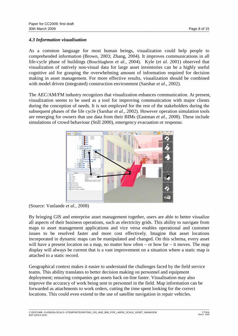
4.3 Information visualisation As a common language for most human beings, visualization could help people to comprehended information (Brown, 2003; Zhang, 2004). It improves communications in all life-cycle phase of buildings (Bouchlaghem et al., 2004). Kyle (et al. 2001) observed that visualization of natively non-visual data for large asset inventories can be a highly useful cognitive aid for grasping the overwhelming amount of information required for decision making in asset management. For more effective results, visualization should be combined with model driven (integrated) construction environment (Sarshar et al., 2002). The AEC/AM/FM industry recognizes that visualization enhances communication. At present, visualization seems to be used as a tool for improving communication with major clients during the conception of needs. It is not employed for the rest of the stakeholders during the subsequent phases of the life cycle (Sarshar et al., 2002). However operation simulation tools are emerging for owners that use data from their BIMs (Eastman et al., 2008). These include simulations of crowd behaviour (Still 2000), emergency evacuation or response.
(Source: Vanlande et al., 2008) By bringing GIS and enterprise asset management together, users are able to better visualize all aspects of their business operations, such as electricity grids. This ability to navigate from maps to asset management applications and vice versa enables operational and customer issues to be resolved faster and more cost effectively. Imagine that asset locations incorporated in dynamic maps can be manipulated and changed. On this schema, every asset will have a present location on a map, no matter how often – or how far – it moves. The map display will always be current that is a vast improvement on a situation where a static map is attached to a static record.
Geographical context makes it easier to understand the challenges faced by the field service teams. This ability translates to better decision making on personnel and equipment deployment; ensuring companies get assets back on-line faster. Visualisation may also improve the accuracy of work being sent to personnel in the field. Map information can be forwarded as attachments to work orders, cutting the time spent looking for the correct locations. This could even extend to the use of satellite navigation in repair vehicles.

Paper for CC2009: first draft 30th March 2009 Page 9 of 15
C:\DOCUME~1\UIS816\LOCALS~1\TEMP\INTEGRATING_GIS_AND_BIM_FOR_LARGE_SCALE_ASSET_MANAGEMENT.DOCX.DOC
X Zhang March 2009
Multimedia data like photographs, videos and 3D panorama imagery could be stored in GIS for corresponding buildings or building equipments to enhance real-life scenarios (Zhang, 2004). This enables site condition assessments for immediate actions. Also the visualisations tools in GIS can be used to find patterns and relationships in the huge amounts of data collected like pressure and flow recordings. Also the functions in GIS to plot graphs for the data help the engineers in finding anomalies in the huge data sets that is otherwise impossible to detect. Furthermore when geo-spatial information is associated with other information to create nD models (Aouat et al.,?), ‘what-if ’ scenarios can be generated and effects studied which helps in better and informed decision making.
By visualising the location of assets and their activities over time, the manager can identify clusters and patterns that are not apparent in tabular data. For example, a map showing maintenance activity or costs for a spread of locations can help in business analyses. Using a spatial presentation of this complex time and motion information can identify issues that warrant further investigation. For example a useful map cluster could be a series of overdue work orders in a particular location which may caused by an absent repairman or some other breakdown in the system.
(Source: Kyle, 2001) 5. Case Study of Integrated Decision Support System for Large Scale Asset
Management In the past twenty years or so, various types of building information (mostly CAD file) has been integrated with GIS for asset and facilities management (Peng and Tsou, 2003; Ramlal, 200?; ). Most of the efforts have been focused on facilities management, more specifically space management. However studies on these cases will get some insight from a general perspective of the integrated GIS and BIM. This section gives four examples on the efforts and explores what benefits or problems have been found in these implementation.

Paper for CC2009: first draft 30th March 2009 Page 10 of 15
C:\DOCUME~1\UIS816\LOCALS~1\TEMP\INTEGRATING_GIS_AND_BIM_FOR_LARGE_SCALE_ASSET_MANAGEMENT.DOCX.DOC
X Zhang March 2009
5.1 University of Minnesota, USA GIS was integrated in a space management system (SPACE) to help the University of Minnesota’s facilities information (Jordani and Gondeck-Becker, 2001; Gondeck-Becker, 1999). The university has facility assets valued over $3 billion and 24 million square feet of space in over 1,000 buildings on 5 major campuses and more than 20 research sites and experimental stations. During the needs analysis, it was discovered that location, or spatial reference is used as a common practice across the University and is considered as an organizing concept for a variety of departmental data including human resources, security, class scheduling, inventory. It was also discovered that there is lack of an enterprise-wide consistent spatial model (e.g., consistent site, building, and room numbering scheme) causes other users to develop their own which leads to multiple database maintenance and inconsistent data. Accurate space data was found to have a significant economic impact on indirect cost recovery, occupancy, and deferred renewal. User requirements dictated the selection of an enterprise-wide rather than a departmental solution. The Project Team determined this approach would add business value to many departments in the University, not just facilities management. The team needed to provide an intuitive interface for finding, analyzing, consolidating and communicating facilities and related data and present data graphically via maps, floor plans and other data. It also need to allow users to integrate to easily integrate facilities data with information from other university systems such as classroom scheduling, inventory services, human resources and departmental databases. The system needed to be easy to maintain and provide accurate, timely and auditable data. In order to connect user-defined data to institutional data for analysis, the data sources must have a common identifier (e.g. buildings or unique room number). The data are organized in a spatial hierarchy by: (1) campus, (2) zone and/or district (if one exists), (3) building, (4) floor, (5) room, and (6) room retail. Most of the information about space is attached to the room and room detail records, but it is possible to capture information about an element at any level of the hierarchy. The room record stores all of the information that is valid for the entire room, i.e. square footage, capacity and accessibility. The implementation of SPACE system included significant data creation and conversion (Gondeck-Becker, 1999). More than 1400 CAD floor plans and five campus maps were developed. Changes to floor plan drawings often cause updates to tabular data as a result of the CAD import procedures which was time consuming. And the changes can only be detected when the CAD drawings are imported into the system which could be well behind the real event. 5.2 NASA, USA An integrated GIS based spatial data management and decision support system is implemented at the National Aeronautics and Space Administration’s (NASA) Langley Research Centre (LaRC) (Gates and Gage, 2005). The general scope of LaRC has been 800 acres and 400 buildings comprising 6,700 rooms totalling 3.7million square feet, with assets

Paper for CC2009: first draft 30th March 2009 Page 11 of 15
C:\DOCUME~1\UIS816\LOCALS~1\TEMP\INTEGRATING_GIS_AND_BIM_FOR_LARGE_SCALE_ASSET_MANAGEMENT.DOCX.DOC
X Zhang March 2009
valued at approximately $3 billion. The facilities were designed to house over 4,000 Civil Service and contract employees. One example is the development of a move planning tools that allows space utilization managers to plan and evaluate various personnel move scenarios for buildings and rooms at the centre. By consolidating space, the centre will be able to reduce dependence on buildings with inefficient operational costs while retaining and improving the coherency of the distribution of personnel within each organization. Web tools have been defined and customized to make the majority of analysis capabilities available to any authorized user with a Web browser. This approach focuses on server side processing that minimizes client side processing and requirements for plug-ins. The architecture allows reuse of map development efforts, increased analysis capability, greater symbolization capability, and easier integration with CAD. However there are some useful capabilities that this system have not be addressed include metadata access/linking, statistical analysis, and area measurement (Ball, 200?). 5.3 North South Wales (NSW) Department of Housing, Australia The NSW Department of Housing (DoH) in Australia faces a sizable challenge in manage its physical assets in relation to their tenancies. It is responsible for both the tenancy management and residential property management of some $A28.5 billion worth of assets consisting of 130000 Public Housing tenancies in NSW(Barton and Plume, 2006). The tasks undertaken by staff within the department may generally be divided into three categories: client, asset and business management. However, the distinction between these categories is blurred as DoH seeks to match the dwellings it provides with the needs of its clients in an optimal way. Furthermore, DoH is intricately involved in all levels of the asset life-cycle. Vast amounts of asset and client data exist within the DoH and, in particular, the geographic nature of this data lends itself to using standard geospatial tools to both manage and visualise it. The DoH was originally operate with three separate and distinct major databases: one recording details of all buildings and properties owned by the department; one with details of tenants and one with drawing records of all buildings owned by DoH. One fundamental problem that was identified is the lack of connection between the asset data and the client data, with the result that all planning tends to be based on analyses of these separate datasets rather than any attempt to correlate the results in any rigorous way (Barton and Plume, 2006). CAD drawings were used for detailed building management. GIS were employed for neighbourhood to urban level analysis, but don not directly link to any CAD data, besides tabular datasets. Resolving this disconnection between the tools may also hold the answer to one of DoH’s ongoing problems that is locating properties within high-rise apartments. Another problem is that most DoH datasets work on a two-dimensional representation of a three-dimensional workspace. Barton and Plume (2006) proposed to use the IFC schema to manage data of the high-rise apartments. The benefits of this approach include:

Paper for CC2009: first draft 30th March 2009 Page 12 of 15
C:\DOCUME~1\UIS816\LOCALS~1\TEMP\INTEGRATING_GIS_AND_BIM_FOR_LARGE_SCALE_ASSET_MANAGEMENT.DOCX.DOC
X Zhang March 2009
• a common geospatial identifier has been developed at a sub-cadastre level that maintains geographic and topological registration with the original GIS datasets;
• these geospatial ‘place makers’ may be used as a common entity that links standard CAD system s with standard GIS;
• large scale assets can be efficiently and effectively represented; As the potential of the tools is being exploited, not only are more powerful tools being employed, but also certain gaps in the data structure are becoming apparent. In particular, the difficulty in using existing GIS tools to handle land parcels that are broken down into many tenancies, especially where those are arranged in high-rise apartments. 5.4 The United States Coast Guard (USCG), USA The USCG plans, designs, builds and manages a portfolio of 8000 owned or leased buildings and nationwide land holdings. In 2001, the USCG determined that BIM was a foundation technology for their Shore Facility Capital Asset Management Roadmap. The Roadmap is an enterprise focused on converging data and knowledge across multiple sectors – the various functional units within the USCG – to facilitate better decision-making for strategic asset planning and missions. One of the projects that utilize BIM in the context of this Roadmap is a facility assessment system. The critical components of the system were the links between the BIM design tool, a central model repository, and the Web portal for entering and viewing assessment data (Eastman et al., 2008). The system is based on open standards including IFCs and XML to support interoperability and integration; and it includes interfaces to application that are vital to the information or process workflows, such as Microsoft Excel for data entry and reporting and Google Earth for earth-based visualisations.
Figure The USCG web-based facility asset and portfolio system (Source: )
6. Summary and Conclusion Asset managers require large amounts of information of many different types in their operations to make informed decision. Typically, many different computer systems keep track of this information, such as utility and energy management, maintenance management, space management, tenant management, environmental compliance, and so on. All this

Paper for CC2009: first draft 30th March 2009 Page 13 of 15
C:\DOCUME~1\UIS816\LOCALS~1\TEMP\INTEGRATING_GIS_AND_BIM_FOR_LARGE_SCALE_ASSET_MANAGEMENT.DOCX.DOC
X Zhang March 2009
makes the work of asset management more tedious, error prone and costly. Future asset management software should be more integrated so that building assets can be managed in a more comprehensive manner throughout the life cycle of the building. Standardization at many levels is required to integrate data and achieve interoperability among software to support asset management in a more practical way. The benefits of using BIM during building design have been well-publicised and are fuelling its adoption rate amongst architects worldwide—transforming their drawing-based processes to model-based processes. The benefits of using information from a building model for facilities management are likewise compelling—fuelling the discussion surrounding building lifecycle management and nudging facilities management towards model-based processes. GIS applied to asset management can not only facilitate data collection, processing, and display but can also integrate asset mapping with project management and budgeting tools so maintenance, inspections, and expenses can be accounted for in the same place. GIS tools help in predictive maintenance through assisting in the locating of problems and the scheduling of work as well as assisting in the locating and fixing of poorly performing assets. Still there is a lack of awareness of the benefits of GIS application in asset management by a majority of the stakeholders. In conclusion, data integration is important for effective asset management. Many IT tools could facilitate such process. In particular GIS and BIM was highlighted in this paper. Geospatial information is important for effective large scale asset management as a large percentage of data used by the asset managers to answer their key questions are geographical. Geospatial location could be used as approach to integrate avaricious data sets. One single geospatial reference system, a simple geo-coded marker, may act as a unique identifier reconciling geographic, building, demographic and economic information. Geospatial analysis is one of the main contributions of GIS for large scale asset management however 3D tools need to be further developed in order to achieve its big potential. Besides acting as a data pool, more benefits of BIM for asset management are still to be clarified. This issue should be further explored and assessed through real project. Before there is more clear evidence showing the benefits of integrated BIM and GIS for asset management, the hope for wide industry adoption seems slim. References Azhar, S., Hein, M and Sketo, B. (2008). “Building Information Modeling: Benefits, Risks
and Challenges”, Proceedings of the 44th ASC National Conference, Auburn, Alabama, USA.
Barton and Plume, 2006. A Geospatial Approach to Managing Public Housing on Superlots. … Bernstein and Pittman, 2004. Barriers to the Adoption of Building Information Modeling in
the Building Industry, ESRI white paper. Bouchlaghem et al., 2004, Visualisation in architecture, engineering and construction (AEC).

Paper for CC2009: first draft 30th March 2009 Page 14 of 15
C:\DOCUME~1\UIS816\LOCALS~1\TEMP\INTEGRATING_GIS_AND_BIM_FOR_LARGE_SCALE_ASSET_MANAGEMENT.DOCX.DOC
X Zhang March 2009
Brown A. G. P. 2003. Visualization as a common design language: connecting art and science, Automation in Construction, Volume 12, Issue 6, November 2003, Pages 703-713
De Sitter, W.R. (1984) Costs for Service Life Optimization: The “Law of Fives”, Durability of Concrete Structures, Workshop Report, Ed. Steen Rostam, 18-20 May, Copenhagen, Denmark, pp. 131-134.
Gondeck-Becker, D. 1999. Implementing an enterprise wide space management system – a case
study at the University of Minnesota. Han, S.S. and Yu, S.M. (2001) EMAPS - a GIS application in town council management in
Singapore, Facilities, 19(11/12) pp. 428-435. Häkkinen T M (2007). Sustainable building related new demands for product information and product
model based design, ITcon Vol. 12, pg. 19-37, http://www.itcon.org/2007/2 Howell I. and Batcheler B. (2005). “Building Information Modeling Two Years Later –
Huge Potential”, Some Success and Several Limitations, Laiserin Letter, Issue: 24, 2005. available at: http://www.laiserin.com/features/bim/newforma_bim.pdf
Jordani and Gondeck-Becker, 2001. GIS case study: space management at the university of
Minnesorta. Facility Design and Management Handbook… Laasonen, M., 2001. Calculation of areas for facility management from measured model of a
building. European council of Civil Engineers (ECCE) Symposium, Information and communication technology (ICT) in the practice of building and civil engineering. Association of Finnish Civil Engineers RIL, Helsinki, 2001. pp. 189--194.
Lee G., Sacks, R. and Eastman M. (2006), Specifying parametric building object behavior
(BOB) for a building information modeling system, Automation in Construction, Elsevier, 15(6), pp. 758–776.
Lemer, A.C. (1998) Progress Toward Integrated Infrastructure-Assets-Management Systems:
GIS and Beyond, Innovations in Urban Infrastructure Seminar of the APWA International Public Works Congress, Los Vegas, Nevada, USA, pp. 7-24, (http://irc.nrc-cnrc.gc.ca/pubs/fulltext/apwa/apwaintegrated.pdf).
Lin H, Wan Q, Li X, Chen J, Kong Y, 1997, "GIS-based multicriteria evaluation for
investment environment" Environment and Planning B: Planning and Design 24(3) 403 – 414
Manning R, Messner J (2008) Case studies in BIM implementation for programming of
healthcare facilities, ITcon Vol. 13, Special Issue Case studies of BIM use, pp. 246-257, http://www.itcon.org/2008/18
Martin, D. Geographic Information Systems and Their Socioeconomic Implications. London:
Routledge, 1991.
Paper for CC2009: first draft 30th March 2009 Page 15 of 15
C:\DOCUME~1\UIS816\LOCALS~1\TEMP\INTEGRATING_GIS_AND_BIM_FOR_LARGE_SCALE_ASSET_MANAGEMENT.DOCX.DOC
X Zhang March 2009
NRC, 2003. GIS for Housing and Urban Development. Ramlal, B., 2005. Using GIS for Asset Management in Trinidad and Tobago. Rodriguez, M. and Sirmans, C.F. and Marks, A. P., 1995. Using Geographic Information
Systems to Improve Real Estate Analysis, The Journal of Real Estate Research, 10(2), pp 163-174.
Kyle, B.R. (2001), “Toward Effective Decision Making for Building Management”, APWA
International Public Works Congress, Philadelphia, Sep. 2001, NRCC/CPWA/IPWEA Seminar Series “Innovations in Urban Infrastructure”, (http://irc.nrc-cnrc.gc.ca/fulltext/apwa/2001kyle.pdf).
Valcik Nicolas A. and Huesca-Dorantes Patricia (2003). Building a GIS Database for Space
and Facilities Management, New Directions for Institutional Research, 2003(120), Pages 53- 61.
Vanier, D.J. (2001) “Why industry needs asset management tools”, Special Issue on
Information Technology for Life-Cycle Infrastructure Management, Journal of Computers in Civil Engineering, ASCE, pp. 35-43.
Vanier, D.J. and Danylo, N.H. (1998), “Municipal infrastructure investment planning: Asset
management”, Proceedings of APWA International Public Works Congress, Las Vegas, NV.
Vanlande, R., Nicolle C. and Cruz C., IFC and building lifecycle management, Automation in
Construction, Volume 18, Issue 1, pp. 70-78. Wyatt and Ralphs, 2003. GIS in land and property management. Zhang X., 2004. Develop a geographic visual information system to support public
participation in urban regeneration, PhD thesis, University of Salford.