
Integrated Transport Plan for Ghana · of the long-term development of the ports of Tema and...
46
Ministry of Finance and Economic Planning Republic of Ghana Integrated Transport Plan for Ghana Volume 11: Pre-feasibility study of the Boankra Dry Port Final Version Financed by the 9th European Development Fund Service Contract N° 9 ACP GH019 In association with June 2010
Transcript of Integrated Transport Plan for Ghana · of the long-term development of the ports of Tema and...

Ministry of Finance and Economic Planning
Republic of Ghana
Integrated Transport Plan for Ghana
Volume 11: Pre-feasibility study of the Boankra Dry Port Final Version
Financed by the 9th European Development Fund
Service Contract N° 9 ACP GH019
In association with
June 2010

Egis Bceom International
Page 1 Integrated Transport Plan for Ghana
Volume 11: Pre-feasibility study of the Boankra Dry Port Final Version
Executive Summary
This report analyses the economic potential of Boankra dry port as well as its social and environmental impacts.
The study provides a comprehensive analysis of aspects related to the functions and design of dry ports and a number of successful examples.
The economic analysis developed here shows that the construction of the Boankra dry port can be financially viable with a relatively modest traffic diversion from the road. The analysis shows that while environmental impacts are foreseen, they can be minimised and a number of social benefits can be generated by the project. It is thus recommended that a comprehensive feasibility study of the dry port is carried out.
However, the report highlights that the construction of a dry port near Kumasi should only be envisaged once definite decisions have been taken in order to rehabilitate – reconstruct the railway lines between Kumasi and Ghanaian seaports (Tema and Takoradi).

Egis Bceom International
Page 2 Integrated Transport Plan for Ghana
Volume 11: Pre-feasibility study of the Boankra Dry Port Final Version
Contents
Chapter 1 Introduction and Context........................... .............................7
1. Background .......................................................................................7
2. Objective of this Study .......................................................................8
3. Definition............................................................................................9
Chapter 2 Dry Ports: Concepts and Examples................... ..................10
1. Dry Port Functions ...........................................................................10
2. Dry Port advantages and disadvantages .........................................12 2.1 Constituents of a good dry port .......................................................... 13
3. Dry Ports and Other Inland Nodes ...................................................14
4. Guidelines for Design.......................................................................16 4.1 Location.............................................................................................. 16 4.2 Type ................................................................................................... 16 4.3 Layout and area ................................................................................. 17 4.4 Railway loading/unloading sidings ..................................................... 17 4.5 Container yard.................................................................................... 18 4.6 Container Freight Station (CFS)......................................................... 21 4.7 Administration complex ...................................................................... 22 4.8 Customs office ................................................................................... 22 4.9 Workshop for light repair of containers .............................................. 23 4.10 Security gate and guardhouse ........................................................... 23
5. Equipment and staffing ....................................................................23 5.1 Equipment requirements and costs ................................................... 23 5.2 Staffing requirement........................................................................... 24 5.3 ICD infrastructure investment costs ................................................... 25
6. Benefits from dry ports.....................................................................26 6.1 Traffic Related Benefits (Direct Benefits)........................................... 26 6.2 Other Benefits .................................................................................... 28
Chapter 3 Boankra Dry Port Summary Evaluation................ ...............29
1. Description of the site ......................................................................29
2. Traffic forecasts ...............................................................................29
3. Investment needs and operation costs.............................................32
4. Institutional arrangements................................................................33
5. Evaluation of Boankra dry port.........................................................34 5.1 Methodology....................................................................................... 34 5.2 Assessment of benefits ...................................................................... 34 5.3 Results of the evaluation.................................................................... 36
6. Social impacts .................................................................................36 6.1 Methodology....................................................................................... 36 6.2 Positive Impacts ................................................................................. 37
Egis Bceom International
Page 3 Integrated Transport Plan for Ghana
Volume 11: Pre-feasibility study of the Boankra Dry Port Final Version
6.3 Negative Impact and Mitigation.......................................................... 38
7. Environmental impacts.....................................................................38 7.1 Legal background............................................................................... 38 7.2 Environmental Context....................................................................... 39 7.3 Issues of Environmental Concern ...................................................... 39
8. Conclusions and recommendations .................................................45

Egis Bceom International
Page 4 Integrated Transport Plan for Ghana
Volume 11: Pre-feasibility study of the Boankra Dry Port Final Version
List of Tables
Table 1 : Determination of CY area 21
Table 2 : Determination of CFS area 22
Table 3 : Productivity factors and costs of container handling equipment 24
Table 4 : Unit cost of ICD development for selected projects in UNESCAP region. 25
Table 5 : Benefits resulting from the development of a dry port 27
Table 6 : Assumptions for converting the volume of cargo in TEUs 30
Table 7 : Traffic projection in TEUs (rail between seaports and Kumasi / Boankra) 31
Table 8 : Traffic projection in TEUs (road between seaports and Kumasi) 31
Table 9 : Traffic projection at Boankra in TEUs depending upon the rate of diverted traffic 32
Table 10 : Average transport costs in Ghana and the sub-region (in US $ / km for one 20’ container) 35
Table 11 : Annual gross benefits from reduction of transport costs from modal shift from road to rail in million US $ 35
Table 12 : Annual net benefits from modal shift from road to rail in million US $ 35
Table 13 : Results of the economic evaluation 36

Egis Bceom International
Page 5 Integrated Transport Plan for Ghana
Volume 11: Pre-feasibility study of the Boankra Dry Port Final Version
List of Figures
Figure 1 : Dry port concept 10
Figure 2 : Dry port in the logistic chain 11
Figure 3 : Example of ICD Layout: reach-stacker served CY 19
Figure 4 : Example of ICD Layout: RTG-served CY 19
Figure 5 : Example of ICD Layout: RMG-served CY 20
Egis Bceom International
Page 6 Integrated Transport Plan for Ghana
Volume 11: Pre-feasibility study of the Boankra Dry Port Final Version
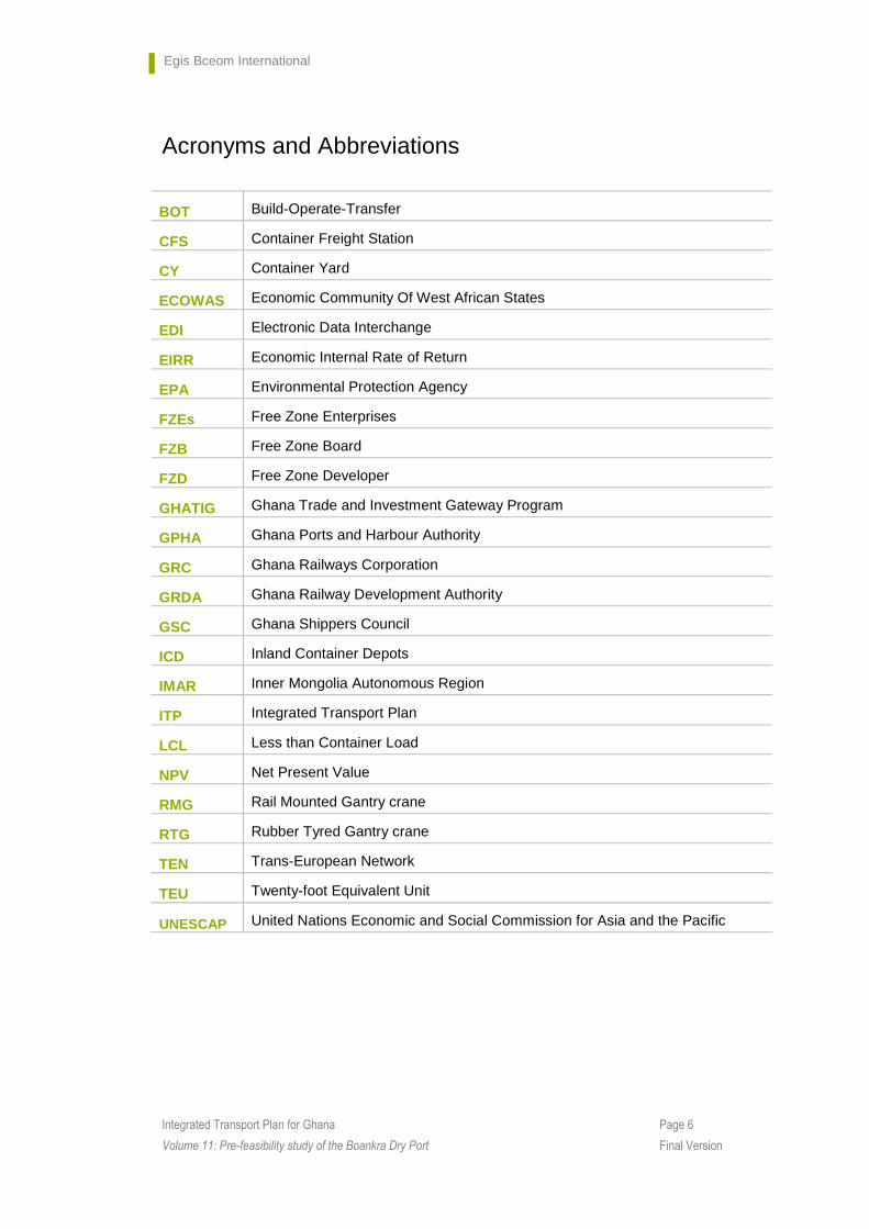
Acronyms and Abbreviations
BOT Build-Operate-Transfer
CFS Container Freight Station
CY Container Yard
ECOWAS Economic Community Of West African States
EDI Electronic Data Interchange
EIRR Economic Internal Rate of Return
EPA Environmental Protection Agency
FZEs Free Zone Enterprises
FZB Free Zone Board
FZD Free Zone Developer
GHATIG Ghana Trade and Investment Gateway Program
GPHA Ghana Ports and Harbour Authority
GRC Ghana Railways Corporation
GRDA Ghana Railway Development Authority
GSC Ghana Shippers Council
ICD Inland Container Depots
IMAR Inner Mongolia Autonomous Region
ITP Integrated Transport Plan
LCL Less than Container Load
NPV Net Present Value
RMG Rail Mounted Gantry crane
RTG Rubber Tyred Gantry crane
TEN Trans-European Network
TEU Twenty-foot Equivalent Unit
UNESCAP United Nations Economic and Social Commission for Asia and the Pacific
Egis Bceom International
Page 7 Integrated Transport Plan for Ghana
Volume 11: Pre-feasibility study of the Boankra Dry Port Final Version
Chapter 1 Introduction and Context
1. Background
As far back as the 1970s initial studies for a dry port facility had been done for the Boankra area but it was not until the year 2002 that the current project was initiated. Boankra was selected out of three likely locations as the site for the dry port. Congestion was making the use of both seaports at Tema and Takoradi difficult and this was impeding economic activities such that there was need for an alternative venue for handling imports and exports. Developing a dry port will constitute a fundamental component part of the future expansion of the existing seaports under the Ghana Trade and Investment Gateway Program (GHATIG). A development study was done by Royal Haskoning before construction begun in 2003.
The dry port being developed under the auspices of the GPHA and GSC, the Ministry of Transportation is co-ordinating the activities of interested parties. The dry port when completed would involve an in-land port estate and in-land container depot as an integral part of the long-term development of the ports of Tema and Takoradi. As part of the programme 100 Container Flats (container carrying wagons) and associated handing equipment is to be procured to enable GRC move containers up country. Sealed containers would be transported from Tema and Takoradi ports to the dry port where they are cleared and dispatched.
The main objectives of Boankra dry port are:
� To participate to the reduction of congestion at Takoradi and Tema ports ;
� To reduce aggregate transport cost of international cargo to importers and exports from the middle and northern parts of Ghana as well as from landlocked countries ;
� To promote the establishment of export zones in the vicinity of the dry Port and to create job opportunities for unemployed youth living in and around Boankra.
Within this context, GSC has acquired 400 acres (160 hectares) of land about 28 km South-East of Kumasi a few kilometers from the main national highway linking Accra to Kumasi and has built the Administration Block Complex for the dry Port at a cost of US $ 3.1 million. At the moment the present report has been prepared, the building still needs to be connected to the public water-sewage and telephone networks and the road linking the dry port to the national highway needs to be built (the access road is presently an unpaved track). The initial plan was that private investors through a Build-Operate-Transfer [BOT] scheme further develop this dry port. Until now, GSC’s efforts to attract major private investors have been unsuccessful, even though small-scale investors have shown interest in building warehouses and other facilitates in the zone.
The establishment of Boankra has been closely aligned with the Eastern railway from Tema to Kumasi although the option of a road-based service could have been feasible to alleviate the congestion at Tema, this appears not to have been explored. In interviews for the ITP, some potential users have stated categorically that they would not use it unless it was supported by a rail link from Tema port.
Egis Bceom International
Page 8 Integrated Transport Plan for Ghana
Volume 11: Pre-feasibility study of the Boankra Dry Port Final Version
Boankra was also identified as an opportunity to realise Government’s policy of engaging private sector finance for the development of transport infrastructure and services. Despite a study being undertaken in 2002/3 to ascertain its viability, private sector investment has not been forthcoming.
Therefore, Boankra’s future appears to be dependent on several conditions:
� The rehabilitation of its rail link with its primary connection to Tema port
� The economic and financial viability in terms of realistic traffic flows
� The ability to raise investment funding from either public or private sectors
� The ongoing need for “relief” at the ports
Since the study undertaken in 2002/3, two important projects have provided new data that can be used to assess Boankra’s viability. The first is the Bonifica feasibility Study of the Western Corridor which has provided an analysis of the economic viability of rehabilitating the Western Line from Takoradi to Boankra and the financial viability likely from the potential operations to Boankra from Takoradi. In the case of financial viability, operating losses are predicted in the early years of operation.
New data has now been provided by the Integrated Transport Plan (ITP) which has shown through a multi-criteria evaluation method that the Eastern rail line is economically viable with operations optimally commencing in 2016. It has also produced traffic demand forecasts to 2035 for the national transport system including the Eastern and Western rail lines that could be routed through Boankra. This latest information, therefore provides a useful platform on which to re-consider the viability and need for Boankra.
Therefore, this pre-feasibility study aims to take a closer look at the:
� Need for Boankra as an integral part of Ghana’s transport system
� Potential viability of operations based on the traffic forecasts derived from the ITP
� Arrangements that will most likely be required in the facility
� Legal conditions that will need to be created for its development
2. Objective of this Study
A prefeasibility study has two main objectives:
1. Provide a better understanding of the project in study, show its advantages and drawbacks;
2. Help to decide whether or not to go ahead with a feasibility study.
On this line, this study aims at
� understanding the key issues related to the development of the Boankra Dry Port,
� identifying the costs and other impacts, benefits related to the traffic as well as wider benefits and
� providing recommendations for further analysis.
� Indentifying strategic barriers to its development
Egis Bceom International
Page 9 Integrated Transport Plan for Ghana
Volume 11: Pre-feasibility study of the Boankra Dry Port Final Version
3. Definition
As it will be discussed in the next chapter, the Dry Port is defined here as an inland intermodal terminal directly connected to seaport(s) with high capacity transport mean(s), where customers can leave/pick up their standardized units as if directly to a seaport. Alternatively, a dry port can be understood as an inland setting with cargo-handling facilities to allow several functions to be carried out, for example, consolidation and distribution, temporary storage, custom clearance, connection between transport modes, allowing agglomeration of institutions (both private and public) which facilitates the interactions between different stakeholders along the supply chain.
Although some divergence can exist in the definitions of Dry Port and Inland Port, as we will see in Chapter 23, they are used interchangeably in this report.

Egis Bceom International
Page 10 Integrated Transport Plan for Ghana
Volume 11: Pre-feasibility study of the Boankra Dry Port Final Version
Chapter 2 Dry Ports: Concepts and Examples
1. Dry Port Functions
A dry port is an inland intermodal terminal directly connected to seaport(s) with high capacity transport mean(s), where customers can leave/pick up their standardized units as if directly to a seaport. Alternatively, a dry port can be understood as an inland setting with cargo-handling facilities to allow several functions to be carried out, for example, consolidation and distribution, temporary storage, custom clearance, connection between transport modes, allowing agglomeration of institutions (both private and public) which facilitates the interactions between different stakeholders along the supply chain.
Figure 1 : Dry port concept
The dry port concept is based on a seaport directly connected with inland intermodal terminals, where goods in intermodal loading units can be turned in as if directly to the seaport. Between the seaport and the inland terminals, here denoted dry ports, relatively large goods in intermodal loading units can be turned in as if the terminal was positioned directly to the seaport. In such dry ports large goods’ flows can shift freight volumes from road to more energy efficient traffic modes that are less harmful to the environment. In addition a dry port can relieve seaport cities from some of the congestion, make goods handling more efficient and facilitate improved logistics solutions for shippers in the port’s hinterland.
Normally the dry port is container and multimodal oriented and has all logistics services and facilities, which is needed for shipping and forwarding agents in a port.

Egis Bceom International
Page 11 Integrated Transport Plan for Ghana
Volume 11: Pre-feasibility study of the Boankra Dry Port Final Version
Figure 2 : Dry port in the logistic chain
A Dry Port must fulfil the following conditions:
� It should have direct connection to a seaport either by rail or by road
� It should have a high capacity traffic mode
� It should offer the same types of facilities as can be found in a seaport.
To ensure an effective Dry Port there are two general objectives:
� Consolidation of maritime goods in intermodal short- and long distance transport flows;
� Collecting and distribution of local, regional and international transports.
With this in mind, a review of the various terms used suggests that the following key attributes are often, although not always found:
� Geographical attributes
• linked to a sea or airport
• inland – located away from traditional land, air, and coastal borders
� Transport logistics attributes
• high capacity transport link(s)
• more than one transport mode
• intermodal transfers
� Warehouse logistics attributes
• temporary storage or warehousing

Egis Bceom International
Page 12 Integrated Transport Plan for Ghana
Volume 11: Pre-feasibility study of the Boankra Dry Port Final Version
• consolidation and deconsolidation
• International port attributes
• international trade involved
• customs inspection
• other services found in an international sea or airport
� Value add logistics services
• freight forwarding
• information systems
• other value added services
The main function of the Dry Port is obviously the transhipment of units between different transportation means, but several others services can be provided at the dry port. Storage of units is frequently offered. It can for instance be storage of empty containers as well as storage of waiting units. This service is indeed very important for the transport system as some regions naturally receive more containers than they send and vice versa. Dry Ports can thus be connected and used to regulate the imbalance phenomenon. Maintenance of units is also a well-developed service that can be done by sub contractors.
Dry ports offer a customs station destined to handle imports and exports. Therefore, they can become an important storage and distribution centre of goods to the whole country and to the international market as well. They represent a good option for companies that need both promptness and low cost in their commercial transactions. For example, several manufacturers and technology companies established in Brazil, rely on imported components, and are therefore increasingly using dry ports (inland customs clearance posts) to cut import costs and better manage the time of delivery and production.
Dry ports imported components are dispatched with greater efficiency. This guarantees deliveries on time and avoids the interruption of production caused by lack of components.
One advantage of the dry ports is that the goods can be warehoused in their facilities and cleared as needed, thus postponing the payment of import duties and local taxes by the importer until the products are needed.
2. Dry Port advantages and disadvantages
The list of attributes given in the preceding section suggests that when considering the advantages offered by inland logistics ports, we need to look at both functional and locational advantages. The existence of an inland logistics port provides shippers with a direct interface to international transport and therefore gives them a locational advantage. It also provides them with access to a number of functions that can be undertaken at the inland logistics port, some of which are traditionally restricted to international ports or border-crossing points (e.g., customs clearance). Most of the advantages described below directly relate to shippers. However, if shippers perceive advantages in the existence of an inland logistics port, then it
Egis Bceom International
Page 13 Integrated Transport Plan for Ghana
Volume 11: Pre-feasibility study of the Boankra Dry Port Final Version
also provides business opportunities for the logistics sector and for the local economy in general. Typical advantages of inland logistics ports are:
� Inexperienced inland-based shippers have the opportunity to undertake international trade through local facilities;
� International functions such as customs clearance and labelling for export can be undertaken locally;
� Uncertainties of customs clearance can be eliminated through the locational advantage of having all associated functions at one site (e.g., unloading, modal transfer, redistribution);
� Smaller shippers can benefit from consolidation of their consignments with others to form full loads;
� Inland-based shippers have direct access to international transport equipment such as containers or roll-on/roll-off vehicles;
� Inland-based domestic-only shippers have access to a wider range of local resources;
� “Transportation-related waste” associated with inefficient supply chains can be eliminated or at least reduced. This is achieved primarily through better linkage between different modes (e.g., intermodal rail facilities) or within modes (e.g., connections between different major road routes); and
� Collaboration is possible between different institutions undertaking such functions as distribution, warehousing, and manufacturing, providing a “shared location for partners”. In other words, this is a benefit of clustering.
A comprehensive analysis of the advantages of dry ports requires a balance check between transport externalities, which can be benefits and costs. Rothengatter (1994) presents a number of external transport benefits (specifically referring to road transport). Those particularly relevant to inland logistics ports include:
� Extension of the consumption pattern and improvement of living standards;
� Introduction of growth and structural effects, and freight logistics to create new approaches to industrial labour division and interaction, setting new quality standards such as “just-intime” transport;
� Increase in flexibility and innovation, which creates a new quality of service and transport and strengthens the economy for international competition;
� Cost reductions for packing, processing, and logistics; and
� Positive employment effects in peripheral regions.
2.1 Constituents of a good dry port
A number of key features contribute to the operation of an effective inland logistics port. They include:
� Location at or near a rail-based intermodal terminal.
� Access to sea and/or airports;
Egis Bceom International
Page 14 Integrated Transport Plan for Ghana
Volume 11: Pre-feasibility study of the Boankra Dry Port Final Version
� Advanced technology in information-sharing such as EDI. This allows international trade to operate at locations other than the traditional international boundaries enabling seamless movement of goods door-to-door.
� Ability to meet the needs of a specific marketplace by integrating services with the physical infrastructure;
� Sufficiently large local population as a market and/or labour pool.
� Sufficiently large area of land for development;
� A full range of services appropriate to an inland logistics port. These include all modes of transport, transloading (between international and domestic transport), warehousing (included bonded warehouse to offer postponement of tax payment), distribution, consolidation, container services (empty storage, maintenance and repair), customs clearance, other logistics services, and manufacturing;
� A free trade zone to provide a tariff shelter;
� Security and control using modern information and communication systems;
� Proximity to substantial manufacturing capacity and production centres or to large shippers;
� Effective cooperation between public and private organizations;
� A multipurpose business centre for offices, conferences, trade shows etc; and
An inland logistics port can have a positive impact on the regional or local economy, not only by providing direct processing of international trade, but also by attracting distributors and manufacturers associated with it. This is another advantage of clustering.
3. Dry Ports and Other Inland Nodes
It is worthwhile to present the different Inland Nodes definitions. Many of these are sometimes used as exchangeable names for dry ports. These definitions do not intend to be the definitive statement of the terms but to provide same basis for understanding the differences between them.
Term Definition Source
Inland Clearance Deport
A common-user inland facility, with public authority status, equipped with fixed installation, and offering services for handling and temporary storage of any kind of goods (including container) carried under customs transit by any applicable mode of inland surface transport, placed under customs control to clear goods for home use, warehousing, temporary admission, re-export, temporary storage for onward transit, and outright export.
UNECE (1998), see also Roso (2005), Jaremskis and Vasiliauskas (2007), Roso et al (2009)
Inland Container
A common user facility with public authority status, equipped with fixed installations and offering services for handling and
Roso (2005), Jaremskis and Vasiliauskas

Egis Bceom International
Page 15 Integrated Transport Plan for Ghana
Volume 11: Pre-feasibility study of the Boankra Dry Port Final Version
Depot temporary storage of import/export stuffed and empty containers.
(2007), Roso et al (2009)
Intermodal Freight Center
A concentration of economic independent companies working in freight transport and supplementing services on a designated area where a change of transport units between traffic modes can take place.
Cardebring and Warnecke (1995), Roso et al (2009)
Inland Freight Terminal
Any facility, other than a seaport or an airport, operated on a common-user basis, at which cargo in international trade is received or dispatched.
UNECE (1998), see also Jaremskis & Vasiliauskas (2007), Roso et al (2009)
Inland Port
An inland port is located inland, generally far from seaport terminals. It supplies regions with an intermodal terminal or a merging point for traffic modes - rail, air, and truck routes - involved in distributing merchandise that comes from seaports. An inland port usually provides international logistics and distribution services, including freight forwarding, customs brokerages, integrated logistics, and information systems.
Economic Commission for Europe (2001), see also Jaremskis and Vasiliauskas (2007), Roso et al (2009)
Dry Port
A dry port is an inland intermodal terminal directly connected to seaport(s) with high capacity transport mean(s), where customers can leave/pick up their standardized units as if directly to a seaport. Alternatively, a dry port can be understood as an inland setting with cargo-handling facilities to allow several functions to be carried out, for example, consolidation and distribution, temporary storage, custom clearance, connection between transport modes, allowing agglomeration of institutions (both private and public) which facilitates the interactions between different stakeholders along the supply chain.
Leveque and Roso (2002), Roso (2005), Roso et al (2009), Ng and Gujar (2009)
Transport Terminal
This type of terminal is almost exclusively aimed at transshipping continental freight. There is almost no collection and distribution in the region where the terminal is located. The freight arrives at and departs from the terminal in huge flows. The terminal is characterized by large areas that enable direct transshipment between trains and/or barges. The corresponding bundling model is the hub-and-spoke network.
Wiegmans et al (1999)
Distribution Terminal
At this terminal value added is created in the form of an extra service provided by the terminal operator. From location A, B, and C continental freight arrives at the terminal and is consolidated into shipments for customers X, Y, and Z. One or more terminal services is added by the terminal operator to the shipments at the terminal. The corresponding bundling model is line network.
Wiegmans et al (1999)
Hinterland Terminal
Small continental cargo shipments are brought to the hinterland terminal and consolidated into bigger freight flows. These bigger freight flows are further transported by larger transport means such as trains or barges. The corresponding bundling model is the trunk line with a collection and distribution network.
Wiegmans et al (1999)
Source: Dr. Jean-Paul Rodrigue, Dept. of Global Studies & Geography, Hofstra University

Egis Bceom International
Page 16 Integrated Transport Plan for Ghana
Volume 11: Pre-feasibility study of the Boankra Dry Port Final Version
4. Guidelines for Design
The guidelines presented here are based on the “Policy Framework for the development of Intermodal Interfaces as part of an Integrated Transport Network in Asia”. It provides an approach to determining the location, type, area, and equipment for inter-modal freight terminal development projects.
4.1 Location
The choice of a location for an intermodal terminal, whether for the handling of containers, breakbulk or bulk cargo, must satisfy two requirements:
� the need to build the facility at a site beside a railway line which will allow easy access/egress to/from the running tracks and will avoid the need to break up or re-form trains; and
� the need to minimize the local road haulage distance to/from the main cargo sources.
A suitable layout for a rail access is shown in Figure 3, Figure 4 and Figure 5. The most important feature of the rail loading/unloading sidings which are linked as loops to the mainline is that they may be accessed from both sides of the intermodal terminal, without the need to break up train formations.
It is expected that Dry Ports will be located close to cargo sources in the hinterland and at some considerable distance from seaports. Unless border areas have the potential to generate trade or unless there is a need to transfer transit or bilateral trade between modes, or indeed between railway gauges, at the border, there would not normally be a need to establish fully equipped intermodal terminals at borders.
To take as an example, there are three dry port facilities located at the border between the Inner Mongolia Autonomous Region (IMAR) of China and Mongolia (at Erenhot, Ceke and Ganginmaodao), as well as one dry port facility at Manzhouli on the border between IMAR and the Russian Federation. Two out of four of these dry ports have facilities to transfer cargo between the Russian and Chinese railway gauges, while one is equipped to transfer cargo from rail to road and vice versa, and the last is a pure road – to – road transfer facility.
Transit containers can, for example, be loaded with cargo and customs cleared in Ulaanbataar for transport to the Port of Tianjin for overseas shipment, with only a minimal inspection of the container customs seals at the Erenhot/Zamyn Ud border. However, since there is a break of gauge at the border the containers will require lifting from wagons of the Mongolian Railway system to wagons of the Chinese Railway system. Thus only container lifting equipment would be required at the border and the focus of customs inspection would be at the cargo source in Ulaanbaatar. This would be in conformity with the International Convention of the Harmonization of Frontier Control of Goods (1982), which specifies that inspection of transit cargoes at borders should be restricted to inspection of customs seals.
4.2 Type
The choice of facility type will mainly reflect the cargo mix available for handling and transportation. If there is potential for sizeable volumes of break-bulk or bulk cargoes, in

Egis Bceom International
Page 17 Integrated Transport Plan for Ghana
Volume 11: Pre-feasibility study of the Boankra Dry Port Final Version
addition to container cargoes, specialized open or enclosed storages will have to be provided within the area of the terminal to accommodate these cargoes.
If the facility is to serve only container demand, an early decision must be made about the type of handling equipment or system, which will be used to transfer containers between rail/road and the container yard (CY). This is because the equipment choice is a determinant (along with projected container volume and average dwell time) of the land area required for construction of the facility and hence has a major influence on land acquisition costs.
Different types of handling systems have different container stacking densities and different requirements for a circulating area between stacks.
4.3 Layout and area
The land area required for a container handling facility should be determined for each of the facility components:
� rail loading/unloading sidings; container yard (CY);
� container freight station (CFS); bonded warehouse;
� administration and forwarder offices;
� customs office; and
� security gate and guardhouse.
4.4 Railway loading/unloading sidings
The optimum length of trains to be operated to and from the terminal must be determined at an early stage, since this will determine the required length of the clear standing trackage in the rail loading/unloading sidings and hence the width of the facility. A primary requirement of the facility design should be that full length container trains will arrive directly into the loading/unloading sidings, be discharged and loaded there by container handling equipment, and then depart directly for their next destination without the need for splitting or reformation.
Optimum train lengths are those which will minimize train operating costs, given prevailing limitations on motive power availability and gross tonnage (i.e. haulage) capacity.
Typically, single tier container trains operating on metre gauge tracks within the region will comprise 30-35 wagons each with an overall length of 15 metres, for a total train length including a single locomotive of about 510 metres. On the standard and broad gauge systems of the region, the optimum length of single tier container trains tends to be about 40-45 wagons for a train length, including a single locomotive, of about 660 metres.
Double tier container trains are in the process of being introduced to the region, especially in Australia and China (both standard gauge systems), as well as in India (a predominantly broad gauge 1,676 metre system). These trains will probably comprise the same number of wagons, but will be slightly longer than, the single tier trains, given the use of well-type wagons with longer overall lengths and the need to attach two or more locomotives to trains (owing to higher train gross weights). For metre gauge networks, typical train lengths are likely to be of the order of 560 metres and for standard/broad gauge networks of the order of 730 metres.

Egis Bceom International
Page 18 Integrated Transport Plan for Ghana
Volume 11: Pre-feasibility study of the Boankra Dry Port Final Version
The width required in the rail loading/unloading area will depend on the number of sidings to be provided, and this in turn depends on train turnaround time and the daily number of train arrivals and departures. Typically, for a facility handling up to 400,000 TEU per year in a two shift 16 hours per day operation, four full length sidings with crossovers or engine escape tracks will be required. The width of the rail loading/unloading area in this case, including allowance for paved areas either side of the tracks would be about 60 metres, giving an overall area for rail loading and unloading of 34,000-50,000 square metres. In fact, the Lat Krabang ICD (Inland Container Depots) in Thailand has a rail loading unloading facility with an area of 48,000 square metres.
4.5 Container yard
The container yard will be a paved area within the terminal for the short term storage of loaded and empty containers. There will be heavy paved areas to allow the stacking of loaded containers and light paved areas to allow the stacking of empty containers. The height of the container stacks, in terms of the number of tiers, will be a function of pavement strength and the type of handling system employed, and hence of overall cost.
Typical facility layouts for the three handling systems reviewed in this study (reach-stackers, RTGs and RMGs) are shown in Figure 3, Figure 4 and Figure 5.
If a high density system, such as an RTG (Rubber Tyred Gantry crane) or RMG (Rail Mounted Gantry crane) system is to be used, then there has to be allowance for the gantries to span the width of the rail sidings and the roadways on both sides of the loading/unloading tracks. This is because these systems involve the use of gantries plus yard chassis (prime movers and trailers) to lift and move containers to and from the stacks. If a lift truck system (such as a reachstacker) is used, adequate areas have to be provided between the stacks for the manoeuvering of the lift trucks. In addition since a reachstacker can place loaded containers in the first row of each stack to a height of 3-4 containers, but only to a height of 2-3 containers in the second row, this type of handling system will require a proportionately greater paved area in the CY for a given throughput level.
The choice of handling system therefore implies a trade-off between the cost of CY construction versus the purchase and operating cost of the handling equipment. If land acquisition costs are low (unlikely in most cases), then the lift truck system may provide a better solution since its acquisition, installation and operating costs are low relative to those of high density handling systems, such as RTGs and RMGs.
The required land area of the CY must be determined by reference to the following factors:
� forecast container throughput volumes for the facility; expected traffic peaking patterns;
� expected average container dwell time (in days);
� desired average stacking height in CY;
� type of handling system to be employed and associated CY area allowance per TEU groundslot.

Egis Bceom International
Page 19 Integrated Transport Plan for Ghana
Volume 11: Pre-feasibility study of the Boankra Dry Port Final Version
Figure 3 : Example of ICD Layout: reach-stacker served CY Source: China Intermodal Transport Services to the Interior Project (ITSIP): Inland
Container Depot Operation Manual, August 2003
Figure 4 : Example of ICD Layout: RTG-served CY Source: China Intermodal Transport Services to the Interior Project (ITSIP): Inland
Container Depot Operation Manual, August 2003
Egis Bceom International
Page 20 Integrated Transport Plan for Ghana
Volume 11: Pre-feasibility study of the Boankra Dry Port Final Version
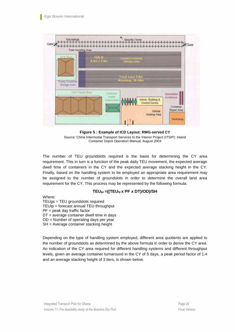
Figure 5 : Example of ICD Layout: RMG-served CY Source: China Intermodal Transport Services to the Interior Project (ITSIP): Inland
Container Depot Operation Manual, August 2003
The number of TEU groundslots required is the basis for determining the CY area requirement. This in turn is a function of the peak daily TEU movement, the expected average dwell time of containers in the CY and the expected average stacking height in the CY. Finally, based on the handling system to be employed an appropriate area requirement may be assigned to the number of groundslots in order to determine the overall land area requirement for the CY. This process may be represented by the following formula:
TEUgs =((TEUtp x PF x DT)/OD)/SH Where: TEUgs = TEU groundslots required TEUtp = forecast annual TEU throughput PF = peak day traffic factor DT = average container dwell time in days OD = Number of operating days per year SH = Average container stacking height
Depending on the type of handling system employed, different area quotients are applied to the number of groundslots as determined by the above formula in order to derive the CY area. An indication of the CY area required for different handling systems and different throughput levels, given an average container turnaround in the CY of 5 days, a peak period factor of 1.4 and an average stacking height of 3 tiers, is shown below.

Egis Bceom International
Page 21 Integrated Transport Plan for Ghana
Volume 11: Pre-feasibility study of the Boankra Dry Port Final Version
Table 1 : Determination of CY area
4.6 Container Freight Station (CFS)
The primary function of the CFS is to load export breakbulk cargo into containers for shipment to foreign trading partners or to unload import cargo from containers, for dispatch as breakbulk freight to local consignees. A subsidiary function is the short term storage of breakbulk container cargoes for export or import. Thus a CFS will need to provide:
Loading/unloading bays for trucks conveying breakbulk cargo; Loading/unloading bays for yard chassis bringing containers to/from the CY, an area for short-term storage of export cargo awaiting stuffing into containers and of de-stuffed import cargo awaiting dispatch to or collection by consignees; and circulation areas for forklifts within the CFS.
The throughput of cargo in the CFS may (and ideally should) be linked to the CY throughput, since containers for stuffing or destuffing in the CFS will be sourced from containers passing through the CY. It should be noted that not all loaded containers arriving at and departing from the CY will be processed in the CFS – some will be moved directly by road transport to or from importers’ and exporters’ premises for processing there.
The formula for calculating the CFS area requirement is as follows:
CFSarea = ((TEUtp x CFS% x PF x DT)/OD)*ATEU
Where: TEUtp = forecast annual TEU throughput CFS% = percentage of CY throughput for processing in CFS PF = peak day traffic factor DT = average breakbulk cargo dwell time in CFS (days) OD = Number of operating days per year ATEU = Average ground area occupied by breakbulk cargo (m2 per TEU)
The average ground area assumption for breakbulk cargo discharged from a container will also depend on the height at which cargo may be stacked in the CFS, as well as on the circulation area to be allowed for forklift operation and the area required for parking of container chassis and trucks in loading bays. Based on the average area requirement assumed by Transmark consultants for the Lat Krabang ICD Phase I project in Thailand (50 m2 per TEU), as well as an assumption of a cargo turn time in the CFS of 3 days, of a traffic peaking factor of 1.4 and that 30 per cent of the CY throughput would be processed in the

Egis Bceom International
Page 22 Integrated Transport Plan for Ghana
Volume 11: Pre-feasibility study of the Boankra Dry Port Final Version
CFS, the following CFS area requirements were determined for different CY throughput levels:
Table 2 : Determination of CFS area
As indicated later in section forecasts for TEU’s at Boankra are 118,000 for 2015 and 362,000 in 2035.
4.7 Administration complex
Administration buildings are provided not merely to accommodate the terminal management and operating staff and the computer and communications installations needed to plan and to execute the various activities comprising the functions and services of the facility, but also to provide offices out of which the various “external” service providers in the facility may operate. These service providers can include: freight forwarder and consolidator organizations; customs brokers; shipping lines and agents; rail and road transport coordination staff; banking, insurance and other financial service providers. The size of the building will depend to a major extent on use to be made of office space by such external service providers, and this in turn is likely to be broadly related to the designed throughput capacity of the overall facility.
For example, the rail served Uiwang ICD near Seoul, with an annual throughput capacity of 1.37 million TEU has two operating terminals, one with five 3-4 storey office buildings and another with three 3-4 storey office buildings. These buildings cover a combined ground area of 14,026 square metres, giving an average ground area of 1,753 square metres per building, which represents less than 2 per cent of the total surface area of the ICD.
The modularized rail served ICD at Lat Krabang, near Bangkok, which in 2006 handled some 1.4 million TEU, has a four floor central administration building This building houses the ICD (not the concessionaires’) administration, the SRT (railway) operating superintendent’s office, as well as offices for the banks, the post office, shipping lines and forwarding agents, customs brokers, and haulage and trucking companies. The overall ground area occupied by this building is about 755 square metres.
4.8 Customs office
Since the ICD will be required to have the permanent presence of customs staff for the routine inspection and clearance of all container and cargo consignments, it will be necessary to provide an office building to accommodate these staff. The size of the building is wholly dependant on the number of customs staff to be based at the ICD, but it will in any case cover a ground area of not less than about 200 square metres. For example, the customs offices at Uiwang (Republic of Korea) and Lat Krabang (Thailand) cover an area of 2,363 square metres and of 2,352 square metres respectively. At Lat Krabang, one four floor customs office is
Egis Bceom International
Page 23 Integrated Transport Plan for Ghana
Volume 11: Pre-feasibility study of the Boankra Dry Port Final Version
provided for each of the six operating modules. These buildings are also used to accommodate health and quarantine department inspection staff as well as the administration and operations management of each ICD module.
4.9 Workshop for light repair of containers
ICD facilities will normally include a workshop to carry out only light repairs to containers. In cases where heavier duty repairs were required the containers would be moved to off-site specialized workshops. Depending on the size of the ICD and its throughput, the repair facility will typically cover a ground area of 200-2,000 square metres. In fact, the Uiwang ICD in the republic of Korea has two repair facilities with a total area of 2.942 square metres. The container repair workshop at Lat Krabang, on the other hand, has an area of only 584 square metres.
4.10 Security gate and guardhouse
A security gate and guardhouse must be provided at the road entrance to the ICD facility. Tis office will usually cover an area of not less than 100 square metres. For example, the Lat Krabang ICD has a security gate and guardhouse covering an area of 300 square metres.
5. Equipment and staffing
Given the daily number of operating hours, the equipment handling rates or productivity, and the average equipment utilization, both the cargo handling equipment and operational staffing levels of the ICD may be scaled in accordance with peak day throughput volumes.
For planning purposes, it is should be assumed that ICD terminals will be operated for at least two shifts, or 16 hours per day.
5.1 Equipment requirements and costs
Typical handling rates in terms of container lifts or moves per hour, together with typical acquisition costs, are shown for the various items of container lifting equipment in the table below.

Egis Bceom International
Page 24 Integrated Transport Plan for Ghana
Volume 11: Pre-feasibility study of the Boankra Dry Port Final Version
Table 3 : Productivity factors and costs of container handlin g equipment
5.2 Staffing requirement
The number of staff to be allowed for at the railhead and in the CY should be two per item of primary handling equipment per shift with appropriate allowance for relief during holidays or for sickness etc.
In calculating the number of gangs required to operate in the CFS, a normal assumption is a productivity rate of 6-8 TEU per gang per shift for loading, unloading and stacking cargo in the CFS. A gang could comprise 6-7 persons.
Other personnel to be allowed for in the ICD could include the following:
� A general manager
� Operations, administration and maintenance managers
� Supervisors in the Traffic, Operations, CFS and Maintenance Departments

Egis Bceom International
Page 25 Integrated Transport Plan for Ghana
Volume 11: Pre-feasibility study of the Boankra Dry Port Final Version
� Clerks (Accounts, Personnel, Claims, etc)
� Other office staff
� General labourers/cleaners etc
� Security guards
It is likely that a very large ICD (with capacity to handle up to about 1 million TEU per year) could require a workforce of about 2,000 people.
5.3 ICD infrastructure investment costs
The cost of ICD development will be sensitive to local conditions, especially to the cost of land and local costs of labour and construction materials. A review of recent and planned projects in the UNESCAP region was undertaken to determine whether there was any consistency in the actual or estimated unit investment costs across the projects reviewed and whether these data could provide a valid basis for measuring the likely investment cost of ICD development. The resulting unit investment costs (expressed in US dollars per square metre of developed land area) are given in table below. The total investment amounts from which these unit values were derived are understood to include amounts for the costs of: land acquisition (where applicable), pavement of container movement and storage areas, construction of rail access and loading/unloading tracks, and construction of buildings and perimeter fencing. The total area shown for each facility is the total developed area of land which may be directly related to the total investment cost.
Table 4 : Unit cost of ICD development for selected projects in UNESCAP region.

Egis Bceom International
Page 26 Integrated Transport Plan for Ghana
Volume 11: Pre-feasibility study of the Boankra Dry Port Final Version
6. Benefits from dry ports
The benefits that can be derived from the creation of a Dry Port can be classified as “Traffic Related Benefits” (or Direct Benefits) and “Other Benefits” (or Indirect Benefits). They are shortly reviewed thereafter.
6.1 Traffic Related Benefits (Direct Benefits)
The development of dry ports results in streamlining physical operations and administrative procedures at the seaport with corresponding benefits in direct relation with the traffic transiting in the dry port. These benefits include: reduction of congestion and higher productivity at the seaport, time savings for the entire journey and cheaper intermodal transfer costs.
In addition, by making easier and cheaper intermodal transfer operations, dry ports enhance the competitiveness of intermodal transport operations and prompt shippers to adopt the cheapest available transport mode on every segment of the journey: thus, modal shift from road to rail will be favoured owing to the lower unit fuel consumption, maintenance and staffing costs for rail as compared with road transport. Obviously, the reduction of transport cost resulting from the modal shift from road to rail for the primary or trunk journey between the seaport and the dry port will be partially counterbalanced by the cost of intermodal transfer at the dry port: however, if the trunk journey is long enough, and if transfer operations at the dry port are efficient and cheap enough, the reduction of transport cost will significantly exceed the cost of intermodal transfer, resulting in net benefits for the shippers. In addition, to this net reduction of transport costs, additional benefits accruing from modal shift from road to rail should not be ignored; they include reduction of road congestion in both the city centres and the highway network, improvement of the road safety and reduction of road maintenance requirements resulting from lower truck traffic.
The following table summarises the benefits expected from the development of dry ports. They are classified into two categories: � First category, including all “direct” benefits from the streamlining of physical operations
and of administrative procedures � Second category, including all benefits resulting from the diversion of traffic from road to
rail which is a consequence of the increased competitiveness of intermodal transport

Egis Bceom International
Page 27 Integrated Transport Plan for Ghana
Volume 11: Pre-feasibility study of the Boankra Dry Port Final Version
Table 5 : Benefits resulting from the development o f a dry port
Reduced transport
costs
Reduced congestion in both the city centres
and the highway network
Improved road safety
Savings in road
mainten ance
costs
First category of benefits Second category of benefits
Apply to all traffic transiting in the dry port
Only apply to traffic diverted from road to rail as a consequence of the development of the dry port
and of the corresponding streamlining of intermodal transfer operations
Favour modal shift from road to rail
Streamlining physical operations and administrative procedures at the seaport
Reduce congestion
at the seaport
Time savings
along the intermodal
logistic chain
Cheaper intermodal
transfer costs
Increase productivity at the sea
port
For the purpose of the economic evaluation of a dry port, the benefits belonging to the first category apply to all traffic transiting through the dry port, i.e. traffic which would have naturally undergone modal shift, even though the dry port is not developed, and traffic diverted from road to rail because of the existence of the dry port. Assessing such benefits requires:
� Establishing forecasts for the traffic likely to transit through the dry port in the future � Quantifying the impact of streamlining operations and procedures on berth congestion,
productivity, transit time and transfer cost � Assessing the monetary benefits accruing from reduction of seaport congestion and
increase in productivity � Assessing the monetary benefits accruing from time savings � Assessing the reduction in intermodal transfer costs
Benefits belonging to the second category should not apply to all traffic transiting in the dry port but only to the traffic which has been diverted by shippers from road to rail as a direct consequence of the development of the dry port and of the corresponding reduction of total intermodal transfer costs. Assessing such benefits requires:
� Establishing forecasts for the traffic likely to be diverted from road to rail as a consequence
of the reduced modal shift costs resulting from the development of the dry port � Comparing transport costs for road and rail � Assessing handling costs at the dry port � Assessing the cost of road congestion and the reduction of road congestion resulting from
the reduction of truck traffic � Assessing the cost of road accident and the reduction of road accidents resulting from the
reduction of truck traffic � Assessing the reduction of maintenance requirements resulting from the reduction of truck
traffic and the corresponding savings in maintenance

Egis Bceom International
Page 28 Integrated Transport Plan for Ghana
Volume 11: Pre-feasibility study of the Boankra Dry Port Final Version
6.2 Other Benefits
Among the other indirect benefits likely to result from the development of dry ports, one should mention:
� Prompt the development of regional trade
� Facilitate the distribution of goods at the regional and national level
� Participate to the elimination of unnecessary charges imposed on road traffic and to the reduction of non-physical barriers to road traffic (informal controls, briberies, etc.) and, finally, participate to the reduction of transport costs to the end customer
� Streamline customs procedures including possibility of differed payment of duties and taxes on imported goods
� Facilitate the consolidation of LCL lots for export
� Prompt new investments in the region
� Prompt the development of export of regional productions
� Create opportunities for developing new private companies with corresponding working opportunities, reduction of unemployment and poverty reduction
Although they may significantly impact the regional and national economy, such benefits are generally quite difficult – and sometimes impossible - to quantify in monetary terms.

Egis Bceom International
Page 29 Integrated Transport Plan for Ghana
Volume 11: Pre-feasibility study of the Boankra Dry Port Final Version
Chapter 3 Boankra Dry Port Summary Evaluation
1. Description of the site
The size of the purchased site is about 160 ha, of which approximately 60% is currently estimated suitable for development if the inland port without extensive ground works. The area is L-shaped. The main characteristics of the site are:
� the elevation of the site ranges between 215 and 245 m above the sea level;
� the gradients at the site range between 1 and 20 degrees;
� the Penema streams runs through the site; this stream is water bearing the year through
� the Kumasi-Accra railway (Eastern Line) runs through the site (with a safety zone of 100 feet from the central line in both directions;
� the Kumasi-Accra road (N6) borders the north eastern boundary of the site
The primary infrastructure needed by the project has been built: the main administration block, the internal road network fencing and a temporary access route from the main road are in place. In addition, utilities such as water, telephone and internet services are about 99% completed while a buffer zone of 10ft recommended by EPA has been established and planted with teak trees.
Plans have been laid to develop the first 30 acres: it will include a container freight park, light industrial area; nursery schools; garages; chop bars (local restaurants); warehouses, hostels, rest stops and a marshalling yard for trains
2. Traffic forecasts
Traffic forecasts for the base year (2008) and for years 2015 and 2035 have been established when carrying out the analysis of the transport demand.
These traffic projections where established by type of merchandise for the main commodities encountered in Ghana (cement, timber, minerals, cocoa, other agricultural products, and general cargo) by zones of origin and destination and by mode of transport (road / rail) according to the result of the modal split analysis.
For the purpose of the economic evaluation of Boankra dry port, it has been considered that it is connected to Tema via the Eastern rail line (Tema – Accra – Kumasi) and to Takoradi via the Western rail line (Takoradi – Kumasi). It has been considered that both lines will be under operation in 2016.

Egis Bceom International
Page 30 Integrated Transport Plan for Ghana
Volume 11: Pre-feasibility study of the Boankra Dry Port Final Version
The following zones have been considered as possible origin / destination for traffic likely to transit in Boankra dry port: � Eastern line :
• Tema to Kumasi and Kumasi to Tema • Tema to Northern Ghana and Northern Ghana to Tema • Tema to Northern border with Burkina Faso and Northern Border to Tema
� Western line :
• Takoradi to Kumasi and Kumasi to Takoradi • Takoradi to Northern Ghana and Northern Ghana to Takoradi • Takoradi to Northern border with Burkina Faso and Northern Border to Takoradi
For reasons which are developed above, only container traffic has been considered in Boankra. As traffic forecasts were given in tons, they had to be converted into number of 20’ containers (TEU). The average weight per container and the containerization rates which have been adopted by the Consultant for converting tons of cargo into number of TEUs are shown on the following table. The figures have been derived from an analysis of GPHA statistics and from the Consultant’s experience.
Table 6 : Assumptions for converting the volume of cargo in TEUs
Cement Timber Cocoa Other
agriculturalGeneral cargo
18 14 14 14 14
90% 60% 90% 90% 90%
Weight per container (net tonnage per TEU)
% containerised
Based on these assumptions, the following tables show the number of TEUs likely to be transported in 2015 and 2035 between the seaports and Kumasi and regions located further North of Kumasi. Table 7shows the traffic projections for the containers which are transported by rail between the seaports (Tema or Takoradi) and Kumasi (Boankra) and by road further North of Kumasi. It also shows the corresponding number of containers likely to be unloaded or loaded at Boankra.
Table 8 shows the traffic projections for the containers which are transported by road between the seaports (Tema or Takoradi) and Kumasi and regions located North of Kumasi.

Egis Bceom International
Page 31 Integrated Transport Plan for Ghana
Volume 11: Pre-feasibility study of the Boankra Dry Port Final Version
Table 7 : Traffic projection in TEUs (rail between seaports and Kumasi / Boankra)
Origin - Destination 2015 2035Tema - Kumasi 5 091 15 293Tema - North of Ghana 8 649 28 036Tema - Border 67 275 227 767Total Tema - Boankra 81 015 271 095Kumasi - Tema 21 436 48 734North of Ghana - Tema 25 431 50 293Border - Tema 15 723 46 632Total Boankra - Tema 62 590 145 658Takoradi - Kumasi 23 777 57 830Takoradi - North of Ghana 0 0Takoradi - Border 13 228 33 424Total Takoradi - Boankra 37 005 91 253Kumasi - Takoradi 38 322 76 874North of Ghana - Takoradi 6 207 10 270Border - Takoradi 0 0Total Boankra - Takoradi 44 529 87 144Total loaded at Boankra 107 119 232 802- from Kumasi 59 758 125 608- from Northern Ghana 31 638 60 563- from border 15 723 46 632
Total unloaded at Boankra 118 020 362 348- to Kumasi 28 868 73 123- to Northern Ghan 8 649 28 036- to border 80 503 261 190
Table 8 : Traffic projection in TEUs (road between seaports and Kumasi)
Origin - Destination 2015 2035Tema - Kumasi 5 970 12 888Tema - North of Ghana 5 444 14 913Tema - Border 51 839 136 072Total between Tema & Kumasi 63 253 163 873Kumasi - Tema 4 980 14 137North of Ghana - Tema 6 877 15 373Border - Tema 18 374 39 439Total between Kumasi & Tema 30 231 68 949Takoradi - Kumasi 10 042 24 539Takoradi - North of Ghana 0 0Takoradi - Border 19 849 38 031Total between Takoradi & Kumasi 29 892 62 570Kumasi - Takoradi 8 692 20 344North of Ghana - Takoradi 4 640 7 759Border - Takoradi 0 0Total between Kumasi & Takoradi 13 332 28 103
As can be seen on the previous table, the number of TEUs transported by rail is significantly higher than that transported by road (about twice).
As mentioned above, one of the impact of Boankra dry port is that, by making easier and cheaper intermodal transfer operations, it will enhance the competitiveness of intermodal transport operations: shippers will be encouraged to adopt the cheapest available transport mode on every segment of the journey: thus, modal shift from road to rail will be favoured
Egis Bceom International
Page 32 Integrated Transport Plan for Ghana
Volume 11: Pre-feasibility study of the Boankra Dry Port Final Version
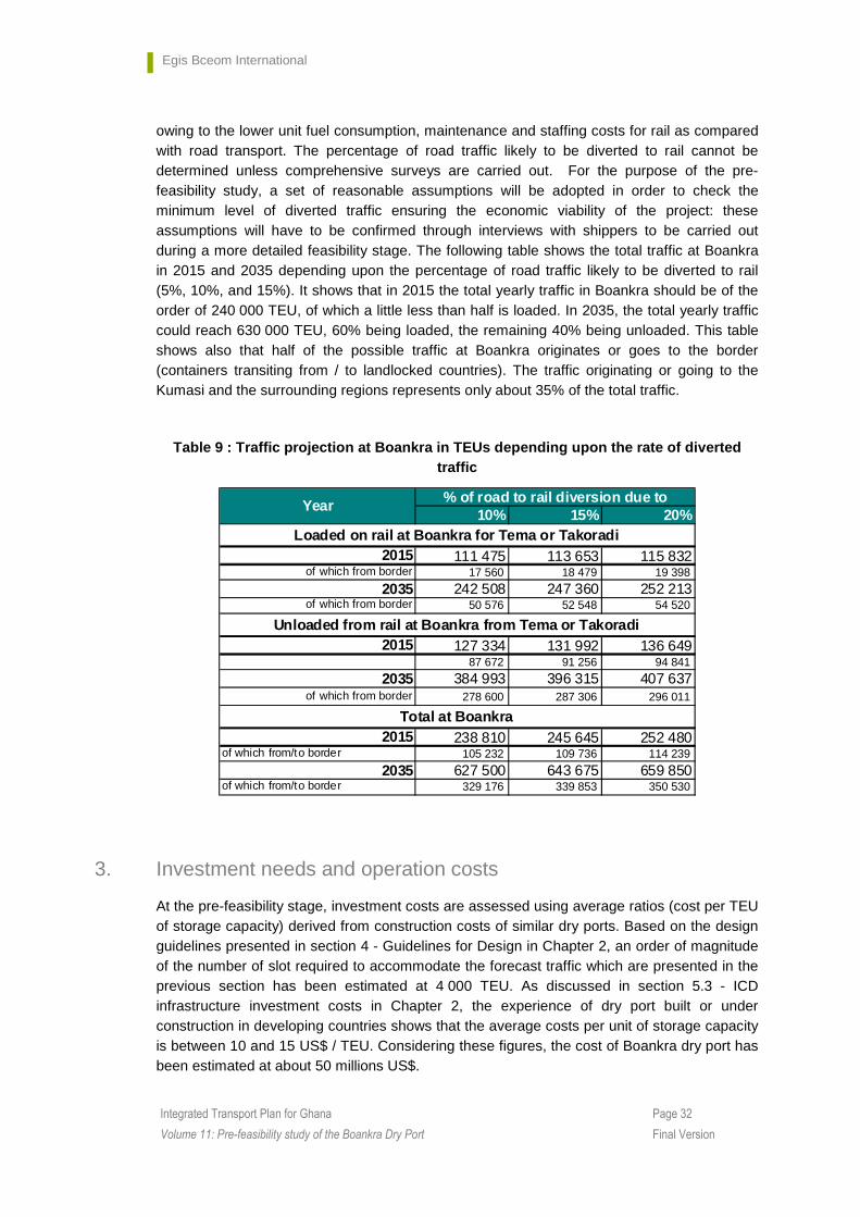
owing to the lower unit fuel consumption, maintenance and staffing costs for rail as compared with road transport. The percentage of road traffic likely to be diverted to rail cannot be determined unless comprehensive surveys are carried out. For the purpose of the pre-feasibility study, a set of reasonable assumptions will be adopted in order to check the minimum level of diverted traffic ensuring the economic viability of the project: these assumptions will have to be confirmed through interviews with shippers to be carried out during a more detailed feasibility stage. The following table shows the total traffic at Boankra in 2015 and 2035 depending upon the percentage of road traffic likely to be diverted to rail (5%, 10%, and 15%). It shows that in 2015 the total yearly traffic in Boankra should be of the order of 240 000 TEU, of which a little less than half is loaded. In 2035, the total yearly traffic could reach 630 000 TEU, 60% being loaded, the remaining 40% being unloaded. This table shows also that half of the possible traffic at Boankra originates or goes to the border (containers transiting from / to landlocked countries). The traffic originating or going to the Kumasi and the surrounding regions represents only about 35% of the total traffic.
Table 9 : Traffic projection at Boankra in TEUs dep ending upon the rate of diverted traffic
10% 15% 20%
2015 111 475 113 653 115 832of which from border 17 560 18 479 19 398
2035 242 508 247 360 252 213of which from border 50 576 52 548 54 520
2015 127 334 131 992 136 64987 672 91 256 94 841
2035 384 993 396 315 407 637of which from border 278 600 287 306 296 011
2015 238 810 245 645 252 480of which from/to border 105 232 109 736 114 239
2035 627 500 643 675 659 850of which from/to border 329 176 339 853 350 530
% of road to rail diversion due to
Unloaded from rail at Boankra from Tema or Takoradi
Loaded on rail at Boankra for Tema or Takoradi
Total at Boankra
Year
3. Investment needs and operation costs
At the pre-feasibility stage, investment costs are assessed using average ratios (cost per TEU of storage capacity) derived from construction costs of similar dry ports. Based on the design guidelines presented in section 4 - Guidelines for Design in Chapter 2, an order of magnitude of the number of slot required to accommodate the forecast traffic which are presented in the previous section has been estimated at 4 000 TEU. As discussed in section 5.3 - ICD infrastructure investment costs in Chapter 2, the experience of dry port built or under construction in developing countries shows that the average costs per unit of storage capacity is between 10 and 15 US$ / TEU. Considering these figures, the cost of Boankra dry port has been estimated at about 50 millions US$.

Egis Bceom International
Page 33 Integrated Transport Plan for Ghana
Volume 11: Pre-feasibility study of the Boankra Dry Port Final Version
One should note that a feasibility study of Boankra dry port has been carried out in 2002. The construction cost was then estimated at 30 millions US$ (2002). This figure is consistent with the former estimate derived from costs of dry ports recently built in developing countries, even though it may be slightly underestimated: considering an average 4% inflation rate applying to construction costs in US$ over the 2002 – 2010 period, the 2002 estimate in 2010 US$ would be about 40 millions US$ (2010).
Finally, considering that 400 ha of land have already been acquired and that the administration block complex has already been built at a cost of 3.1 millions US$, the present evaluation will consider an additional construction cost of 45 millions US$.
4. Institutional arrangements
As reported in the Development study (01/12/03), GPHA and GSC have purchased the land and are described as the initiators and owners. It is stated that they would both act as landlords, responsible for estate management, marketing and development of the primary infrastructure, the latter of which is described as the main road and utilities. The study envisaged that individual lots would be developed by private enterprises. No mention was made of the administration block on the site although it must be assumed that this would be considered part of the primary infrastructure.
Within the existing institutional framework, GPHA as owner and asset manager of Ghana’s maritime ports would be the natural owner of Boankra. Their involvement in this venture supports this principle but the involvement of GSC as joint owner and landlord is not compliant and may give rise to potential conflicts of interest. GSC does not have the same powers as GPHA and it is currently uncertain what legal agreements exist between them.
In line with its mandate and current role at Tema and Takoradi ports, it would be expected that GPHA would manage and maintain the port infrastructure, license individual private enterprises to develop and provide operations on individual plots and also license other port handling services within the port area.
However, some complications may arise in regard to the role of the Free Zone Board (FZB) as described in the Free Zone Act 1995 (Act 504).
Once licensed by the port owner, it is envisaged that ‘free zone enterprises’ (FZEs) would establish activities on the site. According to the Free Zone Act 1995 (Act 504), FZEs should be a body corporate with their own board but should also ‘report’ to the Free Zone Board (FZB) which subsequently reports to the Ministry of Trade and industry.
In this case and within the Free Zone Act, the port owner would also be considered the Free Zone Developer (FZD) and would also require a license to operate from the FZB. This means that the FZEs would require a license to operate from both the FZB and the FZD, the former in its regulatory role for free zones and latter in its role as landlord port owner.
Questions would also arise regarding ownership of the rail infrastructure and loading equipment but with Ghana Railway Development Authority (GRDA) recently mandated to plan and manage railway infrastructure it would seem that responsibilities are clearly defined and contractual boundaries could be easily described in legal agreements between the organisations.
Egis Bceom International
Page 34 Integrated Transport Plan for Ghana
Volume 11: Pre-feasibility study of the Boankra Dry Port Final Version
One concludes therefore that if Boankra is primarily a ‘free zone’ the free zone regulation will dominate. If Boankra is primarily an inland port with no special consideration for ‘free zone activities, then the port authority would dominate.
5. Evaluation of Boankra dry port
5.1 Methodology
The economic evaluation requires assessing the time series of costs and benefits in both “with project” (construction of the dry port) and “without” project alternatives during the duration of the project evaluation period. Based on the cash flow annual series (benefits minus costs for each year of the evaluation period), economic ratios like the Economic Internal Rate of Return [EIRR], the Net Present Value [NPV] for a given discount rate are evaluated.
It is expected that the main benefits from the construction of the dry port come from the reduction of transport costs resulting from the modal shift from road to rail due to the enhanced competitiveness of intermodal transport operations. Although other benefits may not be negligible, most of them are difficult – and some are impossible - to quantify; at the present pre-feasibility level, these additional benefits will not be considered. The approach followed by the Consultant will be limited to the determination of the level of diverted traffic (i.e. the % of the road traffic likely to be shifted to rail) which would make the project economically viable.
5.2 Assessment of benefits
As mentioned above, for the purpose of this pre-feasibility study, the only benefits which are considered are benefits accruing from the reduction of transport costs resulting from the modal shift from road to rail.
Data about transport costs of containers per km in Ghana and in the sub-region have been obtained by the Consultant from the Tema – Akosombo – Buipe multi-modal transport study carried out in 2008 on behalf of the Ministry of Ports, Harbours and Railways (pre-feasibility of the rail – Volta Lake multi-modal transport corridor). This study presented the findings of interviews with transporters and shippers carried out in March 2008 and the result of the review and update of cost data presented in previous studies including a comprehensive review of transport costs along the sub-regional transit corridors which has been carried out in 2004 under a USAID funding.
The findings of this study are presented in Table 10 which gives the transport cost for one container in US $ / km depending upon the total length of the journey. One of the findings of this study is that transport costs by road decrease when the distance increases but remains significantly higher than transport costs by rail, which do not significantly differ depending upon the distance.

Egis Bceom International
Page 35 Integrated Transport Plan for Ghana
Volume 11: Pre-feasibility study of the Boankra Dry Port Final Version
Table 10 : Average transport costs in Ghana and the sub-region (in US $ / km for one 20’ container)
Distance Road Rail< 500 km 2.9500 to 1000 km 2.61000 to 1500 km 2.5above 1500 km 2.0
1.6
Considering these figures, the benefits from shifting from road to rail can be simply evaluated: � For containers transported between the seaports and Kumasi, the benefits resulting from
modal shift to rails is 1.3 US $ / km per container � For containers transported between the seaports and Northern Ghana, the benefits
resulting from modal shift to rail is about 1 US $ / km per container ; � For containers transported to land-locked countries with distance of about 1 500 km, the
benefits resulting from modal shift is about 0.9 US $/km per container
Finally, depending upon the percentage of road traffic likely to be diverted on rail, the annual gross benefits from modal shift are as shown on Table 11. About half of these benefits are generated by transit traffic to / from landlocked countries.
Table 11 : Annual gross benefits from reduction of transport costs from modal shift from road to rail in million US $
10% 15% 20%Gross benefits from
reduction of transport costs in 2015 4.29 6.44 8.58
Gross benefits from reduction of transport
costs in 2035 10.27 15.41 20.54
% of road to rail diversion due to BoankraYear
Even if only 10% of the road traffic is shifted to rail, savings on transport costs are important: 4.29 millions US $ in 2015. Obviously, the corresponding benefits are partly counterbalanced by the costs incurred at the dry port for modal transfer from road to rail and vice-versa (handling costs).
Based on the Consultant experience and on an analysis of GPHA handling rates at Tema and Takoradi, it is estimated that total operation and maintenance costs at the dry port would be of the order of magnitude of 75 US $ / container. Considering this value, the net benefits from modal shift from road to rail is shown on the following table.
Table 12 : Annual net benefits from modal shift fro m road to rail in million US $
10% 15% 20%Net benefits from modal
shift in 2015 3.27 4.90 6.54Net benefits from modal
shift in 2035 7.82 11.73 15.64
Year% of road to rail diversion due to
Boankra
Even if only 10% of the road traffic is shifted to rail, net benefits from modal shift are still significant: 3.27 millions US $ in 2015.

Egis Bceom International
Page 36 Integrated Transport Plan for Ghana
Volume 11: Pre-feasibility study of the Boankra Dry Port Final Version
5.3 Results of the evaluation
Considering the dry port is built in 2014 with a remaining construction cost amounting to 45 millions US $, and considering the net benefits shown in the previous paragraph, the Economic Internal Rate of Return (EIRR) and the Net Present Value (NPV) with a 12% discount rate are shown on the following table.
Table 13 : Results of the economic evaluation
10% 15% 20%EIRR 9% 13% 18%
NPV in millions US $ -10.15 4.39 18.94
Year% of road to rail diversion due to
Boankra
This table shows that in order to obtain an EIRR of 12% which is considered as acceptable for such a project in developing countries, the percentage of road traffic to be diverted to rail is slightly below 15% which seems to be an achievable objective.
One should keep in mind that the previous analysis only considers benefits from reduction of transport cost due to diversion of traffic from road to rail rendered possible by the construction of the dry port.
As discussed in section 6 - Benefits from dry ports, in Chapter 2, the construction of a dry port results in a number of other benefits some of them being difficult or impossible to quantify; they include: � Direct benefits including reduction of congestion and higher productivity at the seaport,
time savings for the entire journey, reduction of intermodal transfer costs, reduction of road congestion in both the city centres and the highway network, improvement of the road safety and reduction of road maintenance
� Indirect benefits including development of regional trade, new investments in the region, development of export of regional productions, opportunities for developing new private companies with corresponding working opportunities, reduction of unemployment and poverty reduction, etc.
Considering these additional direct and indirect benefits would improve the economic viability of the project and reduce the minimum level of traffic diverted from road to rail which makes the project economically viable.
6. Social impacts
6.1 Methodology
The methodology adopted for the study combined desk studies of background documents with field interviews and consultations with the Ghana Shippers Authority in Accra and Kumasi and the Ejisu-Juabeng Municipal Assembly.
Desk Study:
� Secondary data studied include:
� Project background documents
� Bonifica report

Egis Bceom International
Page 37 Integrated Transport Plan for Ghana
Volume 11: Pre-feasibility study of the Boankra Dry Port Final Version
� Reference material at www. Ghanadistricts.com
� Ghana – Burkina Faso Railway study: SIA
Field study:
The field study involved visits to the Ghana Shippers Authority in Accra and Kumasi and the Ejisu-Juabeng Municipal Assembly. There was also a study tour and observation of facilities of the inland port.
6.2 Positive Impacts
6.2.1. Opening up of the area
The inland port is expected to open up the Boankra area and its vicinity to economic activities. In addition to the core businesses to be created by the inland port, other supporting businesses will be created to support the added population likely to be drawn to the area. The two communities directly linked to the project, Boankra and Hwereso will expand to accommodate the population influx leading to growth in social services and other amenities associated with urban centers.
6.2.2. Improvement in travel safety
The establishment of an inland port is expected to lead to improvements in travelling safety. Firstly, it will reduce travel distance to the point of goods collection; goods meant for the northern sector of the country and land-locked countries will be collected from the centre of the country rather than from the coast. The provision of restrooms and hostels will also encourage long distance truck drivers to rest leading to fewer road accidents. The hazards of travelling long distances by road will be considerably reduced.
6.2.3. Job Creation
Employment opportunities will arise from the inland port project itself as well as the ancillary businesses associated with it which will absorb some of the local labor. In addition, individuals could open businesses in the services industry and commodity retail to further serve the increased population. Farmers will require extra farm workers as they expand their production to meet the needs of the additional population.
6.2.4. Poverty Reduction
With the opening up of the project area and an increase in employment opportunities, incomes are likely to rise, leading to poverty reduction.
6.2.5. Enhancement of Social Life
As the original communities become increasingly urbanized, social life will be enhanced by the provision of more social infrastructure such as schools, health facilities and recreational venues which will be provided by both the public and private sectors.
Egis Bceom International
Page 38 Integrated Transport Plan for Ghana
Volume 11: Pre-feasibility study of the Boankra Dry Port Final Version
6.3 Negative Impact and Mitigation
6.3.1. Population Influx
Any increase in population is likely to put pressure on existing social infrastructure during the initial stages of the project due to their inadequacy. Current infrastructure has been created to serve a particular number of people and these numbers will increase as soon as the project starts but any increase will take time and in meantime existing facilities will be stretched to their limit. The inclusion of some social infrastructure in the project itself will alleviate the situation. As the population increases criminality will also increase due to the loosening of social ties. Vigorous policing will help ensure that crime is kept to a minimum.
6.3.2. Increased Incidence of HIV/AIDS
The presence of large concentrations of migrant workers separated from their families and are mostly young and healthy will lead to a tendency to have multiple sexual liaisons. Such behaviour will expose more people to the virus and may lead to a higher number of infections. A good workplace HIV/AIDS policy operated by the contractor and a vibrant anti-HIV/AIDS campaign program for the host communities will keep infections to a minimum level.
6.3.3. Child Delinquency/Teenage Pregnancy
A boom in economic activities may also tempt children to become involved in the labour market leading to frequent absence from school or complete dropout altogether. Men with money may also entice young girls into sexual relationships resulting in unwanted pregnancies and the further spread of HIV/AIDS among that segment of the population. Intensive awareness rising of the dangers involved in delinquency and an affirmation of the value of children’s education, especially for the girl-child, among community members would go a long way to arrest the situation. To further reinforce the disincentives, the traditional authority can be encouraged to institute penalties for parents who do not keep their children in school or exercise proper control over them.
7. Environmental impacts
7.1 Legal background
The Environmental Protection Agency Act, 1994 (Act 490) mandates the Agency “to ensure compliance with any laid down environmental impact assessment procedures in the planning and execution of development projects, including compliance in respect of existing projects”. Additionally, the Environmental Assessment Regulations, 1999 (LI 1652) stipulate that “no person shall commence activities in respect of any undertaking which in the opinion of the Agency has or is likely to have adverse effect on the environment or public health unless, prior to the commencement, the undertaking has been registered by the Agency in respect of the undertaking”.
The construction of ports is listed among undertakings for which environmental impact assessment is mandatory in Schedule 2 of the Environmental Assessment Regulations. And the Regulations states that no environmental permit shall be issued by the Agency for any of
Egis Bceom International
Page 39 Integrated Transport Plan for Ghana
Volume 11: Pre-feasibility study of the Boankra Dry Port Final Version
the undertakings mentioned in Schedule 2 unless the person responsible for the undertaking has submitted an environmental impact assessment to the Agency.
The Ghana Shippers’ Council (GSC), the proponent of the project, will therefore be obliged to liaise with the Environmental Protection Agency (EPA) regarding the registration of the project and the subsequent environmental impact assessment to be carried out on it.
7.2 Environmental Context
The proposed inland port will be located at Boankra in the Ejisu-Juaben municipality of the Ashanti region. The central location of the municipality in the Ashanti Region provides enormous opportunity for the development of the inland port for Ghana to serve the northern section of the country. The plot of land earmarked for the port is 400 acres (161 hectares).
The project site is located in an area characterized by double maxima rainfall; with a major rainfall season lasting from March to July and a minor season which begins in September and normally ends in the latter part of November. The annual rainfall ranges between 1092 and 2344 mm with a mean annual value of about 1874 mm. Temperatures are high, ranging between 25°C and 30°C.
The project area is drained mainly by the Penema stream, a seasonal stream, which flows through the project site.
The original vegetation of the area is the semi-deciduous forest. However, unsustainable farming practices and timber harvesting have resulted in the natural vegetation cover being degraded into a secondary forest.
The Ejisu-Juaben municipality is predominantly underlain by crystalline rocks. These rocks belong to the Birimian Granites formation. The Birimian formation commonly occurs in the northwestern corner of the municipality and a smaller portion in the south. It has two main divisions, the lower and upper Birimian series, with the lower Birimian series dominating.
7.3 Issues of Environmental Concern
Locating the inland port in an area with the characteristics described above, raises issues of environmental concern that will have to be factored into the planning, designing and operation of the facility. Some of the issues include:
7.3.1. Land use changes
The development of the port on the proposed site will significantly alter the land use pattern in the area. To ensure compatibility of the port activities and adjoining land uses may require a (re)zoning of the area from agricultural land to an industrial/commercial one to reflect the changes in the land use pattern. Re-zoning of the area will help in ensuring that developments in the area are planned and will not create any challenges to the operations at the port. For instance, having farms on the lands adjacent to the port will create conditions for bushfires which could have serious negative impacts on life and property at the port. The GSC will have to liaise with the Ejisu Juaben Municipal Assembly to have the rezoning affected.

Egis Bceom International
Page 40 Integrated Transport Plan for Ghana
Volume 11: Pre-feasibility study of the Boankra Dry Port Final Version
7.3.2. Environmentally Sensitive Areas (ESAs)
Listed in Schedule 5 of Environmental Assessment Regulations are twelve environmentally sensitive areas, namely:
� All areas declared by law as national parks, watershed reserves, wildlife reserves and sanctuaries including sacred groves.
� Areas with potential tourist value.
� Areas which constitute the habitat of any endangered or threatened species of indigenous wildlife (flora and fauna).
� Areas of unique historic, archaeological or scientific interests.
� Areas which are traditionally occupied by cultural communities.
� Areas prone to natural disasters (geological hazards, floods, rainstorms, earthquakes, landslides, volcanic activity etc.)
� Areas prone to bushfires.
� Hilly areas with critical slopes.
� Areas classified as prime agricultural lands.
� Recharge areas of aquifers.
� Water bodies characterized by one or any combination of the following conditions –
• water tapped for domestic purposes;
• water within the controlled and/or protected areas;
• water which support wildlife and fishery activities.
� Mangrove areas characterized by one or any combination of the following conditions-
• areas with primary pristine and dense growth
• areas adjoining mouth of major river system;
• areas near or adjacent to traditional fishing grounds;
• areas which act as natural buffers against shore erosion, strong winds or storm floods.
Due to their sensitive nature, the areas enumerated above are to be avoided, where possible, by all projects. Ensuring that the provision of the port facility and infrastructure does not impact adversely on any of these areas should inform the location and design of inland port facilities and operations. Should the development of the port affect any of these areas, the EPA will demand stringent environmental assessment from the proponent. The avoidance of any of the environmentally sensitive areas or the management of impacts of constructional or operational activities should be considered in the project’s construction management plan as well as overall development plan.
7.3.3. Air Pollution
The project site is located in a rural environment where the quality of air can be assumed to be good as there are no identifiable sources of pollution. The quality of air will, however, be
Egis Bceom International
Page 41 Integrated Transport Plan for Ghana
Volume 11: Pre-feasibility study of the Boankra Dry Port Final Version
impacted negatively when site preparation and construction works begin. Site preparation and construction works will involve excavation and other earthmoving activities that will expose loosened soils. Dust or particulate matter will be blown into the atmosphere by wind. The movement of heavy construction equipment and supply-delivering trucks on the exposed soils will throw plumes of dust particles into the air. The delivery of sand, gravels and chippings to the project sites will also release plumes of dust into the atmosphere. The resultant increase in the levels of dust or particular matter in the atmosphere will be a nuisance, particularly to the workers on site and depending on the direction of the prevailing wind, to the residents of Boankra.
Dust suppression measures such as frequent spraying of water on construction sites and on exposed earth surfaces and covering of transportation vehicles with tarpaulins will have to be outlined in the construction management plan for the management of particulate dust releases into the atmosphere.
Vehicular emissions will be generated during both the constructional and operational phases of the project. Exhaust fumes from heavy construction equipment and vehicles and haulage trucks and equipment at the port would increase the concentration of greenhouse gases (carbon monoxide, nitrogen oxide, sulfur dioxide) and smoke particulates in the air. Another source of emission at the port will be air pollutants typically associated with the stationary combustion of fossil fuel in stationary power generating sets.
The project contractor(s) will have to develop an environmental management plan for the project. The plan should include measures such as the servicing of vehicles and equipment and training of equipment operators and drivers in fuel efficiency in order to reduce exhaust emissions.
7.3.4. Water Quality
Most of the 161 hectares of land will be cleared of all vegetation and other obstacles for the development of the inland port. Due to agricultural activities on the site and wildfires over the years, it is unlikely that any plants and/or animals of conservation significance will be encountered on the site. However, the clear removal of the vegetation will expose the land to the forces of erosion, mainly rain and wind. Various construction activities on the site including excavations will also break up soil structures making them susceptible to erosion.
Exposed and loosened soils washed by storm water could end up in the Penema stream which drains the project area. Besides affecting the flow of the stream, sedimentation will impact negatively on the water quality. The potential pollution of the stream has health implications since it serves as a source of drinking water for rural settlements downstream.
Putting in measures such as stabilizing exposed surfaces to protect the Penema stream from sedimentation and pollution should be an important consideration in the development and implementation of a construction management plan for the project.
7.3.5. Noise Pollution
The project site is located in an agricultural area and there are no industries or noise generating activities in the vicinity of the site. Background noise levels at the project site are therefore low. The serenity of the site and its environs will, however, be disturbed with the

Egis Bceom International
Page 42 Integrated Transport Plan for Ghana
Volume 11: Pre-feasibility study of the Boankra Dry Port Final Version
commencement of site preparation and construction works at the project site. Ambient background noise and vibration levels are expected to appreciate during the day because of various construction activities including excavations, drilling, piling, ramping and the operation of heavy construction equipment and trucks. Excessive noise levels will disturb the workers on site and possibly the residents of Boankra, depending on the direction of the prevailing wind.
During the operational phase, the major sources of noise at the port that may potentially affect the community are: � constant movement of heavy duty articulated trucks hauling goods to and from the port � movement of heavy duty haulage equipment � periodic noise generation from stand-by diesel-powered generators during power outages.
Appropriate noise abatement measures will have to be incorporated in a construction management plan and an operational plan for the project.
7.3.6. Waste Management
Preparation and construction works at the project site and the use of large volumes of materials will result in the generation of construction waste. Trees and bushes cleared from the project site, material wastes in the form of wood, metal, glass and plastic off-cuts as well as wooden, cardboard and polythene packaging materials will be generated as waste during the construction of the port facility.
During the operation of the port, waste in the form of packaging materials, damaged goods and domestic solid and liquid waste will be generated. Another important waste that will be generated at the port, particularly during the operational phase will include waste oils from trucks and equipment, spilled oils and leaked chemicals and solvents.
The host community lacks facilities for the management of large volumes of wastes, some of which could be hazardous. An elaborate waste management plan, covering both the constructional and operational phases of the project, should therefore be developed for the handling of both liquid and solid waste.
7.3.7. Traffic Impacts
The construction and operation of the inland port will result in an increase in traffic volume, especially on the section of the Kumasi-Accra in the vicinity of the project site. The presence of heavy duty trucks supplying materials to the site as well as construction trucks and other vehicles and equipment will add to the existing traffic volume on the Accra-Kumasi road. Due to their slow moving nature, the presence of these trucks and vehicles on the road could impact adversely on traffic flow and road safety.
With the operation of the port, there will be tremendous increase in the number of articulated trucks and other heavy duty cargo trucks on the Accra-Kumasi road. These trucks will be conveying goods mainly in containers from the Tema port to the inland port facility and from Boankra to Kumasi and beyond. The increase in articulated traffic volume on the Kumasi-Accra road will have implications for traffic flow, road safety and accidents.

Egis Bceom International
Page 43 Integrated Transport Plan for Ghana
Volume 11: Pre-feasibility study of the Boankra Dry Port Final Version
Due to the potential impacts of the inland port on traffic on the Accra-Kumasi road and the implications for human lives through accidents, the project design must necessarily include the development and implementation of an elaborate traffic management plan.
7.3.8. Safety and Health
Both construction works and operations at the port can compromise the safety and health of workers and residents of the host community. The workers on site will be exposed to: dust pollution and its attendant respiratory difficulties, high level noise and vibration that could result in temporary or permanent hearing loss, injuries resulting from falling from heights and falling objects, as well as from the (mis)use of equipment and tools, cuts from stepping on sharp objects such as nails and other metal off-cuts, injuries resulting from clashes between vehicles and the workers as they both operate within the same space. Residents of Boankra who access the project site during construction will also be exposed to these dangers.
With the constant movement of articulated trucks and haulage equipment and of persons at the port, there could be vehicular-pedestrian conflicts with the attendant injuries and even loss of lives.
Inadequate management of wastes during both constructional and operational phases of the project will create conditions for the growth of vectors of diseases such as cholera and dysentery. The outbreak of these diseases would have far-reaching negative implications for the health of the workers and residents in the project area.
During both the constructional and operational phases, a lot of persons will migrate to the project area to work. The congregation of in-coming workers will increase the risk for the spread of diseases, including sexually transmitted diseases such as HIV/ AIDS.A health and safety management plan, covering workers and the public during both the constructional and operational phase of the project, should be developed. The plan should include measures to restrict access to the site by unauthorized persons, the provision of personal protective equipment and safety training for the workers and an HIV/AIDS Awareness Programme for the benefit of both workers and residents of the area. The plan should also spell out best practices in managing health and safety threats especially in a busy port environment.
7.3.9. Fires
The potential for the outbreak of fires is a threat that should be considered in the design and operation of the port. There would be significant potential sources of fire at the port. The port will be developed in the midst of an agricultural area with luxuriant growth of vegetation and farms on adjoining lands. Fires from the uncontrolled burning of farmlands could spread to affect property and lives at the port. The outbreak of wildfires (bush fires) in the area could also have similar effects.
Fires from electrical sources could be a real threat during the operational phase of the port. The use of inferior cables, faulty electrical wiring, improper installation and misuse of equipment and appliances, and overloading of circuits are all electrical faults, which if not detected early and rectified could result in extensive fires.
The prevention and management of fires should therefore be factored into the design and operations at the port. A fire prevention and management plan will have to be developed for
Egis Bceom International
Page 44 Integrated Transport Plan for Ghana
Volume 11: Pre-feasibility study of the Boankra Dry Port Final Version
the project. The plan could include measures such as the provision of water hydrants, fire extinguishers and fire alarms as well as training of workers in fire prevention and management.
7.3.10. Archaeological and Cultural Artifacts
The likelihood of disturbing unexplored sites of archaeological and cultural significance during site preparation and construction works appears to be low as there is no evidence of such sites on the project site. However, it is important that this potential impact is considered and appropriate mitigation proposed for it. A standard mitigation for chance finds is that if any archaeological or cultural relics are found, work ceases immediately until relevant authorities have a chance to evaluate the significance and nature of such findings. The management of chance finds should be considered in the construction management plan for the project.
7.3.11. Landscape Modification
The construction of the port facility will require large volumes of materials including granite chippings, sand, and gravels. The winning of these materials will result in landscape modification at quarries, sand and gravel pits. Besides, the effect of these excavated pits on visual quality, they could hold stagnant water and thereby create conditions for the breeding of water-borne disease vectors such as mosquitoes. These pits could also pose a danger to residents of communities in these resource areas. The restoration or reclamation of the quarries, sand and gravel pits have to be considered as an important component of the project’s decommissioning plan.
7.3.12. Induced impacts
The development of the port will attract commercial and residential developments to Boankra and its environs. These developments could have implications for the environment in terms of unplanned housing developments, increase in waste generation, increased pressure on utilities and social infrastructure, including health facilities, and high incidence of diseases. The project proponent will have to work with the Ejisu-Juaben Municipal Assembly to plan the anticipated induced developments in the project area.
7.3.13. Conclusion on environmental impacts
Constructing and operating an inland port in the proposed project area is likely to have some environmental impacts. The magnitude of the impacts will, however, depend on the intensity of constructional and operational activities.
Adopting an environmentally based approach to the design and development of the inland port at Boankra will be the key to ensuring that the environmental impacts of the project are identified and addressed appropriately. This will involve the development of elaborate plans, the implementation of which will help in dealing with the impacts.
Egis Bceom International
Page 45 Integrated Transport Plan for Ghana
Volume 11: Pre-feasibility study of the Boankra Dry Port Final Version
8. Conclusions and recommendations
One should first insist that the construction of a dry port near Kumasi should only be envisaged once definite decisions have been taken in order to rehabilitate – reconstruct the railway lines between Kumasi and Ghanaian seaports (Tema and Takoradi).
The economic analysis presented in the previous chapter shows that the construction of such a dry port in the surrounding of Kumasi is likely to be economically viable. It is thus recommended that a comprehensive feasibility study of the dry port is carried out. This feasibility study will be aimed at:
� Interviewing the stakeholders, and particularly shippers, in order to determine the order of
magnitude of the traffic likely to be diverted from road to rail due to the construction of the dry port
� Carrying out a preliminary design of the infrastructures and superstructures to be built at the dry port and estimating the corresponding construction and operation costs
� Quantify whenever possible all benefits generated by the dry ports, including all direct benefits and possibly indirect benefits
� Carry out a full economic and financial evaluation of the construction of the dry port
The feasibility study should also review institutional aspects in order to answer to the following questions: who will finance and who will manage the dry port? It is recommended that the dry port is built and managed by a dedicated autonomous body where the private sector is highly involved (if not totally private). If any, the financial participation of the Government, directly or through public agencies (GRC, GPHA), should be limited to the construction of the infrastructures such as rail tracks, road access and main road network within the inland port, connection to the water sewage, electricity and telephone network.
It is also recommended that this feasibility study envisage possible alternative locations for the construction of a dry port near Kumasi: as discussed above, Boankra is located south east of Kumasi and relatively far (28 km) from Kumasi. This is certainly not the optimum location for diverting to rail the road traffic originating from / going to Kumasi and Takoradi. The risk is then that Boankra is not attractive enough for this traffic and that the level of traffic diverted from road to rail falls significantly. A more “central” location, nearer to Kumasi centre, would probably be preferable in order to optimise the logistic transport chain for traffic originating from / going to Takoradi and Kumasi.
One should also notice that the location of the dry port should probably be reconsidered if the railway happens to be extended further north from Kumasi: indeed, most of the benefits generated by the dry port comes from the transit traffic to landlocked countries and, to a lesser extent, to Northern Ghana (as discussed above, the traffic originating from / going to Kumasi only represents 35% of the total expected traffic at the dry port).