Integrated Tiger Habitat Conservation Programme Project ... · Integrated Tiger Habitat...
16
Integrated Tiger Habitat Conservation Programme Project portfolio snapshots Project portfolio snapshots
Transcript of Integrated Tiger Habitat Conservation Programme Project ... · Integrated Tiger Habitat...

Integrated Tiger Habitat Conservation Programme
Project portfolio snapshotsProject portfolio snapshots

A development programme financed by the
Federal Republic of Germany
through KfW Development Bank
Integrated Tiger Habitat Conservation Programme
Project portfolio snapshots (February 2019 version)

INTEGRATED TIGER HABITAT CONSERVATION PROGRAMME CURRENT PORTFOLIO*
Aaranyak
0 600300
Kilometers
WWF
DoFPS Bhutan
WCS
FFI
WWF
ZSL*as of February 2019
NCF
FFI
MFD
Tiger Conservation
Landscapes
ITHCP projects
Wildlife Asia
WTI / WildTeam

Objective: Increasing tiger populations through improved
management and monitoring of five transboundary
tiger sites in Nepal and India, with foci on law enfor-
cement, biological monitoring, and sustainable
development for local communities in the surrounding
landscape.
Highlights (project outcomes):
• Improved on-site law enforcement in Sukla, Parsa, Bardia,
Banke and Nandaur reduces tiger poaching over the
3-year period
Current tiger population: ~198-> Expected increase to: ~238 tigers
• Improved management effectiveness in 5 PAs (Sukla and
Parsa Wildlife Reserve, Bardia and Banke National Parks
and Nandaur Wildlife Sanctuary) supports the monitoring
and conservation of tiger populations over the 3-year period
• Human-tiger conflict prevention and mitigation measures
established across Sukla, Bardia, Banke and Nandaur PA
reduces the negative impacts of living with tigers over the
3-year period.
• Access to improved and alternative livelihoods for com-
munity members living around the Sukla, Bardia, Banke
and Nandaur PAis improved over the 3-year period
Project investments:
• Construction and repair of roads, guard posts and watch towers in the
core area of all five Pas
• Improvement of PA acilities (solar power sources, drinking water, toilets
and communication systems)
• Establishment of rapid response units in each PA, fully resourced with
vehicles, communication, detection and evidence handling equipment
• Installation of GSM camera-based early warning systems for illegal
activity, long range wi-fi system for CCTV cameras to stop poachers
Sustainable livelihoods:
• Development of homestays, trekking tourism and tiger tracking (with
support of loft loans scheme)
• Installation of predator-proof corrals and insurance scheme against HTC
• Alternative fuels, alternative fodder crops to reduce grazing
• Development of and training on alternative livelihoods (e.g. essential
oils production)
Zooogical Society of London (Nepal-India)Code 1327 - Partners: International NGO; National /Local NGOs & Government Agencies.
>Tiger Conservation Landscapes n° 40, 41, 42, 43<
INDIA
Project Lead: Zoological Society of London (ZSL)
Project Partners: Department of National Parks and Wildlife Conservation (DNPWC, NP); Uttarakhand Forest Department (UKFD, IN);
National Trust for Nature Conservation (NTNC); Himalayan Nature (HN); Panthera; Wildlife Conservation Trust (WCT); Wildlife Institute of India (WII)
Nandaur Wildlife
Sanctuary (IN)
Sukla Phanta
Wildlife Reserve (NP)
Bardia National
Park(NP)
Banke National
Park(NP)
Parsa Wildlife
Reserve (NP)
NEPAL
INDIA
CHINA
NEPAL
IUCN-KfW funding: 2.6 million EUR
Map Sources: Zoological Society of London, IUCN, Protected Planet, Esri, HERE, DeLorme, TomTom,
Intermap, increment P Corp., GEBCO, USGS, FAO, NPS, NRCAN,GeoBase, IGN, Kadaster NL, Ordnance
Survey, Esri Japan, METI, Esri China (Hong Kong), swisstopo, MapmyIndia, © OpenStreetMap contributors,
and the GIS User Community
35 70 140Km
0
Main Protected Areas
Project Areas (5)
Buffer zones of main PAs
Other Protected Areas
CHINA
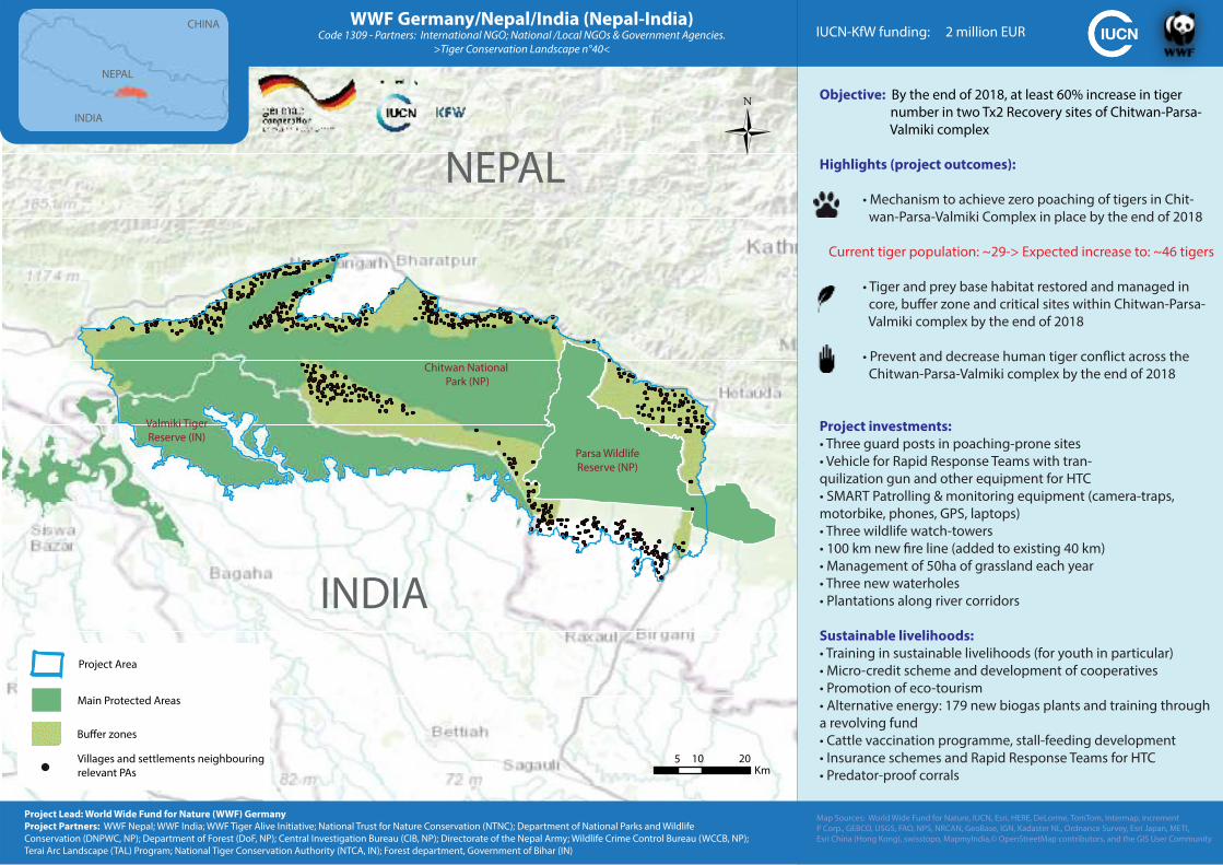
Objective: By the end of 2018, at least 60% increase in tiger
number in two Tx2 Recovery sites of Chitwan-Parsa-
Valmiki complex
Highlights (project outcomes):
• Mechanism to achieve zero poaching of tigers in Chit-
wan-Parsa-Valmiki Complex in place by the end of 2018
Current tiger population: ~29-> Expected increase to: ~46 tigers
• Tiger and prey base habitat restored and managed in
core, buffer zone and critical sites within Chitwan-Parsa-
Valmiki complex by the end of 2018
• Prevent and decrease human tiger conflict across the
Chitwan-Parsa-Valmiki complex by the end of 2018
Project investments:
• Three guard posts in poaching-prone sites
• Vehicle for Rapid Response Teams with tran-
quilization gun and other equipment for HTC
• SMART Patrolling & monitoring equipment (camera-traps,
motorbike, phones, GPS, laptops)
• Three wildlife watch-towers
• 100 km new fire line (added to existing 40 km)
• Management of 50ha of grassland each year
• Three new waterholes
• Plantations along river corridors
Sustainable livelihoods:
• Training in sustainable livelihoods (for youth in particular)
• Micro-credit scheme and development of cooperatives
• Promotion of eco-tourism
• Alternative energy: 179 new biogas plants and training through
a revolving fund
• Cattle vaccination programme, stall-feeding development
• Insurance schemes and Rapid Response Teams for HTC
• Predator-proof corrals
WWF Germany/Nepal/India (Nepal-India)Code 1309 - Partners: International NGO; National /Local NGOs & Government Agencies.
>Tiger Conservation Landscape n°40<
NEPAL
INDIA
Parsa Wildlife
Reserve (NP)
Valmiki Tiger
Reserve (IN)
Chitwan National
Park (NP)
NEPAL
INDIA
CHINA
Main Protected Areas
Project Area
Villages and settlements neighbouring
relevant PAs
Buffer zones
IUCN-KfW funding: 2 million EUR
Map Sources: World Wide Fund for Nature, IUCN, Esri, HERE, DeLorme, TomTom, Intermap, increment
P Corp., GEBCO, USGS, FAO, NPS, NRCAN, GeoBase, IGN, Kadaster NL, Ordnance Survey, Esri Japan, METI,
Esri China (Hong Kong), swisstopo, MapmyIndia,© OpenStreetMap contributors, and the GIS User Community
Project Lead: World Wide Fund for Nature (WWF) Germany
Project Partners: WWF Nepal; WWF India; WWF Tiger Alive Initiative; National Trust for Nature Conservation (NTNC); Department of National Parks and Wildlife
Conservation (DNPWC, NP); Department of Forest (DoF, NP); Central Investigation Bureau (CIB, NP); Directorate of the Nepal Army; Wildlife Crime Control Bureau (WCCB, NP);
Terai Arc Landscape (TAL) Program; National Tiger Conservation Authority (NTCA, IN); Forest department, Government of Bihar (IN)
5 10 20Km
0

•
•
•
••
•
•••••
••••
•••
0
Objective: Achieve 50% increase in tiger population in the project
area in the next 10 years by reducing human disturbances in the
habitat and thus increasing the tiger and prey population.
Highlights (project outcomes):
• Protection and recovery of tiger population through
Law Enforcement
Current tiger population: ~13-> Expected increase to: ~20 tigers
• Evaluate conservation effectiveness through long-term
monitoring of tigers, prey, and threats
• Improve livelihoods and conservation education to
reduce pressure from local people on tigers, their prey
and habitat.
Aaranyak (India)Code 1334 - Partners: Government agencies, international non-profits, national non-profits
>Tiger Conservation Landscape n° 37<
Project investments:• Seven new antipoaching camps and watch towers (West side)
• Equipment (vehicles, GPS, binoculars, phones, bikes...)
• Two Community Tiger Conservation Interpretation Centers with
exhibition and shop for local products and community meeting /
training hall
• Laptops & printers
Sustainable livelihoods:• Biogas reactors
• Improved cooking stoves
• Three tree nurseries
• Reconversion of poachers to new livelihoods (piggery, fishery,
mushroom farming, agroforestry)
• Improved cattle and vet support
• Fodder
• Jobs at patrols
• Alternative fuels
• Awareness through film on Manas
BHUTAN
INDIA
Royal Manas
National Park
Manas
National ParkManas
Reserved Forest (RF)Daodhora
RF
Batabari
RF
Dihira
RF
Subankhata
RF
IUCN-KfW funding: 1 - 1.5 million EUR
Project Area
Buffer zones
Target Protected Areas
Other Protected Areas
Village boundaries
0 5 10 20Km
BHUTANNEPAL
CHINA
INDIA
BANGLADESH
Map Sources: Aaranyak, IUCN, Protected Planet, Esri, HERE, DeLorme, TomTom, Intermap, increment P Corp.,
GEBCO, USGS, FAO, NPS, NRCAN, GeoBase, IGN, Kadaster NL, Ordnance Survey, Esri Japan, METI, Esri China
(Hong Kong), swisstopo, MapmyIndia, © OpenStreetMap contributors, and the GIS User Community
Project Lead: Aaranyak
Project Partners: Awely; Panthera; Wildlife Conservation Trust; Forest Department Bodoland Territorial Council
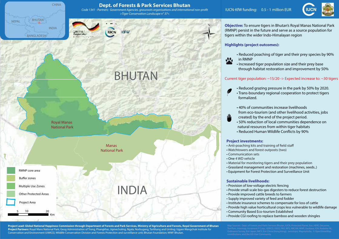
Objective: To ensure tigers in Bhutan’s Royal Manas National Park
(RMNP) persist in the future and serve as a source population for
tigers within the wider Indo-Himalayan region
Highlights (project outcomes):
• Reduced poaching of tiger and their prey species by 90%
in RMNP
• Increased tiger population size and their prey base
through habitat restoration and improvement by 50%
Current tiger population: ~15/20 -> Expected increase to: ~30 tigers
• Reduced grazing pressure in the park by 50% by 2020.
• Trans-boundary regional cooperation to protect tigers
formalized.
• 40% of communities increase livelihoods
from eco-tourism (and other livelihood activities, jobs
created) by the end of the project period.
• 50% reduction of local communities dependence on
natural resources from within tiger habitats
• Reduced Human Wildlife Conflicts by 90%
Dept. of Forests & Park Services BhutanCode 1341 - Partners: Government Agencies. grassroots organisations and international non-profit
>Tiger Conservation Landscape n° 37<
BHUTAN
INDIA
Royal Manas
National Park
Manas
National Park
Project investments:• Anti-poaching kits and training of field staff
• Watchtowers and forest outposts (two)
• Communication sets
• One 4 WD vehicle
• Material for monitoring tigers and their prey population
• Grassland management and restoration (machines, seeds..)
• Equipment for Forest Protection and Surveillance Unit
Sustainable livelihoods:• Provision of low-voltage electric fencing
• Provide small-scale bio-gas digesters to reduce forest destruction
• Provide improved cattle breeds to farmers
• Supply improved variety of feed and fodder
• Institute insurance schemes to compensate for loss of cattle
• Provide high value horticultural crops less vulnerable to wildlife damage
• Community Based Eco-tourism Established
• Provide CGI roofing to replace bamboo and wooden shingles
BHUTANNEPAL
CHINA
INDIA
BANGLADESH
IUCN-KfW funding: 0.5 - 1 million EUR
Map Sources: Dept. of Forests and Parks Services Bhutan, IUCN, Protected Planet, Esri, HERE, DeLorme,
TomTom, Intermap, Increment P Corp., GEBCO, USGS, FAO, NPS, NRCAN, WWF, Geobase, IGN, Kadaster NL,
Ordinance Survey, Esri Japan, METI, Esri China (Hong Kong), swisstopo, MapmyIndia, © OpenStreetMap
contributions, and the GIS User Community
Project Lead: Global National Happiness Commission through Department of Forests and Park Services, Ministry of Agriculture and Forests, Royal Government of Bhutan
Project Partners: Royal Mans National Park; Geog Administration of Trong, Phangkhar, Jigmecholing, Ngala, Norbugang, Tarithang and Umling; Ugyen Wangchuk Institute for
Conservation and Environment (UWICE); Wildlife Conservation Division and Forests Protection and surveillance unit; Bhutan Foundation; WWF Bhutan.
Project Area
Buffer zones
Multiple Use Zones
RMNP core area
Other Protected Areas
5 10 20Km
0
0 140 28070Kilometers
0 140 28070Kilometers
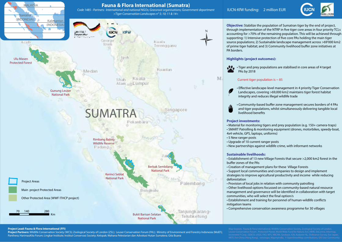
Objective: Stabilize the population of Sumatran tiger by the end of project,
through implementation of the NTRP in five tiger core areas in four priority TCLs
accounting for >70% of the remaining population. This will be achieved through
supporting: 1) Intensive protection of five core PAs holding the main tiger
source populations; 2) Sustainable landscape management across >69’000 km2
of prime tiger habitat; and 3) Community livelihood buffer zone initiatives at
PA borders.
Highlights (project outcomes):
• Tiger and prey populations are stabilised in core areas of 4 target
PAs by 2018
Current tiger population is ~ 85
• Effective landscape-level management in 4 priority Tiger Conservation
Landscapes, covering >69,000 km2 maintains tiger forest habitat
integrity and reduces illegal wildlife trade
• Community-based buffer zone management secures borders of 4 PAs
and tiger populations, whilst simultaneously delivering tangible local
livelihood benefits
Fauna & Flora International (Sumatra)Code 1485 - Partners: International and national NGOs; Grassroot organisations; Government department
>Tiger Conservation Landscapes n° 5; 10; 11 & 14<
Project investments:• Material for monitoring tigers and prey population (e.g. 150+ camera-traps)• SMART Patrolling & monitoring equipment (drones, motorbikes, speedy-boat, 4x4 vehicle, GPS, laptops, uniforms)
• 5 New ranger posts• Upgrade of 10 current ranger posts• New partnerships against wildlife crime, with informant networks
Sustainable livelihoods:• Establishment of 13 new Village Forests that secure >2,000 km2 forest in the buffer zones of the PAs
• Creation of management plans for these Village Forests• Support local communities and companies to design and implement strategies to improve agricultural productivity and income while reducing
deforestation
• Provision of local jobs in relation with community patrolling• Other livelihood options focussed on community-based natural resource management and governance will be identified in collaboration with target
communities, who will select the final option/s
• Establishment and training for personnel of human-wildlife conflicts mitigation teams
• Comprehensive conservation awareness programme for 30 villages
IUCN-KfW funding: 2 million EUR
Project Lead: Fauna & Flora International (FFI)
Project Partners: Wildlife Conservation Society (WCS); Zoological Society of London (ZSL); Leuser Conservation Forum (FKL); Ministry of Environment and Forestry Indonesia (MoEF);
Panthera; HarimauKita Forum; Lingkar Institute; Institut Conservasi Society; Kelopak; Wahana Pelestarian dan Advokasi Hutan Sumatera; Gita Buana
Main project Protected Areas
Project Areas
Other Protected Area (WWF ITHCP project)
SUMATRA
Ulu Masen
Protected Forest
MALAYSIA
Kalimantan
(INDONESIA)
Sumatra
(INDONESIA)
Map Sources: Fauna & Flora International, Wildlife Conservation Society, Zoological Society of London,
Leuser Conservation Forum , Protected Planet, World Wide Fund for Nature, Esri, HERE, DeLorme, Intermap,
Increment P Corp., GEBCO, USGS, FAO, NPS, NRCAN, Geobase, IGN, Kadaster NL, Ordinance Survey, Esri Japan,
METI, Esri China (Hong Kong), swisstopo, MapmyIndia, © OpenStreetMap contributions, GIS User Community
0Km
70 140 280
Gunung Leuser
National Park
Kerinci Seblat
National Park
Rimbang Baling
Wildlife Reserve
Berbak Sembilang
National Park
Bukit Barisan Selatan
National Park
10 205
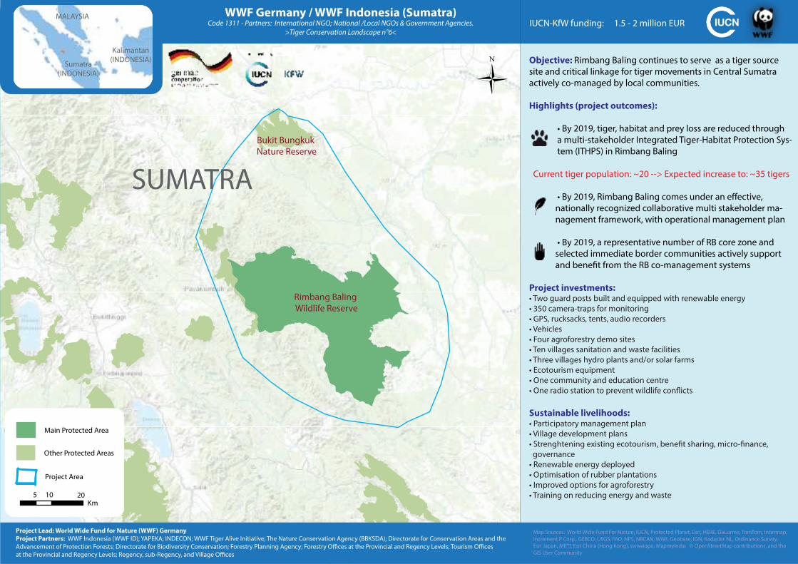
Objective: Rimbang Baling continues to serve as a tiger source
site and critical linkage for tiger movements in Central Sumatra
actively co-managed by local communities.
Highlights (project outcomes):
• By 2019, tiger, habitat and prey loss are reduced through
a multi-stakeholder Integrated Tiger-Habitat Protection Sys-
tem (ITHPS) in Rimbang Baling
Current tiger population: ~20 --> Expected increase to: ~35 tigers
• By 2019, Rimbang Baling comes under an effective,
nationally recognized collaborative multi stakeholder ma-
nagement framework, with operational management plan
• By 2019, a representative number of RB core zone and
selected immediate border communities actively support
and benefit from the RB co-management systems
Project investments:• Two guard posts built and equipped with renewable energy
• 350 camera-traps for monitoring
• GPS, rucksacks, tents, audio recorders
• Vehicles
• Four agroforestry demo sites
• Ten villages sanitation and waste facilities
• Three villages hydro plants and/or solar farms
• Ecotourism equipment
• One community and education centre
• One radio station to prevent wildlife conflicts
Sustainable livelihoods:• Participatory management plan
• Village development plans
• Strenghtening existing ecotourism, benefit sharing, micro-finance,
governance
• Renewable energy deployed
• Optimisation of rubber plantations
• Improved options for agroforestry
• Training on reducing energy and waste
Rimbang Baling
Wildlife Reserve
IUCN-KfW funding: 1.5 - 2 million EUR
Sumatra
(INDONESIA)
MALAYSIA
Kalimantan
(INDONESIA)
WWF Germany / WWF Indonesia (Sumatra)Code 1311 - Partners: International NGO; National /Local NGOs & Government Agencies.
>Tiger Conservation Landscape n°6<
Bukit Bungkuk
Nature Reserve
SUMATRA
Map Sources: World Wide Fund For Nature, IUCN, Protected Planet, Esri, HERE, DeLorme, TomTom, Intermap,
Increment P Corp., GEBCO, USGS, FAO, NPS, NRCAN, WWF, Geobase, IGN, Kadaster NL, Ordinance Survey,
Esri Japan, METI, Esri China (Hong Kong), swisstopo, MapmyIndia © OpenStreetMap contributions, and the
GIS User Community
Project Lead: World Wide Fund for Nature (WWF) Germany
Project Partners: WWF Indonesia (WWF ID); YAPEKA; INDECON; WWF Tiger Alive Initiative; The Nature Conservation Agency (BBKSDA); Directorate for Conservation Areas and the
Advancement of Protection Forests; Directorate for Biodiversity Conservation; Forestry Planning Agency; Forestry Offices at the Provincial and Regency Levels; Tourism Offices
at the Provincial and Regency Levels; Regency, sub-Regency, and Village Offices
Main Protected Area
Project Area
5 10 20Km
0
Other Protected Areas
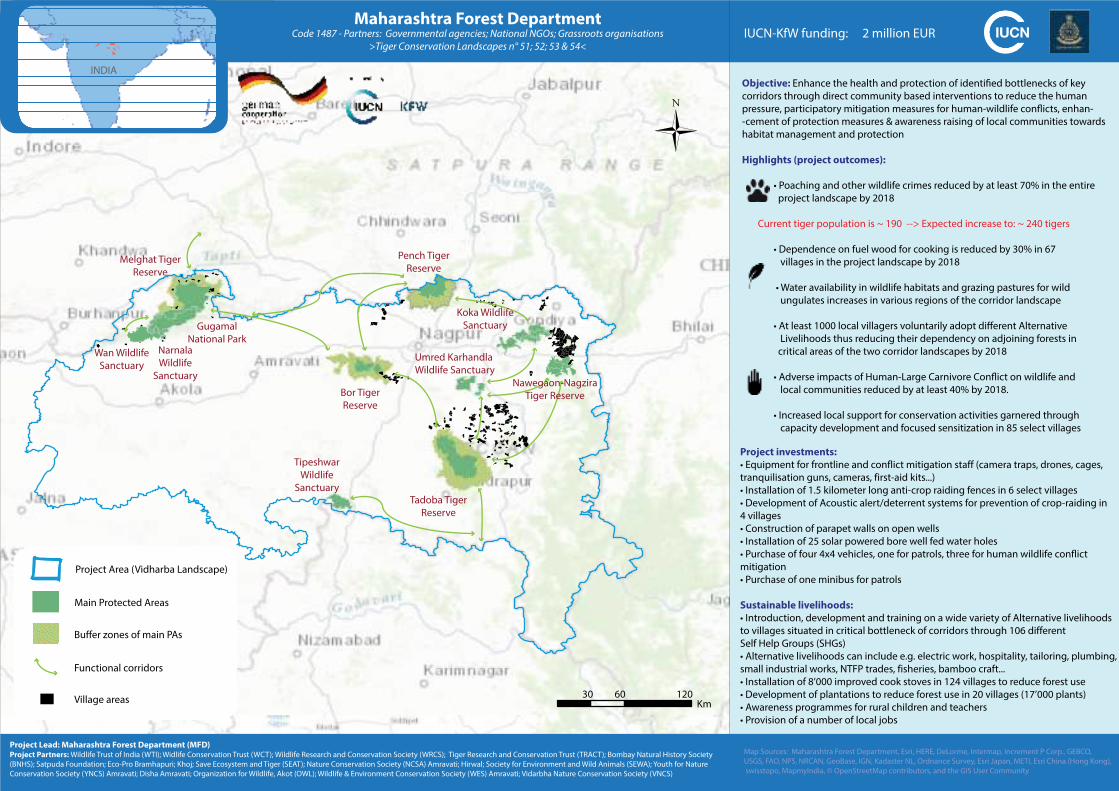
Objective: Enhance the health and protection of identified bottlenecks of key
corridors through direct community based interventions to reduce the human
pressure, participatory mitigation measures for human-wildlife conflicts, enhan-
-cement of protection measures & awareness raising of local communities towards
habitat management and protection
Highlights (project outcomes):
• Poaching and other wildlife crimes reduced by at least 70% in the entire
project landscape by 2018
Current tiger population is ~ 190 --> Expected increase to: ~ 240 tigers
• Dependence on fuel wood for cooking is reduced by 30% in 67
villages in the project landscape by 2018
• Water availability in wildlife habitats and grazing pastures for wild
ungulates increases in various regions of the corridor landscape
• At least 1000 local villagers voluntarily adopt different Alternative
Livelihoods thus reducing their dependency on adjoining forests in
critical areas of the two corridor landscapes by 2018
• Adverse impacts of Human-Large Carnivore Conflict on wildlife and
local communities reduced by at least 40% by 2018.
• Increased local support for conservation activities garnered through
capacity development and focused sensitization in 85 select villages
Maharashtra Forest DepartmentCode 1487 - Partners: Governmental agencies; National NGOs; Grassroots organisations
>Tiger Conservation Landscapes n° 51; 52; 53 & 54<
Project investments:
• Equipment for frontline and conflict mitigation staff (camera traps, drones, cages, tranquilisation guns, cameras, first-aid kits...)
• Installation of 1.5 kilometer long anti-crop raiding fences in 6 select villages • Development of Acoustic alert/deterrent systems for prevention of crop-raiding in 4 villages
• Construction of parapet walls on open wells• Installation of 25 solar powered bore well fed water holes• Purchase of four 4x4 vehicles, one for patrols, three for human wildlife conflict mitigation
• Purchase of one minibus for patrols
Sustainable livelihoods:
• Introduction, development and training on a wide variety of Alternative livelihoods to villages situated in critical bottleneck of corridors through 106 different
Self Help Groups (SHGs)
• Alternative livelihoods can include e.g. electric work, hospitality, tailoring, plumbing, small industrial works, NTFP trades, fisheries, bamboo craft...
• Installation of 8’000 improved cook stoves in 124 villages to reduce forest use• Development of plantations to reduce forest use in 20 villages (17’000 plants)• Awareness programmes for rural children and teachers• Provision of a number of local jobs
IUCN-KfW funding: 2 million EUR
Map Sources: Maharashtra Forest Department, Esri, HERE, DeLorme, Intermap, increment P Corp., GEBCO,
USGS, FAO, NPS, NRCAN, GeoBase, IGN, Kadaster NL, Ordnance Survey, Esri Japan, METI, Esri China (Hong Kong),
swisstopo, MapmyIndia, © OpenStreetMap contributors, and the GIS User Community
Project Lead: Maharashtra Forest Department (MFD)Project Partners: Wildlife Trust of India (WTI); Widlife Conservation Trust (WCT); Wildlife Research and Conservation Society (WRCS); Tiger Research and Conservation Trust (TRACT); Bombay Natural History Society
(BNHS); Satpuda Foundation; Eco-Pro Bramhapuri; Khoj; Save Ecosystem and Tiger (SEAT); Nature Conservation Society (NCSA) Amravati; Hirwal; Society for Environment and Wild Animals (SEWA); Youth for Nature
Conservation Society (YNCS) Amravati; Disha Amravati; Organization for Wildlife, Akot (OWL); Wildlife & Environment Conservation Society (WES) Amravati; Vidarbha Nature Conservation Society (VNCS)
0Km
30 60 120
INDIA
Wan Wildlife
Sanctuary
Narnala
Wildlife
Sanctuary
Melghat Tiger
Reserve
Gugamal
National Park
Bor Tiger
Reserve
Pench Tiger
Reserve
Tadoba Tiger
Reserve
Tipeshwar
Wildlife
Sanctuary
Koka Wildlife
Sanctuary
Umred Karhandla
Wildlife Sanctuary
Main Protected Areas
Project Area (Vidharba Landscape)
Buffer zones of main PAs
Functional corridors
Village areas
Nawegaon-Nagzira
Tiger Reserve
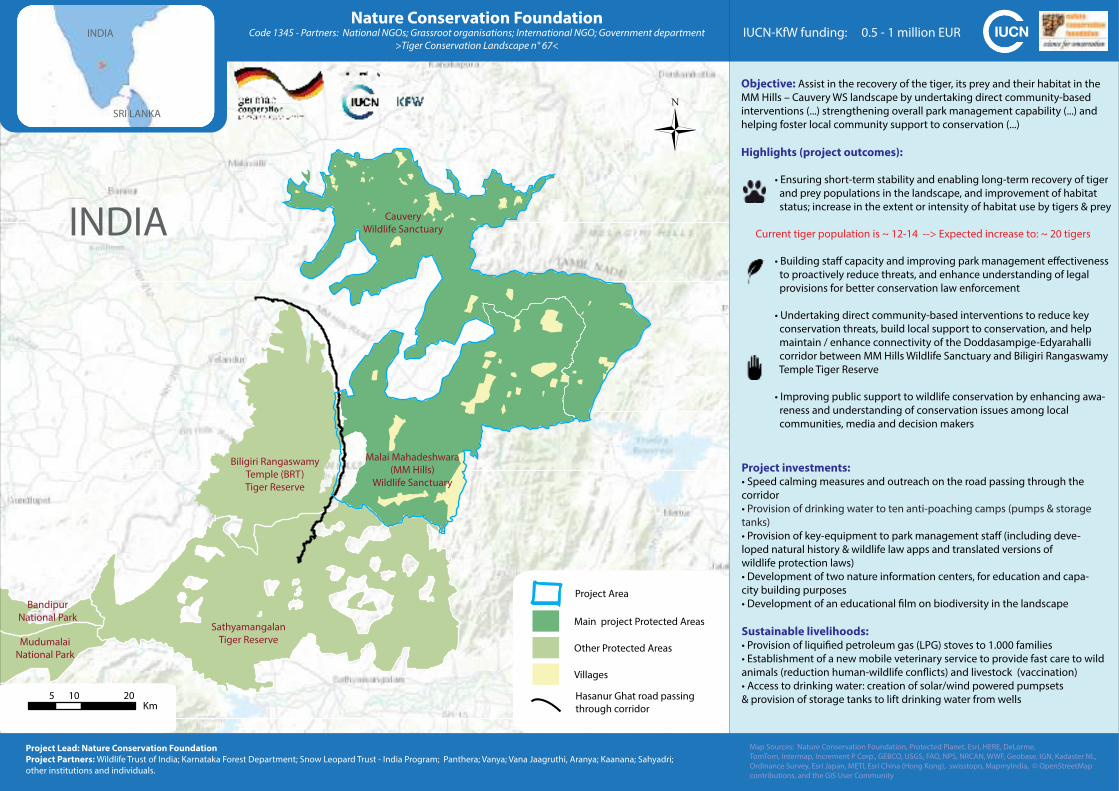
Objective: Assist in the recovery of the tiger, its prey and their habitat in the
MM Hills – Cauvery WS landscape by undertaking direct community-based
interventions (...) strengthening overall park management capability (...) and
helping foster local community support to conservation (...)
Highlights (project outcomes):
• Ensuring short-term stability and enabling long-term recovery of tiger
and prey populations in the landscape, and improvement of habitat
status; increase in the extent or intensity of habitat use by tigers & prey
Current tiger population is ~ 12-14 --> Expected increase to: ~ 20 tigers
• Building staff capacity and improving park management effectiveness
to proactively reduce threats, and enhance understanding of legal
provisions for better conservation law enforcement
• Undertaking direct community-based interventions to reduce key
conservation threats, build local support to conservation, and help
maintain / enhance connectivity of the Doddasampige-Edyarahalli
corridor between MM Hills Wildlife Sanctuary and Biligiri Rangaswamy
Temple Tiger Reserve
• Improving public support to wildlife conservation by enhancing awa-
reness and understanding of conservation issues among local
communities, media and decision makers
Nature Conservation FoundationCode 1345 - Partners: National NGOs; Grassroot organisations; International NGO; Government department
>Tiger Conservation Landscape n° 67<
Project investments:• Speed calming measures and outreach on the road passing through the
corridor
• Provision of drinking water to ten anti-poaching camps (pumps & storage
tanks)
• Provision of key-equipment to park management staff (including deve-
loped natural history & wildlife law apps and translated versions of
wildlife protection laws)
• Development of two nature information centers, for education and capa-
city building purposes
• Development of an educational film on biodiversity in the landscape
Sustainable livelihoods:• Provision of liquified petroleum gas (LPG) stoves to 1.000 families
• Establishment of a new mobile veterinary service to provide fast care to wild
animals (reduction human-wildlife conflicts) and livestock (vaccination)
• Access to drinking water: creation of solar/wind powered pumpsets
& provision of storage tanks to lift drinking water from wells
IUCN-KfW funding: 0.5 - 1 million EUR
Map Sources: Nature Conservation Foundation, Protected Planet, Esri, HERE, DeLorme,
TomTom, Intermap, Increment P Corp., GEBCO, USGS, FAO, NPS, NRCAN, WWF, Geobase, IGN, Kadaster NL,
Ordinance Survey, Esri Japan, METI, Esri China (Hong Kong), swisstopo, MapmyIndia, © OpenStreetMap
contributions, and the GIS User Community
Project Lead: Nature Conservation Foundation
Project Partners: Wildlife Trust of India; Karnataka Forest Department; Snow Leopard Trust - India Program; Panthera; Vanya; Vana Jaagruthi, Aranya; Kaanana; Sahyadri;
other institutions and individuals.
INDIA
SRI LANKA
Main project Protected Areas
Project Area
Other Protected Areas
Villages
Hasanur Ghat road passing
through corridor
5 10 20Km
0
INDIA
Malai Mahadeshwara
(MM Hills)
Wildlife Sanctuary
Cauvery
Wildlife Sanctuary
Biligiri Rangaswamy
Temple (BRT)
Tiger Reserve
Sathyamangalan
Tiger Reserve
Bandipur
National Park
Mudumalai
National Park
0 20 4010Kilometers
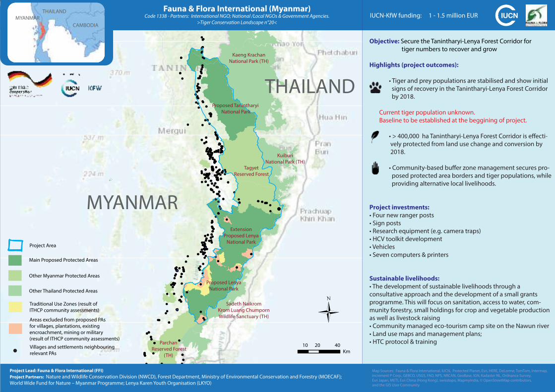
Objective: Secure the Tanintharyi-Lenya Forest Corridor for
tiger numbers to recover and grow
Highlights (project outcomes):
• Tiger and prey populations are stabilised and show initial
signs of recovery in the Tanintharyi-Lenya Forest Corridor
by 2018.
Current tiger population unknown.
Baseline to be established at the beggining of project.
• > 400,000 ha Tanintharyi-Lenya Forest Corridor is effecti-
vely protected from land use change and conversion by
2018.
• Community-based buffer zone management secures pro-
posed protected area borders and tiger populations, while
providing alternative local livelihoods.
Project investments:
• Four new ranger posts
• Sign posts
• Research equipment (e.g. camera traps)
• HCV toolkit development
• Vehicles
• Seven computers & printers
Sustainable livelihoods:
• The development of sustainable livelihoods through a
consultative approach and the development of a small grants
programme. This will focus on sanitation, access to water, com-
munity forestry, small holdings for crop and vegetable production
as well as livestock raising
• Community managed eco-tourism camp site on the Nawun river
• Land use maps and management plans;
• HTC protocol & training
Fauna & Flora International (Myanmar)Code 1338 - Partners: International NGO; National /Local NGOs & Government Agencies.
>Tiger Conservation Landscape n°20<
MYANMAR
Project Lead: Fauna & Flora International (FFI)
Project Partners: Nature and Wildlife Conservation Division (NWCD), Forest Department, Ministry of Environmental Conservation and Forestry (MOECAF);
World Wide Fund for Nature – Myanmar Programme; Lenya Karen Youth Organisation (LKYO)
THAILAND
Main Proposed Protected Areas
Project Area
Other Myanmar Protected Areas
Other Thailand Protected Areas
Traditional Use Zones (result of
ITHCP community assessments)
Areas excluded from proposed PAs
for villages, plantations, existing
encroachment, mining or military
(result of ITHCP community assessments)
Villages and settlements neighbouring
relevant PAs
10 20 40
Km
Proposed Lenya
National Park
Tagyet
Reserved Forest
Proposed Tanintharyi
National Park
Parchan
Reserved Forest
(TH)
Extension
Proposed Lenya
National Park
Sadeth Naikrom
Krom Luang Chumporn
Wildlife Sanctuary (TH)
Kuiburi
National Park (TH)
Kaeng Krachan
National Park (TH)
IUCN-KfW funding: 1 - 1.5 million EURMYANMAR
THAILAND
CAMBODIA
Map Sources: Fauna & Flora International, IUCN, Protected Planet, Esri, HERE, DeLorme, TomTom, Intermap,
increment P Corp., GEBCO, USGS, FAO, NPS, NRCAN, GeoBase, IGN, Kadaster NL, Ordnance Survey,
Esri Japan, METI, Esri China (Hong Kong), swisstopo, MapmyIndia, © OpenStreetMap contributors,
and the GIS User Community

Objective: To recover tiger populations in Northern Myanmar by
increasing effective law enforcement, security community tenure
and improving local ethnic livelihoods in both Myanmar and India,
thus maintaining key habitat connectivity across the transboundary
TCL and reduced reliance on key resources such as tiger prey.
Highlights (project outcomes):
• Identification of critical tiger corridors in NE India
• Conservation activities in corridors
• Stabilized tiger and prey populations
> Baseline data on tiger populations to be determined
• Increased law enforcement with SMART in Myanmar
• Improved management with METT in Htamanthi &
Hukaung Valley WS
• Improved livelihoods in core areas in both countries
• Sustainable management and secure land tenure through
land use plans
Project investments:• Two guard posts and other facilities for Forest Department
• Two staff houses
• Kitchens, wells
• Two community guest houses
• Other facilities for communities
• Conservation Facilitation Centre
• Animal crossings in tea plantations
• Livestock fencing
• Monitoring and patrolling equipment
• Awareness and communications materials
• Camera traps and other investments
Sustainable livelihoods:• Landuse planning
• Community forestry
• Community-based ecotourism
• Bamboo
• Fisheries
• Sustainable livestock & sustainable handicrafts and natural products
Wildlife Conservation Society (India & Myanmar)Code 1337 - Partners: International NGO; National /Local NGOs; Government Agencies & other organisations.
>Tiger Conservation Landscapes n° 37 & 38<
INDIA
MYANMARProtected Areas
Project Area (will be refined further)
20 40 80Km
Hukaung Valley
Wildlife Sanctuary
Naga Hills
Yaybawmee KBA
Htamanthi
Wildlife Sanctuary
Namdapha
Tiger Reserve
Kaziranga
Tiger Reserve
Dibru Saihowa
National Park
Intanki
Wildlife Sanctuary
Map Sources: Wildlife Conservation Society, IUCN, Protected Planet, Esri, HERE, DeLorme, TomTom, Intermap,
Increment P Corp., GEBCO, USGS, FAO, NPS, NRCAN, Geobase, IGN, Kadaster NL, Ordinance Survey, Esri Japan,
METI, Esri China (Hong Kong), swisstopo, MapmyIndia © OpenStreetMap contributions, and the GIS User
Community
Project lead: Wildlife Conservation Society
Project Partners: Nature and Wildlife Conservation Division (NWCD), Forest Department, Ministry of Environmental Conservation and Forestry (MOECAF); Kachin State Government, Sagaing
Regional Government, Naga Self-Administered Area Government; New York Botanical Garden (NYBG); Regional Community Forestry Training Centre (RECOFTC); Naga Traditional Committee
and Naga Hills Development Network; Centre for Wildlife Studies (CWS) ; Balipara Tract and Frontier Foundation (BTFF); Nagaland Wildlife and Biodiversity Conservation Trust (NWBCT).
BHUTAN
CHINA
INDIA
MYANMAR
Sources: Esri, HERE, DeLorme, Intermap, increment P Corp., GEBCO, USGS, FAO, NPS, NRCAN, GeoBase, IGN,Kadaster NL, Ordnance Survey, Esri Japan, METI, Esri China (Hong Kong), swisstopo, MapmyIndia, ©OpenStreetMap contributors, and the GIS User Community
0 40 8020Kilometers
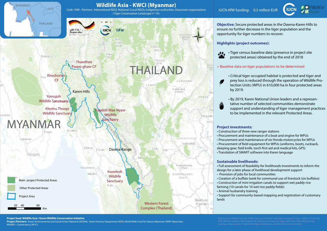
Objective: Secure protected areas in the Dawna-Karen Hills to
ensure no further decrease in the tiger population and the
opportunity for tiger numbers to recover.
Highlights (project outcomes):
• Tiger census baseline data (presence in project site
protected areas) obtained by the end of 2018
> Baseline data on tiger populations to be determined
• Critical tiger occupied habitat is protected and tiger and
prey loss is reduced through the operation of Wildlife Pro-
tection Units (WPU) in 610,000 ha in four protected areas
by 2019.
• By 2019, Karen National Union leaders and a represen-
tative number of selected communities demonstrate
support and understanding of tiger management practices
to be implemented in the relevant Protected Areas.
Project investments:• Construction of three new ranger stations
• Procurement and maintenance of a boat and engine for WPUs
• Procurement and maintenance of six Honda motorcycles for WPUs
• Procurement of field equipment for WPUs (uniforms, boots, rucksack,
sleeping gear, field knife, torch first aid and medical kits, GPS)
• Translation of SMART software into Karen language
Sustainable livelihoods:• Full assessment of feasibility for livelihoods investments to inform the
design for a later phase of livelihood development support
• Provision of jobs for local communities
• Creation of a buffalo bank for communal use of livestock (six buffalos)
• Construction of mini irrigation canals to support wet paddy rice
farming (10 canals for 10 wet rice paddy fields)
• Animal husbandry training
• Support for community-based mapping and registration of customary
lands
Wildlife Asia - KWCI (Myanmar)Code 1490 - Partners: International NGO; National /Local NGOs; Indigenous authorities; Grassroots organisations
>Tiger Conservation Landscape n° 19<
THAILAND
MYANMAR
Western Forest
Complex (Thailand)
Map Sources: Wildlife Asia, Esri, HERE, DeLorme, TomTom, Intermap, Increment P Corp., GEBCO, USGS, FAO,
NPS, NRCAN, Geobase, IGN, Kadaster NL, Ordinance Survey, Esri Japan, METI, Esri China (Hong Kong),
swisstopo, MapmyIndia © OpenStreetMap contributions, and the GIS User Community
Project lead: Wildlife Asia / Karen Wildlife Conservation Initiative
Project Partners: Karen Environmental and Social Action Network (KESAN); Karen Forestry Department (KFD); World Wide Fund for Nature Myanmar (WWF Myanmar);
Wildlife 1 Conservancy (W1C);
IUCN-KfW funding: 0.5 million EUR
20 40 80Km
0
Project Area
Main project Protected Areas
Other Protected Areas
MYANMAR
THAILAND
LAOS
Kweekoh
Wildlife
Sanctuary
Klermu Thoopi
Wildlife Sanctuary
Dawna Range
Karen Hills
Thawthee
Pwaw-ghaw CF
Kheshorter
CF
Kaydoh Mae Nyaw
Wildlife
Sanctuary
Yomujoh
Wildlife Sanctuary
Sources: Esri, HERE, Garmin, Intermap, increment P Corp., GEBCO, USGS, FAO, NPS, NRCAN, GeoBase, IGN,
Kadaster NL, Ordnance Survey, Esri Japan, METI, Esri China (Hong Kong), swisstopo, © OpenStreetMapcontributors, and the GIS User Community
0 20 4010Kilometers
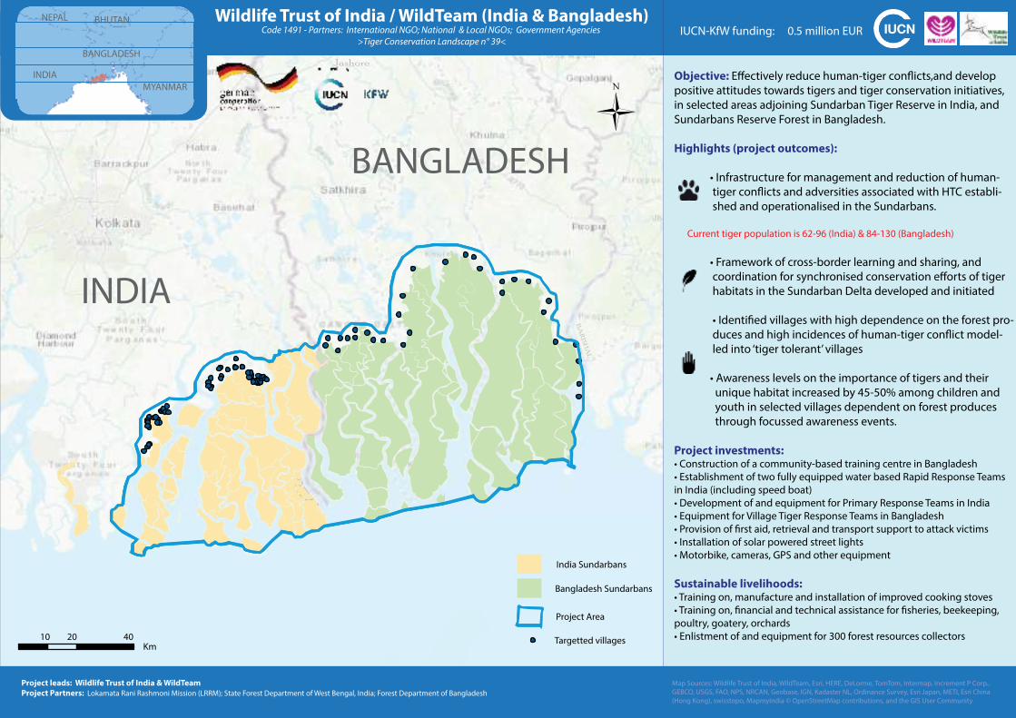
Objective: Effectively reduce human-tiger conflicts,and develop
positive attitudes towards tigers and tiger conservation initiatives,
in selected areas adjoining Sundarban Tiger Reserve in India, and
Sundarbans Reserve Forest in Bangladesh.
Highlights (project outcomes):
• Infrastructure for management and reduction of human-
tiger conflicts and adversities associated with HTC establi-
shed and operationalised in the Sundarbans.
Current tiger population is 62-96 (India) & 84-130 (Bangladesh)
• Framework of cross-border learning and sharing, and
coordination for synchronised conservation efforts of tiger
habitats in the Sundarban Delta developed and initiated
• Identified villages with high dependence on the forest pro-
duces and high incidences of human-tiger conflict model-
led into ‘tiger tolerant’ villages
• Awareness levels on the importance of tigers and their
unique habitat increased by 45-50% among children and
youth in selected villages dependent on forest produces
through focussed awareness events.
Project investments:• Construction of a community-based training centre in Bangladesh
• Establishment of two fully equipped water based Rapid Response Teams
in India (including speed boat)
• Development of and equipment for Primary Response Teams in India
• Equipment for Village Tiger Response Teams in Bangladesh
• Provision of first aid, retrieval and transport support to attack victims
• Installation of solar powered street lights
• Motorbike, cameras, GPS and other equipment
Sustainable livelihoods:• Training on, manufacture and installation of improved cooking stoves
• Training on, financial and technical assistance for fisheries, beekeeping,
poultry, goatery, orchards
• Enlistment of and equipment for 300 forest resources collectors
Wildlife Trust of India / WildTeam (India & Bangladesh)Code 1491 - Partners: International NGO; National & Local NGOs; Government Agencies
>Tiger Conservation Landscape n° 39<
Project leads: Wildlife Trust of India & WildTeam
Project Partners: Lokamata Rani Rashmoni Mission (LRRM); State Forest Department of West Bengal, India; Forest Department of Bangladesh
IUCN-KfW funding: 0.5 million EUR
INDIA
BANGLADESH
Project Area
India Sundarbans
Bangladesh Sundarbans
Targetted villages10 20 40Km
MYANMAR
BANGLADESH
INDIA
NEPAL BHUTAN
Map Sources: Wildlife Trust of India, WildTeam, Esri, HERE, DeLorme, TomTom, Intermap, Increment P Corp.,
GEBCO, USGS, FAO, NPS, NRCAN, Geobase, IGN, Kadaster NL, Ordinance Survey, Esri Japan, METI, Esri China
(Hong Kong), swisstopo, MapmyIndia © OpenStreetMap contributions, and the GIS User Community
BARISHAL
Jashore

INTERNATIONAL UNION FOR CONSERVATION OF NATURE
WORLD HEADQUARTERS Rue Mauverney 28 1196 Gland, Switzerland Tel +41 22 999 0000 Fax +41 22 999 0002
www.iucn.org