INTEGRATED PROTECTED AREA CO-MANAGEMENT...
54
INTEGRATED PROTECTED AREA CO-MANAGEMENT (IPAC) TRAINING AND SUPPORT FOR FOREST CARBON PROJECT DEVELOPMENT May 2010 This report is made possible by the support of the American People through the United States Agency for International Development (USAID). The contents of this report are the sole responsibility of International Resources Group (IRG) and do not necessarily reflect the views of USAID or the United States Government.
Transcript of INTEGRATED PROTECTED AREA CO-MANAGEMENT...

INTEGRATED PROTECTED AREA CO-MANAGEMENT (IPAC) TRAINING AND SUPPORT FOR FOREST CARBON PROJECT DEVELOPMENT
May 2010 This report is made possible by the support of the American People through the United States Agency for International Development (USAID). The contents of this report are the sole responsibility of International Resources Group (IRG) and do not necessarily reflect the views of USAID or the United States Government.

INTEGRATED PROTECTED AREA CO-MANAGEMENT (IPAC) TRAINING AND SUPPORT FOR FOREST CARBON PROJECT DEVELOPMENT March 15-21, 2010 Venue: Main Conference Hall, Bana Bhaban, Forest Department Organized By: Integrated Protected Area Co-Management (IPAC) Project USAID Contract N° EPP-1-00-06-00007-00 Order No : EPP-I-01-06-00007-00 Submitted to : USAID/Bangladesh Prepared by: Communication Team, IPAC Project Submitted for : International Resources Group (IRG) With subcontractors: WWF-USA, dTS, East-West Center Environmental Law Institute, Epler-Wood International World Fish Center, CIPD, CNRS, CODEC BELA, Asiatic M&C, Oasis Transformation Module Architects, IUB/JU
International Resources Group 12 11 Connecticut Avenue, NW, Suite 700 Washington, DC 20036 202-289-0100 Fax 202-289-7601 www.irgltd.com

2
Table of Contents
Introduction .............................................................................................................................. 3
Background and Context ........................................................................................................ 3
Identified Project Areas for carbon projects ......................................................................... 4
Technical Detail ........................................................................................................................ 4
Results ....................................................................................................................................... 6
Discussion and conclusion: ...................................................................................................... 7
ANNEX 1 .................................................................................................................................. 8
Participants List ................................................................................................................................... 8
ANNEX 2 ................................................................................................................................ 10
Overall IPAC Activity.......................................................................................................................... 10
ANNEX 3 ................................................................................................................................ 17
Opening Session Presentation .......................................................................................................... 17
ANNEX 4 ................................................................................................................................ 19
Secondary Information Sources ........................................................................................................ 19
ANNEX 5 ................................................................................................................................ 24
Forest Carbon Project Development ................................................................................................ 24
ANNEX 6 ................................................................................................................................ 28
Field Data Collection ......................................................................................................................... 28
ANNEX 7 ................................................................................................................................ 37
Field Data Collection ......................................................................................................................... 37
ANNEX 8 ................................................................................................................................ 45
Photos from Field Practicum ............................................................................................................. 45
ANNEX 9 ................................................................................................................................ 47
Developed Timelines ......................................................................................................................... 47
ANNEX 10 .............................................................................................................................. 52
Policy and Institutional Context ........................................................................................................ 52

3
Training session
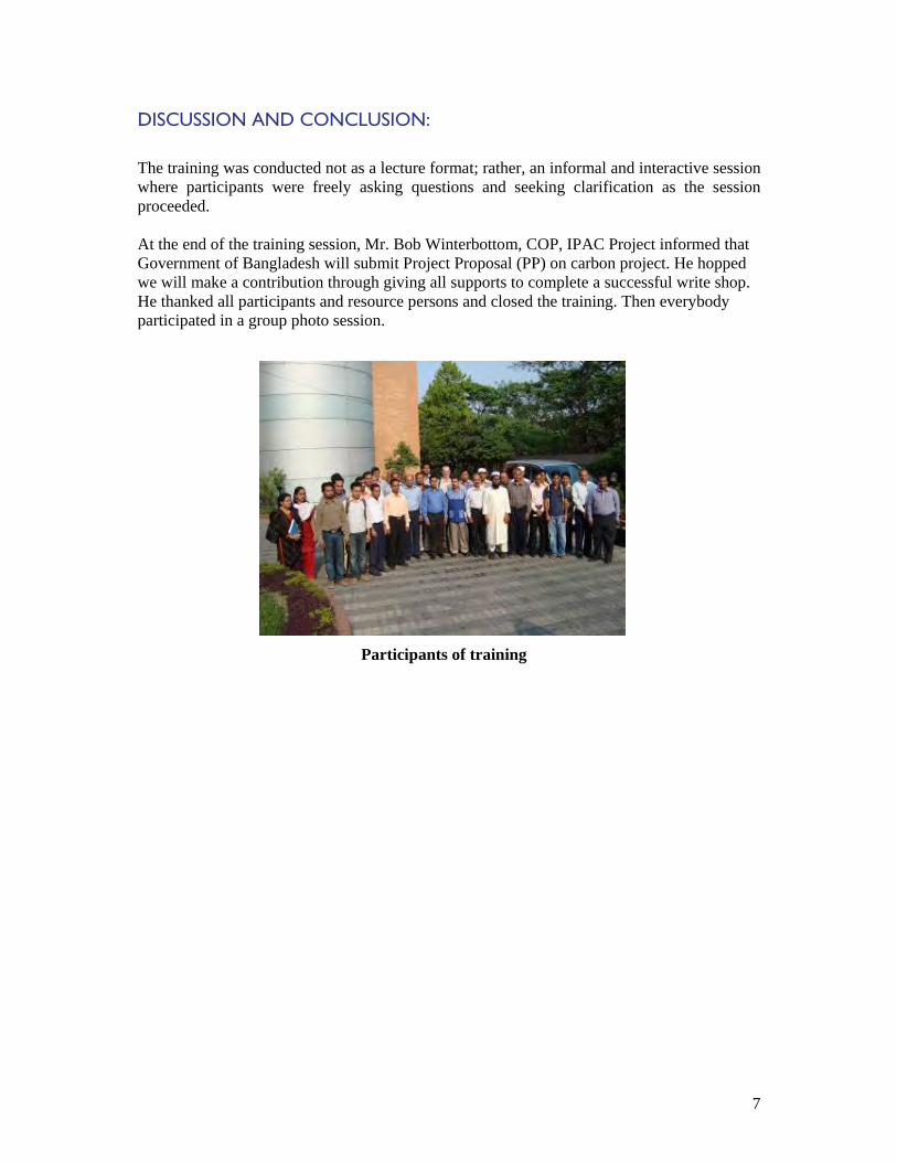
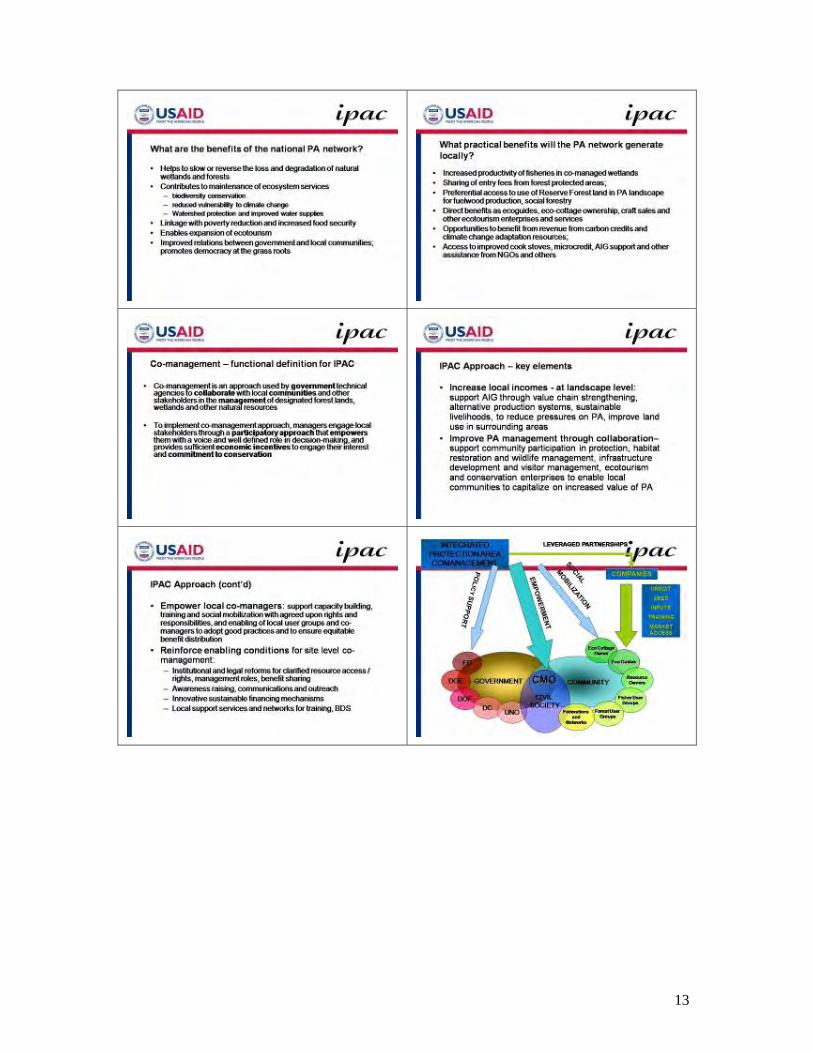
INTRODUCTION The training course on Forest Carbon Project Development was organized by the Integrated Protected Area Co-management (IPAC) Project, a joint program of the United States Agency for International Development (USAID) and the Government of Bangladesh. The training course was held on 15-21 March 2010 at Conference Room of the Forest Department, Bana Bhaban, Agargaon, Dhaka. Twenty-four representatives from Forest Department, Department of Fisheries, Universities, NGOs, private sectors and other partner organizations who are active in climate change/carbon finance, participated (Annex 1). The training course was organized to provide participants with an orientation on carbon project planning and designing, and to enable them to master the field survey techniques which are required to assess carbon stocks and to prepare carbon projects. The overall objective of IPAC is to assist Forest Carbon Training, field support and project development activities to contribute to the adaptation and mitigation of climate change and to promote the sustainable development of natural resources by strengthening the capacity of the IPAC implementing agencies including Forest Department (FD), Department of Fisheries (DOF) and Department of Environment (DOE) to prepare and implement forest carbon projects enabling them to access sustainable financing for the co-management of forest and wetland Protected Areas (PAs) from both national and international carbon markets.
BACKGROUND AND CONTEXT
A snapshot of the project design and development process has been presented by focusing on Land Use, Land-Use Change and Forestry (LULUCF), Afforestation and Reforestation (A/R) and Reduced Emissions from Deforestation and Forest Degradation (REDD). Forest carbon project planning, design and development were discussed. A review of the main components of forest carbon projects, the key issues regarding feasibility and standards, Project Design Document (PDD), methodologies and tolls for making initial and ongoing measurements of carbon pool, and non-carbon risks and benefits, and requirements for accessing carbon markets were also included in the discussion. Main focus was on mastering the use of equipment to be used to carry out carbon pool assessments and associated sampling and inventory techniques; this will include a review of carbon assessment protocols standards and procedures, inventory design, trends analysis and compliance with monitoring requirements. Additional focus has been given on increased understanding of project design issues, including: i) project’s relevance and contribution towards Bangladesh’s national plans and development goals including poverty alleviation and biodiversity conservation, ii) approved baseline and monitoring methodologies, iii) estimation of ex ante net anthropogenic Green House Gases (GHG) removals by land-use sinks, and estimated amount of net anthropogenic

4
GHG removals by land-use sinks over the chosen carbon credit period, iv) potential barriers related to key issues, v) monitoring and reporting plan, and cost, and vi) assessment of environmental and socio-economic impacts. Main principles, tools and procedures related to an A/R and REDD Projects Development for forest has been covered in this training (Phase I) in order to prepare the participants for field inventory and assessments that will be carried out in Phase II and project preparation write-up in Phase III.
IDENTIFIED PROJECT AREAS FOR CARBON PROJECTS In addition to the Sunderbans REDD project (forest inventory and project preparation ongoing since December 2009), the following forest and wetland PAs have been targeted: Sl No.
Name of IPAC PAs
Area of PA (in ha)
Upazila/District Carbon Activity
Forest Division/DOF
1 Rema-Kalenga Wildlife Sanctuary
1,795 Chunarughat/Hobigonj REDD Sylhet WLD
2 Kangsha-Malijhee Basin
8,000 Jhenaigati, Sherpur Sadar/Sherpur
A/R DOF
3 Teknaf Game Reserve
11,615 Teknaf/Cox’s Bazar A/R Cox’s Bazar (S)
4 Himchari National Park
1,729 Cox’s Bazar Sadar/Cox’s Bazar
A/R Cox’s Bazar (S)
5 Inani Reserve Forest
7,700 Ukhia/Cox’s Bazar A/R Cox’s Bazar (S)
6 Fasiakhali WS 1,302 Chakaria/Cox’s Bazar REDD Cox’s Bazar (N) 7 Medha
Kachhapia National Park
396 Chakaria/Cox’s Bazar REDD Cox’s Bazar (N)
8 Sitakundu Reserve Forest
808 Sitakundu/Chittagong A/R Chittagong (N)
9 Dudpukuria National Park (Proposed)
3,500 Chittagong REDD Chittagong (N)
10 Hail Haor 1,000 Moulvibazar A/R DOF
TECHNICAL DETAIL On the opening day, Mr. Ishtiaq Uddin Ahmad, Deputy Chief Conservator of Forest Department, welcomed everyone. He noted the importance of technical capacity building as part of the overall “readiness” of Bangladesh to participate in international REDD and other carbon market mechanisms, and urged participants to apply themselves diligently during the training workshop. After his speech, Mr. Kazi M.A. Hashem, Institutional Capacity Building Specialist, led the participants through an introductions and expectations exercise.

5
Participants Expectations: o To know about carbon and different kinds of carbon measurement; o Carbon project design/how to prepare or develop carbon project; o Concept of Clean Development Mechanism (CDM); o Sequestration of carbon; o How to analyse carbon stock; o Carbon trading-what are the markets and potentiality; o Carbon inventory process; o Calculation of carbon emission; o Techniques of estimating carbon emission and sequestration process; o Relation between power energy and CDM Project; o Inventory process of carbon status in Forest.
Dr. Fazle Rabbi Sadeque Ahmed, Director, DOE mentioned that carbon trading is a flourishing project and CDM is an established concept of climate change. He hopped the participants would learn carbon measuring system and how to develop carbon project through this training. India and Indonesia have already developed project and in future financial help will come in REDD sectors, he added. Dr. Ram A Sharma, DCOP said that after this training we will know how to prepare carbon project proposal against REDD. COP, IPAC Mr. Bob Winterbottom had a presentation on IPAC activities (Annex 2) and he explained how forest carbon project development fits within the overall program. Next, Mr. Todd R. Johnson, Senior Manager and Forest Carbon Specialist, IRG stated the opening session presentation (Annex 3) as a guide for “leveling-off” of participants’ understanding on terrestrial carbon projects, international framework, carbon markets, carbon quality considerations. The session closed with a small group exercise where representatives of each project site listed the secondary information sources (Annex 4) available to them, including previous forest inventories, socioeconomic surveys, biodiversity assessments, and other relevant data. The following day of training continued the interactive discussions, using a list of 20 key concepts from the opening session and the packet of documents as the basis for a plenary discussion. This method also allowed the specialist to assess how well the concepts had been understood. Conceptual understanding was seen as the critical result of the initial two days of training, and by the end of the day a sufficient foundation of core concepts was laid for fieldwork to be conducted with the level of rigor and data quality necessary. Participants understood clearly why they needed to be ever-mindful of introducing error and uncertainty into the data collection.
On the next day of the training, Dr. Sharma conducted a session on forest carbon project development (Annex 5), especially on case study of A/R and REDD+ project development in Bangladesh. He described the proposal that developed on Chunoti Wildlife Sanctuary and Sundarbans. Then the specialist from the Forest Department Md. Zaheer Iqbal of the RIMS Unit and Mr. Imran Ahmed, the ACF for Khulna Division conducted a series of sessions on field data collection (Annex 6 and 7). These sessions included both the concepts and practice of measuring forest carbon, as well as instruction on using the instruments (e.g., densitometer, diameter tape, GPS, laser clinometers, and soil augur). The following day (19th March, 2010) consisted of a field practicum on using the instruments, conducted in Sal forest (Shorea robusta) of Kaliakor Range, Gazipur District (photos with captions in Annex 8).

6
The final two days of the training workshop focused on how to apply the concepts of forest carbon projects, and the fieldwork of carbon pool assessment, to design the projects that meet the Voluntary Carbon Standards (VCS) and Climate, Community and Biodiversity (CCB) Standards. Using those two documents, and the supporting tools (e.g., Project Design Document Template and Tool for AFOLU1 Non-Permanence Risk Analysis and Buffer Determination), the session highlighted which secondary data and other information needs could not be met through forest carbon accounting. The participants also made revisions to the draft Field Data Sheet, and in small groups developed timelines (Annex 9) to successfully complete fieldwork during Phase II of the training. Dr. Fazle Rabbi, Director of DOE, also delivered a presentation on the policy and institutional context (Annex 10) for developing forest carbon projects in Bangladesh and internationally.
RESULTS 1. Participants are being oriented with the important issues that are relevant to the following topics.
a. Afforestation/Reforestation (A/R) and REDD+ Forest Carbon Projects Development (PDD) methods and issues in designing and implementing forest carbon projects (both for regulatory and voluntary markets) including field design, specification, inventory, standards, verification, permanence and leakage, forest and tenures, monitoring, carbon credits, accounting, reporting etc.
b. International and national carbon markets: a brief overview of the specific aspects of international carbon trade as they relate to forest carbon projects including A/R and REDD+.
2. Participants have known how to carry out field inventory works including assessment of basement scenario and carbon sequestration rates for assessing net carbon changes due to implementation of A/R and REDD+ forest carbon projects in the 11 identified PAs.
1 AFOLU-Agriculture, Forestry and Other Land Use
7
DISCUSSION AND CONCLUSION: The training was conducted not as a lecture format; rather, an informal and interactive session where participants were freely asking questions and seeking clarification as the session proceeded. At the end of the training session, Mr. Bob Winterbottom, COP, IPAC Project informed that Government of Bangladesh will submit Project Proposal (PP) on carbon project. He hopped we will make a contribution through giving all supports to complete a successful write shop. He thanked all participants and resource persons and closed the training. Then everybody participated in a group photo session.
Participants of training

8
ANNEX 1
PARTICIPANTS LIST Sl No
Name Designation Department/ Organization
Comments
GO Department 01 Md. Aminul Islam SUFO DOF 02 Md. Mohsen Ali SUFO DOF 03 Quazi Md. Nurul Karim ACF FD 04 Md. Motlubur Rahman ACF FD 05 Md. Anowar Hossain
Serker ACF FD
06 Md. Maksud Alam ACF FD 07 Md. Abdur Rahman ACF FD 08 Shahidul Islam Bhuiya SUFO (in charge) DOF 09 Md. Aminul Hoque UFO DOF 10 Hoq Mahbub Morshed ACF FD Observer 11 Md. Rafiqul Islam ACF FD Observer 12 Rafiqa Sultana ACF FD Observer 13 Dr. Mariam Akhter ACF FD Observer University 14 Shohana Huq Lecturer Independent University of
Bangladesh
15 Md. Omar Sharif Student Bangladesh Agricultural University (BAU)
16 Md. Monirul Islam Student Khulna University 17 Bayezid Khan Student Jahangirnagar University
(JU)
18 Rasel Ahammed Student JU 19 Md. Rajib-ul-Hoque Student North South University
(NSU)
20 Md. Manirul Islam Student NSU 21 Sanjoy Das Student BAU NGOs 22 Utpal Bhattacharjee Manager, CDM Rahimafrooz 23 Kazi Mahmud Ullah DGM Rural Services Foundation 24 Md. Shawkat Hossain Program Officer
(M&E) Arannyak Foundation
Resource Person 25 Dr. Fazle Rabbi
Sadeque Ahmed Director Department of
Environment
26 Todd Johnson Sr. Manager IRG 27 Bob Winterbottom COP IPAC Project 28 Dr. Ram A. Sharma DCOP IPAC Project 29 Kazi M A Hashem ICBS IPAC Project 30 Md. Zaheer Iqbal DCF FD 31 Ruhul Mohaiman PM Specialist IPAC Project 32 Imran Ahmed ACF FD Other

9
33 A.K.M. Shamsuddin Advisor IPAC Project 34 Ishtiaq Uddin Ahmad DCCF FD 35 Mostofa Omar Sharif PMARA IPAC Project 36 Kanailal Debnath PMARA IPAC Project 37 Shital Kumar Nath PMARA IPAC Project 38 Md. Shakil Ahmed
Khan PMARA IPAC Project
39 Md. Amirul Islam IPAC Project

10
ANNEX 2
OVERALL IPAC ACTIVITY

11

12
13
14

15

16

17
ANNEX 3
OPENING SESSION PRESENTATION

18

19
ANNEX 4
SECONDARY INFORMATION SOURCES
Protected Area: Hail Haor Group Members:
1. Shahidul Islam Bhuyian, Senior Upazila Fisheries Officer (SUFO) (In charge), DOF, Srimangal, Moulvibazar
2. Monirul Islam, Student (Soil Science), Khulna University Resources available:
1. HH area 10,000 ha; 2. Permanent Sanctuary area 100 ha 3. 13 more fish sanctuary in Hail Haor 4. Swamp forests plantation, basically Hijal, Karach forests: MACH study reports 5. Land tenure: Government Khas land (Jalmahal), controlled by AC (Land) 6. Maps : MACH and SUFO Offices 7. Socio-economic: Socio-economic study on fishers at Hail Haor – MACH 8. Biodiversity assessments by MACH project 9. Threats: Drying/dewatering of jalmahals; unregulated harvesting causes huge loss of
biodiversity; siltation; deforestation, Protected Area: Rema-Kalenga Wildlife Sanctuary Group Members:
1. Haq Mahbub Morshed, Assistant Conservator of Forests (ACF), FD, Dhaka
2. Kazi Mahmud Ullah, DGM, RSF 3. Md. Amirul Islam, IPAC Project, Dhaka
Resources available:
1. Management Plan for RKWS- by NSP 2. Site information brochure- NSP 3. PRA/RRA reports- NACOM, NSP 4. Digital maps – NSP, RIMS, FD 5. Working Plan for Sylhet Forest Division 1998-2008 6. Articles on RKWS at Internet; 7. National biodiversity action plan by DOE 8. Video documentary by Impress Tele film and Channel i 9. Web site: www.nishorgo.org
www.bforest.gov.bd Protected Area: Kangsha-Malijhee Basin Group Members:
1. Md. Aminul Haque, Upazila Fisheries Officer (UFO), DOF, Jhenaigati, Sherpur
2. Md. Aminul Islam, SUFO, DOF, Jamalpur Sadar, Jamalpur 3. Omar Sharif, Student, Bangladesh Agricultural University (BAU) 4. Sanjoy Das, Student, BAU.

20
Resources available:
1. List of water body by Survey June 2000 2. Water body resources mapping- MACH project 3. Establish Fish Sanctuary in different water bodies 4. Plantation inside water bodies; 2,000+60,000 seedlings in 2003-04; 5. Roadside plantation along different roads of Jhinaigati Upazila; 120,000 + 43000
seedlings; 25-30 miles 6. Study on Fish production increased 150kg/ha to 307kg/ha; Study of MACH 7. land tenure: Govt. Khas land (8000ha) 8. Socio-economic: DOF and MACH project documents 9. Threats: Dewatering, illegal fishing, siltation, flash-flood, excessive lifting of water
for irrigation, 10. Biodiversity: DOF and MACH project documents 11. Study of EWC research grant by Mr. Md. Aminul Hoque, UFO; topic: Fish market
chain and incomes of fishers in Sherpur District, Bangladesh (Aug/09 – Jan/2010) Protected Area: Teknaf Game Reserve (TGR) Group Members:
1. Qazi Md. Nurul Karim, ACF, FD, TGR 2. Md. Monirul Islam, Student, North South University (NSU) 3. Md. Rafiqul Islam, ACF, FD, Dhaka
Resources available:
1. Area: 11,615 ha 2. Range: Teknaf, Shilkhali & Whykong 3. Forest type: Tropical ever green- semi evergreen forests 4. Dominant species: Floral: Garjan, Chapalish, Telsur, Boilam, Chondul, Uriam, Bhadi;
Fauna: Asian elephant, wild boar, barking deer etc; different types of birds and reptiles.
5. Land tenure: Reserved Forests and Protected Forest; Managed by FD; It is a protected area declared in 1983.
6. Socio-economic profile: Mainly Bangali with some ethnic minority like Tanchangya and Chakma. Main profession: Agriculture, fishing, fuel wood collection.
7. Threats: Rohingya Refugees both legal and illegal migrants, conversion of forest lands into agricultural land, human settlements in the forest; illicit felling, brick fields, saw mills, high fuel wood demands;
8. Opportunities: 3 CMCs at Teknaf, Whykeong and Shilkhali; 15 CPGs (595 members); One nature park,
9. FRMP inventory 1995 10. Sub-block maps and forest beat maps 11. Aerial photography 1995 12. NSP mapping 13. PRA study in Nishorgo 14. Bird Monitoring 15. Study on “State of Protected Area (SOPA) 16. East West Center-NSP research monograph 17. Reconnaissance Survey Maps of 1954 18. Cadastral Survey Maps 1926 19. BS Maps 1975-80

21
20. Community based eco-tourism planning strategy for Teknaf Peninsula- Megan Eplerwood
21. Management Plan for Cox’s Bazar Forest Division 22. Site Appraisal report – NSP 23. Site information brochure- NSP 24. PRA/RRA reports- NACOM, NSP 25. Digital maps – NSP, RIMS, FD 26. Web site: www.nishorgo.org
www.bforest.gov.bd Protected Area: Himchari National Park Group Members:
1. Qazi Md. Nurul Karim, ACF, FD, TGR 2. Md. Monirul Islam, Student, North South University (NSU) 3. Md. Rafiqul Islam, ACF, FD, Dhaka
Resources available:
1. Area : 1729 ha Cox’s Bazar south forest division 2. Upazila: Cox’s Bazar Sadar and Ramu 3. Forest inventory: FRMP inventory 1995 4. Floral diversity: tropical evergreen and semi-evergreen forests, mostly degraded
forests; 5. Management Plan: Cox’s bazar forest division 6. PRA/RRA done in IPAC 7. CMC is being developed through IPAC. 8. Highly potential site for eco-tourism development 9. At present annually BDTk.30 lakh are revenue earned 10. Threats: Encroachments for settlers and rapidly growing tourism, illegal fuel wood
collectors, Marine drive road Protected Area: Inani National Park (Proposed) Group Members:
1. Qazi Md. Nurul Karim, ACF, FD, TGR 2. Md. Monirul Islam, Student, North South University (NSU) 3. Md. Rafiqul Islam, ACF, FD, Dhaka
Resources available:
1. Area : 7700 ha; Cox’s Bazar south forest division 2. Upazilla: Ukhia 3. Forest inventory: FRMP inventory 1995 4. Possess a good chunk of natural forests at Swankhali 5. Floral diversity: tropical evergreen and semi-evergreen forests,; 6. Management Plan: Cox’s Bazar forest division; 7. PRA/RRA done in AF/IPAC; 8. CMC is being developed through Arannayk Foundation 9. Highly potential site for eco-tourism development 10. Threats: Encroachments for settlers and rapidly growing tourism, illegal fuel wood
collectors, Marine drive road,

22
Protected Area: Fasiakhali Wildlife Sanctuary Group Members:
1. Qazi Md. Nurul Karim, ACF, FD, TGR 2. Md. Monirul Islam, Student, North South University (NSU) 3. Md. Rafiqul Islam, ACF, FD, Dhaka
Resources available: 1. Area. 1302 ha; Cox’s Bazar south forest division 2. Upazila: Chakaria, Cox’s Bazar 3. Forest inventory: FRMP inventory 1995 4. Floral diversity: tropical evergreen and semi-evergreen forests, enriched natural forests 5. Management Plan: Cox’s Bazar forest division; 6. PRA/RRA done in IPAC 7. CMC is developed through IPAC. 8. Threats: Encroachments for settlers, illegal fuel wood collectors, Protected Area: Medhakachapia National Park Group Members:
1. Qazi Md. Nurul Karim, ACF, FD, TGR 2. Md. Monirul Islam, Student, North South University (NSU) 3. Md. Rafiqul Islam, ACF, FD, Dhaka
Resources available: 1. Area. 396 ha; Cox’s Bazar north forest division 2. Upazilla: Chakaria, Cox’s Bazar 3. Mature Garjan forests 4. Forest inventory: FRMP inventory 1995 5. Floral diversity: Tropical evergreen and semi-evergreen forests, enriched natural forests 6. Management Plan: Cox’s Bazar forest division 7. PRA/RRA done in IPAC 8. CMC is developed through IPAC. 9. Threats: Encroachments for settlers, illegal fuel wood collectors, Protected Area: Rajghat Forest Group Members:
1. Qazi Md. Nurul Karim, ACF, FD, TGR 2. Md. Monirul Islam, Student, North South University (NSU) 3. Md. Rafiqul Islam, ACF, FD, Dhaka
Resources available: Under Fulchari Range, Cox’s Bazar North Forest Division 1. Area. 396 ha; Cox’s Bazar North Forest Division 2. Upazila: Chakaria, Cox’s Bazar 3. Mature Garjan forests 4. Forest inventory: FRMP inventory 1995 5. Floral diversity: Tropical evergreen and semi-evergreen forests, enriched natural forests

23
6. Management Plan: Cox’s Bazar forest division; 7. PRA/RRA done in IPAC 8. CMC is developed through IPAC 9. Threats: Encroachments for settlers, illegal fuel wood collectors Protected Area: Sitakunda Reserve Forest Group Members:
1. Md. Anowar Hossain Sarker, ACF, FD, Chittagong Forest Division 2. Utpal Bhattacharjee, Manager, CDM, RREL 3. Rafiqa Sultana, ACF, FD, Dhaka 4. Rasel Ahmmed, Student, Jahangirnagar University (JU)
Resources available:
1. Total area : 22,382 acre 2. Two Range Offices and 5 Forest Beats 3. 2000 acre is already developed as Sitakunda eco-park 4. Upazila: Sitakunda 5. Land tenure: Govt. Land, Reserved Forest; managed by FD; RS, CS and BS maps are
available 6. Forest inventory in 1994 (under FRMP) 7. Forest Management Plan, Chittagong Forest Division 8. Main features: Natural and plantation forests; forest types: Mixed evergreen forests 9. Dominant species: Teak, Gamar, Akashmoni, Myrobalans; Dominant animals: Deer 10. Historical importance Chandranath Temple 11. Natural geisure (fountain) 12. Socio-economic: mainly agriculture; indigenous (Tripura) community, 13. Livelihood: Agriculture and forestry related activities 14. Tk.200 is income/day- daily labours 15. Plant rotation: short and long rotation 16. Two projects studied in “Forestry Sector Project”, Denuded Hill Forest Afforestation
Project”, Sitakunda Eco-partk project 17. Threats: Soil erosion, loss of top soil, denuded for long time
Protected Area: Dudhpukuria National Park (Proposed) Group Members:
1. Md. Maksud Alam, ACF, FD, Chittagong South Forest Division 2. Mr. Bayezid Khan, Student , JU
Resources available:
1. A proposed National Park 2. Forest types: Tropical semi-evergrngueen forests 3. Area = 3500 ha Reserved Forests 4. Location: Rangunia upazilla, Chittgagong 5. Dominant flora: Garjan, Telsur, Chapalish, Toon, Uriam etc. 6. Fauna: Asian elephants 7. Threats: Santi bahini, forestfire, felling, encroachment and illegal settlement 8. A promising area for carbon project

24
ANNEX 5
FOREST CARBON PROJECT DEVELOPMENT

25

26

27

28
ANNEX 6
FIELD DATA COLLECTION

29

30
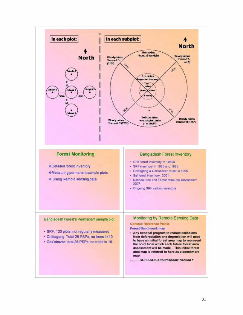
31

32

33

34

35

36

37
ANNEX 7
FIELD DATA COLLECTION

38

39

40
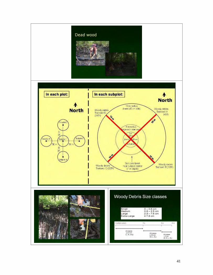
41

42

43

44

45
ANNEX 8
PHOTOS FROM FIELD PRACTICUM 19TH MARCH 2010; KALIAKOIR RANGE, GAZIPUR DISTRICT
Fieldwork preparation briefing
Briefing on use of densiometer
Discussing maps before practicum exercise
Team orientation to GPS before practicum
exercise
Practicing use of laser clinometer Team practicum: plot photographs

46
Team practicum: measuring plots
Data entry in prescribed format
Field measurements: diameter
Sample collection: soil augur

47
ANNEX 9
DEVELOPED TIMELINES Working Plan to Conduct Carbon Inventory
Protected Area (PA): Hail Haor
Group Member: Md. Mohosen Ali, Shawkat Ali, Shahidul Islam and Monirul Islam
Sl No.
Activities Timelines
1 Survey plot identification 01 April, 2010 2 Logistic and administrative arrangement support 02 April, 2010 3 Travel to arrive the targeted spot 03 April, 2010 4 Field data collection
Total area 1000 ha No. of Main Plots = 10 @ 1 Plot / 0.80 ha Total No. of Plots including Sub Plot = 50 a. General project information sharing with local stakeholders and rapport building b. Plot description, photographs c. Land use area assessment d. Sub-plot description e. Seedling and sapling f. Tree information g. Woody debris data h. Sold sample collection i. Leaf litter data collection j. Non woody plant sample collection (Destructive harvest) k. Canopy coverage
04-20 April, 2010
5 Soil sample analysis Plant sample analysis
21-20 April, 2010
6 Data digitization and analysis 01–07 May, 2010
7 Data interpretation and report writing 08-30 May, 2010
PA: Kangsha-Malijhee Basin
Group Member: Aminul, Shakil, Aminul, Sharif
Sl No.
Activities Timelines
1 Map and instrument collection 01-10 April, 2010

48
2 Introducing with formats Do 3 Transect of plot/spot (survey) Do 4 Feasible plot identification Do 5 Spot. Latitude and longitude entry to GPS and save under name Do 6 Introducing with local people/CMC, RMO, Stakeholders about the
project Do
7 Site specific activities: Plots and Sub Plots a. Reaching to the spots. b. Marking/Tagging of central plot c. Measuring 10 m radius d. Taking photographs (North, South, East and West) e. DBH measuring f. Counting woody debris (450, 1350, 2250, 3150)
Small, Medium, Large and Extra Large g. Seedling counting h. Sapling counting i. Shrub and herb identification j. Height of co-dominant trees (03 No) k. Soil sample collection (within 0-30 cm) l. Canopy coverage measurement (Vegetation, weeds-
counting and weighting)
Do
Plot No (1-25) 11-20 April, 2010
Plot No (26-50) 21-30 April, 2010
Plot No (51-75) 01-10 May, 2010
Plot No (76-100) 11-20 May, 2010
8 Over view the total activities
21-30 May, 2010
PA: Sitakundu Reserve Forest (SRF)
Group Member: Anwar (ACF), Utpal, Sanjay and Rafiqa (ACF) Area: 22,382 acrs Estimated plots: 113 Plot estimation:Three plots/day (on an average) Sl No.
Activities Timelines
1 Map collection and plot identification (Previous information collection) 1-2 April, 2010 2 Consultation with Forest Staff 2-3 April, 2010 3 Readiness for inventory works (Capacity building of the team members)
Start of field works (Team mobilization) 2-4 April, 2010
4 GPS entry and move for filed work 4 April, 2010 5 Start of first phase survey 5-8 April, 2010 6 Second phase survey 15-20 April,
2010

49
7 3rd Phase survey 25-30 April, , 2010
8 4th Phase survey 3-7 May, 2010 9 5th Phase survey 9-13 May, 201010 6th Phase survey 17-22 May,
2010 11 7th Phase, Field survey completed 24-27 May,
2010 12 Compilation of data 28-31 May,
2010 13 Compilation of Carbon Inventory Do Note: Total Days: 40 (For filed work and data entry) PA: Inani Reserve Forest and Himchari National Park Group Member: Abdur Rahman, Shital.Kumar Nath and Rasel Ahammed Site: Inani Reserve Forest Area: 7,700 ha Plot No: 88 Sl No.
Activities Timelines
1 Mobilization to the Inani Forest Range Office Meeting with RO/BOs Field Reconnaissance
04 April, 2010
2 Locating plots, getting data on all parameters (54 plots)
05-30 April, 2010
3 Locating plots, getting data on all parameters (26 plots) 02-30 May, 2010
Site: Himchari National Park Area: 1,825 ha Plot No: 23 Sl No.
Activities Timelines
1 Mobilization Meeting Reconnaissance
16 May, 2010
2 Locating Plots Taking measurements
17-31 May, 2010
PA: Teknaf Game Reserve Group Member: Karim, Rafique, Mahmud and Manir
1. Area: 11,615 ha 2. Proj. Sample Plot: 150 3. Range: Whykong, Shilkhali, Teknaf

50
4. Division: Cox’s Bazar South 5. Upazila: Teknaf
Sl No.
Activities Timelines
1 Discussion with CMC, FD, Local Community Collection of survey materials
25-30 March, 2010
2 Data collection: o Go to sample plot with all instruments with the help of GPS and
Map o Identify central plot and tagging o Taking photograph (E.W.N.S) o Marking 10 m radius o Counting trees and DBH measurement o Division of circle 450, 1250, 2250, 3150 o Debris counting o Height measurement- co-dominant tree o Sapling, seedling counting o Canopy closer identification o Vegetative coverage checking o Soil sample collection o Destructive measure o Observation of invasive plant o Identify sub plot and data collection o Review of the data sheet
Per day 3 plots (Weekend: Friday) Whykong (50 plot)
01-20 April, 2010
Shilkhali (40 plot)
21 April-05 May, 2010
Teknaf (60 plot)
06-30 May, 2010
Data analysis and report writing June 2010 PA: Rema-Kalenga Wildlife Sanctuary Group Member: Md. Motlubur, Kanailal, Razibul and Shohana Total Area: 1,795 ha Total no of plots: 25 (approx.) Sl No
Activities Timelines
1 Plot map/Grid map collection (from IPAC) 1st April 2010 2 Equipment collection (from IPAC) do 3 Arrival to site 3rd April 2010 4 Team discussion do 5 Stakeholder discussion and secondary data collection (CMC,
FUG, RMO, LGED etc) 4-6 April, 2010

51
6 Plot identification/Discussions 7th April, 2010 7 Plot survey (1/2 plots per day) 8-25 April, 2010 8 Formats and samples submission 26 – 30 April’10
PA: Dudhpukuria National Park (Proposed) Group Member: Md. Maksud Alam, Mostofa Omar Sharif, Bayezid Khan There are 3 Beats under 2 Ranges in the proposed National Park. Dhopachari Beat under Dohazari Range is the largest amongst the 3 beats and comprises approximately 40% of the total land coverage. Other two Ranges (Dudhpukuria and Kamlachari under Khurusia Range) are more or less similar in size. Total area of the PA is approximately 4000 ha. No. of plots need to be measured: 60 (Dhopachari-24, Dudhpukuria-18, Kamlachari-18) Sl No.
Activities Timelines
1 Map & Equipments Collection 1st week of April, 2010
2 Discussion: FD & others April to May 2010
3 Discussion with Community Do 4 Field Data Collection: Dhopachori Beat 1st week to 3rd
week of April, 2010
5 Field Data Collection: Dudhpukuria Beat 4th week of April to 2nd week of May, 2010
6 Field Data Collection: Kamlachari Beat 2nd week to 3rd week of May, 2010
7 Data Sheet Supply 4th week of May, 2010
Accommodation Facilities: Dhopachari Beat: Dohazari R/O Rest House; 2 hrs. journey; boat & CNG/Motorbike Dudupukuria Beat: Dudhpukuria Rest House; Motorbike Kamlachari Beat: Dudhpukuria Rest House; Motorbike, 1 hr. journey Logistics Support: Motorbike / CNG (Hire) - 2 Boat (Hire) - 1 Cooking Utensils – 1 Set Mattress – 2 Mosquito Net – 2 Pillow – 4 Bed Sheet – 2 Rain Coat - 6 Umbrella – per member of team

52
ANNEX 10
POLICY AND INSTITUTIONAL CONTEXT

53