INTEGRATED NETWORK MAP CONSULTATION … · AUTHOR Callan Burchell 09/10/2017 CHECKER Martin Dolan...
71
RHONDDA CYNON TAF COUNTY BOROUGH COUNCIL INTEGRATED NETWORK MAP CONSULTATION REPORT OCTOBER 2017
Transcript of INTEGRATED NETWORK MAP CONSULTATION … · AUTHOR Callan Burchell 09/10/2017 CHECKER Martin Dolan...
RHONDDA CYNON TAF COUNTY BOROUGH COUNCIL
INTEGRATED NETWORK MAPCONSULTATION REPORT
OCTOBER 2017
ISSUE RECORD
REV DATE DESCRIPTION/COMMENTSAUTHOR/
PREPARED BY:APPROVED FOR
ISSUE BY:
“The report shall be for the private and confidential use of the clients for whom the report is undertaken and should not be reproduced in whole or in part or relied upon by third parties for any use whatsoever without the express written authority of the Consultant”
Client: Rhondda Cynon Taf County Borough CouncilIssue Date: October 2017 Integrated Network MapConsultation Report
Project No: CS/090649 Doc Ref: CS/090649 Rev:
NAME SIGNATURE DATE
AUTHOR Callan Burchell 09/10/2017
CHECKER Martin Dolan 09/10/2017
APPROVER David James 09/10/2017
CLIENT Jessica Lonergan 09/10/2017
Rhondda Cynon Taf County Borough Council Integrated Network Map Consultation Report 09 October 2017
Commercial in Confidence
Contents
i
Contents
1. Introduction 1
1.1 Overview 1 1.2 Guide to this report 1 1.3 Consultation Strategy 2 1.4 Publicity 2 1.5 Accessible 3
2. Secondary School Show of Hands Results 4
2.1 Introduction 4 2.2 Results 4
3. Online Consultation Results 10
3.1 Introduction 10 3.2 Closed Questions 10 3.3 Open-Ended Questions 12
4. Other Responses 51
4.1 Results 51
5. Community Engagement Events 56
5.1 Introduction 56
6. Influence on INM 61
7. Conclusions and Next Steps 63
Appendices
Appendix A - Show of Hands Survey
Appendix B - Online Survey
Rhondda Cynon Taf County Borough Council Integrated Network Map Consultation Report 9 October 2017
Commercial in Confidence
1/ Introduction
1
1. Introduction
1.1 Overview
As part of the Active Travel (Wales) Act 2013, the law which aims to make it easier for people to
walk and cycle in Wales, local authorities are required to map their existing routes and illustrate
where improvements and new routes can be added as part of the Integrated Network Map (INM)
stage. The purpose of the consultation exercises summarised in this report are to help identify
where the public would like improvements to be made and new routes added, giving them the
opportunity to voice their opinions and get involved in shaping Rhondda Cynon Taf County
Borough Council’s (RCTCBC) future active travel provision.
To develop an understanding of the walking and cycling behaviours of the residents throughout
Rhondda Cynon Taf (RCT), and to convey their opinion on the existing routes, extensive
consultation exercises were undertaken, including:
• A secondary school show of hands survey which were distributed across three secondary
schools in RCT:
1) Mountain Ash Comprehensive School
2) Ferndale Community School
3) Ysgol Gyfun Treorci (Treorchy Comprehensive School)
• An online survey which was live from 26th June 2017 to 22nd September 2017, for a total of
13 weeks; and
• Several community engagement events held across several different days throughout
August and September 2017, including a meeting with the local Royal National Institute of
Blind People (RNIB) group.
1.2 Guide to this report
This report sets out a complete overview of the history of consultation and stakeholder
engagement on the INM stage of the Active Travel Act (Wales) 2013. It describes what issues
were raised by respondents and how RCTCBC has had regard to these responses. The issues
raised in response to the consultation have been organised into the methods of consultation that
have been used, to enable readers of this report to navigate to sections of the report that they
are most interested in.
• Chapter 1: Introduces the report;
• Chapter 2: Discusses the results of the secondary school show of hands survey;
• Chapter 3: Discusses the results of the online consultation;
• Chapter 4: Summarises the other consultation responses received;
• Chapter 5: Summarises the community engagement event;
• Chapter 6: Connects the consultation activities with the INM;
• Chapter 7: Concludes the report and outlines next steps

Rhondda Cynon Taf County Borough Council Integrated Network Map Consultation Report 9 October 2017
Commercial in Confidence
1/ Introduction
2
The report includes a number of appendices which contain information of relevance to each
chapter of the report.
1.3 Consultation Strategy
There were a number of inputs to the RCTCBC Consultation process. These included, guidance
issued under paragraph 3.2, Principles of Good Practice from the Active Travel (Wales) Act 2013
Design Guidance and advice from RCTCBC’s own experience of running consultation processes.
1.4 Publicity
To ensure the opportunity for individuals to get involved RCTCBC provided bi-lingual publicity
measures across several channels, designed to maximise the potential for public engagement in
the consultation. This included:
• Making the consultation documents and other information about the INM proposals available
on an online consultation ‘portal’ at:
http://www.rctcbc.gov.uk/EN/Resident/ParkingRoadsandTravel/Travel/ActiveTravelandCycl
ing.aspx
• Press releases and social media campaigns;
• Show of Hands surveys in RCT schools;
• Road Safety courses;
• Providing hard copy of the INM documents as well as supporting material at nine public
libraries including Aberdare, Hirwaun, Abercynon, Pontypridd, Tonypandy, Church Village,
Llantristant, Ferndale and Rhydyfelin; and
• Emails to seldom heard and non-seldom heard groups including:
Seldom heard groups contacted under Equality Act
Action on Hearing Loss
Cymru Age Cymru Disability Can Do
Age Concern Morgannwg Barnardo's Cymru Disability Wales
Bi Cymru Chwarae Teg National Bureau for Students with
Disabilities
Deafblind Cymru Dewis Centre for Independent
Living Race Council Cymru
Guide Dogs Menter Iaith Rhondda Cynon Taf Access Group
Royal National Institute of
Blind People Cymru Sense Cymru (deaf blind) Snap Cymru
Stonewall Cymru Wales Council for Deaf People Wales Council for Voluntary Action
YMCA Yr Urdd

Rhondda Cynon Taf County Borough Council Integrated Network Map Consultation Report 9 October 2017
Commercial in Confidence
1/ Introduction
3
1.5 Accessible
The consultation regarding RCTCBC’s active travel networks and schemes were accessible to
all people regardless of their abilities and the extent of their knowledge or expertise. To be
accessible for all, a range of media was used which was not limited to printed notices and online
activity. For example, all school engagement events with children and young people were
informed by the Children and Young People’s National Participation Standards for Wales.

Rhondda Cynon Taf County Borough Council Integrated Network Map Consultation Report 9 October 2017
Commercial in Confidence
2/ Secondary School Show of Hands Results
4
2. Secondary School Show of Hands Results
2.1 Introduction
Show of hands surveys are useful consultation exercises as they are simple and efficient and
allow large numbers of individuals to be consulted simultaneously. The survey questions are
dispatched to each form teacher for them to carry out the survey during registration when the
majority of pupils are present. The teachers read the questions and pupils raise their hands at
the relevant answer allowing the teacher to count the number of hands raised for each answer.
The majority of the data is therefore numerical and can be easily analysed.
The surveys were distributed and collected in July 2017. The survey reached a network of 1015
pupils as a result of surveys being completed in 57 classes.
The following three schools (listed below) were identified based on their geographic spread, and
are all located within built-up areas throughout RCT. Several other schools throughout RCT were
contacted, however, did not respond to actively participate in the consultation.
• Mountain Ash Comprehensive School
• Ferndale Community School
• Ysgol Gyfun Treorci (Treorchy Comprehensive School)
2.2 Results
The following graphs present the total combined results for all schools surveyed. The show of
hands survey is included as Appendix A.
324299 291
2
99
336
297
201
1
82
0
50
100
150
200
250
300
350
400
Walk Bus Car Bicycle Other
Q1) How do the students normally travel to school?
To School From School
Rhondda Cynon Taf County Borough Council Integrated Network Map Consultation Report 9 October 2017
Commercial in Confidence
2/ Secondary School Show of Hands Results
5
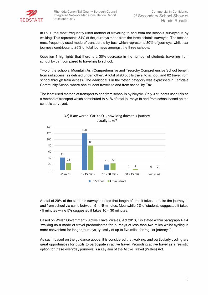
In RCT, the most frequently used method of travelling to and from the schools surveyed is by
walking. This represents 34% of the journeys made from the three schools surveyed. The second
most frequently used mode of transport is by bus, which represents 30% of journeys, whilst car
journeys contribute to 25% of total journeys amongst the three schools.
Question 1 highlights that there is a 30% decrease in the number of students travelling from
school by car, compared to travelling to school.
Two of the schools, Mountain Ash Comprehensive and Treorchy Comprehensive School benefit
from rail access, as defined under ‘other’. A total of 98 pupils travel to school, and 82 travel from
school through train access. The additional 1 in the ‘other’ category was expressed in Ferndale
Community School where one student travels to and from school by Taxi.
The least used method of transport to and from school is by bicycle. Only 3 students used this as
a method of transport which contributed to <1% of total journeys to and from school based on the
schools surveyed.
A total of 29% of the students surveyed noted that length of time it takes to make the journey to
and from school via car is between 5 – 15 minutes. Meanwhile 9% of students suggested it takes
<5 minutes while 5% suggested it takes 16 – 30 minutes.
Based on Welsh Government - Active Travel (Wales) Act 2013, it is stated within paragraph 4.1.4
“walking as a mode of travel predominates for journeys of less than two miles whilst cycling is
more convenient for longer journeys, typically of up to five miles for regular journeys”.
As such, based on the guidance above, it is considered that walking, and particularly cycling are
great opportunities for pupils to participate in active travel. Promoting active travel as a realistic
option for these everyday journeys is a key aim of the Active Travel (Wales) Act.
41
120
18
1 0
23
80
22
3 00
20
40
60
80
100
120
140
<5 mins 5 - 15 mins 16 - 30 mins 31 - 45 mis >45 mins
Q2) If answered 'Car' to Q1, how long does this journey
usually take?
To School From School

Rhondda Cynon Taf County Borough Council Integrated Network Map Consultation Report 9 October 2017
Commercial in Confidence
2/ Secondary School Show of Hands Results
6
A total of 82% of students throughout the three schools surveyed highlighted that they would like
to walk and cycle to school on a more regular basis. 33% more students would like to cycle
compared to walking, which based on question one suggests that 317 students want to travel to
and from school via bicycle rather than car, bus or other.
Students were asked whether any of the following measures would make walking to school better
or encourage them to walk more frequently.
Pupils were advised that they could select two answers to this question.
Of a total 1119 responses for question four, almost 40% of the suggestions to encourage walking
was to provide lockers for storage of students’ belongings. Meanwhile, 15% of responses noted
that it was too far to walk, this supports the number of students who use motor vehicles to travel
to and from school as outlined in question one.
108
171
129
146
0
20
40
60
80
100
120
140
160
180
Walking Cycling
Q3) How many students would like to walk / cycle on a more
regular basis? (That currently don’t)
To School From School
59 50
119
19
169
89
22
117
446
87
18 4
050
100150200250300350400450500
Q4 - What would make walking to school better, or (if you
don’t currently walk) encourage you to walk?
Rhondda Cynon Taf County Borough Council Integrated Network Map Consultation Report 9 October 2017
Commercial in Confidence
2/ Secondary School Show of Hands Results
7
10% of responses highlighted cleanliness of footways presenting an issue of perceived safety
and comfort. At present, this appears to discourage school-users to walk to and from school.
Improved cleanliness, assuming the 10% take-up walking after footways are cleaned, could
increase walking by 17% based on the number of students surveyed.
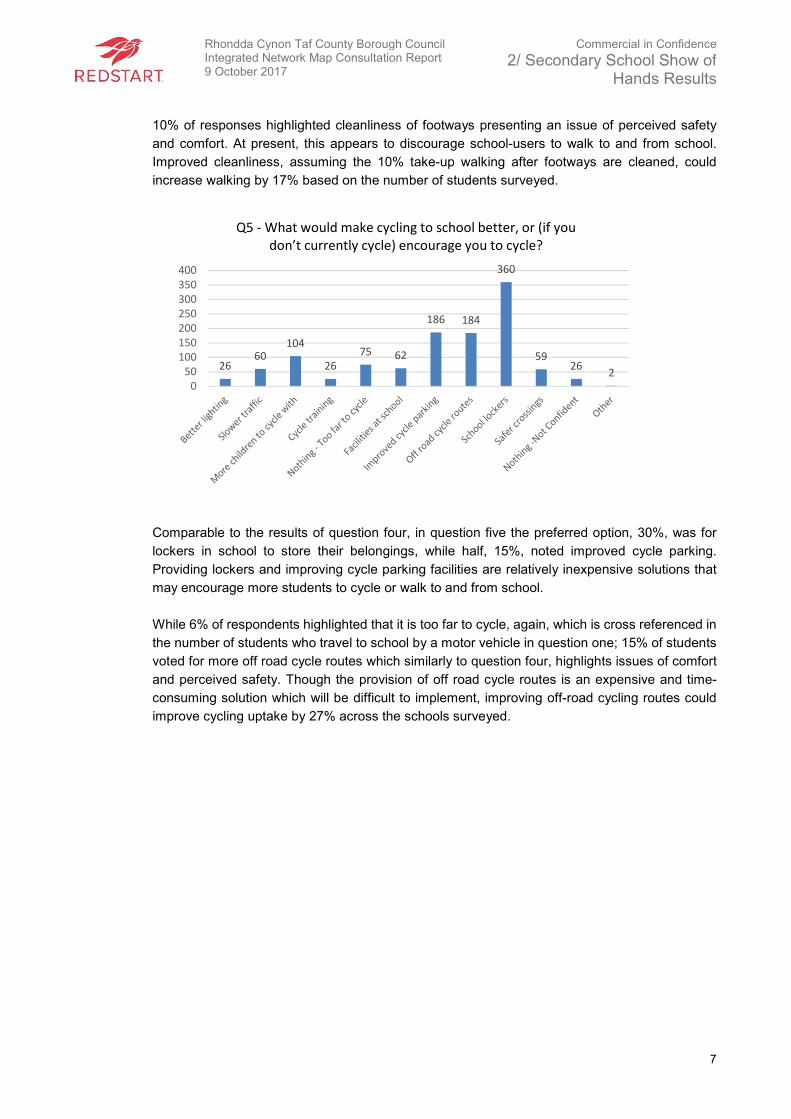
Comparable to the results of question four, in question five the preferred option, 30%, was for
lockers in school to store their belongings, while half, 15%, noted improved cycle parking.
Providing lockers and improving cycle parking facilities are relatively inexpensive solutions that
may encourage more students to cycle or walk to and from school.
While 6% of respondents highlighted that it is too far to cycle, again, which is cross referenced in
the number of students who travel to school by a motor vehicle in question one; 15% of students
voted for more off road cycle routes which similarly to question four, highlights issues of comfort
and perceived safety. Though the provision of off road cycle routes is an expensive and time-
consuming solution which will be difficult to implement, improving off-road cycling routes could
improve cycling uptake by 27% across the schools surveyed.
2660
104
26
75 62
186 184
360
5926
20
50
100
150
200
250
300
350
400
Q5 - What would make cycling to school better, or (if you
don’t currently cycle) encourage you to cycle?
Rhondda Cynon Taf County Borough Council Integrated Network Map Consultation Report 9 October 2017
Commercial in Confidence
2/ Secondary School Show of Hands Results
8
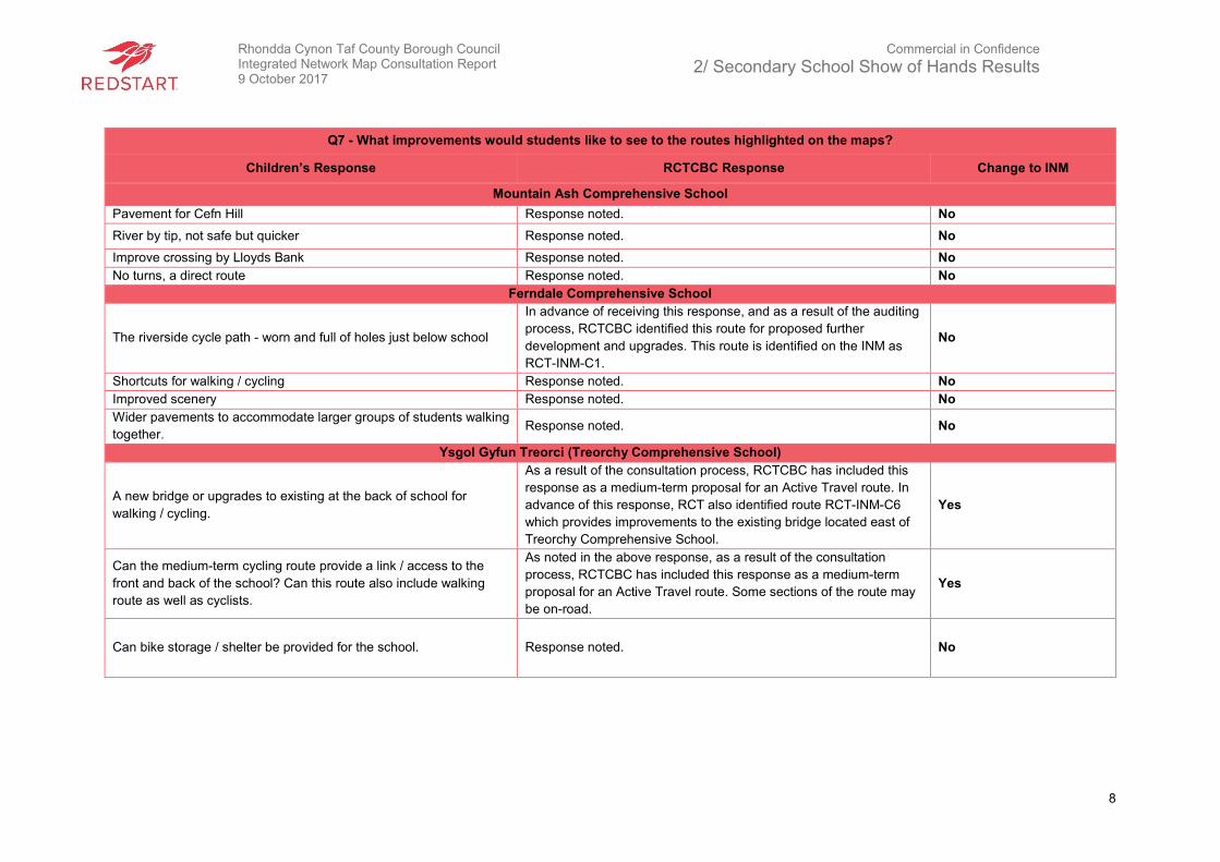
Q7 - What improvements would students like to see to the routes highlighted on the maps?
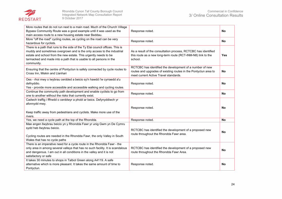
Children’s Response RCTCBC Response Change to INM
Mountain Ash Comprehensive School
Pavement for Cefn Hill Response noted. No
River by tip, not safe but quicker Response noted. No
Improve crossing by Lloyds Bank Response noted. No
No turns, a direct route Response noted. No
Ferndale Comprehensive School
The riverside cycle path - worn and full of holes just below school
In advance of receiving this response, and as a result of the auditing
process, RCTCBC identified this route for proposed further
development and upgrades. This route is identified on the INM as
RCT-INM-C1.
No
Shortcuts for walking / cycling Response noted. No
Improved scenery Response noted. No
Wider pavements to accommodate larger groups of students walking
together. Response noted. No
Ysgol Gyfun Treorci (Treorchy Comprehensive School)
A new bridge or upgrades to existing at the back of school for
walking / cycling.
As a result of the consultation process, RCTCBC has included this
response as a medium-term proposal for an Active Travel route. In
advance of this response, RCT also identified route RCT-INM-C6
which provides improvements to the existing bridge located east of
Treorchy Comprehensive School.
Yes
Can the medium-term cycling route provide a link / access to the
front and back of the school? Can this route also include walking
route as well as cyclists.
As noted in the above response, as a result of the consultation
process, RCTCBC has included this response as a medium-term
proposal for an Active Travel route. Some sections of the route may
be on-road.
Yes
Can bike storage / shelter be provided for the school. Response noted. No
Rhondda Cynon Taf County Borough Council Integrated Network Map Consultation Report 9 October 2017
Commercial in Confidence
2/ Secondary School Show of Hands Results
9
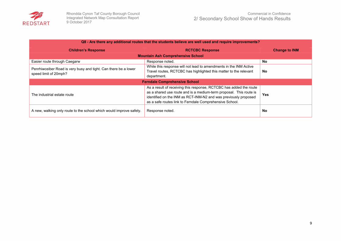
Q8 - Are there any additional routes that the students believe are well used and require improvements?
Children’s Response RCTCBC Response Change to INM
Mountain Ash Comprehensive School
Easier route through Caegarw Response noted. No
Penrhiwceiber Road is very busy and tight. Can there be a lower
speed limit of 20mph?
While this response will not lead to amendments in the INM Active
Travel routes, RCTCBC has highlighted this matter to the relevant
department.
No
Ferndale Comprehensive School
The industrial estate route
As a result of receiving this response, RCTCBC has added the route
as a shared use route and is a medium-term proposal. This route is
identified on the INM as RCT-INM-N2 and was previously proposed
as a safe routes link to Ferndale Comprehensive School.
Yes
A new, walking only route to the school which would improve safety. Response noted. No
Rhondda Cynon Taf County Borough Council Integrated Network Map Consultation Report 9 October 2017
Commercial in Confidence
3/ Online Consultation Results
10
3. Online Consultation Results
3.1 Introduction
The online survey questions differed from the show of hands survey questions in that additional
‘open-ended’ questions were included. These questions focused on existing routes and allowed
participants to specify improvements to existing routes and propose new routes. In addition, the
questionnaire was also provided in hard copy at RCTCBC’s community engagement events,
summarised in Chapter 5.
The online survey was live on RCTCBC website for 13 weeks between 26 June 2017 – 22
September 2017. RCTCBC received 173 responses to the online questionnaire. The results were
captured electronically, analysed and are subsequently presented in this chapter. The results of
some questions are not presented as they are not key to this report, for example personal details
such as addresses and names.
An email was sent to RCTCBC stakeholders which made clear that it wanted to hear recipients’
views on the existing and proposed routes, making clear that the deadline for responses on the
scheme was 22nd of September 2017. The same email provided a link to the relevant RCTCBC
website where the online survey was published for responses and noted that public engagement
events across RCT would be published accordingly.
The online consultation survey is included as Appendix B.
3.2 Closed Questions
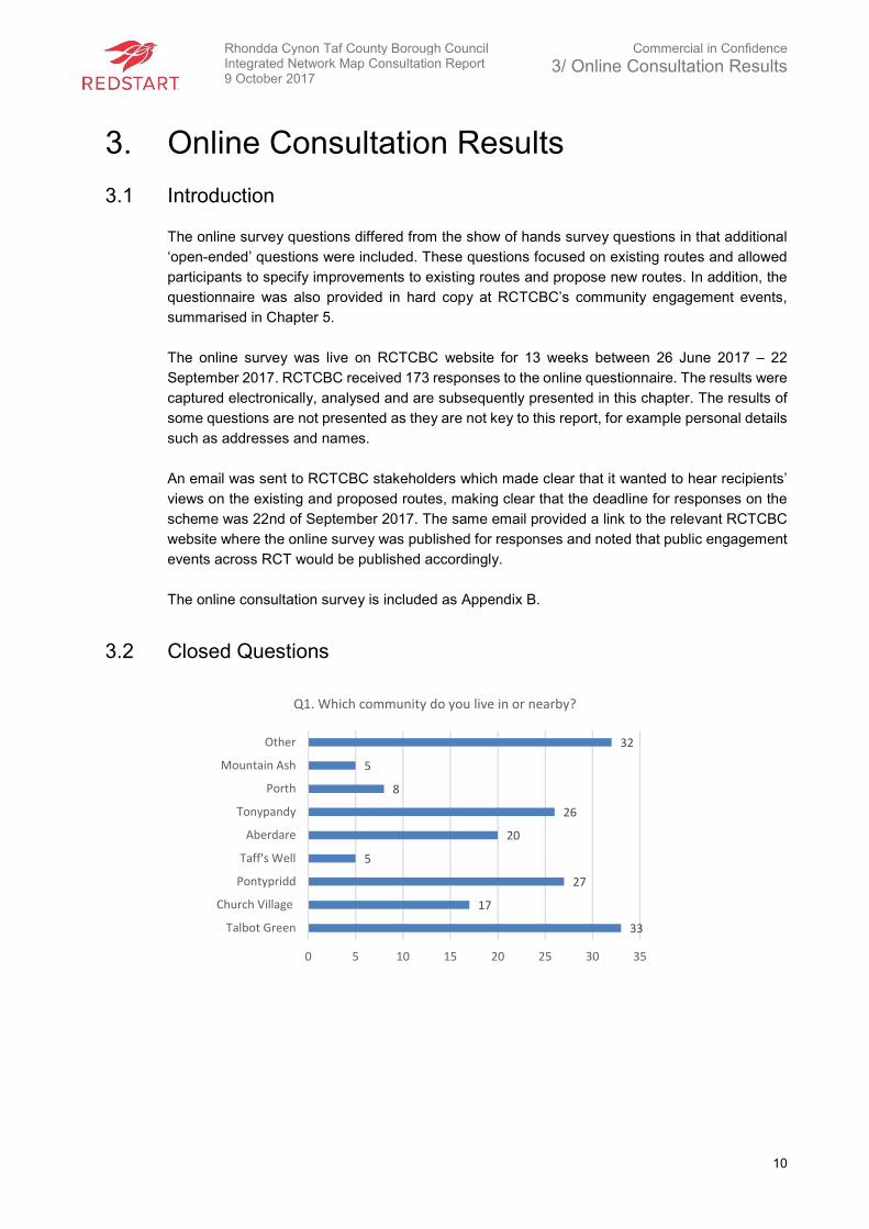
33
17
27
5
20
26
8
5
32
0 5 10 15 20 25 30 35
Talbot Green
Church Village
Pontypridd
Taff's Well
Aberdare
Tonypandy
Porth
Mountain Ash
Other
Q1. Which community do you live in or nearby?
Rhondda Cynon Taf County Borough Council Integrated Network Map Consultation Report 9 October 2017
Commercial in Confidence
3/ Online Consultation Results
11
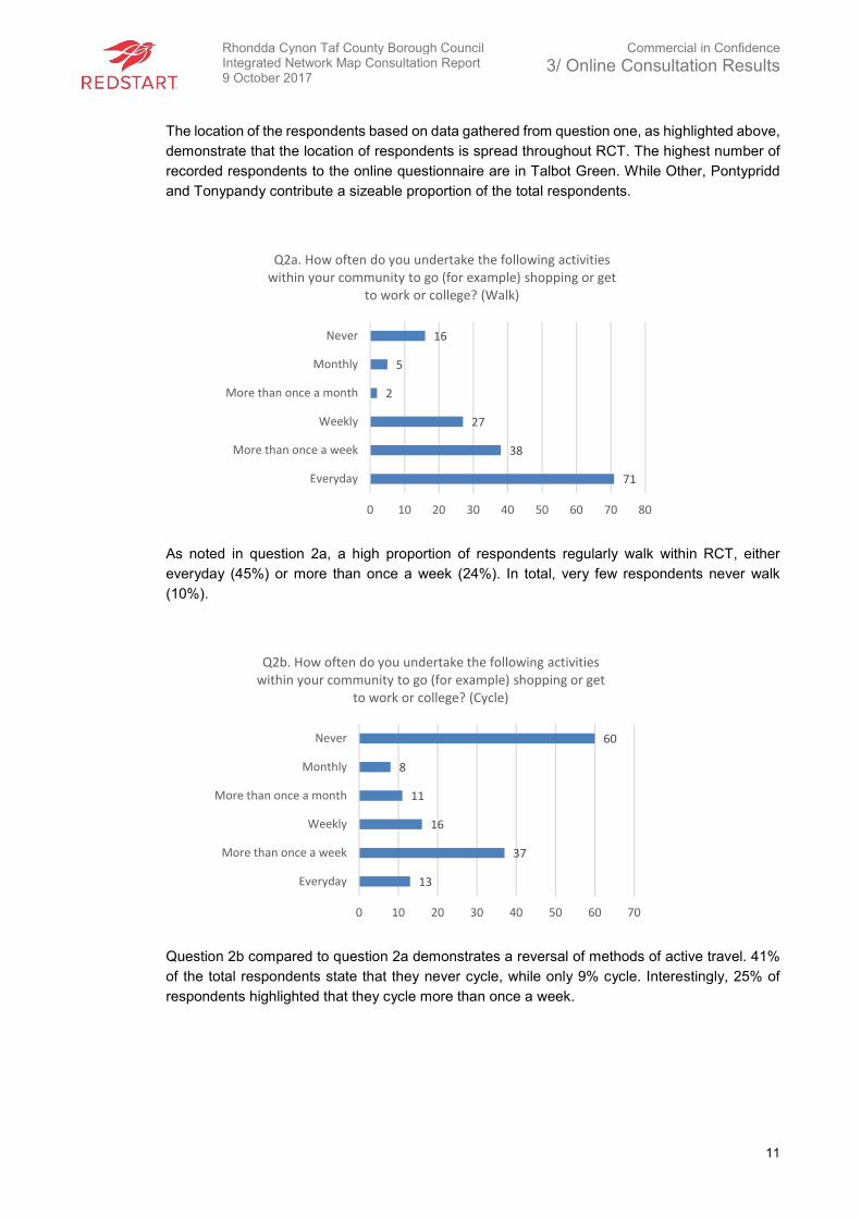
The location of the respondents based on data gathered from question one, as highlighted above,
demonstrate that the location of respondents is spread throughout RCT. The highest number of
recorded respondents to the online questionnaire are in Talbot Green. While Other, Pontypridd
and Tonypandy contribute a sizeable proportion of the total respondents.
As noted in question 2a, a high proportion of respondents regularly walk within RCT, either
everyday (45%) or more than once a week (24%). In total, very few respondents never walk
(10%).
Question 2b compared to question 2a demonstrates a reversal of methods of active travel. 41%
of the total respondents state that they never cycle, while only 9% cycle. Interestingly, 25% of
respondents highlighted that they cycle more than once a week.
71
38
27
2
5
16
0 10 20 30 40 50 60 70 80
Everyday
More than once a week
Weekly
More than once a month
Monthly
Never
Q2a. How often do you undertake the following activities
within your community to go (for example) shopping or get
to work or college? (Walk)
13
37
16
11
8
60
0 10 20 30 40 50 60 70
Everyday
More than once a week
Weekly
More than once a month
Monthly
Never
Q2b. How often do you undertake the following activities
within your community to go (for example) shopping or get
to work or college? (Cycle)
Rhondda Cynon Taf County Borough Council Integrated Network Map Consultation Report 9 October 2017
Commercial in Confidence
3/ Online Consultation Results
12
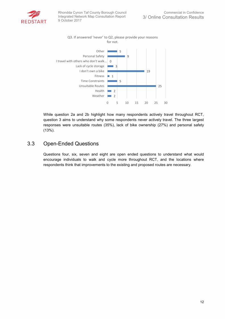
While question 2a and 2b highlight how many respondents actively travel throughout RCT,
question 3 aims to understand why some respondents never actively travel. The three largest
responses were unsuitable routes (35%), lack of bike ownership (27%) and personal safety
(13%).
3.3 Open-Ended Questions
Questions four, six, seven and eight are open ended questions to understand what would
encourage individuals to walk and cycle more throughout RCT, and the locations where
respondents think that improvements to the existing and proposed routes are necessary.
2
2
25
5
1
19
3
0
9
5
0 5 10 15 20 25 30
Weather
Health
Unsuitable Routes
Time Constraints
Fitness
I don’t own a bike
Lack of cycle storage
I travel with others who don't walk…
Personal Safety
Other
Q3. If answered ‘never’ to Q2, please provide your reasons
for not.
Rhondda Cynon Taf County Borough Council Integrated Network Map Consultation Report 9 October 2017
Commercial in Confidence
3/ Online Consultation Results
13
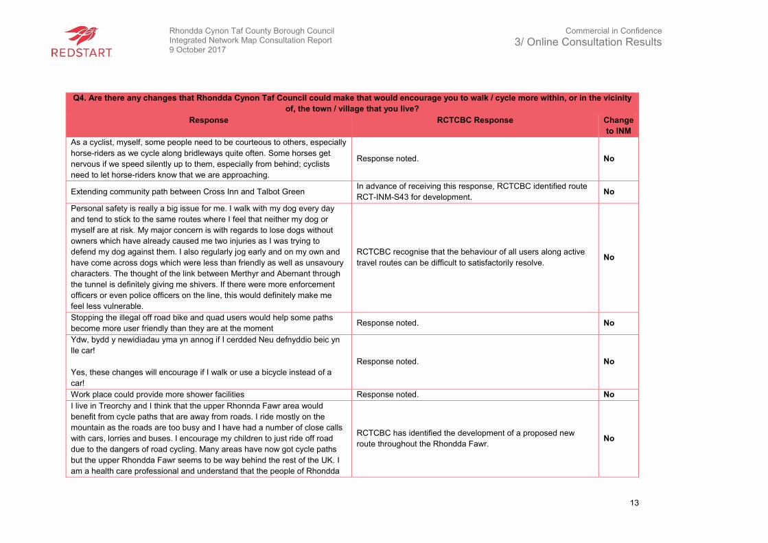
Q4. Are there any changes that Rhondda Cynon Taf Council could make that would encourage you to walk / cycle more within, or in the vicinity
of, the town / village that you live?
Response RCTCBC Response Change
to INM
As a cyclist, myself, some people need to be courteous to others, especially
horse-riders as we cycle along bridleways quite often. Some horses get
nervous if we speed silently up to them, especially from behind; cyclists
need to let horse-riders know that we are approaching.
Response noted. No
Extending community path between Cross Inn and Talbot Green In advance of receiving this response, RCTCBC identified route
RCT-INM-S43 for development. No
Personal safety is really a big issue for me. I walk with my dog every day
and tend to stick to the same routes where I feel that neither my dog or
myself are at risk. My major concern is with regards to lose dogs without
owners which have already caused me two injuries as I was trying to
defend my dog against them. I also regularly jog early and on my own and
have come across dogs which were less than friendly as well as unsavoury
characters. The thought of the link between Merthyr and Abernant through
the tunnel is definitely giving me shivers. If there were more enforcement
officers or even police officers on the line, this would definitely make me
feel less vulnerable.
RCTCBC recognise that the behaviour of all users along active
travel routes can be difficult to satisfactorily resolve. No
Stopping the illegal off road bike and quad users would help some paths
become more user friendly than they are at the moment Response noted. No
Ydw, bydd y newidiadau yma yn annog if I cerdded Neu defnyddio beic yn
lle car!
Yes, these changes will encourage if I walk or use a bicycle instead of a
car!
Response noted. No
Work place could provide more shower facilities Response noted. No
I live in Treorchy and I think that the upper Rhonnda Fawr area would
benefit from cycle paths that are away from roads. I ride mostly on the
mountain as the roads are too busy and I have had a number of close calls
with cars, lorries and buses. I encourage my children to just ride off road
due to the dangers of road cycling. Many areas have now got cycle paths
but the upper Rhondda Fawr seems to be way behind the rest of the UK. I
am a health care professional and understand that the people of Rhondda
RCTCBC has identified the development of a proposed new
route throughout the Rhondda Fawr. No
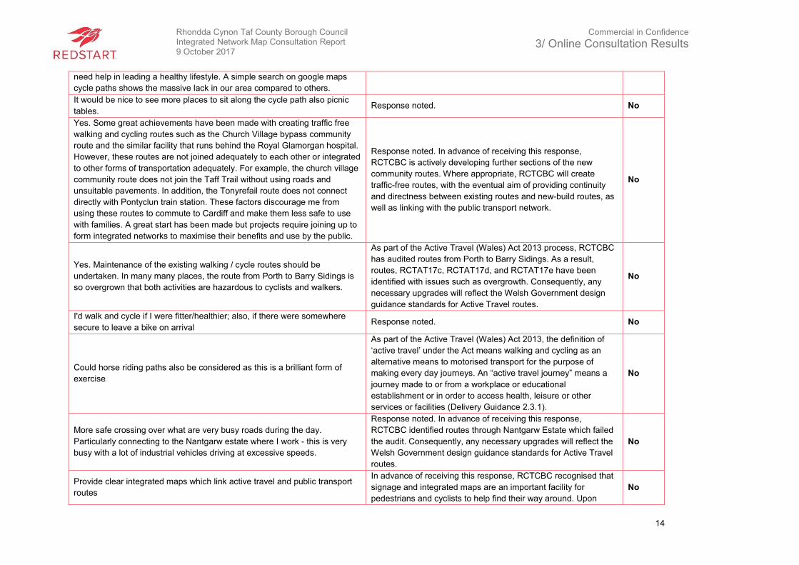
Rhondda Cynon Taf County Borough Council Integrated Network Map Consultation Report 9 October 2017
Commercial in Confidence
3/ Online Consultation Results
14
need help in leading a healthy lifestyle. A simple search on google maps
cycle paths shows the massive lack in our area compared to others.
It would be nice to see more places to sit along the cycle path also picnic
tables. Response noted. No
Yes. Some great achievements have been made with creating traffic free
walking and cycling routes such as the Church Village bypass community
route and the similar facility that runs behind the Royal Glamorgan hospital.
However, these routes are not joined adequately to each other or integrated
to other forms of transportation adequately. For example, the church village
community route does not join the Taff Trail without using roads and
unsuitable pavements. In addition, the Tonyrefail route does not connect
directly with Pontyclun train station. These factors discourage me from
using these routes to commute to Cardiff and make them less safe to use
with families. A great start has been made but projects require joining up to
form integrated networks to maximise their benefits and use by the public.
Response noted. In advance of receiving this response,
RCTCBC is actively developing further sections of the new
community routes. Where appropriate, RCTCBC will create
traffic-free routes, with the eventual aim of providing continuity
and directness between existing routes and new-build routes, as
well as linking with the public transport network.
No
Yes. Maintenance of the existing walking / cycle routes should be
undertaken. In many many places, the route from Porth to Barry Sidings is
so overgrown that both activities are hazardous to cyclists and walkers.
As part of the Active Travel (Wales) Act 2013 process, RCTCBC
has audited routes from Porth to Barry Sidings. As a result,
routes, RCTAT17c, RCTAT17d, and RCTAT17e have been
identified with issues such as overgrowth. Consequently, any
necessary upgrades will reflect the Welsh Government design
guidance standards for Active Travel routes.
No
I'd walk and cycle if I were fitter/healthier; also, if there were somewhere
secure to leave a bike on arrival Response noted. No
Could horse riding paths also be considered as this is a brilliant form of
exercise
As part of the Active Travel (Wales) Act 2013, the definition of
‘active travel’ under the Act means walking and cycling as an
alternative means to motorised transport for the purpose of
making every day journeys. An “active travel journey” means a
journey made to or from a workplace or educational
establishment or in order to access health, leisure or other
services or facilities (Delivery Guidance 2.3.1).
No
More safe crossing over what are very busy roads during the day.
Particularly connecting to the Nantgarw estate where I work - this is very
busy with a lot of industrial vehicles driving at excessive speeds.
Response noted. In advance of receiving this response,
RCTCBC identified routes through Nantgarw Estate which failed
the audit. Consequently, any necessary upgrades will reflect the
Welsh Government design guidance standards for Active Travel
routes.
No
Provide clear integrated maps which link active travel and public transport
routes
In advance of receiving this response, RCTCBC recognised that
signage and integrated maps are an important facility for
pedestrians and cyclists to help find their way around. Upon
No

Rhondda Cynon Taf County Borough Council Integrated Network Map Consultation Report 9 October 2017
Commercial in Confidence
3/ Online Consultation Results
15
finalising the draft INM routes, signage, with, where appropriate,
tactile embossed signs and braille will be used to give pedestrian
users who may not be familiar with the local area some indication
of distance and/or time to local facilities including public transport
nodes, leisure facilities, hospitals, education etc.
Cycle paths Response noted. No
Less rubbish and dog mess on the footpaths. Also, cutting back trees and
brambles. It would be nice if more cyclists were reprimanded for cycling on
footpaths as this makes walking dangerous.
Response noted. As part of the auditing process within the Active
Travel (Wales) Act, RCTCBC audited routes throughout RCT.
The audits identify improvements to identified issues such as
overgrowth and litter. Consequently, any necessary upgrades will
reflect the Welsh Government design guidance standards for
Active Travel routes.
No
When new roads were built, they should have had cycle paths built at the
same time - the Tonypandy to Cordell road is a classic! Similarly, when the
road from Dinas to Tonypandy was built no consideration was ever given to
a parallel cycle path on a reasonably flat route! Cycling in the Rhondda is
the most hazardous activity I can think of! Scenic cycle paths are all very
well and pretty but are of no practical use. Use should be made of parks,
industrial estates, rear lanes that are adopted as roads to produce a safe
practical cycle way. I cannot let my child out in her bike as it is not safe
anywhere!
RCTCBC has identified through the consultation and auditing
process that for many individuals, a significant barrier to active
travel is concern for their safety. As highlighted, these concerns
relate mainly to the existing infrastructure, such as difficult road
junctions or along existing road networks. Therefore, when
necessary, RCTCBC will develop active travel infrastructure to
meet the Welsh Government’s design guidance standards for
active travel.
No
Maintain existing routes better especially access paths which are often very
overgrown preventing easy access to the Taff Trail. Put in traffic calming
measures through Taffs Well and Nantgarw on Cardiff Road.
Response noted. No
Proper cycling lanes/tracks Response noted. No
RCT needs to take a leadership position in getting the Blaencwm
Blaengwnfi tunnel reopened. In addition, the Sustrans route from Porth to
the tunnel portal at Blaencwm needs to be built as a priority. This cycle
route would put the Rhondda on the "must do" cycle challenges i.e. Cardiff
to Port Talbot off-road. It has great potential for tourism and is an
opportunity to revitalise the upper valley.
The relevant department in RCTCBC are in discussions with
Rhondda Tunnel Society as well as Sustrans regarding this
route. RCTCBC has identified the development of a proposed
new route throughout the Rhondda Fawr.
No
I run within Porth, however some routes I can feel unsafe when running
alone. Some areas do become overgrown and not maintained, some paving
areas are uneven also.
Response noted. No
Better, safer cycle routes that are separated from traffic and also, where
possible, from pedestrians. Response noted. No
Separate cycle paths from walking paths as the cyclists are dangerous Response noted. No
Rhondda Cynon Taf County Borough Council Integrated Network Map Consultation Report 9 October 2017
Commercial in Confidence
3/ Online Consultation Results
16
Providing maps of walking routes and details on how to access them.
In advance of receiving this response, RCTCBC recognised that
signage and integrated maps are an important facility for
pedestrians and cyclists to help find their way around. Upon
finalising the draft INM routes, signage, with, where appropriate,
tactile embossed signs and braille will be used to give pedestrian
users who may not be familiar with the local area some indication
of distance and/or time to local facilities including public transport
nodes, leisure facilities, hospitals, education etc.
No
Safe routes not public highways to cycle with children that are accessible
without a bike rack. Response noted. No
Better up keep of the surfaces and far better control of the verges during
the summer months. At times, they become very narrow. Cycle paths also
need better marking for people walking keep left or right etc
Response noted. No
Regular cutting back of bushes they are overgrown in places. More bins on
routes as I find people dumping rubbish on paths and in river having a kid
picking up these things aren't great. Making some paths safer, a few
woodlands routes the trees have fallen down and you have to crouch down
to get through. Getting rid of dog mess, seems to be everywhere whilst it's
not a problem on the grass it is on paths.
Response noted. No
Convenient cycle racks Response noted. No
It would be great to see a cycling track on the Rhigos mountain as the road
is narrow and not much room on the road.
Rhigos mountain route does not meet Active Travel criteria as it
outside the built-up area, and is predominantly used for
recreational journeys.
No
Keep the line/paths clean. Cut the grass and trees back. Empty the bins
along the line. Beat the street more points Response noted. No
Walk frequently and would like to cycle would be good to be able to hire a
bike. RCTCBC will investigate a hire bike scheme further. No
A safe cycling route from Brynna/Llanharan to Talbot green would give me
a fantastic reach on bike. As it stands, the bottom road by Llanharan (the
road by Loreal roundabout) is just too dangerous to cycle on. Additionally,
although I think it would fall under Bridgend, a safe cycling path from
Brynna/Llanharan to Bridgend would be great and allow me to finally be
able to get to most places I need by bike. I have many near misses even
with daytime lights on my bike, people in our area just don't care about
cyclists and often don't even notice us when they should. Having been
knocked off my bike one (luckily only minor injuries) by a driver that didn't
stop it's time we sorted this and as soon as possible.
In advance of receiving this response, RCTCBC identified routes
RCT-INM-C7 and RCT-INM-S4 which will provide a route from
Brynna/Llanharan to Talbot Green. At present, RCTCBC has
identified a potential new build route, identified as route RCT-
INM-S33, which will provide access into Pencoed and Bridgend.
RCTCBC liaises on a regular basis with neighbouring authorities
over the planning and development of Active Travel routes that
run cross boundary and a regional approach is now being taken
through the Regional Transport Authority of the Cardiff Capital
Region.
No
Rhondda Cynon Taf County Borough Council Integrated Network Map Consultation Report 9 October 2017
Commercial in Confidence
3/ Online Consultation Results
17
I'd like to a clear cycle path at the bottom of Power Station road through to
Upper Boat roundabout. Currently the kerbs on the path are not dropped,
the path is not wide enough to support both walkers and cyclists and it’s in
a poor state or repair. In rush hour, there is not enough room for cyclists
and cars in the lane. Also, I'd like to see Treforest industrial estate cycle
path for cyclists and walkers to be cleaned, there is a lot of broken glass on
the floor that has been there for many years. Moy road industrial estate
road needs some repairs (not just for cyclists - but I think I read that this
was on a plan already ???)
As a result of receiving this response, RCTCBC has included a
long-term, aspirational route from Power Station Hill to Upper
Boat roundabout. This route is identified as RCT-INM-S31.
Consequently, the aspirational route, as well as the audited and
proposed upgraded route through the industrial estate will reflect
the Welsh Government’s design guidance standards for Active
Travel routes.
No
Yes, cutting back the hedges on the paths so you don’t have to walk on the
road and the pavement keeps crossing the main road which means you
have to keep crossing a very busy road so don’t bother
Response noted. No
Keep cycle paths clean use road sweeper now and then. Response noted. No
Get some bike storage and showers at council buildings. It beyond reason
why you would publicise the cycle to work scheme so much but contribute
nothing in storage or showers.
Response noted. No
Unable to use a cycle path in Rhondda Fawr, because there isn't one! Very
few Bridleways as well to safely ride our horse without going on the roads.
My wife has already suffered a major accident after being hit by a white van
whilst horse riding in upper Rhondda Fawr.
RCTCBC has identified the development of a proposed new
route throughout the Rhondda Fawr. Comments about
bridleways will be referred to the Council’s Countryside and
Parks department for consideration.
No
Yes, provide more safe cycle/walkways. I have a bike but as I am now
getting older I am afraid to use the main roads. If we had cycle routes I
would use them but I wouldn't I be happy to use them if they were off the
beaten track. The council need to provide safe cycling routes throughout
the Rhondda and not just selected areas within RCT.
Response noted. No
Links between cycle paths to enable journeys to be completed. This is
particularly the case around the town centre and in the Trecynon/Gadlys
area. Why is there not an arrangement for cycling to be possible within
Aberdare Park. Most of the Taff Trail is for walkers and cyclists - there is
generally a good relationship between the two and I do not understand if
you are promoting cycling and active travelling why some arrangement for
cycling could not be made.
Response Noted. Matters regarding byelaws will be considered
further by the RCTCBC. In addition, it is a long-term ambition for
RCTCBC to link existing active travel routes in RCT and form a
comprehensive and continuous network for walking, cycling and
shared-use users.
No
Segregated cycle lanes Response noted. No
Better maintenance of pathways regard to hedges and overgrowth near
paths Response noted – this matter will be addressed by RCTCBC. No
Yes, off road cycle paths Response noted – this matter will be addressed by RCTCBC. No
Remove or alter the overly restrictive pinch points that are all along any
cycle trails in RCT. Make the bike path up the side of power station hill
The removal of barriers is being trialled and monitored on a case
by case basis throughout selected locations within RCT. The trial No
Rhondda Cynon Taf County Borough Council Integrated Network Map Consultation Report 9 October 2017
Commercial in Confidence
3/ Online Consultation Results
18
more practical to use. There is no way to get to it without crossing a
dangerous road and riding in heavy traffic. The path is also constantly
covered in glass from the roads making using it at all unappealing to
cyclists. This is the only cycle friendly way for commuters from Cardiff to
Church Village and I wish it was better thought out.
is to determine whether it results in problems of anti-social
behaviour arising. However, matters such as crossings,
maintenance and clearance of existing routes will be addressed
by RCTCBC.
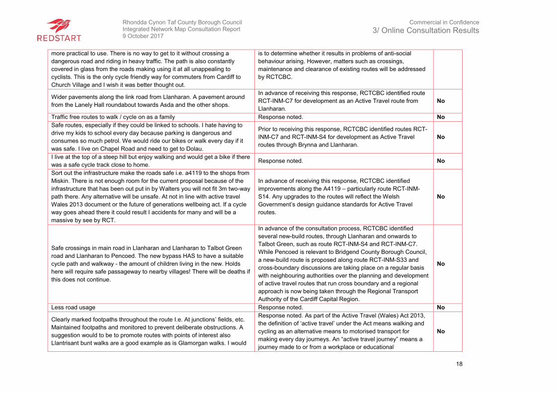
Wider pavements along the link road from Llanharan. A pavement around
from the Lanely Hall roundabout towards Asda and the other shops.
In advance of receiving this response, RCTCBC identified route
RCT-INM-C7 for development as an Active Travel route from
Llanharan.
No
Traffic free routes to walk / cycle on as a family Response noted. No
Safe routes, especially if they could be linked to schools. I hate having to
drive my kids to school every day because parking is dangerous and
consumes so much petrol. We would ride our bikes or walk every day if it
was safe. I live on Chapel Road and need to get to Dolau.
Prior to receiving this response, RCTCBC identified routes RCT-
INM-C7 and RCT-INM-S4 for development as Active Travel
routes through Brynna and Llanharan.
No
I live at the top of a steep hill but enjoy walking and would get a bike if there
was a safe cycle track close to home. Response noted. No
Sort out the infrastructure make the roads safe i.e. a4119 to the shops from
Miskin. There is not enough room for the current proposal because of the
infrastructure that has been out put in by Walters you will not fit 3m two-way
path there. Any alternative will be unsafe. At not in line with active travel
Wales 2013 document or the future of generations wellbeing act. If a cycle
way goes ahead there it could result I accidents for many and will be a
massive by see by RCT.
In advance of receiving this response, RCTCBC identified
improvements along the A4119 – particularly route RCT-INM-
S14. Any upgrades to the routes will reflect the Welsh
Government’s design guidance standards for Active Travel
routes.
No
Safe crossings in main road in Llanharan and Llanharan to Talbot Green
road and Llanharan to Pencoed. The new bypass HAS to have a suitable
cycle path and walkway - the amount of children living in the new. Holds
here will require safe passageway to nearby villages! There will be deaths if
this does not continue.
In advance of the consultation process, RCTCBC identified
several new-build routes, through Llanharan and onwards to
Talbot Green, such as route RCT-INM-S4 and RCT-INM-C7.
While Pencoed is relevant to Bridgend County Borough Council,
a new-build route is proposed along route RCT-INM-S33 and
cross-boundary discussions are taking place on a regular basis
with neighbouring authorities over the planning and development
of active travel routes that run cross boundary and a regional
approach is now being taken through the Regional Transport
Authority of the Cardiff Capital Region.
No
Less road usage Response noted. No
Clearly marked footpaths throughout the route I.e. At junctions’ fields, etc.
Maintained footpaths and monitored to prevent deliberate obstructions. A
suggestion would to be to promote routes with points of interest also
Llantrisant bunt walks are a good example as is Glamorgan walks. I would
Response noted. As part of the Active Travel (Wales) Act 2013,
the definition of ‘active travel’ under the Act means walking and
cycling as an alternative means to motorised transport for
making every day journeys. An “active travel journey” means a
journey made to or from a workplace or educational
No
Rhondda Cynon Taf County Borough Council Integrated Network Map Consultation Report 9 October 2017
Commercial in Confidence
3/ Online Consultation Results
19
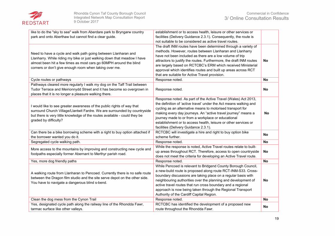
like to do the "sky to sea" walk from Aberdare park to Bryngarw country
park and onto Aberthaw but cannot find a clear guide.
establishment or to access health, leisure or other services or
facilities (Delivery Guidance 2.3.1). Consequently, the route is
not suitable to be considered as active travel routes.
Need to have a cycle and walk path going between Llanharan and
Llanharry. While riding my bike or just walking down that meadow I have
almost been hit a few times as most cars go 60MPH around the blind
corners or don’t give enough room when taking over me.
The draft INM routes have been determined through a variety of
methods. However, routes between Llanharan and Llanharry
have not been included as there are a low volume of trip
attractors to justify the routes. Furthermore, the draft INM routes
are largely based on RCTCBC’s ERM which received Ministerial
approval which identifies routes and built up areas across RCT
that are suitable for Active Travel provision.
No
Cycle routes or pathways Response noted. No
Pathways cleared more regularly I walk my dog on the Taff Trail between
Tudor Terrace and Meirionnydd Street and it has become so overgrown in
places that it is no longer a pleasure walking there.
Response noted. No
I would like to see greater awareness of the public rights of way that
surround Church Village/Llantwit Fardre. We are surrounded by countryside
but there is very little knowledge of the routes available - could they be
graded by difficulty?
Response noted. As part of the Active Travel (Wales) Act 2013,
the definition of ‘active travel’ under the Act means walking and
cycling as an alternative means to motorised transport for
making every day journeys. An “active travel journey” means a
journey made to or from a workplace or educational
establishment or to access health, leisure or other services or
facilities (Delivery Guidance 2.3.1).
No
Can there be a bike borrowing scheme with a right to buy option attached if
the borrower wanted you do it.
RCTCBC will investigate a hire and right to buy option bike
scheme further. No
Segregated cycle walking path. Response noted. No
More access to the mountains by improving and constructing new cycle and
footpaths especially former Abernant to Merthyr parish road.
While the response is noted, Active Travel routes relate to built-
up areas throughout RCT. Therefore, access to open countryside
does not meet the criteria for developing an Active Travel route.
No
Yes, more dog friendly paths Response noted. No
A walking route from Llanharan to Pencoed. Currently there is no safe route
between the Dragon film studio and the site serve depot on the other side.
You have to navigate a dangerous blind s-bend.
While Pencoed is relevant to Bridgend County Borough Council,
a new-build route is proposed along route RCT-INM-S33. Cross-
boundary discussions are taking place on a regular basis with
neighbouring authorities over the planning and development of
active travel routes that run cross boundary and a regional
approach is now being taken through the Regional Transport
Authority of the Cardiff Capital Region.
No
Clean the dog mess from the Cynon Trail Response noted. No
Yes, designated cycle path along the railway line of the Rhondda Fawr,
tarmac surface like other valleys.
RCTCBC has identified the development of a proposed new
route throughout the Rhondda Fawr. No
Rhondda Cynon Taf County Borough Council Integrated Network Map Consultation Report 9 October 2017
Commercial in Confidence
3/ Online Consultation Results
20
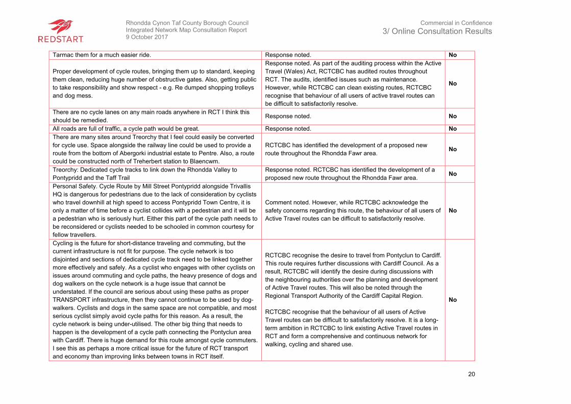
Tarmac them for a much easier ride. Response noted. No
Proper development of cycle routes, bringing them up to standard, keeping
them clean, reducing huge number of obstructive gates. Also, getting public
to take responsibility and show respect - e.g. Re dumped shopping trolleys
and dog mess.
Response noted. As part of the auditing process within the Active
Travel (Wales) Act, RCTCBC has audited routes throughout
RCT. The audits, identified issues such as maintenance.
However, while RCTCBC can clean existing routes, RCTCBC
recognise that behaviour of all users of active travel routes can
be difficult to satisfactorily resolve.
No
There are no cycle lanes on any main roads anywhere in RCT I think this
should be remedied. Response noted. No
All roads are full of traffic, a cycle path would be great. Response noted. No
There are many sites around Treorchy that I feel could easily be converted
for cycle use. Space alongside the railway line could be used to provide a
route from the bottom of Abergorki industrial estate to Pentre. Also, a route
could be constructed north of Treherbert station to Blaencwm.
RCTCBC has identified the development of a proposed new
route throughout the Rhondda Fawr area. No
Treorchy: Dedicated cycle tracks to link down the Rhondda Valley to
Pontypridd and the Taff Trail
Response noted. RCTCBC has identified the development of a
proposed new route throughout the Rhondda Fawr area. No
Personal Safety. Cycle Route by Mill Street Pontypridd alongside Trivallis
HQ is dangerous for pedestrians due to the lack of consideration by cyclists
who travel downhill at high speed to access Pontypridd Town Centre, it is
only a matter of time before a cyclist collides with a pedestrian and it will be
a pedestrian who is seriously hurt. Either this part of the cycle path needs to
be reconsidered or cyclists needed to be schooled in common courtesy for
fellow travellers.
Comment noted. However, while RCTCBC acknowledge the
safety concerns regarding this route, the behaviour of all users of
Active Travel routes can be difficult to satisfactorily resolve.
No
Cycling is the future for short-distance traveling and commuting, but the
current infrastructure is not fit for purpose. The cycle network is too
disjointed and sections of dedicated cycle track need to be linked together
more effectively and safely. As a cyclist who engages with other cyclists on
issues around commuting and cycle paths, the heavy presence of dogs and
dog walkers on the cycle network is a huge issue that cannot be
understated. If the council are serious about using these paths as proper
TRANSPORT infrastructure, then they cannot continue to be used by dog-
walkers. Cyclists and dogs in the same space are not compatible, and most
serious cyclist simply avoid cycle paths for this reason. As a result, the
cycle network is being under-utilised. The other big thing that needs to
happen is the development of a cycle path connecting the Pontyclun area
with Cardiff. There is huge demand for this route amongst cycle commuters.
I see this as perhaps a more critical issue for the future of RCT transport
and economy than improving links between towns in RCT itself.
RCTCBC recognise the desire to travel from Pontyclun to Cardiff.
This route requires further discussions with Cardiff Council. As a
result, RCTCBC will identify the desire during discussions with
the neighbouring authorities over the planning and development
of Active Travel routes. This will also be noted through the
Regional Transport Authority of the Cardiff Capital Region.
RCTCBC recognise that the behaviour of all users of Active
Travel routes can be difficult to satisfactorily resolve. It is a long-
term ambition in RCTCBC to link existing Active Travel routes in
RCT and form a comprehensive and continuous network for
walking, cycling and shared use.
No
Rhondda Cynon Taf County Borough Council Integrated Network Map Consultation Report 9 October 2017
Commercial in Confidence
3/ Online Consultation Results
21
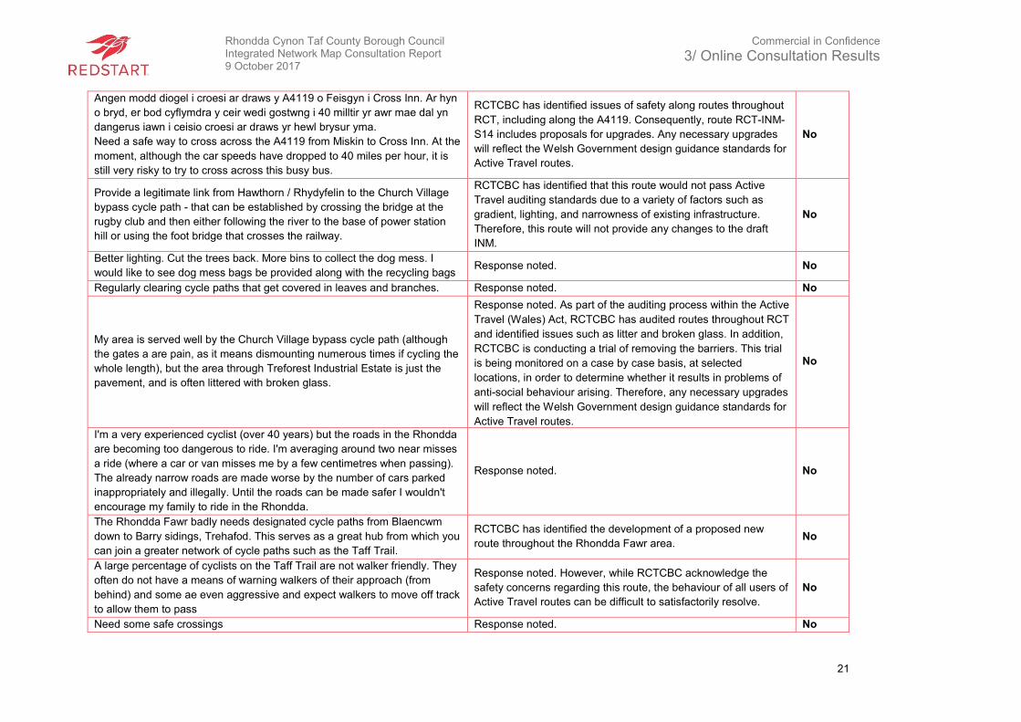
Angen modd diogel i croesi ar draws y A4119 o Feisgyn i Cross Inn. Ar hyn
o bryd, er bod cyflymdra y ceir wedi gostwng i 40 milltir yr awr mae dal yn
dangerus iawn i ceisio croesi ar draws yr hewl brysur yma.
Need a safe way to cross across the A4119 from Miskin to Cross Inn. At the
moment, although the car speeds have dropped to 40 miles per hour, it is
still very risky to try to cross across this busy bus.
RCTCBC has identified issues of safety along routes throughout
RCT, including along the A4119. Consequently, route RCT-INM-
S14 includes proposals for upgrades. Any necessary upgrades
will reflect the Welsh Government design guidance standards for
Active Travel routes.
No
Provide a legitimate link from Hawthorn / Rhydyfelin to the Church Village
bypass cycle path - that can be established by crossing the bridge at the
rugby club and then either following the river to the base of power station
hill or using the foot bridge that crosses the railway.
RCTCBC has identified that this route would not pass Active
Travel auditing standards due to a variety of factors such as
gradient, lighting, and narrowness of existing infrastructure.
Therefore, this route will not provide any changes to the draft
INM.
No
Better lighting. Cut the trees back. More bins to collect the dog mess. I
would like to see dog mess bags be provided along with the recycling bags Response noted. No
Regularly clearing cycle paths that get covered in leaves and branches. Response noted. No
My area is served well by the Church Village bypass cycle path (although
the gates a are pain, as it means dismounting numerous times if cycling the
whole length), but the area through Treforest Industrial Estate is just the
pavement, and is often littered with broken glass.
Response noted. As part of the auditing process within the Active
Travel (Wales) Act, RCTCBC has audited routes throughout RCT
and identified issues such as litter and broken glass. In addition,
RCTCBC is conducting a trial of removing the barriers. This trial
is being monitored on a case by case basis, at selected
locations, in order to determine whether it results in problems of
anti-social behaviour arising. Therefore, any necessary upgrades
will reflect the Welsh Government design guidance standards for
Active Travel routes.
No
I'm a very experienced cyclist (over 40 years) but the roads in the Rhondda
are becoming too dangerous to ride. I'm averaging around two near misses
a ride (where a car or van misses me by a few centimetres when passing).
The already narrow roads are made worse by the number of cars parked
inappropriately and illegally. Until the roads can be made safer I wouldn't
encourage my family to ride in the Rhondda.
Response noted. No
The Rhondda Fawr badly needs designated cycle paths from Blaencwm
down to Barry sidings, Trehafod. This serves as a great hub from which you
can join a greater network of cycle paths such as the Taff Trail.
RCTCBC has identified the development of a proposed new
route throughout the Rhondda Fawr area. No
A large percentage of cyclists on the Taff Trail are not walker friendly. They
often do not have a means of warning walkers of their approach (from
behind) and some ae even aggressive and expect walkers to move off track
to allow them to pass
Response noted. However, while RCTCBC acknowledge the
safety concerns regarding this route, the behaviour of all users of
Active Travel routes can be difficult to satisfactorily resolve.
No
Need some safe crossings Response noted. No
Rhondda Cynon Taf County Borough Council Integrated Network Map Consultation Report 9 October 2017
Commercial in Confidence
3/ Online Consultation Results
22
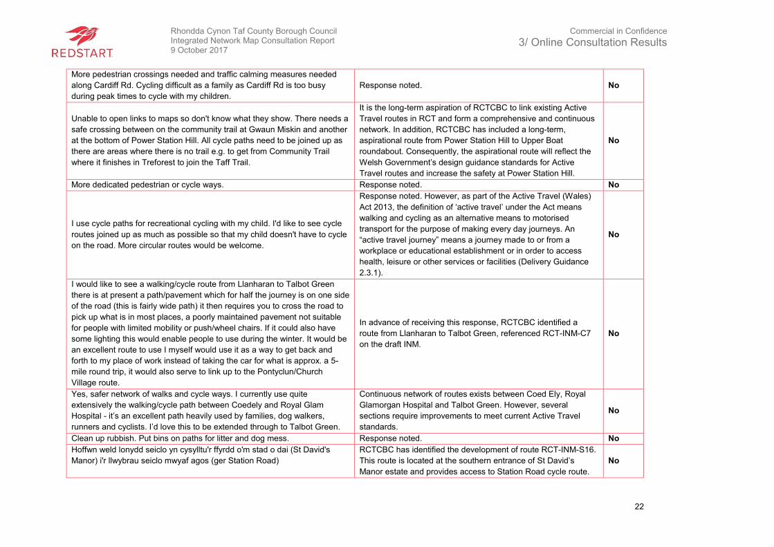
More pedestrian crossings needed and traffic calming measures needed
along Cardiff Rd. Cycling difficult as a family as Cardiff Rd is too busy
during peak times to cycle with my children.
Response noted. No
Unable to open links to maps so don't know what they show. There needs a
safe crossing between on the community trail at Gwaun Miskin and another
at the bottom of Power Station Hill. All cycle paths need to be joined up as
there are areas where there is no trail e.g. to get from Community Trail
where it finishes in Treforest to join the Taff Trail.
It is the long-term aspiration of RCTCBC to link existing Active
Travel routes in RCT and form a comprehensive and continuous
network. In addition, RCTCBC has included a long-term,
aspirational route from Power Station Hill to Upper Boat
roundabout. Consequently, the aspirational route will reflect the
Welsh Government’s design guidance standards for Active
Travel routes and increase the safety at Power Station Hill.
No
More dedicated pedestrian or cycle ways. Response noted. No
I use cycle paths for recreational cycling with my child. I'd like to see cycle
routes joined up as much as possible so that my child doesn't have to cycle
on the road. More circular routes would be welcome.
Response noted. However, as part of the Active Travel (Wales)
Act 2013, the definition of ‘active travel’ under the Act means
walking and cycling as an alternative means to motorised
transport for the purpose of making every day journeys. An
“active travel journey” means a journey made to or from a
workplace or educational establishment or in order to access
health, leisure or other services or facilities (Delivery Guidance
2.3.1).
No
I would like to see a walking/cycle route from Llanharan to Talbot Green
there is at present a path/pavement which for half the journey is on one side
of the road (this is fairly wide path) it then requires you to cross the road to
pick up what is in most places, a poorly maintained pavement not suitable
for people with limited mobility or push/wheel chairs. If it could also have
some lighting this would enable people to use during the winter. It would be
an excellent route to use I myself would use it as a way to get back and
forth to my place of work instead of taking the car for what is approx. a 5-
mile round trip, it would also serve to link up to the Pontyclun/Church
Village route.
In advance of receiving this response, RCTCBC identified a
route from Llanharan to Talbot Green, referenced RCT-INM-C7
on the draft INM.
No
Yes, safer network of walks and cycle ways. I currently use quite
extensively the walking/cycle path between Coedely and Royal Glam
Hospital - it’s an excellent path heavily used by families, dog walkers,
runners and cyclists. I’d love this to be extended through to Talbot Green.
Continuous network of routes exists between Coed Ely, Royal
Glamorgan Hospital and Talbot Green. However, several
sections require improvements to meet current Active Travel
standards.
No
Clean up rubbish. Put bins on paths for litter and dog mess. Response noted. No
Hoffwn weld lonydd seiclo yn cysylltu'r ffyrdd o'm stad o dai (St David's
Manor) i'r llwybrau seiclo mwyaf agos (ger Station Road)
RCTCBC has identified the development of route RCT-INM-S16.
This route is located at the southern entrance of St David’s
Manor estate and provides access to Station Road cycle route.
No
Rhondda Cynon Taf County Borough Council Integrated Network Map Consultation Report 9 October 2017
Commercial in Confidence
3/ Online Consultation Results
23
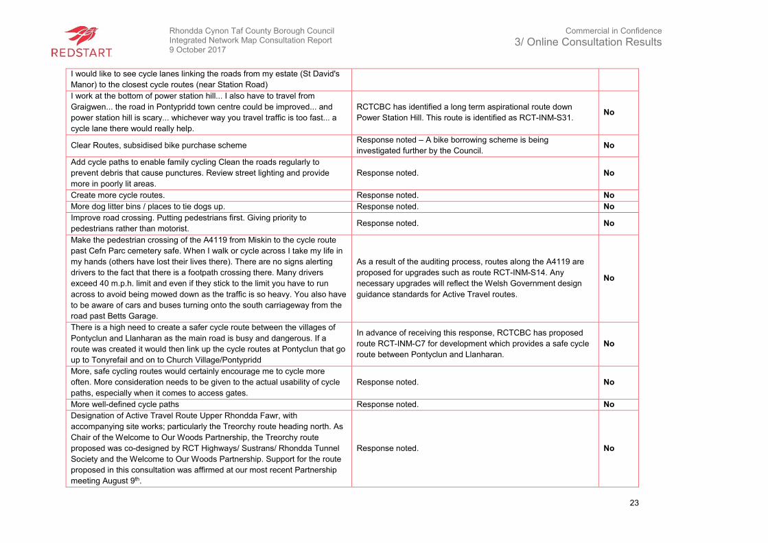
I would like to see cycle lanes linking the roads from my estate (St David's
Manor) to the closest cycle routes (near Station Road)
I work at the bottom of power station hill... I also have to travel from
Graigwen... the road in Pontypridd town centre could be improved... and
power station hill is scary... whichever way you travel traffic is too fast... a
cycle lane there would really help.
RCTCBC has identified a long term aspirational route down
Power Station Hill. This route is identified as RCT-INM-S31. No
Clear Routes, subsidised bike purchase scheme Response noted – A bike borrowing scheme is being
investigated further by the Council. No
Add cycle paths to enable family cycling Clean the roads regularly to
prevent debris that cause punctures. Review street lighting and provide
more in poorly lit areas.
Response noted. No
Create more cycle routes. Response noted. No
More dog litter bins / places to tie dogs up. Response noted. No
Improve road crossing. Putting pedestrians first. Giving priority to
pedestrians rather than motorist. Response noted. No
Make the pedestrian crossing of the A4119 from Miskin to the cycle route
past Cefn Parc cemetery safe. When I walk or cycle across I take my life in
my hands (others have lost their lives there). There are no signs alerting
drivers to the fact that there is a footpath crossing there. Many drivers
exceed 40 m.p.h. limit and even if they stick to the limit you have to run
across to avoid being mowed down as the traffic is so heavy. You also have
to be aware of cars and buses turning onto the south carriageway from the
road past Betts Garage.
As a result of the auditing process, routes along the A4119 are
proposed for upgrades such as route RCT-INM-S14. Any
necessary upgrades will reflect the Welsh Government design
guidance standards for Active Travel routes.
No
There is a high need to create a safer cycle route between the villages of
Pontyclun and Llanharan as the main road is busy and dangerous. If a
route was created it would then link up the cycle routes at Pontyclun that go
up to Tonyrefail and on to Church Village/Pontypridd
In advance of receiving this response, RCTCBC has proposed
route RCT-INM-C7 for development which provides a safe cycle
route between Pontyclun and Llanharan.
No
More, safe cycling routes would certainly encourage me to cycle more
often. More consideration needs to be given to the actual usability of cycle
paths, especially when it comes to access gates.
Response noted. No
More well-defined cycle paths Response noted. No
Designation of Active Travel Route Upper Rhondda Fawr, with
accompanying site works; particularly the Treorchy route heading north. As
Chair of the Welcome to Our Woods Partnership, the Treorchy route
proposed was co-designed by RCT Highways/ Sustrans/ Rhondda Tunnel
Society and the Welcome to Our Woods Partnership. Support for the route
proposed in this consultation was affirmed at our most recent Partnership
meeting August 9th.
Response noted. No
Rhondda Cynon Taf County Borough Council Integrated Network Map Consultation Report 9 October 2017
Commercial in Confidence
3/ Online Consultation Results
24
More routes that do not run next to a main road. Much of the Church Village
Bypass Community Route was a good example until it was used as the
main access route to a new housing estate near Beddau.
Response noted. No
More "off the road" cycling routes, as cycling on the road can be very
hazardous for cyclists. Response noted. No
There is a path that runs to the side of the Ty Elai council offices. This is
muddy and sometimes overgrown and is the only access to the industrial
estate and school from the new estate. This urgently needs to be
tarmacked and made into a path that is usable to all persons in the
community.
As a result of the consultation process, RCTCBC has identified
this route as a new long-term route (RCT-INM-N8) link to the
school.
Yes
Ensuring that the centre of Pontyclun is safely connected by cycle routes to
Cross Inn, Miskin and Llanhari
RCTCBC has identified the development of a number of new
routes and upgrades of existing routes in the Pontyclun area to
meet current Active Travel standards.
No
Oes - rhoi mwy o lwybrau cerdded a beicio sy'n hawdd i'w cyrraedd a'u
defnyddio.
Yes - provide more accessible and accessible walking and cycling routes.
Response noted. No
Continue the community path development and enable cyclists to go from
one to another without the risks that currently exist. Response noted. No
Cadwch traffig i fffrwdd o cerddwyr a phobl ar beics. Defynyddiwch yr
afonnydd mwy.
Keep traffic away from pedestrians and cyclists. Make more use of the
rivers.
Response noted. No
Yes, we need a cycle path at the top of the Rhondda. Response noted. No
Mae angen llwybrau beicio yn y Rhondda Fawr yr unig Gwm yn De Cymru
sydd heb llwybrau beicio.
Cycling routes are needed in the Rhondda Fawr, the only Valley in South
Wales that has no cycle paths
RCTCBC has identified the development of a proposed new
route throughout the Rhondda Fawr area. No
There is an imperative need for a cycle route in the Rhondda Fawr - the
only area in among several valleys that has no such facility. It is scandalous
and dangerous. I am out in all conditions in the valley and it is not
satisfactory or safe
RCTCBC has identified the development of a proposed new
route throughout the Rhondda Fawr Area. No
It takes 30 minutes to shops in Talbot Green along A4119. A safe
alternative which is more pleasant. It takes the same amount of time to
Pontyclun.
Response noted. No
Rhondda Cynon Taf County Borough Council Integrated Network Map Consultation Report 9 October 2017
Commercial in Confidence
3/ Online Consultation Results
25
I would like to see more clearly marked walking routes and guides for the
top of the Rhondda including our mountains. Need cycle routes at the top of
the valley.
While the response is noted, Active Travel routes relate to built-
up areas throughout RCT. Therefore, access to open countryside
does not meet the criteria for developing an Active Travel route.
No
More car parking areas Response noted. No
All dogs should be kept on leads on walks and more penalties for dog
fouling. Response noted. No
Really, I don’t have time as I look after grandchildren, but I am aware of
walking route. Response noted. No
Yes - get some cycle and walking paths created immediately and have the
appropriate facilities for visitors as well as residents to allow them to use
these paths on a regular basis. If health is a serious issue in the Rhondda
Valley as we are constantly told and reminded of the council are doing their
best to keep the bad state of health of its residents and are not investing in
the health and wellbeing of its residents - as well as attracting visitors - by
not giving them credible, safe and well maintained cycle and walking paths.
Response noted. No
Improved safety for on-road sections of Taff Trail and Treforest (cycle
lanes/segregated cycling). Improved surface conditions for off-road sections
of Taff Trail (e.g. Trallwn to Abercynon stretch).
As a result of the auditing process, sections of routes along the
Taf Trail and Treforest are proposed for upgrades. Any
necessary upgrades will reflect the Welsh Government design
guidance standards for Active Travel routes.
No
Introduce more cycle tracks and lanes Response noted. No
Not really, most of the proposed routes make sense or already exist Response noted. No
Better surfaces and better routes Response noted. No
Yes. Ask the cycle riders to be courteous to walkers and to slow down when
they are passing. Do something about the motorbikes that use the Cynon
Trail.
Response noted. No
Sorry this is not about walking or cycling but this is about bridle paths. I
think it's something to be looked at. There are far too many people and
horses being killed while out riding. There is lack of respect for both. There
are too many road uses that don't care. I'm a mother off a 14-year-old that
loves her horses and would love a bridle path. I think this is a must to be
looked into. The poor people with horses are NOT allowed to ride on the
Taff Trail or even church village by pass. I'm a Rhydyfelin girl. But had to
move our horses to Tonteg because of a paddock where my daughter could
ride. Being 14 now She wants to take her horse out and about to get her
use to different things. So, I'm asking you as our councillor please put this
forward and think about bridle paths as well please.
Response noted. However, as part of the Active Travel (Wales)
Act 2013, the definition of ‘active travel’ under the Act means
walking and cycling as an alternative means to motorised
transport for the purpose of making every day journeys. An
“active travel journey” means a journey made to or from a
workplace or educational establishment or in order to access
health, leisure or other services or facilities (Delivery Guidance
2.3.1). Comments about bridleways will be referred to the
Council’s Countryside and Parks department for consideration.
No
The answers to this consultation are from the Cwm Taf Public Health Team
(CTPHT). This response also includes discussion and input from partners, Response noted. No
Rhondda Cynon Taf County Borough Council Integrated Network Map Consultation Report 9 October 2017
Commercial in Confidence
3/ Online Consultation Results
26
specifically Natural Resources Wales. CTPHT welcomes the publication of
walking and cycling routes for Rhondda Cynon Taf. Active travel planning
has a key role to play in reducing reliance on the private car and sedentary
travel. In many cases, routes will be influenced and driven by the timescale
of developments and how quickly they can be implemented.
A proper cycle path in the Rhondda Fawr! RCTCBC has identified the development of a proposed new
route throughout the Rhondda Fawr area. No
Secure places for parking the bike whilst shopping Response noted. No
More cycle paths connected to all communities e.g. Miskin to Talbot Green /
Church Village cycle route. Also, connect Ely Valley to Cardiff.
It is the long-term aspiration of the Council to link existing active
travel routes in RCT and form a comprehensive and continuous
network. In addition, RCTCBC liaises on a regular basis with
neighbouring authorities over the planning and development of
Active Travel routes that run cross boundary and a regional
approach is now being taken through the Regional Transport
Authority of the Cardiff Capital Region.
No
Improve congestion Response noted. No
Improve footways Response noted. No
Widen cycle barriers, cut back undergrowth, remove kissing gates, make
routes readily available. Road crossings are a danger.
The removal of barriers is being trialled and monitored on a case
by case basis, at selected locations, to determine if it results in
problems of anti-social behaviour. In addition, routes with issues
such as undergrowth and safety is being addressed by
RCTCBC.
No
Placing more cycle paths especially in and around the Rhondda area. Response noted. No
Upkeep the cycle/walk ways. Cycle path between Trecynon and Hirwaun
needs to be repaired and cleared of gates.
As a result of the auditing process, RCTCBC has identified
issues such as maintenance. Subsequently, any necessary
upgrades will reflect the Welsh Government design guidance
standards for Active Travel routes. Furthermore, the removal of
barriers is being trialled and monitored on a case by case basis,
at selected locations, to determine if it results in problems of anti-
social behaviour.
No
Dedicated paths! Get cyclists off road! Response noted. No
Plenty of routes off road for cyclists. Taff Trail etc. Roads are too
dangerous! Response noted. No
Rhondda Cynon Taf County Borough Council Integrated Network Map Consultation Report 9 October 2017
Commercial in Confidence
3/ Online Consultation Results
27
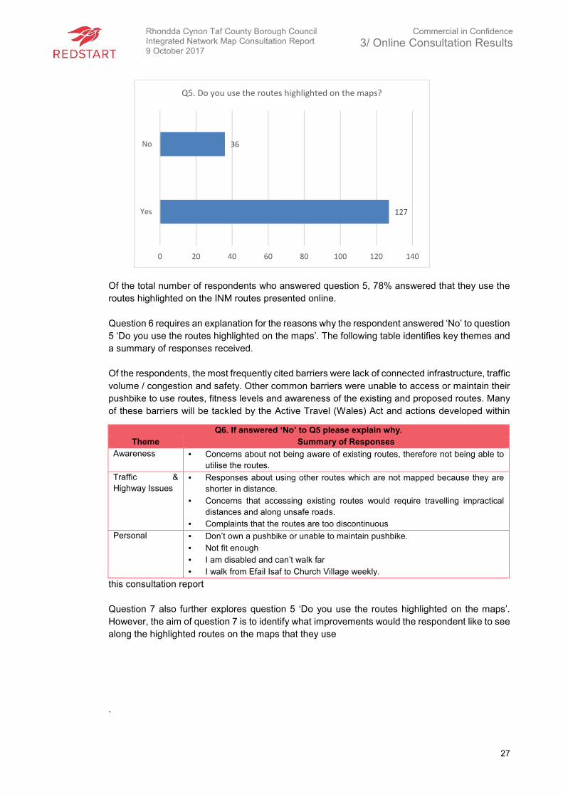
Of the total number of respondents who answered question 5, 78% answered that they use the
routes highlighted on the INM routes presented online.
Question 6 requires an explanation for the reasons why the respondent answered ‘No’ to question
5 ‘Do you use the routes highlighted on the maps’. The following table identifies key themes and
a summary of responses received.
Of the respondents, the most frequently cited barriers were lack of connected infrastructure, traffic
volume / congestion and safety. Other common barriers were unable to access or maintain their
pushbike to use routes, fitness levels and awareness of the existing and proposed routes. Many
of these barriers will be tackled by the Active Travel (Wales) Act and actions developed within
this consultation report
Question 7 also further explores question 5 ‘Do you use the routes highlighted on the maps’.
However, the aim of question 7 is to identify what improvements would the respondent like to see
along the highlighted routes on the maps that they use
.
Q6. If answered ‘No’ to Q5 please explain why.
Theme Summary of Responses
Awareness • Concerns about not being aware of existing routes, therefore not being able to
utilise the routes.
Traffic &
Highway Issues
• Responses about using other routes which are not mapped because they are
shorter in distance.
• Concerns that accessing existing routes would require travelling impractical
distances and along unsafe roads.
• Complaints that the routes are too discontinuous
Personal • Don’t own a pushbike or unable to maintain pushbike.
• Not fit enough
• I am disabled and can’t walk far
• I walk from Efail Isaf to Church Village weekly.
127
36
0 20 40 60 80 100 120 140
Yes
No
Q5. Do you use the routes highlighted on the maps?
Rhondda Cynon Taf County Borough Council Integrated Network Map Consultation Report 9 October 2017
Commercial in Confidence
3/ Online Consultation Results
28
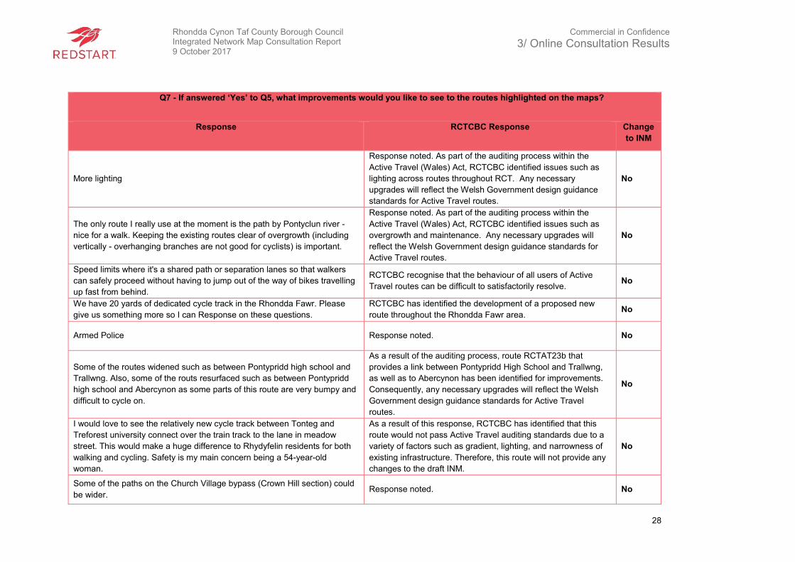
Q7 - If answered ‘Yes’ to Q5, what improvements would you like to see to the routes highlighted on the maps?
Response RCTCBC Response Change
to INM
More lighting
Response noted. As part of the auditing process within the
Active Travel (Wales) Act, RCTCBC identified issues such as
lighting across routes throughout RCT. Any necessary
upgrades will reflect the Welsh Government design guidance
standards for Active Travel routes.
No
The only route I really use at the moment is the path by Pontyclun river -
nice for a walk. Keeping the existing routes clear of overgrowth (including
vertically - overhanging branches are not good for cyclists) is important.
Response noted. As part of the auditing process within the
Active Travel (Wales) Act, RCTCBC identified issues such as
overgrowth and maintenance. Any necessary upgrades will
reflect the Welsh Government design guidance standards for
Active Travel routes.
No
Speed limits where it's a shared path or separation lanes so that walkers
can safely proceed without having to jump out of the way of bikes travelling
up fast from behind.
RCTCBC recognise that the behaviour of all users of Active
Travel routes can be difficult to satisfactorily resolve. No
We have 20 yards of dedicated cycle track in the Rhondda Fawr. Please
give us something more so I can Response on these questions.
RCTCBC has identified the development of a proposed new
route throughout the Rhondda Fawr area. No
Armed Police Response noted. No
Some of the routes widened such as between Pontypridd high school and
Trallwng. Also, some of the routs resurfaced such as between Pontypridd
high school and Abercynon as some parts of this route are very bumpy and
difficult to cycle on.
As a result of the auditing process, route RCTAT23b that
provides a link between Pontypridd High School and Trallwng,
as well as to Abercynon has been identified for improvements.
Consequently, any necessary upgrades will reflect the Welsh
Government design guidance standards for Active Travel
routes.
No
I would love to see the relatively new cycle track between Tonteg and
Treforest university connect over the train track to the lane in meadow
street. This would make a huge difference to Rhydyfelin residents for both
walking and cycling. Safety is my main concern being a 54-year-old
woman.
As a result of this response, RCTCBC has identified that this
route would not pass Active Travel auditing standards due to a
variety of factors such as gradient, lighting, and narrowness of
existing infrastructure. Therefore, this route will not provide any
changes to the draft INM.
No
Some of the paths on the Church Village bypass (Crown Hill section) could
be wider. Response noted. No
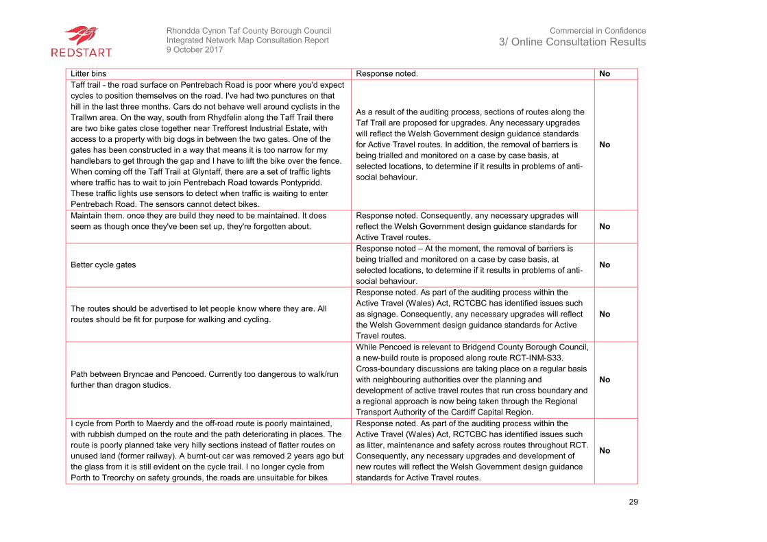
Rhondda Cynon Taf County Borough Council Integrated Network Map Consultation Report 9 October 2017
Commercial in Confidence
3/ Online Consultation Results
29
Litter bins Response noted. No
Taff trail - the road surface on Pentrebach Road is poor where you'd expect
cycles to position themselves on the road. I've had two punctures on that
hill in the last three months. Cars do not behave well around cyclists in the
Trallwn area. On the way, south from Rhydfelin along the Taff Trail there
are two bike gates close together near Trefforest Industrial Estate, with
access to a property with big dogs in between the two gates. One of the
gates has been constructed in a way that means it is too narrow for my
handlebars to get through the gap and I have to lift the bike over the fence.
When coming off the Taff Trail at Glyntaff, there are a set of traffic lights
where traffic has to wait to join Pentrebach Road towards Pontypridd.
These traffic lights use sensors to detect when traffic is waiting to enter
Pentrebach Road. The sensors cannot detect bikes.
As a result of the auditing process, sections of routes along the
Taf Trail are proposed for upgrades. Any necessary upgrades
will reflect the Welsh Government design guidance standards
for Active Travel routes. In addition, the removal of barriers is
being trialled and monitored on a case by case basis, at
selected locations, to determine if it results in problems of anti-
social behaviour.
No
Maintain them. once they are build they need to be maintained. It does
seem as though once they've been set up, they're forgotten about.
Response noted. Consequently, any necessary upgrades will
reflect the Welsh Government design guidance standards for
Active Travel routes.
No
Better cycle gates
Response noted – At the moment, the removal of barriers is
being trialled and monitored on a case by case basis, at
selected locations, to determine if it results in problems of anti-
social behaviour.
No
The routes should be advertised to let people know where they are. All
routes should be fit for purpose for walking and cycling.
Response noted. As part of the auditing process within the
Active Travel (Wales) Act, RCTCBC has identified issues such
as signage. Consequently, any necessary upgrades will reflect
the Welsh Government design guidance standards for Active
Travel routes.
No
Path between Bryncae and Pencoed. Currently too dangerous to walk/run
further than dragon studios.
While Pencoed is relevant to Bridgend County Borough Council,
a new-build route is proposed along route RCT-INM-S33.
Cross-boundary discussions are taking place on a regular basis
with neighbouring authorities over the planning and
development of active travel routes that run cross boundary and
a regional approach is now being taken through the Regional
Transport Authority of the Cardiff Capital Region.
No
I cycle from Porth to Maerdy and the off-road route is poorly maintained,
with rubbish dumped on the route and the path deteriorating in places. The
route is poorly planned take very hilly sections instead of flatter routes on
unused land (former railway). A burnt-out car was removed 2 years ago but
the glass from it is still evident on the cycle trail. I no longer cycle from
Porth to Treorchy on safety grounds, the roads are unsuitable for bikes
Response noted. As part of the auditing process within the
Active Travel (Wales) Act, RCTCBC has identified issues such
as litter, maintenance and safety across routes throughout RCT.
Consequently, any necessary upgrades and development of
new routes will reflect the Welsh Government design guidance
standards for Active Travel routes.
No
Rhondda Cynon Taf County Borough Council Integrated Network Map Consultation Report 9 October 2017
Commercial in Confidence
3/ Online Consultation Results
30
being too narrow in places. There are a number of closed footpaths at the
side of some of the newer road sections that should be reopened for
cycling.
Dog control Response noted. No
Be more suitable for disabled people
Response noted. RCTCBC has actively attempted to engage
with seldom heard groups and non-seldom groups to
understand what upgrades to existing routes, as well as what
new routes should include, to be more suited for individuals with
a variety of disabilities.
No
(I currently use the routes for walking only.) Signposting as a recommended
route for cycling Lighting and security cameras along the off-road sections
along the river, particularly the river crossing near Robert Street Pentre and
the path in Treorchy between Lidl and the Coop Improved road surface
maintenance.
Response noted. No
Removal of barriers. Remind people that the whole road network is for
everyone not just cars. Sometimes the road is safer (Treforest industrial
estate for example).
Response noted - RCTCBC recognise that behaviour of all
users of active travel routes can be difficult to satisfactorily
resolve. In addition, the removal of barriers is being trialled and
monitored on a case by case basis, at selected locations, to
determine whether it results in problems of anti-social behaviour
arising.
No
Widened from Coedy-Cwm to Pontypridd
Response noted. As part of the auditing process within the
Active Travel (Wales) Act, RCTCBC has identified issues along
route RCT-AT-21a. Consequently, any necessary upgrades will
reflect the Welsh Government design guidance standards for
Active Travel routes.
No
Signage to encourage cyclists to be safer around elderly people, dogs,
horses, etc. We must slow down when passing others. Response noted. No
Route RCT-INM-S5 is on the road and many people already use the
pavement to cycle as they do not feel safe. Would be good to widen path
into dual use and slow traffic to 20m as this is a 40-mile zone in essentially
residential area. The section of the trail between the station at Cwmdare
and where the trail restarts after the petrol station is unsafe and busy with
traffic and it would be good to designate a path separate from cars here.
For people accessing the new school and swimming baths there are short
connecting routes that could be built that would make it easier to cross from
Cardiff road to the cycle route. RCTAT22i Its difficult to navigate around the
station on bike, it’s very difficult to cross the road near the Girls school
because there is always traffic.
Response noted. As part of the auditing process within the
Active Travel (Wales) Act, RCTCBC has identified issues along
routes RCT-INM-S5 and RCTAT22i. Consequently, any
necessary upgrades and development of new routes to provide
a continuous network will reflect the Welsh Government design
guidance standards for Active Travel routes.
No

Rhondda Cynon Taf County Borough Council Integrated Network Map Consultation Report 9 October 2017
Commercial in Confidence
3/ Online Consultation Results
31
The surface on which we travel could be improved upon. For instance, the
link between Abernant and Cwmbach as you head past the turning for the
tunnel can get quite boggy and uneven. Perhaps it would be possible to use
a light dusting of sand/ stone mix which would still be friendly to tree roots
by letting the water run through naturally but would also make it easier
when jogging/ walking.
At present, there are proposed upgrades along route
RCTAT22h which connects with a proposed new-build route
RCT-INM-S12 to form an improved connection between
Abernant and Cwmbach. Consequently, any necessary
upgrades and new routes will reflect the Welsh Government
design guidance standards for Active Travel routes.
No
Horse waste left on paths is an issue. Dog owners on the whole do 'pick it
up' where as horse riders do not and on occasion it is very unpleasant,
especially in warm weather.
Response noted. RCTCBC recognise that the behaviour of all
users of Active Travel routes can be difficult to satisfactorily
resolve.
No
Dedicated cycle path through Pontypridd park to both entrances. Maybe a
dedicated cycle lane on the Taff Trail so you don't have to dodge people
wearing headphones.
Certain facilities such as a dedicated cycle lane along the Taf
Trial are unlikely to be appropriate as pedestrian and cycle
desire lines cross. In addition, removing the byelaws through
Pontypridd park will be considered further by RCTCBC.
No
More routes linking Rhondda to Llantrisant and Pontypridd for commuting
by bike.
RCTCBC has identified the development of a proposed new
route throughout the Rhondda Fawr area. It is the long-term
aspiration of RCTCBC to link existing active travel routes in
RCT and form a comprehensive and continuous network.
No
More signs / directions.
Response noted. As part of the auditing process within the
Active Travel (Wales) Act, RCTCBC identified issues such as
signage. Consequently, any necessary upgrades will reflect the
Welsh Government design guidance standards for Active Travel
routes.
No
Better connection between routes and traffic free integration with other
transport modes. Also, marking routes with white lines to help separate
walkers and cyclists and dog walkers. Possible include additional facilities
along the route such as a kiosk or shop selling hot drinks or snacks which
would give potential users more of a reason to use them? For example, a
hot drink at the end of a family bike ride on a cold winters day or an ice
cream on a warm summers day? Or toilets? Simple additions to enhance
the experience and help promote use beyond its primary purpose?
Response noted. Whilst developing the draft INM cycling,
walking and shared routes throughout RCT, RCTCBC considers
the integration of the existing INM routes and other transport
modes important. Trip attractors such as train stations have
been considered. However, the development of Active Travel
routes is for short distance, everyday journeys to the shops,
places of work or college etc.
No
That they include a provision for horse riders.
As part of the Active Travel (Wales) Act 2013, the definition of
‘active travel’ under the Act means walking and cycling as an
alternative means to motorised transport for the purpose of
making every day journeys. An “active travel journey” means a
journey made to or from a workplace or educational
establishment or in order to access health, leisure or other
services or facilities (Delivery Guidance 2.3.1).
No
Rhondda Cynon Taf County Borough Council Integrated Network Map Consultation Report 9 October 2017
Commercial in Confidence
3/ Online Consultation Results
32
These needs to connect to the Nantgarw estate. You can get close but you
can't get onto and around the estate safely. This prevents a lot of people
from viewing cycling to work as a safe option.
Response noted. No
Clean and accessible routes, with all dogs being kept on a lead to prevent
accidents when cycling or running.
Response noted. As part of the auditing process within the
Active Travel (Wales) Act, RCTCBC has identified issues such
as cleanliness. However, RCTCBC recognise that the behaviour
of all users of active travel routes can be difficult to satisfactorily
resolve.
No
Route through Trefforest Ind Est. Is useless for cyclists as you have to keep
stopping at every turning/junction as it is just a wide pavement with no
cyclist priority at junctions. Easier and quicker to cycle on the road which
90% of cyclists I see do on the estate! Don't see how this route is marked in
red and passed for cyclists when no one uses it! Needs to be a proper cycle
access and 'toucan' cycle crossing at Tawelfryn A468 to join trail Taffs Well
to other side and trail towards Pontypridd. Many of the A and K width
restriction gates need to be removed or widened as they actually stop
bicycles because they're too narrow! Access paths to the Taffs Trail need to
be better maintained as they are usually overgrown with brambles and
nettles hindering access to the cycle paths. Access from Taff Trail down to
Tesco Extra and Midway Retail Estate above upper boat should be
improved. Route from Glyntaf Cemetery/University into Pontypridd needs
improving desperately as very dodgy area for cyclists. Nearly all the routes
marked are lovely for leisure and weekend cyclists who are in no hurry but
rubbish for commuting cyclists. Most cycle paths take a long route around
and have too many hold ups at gates, crossings, turnings etc. I can cycle
Taffs Well to Pontypridd at least 10 minutes quicker by avoiding most of the
Taff Trail and using the roads instead! Upper boat roundabout was
improved several years after Active Travel Bill was passed but there were
NO improvements made for cyclists using it and I find it just as hazardous
now as before! More cycle shelters or lock up spots should be provided in
town and village centres. I usually have to look for railings or lamp posts to
secure my bike when visiting Pontypridd etc.
Response noted. As part of the auditing process within the
Active Travel (Wales) Act, RCTCBC has identified issues such
as maintenance and access along routes such as the route from
Glyntaf cemetery in to Pontypridd. Consequently, any necessary
upgrades will reflect the Welsh Government design guidance
standards for Active Travel routes.
Regarding the removal of A and K barriers is being trialled and
monitored on a case by case basis, at selected locations, to
determine whether it results in problems of anti-social behaviour
arising.
As a result of receiving this response, RCTCBC has added a
new INM route (INM-RCT-N5) that provides access from the Taf
Trail down to Tesco Extra and Midway Retail Estate.
Yes
More properly maintained tracks in the Rhondda. RCTCBC has identified the development of a proposed new
route throughout the Rhondda Fawr area. No
Connect up the missing off road sections with good tarmac e.g.
Thomastown to Blackmill. Cwmbach to Aberdare. Hirwaun to Merthyr.
Talbot Green to Brynmenyn. Porth to Blaencwm stands out as a key
missing link.
Response noted. In advance of receiving this response,
RCTCBC highlighted improvements and development of new
routes along Cwmbach to Aberdare and Talbot Green to the
boundary with Bridgend. The other routes including
No
Rhondda Cynon Taf County Borough Council Integrated Network Map Consultation Report 9 October 2017
Commercial in Confidence
3/ Online Consultation Results
33
Thomastown to Blackmill and Hirwaun to Merthyr do not qualify
as Active Travel routes and will therefore not be considered.
Better signposting to the routes, clear detailing of how many KM/Miles each
route is and what is located along the path. One route I take I was
previously unaware there was a park or football pitch along this route.
(Trehafod to Porth Taff Trail).
Response noted. As part of the auditing process within the
Active Travel (Wales) Act, RCTCBC identified issues such as
signage. Therefore, any necessary upgrades will reflect the
Welsh Government design guidance standards for Active Travel
routes.
No
As cyclist for many years who rides the whole South Wales area most
weekends thank you for the opportunity to Response here. This will be a bit
of an information dump so hopefully you will be able to pick up some useful
points. I have also ridden in many European countries and seen how
cycling infrastructure can look so pleased Welsh Government is
encouraging LA's to look into their provision in Wales. 1. The whole system
is too piecemeal and many links are missing that make riding the existing
routes pointless in certain places as either they are dead ends or come out
onto a main road. Planners seem to treat cyclists as people who plod
around recreationally not wanting to get from A-B like car drivers. The first
question in this survey is which area do you live, hopefully not to think oh
well his Responses only relate to Church Village as I cycle all over South
wales not just 3 miles from home. I ticked Church Village but real question
should have been where do you cycle and I would have put all off them and
4 other LA's in South Wales. I am completing surveys for Cardiff, Vale of
Glam as I also ride there. One important point here is that LA's talk to each
other and particularly link their routes at boundaries of their LA. A good
example outside RCT I know is Cardiff- Penarth where the trail simply ends
at LA boundary. Hopefully RCT and say Caerphilly will work together. I will
study the plans for specific route suggestions and Response separately but
general points I would make are 1. Try to link up existing cycle routes, I
know geography etc can get in the way but sometimes routes are pointless
unless they go somewhere. For example, Church Village to Llantrisant
there is gap in trail system that could be sorted. 2. In winter trails are often
not rideable as they are covered in thick leaves that fall in Oct/Nov but are
still there in March/April. This means trails are not useable for 5 months of
year unless you ride a mountain bike or suchlike. I have had a number of
falls due to leaves compacted onto trails so avoid them which is a waste. 3.
Gates on trails. I understand these are added to restrict access to trails to
vehicles but please make access gates for cyclists standard. Could you
imagine the re-action to car drivers if they had toll gates ever half a mile
Response noted. It is the long-term aspiration of RCTCBC to
link existing active travel routes in RCT and form a
comprehensive and continuous network. Furthermore, RCTCBC
liaises on a regular basis with neighbouring authorities over the
planning and development of active travel routes that run cross
boundary and a regional approach is now being taken through
the Regional Transport Authority of the Cardiff Capital Region.
In addition, RCTCBC identified issues such as maintenance,
signage and cleanliness along several routes throughout RCT
which will be subject to upgrades to reflect the Welsh
Government design guidance standards for Active Travel
routes.
There are currently proposals to provide a link between Church
Village to Llantrisant identified as RCT-INM-S43 and RCT-INM-
S14 in the INM. Also, the removal of barriers is being trialled
and monitored on a case by case basis, at selected locations, to
determine whether it results in problems of anti-social behaviour
arising.
No
Rhondda Cynon Taf County Borough Council Integrated Network Map Consultation Report 9 October 2017
Commercial in Confidence
3/ Online Consultation Results
34
and some had speed bumps other barriers and others you had to get out of
car to go to a kiosk? Like motorists some cycling journeys are simply to get
from A-B quickly say commute to work. I will avoid certain sections of trails
simply because there are too many gates that add significant time to your
journey slowing, stopping and then having to accelerate every time. Also on
trails in RCT and other LA's there are at least 10 different style of gates and
the gaps between the barrier arms are often different widths even when
same style gates are used. This is simply an error in concreting the gate
into the floor that could be easily avoided by using a tape measure. In some
trails - Cardiff Taff Trail for example there are no longer any gates and I
have never seen anything other than bikes on those sections of trails. If
gates are needed then at least standardise them in terms of style and width
between bars. 4. Meandering trails are great for recreation but not for
commuting etc planners need to consider that riders can ride 50 - 100 miles
in a day’s ride not just round their local park. The trail alongside the Church
Village bypass is a better example than most of a trail simply following the
same direct route the main road follows and so is worth using. This is the
way they design them in Germany/Holland etc where most major routes
have a cycle path that is separate to the road but follows its course.
Countries like Poland are already following this example. An opposite poor
example is Aberdare where using the trails to cross the town is not really an
option unless out for a Sunday stroll on the bike as it would add 20 minutes
to a 5 minute ride. The alternative is a dangerous busty road or detour. 5.
Having ridden in Holland, France, & Germany I think encouraging cycling is
not just about laying a trail and expecting cyclists to ride it. We should use
some ideas from them. Bins on the route with nets so cyclists don't have to
stop to throw rubbish, lights for cyclists at junctions, signs on the trails
pointing to local facilities, pubs, cafes, shops, tourist attractions etc off the
trail. All these type of signs exist on roads for motorists but nothing of the
sort is added to trails for cyclists. Cyclists are people wanting to eat and
drink etc, Perhaps the assumption is that being on a bike you can't have
come far so must know where the shop is? I am sometimes riding in a
place I don't know and have no idea what is just yards from the trail in that
village I am passing through. Hope some of this is of some use and sorry if
it sounds a bit of a moan, in general the cycling infrastructure in place today
is so much better than it was 15 years ago. Thanks
Separate cycle lands to protect walkers. Response noted. No
Just cleaner and more tidy. Response noted. No
Rhondda Cynon Taf County Borough Council Integrated Network Map Consultation Report 9 October 2017
Commercial in Confidence
3/ Online Consultation Results
35
Clean. Cut back greenery. Response noted. No
Better signage around Pontypridd. It is confusing. I tried following signs to
the Taff trail from Ponty park but they faded away to nothing.
Response noted. As part of the auditing process within the
Active Travel (Wales) Act, RCTCBC identified issues such as
signage. Consequently, any necessary upgrades will reflect the
Welsh Government design guidance standards for Active Travel
routes.
No
All I want is a safe way to travel by bike, I can assure you if this is provided
and connect to other key cycle paths I will regularly be exploring any
provided paths. I'm my opinion, a safe route between Llanharan and Talbot
green should be prioritised.
Response noted. Route RCT-INM-C7, which connects
Llanharan to Talbot Green has been identified for development. No
Yes RCT-INM-S8 - better links from a473 to Treforrest industrial estate and
the national cycle path 4 (on map 10 church village) via a4054 road and
Taffs Well cycle paths also RCT-INM-S16 - for walkers from Dyffyn Dowlais
(Heol Dowlais) estate to Maesybryn Primary school area (possible keeping
close to the southern end of Edwards coaches or pave west bound path
from lights (Heol Dowlais) to road entrance of Edwards coaches.
Response noted. RCTCBC has identified a new long-term INM
route (RCT-INM-S31) from Power Station Hill to Treforest
Industrial Estate. In addition, all schools within RCT have been
invited to submit proposals for potential safe routes in
community schemes.
No
Maintenance of routes and regular clean-up of 'mess' Response noted. No
Less of those anti motorbike barrier things
Response noted - The removal of barriers is being trialled and
monitored on a case by case basis, at selected locations, to
determine whether it results in problems of anti-social behaviour
arising.
No
Lights Response noted. No
All routes need to be safe and a minimum of 3m wide and in line with active
travel Wales document 2013. Response noted. No
More safe crossings. More cycle paths. Gated pavement areas on south
side of main road in Llanharan near Dolau Primary school.
Response noted. RCTCBC has identified a new route for
development which serves Llanharan and Dolau. No
Use on horseback also
As part of the Active Travel (Wales) Act 2013, the definition of
‘active travel’ under the Act means walking and cycling as an
alternative means to motorised transport for the purpose of
making every day journeys. An “active travel journey” means a
journey made to or from a workplace or educational
establishment or in order to access health, leisure or other
services or facilities (Delivery Guidance 2.3.1).
No
Need a clear walk path and cycle route. It’s really dangerous on the road
from Llanharry to Llanharan via the meadow. So many blind corners
because of the high trees and bushes drivers doing 60MPH can’t see
around them and could hit anyone that is walking if they're going too fast.
Suggested route does not meet active travel criteria as it is
mainly outside a built-up area and does not serve any key trip
attractors.
No
Rhondda Cynon Taf County Borough Council Integrated Network Map Consultation Report 9 October 2017
Commercial in Confidence
3/ Online Consultation Results
36
Safety for children and not so many gates
Response noted – The removal of barriers is being trialled and
monitored on a case by case basis, at selected locations, to
determine whether it results in problems of anti-social behaviour
arising.
No
Would like to see the paths better maintained. There is usually a lot of
overgrowth and dog fouling
Response noted. As part of the auditing process within the
Active Travel (Wales) Act, RCTCBC identified issues such as
foul and overgrowth. Consequently, any necessary upgrades
will reflect the Welsh Government design guidance standards
for Active Travel routes.
No
Lighting could be improved especially during winter months.
Response noted. As part of the auditing process within the
Active Travel (Wales) Act, RCTCBC identified issues such as
lighting. Consequently, any necessary upgrades will reflect the
Welsh Government design guidance standards for Active Travel
routes.
No
Speed restrictions, signage to warn that they are shared paths, education of
both walkers’ and cyclist in fair play. Keep left rule? Maintain width of path
by controlling foliage. All cyclists required to have bells fitted and controlled
by enforce the officers.
Response noted. However, RCTCBC recognise that the
behaviour of all users of active travel routes can be difficult to
satisfactorily resolve. In addition, as part of the auditing process
within the Active Travel (Wales) Act, RCTCBC identified issues
such as foliage and signage. Consequently, any necessary
upgrades will reflect the Welsh Government design guidance
standards for Active Travel routes.
No
Improve the footpath surface/drainage on former railway line from Abernant
to Llwydoced, this route could tie into existing cycle routes.
In advance of receiving this response, RCTCBC identified the
development of route RCT-INM-S12, which will provide a link to
the disused rail tunnel, if it reopens to cyclists and walkers.
Furthermore, it is the long-term aspiration of the Council to link
existing active travel routes in RCT and form a comprehensive
and continuous network.
No
The gap in the route between Llanharan and Pencoed needs to be
addressed as this prevents safe walking.
While Pencoed is relevant to Bridgend County Borough Council,
a new-build route is proposed along route RCT-INM-S33.
Cross-boundary discussions are taking place on a regular basis
with neighbouring authorities over the planning and
development of active travel routes that run cross boundary and
a regional approach is now being taken through the Regional
Transport Authority of the Cardiff Capital Region.
No
Dog mess is the real problem. Better signposting. Response noted. No
Cyclists should have to have bells fitted when travelling on Taff Trail as they
travel so fast when they pass it could cause accidents.
Response noted – RCTCBC acknowledge that the behaviour of
all users of active travel routes can be difficult to satisfactorily
resolve.
No
Rhondda Cynon Taf County Borough Council Integrated Network Map Consultation Report 9 October 2017
Commercial in Confidence
3/ Online Consultation Results
37
Safer routes, well linked to each other Response noted. No
Also, extending routes e.g. Baverstocks link, Merthyr Tunnel and surfacing
Cwmbach to Llwydcoed track.
In advance of receiving this response, RCTCBC identified
proposed upgrades to the routes identified in the response.
Consequently, any necessary upgrades will reflect the Welsh
Government design guidance standards for Active Travel
routes.
No
As stated, routes and sections need to be linked together in such a way that
travel along the network is not impeded by gates, roads, and other
obstacles. Dog-walking needs to be banned. This doesn’t come from an
anti-dog’ position more generally, but in order to have a safe.
Response noted - It is the long-term aspiration of the Council to
link existing active travel routes in RCT and form a
comprehensive and continuous network.
No
Regarding RCT, I would like to see more cycle routes. At present, they are
just token gestures, some only last a few hundred meters. As a disabled
cyclist, the routes / paths are a nightmare, the access is appalling, they end
in no man’s land, they put you directly on dangerous highways, no dropped
curbs, the paths are regularly blocked the vehicles. As regards the maps,
they are so misleading, follow one at your peril !!!!!!!!!!!!!!
Response noted. RCTCBC has actively attempted to engage
with seldom heard groups and non-seldom groups to
understand what upgrades to existing routes, as well as what
new routes should include to be more suited for individuals with
a variety of disabilities.
No
Dydy teithio ar beic yn hwylius oherwydd y nifer fawr o weithiau mae angen
stopio i wthio'r beic trwy'r clwydi. Mae'n anodd cadw momentwm.
Traveling on a bike is longer because of the large number of times it is
necessary to stop pushing the bike through roosts It's hard to keep
momentum.
Response noted - The removal of barriers is being trialled and
monitored on a case by case basis, at selected locations, in
order to determine whether it results in problems of anti-social
behaviour arising.
No
Seriously improve (completely rebuild) the cycle/foot path between
Pontypridd and Abercynon. Remove gateways all over RCT that prevent
wheelchairs, pushchairs, mountain bikes (my shoulders) and anything else
remotely wide.
Response noted. No
Where they appear to go through along existing roads and industrial
estates they should have a dedicated cycle lane. Response noted. No
Be nice if they were regularly maintained I currently use Rhondda Fach trail
which is overgrown in places and parts of. The track has been washed
away.
Response noted. As part of the auditing process within the
Active Travel (Wales) Act, RCTCBC identified issues such as
overgrowth along routes throughout RCT. Consequently, any
necessary upgrades will reflect the Welsh Government design
guidance standards for Active Travel routes.
No
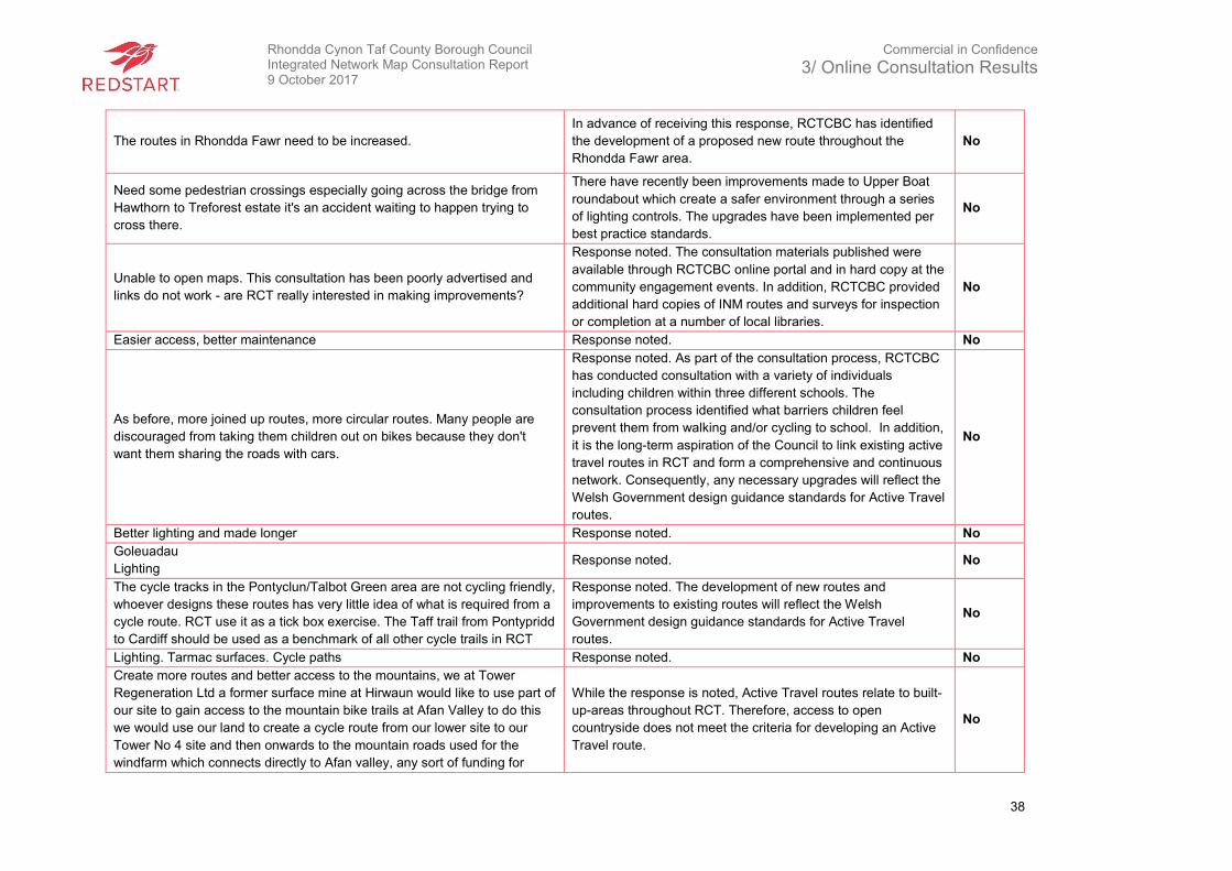
Rhondda Cynon Taf County Borough Council Integrated Network Map Consultation Report 9 October 2017
Commercial in Confidence
3/ Online Consultation Results
38
The routes in Rhondda Fawr need to be increased.
In advance of receiving this response, RCTCBC has identified
the development of a proposed new route throughout the
Rhondda Fawr area.
No
Need some pedestrian crossings especially going across the bridge from
Hawthorn to Treforest estate it's an accident waiting to happen trying to
cross there.
There have recently been improvements made to Upper Boat
roundabout which create a safer environment through a series
of lighting controls. The upgrades have been implemented per
best practice standards.
No
Unable to open maps. This consultation has been poorly advertised and
links do not work - are RCT really interested in making improvements?
Response noted. The consultation materials published were
available through RCTCBC online portal and in hard copy at the
community engagement events. In addition, RCTCBC provided
additional hard copies of INM routes and surveys for inspection
or completion at a number of local libraries.
No
Easier access, better maintenance Response noted. No
As before, more joined up routes, more circular routes. Many people are
discouraged from taking them children out on bikes because they don't
want them sharing the roads with cars.
Response noted. As part of the consultation process, RCTCBC
has conducted consultation with a variety of individuals
including children within three different schools. The
consultation process identified what barriers children feel
prevent them from walking and/or cycling to school. In addition,
it is the long-term aspiration of the Council to link existing active
travel routes in RCT and form a comprehensive and continuous
network. Consequently, any necessary upgrades will reflect the
Welsh Government design guidance standards for Active Travel
routes.
No
Better lighting and made longer Response noted. No
Goleuadau
Lighting Response noted. No
The cycle tracks in the Pontyclun/Talbot Green area are not cycling friendly,
whoever designs these routes has very little idea of what is required from a
cycle route. RCT use it as a tick box exercise. The Taff trail from Pontypridd
to Cardiff should be used as a benchmark of all other cycle trails in RCT
Response noted. The development of new routes and
improvements to existing routes will reflect the Welsh
Government design guidance standards for Active Travel
routes.
No
Lighting. Tarmac surfaces. Cycle paths Response noted. No
Create more routes and better access to the mountains, we at Tower
Regeneration Ltd a former surface mine at Hirwaun would like to use part of
our site to gain access to the mountain bike trails at Afan Valley to do this
we would use our land to create a cycle route from our lower site to our
Tower No 4 site and then onwards to the mountain roads used for the
windfarm which connects directly to Afan valley, any sort of funding for
While the response is noted, Active Travel routes relate to built-
up-areas throughout RCT. Therefore, access to open
countryside does not meet the criteria for developing an Active
Travel route.
No
Rhondda Cynon Taf County Borough Council Integrated Network Map Consultation Report 9 October 2017
Commercial in Confidence
3/ Online Consultation Results
39
these routes would be welcomed. This would be even more advantageous
with the city deal and potential for train service to our railhead.
Made safer. Response noted. No
The proposed cycle route down the A4119 should be down both sides and
join up safely across the A4119 up into the Cefn yr Hendy estate in Miskin.
Miskin appears to be poorly served by the proposed routes. Routes should
join up and not just stop.
It is the long-term aspiration of the Council to link existing active
travel routes in RCT and form a comprehensive and continuous
network.
No
As per my answer to Q5 there needs to be the missing link created to join
lots of routes up. I also think improvements are needed between Treorchy
and Pontypridd/Tonypandy as this is the only valley without a proper cycle
route.
Response noted. At present, and because of the auditing
process, there are several proposed upgrades and new-build
routes in the short, medium and long-term which provide access
between Treorchy to Pontypridd and Tonypandy. Consequently,
any necessary upgrades and new construction will reflect the
Welsh Government design guidance standards for Active Travel
routes.
No
Would like to see the paths maintained - some part of the Church Village
path is overgrown also the route 4 from Tonyrefail to Blackmill.
Response noted. As part of the auditing process within the
Active Travel (Wales) Act, RCTCBC has audited routes
throughout RCT including Church Village and Tonyrefail. Any
necessary upgrades will reflect the Welsh Government design
guidance standards for Active Travel routes. The route NCN4
towards Blackmill does not meet Active Travel criteria as it is
outside the built-up-area and is predominantly used for
recreational journeys.
No
Referring only to the route from Treorchy northwards, designation,
signposting and marketing of this ATR route is key as the next step; on site
walking and cycling of the route last year revealed there will be some
improvements needed to access and linkages of various section.
Response noted. RCTCBC has identified the development of a
proposed new route throughout the Rhondda Fawr area. No
At the planning meeting for the development mentioned in Q4 I suggested
that the community route in this area, could be moved to the land between
the current road and the disused railway line. There is sufficient room. I
notice that this length of the route is marked as a single red line on the map
(Walking). I don't understand while the part from there to Cross Inn is
marked for Cycling rather than Walking and Cycling. Lots of people walk on
that section.
Response noted. Comment refers to existing route which meets
current Active Travel standards for walking and cycling. INM will
be altered accordingly.
Yes
Some sections of the Taff trail (eg. North of Trallwn towards Abercynon) are
in a very poor state of repair and the cycle way needs widening
As a result of the auditing process, RCTCBC has identified
several routes throughout RCT which require upgrades to the
issues identified. Consequently, any necessary upgrades will
No
Rhondda Cynon Taf County Borough Council Integrated Network Map Consultation Report 9 October 2017
Commercial in Confidence
3/ Online Consultation Results
40
reflect the Welsh Government design guidance standards for
Active Travel routes.
I would like them to be safe, comfortable and continuous. The proposed
route to Cross Inn needs to link to the existing bypass path as soon as it is
completely. Anything else will bring the Council into further disrepute. The
proposed path alongside the A4119 may be classified as a 'tick-box' path. It
will make for very unsafe and unattractive cycling. It will not be used. It is
not expected by the Council that it will be used. It ticks a box. LInking old
Miskin to Pontyclun is a valid objective. Heol Miskin is wide and quite flat.
This could be an easy quick win. Linking Brynsadler, Talygarn and Llanhari
to Pontyclun is a valid objective. The proposed route up Brynsadler Hill is
regarded locally as a cruel joke. The road barely functions for its existing
purpose let alone accommodating a cycle path. An imaginative proposal
would be to open up the rear lane to the west side of Cowbridge road and
then designing a safe intersection with Llanhari Road would be an
imaginative solution.
Response noted. At present, the proposed route along
Brynsadler Hill is for illustration purposes only, and should be
used to highlight the desire of RCTCBC to provide a route
between the identified areas and to cater for the relevant trip
attractors.
It is the long-term aspiration of the Council to link existing Active
Travel routes in RCT and form a comprehensive and continuous
network.
No
Gwneud yn siwr bod y tirwedd yn cael ei gadw'n lan, a sicrhau bod unrhyw
'brambles' yn cael eu torri nol.
Make sure the landscape is kept clean, and make any brambles cut back.
Response noted. No
Safer connections ie separating cyclists from motorists Response noted. No
Cycle paths and traffic free walking paths Response noted. No
Rydych dim gallu gwella dim os nag oes dim yno i ddechrau.
You cannot improve anything if there's nothing there to start. Response noted. No
The Rhondda Fawr is in desperate need of cycling upgrading and is
shambles when compared to the likes of the Afan valley just over the
Bwlch.
In advance of receiving this response, RCTCBC has identified
the development of a proposed new route throughout the
Rhondda Fawr area.
No
Make sure paths are kept clean and free of litter. Response noted. No
Cutting back of brambles. Dog fouling is awful. It’s the people who should
be prosecuted. I have 2 dogs so I am aware there are no excuses. Dog
warden please.
Response noted. No
Cut back vegetation more often and dog mess. Response noted. No
Some dog walkers are irresponsible, and do not clean up after their pets.
Response noted. RCTCBC acknowledge that the behaviour of
all users of Active Travel routes can be difficult to satisfactorily
resolve.
No

Rhondda Cynon Taf County Borough Council Integrated Network Map Consultation Report 9 October 2017
Commercial in Confidence
3/ Online Consultation Results
41
Like to see some paths there asap to be able to use them and say yes to
the relevant question. Response noted. No
See previous: Pentrebach Road section in particular does not feel safe due
to traffic volume & speeds. Response noted. No
Better access to the routes without having to use main roads Response noted. No
Whilst the routes themselves are arranged well, most of them are on pre-
existing paths/roads. RCTCBC could achieve the entire network in far less
time than the 15 years proposed. In 15 years’ time, I may be too old.
Response noted. No
Better surfaces and opening the tunnel from Abernat to Merthyr.
In advance of receiving this response, RCTCBC has proposed
the development of a route to the mouth of the tunnel. This
route is identified as RCT-INM-S12.
No
When they cut the grass and trees on the Cynon Trail that they do not leave
them in a dangerous condition. i.e. Sticks poking out of the ground where
they have hacked at the trees. Also, is it necessary to hack the trees so
there is very little left of some trees, this year there was wild honeysuckle
growing ant it was hacked to pieces and quite a lot of it has died. This trail
is to see the countryside, but the countryside is being chopped away. They
leave big gouges in the ground where they have been cutting the grass in
the rain and this never gets sorted out and the ruts just fills up with water.
Get the litter sorted out. Quite a lot comes from the workers in the factory
units close by as there is hairnets scattered around. Stop joggers from
throwing their water bottles away on the trail. People complain about dog
walkers but there is far far more litter on the trail left by people. We love this
trail and as stated use it every day. It is good to hear that there are more
routes planned in RCT.
Response noted. No
The most significant improvement I believe could be made is to ensure that
routine maintenance is carried out on all cycle routes - e.g. sweeping,
repairing the surface, cutting back vegetation and repairing drainage. Such
maintenance is rarely, or never, carried out making many cycle paths
unattractive and even difficult to use. It is a pity that when so much money
and effort has been put into creating what is quite a good cycle path
network that there seems to be an extreme reluctance to carry out even
basic maintenance thereafter. Also, focus should be given to trying to fill the
gaps in the cycle path network on existing routes. There many, often quite
small, gaps in the network where cyclists are forced back onto roads which
again has a significant effect on the attractiveness of cycle paths to
potential users. I can think of examples in Taffs Well, Nangarw and Upper
Boat but I am sure there are many others.
Response noted. Throughout RCT there have been several
audits taking place. The issues identified, such as maintenance
will have been highlighted during a previous audit of the route.
This will be addressed as part of a proposed upgrade to enable
the route to meet current active travel standards.
It is the long-term aspiration of the council to link existing Active
Travel routes in RCT and form a comprehensive and continued
network.
No
Rhondda Cynon Taf County Borough Council Integrated Network Map Consultation Report 9 October 2017
Commercial in Confidence
3/ Online Consultation Results
42
Priority areas should reflect those in most need. Short term routes seem to
be predominantly located in the southern areas of RCT (Church village and
Talbot Green). These areas are more affluent and have lower levels of
deprivation than Upper Rhondda, parts of Cynon and other areas in RCT.
Consideration should be taken to prioritise the more deprived areas first
and whether this is feasible considering budget, timescale, and return on
investment. Healthcare settings (hospitals, GP surgeries etc), education
settings and large business sites should have access to active travel routes
and should also be consulted on necessary changes on their grounds so
that active travel is encouraged (showers, safe areas for bikes, adequate
lighting from October to March. On a separate note, it was difficult to
adequately inspect the routes labelled on the PDFs. It may have been of
use to overlap the proposed routes on a satellite image with local well-
known areas highlighted.
Response noted. However, where appropriate, new-build routes
as well as upgrades to existing routes will take place where
necessary. RCT will identify this through determining routes as
either short, medium or aspirational routes in the submission to
Welsh Government.
No
It’s not easy to create a cycle route through Treorci, but the suggested map
can be improved in a few locations. I’ve had trouble opening the ‘Treorchy’
map, so my observations are from what I recall seeing I am not a ‘cyclist’,
but here are my thoughts. 1) There is no need to divert the path around the
“Treorchy Industrial Estate”. The path can quite easily be linked at the south
end of the site by joining the industrial estate to the path that goes under
the railway bridge. 2) I’m not sure that the bridge across the river at
Dyfodwg Steet is suitable. It is quite narrow. Thanks
Response noted. At present, the proposed new routes on the
draft INM are not designed and are only used as illustration
purposes. Upon Ministerial approval by the Welsh Government,
the appropriate funding as well as the necessary studies,
RCTCBC will finalise the routes.
No
The cycle gates are too narrow – connect communities e.g. Miskin to
Pontyclun. Church Village Cycle route.
In advance of receiving this response, RCTCBC identified
several new-build routes and upgrades to existing routes to
connect communities such as Miskin to Pontyclun. In addition, it
is the long-term aspiration of the Council to link existing active
travel routes in RCT and form a comprehensive and continuous
network. Meanwhile, the removal of barriers is being trialled and
monitored on a case by case basis, at selected locations, in
order to determine whether it results in problems of anti-social
behaviour arising.
No
Easier access (not allowing for disabilities) There are a wide range of
disabilities you are not allowing to access. Wheelchair access!
Response noted. RCTCBC has actively attempted to engage
with seldom heard groups and non-seldom groups to
understand what upgrades to existing routes, as well as what
new routes should include to be more suited for individuals with
a variety of disabilities.
No
Just the upkeep as mentioned Response noted. No
Dedicated cyclist and pedestrian paths. More dog poo bins. Response noted. No
Rhondda Cynon Taf County Borough Council Integrated Network Map Consultation Report 9 October 2017
Commercial in Confidence
3/ Online Consultation Results
43
Map 4: Paths become very waterlogged and slippery. Would love a more
stable path especially side near the rugby field (Ferndale).
RCTCBC has identified a new route in the area to overcome the
issues highlighted. The route is INM-RCT-N2. Yes
Rhondda Cynon Taf County Borough Council Integrated Network Map Consultation Report 9 October 2017
Commercial in Confidence
3/ Online Consultation Results
44
Q8. Are there any additional routes that you believe require improvements?
Response RCTCBC Response Changes
to INM
Improved surface would be the 'line' which runs from Llwydcoed to
Trecynon or Abernant/Cwmbach and even down through
Cefnpennar to Mountain Ash.
In advance of receiving this response, RCTCBC identified the
development of route RCT-INM-S12 between Abernant,
Aberdare and Cwmbach as an Active Travel route. The Cynon
Trail provides an existing link to Mountain Ash.
No
The link between Llanharan and Talbot Green. It's too busy a road
to not have off-road cycling facilities alongside it, and it feels
dangerous having to cross it several times.
RCTCBC has identified a new route for development between
Llanharan and Talbot Green (RCT-INM-C7). The new route will
reflect the Welsh Government design guidance standards for
Active Travel routes.
No
The cycle lane passes through Barry Sidings Country Park has no
speed limit and it is heavily used. Response noted. No
I’d like to see the right-hand pavement at the end of Trefforest
estate in Nant Garw connect to the old train route that runs
between Nant Garw and Tafs Well.
In advance of receiving this response, RCTCBC identified
improvements to INM-RCT-C5. Issues have been identified
during a previous audit of the route and will be addressed as
part of a proposed upgrade to enable the route to meet current
Active Travel Standards.
No
Safe route between Pontypridd and Porth is a must as the current
off road route increases the travel time by 25%. Response noted. No
Merthyr Road through to Cilfynydd is a regular running and cycling
route, but it's also a major commuter route for Pontypridd High
School buses, primary school traffic and tractors.
Response noted. No
NantGarw. Oxford street, the path/cycle route runs out, you then
have to cross the road cycle 100 metres further down then cross
back at the busy roundabout to get onto the path.
In advance of receiving this response, RCTCBC identified
improvements this route. Issues have been identified during a
previous audit of the route and will be addressed as part of a
proposed upgrade to enable the route to meet current Active
Travel Standards.
No
Porth to Rhondda Tunnel is desperately needed. I live in Ystrad
and cycle in Afan forest off road routes. A route from Maerdy to
Treorchy across the mountain would be helpful.
While the response is noted, Active Travel routes relate to built-
up areas throughout RCT. Therefore, access to open
countryside does not meet the criteria for developing an Active
Travel route. RCTCBC has identified the development of a
proposed new route throughout the Rhondda Fawr area.
No
Rhondda Cynon Taf County Borough Council Integrated Network Map Consultation Report 9 October 2017
Commercial in Confidence
3/ Online Consultation Results
45
The cycle and path network does not make use of the most direct
routes i.e the bypass A4059. This road between the station
SO00450270 and McDonalds SO00150295 is used regularly by
mainly young people who walk on the grass.
RCTCBC believe that the existing Cynon Trail has a similar
alignment to the route proposed in the response, and in
addition, is largely traffic free. Therefore, RCTCBC advise users
to use the existing Cynon Trail.
No
Maybe develop the path behind Rhydyfelin rugby club to power
station hill.
As a result of this response, RCTCBC has identified that this
route would not pass Active Travel auditing standards due to a
variety of factors such as gradient, lighting, and narrowness of
existing infrastructure. Therefore, this route will not provide any
changes to the draft INM.
No
I've been walking along the Pontypridd Circular. The signage is not
clear all the way round and in summer, some of the paths are
almost too brambly to walk along.
Response noted. No
I'd like to a clear cycle path at the bottom of Power Station road
through to Upperboat roundabout. Currently the kerbs on the path
are not dropped, the path is not wide enough to support both
walkers and cyclists and it’s in a poor state or repair.
As a result of receiving this response, RCTCBC has included a
long-term, aspirational route from Power Station Hill to Upper
Boat roundabout. Consequently, the aspirational route, as well
as the audited and proposed upgraded route through both
industrial estates will reflect the Welsh Government’s design
guidance standards for Active Travel routes.
No
Widen the Taf trail from Trallwn to Pontypridd high school. Mark the
roads for cyclists/school children. Loads of pupils would ride to
school from those areas.
Response noted. As part of the auditing process within the
Active Travel (Wales) Act, RCTCBC has identified issues along
route RCT-AT-23b. Consequently, any necessary upgrades will
reflect the Welsh Government design guidance standards for
Active Travel routes.
No
The only improvement would be for the road cleaner or cleaning
team to remove glass and other debris from the main Taf Trail on a
regular basis.
Response noted. No
Safe route out of Llanharan towards Pencoed as the blind bend is
lethal and requires a pavement.
While Pencoed is relevant to Bridgend County Borough Council,
a new-build route is proposed along route RCT-INM-S33.
Cross-boundary discussions are taking place on a regular basis
with neighbouring authorities over the planning and
development of active travel routes that run cross boundary and
a regional approach is now being taken through the Regional
Transport Authority of the Cardiff Capital Region.
No
Beddau ael y Bryn to cwm coke and over to the black road is
almost impassable and would make a great circular route around
Penycoedcae and down to the old lamb and flag public house.
While the response is noted, Active Travel routes relate to the
built-up-areas throughout RCT. Therefore, access to open
countryside does not meet the criteria for developing an Active
Travel route.
No
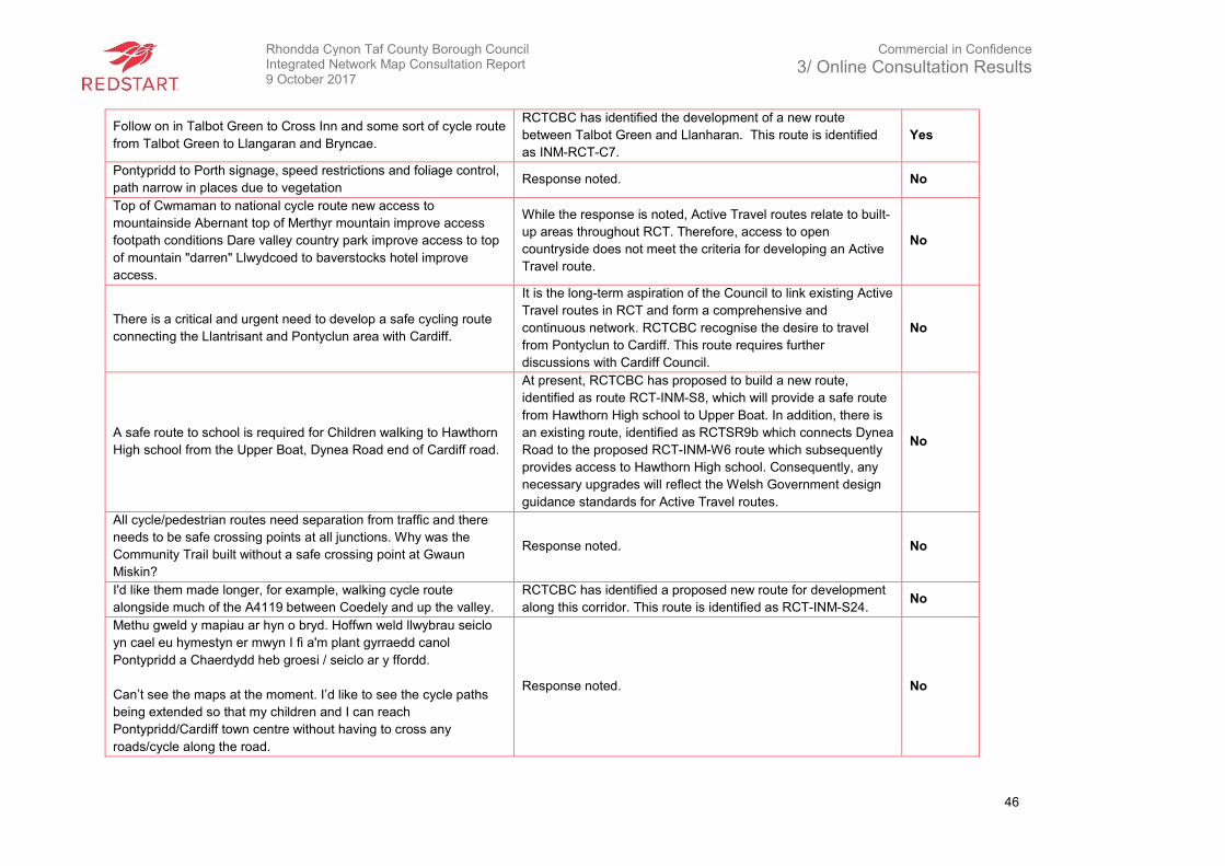
Rhondda Cynon Taf County Borough Council Integrated Network Map Consultation Report 9 October 2017
Commercial in Confidence
3/ Online Consultation Results
46
Follow on in Talbot Green to Cross Inn and some sort of cycle route
from Talbot Green to Llangaran and Bryncae.
RCTCBC has identified the development of a new route
between Talbot Green and Llanharan. This route is identified
as INM-RCT-C7.
Yes
Pontypridd to Porth signage, speed restrictions and foliage control,
path narrow in places due to vegetation Response noted. No
Top of Cwmaman to national cycle route new access to
mountainside Abernant top of Merthyr mountain improve access
footpath conditions Dare valley country park improve access to top
of mountain "darren" Llwydcoed to baverstocks hotel improve
access.
While the response is noted, Active Travel routes relate to built-
up areas throughout RCT. Therefore, access to open
countryside does not meet the criteria for developing an Active
Travel route.
No
There is a critical and urgent need to develop a safe cycling route
connecting the Llantrisant and Pontyclun area with Cardiff.
It is the long-term aspiration of the Council to link existing Active
Travel routes in RCT and form a comprehensive and
continuous network. RCTCBC recognise the desire to travel
from Pontyclun to Cardiff. This route requires further
discussions with Cardiff Council.
No
A safe route to school is required for Children walking to Hawthorn
High school from the Upper Boat, Dynea Road end of Cardiff road.
At present, RCTCBC has proposed to build a new route,
identified as route RCT-INM-S8, which will provide a safe route
from Hawthorn High school to Upper Boat. In addition, there is
an existing route, identified as RCTSR9b which connects Dynea
Road to the proposed RCT-INM-W6 route which subsequently
provides access to Hawthorn High school. Consequently, any
necessary upgrades will reflect the Welsh Government design
guidance standards for Active Travel routes.
No
All cycle/pedestrian routes need separation from traffic and there
needs to be safe crossing points at all junctions. Why was the
Community Trail built without a safe crossing point at Gwaun
Miskin?
Response noted. No
I'd like them made longer, for example, walking cycle route
alongside much of the A4119 between Coedely and up the valley.
RCTCBC has identified a proposed new route for development
along this corridor. This route is identified as RCT-INM-S24. No
Methu gweld y mapiau ar hyn o bryd. Hoffwn weld llwybrau seiclo
yn cael eu hymestyn er mwyn I fi a'm plant gyrraedd canol
Pontypridd a Chaerdydd heb groesi / seiclo ar y ffordd.
Can’t see the maps at the moment. I’d like to see the cycle paths
being extended so that my children and I can reach
Pontypridd/Cardiff town centre without having to cross any
roads/cycle along the road.
Response noted. No
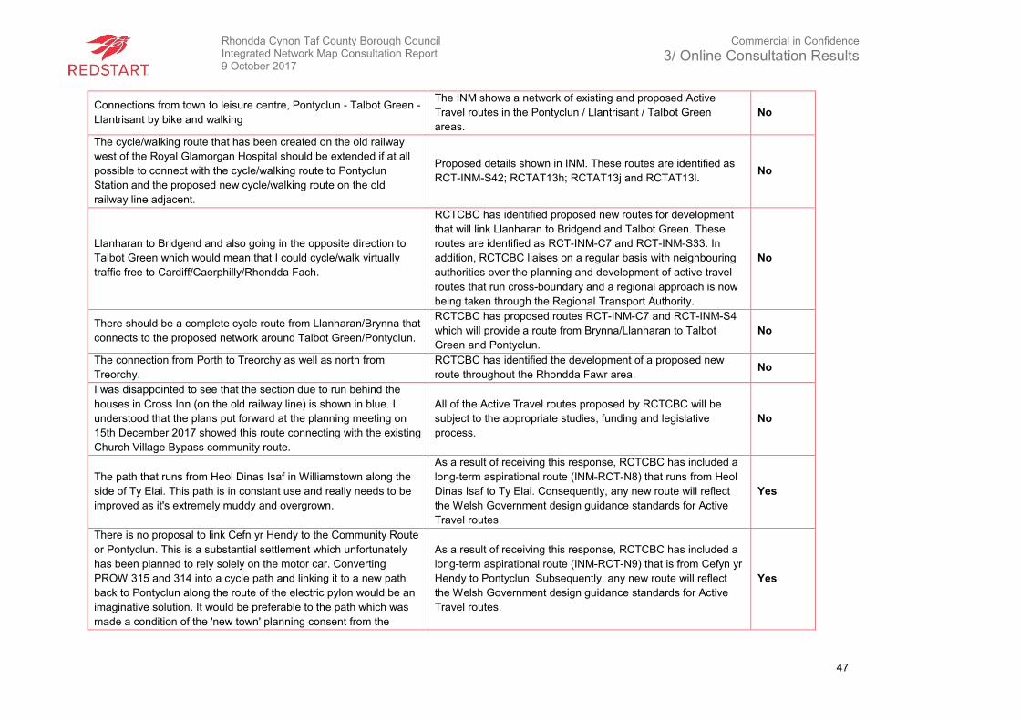
Rhondda Cynon Taf County Borough Council Integrated Network Map Consultation Report 9 October 2017
Commercial in Confidence
3/ Online Consultation Results
47
Connections from town to leisure centre, Pontyclun - Talbot Green -
Llantrisant by bike and walking
The INM shows a network of existing and proposed Active
Travel routes in the Pontyclun / Llantrisant / Talbot Green
areas.
No
The cycle/walking route that has been created on the old railway
west of the Royal Glamorgan Hospital should be extended if at all
possible to connect with the cycle/walking route to Pontyclun
Station and the proposed new cycle/walking route on the old
railway line adjacent.
Proposed details shown in INM. These routes are identified as
RCT-INM-S42; RCTAT13h; RCTAT13j and RCTAT13l. No
Llanharan to Bridgend and also going in the opposite direction to
Talbot Green which would mean that I could cycle/walk virtually
traffic free to Cardiff/Caerphilly/Rhondda Fach.
RCTCBC has identified proposed new routes for development
that will link Llanharan to Bridgend and Talbot Green. These
routes are identified as RCT-INM-C7 and RCT-INM-S33. In
addition, RCTCBC liaises on a regular basis with neighbouring
authorities over the planning and development of active travel
routes that run cross-boundary and a regional approach is now
being taken through the Regional Transport Authority.
No
There should be a complete cycle route from Llanharan/Brynna that
connects to the proposed network around Talbot Green/Pontyclun.
RCTCBC has proposed routes RCT-INM-C7 and RCT-INM-S4
which will provide a route from Brynna/Llanharan to Talbot
Green and Pontyclun.
No
The connection from Porth to Treorchy as well as north from
Treorchy.
RCTCBC has identified the development of a proposed new
route throughout the Rhondda Fawr area. No
I was disappointed to see that the section due to run behind the
houses in Cross Inn (on the old railway line) is shown in blue. I
understood that the plans put forward at the planning meeting on
15th December 2017 showed this route connecting with the existing
Church Village Bypass community route.
All of the Active Travel routes proposed by RCTCBC will be
subject to the appropriate studies, funding and legislative
process.
No
The path that runs from Heol Dinas Isaf in Williamstown along the
side of Ty Elai. This path is in constant use and really needs to be
improved as it's extremely muddy and overgrown.
As a result of receiving this response, RCTCBC has included a
long-term aspirational route (INM-RCT-N8) that runs from Heol
Dinas Isaf to Ty Elai. Consequently, any new route will reflect
the Welsh Government design guidance standards for Active
Travel routes.
Yes
There is no proposal to link Cefn yr Hendy to the Community Route
or Pontyclun. This is a substantial settlement which unfortunately
has been planned to rely solely on the motor car. Converting
PROW 315 and 314 into a cycle path and linking it to a new path
back to Pontyclun along the route of the electric pylon would be an
imaginative solution. It would be preferable to the path which was
made a condition of the 'new town' planning consent from the
As a result of receiving this response, RCTCBC has included a
long-term aspirational route (INM-RCT-N9) that is from Cefyn yr
Hendy to Pontyclun. Subsequently, any new route will reflect
the Welsh Government design guidance standards for Active
Travel routes.
Yes
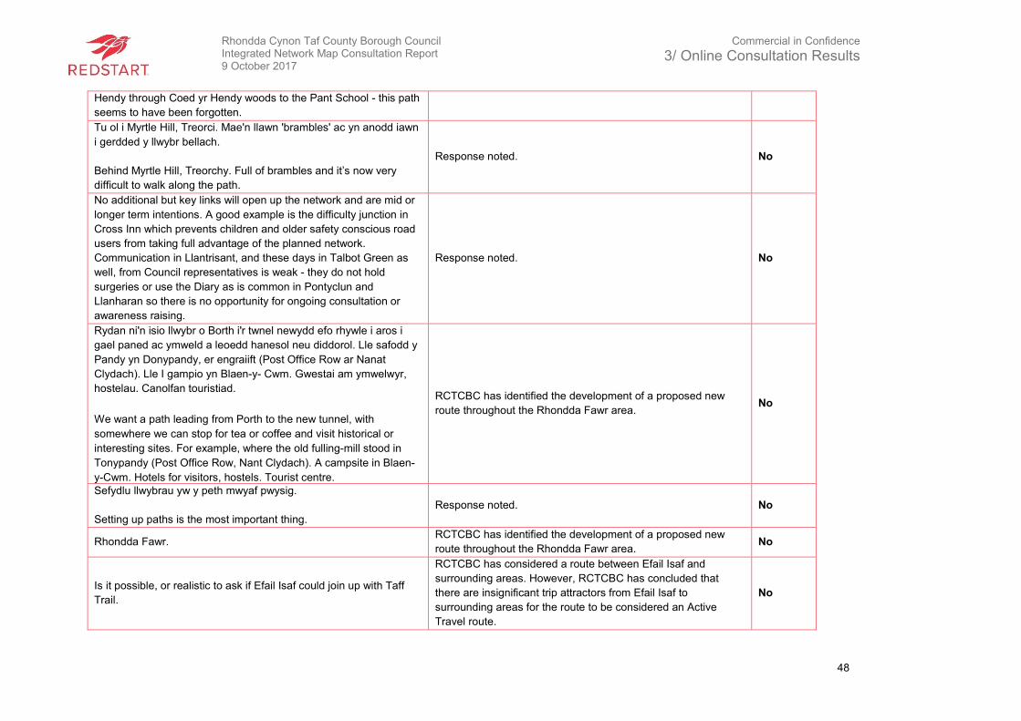
Rhondda Cynon Taf County Borough Council Integrated Network Map Consultation Report 9 October 2017
Commercial in Confidence
3/ Online Consultation Results
48
Hendy through Coed yr Hendy woods to the Pant School - this path
seems to have been forgotten.
Tu ol i Myrtle Hill, Treorci. Mae'n llawn 'brambles' ac yn anodd iawn
i gerdded y llwybr bellach.
Behind Myrtle Hill, Treorchy. Full of brambles and it’s now very
difficult to walk along the path.
Response noted. No
No additional but key links will open up the network and are mid or
longer term intentions. A good example is the difficulty junction in
Cross Inn which prevents children and older safety conscious road
users from taking full advantage of the planned network.
Communication in Llantrisant, and these days in Talbot Green as
well, from Council representatives is weak - they do not hold
surgeries or use the Diary as is common in Pontyclun and
Llanharan so there is no opportunity for ongoing consultation or
awareness raising.
Response noted. No
Rydan ni'n isio llwybr o Borth i'r twnel newydd efo rhywle i aros i
gael paned ac ymweld a leoedd hanesol neu diddorol. Lle safodd y
Pandy yn Donypandy, er engraiift (Post Office Row ar Nanat
Clydach). Lle I gampio yn Blaen-y- Cwm. Gwestai am ymwelwyr,
hostelau. Canolfan touristiad.
We want a path leading from Porth to the new tunnel, with
somewhere we can stop for tea or coffee and visit historical or
interesting sites. For example, where the old fulling-mill stood in
Tonypandy (Post Office Row, Nant Clydach). A campsite in Blaen-
y-Cwm. Hotels for visitors, hostels. Tourist centre.
RCTCBC has identified the development of a proposed new
route throughout the Rhondda Fawr area. No
Sefydlu llwybrau yw y peth mwyaf pwysig.
Setting up paths is the most important thing.
Response noted. No
Rhondda Fawr. RCTCBC has identified the development of a proposed new
route throughout the Rhondda Fawr area. No
Is it possible, or realistic to ask if Efail Isaf could join up with Taff
Trail.
RCTCBC has considered a route between Efail Isaf and
surrounding areas. However, RCTCBC has concluded that
there are insignificant trip attractors from Efail Isaf to
surrounding areas for the route to be considered an Active
Travel route.
No
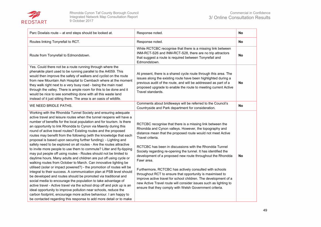
Rhondda Cynon Taf County Borough Council Integrated Network Map Consultation Report 9 October 2017
Commercial in Confidence
3/ Online Consultation Results
49
Parc Dowlais route – at end steps should be looked at. Response noted. No
Routes linking Tonyrefail to RCT. Response noted. No
Route from Tonyrefail to Edmondstown.
While RCTCBC recognise that there is a missing link between
INM-RCT-S26 and INM-RCT-S28, there are no trip attractors
that suggest a route is required between Tonyrefail and
Edmondstown.
No
Yes. Could there not be a route running through where the
phenakite plant used to be running parallel to the A4059. This
would then improve the safety of walkers and cyclist on the route
from new Mountain Ash Hospital to Cwmbach where at the moment
they walk right next to a very busy road - being the main road
through the valley. There is ample room for this to be done and it
would be nice to see something done with all this waste land
instead of it just sitting there. The area is an oasis of wildlife.
At present, there is a shared cycle route through this area. The
issues along the existing route have been highlighted during a
previous audit of the route, and will be addressed as part of a
proposed upgrade to enable the route to meeting current Active
Travel standards.
No
WE NEED BRIDLE PATHS. Comments about bridleways will be referred to the Council’s
Countryside and Park department for consideration. No
Working with the Rhondda Tunnel Society and ensuring adequate
active travel and leisure routes when the tunnel reopens will have a
number of benefits for the local population and for tourism. Is there
an opportunity to link Rhondda to Cynon via Maerdy during this
round of active travel routes? Existing routes and the proposed
routes may benefit from the following (with the knowledge that each
proposal is based upon securing further funding): - Lighting and
safety need to be explored on all routes - Are the routes attractive
to invite more people to use them to commute? Litter and fly-tipping
may put people off using routes - Routes should not be limited to
daytime hours. Many adults and children are put off using cycle or
walking routes from October to March. Can innovative lighting be
utilised (solar or impact powered?) - the promotion of routes will be
integral to their success. A communication plan at PSB level should
be developed and routes should be promoted via traditional and
social media to encourage the population to take advantage of
active travel - Active travel via the school drop off and pick up is an
ideal opportunity to improve pollution near schools, reduce the
carbon footprint, encourage more active behaviour. I am happy to
be contacted regarding this response to add more detail or to make
RCTCBC recognise that there is a missing link between the
Rhondda and Cynon valleys. However, the topography and
distance mean that the proposed route would not meet Active
Travel criteria.
RCTCBC has been in discussions with the Rhondda Tunnel
Society regarding re-opening the tunnel. It has identified the
development of a proposed new route throughout the Rhondda
Fawr area.
Furthermore, RCTCBC has actively consulted with schools
throughout RCT to ensure that opportunity is maximised to
improve active travel for school children. The development of a
new Active Travel route will consider issues such as lighting to
ensure that they comply with Welsh Government criteria.
No
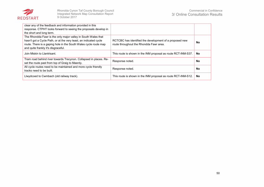
Rhondda Cynon Taf County Borough Council Integrated Network Map Consultation Report 9 October 2017
Commercial in Confidence
3/ Online Consultation Results
50
clear any of the feedback and information provided in this
response. CTPHT looks forward to seeing the proposals develop in
the short and long term.
The Rhondda Fawr is the only major valley in South Wales that
hasn't got a Cycle Path, or at the very least, an indicated cycle
route. There is a gaping hole in the South Wales cycle route map
and quite frankly it's disgraceful.
RCTCBC has identified the development of a proposed new
route throughout the Rhondda Fawr area. No
Join Miskin to Llantrisant. This route is shown in the INM proposal as route RCT-INM-S37. No
Tram road behind river towards Trecynon. Collapsed in places. Re-
set the route past from top of Graig to Maerdy. Response noted. No
All cycle routes need to be maintained and more cycle friendly
tracks need to be built. Response noted. No
Llwydcoed to Cwmbach (old railway track). This route is shown in the INM proposal as route RCT-INM-S12. No
Rhondda Cynon Taf County Borough Council Integrated Network Map Consultation Report 9 October 2017
Commercial in Confidence
4/ Other Responses
51
4. Other Responses
4.1 Results
In addition to the online questionnaire, school surveys and consultation events, individuals could
submit written comments via email or letter. In total, three were received by email and one by
letter. The comments, as outlined below, all have RCTCBC’s response and whether they have
led to changes in the INM.
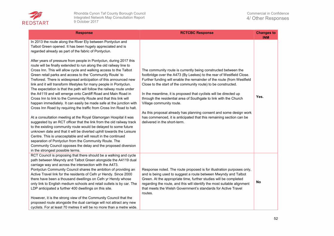
Rhondda Cynon Taf County Borough Council Integrated Network Map Consultation Report 9 October 2017
Commercial in Confidence
4/ Other Responses
52
Response RCTCBC Response Changes to
INM
In 2013 the route along the River Ely between Pontyclun and
Talbot Green opened. It has been hugely appreciated and is
regarded already as part of the fabric of Pontyclun.
After years of pressure from people in Pontyclun, during 2017 this
route will be finally extended to run along the old railway line to
Cross Inn. This will allow cycle and walking access to the Talbot
Green retail parks and access to the ‘Community Route’ to
Treforest. There is widespread anticipation of this announced new
link and it will transform lifestyles for many people in Pontyclun.
The expectation is that the path will follow the railway route under
the A4119 and will emerge onto Cardiff Road and Main Road in
Cross Inn to link to the Community Route and that this link will
happen immediately. It can easily be made safe at the junction with
Cross Inn Road by requiring the traffic from Cross Inn Road to halt.
At a consultation meeting at the Royal Glamorgan Hospital it was
suggested by an RCT officer that the link from the old railway track
to the existing community route would be delayed to some future
unknown date and that it will be diverted uphill towards the Leisure
Centre. This is unacceptable and will result in the continued
separation of Pontyclun from the Community Route. The
Community Council opposes the delay and the proposed diversion
in the strongest possible terms.
The community route is currently being constructed between the
footbridge over the A473 (By Leekes) to the rear of Westfield Close.
Further funding will enable the remainder of the route (from Westfield
Close to the start of the community route) to be constructed.
In the meantime, it is proposed that cyclists will be directed up
through the residential area of Southgate to link with the Church
Village community route.
As this proposal already has planning consent and some design work
has commenced, it is anticipated that this remaining section can be
delivered in the short-term.
Yes.
RCT Council is proposing that there should be a walking and cycle
path between Mwyndy and Talbot Green alongside the A4119 dual
carriage way and across the intersection with the A473.
Pontyclun Community Council shares the ambition of providing an
Active Travel link for the residents of Cefn yr Hendy. Since 2000
there have been a thousand dwellings on Cefn yr Hendy whose
only link to English medium schools and retail outlets is by car. The
LDP anticipated a further 400 dwellings on this site.
However, it is the strong view of the Community Council that the
proposed route alongside the dual carriage will not attract any new
cyclists. For at least 70 metres it will be no more than a metre wide.
Response noted. The route proposed is for illustration purposes only,
and is being used to suggest a route between Mwyndy and Talbot
Green. At the appropriate time, further studies will be completed
regarding the route, and this will identify the most suitable alignment
that meets the Welsh Government’s standards for Active Travel
routes.
No
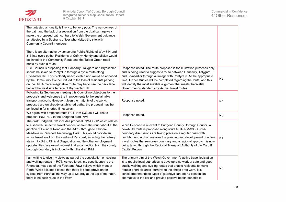
Rhondda Cynon Taf County Borough Council Integrated Network Map Consultation Report 9 October 2017
Commercial in Confidence
4/ Other Responses
53
The untested air quality is likely to be very poor. The narrowness of
the path and the lack of a separation from the dual carriageway
make the proposed path contrary to Welsh Government guidance
as attested by a Sustrans officer who visited the site with
Community Council members.
There is an alternative by converting Public Rights of Way 314 and
315 into cycle paths. Residents of Cefn yr Hendy and Miskin would
be linked to the Community Route and the Talbot Green retail
parks by such a route.
RCT Council is proposing that Llanharry, Talygarn and Brynsadler
should be linked to Pontyclun through a cycle route along
Brynsadler Hill. This is clearly unachievable and would be opposed
by the Community Council if it led to the loss of residents parking
on the Hill. A more imaginative route may be to use the back lane
behind the west side terrace of Brynsadler Hill.
Response noted. The route proposed is for illustration purposes only,
and is being used to suggest a route between Llanharry, Talygarn
and Brynsadler through a linkage with Pontyclun. At the appropriate
time, further studies will be completed regarding the route, and this
will identify the most suitable alignment that meets the Welsh
Government’s standards for Active Travel routes.
No
Following its September meeting this Council no objections to the
proposals and welcomes the improvements to the sustainable
transport network. However, given the majority of the works
proposed are on already established paths, the proposal may be
achieved in far shorted timescales.
Response noted. No
We agree with proposed route RCT-INM-S33 as it will link to
proposal INM-PE-2 in the Bridgend draft INM; Response noted. No
The draft Bridgend INM includes proposal INM-PE-12 which relates
to a shared-use active travel connection from the roundabout at the
junction of Felindre Road and the A473, through to Felindre
Meadows in Pencoed Technology Park. This would provide an
active travel link from the centre of Pencoed, including the railway
station, to Ortho Clinical Diagnostics and the other employment
opportunities. We would request that a connection from the county
borough boundary is included within the draft INM.
While Pencoed is relevant to Bridgend County Borough Council, a
new-build route is proposed along route RCT-INM-S33. Cross-
boundary discussions are taking place on a regular basis with
neighbouring authorities over the planning and development of active
travel routes that run cross boundary and a regional approach is now
being taken through the Regional Transport Authority of the Cardiff
Capital Region.
No
I am writing to give my views as part of the consultation on cycling
and walking routes in RCT. As you know, my constituency is the
Rhondda, made up of the Fach and Fawr valleys which meet at
Porth. While it is good to see that there is some provision for
cyclists from Porth all the way up to Maerdy at the top of the Fach,
there is no such route in the Fawr,
The primary aim of the Welsh Government's active travel legislation
is to require local authorities to develop a network of safe and good
quality walking and cycling routes that enable residents to make
regular short distance journeys to the shops or to work. It is
considered that these types of journeys can offer a convenient
alternative to the car and provide positive health benefits to
No
Rhondda Cynon Taf County Borough Council Integrated Network Map Consultation Report 9 October 2017
Commercial in Confidence
4/ Other Responses
54
This is deeply disappointing, not to mention hazardous for cyclists
in this part of the Rhondda.
Living in Penygraig, I know only too well the hazards of being a
cyclist in this part of the Rhondda. Attempting to cycle north or
south in the valley is fraught with difficulties and dangers. This
activity is made worse by the narrow roads. It’s not safe, especially
for children.
The lack of safe cycle route is having a negative impact on the
promotion of cycling in Rhondda when we have more Welsh cyclist
role models than ever before. Despite the challenge of limited
routes, great efforts being undertaken to encourage cycling in the
Rhondda – as typified by the work of the Bike Doctor shop in Porth.
As well as organising regular road and mountain bike rides through
their thriving club, they are holding lessons in the Barry Sidings
facility they have just taken on. Work like this can only be
applauded. The positive health benefits are undisputed.
I urge you now to ensure that keen cyclists are given the
opportunities to get out and about on their bikes by providing safe
routes. This is key in light of the plans to open the Rhondda Tunnel.
This underground link between the Rhondda and Afan Valley has
the potential to become a major tourist draw as it would be the
second longest cycle tunnel in the world. It is essential that the
cycle network is in place to support this attraction ready for when it
opens.
individuals, a reduction in traffic congestion and an improvement in
local air quality.
I note your comments and can advise that the draft INM is putting
forward a potential active travel route along the Rhondda Fawr to the
mouth of the disused Rhondda Tunnel for consideration. At this very
early stage of possible development, the precise alignment has not
been determined and future construction will be dependent upon the
availability of resources, as well as the outcome of detailed design
and survey work.
Notwithstanding this, active travel journeys are very local in nature
and the Council has already commenced work in the Rhondda Fawr,
using Safe Routes in the Communities funding to create a good
quality walking and cycle route in the Ystrad area. In addition, options
are being considered for the eventual replacement of the footbridge
over the railway and river at Ystrad Rhondda station. As such, it is
envisaged that the bridge and its approaches, which provide access
to the railway station, local leisure centre and schools and the Gelli
Industrial Estate, will form part of a longer distance active travel route
along the Rhondda Fawr.
RCT already have a number of existing walking and cycling routes
that are of low quality and poorly maintained. Examples of this can
be found on NCN route 8 the Taff Trail to the north of Pontypridd
where sections of the route are falling away into the river, it’s very
narrow, the surface is very poor and bumpy and it often floods.
The route between Treforest and Tonteg has been reduced from
2.5m wide to 0.5m wide because the vegetation has not been
managed.
Response noted. As part of the Active Travel Act, particularly the
auditing process, RCTCBC has identified several routes that require
upgrades to such issues identified in the response. Any upgrades
that take place will aim to achieve the Welsh Government’s Active
Travel standards.
No
Rhondda Cynon Taf County Borough Council Integrated Network Map Consultation Report 9 October 2017
Commercial in Confidence
4/ Other Responses
55
HOV-There is potential to create a much improved Heads of the
Valleys route alongside developments that will be funded by the
A465 dualling. These should be included as part of the INM. More
details can be provided.
Response noted. Any route that is along a trunk road requires further
details for this to be confirmed subject to discussions with Welsh
Government, where necessary. No
Abernant tunnel is from a Sustrans perspective to be prioritised
over the Rhondda Tunnel as set out in our work for Welsh
Government in 2015. This is because of its much higher potential
for active travel by providing access to employment. The key to
this project will be routes constructed to ATA guidance to each
entrance otherwise opening the tunnels will have little value. More
work needs to be done on looking at an acceptable route to the
Abernant tunnel. We are not convinced that RCT-INM-S12 is the
best option.
Response noted. No
Rhondda tunnel as with the Abernant requires good active travel
links. The key to this project will at a minimum be a direct route to
Treherbert Station from the tunnel entrance. In the long term a
good quality route from Treherbert to Pontypridd is required that is
Safe, coherent, direct, comfortable and attractive.
Response noted. Feasability work carried out to date has identified
route RCT-INM-S12 as the most suitable in terms of meeting Active
Travel standards. RCTCBC has identified the development of a
proposed new route throughout the Rhondda Fawr area.
No
Power station Hill to Taff Trail – New direct route across the valley
and an extension of RCT INM S31
As a result of the consultation process, RCTCBC have added a new
INM long-term route (INM-RCT-N5) from Upper Boat to the existing
Taf Trail at one end which will connect with RCT-INMS31 at the other
end for Power Station Hill.
Yes
Rhondda Fawr - In the long term a good quality route from Treherbert
to Pontypridd is required that is Safe, coherent, direct, comfortable
and attractive.
RCTCBC has identified the development of a proposed new route
throughout the Rhondda Fawr area. No
Rhondda Fach – Good opportunity to construct a route along the
disused railway alignment north of Stanleytown after a new water
main has been installed.
This route is included in the INM and is identified as proposed route
RCT-INM-C1. No
New alignment of NCN route 4 – Complete routes from Talbot Green
to Tonyrefail and on to Hendreforgan so that NCN route 4 can be
realigned.
Response noted. No

Rhondda Cynon Taf County Borough Council Integrated Network Map Consultation Report 9 October 2017
Commercial in Confidence
5/ Community Engagement Events
56
5. Community Engagement Events
5.1 Introduction
The community engagement events were advertised by RCTCBC and were held on various
dates. A total of 8 events were held which were intended to provide opportunities for the local
community to ask questions about the process to RCTCBC’s staff involved in the scheme, and to
obtain their feedback on where routes can be improved and where new routes should be located.
Visitors to the community engagement events who expressed an opinion about the proposals
were encouraged to submit their opinion through the surveys provided at the event or on the
online questionnaire as advertised by RCTCBC. The remainder of this chapter outlines the issues
raised by respondents to the consultation and the response to these.
At the community engagement events, strategic and local maps were provided on display boards
to provide further information about the existing and proposed routes, hard copies of the surveys
were available, and a factsheet regarding the Active Travel (Wales) Act 2013 was provided.
Table 5 - Community Engagement Event Location
Venue Date Estimated
Attendees
Treorchy Library
Station Rd,
Treorchy
CF42 6NN
Thursday August 3rd between 1000 – 13:00 12
Pontyclun Library
Heol-Y-Felin,
Pontyclun
CF72 9BE
Wednesday 16th August between 1400 – 1700 9
Royal Glamorgan Hospital
Ynysmaerdy,
Llantrisant 9
CF72 8XR8
Thursday 24th August between 1000 – 1600 6
Mountain Ash Library
Knight Street,
Mountain Ash,
CF45 3EY
Tuesday 29th August between 1400 – 1830 9
Sobell Centre,
The Ynys,
Aberdare
CF44 7RP
Friday 08th September between 1000 – 1300 8
Porth Library
Porth St,
Porth
CF39 9RT
Thursday 12th September between 1400 – 1830 11
Tesco Store
Depot Rd,
Aberdare
CF44 8DL
Tuesday 14th September between 1000 – 1700 21
Hawthorn Leisure Centre
Fairfield Lane,
Pontypridd
CF37 5LN
Wednesday 20th September between 1400 - 1830 10
Rhondda Cynon Taf County Borough Council Integrated Network Map Consultation Report 9 October 2017
Commercial in Confidence
5/ Community Engagement Events
57
Summary of notes from the Community Engagement Events
Response RCTCBC Response Change to
INM
Off road bikes (especially motorbikes) are destroying footpaths in the
local forestry. Risk of injury tripping on these paths. Response noted. No
Byelaws in parks should be changed to allow cycling if a cycle route
runs through them. Gaps exist in the Cynon Trail in the Cwmbach
area where cyclists should use the highway. Directional signage is
poor for cyclists who do not know their way around Aberdare.
Response Noted. Matters regarding byelaws will be
considered further by RCTCBC. As part of the auditing
process within the Active Travel (Wales) Act, RCTCBC has
audited routes throughout RCT. Any upgrades will reflect the
Welsh Government’s Active Travel design guidance
standards for Active Travel routes.
No
If a new cycle route is constructed between Cwmparc and Treorchy, it
should use the disused rail alignment. Response noted. No
Converting the disused railway line running through Efail Isaf into a
cycling route. Route could link with the Church Village Community
Route and continue towards Creigiau and Cardiff.
RCTCBC has considered a route between Efail Isaf and
surrounding areas. However, RCTCBC has concluded that
there are insignificant trip attractors from Efall Isaf to
surrounding areas for the route to be considered an Active
Travel route.
No
Designating a short section of path near the A473/Lanelay Road
roundabout that goes under the road as an Active Travel route. Show
as aspirational, an active travel route alongside the alignment of the
proposed Llanharan bypass.
As a result of the consultation process, RCTCBC have
added a new long-term route to link into Llantrisant
community route (RCTAT13i) which is currently under
construction. In line with the Active Travel legislation, the
development of the Llanharan bypass will consider the
provision of an Active Travel route.
Yes
Upgrade existing footpath at the rear of new housing development
(Dyffryn Bach Estate located to the south of The Ridings, Tonteg) to
Active Travel standards and construct a new link to Church Village
Community Route.
There are proposals for a new route nearby RCT-INM-S13. No
Suggests a link between Gellihirion Industrial Estate (near Upper Boat
Roundabout) and Taf Trail/Rhydfelen Estate
As a result of the consultation process, RCTCBC have
added a new INM long-term route from Upper Boat (RCT-
INM-N5) to the existing Taf Trail.
Yes
Suggests a link from Nantgarw roundabout (by entrance to Heol
Crochendy/Oxford Street) to Taf Trail and the new link shown on INM
In advance of receiving this response, RCTCBC identified a
new long-term proposal as identified by route INM-RCT-S32. No
Rhondda Cynon Taf County Borough Council Integrated Network Map Consultation Report 9 October 2017
Commercial in Confidence
5/ Community Engagement Events
58
to Caerphilly along the A468. Avoids the need to go into Taffs Well
from TIE.
Suggests a link along the B4278 bypass between Tonypandy and
Dinas to serve the rail station at Dinas.
As a result of the consultation process, RCTCBC have
added a new route (INM-RCT-N8) to serve the rail station at
Dinas.
Yes
Suggests a link off the existing route shown in Porth town centre to
the Morrisons store (located between Pontypridd Road and the
bypass).
As a result of the consultation process, RCTCBC have
added a new route (RCT-INM-N11) from Porth town centre
to Morrisons.
Yes
Suggests a link along the Broadway (between Pontypridd and
Treforest) as an alternative to the route through Ynysangharad Park,
Pontypridd which is not open 24/7.
As a result of the consultation process, RCTCBC have
added a new route (RCT-INM-N12) along the A473
(Broadway) as an alternative to the route through
Ynysangharad Park.
Yes
In general, improve signage along existing AT routes for people not
familiar with area. In particular, at the end of a route and if they need
to re-join the route further along. eg. at Cross Inn towards the end of
the Church Village Community Route.
Response noted. No
Signs should show more information such as directions to key
facilities as seen on road signs. Response noted. No
In the Hirwaun and Llwydcoed areas, signs are confusing where cycle
routes meet. However, some of these routes have not been identified
as AT routes on the INM and are recreational in nature.
As part of the Active Travel (Wales) Act 2013, the definition
of ‘active travel’ under the Act means walking and cycling as
an alternative means to motorised transport for the purpose
of making every day journeys. An “active travel journey”
means a journey made to or from a workplace or educational
establishment or in order to access health, leisure or other
services or facilities (Delivery Guidance 2.3.1).
No
Connect the Talbot Green route to Ynysddu Pontyclun path via the
link alongside the pumping station and current footpath under A473
which would avoid dismounting and using the narrow substandard
footbridge. Disabled users are unlikely to be able to use the footbridge
on an ICE trike. My request is that the current vegetation clearance is
extended to cover this short stretch so it can be used and walked as a
footpath and then feasibility can be considered over following months
/ years for a proper upgrade pending funding becoming available.
As a result of the consultation process, RCTCBC have
added a new long-term route to link into the Llantrisant
Community route. This route is identified as route RCTAT13i
and is currently under construction.
Yes
RCT-INM-S42 (route along old railway line). Surface along route is
poor and is unsuitable for pushchairs and road bikes etc. Trees are
also overgrown and there is no lighting at present
Route along old railway line (RCTAT13i) is currently under
construction to current Active Travel standards. No
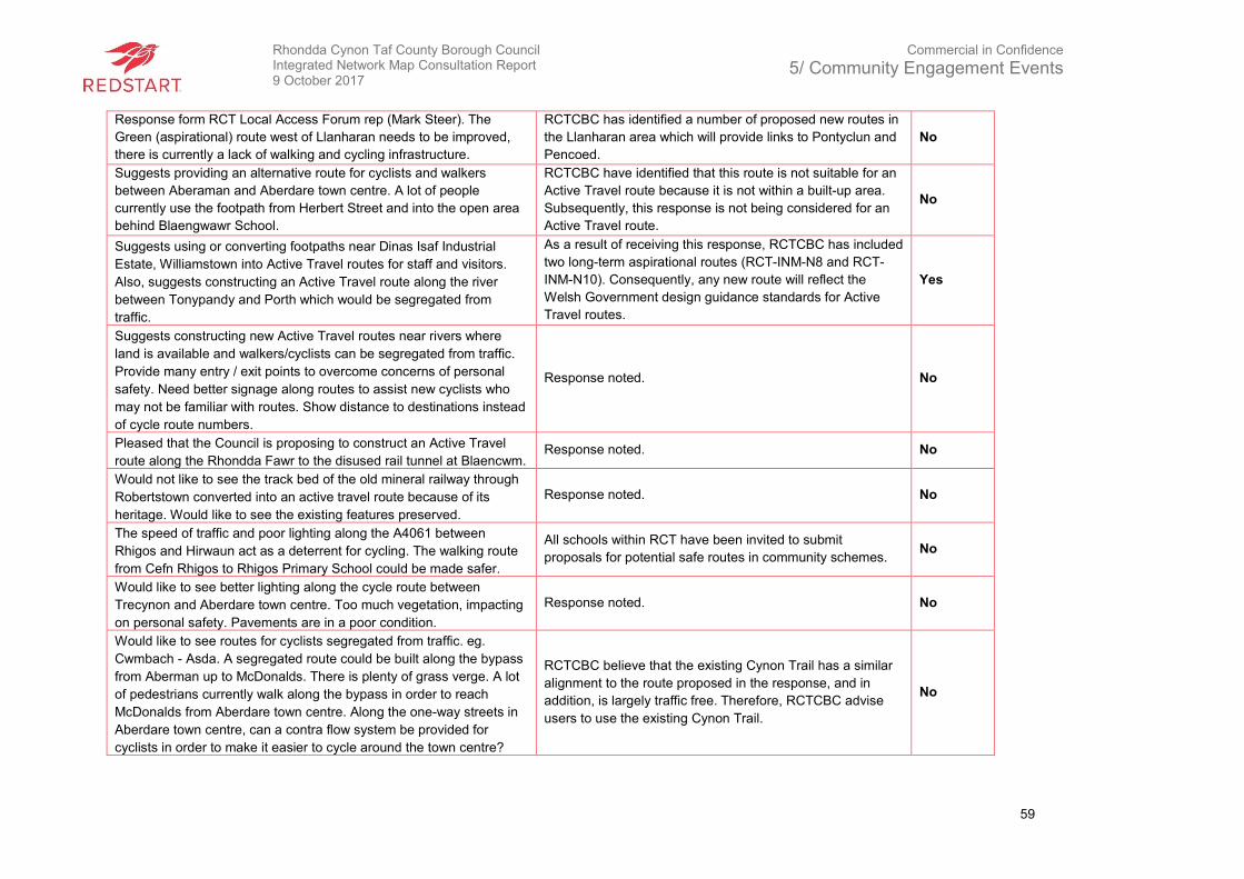
Rhondda Cynon Taf County Borough Council Integrated Network Map Consultation Report 9 October 2017
Commercial in Confidence
5/ Community Engagement Events
59
Response form RCT Local Access Forum rep (Mark Steer). The
Green (aspirational) route west of Llanharan needs to be improved,
there is currently a lack of walking and cycling infrastructure.
RCTCBC has identified a number of proposed new routes in
the Llanharan area which will provide links to Pontyclun and
Pencoed.
No
Suggests providing an alternative route for cyclists and walkers
between Aberaman and Aberdare town centre. A lot of people
currently use the footpath from Herbert Street and into the open area
behind Blaengwawr School.
RCTCBC have identified that this route is not suitable for an
Active Travel route because it is not within a built-up area.
Subsequently, this response is not being considered for an
Active Travel route.
No
Suggests using or converting footpaths near Dinas Isaf Industrial
Estate, Williamstown into Active Travel routes for staff and visitors.
Also, suggests constructing an Active Travel route along the river
between Tonypandy and Porth which would be segregated from
traffic.
As a result of receiving this response, RCTCBC has included
two long-term aspirational routes (RCT-INM-N8 and RCT-
INM-N10). Consequently, any new route will reflect the
Welsh Government design guidance standards for Active
Travel routes.
Yes
Suggests constructing new Active Travel routes near rivers where
land is available and walkers/cyclists can be segregated from traffic.
Provide many entry / exit points to overcome concerns of personal
safety. Need better signage along routes to assist new cyclists who
may not be familiar with routes. Show distance to destinations instead
of cycle route numbers.
Response noted. No
Pleased that the Council is proposing to construct an Active Travel
route along the Rhondda Fawr to the disused rail tunnel at Blaencwm. Response noted. No
Would not like to see the track bed of the old mineral railway through
Robertstown converted into an active travel route because of its
heritage. Would like to see the existing features preserved.
Response noted. No
The speed of traffic and poor lighting along the A4061 between
Rhigos and Hirwaun act as a deterrent for cycling. The walking route
from Cefn Rhigos to Rhigos Primary School could be made safer.
All schools within RCT have been invited to submit
proposals for potential safe routes in community schemes. No
Would like to see better lighting along the cycle route between
Trecynon and Aberdare town centre. Too much vegetation, impacting
on personal safety. Pavements are in a poor condition.
Response noted. No
Would like to see routes for cyclists segregated from traffic. eg.
Cwmbach - Asda. A segregated route could be built along the bypass
from Aberman up to McDonalds. There is plenty of grass verge. A lot
of pedestrians currently walk along the bypass in order to reach
McDonalds from Aberdare town centre. Along the one-way streets in
Aberdare town centre, can a contra flow system be provided for
cyclists in order to make it easier to cycle around the town centre?
RCTCBC believe that the existing Cynon Trail has a similar
alignment to the route proposed in the response, and in
addition, is largely traffic free. Therefore, RCTCBC advise
users to use the existing Cynon Trail.
No
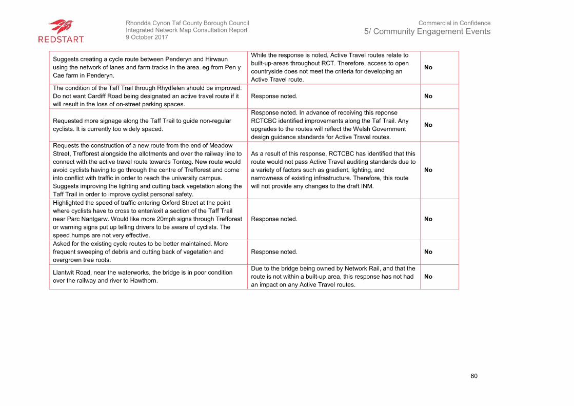
Rhondda Cynon Taf County Borough Council Integrated Network Map Consultation Report 9 October 2017
Commercial in Confidence
5/ Community Engagement Events
60
Suggests creating a cycle route between Penderyn and Hirwaun
using the network of lanes and farm tracks in the area. eg from Pen y
Cae farm in Penderyn.
While the response is noted, Active Travel routes relate to
built-up-areas throughout RCT. Therefore, access to open
countryside does not meet the criteria for developing an
Active Travel route.
No
The condition of the Taff Trail through Rhydfelen should be improved.
Do not want Cardiff Road being designated an active travel route if it
will result in the loss of on-street parking spaces.
Response noted. No
Requested more signage along the Taff Trail to guide non-regular
cyclists. It is currently too widely spaced.
Response noted. In advance of receiving this reponse
RCTCBC identified improvements along the Taf Trail. Any
upgrades to the routes will reflect the Welsh Government
design guidance standards for Active Travel routes.
No
Requests the construction of a new route from the end of Meadow
Street, Trefforest alongside the allotments and over the railway line to
connect with the active travel route towards Tonteg. New route would
avoid cyclists having to go through the centre of Trefforest and come
into conflict with traffic in order to reach the university campus.
Suggests improving the lighting and cutting back vegetation along the
Taff Trail in order to improve cyclist personal safety.
As a result of this response, RCTCBC has identified that this
route would not pass Active Travel auditing standards due to
a variety of factors such as gradient, lighting, and
narrowness of existing infrastructure. Therefore, this route
will not provide any changes to the draft INM.
No
Highlighted the speed of traffic entering Oxford Street at the point
where cyclists have to cross to enter/exit a section of the Taff Trail
near Parc Nantgarw. Would like more 20mph signs through Trefforest
or warning signs put up telling drivers to be aware of cyclists. The
speed humps are not very effective.
Response noted. No
Asked for the existing cycle routes to be better maintained. More
frequent sweeping of debris and cutting back of vegetation and
overgrown tree roots.
Response noted. No
Llantwit Road, near the waterworks, the bridge is in poor condition
over the railway and river to Hawthorn.
Due to the bridge being owned by Network Rail, and that the
route is not within a built-up area, this response has not had
an impact on any Active Travel routes.
No
Rhondda Cynon Taf County Borough Council Integrated Network Map Consultation Report 9 October 2017
Commercial in Confidence
6/ Influence on INM
61
6. Influence on INM
This chapter aims to summarise the influence that the different consultation exercises have had
and continue to have on the emerging INM. The consultation exercises were a crucial method of
engaging with the public and giving individuals the opportunity to share their views and help shape
the INM throughout RCT.
Many people who took part in the consultation events and completed the surveys are not “active”
travellers in the sense of the Active (Wales) Act. By this, it is meant their journeys are purely for
leisure. Therefore, care has been taken, where possible, to try and separate views expressed by
those respondents from those who walk or cycle for a specific purpose.
The results of the consultation process also highlighted that the main factor preventing active
travel is deemed to be the safety of active travel, unsuitable and poorly directed routes as well as
the maintenance of existing and proposed routes. This supports the belief that the identified
improvements because of the auditing process will see the number of individuals taking part in
active travel increasing.
The open-ended questions which asked for new routes and improvements to be suggested
helped to justify the inclusion of some routes and resulted in some new routes being proposed
where viable.
The community engagement event also produced results that will influence the INM. Information
was obtained regarding changes that would encourage participation in active travel as well as
where new links were required. This information helped to inform the location of routes and
linkages and will be of use when suggesting improvements.
After considering all responses, RCTCBC plan to proceed with the INM with a number of changes.
The most significant of which are:
• Upgrades to the rear of Ysgol Gyfun Treorci (INM-RCT-N1)
• New route through industrial estate to access Ferndale, previously a proposed safe route
(INM-RCT-N2);
• Power Station Hill through Upper Boat in to Industrial Estate (INM-RCT-S31);
• Extend proposed new route between Pontyclun and Llanharan towards Pencoed and
Bridgend via Brynna (INM-RCT-N4);
• Tesco Extra to Upper Boat Roundabout (INM-RCT-N5);
• Change INM—RCT-S1 from walking only route to shared-use;
• Talbot Green to Cross Inn (INM-RCT-N7)
• Heol Dinas Isaf to Ty Elai (INM-RCT-N8)
• Cefn yr Hendy to Community Route / Pontyclun (INM-RCT-N9);
• Link along B4276 bypass between Tonypandy and beyond Dinas along the B4276 to Porth
town centre (INM-RCT-N10);
Rhondda Cynon Taf County Borough Council Integrated Network Map Consultation Report 9 October 2017
Commercial in Confidence
6/ Influence on INM
62
• Porth town centre to Morrisons (RCT-INM-N11);
• Broadway route along A473 to bypass closed Ynysangharad Park, Pontypridd (RCT-INM-
N12); and
• New route under A473 in Talbot Green (RCT-INM-N13).
To summarise, the consultation was delivered using a robust methodology, was promoted widely
and led to extensive engagement. The level of participation generated constructive insights from
people who could provide informed comment.
Rhondda Cynon Taf County Borough Council Integrated Network Map Consultation Report 9 October 2017
Commercial in Confidence
7/ Conclusions and Next Steps
63
7. Conclusions and Next Steps
To conclude, this Consultation Report has considered the responses received, and where
appropriate, provided explanatory and mitigating information highlighting ways in which the
proposals are to be amended in light of the responses received. This exercise has demonstrated
how the consultation process has shaped the proposals. In some instances, responses received
relate to on-going matters with RCTCBC and are actively being dealt with, including:
• Connectivity between routes throughout RCT;
• Rhondda Tunnel – ongoing dialogue with Rhondda Tunnel Society;
• Link between Pontyclun to Cardiff – to discuss with Cardiff Council; and
• Review of bye-laws, maintenance regime and investigating the creation of a bike hire
scheme
The next step is to map all the new INM routes and identify whether they are short, medium and
long-term proposals. Subject to internal review, the subsequent step will be to submit the
amended INM routes to Welsh Government for approval. Subject to the relevant outcome,
RCTCBC will endeavour to further develop and deliver these proposals.
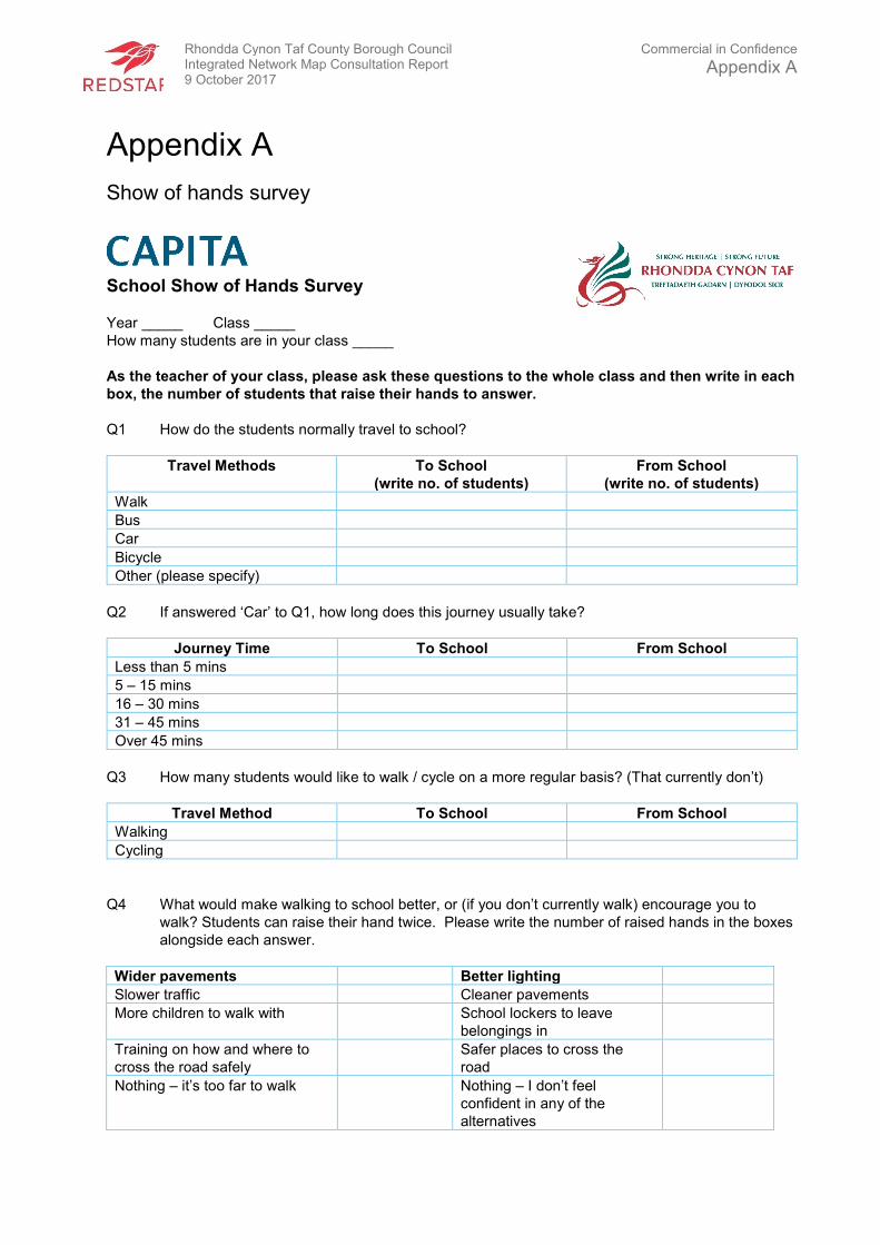
Rhondda Cynon Taf County Borough Council Integrated Network Map Consultation Report 9 October 2017
Commercial in Confidence
Appendix A
Appendix A
Show of hands survey
School Show of Hands Survey
Year _____ Class _____
How many students are in your class _____
As the teacher of your class, please ask these questions to the whole class and then write in each
box, the number of students that raise their hands to answer.
Q1 How do the students normally travel to school?
Travel Methods To School
(write no. of students)
From School
(write no. of students)
Walk
Bus
Car
Bicycle
Other (please specify)
Q2 If answered ‘Car’ to Q1, how long does this journey usually take?
Journey Time To School From School
Less than 5 mins
5 – 15 mins
16 – 30 mins
31 – 45 mins
Over 45 mins
Q3 How many students would like to walk / cycle on a more regular basis? (That currently don’t)
Travel Method To School From School
Walking
Cycling
Q4 What would make walking to school better, or (if you don’t currently walk) encourage you to
walk? Students can raise their hand twice. Please write the number of raised hands in the boxes
alongside each answer.
Wider pavements Better lighting
Slower traffic Cleaner pavements
More children to walk with School lockers to leave
belongings in
Training on how and where to
cross the road safely
Safer places to cross the
road
Nothing – it’s too far to walk Nothing – I don’t feel
confident in any of the
alternatives
Rhondda Cynon Taf County Borough Council Integrated Network Map Consultation Report 9 October 2017
Commercial in Confidence
Appendix A
Changing facilities at school
Other (please specify)
Q5 What would make cycling to school better, or (if you don’t currently cycle) encourage you to
cycle? Students can raise their hand twice. Please write the number of raised hands in the
boxes alongside each answer.
Better lighting More / better cycle parking
Slower traffic Off road cycle routes
More children to cycle with School lockers to leave
belongings in
Cycle training Safer places to cross the road
Nothing – it’s too far to cycle Nothing – I don’t feel confident in
any of the alternatives
Changing facilities at school
Other (please specify)
Q6 How many students use the routes highlighted on the maps?
Open-ended questions
Q7 What improvements would students like to see to the routes highlighted on the maps?
_____________________________________________________________________________
_____________________________________________________________________________
_____________________________________________________________________________
_____________________________________________________________________________
_____________________________________________________________________________
Q8 Are there any additional routes that the students believe are well used and require
improvements?
_____________________________________________________________________________
_____________________________________________________________________________
_____________________________________________________________________________
_____________________________________________________________________________
_____________________________________________________________________________
Thank you for taking the time to complete this survey.
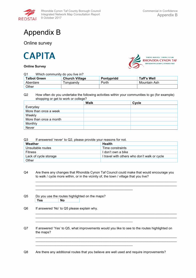
Rhondda Cynon Taf County Borough Council Integrated Network Map Consultation Report 9 October 2017
Commercial in Confidence
Appendix B
Appendix B
Online survey
Online Survey
Q1 Which community do you live in?
Talbot Green Church Village Pontypridd Taff’s Well
Aberdare Tonypandy Porth Mountain Ash
Other
Q2 How often do you undertake the following activities within your communities to go (for example)
shopping or get to work or college?
Walk Cycle
Everyday
More than once a week
Weekly
More than once a month
Monthly
Never
Q3 If answered ‘never’ to Q2, please provide your reasons for not.
Weather Health
Unsuitable routes Time constraints
Fitness I don’t own a bike
Lack of cycle storage I travel with others who don’t walk or cycle
Other
Q4 Are there any changes that Rhondda Cynon Taf Council could make that would encourage you
to walk / cycle more within, or in the vicinity of, the town / village that you live?
_____________________________________________________________________________
_____________________________________________________________________________
_____________________________________________________
Q5 Do you use the routes highlighted on the maps?
Yes No
Q6 If answered ‘No’ to Q5 please explain why.
_____________________________________________________________________________
_____________________________________________________________________________
_____________________________________________________
Q7 If answered ‘Yes’ to Q5, what improvements would you like to see to the routes highlighted on
the maps?
_____________________________________________________________________________
_____________________________________________________________________________
_____________________________________________________
Q8 Are there any additional routes that you believe are well used and require improvements?

Rhondda Cynon Taf County Borough Council Integrated Network Map Consultation Report 9 October 2017
Commercial in Confidence
Appendix B
_____________________________________________________________________________
_____________________________________________________________________________
_____________________________________________________
Please provide your name and e-mail address, you may be contacted for further information.
Name
E-mail address
Thank you for taking the time to complete this survey.

REDSTART
St David’s HousePascal CloseSt MellonsCardiffCF3 0LW
www.redstartwales.com