PRIME Tara Mathew George Kokkonas · Tara Mathew Senior Advisor 847.980.7267 [email protected]
Upload
aditya-jervisCategory
view
217download
0
Integrated Modeling of Regional Basins:
Thirteen Years of Hard Lesson Learned
Mark A. Ross, Patrick D. Tara, and Jeffrey S. Geurink
University of South Florida

Integrated Model: Coupled Comprehensive Surface-
Groundwater Model
(Specifically: Experience with coupled HSPF-MODFLOW model known as FHM, ISGW, or IHM)

PrecipitationTranspiration
Evaporation
Baseflow
Runoff
Water Table
Infiltration &Percolation
Interflow
Leakage
Interception
Impervious Lens
Surface water storages & stream
flowsGroundwater Flow
Aquitard (Confining Unit)Confined or Artesian Aquifer
Unconfined Aquifer
Evaporation
Bays, Gulf, and Oceans
Hydrologic Cycle Process Coupling
1. DTWT2. Hydr. heads (streams, wetlands & lakes)3. Base flow4. SW/GW ET5. Irrigation fluxes6. Variable SY(vadose moist.)
FHM (HSPF/MODFLOW) Integration Pathways

FHM Chronology 1989 FHM development 1993 FHM ver 1.2 used in mine reclamation 1995 ISGW proprietary version used for public water supply
investigations, FHM District-scale application 1995-1997 FHM peer-reviewed, adapted for USFWS water rights
investigations 1995-1998 period of W-C Fl water wars, numerous models 1997-2000 several FHM version updates for regional W-C Fl
regional investigations, ISGW peer reviewed 2001-2002 major re-write of FHM/ISGW->IHM (Interra,
Aquaterra, USF)

Early Problems(Limitations)
Computers (286s) Model components (HSPF & MODFLOW) Data utilities (GIS, database programs) Digital data (no digital quads) Client perspectives/interest (“recharge
generator”) User acceptance (“too much time & money”)
Consequence: Limited Discretization

R 18 W
R 18 W
R 17 W
R 17 W
R 16 W
R 16 W
T11N
Lake Havasu
River
95
N
Bill Williams National Wildlife Refuge

IMPERIALNATIONAL WILDLIFE
REFUGE
T
T
1
S
S
2
R 24 W R 23 WR 21 E
N
Cibola National Wildlife Refuge

T 16 N
T 15 N
R 16 E R 17 E
N
Las Vegas National
Wildlife Refuge

Rattlesnake Creek Study

Model Simulation Results Rattlesnake Creek

USFWS ApplicationsLessons Learned
Need does not justify model where there is no data Streamflow separation (runoff/baseflow) very
important to do but problematic Component pre-calibration very important Size and discretization barriers remained Need much better data utilities

Mid 90s “Water Wars”West-Central Florida
Many model applications, similar stream flow performance & gross ET, wildly varying resultant models (recharge), conclusions
Wide variability in model parameterization resulted from inadequate data, understanding and characterization of processes
Need for detailed basin-scale study, tie down internal fluxes and storages

Near Field Model
10 0 10 20 30 40 50 60 Miles
Hydrography
No Flow BoundaryGeneral Head Boundary
Saddle Creek Basin OutlineDistgen.shp
Saddle Creek Study
(Data Collection, Far-field and Near-
field Models)
N
EW
S

Saddle Creek Gauging Stations

Station 17 Calibration
0
20
40
60
80
100
120 F
lo
w (c
fs
)
Oct-96Apr-97Oct-97Apr-98Oct-98Apr-99Date
Obs. Streamflow
Sim. Streamflow
Station 17b Calibration
0
5
10
15
20
In
ch
es
Oct-96 Apr-97 Oct-97 Apr-98 Oct-98 Apr-99
Date
Obs. Streamflow
Obs. Baseflow
Sim. Streamflow
Sim. Baseflow

Saddle Creek StudyLessons Learned
Extensive basin-scale data collection helped refine model calibration and resultant internal fluxes
Real important to characterize time/space scale of rainfall
Needed to understand the mechanism of runoff, especially role of variable saturated areas (VSAs)
Variable specific yield (SY) very important process

30 0 30 60 Miles
Coastline
BasinsUngagedGaged
Stream/Lake
N
SWFWMD Southern
District Model
HSPF,MODFLOW pre-calibration,1st phase of integrated model

SWFWMD Southern District ModelLessons Learned
Importance of including all hydrography explicitly Strong parameterization and model performance
constraints by DTWT resulted in greatly improved calibration (streamflow and aquifer behavior)
Indicated much higher GW ET fraction in shallow watertable settings than previously considered – resulting in model concept changes
Importance of irrigation fluxes and deep aquifer discharges zones
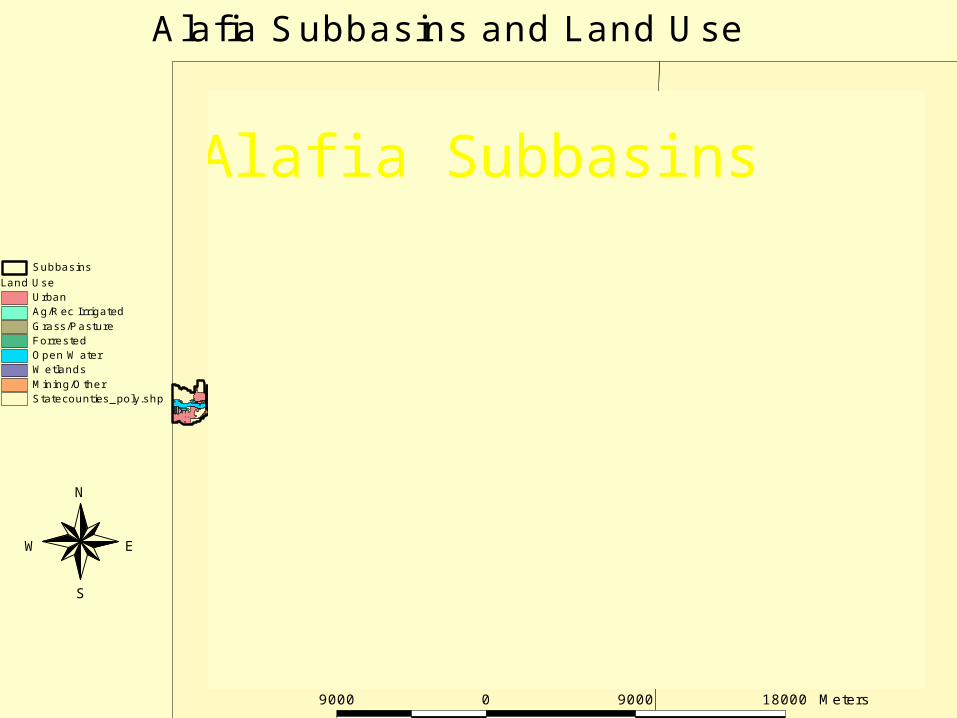
Alafia Subbasins
N
EW
S
Statecounties_poly.shp
Land UseUrbanAg/Rec IrrigatedGrass/PastureForrestedOpen WaterWetlandsMining/Other
Subbasins
Alafia Subbasins and Land Use
9000 0 9000 18000 Meters

Alafia ModelLesson
Need to explicitly characterize connected and unconnected hydrography for each basin
Depart from basin calibration, move to land use calibration

Alafia Micro-Scale Field StudyPreliminary Results
Runoff dominated by saturation excess (VSAs) Air entrapment plays a strong role Water table fluctuations are very rapid Baseflow timescale may be controlled by ET timescale not
water table drainage SY is highly variable (.2 – 2 m) controlling water table
fluctuation Vadose zone moisture maintenance pronounced, thus
significant GW ET (watertable depths < 2 m)

New IHM Model Developments
New code integration structure, HSPF and MODFLOW run concurrently, greatly enhanced capability and enhanced run speed
Integration and all other timesteps completely user defined
Landforms explicitly modeled (more distributed parameterization)

Old Model Structure

New Model Structure
Legend
Land Use
Urban
Irrigated/Rec
Grassland/Pasture
Forested
Open Water
Wetlands
Mining/Other
0 1 20.5 Miles

TBW Connected &Unconnected Hydrography
DICRETIZATIONMODFLOW:20,000 grids (1/4 mi)150,000 river reaches3 aquifer layersHSPF:172 non-connected reaches172 storage attenuation73 routing reaches172 basins5 landform categories 320,000 landuse polygons

zo = 0
Zone 1: Upper ConstantMoisture Region
Zone 2: IntermediateCapillary Zone
Zone 3: LowerCapillary Fringe
DryProfile
WetProfile
EquilibriumProfile
zcz
zcf
zwt
Three Layer Soil Moisture Model
(z)
b)a) c)
D1
D2, icz
D3, cf
z
zrz
Three-Layer Soil Moisture Model

Important Spatial & Temporal Scales(Shallow Aquifer Coastal Plain Systems)
Rainfall
Runoff flow plain Infiltration
1 km2
102 m
102 m
5-15 min.
5-15 min.
5-15 min.
ET: Surface
Vadoze
Water table
102 m Horizontal
.1 – 3 m Vertical
3 m V
hourly
daily
Daily
Rchg: Vadose zone
Surficial
Confined
0.1-2 m
102 mH, 1 mV,
103 mH, 10-102 mV
1-24 hrs.
1-24 hrs.
Wkly
Other: Stream base flow
GW Pumping sens.
Landuse change sens.
103 m
Vars.
Vars.
daily – season
daily
1-5 years

Overall Conclusions & Recommendations
Understand the hydrologic processes and water budget magnitudes before beginning
Ensure adequate data to support model Commit to the data pre-analysis Understand the limitations and long-term
commitments Attention to internal fluxes and storages will
ensure fully constrained, unique solution

Integrated Model Commitments
Enormous data requirementsComplete surface water datasetComplete groundwater datasetData pertaining to the integration
Different timescales and space scales Considerable data analysis prior to calibration More difficulty in calibration Users must possess both SW and GW expertise

ZLS
ZRZZCFZWT
ZCZ
(c) Root zone capillary fringe (ZWT ZRZ < ZCF)
(a) Deep water table (ZWT < ZCF ZRZ)
ZLS
ZRZ
ZCFZWT
ZCZ
(b) Capillary interaction (ZWT < ZCF Zrz)
ZLS
ZRZZCFZWT
ZCZ
(d) Root zone water table ( ZRZ < ZWT; ZCZ ZLS)
ZLS
ZRZ
ZCFZWT
ZCZ
(e) Capillary zone at land surface (ZCF ZLS ZCZ)
ZLS
ZRZ
ZCF
ZWT
Figure 1 a-f: Six cases for vadose zone soil moisture condition.
ZLS
ZRZ
ZWT
(f) Capillary fringe at land surface (ZWT ZLS ZCF)
Root Capillary Zone