INSTITUTE OF WATER MODELLING Ne · PDF fileSustainable Drainage and Flood Management of...
16
Newsletter No. 40, April 2011 www.iwmbd.org CONTENTS CONTENTS INSTITUTE OF WATER MODELLING INSTITUTE OF WATER MODELLING INSTITUTE OF WATER MODELLING Newsletter Newsletter Newsletter Newsletter Prof. Dr. M. Monowar Hossain Joins IWM as Executive Director 02 Mr. Emaduddin Ahmad Retires from the Position of Executive Director 02 IWM organizes Strategic Management Workshop 02 Study for Safe Drinking Water Source Identification in 148 Pourashavas 03 Pilot Study on Artificial Recharge to Upper Dupitila Aquifer by Rain Wate Harvesting from Building Roof Tops in Dhaka City 04 Water Supply and Environmental Engineering Action Research 05 Study to Improve Navigation and Protect Jamuna Erosion at Koitola 06 Land Accretion & Erosion in the Estuary Development Program (EDP) Area 07 Sustainable Drainage and Flood Management of Kobadak River Basin under Jessore & Satkhira Districts 08 Feasibility Study and Detailed Engineering Design for Long Term Solution of Drainage Problems in the Bhabodah Area 09 Groundwater Resources Studies For Barind Integrated Area Development Project – Phase III 10 Gungaijuri Haor Area Integrated Water Management Project 11 Pre-Work and Post-Work Measurement of dredging for Gorai River Restoration Project (Phase-II) 12 World Water Day 2011 Observed/Member, Agriculture, Planning Commission Visits IWM / Ethiopian Minister Visits IWM 13 Research Project with UNESCO-IHE/Training on Bay of Bengal Model/ Training on Salinity Modelling / IWM Professional Participates in the Mekong workshop in Lao PDR 14 IWM Professional Participates in the 2nd International Disaster Management Conference in Pakistan/IWM Professional Participates in the 5th IPWG Workshop and Training in Germany/IWM HRD Manager Attends The Training on HRM in Malaysia / ADB Publication on IWM Study 15
Transcript of INSTITUTE OF WATER MODELLING Ne · PDF fileSustainable Drainage and Flood Management of...

Newsletter No. 40, April 2011www.iwmbd.org
CONTENTSCONTENTS
INSTITUTE OF WATER MODELLINGINSTITUTE OF WATER MODELLINGINSTITUTE OF WATER MODELLINGNewsletterNewsletterNewsletterNewsletter
� Prof. Dr. M. Monowar Hossain Joins IWM as Executive Director 02
� Mr. Emaduddin Ahmad Retires from the Position of Executive Director 02
� IWM organizes Strategic Management Workshop 02
� Study for Safe Drinking Water Source Identification in 148 Pourashavas 03
� Pilot Study on Artificial Recharge to Upper Dupitila Aquifer by Rain Wate
Harvesting from Building Roof Tops in Dhaka City 04
� Water Supply and Environmental Engineering Action Research 05
� Study to Improve Navigation and Protect Jamuna Erosion at Koitola 06
� Land Accretion & Erosion in the Estuary Development Program (EDP) Area 07
� Sustainable Drainage and Flood Management of Kobadak River Basin under
Jessore & Satkhira Districts 08
� Feasibility Study and Detailed Engineering Design for Long Term
Solution of Drainage Problems in the Bhabodah Area 09
� Groundwater Resources Studies For Barind Integrated Area
Development Project – Phase III 10
� Gungaijuri Haor Area Integrated Water Management Project 11
� Pre-Work and Post-Work Measurement of dredging for Gorai
River Restoration Project (Phase-II) 12
� World Water Day 2011 Observed/Member, Agriculture, Planning Commission
Visits IWM / Ethiopian Minister Visits IWM 13
� Research Project with UNESCO-IHE/Training on Bay of Bengal Model/ Training on
Salinity Modelling / IWM Professional Participates in the Mekong workshop in Lao PDR 14
� IWM Professional Participates in the 2nd International Disaster Management
Conference in Pakistan/IWM Professional Participates in the 5th IPWG Workshop and Training
in Germany/IWM HRD Manager Attends The Training on HRM in Malaysia /
ADB Publication on IWM Study 15

INSTITUTE OF WATER MODELLINGINSTITUTE OF WATER MODELLING
�� 02
Prof. Dr. M. Monowar Hossain Joins IWM as Prof. Dr. M. Monowar Hossain Joins IWM as Executive DirectorExecutive DirectorProfessor Dr. M. Monowar Hossain joined IWM on 30 March 2011 as Executive Director. Before joining IWM, he held positions of Dean, Faculty of Civil Engineering and Professor & Head, Water Resources Engineering Department of BUET. He has vast knowledge and experience in the field of Water Resources Engineering.
Dr. Hossain did his B.Sc. in Civil Engineering from BUET, M.Sc. from the same university in Water Resources Engineering and Ph.D in Civil Engineering (Hydraulics) from the University of Strath-clyde, Glasgow, UK. He held various administrative positions in BUET during his career in BUET. Dr. Hossain has a long teaching and research experience in the water related field and has more than
hundred technical and scientific publications in renowned journals and international conference proceedings. He started his career as Lecturer in the Department of Water Resources Engineering, BUET in April 1976.
Dr. Hossain, a Commonwealth Scholar, has also received UNDP Fellowship, Third World Academy of Sciences Fellowship, Dutch Government Fellowships, JICA Fellowship, Jalabigyan Purashkar for best technical paper by Indian Hydrological Society for outstanding achievement in his career so far. He has significant international experience of working in universities at abroad. Dr. Hossain played significant roles as an active member in various policy making bodies of the Government of Bangladesh in connection with development and utilization of water resources. He is a Life Fellow of the Institution of Engineers, Bangladesh, Member of American Society of Civil Engineers, International Group. He actively participated in a large number of national and international seminars, workshops and conferences at home and abroad.
Institute of Water Modelling organized a two-day Strategic Management Workshop at Nazimgarh Resort, Sylhet during 25-26 February 2011. Mr. Shaikh Md. Wahid-uz-Zaman, Secre-tary, Ministry of Water Resources and Chairperson, IWM Board of Trustees (BOT) attended the programme as the Chief Guest while Mr. S. M. Al-Hussainy, Chairman, Swanirvar Bangladesh and Member, IWM BOT and Mr. Md. Habibur Rahman, Director General, BWDB and Treasurer, IWM BOT graced the occasion as the Special Guests. A total of 25 Senior Professionals and Management Staff of the Institute attended the programme where a preliminary draft report
was presented by Mr. G. M. Chowdhury, Director, IBA as the management consultant appointed by IWM. Lively group discussions as well as group exercises was held during the workshop and the feedback from the exercises are expected to be incorporated in the final report. A detailed analysis & discussion on the current strengths, weaknesses, opportuni-ties and threats (SWOT) of IWM was done in the workshop. The workshop was aimed to identify measures to strengthen IWM to meet the in house as well as external challenges of the future.
Group photo of the participants and guests at the workshop Guests showed keen interest in the workshop
Mr. Emaduddin Ahmad Retires from the Position of Mr. Emaduddin Ahmad Retires from the Position of Executive Director Executive Director Engr. Emaduddin Ahmad, PEng, retired from the services of IWM on 24 January 2011 at the age of 64. He joined FAP 25 as Deputy Team Leader under COWI in 1991 on lien from BWDB, a parallel program to coordinate the model development at SWMC for the regional studies and later joined SWMC in 1994 and led the institutionalization process of the ten year long Danida supported TA project that was looking for a home where the models could be housed and it could render subsequent support. SWMC Trust was the choice that came into being in 1997 and Mr. Emad continued his journey with SWMC and later with IWM in 2001 as the Chief Executive.
It was a wonderful experience for IWM to work with him. He served IWM, with a team of dedicated hydraulic engineering professionals and other support officials to develop
mathematical modeling solutions for the complex water resource management that were highly acclaimed both at home and abroad. He always felt happy to be partner of IWM development as it offers services in various prestigious projects at abroad, imparts training to professionals of different countries, conducts research with reputed international universities and institu-tions.
Mr Emad is now with a project of IWM as Team leader to work in a team for Safe Drinking Water Source Identification for the Small Townships of Bangladesh.
The IWM family will always remember him and his contribution with highest esteem.
IWM organizes Strategic Management WorkshopIWM organizes Strategic Management Workshop

Issue � 40 �� 03
Department of Public Health Engineering (DPHE) has taken up a project entitled Groundwater Management and TPP for Survey, Investigation and Feasibility Study in Upazilla and Growth Centre Level Pourashava having no Piped Water Supply System. In this connection, DPHE has appointed IWM to conduct Mathematical Modelling Study for Safe Drinking Water Source Identifica-tion in 148 Pourashavas. The Project is very relevant to the country policy for water supply and sanitation. It, along with other sanitation projects in neighbouring countries, will synergis-tically improve the regional environ-mental sanitation situation.
The 148 Pourashavas selected for study is distributed all across Bangla-desh. It involves people from various cross-sections of the country where different livelihoods prevail and also the living style and standards varies. On the basis of a baseline status of the 148 Pourashava by DPHE, review was done for selection before the commencement of the study. The 148 Pourashavas identified has no-piped water supply & faces various types of difficulties arising out drainage condi-tions, solid waste management and sanitation. All identified Pourashavas has acute problem with safe drinking water supply either from contami-nated SW source or arsenic / salinity contaminated GW source. The project will identify avenues to explore suitable safe water supply either from GW / SW exploiting deeper aquifers or river water & small water conservancy project respectively. Alternate water supply such as Rainwater Harvesting, Pond Sand Filter and Infiltration Gallery etc., will also be considered.
The project has two components viz., Mathematical Modelling for Safe Drinking Water Source Identification (Component-I) & Socio-economic Study, EIA & Detail Engineering Survey & Investiga-tion & Engineering Design (Component-II). Institute of Water Modelling (IWM) was awarded with the modelling activities under Component-I of the project. The scope of work included under Component-I of the project are given below.
The objectives of the study project include the following:
1. Identify safe source with regard to quality especially arsenic contamination.
2. Conduct feasibility study for determining groundwater/surface source to make sure about quality of water as well as to ensure perennial source.
3. Determine water demand and level of services and formu-late design criteria to satisfy the basic needs.
4. Prepare a master plan for each town on water supply, sanitation and drainage issues.
5. Carry out economic and financial analysis to determine the affordability of the beneficiaries and formulation of cost recovery mechanism including tariff strategy.
6. Prepare investment project(s) by involving concerned stakeholders.
7. Prepare environmental impact assessment of the proposed project(s).
As indicated above the total 148 numbers of Pourashavas are included in the project. The project commenced on 17 January 2010 and is scheduled for completion by 42 months. The project is divided into 4 Phases.
Study area (pourashavas) shown in red dots.
Study for Safe Drinking Water Source Identification inStudy for Safe Drinking Water Source Identification in
148 Pourashavas148 Pourashavas

INSTITUTE OF WATER MODELLINGINSTITUTE OF WATER MODELLING
�� 04
Groundwater is the prime source of water supply in the Dhaka city, which is about 87% of the present total supply. This unusual aquifer pumping is endangering the aquifer environment and also becoming a threat to sustain-ability of city itself. This threat is being developed because of imbalance in groundwater recharge and abstraction volume. Such situation should be avoided either by decreasing depen-dency on groundwater or by gradually increasing the groundwater storage volume by artificial recharge to aquifer systems. Besides, Buriganga and Sitalakhya rivers are also no more suitable as the source of water supply due to continued pollution. Consider-ing the threat of groundwater mining, DWASA has been decided to carrying out a pilot study on artificial recharge to aquifer through rain water harvesting. Accordingly the study on “Artificial Recharge to Aquifer by Rain Water Harvesting from Building Roof Tops in Dhaka City” has been assigned by DWASA to IWM on December 2009. The study duration is for 15 months period. The main objective of this pilot study is to investigate the feasibility of artificial recharge to upper Dupitila aquifer within the city to protect aquifer environment and to augment present supply of water in Dhaka City.
IWM has selected Segunbagicha and Lalmatia DWASA compounds consider-ing prevailing hydrogeological condi-tion and scope of rainwater harvesting from roof top. For the purpose 15m2 and 14m2 recharge pits along with 1.3m thick three layer filter bed and 104m & 121m deep injection wells has been constructed at the two sites respectively. For collection and delivery of harvested rainwater in to the recharge pit necessary pipe network has also been constructed. During the last rainy season rainwater was harvested from the selected roof top for trial recharge experiment. IWM has also collected rainwater from spatially distributed 6 different locations. Collected samples were analyzed for 25 parameters in BUET Environ-mental laboratory. Through these experiments some important and interesting output has evolved. These are; Saturated and pumping part of the Upper Dupitila aquifer is the best depth location for making artificial recharge through gravity inflow in Upper Dupitila aquifer system.
Rainwater in Dhaka city has good quality standard for using in artificial recharge to aquifer layers. In Segunbagi-cha area for out flowing recharge water through injection
well by gravity, minimum 560 kPa hydrostatic pressure is to be maintained inside injection well, while target aquifer layer has 57m depth to groundwater level, 0.127 specific yield and 21m /day permeability. If 60 % of the total rainfall from concrete roof tops of the city area can be havested,
then annually about 89,496 million liters rain water will be available for artificial recharge to aquifer. This recharge volume can make available about 245 mld water for city water supply.
Recharge Pit and Injection wells
Rainwater flowing in pit through perforated pipe
Pilot Study on Artificial Recharge to Upper Dupitila Aquifer by Rain Pilot Study on Artificial Recharge to Upper Dupitila Aquifer by Rain Water Harvesting from Building Roof Tops in Dhaka CityWater Harvesting from Building Roof Tops in Dhaka City

Issue � 40 �� 05
Water Supply and EnvironmentalWater Supply and Environmental
Engineering Action ResearchEngineering Action Research
It is a great challenge for DWASA to ensure water supply in adequate quantity and quality round the year. In an effort to reduce the overwhelming dependence on groundwater resources for water supply, groundwa-ter and surface water has been proposed for conjunctive use. Eventu-ally DWASA has developed a strategic development plan to use alternative surface water sources. The total water demand of the Dhaka city has been calculated approximately at 2,470 MLD in 2009, which is predicted to increase to around 4,130 MLD in 2025.
The “Feasibility Study of Pagla/ Keranigonj Water Supply Project’ was launched in April, 2010 and completed in Dec, 2010. A 900 MLD Surface water Treatment Plant, the largest in Bangla-desh was designed by the IWM for the project in two phases. In the first phase 450MLD treated water will be produced and in the 2nd phase 450 MLD water will be added to the system. The major objective of the study is to carryout detailed feasibility study of the project which includes (i) Option study for Intake selection & WTP (ii) Assess dependable flow of Padma River (iii) Identification of water treatment process (iv) Outline design of project components (v) Estimating cost of the project.
Extensive use of 2-dimensional morphological model has been done to investigate sedimentation in the intake, river bank stability and options for bank protection works. Network models have been used to design the transmission lines and booster require-ment. I-dimensional models have been used to generate long-term river discharge data at the intake site for dependable flow calculations. Major efforts have been given to study water quality including sediment load to finalize the treatment process; field and laboratory model tests have been conducted by experts from BUET to design the treatment process. BUET experts also contributed in environmental impact assessment of the project; several option studies were made to select the most suitable location of treatment plant and to identify the route of raw and clean water transmission main; outline design of each component structures of the project including cost estimates were made; EIA, SIA and financial and economical analysis of the project shows that the project is economically viable with no major environmental and social adverse impacts.
A twin trunk main of 32 km of 2100 mm dia was designed for treated water transmission to Dhaka city from the treatment
plant located at Jashaldia. It was decided that the treated water transmission line would be carried along the Sreenagar-Dohar road, then Sreenagar-Dohar bypass road, and then the Mawa-Dhaka highway shown the figure above.
The total estimated cost of the project is Tk. 3338 crore in the first phase. The recurring cost of the project has been estimated as Tk. 65 crore (approximately) per year. The implementation of the project is planned over a period of 4 years. The Financial IRR is 10% and the project is financially at break-even at 10% rate of discount. The project is economically feasible at 11% rate of discount.
Proposed Infrastructure of Pagla/Keraniganj Water Treatment Plant

INSTITUTE OF WATER MODELLINGINSTITUTE OF WATER MODELLING
�� 06
Relentless deposition on the bed of the right anabranch of the Jamuna at Koitola (near PRIDP) has been taking place for quite some time posing threat to naviga-tion around this area, and the conveyance of this channel has been reducing, thus increasing the possibility of spilling over the flood plain. On the contrary, bank erosion at upstream of Hurasagar near Kaijuri bazaar to Binotia Bazar posed serious threat, and in the last few years the rate is several hundred meters/year. The bank erosion in this area has been persisting for more than a decade leading to partial damage of the Brahmaputra right embankment at this location leaving the population without flood protection. Figure 1 shows the study area along with the important locations.
Observing the propagation rate of bank erosion at upstream and siltation at down-stream of Hurasagar, IWM with the assistance of JMREMP formulated the study for investigation. The study focussed to identify the critical reach of bank erosion, assessment of requirement of river bank protective works at upstream, extent and its impact at further down-stream, etc. Another issue for investigation was the hydro-morphological response of the Jamuna river due to the protective works at upstream of the Hurasagar in improving the siltation at downstream.
The study was carried out by scientifically based hydraulic mathematical modelling. A two-dimensional morphological model, covering 45 km reach of the Jamuna enclosing the Hurasagar outfall was devel-oped using MIKE21C modelling system, and the model was simulated for different scenarios for better understanding and management of erosion/deposition phenomena.
Series of satellite images, variation of the cross-sectional profiles, erosion-deposition map indicate siltation at the right channel near the outfall of the Hurasagar. The data reveals that the siltation is due to the sudden change of the upstream morphology rather than the effect of the completion of the revetment at Koitola that came into operation in 2004-05.Sediment generated due to bank erosion at Kaijuri aggravates the siltation condition at Koitola but this is not solely responsible for siltation at Koitola, rather the whole channel change at upstream is responsible that hinders to pass major or at least equal flow towards the channel near Koitola.
Model generated results also verify the findings of the data analysis. Model results indicate the bank erosion affected reach is 13 km and the initiation of it is at Northing 674000. Model shows its effectiveness to stop the bank erosion at Kaijuri. Another impact was to determine its influence on the siltation at downstream of Hurasagar. With the help of the cross-sectional profile analysis and sediment distribu-tion through different channels, model also shows that the siltation is improved with the proposed implementation of the revetment at upstream.
Base map of the Study area of the Jamuna under investigation
Study to Improve Navigation and ProtectStudy to Improve Navigation and Protect
Jamuna Erosion at KoitolaJamuna Erosion at Koitola
Issue � 40 �� 07
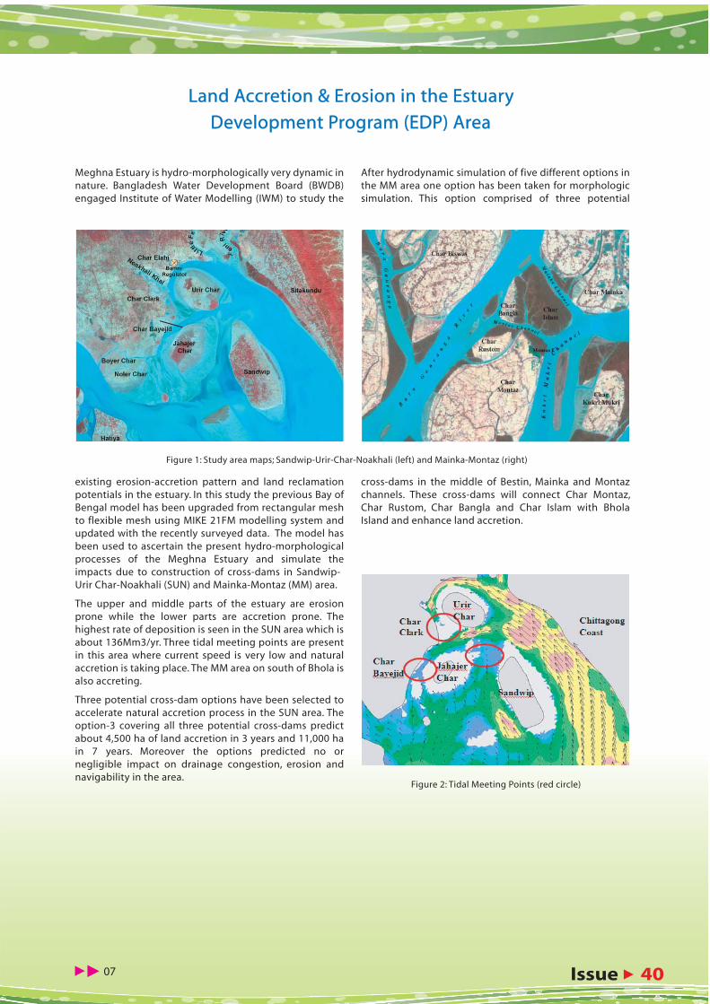
Meghna Estuary is hydro-morphologically very dynamic in nature. Bangladesh Water Development Board (BWDB) engaged Institute of Water Modelling (IWM) to study the
existing erosion-accretion pattern and land reclamation potentials in the estuary. In this study the previous Bay of Bengal model has been upgraded from rectangular mesh to flexible mesh using MIKE 21FM modelling system and updated with the recently surveyed data. The model has been used to ascertain the present hydro-morphological processes of the Meghna Estuary and simulate the impacts due to construction of cross-dams in Sandwip-Urir Char-Noakhali (SUN) and Mainka-Montaz (MM) area.
The upper and middle parts of the estuary are erosion prone while the lower parts are accretion prone. The highest rate of deposition is seen in the SUN area which is about 136Mm3/yr. Three tidal meeting points are present in this area where current speed is very low and natural accretion is taking place. The MM area on south of Bhola is also accreting.
Three potential cross-dam options have been selected to accelerate natural accretion process in the SUN area. The option-3 covering all three potential cross-dams predict about 4,500 ha of land accretion in 3 years and 11,000 ha in 7 years. Moreover the options predicted no or negligible impact on drainage congestion, erosion and navigability in the area.
After hydrodynamic simulation of five different options in the MM area one option has been taken for morphologic simulation. This option comprised of three potential
cross-dams in the middle of Bestin, Mainka and Montaz channels. These cross-dams will connect Char Montaz, Char Rustom, Char Bangla and Char Islam with Bhola Island and enhance land accretion.
Figure 1: Study area maps; Sandwip-Urir-Char-Noakhali (left) and Mainka-Montaz (right)
Figure 2: Tidal Meeting Points (red circle)
Land Accretion & Erosion in the Estuary Land Accretion & Erosion in the Estuary
Development Program (EDP) AreaDevelopment Program (EDP) Area

INSTITUTE OF WATER MODELLINGINSTITUTE OF WATER MODELLING
�� 08
Bangladesh Water Development Board commissioned the Institute of Water Modelling in 2009 to carry out the study titled “Sustainable Drainage and Flood Management of Kobadak River Basin under Jessore & Satkhira Districts” to manage the drainage congestion problem in Kobadak River Basin under Jessore & Satkhira Districts.
A comprehensive field survey, focus group discussions at different locations in the study area, mathematical model-ling, economic analysis, social and environmental impact assessment have been carried out in order to identify prevailing problems and to devise measures for rejuvenating the Kobadak river system. Considering the issues of sedimentation of river, removal of drainage congestion and reduction of flood risk two (2) options have been studied for sustainable drainage and flood management. The details of the proposed options are illustrated in the following Table:
Both the options were analyzed using the-stat-of-the-art mathematical modelling. Option-1 is recommended for
implementation as a log-term solution for drainage and sediment management in the Kobadak River basin since it is technically feasible, economically viable, environmental friendly and socially acceptable.
It is recommended that TRM should be operated at least 7 years or more depending on monitoring results for each beel. Crop compensation to the land owners of the beels for TRM operation should be given for the whole period of operation. Monitoring of sedimentation, erosion, tide, drainage condition in the beel, khal and river is required to assess the effectiveness of the implementation plan compar-ing it with the targets and identifying shortfalls and also to take mitigation measures. Early implementation of Option-1 is crucial to ensure enhancement of agricultural production, promote social and economic development and prevent environmental degradation. Involvement of local stakehold-ers and water management organizations is important during implementation of the recommended measures and
in the period of operation & maintenance (O&M).
Sustainable Drainage and Flood Management of Kobadak River Sustainable Drainage and Flood Management of Kobadak River Basin under Jessore & Satkhira DistrictsBasin under Jessore & Satkhira Districts
SL No
Drainage Improvements Measures Op�on-1 Op�on-2
1 Capital Dredging for removal of deposited silt of Kobadak River (Km 75 to Km 160 and Km 182 to Km 187)
√ √
2 Tidal River Management (TRM) √ √
3 Dwarf Marginal Embankment at specific loca�on of Kobadak River √ √
4 Restora�on of Addi�onal Drainage Routes √ √
5 Re-excava�on of 13 tributary and internal khals √ √
6 Loop cut (Magura Bazar to Jetua Bazar) N/A √
7 Removal of Exis�ng Obstacles √ √
Sedimentation

Issue � 40 �� 09
River sedimentation and drainage congestion are the major concern and crucial problems in the Bhabodah area. As a result prolonged water logging problem occured in the Bhabodah area resulting in the substantial loss of agricultural production, degradation of social, environmental and economic conditions in recent years. Though the benefit of Tidal River Management has been enjoyed by the local people, the concern about long-term sustainability of the present improved situation was vigorously raised by the local stakehold-ers. After several studies and implemen-tation programme, BWDB realized the necessity of formulating a long term solution for the Bhabodah drainage problem. Responding to the urgency, BWDB engaged IWM and DDC consor-tium to study and formulate a long term solution of the problem.
IWM provided a long term solution of the drainage conges-tion considering the tidal river management as the main mode of solving technique. The state-of-the-art mathemati-cal modelling tool has been used to rationalize the problem, and to solve the problem with scientific measures. It has been identified that the river systems of the study area are in the state of change with the huge inputs of sediment. Flood tide brings huge sediment into the river system during dry season and ebb tide cannot flush out this sediment load. Sedimentation mainly occurs in the river since sediment laden tidal flow can not spread over the flood plains due to human interventions and construction of polders and there is no upland water flow into the the river system during the dry season to flush out the incoming sediment. The rivers namely Middle- Bhadra, Upper-Salta, Hamkura and Jhapjapia were very active flowing channels in the late eighties and now these rivers have completely disappeared. The conse-quence of this is the acute drainage congestion in the area.
For removing the persistent water logging and sedimenta-tion problem several number of TRM has been proposed for sustaining the drainage capacity of the rivers by natural dredging. In addition of that, the study also recommended for restoring the Hamkura river and other drainage arteries. For the upper reach of the study area, flood embankment on the both sides of the Teka-Mukteswary rivers along with ten regulators have been proposed. The study confirmed an overall drainage improvement plan for the next 50 years using a sequential TRM plan.
It is believed that the sooner the implementation of the recommendations of the study the better will be the overall
socio-economic environment of the area as well as the life and livelihood of the local people.
Stakeholder participation in the discussion meeting
Potential Beels in the Bhabodah Area for Sequential operation of TRM
Feasibility Study and Detailed Engineering Design for Long Term Feasibility Study and Detailed Engineering Design for Long Term Solution of Drainage Problems in the Bhabodah AreaSolution of Drainage Problems in the Bhabodah Area
INSTITUTE OF WATER MODELLINGINSTITUTE OF WATER MODELLING
�� 10
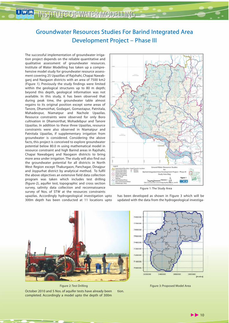
The successful implementation of groundwater irriga-tion project depends on the reliable quantitative and qualitative assessment of groundwater resources. Institute of Water Modelling has taken up a compre-hensive model study for groundwater resource assess-ment covering 25 Upazillas of Rajshahi, Chapai Nawab-ganj and Naogaon districts with an area of 7500 km2 (Figure 1). Previously the study findings were limited within the geological structures up to 80 m depth; beyond this depth, geological information was not available. In this study, it has been observed that during peak time, the groundwater table almost regains to its original position except some areas of Tanore, Dhamoirhat, Godagari, Gomastapur, Patnitala, Mahadevpur, Niamatpur and Nachole Upazilas. Resource constraints were observed for only Boro cultivation in Dhamoirthat, Mohadebpur and Tanore Upazilas. In addition to these three Upazilas, resource constraints were also observed in Niamatpur and Patnitala Upazilas, if supplementary irrigation from groundwater is considered. Considering the above facts, this project is conceived to explore groundwater potential below 80.0 m using mathematical model in resource constraint and high Barind areas in Rajshahi, Chapai Nawabganj and Naogaon districts to bring more area under irrigation. The study will also find out the groundwater potential for all districts in North West Region except Thakurgaon, Panchagar, Dinajpur and Joypurhat district by analytical method. To fulfil the above objectives an extensive field data collection program was taken which includes test drilling (figure-2), aquifer test, topographic and cross section survey, salinity data collection and reconnaissance survey of Nos. of STW at the resources constraints upazilas. Accordingly hydrogeological investigation upto 300m depth has been conducted at 11 locations upto
October 2010 and 5 Nos. of aquifer tests have already been completed. Accordingly a model upto the depth of 300m
has been developed as shown in Figure 3 which will be updated with the data from the hydrogeological investiga-
tion.
Figure 1: The Study Area
Figure 3: Proposed Model AreaFigure 2: Test Drilling
Groundwater Resources Studies For Barind Integrated Area Groundwater Resources Studies For Barind Integrated Area
Development Project – Phase IIIDevelopment Project – Phase III
Ground Water Resources Studiesfor
Barind Integrated Area Development Project - Phase IIIStudy Area Map
LegendInternational BoundaryDistrict BoundaryUpazila BoundaryProject BoundaryNational HighwayOther RoadRailwaySchematized RiverNon-Schematized RiverProblematic Area
Head Quarter LocationDistrictUpazila
Figure: 1Kilometers
Path: IT214/d:/P0017/P3197bdp/Aprfile/Report_nov04/

Issue � 40 �� 11
Bangladesh Water Development Board (BWDB) and Institute of Water Modelling (IWM) have signed a contract agreement on 7th April, 2010 to identify suitable develop-ment options for flood control, drainage improvement and irrigation development of the Gungaijuri project area using mathematical modelling tool. The objective of the mathematical model study is to support the decision makers and the feasibility study to understand and deter-mine the cause and intensity of flooding and identify suitable measures to overcome the problem in a compre-hensive and sustainable way.
The main objectives of the project is to protect 20,413 ha area of Sadar, Bahubal and part of Baniachang thana of Hobigonj district from early flood and to remove the drain-age congestion to cultivate crops. The project area is a remote area that is flooded every year during monsoon. The overall problems of the project area are summarized as:
� Regular flooding as the area is bowl shaped depres-sion
� Pre-monsoon flood causes damage to Boro-crops� Delayed drainage due to high water level in the outfall
river (Gungaijuri river)� Flood embankments are breached at different
locations� Most of the regulating structures, gates in particular,
are partly or completely damaged � Water is not available during dry season in the periph-
eral rivers specially in Karangi � Siltation of the drainage routes/khalsPreviously the Gungaijuri FCD project was developed on the concept of partial flood protection. But now the people
are demanding for full flood protection with irrigation and drainage facility. Understanding the local peoples’ need, IWM is conducting the mathematical modelling study to analyse the present demand of the people of the project as well as adjoining areas.
The mathematical model study would provide the follow-ing outputs:
� Impact/feasibility of full flood control options;� Preliminary alignment of flood control embankment
and location of proposed drainage structures;� Design flood level for the flood control embankment
and other design parameters for drainage structures including khals;
� Flood maps/inundation maps showing the area of the different classes of land under the existing situation and different development options
� Water availability for irrigation and interventions required
� Optimum design of the drainage channels consider-ing the morphological sustainability.
During the inception phase major progress has been achieved in the literature review, secondary data collection from different sources, preparation of a primary base map and designing the data collection program. By this time 5 water level gauges has been installed in the project area and data collection has been initiated. Cross-sections survey of rivers and khals have also been completed though topographic survey of selected area could not be initiated due to presence of water and weeds / bushes. It is to be mentioned here that the collected data will be utilized for the development and calibration of the project model.
Gungaijuri Haor Area Integrated Water Management ProjectGungaijuri Haor Area Integrated Water Management Project
Project location in the Gangaijuri Haor area
A view of the flood condition of the project area
District H/QThana H/QInt’l BoundaryNational HighwayOther RoadOther RoadsRailwayRiverGungaijuri Haor Area
Legend:
Project LocationGungaijuri Haor
Mathematical Modelling Study ForIntegrated Water Management Project
of Gungaijuri Haor Area

INSTITUTE OF WATER MODELLINGINSTITUTE OF WATER MODELLING
�� 12
Institute of Water Modelling (IWM) is supporting Bangla-desh Water Development Board for implementation of the “Gorai River Restoration Project (Phase II)” during 2010 to prevent environmental degradation in the South West Region especially around Khulna, the coastal belt and in the Sundarbans. The activities include bathymetric survey for pre and post work measurement, providing data for fixing the dredging alignment, quality control of dredging to implement it as per design alignment & section and
monitoring of flow through the Ganges and Gorai Rivers and supplying data to the IWM modelling team. IWM has successfully completed the quality control of the 1st year dredging and the monitoring of sedimentation. It is continuing support through quality control and monitor-ing of the 2nd year dredging conducted by the interna-tional contractor China Harbour Engineering Company Ltd. (CHEC) The project is expected to be completed in June 2013.
Joint survey by IWM & China Harbour Engineering Company Ltd
Pre-Work and Post-Work Measurement of dredging for Gorai River Pre-Work and Post-Work Measurement of dredging for Gorai River Restoration Project (Phase-II)Restoration Project (Phase-II)
Observed discharge of Gorai at Gorai Rail Bridge

Issue � 40 �� 13
Dr. Md. Idris Ali Dewan, Member, Agriculture, Water Resource & Rural Institution Division, Planning Commission of Bangladesh visited IWM on 4 November 2010. Through a presentation by Mr. Emaduddin Ahmad, Executive Director the guest was informed about historical background of IWM and its activities, area of service, its field of excellence and achievements. The presentation also covered the specialty and performance of mathematical modelling to solve the complex water related problems in holistic approach including flood management, irrigation management, coastal zone management, bridge hydraulics, groundwater management, climate change model-ling etc. The presentation was attended by Division Directors of IWM. Mr. Dewan visited different divisions of IWM and appreci-ated diversified area of services by the different divisions. The Executive Director presented IWM souvenior to the guest
IWM crest to H E Ato Mitkiu Kassa, Minister for State of Agricul-
ture, Ethiopia
IWM crest to Member, Agriculture, Water Resource & Rural Institution Division, Planning Commission in presence of IWM top management.
A four member Ethiopian delegate headed by H E Ato Mitkiu Kassa, Minister for State of Agriculture paid a visit to IWM on 2 December 2010. Mr. Abu Saleh Khan, Deputy Executive Director made a presentation to the guests on IWM activities, its area of services and interests as well as the significant achievement of the Institute. The Deputy Executive Director focused on the use and excellence of mathematical model-ling in the management of complex water related problems. After the presentation, a lively Question and Answer session took place. The visiting team expressed their interest and appreciated the capacity and activities of IWM.
The Guests were presented IWM crests at the end.
Ethiopian Minister Visits IWMEthiopian Minister Visits IWM
A seminar on World Water Day 2011 was organized on 22 March 2011 at BRAC Centre Inn, Dhaka by the Bangladesh National Committee of the International Commission on Irrigation and Drainage (BANCID) in association with Bangla-desh Water Development Board (BWDB), Water Resources Planning Organization (WARPO), Centre for Environment and Geographic Information Service (CEGIS), Dhaka WASA and Institute of Water Modelling (IWM). This year’s theme of the day was “Water for Cities : Responding to the Urban Challenges”.
Mr. Ramesh Chandra Sen, MP and Honorable Minister for Water Resources, Govt. of the Peoples Republic of Bangladesh attended the programme as the Chief Guest while Mr. Md. Mahbubur Rahman, MP and Hon’ble State Minister for Water Resources, Govt. of the Peoples Republic of Bangladesh and Mr. Shaikh Md. Wahid-uz-Zaman, Secretary, Ministry of Water Resources graced the occasion as the Special Guests. Mr. Mir Sajjad Hossain, Member, Joint Rivers Commission welcomed all to the seminar. Mr. Md. Habibur Rahman, Director General, BWDB and Chairman, BANCID chaired the seminar.
Dr. Md. Liakath Ali, Deputy Managing Director, Dhaka WASA
made a presentation titled “Water Supply and Waste Water Management in Dhaka, Bangladesh”. Another presentation on Climate Changes was made by Mr. Md. Abdul Wadud Bhuiyan, Chief Planning, BWDB.
World Water Day 2011 ObservedWorld Water Day 2011 Observed
Mr. Ramesh Chandra Sen, Hon’ble Minister for Water Resources, Mr. Md. Mahbubur Rahman, MP and Hon’ble State Minister for Water Resources and other guests in the Seminar
Member, Agriculture, Planning Commission Visits IWMMember, Agriculture, Planning Commission Visits IWM

INSTITUTE OF WATER MODELLINGINSTITUTE OF WATER MODELLING
�� 14
Mr. Md. Yousuf Mamun with other participants in the workshop (first from left)
IWM Professional Participates in the Mekong workshop in Lao PDRIWM Professional Participates in the Mekong workshop in Lao PDR
Participants receiving certificate from the Executive Director
Training on Bay of Bengal ModelTraining on Bay of Bengal Model
Mr. Md. Yousuf Mamun, Associate Specialist, Flood Management Division participated in the workshop titled “People Centered Approach in Flood and Land Management in the Mekong Basin” held during 23-25 February 2011 in Luang Prabang, Lao PDR. The interna-tional workshop was jointly organized by the Mekong River Commis-sion, GTZ, GFA Consulting Group and Asian Disaster Preparedness Centre (ADPC). During the workshop Mr. Mamun presented IWM posters that demonstrated IWM projects and activities of the area of interest. The posters were relevant to the workshop theme. The posters drew high attention of the participants. Mr. Mamun had the opportu-nity to share experience in the field of Flood Management in Bangla-desh and IWM involvement in the flood forecasting activities. The workshop was participated by 150 participants from different countries.
Mr. Claus Bjorn Pedersen, Senior Salinity Modelling Expert, DHI, and Denmark addressing on the overview of the training course.
Training on Salinity ModellingTraining on Salinity ModellingIWM arranged a training course on Salinity Modelling for its own staff and BWDB professional during 22 March 2011 - 24 March 2011. A total of 10 participants from different divisions of IWM and 3 participants from Bangla-desh Water Development Board took part in the programme. The training course was arranged to transfer technology under the Danida funded “Assis-tance to Climate Change Adaptation and Disaster Risk Reduction, Bangla-desh - Support to the National Flood Forecasting and Warning Services” Project.
The participants were given hands on training and In-depth discussions were made with respect to the field of Climate Change Adaptation.
IWM arranged a training course on Bay of Bengal Modelling for its own staff during 28 March 2011 -03 April 2011. A total of 8 partici-pants from different divisions of IWM took part in the programme. The course aimed to provide the participants with basic knowledge on developing 2D hydrodynamic model using MIKE21 module for using the model in the coast and estuary of Bangladesh. The partici-pants were given hands on training and In-depth discussions were made with respect to the field of hydrodynamic investigations.
On the closing session of the training programme, Prof. Dr. M. Monowar Hossain, Executive Director IWM reviewed the feedback from the course and awarded certificates among the participants on 03 April, 2011.
Prof. Dr. M. Monowar Hossain (5th from left), Mr. M. M. Zahid Ahmed (1st from right) and Mr. Md. Sohel Masud (2nd from left) along with other participants attending the inception workshop.
Research Project with UNESCO-IHEResearch Project with UNESCO-IHE
An inception workshop on a research project titled “Bangla-
Dutch Research Initiative on Flood Risk Management and
Morphological Assessment” was held at UNESCO-IHE, Institute
of Water Education, Delft, The Netherlands during 21-25 March
2011 under DGIS UNESCO-IHE Programmatic Cooperation. Dr.
M. Monowar Hossain, Professor, WRE, BUET & currently Execu-
tive Director, IWM, Mr. Manjur Murshed Zahid Ahmed and Md.
Sohel Masud, Senior Specialist, IWM attended the workshop,
where the research activities and a concrete work plan was
finalized. Representatives from IWFM, BUET and CEGIS also
attended the inception workshop.

Issue � 40 �� 15
Mr. M. Hasan was selected for the best speaker award
IWM Professional Participates in the Second InternationalIWM Professional Participates in the Second InternationalDisaster Management Conference in PakistanDisaster Management Conference in Pakistan
Mr. Md. Ashraf Ali Khan with other participants (in the middle of front line, fourth from left)
IWM Professional Participates in the 5th IPWG Workshop & Training in GermanyIWM Professional Participates in the 5th IPWG Workshop & Training in Germany
IWM HRD Manager Attends The Training on HRM in MalaysiaIWM HRD Manager Attends The Training on HRM in Malaysia
Mr. Abdulla Hel Kafi with other participants (third from left in the front line)
ADB Publication on IWM StudyADB Publication on IWM Study
Mr. Md. Abdulla Hel Kafi, Junior Specialist of Flood Management Division, IWM participated in the 5th International Precipitation Working Group (IPWG) Workshop and Training during 11-15 October 2010 in Hamburg, Germany. The workshop was jointly hosted by the Klima Campus, University of Hamburg, its Cluster of Excellence Clisap (Integrated Climate System Analysis and Prediction) and the Max Planck Institute for Meteorology (MPI-M). Along with the workshop, a satellite data and hydrology training programme was held during 12-14 October 2010, sponsored by EUMETSAT and hosted by KlimaCampus and MPI-M. The training programme covered precipitation products, generation and extrac-tion, soil moisture data generation from remote sensing, passive and active microwave sensors for precipitation research, precipitation algorithms, TOVAS system (TRMM), calibration methods and activities, precipitation valida-tion, H-SAF product validation and application, precipita-
Mr. Md. Ashraf Ali Khan, Manager (in-charge), Human Resources Development attended a week long training course on Human Resources Management in Kuala Lumpur, Malaysia during 20-26 November 2010. The course was organized by Malaysian Institute of Human Resources management (MIHRM). The course covered different spectrum of HRM with special emphasis on Principles & Functions of HRM, Employment, Recruitment, Interview & Selection, Succession Planning, Job Analysis, Job Descriptions & Job Specifications, Training and Devel-opment, Employee Relations and Malaysian Labor laws. During the course, Mr. Khan had opportunity to exchange views on modern HR practices and policies with partici-pants from other organizations in Malaysia, Japan, Brunei and China.
tion related natural hazards such as floods and landslides etc.
Mr. Mobassarul Hasan, Associate Specialist, Coast Port and Estuary Manage-ment Division attended the conference on “Second International Disaster Management Conference (IDMC-2010) – Good Governance in Disaster Risk Reduction and Climate Change Adaptation” held at University of Peshawar, Pakistan during 19-21 October 2010. The conference was organized by Centre for Disaster Preparedness and Management of Peshawar University. Mr. Hasan presented a paper titled “Impact of Climate Change on Major Water Related Disasters in the Coastal Area of Bangladesh and Respective Adaptive Measures”. He was selected the best speaker in the conference.
The main objective of the conference was to provide a platform to exchange views on how to mainstream the practices of disaster manage-ment into development.
Asian Development Bank (ADB) issued a special publication on the Adaptation to Climate Change based on the study conducted by IWM and Alterra of the Netherlands. The publication is available online and also in hard copy.
The publication provides a specific example of assessing the impacts of climate change and socioeconomic development scenarios for 2030 and 2050, and running mathematical models to obtain the level of salinity in river water—where the proposed intake for water supply is located—and the extent of water logging in the Khulna city.
The study then identifies and makes a financial evaluation on adaptation options to cope with the impacts. While various uncertainties still remain, the proposed investments would be made more climate-resilient by incorporating adaptation options into the project design.

Mr. Muhammad Anowar SaadatMr. Muhammad Anowar Saadat is a Junior Specialist working in River Engineering (REN) Division of IWM. He joined IWM in 2002 in Survey and Data (SDT) Division and participated in field data collection program for supporting different model developments. After working in SDT for six years, he joined the REN in 2008 and started to work with hydrodynamic and morphological models. Mr. Anowar graduated in Civil Engineering from Bangladesh Institute of Technology (B.I.T.) Rajshahi in September 2001. He also completed a M.Sc. program from Institute of Water and Flood Management (IWFM) of BUET in 2010. He enrolled the Masters Program under SAWA Fellowship funded by CB (Crossing Boundary) project carried out by IWFM.
Mr. Anowar gathered wide experience in hydrographic and hydrological data collection activity while he was in the survey division. He exclusively worked with the modern equipments of IWM all over the country and experienced the different hydrological phenomena which IWM reflects into the Models. Later on, he worked with MIKE 11 and MIKE21 models of different types of rivers of Bangladesh in various projects and developed his knowledge base on the river hydrodynamics and morphology. In his tenure, he exclusively worked in some major projects such as Chandpur-Comilla Irrigation Project, Haor Rehabilitation Project, Chalan Beel Survey Project, 3 Bridge Survey Project at Patuakhali , Kurigram Irrigation Project, Padma Bridge Design Study, Mathematical Modelling for the Ganges Barrage Project, Rajbari Town Protection Project, etc.
Mr. Anowar has received in-house trainings on HydroPRO and ADCP during field survey campaign and MIKE11 and MIKE21 during modeling activities in IWM. He also received training on “River Bank Protection” conducted by Water Resources Engineering (WRE) Department and “Dredging” conducted by Directorate of Continuing Education (DCE) in BUET. He participated in trainings abroad in Nepal and India on “Participatory Field Research Methodology” and “Flood Estimation on a Changing Climate” respectively.
Mr. Mehedi MaswoodMr. Mehedi Maswood is a Junior Specialist who joined IWM in March 2009. His working experience encompasses hydrology, hydraulics, hydraulic structures, hydrodynamic and urban and rural road design. He is proficient in a variety of hydraulic and hydrologic analysis software and also GIS. Before joining IWM, Mr. Maswood worked in Australia for a local council and also for a consulting firm. He graduated from Bangla-desh University of Engineering and Technology in 2002 and completed his Graduate Diploma in Computing and IT from University of Western Sydney (NSW) in 2003. While in Australia he was actively involved in various professional organizations and was a member of Institute of Public Works Engineers, Australia (IPWEA). He was actively involved in two climate change related projects such as Economics of Adaptation to Climate Change and Implication of Climate Change on Food Security of
Bangladesh. Currently he is working on a project which is studying integrated water management project of Gungiajuri haor area.
Mr. Mohammad Ziaur RahmanMr. Mohammad Ziaur Rahman joined IWM as a Junior Engineer working in Coast, Port & Estuary Management (CPE) Division since November 2008. He specializes in Coastal morphology, Sediment transport, Climate Change & Sea Level Rise, Land Reclamation , Hydraulic mathematical modelling with MIKE 11, MIKE 21, MIKE21FM, MIKE C-MAP technology of DHI Water and Environment technique. He is proficient in a variety of hydraulic and hydrologic analysis software and also GIS.
Mr. Rahman did his graduation in Civil Engineering from Bangladesh University of Engineering & Technology (BUET) in April 2007.Ever since joining IWM, he has been involved in many important water resources projects in Bangladesh such as Updating of Hydrodynamic & Morpho-logical Models to Investigate Land Accretion & Erosion in the Estuary
Development Program (EDP); Economics of Adaptation to Climate Change Study, Vulnerability Mapping- Bangladesh Case Study; Hydraulic and Morphological Study for proper sand source and effect of land reclamation in Labuan Island, Malaysia; Feasibility Study for Dredging (by dredger) of Khaprabhanga Chapalir Don River (Mohipur Channel) in the Kalapara Upazilla under Patuakhali district for Improvement of Navigability. Mr. Rahman received specialized training on basic principles of GIS, MIKE21FM Modelling & MIKE 21C Morphological Modelling and Oceanography: Principles and Applications.
Mr. Rahman attended a number of National & International Seminars and Conferences. He is a Member of the Institution of Engineers, Bangladesh (IEB).
House 496, Road 32New DOHS, MohakhaliDhaka-1206, BangladeshTel : (88-02) 8822105-68824590-1, 8827902Fax : (88-02) 8827901E-mail : [email protected] : http://www.iwmbd.org
Initially started as a TA Project in 1986, Institute of Water Modelling is an independent TRUST established by the GoB to promote water modelling in managing the complex water resources echosystem. Since 1996 IWm has been offering services in the water and water related environmen-tal modelling to various govt. and other national/ international agencies.
Editorial AdvisorEditorial AdvisorProf. Dr. M. Monowar Hossain
EditorEditorAbu Saleh Khan
CompilationCompilationMd. Ashraf Ali Khan
ContributorsContributorsFariduddin Ahmed MiaSaad Siddiqui Sarwat JahanMizanur RahmanPankaj Kumar MaitraMd. Mobassarul HasanMd. Tarikul IslamFarhana Akhter KamalMehedi MaswoodMd. Moshiur Rahman
This newsletter is published by IWM four times a year and is distributed free of charge to all relevant agencies/persons. Reprints of articles and extracts from articles are permit-ted provided IWM newsletter is quoted as the source of information.
CAREER PROFILECAREER PROFILE
[email protected]:88-02-7195842, Cell:01740984159
Concept


![PPAR: Bangladesh: Ganges-Kobadak Irrigation Rehabilitation ... · Title: PPAR: Bangladesh: Ganges-Kobadak Irrigation Rehabilitation Project (Loan 671-BAN[SF]) Author: Asian Development](https://static.fdocuments.in/doc/165x107/5f87bd77888d5524a31f3544/ppar-bangladesh-ganges-kobadak-irrigation-rehabilitation-title-ppar-bangladesh.jpg)