INSPIRE WCS: From Mystery to Mastery · INSPIRE WCS :: © 2017 Peter Baumann Coverage Coordinates...
77
INSPIRE WCS :: © 2017 Peter Baumann Peter Baumann Jacobs University | rasdaman GmbH Jordi Escriu Institut Cartogràfic i Geològic de Catalunya, INSPIRE Thematic Cluster #3 Facilitator INSPIRE WCS: From Mystery to Mastery [gamingfeeds.com]
Transcript of INSPIRE WCS: From Mystery to Mastery · INSPIRE WCS :: © 2017 Peter Baumann Coverage Coordinates...

INSPIRE WCS :: © 2017 Peter Baumann
Peter Baumann
Jacobs University | rasdaman GmbH
Jordi Escriu
Institut Cartogràfic i Geològic de Catalunya,
INSPIRE Thematic Cluster #3 Facilitator
INSPIRE WCS:
From Mystery to Mastery
[gamingfeeds.com]

INSPIRE WCS :: © 2017 Peter Baumann
Datacube Research @ Jacobs U
Large-Scale Scientific Information Systems
research group
• focus: large-scale n-D raster services & beyond
• www.jacobs-university.de/lsis
Spin-off: rasdaman GmbH
Main visible results:
• pioneer Array DBMS, rasdaman
• Big Data standards

INSPIRE WCS :: © 2017 Peter Baumann

INSPIRE WCS :: © 2017 Peter Baumann
Learning Objectives
This seminar will explain:
- The coverage data model shared by OGC and ISO
- OGC’s coverage service model: WCS, WCPS
- OGC, ISO, and INSPIRE
By the end of the day, you should be able to
- Understand principles of coverage data, service, and clients
- Understand differences between service functionality of WMS, WFS, WCS
- Understand how coverage services provide analysis-ready data
- Understand how common Annex II and III data can be modelled as coverage
- Understand how coverages can be orchestrated in overall service ecosystem
- Express core coverage retrieval tasks as WCS requests
Prerequisites
- Basics of Web services & GIS

INSPIRE WCS :: © 2017 Peter Baumann
Overview
Introduction
The data: Coverages
The service: WCS
Conformance Testing
Selected Applications
Conclusion
6

INSPIRE WCS :: © 2017 Peter Baumann
Overview
Introduction
The data: Coverages
The service: WCS
Conformance Testing
Selected Applications
Conclusion
7

INSPIRE WCS :: © 2017 Peter Baumann
Why Standards?
[www.jhchoppers.com]

INSPIRE WCS :: © 2017 Peter Baumann
Facing the Coverage Tsunami
coverage
server
9
sensor feeds[OGC SWE]

INSPIRE WCS :: © 2017 Peter Baumann
[OGC SWE]sensor feeds
Taming the Coverage Tsunami
10
coverage
server
INSPIRE WCS :: © 2017 Peter Baumann
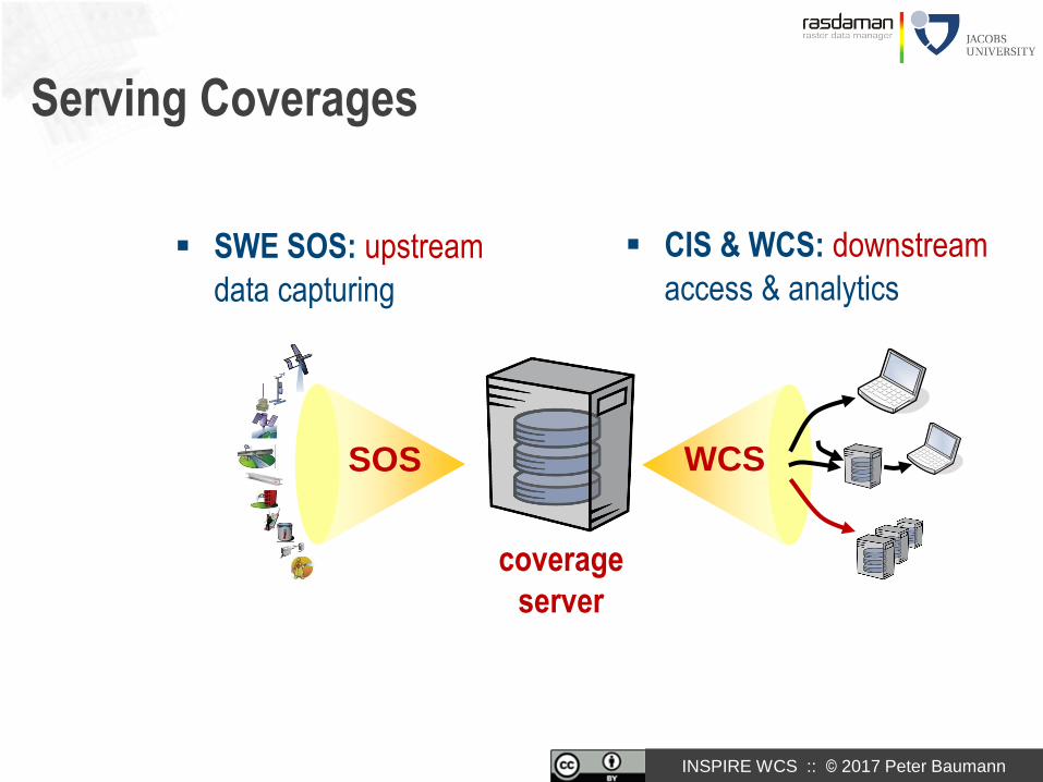
Serving Coverages
SWE SOS: upstream
data capturing
CIS & WCS: downstream
access & analytics
SOS WCS
coverage
server

INSPIRE WCS :: © 2017 Peter Baumann
EarthServer: Datacubes At Your Fingertips
Agile Analytics on x/y/t + x/y/z/t Earth & Planetary datacubes
- Rigorously standards: OGC WMS + WCS + WCPS
- EU rasdaman + US NASA WorldWind
- 700+ TB 1+ PB
Intercontinental initiative,
3+3 years: EU + US + AUS
www.earthserver.eu,
www.planetserver.eu
INSPIRE WCS :: © 2017 Peter Baumann

INSPIRE WCS :: © 2017 Peter Baumann
MEA: Daily Sentinel 2A Availability

INSPIRE WCS :: © 2017 Peter Baumann
MEA: Sample Datacubes Coverages

INSPIRE WCS :: © 2017 Peter Baumann
MEA: NDVI Timeseries Extraction

INSPIRE WCS :: © 2017 Peter Baumann
MEA: Daily Hydro Estimator

INSPIRE WCS :: © 2017 Peter Baumann
ECMWF: River Discharge

INSPIRE WCS :: © 2017 Peter Baumann
MEA: Land Surface Temperature, Cloudfree
INSPIRE WCS :: © 2017 Peter Baumann
Coverages in INSPIRE
Jordi Escriu,
INSPIRE Thematic Cluster #3 Facilitator

INSPIRE WCS :: © 2017 Peter Baumann
Overview
Introduction
The data: Coverages
The service: WCS
Conformance Testing
Selected Applications
Conclusion
22

INSPIRE WCS :: © 2017 Peter Baumann
Features & Coverages
The basis of all: geographic feature
Special kind of feature: coverage
- aka space-time varying phenomenon
- regular & irregular grids, point clouds, meshes
• Usually, coverages are Big Geo Data

INSPIRE WCS :: © 2017 Peter Baumann
MultiSolid
Coverage
Coverages- abstract: OGC Abstract Topic 6 = ISO 19123
- concrete, interoperable: Coverage Implementation Schema ISO 19123-2• (CIS, aka GMLCOV)
MultiPoint
Coverage
MultiCurve
Coverage
MultiSurface
CoverageReferenceable
GridCoverage
Rectified
GridCoverage
Grid
CoverageCIS 1.1
General Grid Coverage
«FeatureType»Abstract
Coverage

INSPIRE WCS :: © 2017 Peter Baumann
MultiSolid
Coverage
Coverages- abstract: OGC Abstract Topic 6 = ISO 19123
- concrete, interoperable: Coverage Implementation Schema ISO 19123-2• (CIS, aka GMLCOV)
AbstractCoverage
MultiPoint
Coverage
MultiCurve
Coverage
MultiSurface
CoverageGeneral Grid
Coverage
general meshes point clouds regular & irregular grids
INSPIRE WCS :: © 2017 Peter Baumann
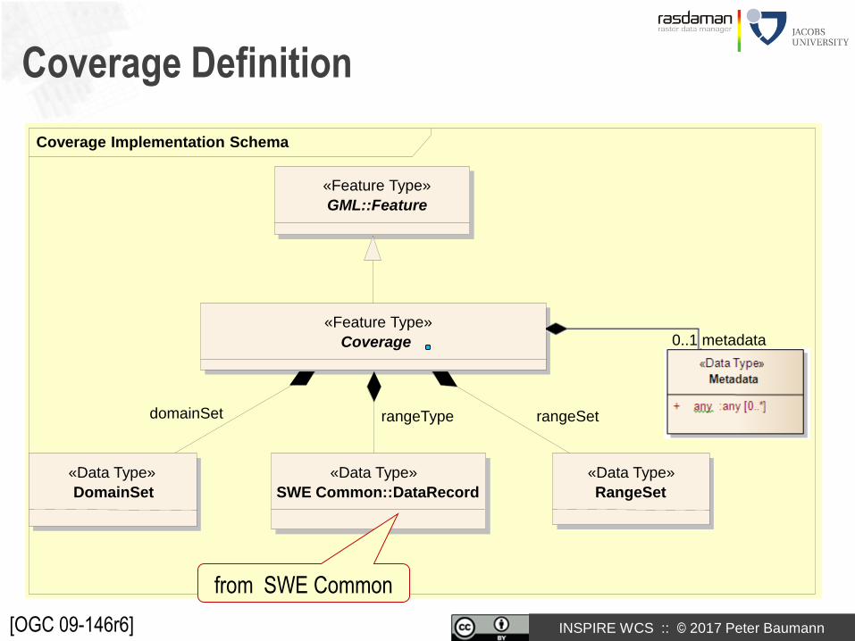
Coverage Implementation Schema
Coverage Definition
«Feature Type»
Coverage
«Feature Type»
GML::Feature
«Data Type»
DomainSet
«Data Type»
RangeSet
«Data Type»
SWE Common::DataRecord
rangeSetdomainSet rangeType
[OGC 09-146r6]
0..1 metadata
from SWE Common

INSPIRE WCS :: © 2017 Peter Baumann

INSPIRE WCS :: © 2017 Peter Baumann

INSPIRE WCS :: © 2017 Peter Baumann
The Integrated Geo Warehouse
Comprehensive
geophysics data mgmt
Integrating
data + meta data
1D
2D
3D
nD
[GFZ Potsdam]
3D
+time

INSPIRE WCS :: © 2017 Peter Baumann
Coverage Coordinates and CRSs
Uniform handling of horizontal space, height, time, etc.
Native CRS = CRS of coverage- srsName attribute in DomainSet, auxiliary attributes accordingly
Ex: <gmlcov:GridCoverage … gml:id="C0001">
<gml:boundedBy>
<gml:Envelope srsName=" http://www.opengis.net/def/crs-compound?
1=http://www.opengis.net/def/crs/EPSG/0/4326&
2=http://www.opengis.net/def/crs/OGC/0/ansiDate“
axisLabels="Lat Long Time" uomLabels="deg deg day" srsDimension=“3">
<gml:lowerCorner>1 1 2012-03-10</gml:lowerCorner>
<gml:upperCorner>3 10 2012-03-10 </gml:upperCorner>
</gml:Envelope>
</gml:boundedBy>
…
</gmlcov:GridCoverage >
INSPIRE WCS :: © 2017 Peter Baumann
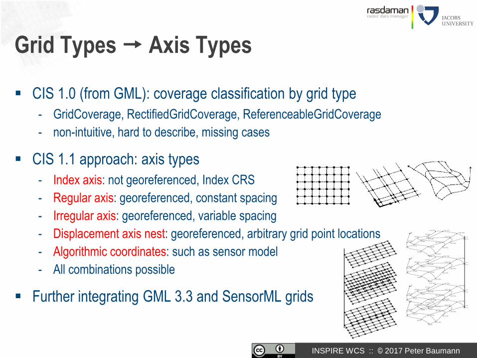
Grid Types Axis Types
CIS 1.0 (from GML): coverage classification by grid type
- GridCoverage, RectifiedGridCoverage, ReferenceableGridCoverage
- non-intuitive, hard to describe, missing cases
CIS 1.1 approach: axis types
- Index axis: not georeferenced, Index CRS
- Regular axis: georeferenced, constant spacing
- Irregular axis: georeferenced, variable spacing
- Displacement axis nest: georeferenced, arbitrary grid point locations
- Algorithmic coordinates: such as sensor model
- All combinations possible
Further integrating GML 3.3 and SensorML grids

INSPIRE WCS :: © 2017 Peter Baumann
Interpolation
Often requested:
coverage should inform about desirable/allowed interpolations
Approach: optional list of interpolation methods
Identifiers defined elsewhere, not hardwired into coverage model
<interpolationRestriction>
<allowedInterpolation>
http://www.opengis.net/def/interpolation/OGC/0/nearest-neighbor
</allowedInterpolation>
<allowedInterpolation>
http://www.opengis.net/def/interpolation/OGC/0/linear
</allowedInterpolation>
<interpolationRestriction>
INSPIRE WCS :: © 2017 Peter Baumann
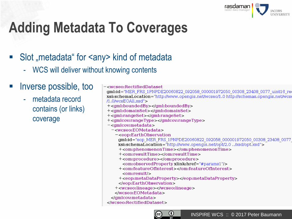
Adding Metadata To Coverages
Slot „metadata“ for <any> kind of metadata
- WCS will deliver without knowing contents
Inverse possible, too
- metadata record
contains (or links)
coverage
INSPIRE WCS :: © 2017 Peter Baumann
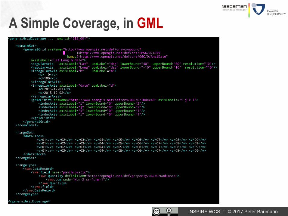
A Simple Coverage, in GML

INSPIRE WCS :: © 2017 Peter Baumann
{ "type": "CoverageByDomainAndRangeType",
"domainSet":{
"type": "DomainSetType",
"generalGrid":{
"type": "GeneralGridCoverageType",
"srsName": "http://www.opengis.net/def/crs/OGC/0/Index2D",
"axisLabels": ["i", "j"],
"axis": [{ "type": "IndexAxisType“, "axisLabel": "i", "lowerBound": 0, "upperBound": 2
},{ "type": "IndexAxisType“, "axisLabel": "j", "lowerBound": 0, "upperBound": 2 }]
}
},
"rangeSet": { "type": "RangeSetType",
"dataBlock": { "type": "VDataBlockType", "values": [1,2,3,4,5,6,7,8,9] } },
"rangeType": { "type": "DataRecordType",
"field":[{ "type": "QuantityType",
"definition": "ogcType:unsignedInt",
"uom": { "type": "UnitReference", "code": "10^0“ } }]
}
}
A Simple Coverage, in JSON
INSPIRE WCS :: © 2017 Peter Baumann
<http://www.opengis.net/cis/1.1/examples/CIS_05_2D>
<http://www.w3.org/1999/02/22-rdf-syntax-ns#type>
<http://www.opengis.net/cis/1.1/CoverageByDomainAndRangeType> .
<http://www.opengis.net/cis/1.1/examples/CIS_05_2D>
<http://www.opengis.net/cis/1.1/domainSet>
<http://www.opengis.net/cis/1.1/examples/CIS_DS_05_2D> .
<http://www.opengis.net/cis/1.1/examples/CIS_DS_05_2D>
<http://www.opengis.net/cis/1.1/generalGrid>
<http://www.opengis.net/cis/1.1/examples/CIS_DS_GG_05_2D> .
<http://www.opengis.net/cis/1.1/examples/CIS_DS_05_2D>
<http://www.w3.org/1999/02/22-rdf-syntax-ns#type>
<http://www.opengis.net/cis/1.1/DomainSetType> .
<http://www.opengis.net/cis/1.1/examples/CIS_DS_GG_05_2D>
<http://www.opengis.net/cis/1.1/axis>
<http://www.opengis.net/cis/1.1/examples/CIS_DS_GG_I_05_2D> .
<http://www.opengis.net/cis/1.1/examples/CIS_DS_GG_05_2D>
<http://www.opengis.net/cis/1.1/axis>
<http://www.opengis.net/cis/1.1/examples/CIS_DS_GG_J_05_2D> .
<http://www.opengis.net/cis/1.1/examples/CIS_DS_GG_05_2D>
<http://www.opengis.net/cis/1.1/axisLabels>
<http://www.opengis.net/cis/1.1/axisLabels0> .
<http://www.opengis.net/cis/1.1/axisLabels0> <http://www.w3.org/1999/02/22-rdf-syntax-ns#first> "i" .
<http://www.opengis.net/cis/1.1/axisLabels0> <http://www.w3.org/1999/02/22-rdf-syntax-ns#rest> <http://www.opengis.net/cis/1.1/axisLabels1> .
<http://www.opengis.net/cis/1.1/axisLabels1> <http://www.w3.org/1999/02/22-rdf-syntax-ns#first> "j" .
<http://www.opengis.net/cis/1.1/axisLabels1> <http://www.w3.org/1999/02/22-rdf-syntax-ns#rest> <http://www.w3.org/1999/02/22-rdf-syntax
<http://www.opengis.net/cis/1.1/examples/CIS_DS_GG_05_2D> <http://www.opengis.net/cis/1.1/srsName> <http://www.opengis.net/def/c
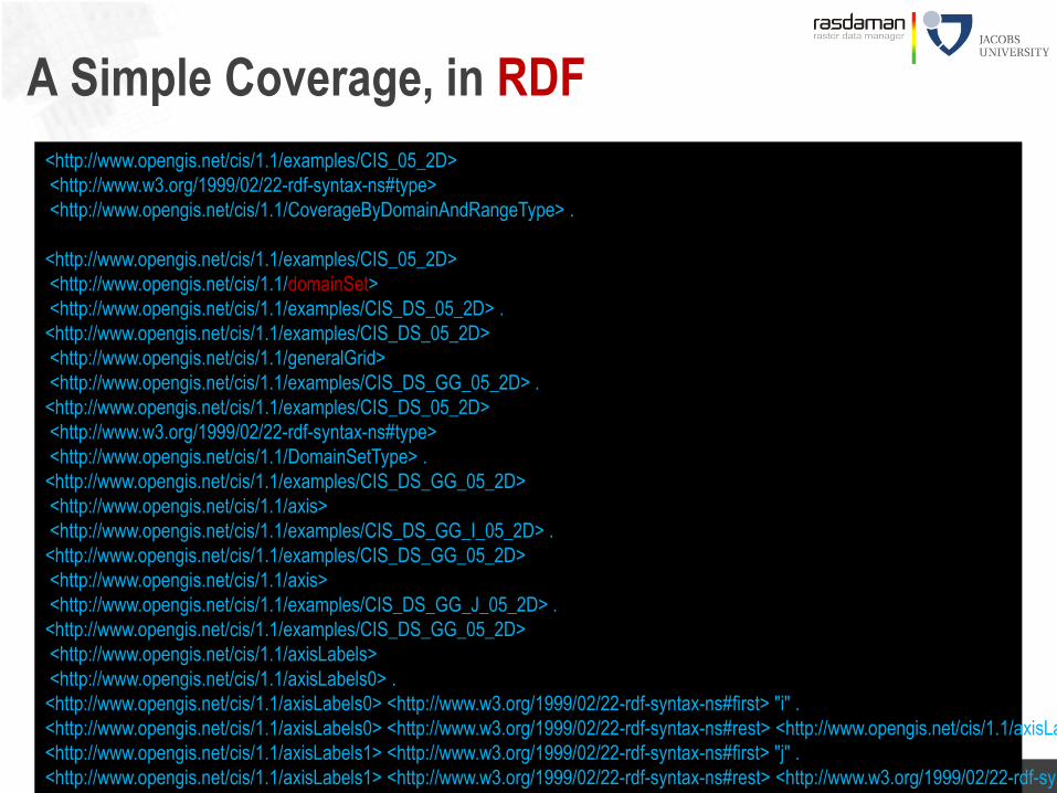
A Simple Coverage, in RDF

INSPIRE WCS :: © 2017 Peter Baumann
Encoding Coverages
Single file encoding:
- Informationally complete: GML, JSON, RDF, …
- Further formats: GeoTIFF, NetCDF, JPEG2000, GRIB, …
Coverage
Domain set
Range type
Range set
App Metadata
Coverage
Domain set
Range type
xlink
App Metadata
NetCDF
Multipart: container( “header” + file1 + file2 + … )
- Multipart/MIME, zip, GMLJP2, SAFE, GeoPackage, ...
- Collections, tiling, streaming
Coverage
Domain set
Range type
xlink
App Metadata
NetCDF

INSPIRE WCS :: © 2017 Peter Baumann
Classical Approach vs Datacubes
WaterML 2.0: time slices
- Good performance in x/y
- Disastrous performance on
timeseries analysis
- same with TimeseriesML
OGC Coverages:
Implementation can
choose efficient layout
- Same performance
in all directions,
space & time
t

INSPIRE WCS :: © 2017 Peter Baumann
Managing Complexity
Separate conformance classes for core,
gridded and discrete data, partitioning, encoding
coverage
grid-regular
grid-irregular
grid-transformation
discrete-pointcloud
discrete-mesh
gml-coverage multipart-coverage
other-format-coverage
json-coverage
coverage-partitioning
json-ld-coverage
«depends-on»
«depends-on»
«depends-on»«depends-on»
«depends-on»
«depends-on»
«depends-on»
«depends-on» «depends-on»

INSPIRE WCS :: © 2017 Peter Baumann
Summary
Coverage Implementation Schema 1.1
= backwards-compatible evolution of GMLCOV 1.0
- All CIS 1.0 coverages remain valid
Grids: Regular + irregular (generalizing GML 3.3), SensorML
Interpolation
Representations: domain/range, „position/value pair“, partitioned, JSON,
RDF
Practice-driven packaging of functionality
OGC CIS 1.0, 1.1 ISO 19123-2

INSPIRE WCS :: © 2017 Peter Baumann
Aligning the Implementation of INSPIRE
Coverages to OGC standards
Jordi Escriu,
INSPIRE Thematic Cluster #3 Facilitator

INSPIRE WCS :: © 2017 Peter Baumann
Overview
Introduction
The data: Coverages
The service: WCS
Conformance Testing
Selected Applications
Conclusion
47

INSPIRE WCS :: © 2017 Peter Baumann
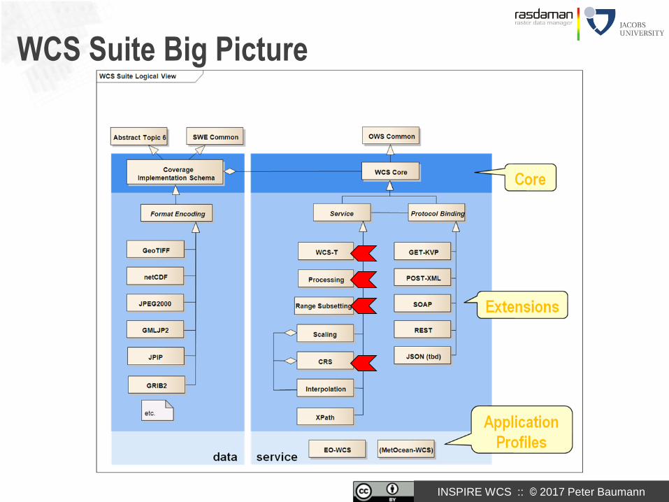
OGC Web Coverage Service (WCS)
WCS Core: access to spatio-temporal coverages & subsets
- Encoding on the fly
- subset = trim | slice
WCS Extensions: optional functionality facets
- Extraction, transformation, …up to flexible analytics (WCPS)
WCS Application Profiles: domain-oriented bundling
Large, growing
implementation basis:
rasdaman, GDAL,
QGIS, OpenLayers,
OPeNDAP, MapServer,
GeoServer, GMU,
NASA WorldWind, EOx-
Server; Pyxis, ERDAS,
ArcGIS, ...

INSPIRE WCS :: © 2017 Peter Baumann
WCS Service Model: Operations
GetCapabilities – OWS Common
- Service metadata
- Coverage list
DescribeCoverage
- coverage metadata
GetCoverage
- coverage, or subset thereof

INSPIRE WCS :: © 2017 Peter Baumann
<?xml version="1.0" encoding="UTF-8"?>
<wcs:Capabilities ...>
<ows:Title>MyLittleWCS</ows:Title>
<ows:Profile>http://www.opengis.net/spec/GMLCOV/1.0/conf/gml-coverage</ows:Profile>
<ows:Profile>http://www.opengis.net/spec/.../1.0/conf/get-kvp</ows:Profile>
<wcs:formatSupported>image/tiff</wcs:formatSupported>
<Contents xmlns="http://www.opengis.net/wcs/2.0">
<CoverageSummary>
<CoverageId>sampleCoverage</CoverageId>
<BoundingBox crs="http://www.opengis.net/def/crs/OGC/0/4326" dimensions=„2">
<LowerCorner>0 0 </LowerCorner>
<UpperCorner>49 11</UpperCorner>
</BoundingBox>
</CoverageSummary>
</Contents>
</wcs:Capabilities>
WCS GetCapabilities
information about Service capabilities + Coverage offering

INSPIRE WCS :: © 2017 Peter Baumann
http://www.acme.com/ows?
SERVICE=WQS & VERSION=1.0 & REQUEST=Query &
QUERY=/Capabilities/Contents/CoverageSummary/CoverageId &
FORMAT=application/gml+xml
Better Than DescribeCoverage: OGC WQS
Web Query Service [OGC 14-121]
- Discussion Paper, adopted May 2016
Can query any hierarchically organized server offering
- XML, JSON, ...
Query = XPath expression
Ex:
QUERY=/Capabilities/formatSupported
QUERY=/OfferedCoverage/RectifiedGridCoverage/domainSet/Grid/[@dimension=“3”]

INSPIRE WCS :: © 2017 Peter Baumann
WCS Core GetCoverage
Download a coverage (or a subset thereof), values guaranteed unchanged
Ex: „download coverage c001“
Ex: „coverage c001, lat/long cutout, time slice t=2009-11-06T23:20:52”
Ex: “coverage c001, in GeoTIFF”
http://www.acme.com/wcs ? SERVICE=WCS & VERSION=2.0
& REQUEST=GetCoverage & COVERAGEID=c001
& SUBSET=Long(100,120) & SUBSET=Lat(50,60)
& SUBSET=time("2009-11-06T23:20:52")
http://www.acme.com/wcs ? SERVICE=WCS & VERSION=2.0
& REQUEST=GetCoverage & COVERAGEID=c001
http://www.acme.com/wcs ? SERVICE=WCS & VERSION=2.0
& REQUEST=GetCoverage & COVERAGEID=c001 & FORMAT=“image/tiff“

INSPIRE WCS :: © 2017 Peter Baumann
Server-Side Processing: Performance
xxx
INSPIRE WCS :: © 2017 Peter Baumann
WCS Suite Big Picture

INSPIRE WCS :: © 2017 Peter Baumann
WCS Range Subsetting Extension [12-040]
Select components from compound cells
- „channel“, „band“ subsetting
Ex: ...& RANGESUBSET=red &…
…& RANGESUBSET=nir,red,green &…
…& RANGESUBSET=green,red,blue &…
…& RANGESUBSET=nir:green &…
…& RANGESUBSET=band01,band03:band05,band19:band21 &…

INSPIRE WCS :: © 2017 Peter Baumann
WCS CRS Extension [11-053]
Preamble
- WCS Core does not define Coordinate Reference System (CRS) handling• accessible only in Native CRS = CRS in which coverage is stored on server• srsName attribute
- CRS Name Type Specification [OGC 11-135] defines CRS URL framework• EPSG & more: Horizontal, vertical, time, index, ...• Not part of WCS
CRS Extension: GetCoverage with additional CRS parameters
- subsettingCrs: CRS in which bounding box is expressed• Default: coverage‘s Native CRS
- outputCrs: CRS in which result coverage is expressed• Default: subsettingCrs
Ex: http://www.acme.com/ows?SERVICE=WCS & VERSION=2.0
& REQUEST=GetCoverage & COVERAGEID=c001
& OUTPUTCRS=http://www.opengis.net/def/crs/EPSG/0/4326

INSPIRE WCS :: © 2017 Peter Baumann
Which CRSs Supported? See Capabilities!
<wcs:crsSupported>
http://www.opengis.net/def/crs/EPSG/0/4326
</wcs:crsSupported>
<wcs:crsSupported>
http://www.opengis.net/def/crs/EPSG
</wcs:crsSupported>
<wcs:crsSupported>
http://www.opengis.net/def/crs?authority=OGC&version=1.3&code=
AUTO42003&UoM=m&CenterLongitude=-100&CenterLatitude=45
</wcs:crsSupported>
<wcs:crsSupported>
http://www.acme.com/def/this-is-EPSG-4326
</wcs:crsSupported>
<wcs:crsSupported>
http://www.opengis.net/def/crs/OGC/0/AnsiDate
</wcs:crsSupported>

INSPIRE WCS :: © 2017 Peter Baumann
WCS Transaction Extension [OGC 13-057]
= WCS-T: Modify coverage offerings on a server via Web
New requests:
InsertCoverage + DeleteCoverage + UpdateCoverage (partial replacement)
Ex:
Compatibility: GetCoverage InsertCoverage
In rasdaman, enhanced with recipes & ingredients layer
http://www.acme.com/wcs
? SERVICE=WCS & VERSION = 2.0
& REQUEST=InsertCoverage
& COVERAGEREF=http://bcme.com/archive/hurricane.nc
& USEID=new

INSPIRE WCS :: © 2017 Peter Baumann
WCS-T With Recipes & Ingredients
Problems:
- WCS-T supports single requests, but often many files + regular updates
- Broad range of situations (metadata!)
rasdaman Approach (http://rasdaman.org/wiki/WCSTImportGuide):
- Single import command for all situations, based on WCS-T
- Import controllled by recipe = JSON import config + parameters = ingredients
Definitions:
- Data source for import
- Defaults: CRS, null values, ...
- Mosaicking
- Tiling structure in database
- ...and many more

INSPIRE WCS :: © 2017 Peter Baumann
WCS-T With Recipes & Ingredients

INSPIRE WCS :: © 2017 Peter Baumann
WCPS: Datacube Analytics
Web Coverage Processing Service
= spatio-temporal datacube analytics language
for $c in ( M1, M2, M3 )where some( $c.nir > 127 )return encode( $c.red - $c.nir, “image/tiff“ )
• "From MODIS scenes M1, M2, M3: difference red & nir, as TIFF"• “…but only those where nir exceeds 127 somewhere”
• s/t regular & irregular grids

INSPIRE WCS :: © 2017 Peter Baumann
...But That‘s Not What You Want to See
Let users remain in comfort zone of well-known tools
- Map navigation: OpenLayers, Leaflet, ...
- Virtual globe: NASA WorldWind, Cesium, ...
- Web GIS: MapServer, GeoServer,
QGIS, ArcGIS, ...
- Analysis: GDAL, R,
python (OWSLIB, Jupyter notebooks), ...
...via WCS / WCPS / WMS
as standard client/server APIs
[screenshots: diverse clients accessing rasdaman]
INSPIRE WCS :: © 2017 Peter Baumann
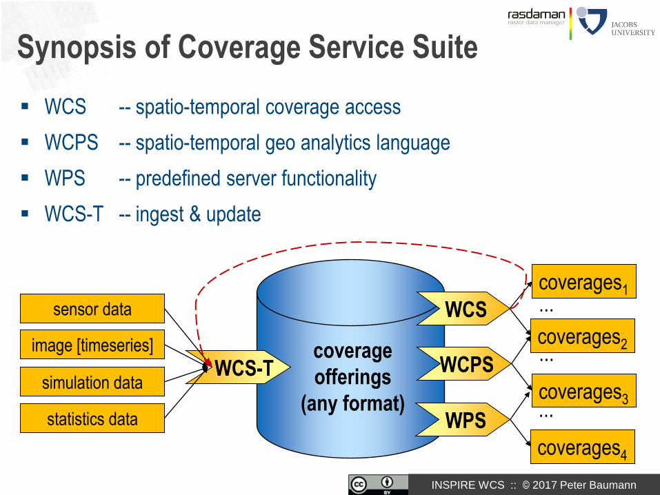
Synopsis of Coverage Service Suite
WCS -- spatio-temporal coverage access
WCPS -- spatio-temporal geo analytics language
WPS -- predefined server functionality
WCS-T -- ingest & update
coverage
offerings
(any format)
coverages1...
coverages2
WCS
coverages3
WCPS
sensor data
WCS-T...
coverages4
WPS...
image [timeseries]
simulation data
statistics data

INSPIRE WCS :: © 2017 Peter Baumann
OGC Sensor Observation Service (SOS)
W*S: downstream
download, processing, visualization
SOS
WMS
WCS
WCPS
WPS...coverage
server
SOS: upstream
sensor data capturing
SOS
sensor, image [timeseries], simulation, statistics data

INSPIRE WCS :: © 2017 Peter Baumann
OGC Web Processing Service (WPS)
WCPS: semantics in language, ready semantic interoperability (m2m!)
WPS: semantics in human-readable text syntactic interoperability
for $c in ( M1, M2, M3 )
return encode abs( $c.red - $c.nir ), "netcdf" )

INSPIRE WCS :: © 2017 Peter Baumann
W...whatever...S ?
OGC standards cover full range
from data-intensive to processing-intensive „Big Data“ coverage
services
WCS WCPS WPS
data access ad-hoc analytics predefined process

INSPIRE WCS :: © 2017 Peter Baumann
Overview
Introduction
The data: Coverages
The service: WCS
Conformance Testing
Selected Applications
Conclusion
84

INSPIRE WCS :: © 2017 Peter Baumann
WCS Testing: Down to Single Pixel Level
Credits: Jinsongdi Yu,
Stephan Meissl

INSPIRE WCS :: © 2017 Peter Baumann
Overview
Introduction
The data: Coverages
The service: WCS
Conformance Testing
Selected Applications
Conclusion
86

INSPIRE WCS :: © 2017 Peter Baumann
Ortho Image Timeseries
[Diedrich et al 2002, using rasdaman]

INSPIRE WCS :: © 2017 Peter Baumann
Elevation
for $s in (SatImage), $d in (DEM)
where $s/metadata/@region = “Glasgow"
return
encode(
struct {
red: (char) $s.b7[x0:x1,x0:x1],
green: (char) $s.b5[x0:x1,x0:x1],
blue: (char) $s.b0[x0:x1,x0:x1],
alpha: (char) scale( $d, 20 )
},
“image/png"
)
[JacobsU, Fraunhofer; data courtesy BGS, ESA]

INSPIRE WCS :: © 2017 Peter Baumann
WMS via WCPS
for $p in (OrthoPhoto),
$wl in (WaterLines), $wa in (WaterAreas),
$d in (DEM)
return
encode( (unsigned char) (
$p * { 1, 1, 1 }
overlay
$wl * { 0, 128, 255 }
overlay
$wa * { 191, 255, 255 }
overlay
switch $d
case $d > 260 return { red:255, green:0, blue:0 }
case $d > 262 return { red:0, green:255, blue:0 }
case $d > 264 return { red:0, green:0, blue:255 }
default return { red:0, green:0, blue:0 }
end
),
"image/png" )

INSPIRE WCS :: © 2017 Peter Baumann
rasdaman: Agile Array Analytics
= „raster data manager“: SQL + n-D arrays
- Scalable parallel “tile streaming” architecture
- Spatio-temporal regular & irregular grids
Mature, in operational use
- blueprint for Big Datacube standards: ISO, OGC, INSPIRE

INSPIRE WCS :: © 2017 Peter Baumann
external
archives
rasserver
databasefile system
rasdaman
geo services
Web clients (m2m, browser)
Architecture
distributed query
processingNo single point of failure
Internet
alternative
storage
[SSTD 2013]
optional compression[SSTD 2013]
INSPIRE WCS :: © 2017 Peter Baumann
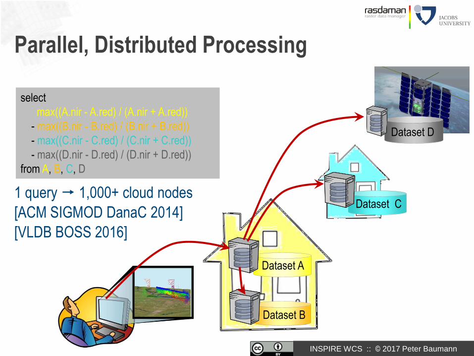
Parallel, Distributed Processing
1 query 1,000+ cloud nodes
[ACM SIGMOD DanaC 2014]
[VLDB BOSS 2016]
Dataset B
Dataset A
Dataset D
Dataset C
select
max((A.nir - A.red) / (A.nir + A.red))
- max((B.nir - B.red) / (B.nir + B.red))
- max((C.nir - C.red) / (C.nir + C.red))
- max((D.nir - D.red) / (D.nir + D.red))
from A, B, C, D

INSPIRE WCS :: © 2017 Peter Baumann
Server-Side Processing: Federation
INSPIRE WCS :: © 2017 Peter Baumann
Overview
Introduction
The data: Coverages
The service: WCS
Conformance Testing
Selected Applications
Conclusion
96

INSPIRE WCS :: © 2017 Peter Baumann
Big Datacube Standards
Open Geospatial Consortium (OGC) :
- WCS „Big Geo Data“ standards suite
- rasdaman WCS Core Reference Implementation
ISO:
- TC211: coverages & WCS• ISO 19123 19123-1• OGC CIS 19123-2• OGC WCS ISO WCS
- SC32: SQL/MDA („Multi-Dimensional Arrays“)
INSPIRE:
- coverages & WCS
- rasdaman INSPIRE Reference Implementation
Research Data Alliance:
- Big Data Interest Group, Geospatial Interest Group, Array Database Assessment WG

INSPIRE WCS :: © 2017 Peter Baumann
Coverages in ISO
Historically, ISO 19123 defines abstract coverage model
- Identical to OGC Abstract Topic 6
- Abstract = not interoperable
– many diverging implementations can (and are known to) exist
Currently (2016):
- 19123 19123-1
- OGC CIS 1.1 19123-2
- Later: OGC WCS 2.1 ISO WCS

INSPIRE WCS :: © 2017 Peter Baumann
ESA Tech Harm Strat Meetg, 2017-feb-21
INSPIRE WCS :: © 2017 Peter Baumann
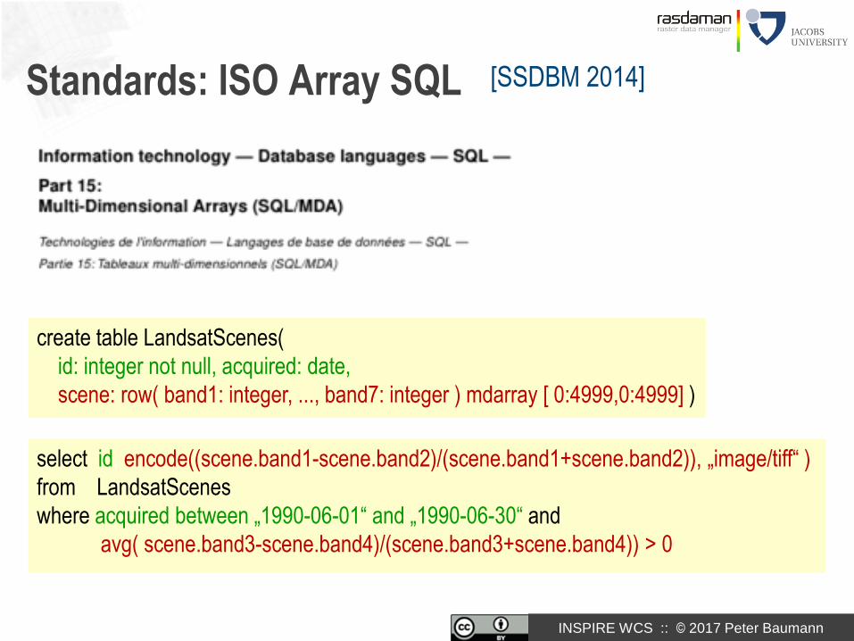
Standards: ISO Array SQL [SSDBM 2014]
select id, encode((scene.band1-scene.band2)/(scene.band1+scene.band2)), „image/tiff“ )
from LandsatScenes
where acquired between „1990-06-01“ and „1990-06-30“ and
avg( scene.band3-scene.band4)/(scene.band3+scene.band4)) > 0
create table LandsatScenes(
id: integer not null, acquired: date,
scene: row( band1: integer, ..., band7: integer ) mdarray [ 0:4999,0:4999] )
INSPIRE WCS :: © 2017 Peter Baumann
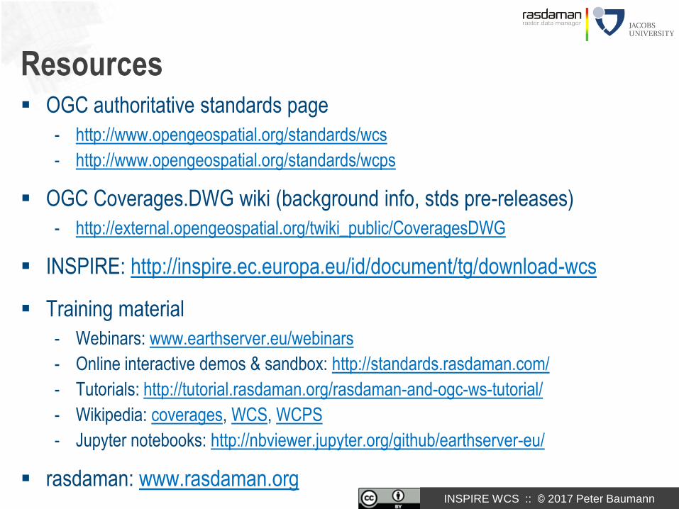
Resources OGC authoritative standards page
- http://www.opengeospatial.org/standards/wcs
- http://www.opengeospatial.org/standards/wcps
OGC Coverages.DWG wiki (background info, stds pre-releases)
- http://external.opengeospatial.org/twiki_public/CoveragesDWG
INSPIRE: http://inspire.ec.europa.eu/id/document/tg/download-wcs
Training material
- Webinars: www.earthserver.eu/webinars
- Online interactive demos & sandbox: http://standards.rasdaman.com/
- Tutorials: http://tutorial.rasdaman.org/rasdaman-and-ogc-ws-tutorial/
- Wikipedia: coverages, WCS, WCPS
- Jupyter notebooks: http://nbviewer.jupyter.org/github/earthserver-eu/
rasdaman: www.rasdaman.org

INSPIRE WCS :: © 2017 Peter Baumann
What‘s Next?
INSPIRE:
- Re-harmonize INSPIRE coverages with OGC/ISO coverages
- INSPIRE conformance tests (based on OGC testing, only specifics in addition)
OGC:
- Protocol bindings: REST (spec ready...)
- Raster/polygon clipping
- MetOcean Application Profile
ISO:
- OGC CIS ISO 19123-2
- Modernize ISO 19123-1
- OGC WCS ISO „19123-3“

INSPIRE WCS :: © 2017 Peter Baumann
Cloud Demo

INSPIRE WCS :: © 2017 Peter Baumann
Conclusion Coverage Suite: data & service model for spatio-temporal data
Coverage Implementation Schema (CIS)- raster data (timeseries) and beyond
Web Coverage Service (WCS)- access (WCS Core) up to analytics (WCPS)
- conformance tests down to pixel level, interoperable
Convergence: stds bodies, open-source & proprietary implementers
- OGC, ISO, INSPIRE
- Growing number of implementations
- rasdaman OGC & INSPIRE Reference Implementation
Federations enabling for INSPIRE
107
[Dali]