
INSPIRE Metadata Implementing Rules: Technical Guidelines based on EN ISO 19115 and EN...
75
INSPIRE Infrastructure for Spatial Information in Europe INSPIRE Metadata Implementing Rules: Technical Guidelines based on EN ISO 19115 and EN ISO 19119 Title INSPIRE Metadata Implementing Rules: Technical Guidelines based on EN ISO 19115 and EN ISO 19119 Creator Drafting Team Metadata and European Commission Joint Research Centre Creation date 2007-10-26 Date of last revision 2010-06-16 Subject INSPIRE Implementing Rules for Metadata Status V. 1.2 Publisher European Commission Joint Research Centre Type Text Description Guidelines based on EN ISO 19115 and EN ISO 19119 for Commission Regulation (EC) No 1205/2008 of 3 December 2008 implementing Directive 2007/2/EC of the European Parliament and of the Council as regards metadata Contributor See Acknowledgements Format Pdf Source European Commission Joint Research Centre Rights Public Identifier MD_IR_and_ISO_v1_2_20100616 Language EN Relation Not applicable Coverage Not applicable
Transcript of INSPIRE Metadata Implementing Rules: Technical Guidelines based on EN ISO 19115 and EN...
INSPIRE Infrastructure for Spatial Information in Europe
INSPIRE Metadata Implementing Rules: Technical Guidelines based on EN ISO 19115 and EN ISO 19119
Title INSPIRE Metadata Implementing Rules: Technical Guidelines based on EN ISO 19115 and EN ISO 19119
Creator Drafting Team Metadata and European Commission Joint Research Centre
Creation date 2007-10-26
Date of last revision 2010-06-16
Subject INSPIRE Implementing Rules for Metadata
Status V. 1.2
Publisher European Commission Joint Research Centre
Type Text
Description Guidelines based on EN ISO 19115 and EN ISO 19119 for Commission Regulation (EC) No 1205/2008 of 3 December 2008 implementing Directive 2007/2/EC of the European Parliament and of the Council as regards metadata
Contributor See Acknowledgements
Format Pdf
Source European Commission Joint Research Centre
Rights Public
Identifier MD_IR_and_ISO_v1_2_20100616
Language EN
Relation Not applicable
Coverage Not applicable
2
Table of Contents Acknowledgements.................................................................................................................... 4 Introduction ................................................................................................................................ 5 Changes from Version 1.1 of 2009-02-18 ................................................................................. 5 Normative references ................................................................................................................ 6 1 INSPIRE profile of ISO 19115 and ISO 19119................................................................... 7
1.1 ISO Core Metadata Elements....................................................................................... 7 1.1.1 Spatial dataset and spatial dataset series ........................................................... 7 1.1.2 Services ............................................................................................................... 8 1.1.3 Conclusion ......................................................................................................... 10
1.2 INSPIRE specific constraints...................................................................................... 10 1.3 Extensions .................................................................................................................. 11
1.3.1 Spatial data service type.................................................................................... 11 1.3.2 Classification of spatial data services ................................................................ 11
2 Basic mapping .................................................................................................................. 12 2.1 Introduction ................................................................................................................. 12
2.1.1 Xpath expression ............................................................................................... 12 2.1.2 ISO Schemas Location ...................................................................................... 13
2.2 Identification................................................................................................................ 14 2.2.1 Resource title ..................................................................................................... 14 2.2.2 Resource abstract.............................................................................................. 15 2.2.3 Resource Type................................................................................................... 16 2.2.4 Resource locator................................................................................................ 17 2.2.5 Unique resource identifier .................................................................................. 18 2.2.6 Coupled resource............................................................................................... 19 2.2.7 Resource language............................................................................................ 20
2.3 Classification of spatial data and services.................................................................. 21 2.3.1 Topic category ................................................................................................... 21 2.3.2 Spatial data service type.................................................................................... 22
2.4 Keyword...................................................................................................................... 23 2.4.1 Keyword value ................................................................................................... 24 2.4.2 Originating controlled vocabulary ...................................................................... 26
2.5 Geographic location.................................................................................................... 28 2.5.1 Geographic bounding box.................................................................................. 28
2.6 Temporal reference .................................................................................................... 30 2.6.1 Temporal extent ................................................................................................. 30 2.6.2 Date of publication ............................................................................................. 31 2.6.3 Date of last revision ........................................................................................... 32 2.6.4 Date of creation.................................................................................................. 33
2.7 Quality and validity ..................................................................................................... 34 2.7.1 Lineage .............................................................................................................. 34 2.7.2 Spatial resolution ............................................................................................... 35
2.8 Conformity .................................................................................................................. 37 2.8.1 Degree ............................................................................................................... 38 2.8.2 Specification....................................................................................................... 39
2.9 Constraints related to access and use ....................................................................... 41 2.9.1 Limitations on public access .............................................................................. 42 2.9.2 Conditions applying to access and use ............................................................. 44
2.10 Responsible organisation....................................................................................... 44 2.10.1 Responsible party .............................................................................................. 45 2.10.2 Responsible party role ....................................................................................... 46
2.11 Metadata on metadata ........................................................................................... 47 2.11.1 Metadata point of contact................................................................................... 47 2.11.2 Metadata date .................................................................................................... 48 2.11.3 Metadata language ............................................................................................ 49
3 Detailed mapping.............................................................................................................. 50 3.1 Introduction ................................................................................................................. 50 3.2 Resource MetadataSet............................................................................................... 50 3.3 Identification Section .................................................................................................. 51
3.3.1 Sub-elements for spatial dataset and spatial dataset series ............................. 51 3.3.2 Sub-elements for service resources .................................................................. 52
3
3.4 Data Quality Section................................................................................................... 53 3.4.1 Lineage .............................................................................................................. 53 3.4.2 Conformity.......................................................................................................... 53
3.5 Responsible Organisation .......................................................................................... 54 3.5.1 Resource responsible organisation ................................................................... 54 3.5.2 Metadata point of contact................................................................................... 54
3.6 Constraint section....................................................................................................... 54 3.7 Abbreviations .............................................................................................................. 55
Annex A – ISO/TS 19139 encoding of the INSPIRE metadata elements ............................... 56 A.1 Introduction............................................................................................................. 56 A.2 From the conceptual schema to XML File instances ............................................. 56 A.3 Polymorphism......................................................................................................... 56 A.4 Management of polymorphism............................................................................... 56
A.4.1 Management of community extensions ............................................................. 56 A.4.2 Parsing of metadata files ................................................................................... 56
A.5 Management of containment by reference ............................................................ 57 A.6 ISO 19139 and multilingual metadata.................................................................... 57
A.6.1 The default language ......................................................................................... 58 A.6.2 Alternate languages ........................................................................................... 59 A.6.3 Embedded translations ...................................................................................... 59 A.6.4 Use of translation files........................................................................................ 60
A.7 Contexts of use ...................................................................................................... 61 A.7.1 Use of ISO 19139 in the context of a Catalogue Service .................................. 61 A.7.2 Use of ISO 19139 in the context of the standard interchange by transfer......... 61
A.8 Character encoding................................................................................................ 61 A.9 Temporal extent encoding...................................................................................... 61 A.10 Spatial resolution encoding .................................................................................... 63 A.11 Codelists................................................................................................................. 64 A.12 Example of ISO 19139 XML Metadata Sets .......................................................... 65
A.12.1 Dataset .......................................................................................................... 65 A.12.2 Dataset series................................................................................................ 71 A.12.3 Service........................................................................................................... 71
4
Acknowledgements Many individuals and organisations have contributed to the development of these Guidelines. The Drafting Team on Metadata included: Marcel Reuvers (Netherlands), Nicolas Lesage (France), Kristian Senkler (Germany), Michael Gould (Spain), Gil Ross (UK), Stefano Nativi (Italy), Jan Hjelmager (Denmark), Franz Daffner (European Environment Agency), Per Ryghaud (Norway), Thomas Vögele and Fred Kruse (Germany), David Danko (USA). We are also grateful for the comments received during the consultation (28th May-15th June 2010) with the Member Sates via their Points of Contact. The team at the Joint Research Centre who has contributed to these Guidelines include: Simon Cox, Massimo Craglia, Ioannis Kanellopoulos, Roberto Lucchi, Gianluca Luraschi, , Michael Lutz, Michel Millot, Nicole Ostländer, Angelo Quaglia, Paul Smits, Robert Tomas. Contact information Massimo Craglia (Editor) European Commission Joint Research Centre Institute for Environment and Sustainability Spatial Data Infrastructures Unit TP262, Via Fermi 2749 I-21027 Ispra (VA) ITALY E-mail: [email protected] Tel.: +39-0332-786269 Fax: +39-0332-786325 http://ies.jrc.ec.europa.eu/ http://www.jrc.ec.europa.eu/
5
Introduction According to Article 5(4) of Directive 2007/2/EC, the INSPIRE Implementing Rules shall take account of relevant, existing international standards and user requirements. In the context of metadata for spatial data and spatial data services, the standards EN ISO 19115, EN ISO 19119, and ISO 15836 (Dublin Core) have been identified as important standards. Commission Regulation (EC) No. 1205/2008 implementing Directive 2007/2/EC of the European Parliament and of the Council as regards metadata was adopted on of 3rd December 2008, and published on the Official Journal of the European Union on 4th December (OJ L 326, 4.12.2008, p. 12–30). Any reference in this document to “Implementing Rules for Metadata” refers to the above mentioned Regulation. Regulation 1205/2008 has been amended with the corrigenda published in the OJ L 328/83 of 15.12.2009 as follows:
On page 12 delete the subtitle “Text with EEA relevance” (European Economic Area) On page 20, Annex D, point 1.3 replace “Spatial data services (services)” with
“Spatial data services (service)”. PLEASE NOTE that in the course of this revision, another typing error has come to light in the Regulation 1205/2008 which will need a further amendment. In Part D 4, the language neutral name for element 501: Geoparameter calculation service should be (thematicGeoparameterCalculationService) and not (thematicGoparameterCalculationService) (part in bold is added to put in evidence the typing error. The aim of this document is to define how the Regulation can be implemented using EN ISO 19115 and EN ISO 19119. The following subsections describe for each element of the Regulation its relation with the mentioned European standards. This is an initial version of this document that will be developed further in collaboration with the stakeholder community and relevant standardization organizations. This document will be publicly available as a ‘non-paper’, as it does not represent an official position of the Commission, and as such can not be invoked in the context of legal procedures. Legal Notice Neither the European Commission nor any person acting on behalf of the Commission is responsible for the use which might be made of this publication.
Changes from Version 1.1 of 2009-02-18 This document is Version 1.2. The changes introduced since Version 1.1 are detailed in the document available at: http://inspire.jrc.ec.europa.eu/documents/Metadata/Changes_to_MD_Guidelines_from_v1-1_to_v1-2_20100616-1.pdf
6
Normative references The following referenced documents are indispensable for the application of this document. For dated references, only the edition cited applies. For undated references, the latest edition of the referenced document (including any amendments) applies. ISO 19115 designates these two normative references: • EN ISO 19115:2005, Geographic information - Metadata1 • ISO 19115/Cor.1:2006, Geographic information – Metadata, Technical Corrigendum 1
ISO 19119 designates these two normative references: • ISO 19119:2005, Geographic information - Services • ISO 19119:2005/Amd 1:2008, Extensions of the service metadata model
ISO 19108 designates: • EN ISO 19108:2005, Geographic information – Temporal Schema2
ISO 639-2, Codes for the representation of names of languages - Part 2: Alpha-3 codeda control
ISO 8601, Data elements and interchange formats - Information interchange - Representation of dates and times
ISO/TS 19139:2007, Geographic information - Metadata – XML Schema Implementation
CSW2 AP ISO, OpenGIS Catalogue Services Specification 2.0.2 - ISO Metadata Application Profile, Version 1.0.0, OGC 07-045, 2007
ISO 10646-1, Information technology ― Universal Multiple-Octet Coded Character Set (UCS) ― Part 1: Architecture and Basic Multilingual Plane
1 EN ISO 19115:2005 is the adoption by CEN of ISO 19115:2003 2 EN ISO 19108:2005 is the adoption by CEN of ISO 19108:2002
7
1 INSPIRE profile of ISO 19115 and ISO 19119
1.1 ISO Core Metadata Elements
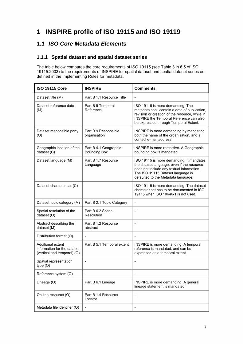
1.1.1 Spatial dataset and spatial dataset series The table below compares the core requirements of ISO 19115 (see Table 3 in 6.5 of ISO 19115:2003) to the requirements of INSPIRE for spatial dataset and spatial dataset series as defined in the Implementing Rules for metadata.
ISO 19115 Core INSPIRE Comments
Dataset title (M) Part B 1.1 Resource Title -
Dataset reference date (M)
Part B 5 Temporal Reference
ISO 19115 is more demanding. The metadata shall contain a date of publication, revision or creation of the resource, while in INSPIRE the Temporal Reference can also be expressed through Temporal Extent.
Dataset responsible party (O)
Part B 9 Responsible organisation
INSPIRE is more demanding by mandating both the name of the organisation, and a contact e-mail address
Geographic location of the dataset (C)
Part B 4.1 Geographic Bounding Box
INSPIRE is more restrictive. A Geographic bounding box is mandated
Dataset language (M) Part B 1.7 Resource Language
ISO 19115 is more demanding. It mandates the dataset language, even if the resource does not include any textual information. The ISO 19115 Dataset language is defaulted to the Metadata language.
Dataset character set (C) - ISO 19115 is more demanding. The dataset character set has to be documented in ISO 19115 when ISO 10646-1 is not used.
Dataset topic category (M) Part B 2.1 Topic Category -
Spatial resolution of the dataset (O)
Part B 6.2 Spatial Resolution
-
Abstract describing the dataset (M)
Part B 1.2 Resource abstract
-
Distribution format (O) - -
Additional extent information for the dataset (vertical and temporal) (O)
Part B 5.1 Temporal extent INSPIRE is more demanding. A temporal reference is mandated, and can be expressed as a temporal extent.
Spatial representation type (O)
- -
Reference system (O) - -
Lineage (O) Part B 6.1 Lineage INSPIRE is more demanding. A general lineage statement is mandated.
On-line resource (O) Part B 1.4 Resource Locator
-
Metadata file identifier (O) - -
8
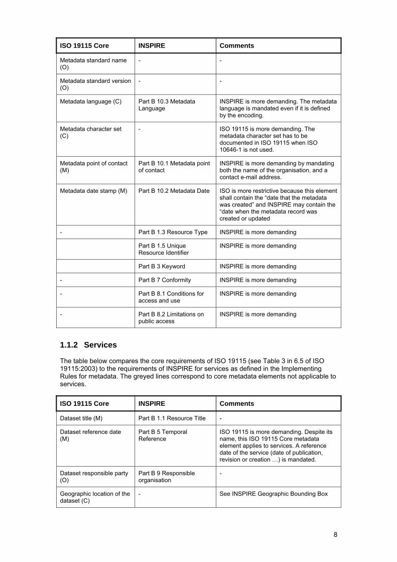
ISO 19115 Core INSPIRE Comments
Metadata standard name (O)
- -
Metadata standard version (O)
- -
Metadata language (C) Part B 10.3 Metadata Language
INSPIRE is more demanding. The metadata language is mandated even if it is defined by the encoding.
Metadata character set (C)
- ISO 19115 is more demanding. The metadata character set has to be documented in ISO 19115 when ISO 10646-1 is not used.
Metadata point of contact (M)
Part B 10.1 Metadata point of contact
INSPIRE is more demanding by mandating both the name of the organisation, and a contact e-mail address.
Metadata date stamp (M) Part B 10.2 Metadata Date ISO is more restrictive because this element shall contain the “date that the metadata was created” and INSPIRE may contain the “date when the metadata record was created or updated
- Part B 1.3 Resource Type INSPIRE is more demanding
Part B 1.5 Unique Resource Identifier
INSPIRE is more demanding
Part B 3 Keyword INSPIRE is more demanding
- Part B 7 Conformity INSPIRE is more demanding
- Part B 8.1 Conditions for access and use
INSPIRE is more demanding
- Part B 8.2 Limitations on public access
INSPIRE is more demanding
1.1.2 Services The table below compares the core requirements of ISO 19115 (see Table 3 in 6.5 of ISO 19115:2003) to the requirements of INSPIRE for services as defined in the Implementing Rules for metadata. The greyed lines correspond to core metadata elements not applicable to services.
ISO 19115 Core INSPIRE Comments
Dataset title (M) Part B 1.1 Resource Title -
Dataset reference date (M)
Part B 5 Temporal Reference
ISO 19115 is more demanding. Despite its name, this ISO 19115 Core metadata element applies to services. A reference date of the service (date of publication, revision or creation …) is mandated.
Dataset responsible party (O)
Part B 9 Responsible organisation
-
Geographic location of the dataset (C)
- See INSPIRE Geographic Bounding Box
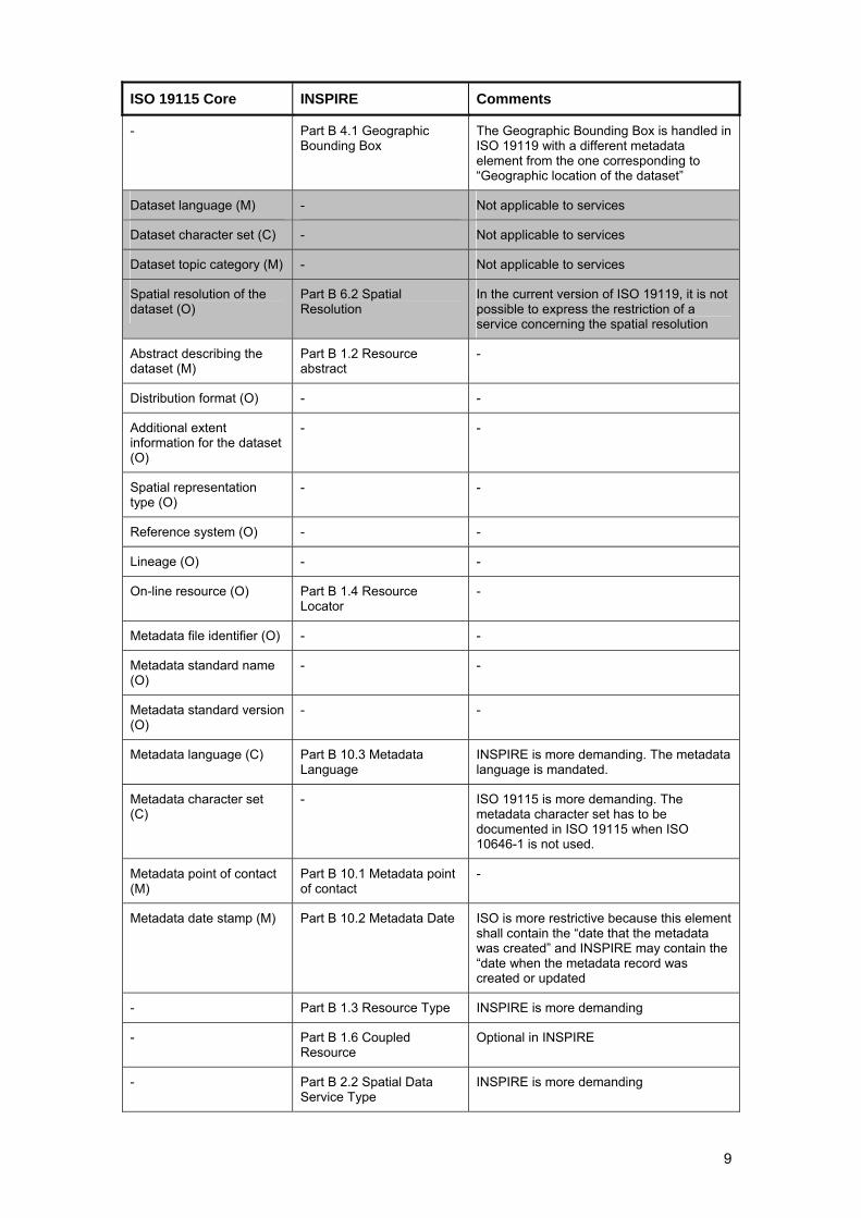
9
ISO 19115 Core INSPIRE Comments
- Part B 4.1 Geographic Bounding Box
The Geographic Bounding Box is handled in ISO 19119 with a different metadata element from the one corresponding to “Geographic location of the dataset”
Dataset language (M) - Not applicable to services
Dataset character set (C) - Not applicable to services
Dataset topic category (M) - Not applicable to services
Spatial resolution of the dataset (O)
Part B 6.2 Spatial Resolution
In the current version of ISO 19119, it is not possible to express the restriction of a service concerning the spatial resolution
Abstract describing the dataset (M)
Part B 1.2 Resource abstract
-
Distribution format (O) - -
Additional extent information for the dataset (O)
- -
Spatial representation type (O)
- -
Reference system (O) - -
Lineage (O) - -
On-line resource (O) Part B 1.4 Resource Locator
-
Metadata file identifier (O) - -
Metadata standard name (O)
- -
Metadata standard version (O)
- -
Metadata language (C) Part B 10.3 Metadata Language
INSPIRE is more demanding. The metadata language is mandated.
Metadata character set (C)
- ISO 19115 is more demanding. The metadata character set has to be documented in ISO 19115 when ISO 10646-1 is not used.
Metadata point of contact (M)
Part B 10.1 Metadata point of contact
-
Metadata date stamp (M) Part B 10.2 Metadata Date ISO is more restrictive because this element shall contain the “date that the metadata was created” and INSPIRE may contain the “date when the metadata record was created or updated
- Part B 1.3 Resource Type INSPIRE is more demanding
- Part B 1.6 Coupled Resource
Optional in INSPIRE
- Part B 2.2 Spatial Data Service Type
INSPIRE is more demanding
10
ISO 19115 Core INSPIRE Comments
Part B 3 Keyword INSPIRE is more demanding
- Part B 7 Conformity INSPIRE is more demanding
- Part B 8.1 Conditions for access and use
INSPIRE is more demanding
- Part B 8.2 Limitations on public access
INSPIRE is more demanding
1.1.3 Conclusion
• The conformance of an ISO 19115 metadata set to the ISO 19115 Core does not guarantee the conformance to INSPIRE;
• The use of these guideline to create INSPIRE metadata ensures that the metadata is not in conflict with ISO 19115. However, full conformance to ISO 19115 implies the provision of additional metadata elements which are not required by INSPIRE.
Over the structural requirements formalised through the mappings, the conformance to INSPIRE is also a matter of semantic of the information provided. If it is acceptable that the ISO 19115/ISO 19119 contain information which are not strictly bounded to the definition of the corresponding INSPIRE metadata elements, the minimum requirements expressed in the implementing rules have also to be met semantically, i.e. with metadata contents strictly satisfying the INSPIRE requirements.
1.2 INSPIRE specific constraints Here is an initial list of INSPIRE constraints applicable to an ISO 19115/ISO 19119 metadata set (i.e. an instance of MD_Metadata) describing a resource: SC1. MD_Metadata.language is mandatory; SC2. MD_Metadata.hierarchyLevel is mandatory; SC3. INSPIRE only considers the first instance of MD_Metadata.hierarchyLevel (i.e.
MD_Metadata.hierarchyLevel[1]) when there are many; SC4. If the value of MD_Metadata.hierarchyLevel[1] is not service, dataset or series, the
metadata set is out of scope of the directive; SC5. When there are many instances of MD_Metadata.identificationInfo, only the first one
(i.e. MD_Metadata.identificationInfo[1]) concerns the current INSPIRE Resource; SC6. INSPIRE only considers the instance of MD_Metadata.dataQualityInfo applicable to the
whole resource; SC7. There shall not be more than one instance of
MD_Metadata.identificationInfo[1].MD_Identification.citation.CI_Citation.date declared as a creation date (i.e. CI_Date.dateType having the creation value);
SC8. MD_Metadata.identificationInfo[1].MD_DataIdentification.citation.CI_Citation.identifier is mandatory for metadata sets related to spatial dataset and spatial dataset series;
SC9. The data type of MD_Metadata.identificationInfo.MD_DataIdentification.language is the codelist LanguageCode from ISO/TS 19139;
SC10. There is at least one instance of MD_Metadata.identificationInfo[1].MD_DataIdentification.extent defining the geographic location of the resource as a geographic bounding box (i.e. an instance of EX_GeographicBoundingBox or one of its subclasses).
SC11. MD_Metadata.identificationInfo[1].SV_ServiceIdentification.operatesOn shall be instantiated by reference
SC12. There shall be at least one instance of MD_Metadata.identificationInfo[1].MD_Identification.resourceConstraints
11
SC13. The coordinates of the bounding boxes (instance of EX_GeographicBoundingBox) shall be expressed in any geodetic coordinate reference system with the Greenwich Prime Meridian
SC14. For datasets and series: MD_Metadata.identificationInfo[1].MD_DataIdentification.pointOfContact[1].CI_ResponsibleParty.organisationName and MD_Metadata.identificationInfo[1].MD_DataIdentification.pointOfContact[1].CI_ResponsibleParty.contactInfo.CI_Contact.address.CI_Address.electronicMailAddress are mandatory. For services these elements are also mandatory but they are referred as follows: MD_Metadata.identificationInfo[1].SV_ServiceIdentification.pointOfContact[1].CI_ResponsibleParty.organisationName and MD_Metadata.identificationInfo[1].SV_ServiceIdentification.pointOfContact[1].CI_ResponsibleParty.contactInfo.CI_Contact.address.CI_Address.electronicMailAddress.
SC15. MD_Metadata.contact[1].CI_ResponsibleParty.organisationName and MD_Metadata.contact[1].CI_ResponsibleParty.contactInfo.CI_Contact.address.CI_Address.electronicMailAddress are mandatory.
SC16. The value of MD_Metadata.contact[1].CI_ResponsibleParty.role.CI_RoleCode shall be pointOfContact.
SC17. For datasets and series at least one keyword of GEMET thesaurus shall be documented using MD_Metadata.identificationInfo[1].MD_DataIdentification.descriptiveKeywords.
SC18. For services at least one keyword of Part D.4 of Commission Regulation (EC) No. 1205/2008 shall be documented using MD_Metadata.identificationInfo[1].SV_ServiceIdentification.descriptiveKeywords
1.3 Extensions
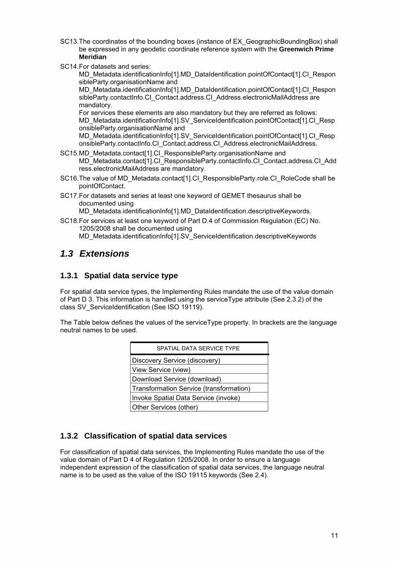
1.3.1 Spatial data service type For spatial data service types, the Implementing Rules mandate the use of the value domain of Part D 3. This information is handled using the serviceType attribute (See 2.3.2) of the class SV_ServiceIdentification (See ISO 19119). The Table below defines the values of the serviceType property. In brackets are the language neutral names to be used.
SPATIAL DATA SERVICE TYPE
Discovery Service (discovery) View Service (view) Download Service (download) Transformation Service (transformation) Invoke Spatial Data Service (invoke) Other Services (other)
1.3.2 Classification of spatial data services For classification of spatial data services, the Implementing Rules mandate the use of the value domain of Part D 4 of Regulation 1205/2008. In order to ensure a language independent expression of the classification of spatial data services, the language neutral name is to be used as the value of the ISO 19115 keywords (See 2.4).
12
2 Basic mapping
2.1 Introduction The following tables describe the mapping between the metadata elements of INSPIRE, as defined in the INSPIRE implementing rules for metadata, and ISO 19115/ISO 19119. For each of the INSPIRE Metadata element, the mapping is composed of:
• The main characteristics of the metadata element as they are defined3 in the INSPIRE implementing rules (IR) for metadata, i.e.:
o The reference to the paragraph of the implementing rules describing the metadata element;
o The name of the metadata element as used in the implementing rules; o The obligation/condition applicable to the metadata element; o The multiplicity of the metadata element.
• The main characteristics of the corresponding metadata element of ISO 19115 or ISO 19119, i.e.:
o The number that identifies the metadata element inside tables in ISO 19115 (or ISO 19119) published standard;
o The name by which the metadata element is known in ISO 19115 (or ISO 19119) published standard;
o The definition, which gives the current ISO 19115 or ISO 19119 terms for describing the metadata element (Annex B of ISO 19115 standard: Data Dictionary for geographic metadata or Annex C of ISO 19119: Data dictionary for geographic service metadata);
o An XPath expression indicating the metadata element within the ISO 19115 / ISO 19119 UML model (see 2.1.1).
o An example that illustrates the description of the metadata element by providing a concrete case.
• Some Implementing instructions, which give more warnings about the implementation in the particular context of the current metadata element.
• An example of XML encoding, i.e. a fragment of the XML of a metadata record created and validated with the INSPIRE Metadata Editor available from the EU Geoportal (http://www.inspire-geoportal.eu/inspireEditor.htm).
The overall structure of an ISO 19115/ISO 19119 metadata set supporting the requirements expressed in the INSPIRE Implementing rules for metadata is defined in Section 3 of this document.
2.1.1 Xpath expression This compact notation allows many defaults and abbreviations for common cases. The simplest XPath takes a form such as /A/B/C which selects C elements that are children of B elements that are children of the A element that forms the outermost element of the model. More complex expressions can be constructed by specifying an axis other than the default 'child' axis, a node test other than a simple name, or predicates, which can be written in square brackets after any step. The main rules are the following ones:
• * selects all element children of the context node; • text() selects all text node children of the context node; • @name selects the name attribute of the context node; • @* selects all the attributes of the context node; • . selects the context node; • .//para selects the para element descendants at any level of the context node; • .. selects the parent of the context node.
Hereafter, the root element of the XPath expression is an instance of MD_Metadata or one of its subclasses. The possible subelements of a class are its properties. The possible 3 In case of discrepancy, the INSPIRE Implementing rules take precedence
13
subelement of a property is its data type or a subtype of its data type. In order to manage the polymorphism, the XPath expression deals with the data type in a generic way (e.g., property_element_name/*/datatype_property_name).
2.1.2 ISO Schemas Location Official ISO schemas (ISO AP or ISO 19139) are currently found in two separate locations: 1) ISO repository for public available standards. The ISO 19139 schemas can be found here: http://standards.iso.org/ittf/PubliclyAvailableStandards/ISO_19139_Schemas/ Date of schemas: 2007-08-11. 2.) OGC Schema repository. The ISO 19139 schemas are located here: http://schemas.opengis.net/iso/19139/20070417/ Date of schemas: 2007-04-17. and here: http://schemas.opengis.net/iso/19139/20060504/ Date of schemas: 2006-06-04. ISO AP schemas are located here: http://schemas.opengis.net/csw/2.0.2/profiles/apiso/ Date of schemas: 2007-07-19. The ISO AP schemas are bound to http://schemas.opengis.net/iso/19139/20060504/ The difference in the schemas located in the OGC repository is the GML version. The version dated "2007-04-17" uses GML 3.2.1, the version dated "2006-06-04" use GML 3.2.0. The version "2006-06-04" provides gml in a separate directory (/gml) whereas the version "2007-04-17" directly refers to http://schemas.opengis.net/gml/3.2.1/. The major difference is that GML 3.2.0 schemas are defined in the namespace http://www.opengis.net/gml whereas GML 3.2.1 schemas are defined in the namespace http://www.opengis.net/gml/3.2. The schemas located in the ISO repository for public available standards are comparable to OGC schemas located here: http://schemas.opengis.net/iso/19139/20070417/. In conclusion: To Validate XML against ISO AP 1.0: http://schemas.opengis.net/csw/2.0.2/profiles/apiso/1.0.0/apiso.xsd To Validate XML against ISO 19139 with GML 3.2.0: http://schemas.opengis.net/iso/19139/20060504/gmd/gmd.xsd To Validate XML against ISO 19139 with GML 3.2.1: http://standards.iso.org/ittf/PubliclyAvailableStandards/ISO_19139_Schemas/gmd/gmd.xsd or http://schemas.opengis.net/iso/19139/20070417/gmd/gmd.xsd INSPIRE Validator Service: A RESTful Web service that can be invoked by http request to validate Inspire Metadata. The purpose of the INSPIRE Metadata Validator is to test compliance of INSPIRE metadata with the INSPIRE Metadata Regulation. The validator accepts metadata which follow the Metadata Technical Guidance encoded in EN ISO 19139 schema. The INSPIRE Metadata Validator is implemented by ISO Schematron (2006). The web application and service are provided for testing. Please report any issues you find so that they can be improved at [email protected] End point: http://www.inspire-geoportal.eu/INSPIREValidatorService/resources/validation/inspire Supported method: POST Supported response formats: XML, HTML (The response format is returned according to the Accept value of the http request header) Request parameter: dataFile (This is the name of the parameter associated with the metadata record xml file that should be added to the request) (see also http://www.inspire-geoportal.eu/index.cfm/pageid/48 )
14
PLEASE NOTE: The validator is a proof of concept that has been developed to test these guidelines. It is not intended to be an operational tool, and at the present time works in English only. All the files of the Validator including documentation are available under EU Public License from the OSOR web site (http://www.osor.eu/projects/validator). Interested stakeholders are welcome to adapt the Validator to their own language, and contribute it back through OSOR to enrich the collective portfolio of tools supporting the implementation of INSPIRE.
2.2 Identification
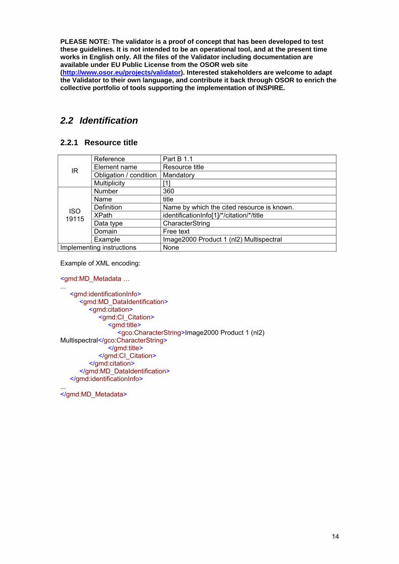
2.2.1 Resource title
Reference Part B 1.1 Element name Resource title Obligation / condition Mandatory IR
Multiplicity [1] Number 360 Name title Definition Name by which the cited resource is known. XPath identificationInfo[1]/*/citation/*/title Data type CharacterString Domain Free text
ISO 19115
Example Image2000 Product 1 (nl2) Multispectral Implementing instructions None Example of XML encoding: <gmd:MD_Metadata … ... <gmd:identificationInfo> <gmd:MD_DataIdentification> <gmd:citation> <gmd:CI_Citation> <gmd:title> <gco:CharacterString>Image2000 Product 1 (nl2) Multispectral</gco:CharacterString> </gmd:title> </gmd:CI_Citation> </gmd:citation> </gmd:MD_DataIdentification> </gmd:identificationInfo> ... </gmd:MD_Metadata>
15
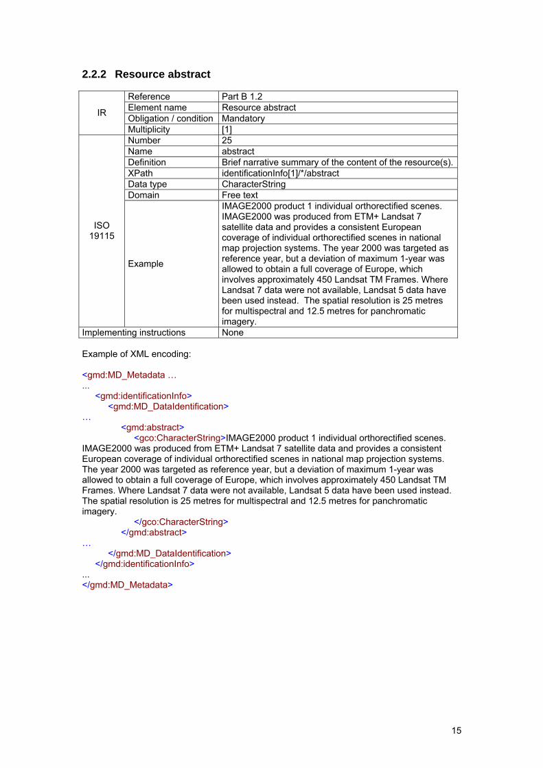
2.2.2 Resource abstract
Reference Part B 1.2 Element name Resource abstract Obligation / condition Mandatory IR
Multiplicity [1] Number 25 Name abstract Definition Brief narrative summary of the content of the resource(s).XPath identificationInfo[1]/*/abstract Data type CharacterString Domain Free text
ISO 19115
Example
IMAGE2000 product 1 individual orthorectified scenes. IMAGE2000 was produced from ETM+ Landsat 7 satellite data and provides a consistent European coverage of individual orthorectified scenes in national map projection systems. The year 2000 was targeted as reference year, but a deviation of maximum 1-year was allowed to obtain a full coverage of Europe, which involves approximately 450 Landsat TM Frames. Where Landsat 7 data were not available, Landsat 5 data have been used instead. The spatial resolution is 25 metres for multispectral and 12.5 metres for panchromatic imagery.
Implementing instructions None Example of XML encoding: <gmd:MD_Metadata … ... <gmd:identificationInfo> <gmd:MD_DataIdentification> … <gmd:abstract> <gco:CharacterString>IMAGE2000 product 1 individual orthorectified scenes. IMAGE2000 was produced from ETM+ Landsat 7 satellite data and provides a consistent European coverage of individual orthorectified scenes in national map projection systems. The year 2000 was targeted as reference year, but a deviation of maximum 1-year was allowed to obtain a full coverage of Europe, which involves approximately 450 Landsat TM Frames. Where Landsat 7 data were not available, Landsat 5 data have been used instead. The spatial resolution is 25 metres for multispectral and 12.5 metres for panchromatic imagery. </gco:CharacterString> </gmd:abstract> … </gmd:MD_DataIdentification> </gmd:identificationInfo> ... </gmd:MD_Metadata>
16
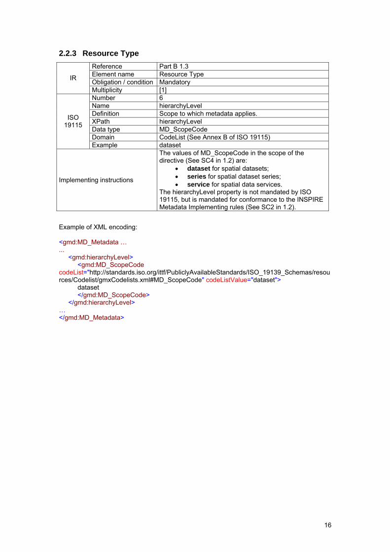
2.2.3 Resource Type
Reference Part B 1.3 Element name Resource Type Obligation / condition Mandatory IR
Multiplicity [1] Number 6 Name hierarchyLevel Definition Scope to which metadata applies. XPath hierarchyLevel Data type MD_ScopeCode Domain CodeList (See Annex B of ISO 19115)
ISO 19115
Example dataset
Implementing instructions
The values of MD_ScopeCode in the scope of the directive (See SC4 in 1.2) are:
• dataset for spatial datasets; • series for spatial dataset series; • service for spatial data services.
The hierarchyLevel property is not mandated by ISO 19115, but is mandated for conformance to the INSPIRE Metadata Implementing rules (See SC2 in 1.2).
Example of XML encoding: <gmd:MD_Metadata … ... <gmd:hierarchyLevel> <gmd:MD_ScopeCode codeList="http://standards.iso.org/ittf/PubliclyAvailableStandards/ISO_19139_Schemas/resources/Codelist/gmxCodelists.xml#MD_ScopeCode" codeListValue="dataset"> dataset </gmd:MD_ScopeCode> </gmd:hierarchyLevel> … </gmd:MD_Metadata>

17
2.2.4 Resource locator
Reference Part B 1.4 Element name Resource locator
Obligation / condition
• Conditional for spatial dataset and spatial dataset series: Mandatory if a URL is available to obtain more information on the resources and/or access related services.
• Conditional for services: Mandatory if linkage to the service is available
IR
Multiplicity [0..*] Number 397 Name linkage
Definition Location (address) for on-line access using a Uniform Resource Locator address or similar addressing scheme.
XPath distributionInfo/*/transferOptions/*/onLine/*/linkage Data type URL Domain URL (IETF RFC1738 and IETF RFC 2056)
ISO 19115
Example http://image2000.jrc.it
Implementing instructions
• Specify a valid URL to the resource. If no direct link to a resource is available, provide link to a contact point where more information about the resource is available.
• For a service, the Resource Locator might be one of the following: - A link to the service capabilities document; - A link to the service WSDL document (SOAP
Binding); - A link to a web page with further instructions - A link to a client application that directly accesses
the service Example of XML encoding: <gmd:MD_Metadata … … <gmd:distributionInfo> <gmd:MD_Distribution> … <gmd:transferOptions> <gmd:MD_DigitalTransferOptions> <gmd:onLine> <gmd:CI_OnlineResource> <gmd:linkage> <gmd:URL>http://image2000.jrc.it/</gmd:URL> </gmd:linkage> </gmd:CI_OnlineResource> </gmd:onLine> </gmd:MD_DigitalTransferOptions> </gmd:transferOptions> </gmd:MD_Distribution> </gmd:distributionInfo> … </gmd:MD_Metadata>
18
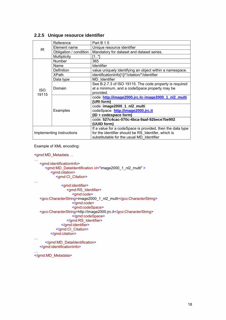
2.2.5 Unique resource identifier
Reference Part B 1.5 Element name Unique resource identifier Obligation / condition Mandatory for dataset and dataset series. IR
Multiplicity [1..*] Number 365 Name Identifier Definition value uniquely identifying an object within a namespace. XPath identificationInfo[1]/*/citation/*/identifier Data type MD_Identifier
Domain See B.2.7.3 of ISO 19115. The code property is required at a minimum, and a codeSpace property may be provided. code: http://image2000.jrc.it#image2000_1_nl2_multi (URI form) code: image2000_1_nl2_multi codeSpace: http://image2000.jrc.it (ID + codespace form)
ISO 19115
Examples
code: 527c4cac-070c-4bca-9aaf-92bece7be902 (UUID form)
Implementing instructions If a value for a codeSpace is provided, then the data type for the identifier should be RS_Identifer, which is substitutable for the usual MD_Identifier
Example of XML encoding: <gmd:MD_Metadata … … <gmd:identificationInfo> <gmd:MD_DataIdentification id="image2000_1_nl2_multi" > <gmd:citation> <gmd:CI_Citation> … <gmd:identifier> <gmd:RS_Identifier> <gmd:code> <gco:CharacterString>image2000_1_nl2_multi</gco:CharacterString> </gmd:code> <gmd:codeSpace> <gco:CharacterString>http://image2000.jrc.it</gco:CharacterString> </gmd:codeSpace> </gmd:RS_Identifier> </gmd:identifier> </gmd:CI_Citation> </gmd:citation> … </gmd:MD_DataIdentification> </gmd:identificationInfo> … </gmd:MD_Metadata>
19
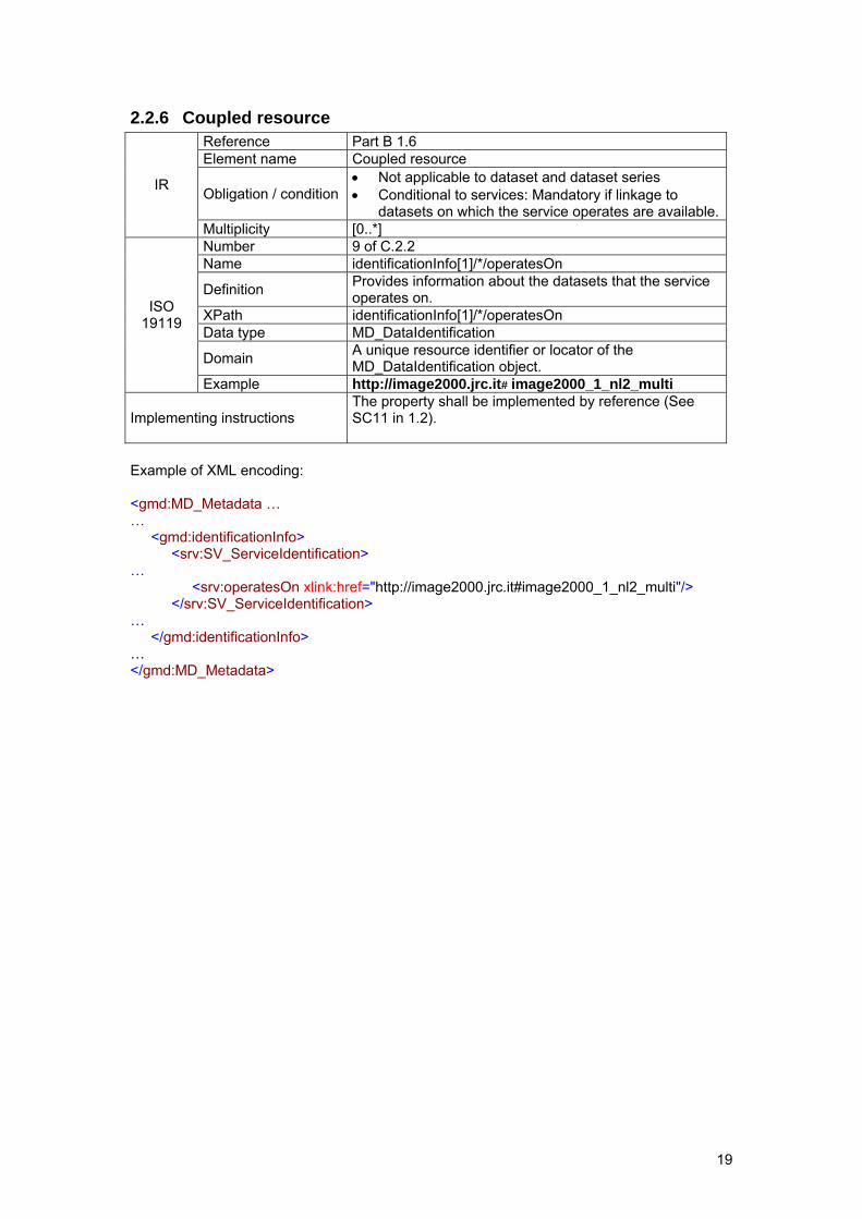
2.2.6 Coupled resource
Reference Part B 1.6 Element name Coupled resource
Obligation / condition • Not applicable to dataset and dataset series • Conditional to services: Mandatory if linkage to
datasets on which the service operates are available.
IR
Multiplicity [0..*] Number 9 of C.2.2 Name identificationInfo[1]/*/operatesOn
Definition Provides information about the datasets that the service operates on.
XPath identificationInfo[1]/*/operatesOn Data type MD_DataIdentification
Domain A unique resource identifier or locator of the MD_DataIdentification object.
ISO 19119
Example http://image2000.jrc.it#image2000_1_nl2_multi
Implementing instructions The property shall be implemented by reference (See SC11 in 1.2).
Example of XML encoding: <gmd:MD_Metadata … … <gmd:identificationInfo> <srv:SV_ServiceIdentification> … <srv:operatesOn xlink:href="http://image2000.jrc.it#image2000_1_nl2_multi"/> </srv:SV_ServiceIdentification> … </gmd:identificationInfo> … </gmd:MD_Metadata>
20
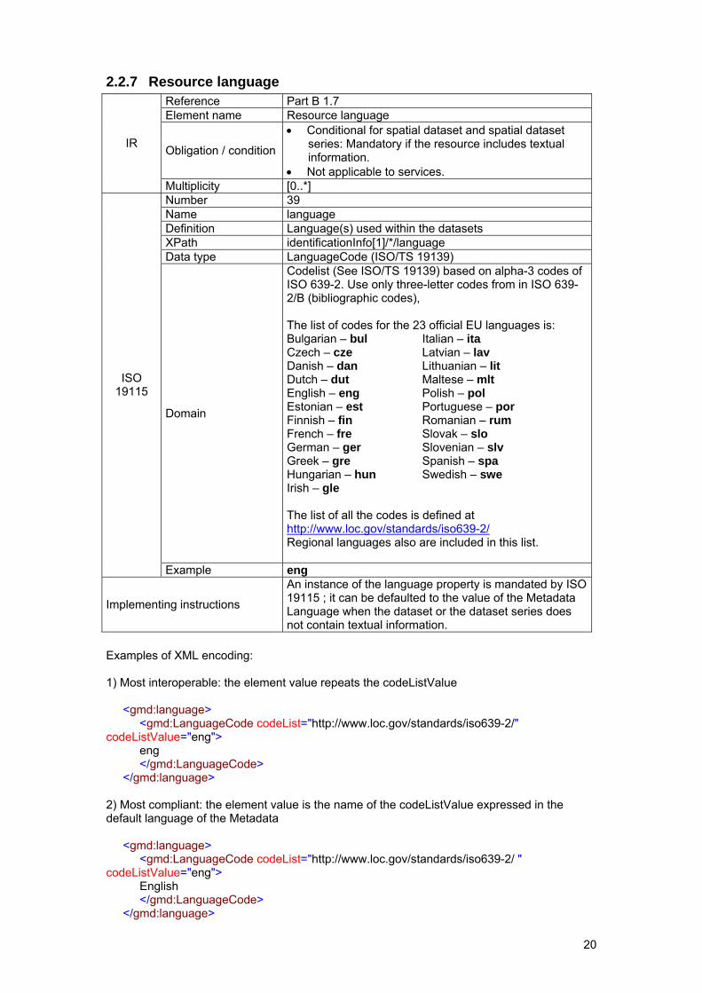
2.2.7 Resource language
Reference Part B 1.7 Element name Resource language
Obligation / condition
• Conditional for spatial dataset and spatial dataset series: Mandatory if the resource includes textual information.
• Not applicable to services.
IR
Multiplicity [0..*] Number 39 Name language Definition Language(s) used within the datasets XPath identificationInfo[1]/*/language Data type LanguageCode (ISO/TS 19139)
Domain
Codelist (See ISO/TS 19139) based on alpha-3 codes of ISO 639-2. Use only three-letter codes from in ISO 639-2/B (bibliographic codes), The list of codes for the 23 official EU languages is: Bulgarian – bul Italian – ita Czech – cze Latvian – lav Danish – dan Lithuanian – lit Dutch – dut Maltese – mlt English – eng Polish – pol Estonian – est Portuguese – por Finnish – fin Romanian – rum French – fre Slovak – slo German – ger Slovenian – slv Greek – gre Spanish – spa Hungarian – hun Swedish – swe Irish – gle The list of all the codes is defined at http://www.loc.gov/standards/iso639-2/ Regional languages also are included in this list.
ISO 19115
Example eng
Implementing instructions
An instance of the language property is mandated by ISO 19115 ; it can be defaulted to the value of the Metadata Language when the dataset or the dataset series does not contain textual information.
Examples of XML encoding: 1) Most interoperable: the element value repeats the codeListValue <gmd:language> <gmd:LanguageCode codeList="http://www.loc.gov/standards/iso639-2/" codeListValue="eng"> eng </gmd:LanguageCode> </gmd:language> 2) Most compliant: the element value is the name of the codeListValue expressed in the default language of the Metadata <gmd:language> <gmd:LanguageCode codeList="http://www.loc.gov/standards/iso639-2/ " codeListValue="eng"> English </gmd:LanguageCode> </gmd:language>
21
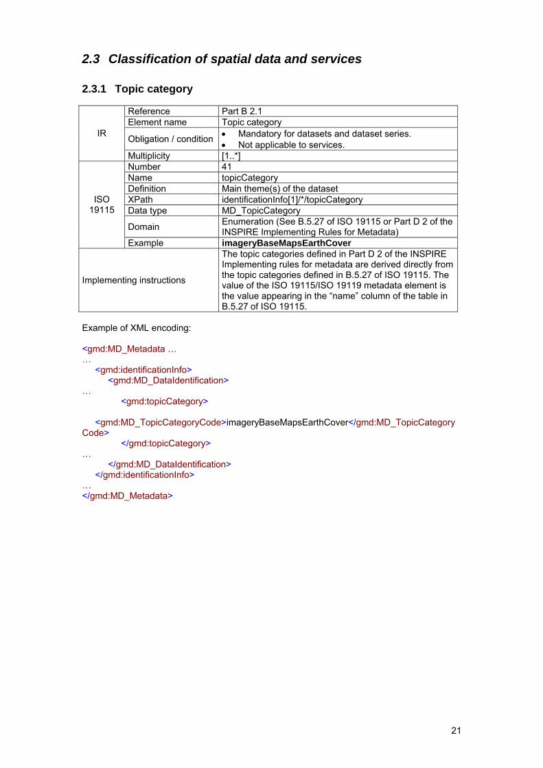
2.3 Classification of spatial data and services
2.3.1 Topic category
Reference Part B 2.1 Element name Topic category
Obligation / condition • Mandatory for datasets and dataset series. • Not applicable to services.
IR
Multiplicity [1..*] Number 41 Name topicCategory Definition Main theme(s) of the dataset XPath identificationInfo[1]/*/topicCategory Data type MD_TopicCategory
Domain Enumeration (See B.5.27 of ISO 19115 or Part D 2 of the INSPIRE Implementing Rules for Metadata)
ISO 19115
Example imageryBaseMapsEarthCover
Implementing instructions
The topic categories defined in Part D 2 of the INSPIRE Implementing rules for metadata are derived directly from the topic categories defined in B.5.27 of ISO 19115. The value of the ISO 19115/ISO 19119 metadata element is the value appearing in the “name” column of the table in B.5.27 of ISO 19115.
Example of XML encoding: <gmd:MD_Metadata … … <gmd:identificationInfo> <gmd:MD_DataIdentification> … <gmd:topicCategory> <gmd:MD_TopicCategoryCode>imageryBaseMapsEarthCover</gmd:MD_TopicCategoryCode> </gmd:topicCategory> … </gmd:MD_DataIdentification> </gmd:identificationInfo> … </gmd:MD_Metadata>
22
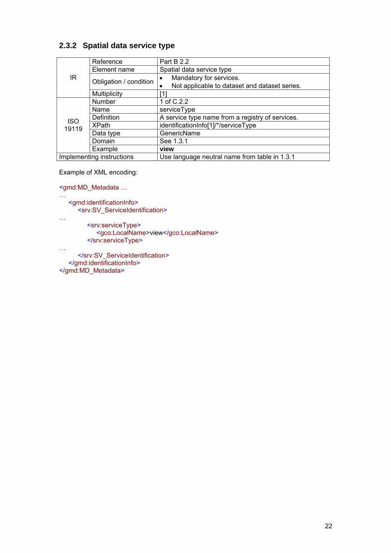
2.3.2 Spatial data service type
Reference Part B 2.2 Element name Spatial data service type
Obligation / condition • Mandatory for services. • Not applicable to dataset and dataset series.
IR
Multiplicity [1] Number 1 of C.2.2 Name serviceType Definition A service type name from a registry of services. XPath identificationInfo[1]/*/serviceType Data type GenericName Domain See 1.3.1
ISO 19119
Example view Implementing instructions Use language neutral name from table in 1.3.1 Example of XML encoding: <gmd:MD_Metadata … … <gmd:identificationInfo> <srv:SV_ServiceIdentification> … <srv:serviceType> <gco:LocalName>view</gco:LocalName> </srv:serviceType> … </srv:SV_ServiceIdentification> </gmd:identificationInfo> </gmd:MD_Metadata>
23
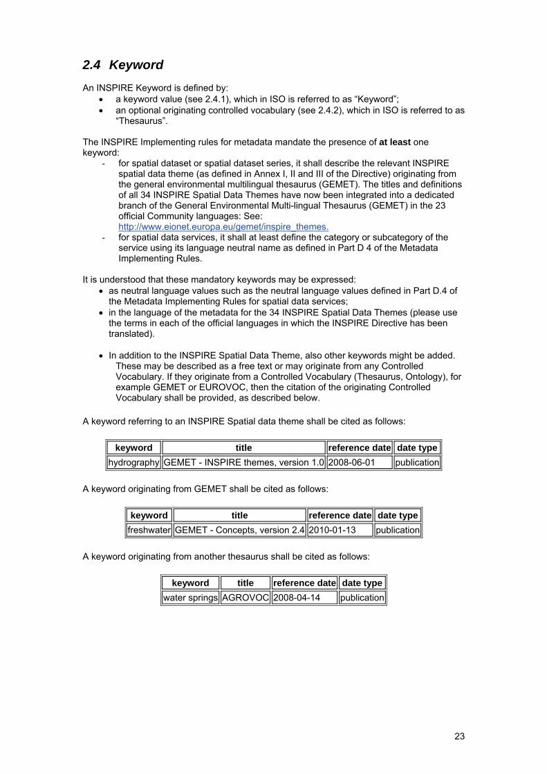
2.4 Keyword An INSPIRE Keyword is defined by:
• a keyword value (see 2.4.1), which in ISO is referred to as “Keyword”; • an optional originating controlled vocabulary (see 2.4.2), which in ISO is referred to as
“Thesaurus”.
The INSPIRE Implementing rules for metadata mandate the presence of at least one keyword:
- for spatial dataset or spatial dataset series, it shall describe the relevant INSPIRE spatial data theme (as defined in Annex I, II and III of the Directive) originating from the general environmental multilingual thesaurus (GEMET). The titles and definitions of all 34 INSPIRE Spatial Data Themes have now been integrated into a dedicated branch of the General Environmental Multi-lingual Thesaurus (GEMET) in the 23 official Community languages: See: http://www.eionet.europa.eu/gemet/inspire_themes.
- for spatial data services, it shall at least define the category or subcategory of the service using its language neutral name as defined in Part D 4 of the Metadata Implementing Rules.
It is understood that these mandatory keywords may be expressed:
• as neutral language values such as the neutral language values defined in Part D.4 of the Metadata Implementing Rules for spatial data services;
• in the language of the metadata for the 34 INSPIRE Spatial Data Themes (please use the terms in each of the official languages in which the INSPIRE Directive has been translated).
• In addition to the INSPIRE Spatial Data Theme, also other keywords might be added.
These may be described as a free text or may originate from any Controlled Vocabulary. If they originate from a Controlled Vocabulary (Thesaurus, Ontology), for example GEMET or EUROVOC, then the citation of the originating Controlled Vocabulary shall be provided, as described below.
A keyword referring to an INSPIRE Spatial data theme shall be cited as follows:
keyword title reference date date type hydrography GEMET - INSPIRE themes, version 1.0 2008-06-01 publication
A keyword originating from GEMET shall be cited as follows:
keyword title reference date date type freshwater GEMET - Concepts, version 2.4 2010-01-13 publication
A keyword originating from another thesaurus shall be cited as follows:
keyword title reference date date type water springs AGROVOC 2008-04-14 publication
24
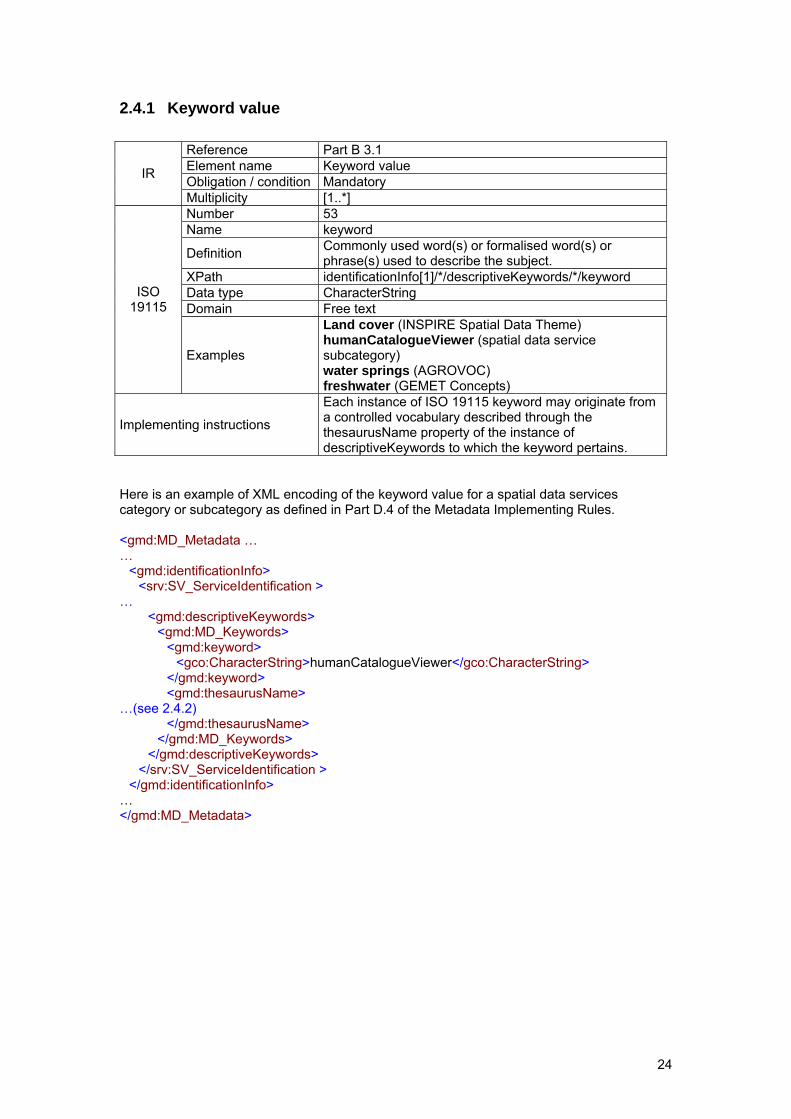
2.4.1 Keyword value
Reference Part B 3.1 Element name Keyword value Obligation / condition Mandatory IR
Multiplicity [1..*] Number 53 Name keyword
Definition Commonly used word(s) or formalised word(s) or phrase(s) used to describe the subject.
XPath identificationInfo[1]/*/descriptiveKeywords/*/keyword Data type CharacterString Domain Free text
ISO 19115
Examples
Land cover (INSPIRE Spatial Data Theme) humanCatalogueViewer (spatial data service subcategory) water springs (AGROVOC) freshwater (GEMET Concepts)
Implementing instructions
Each instance of ISO 19115 keyword may originate from a controlled vocabulary described through the thesaurusName property of the instance of descriptiveKeywords to which the keyword pertains.
Here is an example of XML encoding of the keyword value for a spatial data services category or subcategory as defined in Part D.4 of the Metadata Implementing Rules. <gmd:MD_Metadata … … <gmd:identificationInfo> <srv:SV_ServiceIdentification > … <gmd:descriptiveKeywords> <gmd:MD_Keywords> <gmd:keyword> <gco:CharacterString>humanCatalogueViewer</gco:CharacterString> </gmd:keyword> <gmd:thesaurusName> …(see 2.4.2) </gmd:thesaurusName> </gmd:MD_Keywords> </gmd:descriptiveKeywords> </srv:SV_ServiceIdentification > </gmd:identificationInfo> … </gmd:MD_Metadata>
25
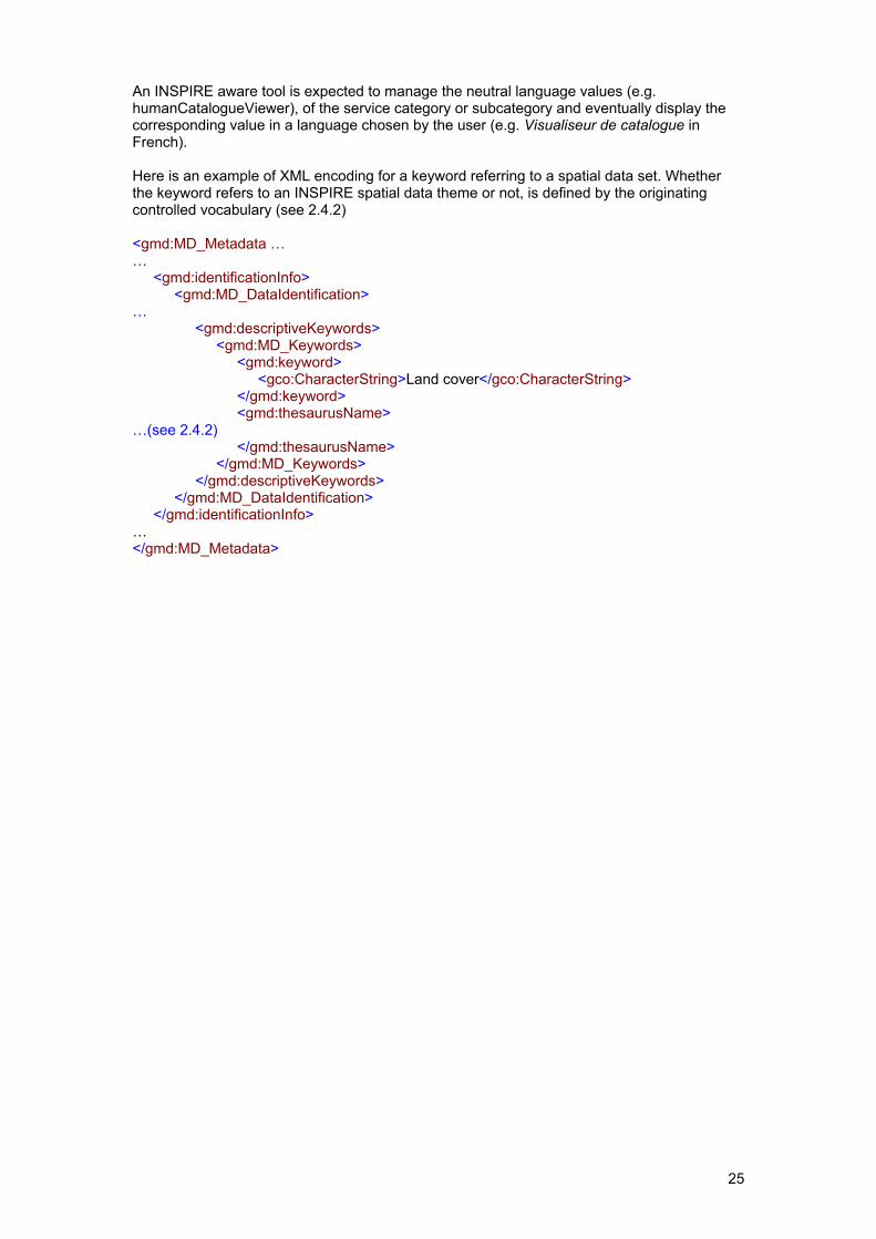
An INSPIRE aware tool is expected to manage the neutral language values (e.g. humanCatalogueViewer), of the service category or subcategory and eventually display the corresponding value in a language chosen by the user (e.g. Visualiseur de catalogue in French). Here is an example of XML encoding for a keyword referring to a spatial data set. Whether the keyword refers to an INSPIRE spatial data theme or not, is defined by the originating controlled vocabulary (see 2.4.2) <gmd:MD_Metadata … … <gmd:identificationInfo> <gmd:MD_DataIdentification> … <gmd:descriptiveKeywords> <gmd:MD_Keywords> <gmd:keyword> <gco:CharacterString>Land cover</gco:CharacterString> </gmd:keyword> <gmd:thesaurusName> …(see 2.4.2) </gmd:thesaurusName> </gmd:MD_Keywords> </gmd:descriptiveKeywords> </gmd:MD_DataIdentification> </gmd:identificationInfo> … </gmd:MD_Metadata>
26
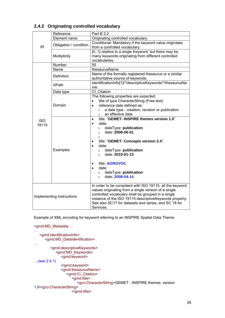
2.4.2 Originating controlled vocabulary
Reference Part B 3.2 Element name Originating controlled vocabulary.
Obligation / condition Conditional: Mandatory if the keyword value originates from a controlled vocabulary. IR
Multiplicity [0..1] relative to a single Keyword, but there may be many keywords originating from different controlled vocabularies.
Number 55 Name thesaurusName
Definition Name of the formally registered thesaurus or a similar authoritative source of keywords.
XPath identificationInfo[1]/*/descriptiveKeywords/*/thesaurusName
Data type CI_Citation
Domain
The following properties are expected: • title of type CharacterString (Free text) • reference date defined as:
o a date type : creation, revision or publication o an effective date
ISO 19115
Examples
• title: “GEMET- INSPIRE themes version 1.0” • date:
o dateType: publication o date: 2008-06-01 o
• title: “GEMET- Concepts version 2.4” • date:
o dateType: publication o date: 2010-01-13
• title: AGROVOC • date:
o dateType: publication o date: 2008-04-14
Implementing instructions
In order to be consistent with ISO 19115, all the keyword values originating from a single version of a single controlled vocabulary shall be grouped in a single instance of the ISO 19115 descriptiveKeywords property. See also SC17 for datasets and series, and SC 18 for Services.
Example of XML encoding for keyword referring to an INSPIRE Spatial Data Theme <gmd:MD_Metadata … … <gmd:identificationInfo> <gmd:MD_DataIdentification> … <gmd:descriptiveKeywords> <gmd:MD_Keywords> <gmd:keyword> …(see 2.4.1) </gmd:keyword> <gmd:thesaurusName> <gmd:CI_Citation> <gmd:title> <gco:CharacterString>GEMET - INSPIRE themes, version 1.0</gco:CharacterString> </gmd:title>
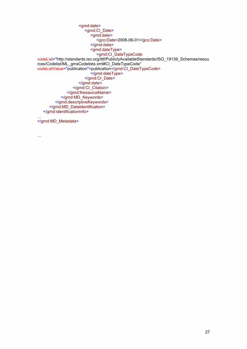
27
<gmd:date> <gmd:CI_Date> <gmd:date> <gco:Date>2008-06-01</gco:Date> </gmd:date> <gmd:dateType> <gmd:CI_DateTypeCode codeList="http://standards.iso.org/ittf/PubliclyAvailableStandards/ISO_19139_Schemas/resources/Codelist/ML_gmxCodelists.xml#CI_DateTypeCode" codeListValue="publication">publication</gmd:CI_DateTypeCode> </gmd:dateType> </gmd:CI_Date> </gmd:date> </gmd:CI_Citation> </gmd:thesaurusName> </gmd:MD_Keywords> </gmd:descriptiveKeywords> </gmd:MD_DataIdentification> </gmd:identificationInfo> … </gmd:MD_Metadata> …
28
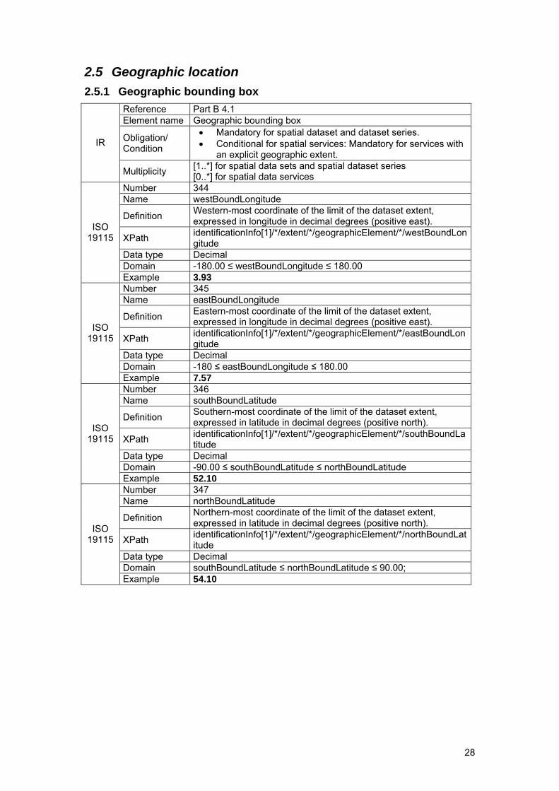
2.5 Geographic location 2.5.1 Geographic bounding box
Reference Part B 4.1 Element name Geographic bounding box
Obligation/ Condition
• Mandatory for spatial dataset and dataset series. • Conditional for spatial services: Mandatory for services with
an explicit geographic extent. IR
Multiplicity [1..*] for spatial data sets and spatial dataset series [0..*] for spatial data services
Number 344 Name westBoundLongitude
Definition Western-most coordinate of the limit of the dataset extent, expressed in longitude in decimal degrees (positive east).
XPath identificationInfo[1]/*/extent/*/geographicElement/*/westBoundLongitude
Data type Decimal Domain -180.00 ≤ westBoundLongitude ≤ 180.00
ISO 19115
Example 3.93 Number 345 Name eastBoundLongitude
Definition Eastern-most coordinate of the limit of the dataset extent, expressed in longitude in decimal degrees (positive east).
XPath identificationInfo[1]/*/extent/*/geographicElement/*/eastBoundLongitude
Data type Decimal Domain -180 ≤ eastBoundLongitude ≤ 180.00
ISO 19115
Example 7.57 Number 346 Name southBoundLatitude
Definition Southern-most coordinate of the limit of the dataset extent, expressed in latitude in decimal degrees (positive north).
XPath identificationInfo[1]/*/extent/*/geographicElement/*/southBoundLatitude
Data type Decimal Domain -90.00 ≤ southBoundLatitude ≤ northBoundLatitude
ISO 19115
Example 52.10 Number 347 Name northBoundLatitude
Definition Northern-most coordinate of the limit of the dataset extent, expressed in latitude in decimal degrees (positive north).
XPath identificationInfo[1]/*/extent/*/geographicElement/*/northBoundLatitude
Data type Decimal Domain southBoundLatitude ≤ northBoundLatitude ≤ 90.00;
ISO 19115
Example 54.10
29
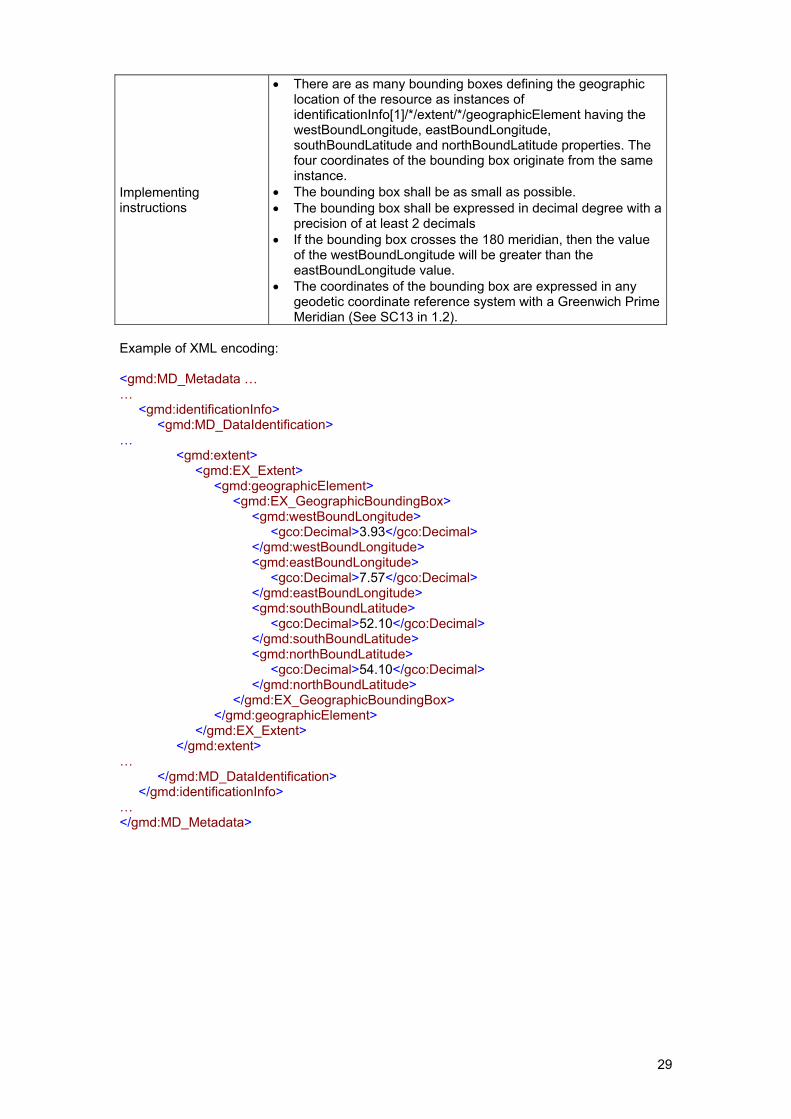
Implementing instructions
• There are as many bounding boxes defining the geographic location of the resource as instances of identificationInfo[1]/*/extent/*/geographicElement having the westBoundLongitude, eastBoundLongitude, southBoundLatitude and northBoundLatitude properties. The four coordinates of the bounding box originate from the same instance.
• The bounding box shall be as small as possible. • The bounding box shall be expressed in decimal degree with a
precision of at least 2 decimals • If the bounding box crosses the 180 meridian, then the value
of the westBoundLongitude will be greater than the eastBoundLongitude value.
• The coordinates of the bounding box are expressed in any geodetic coordinate reference system with a Greenwich Prime Meridian (See SC13 in 1.2).
Example of XML encoding: <gmd:MD_Metadata … … <gmd:identificationInfo> <gmd:MD_DataIdentification> … <gmd:extent> <gmd:EX_Extent> <gmd:geographicElement> <gmd:EX_GeographicBoundingBox> <gmd:westBoundLongitude> <gco:Decimal>3.93</gco:Decimal> </gmd:westBoundLongitude> <gmd:eastBoundLongitude> <gco:Decimal>7.57</gco:Decimal> </gmd:eastBoundLongitude> <gmd:southBoundLatitude> <gco:Decimal>52.10</gco:Decimal> </gmd:southBoundLatitude> <gmd:northBoundLatitude> <gco:Decimal>54.10</gco:Decimal> </gmd:northBoundLatitude> </gmd:EX_GeographicBoundingBox> </gmd:geographicElement> </gmd:EX_Extent> </gmd:extent> … </gmd:MD_DataIdentification> </gmd:identificationInfo> … </gmd:MD_Metadata>
30
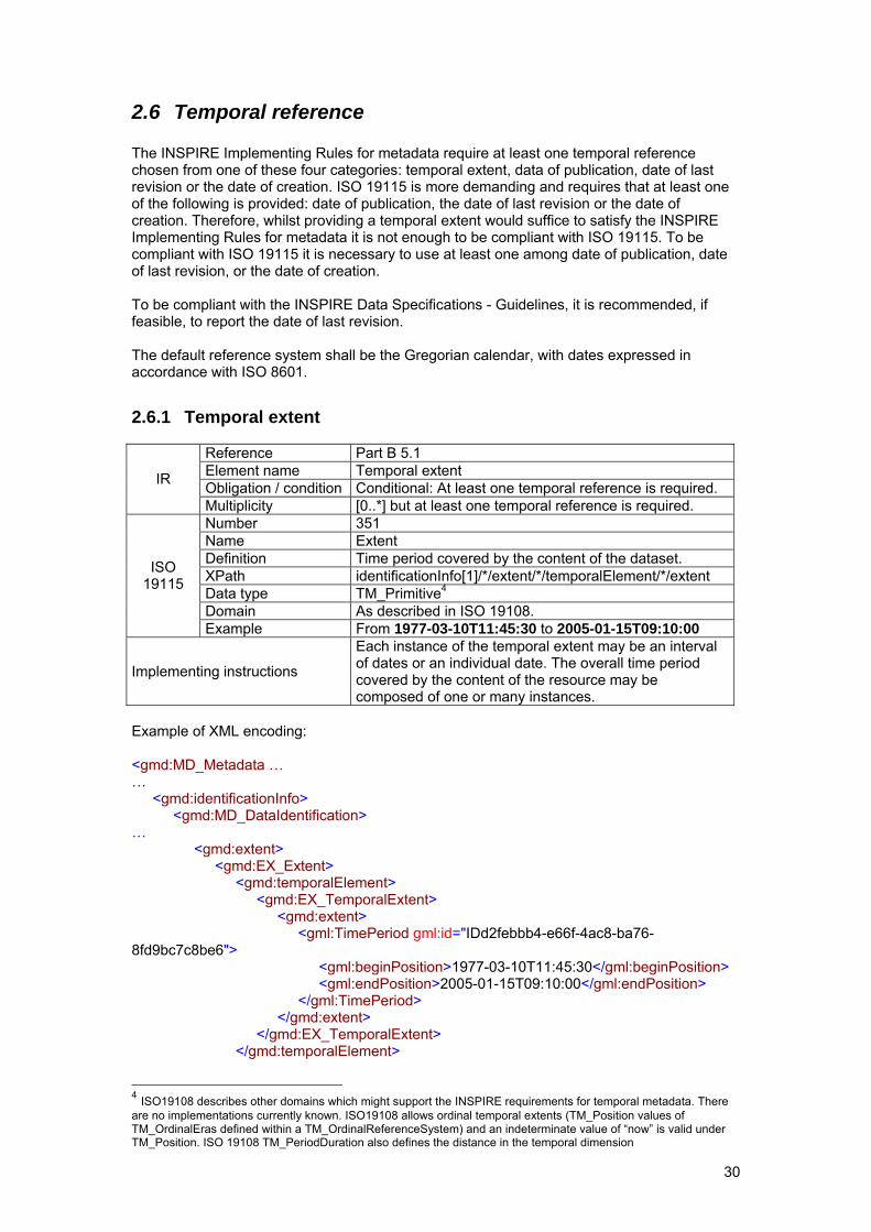
2.6 Temporal reference The INSPIRE Implementing Rules for metadata require at least one temporal reference chosen from one of these four categories: temporal extent, data of publication, date of last revision or the date of creation. ISO 19115 is more demanding and requires that at least one of the following is provided: date of publication, the date of last revision or the date of creation. Therefore, whilst providing a temporal extent would suffice to satisfy the INSPIRE Implementing Rules for metadata it is not enough to be compliant with ISO 19115. To be compliant with ISO 19115 it is necessary to use at least one among date of publication, date of last revision, or the date of creation. To be compliant with the INSPIRE Data Specifications - Guidelines, it is recommended, if feasible, to report the date of last revision. The default reference system shall be the Gregorian calendar, with dates expressed in accordance with ISO 8601.
2.6.1 Temporal extent
Reference Part B 5.1 Element name Temporal extent Obligation / condition Conditional: At least one temporal reference is required. IR
Multiplicity [0..*] but at least one temporal reference is required. Number 351 Name Extent Definition Time period covered by the content of the dataset. XPath identificationInfo[1]/*/extent/*/temporalElement/*/extent Data type TM_Primitive4 Domain As described in ISO 19108.
ISO 19115
Example From 1977-03-10T11:45:30 to 2005-01-15T09:10:00
Implementing instructions
Each instance of the temporal extent may be an interval of dates or an individual date. The overall time period covered by the content of the resource may be composed of one or many instances.
Example of XML encoding: <gmd:MD_Metadata … … <gmd:identificationInfo> <gmd:MD_DataIdentification> … <gmd:extent> <gmd:EX_Extent> <gmd:temporalElement> <gmd:EX_TemporalExtent> <gmd:extent> <gml:TimePeriod gml:id="IDd2febbb4-e66f-4ac8-ba76-8fd9bc7c8be6"> <gml:beginPosition>1977-03-10T11:45:30</gml:beginPosition> <gml:endPosition>2005-01-15T09:10:00</gml:endPosition> </gml:TimePeriod> </gmd:extent> </gmd:EX_TemporalExtent> </gmd:temporalElement>
4 ISO19108 describes other domains which might support the INSPIRE requirements for temporal metadata. There are no implementations currently known. ISO19108 allows ordinal temporal extents (TM_Position values of TM_OrdinalEras defined within a TM_OrdinalReferenceSystem) and an indeterminate value of “now” is valid under TM_Position. ISO 19108 TM_PeriodDuration also defines the distance in the temporal dimension
31
</gmd:EX_Extent> </gmd:extent> … </gmd:MD_DataIdentification> … </gmd:identificationInfo> ... </gmd:MD_Metadata>
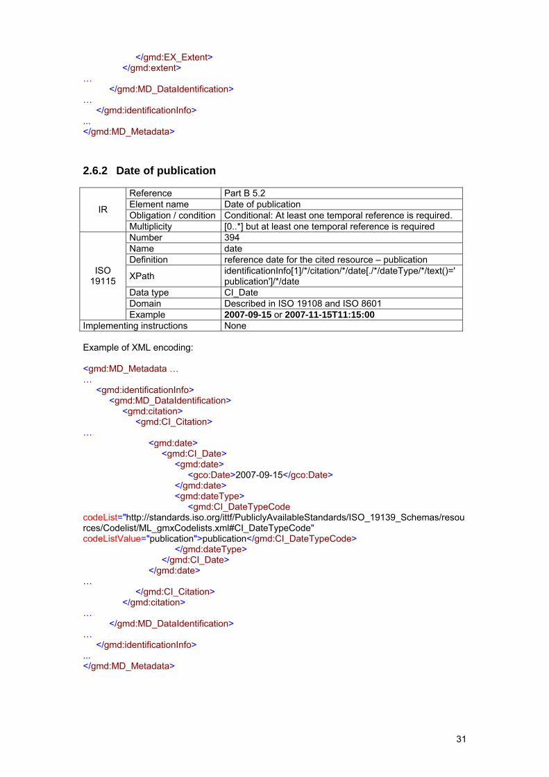
2.6.2 Date of publication
Reference Part B 5.2 Element name Date of publication Obligation / condition Conditional: At least one temporal reference is required. IR
Multiplicity [0..*] but at least one temporal reference is required Number 394 Name date Definition reference date for the cited resource – publication
XPath identificationInfo[1]/*/citation/*/date[./*/dateType/*/text()='publication']/*/date
Data type CI_Date Domain Described in ISO 19108 and ISO 8601
ISO 19115
Example 2007-09-15 or 2007-11-15T11:15:00 Implementing instructions None Example of XML encoding: <gmd:MD_Metadata … … <gmd:identificationInfo> <gmd:MD_DataIdentification> <gmd:citation> <gmd:CI_Citation> … <gmd:date> <gmd:CI_Date> <gmd:date> <gco:Date>2007-09-15</gco:Date> </gmd:date> <gmd:dateType> <gmd:CI_DateTypeCode codeList="http://standards.iso.org/ittf/PubliclyAvailableStandards/ISO_19139_Schemas/resources/Codelist/ML_gmxCodelists.xml#CI_DateTypeCode" codeListValue="publication">publication</gmd:CI_DateTypeCode> </gmd:dateType> </gmd:CI_Date> </gmd:date> … </gmd:CI_Citation> </gmd:citation> … </gmd:MD_DataIdentification> … </gmd:identificationInfo> ... </gmd:MD_Metadata>
32
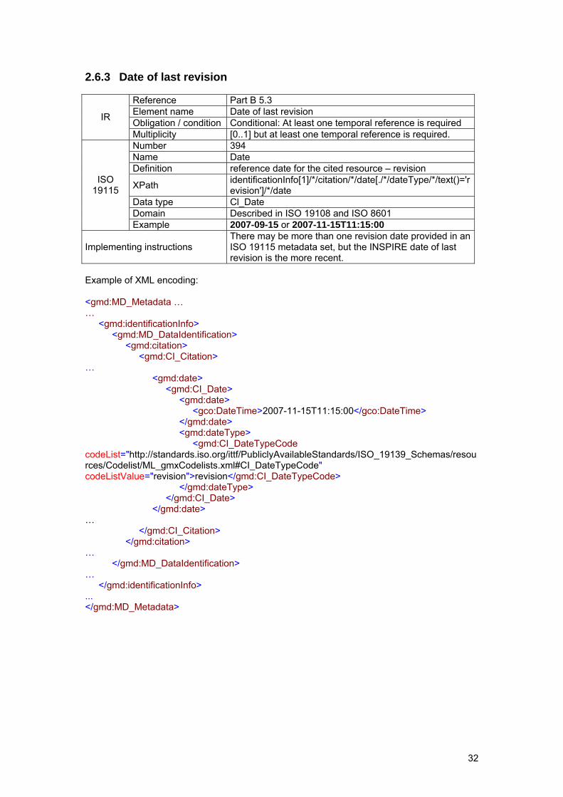
2.6.3 Date of last revision
Reference Part B 5.3 Element name Date of last revision Obligation / condition Conditional: At least one temporal reference is required IR
Multiplicity [0..1] but at least one temporal reference is required. Number 394 Name Date Definition reference date for the cited resource – revision
XPath identificationInfo[1]/*/citation/*/date[./*/dateType/*/text()='revision']/*/date
Data type Cl_Date Domain Described in ISO 19108 and ISO 8601
ISO 19115
Example 2007-09-15 or 2007-11-15T11:15:00
Implementing instructions There may be more than one revision date provided in an ISO 19115 metadata set, but the INSPIRE date of last revision is the more recent.
Example of XML encoding: <gmd:MD_Metadata … … <gmd:identificationInfo> <gmd:MD_DataIdentification> <gmd:citation> <gmd:CI_Citation> … <gmd:date> <gmd:CI_Date> <gmd:date> <gco:DateTime>2007-11-15T11:15:00</gco:DateTime> </gmd:date> <gmd:dateType> <gmd:CI_DateTypeCode codeList="http://standards.iso.org/ittf/PubliclyAvailableStandards/ISO_19139_Schemas/resources/Codelist/ML_gmxCodelists.xml#CI_DateTypeCode" codeListValue="revision">revision</gmd:CI_DateTypeCode> </gmd:dateType> </gmd:CI_Date> </gmd:date> … </gmd:CI_Citation> </gmd:citation> … </gmd:MD_DataIdentification> … </gmd:identificationInfo> ... </gmd:MD_Metadata>
33
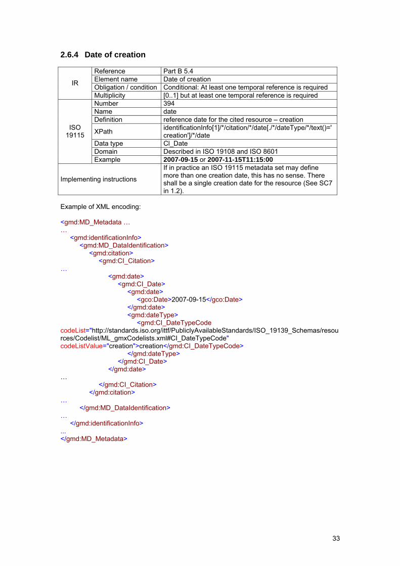
2.6.4 Date of creation
Reference Part B 5.4 Element name Date of creation Obligation / condition Conditional: At least one temporal reference is required IR
Multiplicity [0..1] but at least one temporal reference is required Number 394 Name date Definition reference date for the cited resource – creation
XPath identificationInfo[1]/*/citation/*/date[./*/dateType/*/text()='creation']/*/date
Data type Cl_Date Domain Described in ISO 19108 and ISO 8601
ISO 19115
Example 2007-09-15 or 2007-11-15T11:15:00
Implementing instructions
If in practice an ISO 19115 metadata set may define more than one creation date, this has no sense. There shall be a single creation date for the resource (See SC7 in 1.2).
Example of XML encoding: <gmd:MD_Metadata … … <gmd:identificationInfo> <gmd:MD_DataIdentification> <gmd:citation> <gmd:CI_Citation> … <gmd:date> <gmd:CI_Date> <gmd:date> <gco:Date>2007-09-15</gco:Date> </gmd:date> <gmd:dateType> <gmd:CI_DateTypeCode codeList="http://standards.iso.org/ittf/PubliclyAvailableStandards/ISO_19139_Schemas/resources/Codelist/ML_gmxCodelists.xml#CI_DateTypeCode" codeListValue="creation">creation</gmd:CI_DateTypeCode> </gmd:dateType> </gmd:CI_Date> </gmd:date> … </gmd:CI_Citation> </gmd:citation> … </gmd:MD_DataIdentification> … </gmd:identificationInfo> ... </gmd:MD_Metadata>
34
2.7 Quality and validity
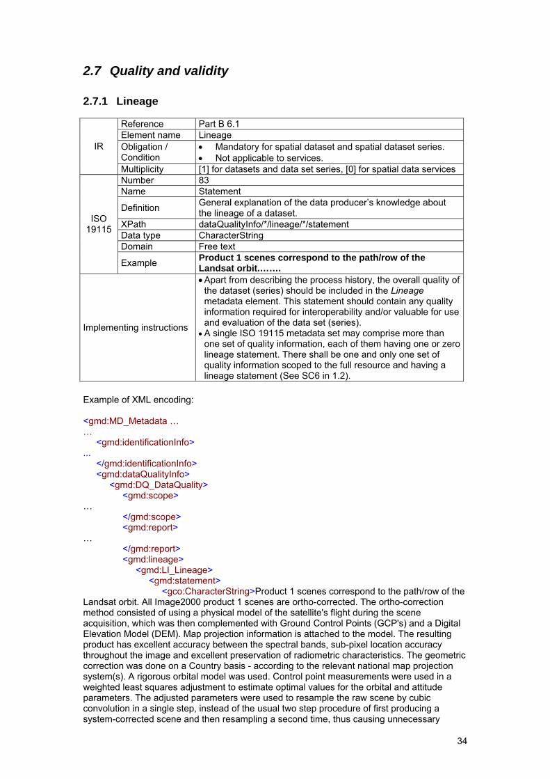
2.7.1 Lineage
Reference Part B 6.1 Element name Lineage Obligation / Condition
• Mandatory for spatial dataset and spatial dataset series. • Not applicable to services.
IR
Multiplicity [1] for datasets and data set series, [0] for spatial data services Number 83 Name Statement
Definition General explanation of the data producer’s knowledge about the lineage of a dataset.
XPath dataQualityInfo/*/lineage/*/statement Data type CharacterString Domain Free text
ISO 19115
Example Product 1 scenes correspond to the path/row of the Landsat orbit.…….
Implementing instructions
• Apart from describing the process history, the overall quality of the dataset (series) should be included in the Lineage metadata element. This statement should contain any quality information required for interoperability and/or valuable for use and evaluation of the data set (series).
• A single ISO 19115 metadata set may comprise more than one set of quality information, each of them having one or zero lineage statement. There shall be one and only one set of quality information scoped to the full resource and having a lineage statement (See SC6 in 1.2).
Example of XML encoding: <gmd:MD_Metadata … … <gmd:identificationInfo> ... </gmd:identificationInfo> <gmd:dataQualityInfo> <gmd:DQ_DataQuality> <gmd:scope> … </gmd:scope> <gmd:report> … </gmd:report> <gmd:lineage> <gmd:LI_Lineage> <gmd:statement> <gco:CharacterString>Product 1 scenes correspond to the path/row of the Landsat orbit. All Image2000 product 1 scenes are ortho-corrected. The ortho-correction method consisted of using a physical model of the satellite's flight during the scene acquisition, which was then complemented with Ground Control Points (GCP's) and a Digital Elevation Model (DEM). Map projection information is attached to the model. The resulting product has excellent accuracy between the spectral bands, sub-pixel location accuracy throughout the image and excellent preservation of radiometric characteristics. The geometric correction was done on a Country basis - according to the relevant national map projection system(s). A rigorous orbital model was used. Control point measurements were used in a weighted least squares adjustment to estimate optimal values for the orbital and attitude parameters. The adjusted parameters were used to resample the raw scene by cubic convolution in a single step, instead of the usual two step procedure of first producing a system-corrected scene and then resampling a second time, thus causing unnecessary
35
smoothing of the data. The final pixel size after resampling is 12.5m for the panchromatic band, 25m for the multispectral bands and 60m for the thermal band. All the orthorectified scenes are well within the requirement of Root Mean Square Error (RMSE) > 25m.</gco:CharacterString> </gmd:statement> </gmd:LI_Lineage> </gmd:lineage> </gmd:DQ_DataQuality> </gmd:dataQualityInfo> </gmd:MD_Metadata>
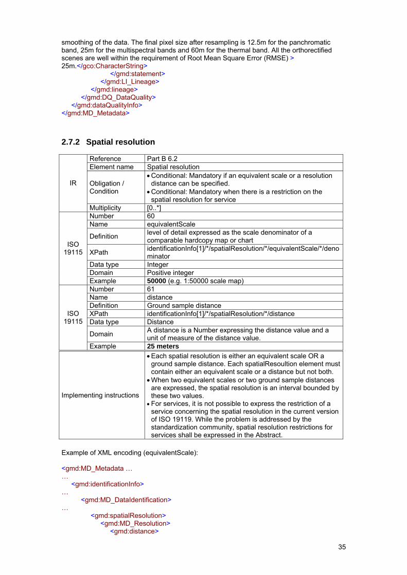
2.7.2 Spatial resolution
Reference Part B 6.2 Element name Spatial resolution
Obligation / Condition
• Conditional: Mandatory if an equivalent scale or a resolution distance can be specified.
• Conditional: Mandatory when there is a restriction on the spatial resolution for service
IR
Multiplicity [0..*] Number 60 Name equivalentScale
Definition level of detail expressed as the scale denominator of a comparable hardcopy map or chart
XPath identificationInfo[1]/*/spatialResolution/*/equivalentScale/*/denominator
Data type Integer Domain Positive integer
ISO 19115
Example 50000 (e.g. 1:50000 scale map) Number 61 Name distance Definition Ground sample distance XPath identificationInfo[1]/*/spatialResolution/*/distance Data type Distance
Domain A distance is a Number expressing the distance value and a unit of measure of the distance value.
ISO 19115
Example 25 meters
Implementing instructions
• Each spatial resolution is either an equivalent scale OR a ground sample distance. Each spatialResoultion element must contain either an equivalent scale or a distance but not both.
• When two equivalent scales or two ground sample distances are expressed, the spatial resolution is an interval bounded by these two values.
• For services, it is not possible to express the restriction of a service concerning the spatial resolution in the current version of ISO 19119. While the problem is addressed by the standardization community, spatial resolution restrictions for services shall be expressed in the Abstract.
Example of XML encoding (equivalentScale): <gmd:MD_Metadata … … <gmd:identificationInfo> … <gmd:MD_DataIdentification> … <gmd:spatialResolution> <gmd:MD_Resolution> <gmd:distance>

36
…(see next example) </gmd:distance> </gmd:MD_Resolution> </gmd:spatialResolution> <gmd:spatialResolution> <gmd:MD_Resolution> <gmd:equivalentScale> <gmd:MD_RepresentativeFraction> <gmd:denominator> <gco:Integer>50000</gco:Integer> </gmd:denominator> </gmd:MD_RepresentativeFraction> </gmd:equivalentScale> </gmd:MD_Resolution> </gmd:spatialResolution> … </gmd:MD_DataIdentification> </gmd:identificationInfo> … </gmd:MD_Metadata> Example of XML encoding (distance): <gmd:MD_Metadata … … <gmd:identificationInfo> … <gmd:MD_DataIdentification> … <gmd:spatialResolution> <gmd:MD_Resolution> <gmd:distance> <gco:Distance uom="http://standards.iso.org/ittf/PubliclyAvailableStandards/ISO_19139_Schemas/resources/uom/ML_gmxUom.xml#m">25.0</gco:Distance> </gmd:distance> </gmd:MD_Resolution> </gmd:spatialResolution> <gmd:spatialResolution> <gmd:MD_Resolution> <gmd:equivalentScale> …(see previous example) </gmd:equivalentScale> </gmd:MD_Resolution> </gmd:spatialResolution> … </gmd:MD_DataIdentification> </gmd:identificationInfo> … </gmd:MD_Metadata>
37
2.8 Conformity In conformance to Directive 2007/2/EC, the metadata shall include information on the degree of conformity with the implementing rules provided in Art. 7-1. ISO 19115 provides a mechanism for reporting about the evaluation of the conformity of the resource against a given specification. This mechanism is used here to handle the conformity requirements of INSPIRE. The Implementing Rules for metadata defines in Part D 5 three degrees of conformity: conformant, not conformant and not evaluated. The expression of these three degrees follows the following rules:
• When the conformity to an INSPIRE Specification has been evaluated, it shall be reported as a domain consistency element (i.e. an instance of DQ_DomainConsistency) in ISO 19115 metadata (see 2.8.1). In that case, if the evaluation has passed, the degree is conformant, otherwise it is not conformant.
• The absence5 of ISO 19115 metadata related to the conformity to an INSPIRE specification does imply that the conformity to this specification has not been evaluated.
Known relevant specifications include the INSPIRE Data Specification guidelines6 established for each INSPIRE theme. The Specification element should be given as follows: - title: “INSPIRE Data Specification on <Theme Name> –Guidelines” - date: - dateType: publication It is acknowledged that the title of the specification may be in any of the official languages of the European Union. Other relevant specifications may have to be considered at a later stage. An identification mechanism corresponding to the nature of these specifications will then be defined. When the metadata does not contain any information about one of these specifications, the user applications exploiting the metadata shall report that the conformity to that specification has not been evaluated. Therefore, the general process for exploiting the metadata is for each INSPIRE conformity specification to:
• check using the quality measure identifier defined for the specification whether the conformance to any INSPIRE specification has been reported;
• for each known relevant specification: o report that the conformity to this specification has not been evaluated if none
of the INSPIRE conformity statement relates to it; o exploit the metadata, i.e. the description of the specification and the degree of
conformity, as stated hereafter when the specification has been evaluated.
5 In ISO 19115, it is possible to report about the conformity to a specification when it has been evaluated, but the only
way to express the fact that the conformity with a given specification has not been evaluated is not to report anything in the metadata.
6 A common abstract test suite including detailed instructions on how to test each requirement will be defined at a later stage.
38
2.8.1 Degree
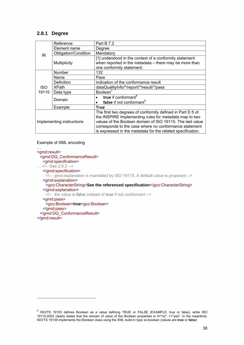
Reference Part B 7.2 Element name Degree Obligation/Condition Mandatory IR
Multiplicity [1] understood in the context of a conformity statement when reported in the metadata – there may be more than one conformity statement.
Number 132 Name Pass Definition indication of the conformance result XPath dataQualityInfo/*/report/*/result/*/pass Data type Boolean7
Domain • true if conformant8 • false if not conformant5
ISO 19115
Example True
Implementing instructions
The first two degrees of conformity defined in Part D 5 of the INSPIRE Implementing rules for metadata map to two values of the Boolean domain of ISO 19115. The last value corresponds to the case where no conformance statement is expressed in the metadata for the related specification.
Example of XML encoding … <gmd:result> <gmd:DQ_ConformanceResult> <gmd:specification> … <!-- See 2.8.2 --> </gmd:specification> <!-- gmd:explanation is mandated by ISO 19115. A default value is proposed --> <gmd:explanation> <gco:CharacterString>See the referenced specification</gco:CharacterString> </gmd:explanation> <!-- the value is false instead of true if not conformant --> <gmd:pass> <gco:Boolean>true<gco:Boolean> </gmd:pass> </gmd:DQ_ConformanceResult> </gmd:result>
8 ISO/TS 19103 defines Boolean as a value defining TRUE or FALSE (EXAMPLE: true or false), while ISO 19115:2003 clearly states that the domain of value of the Boolean properties is 0="no", 1="yes". In the meantime, ISO/TS 19139 implements the Boolean class using the XML build-in type xs:boolean (values are true or false)
39
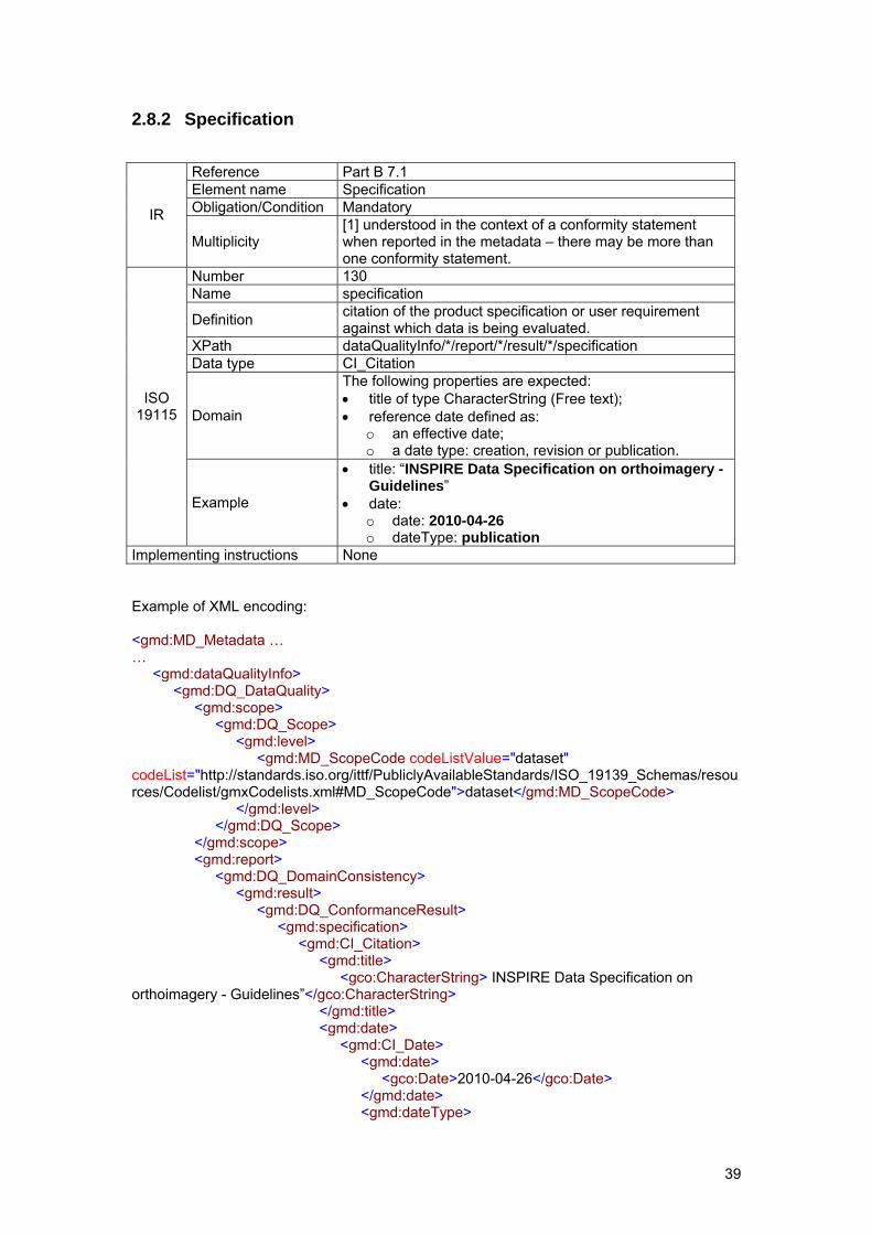
2.8.2 Specification
Reference Part B 7.1 Element name Specification Obligation/Condition Mandatory IR
Multiplicity [1] understood in the context of a conformity statement when reported in the metadata – there may be more than one conformity statement.
Number 130 Name specification
Definition citation of the product specification or user requirement against which data is being evaluated.
XPath dataQualityInfo/*/report/*/result/*/specification Data type CI_Citation
Domain
The following properties are expected: • title of type CharacterString (Free text); • reference date defined as:
o an effective date; o a date type: creation, revision or publication.
ISO 19115
Example
• title: “INSPIRE Data Specification on orthoimagery - Guidelines”
• date: o date: 2010-04-26 o dateType: publication
Implementing instructions None Example of XML encoding: <gmd:MD_Metadata … … <gmd:dataQualityInfo> <gmd:DQ_DataQuality> <gmd:scope> <gmd:DQ_Scope> <gmd:level> <gmd:MD_ScopeCode codeListValue="dataset" codeList="http://standards.iso.org/ittf/PubliclyAvailableStandards/ISO_19139_Schemas/resources/Codelist/gmxCodelists.xml#MD_ScopeCode">dataset</gmd:MD_ScopeCode> </gmd:level> </gmd:DQ_Scope> </gmd:scope> <gmd:report> <gmd:DQ_DomainConsistency> <gmd:result> <gmd:DQ_ConformanceResult> <gmd:specification> <gmd:CI_Citation> <gmd:title> <gco:CharacterString> INSPIRE Data Specification on orthoimagery - Guidelines”</gco:CharacterString> </gmd:title> <gmd:date> <gmd:CI_Date> <gmd:date> <gco:Date>2010-04-26</gco:Date> </gmd:date> <gmd:dateType>
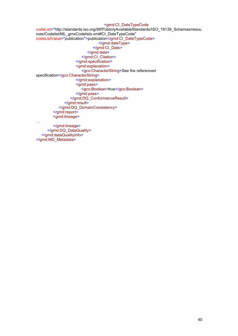
40
<gmd:CI_DateTypeCode codeList="http://standards.iso.org/ittf/PubliclyAvailableStandards/ISO_19139_Schemas/resources/Codelist/ML_gmxCodelists.xml#CI_DateTypeCode" codeListValue="publication">publication</gmd:CI_DateTypeCode> </gmd:dateType> </gmd:CI_Date> </gmd:date> </gmd:CI_Citation> </gmd:specification> <gmd:explanation> <gco:CharacterString>See the referenced specification</gco:CharacterString> </gmd:explanation> <gmd:pass> <gco:Boolean>true</gco:Boolean> </gmd:pass> </gmd:DQ_ConformanceResult> </gmd:result> </gmd:DQ_DomainConsistency> </gmd:report> <gmd:lineage> … </gmd:lineage> </gmd:DQ_DataQuality> </gmd:dataQualityInfo> </gmd:MD_Metadata>
41
2.9 Constraints related to access and use ISO 19115 provides a general mechanism for documenting different categories of constraints applicable to the resource (or its metadata). This mechanism is supported by the class MD_Constraints and its subclasses:
• MD_LegalConstraints for legal constraints; • MD_SecurityConstraints for security constraints.
There are two major requirements expressed in Directive 20007/2/EC in terms of documentation of the constraints as part of the metadata:
• The conditions applying to access and use of the resource, and where applicable, the corresponding fees as required by Articles 5-2(b) and 11-2(f).
• The limitations on public access: the Member States may limit public access to spatial datasets and spatial data services in a set of cases defined in Article 13. These cases include public security or national defence, i.e. more generally the existence of a security constraint.
Each instance of MD_Constraints expresses:
• Zero or One condition applying to access and use (see 2.9.2); • Zero or More limitations on public access (see 2.9.1); • Or, both one or more limitations on public access and a condition applying to access
and use. In any case, there shall be at least one ISO 19115 metadata element representing a limitation on public access (see .2.9.1) and one ISO 19115 metadata element representing a condition applying to access and use (see 2.9.2) as part of the different instances of MD_Constraints and its subclasses. There shall be at least one instance of MD_Constraints or one of its subclasses (See SC12 in Section 1.2) even if there is no limitation on public access or no specific condition applies to access and use of the resource.9 When a single instance is provided in a given metadata set, it shall handle metadata elements representing both at least one condition applying to access and use and at least one limitation on public access in compliance with the mapping provided in 2.9.1 and 2.9.2.
9 If the Resource Type is ‘service’ there might be a conflict with the property ‘restrictions’ of class
‘SV_ServiceIdentification’. This property is also of type MD_Constraints with a multiplicity of 0..1. Any constraint on a service described by this property is out of the scope of the Implementing rules. Instead, the constraints on services shall be defined as stated in clause 2.9.1 and 2.9.2 of this document.
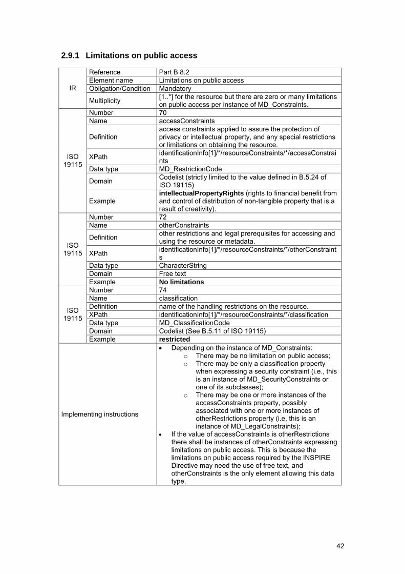
42
2.9.1 Limitations on public access
Reference Part B 8.2 Element name Limitations on public access Obligation/Condition Mandatory IR
Multiplicity [1..*] for the resource but there are zero or many limitations on public access per instance of MD_Constraints.
Number 70 Name accessConstraints
Definition access constraints applied to assure the protection of privacy or intellectual property, and any special restrictions or limitations on obtaining the resource.
XPath identificationInfo[1]/*/resourceConstraints/*/accessConstraints
Data type MD_RestrictionCode
Domain Codelist (strictly limited to the value defined in B.5.24 of ISO 19115)
ISO 19115
Example intellectualPropertyRights (rights to financial benefit from and control of distribution of non-tangible property that is a result of creativity).
Number 72 Name otherConstraints
Definition other restrictions and legal prerequisites for accessing and using the resource or metadata.
XPath identificationInfo[1]/*/resourceConstraints/*/otherConstraints
Data type CharacterString Domain Free text
ISO 19115
Example No limitations Number 74 Name classification Definition name of the handling restrictions on the resource. XPath identificationInfo[1]/*/resourceConstraints/*/classification Data type MD_ClassificationCode Domain Codelist (See B.5.11 of ISO 19115)
ISO 19115
Example restricted
Implementing instructions
• Depending on the instance of MD_Constraints: o There may be no limitation on public access; o There may be only a classification property
when expressing a security constraint (i.e., this is an instance of MD_SecurityConstraints or one of its subclasses);
o There may be one or more instances of the accessConstraints property, possibly associated with one or more instances of otherRestrictions property (i.e, this is an instance of MD_LegalConstraints);
• If the value of accessConstraints is otherRestrictions there shall be instances of otherConstraints expressing limitations on public access. This is because the limitations on public access required by the INSPIRE Directive may need the use of free text, and otherConstraints is the only element allowing this data type.
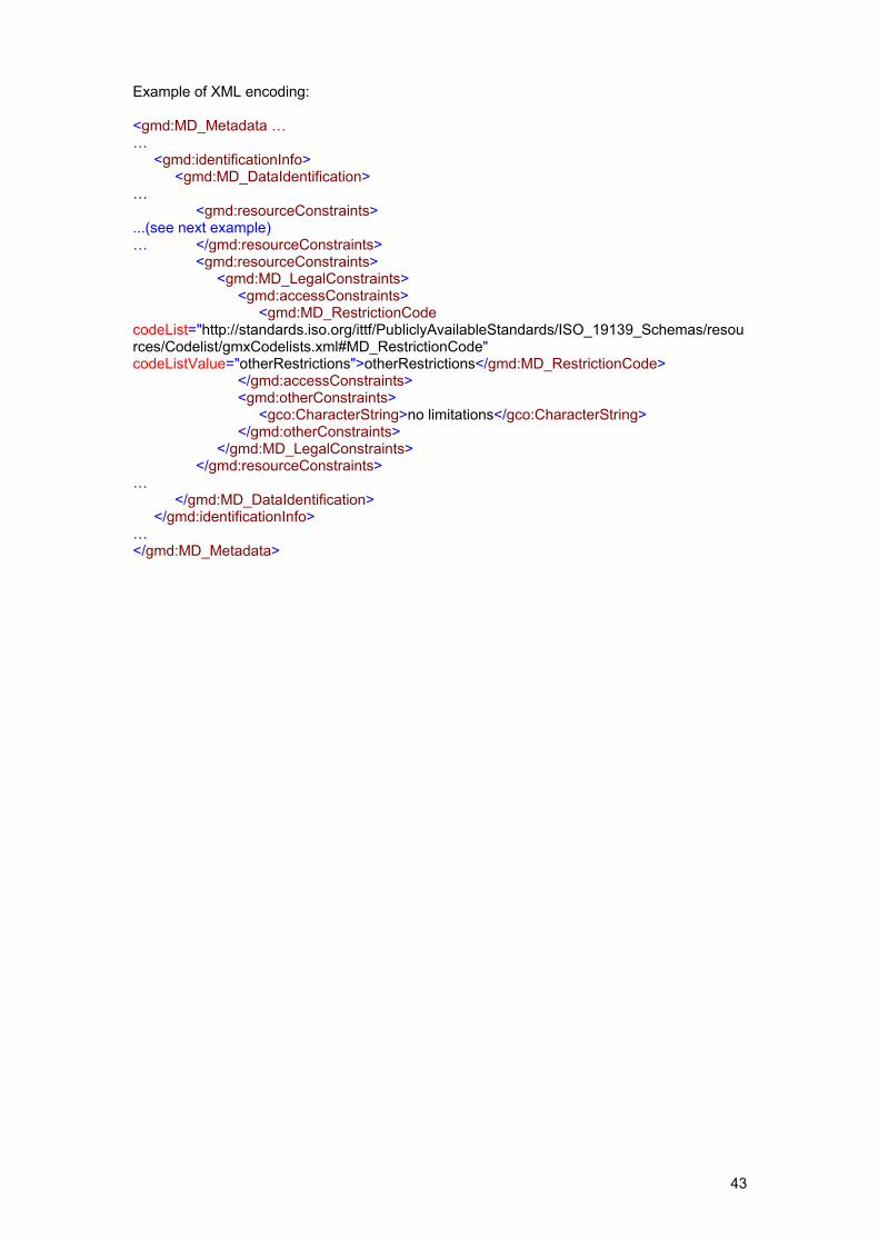
43
Example of XML encoding: <gmd:MD_Metadata … … <gmd:identificationInfo> <gmd:MD_DataIdentification> … <gmd:resourceConstraints> ...(see next example) … </gmd:resourceConstraints> <gmd:resourceConstraints> <gmd:MD_LegalConstraints> <gmd:accessConstraints> <gmd:MD_RestrictionCode codeList="http://standards.iso.org/ittf/PubliclyAvailableStandards/ISO_19139_Schemas/resources/Codelist/gmxCodelists.xml#MD_RestrictionCode" codeListValue="otherRestrictions">otherRestrictions</gmd:MD_RestrictionCode> </gmd:accessConstraints> <gmd:otherConstraints> <gco:CharacterString>no limitations</gco:CharacterString> </gmd:otherConstraints> </gmd:MD_LegalConstraints> </gmd:resourceConstraints> … </gmd:MD_DataIdentification> </gmd:identificationInfo> … </gmd:MD_Metadata>
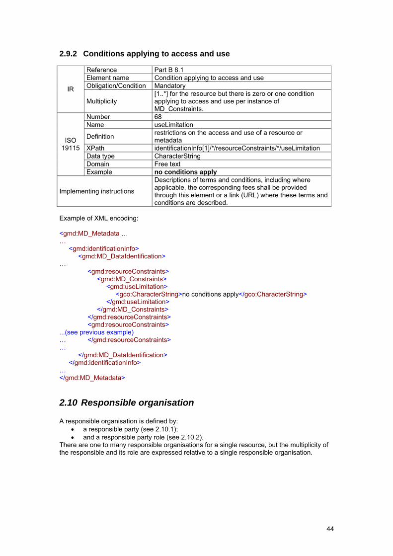
44
2.9.2 Conditions applying to access and use
Reference Part B 8.1 Element name Condition applying to access and use Obligation/Condition Mandatory IR
Multiplicity [1..*] for the resource but there is zero or one condition applying to access and use per instance of MD_Constraints.
Number 68 Name useLimitation
Definition restrictions on the access and use of a resource or metadata
XPath identificationInfo[1]/*/resourceConstraints/*/useLimitation Data type CharacterString Domain Free text
ISO 19115
Example no conditions apply
Implementing instructions
Descriptions of terms and conditions, including where applicable, the corresponding fees shall be provided through this element or a link (URL) where these terms and conditions are described.
Example of XML encoding: <gmd:MD_Metadata … … <gmd:identificationInfo> <gmd:MD_DataIdentification> … <gmd:resourceConstraints> <gmd:MD_Constraints> <gmd:useLimitation> <gco:CharacterString>no conditions apply</gco:CharacterString> </gmd:useLimitation> </gmd:MD_Constraints> </gmd:resourceConstraints> <gmd:resourceConstraints> ...(see previous example) … </gmd:resourceConstraints> … </gmd:MD_DataIdentification> </gmd:identificationInfo> … </gmd:MD_Metadata>
2.10 Responsible organisation A responsible organisation is defined by:
• a responsible party (see 2.10.1); • and a responsible party role (see 2.10.2).
There are one to many responsible organisations for a single resource, but the multiplicity of the responsible and its role are expressed relative to a single responsible organisation.
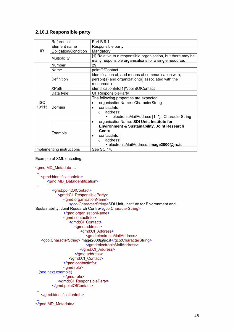
45
2.10.1 Responsible party
Reference Part B 9.1 Element name Responsible party Obligation/Condition Mandatory IR
Multiplicity [1] Relative to a responsible organisation, but there may be many responsible organisations for a single resource.
Number 29 Name pointOfContact
Definition identification of, and means of communication with, person(s) and organization(s) associated with the resource(s)
XPath identificationInfo[1]/*/pointOfContact Data type CI_ResponsibleParty
Domain
The following properties are expected: • organisationName : CharacterString • contactInfo:
o address: electronicMailAddress [1..*] : CharacterString
ISO 19115
Example
• organisationName: SDI Unit, Institute for Environment & Sustainability, Joint Research Centre
• contactInfo: o address:
electronicMailAddress: [email protected] Implementing instructions See SC 14. Example of XML encoding: <gmd:MD_Metadata … … <gmd:identificationInfo> <gmd:MD_DataIdentification> … <gmd:pointOfContact> <gmd:CI_ResponsibleParty> <gmd:organisationName> <gco:CharacterString>SDI Unit, Institute for Environment and Sustainability, Joint Research Centre</gco:CharacterString> </gmd:organisationName> <gmd:contactInfo> <gmd:CI_Contact> <gmd:address> <gmd:CI_Address> <gmd:electronicMailAddress> <gco:CharacterString>[email protected]</gco:CharacterString> </gmd:electronicMailAddress> </gmd:CI_Address> </gmd:address> </gmd:CI_Contact> </gmd:contactInfo> <gmd:role> ...(see next example) </gmd:role> </gmd:CI_ResponsibleParty> </gmd:pointOfContact> … </gmd:identificationInfo> … </gmd:MD_Metadata>
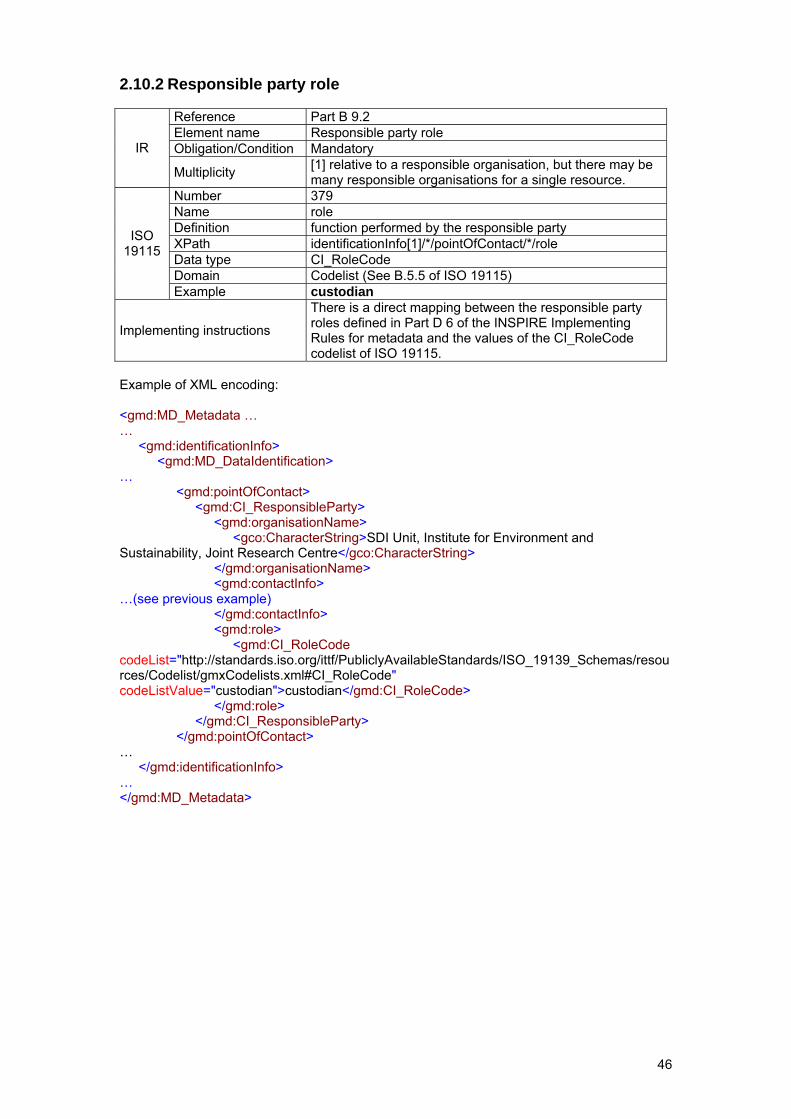
46
2.10.2 Responsible party role
Reference Part B 9.2 Element name Responsible party role Obligation/Condition Mandatory IR
Multiplicity [1] relative to a responsible organisation, but there may be many responsible organisations for a single resource.
Number 379 Name role Definition function performed by the responsible party XPath identificationInfo[1]/*/pointOfContact/*/role Data type CI_RoleCode Domain Codelist (See B.5.5 of ISO 19115)
ISO 19115
Example custodian
Implementing instructions
There is a direct mapping between the responsible party roles defined in Part D 6 of the INSPIRE Implementing Rules for metadata and the values of the CI_RoleCode codelist of ISO 19115.
Example of XML encoding: <gmd:MD_Metadata … … <gmd:identificationInfo> <gmd:MD_DataIdentification> … <gmd:pointOfContact> <gmd:CI_ResponsibleParty> <gmd:organisationName> <gco:CharacterString>SDI Unit, Institute for Environment and Sustainability, Joint Research Centre</gco:CharacterString> </gmd:organisationName> <gmd:contactInfo> …(see previous example) </gmd:contactInfo> <gmd:role> <gmd:CI_RoleCode codeList="http://standards.iso.org/ittf/PubliclyAvailableStandards/ISO_19139_Schemas/resources/Codelist/gmxCodelists.xml#CI_RoleCode" codeListValue="custodian">custodian</gmd:CI_RoleCode> </gmd:role> </gmd:CI_ResponsibleParty> </gmd:pointOfContact> … </gmd:identificationInfo> … </gmd:MD_Metadata>
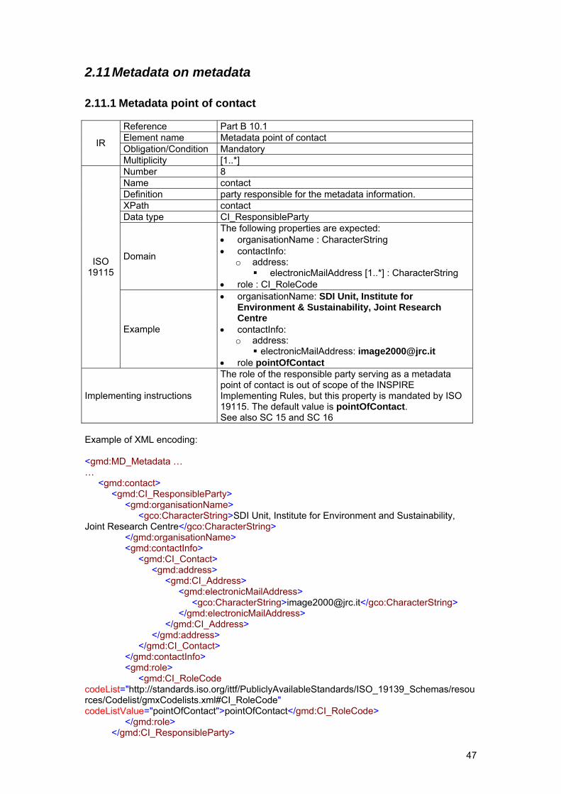
47
2.11 Metadata on metadata
2.11.1 Metadata point of contact
Reference Part B 10.1 Element name Metadata point of contact Obligation/Condition Mandatory IR
Multiplicity [1..*] Number 8 Name contact Definition party responsible for the metadata information. XPath contact Data type CI_ResponsibleParty
Domain
The following properties are expected: • organisationName : CharacterString • contactInfo:
o address: electronicMailAddress [1..*] : CharacterString
• role : CI_RoleCode
ISO 19115
Example
• organisationName: SDI Unit, Institute for Environment & Sustainability, Joint Research Centre
• contactInfo: o address:
electronicMailAddress: [email protected] • role pointOfContact
Implementing instructions
The role of the responsible party serving as a metadata point of contact is out of scope of the INSPIRE Implementing Rules, but this property is mandated by ISO 19115. The default value is pointOfContact. See also SC 15 and SC 16
Example of XML encoding: <gmd:MD_Metadata … … <gmd:contact> <gmd:CI_ResponsibleParty> <gmd:organisationName> <gco:CharacterString>SDI Unit, Institute for Environment and Sustainability, Joint Research Centre</gco:CharacterString> </gmd:organisationName> <gmd:contactInfo> <gmd:CI_Contact> <gmd:address> <gmd:CI_Address> <gmd:electronicMailAddress> <gco:CharacterString>[email protected]</gco:CharacterString> </gmd:electronicMailAddress> </gmd:CI_Address> </gmd:address> </gmd:CI_Contact> </gmd:contactInfo> <gmd:role> <gmd:CI_RoleCode codeList="http://standards.iso.org/ittf/PubliclyAvailableStandards/ISO_19139_Schemas/resources/Codelist/gmxCodelists.xml#CI_RoleCode" codeListValue="pointOfContact">pointOfContact</gmd:CI_RoleCode> </gmd:role> </gmd:CI_ResponsibleParty>
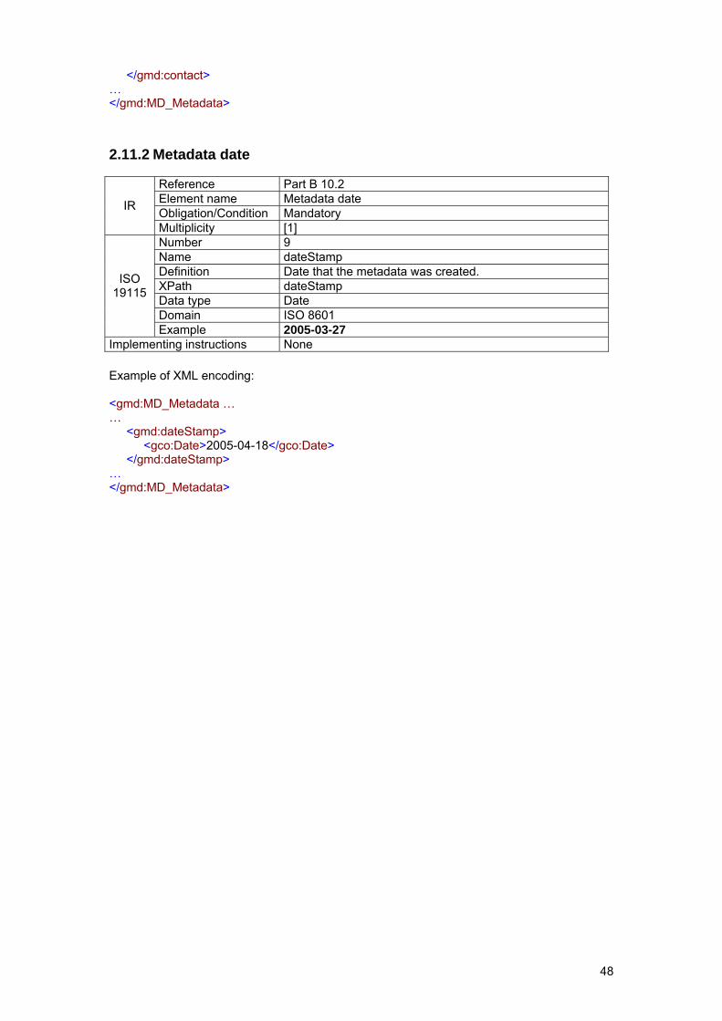
48
</gmd:contact> … </gmd:MD_Metadata>
2.11.2 Metadata date
Reference Part B 10.2 Element name Metadata date Obligation/Condition Mandatory IR
Multiplicity [1] Number 9 Name dateStamp Definition Date that the metadata was created. XPath dateStamp Data type Date Domain ISO 8601
ISO 19115
Example 2005-03-27 Implementing instructions None Example of XML encoding: <gmd:MD_Metadata … … <gmd:dateStamp> <gco:Date>2005-04-18</gco:Date> </gmd:dateStamp> … </gmd:MD_Metadata>
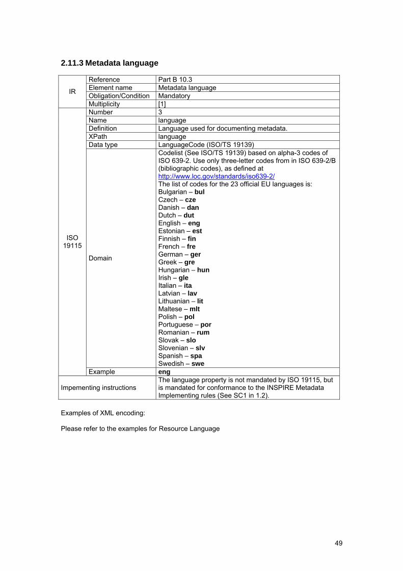
49
2.11.3 Metadata language
Reference Part B 10.3 Element name Metadata language Obligation/Condition Mandatory IR
Multiplicity [1] Number 3 Name language Definition Language used for documenting metadata. XPath language Data type LanguageCode (ISO/TS 19139)
Domain
Codelist (See ISO/TS 19139) based on alpha-3 codes of ISO 639-2. Use only three-letter codes from in ISO 639-2/B (bibliographic codes), as defined at http://www.loc.gov/standards/iso639-2/ The list of codes for the 23 official EU languages is: Bulgarian – bul Czech – cze Danish – dan Dutch – dut English – eng Estonian – est Finnish – fin French – fre German – ger Greek – gre Hungarian – hun Irish – gle Italian – ita Latvian – lav Lithuanian – lit Maltese – mlt Polish – pol Portuguese – por Romanian – rum Slovak – slo Slovenian – slv Spanish – spa Swedish – swe
ISO 19115
Example eng
Impementing instructions The language property is not mandated by ISO 19115, but is mandated for conformance to the INSPIRE Metadata Implementing rules (See SC1 in 1.2).
Examples of XML encoding: Please refer to the examples for Resource Language
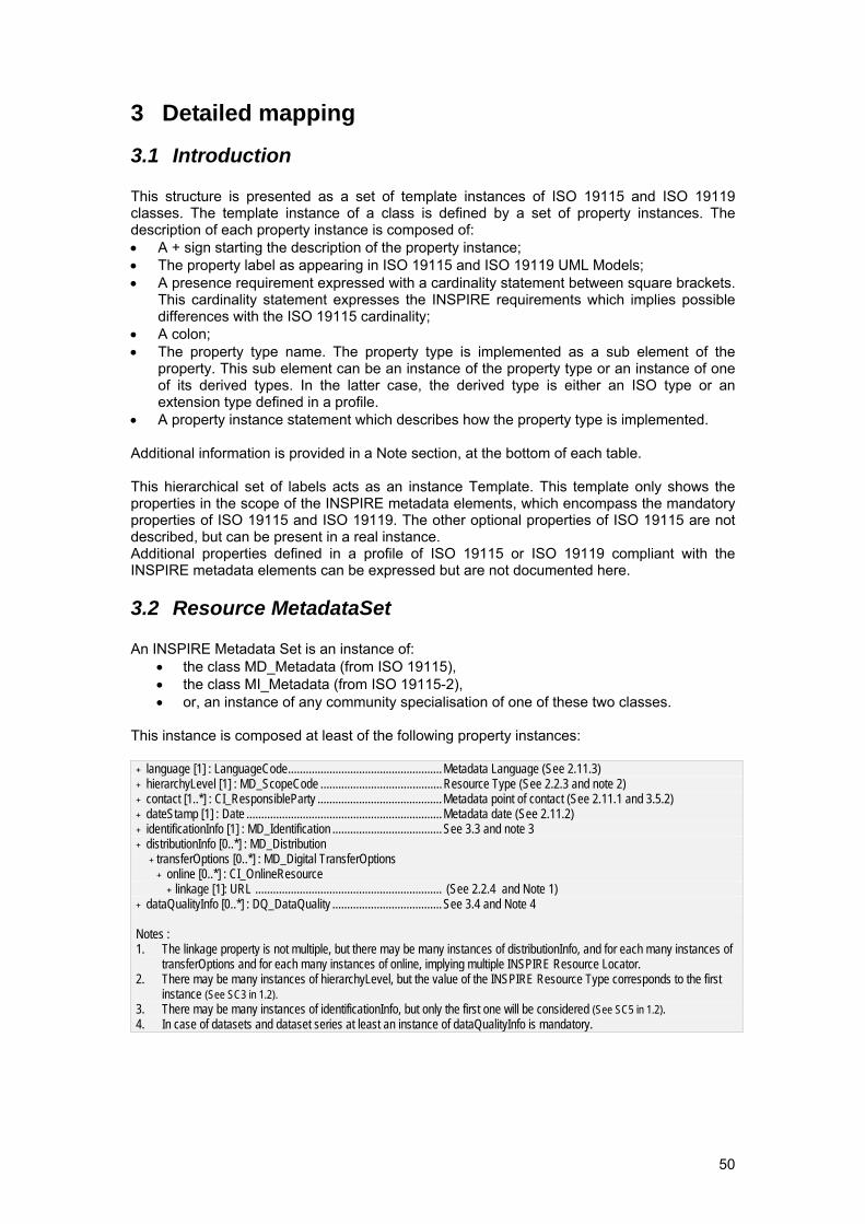
50
3 Detailed mapping
3.1 Introduction This structure is presented as a set of template instances of ISO 19115 and ISO 19119 classes. The template instance of a class is defined by a set of property instances. The description of each property instance is composed of: • A + sign starting the description of the property instance; • The property label as appearing in ISO 19115 and ISO 19119 UML Models; • A presence requirement expressed with a cardinality statement between square brackets.
This cardinality statement expresses the INSPIRE requirements which implies possible differences with the ISO 19115 cardinality;
• A colon; • The property type name. The property type is implemented as a sub element of the
property. This sub element can be an instance of the property type or an instance of one of its derived types. In the latter case, the derived type is either an ISO type or an extension type defined in a profile.
• A property instance statement which describes how the property type is implemented. Additional information is provided in a Note section, at the bottom of each table. This hierarchical set of labels acts as an instance Template. This template only shows the properties in the scope of the INSPIRE metadata elements, which encompass the mandatory properties of ISO 19115 and ISO 19119. The other optional properties of ISO 19115 are not described, but can be present in a real instance. Additional properties defined in a profile of ISO 19115 or ISO 19119 compliant with the INSPIRE metadata elements can be expressed but are not documented here.
3.2 Resource MetadataSet An INSPIRE Metadata Set is an instance of:
• the class MD_Metadata (from ISO 19115), • the class MI_Metadata (from ISO 19115-2), • or, an instance of any community specialisation of one of these two classes.
This instance is composed at least of the following property instances:
+ language [1] : LanguageCode....................................................Metadata Language (See 2.11.3) + hierarchyLevel [1] : MD_ScopeCode .........................................Resource Type (See 2.2.3 and note 2) + contact [1..*] : CI_ResponsibleParty ..........................................Metadata point of contact (See 2.11.1 and 3.5.2) + dateStamp [1] : Date ..................................................................Metadata date (See 2.11.2) + identificationInfo [1] : MD_Identification .....................................See 3.3 and note 3 + distributionInfo [0..*] : MD_Distribution
+ transferOptions [0..*] : MD_Digital TransferOptions + online [0..*] : CI_OnlineResource
+ linkage [1]: URL ............................................................... (See 2.2.4 and Note 1) + dataQualityInfo [0..*] : DQ_DataQuality .....................................See 3.4 and Note 4 Notes : 1. The linkage property is not multiple, but there may be many instances of distributionInfo, and for each many instances of
transferOptions and for each many instances of online, implying multiple INSPIRE Resource Locator. 2. There may be many instances of hierarchyLevel, but the value of the INSPIRE Resource Type corresponds to the first
instance (See SC3 in 1.2). 3. There may be many instances of identificationInfo, but only the first one will be considered (See SC5 in 1.2). 4. In case of datasets and dataset series at least an instance of dataQualityInfo is mandatory.
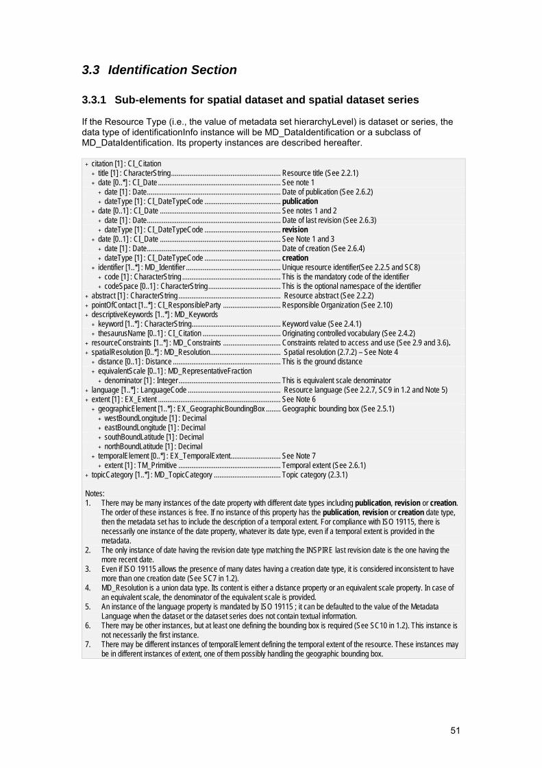
51
3.3 Identification Section
3.3.1 Sub-elements for spatial dataset and spatial dataset series If the Resource Type (i.e., the value of metadata set hierarchyLevel) is dataset or series, the data type of identificationInfo instance will be MD_DataIdentification or a subclass of MD_DataIdentification. Its property instances are described hereafter.
+ citation [1] : CI_Citation + title [1] : CharacterString........................................................... Resource title (See 2.2.1) + date [0..*] : CI_Date .................................................................. See note 1
+ date [1] : Date........................................................................ Date of publication (See 2.6.2) + dateType [1] : CI_DateTypeCode ......................................... publication
+ date [0..1] : CI_Date ................................................................. See notes 1 and 2 + date [1] : Date........................................................................ Date of last revision (See 2.6.3) + dateType [1] : CI_DateTypeCode ......................................... revision
+ date [0..1] : CI_Date ................................................................. See Note 1 and 3 + date [1] : Date........................................................................ Date of creation (See 2.6.4) + dateType [1] : CI_DateTypeCode ......................................... creation
+ identifier [1..*] : MD_Identifier ................................................... Unique resource identifier(See 2.2.5 and SC8) + code [1] : CharacterString ..................................................... This is the mandatory code of the identifier + codeSpace [0..1] : CharacterString....................................... This is the optional namespace of the identifier
+ abstract [1] : CharacterString ....................................................... Resource abstract (See 2.2.2) + pointOfContact [1..*] : CI_ResponsibleParty ............................... Responsible Organization (See 2.10) + descriptiveKeywords [1..*] : MD_Keywords
+ keyword [1..*] : CharacterString................................................ Keyword value (See 2.4.1) + thesaurusName [0..1] : CI_Citation .......................................... Originating controlled vocabulary (See 2.4.2)
+ resourceConstraints [1..*] : MD_Constraints ............................... Constraints related to access and use (See 2.9 and 3.6). + spatialResolution [0..*] : MD_Resolution...................................... Spatial resolution (2.7.2) – See Note 4
+ distance [0..1] : Distance .......................................................... This is the ground distance + equivalentScale [0..1] : MD_RepresentativeFraction
+ denominator [1] : Integer ....................................................... This is equivalent scale denominator + language [1..*] : LanguageCode .................................................. Resource language (See 2.2.7, SC9 in 1.2 and Note 5) + extent [1] : EX_Extent .................................................................. See Note 6
+ geographicElement [1..*] : EX_GeographicBoundingBox ........ Geographic bounding box (See 2.5.1) + westBoundLongitude [1] : Decimal + eastBoundLongitude [1] : Decimal + southBoundLatitude [1] : Decimal + northBoundLatitude [1] : Decimal
+ temporalElement [0..*] : EX_TemporalExtent........................... See Note 7 + extent [1] : TM_Primitive ....................................................... Temporal extent (See 2.6.1)
+ topicCategory [1..*] : MD_TopicCategory .................................... Topic category (2.3.1) Notes: 1. There may be many instances of the date property with different date types including publication, revision or creation.
The order of these instances is free. If no instance of this property has the publication, revision or creation date type, then the metadata set has to include the description of a temporal extent. For compliance with ISO 19115, there is necessarily one instance of the date property, whatever its date type, even if a temporal extent is provided in the metadata.
2. The only instance of date having the revision date type matching the INSPIRE last revision date is the one having the more recent date.
3. Even if ISO 19115 allows the presence of many dates having a creation date type, it is considered inconsistent to have more than one creation date (See SC7 in 1.2).
4. MD_Resolution is a union data type. Its content is either a distance property or an equivalent scale property. In case of an equivalent scale, the denominator of the equivalent scale is provided.
5. An instance of the language property is mandated by ISO 19115 ; it can be defaulted to the value of the Metadata Language when the dataset or the dataset series does not contain textual information.
6. There may be other instances, but at least one defining the bounding box is required (See SC10 in 1.2). This instance is not necessarily the first instance.
7. There may be different instances of temporalElement defining the temporal extent of the resource. These instances may be in different instances of extent, one of them possibly handling the geographic bounding box.
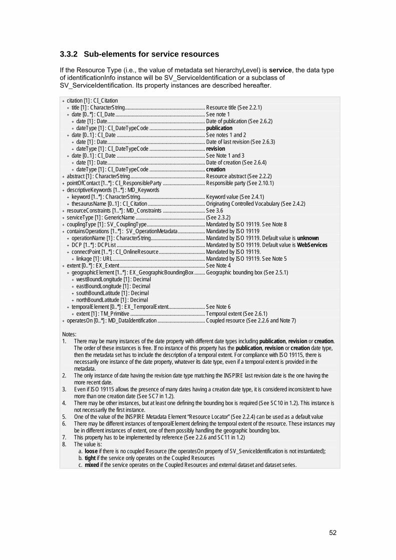
52
3.3.2 Sub-elements for service resources If the Resource Type (i.e., the value of metadata set hierarchyLevel) is service, the data type of identificationInfo instance will be SV_ServiceIdentification or a subclass of SV_ServiceIdentification. Its property instances are described hereafter.
+ citation [1] : CI_Citation + title [1] : CharacterString........................................................... Resource title (See 2.2.1) + date [0..*] : CI_Date .................................................................. See note 1
+ date [1] : Date........................................................................ Date of publication (See 2.6.2) + dateType [1] : CI_DateTypeCode ......................................... publication
+ date [0..1] : CI_Date ................................................................. See notes 1 and 2 + date [1] : Date........................................................................ Date of last revision (See 2.6.3) + dateType [1] : CI_DateTypeCode ......................................... revision
+ date [0..1] : CI_Date ................................................................. See Note 1 and 3 + date [1] : Date........................................................................ Date of creation (See 2.6.4) + dateType [1] : CI_DateTypeCode ......................................... creation
+ abstract [1] : CharacterString ....................................................... Resource abstract (See 2.2.2) + pointOfContact [1..*] : CI_ResponsibleParty ............................... Responsible party (See 2.10.1) + descriptiveKeywords [1..*] : MD_Keywords
+ keyword [1..*] : CharacterString................................................ Keyword value (See 2.4.1) + thesaurusName [0..1] : CI_Citation .......................................... Originating Controlled Vocabulary (See 2.4.2)
+ resourceConstraints [1..*] : MD_Constraints ............................... See 3.6 + serviceType [1] : GenericName ................................................... (See 2.3.2) + couplingType [1] : SV_CouplingType........................................... Mandated by ISO 19119. See Note 8 + containsOperations [1..*] : SV_OperationMetadata.................... Mandated by ISO 19119
+ operationName [1] : CharacterString........................................ Mandated by ISO 19119. Default value is unknown + DCP [1..*] : DCPList ................................................................. Mandated by ISO 19119. Default value is WebServices + connectPoint [1..*] : CI_OnlineResource.................................. Mandated by ISO 19119.
+ linkage [1] : URL.................................................................... Mandated by ISO 19119. See Note 5 + extent [0..*] : EX_Extent ............................................................... See Note 4
+ geographicElement [1..*] : EX_GeographicBoundingBox ........ Geographic bounding box (See 2.5.1) + westBoundLongitude [1] : Decimal + eastBoundLongitude [1] : Decimal + southBoundLatitude [1] : Decimal + northBoundLatitude [1] : Decimal
+ temporalElement [0..*] : EX_TemporalExtent........................... See Note 6 + extent [1] : TM_Primitive ....................................................... Temporal extent (See 2.6.1)
+ operatesOn [0..*] : MD_DataIdentification ................................... Coupled resource (See 2.2.6 and Note 7) Notes: 1. There may be many instances of the date property with different date types including publication, revision or creation.
The order of these instances is free. If no instance of this property has the publication, revision or creation date type, then the metadata set has to include the description of a temporal extent. For compliance with ISO 19115, there is necessarily one instance of the date property, whatever its date type, even if a temporal extent is provided in the metadata.
2. The only instance of date having the revision date type matching the INSPIRE last revision date is the one having the more recent date.
3. Even if ISO 19115 allows the presence of many dates having a creation date type, it is considered inconsistent to have more than one creation date (See SC7 in 1.2).
4. There may be other instances, but at least one defining the bounding box is required (See SC10 in 1.2). This instance is not necessarily the first instance.
5. One of the value of the INSPIRE Metadata Element “Resource Locator” (See 2.2.4) can be used as a default value 6. There may be different instances of temporalElement defining the temporal extent of the resource. These instances may
be in different instances of extent, one of them possibly handling the geographic bounding box. 7. This property has to be implemented by reference (See 2.2.6 and SC11 in 1.2) 8. The value is:
a. loose if there is no coupled Resource (the operatesOn property of SV_ServiceIdentification is not instantiated); b. tight if the service only operates on the Coupled Resources c. mixed if the service operates on the Coupled Resources and external dataset and dataset series.
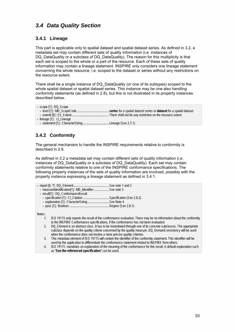
53
3.4 Data Quality Section
3.4.1 Lineage This part is applicable only to spatial dataset and spatial dataset series. As defined in 3.2, a metadata set may contain different sets of quality information (i.e. instances of DQ_DataQuality or a subclass of DQ_DataQuality). The reason for this multiplicity is that each set is scoped to the whole or a part of the resource. Each of these sets of quality information may contain a lineage statement. INSPIRE only considers one lineage statement concerning the whole resource, i.e. scoped to the dataset or series without any restrictions on the resource extent. There shall be a single instance of DQ_DataQuality (or one of its subtypes) scoped to the whole spatial dataset or spatial dataset series. This instance may be one also handling conformity statements (as defined in 2.8), but this is not illustrated in its property instances described below.
+ scope [1] : DQ_Scope + level [1] : MD_ScopeCode........................................ series for a spatial dataset series or dataset for a spatial dataset + extentl [0] : EX_Extent .............................................. There shall not be any restriction on the resource extent
+ lineage [1] : LI_Lineage + statement [1] : CharacterString................................. Lineage (See 2.7.1)
3.4.2 Conformity The general mechanism to handle the INSPIRE requirements relative to conformity is described in 2.8. As defined in 3.2 a metadata set may contain different sets of quality information (i.e. instances of DQ_DataQuality or a subclass of DQ_DataQuality). Each set may contain conformity statements relative to one of the INSPIRE conformance specifications. The following property instances of the sets of quality information are involved, possibly with the property instance expressing a lineage statement as defined in 3.4.1.
+ report [0..*] : DQ_Element............................................ See note 1 and 2 + measureIdentification[1] : MD_Identifier ................... See note 3 + result[1] : DQ_ConformanceResult
+ specification [1] : CI_Citation ................................ Specification (See 2.8.2) + explanation [1] : CharacterString .......................... See Note 4 + pass [1] : Boolean ................................................. Degree (See 2.8.1)
Notes:
1. ISO 19115 only reports the result of the conformance evaluation. There may be no information about the conformity to the INSPIRE Conformance specifications, if the conformance has not been evaluated.
2. DQ_Element is an abstract class. It has to be instantiated through one of its concrete subclasses. The appropriate subclass depends on the quality criteria concerned by the quality measure. DQ_DomainConsistency will be used when the conformance does not involve a more precise quality criterion.
3. This metadata element of ISO 19115 will contain the identifier of the conformity statement. This identifier will be used by the application to differentiate the conformance statement related to INSPIRE from others.
4. ISO 19115 mandates an explanation of the meaning of the conformance for this result. A default explanation such as “See the referenced specification” can be used.
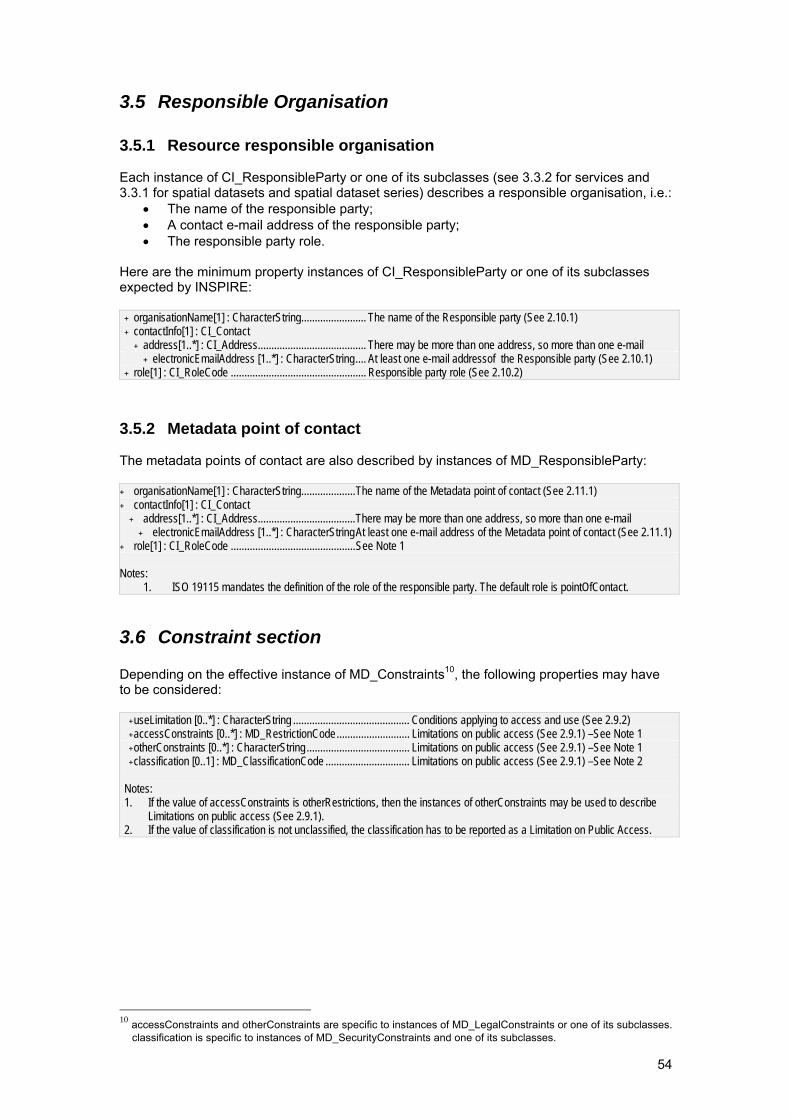
54
3.5 Responsible Organisation
3.5.1 Resource responsible organisation Each instance of CI_ResponsibleParty or one of its subclasses (see 3.3.2 for services and 3.3.1 for spatial datasets and spatial dataset series) describes a responsible organisation, i.e.:
• The name of the responsible party; • A contact e-mail address of the responsible party; • The responsible party role.
Here are the minimum property instances of CI_ResponsibleParty or one of its subclasses expected by INSPIRE:
+ organisationName[1] : CharacterString........................ The name of the Responsible party (See 2.10.1) + contactInfo[1] : CI_Contact
+ address[1..*] : CI_Address........................................ There may be more than one address, so more than one e-mail + electronicEmailAddress [1..*] : CharacterString.... At least one e-mail addressof the Responsible party (See 2.10.1)
+ role[1] : CI_RoleCode .................................................. Responsible party role (See 2.10.2)
3.5.2 Metadata point of contact The metadata points of contact are also described by instances of MD_ResponsibleParty: + organisationName[1] : CharacterString....................The name of the Metadata point of contact (See 2.11.1) + contactInfo[1] : CI_Contact
+ address[1..*] : CI_Address....................................There may be more than one address, so more than one e-mail + electronicEmailAddress [1..*] : CharacterStringAt least one e-mail address of the Metadata point of contact (See 2.11.1)
+ role[1] : CI_RoleCode ..............................................See Note 1 Notes:
1. ISO 19115 mandates the definition of the role of the responsible party. The default role is pointOfContact.
3.6 Constraint section Depending on the effective instance of MD_Constraints10, the following properties may have to be considered:
+ useLimitation [0..*] : CharacterString ........................................... Conditions applying to access and use (See 2.9.2) + accessConstraints [0..*] : MD_RestrictionCode........................... Limitations on public access (See 2.9.1) –See Note 1 + otherConstraints [0..*] : CharacterString ...................................... Limitations on public access (See 2.9.1) –See Note 1 + classification [0..1] : MD_ClassificationCode ............................... Limitations on public access (See 2.9.1) –See Note 2
Notes: 1. If the value of accessConstraints is otherRestrictions, then the instances of otherConstraints may be used to describe
Limitations on public access (See 2.9.1). 2. If the value of classification is not unclassified, the classification has to be reported as a Limitation on Public Access.
10 accessConstraints and otherConstraints are specific to instances of MD_LegalConstraints or one of its subclasses.
classification is specific to instances of MD_SecurityConstraints and one of its subclasses.
55
3.7 Abbreviations CEN Comité Européen de Normalisation CSW OGC Catalog Service Web EN European Norm by CEN EU European Union GML Geography Markup Language ID IDentifier IRs Implementing Rules ISO International Organisation for Standardization ISO/TS ISO Technical Specification OGC Open Geospatial Consortium UML Unified Modelling Language URL Uniform Resource Locator UUID Universally Unique IDentifier XML eXtensible Markup Language
56
Annex A – ISO/TS 19139 encoding of the INSPIRE metadata elements
A.1 Introduction This annex defines the XML ISO/TS 19139 encoding of the INSPIRE metadata elements. This XML encoding is based on XML Schemas derived from the UML models of ISO 19115 and ISO 19119 using the encoding rules defined in ISO/TS 19139 and:
• the XML Schema Implementation of ISO 19115 and the related standards defined in ISO/TS 19139;
• the XML Schema implementation of ISO 19119 defined in CSW2 AP ISO. The XML encoding of the INSPIRE metadata elements shall follow the instance template defined in Section 3 and the instructions of Section 2 of this document with respect to the following instructions.
A.2 From the conceptual schema to XML File instances The way in which the geographic metadata XML Schema is expected to be used makes it necessary to keep the organisation of the data, its associated metadata and the related information in very flexible files. Since the MD_Metadata XML element will rarely be the root element of an XML File, depending on the context, it may appear one or many times in a single XML File describing one or many different types of resources.
A.3 Polymorphism It is possible to have an XML file containing a metadata set without containing a single MD_Metadata XML element. This is a consequence of polymorphism, which may imply that an XML element representing a subclass of MD_Metadata, potentially defined in a user community profile, occurs instead of the MD_Metadata XML element. This is true for MD_Metadata as well as for any of the concepts defined in the ISO 19100 series of International Standards.
A.4 Management of polymorphism
A.4.1 Management of community extensions A.3 of ISO 19139 has a specific requirement to aid the understanding of user profiled metadata sets. The XML element of any new metadata element has to support a mandatory XML attribute called isoType that is expected to contain the name of the ISO class it derives from directly or indirectly. <MY_Metadata gco:isoType=”MD_Metadata”> <!-- Standard properties not detailed here --> <myProperty> <gco:CharacterString>Whatever text</gco:CharacterString> </myProperty> </MY_Metadata>
A.4.2 Parsing of metadata files To accommodate polymorphism of the data types, parsing of metadata files has to be driven by the XML elements corresponding to the properties of the UML models (look rather for the metadata elements named identificationInfo, than the metadata elements named MD_DataIdentification or SV_ServiceIdentification). The elements corresponding to the data type can generally be skipped.
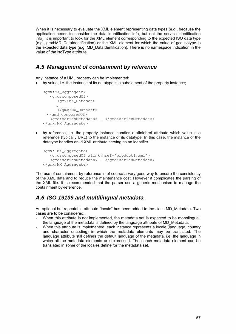
57
When it is necessary to evaluate the XML element representing data types (e.g., because the application needs to consider the data identification info, but not the service identification info), it is important to look for the XML element corresponding to the expected ISO data type (e.g., gmd:MD_DataIdentification) or the XML element for which the value of gco:isotype is the expected data type (e.g. MD_DataIdentification). There is no namespace indication in the value of the isoType attribute.
A.5 Management of containment by reference Any instance of a UML property can be implemented: • by value, i.e. the instance of its datatype is a subelement of the property instance;
<gmx:MX_Aggregate> <gmd:composedOf> <gmx:MX_Dataset>
… </gmx:MX_Dataset> </gmd:composedOf> <gmd:seriesMetadata> … </gmd:seriesMetadata> </gmx:MX_Aggregate>
• by reference, i.e. the property instance handles a xlink:href attribute which value is a reference (typically URL) to the instance of its datatype. In this case, the instance of the datatype handles an id XML attribute serving as an identifier.
<gmx: MX_Aggregate> <gmd:composedOf xlink:href=”product1.xml”> <gmd:seriesMetadata> … </gmd:seriesMetadata> </gmx:MX_Aggregate>
The use of containment by reference is of course a very good way to ensure the consistency of the XML data and to reduce the maintenance cost. However it complicates the parsing of the XML file. It is recommended that the parser use a generic mechanism to manage the containment by-reference.
A.6 ISO 19139 and multilingual metadata An optional but repeatable attribute “locale” has been added to the class MD_Metadata. Two cases are to be considered: - When this attribute is not implemented, the metadata set is expected to be monolingual:
the language of the metadata is defined by the language attribute of MD_Metadata. - When this attribute is implemented, each instance represents a locale (language, country
and character encoding) in which the metadata elements may be translated. The language attribute still defines the default language of the metadata, i.e. the language in which all the metadata elements are expressed. Then each metadata element can be translated in some of the locales define for the metadata set.
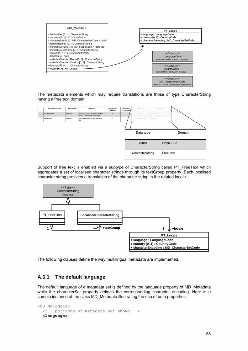
58
MD_Metadata
+ fileIdentifier [0..1] : CharacterString+ language [0..1] : CharacterString+ characterSet [0..1] : MD_CharacterSetCode = "utf8"+ parentIdentifier [0..1] : CharacterString+ hierarchyLevel [0..*] : MD_ScopeCode = "dataset"+ hierarchyLevelName [0..*] : CharacterString+ contact [1..*] : CI_ResponsibleParty+ dateStamp : Date+ metadataStandardName [0..1] : CharacterString+ metadataStandardVersion [0..1] : CharacterString+ datasetURI [0..1] : CharacterString
MD_Metadata
+ fileIdentifier [0..1] : CharacterString+ language [0..1] : CharacterString+ characterSet [0..1] : MD_CharacterSetCode = "utf8"+ parentIdentifier [0..1] : CharacterString+ hierarchyLevel [0..*] : MD_ScopeCode = "dataset"+ hierarchyLevelName [0..*] : CharacterString+ contact [1..*] : CI_ResponsibleParty+ dateStamp : Date+ metadataStandardName [0..1] : CharacterString+ metadataStandardVersion [0..1] : CharacterString+ datasetURI [0..1] : CharacterString+ locale [0..*] : PT_Locale
PT_Locale+ language : LanguageCode+ country [0..1] : CountryCode+ characterEncoding : MD_CharacterSetCode
PT_Locale+ language : LanguageCode+ country [0..1] : CountryCode+ characterEncoding : MD_CharacterSetCode
PT_Locale+ language : LanguageCode+ country [0..1] : CountryCode+ characterEncoding : MD_CharacterSetCode
LanguageCode(from ISO 00639 Human Language)
<<CodeList>>
MD_CharacterSetCode(from ISO 19115 Identification information)
<<CodeList>>
CountryCode(from ISO 03166 Country Codes)
<<CodeList>>
LanguageCode(from ISO 00639 Human Language)
<<CodeList>>LanguageCode
(from ISO 00639 Human Language)
<<CodeList>>
MD_CharacterSetCode(from ISO 19115 Identification information)
<<CodeList>>MD_CharacterSetCode
(from ISO 19115 Identification information)
<<CodeList>>
CountryCode(from ISO 03166 Country Codes)
<<CodeList>>CountryCode
(from ISO 03166 Country Codes)
<<CodeList>>
The metadata elements which may require translations are those of type CharacterString having a free text domain.
Support of free text is enabled via a subtype of CharacterString called PT_FreeText which aggregates a set of localised character strings through its textGroup property. Each localised character string provides a translation of the character string in the related locale.
1..* +locale
LocalisedCharacterString
1 1
PT_Locale+ language : LanguageCode+ country [0..1] : CountryCode+ characterEncoding : MD_CharacterSetCode
+textGroup1..* +locale
LocalisedCharacterString
1 1
PT_Locale+ language : LanguageCode+ country [0..1] : CountryCode+ characterEncoding : MD_CharacterSetCode
+textGroup
PT_FreeText
CharacterString(from Text)
<<Type>>
PT_FreeTextPT_FreeText
CharacterString(from Text)
<<Type>>CharacterString
(from Text)
<<Type>>
The following clauses define the way multilingual metadata are implemented.
A.6.1 The default language The default language of a metadata set is defined by the language property of MD_Metadata while the characterSet property defines the corresponding character encoding. Here is a sample instance of the class MD_Metadata illustrating the use of both properties. <MD_Metadata> <!-- portions of metadata not shown --> <language>
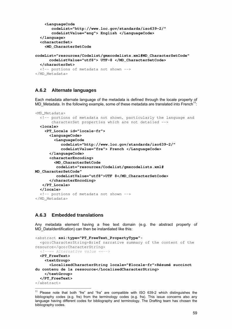
59
<LanguageCode codeList="http://www.loc.gov/standards/iso639-2/" codeListValue="eng"> English </LanguageCode> </language> <characterSet> <MD_CharacterSetCode codeList="resources/Codelist/gmxcodelists.xml#MD_CharacterSetCode" codeListValue="utf8"> UTF-8 </MD_CharacterSetCode> </characterSet> <!-- portions of metadata not shown --> </MD_Metadata>
A.6.2 Alternate languages Each metadata alternate language of the metadata is defined through the locale property of MD_Metadata. In the following example, some of these metadata are translated into French11: <MD_Metadata> <!-- portions of metadata not shown, particularly the language and characterSet properties which are not detailed --> <locale> <PT_Locale id="locale-fr"> <languageCode> <LanguageCode codeList="http://www.loc.gov/standards/iso639-2/" codeListValue="fre"> French </LanguageCode> </languageCode> <characterEncoding> <MD_CharacterSetCode codeList="resources/Codelist/gmxcodelists.xml# MD_CharacterSetCode" codeListValue="utf8">UTF 8</MD_CharacterSetCode> </characterEncoding> </PT_Locale> </locale> <!-- portions of metadata not shown --> </MD_Metadata>
A.6.3 Embedded translations Any metadata element having a free text domain (e.g. the abstract property of MD_DataIdentification) can then be instantiated like this: <abstract xsi:type="PT_FreeText_PropertyType"> <gco:CharacterString>Brief narrative summary of the content of the resource</gco:CharacterString> <!--== Alternative value ==--> <PT_FreeText> <textGroup> <LocalisedCharacterString locale="#locale-fr">Résumé succinct du contenu de la ressource</LocalisedCharacterString> </textGroup> </PT_FreeText> </abstract> 11 Please note that both “fre” and “fra” are compatible with ISO 639-2 which distinguishes the bibliography codes (e.g. fre) from the terminology codes (e.g. fra). This issue concerns also any language having different codes for bibliography and terminology. The Drafting team has chosen the bibliography codes.
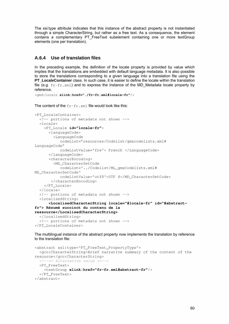
60
The xsi:type attribute indicates that this instance of the abstract property is not instantiated through a simple CharacterString, but rather as a free text. As a consequence, the element contains a complementary PT_FreeText subelement containing one or more textGroup elements (one per translation).
A.6.4 Use of translation files In the preceding example, the definition of the locale property is provided by value which implies that the translations are embedded with default language metadata. It is also possible to store the translations corresponding to a given language into a translation file using the PT_LocaleContainer class. In such case, it is easier to define the locale within the translation file (e.g. fr-fr.xml) and to express the instance of the MD_Metadata locale property by reference. <gmd:locale xlink:href="./fr-fr.xml#locale-fr"/>
The content of the fr-fr.xml file would look like this: <PT_LocaleContainer> <!-- portions of metadata not shown --> <locale> <PT_Locale id="locale-fr"> <languageCode> <LanguageCode codeList=”resources/Codelist/gmxcodelists.xml# LanguageCode” codeListValue="fre"> French </LanguageCode> </languageCode> <characterEncoding> <MD_CharacterSetCode codeList="../Codelist/ML_gmxCodelists.xml# MD_CharacterSetCode" codeListValue="utf8">UTF 8</MD_CharacterSetCode> </characterEncoding> </PT_Locale> </locale> <!-- portions of metadata not shown --> <localisedString> <LocalisedCharacterString locale="#locale-fr" id="#abstract-fr"> Résumé succinct du contenu de la ressource</LocalisedCharacterString> </localisedString> <!-- portions of metadata not shown --> </PT_LocaleContainer> The multilingual instance of the abstract property now implements the translation by reference to the translation file: <abstract xsi:type="PT_FreeText_PropertyType"> <gco:CharacterString>Brief narrative summary of the content of the resource</gco:CharacterString> <!--== Alternative value ==--> <PT_FreeText> <textGroup xlink:href="fr-fr.xml#abstract-fr"/> </PT_FreeText> </abstract>
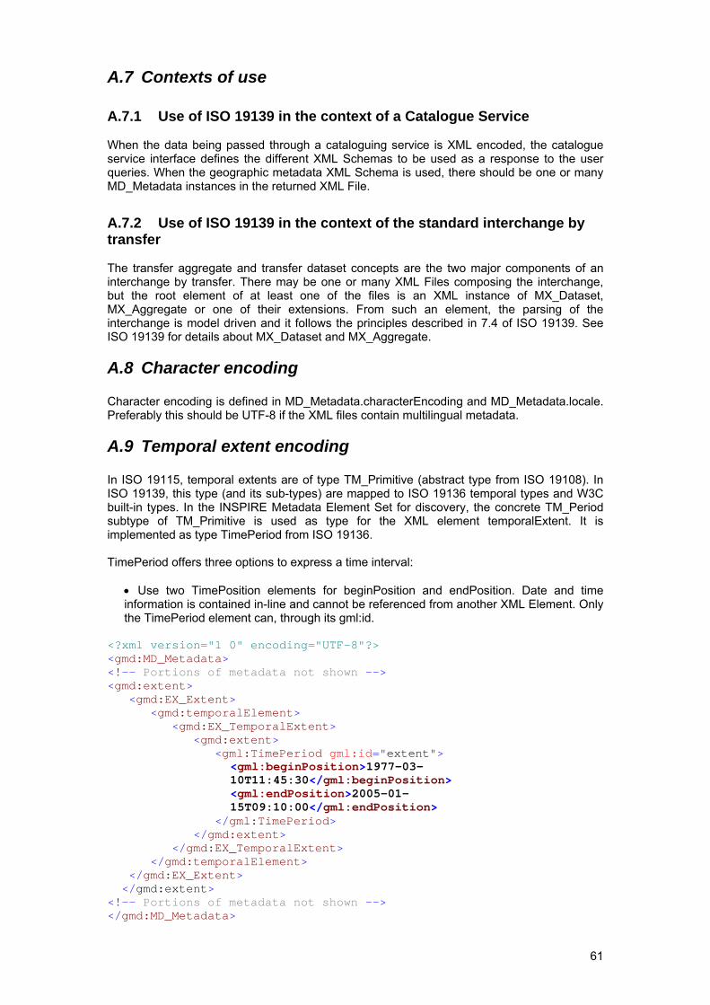
61
A.7 Contexts of use
A.7.1 Use of ISO 19139 in the context of a Catalogue Service When the data being passed through a cataloguing service is XML encoded, the catalogue service interface defines the different XML Schemas to be used as a response to the user queries. When the geographic metadata XML Schema is used, there should be one or many MD_Metadata instances in the returned XML File.
A.7.2 Use of ISO 19139 in the context of the standard interchange by transfer The transfer aggregate and transfer dataset concepts are the two major components of an interchange by transfer. There may be one or many XML Files composing the interchange, but the root element of at least one of the files is an XML instance of MX_Dataset, MX_Aggregate or one of their extensions. From such an element, the parsing of the interchange is model driven and it follows the principles described in 7.4 of ISO 19139. See ISO 19139 for details about MX_Dataset and MX_Aggregate.
A.8 Character encoding Character encoding is defined in MD_Metadata.characterEncoding and MD_Metadata.locale. Preferably this should be UTF-8 if the XML files contain multilingual metadata.
A.9 Temporal extent encoding In ISO 19115, temporal extents are of type TM_Primitive (abstract type from ISO 19108). In ISO 19139, this type (and its sub-types) are mapped to ISO 19136 temporal types and W3C built-in types. In the INSPIRE Metadata Element Set for discovery, the concrete TM_Period subtype of TM_Primitive is used as type for the XML element temporalExtent. It is implemented as type TimePeriod from ISO 19136. TimePeriod offers three options to express a time interval:
• Use two TimePosition elements for beginPosition and endPosition. Date and time information is contained in-line and cannot be referenced from another XML Element. Only the TimePeriod element can, through its gml:id.
<?xml version="1 0" encoding="UTF-8"?> <gmd:MD_Metadata> <!-- Portions of metadata not shown --> <gmd:extent> <gmd:EX_Extent> <gmd:temporalElement> <gmd:EX_TemporalExtent> <gmd:extent> <gml:TimePeriod gml:id="extent">
<gml:beginPosition>1977-03-10T11:45:30</gml:beginPosition> <gml:endPosition>2005-01-15T09:10:00</gml:endPosition>
</gml:TimePeriod> </gmd:extent> </gmd:EX_TemporalExtent> </gmd:temporalElement> </gmd:EX_Extent> </gmd:extent> <!-- Portions of metadata not shown --> </gmd:MD_Metadata>
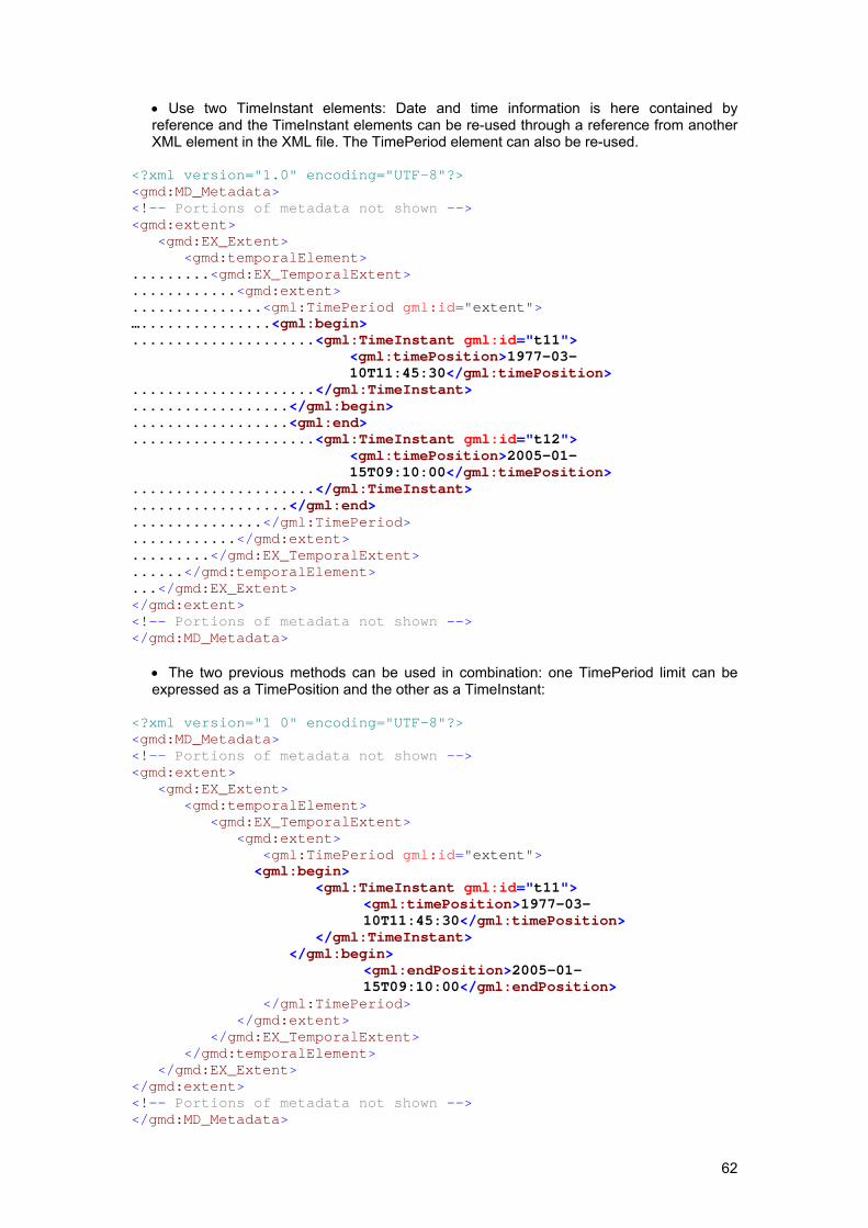
62
• Use two TimeInstant elements: Date and time information is here contained by reference and the TimeInstant elements can be re-used through a reference from another XML element in the XML file. The TimePeriod element can also be re-used.
<?xml version="1.0" encoding="UTF-8"?> <gmd:MD_Metadata> <!-- Portions of metadata not shown --> <gmd:extent> <gmd:EX_Extent> <gmd:temporalElement> .........<gmd:EX_TemporalExtent> ............<gmd:extent> ...............<gml:TimePeriod gml:id="extent"> …...............<gml:begin> .....................<gml:TimeInstant gml:id="t11">
<gml:timePosition>1977-03-10T11:45:30</gml:timePosition>
.....................</gml:TimeInstant>
..................</gml:begin>
..................<gml:end>
.....................<gml:TimeInstant gml:id="t12"> <gml:timePosition>2005-01-15T09:10:00</gml:timePosition>
.....................</gml:TimeInstant>
..................</gml:end>
...............</gml:TimePeriod>
............</gmd:extent>
.........</gmd:EX_TemporalExtent>
......</gmd:temporalElement>
...</gmd:EX_Extent> </gmd:extent> <!-- Portions of metadata not shown --> </gmd:MD_Metadata>
• The two previous methods can be used in combination: one TimePeriod limit can be expressed as a TimePosition and the other as a TimeInstant:
<?xml version="1 0" encoding="UTF-8"?> <gmd:MD_Metadata> <!-- Portions of metadata not shown --> <gmd:extent> <gmd:EX_Extent> <gmd:temporalElement> <gmd:EX_TemporalExtent> <gmd:extent> <gml:TimePeriod gml:id="extent"> <gml:begin> <gml:TimeInstant gml:id="t11">
<gml:timePosition>1977-03-10T11:45:30</gml:timePosition>
</gml:TimeInstant> </gml:begin>
<gml:endPosition>2005-01-15T09:10:00</gml:endPosition>
</gml:TimePeriod> </gmd:extent> </gmd:EX_TemporalExtent> </gmd:temporalElement> </gmd:EX_Extent> </gmd:extent> <!-- Portions of metadata not shown --> </gmd:MD_Metadata>
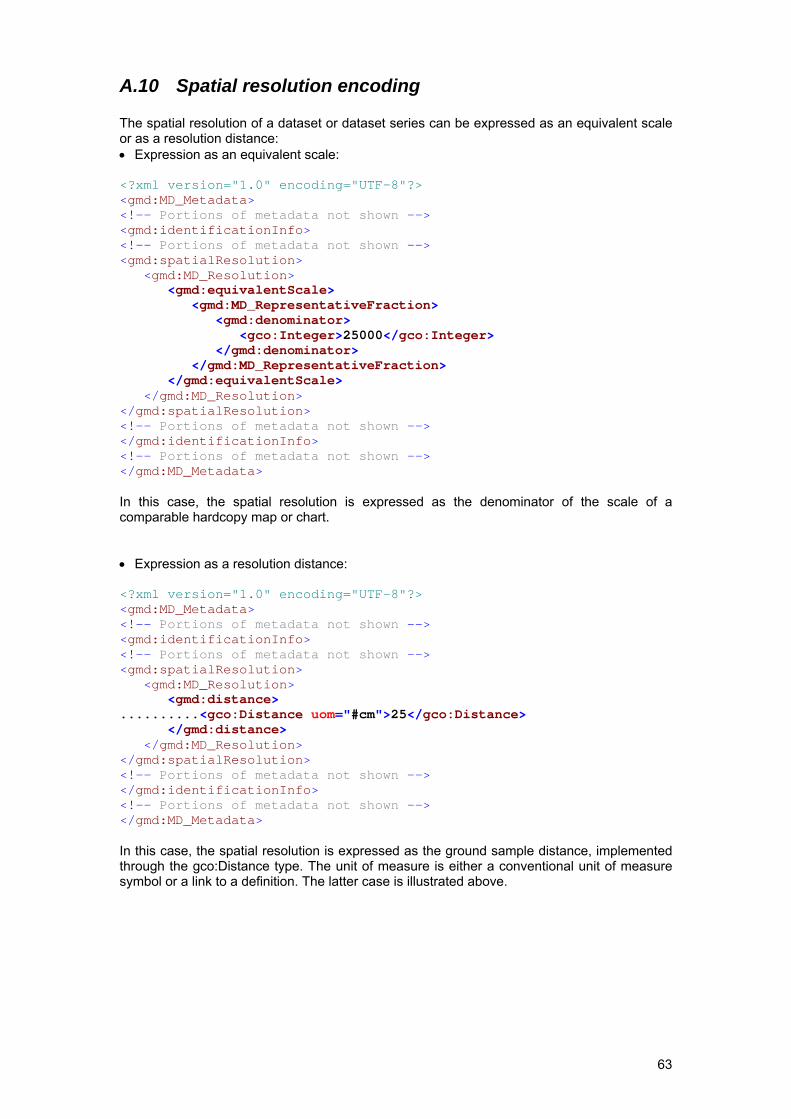
63
A.10 Spatial resolution encoding The spatial resolution of a dataset or dataset series can be expressed as an equivalent scale or as a resolution distance: • Expression as an equivalent scale: <?xml version="1.0" encoding="UTF-8"?> <gmd:MD_Metadata> <!-- Portions of metadata not shown --> <gmd:identificationInfo> <!-- Portions of metadata not shown --> <gmd:spatialResolution> <gmd:MD_Resolution> <gmd:equivalentScale> <gmd:MD_RepresentativeFraction> <gmd:denominator> <gco:Integer>25000</gco:Integer> </gmd:denominator> </gmd:MD_RepresentativeFraction> </gmd:equivalentScale> </gmd:MD_Resolution> </gmd:spatialResolution> <!-- Portions of metadata not shown --> </gmd:identificationInfo> <!-- Portions of metadata not shown --> </gmd:MD_Metadata> In this case, the spatial resolution is expressed as the denominator of the scale of a comparable hardcopy map or chart. • Expression as a resolution distance: <?xml version="1.0" encoding="UTF-8"?> <gmd:MD_Metadata> <!-- Portions of metadata not shown --> <gmd:identificationInfo> <!-- Portions of metadata not shown --> <gmd:spatialResolution> <gmd:MD_Resolution> <gmd:distance> ..........<gco:Distance uom="#cm">25</gco:Distance> </gmd:distance> </gmd:MD_Resolution> </gmd:spatialResolution> <!-- Portions of metadata not shown --> </gmd:identificationInfo> <!-- Portions of metadata not shown --> </gmd:MD_Metadata> In this case, the spatial resolution is expressed as the ground sample distance, implemented through the gco:Distance type. The unit of measure is either a conventional unit of measure symbol or a link to a definition. The latter case is illustrated above.
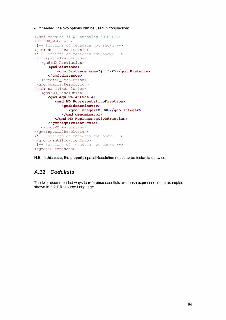
64
• If needed, the two options can be used in conjunction: <?xml version="1 0" encoding="UTF-8"?> <gmd:MD_Metadata> <!-- Portions of metadata not shown --> <gmd:identificationInfo> <!-- Portions of metadata not shown --> <gmd:spatialResolution> <gmd:MD_Resolution> <gmd:distance> <gco:Distance uom="#cm">25</gco:Distance> </gmd:distance> </gmd:MD_Resolution> </gmd:spatialResolution> <gmd:spatialResolution> <gmd:MD_Resolution> <gmd:equivalentScale> <gmd:MD_RepresentativeFraction> <gmd:denominator> <gco:Integer>25000</gco:Integer> </gmd:denominator> </gmd:MD_RepresentativeFraction> </gmd:equivalentScale> </gmd:MD_Resolution> </gmd:spatialResolution> <!-- Portions of metadata not shown --> </gmd:identificationInfo> <!-- Portions of metadata not shown --> </gmd:MD_Metadata> N.B. In this case, the property spatialResolution needs to be instantiated twice.
A.11 Codelists The two recommended ways to reference codelists are those expressed in the examples shown in 2.2.7 Resource Language.
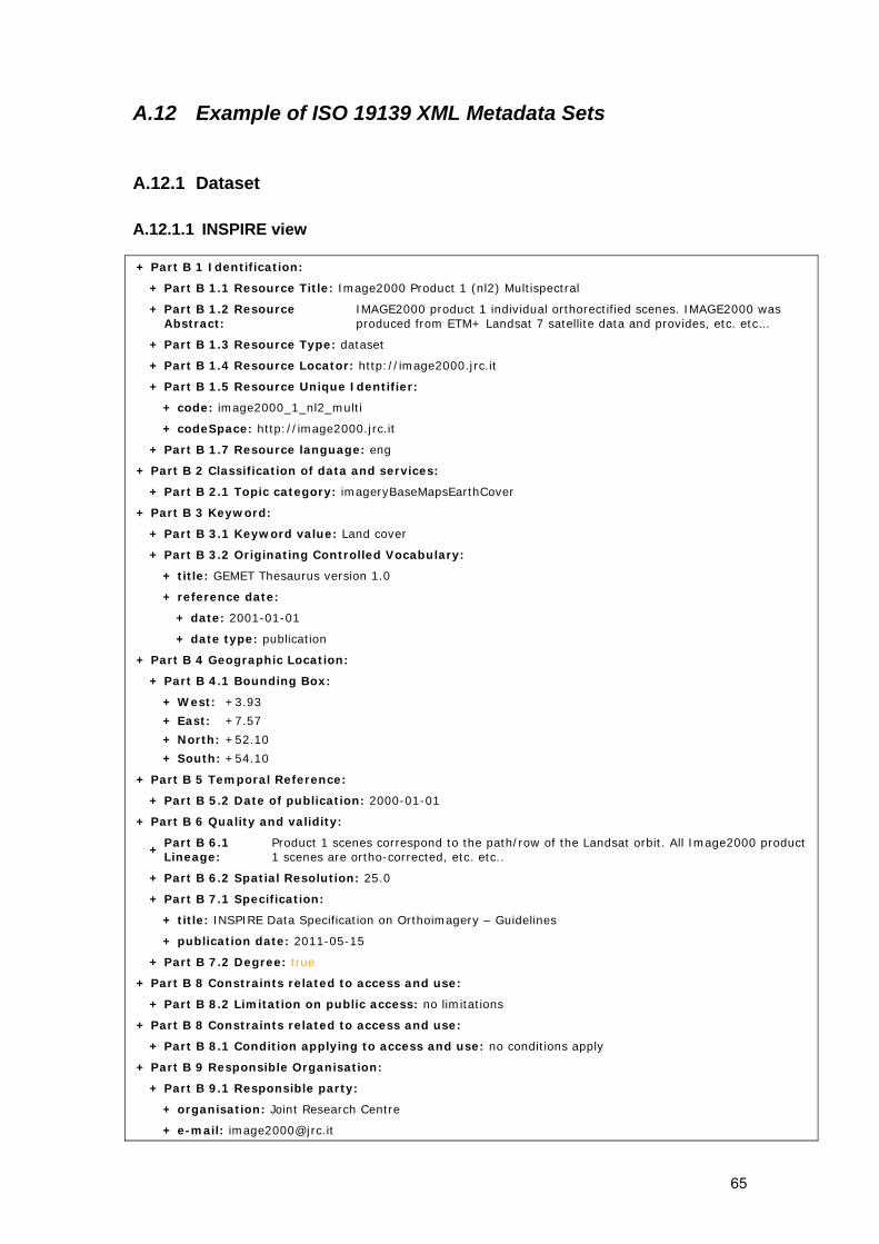
65
A.12 Example of ISO 19139 XML Metadata Sets
A.12.1 Dataset
A.12.1.1 INSPIRE view + Part B 1 Identification:
+ Part B 1.1 Resource Title: Image2000 Product 1 (nl2) Multispectral
+ Part B 1.2 Resource Abstract:
IMAGE2000 product 1 individual orthorectified scenes. IMAGE2000 was produced from ETM+ Landsat 7 satellite data and provides, etc. etc…
+ Part B 1.3 Resource Type: dataset
+ Part B 1.4 Resource Locator: http://image2000.jrc.it
+ Part B 1.5 Resource Unique Identifier:
+ code: image2000_1_nl2_multi
+ codeSpace: http://image2000.jrc.it
+ Part B 1.7 Resource language: eng
+ Part B 2 Classification of data and services:
+ Part B 2.1 Topic category: imageryBaseMapsEarthCover
+ Part B 3 Keyword:
+ Part B 3.1 Keyword value: Land cover
+ Part B 3.2 Originating Controlled Vocabulary:
+ title: GEMET Thesaurus version 1.0
+ reference date:
+ date: 2001-01-01
+ date type: publication
+ Part B 4 Geographic Location:
+ Part B 4.1 Bounding Box:
+ West: +3.93
+ East: +7.57
+ North: +52.10
+ South: +54.10
+ Part B 5 Temporal Reference:
+ Part B 5.2 Date of publication: 2000-01-01
+ Part B 6 Quality and validity:
+ Part B 6.1 Lineage:
Product 1 scenes correspond to the path/row of the Landsat orbit. All Image2000 product 1 scenes are ortho-corrected, etc. etc..
+ Part B 6.2 Spatial Resolution: 25.0
+ Part B 7.1 Specification:
+ title: INSPIRE Data Specification on Orthoimagery – Guidelines
+ publication date: 2011-05-15
+ Part B 7.2 Degree: true
+ Part B 8 Constraints related to access and use:
+ Part B 8.2 Limitation on public access: no limitations
+ Part B 8 Constraints related to access and use:
+ Part B 8.1 Condition applying to access and use: no conditions apply
+ Part B 9 Responsible Organisation:
+ Part B 9.1 Responsible party:
+ organisation: Joint Research Centre
+ e-mail: [email protected]
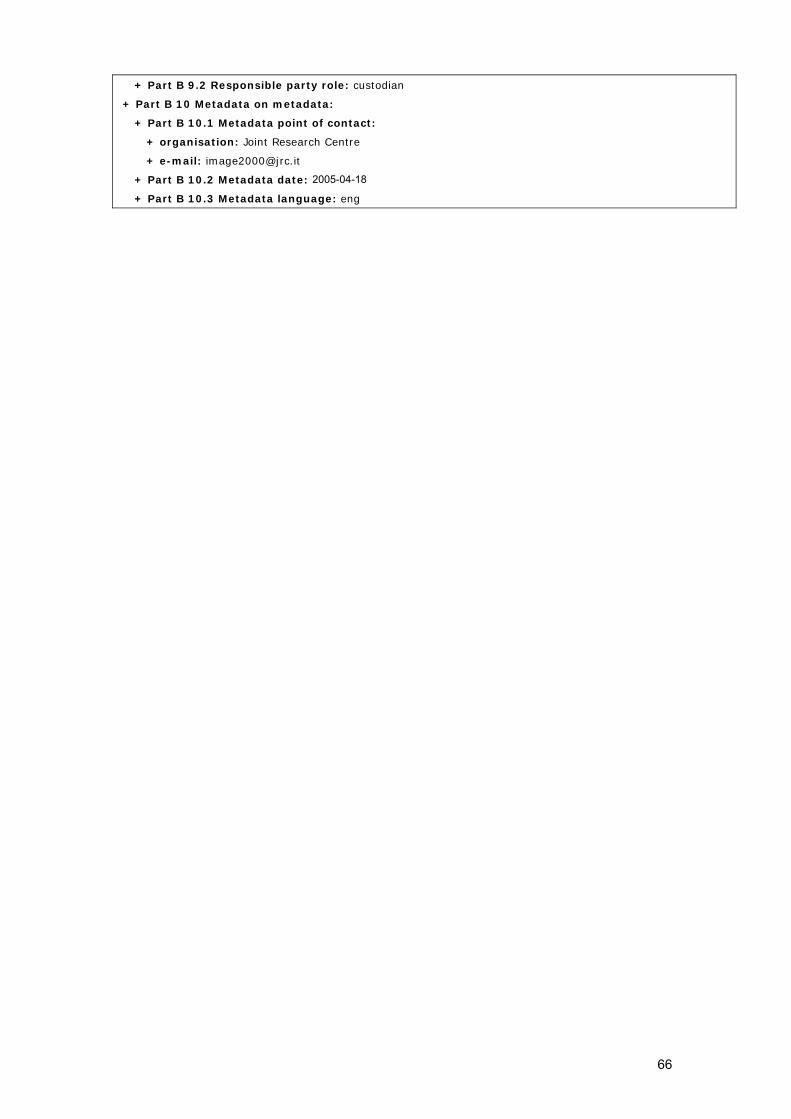
66
+ Part B 9.2 Responsible party role: custodian
+ Part B 10 Metadata on metadata:
+ Part B 10.1 Metadata point of contact:
+ organisation: Joint Research Centre
+ e-mail: [email protected]
+ Part B 10.2 Metadata date: 2005-04-18
+ Part B 10.3 Metadata language: eng
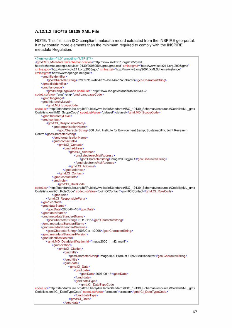
67
A.12.1.2 ISO/TS 19139 XML File NOTE: This file is an ISO compliant metadata record extracted from the INSPIRE geo-portal. It may contain more elements than the minimum required to comply with the INSPIRE metadata Regulation. <?xml version="1.0" encoding="UTF-8"?> <gmd:MD_Metadata xsi:schemaLocation="http://www.isotc211.org/2005/gmd http://schemas.opengis.net/iso/19139/20060504/gmd/gmd.xsd" xmlns:gmd="http://www.isotc211.org/2005/gmd" xmlns:gco="http://www.isotc211.org/2005/gco" xmlns:xsi="http://www.w3.org/2001/XMLSchema-instance" xmlns:gml="http://www.opengis.net/gml"> <gmd:fileIdentifier> <gco:CharacterString>029097fd-2ef2-487c-a5ca-6ec7a3dbac53</gco:CharacterString> </gmd:fileIdentifier> <gmd:language> <gmd:LanguageCode codeList=" http://www.loc.gov/standards/iso639-2/" codeListValue="eng">eng</gmd:LanguageCode> </gmd:language> <gmd:hierarchyLevel> <gmd:MD_ScopeCode codeList="http://standards.iso.org/ittf/PubliclyAvailableStandards/ISO_19139_Schemas/resources/Codelist/ML_gmxCodelists.xml#MD_ScopeCode" codeListValue="dataset">dataset</gmd:MD_ScopeCode> </gmd:hierarchyLevel> <gmd:contact> <gmd:CI_ResponsibleParty> <gmd:organisationName> <gco:CharacterString>SDI Unit, Institute for Environment & Sustainability, Joint Research Centre</gco:CharacterString> </gmd:organisationName> <gmd:contactInfo> <gmd:CI_Contact> <gmd:address> <gmd:CI_Address> <gmd:electronicMailAddress> <gco:CharacterString>[email protected]</gco:CharacterString> </gmd:electronicMailAddress> </gmd:CI_Address> </gmd:address> </gmd:CI_Contact> </gmd:contactInfo> <gmd:role> <gmd:CI_RoleCode codeList="http://standards.iso.org/ittf/PubliclyAvailableStandards/ISO_19139_Schemas/resources/Codelist/ML_gmxCodelists.xml#CI_RoleCode" codeListValue="pointOfContact">pointOfContact</gmd:CI_RoleCode> </gmd:role> </gmd:CI_ResponsibleParty> </gmd:contact> <gmd:dateStamp> <gco:Date>2005-04-18</gco:Date> </gmd:dateStamp> <gmd:metadataStandardName> <gco:CharacterString>ISO19115</gco:CharacterString> </gmd:metadataStandardName> <gmd:metadataStandardVersion> <gco:CharacterString>2003/Cor.1:2006</gco:CharacterString> </gmd:metadataStandardVersion> <gmd:identificationInfo> <gmd:MD_DataIdentification id="image2000_1_nl2_multi"> <gmd:citation> <gmd:CI_Citation> <gmd:title> <gco:CharacterString>Image2000 Product 1 (nl2) Multispectral</gco:CharacterString> </gmd:title> <gmd:date> <gmd:CI_Date> <gmd:date> <gco:Date>2007-09-15</gco:Date> </gmd:date> <gmd:dateType> <gmd:CI_DateTypeCode codeList="http://standards.iso.org/ittf/PubliclyAvailableStandards/ISO_19139_Schemas/resources/Codelist/ML_gmxCodelists.xml#CI_DateTypeCode" codeListValue="creation">creation</gmd:CI_DateTypeCode> </gmd:dateType> </gmd:CI_Date> </gmd:date>
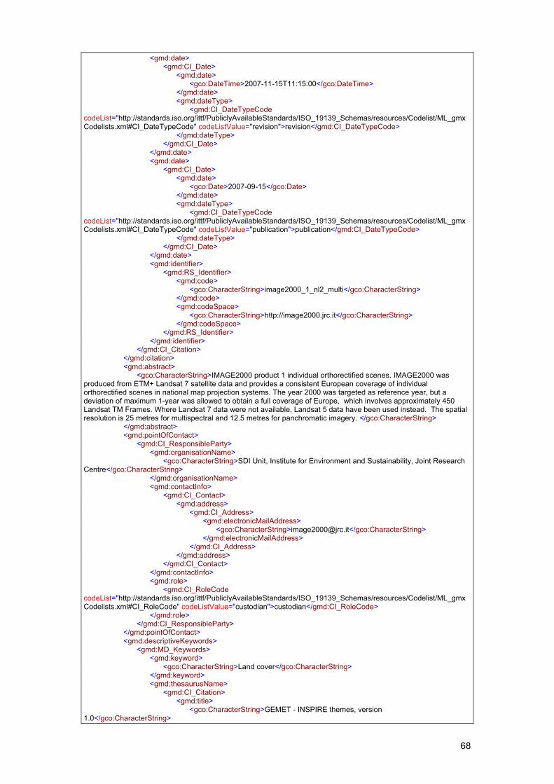
68
<gmd:date> <gmd:CI_Date> <gmd:date> <gco:DateTime>2007-11-15T11:15:00</gco:DateTime> </gmd:date> <gmd:dateType> <gmd:CI_DateTypeCode codeList="http://standards.iso.org/ittf/PubliclyAvailableStandards/ISO_19139_Schemas/resources/Codelist/ML_gmxCodelists.xml#CI_DateTypeCode" codeListValue="revision">revision</gmd:CI_DateTypeCode> </gmd:dateType> </gmd:CI_Date> </gmd:date> <gmd:date> <gmd:CI_Date> <gmd:date> <gco:Date>2007-09-15</gco:Date> </gmd:date> <gmd:dateType> <gmd:CI_DateTypeCode codeList="http://standards.iso.org/ittf/PubliclyAvailableStandards/ISO_19139_Schemas/resources/Codelist/ML_gmxCodelists.xml#CI_DateTypeCode" codeListValue="publication">publication</gmd:CI_DateTypeCode> </gmd:dateType> </gmd:CI_Date> </gmd:date> <gmd:identifier> <gmd:RS_Identifier> <gmd:code> <gco:CharacterString>image2000_1_nl2_multi</gco:CharacterString> </gmd:code> <gmd:codeSpace> <gco:CharacterString>http://image2000.jrc.it</gco:CharacterString> </gmd:codeSpace> </gmd:RS_Identifier> </gmd:identifier> </gmd:CI_Citation> </gmd:citation> <gmd:abstract> <gco:CharacterString>IMAGE2000 product 1 individual orthorectified scenes. IMAGE2000 was produced from ETM+ Landsat 7 satellite data and provides a consistent European coverage of individual orthorectified scenes in national map projection systems. The year 2000 was targeted as reference year, but a deviation of maximum 1-year was allowed to obtain a full coverage of Europe, which involves approximately 450 Landsat TM Frames. Where Landsat 7 data were not available, Landsat 5 data have been used instead. The spatial resolution is 25 metres for multispectral and 12.5 metres for panchromatic imagery. </gco:CharacterString> </gmd:abstract> <gmd:pointOfContact> <gmd:CI_ResponsibleParty> <gmd:organisationName> <gco:CharacterString>SDI Unit, Institute for Environment and Sustainability, Joint Research Centre</gco:CharacterString> </gmd:organisationName> <gmd:contactInfo> <gmd:CI_Contact> <gmd:address> <gmd:CI_Address> <gmd:electronicMailAddress> <gco:CharacterString>[email protected]</gco:CharacterString> </gmd:electronicMailAddress> </gmd:CI_Address> </gmd:address> </gmd:CI_Contact> </gmd:contactInfo> <gmd:role> <gmd:CI_RoleCode codeList="http://standards.iso.org/ittf/PubliclyAvailableStandards/ISO_19139_Schemas/resources/Codelist/ML_gmxCodelists.xml#CI_RoleCode" codeListValue="custodian">custodian</gmd:CI_RoleCode> </gmd:role> </gmd:CI_ResponsibleParty> </gmd:pointOfContact> <gmd:descriptiveKeywords> <gmd:MD_Keywords> <gmd:keyword> <gco:CharacterString>Land cover</gco:CharacterString> </gmd:keyword> <gmd:thesaurusName> <gmd:CI_Citation> <gmd:title> <gco:CharacterString>GEMET - INSPIRE themes, version 1.0</gco:CharacterString>
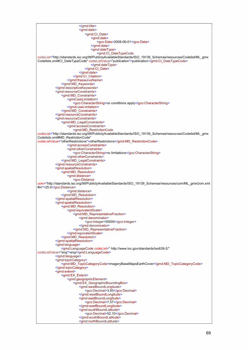
69
</gmd:title> <gmd:date> <gmd:CI_Date> <gmd:date> <gco:Date>2008-06-01</gco:Date> </gmd:date> <gmd:dateType> <gmd:CI_DateTypeCode codeList="http://standards.iso.org/ittf/PubliclyAvailableStandards/ISO_19139_Schemas/resources/Codelist/ML_gmxCodelists.xml#CI_DateTypeCode" codeListValue="publication">publication</gmd:CI_DateTypeCode> </gmd:dateType> </gmd:CI_Date> </gmd:date> </gmd:CI_Citation> </gmd:thesaurusName> </gmd:MD_Keywords> </gmd:descriptiveKeywords> <gmd:resourceConstraints> <gmd:MD_Constraints> <gmd:useLimitation> <gco:CharacterString>no conditions apply</gco:CharacterString> </gmd:useLimitation> </gmd:MD_Constraints> </gmd:resourceConstraints> <gmd:resourceConstraints> <gmd:MD_LegalConstraints> <gmd:accessConstraints> <gmd:MD_RestrictionCode codeList="http://standards.iso.org/ittf/PubliclyAvailableStandards/ISO_19139_Schemas/resources/Codelist/ML_gmxCodelists.xml#MD_RestrictionCode" codeListValue="otherRestrictions">otherRestrictions</gmd:MD_RestrictionCode> </gmd:accessConstraints> <gmd:otherConstraints> <gco:CharacterString>no limitations</gco:CharacterString> </gmd:otherConstraints> </gmd:MD_LegalConstraints> </gmd:resourceConstraints> <gmd:spatialResolution> <gmd:MD_Resolution> <gmd:distance> <gco:Distance uom="http://standards.iso.org/ittf/PubliclyAvailableStandards/ISO_19139_Schemas/resources/uom/ML_gmxUom.xml#m">25.0</gco:Distance> </gmd:distance> </gmd:MD_Resolution> </gmd:spatialResolution> <gmd:spatialResolution> <gmd:MD_Resolution> <gmd:equivalentScale> <gmd:MD_RepresentativeFraction> <gmd:denominator> <gco:Integer>50000</gco:Integer> </gmd:denominator> </gmd:MD_RepresentativeFraction> </gmd:equivalentScale> </gmd:MD_Resolution> </gmd:spatialResolution> <gmd:language> <gmd:LanguageCode codeList=" http://www.loc.gov/standards/iso639-2/" codeListValue="eng">eng</gmd:LanguageCode> </gmd:language> <gmd:topicCategory> <gmd:MD_TopicCategoryCode>imageryBaseMapsEarthCover</gmd:MD_TopicCategoryCode> </gmd:topicCategory> <gmd:extent> <gmd:EX_Extent> <gmd:geographicElement> <gmd:EX_GeographicBoundingBox> <gmd:westBoundLongitude> <gco:Decimal>3.93</gco:Decimal> </gmd:westBoundLongitude> <gmd:eastBoundLongitude> <gco:Decimal>7.57</gco:Decimal> </gmd:eastBoundLongitude> <gmd:southBoundLatitude> <gco:Decimal>52.10</gco:Decimal> </gmd:southBoundLatitude> <gmd:northBoundLatitude>
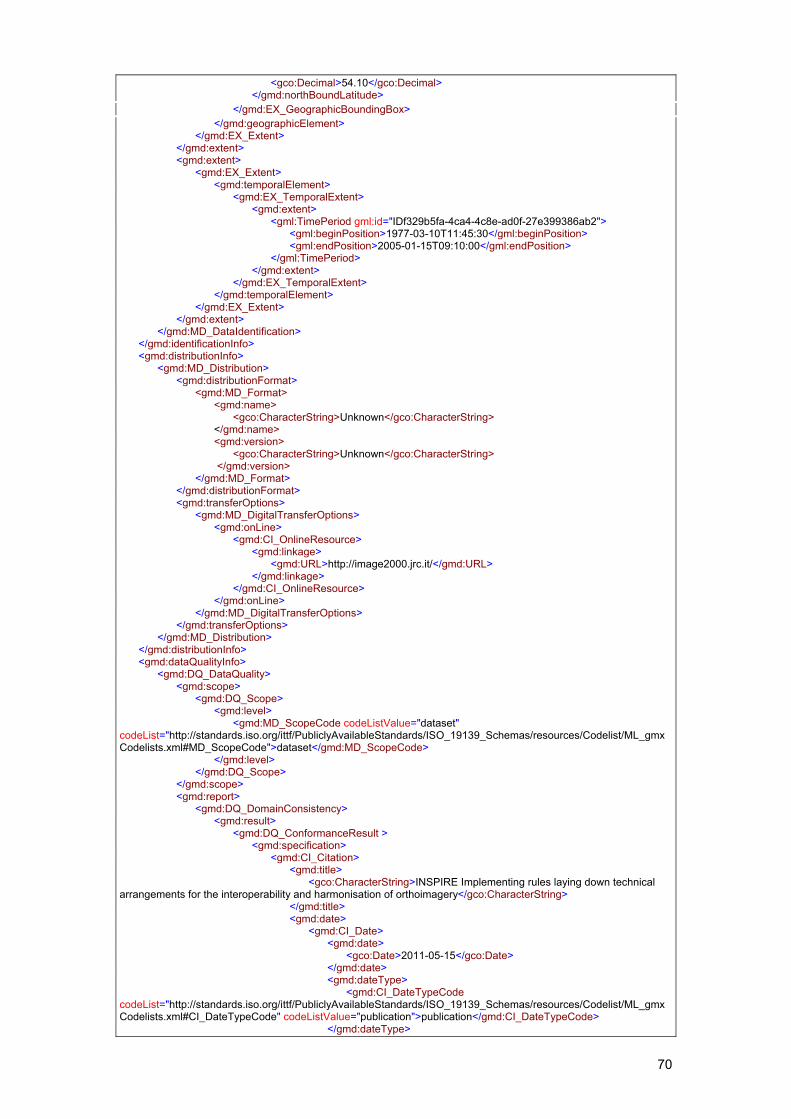
70
<gco:Decimal>54.10</gco:Decimal> </gmd:northBoundLatitude> </gmd:EX_GeographicBoundingBox> </gmd:geographicElement> </gmd:EX_Extent> </gmd:extent> <gmd:extent> <gmd:EX_Extent> <gmd:temporalElement> <gmd:EX_TemporalExtent> <gmd:extent> <gml:TimePeriod gml:id="IDf329b5fa-4ca4-4c8e-ad0f-27e399386ab2"> <gml:beginPosition>1977-03-10T11:45:30</gml:beginPosition> <gml:endPosition>2005-01-15T09:10:00</gml:endPosition> </gml:TimePeriod> </gmd:extent> </gmd:EX_TemporalExtent> </gmd:temporalElement> </gmd:EX_Extent> </gmd:extent> </gmd:MD_DataIdentification> </gmd:identificationInfo> <gmd:distributionInfo> <gmd:MD_Distribution> <gmd:distributionFormat> <gmd:MD_Format> <gmd:name> <gco:CharacterString>Unknown</gco:CharacterString> </gmd:name> <gmd:version> <gco:CharacterString>Unknown</gco:CharacterString> </gmd:version> </gmd:MD_Format> </gmd:distributionFormat> <gmd:transferOptions> <gmd:MD_DigitalTransferOptions> <gmd:onLine> <gmd:CI_OnlineResource> <gmd:linkage> <gmd:URL>http://image2000.jrc.it/</gmd:URL> </gmd:linkage> </gmd:CI_OnlineResource> </gmd:onLine> </gmd:MD_DigitalTransferOptions> </gmd:transferOptions> </gmd:MD_Distribution> </gmd:distributionInfo> <gmd:dataQualityInfo> <gmd:DQ_DataQuality> <gmd:scope> <gmd:DQ_Scope> <gmd:level> <gmd:MD_ScopeCode codeListValue="dataset" codeList="http://standards.iso.org/ittf/PubliclyAvailableStandards/ISO_19139_Schemas/resources/Codelist/ML_gmxCodelists.xml#MD_ScopeCode">dataset</gmd:MD_ScopeCode> </gmd:level> </gmd:DQ_Scope> </gmd:scope> <gmd:report> <gmd:DQ_DomainConsistency> <gmd:result> <gmd:DQ_ConformanceResult > <gmd:specification> <gmd:CI_Citation> <gmd:title> <gco:CharacterString>INSPIRE Implementing rules laying down technical arrangements for the interoperability and harmonisation of orthoimagery</gco:CharacterString> </gmd:title> <gmd:date> <gmd:CI_Date> <gmd:date> <gco:Date>2011-05-15</gco:Date> </gmd:date> <gmd:dateType> <gmd:CI_DateTypeCode codeList="http://standards.iso.org/ittf/PubliclyAvailableStandards/ISO_19139_Schemas/resources/Codelist/ML_gmxCodelists.xml#CI_DateTypeCode" codeListValue="publication">publication</gmd:CI_DateTypeCode> </gmd:dateType>
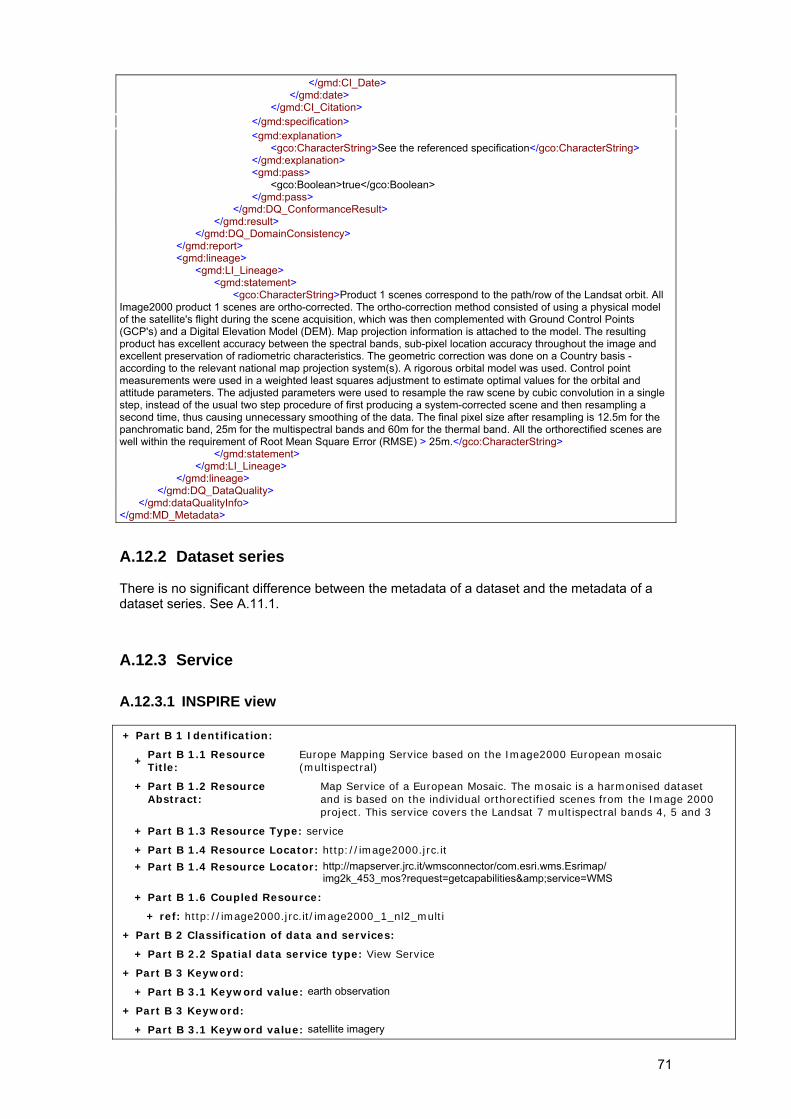
71
</gmd:CI_Date> </gmd:date> </gmd:CI_Citation> </gmd:specification> <gmd:explanation> <gco:CharacterString>See the referenced specification</gco:CharacterString> </gmd:explanation> <gmd:pass> <gco:Boolean>true</gco:Boolean> </gmd:pass> </gmd:DQ_ConformanceResult> </gmd:result> </gmd:DQ_DomainConsistency> </gmd:report> <gmd:lineage> <gmd:LI_Lineage> <gmd:statement> <gco:CharacterString>Product 1 scenes correspond to the path/row of the Landsat orbit. All Image2000 product 1 scenes are ortho-corrected. The ortho-correction method consisted of using a physical model of the satellite's flight during the scene acquisition, which was then complemented with Ground Control Points (GCP's) and a Digital Elevation Model (DEM). Map projection information is attached to the model. The resulting product has excellent accuracy between the spectral bands, sub-pixel location accuracy throughout the image and excellent preservation of radiometric characteristics. The geometric correction was done on a Country basis - according to the relevant national map projection system(s). A rigorous orbital model was used. Control point measurements were used in a weighted least squares adjustment to estimate optimal values for the orbital and attitude parameters. The adjusted parameters were used to resample the raw scene by cubic convolution in a single step, instead of the usual two step procedure of first producing a system-corrected scene and then resampling a second time, thus causing unnecessary smoothing of the data. The final pixel size after resampling is 12.5m for the panchromatic band, 25m for the multispectral bands and 60m for the thermal band. All the orthorectified scenes are well within the requirement of Root Mean Square Error (RMSE) > 25m.</gco:CharacterString> </gmd:statement> </gmd:LI_Lineage> </gmd:lineage> </gmd:DQ_DataQuality> </gmd:dataQualityInfo> </gmd:MD_Metadata>
A.12.2 Dataset series There is no significant difference between the metadata of a dataset and the metadata of a dataset series. See A.11.1.
A.12.3 Service
A.12.3.1 INSPIRE view + Part B 1 Identification:
+ Part B 1.1 Resource Title:
Europe Mapping Service based on the Image2000 European mosaic (multispectral)
+ Part B 1.2 Resource Abstract:
Map Service of a European Mosaic. The mosaic is a harmonised dataset and is based on the individual orthorectified scenes from the Image 2000 project. This service covers the Landsat 7 multispectral bands 4, 5 and 3
+ Part B 1.3 Resource Type: service
+ Part B 1.4 Resource Locator: http://image2000.jrc.it
+ Part B 1.4 Resource Locator: http://mapserver.jrc.it/wmsconnector/com.esri.wms.Esrimap/ img2k_453_mos?request=getcapabilities&service=WMS
+ Part B 1.6 Coupled Resource:
+ ref: http://image2000.jrc.it/image2000_1_nl2_multi
+ Part B 2 Classification of data and services:
+ Part B 2.2 Spatial data service type: View Service
+ Part B 3 Keyword:
+ Part B 3.1 Keyword value: earth observation
+ Part B 3 Keyword:
+ Part B 3.1 Keyword value: satellite imagery
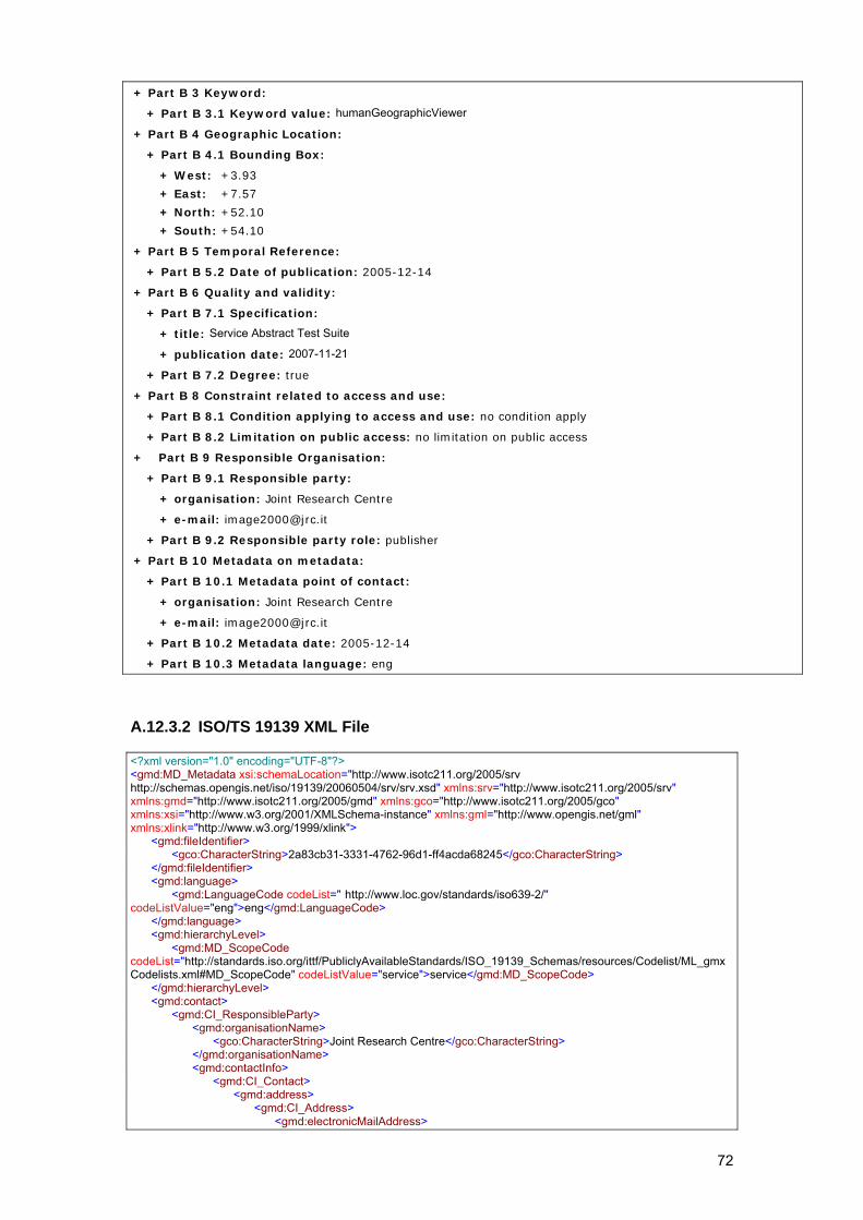
72
+ Part B 3 Keyword:
+ Part B 3.1 Keyword value: humanGeographicViewer
+ Part B 4 Geographic Location:
+ Part B 4.1 Bounding Box:
+ West: +3.93
+ East: +7.57
+ North: +52.10
+ South: +54.10
+ Part B 5 Temporal Reference:
+ Part B 5.2 Date of publication: 2005-12-14
+ Part B 6 Quality and validity:
+ Part B 7.1 Specification:
+ title: Service Abstract Test Suite
+ publication date: 2007-11-21
+ Part B 7.2 Degree: true
+ Part B 8 Constraint related to access and use:
+ Part B 8.1 Condition applying to access and use: no condition apply
+ Part B 8.2 Limitation on public access: no limitation on public access
+ Part B 9 Responsible Organisation:
+ Part B 9.1 Responsible party:
+ organisation: Joint Research Centre
+ e-mail: [email protected]
+ Part B 9.2 Responsible party role: publisher
+ Part B 10 Metadata on metadata:
+ Part B 10.1 Metadata point of contact:
+ organisation: Joint Research Centre
+ e-mail: [email protected]
+ Part B 10.2 Metadata date: 2005-12-14
+ Part B 10.3 Metadata language: eng
A.12.3.2 ISO/TS 19139 XML File <?xml version="1.0" encoding="UTF-8"?> <gmd:MD_Metadata xsi:schemaLocation="http://www.isotc211.org/2005/srv http://schemas.opengis.net/iso/19139/20060504/srv/srv.xsd" xmlns:srv="http://www.isotc211.org/2005/srv" xmlns:gmd="http://www.isotc211.org/2005/gmd" xmlns:gco="http://www.isotc211.org/2005/gco" xmlns:xsi="http://www.w3.org/2001/XMLSchema-instance" xmlns:gml="http://www.opengis.net/gml" xmlns:xlink="http://www.w3.org/1999/xlink"> <gmd:fileIdentifier> <gco:CharacterString>2a83cb31-3331-4762-96d1-ff4acda68245</gco:CharacterString> </gmd:fileIdentifier> <gmd:language> <gmd:LanguageCode codeList=" http://www.loc.gov/standards/iso639-2/" codeListValue="eng">eng</gmd:LanguageCode> </gmd:language> <gmd:hierarchyLevel> <gmd:MD_ScopeCode codeList="http://standards.iso.org/ittf/PubliclyAvailableStandards/ISO_19139_Schemas/resources/Codelist/ML_gmxCodelists.xml#MD_ScopeCode" codeListValue="service">service</gmd:MD_ScopeCode> </gmd:hierarchyLevel> <gmd:contact> <gmd:CI_ResponsibleParty> <gmd:organisationName> <gco:CharacterString>Joint Research Centre</gco:CharacterString> </gmd:organisationName> <gmd:contactInfo> <gmd:CI_Contact> <gmd:address> <gmd:CI_Address> <gmd:electronicMailAddress>
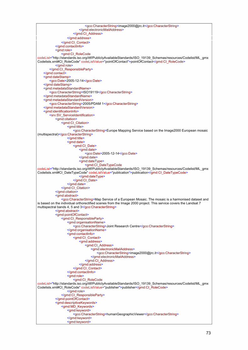
73
<gco:CharacterString>[email protected]</gco:CharacterString> </gmd:electronicMailAddress> </gmd:CI_Address> </gmd:address> </gmd:CI_Contact> </gmd:contactInfo> <gmd:role> <gmd:CI_RoleCode codeList="http://standards.iso.org/ittf/PubliclyAvailableStandards/ISO_19139_Schemas/resources/Codelist/ML_gmxCodelists.xml#CI_RoleCode" codeListValue="pointOfContact">pointOfContact</gmd:CI_RoleCode> </gmd:role> </gmd:CI_ResponsibleParty> </gmd:contact> <gmd:dateStamp> <gco:Date>2005-12-14</gco:Date> </gmd:dateStamp> <gmd:metadataStandardName> <gco:CharacterString>ISO19119</gco:CharacterString> </gmd:metadataStandardName> <gmd:metadataStandardVersion> <gco:CharacterString>2005/PDAM 1</gco:CharacterString> </gmd:metadataStandardVersion> <gmd:identificationInfo> <srv:SV_ServiceIdentification> <gmd:citation> <gmd:CI_Citation> <gmd:title> <gco:CharacterString>Europe Mapping Service based on the Image2000 European mosaic (multispectral)</gco:CharacterString> </gmd:title> <gmd:date> <gmd:CI_Date> <gmd:date> <gco:Date>2005-12-14</gco:Date> </gmd:date> <gmd:dateType> <gmd:CI_DateTypeCode codeList="http://standards.iso.org/ittf/PubliclyAvailableStandards/ISO_19139_Schemas/resources/Codelist/ML_gmxCodelists.xml#CI_DateTypeCode" codeListValue="publication">publication</gmd:CI_DateTypeCode> </gmd:dateType> </gmd:CI_Date> </gmd:date> </gmd:CI_Citation> </gmd:citation> <gmd:abstract> <gco:CharacterString>Map Service of a European Mosaic. The mosaic is a harmonised dataset and is based on the individual orthorectified scenes from the Image 2000 project. This service covers the Landsat 7 multispectral bands 4, 5 and 3</gco:CharacterString> </gmd:abstract> <gmd:pointOfContact> <gmd:CI_ResponsibleParty> <gmd:organisationName> <gco:CharacterString>Joint Research Centre</gco:CharacterString> </gmd:organisationName> <gmd:contactInfo> <gmd:CI_Contact> <gmd:address> <gmd:CI_Address> <gmd:electronicMailAddress> <gco:CharacterString>[email protected]</gco:CharacterString> </gmd:electronicMailAddress> </gmd:CI_Address> </gmd:address> </gmd:CI_Contact> </gmd:contactInfo> <gmd:role> <gmd:CI_RoleCode codeList="http://standards.iso.org/ittf/PubliclyAvailableStandards/ISO_19139_Schemas/resources/Codelist/ML_gmxCodelists.xml#CI_RoleCode" codeListValue="publisher">publisher</gmd:CI_RoleCode> </gmd:role> </gmd:CI_ResponsibleParty> </gmd:pointOfContact> <gmd:descriptiveKeywords> <gmd:MD_Keywords> <gmd:keyword> <gco:CharacterString>humanGeographicViewer</gco:CharacterString> </gmd:keyword> <gmd:keyword>
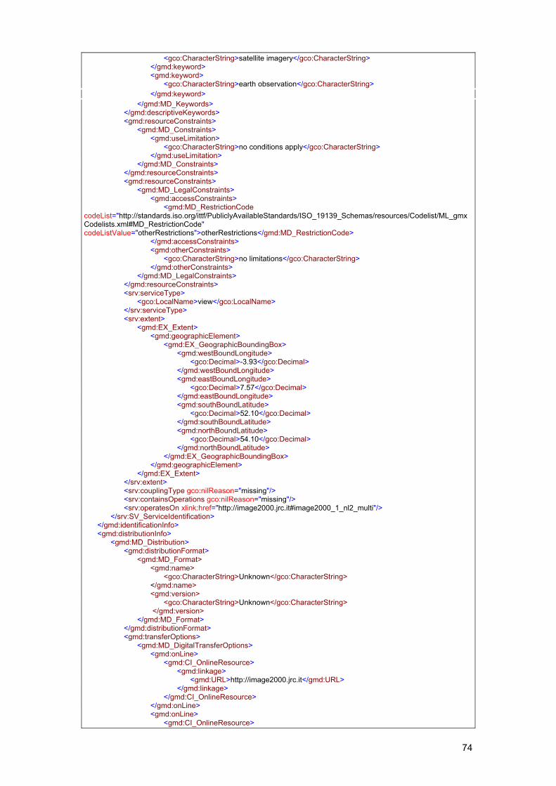
74
<gco:CharacterString>satellite imagery</gco:CharacterString> </gmd:keyword> <gmd:keyword> <gco:CharacterString>earth observation</gco:CharacterString> </gmd:keyword> </gmd:MD_Keywords> </gmd:descriptiveKeywords> <gmd:resourceConstraints> <gmd:MD_Constraints> <gmd:useLimitation> <gco:CharacterString>no conditions apply</gco:CharacterString> </gmd:useLimitation> </gmd:MD_Constraints> </gmd:resourceConstraints> <gmd:resourceConstraints> <gmd:MD_LegalConstraints> <gmd:accessConstraints> <gmd:MD_RestrictionCode codeList="http://standards.iso.org/ittf/PubliclyAvailableStandards/ISO_19139_Schemas/resources/Codelist/ML_gmxCodelists.xml#MD_RestrictionCode" codeListValue="otherRestrictions">otherRestrictions</gmd:MD_RestrictionCode> </gmd:accessConstraints> <gmd:otherConstraints> <gco:CharacterString>no limitations</gco:CharacterString> </gmd:otherConstraints> </gmd:MD_LegalConstraints> </gmd:resourceConstraints> <srv:serviceType> <gco:LocalName>view</gco:LocalName> </srv:serviceType> <srv:extent> <gmd:EX_Extent> <gmd:geographicElement> <gmd:EX_GeographicBoundingBox> <gmd:westBoundLongitude> <gco:Decimal>-3.93</gco:Decimal> </gmd:westBoundLongitude> <gmd:eastBoundLongitude> <gco:Decimal>7.57</gco:Decimal> </gmd:eastBoundLongitude> <gmd:southBoundLatitude> <gco:Decimal>52.10</gco:Decimal> </gmd:southBoundLatitude> <gmd:northBoundLatitude> <gco:Decimal>54.10</gco:Decimal> </gmd:northBoundLatitude> </gmd:EX_GeographicBoundingBox> </gmd:geographicElement> </gmd:EX_Extent> </srv:extent> <srv:couplingType gco:nilReason="missing"/> <srv:containsOperations gco:nilReason="missing"/> <srv:operatesOn xlink:href="http://image2000.jrc.it#image2000_1_nl2_multi"/> </srv:SV_ServiceIdentification> </gmd:identificationInfo> <gmd:distributionInfo> <gmd:MD_Distribution> <gmd:distributionFormat> <gmd:MD_Format> <gmd:name> <gco:CharacterString>Unknown</gco:CharacterString> </gmd:name> <gmd:version> <gco:CharacterString>Unknown</gco:CharacterString> </gmd:version> </gmd:MD_Format> </gmd:distributionFormat> <gmd:transferOptions> <gmd:MD_DigitalTransferOptions> <gmd:onLine> <gmd:CI_OnlineResource> <gmd:linkage> <gmd:URL>http://image2000.jrc.it</gmd:URL> </gmd:linkage> </gmd:CI_OnlineResource> </gmd:onLine> <gmd:onLine> <gmd:CI_OnlineResource>
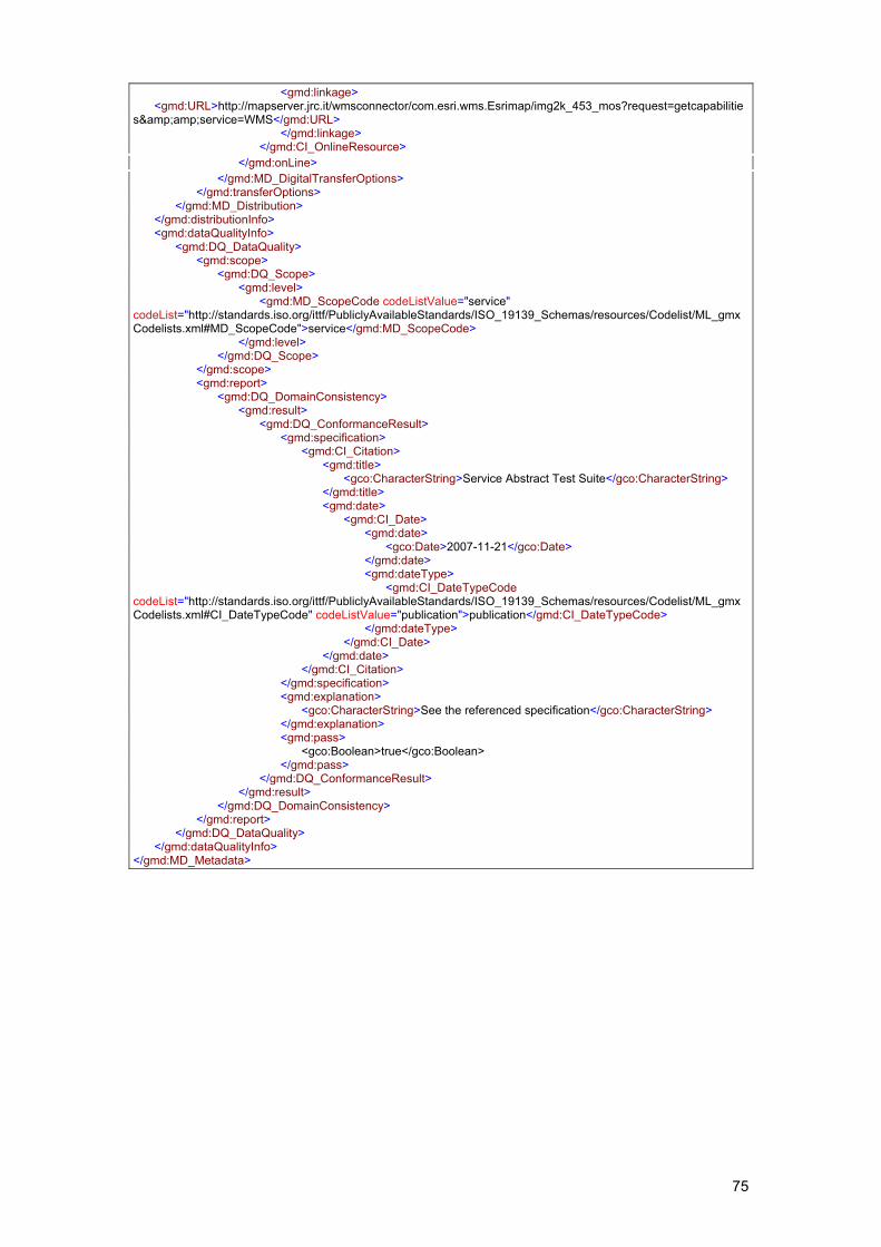
75
<gmd:linkage> <gmd:URL>http://mapserver.jrc.it/wmsconnector/com.esri.wms.Esrimap/img2k_453_mos?request=getcapabilities&amp;service=WMS</gmd:URL> </gmd:linkage> </gmd:CI_OnlineResource> </gmd:onLine> </gmd:MD_DigitalTransferOptions> </gmd:transferOptions> </gmd:MD_Distribution> </gmd:distributionInfo> <gmd:dataQualityInfo> <gmd:DQ_DataQuality> <gmd:scope> <gmd:DQ_Scope> <gmd:level> <gmd:MD_ScopeCode codeListValue="service" codeList="http://standards.iso.org/ittf/PubliclyAvailableStandards/ISO_19139_Schemas/resources/Codelist/ML_gmxCodelists.xml#MD_ScopeCode">service</gmd:MD_ScopeCode> </gmd:level> </gmd:DQ_Scope> </gmd:scope> <gmd:report> <gmd:DQ_DomainConsistency> <gmd:result> <gmd:DQ_ConformanceResult> <gmd:specification> <gmd:CI_Citation> <gmd:title> <gco:CharacterString>Service Abstract Test Suite</gco:CharacterString> </gmd:title> <gmd:date> <gmd:CI_Date> <gmd:date> <gco:Date>2007-11-21</gco:Date> </gmd:date> <gmd:dateType> <gmd:CI_DateTypeCode codeList="http://standards.iso.org/ittf/PubliclyAvailableStandards/ISO_19139_Schemas/resources/Codelist/ML_gmxCodelists.xml#CI_DateTypeCode" codeListValue="publication">publication</gmd:CI_DateTypeCode> </gmd:dateType> </gmd:CI_Date> </gmd:date> </gmd:CI_Citation> </gmd:specification> <gmd:explanation> <gco:CharacterString>See the referenced specification</gco:CharacterString> </gmd:explanation> <gmd:pass> <gco:Boolean>true</gco:Boolean> </gmd:pass> </gmd:DQ_ConformanceResult> </gmd:result> </gmd:DQ_DomainConsistency> </gmd:report> </gmd:DQ_DataQuality> </gmd:dataQualityInfo> </gmd:MD_Metadata>