Innovation in Bicycle and Pedestrian Counts white paper
14
SUMMARY To create better facilities for people walking and biking, and to locate these facilities where demand and need is the highest, transportation professionals need reliable data to guide decision-making. Historically, collecting active transportation data has been both time and resource intensive. Although many communities have established robust count programs, there are still funding, quality control, and data management limitations. New technologies are emerging that aim to change the way active transportation data is collected, making it less expensive and easier to collect, resulting in more reliable data. This report provides a review of these technologies and their applications. Contributors: Hugh Louch, Brad Davis, Kim Voros, Kristen O’Toole, and Sam Piper, Alta Planning + Design This white paper is based on research leading to online publication in Spring 2016. The report is based on findings as of this date. Innovation in Bicycle and Pedestrian Counts A Review of Emerging Technology Laurenzo’s Fleurs alta APP BASED COUNTING SOFTWARE ANONYMOUS DATA COLLECTION GPS ENABLED ROUTE TRACKERS WIRELESS SENSORS MOBILE-BASED VIDEO COUNTING SOFTWARE VIDEO DETECTION SYSTEMS THERMAL SENSORS 198 #bikestoday PNEUMATIC TUBE COUNTER
Transcript of Innovation in Bicycle and Pedestrian Counts white paper

Summary
To create better facilities for people walking and biking, and to locate these facilities where demand and need is the highest, transportation professionals need reliable data to guide decision-making. Historically, collecting active transportation data has been both time and resource intensive. Although many communities have established robust count programs, there are still funding, quality control, and data management limitations. New technologies are emerging that aim to change the way active transportation data is collected, making it less expensive and easier to collect, resulting in more reliable data. This report provides a review of these technologies and their applications.
Contributors: Hugh Louch, Brad Davis, Kim Voros, Kristen O’Toole, and Sam Piper, Alta Planning + DesignThis white paper is based on research leading to online publication in Spring 2016. The report is based on findings as of this date.
Innovation in Bicycle and Pedestrian Counts
A Review of Emerging Technology
Laurenzo’s FleursaltaAPP BASED COUNTING SOFTWARE
ANONYMOUSDATA COLLECTION
GPS ENABLED ROUTE TRACKERS
WIRELESSSENSORS
MOBILE-BASED VIDEO COUNTING SOFTWARE
VIDEO DETECTIONSYSTEMS
THERMAL SENSORS
198#bikestoday
PNEUMATIC TUBECOUNTER
Summary
To create better facilities for people walking and biking, and to locate these facilities where demand and need is the highest, transportation professionals need reliable data to guide decision-making. Historically, collecting active transportation data has been both time and resource intensive. Although many communities have established robust count programs, there are still funding, quality control, and data management limitations. New technologies are emerging that aim to change the way active transportation data is collected, making it less expensive and easier to collect, resulting in more reliable data. This report provides a review of these technologies and their applications.
Contributors: Hugh Louch, Brad Davis, Kim Voros, Kristen O’Toole, and Sam Piper, Alta Planning + DesignThis white paper is based on research leading to online publication in Spring 2016. The report is based on findings as of this date.
Innovation in Bicycle and Pedestrian Counts
A Review of Emerging Technology
2 | Alta Planning + Design
IntroductIonRates of active transportation have increased nationally over the past fifteen years, driven by steady growth in better walking and bicycling infrastructure. As this trend continues, transportation professionals have become frustrated by a general lack of bike and pedestrian count data. Having access to more robust data is important for several reasons:
» Data helps to determine where investments in walking and biking infrastructure are most needed
» Data makes it possible to assess changes over time, draw conclusions about the impact of new facilities, and improve the design of future facilities
» Data helps to quantify the benefits of walking and biking, which ultimately makes active transportation projects more competitive for funding
» A federal-level initiative, the US Department of Transportation’s Mayor’s Challenge for Safer People, Safer Streets, calls for improved walking and bicycling data collection
One of the most persistent challenges facing the bicycle and pedestrian field is the lack of usage and demand documentation. Without accurate and consistent count data, it is difficult to measure the positive benefits of investments in these forms of transportation, especially when compared to other modes, such as the private automobile. Fortunately, current and emerging technologies can capture and process non-motorized data efficiently and economically. This report provides a review of these technologies and how they can be integrated into bike and pedestrian count programs.
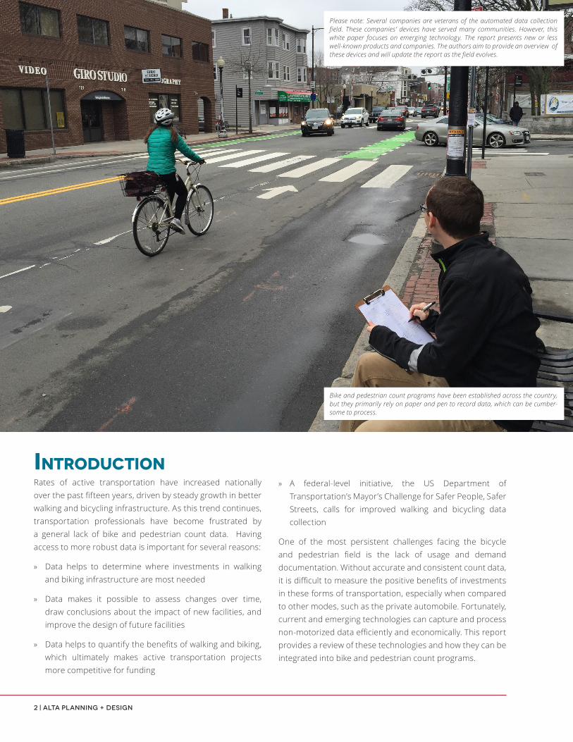
Bike and pedestrian count programs have been established across the country, but they primarily rely on paper and pen to record data, which can be cumber-some to process.
Please note: Several companies are veterans of the automated data collection field. These companies’ devices have served many communities. However, this white paper focuses on emerging technology. The report presents new or less well-known products and companies. The authors aim to provide an overview of these devices and will update the report as the field evolves.

Innovation in Bicycle and Pedestrian Counts | 3
NATIONAL BIKE AND PEDESTRIAN DOCUMENTATION PROJECTIn 2004, Alta Planning + Design and the Institute of Transportation Engineers (ITE) Pedestrian and Bicycle Council established the National Bicycle & Pedestrian Documentation Project (NBPD).* This nationwide effort provided a consistent model of data collection for use by planners, governments, and bicycle and pedestrian professionals. Before the program, there were few systematic and coordinated efforts to include bicycle and pedestrian movements in count data.
The NBPD specifies that standardized counts should occur twice a year, in the spring and the fall. Communities record activity at key locations during two-hour morning and afternoon ‘peak-commute’ periods on weekdays (Tuesdays, Wednesdays, or Thursdays). A Saturday count precedes or follows the official count dates. Typically, cities and towns enlist volunteers to staff the various locations. Since its inception in 2004, hundreds of cities and towns across the country have used this methodology to count bicycle and pedestrian activity within their communities. The NBPD project has succeeded in changing the way these cities and towns collect active transportation data. However, after nearly a decade of operation, challenges to the program have become apparent:
» Two-hour AM and PM count periods provide invaluable data, but planners have difficulty making annualized assumptions from this data. A single day does not represent typical travel patterns. National Cooperative Highway Research Program (NCHRP) Report 797: Guidebook on Pedestrian and Bicycle Volume Data Collection found, “the error in estimating average annual bicycle traffic from two-hour, 12-hour, or even one-week counts can be up to 40%” (TRB, 2015, http://www.trb.org/Main/Blurbs/171973.aspx). Conversely, annualized vehicle count data is readily available. Annualized data is critical because it provides the ability to understand change and forecast trends. Without comparable annualized walk and bike figures, it is more difficult to make a case for investments in these modes.
» Bicyclists and pedestrians have different travel habits than motor vehicles – trips tend to be shorter and distributed throughout the day. These factors make it more difficult to reliably capture their activity with two hour counts.
The growth of walking and biking over the past fifteen years has increased the need to have active transportation data available.
» Enlisting volunteers to staff counts is time consuming, and organizing volunteers can be a burden for municipal employees who have limited time and budget available to dedicate to this important task.
» Non-motorized counts are still primarily conducted with paper and pen. Staff digitize these records after data collection. This process can be time consuming, making data analysis a tedious task.
*Now called the ITE Pedestrian and Bicycle Standing Committee.
Alta is not advocating for the cessation of manual count programs. Alta recognizes that integrating technology into count programs will be a gradual process that will take time. Manual programs have many benefits, including the following, which are listed in no particular order:
• They are great community building exercises that help to engage advocates and highlight the importance of walking & biking.
• Some communities may not have the resources to purchase and install automated counters, making manual count programs the most economical option. In the event that an automated program cannot be implemented, manual counts should continue to be conducted as usual.
• They can quickly produce data in locations of interest (e.g., high-crash locations, corridors that are under review for design changes).
• They can be combined with automated technology, such as mobile applications that replace clipboards with counting boards or screens.
• They are used before deploying automated devices to study a given location’s suitability for automated counters. They are also used after automated devices are installed to calibrate and confirm data collected through automated means.
4 | Alta Planning + Design
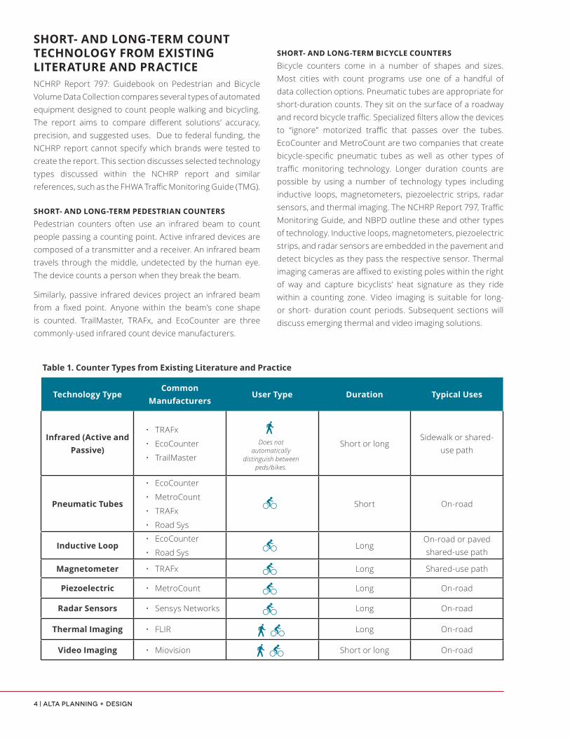
SHORT- AND LONG-TERM COUNT TECHNOLOGY FROM EXISTING LITERATURE AND PRACTICENCHRP Report 797: Guidebook on Pedestrian and Bicycle Volume Data Collection compares several types of automated equipment designed to count people walking and bicycling. The report aims to compare different solutions’ accuracy, precision, and suggested uses. Due to federal funding, the NCHRP report cannot specify which brands were tested to create the report. This section discusses selected technology types discussed within the NCHRP report and similar references, such as the FHWA Traffic Monitoring Guide (TMG).
SHORT- AND LONG-TERM PEDESTRIAN COUNTERS
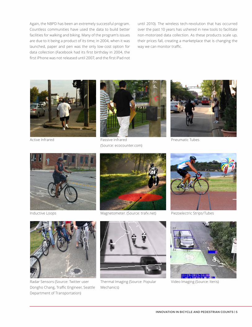
Pedestrian counters often use an infrared beam to count people passing a counting point. Active infrared devices are composed of a transmitter and a receiver. An infrared beam travels through the middle, undetected by the human eye. The device counts a person when they break the beam.
Similarly, passive infrared devices project an infrared beam from a fixed point. Anyone within the beam’s cone shape is counted. TrailMaster, TRAFx, and EcoCounter are three commonly-used infrared count device manufacturers.
SHORT- AND LONG-TERM BICYCLE COUNTERS
Bicycle counters come in a number of shapes and sizes. Most cities with count programs use one of a handful of data collection options. Pneumatic tubes are appropriate for short-duration counts. They sit on the surface of a roadway and record bicycle traffic. Specialized filters allow the devices to “ignore” motorized traffic that passes over the tubes. EcoCounter and MetroCount are two companies that create bicycle-specific pneumatic tubes as well as other types of traffic monitoring technology. Longer duration counts are possible by using a number of technology types including inductive loops, magnetometers, piezoelectric strips, radar sensors, and thermal imaging. The NCHRP Report 797, Traffic Monitoring Guide, and NBPD outline these and other types of technology. Inductive loops, magnetometers, piezoelectric strips, and radar sensors are embedded in the pavement and detect bicycles as they pass the respective sensor. Thermal imaging cameras are affixed to existing poles within the right of way and capture bicyclists’ heat signature as they ride within a counting zone. Video imaging is suitable for long- or short- duration count periods. Subsequent sections will discuss emerging thermal and video imaging solutions.
Technology TypeCommon
ManufacturersUser Type Duration Typical Uses
Infrared (Active and Passive)
• TRAFx
• EcoCounter
• TrailMaster
Short or longSidewalk or shared-
use path
Pneumatic Tubes
• EcoCounter
• MetroCount
• TRAFx
• Road Sys
Short On-road
Inductive Loop• EcoCounter
• Road SysLong
On-road or paved shared-use path
Magnetometer • TRAFx Long Shared-use path
Piezoelectric • MetroCount Long On-road
Radar Sensors • Sensys Networks Long On-road
Thermal Imaging • FLIR Long On-road
Video Imaging • Miovision Short or long On-road
Table 1. Counter Types from Existing Literature and Practice
Does not automatically
distinguish between peds/bikes.
Innovation in Bicycle and Pedestrian Counts | 5
until 2010). The wireless tech-revolution that has occurred over the past 10 years has ushered in new tools to facilitate non-motorized data collection. As these products scale up, their prices fall, creating a marketplace that is changing the way we can monitor traffic.
Active Infrared Passive Infrared (Source: ecocounter.com)
Pneumatic Tubes
Inductive Loops Magnetometer. (Source: trafx.net) Piezoelectric Strips/Tubes
Radar Sensors (Source: Twitter user Dongho Chang, Traffic Engineer, Seattle Department of Transportation)
Thermal Imaging (Source: Popular Mechanics)
Video Imaging (Source: Iteris)
Again, the NBPD has been an extremely successful program. Countless communities have used the data to build better facilities for walking and biking. Many of the program’s issues are due to it being a product of its time; in 2004, when it was launched, paper and pen was the only low-cost option for data collection (Facebook had its first birthday in 2004, the first iPhone was not released until 2007, and the first iPad not

6 | Alta Planning + Design
Device Cost:
Device costs vary based on a number of factors. Costs are based on the price of purchasing counting units, but may also include additional charges for data processing (i.e., an hourly processing rate). Some companies allow users to utilize their own, pre-existing cameras as counting devices. In these cases, prices will differ, since they may not involve data processing but not hardware purchase costs.
Device Accuracy:
No independent authority has yet conducted a peer review of these devices’ accuracy. At this time, the devices offer varying margins of error. Interested parties should contact the device suppliers to learn more about potential devices and their precision and accuracy.
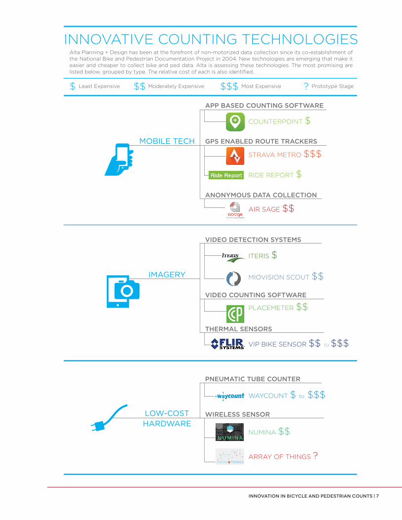
a variety of services, while frequently costing a fraction of traditional counting equipment. The following section outlines several services and corresponding technological solutions. The technologies that are emerging can be grouped into the categories listed below, and the graphic on page six summarizes the technologies reviewed.
InnovatIve countIng technologIeSSeveral cities are leading the way in using mobile devices to measure increasing levels of bicycle traffic. Several others would like to retire their clipboards and install higher-tech, automated machines. Until very recently, such programs were cost prohibitive. New technologies can reduce the cost of non-motorized data collection, analysis, and visualization. These market disrupters have the potential to provide
INNOVATIVE COUNTING TECHNOLOGIES
APP BASED COUNTING SOFTWARE
GPS ENABLED ROUTE TRACKERSMOBILE TECH
VIDEO DETECTION SYSTEMS
IMAGERY
PNEUMATIC TUBE COUNTER
LOW-COSTHARDWARE
COUNTERPOINT $
STRAVA METRO $$$
RIDE REPORT $
ITERIS $
VIDEO COUNTING SOFTWARE
THERMAL SENSORS
WIRELESS SENSOR
PLACEMETER $$
WAYCOUNT $ to $$$
NUMINA $$
ARRAY OF THINGS ?
Alta Planning + Design has been at the forefront of non-motorized data collection since its co-establishment of the National Bike and Pedestrian Documentation Project in 2004. New technologies are emerging that make it easier and cheaper to collect bike and ped data. Alta is assessing these technologies. The most promising are listed below, grouped by type. The relative cost of each is also identified.
$ Least Expensive $$ Moderately Expensive $$$ Most Expensive ? Prototype Stage
AIR SAGE $$ANONYMOUS DATA COLLECTION
MIOVISION SCOUT $$
THERMAL SENSOR VIP BIKE SENSOR $$ to $$$
Innovation in Bicycle and Pedestrian Counts | 7
INNOVATIVE COUNTING TECHNOLOGIES
APP BASED COUNTING SOFTWARE
GPS ENABLED ROUTE TRACKERSMOBILE TECH
VIDEO DETECTION SYSTEMS
IMAGERY
PNEUMATIC TUBE COUNTER
LOW-COSTHARDWARE
COUNTERPOINT $
STRAVA METRO $$$
RIDE REPORT $
ITERIS $
VIDEO COUNTING SOFTWARE
THERMAL SENSORS
WIRELESS SENSOR
PLACEMETER $$
WAYCOUNT $ to $$$
NUMINA $$
ARRAY OF THINGS ?
Alta Planning + Design has been at the forefront of non-motorized data collection since its co-establishment of the National Bike and Pedestrian Documentation Project in 2004. New technologies are emerging that make it easier and cheaper to collect bike and ped data. Alta is assessing these technologies. The most promising are listed below, grouped by type. The relative cost of each is also identified.
$ Least Expensive $$ Moderately Expensive $$$ Most Expensive ? Prototype Stage
AIR SAGE $$ANONYMOUS DATA COLLECTION
MIOVISION SCOUT $$
THERMAL SENSOR VIP BIKE SENSOR $$ to $$$

8 | Alta Planning + Design
STRAVA METRO, CYCLETRACKS, AND CYCLE ATLANTA (GPS ENABLED ROUTE TRACKERS)
Many people who bike or jog use Strava or related apps to track their distance, speed, and route. Portland Bureau of Transportation (PBOT) made history a few years ago when they decided to purchase a large Strava-collected data set. Cities around the world have since purchased Strava data sets to get a sense of their cities’ own trip patterns.
Although the data tends to capture recreational riders, whose gender and ethnicity do not typically represent the overall population, the data is useful to generally determine what routes people are riding. Strava is currently working with municipalities to identify the shortcomings of the data and tailor it better to cities’ needs. Eighteen cities have adapted a similar app, CycleTracks, originally created for data collection in San Francisco in 2010. The application’s code is open
MOBILE TECHNOLOGYMobile applications and devices can harness human action to count a variety of road users, track their travel, and measure the quality of transportation infrastructure.
COUNTERPOINT (APP BASED COUNTING SOFTWARE)
Counterpoint is a mobile app designed to “make it easy to count traffic.” It provides the ability to make your own counting site or add to an existing site. Tap specific buttons to record who uses the public realm during your counting session. The app also boasts robust traffic categories that are more nuanced than traditional pen and paper tallies, including user-friendly options such as “baby in stroller”, “oversized bike”, and “visually impaired pedestrian.”
Creator Name: Green Action Centre
User Type:
Pros:• Free• Easy to Use
Cons: • Does not replace manual counting
Typical Uses:• Crowdsourced or semi-automated
volunteer-collected counts• Short-term research projects
Cost $Installation Easy
Data Extraction Mobile device
COUNTERPOINT
STRAVA METRO
Heatmap of Milwaukee/Wauwatosa, WI. Red shows popular routes (Source: labs.strava.com/heatmap/)
Counterpoint app screenshot (Source: http://counterpointapp.org/)
Creator Name: Strava, Inc.
User Type:
Pros:
• Easily readable heat maps
• Potentially high number of users per city because of crowd-sourced data
Cons: • Potential bias towards recreational riders, especially white, older males
Typical Uses:• Coupled with additional data sources
to assist with bicycle infrastructure planning
Installation Easy
Data Extraction Mobile device
$$$Cost
Innovation in Bicycle and Pedestrian Counts | 9
source (http://github.com/sfcta). Cycle Atlanta (cycleatalanta.org) was created to help the City make decisions about locations for new bicycle infrastructure. App users could also submit data about their experience along a given route.
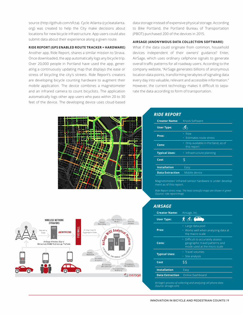
RIDE REPORT (GPS ENABLED ROUTE TRACKER + HARDWARE)
Another app, Ride Report, shares a similar mission to Strava. Once downloaded, the app automatically logs any bicycle trip. Over 20,000 people in Portland have used the app, gener-ating a continuously updating map that displays the ease or stress of bicycling the city’s streets. Ride Report’s creators are developing bicycle counting hardware to augment their mobile application. The device combines a magnetometer and an infrared camera to count bicyclists. The application automatically logs other app users who pass within 20 to 30 feet of the device. The developing device uses cloud-based
data storage instead of expensive physical storage. According to Bike Portland, the Portland Bureau of Transportation (PBOT) purchased 200 of the devices in 2015.
AIRSAGE (ANONYMOUS DATA COLLECTION SOFTWARE)
What if the data could originate from common, household devices independent of their owners’ guidance? Enter, AirSage, which uses ordinary cellphone signals to generate overall traffic patterns for all roadway users. According to the company website, “AirSage generates billions of anonymous location data points, transforming terabytes of signaling data every day into valuable, relevant and accessible information.” However, the current technology makes it difficult to sepa-rate the data according to form of transportation.
Creator Name: Knock Software
User Type:
Pros:• Free• Estimates route stress
Cons: • Only available in Portland, as of this report
Typical Uses: • Infrastructure planning
Cost $Installation Easy
Data Extraction Mobile device
RIDE REPORT
Ride Report stress map. The least stressful maps are shown in green (Source: ride.report/map)
Creator Name: Airsage, Inc.
User Type:
Pros:• Large data pool• Works well when analyzing data at
the macro scale
Cons:• Difficult to accurately assess
geographic travel patterns and mode used at the micro scale
Typical Uses:• Travel volumes• Site analysis
Cost $$Installation Easy
Data Extraction Online Dashboard
AIRSAGE
AirSage’s process of collecting and analyzing cell phone data (Source: airsage.com)
Magnetometer/ infrared sensor hardware is under develop-ment as of this report.
10 | Alta Planning + Design
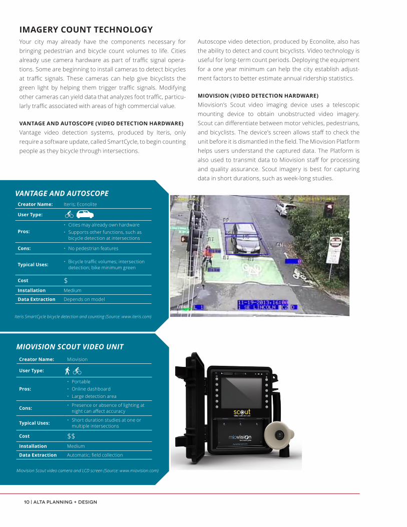
Autoscope video detection, produced by Econolite, also has the ability to detect and count bicyclists. Video technology is useful for long-term count periods. Deploying the equipment for a one year minimum can help the city establish adjust-ment factors to better estimate annual ridership statistics.
MIOVISION (VIDEO DETECTION HARDWARE)
Miovision’s Scout video imaging device uses a telescopic mounting device to obtain unobstructed video imagery. Scout can differentiate between motor vehicles, pedestrians, and bicyclists. The device’s screen allows staff to check the unit before it is dismantled in the field. The Miovision Platform helps users understand the captured data. The Platform is also used to transmit data to Miovision staff for processing and quality assurance. Scout imagery is best for capturing data in short durations, such as week-long studies.
IMAGERY COUNT TECHNOLOGYYour city may already have the components necessary for bringing pedestrian and bicycle count volumes to life. Cities already use camera hardware as part of traffic signal opera-tions. Some are beginning to install cameras to detect bicycles at traffic signals. These cameras can help give bicyclists the green light by helping them trigger traffic signals. Modifying other cameras can yield data that analyzes foot traffic, particu-larly traffic associated with areas of high commercial value.
VANTAGE AND AUTOSCOPE (VIDEO DETECTION HARDWARE)
Vantage video detection systems, produced by Iteris, only require a software update, called SmartCycle, to begin counting people as they bicycle through intersections.
Creator Name: Iteris; Econolite
User Type:
Pros:• Cities may already own hardware• Supports other functions, such as
bicycle detection at intersections
Cons: • No pedestrian features
Typical Uses: • Bicycle traffic volumes; intersection detection; bike minimum green
Cost $Installation Medium
Data Extraction Depends on model
VANTAGE AND AUTOSCOPE
Iteris SmartCycle bicycle detection and counting (Source: www.iteris.com)
Creator Name: Miovision
User Type:
Pros:• Portable• Online dashboard• Large detection area
Cons: • Presence or absence of lighting at night can affect accuracy
Typical Uses: • Short duration studies at one or multiple intersections
Cost $$Installation Medium
Data Extraction Automatic; field collection
MIOVISION SCOUT VIDEO UNIT
Miovision Scout video camera and LCD screen (Source: www.miovision.com)

Innovation in Bicycle and Pedestrian Counts | 11
security cameras. In addition to travel volumes, Placemeter can measure walking direction and store visits, and it is particularly well suited for locations where continuous count data is desired. The second generation Placement Sensor is expected in 2016. One drawback of the technology is that it requires a WiFi connection.
FLIR SYSTEMS (THERMAL SENSORS)
FLIR Systems, Inc. produces thermal imaging devices capable of long-term detection and counting of people walking, biking, and driving. Thermal sensors operate similarly to video sensors. While both types of devices capture imagery, thermal sensors generate images based on objects’ and people’s naturally-occurring infrared radiation. Thermal cameras do not need natural light to produce imagery. Therefore, they are less vulnerable to occlusion than video.
PLACEMETER (VIDEO COUNTING SOFTWARE)
Placemeter, a company that emerged in 2012, turns video footage from any camera (including cell phones) into pedestrian, bicycle, and car movement data. First, users attach an existing security camera or a Placemeter Sensor in a window over the preferred measuring point. Placemeter defines a “Measurement Point” as a sidewalk, street, or storefront, where one wishes to measure bicycle, pedestrian, or vehicle activity. Since measurement points cannot currently distinguish between forms of transportation; users must purchase one screenline per mode of transportation. Measuring people walking, bicycling, and driving would therefore require three screenlines. After installation, the company turns measurement point video footage into data displayed on an online dashboard or emailed as a downloadable file. Placemeter can continue ongoing measurement using the Placemeter Sensor or live
Creator Name: FLIR Systems, Inc.
User Type:
Pros:
• Easily installed• Bicycle detection can be used to
adapt green time for people bicycling• Large detection area
Cons: • Poor weather at night can affect accuracy
Typical Uses: • Long duration counts at one or more intersections
Cost $$ to $$$Installation Medium
Data Extraction Automatic
VIP BIKE DETECTION BOARD FOR THERMAL SENSOR
Creator Name: Placemeter, Inc.
User Type:
Pros:• Use existing cameras• Dashboard to view data
Cons:
• Mode differentiation across one screenline is still in development
• Need for WiFi may limit suitability in some locations
Typical Uses:• Place sensor indoors to count in/out
shop movements; traffic volumes on a sidewalk/street
Cost $$Installation Easy
Data Extraction Automatic
PLACEMETER
Process of collecting and analyzing data (Source: placemeter.com)
Bicycle detection at an intersection (Source: www.popularmechanics.com)

12 | Alta Planning + Design
INEXPENSIVE HARDWARE
WAYCOUNT (PNEUMATIC TUBE COUNTER)
WayCount, based in New York, offers three DIY-type models. Each device uses pneumatic tubes and inexpensive, easily portable components to count bikes and cars. WayCount produces three devices: Lite, Aluminum, and Hi-Viz. The Lite model is $199. The Aluminum device is $200 plus freight. WayCount Aluminum requires a minimum purchase of 250 units. WayCount Hi-Viz features a screen with 6” tall LED letters, which makers say can be viewed 100’ away. The screen lets bicyclists, passersby, and drivers see the number of bicyclists counted in real time since the session began. Each of the WayCount devices can collect continuous data throughout a 24-hour period.
NUMINA (WIRELESS SENSOR)
Numina, an emerging product from CTY, used the Knight Foundation Prototype Fund to develop a device to track people walking, biking, and driving. The start-up aims to produce an inexpensive sensor, easily installed on existing light poles, without the need for special tools or know-how.
The 2015 Association of Pedestrian and Bicycle Professionals (APBP) conference proved the perfect testing ground for the fledgling device. Conference attendees provided feedback to improve the prototype. With time, Numina aims to measure noise pollution, air quality, and green space, in relation to traffic counts.
Creator Name: CTY
User Type:
Pros:• Alternative to more expensive
equipment• Online dashboard
Cons: • Not currently available for purchase- in prototyping stage
Typical Uses:• On-street or off-street volume
analysis for short- or long-term counts
Cost $$Installation Easy
Data Extraction Automatic
NUMINA
Potential applications for Numina sensors (Source: Numina by CTY)
WAYCOUNT
WayCount Hi-Viz in action (Source: http://waycount.com/)
Creator Name: Tomorrow Lab
User Type:
Pros:• Less expensive than other pneu-
matic tubes• Real time count display
Cons: • Minimum unit purchase for Aluminum counter
Typical Uses:• Short-duration counts as part of
a citywide program; one-off data collection efforts along a bike facility
Cost $ to $$$Installation Easy
Data Extraction Field collection
Solution
Numina is analytics for places.
See real-time heat maps of activity for your neighborhood, park, institution, or business. See how people move, not just cars.

Innovation in Bicycle and Pedestrian Counts | 13
COUNTING AND MORESome devices go beyond counts data collection to investigate other characteristics of an urban space. The Array of Things (AoT) project team is developing sensors to count people in public spaces. They are also working to collect place-related data such as air quality and other indicators.
AoT, led by Argonne National Laboratory and the University of Chicago, is currently working with a $3.1 million grant from the National Science Foundation to develop an “urban-scale ‘instrument’” to track a laundry list of freely-available, public data. The project team and the City of Chicago plan to install 50 sensor nodes to streetlights in early 2016. By 2017, the number will grow to 500.
Creator Name: Argonne National Laboratory and the University of Chicago
User Type:
Pros: • Will eventually collect data related to air quality and other metrics
Cons: • Not currently available for purchase- in prototyping stage
Typical Uses:• Monitor citywide trends related
to economic, environmental, and transportation trends
Cost Unknown
ARRAY OF THINGS PROJECT
Prototype Photo (Source: Anthony Souffle / Chicago Tribune)

Innovation in Bicycle and Pedestrian Counts | 14
This page intentionally left blank.
Laurenzo’s FleursaltaAPP BASED COUNTING SOFTWARE
ANNONYMOUSDATA COLLECTION
GPS ENABLED ROUTE TRACKERS
WIRELESSSENSORS
MOBILE-BASED VIDEO COUNTING SOFTWARE
VIDEO DETECTIONSYSTEMS
THERMAL SENSORS
198#bikestoday
PNEUMATIC TUBECOUNTER
IntereSted In learnIng more?The range of technologies shown below can help you create powerful datasets to inform transportation planning in your community. Alta Planning + Design offers comprehensive services to develop custom tailored active transportation count programs. We can help you deter-mine which tools are the most appropriate, identify count locations, and coordinate installation. Our analytics team can also collect the data and create compelling visuals to make it useful for decision makers. Please contact us with any questions you have about instituting a tech-driven count program today.
THE SENSORED STREET
ABOUT THE AUTHORS
Kristen O’Toole | [email protected]
Kristen assists in managing a variety of bicycle and pedestrian projects ranging from data collection and analysis to master planning. She guides cities, regions, and states through the data collection process with the ultimate goal of deciphering data to support their current and future visions.
Sam Piper | [email protected]
Sam has focused his career on developing better infrastructure for active modes of transportation. He has extensive experience leading long-term count programs and visualizing bike and pedestrian data. He enjoys using technology to make sense of our surroundings and to facilitate decision making.
Innovation in Bicycle and Pedestrian Counts | 14
This page intentionally left blank.
Laurenzo’s FleursaltaAPP BASED COUNTING SOFTWARE
ANONYMOUSDATA COLLECTION
GPS ENABLED ROUTE TRACKERS
WIRELESSSENSORS
MOBILE-BASED VIDEO COUNTING SOFTWARE
VIDEO DETECTIONSYSTEMS
THERMAL SENSORS
198#bikestoday
PNEUMATIC TUBECOUNTER
IntereSted In learnIng more?The range of technologies shown below can help you create powerful datasets to inform transportation planning in your community. Alta Planning + Design offers comprehensive services to develop custom tailored active transportation count programs. We can help you deter-mine which tools are the most appropriate, identify count locations, and coordinate installation. Our analytics team can also collect the data and create compelling visuals to make it useful for decision makers. Please contact us with any questions you have about instituting a tech-driven count program today.
THE SENSORED STREET
ABOUT THE AUTHORS
Kristen O’Toole | [email protected]
Kristen assists in managing a variety of bicycle and pedestrian projects ranging from data collection and analysis to master planning. She guides cities, regions, and states through the data collection process with the ultimate goal of deciphering data to support their current and future visions.
Sam Piper | [email protected]
Sam has focused his career on developing better infrastructure for active modes of transportation. He has extensive experience leading long-term count programs and visualizing bike and pedestrian data. He enjoys using technology to make sense of our surroundings and to facilitate decision making.