Initial Study/Mitigated Negative Declaration - California · Shasta County, California . ... This...
81
Draft Initial Study / Mitigated Negative Declaration For the Proposed LaTour Demonstration State Forest 2013 Management Plan Shasta County, California Prepared by: The State of California Board of Forestry and Fire Protection P.O. Box 944246 Sacramento, CA The Lead Agency Pursuant to Section 21082.1 of the The California Environmental Quality Act May 2013
Transcript of Initial Study/Mitigated Negative Declaration - California · Shasta County, California . ... This...

Draft Initial Study / Mitigated Negative Declaration For the Proposed
LaTour Demonstration State Forest 2013 Management Plan
Shasta County, California
Prepared by:
The State of California Board of Forestry and Fire Protection
P.O. Box 944246 Sacramento, CA
The Lead Agency Pursuant to Section 21082.1 of the
The California Environmental Quality Act
May 2013

ii
Table of Contents
I. MITIGATED NEGATIVE DECLARATION .............................................................................. 1
Determination ........................................................................................................................................... 1
Introduction and Regulatory Guidance ..................................................................................................... 2
Purpose of the Initial Study ...................................................................................................................... 2
Environmental Permits ............................................................................................................................. 3
Summary of Findings ............................................................................................................................... 3
Mitigation Measures ................................................................................................................................. 4
Management Measures ............................................................................................................................. 4
Project Location ........................................................................................................................................ 5
Background and Need for the Project ....................................................................................................... 5
Project Objectives ..................................................................................................................................... 6
Project Description ................................................................................................................................... 6
Environmental Setting ............................................................................................................................ 10
Figure 1 - Project Vicinity Map .......................................................................................................... 12
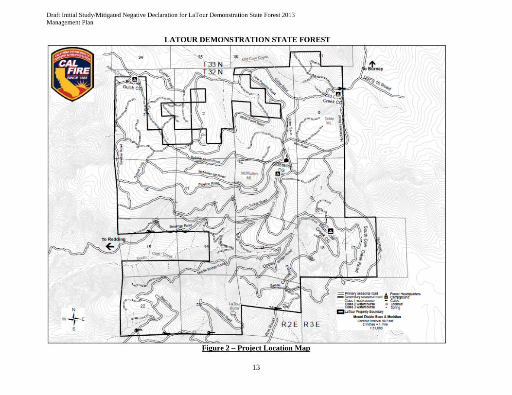
Figure 2 – Project Location Map ........................................................................................................ 13
Figure 3 - LDSF Planning Watersheds ............................................................................................... 14 II. INITIAL STUDY & ENVIRONMENTAL CHECKLIST .......................................................... 15
Determination of Initial Evaluation ........................................................................................................ 20
Analysis of Potential Environmental Impacts ........................................................................................ 21
Aesthetics ............................................................................................................................................ 21
Agricultural Resources ....................................................................................................................... 23
Air Quality .......................................................................................................................................... 24
Biological Resources .......................................................................................................................... 26
Cultural Resources .............................................................................................................................. 36
Geology and Soils ............................................................................................................................... 39
Hazards and Hazardous Materials ...................................................................................................... 43
Hydrology and Water Quality ............................................................................................................ 50
Land Use and Planning ....................................................................................................................... 53
Mineral Resources .............................................................................................................................. 54
Noise ................................................................................................................................................... 55

iii
Population and Housing ...................................................................................................................... 57
Public Services .................................................................................................................................... 58
Recreation ........................................................................................................................................... 60
Transportation/Traffic ......................................................................................................................... 61
Utilities and Service Systems ............................................................................................................. 63
Mandatory Findings of Significance .................................................................................................. 65
Assessment Area ..................................................................................................................................... 66
Past, Present and Future Projects ............................................................................................................ 68
Table 4 – Projects Within Assessment Area....................................................................................... 71
Resource Values ..................................................................................................................................... 72
Aesthetics ............................................................................................................................................ 72
Air Quality .......................................................................................................................................... 72
Biological Resources .......................................................................................................................... 72
Geology ............................................................................................................................................... 73
Hydrology and Water Quality ............................................................................................................ 74
Hazards and Hazardous Materials ...................................................................................................... 74
Management Activities ........................................................................................................................... 74
Discussion and Conclusions ................................................................................................................... 75
References ............................................................................................................................................... 77
List of Preparers of This Document........................................................................................................ 78
List of Experts Consulted ....................................................................................................................... 78

Draft Initial Study/Mitigated Negative Declaration for LaTour Demonstration State Forest 2013 Management Plan
1
I. MITIGATED NEGATIVE DECLARATION
Determination This Initial Study/Mitigated Negative Declaration (IS/MND) describes an environmental impact analysis conducted for the proposed LaTour Demonstration State Forest (LDSF) 2013 Management Plan. This document was prepared by California Department of Forestry and Fire Protection (CAL FIRE) staff, under contract to the California Board of Forestry and Fire Protection (Board). This document utilizes information gathered from a number of sources including research and field review of the proposed project area and consultation with an environmental planner and other experts on staff at other public agencies. Pursuant to Section 21082.1 of the California Environmental Quality Act, the Lead Agency, the Board of Forestry and Fire Protection, has independently reviewed and analyzed the Initial Study/Mitigated Negative Declaration and finds that this document reflects its independent judgment. The lead agency further finds that the proposed project, which includes management measures and mitigations designed to minimize environmental impacts, would not result in significant adverse effects on the environment. I hereby authorize the distribution of this IS/MND for public review and comment: _______________________________ Dated: ________________ George Gentry Executive Officer State Board of Forestry and Fire Protection

2 May 2013
Introduction and Regulatory Guidance This Initial Study/Mitigated Negative Declaration (IS/MND) has been prepared by the California Department of Forestry and Fire Protection (CAL FIRE) under contract to the California Board of Forestry and Fire Protection (Board) to evaluate potential environmental effects of the proposed LaTour Demonstration State Forest 2013 Management Plan project, located near the community of Whitmore in Shasta County California. This document has been prepared in accordance with the California Environmental Quality Act (CEQA) (Public Resources Code Section 21000 et seq.) and the State CEQA Guidelines (California Code of Regulations [CCR] Section 15000 et seq.). An Initial Study (IS) is prepared by a lead agency to determine if a project may have a significant effect on the environment (State CEQA Guidelines Section 15063[a]), and thus to determine the appropriate environmental document. In accordance with State CEQA Guidelines Section 15070, a “public agency shall prepare … a proposed negative declaration or mitigated negative declaration … when: (a) The Initial Study shows that there is no substantial evidence … that the project may have a significant impact upon the environment, or (b) The Initial Study identifies potentially significant effects but revisions to the project plans or proposal are agreed to by the applicant and such revisions would reduce potentially significant effects to a less-than-significant level.” In this circumstance, the lead agency prepares a written statement describing its reasons for concluding that the proposed project would not have a significant effect on the environment and, therefore, does not require the preparation of an Environmental Impact Report (EIR). This IS/MND conforms to these requirements and to the content requirements of State CEQA Guidelines Section 15071. This IS/MND evaluates the environmental effects of the proposed LDSF 2013 Management Plan project. The project involves a 9,033-acre state owned forested landscape managed by CAL FIRE which includes timber harvesting, road building, campground development and use, biomass harvesting, prescribed burning, pre-commercial thinning, nature trail construction, culvert replacement or removal, Christmas tree harvesting, fire wood cutting, etc. This list is not all inclusive as there may be additional activities as well as research and demonstration.
Purpose of the Initial Study CAL FIRE has primary authority for carrying out the proposed LDSF 2013 Management Plan project and Board is the lead agency under CEQA. The purpose of this IS/MND is to present to the public the environmental consequences of implementing the proposed project and describe the adjustments made to the project to avoid significant environmental effects or reduce them to a less-than-significant level. This disclosure document is being made available to the public for review and comment. The IS/MND is being circulated for public review and comment for a review period of 30 days. The beginning and ending dates of the 30-day public review period will be indicated on the Notice of Intent. Your views and comments on how the proposed project may affect the environment are welcomed. If you wish to submit written comments for the Board’s consideration, these must be postmarked on or prior to the date the public review period will close as indicated on the Notice of Intent. If you wish to submit written comments via email, such comments must be received on or prior to the date the public review period closes, as listed on the Notice of Intent.
3 May 2013
Comments should be addressed to: George Gentry, Executive Officer State Board of Forestry and Fire Protection P.O. Box 944246 Sacramento, CA 94244-2460 Phone: (916) 653-8007 Email: [email protected] After comments are received from the public and reviewing agencies, CAL FIRE will consider those comments and may (1) adopt the Mitigated Negative Declaration and approve the proposed project; (2) undertake additional environmental studies; or (3) abandon the project. If the project is approved, CAL FIRE will be responsible for implementing the project.
Environmental Permits All projects conducted under the guidance of this Management Plan are subject to additional CEQA documentation and permits from some or all of the following agencies:
CAL FIRE California Department of Fish and Wildlife Regional Water Quality Control Board Shasta County Air Quality Shasta County Public Health Shasta County Agriculture Commissioner California Department of Pesticide Regulation Shasta County Sheriff Department.
Summary of Findings An IS/MND has been prepared to assess the project’s potential effects on the environment and an appraisal of the significance of those effects. Based on this IS/MND, it has been determined that the proposed project would not have any significant effects on the environment after implementation of mitigation measures. This conclusion is supported by the following findings:
1. The proposed project would have no effect related to Agricultural Resources, Land Use and Planning, Mineral Resources, Population and Housing, Public Services.
2. The proposed project would have a less than significant impact on Aesthetics, Air Quality,
Biological Resources, Cultural Resources, Geology and Soils, Hydrology and Water Quality, Noise, Recreation, Transportation, Utilities and Service Systems.

4 May 2013
3. Mitigation is required to reduce potentially significant impacts related to Hazards and Hazardous Materials.
Mitigation Measures The following five mitigation measures would be implemented by CAL FIRE to avoid or minimize environmental impacts. Implementation of these mitigation measures would reduce the environmental impacts of the proposed project to a less-than-significant level.
1. Mitigation Measure 1: To insure that all material is properly used, stored and transported, Material Safety Data Sheets (MSDS), material labels, and any additional handing and emergency instruction of the materials are kept on file at LDSF Headquarters.
2. Mitigation Measure 2: Any state employee handling these materials are made aware of the
potential hazards, given proper training and instruction, and also made aware of the location of the MSDS, and any other documentation for the material.
3. Mitigation Measure 3: All contractors used in the application or use of these hazardous
materials shall have the appropriate licenses and be able to read and understand the MSDS, labels, appropriate recommendations and application instructions.
4. Mitigation Measure 4: The storage of potentially hazardous materials on LDSF is in
accordance to the MSDS and any buildings that are used for storage will display appropriate placards.
5. Mitigation Measure 5: To prevent the spread of the fungus Batrachochytrium dendrobatidis (Bd) and other diseases, all gear used in the water or mud by contractors or permittees (dip nets, waders, booties, boots, calipers, etc.) shall be disinfected before moving from one body of water to another. They shall be disinfected in a 0.1 percent solution of Quat 128 and soak all items for five minutes. The disinfectant shall be disposed of > 100 M from the water on a trail or in thick duff where it is quickly broken down by particulate carbon. In addition, wash hands with a hand sanitizer or replace gloves and rinse equipment after contact with each animal.
Management Measures Management measures are different from the mitigations developed in this mitigated negative declaration. Management measures are actions that are already included in the management plan, as an integral part of the planned management for the Forest. A small number of these have been documented here because of their importance in avoiding environmental impacts. Mitigations by contrast, are additional actions, over and above the management plan, that have been identified as necessary to avoid environmental impacts. Implementation of the following four management measures from the LDSF management plan will help reduce the environmental impacts of the proposed project to a less-than-significant level.

5 May 2013
1. Management Measure 1: All harvest trees or leave trees will be marked under single tree selection silviculture. This management measure ensures that all trees will be evaluated for the presence of nesting structures, potential snag and LWD recruitment, and the existence of any other special habitat elements.
2. Management Measure 2: LDSF is conducting wildlife studies to obtain a current knowledge
of wildlife species use, and for the detection of rare, threatened, or endangered species.
3. Management Measure 3: LDSF has a road management plan
4. Management Measure 4: LDSF has restricted timber operations and roadwork near designated campgrounds to be conducted during the weekdays, to the extent feasible, to minimize the impact to forest visitors.
Project Location LDSF is located in eastern Shasta County in Townships 32 and 33 North, Ranges 2 and 3 East M.D.B & M. It ranges in elevation from 3,800 feet to over 6,700 feet with 80% of LDSF above 5,000 feet. LDSF comprises 9,033 acres of which, the GIS timber land base acres for the forest types are 8968 acres. LDSF is situated approximately forty-five miles east of Redding and twenty-one miles south of Burney. Seventeen miles southeast of LDSF is Lassen Volcanic National Park. The nearest community is Whitmore, eleven miles to the west.
Background and Need for the Project
In 1923 legislation was enacted enabling the eventual exchange of various state school lands for National Forest lands of comparable value. On September 28, 1930 the State Lands Commission exchanged 10,957 acres of land administered by them for the land included in the Cow Creek unit of Lassen National Forest.
Purchase of the property by the California Division of Forestry was made possible with the enactment of Chapter 1465 Statutes, dated July 17, 1945. Therein the legislature encumbered the sum of $100,000 from the State Treasury for the purchase of the Cow Creek Unit by the Division of Forestry from the State Lands Commission. The patent deed to the property known as “LaTour State Forest” was executed on January 8, 1946. LDSF was the first sizable state forest acquired.
The legislative authority for the State Forest System is contained in Public Resources Code (PRC) §4631-4658. CAL FIRE is responsible for the management of LDSF. As part of this oversight, the LDSF staff operates under a management plan, which provides general objectives and goals. The plan is required pursuant to Public Resources Code (PRC) §4645 and Article 8 of the Board policy.
Guided by the statutes, the Board establishes policy, which governs LDSF and other state forests. Board policy states that the primary purpose of the state forest program is to conduct innovative demonstrations, experiments, and education in forest management. Many such projects are integrated into the production and harvesting of forest products.

6 May 2013
Board policy states that the LDSF Management Plan shall be prepared by the Department, with appropriate public review, for approval by the Board. The Department shall present to the Board a thorough review of each existing plan at least every five years. After each review, the Board may direct the Department either to continue management under the existing plan, to prepare amendments to the plan, or to prepare a new plan for public review and Board approval. The Department shall submit the requested amendments or plan to the Board within one year after each request. The Department shall continue management under existing plans with appropriate consideration for changes in law or regulation, until amendments or new plans are approved by the Board.
The California Environmental Quality Act (CEQA) requires analysis of the potential environmental impacts of a forest management plan. This requirement is fulfilled by a Mitigated Negative Declaration CEQA document for the LDSF management plan.
Project Objectives
The Project is to update the 2008 management plan for LDSF. The Project gives programmatic guidance to LDSF staff on the planned on-the-ground management of LDSF for the next five to ten years. It serves as a guide to Forest managers as well as a public disclosure of the management direction at LDSF. It refers to, and should be interpreted in context with the 2007 Option A Plan for the Forest, which contains a large landscape level strategic analysis of sustainable management on LDSF. Using a planning interval of 100 years, the Option A Plan establishes the long-term sustained yield for the Forest and the long term strategy for protecting other public trust resources.
Project Description
The LDSF management plan provides direction and guidance for the managed uses of forest resources and non-timber resources with an emphasis on forest research and demonstrations, recreation, maintenance of wildlife habitat, and water quality protection. Timber harvesting is one of the mechanisms used to implement forest management and to protect public trust resources. Other mechanisms include reforestation, vegetation management, controlled burning and other silvicultural methods.
The following is a list of overall management goals for LDSF. Each project on LDSF shall meet one or more of these goals:
1. Maintain and strive to improve the research and demonstration program to provide valuable information regarding timber production, wildlife habitat requirements for various species that inhabit LDSF, and road management practices that result in reduced sediment. This information should be made available to the general public, small forest landowners, resource professionals, timber operators, and the timber industry. Research and demonstration projects will be aimed at providing practical information for forest landowners who need to manage a host of forest resources, including but not limited to, wildlife, water, soil, sensitive plants, and timber. Due to limited staff resources, cooperative research projects will be sought with other public and private researchers who share a common interest and direction in forest management. Staff will seek opportunities to disseminate to landowners and the public information on Best Management Practices (BMPs) to maintain a healthy managed forest ecosystem. LDSF will continue research

7 May 2013
into forest-based carbon sequestration and forest management techniques to promote forest adaptation and resiliency to climate change.
2. Maintain a comprehensive forest resources inventory for purposes of estimating growing stock by species and site class. The resources inventory data will be used to calculate timber growth and future sustained yield calculations. The inventory will also be used to estimate the quantity of wildlife habitat attributes such as snag retention and stand structure. The collection of this data will assist managers in evaluating wildlife use and habitat condition on LDSF.
3. Provide low impact recreational opportunities for forest visitors. Work toward expansion and improvement of existing facilities and the development of new recreational opportunities in suitable areas.
4. Harvest timber under sustained yield management (PRC 4513). Use methods and levels of harvest which permit continuous production of timber and achieve maximum sustained production of high quality timber products (PRC 4513) without degrading the productivity and health of the forest, and contribute to local employment and tax revenue. Timber production will be conducted to provide local job opportunities, consistent with the overall objective of providing for recreation, wildlife, fisheries, aesthetic enjoyment, protection of soil resources, and protection of water quality.
5. Improve and maintain watershed protection through best forest management practices and erosion control efforts. Continue operating under the existing road management plan to maintain public access and prevent contamination of watercourses from road water runoff.
6. Continue an aggressive pest management program to help prevent the spread of harmful insects and disease to keep tree mortality at a minimal level. Harvest salvageable mortality when and where economically feasible and compatible with the management of other forest resources.
7 Continue the fire prevention and hazard reduction programs and construct fuel breaks in critical areas to help keep the damage from wildfires at a minimum. Maintain a prescribed burn program or other non-fire vegetation management program to help reduce the hazard associated with uncontrolled wildfires.
8 Work toward achieving the widest possible diversity of managed forest stands in different successional stages in order to foster ecosystem resiliency and adaptability to climate change and develop a laboratory of representative managed forest conditions for research. Seek opportunities to maintain or increase functional wildlife habitat within the planning watersheds.
9 Prevent site degradation by using erosion controls and best soil conservation practices in all management activities.
10 Continue to provide safe conditions for employees and visitors, identifying potentially hazardous situations, and where appropriate provide for safety guidelines, procedures, and equipment.
LDSF management goals are going to be obtained by meeting a series of specific objectives, listed within the management plan, for Forest Management, Other Forest Resources, Resource Protection, Research and Demonstration, and Recreation. These objectives include:
8 May 2013
• Concentrate harvesting in the young growth true fir stands to increase growth on residual trees, improve regeneration and biological diversity. Selection and group selection will be the primary silviculture methods used.
• Manage mixed conifer stands to increase growth on residual trees, improve regeneration and biological diversity. Pine species will be the preferred leave species to help increase pine regeneration.
• Uneven-aged management will be the primary management strategy, but all silvicultural prescriptions available for use under the State Forest Practice Rules will be available for use in research and management of the Forest.. Even-aged management may be used for management, research, demonstrations, insects and disease mortality areas, in unforeseen situations such as following wildfires, and in order to create a balanced range of seral stages for the purposes of research and forest health. In the last ten years, variable retention has been applied on fifty-five acres to help control the spread of fir canker. Even aged methods have been applied on six acres in the last ten years.
• Maintain and update the LDSF Marking Guide to reflect the most recent research and best management practices to assist personnel in the marking of timber for timber sales.
• Maintain harvest levels at or below the projected sustainable decadal harvest levels in the 2007 LDSF Option A plan. Timber harvesting activities will occur primarily in the Beal, Upper Battle Creek, and Huckleberry Creek Watersheds, but they may also occur elsewhere on the Forest.
• Maintain all roads in serviceable conditions and adhere to the LDSF road management plan
• LDSF will work to restore, maintain, or enhance occurrence of special habitat elements and unique habitats to promote species diversity and habitat quality.
• Wildlife habitat improvement opportunities will be identified during the planning and implementation of timber sales, demonstration and education activities, and recreational facilities.
• LDSF will incorporate control or eradication of exotic plant species into management activities, as opportunities are identified.
• Prescribed burning will continue to be utilized to help reduce the fire hazard, improve deer habitat, and as a tool to regenerate brush fields to conifer forests.
• As far as possible, all ongoing studies will be carried out to completion. Final reports will be written on completed studies.
• Seek advice from research institutions, other entities with a research focus and interest and forest managers on potential studies that could be conducted on LDSF.
• Give tours to groups or individuals to show projects being conducted on LDSF.

9 May 2013
• Maintain existing recreational facilities and annually evaluate the need for further development of campsites.
• Develop nature trails from Old Cow and South Creek campgrounds, as allowed by availability of funds.

10 May 2013
Environmental Setting
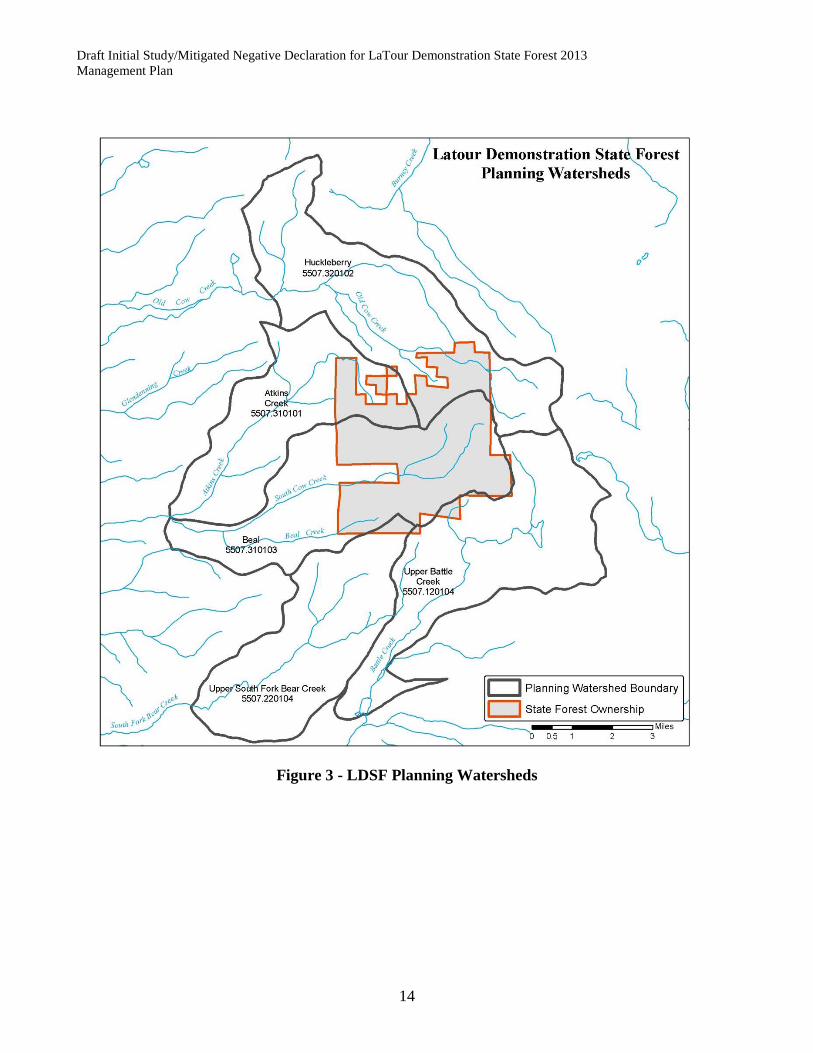
LDSF is located within five different CalWater planning watersheds: Beal (CalWater ID v2.2 5507.310103), Huckleberry Creek (CalWater ID v2.2 5507.320102), Atkins Creek (CalWater ID v2.2 5507.310101), Upper South Fork Bear Creek (CalWater ID v2.2 5507.220104), and Upper Battle Creek (CalWater ID v2.2 5507.120104). Only Beal and Atkins Creek are listed under the Forest Practice Rules as Anadromous Salmonid Watersheds. LDSF is the headwater source of two major streams, Old Cow Creek and South Cow Creek. A tributary to the North Fork of Battle Creek and South Fork of Bear Creek drain small portions of the south side of LDSF.
Old Cow Creek originates in Old Cow Creek and Huckleberry Meadows. Two intermittent tributaries that contribute to Old Cow Creek outside LDSF boundary are Peavine Gulch and White Fawn Gulch.
South Cow Creek starts in the South Cow Creek Basin above the meadows and flows westerly. Spring areas in the meadows and the tributaries contribute to its flow so that it is a major stream before it leaves LDSF. Tributaries to South Cow Creek that arise on or cross portions of LDSF are Bullhock, Beaver, and Atkins Creeks. Three intermittent streams that contribute to South Cow Creek are Beal Creek, Dry Gulch, and Lee March Gulch.
Climate on LDSF is Mediterranean type with warm dry summers and cold wet winters. Precipitation averages 46 inches with most of it as snow (74%) between November and March. Summer rainfall in the form of thundershowers is very sporadic and unpredictable. Temperatures range from a low of 0º Fahrenheit in the winter to a high of 85º Fahrenheit in the summer at the 6,000 foot elevation. The snow pack ranges from 1’ at the lower elevations to over 8’ at the higher elevations.
The soils on LDSF were inventoried in the early 1960s by the “State Cooperative Soil-Vegetation Survey” and the report was published in 1964. Soils are developed from four parent materials. Dark colored volcanic rocks and tuff breccia covers 60% of the area: light colored volcanic rock covers 25%; mixed unconsolidated glacial deposits occupy 10%; and mixed alluvial deposits resulting from faulting or glacial activity make up the remaining 5%.
There are eight soils derived from the above mentioned parent materials. The Windy, Cohasset, and Nanny soils are the most productive with the Cohasset series having the highest timber sites. The Jiggs, Lyonsville, and Windy variant are lower site timber soils with Jiggs soils being the least productive. Jiggs, Lyonsville, Windy, and Windy variant soils are found on the ridges and uplands of LDSF. The Cohasset soils are found at the lower elevations on the heavily forested sites. The Elam, Nanny, and Childs are found in or adjacent to meadows.
There are two major forest types found on LDSF, mixed conifer and true fir. The mixed conifer type is found at lower elevations on drier south and west facing slopes. The tree components of this type are ponderosa pine (Pinus ponderosa), sugar pine (Pinus lambertiana), white fir (Abies concolor), incense-cedar (Calocedrus decurrens), Douglas-fir (Pseudotsuga menziesii), and at the upper elevations jeffrey pine (Pinus jeffreyi) and red fir (Abies magnifica). The major component of the mixed conifer type is white fir.
The true fir type is found at the higher elevations and on the north slopes. This type is characterized by almost pure even aged stands of white and red fir. Other species found in association with the true firs
11 May 2013
are sugar pine, jeffrey pine, lodgepole pine (Pinus contorta), western white pine (Pinus monticola) and in an isolated area, mountain hemlock (Tsuga mertensiana).
Small amounts of hardwoods found in association with these types include black oak (Quercus kelloggii), canyon live oak (Quercus chrysolepsis), big leaf maple (Acer macrophylum), and Pacific dogwood (Cornus nuttallii).
Coniferous forest covers 83% of LDSF. The remaining 17% is covered with brush, rocky areas, and meadows. The brush fields are generally composed of manzanita (Arctostaphylos spp.) and chinquapin (Castanopsis sempervirens) with minor components of the genera Prunus and Ceanothus.
There are four campgrounds that have been developed adjacent to various streams. These campgrounds are primitive, as the only developments are pit toilets, tables and stoves. In the summer of 2002 potable water was piped into the Old Station Campground. Water from a spring is available at the South Cow Creek campground. Old Cow Creek and Butcher Gulch campgrounds have hand pumps that campers can use to obtain water.
Five water tanks are located on LDSF. Three tanks, one 10,000 gallon, one 5,500 gallon, and a 1,000 gallon tank are used to store water for fire control. One 10,000 gallon and one 5,500 gallon tank have been constructed to provide water for LDSF headquarters.
LDSF headquarters is used during the summer months. During the winter the headquarters is usually inaccessible due to snow. The headquarters consist of an office/barracks, a second barracks building, garage, storeroom, generator room/gas house, and a kitchen/mess hall used as a guest facility. The headquarters facilities provide housing and work facilities for forestry aides and visiting researchers.
The entire LDSF has been zoned as a Timberland Production Zone (TPZ). This means the land is devoted to and used for growing and harvesting timber and compatible uses. Compatible use is defined as any use that does not significantly detract from the use of the land for, or inhibit, growing and harvesting timber. Compatible uses include watershed management, fish and wildlife habitat management, hunting, fishing, and grazing.

12 May 2013
Figure 1 - Project Vicinity Map
Draft Initial Study/Mitigated Negative Declaration for LaTour Demonstration State Forest 2013 Management Plan
13
LATOUR DEMONSTRATION STATE FOREST
Figure 2 – Project Location Map
Draft Initial Study/Mitigated Negative Declaration for LaTour Demonstration State Forest 2013 Management Plan
14
Figure 3 - LDSF Planning Watersheds

15 May 2013
II. INITIAL STUDY & ENVIRONMENTAL CHECKLIST The project being considered is the 2013 update of the 2008 management plan for LaTour Demonstration State Forest1 (LDSF). California Department of Forestry and Fire Protection (CAL FIRE) has primary authority for management of LDSF. The Board of Forestry and Fire Protection (Board) is the lead agency under CEQA. The purpose of this Initial Study is to evaluate the potential environmental consequences of implementing the proposed project, in order to allow the Board to make a reasoned determination.
The Project gives programmatic guidance to LDSF staff on the management of LDSF. Individual research and demonstration projects, or preparatory management actions designed to create a specific set of conditions conducive to certain research applications, may differ from the general programmatic direction. All management activities conducted on LDSF under the guidance of the Project are subject to further CEQA analysis at the project level. Specific research projects or management actions may require approval/exemption from regulatory and programmatic direction by the Board of Forestry and Fire Protection.
PROJECT INFORMATION
1. Project Title: LaTour Demonstration State Forest Management Plan revised 2013
2. Lead Agency Name: California Board of Forestry and Fire Protection
3. Contact Person and Phone Number:
George Gentry, Board Executive Officer (916) 653-8007
4. Project Location: LaTour Demonstration State Forest, Shasta County
5. Project Sponsor’s Name and Address:
California Department of Forestry and Fire Protection (CAL FIRE), LaTour Demonstration State Forest 875 Cypress Ave, Redding CA. 96001
6. General Plan Designation: Public Land
7. Zoning: TPZ - Timberland Production
8. Description of Project: See Page 2 of Initial Study
1 Board of Forestry and Fire Protection policy states: “Management Plans for Boggs Mountain, Jackson, LaTour, Mountain Home and Soquel Demonstration State Forests shall be prepared by the Department, with appropriate public review, for approval by the Board. The Department shall present to the Board a thorough review of each existing plan at least every five years. After each review, the Board may direct the Department either to continue management under the existing plan, to prepare amendments to the plan, or to prepare a new plan for public review and Board approval. The Department shall submit the requested amendments or plan to the Board within one year after each request. The Department shall continue management under existing plans with appropriate consideration for changes in law or regulation, until amendments or new plans are approved by the Board.”

16 May 2013
9. Surrounding Land Uses and Setting: Bordering LaTour Demonstration State Forest (LDSF) is private commercial and non-commercial timberlands on three sides. To the east of LDSF is Lassen National Forest. The vegetation surrounding LDSF is composed of Sierra Mixed Conifer and True Fir coniferous forests.
10: Other public agencies whose approval may be required: None required for the Management Plan.
All projects conducted under the guidance of this Management Plan are subject to additional CEQA documentation and permits from some or all of the following agencies:
CAL FIRE California Department of Fish and Wildlife Regional Water Quality Control Board Shasta County Air Quality Shasta County Public Health Shasta County Agriculture Commissioner California Department of Pesticide Regulation Shasta County Sheriff Department
ENVIRONMENTAL FACTORS POTENTIALLY AFFECTED:
The environmental factors checked below would be potentially affected by this project involving at least one impact that is a “Potentially Significant Impact” as indicated by the checklist on the following pages.
Aesthetics Agriculture Resources Air Quality
Biological Resources Cultural Resources Geology / Soils
Hazards & Hazardous Materials
Hydrology / Water Quality Land Use / Planning
Mineral Resources Noise Population / Housing
Public Services Recreation Transportation / Traffic
Utilities / Service Systems Mandatory Findings of Significance
None With Mitigation
8. Description of Project:
The Project is a revised Forest Management Plan for LDSF, a 9,033-acre state-owned forested landscape managed by CAL FIRE. The management plan provides direction and guidance for the management of forest resources with an emphasis on forest research, demonstration, and education (Public Resources Code 4631(c)) and the demonstration of economical forest management (Public Resources Code 4631(d)). LDSF has been managed by CAL FIRE since 1946 through the implementation of a series of management plans approved by the Board. The project is a minor revision of the 2008 LDSF Management Plan.
The management plan for Latour Demonstration State Forest (LDSF) was last approved by the Board on August 11, 2008. While no dramatic changes were proposed in the overall management direction, goals or objectives for the Forest, there were some key elements within the plan that were updated either to propose procedural modifications, provide additional clarity to a specific area or simply to

17 May 2013
update sections with current or new information. The following is a synopsis of changes to the Latour Demonstration State Forest management plan:
1. A new estimate of standing inventory and growth was provided, based on the remeasurement of the Continuous Forest Inventory (CFI) plots in 2010.
2. The management plan made three changes to the current inventory procedures for the Timber Atlas Inventory (TAI) plots. The changes include: 1) Total heights to be measured for all trees found on each plot, as opposed to a sub-sample as specified in the current TAI inventory plot procedures handbook. This will provide the Forest with a much more robust and accurate data set for calculating inventories, developing local volume tables, modeling future yields, and for any future research projects as opposed to the current method of using the sub-sample to fill in missing data; 2) The TAI plot intensity was reduced from the current 16 plots per 40 acres (1 plot per 2.5 acres) to 8 plots per 40 acres (1 plot per 5 acres). This plot intensity will expedite the data collection process, reduce inventory costs, ensure that the data is collected in a more timely manner, and still provide for a sample intensity that will produce a reasonable statistical sampling error estimated to be in the range of ±5% or less for the Forest; and 3) Inventory projects will be implemented on the basis of need, with those areas most recently treated by harvesting, pre-commercial thinning, or other stand altering event given priority for re-cruise, followed by those areas with the oldest inventory plot data with the goal of maintaining a current data set with plot data no more than 10 years old on any segment of the forest. In order to accommodate and ensure implementation of the proposed changes to the TAI re-cruise process, the LDSF TAI Procedures Manual will also be modified to account for and document the proposed changes.
3. A general statement was added to the management plan to reaffirm the concept that, as a Demonstration State Forest, all silvicultural prescriptions allowed under the Forest Practice Rules are available for use on LDSF.
4. There are areas on LDSF that are exclusively or predominantly comprised of brush that are capable of being successfully converted to timber production. Past management plans for LDSF did not specifically address the issue of brush conversion. To date, most treatments undertaken to control brush on LDSF have focused in large part on the rehabilitation of previously established plantations that are marginally stocked, failed, or otherwise under severe competition from brush species. CEQA review for these rehabilitation projects has been covered under the existing mitigated negative declaration (MND) prepared for the current management plan for LDSF. Language has been added to the management plan clarifying that brush conversion is in fact covered under the existing management plan MND, in order to confirm that these types of projects may be undertaken without additional CEQA review.
5. The management plan includes revised language to address the potential for silvicultural treatments other than single tree selection in specific areas comprised of unstable soil types under defined circumstances. A pathogen found on LDSF, Cytospora fungus, is severely affecting some true fir stands,

18 May 2013
specifically red fir located at the higher elevations both on the LDSF as well as surrounding USDA-Forest Service properties. Some of these stands are found on what are classified as unstable soil types. While the single tree selection prescription allows for individual trees infected with the disease to be removed, it does not provide for stand treatments that adequately address the problem, thus perpetuating the disease. In order to combat and control these infections, a broader range of treatments are necessary that allow for the removal of all infected trees, thereby removing the infection source which perpetuates the spread of the disease. The management plan update addresses circumstances where other silvicultural prescriptions will be proposed on unstable areas in order to address this on-going problem.
6. The management plan includes revised language to address the potential for operations within the Watercourse and Lake Protection Zones (WLPZ) on LDSF, for research or management purposes. Board policy, as specified under 0351.3 “Demonstrations and Experiments”, states:
“The Board, consistent with PRC Section 4631, recognizes and reaffirms that the primary purpose of State forests is to conduct demonstrations, investigations, and education in forest management. The Board wishes to emphasize and expand demonstrational, experimental, and educational activities on the State forests. Accordingly, in the operation of State forests, the Department will: A. Conduct a balanced program of demonstrations and investigations in silviculture, mensuration, logging methods, economics, hydrology, protection, and recreation; directed to the needs of the general public, small forest landowners, timber operators and the timber industry.”
LDSF developed a proposal and submitted it to VTAC for review, to conduct timber operations within Water and Lake Protection Zones (WLPZ’s), as per Title 14 CCR § 936.9(v) of the Forest Practice Rules, prior to submitting a Timber Harvest Plan (THP) or amendment that proposes such operations to CAL FIRE for review. The purpose for the proposed operations is two-fold: 1) To demonstrate the viability of the application of this FPR section, and 2) to implement silvicultural practices intended to reduce the current potential for a catastrophic wildfire to occur within the watersheds comprising LDSF.
7. The road management plan2 for LDSF, included in the management plan, was updated to address road related projects undertaken in the last five years. The management plan includes both narrative and map updates.
8. The management plan provides an update for recent events, such as educational tours, research,
timber sales, and other projects and contracts that have taken place on the Forest. The following is a list of management activities that may be conducted under the guidance of this Project: timber harvesting, road building, campground development and use, biomass harvesting,
2 LaTour’s road management plan originated in 1995 during the development of the sustained yield plan. LaTour’s road management plan and the associated Negative Declaration were approved by the Board of Forestry and Fire Protection in 2000, seven years prior to the adoption of the term “road management plan” in the Board’s rules. In 2008 the Board re-affirmed LaTour’s road management plan with the approval of the 2008 LaTour’s Management Plan. Because of the established historical usage and references to LaTour’s road management plan, we do not believe changing the name is appropriate.

19 May 2013
prescribed burning, pre-commercial thinning, nature trail construction, culvert replacement or removal, Christmas tree harvesting, fire wood cutting, brush conversion, etc. This list is not all inclusive as there may be additional activities as well as research and demonstration. Additionally, LDSF has adopted the following management measures and mitigations to ensure that individual projects conducted under the guidance of this management plan will have less than significant impact: Management Measures
1. All harvest trees or leave trees will be marked under single tree selection silviculture. This management measure ensures that all trees will be evaluated for the presence of nesting structures, potential snag and LWD recruitment, and the existence of any other special habitat elements.
2. LDSF is conducting wildlife studies to obtain a current knowledge of wildlife species use, and for the detection of rare, threatened, or endangered species.
3. LDSF has a road management plan. 4. LDSF has restricted timber operations and roadwork near designated campgrounds to be
conducted during the weekdays, to the extent feasible, to minimize the impact to forest visitors.
Mitigations
1. To insure that all material is properly used, stored and transported, Material Safety Data Sheets (MSDS), material labels, and any additional handing and emergency instruction of the materials are kept on file at LDSF Headquarters.
2. Any state employee handling these materials are made aware of the potential hazards, given proper training and instruction, and also made aware of the location of the MSDS, and any other documentation for the material.
3. All contractors used in the application or use of these hazardous materials shall have the appropriate licenses and be able to read and understand the MSDS, labels, appropriate recommendations and application instructions.
4. The storage of potentially hazardous materials on LDSF is in accordance to the MSDS and any buildings that are used for storage will display appropriate placards.
5. To prevent the spread of the fungus Batrachochytrium dendrobatidis (Bd) and other diseases, all gear used in the water or mud (dip nets, waders, booties, boots, calipers, etc.) shall be disinfected before moving from one body of water to another. They shall be disinfected in a 0.1 percent solution of Quat 128 and soak all items for five minutes. The disinfectant shall be disposed of > 100 M from the water on a trail or in thick duff where it is quickly broken down by particulate carbon. In addition, wash hands with a hand sanitizer or replace gloves and rinse equipment after contact with each animal.
20 May 2013
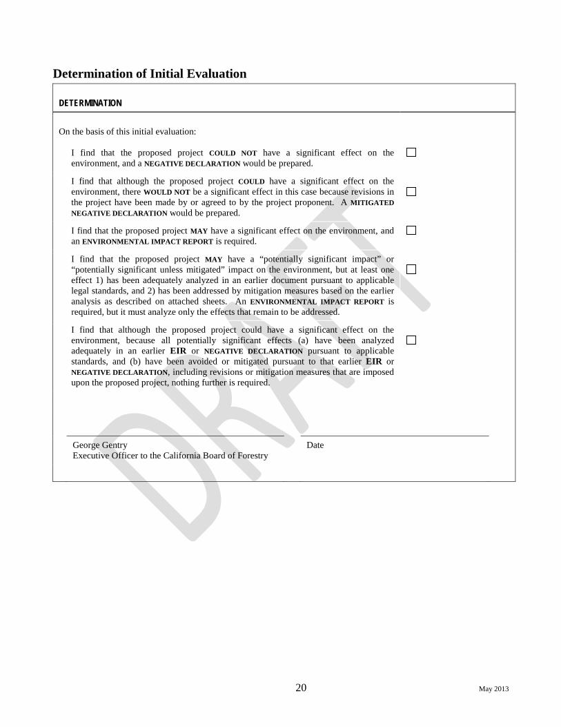
Determination of Initial Evaluation DETERMINATION
On the basis of this initial evaluation:
I find that the proposed project COULD NOT have a significant effect on the environment, and a NEGATIVE DECLARATION would be prepared.
I find that although the proposed project COULD have a significant effect on the environment, there WOULD NOT be a significant effect in this case because revisions in the project have been made by or agreed to by the project proponent. A MITIGATED NEGATIVE DECLARATION would be prepared.
I find that the proposed project MAY have a significant effect on the environment, and an ENVIRONMENTAL IMPACT REPORT is required.
I find that the proposed project MAY have a “potentially significant impact” or “potentially significant unless mitigated” impact on the environment, but at least one effect 1) has been adequately analyzed in an earlier document pursuant to applicable legal standards, and 2) has been addressed by mitigation measures based on the earlier analysis as described on attached sheets. An ENVIRONMENTAL IMPACT REPORT is required, but it must analyze only the effects that remain to be addressed.
I find that although the proposed project could have a significant effect on the environment, because all potentially significant effects (a) have been analyzed adequately in an earlier EIR or NEGATIVE DECLARATION pursuant to applicable standards, and (b) have been avoided or mitigated pursuant to that earlier EIR or NEGATIVE DECLARATION, including revisions or mitigation measures that are imposed upon the proposed project, nothing further is required.
George Gentry Executive Officer to the California Board of Forestry
Date

21 May 2013
Analysis of Potential Environmental Impacts
Aesthetics
ENVIRONMENTAL ISSUES Potentially Significant Impact
Less Than Significant with Mitigation Incorporated
Less Than Significant Impact
No Impact
I. Aesthetics. Would the project: a) Have a substantial adverse effect on a scenic
vista?
b) Substantially damage scenic resources, including, but not limited to, trees, rock outcroppings, and historic buildings within a state scenic highway?
c) Substantially degrade the existing visual character or quality of the site and its surroundings?
d) Create a new source of substantial light or glare which would adversely affect day or nighttime views in the area?
Discussion
LDSF has been subject to timber harvest and other associated activities by the State of California since 1951. The past management at LDSF has resulted in a landscape that has a mixture of different sizes and densities of trees in the timber stands. The principal road system is well developed, but there may be additional road clearing or building. The planned management of LDSF and the utilization of both uneven-aged and even-aged management will result in the continuation of the varied appearance of the forested landscape. Individual projects conducted under the guidance of this management plan will have additional visual assessments done utilizing site specific information.
Timber harvest activities are most likely to have adverse impacts to aesthetics resources. However, the reduction of stocking levels as a result of forest management activities may reduce the detrimental effects of catastrophic wildfires. This in turn can lessen the visual impact in the event of a catastrophic wildfire. Prior to approval, timber harvest plans go through an interdisciplinary agency review and public comment period (THP review). The review process ensures that potential visual impacts which may result from timber harvest activities are minimized. Furthermore, visual effects are addressed by Title 14 of the California Code of Regulations, Forest Practice Rules (FPR), under “Board of Forestry Technical Rule Addendum No. 2, Appendix Technical Rule Addendum No. 2, Visual Resources”. The visual assessment area is generally the harvesting area that is readily visible to a significant number of people who are no further than three miles from the timber operations.
a) Would the project have a substantial adverse effect on a scenic vista? LDSF has one scenic vista that is accessible to the public. Valley View Point is located along the Bateman Road and provides a scenic overlook back towards Redding and the Sacramento

22 May 2013
Valley. Only a small portion of the southwest side of the forest is visible from the overlook and the majority of the view being of commercial forestland, foothill ranchland and the Sacramento Valley. Valley View Point is also used as an emergency helispot, so the vista will be maintained to permit helicopter use. Vehicle access to LaTour Butte lookout is not open to the public, but in the event that the public hikes to the lookout the management on LDSF has a consistent appearance with the surrounding land uses. The appearance on the surrounding land varies, depending upon the individual landowners’ objectives. Three of the four sides surrounding LDSF are private timberlands with varying levels of harvest. The east side of LDSF is managed by the Lassen National Forest on which no timber harvest has been undertaken in the vicinity of LDSF for years. LDSF utilization of both uneven-aged and even-aged management will maintain the current varied appearance of the forested landscape.
Portions of LDSF are visible from State Highway 44, between Shingletown and Viola, and from several locations along the Whitmore road, including the intersection of Whitmore road and Bateman Road. The locations where LDSF is visible from these road ways are all greater than 3 miles away from LDSF. The planned management activities described within the project are consistent with previous management practices and should have less than a significant impact on any scenic vistas.
b) Would the project substantially damage scenic resources, including, but not limited to, trees, rock outcroppings, and historic buildings within a state scenic highway?
There are no designated state scenic highways in the project area or within the assessment area.
The planned management activities described within the project are not intensive and will have a less than significant effect on scenic resources. The appearance of LDSF will not be substantially altered, nor will the scenic resources be substantially impacted by this project.
c) Would the project substantially degrade the existing visual character or quality of the site and its surroundings?
LDSF has been subject to timber harvest and associated activities by the State of California since 1951. The past management LDSF has resulted in a landscape that has a mixture of different sizes and densities of trees in the forest. The principal road system is well developed, but there may be additional road clearing or building. The planned management of LDSF and the utilization of both uneven-aged and even-aged management will result in the continuation of the varied appearance of the forested landscape. This appearance is consistent with the surrounding land use.
d) Would the project create a new source of substantial light or glare which would adversely affect day or nighttime views in the area? There are no planned activities that would create a light source or create any glare.

23 May 2013
Agricultural Resources
ENVIRONMENTAL ISSUES Potentially Significant Impact
Less Than Significant with Mitigation Incorporated
Less Than Significant Impact
No Impact
II. Agricultural Resources. In determining whether impacts to agricultural resources are significant environmental effects, lead agencies may refer to the California Agricultural Land Evaluation and Site Assessment Model (1997, as updated) prepared by the California Department of Conservation as an optional model to use in assessing impacts on agriculture and farmland.
Would the project: a) Convert Prime Farmland, Unique Farmland, or
Farmland of Statewide Importance (Farmland), as shown on the maps prepared pursuant to the Farmland Mapping and Monitoring Program of the California Resources Agency, to non-agricultural use?
b) Conflict with existing zoning for agricultural use or a Williamson Act contract?
c) Involve other changes in the existing environment, which, due to their location or nature, could result in conversion of Farmland to non-agricultural use?
Discussion
a) Would the project convert Prime Farmland, Unique Farmland, or Farmland of Statewide Importance (Farmland), as shown on the maps prepared pursuant to the Farmland Mapping and Monitoring Program of the California Resources Agency, to non-agricultural use? LDSF is not farmland.
b) Would the project conflict with existing zoning for agricultural use or a Williamson Act contract? LDSF is zoned as Timberland Production (TPZ) and does not have a Williamson Act contract.
c) Would the project involve other changes in the existing environment, which, due to their location or nature, could result in conversion of Farmland to non-agricultural use? LDSF is not farmland.

24 May 2013
Air Quality
ENVIRONMENTAL ISSUES Potentially Significant Impact
Less Than Significant with Mitigation Incorporated
Less Than Significant Impact
No Impact
III. Air Quality. Where available, the significance criteria established by the applicable air quality management or air pollution control district may be relied on to make the following determinations.
Would the project: a) Conflict with or obstruct implementation of the
applicable air quality plan?
b) Violate any air quality standard or contribute substantially to an existing or projected air quality violation?
c) Result in a cumulatively considerable net increase of any criteria pollutant for which the project region is non-attainment under an applicable federal or state ambient air quality standard (including releasing emissions which exceed quantitative thresholds for ozone precursors)?
d) Expose sensitive receptors to substantial pollutant concentrations?
e) Create objectionable odors affecting a substantial number of people?
Discussion
There are three management activities on LDSF, which may have an impact on air quality. They are open burning, road construction and maintenance, and dust created from logging truck traffic. Shasta County Air Quality Management District (AQMD) rules 2-6 through 2-8 correspond to open burning and rule 3-16 corresponds to dust created by road construction, maintenance and hauling.
a) Would the project conflict with or obstruct implementation of the applicable air quality plan?
Project burns conducted on LDSF that are greater than 10 acres in size or where the expected emissions are greater than one ton, are required to have an approved Smoke Management Plan (SMP). Upon AQMD approval of the SMP, LDSF shall obtain an open burning permit from Shasta County AQMD. Additionally burning shall only be conducted on “Burn Days” designated by Shasta County AQMD, unless a variance has been approved by Air Quality Management for specific burning criteria. Adherence to the SMP, burn permit and burning only on burn days unless a variance has been granted reduces any potential impact to air quality to less than significant and is in compliance with the State Implementation Plan for air quality.

25 May 2013
Use of the dust abatement activities described within LDSF’s road management plan during hauling, road construction and maintenance effectively controls dust generation from LDSF roads.
b) Would the project violate any air quality standard or contribute substantially to an existing or projected air quality violation? Shasta County does not approve “Burn Days” if open burning has the potential to decrease air quality to a level that would violate air quality standards. Adherence to the SMP, burn permit and permissive burning only on burn days, unless a variance is granted, reduces any potential impact to air quality to less than significant and is in compliance with the State Implementation Plan for air quality.
c) Would the project result in a cumulatively considerable net increase of any criteria pollutant for which the project region is non-attainment under an applicable federal or state ambient air quality standard (including releasing emissions which exceed quantitative thresholds for ozone precursors)? Shasta County does not approve “Burn Days” if open burning has the potential to decrease air quality to a level that would violate air quality standards. Adherence to the SMP, burn permit and burning only on permissive burn days, unless a variance is granted, reduces any potential impact to air quality to less than significant and is in compliance with the State Implementation Plan for air quality.
d) Would the project expose sensitive receptors to substantial pollutant concentrations?
LDSF is located approximately 10 miles east of the community of Whitmore, 11 miles northeast of Shingletown and 8 miles northwest of Viola. The Lassen Pines subdivision, located near Lake McCumber is the closest community to LDSF and is 4 miles south of the forest. Smoke impacts to these communities are addressed in the SMPs. Smoke impacts to these communities are minimized and adequate smoke dispersal is obtained by the adherence to the SMP, burn permit and permissive burning only on permissive burn days unless a variance is granted.
e) Would the project create objectionable odors affecting a substantial number of people?
LDSF is located approximately 10 miles east of the community of Whitmore, 11 miles northeast of Shingletown and 8 miles northwest of Viola. The Lassen Pines subdivision, located near Lake McCumber is the closest community to LDSF and is 4 miles south of the forest. Smoke impacts to these communities are addressed in the SMPs. Adequate smoke dispersal and smoke impacts to these communities are minimized by the adherence to the SMP, burn permit and burning only on burn days unless a variance is granted.
LDSF uses chemicals for dust abatement on LDSF roads. The chemicals that have been used in the past have been resins or hygroscopic salts. These chemicals have a slight or no odor. The curing time for these chemicals is 1-2 days depending on weather and any odor dissipates once the chemical has cured.

26 May 2013
Biological Resources
ENVIRONMENTAL ISSUES Potentially Significant Impact
Less Than Significant with Mitigation Incorporated
Less Than Significant Impact
No Impact
IV. Biological Resources. Would the project: a) Have a substantial adverse effect, either directly
or through habitat modifications, on any species identified as a candidate, sensitive, or special-status species in local or regional plans, policies, or regulations, or by the California Department of Fish and Wildlife or the U.S. Fish and Wildlife Service?
b) Have a substantial adverse effect on any riparian habitat or other sensitive natural community identified in local or regional plans, policies, or regulations or by the California Department of Fish and Wildlife or the U.S. Fish and Wildlife Service?
c) Have a substantial adverse effect on federally protected wetlands as defined by Section 404 of the Clean Water Act (including, but not limited to, marsh, vernal pool, coastal, etc.) through direct removal, filling, hydrological interruption, or other means?
d) Interfere substantially with the movement of any native resident or migratory fish or wildlife species or with established native resident or migratory wildlife corridors, or impede the use of native wildlife nursery sites?
e) Conflict with any local policies or ordinances protecting biological resources, such as a tree preservation policy or ordinance?
f) Conflict with the provisions of an adopted Habitat Conservation Plan, Natural Community Conservation Plan, or other approved local, regional, or state habitat conservation plan?
g) Contribute to climate change and greenhouse gas emissions?
Discussion
LDSF supports a wide variety of fish, wildlife, and botanical species and their associated habitats. Timber harvest activities and road building are the management activities on LDSF which have the highest potential to adversely impact biological resources. LDSF recognizes the importance of these biological resources and works to maintain, restore and enhance the occurrence of special habitat elements and unique habitats to promote species diversity and habitat quality. Several measures included in the Project that achieve these goals are:

27 May 2013
1) Retain and recruit large diameter snags. 2) Retain and recruit down logs and large woody debris as needed in aquatic and
terrestrial environments, 3) Maintain and protect natural ponds and springs, 4) Protect riparian zones and restore where needed, 5) Retain late-successional forest characteristics in the near term, and consolidation of
late successional forest characteristics in the long term. 6) Design forest management activities based on landscape perspectives. Components to
consider will include horizontal and vertical forest structure, vegetation density, edge effect, corridor size, and biological diversity.
7) Maintain conifer and hardwood trees in buffer zones along all watercourses and around all springs in order to lower water temperature, or prevent increases in water temperature.
8) Allow for the natural recruitment of large woody debris to the stream channel to improve or maintain instream habitat quality and stream ecosystem function.
9) Minimize the number of temporary watercourse crossings.
Several management goals of LDSF describe the need to maintain the widest possible diversity of managed forest stands in different successional stages, maintain or increase functional wildlife habitat, and provide research and demonstration opportunities for various biological resources. LDSF balances sustained timber productivity with the long-term biological productivity of the timberland and protection of public trust resources. The forest management program under the guidance of this plan is expected to produce a moderate, perpetually sustainable harvest level. The planned harvest rates are somewhat lower than that of many private owners due to additional landscape and wildlife habitat constraints imposed on LDSF as a public forest, and the need to maintain the widest possible range of forest conditions in order to accommodate potential future research studies.
Based on the approved Option A, the long-term sustained yield (LTSY) is 5.51 million board feet per year, or 615 board feet per acre per year. The corresponding near term sustainable harvest level through 2014 is 4.1 million board feet per year, or 467 board feet per acre per year. Based on the inventory derived from the 2010 CFI plot remeasurements, this constitutes a harvest intensity of about 1.9 percent of the current inventory. Comparatively, the theoretical LTSY for LDSF if it were managed for maximum sustainable fiber production would be approximately 7 million board feet per year, or 800 board feet per acre per year. Current measured growth on the Forest is 499 board feet per acre per year, based on the 2010 CFI plot remeasurements.
The annual harvest is less than the LTSY, due to the fact that the forest currently is not at the level of productivity reflected in the growth potential of the desired future conditions at the end of the planning interval. In addition to the constraints placed on the calculation of the LTSY in the harvest schedule, LDSF also has discretionary commitments to planned management practices for non-timber resources.
Based on ground-truthing and forest inventory data, stands were assessed for meeting the Board of Forestry late-successional forest definition. No stands meeting all criteria of the definition were found on LDSF. There are stands that meet all criteria with the exception of the minimum acreage of twenty acres. Many areas throughout the ownership have functional characteristics;

28 May 2013
large down logs, large decadent trees, and snags. These attributes will be retained and recruited wherever feasible. Forest stands currently considered late successional, but less than 20 acres in size, provide a valuable starting point for the recruitment of additional adjacent acreage to late successional conditions through management. In addition, late successional associated biological resources are enhanced and present an important demonstration opportunity. Currently LDSF has about six percent of the Forest in CWHR size classes 5 and 6(3). The model projections indicate that within the next two decades, a large number of acres may move into CWHR size classes 5 and 6. At the end of the 100-year planning interval, almost half of the acreage on LDSF may be in CWHR size class 5 and 6. According to the model, it is reasonable to expect that a portion of this acreage may meet the BOF late successional definition.
LDSF individually marks all harvest or leave trees under single tree selection silviculture (management measure 1). LDSF maintains a marking guide to assist personnel in the marking of timber for timber sales. This management measure ensures that all trees will be evaluated for the presence of nesting structures, potential snag and LWD recruitment, and the existence of any other special habitat elements. It is also CAL FIRE policy that all harvest trees or leave trees are to be marked.
LDSF staff is also conducting various wildlife inventory studies to obtain a current knowledge of wildlife species use, and for the detection of rare, threatened or endangered species (management measure 2). All detections of rare, threatened or endangered species will be documented and assessed to determine if these biological resources are being impacted by any projects being conducted under the guidance of this management plan.
INITIAL BIOLOGICAL SCOPING
The California Natural Diversity Data Base (CNDDB) was used as a scoping tool to check if any rare, threatened, endangered, or special concern species and/or their habitat are located on LDSF. A ten quadrangle query was conducted, which included Jacks Backbone 7.5 minute quad, its surrounding eight quads and the Lassen Peak quad. The CNDDB was checked and the following list updated on May 2, 2013. The following is a list of rare, threatened, endangered species, and/or their habitat that occurs on LDSF. There are no recorded occurrences of threatened or endangered species on LDSF.
Bald Eagle: Although Bald Eagles have been observed soaring over LDSF, they appear to be associated with Lake McCumber, 7.5 miles from the southern most area of the forest. LDSF does not contain the large bodies of water that is a key habitat element to the Bald Eagle.
Sierra Red Fox: LDSF does contain the vegetation types considered habitat for the Sierra Red Fox. Observations of the red fox have occurred within the scoping area and primarily around Lassen Volcanic National Park. The closest observation to LDSF is near Highway 44 and
3: CWHR 6 refers to multi-storied stands that contain a component of greater than 24 inches DBH trees, must contribute at least 25 percent to the canopy closure over CWHR size class 3 (6-11 inches DBH) trees and/or CWHR size class 4 (11-24 inches DBH) trees, with a canopy closure total of 60 percent or greater. CWHR size class 5 stands have a greater than 24 inches DBH on average (including all stems greater than 5 inches DBH, including hardwoods). CWHR “M” and “D” refers to moderate (40-59 percent) and dense (greater than 60 percent) canopy closure, respectively.
29 May 2013
Scharch Meadow. LDSF staff has been conducting forest carnivore surveys the last three years and the Sierra Red Fox has not been detected. The project will maintain habitat for the Sierra Red Fox.
Gray Wolf: Since 1924, there has been only one documented Gray Wolf (OR7) in California. OR7 is a radio collared Gray wolf from Oregon. OR 7 first wandered into California in December 2011 and predominantly stayed in California until March 2013 when it returned to Oregon. OR 7 was recorded nine times within the Assessment Area of this Management Plan and may have possibly traversed a portion of LDSF. LDSF currently has suitable habitat for Gray Wolfs and the project will maintain the habitat.
California Wolverine: Though not observed or detected on LDSF, the California wolverine was detected within the scoping area in 1975. LDSF has the vegetation types that are considered habitat for the wolverine. LDSF staff has been conducting forest carnivore surveys for the last six years and the wolverine has not been detected. The project will maintain habitat for the California Wolverine.
Pacific Fisher: LDSF contains habitats for Pacific Fishers. A 1990 furbearer presence survey detected Pacific Fishers on LDSF and more recently Pacific Fishers have been photographed on LDSF during the winters of 2011 and 2012. The project will maintain habitat for the Pacific Fisher. Pacific fisher is currently listed as a candidate species for protection under the California Endangered Species Act.
Pine Marten: LDSF contains habitats for the Pine Marten. Pine martins were detected on LDSF in a 1990 furbearer presence survey. More recently (2008, 2009, 2011) the Pine Marten have been photographed in the southeastern portions of the forest during the forest carnivore surveys being conducted by LDSF staff. The project will maintain habitat for both the Pine Martens.
Western Pond Turtle: Western Pond Turtles have not been observed on LDSF. The preferred habitat of the turtles is low gradient streams. LDSF does contain habitat for the Western Pond Turtles, but the low gradient stream reaches are located above 5000 feet elevation, and may be out of the range of the turtles. The Project will not impact the Western Pond Turtle and affords protection to all wetlands, including springs, creeks, meadows, and natural ponds.
Cascade Frogs: Have been observed in Cutter and Old Cow meadows, which are adjacent to the northern boundary of LDSF. Cascade frogs are located within and adjacent to various fresh water features. The Project will not impact the Cascade frog and affords protection to all wetlands, including springs, creeks, meadows, and natural ponds.
Osprey: Although Ospreys have been observed soaring over LDSF they appear to be associated with Lake McCumber, 7.5 miles from the southern most area of the forest. LDSF does not contain the large bodies of water that is a key habitat element to the Osprey.
Northern Goshawk: All of LDSF is habitat for the Northern Goshawk. There is one known active territory and nest site located on LDSF and one historical territory. LDSF staff conducted a forest wide Northern Goshawk survey in 2006 with cooperation from DFW. The goshawks from the known active territory were the only birds detected. This territory is

30 May 2013
monitored annually. The results of future monitoring efforts on LDSF, either positive or negative detections, shall be documented. The Project maintains Northern Goshawk habitat.
Black-Backed Woodpecker: No known observations of black-backed woodpecker have occurred on LDSF. This species generally requires large-scale disturbance such as fire killed or insect infested landscapes. This habitat does not currently exist on LDSF or within the biological assessment area. The black-backed woodpecker is currently listed as a candidate species for protection under the California Endangered Species Act.
Steelhead: LDSF is within the northern California ESU of the steelhead. Class I watercourses are protected within the Project.
BOTANICAL
The CNDDB check results indicated that there are potentially 30 rare plant species. LDSF has habitat that would support 17 of the 30 plants scoped. The Project will not impact these botanical resources.
Little hulsea: Little hulsea is located within alpine boulder rock fields and subalpine coniferous forests. Little hulsea is typically found on rocky, gravelly sites above 6000 feet in elevation. There are several rock outcrops located on LDSF that have potential habitat for little hulsea. Habitat will be surveyed prior to potential disturbances.
Northern Spleenwort: LDSF has the general habitat types associated with the known occurrences of northern spleenwort. Northern spleenwort is found growing out of crevices in granite like rock outcrops and is usually found above 5000 feet in elevation. Habitat will be surveyed prior to potential disturbances.
Vanilla grass: LDSF has the general habitat types associated with the known occurrences of vanilla grass. Vanilla grass is located within wet meadows and seeps above 5400 feet in elevation. The Project provides protection for all meadows and seeps. Habitat will be surveyed prior to potential disturbances.
Rattlesnake fern: Rattlesnake fern is located along bogs, fens and other wet areas generally below 4000 feet. LDSF has potential habitat located along South Cow Creek on the southwestern side of the forest. The Project provides protection for all meadows and seeps. Habitat will be surveyed prior to potential disturbances.
White-stemmed pondweed: White-stemmed pondweed habitat is associated with deep water in marshes and swamps. It is typically found above 5400 feet. LDSF may have habitat around South Cow, Old Cow and near Cutter meadows. The Project provides protection for all meadows and seeps. Habitat will be surveyed prior to potential disturbances.
Newberry’s cinquefoil: Newberry’s cinquefoil is located along the drying edges of marshes and swamps. LDSF has habitat around South Cow, Old Cow and near Cutter meadows and several springs. The Project provides protection for all meadows, seeps and springs. Habitat will be surveyed prior to potential disturbances.
Butte County morning-glory: Butte County morning glory is found in dry open slopes within lower montane coniferous forests. They are typically located below 3900 feet in elevation.

31 May 2013
LDSF is located above 3900 feet in elevation, but there may be suitable habitat conditions located on the western side of LDSF, within the 1978 Whitmore burn. Habitat will be surveyed prior to potential disturbances.
Rayless mountain ragwort: Rayless mountain ragwort is located in meadows and seeps on mesic sites between 5200 and 6500 feet in elevation. LDSF has potential habitat along the watercourses, meadows, springs and seeps. Habitat will be surveyed prior to potential disturbances.
Northwestern moonwort: LDSF has the general habitat types associated with the few known occurrences of northwestern moonwort. Northwestern moonwort is located along creek banks, meadows, upper and lower montane coniferous forest above 5310 feet in elevation. Habitat will be surveyed prior to potential disturbances.
Mingan moonwort,: LDSF has the general habitat types associated with the known occurrences of mingan moonwort. Mingan moonwort is located along creek banks of lower montane coniferous forest above 4500 feet in elevation. Habitat will be surveyed prior to potential disturbances.
Upswept moonwort: The assessment area and the THP have the general habitat types associated with the few known occurrences of upswept moonwort. Upswept moonwort is located along creek banks, meadows, upper and lower montane coniferous forest above 4500 feet in elevation. Habitat will be surveyed prior to potential disturbances.
Western goblin: LDSF has the general habitat types associated with the few known occurrences of western goblin. Western goblin is located along creek banks in old growth lower montane coniferous forest above 4500 feet in elevation. Habitat will be surveyed prior to potential disturbances.
Tall alpine-aster: LDSF has the general habitat types associated with the vaguely documented occurrence of tall alpine-aster in this area. Tall alpine-aster is located on mesic sites along meadows and seeps of upper montane coniferous forest above 3015 feet in elevation. Habitat will be surveyed prior to potential disturbances.
Scalloped moonwort: LDSF has the general habitat types associated with the known occurrences of scalloped moonwort. Scalloped moonwort is located along moist meadows and near creeks of lower montane coniferous forests and freshwater marshes above 4500 feet in elevation. Habitat will be surveyed prior to potential disturbances. Broad-nerved hump moss: LDSF has the general habitat types associated with the vaguely documented occurrence of broad-nerved hump moss in this area. Broad-nerved hump moss is located on meadows and seeps of upper montane coniferous forest above 3900 feet in elevation. Habitat will be surveyed prior to potential disturbances.
a) Would the project have a substantial adverse effect, either directly or through habitat modifications, on any species identified as a candidate, sensitive, or special-status species in local or regional plans, policies, or regulations, or by the California Department of Fish and Wildlife or the U.S. Fish and Wildlife Service?

32 May 2013
The past management of LDSF has resulted in a forested landscape that is varied and has a mixture of various stand types and wildlife characteristics. The Project proposes no substantial changes to the management of LDSF that would result in significant changes in the current forest structure or wildlife habitat. The planned utilization of both uneven-aged and even-aged management will continue to maintain a landscape that is varied and has a mixture of various wildlife habitats.
The current inventory of LDSF shows that there is a wide variety of California Wildlife Habitat Relationships (Mayer and Laudenslayer) types and size classes. Through time LDSF will have substantially more size class 5 and 6 trees and timber stands. These WHR classes have the potential to develop late successional characteristics, which can provide important habitat values.
LDSF stands were assessed for meeting the Board of Forestry late-successional forest definition. No stands meeting all criteria of the definition were found on LDSF. There are stands that meet all criteria with the exception of the minimum acreage of twenty acres. Many areas throughout the ownership have functional characteristics; large down logs, large decadent trees, and snags. These attributes will be retained and recruited wherever feasible. Forest stands currently considered late successional, but less than 20 acres in size, provide a valuable starting point for the recruitment of additional adjacent acreage to late successional conditions through management and an important research and demonstration opportunities.
LDSF’s identification and goals to maintain restore and enhance the occurrence of special habitat elements and unique habitats to promote species diversity and habitat quality, and impacts from the implementation of the Project will be less than significant on any species identified as a candidate, sensitive, or special-status species.
Individual projects conducted under the guidance of this management plan will require a separate biological assessment (during THP review or other CEQA review), based upon site-specific conditions. If during the assessment, project layout, or surveys, species identified as a candidate, sensitive, or special-status species or their habitats are identified, protection measures and mitigations will be incorporated into the project. Protection measures and mitigations will be developed in cooperation with the California Department of Fish and Wildlife (DFW).
b) Would the project have a substantial adverse effect on any riparian habitat or other sensitive natural community identified in local or regional plans, policies, or regulations or by the California Department of Fish and Wildlife or the U.S. Fish and Wildlife Service?
The Project recognizes the importance of riparian habitats and other sensitive natural communities and it describes measures to maintain, restore and enhance the occurrence of special habitat elements and unique habitats. All projects conducted under the guidance of this management plan will have protection measures for all riparian areas.
With LDSF’s identification and goals to maintain, restore, and enhance the occurrence of special habitat elements and unique habitats to promote species diversity and habitat quality, and the implementation of the Project, impacts will be less than significant on riparian habitat and other sensitive natural communities.
33 May 2013
c) Would the project have a substantial adverse effect on federally protected wetlands as defined by Section 404 of the Clean Water Act (including, but not limited to, marsh, vernal pool, coastal, etc.) through direct removal, filling, hydrological interruption, or other means?
The Project recognizes the importance of wetlands and the habitats associated with them. It describes measures to maintain all natural ponds and springs, and measures for riparian zone protection and restoration. All projects conducted under the guidance of this management plan will have protection measures for all wetlands, springs, creeks, meadows, and natural ponds.
d) Would the project interfere substantially with the movement of any native resident or migratory fish or wildlife species or with established native resident or migratory wildlife corridors, or impede the use of native wildlife nursery sites?
The past management of LDSF has resulted in forested landscape that is varied and has a mixture of various timberstand types and wildlife characteristics. The Project proposes no substantial changes to the management of LDSF that would result in significant changes to the current forest structure or wildlife habitat. Additionally, management activities are seasonal and generally occur on less than 10 percent of LDSF annually. Management plan measures in riparian areas will assist in the maintenance and enhancement of wildlife migration corridors. The Project will have a less than significant impact on the movement of any native resident or migratory fish or wildlife species or wildlife corridors, or impede the use of native wildlife nursery sites
e) Would the project conflict with any local policies or ordinances protecting biological resources, such as a tree preservation policy or ordinance?
The project does not conflict with any policies or ordinances protecting biological resources.
f) Would the project conflict with the provisions of an adopted Habitat Conservation Plan, Natural Community Conservation Plan, or other approved local, regional, or state habitat conservation plan?
There is no known Habitat Conservation Plan, Natural Community Conservation Plan, or other approved local, regional, or state habitat conservation plan in the vicinity of LDSF.
g) Would the project exacerbate climate change or increase greenhouse gas emissions? This analysis evaluates whether climate change and greenhouse gas (GHG) issues related to management of LDSF have the potential to be a significant environmental effect, either on a project basis or cumulatively. Table 1 summarizes estimated net carbon dioxide sequestration levels under proposed management at LDSF over a 100-year planning interval4. The analysis shows substantial positive carbon sequestration benefits. Proposed management at LDSF will
4 A 100-year look-ahead period is necessary in forested ecosystems, where trees can take more than 50 years to reach maturity. The 100-year planning interval allows a minimum period necessary to evaluate long-term steady-state behavior of forested ecosystem while not exceeding the range of applicability of mathematical simulation models.

34 May 2013
sequester a net CO2 equivalent of 3,773,000 tons of carbon at the end of 100 years. The GHG analysis is based upon the volume information calculated for and contained within the LDSF 2007 Option A.
Table 1. Estimated carbon sequestration at LDSF over the next 100 years.
1 2 3 4 5 6 7 Current standing inventory
CO2 stored in current standing timber5
Standing inventory at end of 100-
year planning interval
CO2 stored in standing timber at
end of 100-year
planning interval
Total harvest over
100-year planning interval
Total CO2 sequestered
in forest products at end of 100-
year planning interval
Total net CO2
sequestered at end of 100-year planning
interval (4-2+6)
MBF* M* tons MBF M tons MBF M tons M tons
196,931 1,575 308,096 2,465 360,460 2,884 3,773
* MBF (thousand board feet), M (thousand).
Accounting for emissions from the Forest includes vehicles and buildings used by the Department that are associated with management. It also includes emissions from harvesting and manufacturing. We chose to do the downstream accounting. This will be the most conservative accounting approach because we are not including the negative substitution effect that occurs when alternative higher-GHG-impact building materials such as steel and concrete are used instead of wood products. Emissions from vehicles and buildings are estimated as follows:
Vehicles: 0.02 thousand (M) tons per year x 100-year planning horizon = 2 M tons
Building: 0.00003 M tons per year x 100-year planning horizon = 0.003 M tons
This is a total of 2.003 M tons for the 100-year planning horizon.
Harvesting emissions include in-woods emissions from equipment and vehicles and transportation to a mill. Mill emissions estimates from processing are included because long-term storage of wood products is included in the analysis. Mill emissions include sawing, drying, energy generation, and planing. Also, transport to final destination is included. The entire life cycle for green-dried lumber is included (Puettmann and Wilson 2005). This results in a total emission estimate of 0.13 metric tons CO2 equivalent per thousand board feet (MBF).
Given the total harvest of 360,460 MBF over the 100-year planning horizon in Table 1 above, this equates to 46,859 tons of CO2 equivalent from harvesting emissions. Including vehicle and building emissions, the total GHG emissions estimate for LDSF is 46,861 tons of CO2 equivalents.
5 A conversion factor of 8.0 was used to convert thousand board feet to tons of CO2 including soil root biomass, duff, litter, canopy and non-bole tree parts (Smith et al, 2002, GTR NE-298).

35 May 2013
These emissions including full life-cycle of wood, vehicle, and building emissions, represent 1.24 percent of the total carbon sequestered (column 7 in Table 1). The conclusion from the above analysis is that there is a substantial positive carbon sequestration benefit and a net negative emission of GHGs at LDSF under the guidance of the Project. Orders of magnitude more biomass is being conserved than is being harvested. In other words, the management plan proposes to harvest less biomass (and to emit less CO2) than growth.
Climate change science is still in its infancy. There are likely wide error bars around the above estimates, given the general level of the analysis and the continuing evolution of CO2 calculation equations. The result that positive sequestration benefits exceed emissions by orders of magnitude however, lends validity to the general conclusion that sequestration will be much greater than emissions. Our conclusion is also supported by estimates from the Air Resources Board, which indicate that forest land use in California results in a net decrease in atmospheric carbon, not an increase http://www.arb.ca.gov/cc/inventory/archive/tables/net_co2_flux_2007-11-19.pdf.
Since the net amount of carbon that would be sequestered under the Project is calculated to be significantly greater than the amount of carbon that will be released by LDSF management activities, there are no potential significant adverse environmental impacts, single or cumulative. In fact, significant beneficial impacts of net carbon sequestration are expected to occur as a result of the proposed management activities.

36 May 2013
Cultural Resources
ENVIRONMENTAL ISSUES Potentially Significant Impact
Less Than Significant with Mitigation Incorporated
Less Than Significant Impact
No Impact
V. Cultural Resources. Would the project: a) Cause a substantial adverse change in the significance
of a historical resource as defined in Section 15064.5?
b) Cause a substantial adverse change in the significance of an archaeological resource pursuant to Section 15064.5?
c) Directly or indirectly destroy a unique paleontological resource or site or unique geologic feature?
d) Disturb any human remains, including those interred outside of formal cemeteries?
Discussion
In the last 20 years there have been eight separate archaeological surveys conducted on LDSF. These surveys have been extensive and the forest has near complete coverage as a result of these surveys. Three archaeological sites and several isolated artifacts have been located from these surveys. The three sites have been recorded, and management measures are described in Foster and Thornton (2001). There are no known archaeological resources that would be impacted by LDSF management activities. Prior to any ground disturbing activities (timber harvest, road building, prescribed burns, construction of new campsites, etc), potentially affected areas will be surveyed for archaeological resources and information will be requested from local Native Americans. If any unrecorded sites are discovered during surveys or management activities, a CAL FIRE Archaeologist will be contacted to determine the appropriate protection measures. Archaeological surveys will be conducted by professional archaeologists or LDSF staff who are trained to conduct archaeological surveys (Foster, 2006).
LDSF’s cultural resources management procedures are based on CAL FIRE’s statewide Management Plan for Historic Buildings and Archaeological Sites (plan) (Foster and Thornton, 2001) and its accompanying EIR (Foster and Sosa, 2001) which prescribe general measures for identifying, evaluating and managing heritage resources on CAL FIRE lands statewide including LDSF. This management plan was initiated in 1991 pursuant to Executive Order W-26-92, CEQA and PRC Section 5020 et seq., in coordination with the SHPO and in consideration of comments from the interested public and Native American Tribes and organizations. For each of CAL FIRE’s properties, including LDSF, the plan summarizes the inventory of recorded historic buildings and prehistoric and historic archaeological sites; identifies those buildings and sites determined to be significant per National and State Registers criteria in consultation with SHPO; establishes decision making criteria for managing its historic buildings and identifies those targeted for preservation; describes CAL FIRE’s archaeology program, role in fire protection, Native American gathering policy, and artifact collections; and establishes specific management objectives and measures.

37 May 2013
a) Would the project cause a substantial adverse change in the significance of a historical resource as defined in Section 15064.5?
All known historic resources have been recorded and protection measures developed. CAL FIRE’s primary approach to managing significant heritage resources is to preserve them through avoidance of project-related impacts. If any unrecorded sites are discovered during surveys or management activities, a CAL FIRE Archaeologist will be contacted to determine the appropriate protection measures. Procedures described in Foster (2006) will be used to avoid impacts.
b) Would the project cause a substantial adverse change in the significance of an archaeological resource pursuant to Section 15064.5?
All known archaeological resources have been recorded and protection measures developed. CAL FIRE’s primary approach to managing significant heritage resources is to preserve them through avoidance of project-related impacts. If any unrecorded sites are discovered during surveys or management activities, a CAL FIRE Archaeologist will be contacted to determine the appropriate protection measures. Procedures described in Foster (2006) will be used to avoid impacts.
c) Would the project directly or indirectly destroy a unique paleontological resource or site or unique geologic feature? There are no known paleontological resources, site or unique geologic features existing on LDSF.
d) Would the project disturb any human remains, including those interred outside of formal cemeteries? There are no known cemeteries or human remains existing on LDSF. No human remains or associated grave goods were encountered during the archaeological survey work on LDSF, and human remains or grave goods are not likely to be encountered during project activities. None-the-less, the possibility exists for human remains to occur within the project area. If such human remains were unearthed, but not protected in accordance with procedures in state law (see below), this could be a potentially significant impact. LDSF will follow the California Health and Safety Code and California Public Resources Code Section 5097. Procedures for Inadvertent Discovery of Human Remains: In accordance with the California Health and Safety Code (CHSC) 7050.5(b), if human remains are discovered during ground-disturbing activities, CAL FIRE and/or the project contractor(s) shall immediately halt potentially damaging excavation in the area of the burial and notify the Shasta County Coroner and the CAL FIRE Region archaeologist to determine the nature and significance of the remains. The coroner is required to examine all discoveries of human remains with 48 hours of receiving notice of a discovery on private or state lands. If the remains are determined by the coroner to be Native American, he or she must contact by telephone, within 24 hours, the Native American Heritage Commission (NAHC) per CHSC 7050.5(c). The NAHC will in turn immediately identify and notify the Most Likely Descendent (MLD) in accordance with Public Resources Code (PRC) 5097.98(a). CAL FIRE is obligated to continue to protect the discovery

38 May 2013
area from damage or disturbance, per PRC 5097.98(b), until staff has discussed and conferred with the MLD regarding their recommendations for treatment of the discovery. (1) The MLD preferences for treatment of the discovery may include the following: (A) The nondestructive removal and analysis of human remains and items associated with
Native American human remains. (B) Preservation of Native American human remains and associated items in place. (C) Relinquishment of Native American human remains and associated items to the
descendents for treatment. (D) Other culturally appropriate treatment. (2) The parties may also mutually agree to extend discussions, taking into account the possibility that additional or multiple Native American human remains, as defined in PRC 5097, are located in the project area providing a basis for additional treatment measures

39 May 2013
Geology and Soils
ENVIRONMENTAL ISSUES Potentially Significant Impact
Less Than Significant with Mitigation Incorporated
Less Than Significant Impact
No Impact
VI. Geology and Soils. Would the project: a) Expose people or structures to potential
substantial adverse effects, including the risk of loss, injury, or death involving:
i) Rupture of a known earthquake fault, as delineated on the most recent Alquist-Priolo Earthquake Fault Zoning Map issued by the State Geologist for the area or based on other substantial evidence of a known fault? (Refer to California Geological Survey Special Publication 42.)
ii) Strong seismic ground shaking? iii) Seismic-related ground failure, including
liquefaction?
iv) Landslides? b) Result in substantial soil erosion or the loss of
topsoil?
c) Be located on a geologic unit or soil that is unstable, or that would become unstable as a result of the project, and potentially result in on- or off-site landslide, lateral spreading, subsidence, liquefaction, or collapse?
d) Be located on expansive soil, as defined in Table 18-1-B of the Uniform Building Code (1994, as updated), creating substantial risks to life or property?
e) Have soils incapable of adequately supporting the use of septic tanks or alternative waste water disposal systems where sewers are not available for the disposal of waste water?
Discussion
a) Would the project expose people or structures to potential substantial adverse effects, including the risk of loss, injury, or death involving:
i) Rupture of a known earthquake fault, as delineated on the most recent Alquist-Priolo Earthquake Fault Zoning Map issued by the State Geologist for the area or based on other substantial evidence of a known fault? (Refer to California Geological Survey Special Publication 42.)

40 May 2013
Review of California Geological Survey Special Publication 42 (Fault-rupture-Hazard zones in California) and Geologic Data Map #6 (Fault Activity Map of California and Adjacent Areas) found no active faults or faults with historic movement mapped within or immediately adjacent to LDSF. The closest faults with Holocene displacement are part of an unnamed southern extension of the Hat Creek Fault that lie approximately 15 miles east of LDSF. No surface rupture from fault activity is expected to occur on LSDF.
ii) Strong seismic ground shaking?
Strong seismic shaking on LDSF is unlikely. California Geological Survey Map Sheet 48 (Seismic Shaking Hazard Maps of California) shows the LSDF and immediate vicinity to have a 10-percent probability of exceeding a maximum peak ground acceleration of 30 percent g* (but not 40 % g) in 50 years. No areas in LSDF or immediate vicinity are known to have been damaged by historic earthquakes (historic = 1800 to present day)
* The unit g is the acceleration of gravity.
iii) Seismic-related ground failure, including liquefaction?
Seismic-related ground failure is feasible. Such failure would most likely consist of rock-fall from steep outcrops that could be hazardous to people downslope of such outcrops. The combination of soil types, groundwater conditions, and seismic shaking intensity necessary for liquefaction does not appear present in LSDF, therefore the probability of seismic-induced liquefaction is very low.
iv) Landslides?
The Photo Reconnaissance Map of Geologic and Geomorphic Features Related to Landsliding, LDSF Sustained Yield Plan, Shasta County, California (Schlosser, 1994; Draft digital version produced by California Geological Survey in 2002) shows numerous debris-slide slopes and debris-flow/torrent tracks on steep slopes along both sides of South Cow Creek and Atkins Creek. Debris-flows/torrents move quickly and could threaten people on roads that cross the tracks. However, because such flows and torrent usually occur during winter, when LDSF is effectively closed by snow, the threat to people from debris-flows/torrents is small.
The few deep-seated landslides shown on the map move slowly and would be unlikely to expose people to potentially substantial adverse effects. Although the deep-seated landslides are capable of affecting buildings and infrastructure adversely, no buildings appear to be located in areas likely to be affected by the mapped deep-seated landslides. Proposed operations under the management plan would be unlikely to affect the natural potential for existing deep-seated landslides to adversely affect existing structures.
Individual projects conducted under the guidance of this management plan, which have the potential to affect soil stability (e.g. timber harvest, road building) are subject to THP review or other CEQA review and comment. This review would minimize the likelihood of destabilizing operations being carried out. The California Geology Survey (CGS) is part of the multiagency review team that provides comments as well as expertise. CGS staff has a Certified Engineering Geologists (CEG) that participates in field review of individual projects.

41 May 2013
b) Would the project result in substantial soil erosion or the loss of topsoil?
Forest roads are a source of soil erosion and are considered a major contributing source to stream sediment. Much of this sediment originates from points at or near watercourse crossings. The most serious erosion observed on LDSF is associated with the inside ditch network draining the roads. This has been mitigated by eliminating as much inside drainage as possible, by installing rolling dips and outsloping roads. Inside ditch erosion has been shown to be a significant source of sediment delivery into stream systems.
LDSF has had an approved road management plan on the forest since 2000. The intent of this road management plan is to provide a systematic program to ensure that the design, construction, use, maintenance, and surfacing of LDSF’s roads, road landings, and road crossings will avoid, minimize, or mitigate adverse impacts to the aquatic habitats supporting fish, amphibians, and other aquatic organisms. An additional benefit may be the long-term reduction in the costs of repairs as a result of problem avoidance. The initial inventory of LDSF roads occurred in 1995. A re-inventory was conducted between 2000 and 2003 that assessed the entire road system and watercourse crossings. The assessment identified 45 road segments and crossings that posed potential hazards associated with the road system. These 45 issues were prioritized and 34 of the 45 issues have been corrected as funding has become available. The assessment of LDSF roads is an ongoing process. Since 2008, twelve new road issues have been identified, nine of which remain and are scheduled for repair under upcoming Timber Harvest Plans. Soil erosion from LDSF roads will be minimized and impacts to water quality will be reduced to less than significant with the continued implementation of the road management plan (management measure 3).
Timber harvest activities are another potential source of soil erosion and sediment delivery to watercourses. The California Forest Practice Rules (FPRs), which regulate timber harvest activities, provide several rules for the protection of water quality and reduction of soil erosion. These rules include; the implementation of Watercourse and Lake Protection Zones, the installation and maintenance of erosion control features, scattering and lopping of slash, appropriate stream crossing design and construction, and the implementation of a water-drafting plan.
All timber operations are required to adhere to a waiver of waste discharge that is obtained from the Regional Water Quality Control Board (WQ). Included in the waver is the requirement for effectiveness monitoring. The monitoring will provide early detection of any erosion issues needing immediate correction. Where required LDSF obtains a 1600 permit from the DFG, for the installation or repair of watercourse crossings.
The adherence to the FPRs, WQ waiver, DFG permits and the implementation of management measure 3 ensures the potential project impacts to soil erosion and topsoil loss are less than significant.

42 May 2013
c) Would the project be located on a geologic unit or soil that is unstable, or that would become unstable as a result of the project, and potentially result in on- or off-site landslide, lateral spreading, subsidence, liquefaction, or collapse?
Although it is conceivable that ground disturbing operations carried out under a project could feasibly destabilize soils within LDSF, such projects are subject to THP review or other CEQA review and comment. This review process would minimize the likelihood of destabilizing operations being carried out.
d) Would the project be located on expansive soil, as defined in Table 18-1-B of the Uniform Building Code (1994, as updated), creating substantial risks to life or property? Expansive soils as defined in the Uniform Building Code are not located on LDSF and no new structures are planned to be built.
e) Would the project have soils incapable of adequately supporting the use of septic tanks or alternative waste water disposal systems where sewers are not available for the disposal of waste water? There is one septic system located at LDSF Headquarters. The soils around headquarters are cable of supporting a septic system. No other septic systems are planned to be installed on LDSF. The toilets located at the campgrounds are self-contained and require pumping for removal of the waste. Licensed contractors dispose of the waste.

43 May 2013
Hazards and Hazardous Materials
ENVIRONMENTAL ISSUES Potentially Significant Impact
Less Than Significant with Mitigation Incorporated
Less Than Significant Impact
No Impact
VII. Hazards and Hazardous Materials. Would the project: a) Create a significant hazard to the public or the
environment through the routine transport, use, or disposal of hazardous materials?
b) Create a significant hazard to the public or the environment through reasonably foreseeable upset and/or accident conditions involving the release of hazardous materials into the environment?
c) Emit hazardous emissions or handle hazardous or acutely hazardous materials, substances, or waste within one-quarter mile of an existing or proposed school?
d) Be located on a site which is included on a list of hazardous materials sites compiled pursuant to Government Code Section 65962.5 and, as a result, would it create a significant hazard to the public or the environment?
e) For a project located within an airport land use plan or, where such a plan has not been adopted, within two miles of a public airport or public use airport, would the project result in a safety hazard for people residing or working in the project area?
f) For a project within the vicinity of a private airstrip, would the project result in a safety hazard for people residing or working in the project area?
g) Impair implementation of or physically interfere with an adopted emergency response plan or emergency evacuation plan?
h) Expose people or structures to a significant risk of loss, injury, or death involving wildland fires, including where wildlands are adjacent to urbanized areas or where residences are intermixed with wildlands?
Discussion
Potentially hazardous materials located on LDSF or used on LDSF for management activities include equipment fuel and oil, petroleum and propane storage tanks, dust palliatives, herbicides, marking paint, and incendiary and firing devices. Proper use, storage and
44 May 2013
transportation of these chemicals should not result in any potential significant impacts on the environment. Potential significant impacts could occur by accidental spilling of the material.
To insure that all material is properly used, stored and transported, Material Safety Data Sheets (MSDS), material labels, and any additional handing and emergency instruction of the materials are kept on file at LDSF Headquarters (mitigation 1). Any state employee handling these materials are made aware of the potential hazards, given proper training and instruction, and also made aware of the location of the MSDS, and any other documentation for the material (mitigation 2). All contractors used in the application or use of these hazardous materials shall have the appropriate licenses and be able to read and understand the MSDS, labels, appropriate recommendations and application instructions (mitigation 3). The storage of potentially hazardous materials on LDSF is in accordance to the MSDS and any buildings that are used for storage will display appropriate placards (mitigation 4).
• Small amounts of equipment fuel, oils and burn mix are stored in petroleum approved containers in a placard outbuilding at LDSF Headquarters. There are also two petroleum storage tanks located at LDSF Headquarters. These tanks are above ground and access is restricted to CAL FIRE employees.
• Firing and incendiary devices are stored in accordance to the MSDS with ignition devices and fuel stored separately. These devices are only used by properly trained CAL FIRE employees. Storage buildings display the appropriate placard.
• The types of dust palliatives that have been used on LDSF have been hygroscopic salts and resins, these materials are considered to be non-hazardous as per MSDS information provided to LDSF. These materials are non-flammable, non-combustible and are considered to be low or non-toxic to aquatic organisms. When these materials are utilized on LDSF, they will be applied under ideal weather conditions to allow for rapid curing. Potential hazards associated with the proper delivery and application of these products is very unlikely. By controlling the application process, using only licensed applicators and adhering to the MSDS, product labels and application recommendations, accidental spills can be minimized, eliminated and controlled if they occur. Additionally 90 % plus of dust abatement on LDSF is accomplished by use of water and water trucks.
• Herbicides have been used on LDSF for demonstration, research and for the establishment, survival and improved growth of new forest stands. The use of herbicides as a tool to control vegetation is determined by the vegetation present on site, by the vegetation targeted for control and the level of control needed to accomplish the goals of the project. These factors, as well as local weather patterns, soil types, topography, and the presence of threatened or endangered species are used to determine if herbicides will be used. The specific recommendation for the type of herbicide, application rate, timing, and application method will be determined by the site specific conditions and made by a Licensed Pest Control Advisor (PCA).
The three main brush species targeted for control on LDSF are chinquapin, manzanita, and snow brush. Other species that may be targeted in specific situations are gooseberry, currant, bitter cherry and various grasses. Application methods have been typically a
45 May 2013
directed backpack application to target species and two aerial applications following the 1978 Whitmore Burn.
Individual herbicide applications are based on label and MSDS restrictions, and written recommendations by PCA, that provide CEQA equivalency. The Recommendations build upon the Pesticide, surfactant and adjuvant Labels and Material Safety Data Sheets, which provide information potential for movement and toxicity. The PCA Recommendations consider site specific information such as vegetation present on site, targeted species, restrictions on chemical use, current and forecasted weather, soil types, topography, and the presence of threatened or endangered species. These recommendations will also evaluate proximity to schools, apiaries, neighbors, domestic water systems, presence of wetlands, watercourses, amphibians, and fish. If necessary these recommendations will include mitigations to reduce the impacts to apiaries, humans or biological resources. Mitigation examples include but are not limited to drift control measures, buffers, avoidance, weather restrictions, and timing. Additionally, LDSF is open range and grazing cattle are periodically present. Each pest control recommendation will consider the probability that cattle could graze treated vegetation (location and timing) and select herbicides with appropriate grazing restrictions.
Specific herbicide use depends on the nature of the vegetation and site conditions and may change based on availability from the manufacturer, registration status, feasible treatment alternatives and the recommendations of the Pest Control Advisor. Active ingredients in previous herbicides used on LDSF include Glyphosate, Triclopyr, Imazapyr, 2-4D, Hexazinone and picloram. The Carbon Sequestration research project on LDSF is currently utilizing Glyphosate, Triclopyr, and Imazapyr.
New products, formulations and application techniques may provide better control and improved environmental toxicology profiles than the current chemicals being utilized at LDSF. Additionally, as part of LDSF’s research and demonstration mission, small-scale herbicide trials or vegetation control studies are likely to occur. For this reason, in the future, there may be additions or deletions to the list of herbicides considered for use on LDSF.
Additional background on herbicide regulation and use is included as this topic is of concern to some members of the public. The U.S. Environmental Protection Agency regulates pesticide use nationwide and has exclusive authority over pesticide labeling. Use of a pesticide is limited to the applications and restrictions on the label, and the label restrictions are legally enforceable. The California Department of Pesticide Regulation (DPR) regulates pesticides within the State of California and has legal authority to adopt restrictions on pesticide use going beyond the regulations of the U.S. Environmental Protection Agency (7 U.S.C.A. §136v). Under California law, pesticide products must be registered by DPR in order to be sold and used in California. Before a substance is registered as a pesticide for the first time, DPR conducts a thorough evaluation. After a pesticide is registered for use in this state, DPR has an ongoing obligation to review new information received about the pesticide that might show new problems beyond those identified in the registration process. DPR is the lead agency for regulating herbicide use under CEQA. Where the review of new information shows that a significant adverse impact has occurred, or is likely to occur, DPR is required to reevaluate the registration.

46 May 2013
The regulatory program of DPR and the county agricultural commissioners is thorough, detailed, and involved.
DPR’s program for regulating pesticides was certified by the Secretary of the Resources Agency as a functional equivalent program under Public Resources Code (PRC) § 21080.5 in the same manner as the state’s program of regulating timber harvesting was certified (14 CCR. § 15251(i)). Because the program is certified, DPR does not prepare environmental impact reports (EIRs) but prepares other documents in the place of EIRs (PRC § 21080.5(d)(3)). Because the registration evaluation process considers use of an herbicide in a broad area and in a variety of conditions, the documents are the functional equivalent of a program EIR for each pesticide. By the terms of its certification, the program is prevented from approving the registration as requested if there are feasible alternatives or mitigation measures available that could lessen any significant adverse effects on the environment (PRC § 21080.5(d)(2)(A)). By § 12825 of the Food and Agricultural Code, DPR may refuse to approve the registration of a new pesticide if its use would cause a significant adverse effect on the environment.
If DPR determines that further restrictions need to be placed on the use of a pesticide product to mitigate potential adverse effects, including human health effects and environmental effects, DPR classifies the pesticide as a restricted pesticide, and individual applications need a permit from the county agricultural commissioner. Site specific application and use of restricted pesticides is evaluated by the county agricultural commissioner during its review of applications for restricted materials permits. Not all pesticides are restricted, and only restricted pesticides require a permit from the county agricultural commissioner, except for a pesticide that DPR has not designated as restricted, the commissioner can require a permit for its use if the commissioner makes a finding that the pesticide will present an undue hazard when used under local conditions.
Because DPR is the CEQA lead agency, its determination the use will not have a significant effect on the environment is binding on all State agencies, including CAL FIRE (PRC § 21080.1, 14 CCR § 15050). Accordingly, if a DPR registered herbicide will be used in accordance with the directions and restrictions on the pesticide product label and any other restrictions established by DPR, LDSF is required to find that the use will not have a significant effect on the environment unless there is new information showing significant or potentially significant effects not analyzed by DPR. The significant new information must show that the use would cause a new significant effect on the environment that had not been analyzed previously, that a previously analyzed effect would be much more severe, or that a new feasible alternative or mitigation measure, considerably different from ones analyzed previously, would lessen the significant effect but the project proponents declined to adopt it (14 CCR § 15088.5(a)). If CAL FIRE receives comments on proposed herbicide use, CAL FIRE will need to determine whether the information qualifies as significant new information. CAL FIRE will consult with DPR and the county agricultural commissioner about the submitted information both to obtain the evaluation by the agencies with their expertise and to alert them about the issues. DPR could respond to the information with a decision to reevaluate the registration of the herbicide or it could advise CAL FIRE that the information is repetitive of what was evaluated during the registration decision.

47 May 2013
The Shasta County Agricultural Commissioner has responsibility for compliance and enforcement actions, registration of businesses that perform pest control in Shasta County, issuing Restricted Materials Permits and Operator ID numbers and other regulatory responsibilities. The forest does not lie in the Shasta County Groundwater Protection Areas. The Central Valley Water Quality Control Board does not require notification for herbicide application that is applied in accordance to the product labels.
When herbicides are determined to be used on individual projects, conducted under this guidance of this management plan, LDSF will review the recommended herbicide’s, surfactant’s, and adjuvant’s intended use and the possible environmental effects of each. LDSF will work with the PCA to determine whether the proposed use would be consistent with the label and the registration limitations.
Details of herbicide, surfactant and adjuvant chemistry, including mode of action and break down products as well as manufactures formulations are evaluated in depth by EPA and DPR during both the registration process and periodic reviews. In addition to the label and MSDS the following source should be reviewed for information relevant to the project; National Pesticide Information Center http://npic.orst.edu/ .
LDSF will also check for significant new information showing changes in circumstances or available information that would require new environmental analysis. Significant new information should be referred to DPR for that department’s analysis as part of its ongoing evaluation program.
Accidental spills can be minimized, avoided or controlled, by adherence to the PCA’s recommendation, the product label and mitigations 1-4. Additionally when herbicides are used on LDSF all herbicide containers must be secured when being transported and all empty containers must be triple rinsed and disposed of properly off-site, with rinse water being put into the mixing tank. Any herbicide work conducted by contractors shall be closely monitored by LDSF staff. When herbicides are handled and applied according to the product label instruction, PCA’s recommendation, and the MSDS, significant adverse impacts to people, wildlife, water resources and the environment are not expected to occur.
The measures described above along with the mitigations 1- 4, will insure that no significant adverse environmental or human health impacts occur as a result of pesticide application. Cumulative impacts are unlikely because herbicide uses related to different control projects are separated in time and distance so that their individual effects do not reinforce or interact with each other. Herbicide use under the plan is neither widespread nor frequent. Herbicide may be used for demonstration, research and for the establishment, survival and improved growth of forest stands. Forestry herbicide uses are substantially less, in both frequency and amount, than in agricultural or urban settings.
Other pesticides including rodenticides and fungicides would not be routinely used. Because bark beetle infestations can be serious in this region, there may be limited use of pheromones (attractants and repellants) which are classified as insecticides. Any future use would be carefully evaluated in Pest Control Recommendations and associated CEQA documents.
48 May 2013
a) Would the project create a significant hazard to the public or the environment through the routine transport, use, or disposal of hazardous materials? Adherence to mitigations 1-4 reduce any potential significant impacts from the use, transport, and storage of hazardous materials to less than significant.
b) Would the project create a significant hazard to the public or the environment through reasonably foreseeable upset and/or accident conditions involving the release of hazardous materials into the environment? Adherence to mitigations 1-4 reduce any potential significant impacts from the use, transport, and storage of hazardous materials to less than significant.
c) Would the project emit hazardous emissions or handle hazardous or acutely hazardous materials, substances, or waste within one-quarter mile of an existing or proposed school? No, the nearest school is approximately 11 miles west of LDSF, in the town of Whitmore.
d) Would the project be located on a site which is included on a list of hazardous materials sites compiled pursuant to Government Code §65962.5 and, as a result, would it create a significant hazard to the public or the environment?
LDSF is not on any list of hazardous material sites.
e) For a project located within an airport land use plan or, where such a plan has not been adopted, within two miles of a public airport or public use airport, would the project result in a safety hazard for people residing or working in the project area? LDSF is not located within two miles of an airport.
f) For a project within the vicinity of a private airstrip, would the project result in a safety hazard for people residing or working in the project area?
LDSF is not located within two miles of an airport.
g) Would the project impair implementation of or physically interfere with an adopted emergency response plan or emergency evacuation plan? Timber operations have the potential to temporarily block roads with downed timber. FPRs 14 CCR 938.3 requires that all logging roads must be kept passable during the fire season for fire truck travel. To maintain compliance with 14 CCR 938.3, in the event that timber will block emergency response equipment, all timber operators are required to have equipment available on site to open the road immediately for emergency response equipment and to permit public access to and from LDSF.
49 May 2013
h) Would the project expose people or structures to a significant risk of loss, injury, or death involving wildland fires, including where wildlands are adjacent to urbanized areas or where residences are intermixed with wildlands?
Several management activities have varying levels of risk to cause a wildfire. These activities are timber operations, road construction and maintenance, campgrounds, site preparation and prescribed burning. Active forest management helps break up vertical and horizontal fuel continuity, which helps reduce the intensity and spread of fire.
The Public Resources Code regulates all timber operations, road construction and maintenance, and site preparation activities conducted during the fire season. During these activities operators are required to have the appropriate fire suppression equipment on site and maintained in a serviceable condition to aid in the suppression and control of any fires caused by the operations.
Campfires are only permitted in the four designated campgrounds and the campers are required to obtain and adhere to a campfire permit. Additionally the four designated campgrounds are maintained in a manner to lessen the potential of fire escape. Accumulation of dead vegetation is removed, trees pruned, and the fire rings are maintained.
All prescribed burning is conducted by the appropriate number of CAL FIRE personnel and equipment to maintain control of the prescribed burn.
LDSF is not adjacent to urbanized areas and there are very few residences intermixed with adjacent wildlands.

50 May 2013
Hydrology and Water Quality
ENVIRONMENTAL ISSUES Potentially Significant Impact
Less Than Significant with Mitigation Incorporated
Less Than Significant Impact
No Impact
VIII. Hydrology and Water Quality. Would the project: a) Violate any water quality standards or waste
discharge requirements?
b) Substantially deplete groundwater supplies or interfere substantially with groundwater recharge such that there would be a net deficit in aquifer volume or a lowering of the local groundwater table level (e.g., the production rate of pre-existing nearby wells would drop to a level that would not support existing land uses or planned uses for which permits have been granted)?
c) Substantially alter the existing drainage pattern of the site or area, including through the alteration of the course of a stream or river, in a manner which would result in substantial on- or off-site erosion or siltation?
d) Substantially alter the existing drainage pattern of the site or area, including through the alteration of the course of a stream or river, or substantially increase the rate or amount of surface runoff in a manner which would result in on- or off-site flooding?
e) Create or contribute runoff water which would exceed the capacity of existing or planned stormwater drainage systems or provide substantial additional sources of polluted runoff?
f) Otherwise substantially degrade water quality? g) Place housing within a 100-year flood hazard
area as mapped on a federal Flood Hazard Boundary or Flood Insurance Rate Map or other flood hazard delineation map?
h) Place within a 100-year flood hazard area structures that would impede or redirect flood flows?
i) Expose people or structures to a significant risk of loss, injury, or death involving flooding, including flooding as a result of the failure of a levee or dam?
j) Result in inundation by seiche, tsunami, or mudflow?

51 May 2013
Discussion
Soil erosion and sediment delivery to watercourses has the highest potential to degrade water quality on LDSF. Forest roads and timber harvest activities are the primary sources of soil erosion caused by LDSF management (see Soil Erosion Discussion herein).
a) Would the project violate any water quality standards or waste discharge requirements?
Impacts to water quality, violations of waste discharge requirements and the basin plan resulting from management activities at LDSF will be less than significant. The adherence to the FPRs, WQ waiver, DFG permits and the implementation of management measure 3 ensures that potential Project impacts are less than significant.
b) Would the project substantially deplete groundwater supplies or interfere substantially with groundwater recharge such that there would be a net deficit in aquifer volume or a lowering of the local groundwater table level (e.g., the production rate of pre existing nearby wells would drop to a level that would not support existing land uses or planned uses for which permits have been granted)?
LDSF has two hand-pump wells located at Old Cow and Butcher Gulch campgrounds. These are non-potable water sources, receive minimal use and would not significantly deplete ground water. The residence located along the Bateman Road on the western edge of LDFS is located within a different watershed from where the two wells are located. Water for this residence is obtained from Roaring Springs, a large high volume spring. Protection of Roaring Springs is accomplished by the adherence to FPRs, WQ, and DFG requirements and the implementation of management measure 3.
c) Would the project substantially alter the existing drainage pattern of the site or area, including through the alteration of the course of a stream or river, in a manner which would result in substantial on- or off-site erosion or siltation? Road construction and maintenance, installation of erosion control structures, and the installation and repair of watercourse crossings all have the potential to alter the existing drainage patterns and cause substantial on or off site erosion. The adherence to the FPRs, WQ waiver, DFG permits and the implementation of management measure 3 will lessen the potential Project impacts to less than significant.
d) Would the project substantially alter the existing drainage pattern of the site or area, including through the alteration of the course of a stream or river, or substantially increase the rate or amount of surface runoff in a manner which would result in on- or off-site flooding? Road construction and maintenance, installation of erosion control structures, and the installation and repair of watercourse crossings all have the potential to alter the existing drainage patterns. The potential that these activities will cause on or off site flooding is less than significant. The adherence to the FPRs, WQ waiver, DFG permits and the implementation of management measure 3 ensures that any potential Project impacts that may cause flooding are less than significant.

52 May 2013
e) Would the project create or contribute runoff water which would exceed the capacity of existing or planned stormwater drainage systems or provide substantial additional sources of polluted runoff? There are no stormwater drainage systems located on or downstream of LDSF.
f) Would the project otherwise substantially degrade water quality?
Degradation to water quality caused from management activities at LDSF will be less than significant. The adherence to the FPRs, WQ waiver, DFG permits and the implementation of management measure 3 ensures that potential Project impacts are less than significant.
g) Would the project place housing within a 100-year flood hazard area as mapped on a federal Flood Hazard Boundary or Flood Insurance Rate Map or other flood hazard delineation map? The project does not propose the construction of any structures. The structures at LDSF Headquarters are located outside a 100-year flood hazard area.
h) Would the project place within a 100-year flood hazard area structures that would impede or redirect flood flows?
The project does not propose the construction of any structures.
i) Would the project expose people or structures to a significant risk of loss, injury, or death involving flooding, including flooding as a result of the failure of a levee or dam? The project is not located in a flood zone or below a levee or dam. The potential that LDSF management activities will cause on or off site flooding is less than significant. The adherence to the FPRs, WQ waiver, DFG permits and the implementation of management measure 3 ensures that any potential Project impacts that may cause flooding are less than significant.
j) Would the project result in inundation by seiche, tsunami, or mudflow? The project is not located within an area that is subject to a seiche, tsunami or mudflow.

53 May 2013
Land Use and Planning
ENVIRONMENTAL ISSUES Potentially Significant Impact
Less Than Significant with Mitigation Incorporated
Less Than Significant Impact
No Impact
IX. Land Use and Planning. Would the project: a) Physically divide an established community? b) Conflict with any applicable land use plan,
policy, or regulation of an agency with jurisdiction over the project (including, but not limited to, a general plan, specific plan, local coastal program, or zoning ordinance) adopted for the purpose of avoiding or mitigating an environmental effect?
c) Conflict with any applicable habitat conservation plan or natural community conservation plan?
Discussion
a) Would the project physically divide an established community?
No, the nearest community to LDSF is the Lassen Pines subdivision, located 4 miles south of the forest.
b) Would the project conflict with any applicable land use plan, policy, or regulation of an agency with jurisdiction over the project (including, but not limited to, a general plan, specific plan, local coastal program, or zoning ordinance) adopted for the purpose of avoiding or mitigating an environmental effect? LDSF is pubic land and is zoned TPZ. The project is compatible with the zoning and is required pursuant to Public Resources Code (PRC) §4645 and Article 8 of the California Board of Forestry and Fire Protection (Board) policy. The Board also establishes policy, which governs LDSF. Board policy states that the primary purpose of the state forest program is to conduct innovative demonstrations, experiments, and education in forest management. The project is guidance to LDSF staff and the policies of the Board are met by many of the management practices described within.
c) Would the project conflict with any applicable habitat conservation plan or natural community conservation plan? The large forestlands adjacent to LDSF, managed by W.M. Beaty and Associates, Sierra Pacific Industries, Roseburg Forest Products, and the Lassen National Forest all have varying land management documents. The project does not conflict with any of these documents.
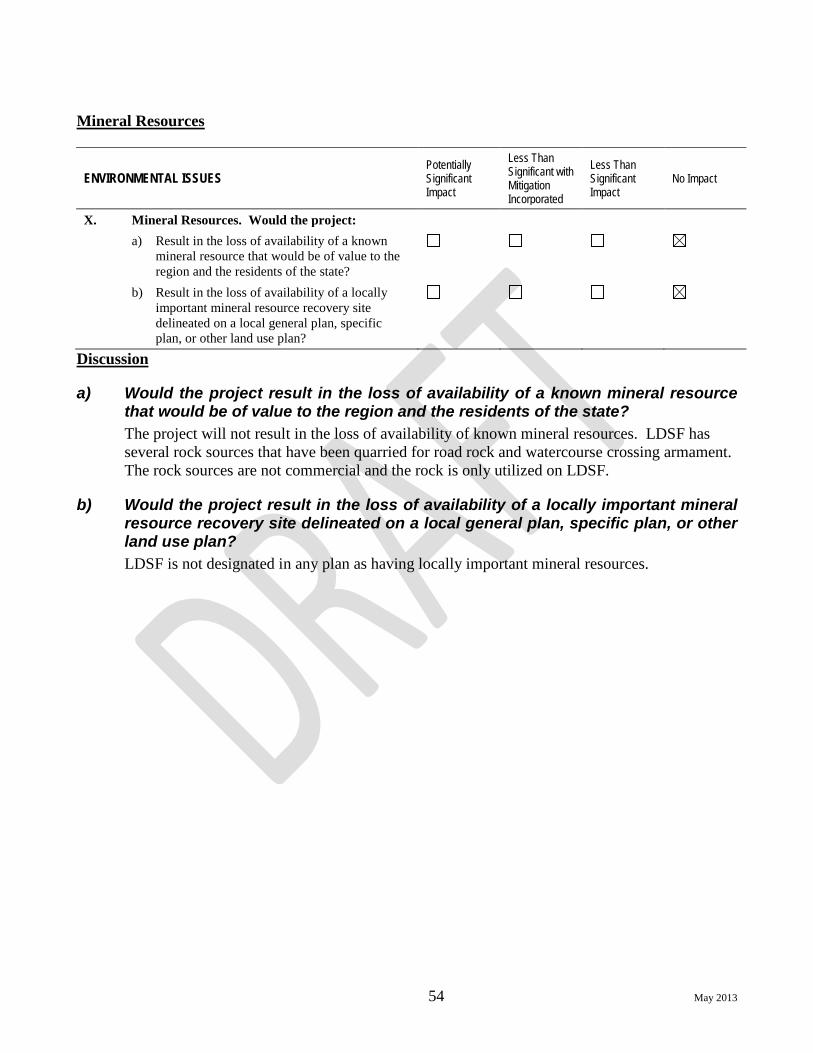
54 May 2013
Mineral Resources
ENVIRONMENTAL ISSUES Potentially Significant Impact
Less Than Significant with Mitigation Incorporated
Less Than Significant Impact
No Impact
X. Mineral Resources. Would the project: a) Result in the loss of availability of a known
mineral resource that would be of value to the region and the residents of the state?
b) Result in the loss of availability of a locally important mineral resource recovery site delineated on a local general plan, specific plan, or other land use plan?
Discussion
a) Would the project result in the loss of availability of a known mineral resource that would be of value to the region and the residents of the state? The project will not result in the loss of availability of known mineral resources. LDSF has several rock sources that have been quarried for road rock and watercourse crossing armament. The rock sources are not commercial and the rock is only utilized on LDSF.
b) Would the project result in the loss of availability of a locally important mineral resource recovery site delineated on a local general plan, specific plan, or other land use plan? LDSF is not designated in any plan as having locally important mineral resources.
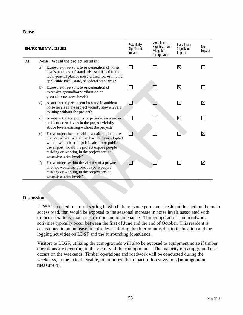
55 May 2013
Noise
ENVIRONMENTAL ISSUES Potentially Significant Impact
Less Than Significant with Mitigation Incorporated
Less Than Significant Impact
No Impact
XI. Noise. Would the project result in: a) Exposure of persons to or generation of noise
levels in excess of standards established in the local general plan or noise ordinance, or in other applicable local, state, or federal standards?
b) Exposure of persons to or generation of excessive groundborne vibration or groundborne noise levels?
c) A substantial permanent increase in ambient noise levels in the project vicinity above levels existing without the project?
d) A substantial temporary or periodic increase in ambient noise levels in the project vicinity above levels existing without the project?
e) For a project located within an airport land use plan or, where such a plan has not been adopted, within two miles of a public airport or public use airport, would the project expose people residing or working in the project area to excessive noise levels?
f) For a project within the vicinity of a private airstrip, would the project expose people residing or working in the project area to excessive noise levels?
Discussion
LDSF is located in a rural setting in which there is one permanent resident, located on the main access road, that would be exposed to the seasonal increase in noise levels associated with timber operations, road construction and maintenance. Timber operations and roadwork activities typically occur between the first of June and the end of October. This resident is accustomed to an increase in noise levels during the drier months due to its location and the logging activities on LDSF and the surrounding forestlands.
Visitors to LDSF, utilizing the campgrounds will also be exposed to equipment noise if timber operations are occurring in the vicinity of the campgrounds. The majority of campground use occurs on the weekends. Timber operations and roadwork will be conducted during the weekdays, to the extent feasible, to minimize the impact to forest visitors (management measure 4).

56 May 2013
a) Would the project create exposure of persons to or generation of noise levels in excess of standards established in the local general plan or noise ordinance, or in other applicable local, state, or federal standards?
The project as proposed will not have an increase in noise over historical levels. As defined in the Shasta County General Plan, Section 5.5, there are no “noise sensitive areas and uses” in the vicinity of LDSF. There are no known noise ordinances in the vicinity of LDSF. Implementation of management measure 4 will reduce conflicts with forest visitors and historical use shows noise impacts will be less than significant.
b) Would the project create exposure of persons to or generation of excessive groundborne vibration or groundborne noise levels?
The project as proposed will not have an increase in noise over historical levels. The nearby resident will have a temporary increase to ground vibrations resulting from road maintenance activities. The resident is accustomed to the temporary increase in ground vibrations and benefits from the road maintenance by improving year round access to the residence. Implementation of management measure 4 will reduce conflicts with forest visitors and historical use shows noise and vibration impacts will be less than significant.
c) Would the project create a substantial permanent increase in ambient noise levels in the project vicinity above levels existing without the project?
The project as proposed will not have an increase in noise over historical levels. The project will result in no impact.
d) Would the project create a substantial temporary or periodic increase in ambient noise levels in the project vicinity above levels existing without the project?
The project as proposed will not have an increase in noise over historical levels. The nearby resident is accustomed to a seasonal increase of noise associated with timber operations and roadwork. Implementation of management measure 4 will reduce conflicts with forest visitors and historical use shows noise and vibration impacts will be less than significant.
e) For a project located within an airport land use plan or, where such a plan has not been adopted, within two miles of a public airport or public use airport, would the project expose people residing or working in the project area to excessive noise levels?
The project is not located within two miles of an airport. The project will result in no impact.
f) For a project within the vicinity of a private airstrip, would the project expose people residing or working in the project area to excessive noise levels?
There are no known private airstrips within 20 miles of LDSF. The project will result in no impact.

57 May 2013
Population and Housing
ENVIRONMENTAL ISSUES Potentially Significant Impact
Less Than Significant with Mitigation Incorporated
Less Than Significant Impact
No Impact
XII. Population and Housing. Would the project: a) Induce substantial population growth in an
area, either directly (for example, by proposing new homes and businesses) or indirectly (for example, through extension of roads or other infrastructure)?
b) Displace substantial numbers of existing homes, necessitating the construction of replacement housing elsewhere?
c) Displace substantial numbers of people, necessitating the construction of replacement housing elsewhere?
Discussion
a) Would the project induce substantial population growth in an area, either directly (for example, by proposing new homes and businesses) or indirectly (for example, through extension of roads or other infrastructure)?
The project will not increase population growth. LDSF and the surround forestlands are zoned TPZ and no developments in homes, businesses, or infrastructure is planned.
b) Would the project displace substantial numbers of existing homes, necessitating the construction of replacement housing elsewhere? The project will not displace any residences.
c) Would the project displace substantial numbers of people, necessitating the construction of replacement housing elsewhere? The project will not displace any persons.

58 May 2013
Public Services
ENVIRONMENTAL ISSUES Potentially Significant Impact
Less Than Significant with Mitigation Incorporated
Less Than Significant Impact
No Impact
XIII. Public Services. Would the project: a) Result in substantial adverse physical impacts
associated with the provision of new or physically altered governmental facilities, or the need for new or physically altered governmental facilities, the construction of which could cause significant environmental impacts, in order to maintain acceptable service ratios, response times, or other performance objectives for any of the public services:
Fire protection? Police protection? Schools? Parks? Other public facilities?
Discussion
There are no substantial changes in this project from LDSF 2008 management plan. The response times from emergency services will not be affected by management activities. LaTour Butte has a fire lookout and several radio repeaters. CAL FIRE manages LDSF, the fire lookout and the radio repeaters. The project does not conflict with, but rather assists with the objectives of the lookout and the repeaters.
By Board policy one of LDSF’s primary purposes is education in forest management. LDSF currently participates in several tours and presentations, including annual tours for the community college and an annual presentation to the Boy Scouts of America. The nearest school is eleven miles to the west of LDSF. The project will not impact school access to the Forest, or any school facilities.
LDSF is public land and the project does not limit public access to LDSF.

59 May 2013
a) Would the project result in substantial adverse physical impacts associated with the provision of new or physically altered governmental facilities, or the need for new or physically altered governmental facilities, the construction of which could cause significant environmental impacts, in order to maintain acceptable service ratios, response times, or other performance objectives for any of the public services:
Fire protection? The project will have no impact.
Police protection? The project will have no impact.
Schools? The project will have no impact.
Parks? The project will have no impact.
Other Public Facilities? The project will have no impact.

60 May 2013
Recreation
ENVIRONMENTAL ISSUES Potentially Significant Impact
Less Than Significant with Mitigation Incorporated
Less Than Significant Impact
No Impact
XIV. Recreation. Would the project: a) Increase the use of existing neighborhood and
regional parks or other recreational facilities such that substantial physical deterioration of the facility would occur or be accelerated?
b) Include recreational facilities or require the construction or expansion of recreational facilities that might have an adverse physical effect on the environment?
Discussion
a) Would the project increase the use of existing neighborhood and regional parks or other recreational facilities such that substantial physical deterioration of the facility would occur or be accelerated?
The primary recreational uses on LDSF are hunting, camping, fishing, hiking and during the winter snow mobiling, snow shoeing, and cross-country skiing. The project proposes no significant changes from previous LDSF management plans, thus the amount of recreation is not expected to increase above historical use. The project does anticipate the expansion of three of the campgrounds and possible development of nature trails as funds become available. The expected recreational use on LDSF and the adjacent Lassen National Forest will have no impact on the physical deterioration of either the state or national forests.
b) Would the project include recreational facilities or require the construction or expansion of recreational facilities that might have an adverse physical effect on the environment?
The expansion of the three campgrounds will be the development of additional sites that are currently being utilized during peak usage. The existing facilities at the campgrounds will be able to accommodate these new sites.
To minimize ground disturbance, the development of the nature trails will utilize, to the maximum extent possible, existing footpaths and old skid trials. Prior to construction of the nature trails, archaeological and biological surveys will be conducted. These surveys will minimize impacts to the resources and aide in locating plant identification stops along the trail.
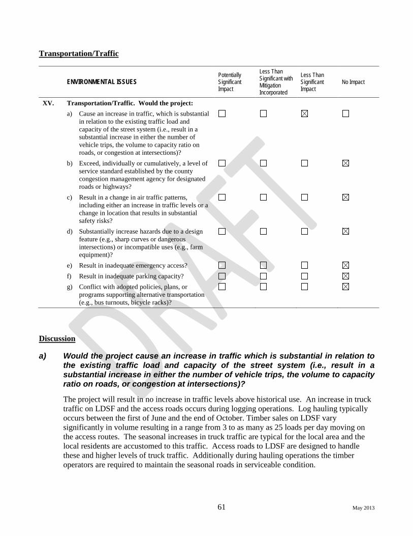
61 May 2013
Transportation/Traffic
ENVIRONMENTAL ISSUES Potentially Significant Impact
Less Than Significant with Mitigation Incorporated
Less Than Significant Impact
No Impact
XV. Transportation/Traffic. Would the project: a) Cause an increase in traffic, which is substantial
in relation to the existing traffic load and capacity of the street system (i.e., result in a substantial increase in either the number of vehicle trips, the volume to capacity ratio on roads, or congestion at intersections)?
b) Exceed, individually or cumulatively, a level of service standard established by the county congestion management agency for designated roads or highways?
c) Result in a change in air traffic patterns, including either an increase in traffic levels or a change in location that results in substantial safety risks?
d) Substantially increase hazards due to a design feature (e.g., sharp curves or dangerous intersections) or incompatible uses (e.g., farm equipment)?
e) Result in inadequate emergency access? f) Result in inadequate parking capacity? g) Conflict with adopted policies, plans, or
programs supporting alternative transportation (e.g., bus turnouts, bicycle racks)?
Discussion
a) Would the project cause an increase in traffic which is substantial in relation to the existing traffic load and capacity of the street system (i.e., result in a substantial increase in either the number of vehicle trips, the volume to capacity ratio on roads, or congestion at intersections)?
The project will result in no increase in traffic levels above historical use. An increase in truck traffic on LDSF and the access roads occurs during logging operations. Log hauling typically occurs between the first of June and the end of October. Timber sales on LDSF vary significantly in volume resulting in a range from 3 to as many as 25 loads per day moving on the access routes. The seasonal increases in truck traffic are typical for the local area and the local residents are accustomed to this traffic. Access roads to LDSF are designed to handle these and higher levels of truck traffic. Additionally during hauling operations the timber operators are required to maintain the seasonal roads in serviceable condition.

62 May 2013
b) Would the project exceed, individually or cumulatively, a level of service standard established by the county congestion management agency for designated roads or highways? The vast majority of the logging truck traffic leaving LDSF travels down the Bateman and the Tamarack Roads to the Whitmore Road and down to State Highway 44. The logging truck traffic originating from LDSF does not result in a significant increase in traffic on these roadways. The level of service to the roads should not be impacted.
c) Would the project result in a change in air traffic patterns, including either an increase in traffic levels or a change in location that results in substantial safety risks?
The project will have no influence on any existing air traffic patterns.
d) Would the project substantially increase hazards due to a design feature (e.g., sharp curves or dangerous intersections) or incompatible uses (e.g., farm equipment)?
There are no known design features, along the access roads to LDSF, which are considered hazardous. There is no expected increase in hazards associated with LDSF traffic. The local residents are accustomed to logging truck traffic and there is no history of conflict with incompatible uses along the access roads to neither LDSF, nor are any expected.
e) Would the project result in inadequate emergency access? Timber operations have the potential to temporarily block roads with downed timber. California Forest Practice Rules (FPRs) 14 CCR 938.3 requires that all logging roads must be kept passable during the fire season for fire truck travel. To maintain compliance with 14 CCR 938.3 in the event that timber will block emergency response equipment, all timber operators are required to have equipment available on site to open the road immediately for emergency response equipment.
f) Would the project result in inadequate parking capacity? There is adequate parking at LDSF Headquarters to accommodate LDSF staff and visitors. The campgrounds can also accommodate several vehicles per campsite. Road turnouts and log landings are also used for parking. The use of log landings allows ample parking and access to visitors throughout LDSF.
g) Would the project conflict with adopted policies, plans, or programs supporting alternative transportation (e.g., bus turnouts, bicycle racks)?
The project has no potential to impact alternative transportation programs.

63 May 2013
Utilities and Service Systems
ENVIRONMENTAL ISSUES Potentially Significant Impact
Less Than Significant with Mitigation Incorporated
Less Than Significant Impact
No Impact
XVI. Utilities and Service Systems. Would the project: a) Exceed wastewater treatment requirements of
the applicable Regional Water Quality Control Board?
b) Require or result in the construction of new water or wastewater treatment facilities or expansion of existing facilities, the construction of which could cause significant environmental effects?
c) Require or result in the construction of new storm water drainage facilities or expansion of existing facilities, the construction of which could cause significant environmental effects?
d) Have sufficient water supplies available to serve the project from existing entitlements and resources, or are new or expanded entitlements needed?
e) Result in a determination by the wastewater treatment provider that serves or may serve the project that it has adequate capacity to serve the project’s projected demand, in addition to the provider’s existing commitments?
f) Be served by a landfill with sufficient permitted capacity to accommodate the project’s solid waste disposal needs?
g) Comply with federal, state, and local statutes and regulations related to solid waste?
Discussion
There is one septic system located at LDSF Headquarters, four self-contained toilets located at campgrounds and one self-contained toilet located at Valley View Point.
a) Would the project exceed wastewater treatment requirements of the applicable Regional Water Quality Control Board?
The septic system at LDSF Headquarters is adequate for the facilities and use. The toilet facilities at the campgrounds can accommodate the campground use. The project will not exceed wastewater treatment requirements of WQ.

64 May 2013
b) Would the project require or result in the construction of new water or wastewater treatment facilities or expansion of existing facilities, the construction of which could cause significant environmental effects?
The existing facilities at the campgrounds will be able to accommodate the additional planned campsites.
c) Would the project require or result in the construction of new storm water drainage facilities or expansion of existing facilities, the construction of which could cause significant environmental effects? There are no storm water facilities associated with this project. The installation of new drainage features (watercourse crossings and road drainage) and the replacement of old features shall adhere to the FPRs, WQ waiver, DFG permits. The replacement and installation of drainage features will have a less than significant impact on the environment.
d) Would the project have sufficient water supplies available to serve the project from existing entitlements and resources, or are new or expanded entitlements needed?
The existing water on LDSF and the LDSF water rights are sufficient to accommodate the project.
e) Would the project result in a determination by the wastewater treatment provider that serves or may serve the project that it has adequate capacity to serve the project’s projected demand, in addition to the provider’s existing commitments?
The existing facilities on LDSF will not be impacted by the project.
f) Would the project be served by a landfill with sufficient permitted capacity to accommodate the project’s solid waste disposal needs? The Project will not increase the production of solid waste generated on LDSF and should not exceed the capacities of the county landfill.
g) Would the project comply with federal, state, and local statutes and regulations related to solid waste? The project will not violate any federal, state, or local statutes regulating solid waste.

65 May 2013
Mandatory Findings of Significance
ENVIRONMENTAL ISSUES Potentially Significant Impact
Less Than Significant with Mitigation Incorporated
Less Than Significant Impact
No Impact
XVII. Mandatory Findings of Significance. a) Does the project have the potential to
substantially degrade the quality of the environment, substantially reduce the habitat of a fish or wildlife species, cause a fish or wildlife population to drop below self-sustaining levels, threaten to eliminate a plant or animal community, reduce the number or restrict the range of an endangered, rare, or threatened species, or eliminate important examples of the major periods of California history or prehistory?
b) Does the project have impacts that are individually limited, but cumulatively considerable? (“Cumulatively considerable” means that the incremental effects of a project are considerable when viewed in connection with the effects of past projects, the effects of other current projects, and the effects of probable future projects.)
c) Does the project have environmental effects that would cause substantial adverse effects on human beings, either directly or indirectly?
Authority: Public Resources Code Sections 21083 and 21087. Reference: Public Resources Code Sections 21080(c), 21080.1, 21080.3, 21082.1, 21083, 21083.3, 21093, 21094, 21151; Sundstrom v. County of Mendocino, 202 Cal.App.3d 296 (1988); Leonoff v. Monterey Board of Supervisors, 222 Cal.App.3d 1337 (1990).
Discussion
a) Would the project have the potential to substantially degrade the quality of the environment, substantially reduce the habitat of a fish or wildlife species, cause a fish or wildlife population to drop below self-sustaining levels, threaten to eliminate a plant or animal community, reduce the number or restrict the range of an endangered, rare, or threatened species, or eliminate important examples of the major periods of California history or prehistory?
The project is an update of the LDSF 2008 Management Plan and proposes no substantial changes in the management of LDSF. The implementation of this management plan may have the potential to impact fish, wildlife and botanical species and/or their habitat in the sense that any projects conducted under the guidance of this management plan may impact these species and/or their habitat. The development of projects under the guidance of this management plan will have separate analyses conducted based on the project’s specifications and site-specific information. Potential impacts will be less than significant with the adherence to all applicable

66 May 2013
laws and regulations, obtaining the appropriate permits and the implementation of mitigations 1-5 described herein. See also the discussion above under item IV, Biological Resources, and item VIII Hydrology and Water Quality.
The implementation of this management plan will have a less than significant impact on cultural resources. Archeological surveys have been conducted on nearly all of LDSF. The three discovered cultural sites have been recorded and management measures developed. Any projects conducted under the guidance of this management plan which could cause ground disturbance, will require a survey and a Native American information request. See also the discussion above under item V, Cultural Resources.
b) Would the project have impacts that are individually limited, but cumulatively considerable? (“Cumulatively considerable” means that the incremental effects of a project are considerable when viewed in connection with the effects of past projects, the effects of other current projects, and the effects of probable future projects.)
Assessment Area The cumulative effects assessment area consists of the five Cal Water v2.2 planning watersheds (Table 2) that contain LDSF (Figure 3). This assessment area is used because the key cumulative impact issues related to forest management typically express themselves at the scale of planning watersheds or a subset of the planning watershed area. The biological assessment area varied with the species being evaluated.
Table 2 Huckleberry Creek CalWater ID v2.2 5507.320102/12,836 total acres; 1,452 (11%) LDSF acres. Beal Watershed CalWater ID v2.2 5507.310103/11,598 total acres; 5,928 (51%) LDSF acres. Atkins Creek CalWater ID v2.2 5507.310101/8,646 total acres; 1,211 (14%) LDSF acres. Upper South Fork Bear Creek CalWater ID v2.2 5507.220104/9,116 total acres; 180 (2%) LDSF acres.. Upper Battle Creek CalWater ID v2.2 5507.120104/9,830 total acres; 199 (2%) LDSF acres. Total Assessment Area: 52,026 total acres; 9,033 (17%) LDSF acres
The five planning watershed assessment areas include several vegetation types but are dominated by conifer forest types. Out of the five planning watersheds, three drain into the Cow Creek watershed. Significant areas of young ponderosa pine plantations mixed with various shrub species are found in the Atkins Creek and Beal planning watersheds. The Upper

67 May 2013
South Fork Bear and Upper Battle Creek watersheds include large wet meadow areas. Low elevations range from 2,920 feet for the Beal and Atkins Creek planning watersheds to 4,520, 4,100, and 3,840 feet for the Huckleberry, Upper Battle Creek and Upper South Fork Bear Creek watersheds respectively. No lakes are found on LDSF, and the only natural lake defined by the five planning watershed boundary is Huckleberry Lake (about 1.5 acres in size). Several small stock ponds exist in the Atkins Creek and South Fork Bear Creek planning watersheds. The largest man-made reservoir is located in the headwaters of Upper Battle Creek.
Descriptions of the five planning watersheds within the assessment area are as follows:
1. Beal Watershed - South Cow Creek and Beal Creek to the junction with Atkins Creek
Beal watershed (planning watershed 5507.310103) is the headwaters of South Cow Creek and drains a basin of 11,598 acres, of which 5,928 acres are contained within the boundaries of LDSF. Elevation ranges from 6,740 at LaTour Butte to 2,920 feet at the junction with Atkins Creek. Major tributaries include Beaver, Bullhock and Beal Creeks. South Cow is a third order stream before the junction with Atkins Creek (and fourth order below Atkins). There are approximately 9 miles of Class I watercourse along the main channel.
2. Atkins Creek
Atkins Creek (planning watershed 5507.310101) is a major tributary of the headwaters portion of South Cow Creek. The drainage basin is 8,646 acres in size, of which 1,211 acres are contained within the boundaries of LDSF. Elevation ranges from 6,500 feet at McMullen Mountain to 2,920 feet where it enters Cow Creek. Major tributaries include Lee March, Butcher, and Sunset Gulches. Atkins Creek is a third order stream and there are approximately 7 miles of Class I watercourse along the main channel.
3. Huckleberry Creek - Old Cow Creek, including Hunt Creek
Huckleberry Creek (planning watershed 5507.320102) includes the headwaters portion of Old Cow Creek and drains a basin of 12,836 acres, of which 1,452 acres are contained within the boundaries of LDSF. Elevation ranges from 7,064 (Huckleberry Mountain) to 4,520 feet about 1/4 mile below the junction with Hunt Creek. The stream originates from Huckleberry Lake in the Lassen National Forest. Additional major tributaries include Huckleberry Creek, Peavine Gulch, and White Fawn Gulch. Old Cow Creek below Hunt Creek is a fourth order stream. There are about 7.5 miles of Class I watercourse along the main channel.
4. Upper Battle Creek
Upper Battle Creek (planning watershed 5507.120104) is the headwaters of North Fork Battle Creek. It includes North Battle Creek Reservoir, but is above McCumber Reservoir. Total watershed area is 9,830 acres, of which 199 acres are contained within the boundaries of LDSF DSF. Elevation ranges from 7,064 (Huckleberry Mountain) to 4,100 feet at Bridges Creek. Major tributaries are unnamed. North Fork Battle Creek is a third order stream. There are approximately 7.5 miles of Class I watercourse along the main channel.
5. Upper South Fork Bear Creek

68 May 2013
Upper South Fork of Bear Creek (planning watershed 5507.220104) drains a watershed of 9,116 acres, of which 180 acres are contained within the boundaries of LDSF. Elevation ranges from 6740 (LaTour Butte) to 3,840 feet. Major tributaries are unnamed. Dersch and Thatchers Meadows are major openings located within this planning watershed. South Fork Bear Creek is a third order stream. There are about 6 miles of Class I watercourse along the main channel.
Past, Present and Future Projects The main purpose of LDSF’s forest management program is to conduct demonstrations, education and research in forest management consistent with the legislative goals for the management of the Demonstration State Forests. Subordinate goals include harvesting to create the depth of forest structure diversity necessary to maintain a multi-disciplinary research forest, and revenue generation to cover the costs of operations of the State Forests program.
The dominant land use in the assessment area is forest management. Hence, concerns about cumulative impacts are related to the accumulation over time and space of impacts related to forest management. Timber harvesting plans (THPs) are the best source of information on the kinds of forest management activities that have the greatest potential to contribute to significant adverse cumulative impacts.
Table 3 contains a list of historical and projected harvest on LDSF from 2007-2017, by silviculture method. Table 4 is a list of THPs and CEQA projects that have occurred within the assessment area in the last 10 years. The 10-year look back for cumulative impacts potential provides an adequate retrospective view.
Table 3
Currently there are four approved THPs, (2-09-084 SHA, 2-09-059 SHA, 2-10-049 SHA and 2-12-061) on LDSF. Sierra Pacific Industries has 5 approved THPs within the assessment area, W.M. Beaty and Associates has one THP approved and one in THP Review and Roseburg
6 The 377 acres represents the acreage in group openings only.
10 year (2007-2017) projected harvest at LDSF (LDSF Option A 2007)
ACRES
Group selection6 377 Selection 1381 Commercial Thin 590 Sanitation/salvage 302 Rehabilitation 40 Fuelbreak 83 Shelterwood 202 Seed Tree 140 Clearcut 15 Variable Retention 80 Total 3210

69 May 2013
Resources Co. has one THP in review. The Lassen National Forest has one project (North 49 Forest Health Recovery Project) that proposes (proposed alternative) thinning approximately 640 acres and broad cast burning 90 acres within the assessment area.

Draft Initial Study/Mitigated Negative Declaration for LaTour Demonstration State Forest 2013 Management Plan
71
Table 4 – Projects Within Assessment Area Table 4 Timber Harvest Plans in the Assessment Area
Acres by Prescription
THP Number
yarding method status NH FB AP R/W CC SWR VR SEL SS CT Rehab GSEL Total
2-03-172 tractor/skidder completed 458 458 2-03-143 tractor/skidder completed 11 95 362 468 2-03-188 tractor/skidder completed 57 485 2 237 781 2-03-050 tractor/skidder completed 1185 1,185 2-04-177 tractor/skidder completed 40 1133 11 1,184 2-04-211 tractor/skidder completed 292 749 1,041 2-05-111 tractor/skidder completed 2 213 10 225 2-05-149 tractor/skidder completed 39 14 95 200 1914 2,262 2-05-147 tractor/skidder completed 4 40 44 2-06-129 tractor/skidder completed 344 2 346 2-06-138 tractor/skidder completed 167 239 406 2-07-142 tractor/skidder completed 2528 2528 2-08-071 tractor/skidder completed 2 7 341 350 2-09-063 tractor/skidder completed 1768 64 1768 2-09-059 tractor/skidder Active 15 1 320 101 437 2-09-084 tractor/skidder Active 3 55 142 200 2-09-110 tractor/skidder Active 5 37 17 148 215 422 2-09-064 tractor/skidder Active 6 266 12 284 2-10-034 tractor/skidder Active 351 277 270 898 2-10-049 tractor/skidder Active 80 10 27 753 870 2-12-036 tractor/skidder approved 60 60 2-12-044 tractor/skidder approved 51 1572 1623 2-12-061 tractor/cable approved 1 84 586 671 2-12-073 tractor/skidder pending 136 4 140 2-12-084 tractor/skidder approved 1 319 50 10 380 2-12-091 Tractor/cable pending 6 4183 4189
SCH# 2008062009 Active LDSF MGMT plan
Total Acreage 191 476 788 20 1,989 268 55 9,616 567 396 242 8,586 23,194 Percent of Assessment Area 0.3% 0.9% 1.5% 0.0% 3.8% 0.5% 0.1% 18.5% 1.1% 0.7% 0.5% 16.5% 44.5%

Draft Initial Study/Mitigated Negative Declaration for LaTour Demonstration State Forest 2013 Management Plan
72
The symbols in Table 4 are defined as follows:
CC Clear Cut SEL Selection SWS Shelterwood Seed Step SS Sanitation-Salvage SWP Shelterwood Preparation
Step CT Commercial Thinning
SWR Shelterwood Removal Step
AP Alternative Prescription
STS Seed Tree Seed Step Rehab Rehabilitation of Understocked Area STR Seed Tree Removal
Step GSEL Group Selection
R/W Right of Way VR Variable Retention FB Fuelbreak NH No Harvest
Resource Values Adverse cumulative impacts arising from forest management activities typically have the potential to affect the six resources areas identified below:
• Aesthetics • Air Quality • Biological Resources • Geology and Soils • Hazards and Hazardous Materials • Hydrology and Water Quality
Aesthetics
The discussion of aesthetics in section I already considered this resource area from a cumulative effects perspective [i.e., I(a) effects on a scenic vista, I(c) substantially degrade visual character] and found that there would be no significant adverse impact.
Air Quality
The discussion of air quality in section III already considered this resource area from a cumulative effects perspective (section III(a) conflict with air quality plan, III(b) violate air quality standards, and III(c) result in a cumulative considerable net increase in any criteria pollutant) and found that there would be no significant adverse impacts.
Biological Resources
The discussion of biological resources in section IV already considered a number of elements of this resource area from a cumulative effects perspective and found that there would be no significant adverse impact. These include IV(a) impacts via habitat modification on listed

73 May 2013
species, IV(b) impacts on riparian habitat or sensitive natural communities, IV(c) effects on wetlands, IV(g) impacts on greenhouse gasses an climate change.
The discussion under section IV above identified four management measures from the management plan that are specifically intended to protect biological resources from both individual and cumulative impacts. These measures go above and beyond the requirements of the Forest Practice Rules.
The project will not generate cumulative impacts related to wildlife, habitat diversity or ecosystem productivity. One-hundred year modeled projections of forest habitat conditions within LDSF boundaries for the approved Option A indicate that the acreage of late seral forest types on LDSF will increase significantly over the next several decades. Forest management practices outside LDSF within the assessment area is expected to remain similar to that of the last 10 years for the foreseeable future, and can be treated as a neutral to beneficial factor.
Snag and large woody debris retention standards in the management plan are formulated to improve wildlife habitat and diversity. It is expected that these retention standards will have a beneficial effect in time and distance.
Trout occur in South Cow Creek and Old Cow Creek and seasonally in the lower 600 – 800 feet of Bullhock Creek during the early part of the year. Trout species found on LDSF are rainbow trout (Salmo gairdnerii), brown trout (Salmo trutta), and an occasional eastern brook trout (Salvelinus frontinalis). No anadromous salmonids have been observed on LDSF. There are no records of historical observations.
All planning watersheds within the assessment area are included within the Evolutionarily Significant Unit (ESU) for Chinook salmon and steelhead trout due to known downstream populations. Only the Beal and Atkins planning watersheds are classified as “Threatened and Impaired Watersheds” under the Forest Practice Rules.
All stream channels, streambanks, and riparian zones will be protected during forest management activities. Protection of watershed values is an integral part of the overall management of LDSF and shall be directly correlated with silvicultural practices and logging standards pursuant to section 4651 of the Public Resource Code and the Forest Practice Act7.
Geology
The volcanic rocks present have generally low landsliding potential, with debris sliding restricted to steep areas which occupy only a small portion of the landscape. Most of the assessment area is composed of soils (Windy and Cohasset) which are not particularly susceptible to surface erosion on slopes less than 50 percent. The Jiggs/Lyonsville soils are prone to surface erosion and road erosion problems frequently occur on these soils. The LDSF Option A and this management plan restrict timber harvest to single tree selection on these soil types.
7 Timber Harvest Plans submitted within these watersheds will comply with the Forest Practice Rule 14 CCR 936.9, “Protection and Restoration in Watersheds with Threatened or Impaired Values.”

74 May 2013
Hydrology and Water Quality
The project will not generate cumulative impacts related to watershed resources. Factors supporting this conclusion include LDSF’s geographic position at high elevation near the headwaters of all watercourses, combined with LDSF modeled timber harvest, and the implementation of LaTour’s road management plan.
A detailed watershed analysis for the five planning watersheds draining LDSF has been conducted by CAL FIRE (CAL FIRE 1995). Findings from the watershed process modules (mass wasting, surface erosion, hydrology, and riparian function) included:
The Atkins Creek planning watershed has a third of its area composed of hydrologically immature forest8 located in the transient rain-on-snow zone and is prone to channel damaging increased peak flows. Management in this area is focused on enhancing growth of forest stands. Canopy density is generally adequate within LDSF for fish bearing streams.
Hazards and Hazardous Materials
The key hazardous materials concern related to cumulative effects on LDSF is the use of herbicides. The discussion of potential herbicide cumulative effects was addressed in section VII, which found that there was not the potential for a significant adverse impact, given the application of the mitigations 1-4.
Management Activities The dominant land use in this area is forest management. Forest management activities may include timber harvest, site preparation including burning, planting, competing vegetation control including manual methods and herbicides, pre-commercial thinning and road repair and maintenance. Forest management also includes activities associated with recreation and research.
The project will not generate cumulatively considerable impacts from timber harvesting. The modeled one-hundred-year projections of forest habitat conditions show that the acreage of different habitat types on LDSF will not diminish over time. LDSF’s forest management activities will continue to provide a diversity of forest stands and habitat types of various seral stages and provide connectivity of these habitats within the assessment area. The planned harvests at LDSF, and harvest units will be separated in time and distance. The acreage distribution of THPs in the proposed project is consistent with Table 3.
An analysis of past and current THP’s in the assessment area identified one project in the vicinity of LDSF on the Lassen National Forest. There were several THP’s identified on the surrounding private timberlands in the vicinity of LDSF. The project related impacts when added to the other projects in the vicinity of LDSF will not have considerable cumulative impacts.
8 Hydrologic maturity can be defined as the elapsed time after which there is little or no difference in wind speed and turbulence between forest and clearcut areas, usually 20 to 25 years.
75 May 2013
Timber harvest activity on the Lassen National Forest has been negligible for the last 10 years, and is expected to continue to remain at very low levels for the foreseeable future. The neighboring private landowners, Sierra Pacific Industries, and lands managed by W. M. Beaty and Associates are committed to sustainable forestry practices through their certification by the Forest Stewardship Council or Sustainable Forestry Initiative. W.M. Beaty and Associates also manages their lands under a State-approved Sustained Yield Plan. These planning and certification instruments have goals oriented to the protection of non-timber public trust resource values, maintenance of forest health and productivity and sustainable forest management. An analysis of these plans along with the proposed project led to the conclusion that no cumulatively considerably impacts will occur.
The project will not generate cumulatively considerable impacts from road repair and maintenance. The LDSF road management plan included in the Forest Management Plan contains a systematic protocol for avoiding and repairing road related cumulative impacts over time and distance.
The project will not generate cumulatively considerable impacts from recreation. Recreation on LDSF is dispersed and occurs at low levels that have been shown to have negligible impacts on the environment. The management plan does not propose any significant changes in recreation pattern or intensity.
The project will not generate cumulatively considerable impacts from research. Research installations are most often non-interventional and they will be of a size and density such that they do not create a significant adverse environmental impact, either singly or cumulatively.
The project will not generate cumulatively considerable impacts from the use of herbicides because herbicide uses related to different control projects are separated in time and distance so that their individual effects do not reinforce or interact with each other. Forestry herbicide uses on LDSF are substantially less, in both frequency and amount, than in agricultural or urban settings. Herbicide use under the plan is neither widespread nor frequent. Herbicide may be used for demonstration, research and for the establishment, survival and improved growth of forest stands. These conclusions are based on the analysis in Section VII above.
Discussion and Conclusions The above analyses of resource values including soil, water and biological resources, show that the assessment area watersheds are stable landscapes. Forest management activities in the assessment area, including LDSF, over the last several decades have not resulted in cumulatively considerable environmental impacts.
The proposed project proposes no substantial changes in the management of LDSF. The planned utilization of both uneven-aged and even-aged management will continue to maintain a landscape that is varied and has a mixture of various timberstand types and wildlife habitats.
Alone or in combination with management on neighboring properties, the proposed project does not represent a substantial deviation from past practices in the assessment area. Past practices have been shown not to cause cumulative environmental impacts through State-approved Maximum Sustained Production (MSP) documents and individual THP’s. MSP documents and THP’s from all landowners in the assessment area provide a basis for evaluating the potential cumulative effects of timber harvesting. The sustainable harvest levels,

76 May 2013
silvicultural methods and environmental protection measures in these MSP documents, when evaluated over the assessment area, show that cumulatively considerable environmental impacts from forest management activities, alone or in combination, will not occur.
Possible site-specific impacts will be addressed on a project by project basis. The development of THP’s or other CEQA projects under the guidance of this management plan will be subject to separate cumulative effects analysis consistent with CEQA. The analysis will be conducted based on the project’s specifications and any current or reasonably foreseeable future projects in the analysis area.
c) Would the project have environmental effects that would cause substantial adverse effects on human beings, either directly or indirectly?
No project related environmental effects were identified that would cause a substantial adverse effect on human beings. As described herein, the proposed project has the potential to impact air quality, biological resources, soil erosion, hazardous materials, and water quality. However, with the adherence to all applicable laws and regulations, obtaining the appropriate permits, and the implementation of mitigations 1-5 and management measures 1-4 described herein, these impacts would be reduced to a less than significant level.

77 May 2013
References
2006b. Landscape Management System. University of Washington, College of Forest Resources.
California Department of Forestry and Fire Protection, 2003. La Tour Demonstration State Forest Management Plan. California Department of Forestry and Fire Protection, Redding, California.
California Department of Forestry and Fire Protection, 2007. La Tour Demonstration State Forest Option A plan. California Department of Forestry and Fire Protection, Redding, California. 91 p.
California Department of Forestry and Fire Protection, 1995. La Tour Demonstration State Forest Draft Sustained Yield Plan. California Department of Forestry and Fire Protection, Redding, California. 246 p.
California Department of Forestry and Fire Protection. 2008. LaTour Demonstration State Forest 2008 Management Plan.
California Department of Forestry and Fire Protection. 2008. LaTour Demonstration State Forest 2008 Roads Management Plan.
California Natural Diversity Data Base. California Department of Fish and Game, 2008
Foster, D. G. 2006. Archaeological review procedures for CDF Projects. California Department of Forestry and Fire Protection, Sacramento, California.
Foster, D. G. and M. V. Thornton. 2001. Management Plan for CDF’s Historic Buildings and Archaeological Sites. CDF Archaeological Reports Number 22.
Foster, D. G. and M. Sosa. 2001. Environmental Impact Report Supporting the Management Plan for CDF’s Historic Buildings and Archaeological Sites. SCH #99021015, CDF Archaeological Reports Number 22
Hannaford, M. and North State Institute for Sustainable Communities. 2000. Preliminary Water Quality Assessment of Cow Creek Tributaries.
Hart, E., and Bryant, W.A., revised 1997, Fault-Rupture Hazard Zones in California: Alquist-Priolo Earthquake Fault Zoning Act with Index to Earthquake Fault Zones Maps: Department of Conservation, Division of Mines and Geology, Special Publication SP-42, 38 p.
Jennings, C.W., Compiler, 1994, Fault Activity Map of California and Adjacent Areas, with Locations and Ages of Recent Volcanic Eruptions: California Department of Conservation, Division of Mines and Geology, Geologic Data Map No. 6, 92-page explanatory text, 1 Plate, scale 1:750,000.
Mayer, K. E., and W. F. Laudenslayer. 1988. A guide to wildlife habitats of California. California Department of Forestry and Fire Protection, 1416 Ninth Street, Sacramento, CA 95814.

78 May 2013
Peterson, M., Beeby, D., and others, 1999, Seismic Shaking Maps of California: California Department of Conservation, Division of Mines and Geology, Map Sheet MS-48, various scales.
Puettmann, M.E. and J.B. Wilson. 2005. Life-cycle analysis of wood products: Cradle-to-Gate LCI of residential wood building materials. Wood and Fiber Science. 37. Corrim Special Issue: 18-29.
Sacramento Watersheds Action Group. 2001. Latour Demonstration State Forest Watershed Monitoring Project—Stream Channel and Fish Habitat Assessment.
Schlosser, John, 1994, Photo Reconnaissance Map of Geologic and Geomorphic Features Related to Landsliding, Latour State Forest Sustained Yield Plan, Shasta County, California (Draft digital version produced by California Geological Survey in 2002): California Geological Survey, Scale 1:24,000.
Shasta County Planning, General Plan, Section 5.5
SHN Consulting Engineers and Geologists and VESTRA Resources, Inc. 2001. Cow Creek Watershed Assessment.
U.S. Department of Agiculture, Soil Conservation Service (USDA-SCS) and U.S. Forest Service, in cooperation with the University of California Agricultural Experiment Station. 1974. Soil survey of Shasta County area, California.
Western Shasta Resource Conservation District and the Cow Creek Watershed Management Group. 2005. Cow Creek Watershed Management Plan.
List of Preparers of This Document Benjamin Rowe Dave Loveless Bruce Beck Helge Eng, PhD Michael Wopat, PhD Lynn Web
List of Experts Consulted Drew Coe, Central Valley Regional Water Quality Control Board, Redding CA. John Waltrip, Shasta County Air Quality Management District, Redding CA Michael Wopat, California Geological Survey, Redding CA Rick Kyle, Unit Chief, Shasta-Trinity Unit CAL FIRE, Redding CA. Scott McDonald, Division Chief CAL FIRE, Redding CA. LDSF manager 1992-2003. Bill Stewart, University of California Cooperative Extension Stacy Stanish, California Department of Fish and Wildlife, Redding CA Charles Whatford, Archaeologist, CAL FIRE, Santa Rosa CA Carl Yingsp, Shasta County Agriculture Commission, Redding CA Kent Hecker, Shasta County Planning Department, Resources, Redding CA

79 May 2013
Edward Fredrickson, Total Forestry, PCA #01919, Anderson CA. Lynn Webb, CAL FIRE, Jackson Demonstration State Forest, Fort Bragg CA Richard Jenkins, CAL FIRE Northern Region Archaeologist, Redding CA