
Initial Study/Environmental Checklist and Mitigated Negative … · Initial Study...
107
Initial Study/Environmental Checklist and Mitigated Negative Declaration for the Manchester Avenue Recycled Water Pipeline Project Encinitas, California Prepared for Karen Ogawa Engineering Project Administrator Olivenhain Municipal Water District 1966 Olivenhain Road Encinitas, CA 92024 [email protected] 760-753-6466 Prepared by RECON Environmental, Inc. 1927 Fifth Avenue San Diego, CA 92101 P 619.308.9333 RECON Number 9421-1 October 28, 2019
Transcript of Initial Study/Environmental Checklist and Mitigated Negative … · Initial Study...

Initial Study/Environmental Checklist and Mitigated Negative Declaration for the Manchester Avenue Recycled Water Pipeline Project Encinitas, California
Prepared for Karen Ogawa Engineering Project Administrator Olivenhain Municipal Water District 1966 Olivenhain Road Encinitas, CA 92024 [email protected] 760-753-6466
Prepared by RECON Environmental, Inc. 1927 Fifth Avenue San Diego, CA 92101 P 619.308.9333
RECON Number 9421-1 October 28, 2019

Initial Study Checklist/Mitigated Negative Declaration
Manchester Avenue Recycled Water Pipeline Project
TABLE OF CONTENTS 1.0 Introduction ..................................................................................................... 1
1.1 Scope and Use of this Document ........................................................................ 1 1.2 CEQA Process ..................................................................................................... 1 1.3 Impact Terminology ........................................................................................... 2
2.0 Draft Mitigated Negative Declaration ........................................................ 3 2.1 Project Name ...................................................................................................... 3 2.2 Project Location .................................................................................................. 3 2.3 Project Overview ................................................................................................ 3 2.4 Project Site Setting ............................................................................................. 3 2.5 Project Objectives ............................................................................................... 4 2.6 Project Description ............................................................................................. 4
3.0 Project Description/Environmental Checklist Form .............................. 5
4.0 Initial Study Checklist ................................................................................. 11 4.1 Aesthetics ......................................................................................................... 13 4.2 Agriculture and Forestry Resources ................................................................ 14 4.3 Air Quality ........................................................................................................ 15 4.4 Biological Resources ......................................................................................... 21 4.5 Cultural Resources ........................................................................................... 25 4.6 Energy ............................................................................................................... 27 4.7 Geology and Soils.............................................................................................. 28 4.8 Greenhouse Gas Emissions .............................................................................. 31 4.9 Hazards and Hazardous Materials .................................................................. 35 4.10 Hydrology and Water Quality .......................................................................... 38 4.11 Land Use and Planning .................................................................................... 41 4.12 Mineral Resources ............................................................................................ 42 4.13 Noise ................................................................................................................. 43 4.14 Population and Housing ................................................................................... 47 4.15 Public Services .................................................................................................. 48 4.16 Recreation ......................................................................................................... 49 4.17 Transportation .................................................................................................. 50 4.18 Tribal Cultural Resources ................................................................................ 51 4.19 Utilities and Service Systems .......................................................................... 53 4.20 Wildfire ............................................................................................................. 56 4.21 Mandatory Findings of Significance ................................................................ 58
5.0 Determination and Preparers .................................................................... 60
6.0 Sources Consulted ......................................................................................... 61

Initial Study Checklist/Mitigated Negative Declaration
Manchester Avenue Recycled Water Pipeline Project
TABLE OF CONTENTS (cont.)
FIGURES
1: Regional Location .......................................................................................................... 8 2: Project Location on USGS Map .................................................................................... 9 3: Project Location on Aerial Photograph ........................................................................10
TABLES
1: Air Quality Impact Trigger Levels ..............................................................................17 2: Maximum Daily Construction Emissions ..................................................................19 3: Construction GHG Emissions ....................................................................................34 4: Construction Equipment Noise Levels ........................................................................45
APPENDICES
A: Road Construction Emissions Model Calculations B: Biological Letter Report C: Cultural Resources Assessment
Initial Study Checklist/Mitigated Negative Declaration
Manchester Avenue Recycled Water Pipeline Project Page 1
1.0 Introduction 1.1 Scope and Use of this Document This document is an Initial Study/Mitigated Negative Declaration (IS/MND) that addresses the potential environmental impacts of the Manchester Avenue Recycled Water Pipeline Project (project). This IS/MND has been prepared by Olivenhain Municipal Water District (OMWD or District) as lead agency under the California Environmental Quality Act (CEQA). This IS/MND provides an assessment of the potential impacts on environmental resources that would result from the implementation of the project. The discussion and level of analysis are commensurate with the expected magnitude and severity of each impact to environmental resources. This document evaluates the potential for impacts to resource areas identified in Appendix G of the CEQA Guidelines. These resource areas are listed in Section 3.0, Project Description/Environmental Checklist Form below.
1.2 CEQA Process This IS/MND has been prepared in accordance with relevant provisions of CEQA, as amended, and the CEQA Guidelines, as revised. The IS/MND includes the following components:
• A Draft MND and the formal findings made by the District that the project would not result in any significant effects on the environment, as identified in the CEQA IS Checklist.
• A detailed project description.
• The CEQA IS Checklist, which provides standards to evaluate the potential for significant environmental impacts from the project, and is adapted from Appendix G of the CEQA Guidelines. The project is evaluated in 21 environmental issue categories to determine whether the project’s environmental impacts would be significant in any category. Brief discussions are provided that further substantiate the project’s anticipated environmental impacts in each category.
Because the proposed recycled water line meets the definition of a “project” under Public Resources Code Section 21065 requiring discretionary approvals by the District, and because it could result in a significant effect on the environment, the project is subject to CEQA review. The IS Checklist was prepared to determine the appropriate environmental document to satisfy CEQA requirements: an Environmental Impact Report (EIR), a Mitigated Negative Declaration (MND), or a Negative Declaration (ND). The analysis in this IS Checklist supports the conclusion that with the inclusion of mitigation measures the project would not result in significant environmental impacts; therefore, an MND has been prepared.

Initial Study Checklist/Mitigated Negative Declaration
Manchester Avenue Recycled Water Pipeline Project Page 2
In accordance with CEQA Guidelines §15073, this IS/MND is being circulated to local and state agencies, and to interested organizations and individuals who may wish to review and comment on the report for a period of 30 days. The District has circulated the Draft IS/MND to the State Clearinghouse and interested entities for distribution and public review (December 1, 2019 – December 30, 2019). OMWD’s Board of Directors will hold a public hearing to receive verbal comments on this Draft IS/MND on January 15, 2020 at the address listed below. The District will evaluate comments received on the Draft IS/MND and will prepare responses to address any substantial evidence that the proposed project could have a significant impact on the environment. If there is no such substantial evidence, the District as lead agency will adopt the MND in compliance with CEQA. Written comments should be submitted to the District by 5:00 p.m. on December 30, 2019. Submit comments to: Karen Ogawa, Engineering Project Administrator, Olivenhain Municipal Water District, 1966 Olivenhain Road Encinitas, California 92024; or by e-mail: [email protected]. This IS/MND and any comments received during the public review process will be considered for adoption by the District’s Board of Directors on February 12, 2020 at the address listed above.
1.3 Impact Terminology The anticipated environmental impacts are identified for each of the resource areas listed in Section 3.0, Project Description/Environmental Checklist Form. The level of significance for each resource area is described using CEQA terminology as specified below:
• Potentially Significant. Adverse environmental consequences that have the potential to be significant according to the threshold criteria identified for the resource, even after mitigation strategies are applied and/or an adverse effect that could be significant and for which no mitigation has been identified. If any potentially significant impacts are identified, an EIR must be prepared to meet the requirements of CEQA.
• Less Than Significant with Mitigation Incorporated. Adverse environmental consequences that have the potential to be significant, but can be reduced to less than significant levels through the application of identified mitigation strategies that have not already been incorporated into the proposed project.
• Less than Significant. Potential adverse environmental consequences have been identified. However, they are not so adverse as to meet the significance threshold criteria for that resource. Therefore, no mitigation measures are required.
• No Impact. No adverse environmental consequences have been identified for the resource or the consequences are negligible or undetectable. Therefore, no mitigation measures are required.

Initial Study Checklist/Mitigated Negative Declaration
Manchester Avenue Recycled Water Pipeline Project Page 3
2.0 Draft Mitigated Negative Declaration 2.1 Project Name Manchester Avenue Recycled Water Pipeline Project
2.2 Project Location Manchester Avenue and El Camino Real, between Via Poco and Tennis Club Drive, Encinitas, San Diego County, California (Figures 1 and 2).
2.3 Project Overview OMWD is a public agency in north San Diego County, providing water, wastewater, and recycled water service, hydroelectric power generation, and the operation of Elfin Forest Recreational Reserve. OMWD was formed on April 9, 1959, and on June 14, 1960 voted to become a member of the San Diego County Water Authority (SDCWA), itself a member of Metropolitan Water District of Southern California (Metropolitan or MWD). OMWD covers an area of approximately 48 square miles and serves approximately 86,000 customers through 27,000 potable water meters including portions of Encinitas, Carlsbad, San Marcos, San Diego, Solana Beach, and surrounding communities. The project is an extension of the Northwest Quadrant recycled water distribution system. One hundred percent of wastewater treated at the 4S Ranch WRF is distributed for recycled water use, and OMWD has agreements with Vallecitos Water District, the City of San Diego, Rancho Santa Fe Community Services District, and San Elijo JPA for additional recycled water supplies. OMWD intends to continue expanding its recycled water systems to provide a reliable, drought-proof water supply, to offset imported water demands and to meet additional recycled water demands. OMWD participates in the North San Diego Water Reuse Coalition made up of nine water and wastewater agencies in northern San Diego County. This project has received grant funding from the San Diego Integrated Regional Water Management program and from the Department of Water Resources.
2.4 Project Site Setting The project is located within Manchester Avenue and transitions into El Camino Real, between Via Poco and Tennis Club Drive, Encinitas, San Diego County, California. Adjacent land uses include the San Elijo Lagoon Ecological Reserve, the Encinitas Day School, the Redeemer Presbyterian Church, Kingdom Hall of Jehovah’s Witnesses, and Sage Canyon gated community to the south and east; agricultural fields, Mira Costa College, Saints Constantine and Helen Greek Orthodox Church, Belmont Village Senior Living Cardiff, Temple Solel, Lux Art Institute; and the Grauer School to the north and west Undeveloped areas containing a variety of habitats generally occur southwest and

Initial Study Checklist/Mitigated Negative Declaration
Manchester Avenue Recycled Water Pipeline Project Page 4
west of the project site and include a part of the San Elijo Lagoon and the slopes surrounding small housing developments.
2.5 Project Objectives The primary objectives of the project include the following:
• Increase and expand the use of local recycled water to continue efforts toward reducing imported water supply use in a cost-effective and environmentally responsible manner; and
• Provide a water source that is reliable drought-resistant, and locally produced and controlled.
2.6 Project Description The proposed project includes the installation of approximately 7,400 linear feet of 6-inch polyvinyl chloride (PVC) recycled water pipeline within the paved right-of-way of Manchester Avenue and El Camino Real (Figure 3).
Construction of the project is expected to begin in winter of 2020. The new pipeline would be constructed via standard cut and cover technique with the bottom of the trench extending 4 to 6 feet below grade and between 24 to 32 inches wide. Typical construction equipment employed would include a backhoe, flatbed supply trucks, pickup trucks, excavator, and dump trucks. Project construction activity could occur in one or two phases, dependent upon the prices received during bidding, with construction lasting approximately six months. Construction equipment would not be located at a single point for an extended period of time. Rather, multiple pieces of construction equipment would move along the alignment. Based on an average working distance of 350 feet per day, when the active work area is directly adjacent to a given receiver, construction activities throughout the day would be an average distance of 175 feet along an active portion of the alignment from any adjacent receiver. Project construction would occur between the hours of 7:00 a.m. and 5:00 p.m., Monday through Friday only (not on the weekend) and excluding federal holidays. The District’s standard working hours are 7:00 a.m. to 5:00 p.m.
Findings: Pursuant to the provisions of CEQA (Public Resources Code, Section 21000 et seq.) and based on information contained in the attached IS Checklist, the Olivenhain Municipal Water District has determined that with the incorporation of mitigation measures, the project will not have a significant effect on the environment.
________________________________________________ _______________________ Signature of Lead Agency Representative Date

Initial Study Checklist/Mitigated Negative Declaration
Manchester Avenue Recycled Water Pipeline Project Page 5
3.0 Project Description/Environmental Checklist Form
1. Project:
Manchester Avenue Recycled Water Pipeline Project
2. Lead Agency:
Olivenhain Municipal Water District 1966 Olivenhain Road Encinitas, CA 92024 3. Contact Person and Phone Number:
Ms. Karen Ogawa Engineering Project Administrator 760-753-6466; [email protected] 4. Project Location:
Manchester Avenue and El Camino Real, between Via Poco and Tennis Club Drive, Encinitas, California. 5. Project Applicant/Sponsor:
Olivenhain Municipal Water District 1966 Olivenhain Road Encinitas, CA 92024 6. General Plan Designation:
The project site is located within various General Plan land use designations in the city of Encinitas. The San Elijo Lagoon, located south of the project site, is designated as Ecological Resource/Open Space/Parks. East of the San Elijo Lagoon, but south of the project site is designated as Rural Residential. North of the project site, from west to east, is designated as Residential 3, Rural Residential 2, Residential 3, Public/Semi-Public, and Rural Residential 1.
7. Zoning:
The project site is located within various zoning designations in the city of Encinitas. The San Elijo Lagoon, located south of the project site, is zoned Ecological Resource/Open Space/Parks. North of the project site, from west to east is zoned Rural Residential 2, Public/Semi-Public, and Rural Residential 1. In addition, the entire project is located within

Initial Study Checklist/Mitigated Negative Declaration
Manchester Avenue Recycled Water Pipeline Project Page 6
the Coastal Zone, which is subject to the City of Encinitas’ (City’s) Local Coastal Program (LCP) as defined in §30.34.020 of the City’s Municipal Code (2018).
8. Description of Project:
See Section 2.6.
9. Surrounding Land Use(s) and Project Setting:
Adjacent land uses include the San Elijo Lagoon Ecological Reserve, the Encinitas Day School, the Redeemer Presbyterian Church, Kingdom Hall of Jehovah’s Witnesses, and Sage Canyon gated community to the south and east; agricultural fields, Mira Costa College, Saints Constantine and Helen Greek Orthodox Church, Belmont Village Senior Living Cardiff, Temple Solel, Lux Art Institute, and the Grauer School to the north and west. Undeveloped areas containing a variety of habitats generally occur southwest and west of the project site and include a part of the San Elijo Lagoon and the slopes surrounding small housing developments. 10. Other Required Agency Approvals or Permits Required:
A Coastal Development Permit is required from the City of Encinitas. 11. Have California Native American tribes traditionally and culturally affiliated
with the project area requested consultation pursuant to Public Resources Code Section 21080.3.1? If so, is there a plan for consultation that includes, for example, the determination of significance of impacts to tribal cultural resources, procedures regarding confidentiality, etc.?
A letter was sent to the Native American Heritage Commission (NAHC) on May 14, 2019, requesting them to search their files to identify spiritually significant and/or sacred sites or traditional use areas in the project parcel vicinity. On May 31, 2019, RECON received a response stating that a record search of the NAHC Sacred Lands File was completed and results were negative (see Appendix C).
Initial Study Checklist/Mitigated Negative Declaration
Manchester Avenue Recycled Water Pipeline Project Page 7
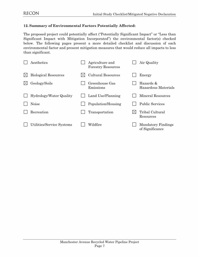
12. Summary of Environmental Factors Potentially Affected:
The proposed project could potentially affect (“Potentially Significant Impact” or “Less than Significant Impact with Mitigation Incorporated”) the environmental factor(s) checked below. The following pages present a more detailed checklist and discussion of each environmental factor and present mitigation measures that would reduce all impacts to less than significant.
Aesthetics Agriculture and Forestry Resources
Air Quality
Biological Resources Cultural Resources Energy
Geology/Soils Greenhouse Gas Emissions
Hazards & Hazardous Materials
Hydrology/Water Quality Land Use/Planning Mineral Resources
Noise Population/Housing Public Services
Recreation Transportation Tribal Cultural Resources
Utilities/Service Systems Wildfire Mandatory Findings of Significance

FIGURE 1
Regional Location
kj
USMC AIRSTATION
MIRAMAR
USMC AIRSTATION
MIRAMAR
CAMP PENDLETONMARINE CO BASE
Daley
Ranch
Los PenasquitosCanyon Presv
Mission TrailsRegional Park
Cleveland NF
Lake Wohlford
Batiquitos Lagoon
Lake Hodges
El CapitanReservoir
San VicenteReservoir
SweetwaterReservoir
Sa
nD
i e g u i t o
Ri
v e r
Sa
n
D
i e g u i t oR
i
v e r
S a n t aY
sa
b
el
C r ee
k
Sw
ee
tw
at
e
r
Ri
ve
r
Es
co
nd
id
o
Cr
e
ek
S a n Di e g
oR i v e
r
Jamul Indian
Village
San
PasqualReservation
Rincon Reservation
Sycuan
Reservation
La Jolla Reservation
Barona
Reservation
Valley Center
Bostonia
Casa deOro-Mount
Helix
Crest
FairbanksRanch
Granite Hills
HarbisonCanyon
HiddenMeadows
Jamul
LakeSan Marcos
Lakeside
LaPresa
Ramona
RanchoSan Diego
RanchoSanta Fe
Spring
Valley
Winter Gardens
UV163
UV78
UV54
UV56
UV76
UV75
UV125
UV67
UV94
UV52
§̈¦8
§̈¦805
§̈¦15
§̈¦5
S A N D I E G O
C O U N T Y
Carlsbad
Chula Vista
Coronado
DelMar
El Cajon
Encinitas
Escondido
LaMesa
LemonGrove
National City
Oceanside
Poway
San Diego
San Marcos
Santee
SolanaBeach
Vista
0 5Miles [
M:\JOBS5\9421-1\common_gis\fig1.mxd 5/6/2019 bma
SAN DIEGO
RIVERSIDE
SAN BERNARDINO
ORANGE
MEXICO
Project Locationkj

FIGURE 2
Project Location on USGS Map
Map Source: USGS 7.5 minute topographic map series, Encinitas quadrangle, 1975, T13S R04W
0 2,000Feet [
Project Construction Work Area
M:\JOBS5\9421-1\Task1\common_gis\fig2_bioltr.mxd 6/4/2019 bma

FIGURE 3
Project Location on Aerial Photograph
EL
CA
MIN
OR
EA
L
MANCHESTER
§̈¦5
S a n E l i j o L a g o o n
E c o l o g i c a l R e s e r v e
EL
CA
MIN
OR
EA
L
MANCHESTER
§̈¦5
S a n E l i j o L a g o o n
E c o l o g i c a l R e s e r v e
Image Source: NearMap (flown February 2019)
0 1,000Feet [
Project Construction Work Area
M:\JOBS5\9421-1\Task1\common_gis\fig3.mxd 6/6/2019 bma
Initial Study Checklist/Mitigated Negative Declaration
Manchester Avenue Recycled Water Pipeline Project Page 11
4.0 Initial Study Checklist EVALUATION OF ENVIRONMENTAL IMPACTS:
1. A brief explanation is required for all answers except “No Impact” answers that are adequately supported by the information sources a lead agency cites in the parentheses following each question. A “No Impact” answer is adequately supported if the referenced information sources show that the impact simply does not apply to projects like the one involved (e.g., the project falls outside a fault rupture zone). A “No Impact” answer should be explained where it is based on project-specific factors as well as general standards (e.g., the project will not expose sensitive receptors to pollutants, based on a project-specific screening analysis).
2. All answers must take account of the whole action involved, including off-site as well as on-site, cumulative as well as project-level, indirect as well as direct, and construction as well as operational impacts.
3. Once the lead agency has determined that a particular physical impact may occur, then the checklist answers must indicate whether the impact is potentially significant, less than significant with mitigation, or less than significant. “Potentially Significant Impact” is appropriate if there is substantial evidence that an effect may be significant. If there are one or more “Potentially Significant Impact” entries when the determination is made, an EIR is required.
4. “Negative Declaration: Less Than Significant With Mitigation Incorporated” applies where the incorporation of mitigation measures has reduced an effect from “Potentially Significant Impact” to a “Less Than Significant Impact.” The lead agency must describe the mitigation measures, and briefly explain how they reduce the effect to a less than significant level (mitigation measures from “Earlier Analyses,” as described in (5) below, may be cross-referenced).
5. Earlier analyses may be used where, pursuant to the tiering, program EIR, or other CEQA process, an effect has been adequately analyzed in an earlier EIR or negative declaration. Section 15063(c)(3)(D). In this case, a brief discussion should identify the following:
a. Earlier Analysis Used. Identify and state where they are available for review.
b. Impacts Adequately Addressed. Identify which effects from the above checklist were within the scope of and adequately analyzed in an earlier document pursuant to applicable legal standards, and state whether such effects were addressed by mitigation measures based on the earlier analysis.
c. Mitigation Measures. For effects that are “Less than Significant with Mitigation Measures Incorporated,” describe the mitigation measures which were incorporated

Initial Study Checklist/Mitigated Negative Declaration
Manchester Avenue Recycled Water Pipeline Project Page 12
or refined from the earlier document and the extent to which they address site-specific conditions for the project.
6. Lead agencies are encouraged to incorporate into the checklist references to information sources for potential impacts (e.g., general plans, zoning ordinances). Reference to a previously prepared or outside document should, where appropriate, include a reference to the page or pages where the statement is substantiated.
7. Supporting Information Sources: A source list should be attached, and other sources used or individuals contacted should be cited in the discussion.
8. This is only a suggested form, and lead agencies are free to use different formats; however, lead agencies should normally address the questions from this checklist that are relevant to a project's environmental effects in whatever format is selected.
9. The explanation of each issue should identify:
a. the significance criteria or threshold, if any, used to evaluate each question; and
b. the mitigation measure identified, if any, to reduce the impact to less than significance.

Initial Study Checklist/Mitigated Negative Declaration
Manchester Avenue Recycled Water Pipeline Project Page 13
4.1 Aesthetics Except as provided in Public Resources Code Section 21099, would the project:
Issue
Potentially Significant
Impact
Potentially Significant
Unless Mitigation
Incorporated
Less Than Significant
Impact No Impact a. Have a substantial adverse effect on
a scenic vista?
b. Substantially damage scenic resources, including but not limited to, trees, rock outcroppings, and historic buildings within a state scenic highway?
c. In non-urbanized areas, substantially degrade the existing visual character or quality of public views of the site and its surroundings? (Public views are those that are experienced from a publicly accessible vantage point). If the project is in an urbanized area, would the project conflict with applicable zoning and other regulations governing scenic quality?
d. Create a new source of substantial light or glare that would adversely affect day or nighttime views in the area?
EXPLANATIONS:
The project is located in the City of Encinitas. Policy 4.7 in the City of Encinitas Resource Management Element within the City’s General Plan designates Manchester Avenue, between San Elijo Avenue and Encinitas Boulevard as a scenic highway/visual corridor viewshed (City of Encinitas, 2011).
a-d. Less Than Significant Impact
Policy 4.7 in the City of Encinitas Resource Management Element within the City’s General Plan designates Manchester Avenue, between San Elijo Avenue and Encinitas Boulevard as a scenic highway/visual corridor viewshed (City of Encinitas 2011). Project construction impacts would be temporary in nature and surfaces would be restored to pre-construction conditions. Therefore, construction of the project would not have a substantially adverse effect on a scenic vista, damage scenic resources within a State Scenic Highway, or degrade the existing visual character of the site or its surroundings. The project would not create any new source of light or glare because all work would is expected to be conducted during

Initial Study Checklist/Mitigated Negative Declaration
Manchester Avenue Recycled Water Pipeline Project Page 14
daylight hours and because the recycled water line would remain underground. Impacts would be less than significant, and no mitigation is required.
Mitigation Measures: None required or recommended.
4.2 Agriculture and Forestry Resources Would the project:
Issue
Potentially Significant
Impact
Potentially Significant
Unless Mitigation
Incorporated
Less Than Significant
Impact No
Impact a. Convert Prime Farmland, Unique
Farmland, or Farmland of Statewide Importance (Farmland), as shown on the maps prepared pursuant to the Farmland Mapping and Monitoring Program of the California Resources Agency, to non-agricultural use?
b. Conflict with existing zoning for agricultural use, or a Williamson Act Contract?
c. Conflict with existing zoning for, or cause rezoning of, forest land (as defined in Public Resources Code Section 1220[g]), timberland (as defined by Public Resources Code Section 4526), or timberland zoned Timberland Production (as defined by Government Code section 51104[g])?
d. Result in the loss of forest land or conversion of forest land to non-forest use?
e. Involve other changes in the existing environment, which, due to their location or nature, could result in conversion of Farmland to non-agricultural use or conversion of forest land to non-forest use?
EXPLANATIONS:
The project area is designated as Urban and Built-Up Land and Other Land by the California Department of Conservation Farmland Mapping and Monitoring Program. The agricultural fields located east of Via Poco, west of Mira Costa College, and north of the

Initial Study Checklist/Mitigated Negative Declaration
Manchester Avenue Recycled Water Pipeline Project Page 15
project site are designated as Farmland of Local Importance. Within the unincorporated county of San Diego, the agricultural fields are designated as Intensive Agriculture (County of San Diego 2019). There is no Prime Farmland, Unique Farmland, or Farmland of Statewide Importance in the project area (California Department of Conservation 2016). There is no designated forest land or timberland land within the project area.
a-e. No Impact
There is no Farmland of Local Importance within the project area. The project would be located on land designated by the California Department of Conservation as Urban and Built-Up Land and Other Land. The project would not result in a conflict with existing zoning for agricultural use or a Williamson Act contract or result in conversion of farmland to nonagricultural use. Therefore, no impacts would occur. There is no forest land or timberland within the project area. Therefore, there would be no conflict with zoning or loss or conversion of forest land or timberland. No impacts to forest land or timberland would occur and no mitigation is required.
Mitigation Measures: None required or recommended.
4.3 Air Quality Would the project:
Issue
Potentially Significant
Impact
Potentially Significant
Unless Mitigation
Incorporated
Less Than Significant
Impact No
Impact a. Conflict with or obstruct
implementation of the applicable air quality plan?
b. Result in a cumulatively considerable net increase of any criteria pollutant for which the project region is non-attainment under an applicable federal or state ambient air quality standard?
c. Expose sensitive receptors to substantial pollutant concentrations?
d. Result in other emissions (such as those leading to odors) adversely affecting a substantial number of people?

Initial Study Checklist/Mitigated Negative Declaration
Manchester Avenue Recycled Water Pipeline Project Page 16
EXPLANATIONS:
This section addresses air emissions generated by construction and operation of the project. The primary air pollutants of concern include: ozone (O3), volatile organic compounds (VOC), oxides of nitrogen (NOX), carbon monoxide (CO), respirable particulate matter (PM10), and fine particulate matter (PM2.5). This section also addresses the project’s consistency with air quality policies for the San Diego Air Basin (SDAB) and the California State Implementation Plan (SIP). Analysis of project-generated air emissions focuses on whether the project would cause an exceedance of an ambient air quality standard or significance threshold. The applicable air quality plans for the project are the San Diego Regional Air Quality Strategy (RAQS) and applicable portions of the SIP. The RAQS is produced by the San Diego Air Pollution Control District (SDAPCD) and submitted to the state for inclusion in the SIP. The RAQS is revised every three years; the most recent RAQS was published in December 2016. Air quality emissions projections and control measures for stationary sources provided in the RAQS and SIP include consideration of many factors such as population projections from local planning documents (e.g., General Plans) and projections from the San Diego Association of Governments (SANDAG). Existing Climate and Air Quality The San Diego region’s climate is characterized by dry, warm summers and mild, occasionally wet winters. The region experiences an average temperature range from the mid-40s to the high 90s (degrees Fahrenheit). Approximately 90 percent of the region’s precipitation falls from November to April, with an average seasonal precipitation at the coast of approximately 10 inches. Precipitation generally increases towards the mountains and high elevations.
The local topography and coastal influence affects the dispersal and movement of pollutants in the basin. Topography in the region ranges from desert and mountains in the east to beaches and coastal areas in the west. Pollutant dispersal can be impeded by the mountains, which help trap them in inversion layers. Prevailing wind patterns are westerly to northwesterly, and inland winds can blow through the valleys during the day and down the hills and valleys at night.
The project is located in the SDAB, which is under the authority of the SDAPCD. The SDAB covers 4,260 square miles, which comprises the entire San Diego region and is contiguous with the County boundary. During warmer months, temperature subsidence inversions occur as descending air associated with the Pacific High Pressure Zone encounters air cooled by the ocean, trapping pollutants. A shallow inversion layer can form on cooler nights due to radiation inversion, which can also trap pollutants. Pollutants can become concentrated in the inversion layers allowing for photochemical reactions which produce O3, or smog. The SDAB is currently classified as a federal marginal nonattainment area for O3 and a state nonattainment area for PM10, PM2.5, and O3 (County of San Diego 2007).

Initial Study Checklist/Mitigated Negative Declaration
Manchester Avenue Recycled Water Pipeline Project Page 17
The SDAPCD maintains a network of air quality monitoring stations located throughout the SDAB. The purpose of the monitoring stations is to measure ambient concentrations of the pollutants and determine whether the ambient air quality meets the California Ambient Air Quality Standards (CAAQS) and the National Ambient Air Quality Standards (NAAQS). The closest to the project site with the most complete monitoring data is the Mira Costa College station in Del Mar, which measures O3, PM2.5, PM10, NO2, and CO.
Air Quality Standards The project site is located within the city of Encinitas. The City has not adopted thresholds of significance for evaluating air quality impacts; therefore, this analysis relies on thresholds established by the County of San Diego. The relevant air quality standards are the County of San Diego air quality screening level thresholds (County of San Diego 2007), which are part of its Guidelines for Determining Significance and Report Format and Content Requirements – Air Quality. The thresholds for criteria pollutants are presented in Table 1. Note that the terms reactive organic gases (ROG) and volatile organic compounds (VOC) are considered interchangeable.
Table 1 Air Quality Impact Trigger Levels
Pollutant Emission Rate Pounds/Hour Pounds/Day Tons/Year
Respirable Particulate Matter (PM10) -- 100 15 Fine Particulate Matter (PM2.5) -- 55a 10a
Oxides of Nitrogen (NOX) 25 250 40 Oxides of Sulfur (SOX) 25 250 40 Carbon Monoxide (CO) 100 550 100 Lead and Lead Compounds -- 3.2 0.6 Volatile Organic Compounds (VOCs) -- 75b 13.7c
SOURCE: SDAPCD, Rules 20.1, 20.2, 20.3; County of San Diego 2007. aBased on the U.S. Environmental Protection Agency “Proposed Rule to Implement the
Fine Particle National Ambient Air Quality Standards” published September 8, 2005. Also used by the South Coast Air Quality Management District.
bThreshold for VOCs based on the threshold of significance for VOCs from the South Coast Air Quality Management District for the Coachella Valley.
c13.7 tons per year threshold based on 75 pounds per day multiplied by 365 days per year and divided by 2,000 pounds per ton.
The criteria levels listed in Table 1 are thresholds to evaluate the increased emissions that would be discharged to the SDAB if the project were to be approved. Emissions below the screening level thresholds would not cause a significant impact on air quality. If emissions exceed these thresholds, modeling would be required to demonstrate that the project’s total air quality impacts would not exceed the NAAQS and CAAQS, including background levels. For nonattainment pollutants (O3, with ozone precursors NOX and VOCs, and PM10 and PM2.5), if emissions exceed the thresholds shown in Table 1, the project could have the potential to result in a cumulatively considerable net increase in these pollutants, and thus could have a significant impact on the ambient air quality. In addition to impacts from criteria pollutants, project impacts may include emissions of pollutants identified by the state and federal governments as toxic air contaminants

Initial Study Checklist/Mitigated Negative Declaration
Manchester Avenue Recycled Water Pipeline Project Page 18
(TACs). In San Diego County, SDAPCD Regulation XII Rule 1210 governs TAC emissions. It contains requirements for notifications of emissions and risk reduction audits and plans for stationary source toxic air contaminants. Under Rule 1210, emissions of TACs that result in a cancer risk of 10 in 1 million or less and a health hazard index of one or less would not be required to notify the public of potential health risks. If a project has the potential to result in emissions of any TAC which results in a cancer risk of greater than 10 in 1 million, it would have a potentially significant impact. a. Less Than Significant Impact In general, projects that do not increase growth beyond that included in existing General Plans, which are used to develop air emission budgets for the purpose of air quality planning and attainment demonstrations, would be consistent with the SDAB’s air quality plans, including the RAQS and SIP. The project would not directly or indirectly induce growth. The project would install a recycled water pipeline. The project would not impact the demands that are anticipated under existing General Plan population projections and, therefore, are incorporated into the RAQS and SIP. In addition, installation of the recycled water line would not be growth inducing. Given that anticipated air quality emissions associated with the project are accounted for in the RAQS and SIP, the project would not obstruct implementation of the applicable plans. Impacts would be less than significant, and no mitigation would be required.
b. Less Than Significant Impact A project could result in a cumulatively significant impact if it would generate emissions that constitute a cumulatively considerable net increase of PM10 and PM2.5, or exceed quantitative thresholds for O3 precursors, NOX and VOCs. The project site is in an area that is largely developed, and emissions from existing development are part of the ambient air quality levels. As a pipeline construction project, the project would involve only construction air emissions impacts. There would be no change in the operational impacts to air quality, which are minimal related to ongoing maintenance activities. The SDAPCD does not have a specific construction emissions modeling program. Construction emissions were calculated using the Sacramento Metropolitan Air Quality Management District’s (SMAQMD) Road Construction Emissions Model, Version 8.1.0 (SMAQMD 2016). This model is applicable for all construction projects that involve construction equipment that is subject to CARB construction equipment emissions standards. The Roadway Construction Emissions Model is a spreadsheet-based model that is able to use basic project information (e.g., total construction months, project type, total project area) to estimate a construction schedule and quantify exhaust emissions from heavy-duty construction equipment, haul trucks, and worker commute trips associated with linear construction projects. Version 8.1.0 of the model incorporates the most currently approved Emission Factor (EMFAC) model and Off-Road emissions factors model. The Road Construction Emissions Model calculates fugitive dust, exhaust, and off-gas emissions from grubbing/land clearing, grading/excavation, drainage/utilities/sub-grade, and paving

Initial Study Checklist/Mitigated Negative Declaration
Manchester Avenue Recycled Water Pipeline Project Page 19
activities associated with construction projects that are linear in nature (e.g., road or levee construction, pipeline installation, transmission lines). Construction is expected to last approximately six months. Appendix A contains the Road Construction Emissions Model calculations for this project. The results of construction emissions were calculated using the Road Construction Emissions Model and are summarized in Table 2.
Table 2 Maximum Daily Construction Emissions
(pounds per day)
Pollutant
VOC NOX CO SOX PM10 PM2.5 Grubbing/Land Clearing 2 16 17 <1 11 3 Grading/Excavation 2 17 18 <1 11 3 Drainage/Utilities/Sub-Grade 2 17 20 <1 11 3 Paving 2 23 24 <1 1 1 Maximum Daily Emissions 2 23 24 <1 11 3 Significance Threshold 75 250 550 250 100 55 Significant Impact? No No No No No No VOC = volatile organic compounds; NOX = nitrogen oxides; CO = carbon monoxide; SOX = sulfur oxides; PM10 = particulate matter less than 10 microns; PM2.5 = particulate matter less than 2.5 microns As shown, maximum daily construction emissions are projected to be less than the applicable thresholds for all criteria pollutants. Therefore, air quality impacts during construction activities would be less than significant. Once construction is complete, there would be no operational source of emissions. Therefore, operational impacts would be less than significant. c. Less Than Significant Impact Sensitive receptors are typically defined as schools (preschool – 12th grade), hospitals, resident care facilities, day care centers, or other facilities that may house individuals with health conditions that would be adversely impacted by changes in air quality. Any project which has the potential to directly impact a sensitive receptor located within one mile and result in a health risk greater than 10 in 1 million would have a potentially significant impact. The land uses within the project vicinity include residential development, educational and religious facilities, and a tennis club. The two primary emissions of concern regarding health effects for land development projects are diesel-fired particulates and carbon monoxide. Projects that would site sensitive receptors near potential CO hot spots (i.e., exceedance of County CO thresholds) or would contribute vehicle traffic to local intersections where a CO hot spot could occur would be considered as having a potentially significant impact. Additionally, projects that would result in exposure to TAC resulting in a maximum incremental cancer risk greater than 1 in 1 million without application of best available control technology for toxics or a threshold of 10 in 1 million for project’s implementing best emission-control technologies or a health hazard index greater than one would be considered as having a potentially significant impact. The project would construct a pipeline and would not be an operational source of TAC emissions.
Initial Study Checklist/Mitigated Negative Declaration
Manchester Avenue Recycled Water Pipeline Project Page 20
Construction of the project would result in the generation of diesel particulate matter (DPM) emissions from the use of off-road diesel construction activities and on-road diesel equipment. Generation of DPM from construction projects typically occurs in a single area for a short period. Construction of the project would occur over a six-month period. The dose to which the receptors are exposed is the primary factor used to determine health risk. Dose is a function of the concentration of a substance or substances in the environment and the extent of exposure that person has with the substance. Dose is positively correlated with time, meaning that a longer exposure period would result in a higher exposure level for the Maximally Exposed Individual. The risks estimated for a Maximally Exposed Individual are higher if a fixed exposure occurs over a longer period of time. According to the Office of Environmental Health Hazard Assessment (OEHHA), health risk assessments, which determine the exposure of sensitive receptors to toxic emissions, should be based on a 30-year exposure period; however, such assessments should be limited to the period/duration of activities associated with the project (OEHHA 2015). Thus, if the duration of proposed construction activities near any specific sensitive receptor were six months, the exposure would be less than two percent of the total exposure period used for health risk calculation. Therefore, due to the short duration of construction activity and the limited amount of construction equipment, DPM generated by project construction is not expected to create conditions where the probability is greater than 10 in 1 million of contracting cancer for the Maximally Exposed Individual or to generate ground-level concentrations of noncarcinogenic TACs that exceed a Hazard Index greater than 1 for the Maximally Exposed Individual. Additionally, with ongoing implementation of U.S. Environmental Protection Agency (U.S. EPA) and California Air Resources Board (CARB) requirements for cleaner fuels; off-road diesel engine retrofits; and new, low-emission diesel engine types, the DPM emissions of individual equipment would be substantially reduced. Due to the limited time of exposure, project construction would not expose sensitive receptors to substantial pollutant concentrations. d. Less Than Significant Impact SDAPCD Rule 51 (Public Nuisance) and California Health & Safety Code, Division 26, Part 4, Chapter 3, Section 41700 prohibit the emission of any material which causes nuisance to a considerable number of persons or endangers the comfort, health, or safety of the public. Projects required to obtain permits from SDAPCD, typically industrial and some commercial projects, are evaluated by SDAPCD staff for potential odor nuisance and conditions may be applied (or control equipment required) where necessary to prevent occurrence of public nuisance. The project does not include the construction or operation of heavy industrial or agricultural uses that are typically associated with odor complaints. During construction, diesel equipment may generate some temporary nuisance odors. Sensitive receptors near the project site include residential uses, educational and religious facilities, and a tennis club. However, exposure to odors associated with project construction would be short term and temporary in nature. There would be no permanent or operational source of odors associated with the project. Impacts would be less than significant. Mitigation Measures: None required or recommended.

Initial Study Checklist/Mitigated Negative Declaration
Manchester Avenue Recycled Water Pipeline Project Page 21
4.4 Biological Resources Would the project:
Issue
Potentially Significant
Impact
Potentially Significant
Unless Mitigation
Incorporated
Less Than Significant
Impact No
Impact a. Have substantial adverse effects,
either directly or through habitat modifications, on any species identified as a candidate, sensitive, or special status species in local or regional plans, policies, or regulations, or by the California Department of Fish and Wildlife (CDFW) or U.S. Fish and Wildlife Service (USFWS)?
b. Have a substantial adverse effect on any riparian habitat or other community identified in local or regional plans, policies, and regulations or by the CDFW or USFWS?
c. Have a substantial adverse effect on state or federally protected wetlands (including, but not limited to, marsh, vernal pool, coastal, etc.) through direct removal, filling, hydrological interruption, or other means?
d. Interfere substantially with the movement of any native resident or migratory fish or wildlife species or with established native resident or migratory wildlife corridors, or impede the use of native wildlife nursery sites?
e. Conflict with any local policies or ordinances protecting biological resources, such as tree preservation policy or ordinance?
f. Conflict with the provisions of an adopted Habitat Conservation Plan, Natural Community Conservation Plan, or other approved local, regional, or state habitat conservation plan?

Initial Study Checklist/Mitigated Negative Declaration
Manchester Avenue Recycled Water Pipeline Project Page 22
EXPLANATIONS:
A biological resources field survey of the project area and associated biological resources was conducted on May 13, 2019 by RECON Environmental. The complete Biological Letter Report is provided in Appendix B.
a. Potentially Significant Unless Mitigation Incorporated
The project includes the installation of approximately 7,400 linear feet of 6-inch PVC recycled water pipeline within the paved right-of-way of Manchester Avenue and El Camino Real. No sensitive vegetation communities occur within the project work area, as the work area is within roadway pavement. Although, southern coastal salt marsh, subtidal estuary, southern riparian forest, southern willow scrub, fresh water, Diegan coastal sage scrub, non-native grassland, eucalyptus woodland, and disturbed habitat exist adjacent to portions of Manchester and El Camino Real, there would be no direct impacts to these vegetation types.
Since no vegetation removal is proposed, no direct impacts are expected to occur to any of the potentially present sensitive wildlife species. However, construction noise in excess of 60 dB(A) hourly average at the edge of potentially occupied habitat has potential to cause indirect impacts to nesting sensitive bird species. A total of 26 sensitive wildlife species (see Appendix B) have the potential to occur in the habitats occurring within the survey area. However, no direct impacts to these species would occur. Indirect impacts to any nesting individuals of the 18 potentially occurring bird species may occur as a result of construction noise.
To avoid potential indirect impacts to these species, mitigation measure BIO-1 would require construction activities to occur outside their combined breeding season (January 15 to September 15). If construction must occur during any of the breeding seasons of the mentioned sensitive bird species, mitigation measure BIO-2 would require noise monitoring and noise attenuation to ensure noise levels do not exceed a 60 dB(A) hourly average at the edge of potentially occupied habitat. Implementation of mitigation measure BIO-1 or BIO-2 would lessen potential impacts to nesting birds to less than significant.
b and c. Less than Significant Impact
According to the biological resources survey report, fresh water occurs within one small basin in the south-central portion of the survey area, northwest of Manchester Avenue; a non-vegetated channel occurs in the north-central portion of the survey area along the west side of El Camino Real; and a subtidal estuary occurs in the southern portion of the survey area where the survey area extends into the open water within the San Elijo Lagoon. The small non-vegetated channel, the basin containing fresh water, and the subtidal estuary all have connectivity to the San Elijo Lagoon and Pacific Ocean, a traditional navigable water.
The southern coastal salt marsh, southern riparian forest, and southern willow scrub are likely jurisdictional under CDFW and the Regional Water Quality Control Board (RWQCB) as wetland waters of the state, as County RPO wetlands, and may be jurisdictional under

Initial Study Checklist/Mitigated Negative Declaration
Manchester Avenue Recycled Water Pipeline Project Page 23
USACE as wetland waters of the U.S. The fresh water, non-vegetated channel, and subtidal estuary would likely be considered non-wetland waters of the U.S. under the jurisdiction of the USACE, non-wetland waters of the state under the jurisdiction of the RWQCB and CDFW, and County RPO wetlands. No sensitive vegetation communities or jurisdictional resources would be directly impacted by the project.
The potentially jurisdictional vegetation communities (southern coastal salt marsh, southern riparian forest, and southern willow scrub), as well as the non-vegetated channel, the basin containing fresh water, and the subtidal estuary, all occur outside the project work area. No indirect impacts, such as those caused by erosion or dust, are expected to occur to jurisdictional areas as all work would occur within the paved roadway where erosion and dust would be controlled. Therefore, impacts would be less than significant.
d. Less Than Significant Impact
Non-vegetated channel occurs in the north-central portion of the survey area along the west side of El Camino Real. It is sparsely vegetated with non-native herbaceous species and occurs among large patches of disturbed habitat. This channel drains the upstream southern riparian forest and continues south along the drainage and under a series of driveways and Manchester Avenue via culverts. South of Manchester Avenue, the channel empties into the wetland habitats within the San Elijo Lagoon. Given this connectivity, this channel would likely be under the jurisdiction of the wetland agencies. However, the channel is not a defined or mapped wildlife corridor. Furthermore, the proposed project’s work area consists entirely of areas mapped as urban/developed land. Therefore, impacts would be less than significant.
e and f. Less Than Significant Impact
The project would be implemented in accordance with all applicable policies and ordinances. The project would not require the removal of trees, as the project impact areas consist of urban/developed land within the paved right-of-way of Manchester Avenue and El Camino Real. Furthermore, the project would adhere to the City of Encinitas Urban Forest Management Program and the City’s Municipal Code Section 15.02.110, Protection of Trees, which requires protection of trees during construction. Therefore, impacts would be less than significant.
Mitigation Measures:
Mitigation Measure BIO-1
If construction occurs during the general breeding season (January 15 to September 15) but away from any potentially occupied habitat during the species-specific breeding seasons listed below, a qualified biologist shall conduct a pre-activity nesting bird survey in the suitable habitat within 300 feet of the location of proposed construction activity. If an active nest is detected, activities within 300 feet of the nest will be delayed until species-specific measures to prevent impacts to the birds are determined and applied by the qualified biologist.

Initial Study Checklist/Mitigated Negative Declaration
Manchester Avenue Recycled Water Pipeline Project Page 24
• light footed Ridgway’s rail–breeding season from February 15 to September 30, southern coastal salt marsh
• western snowy plover–breeding season from April 1 to August 31, southern coastal salt marsh
• California least tern–breeding season from April 1 to September 15, southern coastal salt marsh and subtidal estuary
• coastal California gnatcatcher–breeding season from February 15 to August 31, Diegan coastal sage scrub
• least Bell’s vireo–breeding season from March 15 to September 15, southern willow scrub and southern riparian forest
Mitigation Measure BIO-2
If construction must occur during any of the breeding seasons of the following sensitive bird species, noise monitoring shall be conducted and noise attenuation measures may be required to ensure noise levels do not exceed a 60 A-weighted decibels hourly average at the edge of potentially occupied habitat:
• light footed Ridgway’s rail–breeding season from February 15 to September 30, southern coastal salt marsh
• western snowy plover–breeding season from April 1 to August 31, southern coastal salt marsh
• California least tern–breeding season from April 1 to September 15, southern coastal salt marsh and subtidal estuary
• coastal California gnatcatcher–breeding season from February 15 to August 31, Diegan coastal sage scrub
• least Bell’s vireo–breeding season from March 15 to September 15, southern willow scrub and southern riparian forest

Initial Study Checklist/Mitigated Negative Declaration
Manchester Avenue Recycled Water Pipeline Project Page 25
4.5 Cultural Resources Would the project:
Issue
Potentially Significant
Impact
Potentially Significant
Unless Mitigation
Incorporated
Less Than Significant
Impact No
Impact a. Cause a substantial adverse
change in the significance of an historical resource pursuant to §15064.5?
b. Cause a substantial adverse change in the significance of an archaeological resource pursuant to §15064.5?
c. Disturb human remains, including those interred outside of formal cemeteries?
EXPLANATIONS:
A Cultural Resources Assessment (Appendix C) was conducted in May 2019 by RECON for the project. A field survey of the project area and associated cultural resources was conducted on May 21, 2019. The complete Cultural Resources Assessment and is provided in Appendix C. On May 15, 2019, as part of the Cultural Resources Assessment, a cultural resources self-search indicated that there are 30 cultural resources identified within a one-mile radius of the project site. The recorded sites are all prehistoric and include hearth features, midden sites with and without artifacts, a multi-component habitation site, temporary camps, lithic scatters, a habitation site, and an isolates. No sites are within the project boundary, and none are mapped within 800 feet of the project. On May 21, 2019, an intensive pedestrian survey of the project area was conducted by RECON archaeologists. The entire project area has been impacted by the construction of El Camino Real and the adjacent commercial developments. The actual excavation area is within Manchester Avenue and S. El Camino Real, which is a paved road. Areas adjacent to the project are a combination of concrete sidewalks, driveways, and landscaped areas. No pre-development ground surface remains within or adjacent to the project. No prehistoric or historic cultural material was observed during the survey.
a and b. Less than Significant with Mitigation
No prehistoric or historic cultural resources were mapped on or immediately adjacent to the property in the South Coastal Information Center record search files. No significant or potentially significant prehistoric or historic cultural resources were found during the survey of the project property. However, the project does have the potential to excavate into undisturbed soils, and impact currently unidentified prehistoric or historic cultural resources. Mitigation measure CUL-1 would require a qualified archaeological monitor and

Initial Study Checklist/Mitigated Negative Declaration
Manchester Avenue Recycled Water Pipeline Project Page 26
Native American monitor be present during any excavations that have the potential to extend into undisturbed soils. Implementation of mitigation measure CUL-1 would reduce impacts to unidentified prehistoric or historic cultural resources to less than significant.
c. Less than Significant Impact
The discovery of human remains is always a possibility during ground disturbing activities. If human remains are discovered, work shall halt in that area and the procedures set forth in the California Public Resources Code (Section 5097.98) and State Health and Safety Code (Section 7050.5) will be followed. With adherence to state regulations, impacts to human remains would be less than significant.
Mitigation Measures:
Mitigation Measure CUL-1
A qualified archaeological monitor and Native American Monitor shall be present during any excavations that have the potential to extend into undisturbed soils. In the event that unknown cultural resources or significant features are encountered during construction monitoring, the archaeological and Native American monitors shall be authorized to temporarily divert trenching in the area of discovery until the significance and the appropriate mitigation measures are determined. Should significant resources be discovered during the monitoring, additional mitigation may be required such as data recovery. If required, an Archaeological Data Recovery Program shall be submitted by the Principal Investigator, approved by OMWD, and implemented prior to resuming construction activities. All cultural material collected during the monitoring and data recovery program shall be processed and permanently curated with an appropriate institution. After the completion of the monitoring, an appropriate report shall be prepared. If no significant cultural resources are discovered, a brief letter shall be prepared. If significant cultural resources are discovered, a report with the results of the monitoring and data recovery (including the interpretation of the data within the research context) shall be prepared.

Initial Study Checklist/Mitigated Negative Declaration
Manchester Avenue Recycled Water Pipeline Project Page 27
4.6 Energy Would the project:
Issue
Potentially Significant
Impact
Potentially Significant
Unless Mitigation
Incorporated
Less Than Significant
Impact No
Impact a. Result in potentially significant
environmental impacts due to wasteful, inefficient, or unnecessary consumption of energy resources, during project construction or operation?
b. Conflict with or obstruct a state or local plan for renewable energy or energy efficiency?
EXPLANATIONS:
a. Less Than Significant Impact
Construction
During construction, the project would consume energy in two general forms: (1) the fuel energy consumed by construction vehicles and equipment and (2) bound energy in construction materials, such as asphalt and pipes.
Construction of the project would require the use of construction equipment for trenching, hauling, and pipeline installation, backfill and paving activities. Equipment for these types of activities are discussed in section, 4.3, Air Quality, above. Construction equipment which requires electricity would be gas powered or diesel powered. Construction also includes the vehicles of construction workers traveling to and from the project site.
Furthermore, there are no unusual project characteristics that would necessitate the use of construction equipment that would be less energy efficient than at comparable pipeline construction sites in other parts of the state. Therefore, the proposed short-term construction activities would not result in inefficient, wasteful, or unnecessary fuel consumption.
Transportation
Transportation energy use depends on the type and number of trips, vehicle miles traveled, fuel efficiency of vehicles, and travel mode. Transportation energy use during construction would come from the transport and use of construction equipment and construction employee vehicles that would use diesel fuel and/or gasoline. The use of energy resources by these vehicles would be temporary. Impacts related to transportation energy use during

Initial Study Checklist/Mitigated Negative Declaration
Manchester Avenue Recycled Water Pipeline Project Page 28
construction would be temporary and would not require expanded energy supplies or the construction of new infrastructure. Impacts would be less than significant.
Operation
The project would involve installation of approximately 7,400 linear feet of 6-inch PVC recycled water pipeline. Operational impacts of the proposed project would be comparable to the other district pipelines in the roadway. Therefore, impacts due to wasteful, inefficient, or unnecessary consumption of energy resources during operation would be less than significant.
b. No Impact
The project is located within SCAG’s 2016-2040 Regional Transportation Plan/Sustainable Communities Strategy, which establishes a long-range visioning plan that balances future mobility and housing needs with economic, environmental and public health goals. As identified in Table 3 (see Section 4.8), GHG emissions would only occur during construction. Furthermore, installation of approximately 7,400 linear feet of 6-inch PVC recycled water pipeline and would not result in significant impacts to GHG emissions. In addition, the project would be required to adhere to the City of Encinitas 2018 Climate Action Plan. Therefore, the project would not obstruct a state or local plan for renewable energy or energy efficiency and no impacts would occur. Mitigation Measures: None required or recommended.
4.7 Geology and Soils Would the project:
Issue
Potentially Significant
Impact
Potentially Significant
Unless Mitigation
Incorporated
Less Than Significant
Impact No
Impact a. Directly or indirectly cause
potential substantial adverse effects, including the risk of loss, injury, or death involving:
i. Rupture of a known earthquake fault, as delineated on the most recent Alquist-Priolo Earthquake Fault Zoning Map issued by the State Geologist for the area or based on other substantial evidence of a known fault?
ii. Strong seismic ground shaking?

Initial Study Checklist/Mitigated Negative Declaration
Manchester Avenue Recycled Water Pipeline Project Page 29
Issue
Potentially Significant
Impact
Potentially Significant
Unless Mitigation
Incorporated
Less Than Significant
Impact No
Impact iii. Seismic-related ground
failure, including liquefaction?
iv. Landslides? b. Result in substantial soil erosion
or the loss of topsoil?
c. Be located on a geologic unit or soil that is unstable, or that would become unstable as a result of the project, and potentially result in on- or off-site landslide, lateral spreading, subsidence, liquefaction or collapse?
d. Be located on expansive soil, as defined in Table 18-1-B of the Uniform Building Code (1994), creating substantial direct or indirect risks to life or property?
e. Have soils incapable of adequately supporting the use of septic tanks or alternative wastewater disposal systems where sewers are not available for the disposal of wastewater?
f. Directly or indirectly destroy a unique paleontological resource or site or unique geologic feature?
EXPLANATIONS:
The project area is within the San Dieguito river valley and lies within the Coastal Plain region area of the Peninsular Range. The Coastal Plain region is terraced, while the Central Mountain-Valley region is characterized by ridges and basins, with the floors of the basins covered by a layer of alluvium. Southern California is considered a seismically active region. Moderate to strong earthquakes can occur on numerous local faults. Faults that have historically produced earthquakes or show evidence of movement within the past 1,000 years are considered “active faults.” No known active faults are located in the project area. However, the San Dieguito river valley is situated between two major northwest trending faults: the Elsinore fault zone (located 13 miles to the northeast of Bonsall) and Inglewood/Rose Canyon fault zone (located approximately three miles to the southwest of the project site). Due to its location near these faults, and within the seismically active area of southern California, the project area, like all of San Diego County, is subject to ground shaking.

Initial Study Checklist/Mitigated Negative Declaration
Manchester Avenue Recycled Water Pipeline Project Page 30
a.i and a.ii. Less Than Significant Impact The principal seismic hazard to the project is strong ground shaking from earthquakes produced by local and regional faults. The intensity of ground shaking would depend upon the magnitude of the earthquake, distance to the epicenter, and the geology of the area between the epicenter and the project site. Seismically induced ground rupture could occur with the physical displacement of surface deposits in response to an earthquake’s seismic waves. Ground rupture is most likely along active faults, and typically occurs during earthquakes of magnitude five or higher. Ground rupture only affects the area immediately adjacent to a fault. No active or potentially active faults are mapped or known to occur within or adjacent to the proposed site of the recycled water pipeline extension. According to the California Geologic Survey’s on-line Earthquake Hazards Zone Application (accessed 5/7/2019), the project site is not located in a fault zone. The likelihood for occurrence of ground rupture at the site is considered low due to the absence of known faulting within or adjacent to the project area. The closest fault zone is the Rose Canyon fault zone, located approximately 14 miles south of the project site (Department of Conservation, accessed 5/7/2019). Due to the distance of the nearest fault, potential impacts from ground shaking would be less than significant. a.iii, a.iv, and c. No Impact
According to the California Geologic Survey’s (CGS) on-line Earthquake Hazards Zone Application (accessed 5/7/2019), the project site is not located within an earthquake fault zone. In addition, the project site has not been evaluated by CGS for liquefaction hazards or seismic landslide hazards. The project work area consists entirely of areas mapped as urban/developed land and no habitable structures are proposed. Therefore, impacts would be less than significant.
b. Less Than Significant Impact
The project could result in minor erosion of soils on or offsite during project construction due to the presence of soil piles. However, construction of the project would include BMPs as specified in the site construction SWPPP to control wind or water erosion of exposed soils. Potential impacts associated with erosion of top soil would be less than significant.
d. No Impact
The project includes the installation of approximately 7,400 linear feet of 6-inch PVC recycled water pipeline within the paved right-of-way of Manchester Avenue and El Camino Real. No development would occur on expansive soil. Therefore, no impact would occur in regard to substantial direct or indirect risks to life or property due to expansive soils.
e. No Impact
The project would involve the installation and operation of recycled water pipeline. Septic tanks or other alternative wastewater disposal systems would not be a part of the proposed project. Accordingly, no impact would occur.

Initial Study Checklist/Mitigated Negative Declaration
Manchester Avenue Recycled Water Pipeline Project Page 31
f. Less Than Significant Impact with Mitigation
The probability of discovering paleontological resources depends on the geologic formation being excavated and the depth and volume of the excavation. The new pipeline will be constructed via standard cut and cover technique with the bottom of the trench extending 4 to 6 feet below grade and between 24 to 32 inches wide. Mitigation measure GEO-1 would require a qualified paleontologist to be contacted if any paleontological resources are encountered during construction or excavation activities. Implementation of mitigation measure GEO-1 would reduce impacts to paleontological resources to less than significant.
Mitigation Measures:
Mitigation Measure GEO-1
If any paleontological resources are encountered during construction or excavation activities, a qualified paleontologist shall be contacted to assess the significance of the paleontological resource.
4.8 Greenhouse Gas Emissions Would the project:
Issue
Potentially Significant
Impact
Potentially Significant
Unless Mitigation
Incorporated
Less Than Significant
Impact No
Impact a. Generate greenhouse gas
emissions, either directly or indirectly, that may have a significant impact on the environment?
b. Conflict with an applicable plan, policy or regulation adopted for the purpose of reducing the emissions of greenhouse gases?
EXPLANATIONS:
Greenhouse gases (GHGs) and their contributions to climate change are a global issue, but this analysis focuses on emissions associated with the project and their relationship to statewide policies for GHG emissions reductions. In San Diego County, climate change effects include changes in temperature and rainfall patterns, changes in hydrology and water quality, coastal flooding, wildfires, threats to wildlife, and public health.
The primary GHGs of concern are carbon dioxide (CO2), methane (CH4), and nitrous oxide (N2O). The presence of CO2, CH4, and N2O is largely the result of human activities that have accelerated the rate at which these compounds occur within the earth’s atmosphere. Every GHG has a “global warming potential” (GWP), a measurement of the impact that a

Initial Study Checklist/Mitigated Negative Declaration
Manchester Avenue Recycled Water Pipeline Project Page 32
particular gas has on the additional heat/energy retained by the earth’s atmosphere. CO2 is the “reference gas” for climate change and has a GWP of 1. CH4 has a GWP of 21 and N2O has a GWP of 310, meaning that their effect on global warming would be 21 and 310 times greater, respectively, than an equivalent amount of CO2. GHG emissions are typically reported in “carbon dioxide equivalents” (CO2E). CO2E provides a universal standard of measurement against which the effects of releasing (or avoiding release of) different GHGs can be evaluated.
There are initiatives to address climate change at the international, federal, state, and local levels. Following is a summary of the plans, policies, and regulations that are applicable to the project:
• Executive Order (EO) S-3-05. The Governor issued EO S-3-05 in 2005 which set GHG emission reduction targets: reduce GHG emissions to 2000 levels by 2010; reduce GHG emissions to 1990 levels by 2020; and reduce GHG emissions to 80 percent below 1990 levels by 2050.
• Assembly Bill (AB) 32. In 2006, California passed the California Global Warming Solutions Act of 2006. It required CARB to design and implement emission limits, regulations, and other measures to reduce statewide GHG emissions to 1990 levels by 2020 (representing a 25 percent reduction in emissions), consistent with EO S-3- 05. AB 32 establishes an enforceable statewide cap on global warming emissions and reduction measures phased in by 2012, and through discrete early action measures that could be made effective by 2010. AB 32 established a timeframe for CARB to adopt emissions limits, rules, and regulations, but did not provide thresholds or methodologies for analyzing a project’s impacts on global climate change.
• CARB Scoping Plan. CARB adopted the Scoping Plan in December 2008 and a Scoping Plan Update in December 2017. The state intends to achieve GHG reductions in California required by AB 32 and Senate Bill 32 (SB 32) (described below). The Scoping Plan contains the strategies California will implement to achieve reduction of 40 percent below 1990 levels by 2030 and 80 percent below 1990 levels by 2050. In the Scoping Plan, “CARB recommends that lead agencies prioritize on-site design features that reduce emissions, especially from vehicle miles travelled, and direct investments in GHG reductions within the project’s region that contribute potential air quality, health, and economic co-benefits locally.”
• EO B-30-15 / Senate Bill 32. In April 2015, the Governor issued EO B-30-15 which sets the state’s GHG emissions target for 2030 at 40 percent below 1990 levels. Similarly, SB 32 (2016) requires that CARB, in its next update to the AB 32 Scoping Plan, “ensure that statewide GHG emissions are reduced to at least 40 percent below the statewide GHG emissions limit no later than December 31, 2030.”
• County of San Diego Climate Action Plan (CAP). The County of San Diego Board of Supervisors adopted the CAP on February 14, 2018. The CAP identifies specific strategies and measures to reduce GHG emissions in the largely rural, unincorporated areas of San Diego County as well as County government operations.

Initial Study Checklist/Mitigated Negative Declaration
Manchester Avenue Recycled Water Pipeline Project Page 33
The CAP aims to meet the state's 2020 and 2030 GHG reduction targets, and demonstrate progress towards the 2050 GHG reduction goal. The CAP includes a CAP Consistency Review Checklist to implement GHG reduction measures from the CAP that apply to new development projects. The Checklist follows a two-step process to determine if projects are consistent with the CAP and whether they may have a significant cumulative impact under the County’s adopted GHG thresholds of significance. The Checklist first assesses a project’s consistency with the growth projections and land use assumptions that formed the basis of CAP emissions projections. The second step of the CAP Checklist is to review and evaluate a project’s consistency with the applicable measures of the CAP. These measures are applicable to all projects with an operational component. If a project is consistent with the projections and land use assumptions in the CAP, its associated growth in terms of GHG emissions would have been accounted for in the CAP’s projections and project implementation of the CAP reduction measures will contribute towards reducing the County’s emissions and meeting the County’s reduction targets.
a. Less Than Significant Impact
Construction activities would generate GHGs due to the combustion of fossil fuel used in construction equipment, worker vehicle trips, and hauling and delivery truck trips. The methodology for addressing climate change is based on screening thresholds published by the California Air Pollution Control Officers Association (CAPCOA) to determine the need for additional analysis and mitigation of GHG-related impacts under CEQA. The screening level used to determine whether a climate change analysis is required is annual GHG emissions of 900 metric ton carbon dioxide equivalent. Following rationale presented in the CAPCOA Guidance, the aggregate emissions from all projects with individual annual emissions that are equal to or less than 900 MT CO2E would not impede achievement of the state GHG emissions reduction targets codified by AB 32 (2006) and SB 32 (2016), and impacts under CEQA would therefore be less than cumulatively considerable.
As discussed in Section 4.3, Air Quality, the project would involve only construction air emissions impacts. There would be no change in the operational impacts to air quality, which are minimal. Annual GHG emissions were calculated using the Road Construction Emissions Model.
Construction activities emit GHGs primarily through the combustion of fuels in the engines of off-road construction equipment (primarily diesel) and in the engines of on-road vehicles used for the delivery of materials and the commute vehicles of the construction workers. Every phase of the construction process, including demolition, grading, paving, and building, emits GHGs in volumes proportional to the quantity and type of construction equipment used. Modeled construction equipment, worker trips, and vendor trips were based on the construction surveys built into the model for each construction phase.
Appendix A contains the Road Construction Emissions Model calculations for this project. The results of construction GHG emissions calculated using the Road Construction Emissions Model are summarized in Table 3. To determine annual GHG emissions, total

Initial Study Checklist/Mitigated Negative Declaration
Manchester Avenue Recycled Water Pipeline Project Page 34
construction emissions were amortized over the approximate lifetime of the project, which was conservatively estimated to be 50 years.
Table 3 Construction GHG Emissions
(MT CO2E) Phase GHG Emissions
Grubbing/Land Clearing 20 Grading/Excavation 105 Drainage/Utilities/Sub-Grade 71 Paving 41 Total Emissions 238 Annual Emissions (amortized over 20 years) 12
NOTE: Totals may vary due to independent rounding.
As shown, the project would result in a total of 238 MT CO2E over the entire six-month construction period for an average of 12 MT CO2E per year when amortized over a 50-year lifetime of the project. Annual emissions would not exceed 900 MT CO2E per year. The annual 900 MT CO2E screening level corresponds to the most ambitious state reduction target and is highly conservative. Projects with individual annual emissions that are equal to or less than 900 MT CO2E would not impede achievement of the state GHG emissions reduction targets codified by AB 32 (2006) and SB 32 (2016), and impacts under CEQA would, therefore, be less than cumulatively considerable. As the project would not exceed the 900 MT CO2E screening threshold for GHG emissions, GHG impacts associated with the project would be less than significant.
Further, once project construction is complete, GHG emissions associated with the project would no longer be emitted.
b. Less Than Significant Impact
The Legislature enacted AB 32, the California Global Warming Solutions Act of 2006, which was signed on September 27, 2006, to further the goals of EO S-3-05. (Health and Safety Code, S38500 et seq.) AB 32 requires the California Air Resources Board (CARB) to adopt statewide GHG emissions limits to achieve statewide GHG emissions levels realized in 1990 by 2020. A longer-range goal requires an 80 percent reduction in GHG emissions from 1990 levels by 2050. CARB adopted the 2020 statewide target and mandatory reporting requirements in December 2007 and a statewide scoping plan in December 2008 (the AB 32 Scoping Plan).
As discussed, projects with individual annual emissions that are equal to or less than 900 MT CO2E would not impede achievement of the state GHG emissions reduction targets codified by AB 32 (2006) and SB 32 (2016). Because construction would be short term and would not result in emissions that exceed 900 MT CO2E, the project would not conflict with any applicable plan, policy, or regulation adopted for the purpose of reducing GHG emissions. Implementation of the GHG reduction strategies and measures in the County of

Initial Study Checklist/Mitigated Negative Declaration
Manchester Avenue Recycled Water Pipeline Project Page 35
San Diego CAP are found to allow the County of San Diego General Plan to achieve its GHG reduction target consistent with AB 32. One of the primary uses of the CAP is to establish significance thresholds for reviewing projects under CEQA.
Adoption of the CAP by the County was considered a project under CEQA. The potential impacts of the CAP have been evaluated as part of the Final EIR for the County of San Diego General Plan. With completion and adoption of County of San Diego General Plan Final EIR, the CAP has undergone environmental review under CEQA. Consequently, the Final EIR found that County of San Diego General Plan would result in less than significant impacts relative to conflicts with applicable GHG policies. Overall, determining the consistency of a proposed project with the CAP is one way to evaluate whether a project would have a significant climate change impact. As discussed, the CAP includes a CAP Consistency Review Checklist to implement GHG reduction measures from the CAP that apply to new development projects. These measures are applicable to all projects with an operational component. However, the proposed project does not include an operational component. Once construction is complete, the project would not be a source of operational emissions. The project would be consistent with the projections and land use assumptions in the CAP and would, therefore, not conflict with implementation of the CAP. Thus, the project would have a less than significant impact on climate change.
Mitigation Measures: None required or recommended.
4.9 Hazards and Hazardous Materials Would the project:
Issue
Potentially Significant
Impact
Potentially Significant
Unless Mitigation
Incorporated
Less Than Significant
Impact No
Impact a. Create a significant hazard to the
public or the environment through routine transport, use, or disposal of hazardous materials?
b. Create a significant hazard to the public or the environment through reasonably foreseeable upset and accident conditions involving the release of hazardous materials into the environment?
c. Emit hazardous emissions or handle hazardous or acutely hazardous materials, substances, or waste within one-quarter mile of an existing or proposed school?

Initial Study Checklist/Mitigated Negative Declaration
Manchester Avenue Recycled Water Pipeline Project Page 36
Issue
Potentially Significant
Impact
Potentially Significant
Unless Mitigation
Incorporated
Less Than Significant
Impact No
Impact d. Be located on a site which is
included on a list of hazardous materials sites compiled pursuant to Government Code Section 65962.5 and, as a result, would it create a significant hazard to the public or the environment?
e. For a project located within an airport land use plan or, where such a plan has not been adopted, within two miles of a public airport or public use airport, would the project result in a safety hazard for people residing or working in the project area?
f. Impair implementation of or physically interfere with an adopted emergency response plan or emergency evacuation plan?
g. Expose people or structures, either directly or indirectly, to a significant risk of loss, injury or death involving wildland fires?
EXPLANATIONS:
Hazardous materials are used throughout the project area for agricultural, transportation, construction, residential, and other uses. Through natural events, system failures, and accidents (spills), hazardous materials can become a risk to the environment and human health. Numerous local, state and federal laws exist to regulate the storage, use, handling and transportation of hazardous materials. To increase public safety and awareness of hazardous materials exposure risk, businesses and entities that handle, store, transport, or use hazardous materials are required to file reports with appropriate authorities and maintain emergency response plans in the event of a hazardous materials release.
A regulatory records search was performed for the project area using the State Water Resources Control Board (SWRCB) GeoTracker database and the California Department of Toxic Substances Control (DTSC) EnviroStor database (2019). These lists are a compilation of information from various sources listing potential and confirmed hazardous waste and hazardous substances sites in California. There are no hazardous sites listed on the GeoTracker database or the EnviroStor database within proximity to the project.

Initial Study Checklist/Mitigated Negative Declaration
Manchester Avenue Recycled Water Pipeline Project Page 37
According to the ReadySanDiego wildfire hazard map, the project site is within the moderate fire hazard severity zone (ReadySanDiego 2019).
There are no airports within two miles of the project site. The McClellan-Palomar Airport is located approximately 11.5 miles to the northeast and the Ramona Airport is located approximately 20 miles to the southeast of the project.
a. Less Than Significant Impact
The project would not utilize acutely hazardous materials (as defined in Title 22 Cal. Code Regs. § 66260.10). Hazardous materials that may be utilized include diesel fuel, gasoline, oils, and solvents typically associated with standard construction vehicles and equipment. All materials would be routinely transported, used, and disposed of in accordance with any applicable laws, regulations, and protocols that protect the environment, the public, and workers. Compliance with all applicable laws and regulations would reduce the potential impact associated with the routine transport, use, storage, or disposal of hazardous materials to a less than significant level.
b. Less Than Significant Impact
Construction of the project could create a hazard to the public or the environment through reasonably foreseeable upset and accident conditions involving the release of hazardous materials used in construction, which include diesel fuel and minor amounts of paints, fuels, solvents, and glues. The potential exists for accidents to occur during construction activities and routine operations and maintenance, which could result in the release of hazardous materials into the environment. Construction activities will be required to follow all applicable codes and regulations, including but not limited to the California Building and Fire Codes federal and California Occupational Safety and Health Administration (OSHA) regulations. With adherence to applicable codes and regulations, impacts related to the release of hazardous materials would be less than significant.
c. Less Than Significant Impact
The project is located approximately 0.2 mile west of Encinitas Country Day School and approximately 0.3 mile south of the Grauer School. The project would utilize limited amounts of hazardous materials such as gas, diesel fuel, oils, and solvents associated with standard construction vehicles and equipment, within the public right-of-way. All materials would be routinely transported, used, and disposed of in accordance with any applicable laws, regulations, and protocols that protect the environment, the public, and workers. Therefore, the project would have less than significant impacts on existing or proposed schools.
d. No Impact
The project is not located within any sites that are included on a list of hazardous materials sites pursuant to Government Code Section 65962.5. Therefore, the project would not create a significant hazard to the public or environment.

Initial Study Checklist/Mitigated Negative Declaration
Manchester Avenue Recycled Water Pipeline Project Page 38
e. No Impact
The project is not located within an airport land use plan or within two miles of a public airport. Therefore, the project would not result in a safety hazard for people working or residing in the proposed project area.
f. No Impact
The project is not located within the vicinity of a private airstrip. Therefore, there would be no impacts to people residing or working in the proposed project area.
g. No Impact
The project is located within urban and built-up land. The project site lies adjacent to the San Elijo Lagoon; however, the lagoon is not designated as a fire hazard zone. In addition, according to the ReadySanDiego wildfire hazard map, the project site is within the moderate fire hazard severity zone (ReadySanDiego 2019). Therefore, no impacts associated wildland fires would occur.
Mitigation Measures: None required or recommended.
4.10 Hydrology and Water Quality Would the project:
Issue
Potentially Significant
Impact
Potentially Significant
Unless Mitigation
Incorporated
Less Than Significant
Impact No
Impact a. Violate any water quality
standards or waste discharge requirements or otherwise substantially degrade surface or ground water quality?
b. Substantially decrease groundwater supplies or interfere substantially with groundwater recharge such that the project may impede sustainable groundwater management of the basin?
c. Substantially alter the existing drainage pattern of the site or area, including through the alteration of the course of a stream or river or through the addition of impervious surfaces, in a manner, which would:

Initial Study Checklist/Mitigated Negative Declaration
Manchester Avenue Recycled Water Pipeline Project Page 39
Issue
Potentially Significant
Impact
Potentially Significant
Unless Mitigation
Incorporated
Less Than Significant
Impact No
Impact i. result in substantial erosion
or siltation on- or off-site;
ii. substantially increase the rate or amount of surface runoff in a manner which would result in flooding on- or off-site;
iii. create or contribute runoff water which would exceed the capacity of existing or planned stormwater drainage systems or provide substantial additional sources of polluted runoff; or
iv. impede or redirect flood flows?
d. In flood hazard, tsunami, or seiche zones, risk release of pollutants due to project inundation?
e. Conflict with or obstruct implementation of a water quality control plan or sustainable groundwater management plan?
EXPLANATIONS:
a. Less Than Significant Impact
Potential water quality impacts associated with construction of the project would be limited to short-term erosion/sedimentation that could occur during construction of the recycled water pipeline. Construction of the project would require coverage under the SWRCB’s NPDES General Permit for Discharges of Storm Water Associates with Construction Activity – Construction General Permit (Order 2009-0009-DWQ). The Construction General Permit requires preparation and implementation of a Storm Water Pollution Prevention Plan (SWPPP) containing best management practices (BMPs) to control sediment and other construction-related pollutants in storm water discharges. Such BMPs would include, but are not limited to, general housekeeping practices such as sweeping up of site debris, proper waste disposal procedures, use of tarps on any stockpiles, containment of building materials, and inspection for leaks and spills from construction vehicles and equipment. With implementation of the SWPPP, storm water discharges from the project site during construction are not expected to violate existing water quality standards or waste discharge

Initial Study Checklist/Mitigated Negative Declaration
Manchester Avenue Recycled Water Pipeline Project Page 40
requirements set by the RWQCB. Less than significant impacts to the water quality of surface waters would be expected and no mitigation measures would be required.
b. No Impact
The project involves installation of a recycled water pipeline below the ground surface. Changes in surface area would be negligible and would not affect recharge of the San Dieguito Groundwater Basin. Additionally, the project does not require pumping of groundwater. Therefore, the project would have no adverse impact on the groundwater basin.
c.i, c.ii, and c.iii. Less Than Significant Impact
No change in the local drainage patterns of the project site area would occur. Additionally, since the pipeline would be installed below ground, no changes in impervious surface areas would occur. Therefore, no changes in the volume or rate of runoff in the area would occur and no impacts to the existing storm drain system in the project area would be expected. All construction activities would be conducted in accordance with BMPs specified in the construction SWPPP to prevent erosion and siltation, and other construction-related pollutants such as potential leaks from construction equipment. Potential impacts to drainage and water quality would be less than significant and no mitigation measures would be required.
c.iv. No Impact
The project area is located within the Federal Emergency Management Agency (FEMA) 100-year floodplain as “Zone A- No base flood elevations determined” on the effective Flood Insurance Rate Map (FIRM) published by the FEMA (2012). However, the project is a below ground recycled water pipeline and, therefore, would not impede or redirect flood flows. The recycled water pipeline would be far below grade and would not be exposed to flood flows. In addition, no habitable structures would be constructed as part of the project. As a result, no impacts would occur.
d. No Impact
The project is located within the FEMA 100-year floodplain and is approximately two miles east of the ocean shoreline. No habitable structures would be constructed. Therefore, the project would not expose people or structures to an inundation risk area for seiches, tsunamis, or mudflows. No impact would occur.
e. Less Than Significant Impact
Pursuant to the California Water Code Section 13240 and the Clean Water Act (CWA) Section 303, all surface waters and groundwater in the city are assigned beneficial uses by the RWQCB in the adopted Basin Plan. The project design does not include the construction of new housing or other development that would result in the generation of runoff pollutants. In addition, the project would be required to comply with the City’s

Initial Study Checklist/Mitigated Negative Declaration
Manchester Avenue Recycled Water Pipeline Project Page 41
Municipal Code (e.g., Chapter 20.08 and Chapter 23.24), all pertinent requirements of the City’s Jurisdictional Runoff Management Program (JRMP), Encinitas Stormwater Manual, and Stormwater Standards Manual, National Pollutant Discharge Elimination System (NPDES) General Construction Permit, as well as all regulations related to water quality. The General Construction Permit requires preparation and implementation of a SWPPP, which must include erosion and sediment control BMPs that would meet or exceed measures required by the NPDES General Permit, as well as BMPs that control hydrocarbons, trash and debris, and other potential construction-related pollutants. In addition, the project would not utilize groundwater. Therefore, impacts related to implementation of a water quality control plan or sustainable groundwater management plan would be less than significant.
Mitigation Measures: None required or recommended.
4.11 Land Use and Planning Would the project:
Issue
Potentially Significant
Impact
Potentially Significant
Unless Mitigation
Incorporated
Less Than Significant
Impact No
Impact a. Physically divide an established
community?
b. Cause a significant environmental impact due to a conflict with any land use plan, policy, or regulation adopted for the purpose of avoiding or mitigating an environmental effect?
EXPLANATIONS:
a. No Impact
The project would include construction of a recycled water pipeline from within Manchester Avenue and El Camino Real, between Via Poco and Tennis Club Drive in Encinitas, California. Construction of the proposed pipeline would temporarily affect adjacent land uses (through increased dust, noise, and traffic), but impacts would cease upon completion of construction and would not permanently affect the existing surround land uses. In the long term, the pipeline would be located underground and, therefore, would not serve as a barrier within the existing community. No impact would occur.
Initial Study Checklist/Mitigated Negative Declaration
Manchester Avenue Recycled Water Pipeline Project Page 42
b. No Impact
The project would not require land use or zoning changes and would not otherwise conflict with land use plans, policies, or regulations. Therefore, the project would be consistent with all applicable land use plans, policies and regulations of agencies with jurisdiction over the project adopted for the purpose of avoiding or mitigating an environmental effect. No impact would occur.
Mitigation Measures: None required or recommended.
4.12 Mineral Resources Would the project:
Issue
Potentially Significant
Impact
Potentially Significant
Unless Mitigation
Incorporated
Less Than Significant
Impact No
Impact a. Result in the loss of availability
of a known mineral resource that would be of value to the region and the residents of the state?
b. Result in the loss of availability of a locally important mineral resource recovery site delineated on a local general plan, specific plan or other land use plan?
EXPLANATIONS:
a and b. No Impact
The General Plan does not identify any mineral resources in the city (City of Encinitas 2011). In addition, the project is not located in an area with commercially viable mineral resource extraction potential due to the urbanized and previously disturbed nature of the project site. Therefore, the construction and operation of the project would not result in significant loss of availability of known mineral resources or locally important mineral resources as designated by the County of San Diego. No impacts would occur.
Mitigation Measures: None required or recommended.

Initial Study Checklist/Mitigated Negative Declaration
Manchester Avenue Recycled Water Pipeline Project Page 43
4.13 Noise Would the project result in:
Issue
Potentially Significant
Impact
Potentially Significant
Unless Mitigation
Incorporated
Less Than Significant
Impact No
Impact a. Generation of a substantial
temporary or permanent increase in ambient noise levels in the vicinity of the project in excess of standards established in the local general plan or noise ordinance, or applicable standards of other agencies?
b. Generation of excessive ground borne vibration or ground borne noise levels?
c. For a project located within the vicinity of a private airstrip or an airport land use plan, or, where such a plan has not been adopted, within two miles of a public airport or public use airport, would the project expose people residing or working in the area to excessive noise levels?
EXPLANATIONS:
Potential noise levels are compared to local thresholds of significance, within the context of the existing ambient noise setting. The existing ambient noise is consistent with the existing surrounding land use. The project site is surrounded by residential development, educational and religious facilities, and a tennis club. Transportation-related noise is the dominant existing source of ambient noise at the project site. In the vicinity of the project, Manchester Avenue is a 4-lane roadway from Interstate 5 to El Camino Real, and a 2-lane roadway east of El Camino Real. North of Manchester Avenue, El Camino Real is a 4-lane roadway in the vicinity of the project.
Sound levels are described in units called the decibel (dB). A dB is a unit of measure of sound (noise) level. A-weighting decibel [dB(A)] represents the frequency characteristics of the average human ear for various sound intensities. An A-weight sound filters out lower frequencies and provides a good indicator of the annoyance potential of a noise. The impact of noise is not a function of loudness alone. The time of day when noise occurs and the duration of the noise are also important. In addition, most noise that lasts for more than a few seconds is variable in its intensity. Consequently, a variety of noise descriptors has

Initial Study Checklist/Mitigated Negative Declaration
Manchester Avenue Recycled Water Pipeline Project Page 44
been developed. The noise descriptors used for this study are the one-hour equivalent noise level (Leq), the community noise equivalent level (CNEL), and the day-night equivalent level (Ldn).
• The Leq is the level of a steady sound that, in a stated time period and at a stated location, has the same A-weighted sound energy as the time-varying sound. For example, Leq(1) is the equivalent noise level over a 1-hour period and Leq(8) is the equivalent noise level over a 8-hour period. Leq(8) is a common metric for evaluating construction noise.
• The CNEL is a 24-hour equivalent sound level. The CNEL calculation applies an additional 5 dB(A) penalty to noise occurring during evening hours, between 7:00 p.m. and 10:00 p.m., and an additional 10 dB(A) penalty is added to noise occurring during the night, between 10:00 p.m. and 7:00 a.m. These increases for certain times are intended to account for the added sensitivity of humans to noise during the evening and night.
• The Ldn is also a 24-hour equivalent sound level that applies an additional 10 dB(A) to the sound levels occurring between 10:00 p.m. and 7:00 a.m. CNEL and Ldn noise levels usually agree within one decibel for the same noise. For all practical purposes, CNEL and Ldn can be considered synonymous.
The City has established Noise Land Use Compatibility Guidelines in the City’s adopted General Plan Noise Element. These guidelines identify compatible exterior noise levels for various land use types. Additionally, the City’s Municipal Code Chapter 9.32, Noise Abatement and Control Ordinance, and Chapter 30.40, Performance Standards, establish property line noise level limits for operational source. However, the project would not construct a noise sensitive land use or create an operational source of noise. The City regulations applicable to the project are the construction noise regulations established in Section 9.32.410 of the City’s Municipal Code.
Municipal Code
Construction Noise
Section 9.32.410 of the City’s Municipal Code identifies construction noise level limits and states that:
Except for emergency work, it shall be unlawful for any person, including the City, to operate construction equipment at any construction site, except as outlined in subsections A and B of this section:
A. It shall be unlawful for any person, including the City, to operate construction equipment at any construction site on Sundays, and days appointed by the President, Governor, or the City Council for a public fast, thanksgiving or holiday. Notwithstanding the above, a person may operate construction equipment on the above-specified days between the hours of 10:00 a.m. and 5:00 p.m. in compliance with the

Initial Study Checklist/Mitigated Negative Declaration
Manchester Avenue Recycled Water Pipeline Project Page 45
requirements of subsection B of this section at his or her residence or for the purpose of constructing a residence for him or herself, provided such operation of construction equipment is not carried on for profit or livelihood. In addition, it shall be unlawful for any person to operate construction equipment at any construction site on Mondays through Saturdays except between the hours of 7:00 a.m. and 7:00 p.m.
B. No such equipment, or combination of equipment regardless of age or date of acquisition, shall be operated so as to cause noise at a level in excess of 75 dB for more than 8 hours [dB(A) Leq(8)] during any 24-hour period when measured at or within the property lines of any property which is developed and used either in part or in whole for residential purposes.
In the event that lower noise limit standards are established for construction equipment pursuant to state or federal law, said lower limits shall be used as a basis for revising and amending the noise level limits specified in this subsection.
Note that the metric used to evaluate construction noise is the 8-hour equivalent noise level [dB(A) Leq(8)]. Leq(8) is useful for evaluating construction noise because equipment is operated intermittently with brief periods of maximum power, varying load cycles, and breaks for the operators and for non-equipment tasks.
a. Less than Significant Impact
Noise impacts from construction are a function of the noise generated by equipment, the location and sensitivity of nearby land uses, and the timing and duration of the noise-generating activities. Table 4 presents a list of noise generation levels for various types of equipment anticipated to be used on construction of the project. The duty cycle is the amount of time that equipment generates the reported noise level during typical, standard equipment operation. The noise levels and duty cycles summarized in Table 4 are based on measurements and studies conducted by Federal Highway Administration (FHWA) and the Federal Transit Authority (FTA).
Table 4 Construction Equipment Noise Levels
Equipment
Maximum Noise Level at 50 Feet [dB(A) Leq] Typical Duty Cycle
Average Noise Level at 50 Feet [dB(A) Leq]
Cement and Mortar Mixers 80 20% 73 Dump Truck 76 40% 72 Excavators 85 40% 81 Flat Bed Truck 74 40% 70 Plate Compactors 80 20% 73 Surfacing Equipment 80 40% 76 Sweepers/Scrubbers 80 40% 76 Tractors/Loaders/Backhoes 80 40% 76 SOURCE: Federal Highway Administration 2011; Federal Transit Authority 2006. dB(A) Leq = A-weighted decibels average noise level

Initial Study Checklist/Mitigated Negative Declaration
Manchester Avenue Recycled Water Pipeline Project Page 46
As shown in Table 4, maximum noise levels from construction equipment range from approximately 74 dB(A) to 85 dB(A) at 50 feet from the source. Typical construction projects, with equipment moving from one point to another, work breaks, and idle time, have long-term noise averages that are lower than louder short-term noise events.
The residential uses closest to the construction area are the Pacific Pines apartments located at the intersection of El Camino Real and El Camino Court. The closest unit is located approximately 110 feet from the pipeline centerline. As shown in Table 4, excavators generate the loudest noise level of 81 dB(A) Leq. Noise generated by an excavator would attenuate to approximately 74 dB(A) Leq at 110 feet. Thus, if an excavator were to operate at a fixed location closest to the nearest residential use, average noise levels at the residence would be 74 dB(A) Leq.
As discussed, construction equipment would not be located at a single point for an extended period of time. Rather, multiple pieces of construction equipment would move along the alignment. Based on an average working distance of 350 feet per day, when the active work area is directly adjacent to a given receiver, construction activities throughout the day would be an average distance of 175 feet along an active portion of the alignment from the receiver. For a receiver that is set back 110 feet from the active work area alignment, using the Pythagorean theorem (a2 + b2 = c2), it is calculated that the receiver is at an average distance of 207 feet from the construction equipment (√(1102 + 1752) = 207). Hourly average noise levels from the operation of up to three large pieces of equipment (e.g., excavator, backhoe, and a dump truck) would be 83 dB(A) Leq at 50 feet from the equipment when assessing the loudest pieces of equipment working simultaneously. This noise level would attenuate to 70 dB(A) Leq at the residential use closest to the proposed alignment. Thus, hourly noise levels from construction activities would not exceed 75 dB(A) Leq at adjacent Pacific Pines residential uses. All other residential uses are located at greater distances from the project area than the Pacific Pines apartments; therefore, hourly noise levels would not exceed 75 dB(A) Leq at any other adjacent residential uses. Temporary noise impacts due to construction activity would be less than significant.
Once construction is complete, the project would not be a source of operational noise. Thus, the project would not result in any permanent increase in ambient noise levels.
b. Less than Significant Impact
Human reaction to vibration is dependent on the environment the receiver is in as well as individual sensitivity. As example, vibration outdoors is rarely noticeable and generally not considered annoying. Typically, humans must be inside a structure for vibrations to become noticeable and/or annoying. Based on several federal studies, the threshold of perception is 0.035 inch per second (in/sec) peak particle velocity (PPV), with 0.24 in/sec PPV being a distinctly perceptible (California Department of Transportation [Caltrans] 2013).
No operational components of the project include significant groundborne noise or vibration sources.

Initial Study Checklist/Mitigated Negative Declaration
Manchester Avenue Recycled Water Pipeline Project Page 47
Construction activities produce varying degrees of ground vibration, depending on the equipment and methods employed. While ground vibrations from typical construction activities rarely reach levels high enough to cause damage to structures, special consideration must be made when sensitive or historic land uses are near the construction site. The construction activities that typically generate the highest levels of vibration are blasting and impact pile driving. However, the project would not require blasting or pile driving.
Vibration perception would occur at structures, as people do not perceive vibrations without vibrating structures. According to the FTA, loaded generate vibration levels of 0.076 in/sec PPV at 25 feet. As discussed, the nearest residence is approximately 110 feet from the work area. At this distance, vibration levels would attenuate to 0.008 in/sec PPV or less. Therefore, construction vibration levels would be below the distinctly perceptible threshold. Impacts due to vibration would be less than significant.
c. No Impact
The project is not located within two miles of a private or public airport or airstrip. Additionally, the project would not include any structural land development and would therefore does not include any on-site receptors. There would be no impact related to airport noise.
Mitigation Measures: None required or recommended.
4.14 Population and Housing Would the project:
Issue
Potentially Significant
Impact
Potentially Significant
Unless Mitigation
Incorporated
Less Than Significant
Impact No
Impact a. Induce substantial unplanned
population growth in an area, either directly (for example, by proposing new homes and businesses) or indirectly (for example, through extension of roads or other infrastructure)?
b. Displace substantial numbers of existing people or housing, necessitating the construction of replacement housing elsewhere?
EXPLANATIONS:
a. No Impact
The project would not induce substantial population growth in the area, directly or indirectly. Construction personnel are anticipated to come from the local area, with no

Initial Study Checklist/Mitigated Negative Declaration
Manchester Avenue Recycled Water Pipeline Project Page 48
impacts occurring on population growth. Construction and operation of the project would improve the District’s capability to deliver reliable and safe recycled water for irrigation. No growth-inducing impacts are anticipated to occur from construction or operation of the project because it would only benefit existing customers. Therefore, substantial population growth would not result from the project.
b. No Impact
The project would not displace any existing housing, necessitating the construction of replacement housing elsewhere. No existing residents would be displaced by construction of the new pipeline. Therefore, the construction of replacement housing due to the displacement of existing residents would not result from the project.
Mitigation Measures: None required or recommended.
4.15 Public Services Would the project:
Issue
Potentially Significant
Impact
Potentially Significant
Unless Mitigation
Incorporated
Less Than Significant
Impact No
Impact a. Result in substantial adverse
physical impacts associated with the provision of new or physically altered governmental facilities, need for new or physically altered governmental facilities, the construction of which could cause significant environmental impacts, in order to maintain acceptable service ratios, response times or other performance objectives for any of the public services:
i. Fire protection? ii. Police protection? iii. Schools? iv. Parks? v. Other public facilities?

Initial Study Checklist/Mitigated Negative Declaration
Manchester Avenue Recycled Water Pipeline Project Page 49
EXPLANATIONS:
a. No Impact
The project would not change existing demand for public services (e.g., fire and police protection, schools, parks, libraries, or health clinics) because population growth would not result from construction of the project (see Section 4.14 Population and Housing). As implementation of the project would not change the demand for public services, it would not require additional equipment or resources for those public service providers. The project would have no impact and no mitigation is required.
Mitigation Measures: None required or recommended.
4.16 Recreation Would the project:
Issue
Potentially Significant
Impact
Potentially Significant
Unless Mitigation
Incorporated
Less Than Significant
Impact No
Impact a. Increase the use of existing
neighborhood and regional parks or other recreational facilities such that substantial physical deterioration of the facility would occur or be accelerated?
b. Include recreational facilities or require the construction or expansion of recreational facilities, which might have an adverse physical effect on the environment?
EXPLANATIONS:
a. No Impact
The project would not increase the use of existing neighborhood and regional parks or other recreational facilities such that substantial physical deterioration of the facility would occur or be accelerated. No population growth would be generated that would increase the use and deterioration of existing recreational facilities. Therefore, no impacts to existing neighborhood and regional parks or other recreational facilities are anticipated to result from the project.

Initial Study Checklist/Mitigated Negative Declaration
Manchester Avenue Recycled Water Pipeline Project Page 50
b. No Impact
The project would not require the construction or expansion of recreational facilities, which might have an adverse physical effect on the environment. The project would not include recreational facility components. Therefore, no impacts to recreational facilities that would create an adverse physical effect on the environment would result from the project.
Mitigation Measures: None required or recommended.
4.17 Transportation Would the project:
Issue
Potentially Significant
Impact
Potentially Significant
Unless Mitigation
Incorporated
Less Than Significant
Impact No
Impact a. Conflict with a program plan,
ordinance, or policy addressing the circulation system, including transit, roadway, bicycle and pedestrian facilities?
b. Conflict or be inconsistent with CEQA Guidelines Section 15064.3, subdivision (b)?
c. Substantially increase hazards due to a geometric design feature (e.g., sharp curves or dangerous intersections) or incompatible uses (e.g., farm equipment)?
d. Result in inadequate emergency access?
EXPLANATIONS:
a. Less Than Significant
The project would affect traffic patterns in the project area as a result of construction. Construction may require temporary lane closure tapers on Manchester Avenue. In accordance with City of Encinitas Ordinance 15.04.130, a traffic control plan would be required prior to construction. With implementation of City regulations, impacts would be less than significant.
b. Less Than Significant Impact According to CEQA Guidelines Section 15064.3 subdivision (b), vehicle miles traveled (VMT) exceeding an applicable threshold of significance may indicate a significant impact. Generally, projects that would decrease vehicle miles traveled compared to existing

Initial Study Checklist/Mitigated Negative Declaration
Manchester Avenue Recycled Water Pipeline Project Page 51
conditions should be considered to have a less than significant transportation impact. Construction of the project would include the temporary travel of project construction worker vehicles traveling to and from the project site. As the project’s VMT impact would be temporary, the project would not conflict with Section 15064.3 subdivision (b) and a less than significant impact would occur.
c. No Impact
The project would not substantially increase hazards due to a transportation design feature or incompatible uses. No change to current roadway design will result from the project. Therefore, the project would have no impact to hazards due to a design feature or incompatible uses.
d. Less Than Significant The project would affect traffic patterns in the project area as a result of construction. However the project would not result in inadequate emergency access. City of Encinitas Ordinance 15.04.130 requires a traffic control plan to be approved by the Director of Public Works prior to construction. With implementation of City regulations, impacts would be less than significant.
Mitigation Measures: None required or recommended.
4.18 Tribal Cultural Resources Would the project:
Issue
Potentially Significant
Impact
Potentially Significant
Unless Mitigation
Incorporated
Less Than Significant
Impact No
Impact a. Cause a substantial adverse
change in the significance of a tribal cultural resource, defined in Public Resources Code Section 21074 as either a site, feature, place, cultural landscape that is geographically defined in terms of the size and scope of the landscape, sacred place, or object with cultural value to a California Native American tribe, and that is:
i. Listed or eligible for listing in the California Register of Historical Resources, or in a local register of historical resources as defined in Public Resources Code Section 5020.1(k)?

Initial Study Checklist/Mitigated Negative Declaration
Manchester Avenue Recycled Water Pipeline Project Page 52
Issue
Potentially Significant
Impact
Potentially Significant
Unless Mitigation
Incorporated
Less Than Significant
Impact No
Impact ii. A resource determined by the
lead agency, in its discretion and supported by substantial evidence, to be significant pursuant to criteria set forth in subdivision (c) of Public Resources Code Section 5024.1. In applying the criteria set forth in subdivision (c) of Public Resource Code Section 5024.1, the lead agency shall consider the significance of the resource to a California Native American tribe?
EXPLANATIONS:
A Cultural Resources Assessment was conducted in May 2019 by RECON for the project. A field survey of the project area and associated cultural resources, including tribal cultural resources was conducted on May 21, 2019. The complete Cultural Resources Assessment is provided in Appendix C.
A letter was sent to the Native American Heritage Commission (NAHC) on May 14, 2019 requesting them to search their files to identify spiritually significant and/or sacred sites or traditional use areas in the project parcel vicinity. On May 31, 2019, RECON received a response stating that a record search of the NAHC Sacred Lands File was completed and results were negative (see Appendix C).
a.i. Less Than Significant with Mitigation
A project-level Cultural Resources Assessment (see Appendix C) was prepared to identify potential impacts to cultural resources, including tribal cultural resources that would result from the project. Although no tribal cultural resources have been recorded or identified within the project area and the project area is located within urban/developed land, there is potential for ground disturbing activities to expose previously unrecorded tribal cultural resources. Mitigation measure CUL-1 would require a qualified archaeological monitor and Native American monitor be present during any excavations that have the potential to extend into undisturbed soils. With implementation of mitigation measure CUL-1, potential impacts resulting in a substantial adverse change to the significance of a tribal cultural resource that is listed or eligible for listing in the California Register of Historical Resources would be reduced to less than significant.

Initial Study Checklist/Mitigated Negative Declaration
Manchester Avenue Recycled Water Pipeline Project Page 53
a.ii. Less Than Significant Impact
No prehistoric or historic cultural resources were mapped on or immediately adjacent to the property in the South Coastal Information Center record search files. Therefore, potential impacts to tribal cultural resources with cultural value to a California Native American Tribe that is listed or eligible for listing in the California Register of Historical Resources or in a local register of historical resources would be less than significant.
Mitigation Measures: Refer to Mitigation Measure CUL-1 in Section 4.5 Cultural Resources.
4.19 Utilities and Service Systems Would the project:
Issue
Potentially Significant
Impact
Potentially Significant
Unless Mitigation
Incorporated
Less Than Significant
Impact No
Impact a. Require or result in the
relocation or construction of new or expanded water, wastewater treatment or storm water drainage, electric power, natural gas, or telecommunications facilities, the construction or relocation of which could cause significant environmental effects?
b. Have sufficient water supplies available to serve the project and reasonably foreseeable future development during normal, dry, and multiple dry years?
c. Result in a determination by the wastewater treatment provider which serves or may serve the project that it has adequate capacity to serve the project’s projected demand in addition to the provider’s existing commitments?
d. Generate solid waste in excess of State or local standards, or in excess of the capacity of local infrastructure, or otherwise impair the attainment of solid waste reduction goals?

Initial Study Checklist/Mitigated Negative Declaration
Manchester Avenue Recycled Water Pipeline Project Page 54
Issue
Potentially Significant
Impact
Potentially Significant
Unless Mitigation
Incorporated
Less Than Significant
Impact No
Impact e. Comply with federal, state, and
local management and reduction statutes and regulation related to solid waste?
EXPLANATIONS:
Water Supply
Water supply services for the project area are provided by OMWD. OMWD provides potable water, wastewater, and recycled water services. The primary source of potable water is imported raw water from the SDCWA, the water wholesaler for the region. For its raw water supply, SDCWA purchases imported water from the State Water Project and Colorado River and MWD, as well as through transfer and conservation agreements with Imperial Irrigation District (IID). For its treated water supply, SDCWA blends its imported water with desalinated seawater from the Claude Lewis Carlsbad Desalination Plant. SDCWA and many of its 24-member agencies, including OMWD, are seeking to reduce their reliance on imported water through implementation of alternative options, including increased use of recycled water, potable reuse, increased groundwater extraction, and seawater desalination.
Wastewater and Recycled Water
The Cardiff Sanitation District provides wastewater collection and the San Elijo Water Reclamation Facility provides wastewater treatment and reclamation services in the project area. Wastewater is treated at OMWD’s 4S Ranch Water Reclamation Facility (WRF), which is then distributed via the Southeast Quadrant recycled water distribution systems. The project is an extension of the Northwest Quadrant and will receive recycled water via a connection to San Elijo JPA. One hundred percent of wastewater treated at the 4S Ranch WRF is distributed for recycled water use, and OMWD has agreements with Vallecitos Water District, the City of San Diego, Rancho Santa Fe Community Services District, and San Elijo JPA for additional recycled water supplies. OMWD intends to continue expanding its recycled water systems to provide a reliable, drought-proof water supply, to offset imported water demands and to meet additional recycled water demands.
Stormwater
Stormwater quality and flooding potential in the project area are described in Section 4.10 Hydrology and Water Quality. Stormwater is regulated under the Municipal Separate Storm Sewer System (MS4) Permit, which was reissued for San Diego County in 2013 (and amended in 2015). Co-Permittees named in the MS4 Permit are responsible for implementation of the compliance requirements in the permit. OMWD does not have jurisdiction over stormwater and is not a Co-permittee of the MS4 Permit.

Initial Study Checklist/Mitigated Negative Declaration
Manchester Avenue Recycled Water Pipeline Project Page 55
Solid Waste
Waste collection in the project area is provided by Waste Management of North County. There are two transfer stations in the North County region (but outside of the project area): Carlsbad Palomar Transfer Station and Escondido Resource Recovery. The former is located in the city of Carlsbad on El Camino Real east and south of Interstate 5 and State Route 78. The latter is located on W. Washington Avenue near State Route 78 in eastern Escondido. The Miramar Landfill, located on Convoy Street north of State Route 52, serves the city of San Diego.
Utilities
San Diego Gas and Electric (SDG&E) is the public utility providing gas and electric service for San Diego County, including the project area.
a-c. Less Than Significant Impact
The project entails expansion of existing recycled water distribution pipelines to offset the use of potable water. OMWD has an agreement with the San Elijo Joint Powers Association to provide enough recycled water supplies to serve the project and would not require or result in the construction of new water or wastewater treatment facilities. The project would not generate wastewater. Therefore, San Elijo Joint Powers Association’s wastewater treatment facility has adequate capacity to serve the project’s demands in addition to the provider’s existing commitments. Impacts are considered less than significant and no mitigation is required.
d and e. No Impact
Construction and implementation of the project is not anticipated to generate a significant amount of solid waste. To the extent possible, excavated soil would be reused on-site. The construction contractor(s) would be required to dispose of excavated soil and solid wastes in accordance with local solid waste disposal requirements. Waste material may be hauled to the City of San Diego’s Miramar Landfill or one of the transfer stations: Carlsbad Palomar Transfer Station and Escondido Resource Recovery.
Solid waste generation would be limited to construction-related activities and would not affect available solid waste disposal capacity in the region. No long-term solid waste generation would be associated with the project. Therefore, no impacts would occur.
Mitigation Measures: None required or recommended.

Initial Study Checklist/Mitigated Negative Declaration
Manchester Avenue Recycled Water Pipeline Project Page 56
4.20 Wildfire If located in or near state responsibility areas or lands classified as very high fire hazard severity zones, would the project:
Issue
Potentially Significant
Impact
Potentially Significant
Unless Mitigation
Incorporated
Less Than Significant
Impact No
Impact a. Substantially impair an adopted
emergency response plan or emergency evacuation plan?
b. Due to slope, prevailing winds, and other factors, exacerbate wildfire risks, and thereby expose project occupants to, pollutant concentrations from a wildfire or the uncontrolled spread of a wildfire?
c. Require the installation or maintenance of associated infrastructure (such as roads, fuel breaks, emergency water sources, power lines, or other utilities) that may exacerbate fire risk or that may result in temporary or ongoing impacts to the environment?
d. Expose people or structures to significant risks, including downslope or downstream flooding or landslides, as a result of runoff, post-fire slope instability, or drainage changes?
EXPLANATIONS:
The project is located within the city of Encinitas. The Encinitas Fire Department provides a wide array of public safety services. These services include fire protection, emergency response, medical aid, fire prevention, disaster preparedness, search and rescue, lifeguard services and community education programs. In 2018, the Fire Department responded to 6,572 calls involving fire and medical emergencies, including structure fires, vegetation fires, vehicle fires and medical aids, such as heart attacks, vehicle accidents, seizures, and respiratory difficulties. The demand for our services continues to increase. Over an eight-year period (2010-2018) the Fire Department’s call volume increased by 33 percent.

Initial Study Checklist/Mitigated Negative Declaration
Manchester Avenue Recycled Water Pipeline Project Page 57
The Fire Department has 70 full-time employees and 5 divisions: Fire Operations and Support Services, Fire Administration, Loss Prevention and Planning (Fire Prevention), Disaster Preparedness, and Marine Safety Services. The Fire Department operates six fire stations and is responsible for responding to a variety of emergencies in a 23-square-mile area. In 2018, the Fire Department’s average response time for the city as a whole was 4 minutes and 49 seconds. The Insurance Services Organization (which rates fire departments based on the effectiveness of their response capabilities) gave the Fire Department a rating of 2, which has resulted in lower homeowners insurance premiums for Encinitas residents.
The Fire Department coordinates with the San Dieguito Ambulance District, also known as County Service Area 17 (CSA 17), for ambulance services. The ambulance service provider currently contracted to provide services for Encinitas residents is American Medical Response (AMR) (City of Encinitas 2019).
a. Less Than Significant Impact
The project would affect traffic patterns in the area as a result of construction. Construction may require temporary lane closure tapers on Manchester Avenue. In accordance with City of Encinitas Ordinance 15.04.130, a traffic control plan would be required prior to construction. Implementation of a traffic control plan would reduce any potential impacts to an emergency response plan or emergency evacuation plan. Therefore, impacts would be less than significant.
b. No Impact
The project includes the installation of approximately 7,400 linear feet of 6-inch PVC recycled water pipeline within the paved right-of-way of Manchester Avenue and El Camino Real. No habitable structures would be constructed. Therefore, no impacts would occur in regards to exposure of project occupants to pollutant concentrations from a wildfire or the uncontrolled spread of a wildfire.
c. No Impact
Installation of the proposed pipeline would not exacerbate fire risk or result in ongoing impacts to the environment. No impacts would occur.
d. No Impact
The project includes the installation of approximately 7,400 linear feet of 6-inch PVC recycled water pipeline within the paved right-of-way of Manchester Avenue and El Camino Real. No habitable structures would be constructed. Therefore, no impacts would occur in regard to exposure of people or structures to significant risks, including downslope or downstream flooding or landslides, as a result of runoff, post-fire slope instability, or drainage changes.
Mitigation Measures: None required or recommended.

Initial Study Checklist/Mitigated Negative Declaration
Manchester Avenue Recycled Water Pipeline Project Page 58
4.21 Mandatory Findings of Significance Does the project:
Issue
Potentially Significant
Impact
Potentially Significant
Unless Mitigation
Incorporated
Less Than Significant
Impact No
Impact a. Have the potential to
substantially degrade the quality of the environment, substantially reduce the habitat of a fish or wildlife species, cause a fish or wildlife population to drop below self-sustaining levels, threaten to eliminate a plant or animal community, substantially reduce the number or restrict the range of a rare or endangered plant or animal or eliminate important examples of the major periods of California history or prehistory?
b. Have impacts that are individually limited, but cumulatively considerable? (“Cumulatively considerable” means that the incremental effects of a project are considerable when viewed in connection with the effects of past projects, the effects of other current projects, and the effects of probable futures projects)?
c. Have environmental effects, which will cause substantial adverse effects on human beings, either directly or indirectly?
EXPLANATIONS:
a. Potentially Significant Unless Mitigation Incorporated
Implementation of the project has the potential to result in significant impacts to biological resources, cultural resources, and tribal cultural resources. Given the implementation of the recommended mitigation measures, potential impacts would be mitigated to a less than significant level. The project does not include a component with the potential to otherwise degrade the quality of the environment or eliminate important examples of the major periods of California history or prehistory.

Initial Study Checklist/Mitigated Negative Declaration
Manchester Avenue Recycled Water Pipeline Project Page 59
b. Less Than Significant Impact
The project’s contribution to cumulative impacts would be less than significant. Impacts from project construction would not contribute to cumulatively considerable impacts due to the short-term nature of construction, the localized footprint of project construction, and the lack of other projects in the immediate vicinity of the project that would contribute cumulative impacts.
c. Less Than Significant Impact
The project would provide safe, reliable, efficient delivery of recycled water to the surrounding community thereby improving water supply and quality to OMWD customers. With adherence to applicable codes and regulations direct or indirect impacts on humans resulting from the proposed project would be less than significant.

Initial Study Checklist/Mitigated Negative Declaration
Manchester Avenue Recycled Water Pipeline Project Page 60
5.0 Determination and Preparers CALIFORNIA DEPARTMENT OF FISH AND WILDLIFE FEE DETERMINATION
(Fish and Game Code Section 711.4, Statutes of 2006 – SB 1535)
[ ] It is hereby found that this project involves no potential for any adverse effect, either individual or cumulatively, on wildlife resources and that a “Certificate of Fee Exemption” shall be prepared for this project.
[X] It is hereby found that this project could potentially impact wildlife, individually or cumulatively, and therefore, fees in accordance with Section 711.4(d) of the Fish and Game Code shall be paid to the County Clerk.
Report Preparers
RECON Environmental, Inc., 1927 Fifth Avenue, San Diego, CA 92101 Michael Page, Report Reviewer, Principal Morgan Weintraub, Primary Report Author Jessica Fleming, Environmental Analyst, Noise, Air Quality, GHG Andrew Smisek, Project Biologist Harry Price, Project Archaeologist Stacey Higgins, Senior Production Specialist Jennifer Gutierrez, Production Specialist Frank McDermott, GIS Coordinator Benjamin Arp, GIS Specialist
Initial Study Checklist/Mitigated Negative Declaration
Manchester Avenue Recycled Water Pipeline Project Page 61
6.0 Sources Consulted California Department of Conservation 2016 California Important Farmland Finder.
https://maps.conservation.ca.gov/DLRP/CIFF/. 2019 California Earthquake Hazards Zone Application. Accessed on May 7, 2019.
https://www.conservation.ca.gov/cgs/geohazards/eq-zapp. California Department of Toxic Substances Control 2019 EnviroStor. https://www.envirostor.dtsc.ca.gov/public/. California Department of Transportation (Caltrans) 2013 Transportation and Construction Vibration Guidance Manual. September. Encinitas, City of 2011 Resource Management Element. General Plan.
http://archive.ci.encinitas.ca.us/weblink8/browse.aspx?startid=665622. 2018 Municipal Code. The code is currently up-to-date through Supplement No. 11 and
Ordinance 2018-12, passed October 24, 2018. http://www.qcode.us/codes/encinitas/view.php?&frames=on.
2019 Public Safety. http://encinitasca.gov/Government/Departments/Public-Safety. Federal Highway Administration (FHWA) 2011 Highway Traffic Noise: Analysis and Abatement Guidance. FHWA-HEP-10-025.
December. Federal Transit Administration (FTA) 2006 Transit Noise and Vibration Impact Assessment. Washington, DC. May. Office of Environmental Health Hazard Assessment (OEHHA) 2015 Air Toxics Hot Spots Program Guidance Manual for the Preparation of Risk
Assessments (Guidance Manual), February. ReadySanDiego 2019 Wildfire Hazard Map. http://www.readysandiego.org/wildfire-hazard-map/. Sacramento Metropolitan Air Quality Management District (SMAQMD) 2016 Road Construction Emissions Model, Version 8.1.0. San Diego, County of 2007 Guidelines for Determining Significance and Report Format and Content
Requirements, Air Quality. March.

Initial Study Checklist/Mitigated Negative Declaration
Manchester Avenue Recycled Water Pipeline Project Page 62
2017 Guidelines for Determining Significance and Report Format and Content
Requirements – Air Quality. 2019 SanGis. http://www.sangis.org/interactive/.

Initial Study Checklist/Mitigated Negative Declaration
Manchester Avenue Recycled Water Pipeline Project
APPENDICES

Initial Study Checklist/Mitigated Negative Declaration
Manchester Avenue Recycled Water Pipeline Project
APPENDIX A
Road Construction Emissions Model Calculations
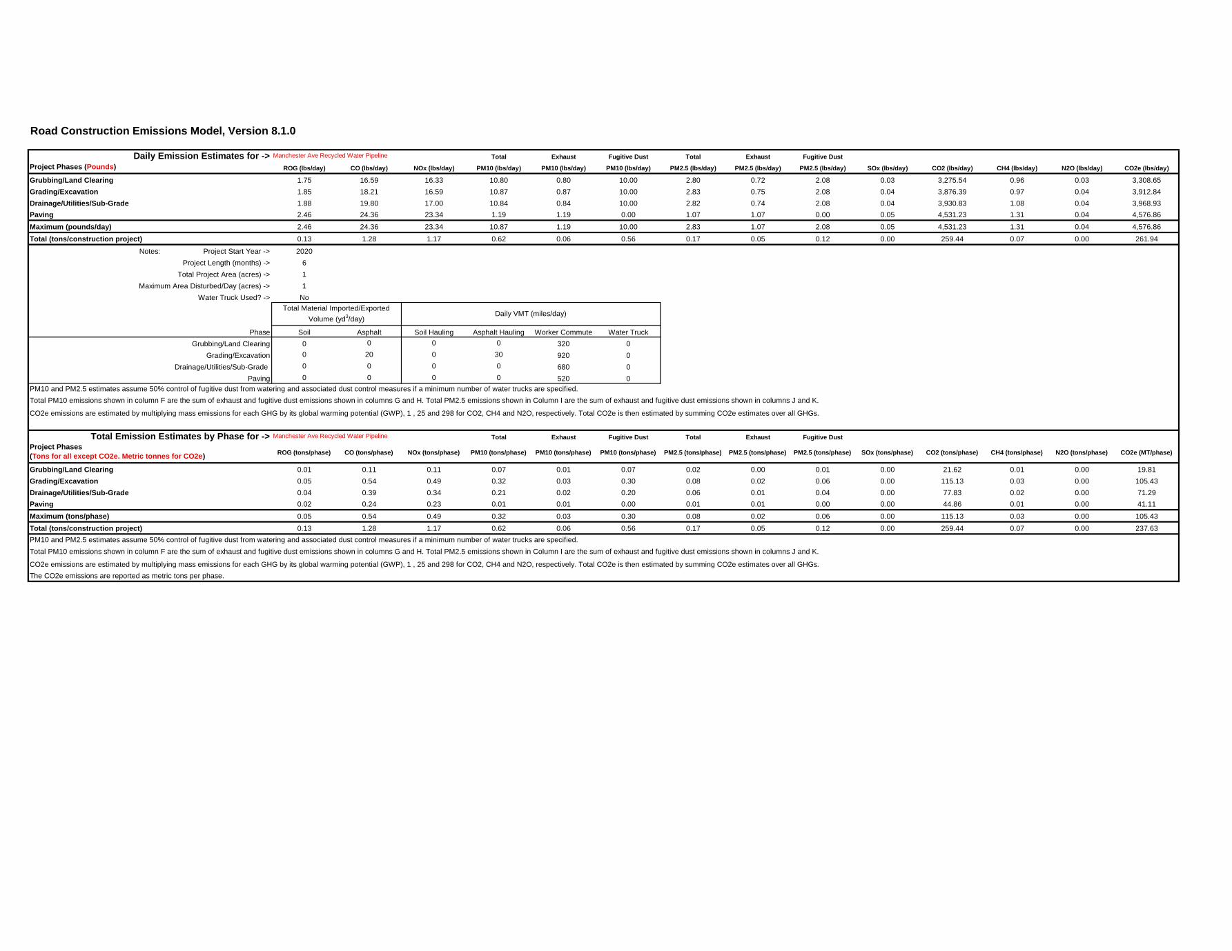
Road Construction Emissions Model, Version 8.1.0
Daily Emission Estimates for -> Total Exhaust Fugitive Dust Total Exhaust Fugitive Dust
Project Phases (Pounds) ROG (lbs/day) CO (lbs/day) NOx (lbs/day) PM10 (lbs/day) PM10 (lbs/day) PM10 (lbs/day) PM2.5 (lbs/day) PM2.5 (lbs/day) PM2.5 (lbs/day) SOx (lbs/day) CO2 (lbs/day) CH4 (lbs/day) N2O (lbs/day) CO2e (lbs/day)
Grubbing/Land Clearing 1.75 16.59 16.33 10.80 0.80 10.00 2.80 0.72 2.08 0.03 3,275.54 0.96 0.03 3,308.65
Grading/Excavation 1.85 18.21 16.59 10.87 0.87 10.00 2.83 0.75 2.08 0.04 3,876.39 0.97 0.04 3,912.84
Drainage/Utilities/Sub-Grade 1.88 19.80 17.00 10.84 0.84 10.00 2.82 0.74 2.08 0.04 3,930.83 1.08 0.04 3,968.93
Paving 2.46 24.36 23.34 1.19 1.19 0.00 1.07 1.07 0.00 0.05 4,531.23 1.31 0.04 4,576.86
Maximum (pounds/day) 2.46 24.36 23.34 10.87 1.19 10.00 2.83 1.07 2.08 0.05 4,531.23 1.31 0.04 4,576.86
Total (tons/construction project) 0.13 1.28 1.17 0.62 0.06 0.56 0.17 0.05 0.12 0.00 259.44 0.07 0.00 261.94
Notes: Project Start Year -> 2020
Project Length (months) -> 6
Total Project Area (acres) -> 1
Maximum Area Disturbed/Day (acres) -> 1
Water Truck Used? -> No
Phase Soil Asphalt Soil Hauling Asphalt Hauling Worker Commute Water Truck
Grubbing/Land Clearing 0 0 0 0 320 0
Grading/Excavation 0 20 0 30 920 0
Drainage/Utilities/Sub-Grade 0 0 0 0 680 0
Paving 0 0 0 0 520 0
CO2e emissions are estimated by multiplying mass emissions for each GHG by its global warming potential (GWP), 1 , 25 and 298 for CO2, CH4 and N2O, respectively. Total CO2e is then estimated by summing CO2e estimates over all GHGs.
Total Emission Estimates by Phase for -> Total Exhaust Fugitive Dust Total Exhaust Fugitive Dust
Project Phases
(Tons for all except CO2e. Metric tonnes for CO2e)ROG (tons/phase) CO (tons/phase) NOx (tons/phase) PM10 (tons/phase) PM10 (tons/phase) PM10 (tons/phase) PM2.5 (tons/phase) PM2.5 (tons/phase) PM2.5 (tons/phase) SOx (tons/phase) CO2 (tons/phase) CH4 (tons/phase) N2O (tons/phase) CO2e (MT/phase)
Grubbing/Land Clearing 0.01 0.11 0.11 0.07 0.01 0.07 0.02 0.00 0.01 0.00 21.62 0.01 0.00 19.81
Grading/Excavation 0.05 0.54 0.49 0.32 0.03 0.30 0.08 0.02 0.06 0.00 115.13 0.03 0.00 105.43
Drainage/Utilities/Sub-Grade 0.04 0.39 0.34 0.21 0.02 0.20 0.06 0.01 0.04 0.00 77.83 0.02 0.00 71.29
Paving 0.02 0.24 0.23 0.01 0.01 0.00 0.01 0.01 0.00 0.00 44.86 0.01 0.00 41.11
Maximum (tons/phase) 0.05 0.54 0.49 0.32 0.03 0.30 0.08 0.02 0.06 0.00 115.13 0.03 0.00 105.43
Total (tons/construction project) 0.13 1.28 1.17 0.62 0.06 0.56 0.17 0.05 0.12 0.00 259.44 0.07 0.00 237.63
CO2e emissions are estimated by multiplying mass emissions for each GHG by its global warming potential (GWP), 1 , 25 and 298 for CO2, CH4 and N2O, respectively. Total CO2e is then estimated by summing CO2e estimates over all GHGs.
The CO2e emissions are reported as metric tons per phase.
Daily VMT (miles/day)
Total PM10 emissions shown in column F are the sum of exhaust and fugitive dust emissions shown in columns G and H. Total PM2.5 emissions shown in Column I are the sum of exhaust and fugitive dust emissions shown in columns J and K.
Manchester Ave Recycled Water Pipeline
PM10 and PM2.5 estimates assume 50% control of fugitive dust from watering and associated dust control measures if a minimum number of water trucks are specified.
Manchester Ave Recycled Water Pipeline
PM10 and PM2.5 estimates assume 50% control of fugitive dust from watering and associated dust control measures if a minimum number of water trucks are specified.
Total PM10 emissions shown in column F are the sum of exhaust and fugitive dust emissions shown in columns G and H. Total PM2.5 emissions shown in Column I are the sum of exhaust and fugitive dust emissions shown in columns J and K.
Total Material Imported/Exported
Volume (yd3/day)

Road Construction Emissions Model, Version 8.1.0 6/21/2019
Road Construction Emissions Model Version 8.1.0Data Entry Worksheet
Optional data input sections have a blue background. Only areas with a
yellow or blue background can be modified. Program defaults have a white background.
The user is required to enter information in cells D10 through D24, E28 through G35, and D38 through D41 for all project types.
Please use "Clear Data Input & User Overrides" button first before changing the Project Type or begin a new project.
Input TypeProject Name Manchester Ave Recycled Water Pipeline
Construction Start Year 2020Enter a Year between 2014 and 2025
(inclusive)
Project Type 1) New Road Construction : Project to build a roadway from bare ground, which generally requires more site preparation than widening an existing roadway
2) Road Widening : Project to add a new lane to an existing roadway
3) Bridge/Overpass Construction : Project to build an elevated roadway, which generally requires some different equipment than a new roadway, such as a crane
4) Other Linear Project Type: Non-roadway project such as a pipeline, transmission line, or levee construction
Project Construction Time 6.00 months
Working Days per Month 22.00 days (assume 22 if unknown)
Predominant Soil/Site Type: Enter 1, 2, or 3 1) Sand Gravel : Use for quaternary deposits (Delta/West County)
2) Weathered Rock-Earth : Use for Laguna formation (Jackson Highway area) or the Ione formation (Scott Road, Rancho Murieta)
3) Blasted Rock : Use for Salt Springs Slate or Copper Hill Volcanics (Folsom South of Highway 50, Rancho Murieta)
Project Length 1.40 miles
Total Project Area 0.50 acres
Maximum Area Disturbed/Day 0.50 acres
Water Trucks Used? 21. Yes
2. No
Material Hauling Quantity Input
Material Type PhaseHaul Truck Capacity (yd
3) (assume
20 if unknown)Import Volume (yd
3/day) Export Volume (yd
3/day)
Grubbing/Land Clearing
Grading/Excavation
Drainage/Utilities/Sub-Grade
Paving
Grubbing/Land Clearing
Grading/Excavation 20.00 0.00 20.00
Drainage/Utilities/Sub-Grade
Paving
Mitigation OptionsOn-road Fleet Emissions Mitigation Select "2010 and Newer On-road Vehicles Fleet" option when the on-road heavy-duty truck fleet for the project will be limited to vehicles of model year 2010 or newer
Off-road Equipment Emissions Mitigation
Select "Tier 4 Equipment" option if some or all off-road equipment used for the project meets CARB Tier 4 Standard
Will all off-road equipment be tier 4?
The remaining sections of this sheet contain areas that require modification when 'Other Project Type' is selected.
Select "20% NOx and 45% Exhaust PM reduction" option if the project will be required to use a lower emitting off-road construction fleet. The SMAQMD Construction Mitigation
Calculator can be used to confirm compliance with this mitigation measure (http://www.airquality.org/ceqa/mitigation.shtml).
Note: Required data input sections have a yellow background.
Soil
Asphalt
For 4: Other Linear Project Type, please provide project specific off-
road equipment population and vehicle trip data
Please note that the soil type instructions provided in cells
E18 to E20 are specific to Sacramento County. Maps
available from the California Geologic Survey (see weblink
below) can be used to determine soil type outside
Sacramento County.
http://www.conservation.ca.gov/cgs/information/geologic_
mapping/Pages/googlemaps.aspx#regionalseries
4
All Tier 4 Equipment
(for project within "Sacramento County", follow soil type selection
instructions in cells E18 to E20 otherwise see instructions provided in
cells J18 to J22)
2
To begin a new project, click this button to clear data previously entered. This button will only work if you opted not to disable macros when loading this spreadsheet.
Data Entry Worksheet 2

Road Construction Emissions Model, Version 8.1.0 6/21/2019
Note: The program's estimates of construction period phase length can be overridden in cells D50 through D53, and F50 through F53.
Program Program
User Override of Calculated User Override of Default
Construction Periods Construction Months Months Phase Starting Date Phase Starting Date
Grubbing/Land Clearing 0.60 9/1/2020 1/1/2020
Grading/Excavation 2.70 9/20/2020 1/20/2020
Drainage/Utilities/Sub-Grade 1.80 12/12/2020 4/12/2020
Paving 0.90 2/6/2020 6/6/2020
Totals (Months)
Note: Soil Hauling emission default values can be overridden in cells D61 through D64, and F61 through F64.
Soil Hauling Emissions User Override of Program Estimate of User Override of Truck Default Values Calculated
User Input Miles/Round Trip Miles/Round Trip Round Trips/Day Round Trips/Day Daily VMT
Miles/round trip: Grubbing/Land Clearing 0.00 0 0.00
Miles/round trip: Grading/Excavation 0.00 0 0.00
Miles/round trip: Drainage/Utilities/Sub-Grade 0.00 0 0.00
Miles/round trip: Paving 0.00 0 0.00
Emission Rates ROG CO NOx PM10 PM2.5 SOx CO2 CH4 N2O CO2e
Grubbing/Land Clearing (grams/mile) 0.07 0.37 1.46 0.10 0.04 0.01 1,571.31 0.00 0.05 1,586.79
Grading/Excavation (grams/mile) 0.07 0.37 1.46 0.10 0.04 0.01 1,571.31 0.00 0.05 1,586.79
Draining/Utilities/Sub-Grade (grams/mile) 0.07 0.37 1.44 0.10 0.04 0.01 1,563.64 0.00 0.05 1,579.05
Paving (grams/mile) 0.07 0.37 1.46 0.10 0.04 0.01 1,571.31 0.00 0.05 1,586.79
Hauling Emissions ROG CO NOx PM10 PM2.5 SOx CO2 CH4 N2O CO2e
Pounds per day - Grubbing/Land Clearing 0.00 0.00 0.00 0.00 0.00 0.00 0.00 0.00 0.00 0.00
Tons per const. Period - Grubbing/Land Clearing 0.00 0.00 0.00 0.00 0.00 0.00 0.00 0.00 0.00 0.00
Pounds per day - Grading/Excavation 0.00 0.00 0.00 0.00 0.00 0.00 0.00 0.00 0.00 0.00
Tons per const. Period - Grading/Excavation 0.00 0.00 0.00 0.00 0.00 0.00 0.00 0.00 0.00 0.00
Pounds per day - Drainage/Utilities/Sub-Grade 0.00 0.00 0.00 0.00 0.00 0.00 0.00 0.00 0.00 0.00
Tons per const. Period - Drainage/Utilities/Sub-Grade 0.00 0.00 0.00 0.00 0.00 0.00 0.00 0.00 0.00 0.00
Pounds per day - Paving 0.00 0.00 0.00 0.00 0.00 0.00 0.00 0.00 0.00 0.00
Tons per const. Period - Paving 0.00 0.00 0.00 0.00 0.00 0.00 0.00 0.00 0.00 0.00
Total tons per construction project 0.00 0.00 0.00 0.00 0.00 0.00 0.00 0.00 0.00 0.00
Note: Asphalt Hauling emission default values can be overridden in cells D87 through D90, and F87 through F90.
Asphalt Hauling Emissions User Override of Program Estimate of User Override of Truck Default Values Calculated
User Input Miles/Round Trip Miles/Round Trip Round Trips/Day Round Trips/Day Daily VMT
Miles/round trip: Grubbing/Land Clearing 0.00 0 0.00
Miles/round trip: Grading/Excavation 30.00 0.00 1 30.00
Miles/round trip: Drainage/Utilities/Sub-Grade 0.00 0 0.00
Miles/round trip: Paving 0.00 0 0.00
Emission Rates ROG CO NOx PM10 PM2.5 SOx CO2 CH4 N2O CO2e
Grubbing/Land Clearing (grams/mile) 0.07 0.37 1.46 0.10 0.04 0.01 1,571.31 0.00 0.05 1,586.79
Grading/Excavation (grams/mile) 0.07 0.37 1.46 0.10 0.04 0.01 1,571.31 0.00 0.05 1,586.79
Draining/Utilities/Sub-Grade (grams/mile) 0.07 0.37 1.44 0.10 0.04 0.01 1,563.64 0.00 0.05 1,579.05
Paving (grams/mile) 0.07 0.37 1.46 0.10 0.04 0.01 1,571.31 0.00 0.05 1,586.79
Emissions ROG CO NOx PM10 PM2.5 SOx CO2 CH4 N2O CO2e
Pounds per day - Grubbing/Land Clearing 0.00 0.00 0.00 0.00 0.00 0.00 0.00 0.00 0.00 0.00
Tons per const. Period - Grubbing/Land Clearing 0.00 0.00 0.00 0.00 0.00 0.00 0.00 0.00 0.00 0.00
Pounds per day - Grading/Excavation 0.00 0.02 0.10 0.01 0.00 0.00 103.92 0.00 0.00 104.95
Tons per const. Period - Grading/Excavation 0.00 0.00 0.00 0.00 0.00 0.00 3.09 0.00 0.00 3.12
Pounds per day - Drainage/Utilities/Sub-Grade 0.00 0.00 0.00 0.00 0.00 0.00 0.00 0.00 0.00 0.00
Tons per const. Period - Drainage/Utilities/Sub-Grade 0.00 0.00 0.00 0.00 0.00 0.00 0.00 0.00 0.00 0.00
Pounds per day - Paving 0.00 0.00 0.00 0.00 0.00 0.00 0.00 0.00 0.00 0.00
Tons per const. Period - Paving 0.00 0.00 0.00 0.00 0.00 0.00 0.00 0.00 0.00 0.00
Total tons per construction project 0.00 0.00 0.00 0.00 0.00 0.00 3.09 0.00 0.00 3.12
6
Data Entry Worksheet 3

Road Construction Emissions Model, Version 8.1.0 6/21/2019
Note: Worker commute default values can be overridden in cells D113 through D118.
Worker Commute Emissions User Override of Worker
User Input Commute Default Values Default Values
Miles/ one-way trip 20 0 Calculated Calculated
One-way trips/day 2 0 Daily Trips Daily VMT
No. of employees: Grubbing/Land Clearing 8 0 16 320.00
No. of employees: Grading/Excavation 23 0 46 920.00
No. of employees: Drainage/Utilities/Sub-Grade 17 0 34 680.00
No. of employees: Paving 13 0 26 520.00
Emission Rates ROG CO NOx PM10 PM2.5 SOx CO2 CH4 N2O CO2e
Grubbing/Land Clearing (grams/mile) 0.02 1.08 0.11 0.05 0.02 0.00 371.46 0.01 0.00 373.08
Grading/Excavation (grams/mile) 0.02 1.08 0.11 0.05 0.02 0.00 371.46 0.01 0.00 373.08
Draining/Utilities/Sub-Grade (grams/mile) 0.02 1.02 0.11 0.05 0.02 0.00 364.00 0.01 0.00 365.51
Paving (grams/mile) 0.02 1.08 0.11 0.05 0.02 0.00 371.46 0.01 0.00 373.08
Grubbing/Land Clearing (grams/trip) 1.00 2.55 0.20 0.00 0.00 0.00 84.03 0.01 0.01 86.84
Grading/Excavation (grams/trip) 1.00 2.55 0.20 0.00 0.00 0.00 84.03 0.01 0.01 86.84
Draining/Utilities/Sub-Grade (grams/trip) 0.95 2.37 0.18 0.00 0.00 0.00 82.63 0.01 0.01 85.22
Paving (grams/trip) 1.00 2.55 0.20 0.00 0.00 0.00 84.03 0.01 0.01 86.84
Emissions ROG CO NOx PM10 PM2.5 SOx CO2 CH4 N2O CO2e
Pounds per day - Grubbing/Land Clearing 0.05 0.85 0.09 0.03 0.01 0.00 265.02 0.01 0.00 266.26
Tons per const. Period - Grubbing/Land Clearing 0.00 0.01 0.00 0.00 0.00 0.00 1.75 0.00 0.00 1.76
Pounds per day - Grading/Excavation 0.14 2.44 0.25 0.09 0.04 0.01 761.94 0.02 0.01 765.50
Tons per const. Period - Grading/Excavation 0.00 0.07 0.01 0.00 0.00 0.00 22.63 0.00 0.00 22.74
Pounds per day - Drainage/Utilities/Sub-Grade 0.10 1.71 0.17 0.07 0.03 0.01 551.88 0.01 0.01 554.33
Tons per const. Period - Drainage/Utilities/Sub-Grade 0.00 0.03 0.00 0.00 0.00 0.00 10.93 0.00 0.00 10.98
Pounds per day - Paving 0.08 1.38 0.14 0.05 0.02 0.00 430.66 0.01 0.01 432.68
Tons per const. Period - Paving 0.00 0.01 0.00 0.00 0.00 0.00 4.26 0.00 0.00 4.28
Total tons per construction project 0.01 0.13 0.01 0.00 0.00 0.00 39.57 0.00 0.00 39.75
Note: Water Truck default values can be overridden in cells D145 through D148, and F145 through F148.
Water Truck Emissions User Override of Program Estimate of User Override of Truck Default Values Calculated
User Input Default # Water Trucks Number of Water Trucks Miles Traveled/Vehicle/Day Miles Traveled/Vehicle/Day Daily VMT
Grubbing/Land Clearing - Exhaust 0 0.00 0.00
Grading/Excavation - Exhaust 0 0.00 0.00
Drainage/Utilities/Subgrade 0 0.00 0.00
Paving 0 0.00 0.00
Emission Rates ROG CO NOx PM10 PM2.5 SOx CO2 CH4 N2O CO2e
Grubbing/Land Clearing (grams/mile) 0.07 0.37 1.46 0.10 0.04 0.01 1,571.31 0.00 0.05 1,586.79
Grading/Excavation (grams/mile) 0.07 0.37 1.46 0.10 0.04 0.01 1,571.31 0.00 0.05 1,586.79
Draining/Utilities/Sub-Grade (grams/mile) 0.07 0.37 1.44 0.10 0.04 0.01 1,563.64 0.00 0.05 1,579.05
Paving (grams/mile) 0.07 0.37 1.46 0.10 0.04 0.01 1,571.31 0.00 0.05 1,586.79
Emissions ROG CO NOx PM10 PM2.5 SOx CO2 CH4 N2O CO2e
Pounds per day - Grubbing/Land Clearing 0.00 0.00 0.00 0.00 0.00 0.00 0.00 0.00 0.00 0.00
Tons per const. Period - Grubbing/Land Clearing 0.00 0.00 0.00 0.00 0.00 0.00 0.00 0.00 0.00 0.00
Pounds per day - Grading/Excavation 0.00 0.00 0.00 0.00 0.00 0.00 0.00 0.00 0.00 0.00
Tons per const. Period - Grading/Excavation 0.00 0.00 0.00 0.00 0.00 0.00 0.00 0.00 0.00 0.00
Pounds per day - Drainage/Utilities/Sub-Grade 0.00 0.00 0.00 0.00 0.00 0.00 0.00 0.00 0.00 0.00
Tons per const. Period - Drainage/Utilities/Sub-Grade 0.00 0.00 0.00 0.00 0.00 0.00 0.00 0.00 0.00 0.00
Pounds per day - Paving 0.00 0.00 0.00 0.00 0.00 0.00 0.00 0.00 0.00 0.00
Tons per const. Period - Paving 0.00 0.00 0.00 0.00 0.00 0.00 0.00 0.00 0.00 0.00
Total tons per construction project 0.00 0.00 0.00 0.00 0.00 0.00 0.00 0.00 0.00 0.00
Note: Fugitive dust default values can be overridden in cells D171 through D173.
User Override of Max Default PM10 PM10 PM2.5 PM2.5
Acreage Disturbed/Day Maximum Acreage/Day pounds/day tons/per period pounds/day tons/per period
Fugitive Dust - Grubbing/Land Clearing 0.50 0.50 10.00 0.07 2.08 0.01
Fugitive Dust - Grading/Excavation 0.50 0.50 10.00 0.30 2.08 0.06
Fugitive Dust - Drainage/Utilities/Subgrade 0.50 0.50 10.00 0.20 2.08 0.04
Fugitive Dust
Data Entry Worksheet 4

Road Construction Emissions Model, Version 8.1.0 6/21/2019
Values in cells D183 through D216, D234 through D267, D285 through D318, and D336 through D369 are required when 'Other Project Type' is selected.
Off-Road Equipment Emissions
Default
Grubbing/Land Clearing Number of Vehicles Override of Default ROG CO NOx PM10 PM2.5 SOx CO2 CH4 N2O CO2e
Override of Default Number of Vehicles Program-estimate
Default Equipment Tier (applicable
only when "Tier 4 Mitigation" Option
Selected) Equipment Tier Type pounds/day pounds/day pounds/day pounds/day pounds/day pounds/day pounds/day pounds/day pounds/day pounds/day
Model Default Tier Model Default Tier Aerial Lifts 0.00 0.00 0.00 0.00 0.00 0.00 0.00 0.00 0.00 0.00
Model Default Tier Model Default Tier Air Compressors 0.00 0.00 0.00 0.00 0.00 0.00 0.00 0.00 0.00 0.00
Model Default Tier Model Default Tier Bore/Drill Rigs 0.00 0.00 0.00 0.00 0.00 0.00 0.00 0.00 0.00 0.00
Model Default Tier Model Default Tier Cement and Mortar Mixers 0.00 0.00 0.00 0.00 0.00 0.00 0.00 0.00 0.00 0.00
Model Default Tier Model Default Tier Concrete/Industrial Saws 0.00 0.00 0.00 0.00 0.00 0.00 0.00 0.00 0.00 0.00
Model Default Tier Model Default Tier Cranes 0.00 0.00 0.00 0.00 0.00 0.00 0.00 0.00 0.00 0.00
0 Model Default Tier Model Default Tier Crawler Tractors 0.00 0.00 0.00 0.00 0.00 0.00 0.00 0.00 0.00 0.00
Model Default Tier Model Default Tier Crushing/Proc. Equipment 0.00 0.00 0.00 0.00 0.00 0.00 0.00 0.00 0.00 0.00
2.00 0 Model Default Tier Model Default Tier Excavators 0.51 6.74 4.98 0.24 0.22 0.01 1,031.89 0.33 0.01 1,043.01
Model Default Tier Model Default Tier Forklifts 0.00 0.00 0.00 0.00 0.00 0.00 0.00 0.00 0.00 0.00
Model Default Tier Model Default Tier Generator Sets 0.00 0.00 0.00 0.00 0.00 0.00 0.00 0.00 0.00 0.00
Model Default Tier Model Default Tier Graders 0.00 0.00 0.00 0.00 0.00 0.00 0.00 0.00 0.00 0.00
Model Default Tier Model Default Tier Off-Highway Tractors 0.00 0.00 0.00 0.00 0.00 0.00 0.00 0.00 0.00 0.00
1.00 Model Default Tier Model Default Tier Off-Highway Trucks 0.66 3.79 6.29 0.23 0.21 0.01 1,272.26 0.41 0.01 1,285.96
Model Default Tier Model Default Tier Other Construction Equipment 0.00 0.00 0.00 0.00 0.00 0.00 0.00 0.00 0.00 0.00
Model Default Tier Model Default Tier Other General Industrial Equipment 0.00 0.00 0.00 0.00 0.00 0.00 0.00 0.00 0.00 0.00
Model Default Tier Model Default Tier Other Material Handling Equipment 0.00 0.00 0.00 0.00 0.00 0.00 0.00 0.00 0.00 0.00
Model Default Tier Model Default Tier Pavers 0.00 0.00 0.00 0.00 0.00 0.00 0.00 0.00 0.00 0.00
Model Default Tier Model Default Tier Paving Equipment 0.00 0.00 0.00 0.00 0.00 0.00 0.00 0.00 0.00 0.00
Model Default Tier Model Default Tier Plate Compactors 0.00 0.00 0.00 0.00 0.00 0.00 0.00 0.00 0.00 0.00
Model Default Tier Model Default Tier Pressure Washers 0.00 0.00 0.00 0.00 0.00 0.00 0.00 0.00 0.00 0.00
Model Default Tier Model Default Tier Pumps 0.00 0.00 0.00 0.00 0.00 0.00 0.00 0.00 0.00 0.00
Model Default Tier Model Default Tier Rollers 0.00 0.00 0.00 0.00 0.00 0.00 0.00 0.00 0.00 0.00
Model Default Tier Model Default Tier Rough Terrain Forklifts 0.00 0.00 0.00 0.00 0.00 0.00 0.00 0.00 0.00 0.00
Model Default Tier Model Default Tier Rubber Tired Dozers 0.00 0.00 0.00 0.00 0.00 0.00 0.00 0.00 0.00 0.00
Model Default Tier Model Default Tier Rubber Tired Loaders 0.00 0.00 0.00 0.00 0.00 0.00 0.00 0.00 0.00 0.00
Model Default Tier Model Default Tier Scrapers 0.00 0.00 0.00 0.00 0.00 0.00 0.00 0.00 0.00 0.00
2.00 0 Model Default Tier Model Default Tier Signal Boards 0.11 0.60 0.72 0.03 0.03 0.00 98.63 0.01 0.00 99.13
Model Default Tier Model Default Tier Skid Steer Loaders 0.00 0.00 0.00 0.00 0.00 0.00 0.00 0.00 0.00 0.00
Model Default Tier Model Default Tier Surfacing Equipment 0.00 0.00 0.00 0.00 0.00 0.00 0.00 0.00 0.00 0.00
Model Default Tier Model Default Tier Sweepers/Scrubbers 0.00 0.00 0.00 0.00 0.00 0.00 0.00 0.00 0.00 0.00
2.00 Model Default Tier Model Default Tier Tractors/Loaders/Backhoes 0.42 4.61 4.25 0.27 0.25 0.01 607.74 0.20 0.01 614.28
Model Default Tier Model Default Tier Trenchers 0.00 0.00 0.00 0.00 0.00 0.00 0.00 0.00 0.00 0.00
Model Default Tier Model Default Tier Welders 0.00 0.00 0.00 0.00 0.00 0.00 0.00 0.00 0.00 0.00
User-Defined Off-road Equipment If non-default vehicles are used, please provide information in 'Non-default Off-road Equipment' tab ROG CO NOx PM10 PM2.5 SOx CO2 CH4 N2O CO2e
Type pounds/day pounds/day pounds/day pounds/day pounds/day pounds/day pounds/day pounds/day pounds/day pounds/day
0 0.00 0.00 0.00 0.00 0.00 0.00 0.00 0.00 0.00 0.00
0 0.00 0.00 0.00 0.00 0.00 0.00 0.00 0.00 0.00 0.00
0 0.00 0.00 0.00 0.00 0.00 0.00 0.00 0.00 0.00 0.00
0 0.00 0.00 0.00 0.00 0.00 0.00 0.00 0.00 0.00 0.00
0 0.00 0.00 0.00 0.00 0.00 0.00 0.00 0.00 0.00 0.00
0 0.00 0.00 0.00 0.00 0.00 0.00 0.00 0.00 0.00 0.00
0 0.00 0.00 0.00 0.00 0.00 0.00 0.00 0.00 0.00 0.00
Grubbing/Land Clearing pounds per day 1.70 15.74 16.24 0.77 0.71 0.03 3,010.52 0.95 0.03 3,042.39
Grubbing/Land Clearing tons per phase 0.01 0.10 0.11 0.01 0.00 0.00 19.87 0.01 0.00 20.08
Mitigation Option
0.00
0.00
0.00
0.00
0.00
0.00
N/A
N/A
N/A
N/A
0.00
Number of Vehicles Equipment Tier
N/A
N/A
N/A
Data Entry Worksheet 5

Road Construction Emissions Model, Version 8.1.0 6/21/2019
Default
Grading/Excavation Number of Vehicles Override of Default ROG CO NOx PM10 PM2.5 SOx CO2 CH4 N2O CO2e
Override of Default Number of Vehicles Program-estimate
Default Equipment Tier (applicable
only when "Tier 4 Mitigation" Option
Selected) Equipment Tier Type pounds/day pounds/day pounds/day pounds/day pounds/day pounds/day pounds/day pounds/day pounds/day pounds/day
Model Default Tier Model Default Tier Aerial Lifts 0.00 0.00 0.00 0.00 0.00 0.00 0.00 0.00 0.00 0.00
Model Default Tier Model Default Tier Air Compressors 0.00 0.00 0.00 0.00 0.00 0.00 0.00 0.00 0.00 0.00
Model Default Tier Model Default Tier Bore/Drill Rigs 0.00 0.00 0.00 0.00 0.00 0.00 0.00 0.00 0.00 0.00
Model Default Tier Model Default Tier Cement and Mortar Mixers 0.00 0.00 0.00 0.00 0.00 0.00 0.00 0.00 0.00 0.00
Model Default Tier Model Default Tier Concrete/Industrial Saws 0.00 0.00 0.00 0.00 0.00 0.00 0.00 0.00 0.00 0.00
0 Model Default Tier Model Default Tier Cranes 0.00 0.00 0.00 0.00 0.00 0.00 0.00 0.00 0.00 0.00
0 Model Default Tier Model Default Tier Crawler Tractors 0.00 0.00 0.00 0.00 0.00 0.00 0.00 0.00 0.00 0.00
Model Default Tier Model Default Tier Crushing/Proc. Equipment 0.00 0.00 0.00 0.00 0.00 0.00 0.00 0.00 0.00 0.00
2.00 0 Model Default Tier Model Default Tier Excavators 0.51 6.74 4.98 0.24 0.22 0.01 1,031.89 0.33 0.01 1,043.01
Model Default Tier Model Default Tier Forklifts 0.00 0.00 0.00 0.00 0.00 0.00 0.00 0.00 0.00 0.00
Model Default Tier Model Default Tier Generator Sets 0.00 0.00 0.00 0.00 0.00 0.00 0.00 0.00 0.00 0.00
0 Model Default Tier Model Default Tier Graders 0.00 0.00 0.00 0.00 0.00 0.00 0.00 0.00 0.00 0.00
Model Default Tier Model Default Tier Off-Highway Tractors 0.00 0.00 0.00 0.00 0.00 0.00 0.00 0.00 0.00 0.00
1.00 Model Default Tier Model Default Tier Off-Highway Trucks 0.66 3.79 6.29 0.23 0.21 0.01 1,272.26 0.41 0.01 1,285.96
Model Default Tier Model Default Tier Other Construction Equipment 0.00 0.00 0.00 0.00 0.00 0.00 0.00 0.00 0.00 0.00
Model Default Tier Model Default Tier Other General Industrial Equipment 0.00 0.00 0.00 0.00 0.00 0.00 0.00 0.00 0.00 0.00
Model Default Tier Model Default Tier Other Material Handling Equipment 0.00 0.00 0.00 0.00 0.00 0.00 0.00 0.00 0.00 0.00
Model Default Tier Model Default Tier Pavers 0.00 0.00 0.00 0.00 0.00 0.00 0.00 0.00 0.00 0.00
Model Default Tier Model Default Tier Paving Equipment 0.00 0.00 0.00 0.00 0.00 0.00 0.00 0.00 0.00 0.00
Model Default Tier Model Default Tier Plate Compactors 0.00 0.00 0.00 0.00 0.00 0.00 0.00 0.00 0.00 0.00
Model Default Tier Model Default Tier Pressure Washers 0.00 0.00 0.00 0.00 0.00 0.00 0.00 0.00 0.00 0.00
Model Default Tier Model Default Tier Pumps 0.00 0.00 0.00 0.00 0.00 0.00 0.00 0.00 0.00 0.00
0 Model Default Tier Model Default Tier Rollers 0.00 0.00 0.00 0.00 0.00 0.00 0.00 0.00 0.00 0.00
Model Default Tier Model Default Tier Rough Terrain Forklifts 0.00 0.00 0.00 0.00 0.00 0.00 0.00 0.00 0.00 0.00
Model Default Tier Model Default Tier Rubber Tired Dozers 0.00 0.00 0.00 0.00 0.00 0.00 0.00 0.00 0.00 0.00
0 Model Default Tier Model Default Tier Rubber Tired Loaders 0.00 0.00 0.00 0.00 0.00 0.00 0.00 0.00 0.00 0.00
0 Model Default Tier Model Default Tier Scrapers 0.00 0.00 0.00 0.00 0.00 0.00 0.00 0.00 0.00 0.00
2.00 0 Model Default Tier Model Default Tier Signal Boards 0.11 0.60 0.72 0.03 0.03 0.00 98.63 0.01 0.00 99.13
Model Default Tier Model Default Tier Skid Steer Loaders 0.00 0.00 0.00 0.00 0.00 0.00 0.00 0.00 0.00 0.00
Model Default Tier Model Default Tier Surfacing Equipment 0.00 0.00 0.00 0.00 0.00 0.00 0.00 0.00 0.00 0.00
Model Default Tier Model Default Tier Sweepers/Scrubbers 0.00 0.00 0.00 0.00 0.00 0.00 0.00 0.00 0.00 0.00
2.00 0 Model Default Tier Model Default Tier Tractors/Loaders/Backhoes 0.42 4.61 4.25 0.27 0.25 0.01 607.74 0.20 0.01 614.28
Model Default Tier Model Default Tier Trenchers 0.00 0.00 0.00 0.00 0.00 0.00 0.00 0.00 0.00 0.00
Model Default Tier Model Default Tier Welders 0.00 0.00 0.00 0.00 0.00 0.00 0.00 0.00 0.00 0.00
User-Defined Off-road Equipment If non-default vehicles are used, please provide information in 'Non-default Off-road Equipment' tab ROG CO NOx PM10 PM2.5 SOx CO2 CH4 N2O CO2e
Type pounds/day pounds/day pounds/day pounds/day pounds/day pounds/day pounds/day pounds/day pounds/day pounds/day
0 0.00 0.00 0.00 0.00 0.00 0.00 0.00 0.00 0.00 0.00
0 0.00 0.00 0.00 0.00 0.00 0.00 0.00 0.00 0.00 0.00
0 0.00 0.00 0.00 0.00 0.00 0.00 0.00 0.00 0.00 0.00
0 0.00 0.00 0.00 0.00 0.00 0.00 0.00 0.00 0.00 0.00
0 0.00 0.00 0.00 0.00 0.00 0.00 0.00 0.00 0.00 0.00
0 0.00 0.00 0.00 0.00 0.00 0.00 0.00 0.00 0.00 0.00
0 0.00 0.00 0.00 0.00 0.00 0.00 0.00 0.00 0.00 0.00
Grading/Excavation pounds per day 1.70 15.74 16.24 0.77 0.71 0.03 3,010.52 0.95 0.03 3,042.39
Grading/Excavation tons per phase 0.05 0.47 0.48 0.02 0.02 0.00 89.41 0.03 0.00 90.36
Mitigation Option
Number of Vehicles
0.00
0.00
0.00
N/A
0.00
0.00
0.00
0.00
Equipment Tier
N/A
N/A
N/A
N/A
N/A
N/A
Data Entry Worksheet 6

Road Construction Emissions Model, Version 8.1.0 6/21/2019
Default
Drainage/Utilities/Subgrade Number of Vehicles Override of Default ROG CO NOx PM10 PM2.5 SOx CO2 CH4 N2O CO2e
Override of Default Number of Vehicles Program-estimate
Default Equipment Tier (applicable
only when "Tier 4 Mitigation" Option
Selected) Equipment Tier pounds/day pounds/day pounds/day pounds/day pounds/day pounds/day pounds/day pounds/day pounds/day pounds/day
Model Default Tier Model Default Tier Aerial Lifts 0.00 0.00 0.00 0.00 0.00 0.00 0.00 0.00 0.00 0.00
0 Model Default Tier Model Default Tier Air Compressors 0.00 0.00 0.00 0.00 0.00 0.00 0.00 0.00 0.00 0.00
Model Default Tier Model Default Tier Bore/Drill Rigs 0.00 0.00 0.00 0.00 0.00 0.00 0.00 0.00 0.00 0.00
Model Default Tier Model Default Tier Cement and Mortar Mixers 0.00 0.00 0.00 0.00 0.00 0.00 0.00 0.00 0.00 0.00
Model Default Tier Model Default Tier Concrete/Industrial Saws 0.00 0.00 0.00 0.00 0.00 0.00 0.00 0.00 0.00 0.00
Model Default Tier Model Default Tier Cranes 0.00 0.00 0.00 0.00 0.00 0.00 0.00 0.00 0.00 0.00
Model Default Tier Model Default Tier Crawler Tractors 0.00 0.00 0.00 0.00 0.00 0.00 0.00 0.00 0.00 0.00
Model Default Tier Model Default Tier Crushing/Proc. Equipment 0.00 0.00 0.00 0.00 0.00 0.00 0.00 0.00 0.00 0.00
2.00 Model Default Tier Model Default Tier Excavators 0.48 6.75 4.63 0.22 0.21 0.01 1,031.99 0.33 0.01 1,043.12
Model Default Tier Model Default Tier Forklifts 0.00 0.00 0.00 0.00 0.00 0.00 0.00 0.00 0.00 0.00
0 Model Default Tier Model Default Tier Generator Sets 0.00 0.00 0.00 0.00 0.00 0.00 0.00 0.00 0.00 0.00
0 Model Default Tier Model Default Tier Graders 0.00 0.00 0.00 0.00 0.00 0.00 0.00 0.00 0.00 0.00
Model Default Tier Model Default Tier Off-Highway Tractors 0.00 0.00 0.00 0.00 0.00 0.00 0.00 0.00 0.00 0.00
1.00 Model Default Tier Model Default Tier Off-Highway Trucks 0.62 3.66 5.60 0.21 0.19 0.01 1,272.20 0.41 0.01 1,285.90
Model Default Tier Model Default Tier Other Construction Equipment 0.00 0.00 0.00 0.00 0.00 0.00 0.00 0.00 0.00 0.00
Model Default Tier Model Default Tier Other General Industrial Equipment 0.00 0.00 0.00 0.00 0.00 0.00 0.00 0.00 0.00 0.00
Model Default Tier Model Default Tier Other Material Handling Equipment 0.00 0.00 0.00 0.00 0.00 0.00 0.00 0.00 0.00 0.00
Model Default Tier Model Default Tier Pavers 0.00 0.00 0.00 0.00 0.00 0.00 0.00 0.00 0.00 0.00
Model Default Tier Model Default Tier Paving Equipment 0.00 0.00 0.00 0.00 0.00 0.00 0.00 0.00 0.00 0.00
1.00 0 Model Default Tier Model Default Tier Plate Compactors 0.04 0.21 0.25 0.01 0.01 0.00 34.48 0.00 0.00 34.65
Model Default Tier Model Default Tier Pressure Washers 0.00 0.00 0.00 0.00 0.00 0.00 0.00 0.00 0.00 0.00
0 Model Default Tier Model Default Tier Pumps 0.00 0.00 0.00 0.00 0.00 0.00 0.00 0.00 0.00 0.00
Model Default Tier Model Default Tier Rollers 0.00 0.00 0.00 0.00 0.00 0.00 0.00 0.00 0.00 0.00
1.00 0 Model Default Tier Model Default Tier Rough Terrain Forklifts 0.13 2.30 1.65 0.07 0.06 0.00 333.74 0.11 0.00 337.34
Model Default Tier Model Default Tier Rubber Tired Dozers 0.00 0.00 0.00 0.00 0.00 0.00 0.00 0.00 0.00 0.00
Model Default Tier Model Default Tier Rubber Tired Loaders 0.00 0.00 0.00 0.00 0.00 0.00 0.00 0.00 0.00 0.00
0 Model Default Tier Model Default Tier Scrapers 0.00 0.00 0.00 0.00 0.00 0.00 0.00 0.00 0.00 0.00
2.00 0 Model Default Tier Model Default Tier Signal Boards 0.11 0.60 0.72 0.03 0.03 0.00 98.63 0.01 0.00 99.13
Model Default Tier Model Default Tier Skid Steer Loaders 0.00 0.00 0.00 0.00 0.00 0.00 0.00 0.00 0.00 0.00
Model Default Tier Model Default Tier Surfacing Equipment 0.00 0.00 0.00 0.00 0.00 0.00 0.00 0.00 0.00 0.00
Model Default Tier Model Default Tier Sweepers/Scrubbers 0.00 0.00 0.00 0.00 0.00 0.00 0.00 0.00 0.00 0.00
2.00 0 Model Default Tier Model Default Tier Tractors/Loaders/Backhoes 0.39 4.58 3.98 0.24 0.22 0.01 607.91 0.20 0.01 614.46
Model Default Tier Model Default Tier Trenchers 0.00 0.00 0.00 0.00 0.00 0.00 0.00 0.00 0.00 0.00
Model Default Tier Model Default Tier Welders 0.00 0.00 0.00 0.00 0.00 0.00 0.00 0.00 0.00 0.00
User-Defined Off-road Equipment If non-default vehicles are used, please provide information in 'Non-default Off-road Equipment' tab ROG CO NOx PM10 PM2.5 SOx CO2 CH4 N2O CO2e
Type pounds/day pounds/day pounds/day pounds/day pounds/day pounds/day pounds/day pounds/day pounds/day pounds/day
0 0.00 0.00 0.00 0.00 0.00 0.00 0.00 0.00 0.00 0.00
0 0.00 0.00 0.00 0.00 0.00 0.00 0.00 0.00 0.00 0.00
0 0.00 0.00 0.00 0.00 0.00 0.00 0.00 0.00 0.00 0.00
0 0.00 0.00 0.00 0.00 0.00 0.00 0.00 0.00 0.00 0.00
0 0.00 0.00 0.00 0.00 0.00 0.00 0.00 0.00 0.00 0.00
0 0.00 0.00 0.00 0.00 0.00 0.00 0.00 0.00 0.00 0.00
0 0.00 0.00 0.00 0.00 0.00 0.00 0.00 0.00 0.00 0.00
Drainage/Utilities/Sub-Grade pounds per day 1.78 18.09 16.83 0.77 0.71 0.04 3,378.95 1.06 0.03 3,414.59
Drainage/Utilities/Sub-Grade tons per phase 0.04 0.36 0.33 0.02 0.01 0.00 66.90 0.02 0.00 67.61
Mitigation Option
Number of Vehicles
0.00
0.00
0.00
Equipment Tier
N/A
N/A
N/A
N/A0.00
0.00
0.00
0.00
N/A
N/A
N/A
Data Entry Worksheet 7

Road Construction Emissions Model, Version 8.1.0 6/21/2019
Default
Paving Number of Vehicles Override of Default ROG CO NOx PM10 PM2.5 SOx CO2 CH4 N2O CO2e
Override of Default Number of Vehicles Program-estimate
Default Equipment Tier (applicable
only when "Tier 4 Mitigation" Option
Selected) Equipment Tier Type pounds/day pounds/day pounds/day pounds/day pounds/day pounds/day pounds/day pounds/day pounds/day pounds/day
Model Default Tier Model Default Tier Aerial Lifts 0.00 0.00 0.00 0.00 0.00 0.00 0.00 0.00 0.00 0.00
Model Default Tier Model Default Tier Air Compressors 0.00 0.00 0.00 0.00 0.00 0.00 0.00 0.00 0.00 0.00
Model Default Tier Model Default Tier Bore/Drill Rigs 0.00 0.00 0.00 0.00 0.00 0.00 0.00 0.00 0.00 0.00
Model Default Tier Model Default Tier Cement and Mortar Mixers 0.00 0.00 0.00 0.00 0.00 0.00 0.00 0.00 0.00 0.00
Model Default Tier Model Default Tier Concrete/Industrial Saws 0.00 0.00 0.00 0.00 0.00 0.00 0.00 0.00 0.00 0.00
Model Default Tier Model Default Tier Cranes 0.00 0.00 0.00 0.00 0.00 0.00 0.00 0.00 0.00 0.00
Model Default Tier Model Default Tier Crawler Tractors 0.00 0.00 0.00 0.00 0.00 0.00 0.00 0.00 0.00 0.00
Model Default Tier Model Default Tier Crushing/Proc. Equipment 0.00 0.00 0.00 0.00 0.00 0.00 0.00 0.00 0.00 0.00
2.00 Model Default Tier Model Default Tier Excavators 0.51 6.74 4.98 0.24 0.22 0.01 1,031.89 0.33 0.01 1,043.01
Model Default Tier Model Default Tier Forklifts 0.00 0.00 0.00 0.00 0.00 0.00 0.00 0.00 0.00 0.00
Model Default Tier Model Default Tier Generator Sets 0.00 0.00 0.00 0.00 0.00 0.00 0.00 0.00 0.00 0.00
Model Default Tier Model Default Tier Graders 0.00 0.00 0.00 0.00 0.00 0.00 0.00 0.00 0.00 0.00
Model Default Tier Model Default Tier Off-Highway Tractors 0.00 0.00 0.00 0.00 0.00 0.00 0.00 0.00 0.00 0.00
1.00 Model Default Tier Model Default Tier Off-Highway Trucks 0.66 3.79 6.29 0.23 0.21 0.01 1,272.26 0.41 0.01 1,285.96
Model Default Tier Model Default Tier Other Construction Equipment 0.00 0.00 0.00 0.00 0.00 0.00 0.00 0.00 0.00 0.00
Model Default Tier Model Default Tier Other General Industrial Equipment 0.00 0.00 0.00 0.00 0.00 0.00 0.00 0.00 0.00 0.00
Model Default Tier Model Default Tier Other Material Handling Equipment 0.00 0.00 0.00 0.00 0.00 0.00 0.00 0.00 0.00 0.00
1.00 0 Model Default Tier Model Default Tier Pavers 0.25 2.81 2.72 0.13 0.12 0.00 441.26 0.14 0.00 446.02
1.00 0 Model Default Tier Model Default Tier Paving Equipment 0.21 2.52 2.13 0.11 0.10 0.00 391.54 0.13 0.00 395.76
Model Default Tier Model Default Tier Plate Compactors 0.00 0.00 0.00 0.00 0.00 0.00 0.00 0.00 0.00 0.00
Model Default Tier Model Default Tier Pressure Washers 0.00 0.00 0.00 0.00 0.00 0.00 0.00 0.00 0.00 0.00
Model Default Tier Model Default Tier Pumps 0.00 0.00 0.00 0.00 0.00 0.00 0.00 0.00 0.00 0.00
1.00 0 Model Default Tier Model Default Tier Rollers 0.21 1.92 2.11 0.13 0.12 0.00 257.24 0.08 0.00 260.01
Model Default Tier Model Default Tier Rough Terrain Forklifts 0.00 0.00 0.00 0.00 0.00 0.00 0.00 0.00 0.00 0.00
Model Default Tier Model Default Tier Rubber Tired Dozers 0.00 0.00 0.00 0.00 0.00 0.00 0.00 0.00 0.00 0.00
Model Default Tier Model Default Tier Rubber Tired Loaders 0.00 0.00 0.00 0.00 0.00 0.00 0.00 0.00 0.00 0.00
Model Default Tier Model Default Tier Scrapers 0.00 0.00 0.00 0.00 0.00 0.00 0.00 0.00 0.00 0.00
2.00 0 Model Default Tier Model Default Tier Signal Boards 0.11 0.60 0.72 0.03 0.03 0.00 98.63 0.01 0.00 99.13
Model Default Tier Model Default Tier Skid Steer Loaders 0.00 0.00 0.00 0.00 0.00 0.00 0.00 0.00 0.00 0.00
Model Default Tier Model Default Tier Surfacing Equipment 0.00 0.00 0.00 0.00 0.00 0.00 0.00 0.00 0.00 0.00
Model Default Tier Model Default Tier Sweepers/Scrubbers 0.00 0.00 0.00 0.00 0.00 0.00 0.00 0.00 0.00 0.00
2.00 0 Model Default Tier Model Default Tier Tractors/Loaders/Backhoes 0.42 4.61 4.25 0.27 0.25 0.01 607.74 0.20 0.01 614.28
Model Default Tier Model Default Tier Trenchers 0.00 0.00 0.00 0.00 0.00 0.00 0.00 0.00 0.00 0.00
Model Default Tier Model Default Tier Welders 0.00 0.00 0.00 0.00 0.00 0.00 0.00 0.00 0.00 0.00
User-Defined Off-road Equipment If non-default vehicles are used, please provide information in 'Non-default Off-road Equipment' tab ROG CO NOx PM10 PM2.5 SOx CO2 CH4 N2O CO2e
Type pounds/day pounds/day pounds/day pounds/day pounds/day pounds/day pounds/day pounds/day pounds/day pounds/day
0 0.00 0.00 0.00 0.00 0.00 0.00 0.00 0.00 0.00 0.00
0 0.00 0.00 0.00 0.00 0.00 0.00 0.00 0.00 0.00 0.00
0 0.00 0.00 0.00 0.00 0.00 0.00 0.00 0.00 0.00 0.00
0 0.00 0.00 0.00 0.00 0.00 0.00 0.00 0.00 0.00 0.00
0 0.00 0.00 0.00 0.00 0.00 0.00 0.00 0.00 0.00 0.00
0 0.00 0.00 0.00 0.00 0.00 0.00 0.00 0.00 0.00 0.00
0 0.00 0.00 0.00 0.00 0.00 0.00 0.00 0.00 0.00 0.00
Paving pounds per day 2.37 22.98 23.20 1.14 1.05 0.04 4,100.56 1.30 0.04 4,144.19
Paving tons per phase 0.02 0.23 0.23 0.01 0.01 0.00 40.60 0.01 0.00 41.03
Total Emissions all Phases (tons per construction period) => 0.12 1.16 1.15 0.05 0.05 0.00 216.78 0.07 0.00 219.08
Mitigation Option
0.00
0.00
0.00
Number of Vehicles
0.00
0.00
0.00
0.00
N/A
N/A
N/A
N/A
Equipment Tier
N/A
N/A
N/A
Data Entry Worksheet 8

Road Construction Emissions Model, Version 8.1.0 6/21/2019
Equipment default values for horsepower and hours/day can be overridden in cells D391 through D424 and F391 through F424.
User Override of Default Values User Override of Default Values
Equipment Horsepower Horsepower Hours/day Hours/day
Aerial Lifts 63 8
Air Compressors 78 8
Bore/Drill Rigs 206 8
Cement and Mortar Mixers 9 8
Concrete/Industrial Saws 81 8
Cranes 226 8
Crawler Tractors 208 8
Crushing/Proc. Equipment 85 8
Excavators 163 8
Forklifts 89 8
Generator Sets 84 8
Graders 175 8
Off-Highway Tractors 123 8
Off-Highway Trucks 400 8
Other Construction Equipment 172 8
Other General Industrial Equipment 88 8
Other Material Handling Equipment 167 8
Pavers 126 8
Paving Equipment 131 8
Plate Compactors 8 8
Pressure Washers 13 8
Pumps 84 8
Rollers 81 8
Rough Terrain Forklifts 100 8
Rubber Tired Dozers 255 8
Rubber Tired Loaders 200 8
Scrapers 362 8
Signal Boards 6 8
Skid Steer Loaders 65 8
Surfacing Equipment 254 8
Sweepers/Scrubbers 64 8
Tractors/Loaders/Backhoes 98 8
Trenchers 81 8
Welders 46 8
END OF DATA ENTRY SHEET
Data Entry Worksheet 9

Initial Study Checklist/Mitigated Negative Declaration
Manchester Avenue Recycled Water Pipeline Project
APPENDIX B
Biological Letter Report

An Employee-Owned Company
1927 Fifth Avenue, San Diego, CA 92101 | 619.308.9333 | reconenvironmental.com SAN DIEGO | BAY AREA | TUCSON
June 28, 2019
Mr. Chad Williams Engineering Services Supervisor Olivenhain Municipal Water District 1966 Olivenhain Road Encinitas, CA 92024
Reference: Biological Letter Report for Manchester Avenue Recycled Water Line (RECON Number 9421-1)
Dear Mr. Williams:
This report summarizes the existing and potential biological resources on the proposed Manchester Avenue Recycled Water Line Project (project) site. This report identifies potential impacts to sensitive biological resources from project activities and recommendations to avoid, minimize, and mitigate those potential impacts.
Project Location and Setting The project is located in northwestern San Diego County, in the city of Encinitas (Figure 1). The project is shown on the U.S. Geological Survey (USGS) 7.5-minute topographic map series, Encinitas quadrangle, Township 13 South, Range 4 West (Figure 2; USGS 1975). The project occurs along Manchester Avenue/South El Camino Real between Via Poco and Tennis Club Drive. The southwest terminus is located approximately 500 feet east of Interstate 5. At the approximate project midpoint, Manchester Avenue turns east, whereas the proposed pipeline continues north within El Camino Real. From this intersection, the work area continues north along El Camino Real to just north of its intersection with Tennis Club Drive, the northern terminus of the project. The work area occurs entirely within the paved rights-of-way of Manchester Avenue and El Camino Real, which contain between four and five traffic lanes, as well as the aprons of adjoining roads, widened road shoulders, and a staging area just northwest of Manchester Avenue in the south-central portion of the work area (Figure 3).
The 59.48-acre survey area for this study includes the proposed work area and a 100-foot radius buffer area as measured from the edge of the proposed work area (see Figure 3), which includes a mixture of developed residential and commercial areas, as well as undeveloped areas containing a variety of habitats. These undeveloped areas generally occur southwest and west of the work area and include a part of the San Elijo Lagoon and the slopes surrounding small housing developments. The residential and commercial areas surrounding the project contain a variety of ornamental trees, shrubs, and herbaceous plantings in their associated landscaped areas. As shown on Figure 3, the southern half of the survey area west and southwest of Manchester Avenue is mapped as a Draft Multiple Species Conservation Program North County Plan (herein after referred to as Draft NCMSCP; County of San Diego 2009) preserve area.
The project location falls within the plan area for the Draft Encinitas Subarea Plan, which is a proposed subarea plan under the North County Multiple Habitat Conservation Plan (MHCP). However, the Draft Encinitas Subarea Plan has not yet been adopted. Therefore, no implementing agreement under the MHCP has been established for the Encinitas plan area, which includes the project area. However, this project is subject to any applicable state or federal regulations regarding the protection of natural resources.

FIGURE 1
Regional Location
kj
USMC AIRSTATION
MIRAMAR
USMC AIRSTATION
MIRAMAR
CAMP PENDLETONMARINE CO BASE
Daley
Ranch
Los PenasquitosCanyon Presv
Mission TrailsRegional Park
Cleveland NF
Lake Wohlford
Batiquitos Lagoon
Lake Hodges
El CapitanReservoir
San VicenteReservoir
SweetwaterReservoir
Sa
nD
i e g u i t o
Ri
v e r
Sa
n
D
i e g u i t oR
i
v e r
S a n t aY
sa
b
el
C r ee
k
Sw
ee
tw
at
e
r
Ri
ve
r
Es
co
nd
id
o
Cr
e
ek
S a n Di e g
oR i v e
r
Jamul Indian
Village
San
PasqualReservation
Rincon Reservation
Sycuan
Reservation
La Jolla Reservation
Barona
Reservation
Valley Center
Bostonia
Casa deOro-Mount
Helix
Crest
FairbanksRanch
Granite Hills
HarbisonCanyon
HiddenMeadows
Jamul
LakeSan Marcos
Lakeside
LaPresa
Ramona
RanchoSan Diego
RanchoSanta Fe
Spring
Valley
Winter Gardens
UV163
UV78
UV54
UV56
UV76
UV75
UV125
UV67
UV94
UV52
§̈¦8
§̈¦805
§̈¦15
§̈¦5
S A N D I E G O
C O U N T Y
Carlsbad
Chula Vista
Coronado
DelMar
El Cajon
Encinitas
Escondido
LaMesa
LemonGrove
National City
Oceanside
Poway
San Diego
San Marcos
Santee
SolanaBeach
Vista
kj
USMC AIRSTATION
MIRAMAR
USMC AIRSTATION
MIRAMAR
CAMP PENDLETONMARINE CO BASE
Daley
Ranch
Los PenasquitosCanyon Presv
Mission TrailsRegional Park
Cleveland NF
Lake Wohlford
Batiquitos Lagoon
Lake Hodges
El CapitanReservoir
San VicenteReservoir
SweetwaterReservoir
Sa
nD
i e g u i t o
Ri
v e r
Sa
n
D
i e g u i t oR
i
v e r
S a n t aY
sa
b
el
C r ee
k
Sw
ee
tw
at
e
r
Ri
ve
r
Es
co
nd
id
o
Cr
e
ek
S a n Di e g
oR i v e
r
Jamul Indian
Village
San
PasqualReservation
Rincon Reservation
Sycuan
Reservation
La Jolla Reservation
Barona
Reservation
Valley Center
Bostonia
Casa deOro-Mount
Helix
Crest
FairbanksRanch
Granite Hills
HarbisonCanyon
HiddenMeadows
Jamul
LakeSan Marcos
Lakeside
LaPresa
Ramona
RanchoSan Diego
RanchoSanta Fe
Spring
Valley
Winter Gardens
UV163
UV78
UV54
UV56
UV76
UV75
UV125
UV67
UV94
UV52
§̈¦8
§̈¦805
§̈¦15
§̈¦5
S A N D I E G O
C O U N T Y
Carlsbad
Chula Vista
Coronado
DelMar
El Cajon
Encinitas
Escondido
LaMesa
LemonGrove
National City
Oceanside
Poway
San Diego
San Marcos
Santee
SolanaBeach
Vista
0 5Miles [
M:\JOBS5\9421-1\common_gis\fig1.mxd 5/6/2019 bma
SAN DIEGO
RIVERSIDE
SAN BERNARDINO
ORANGE
MEXICO
Project Locationkj

FIGURE 2
Project Location on USGS Map
Map Source: USGS 7.5 minute topographic map series, Encinitas quadrangle, 1975, T13S R04W
0 2,000Feet [
Project Construction Work Area
M:\JOBS5\9421-1\Task1\common_gis\fig2_bioltr.mxd 6/4/2019 bma

PAC
IFIC
RA
NCH
DR
BIRMINGHAM DR
VIA
PO
CO
ESTE VISTA CT
CR
ES
TD
R
WALE
SDR
WE
ST
VIE
W DR
BE
LA
IRTE
R
TENNIS CLUB DRCARDIFF DR
VIA
TIE
MP
O
BRAND CREST
TE
NNIS
PL
AVOCET CT
LORIMER LN
BR
UC
EA
LA
CT
EL CAMINO CT
S E
L C
AM
INO
RE
AL
SAG
E CANYONDR
MANCH
ESTE
RAV
E
MA
NC
H
ESTERAVE
MA
NC
HE
ST
ER
AV
EMANCHESTER AVE
§̈¦5
S a n E l i j o L a g o o n
E c o l o g i c a l R e s e r v e
M:\JOBS5\9421-1\Task1\common_gis\fig3_bioltr.mxd 6/4/2019 bma
[0 500Feet
FIGURE 3
Project in Relation to North County MSCP Preserve Area
Image Source: Nearmap (flown February 2019)
Draft North County MSCP
Preserve Area
Project Construction Work Area
100-ft Survey Area

Mr. Chad Williams Page 5 June 28, 2019
Project Description The primary objectives of the proposed project are twofold, with one goal being to increase the use of local recycled water to continue efforts toward reducing imported water supply use in a cost effective and environmentally responsible manner; and the other goal being to provide a water source that is reliable, drought-resistant, and locally produced and controlled.
The proposed project includes the installation of approximately 7,400 linear feet of 6-inch polyvinyl chloride (PVC) recycled water pipeline within the portions of the paved rights-of-way of Manchester Avenue and El Camino Real described above. Construction of the project is expected to begin in late summer or early fall of 2020.
The new pipeline would be constructed via standard cut and cover technique with the bottom of the trench extending 4 to 6 feet below grade and between 24 to 32 inches wide. Typical construction equipment employed would include a backhoe, flatbed supply trucks, pickup trucks, excavators, and dump trucks. Project construction activities would occur in one phase, with construction lasting approximately six months, and between the hours of 7:00 a.m. and 5:00 p.m., Monday through Friday only (not on weekends) and excluding federal holidays.
Methods RECON conducted an analysis of existing sensitive species data recorded within one mile of the project. This analysis included searches of the U.S. Fish and Wildlife (USFWS) all-species occurrence database (USFWS 2019a) and critical habitat portal (USFWS 2019b), the SanBIOS database (County of San Diego 2019), and the California Natural Diversity Database (CNDDB; California Department of Fish and Wildlife [CDFW] 2019a), as well as reviews of the San Diego County bird and mammal atlas’ (Unitt 2004; Tremor et al. 2017). Background research to assess the existing biological conditions also included a review of online aerial satellite imagery, USGS topographic map (USGS 1975), and U.S. Department of Agriculture soil survey maps (U.S. Department of Agriculture 1973). For purposes of this report, natural communities are considered sensitive if they have a state rarity ranks of S1–S3, as reviewed by the Vegetation Classification and Mapping Program (VegCAMP) and the California Native Plant Society, and recognized by CDFW (2019b); and/or if they are considered wetlands and waters under the jurisdiction of federal and state agencies.
RECON biologist Andrew Smisek conducted a biological resources survey on May 13, 2019, between 10:30 a.m. and 1:30 p.m., to document existing biological resources and assess the potential for special status species to occur within survey area. Weather conditions during the survey consisted of complete cloud cover, 2-to-6-mile-per-hour winds, and air temperatures between 69 and 73 degrees Fahrenheit. Mr. Smisek conducted the survey on-foot by walking along sidewalks and road shoulders within the project right-of-way and occasionally accessing portions of the survey area outside the roadway. Areas not accessed directly were viewed from the closest accessible point, using binoculars when necessary.
Mr. Smisek recorded plant species observed and wildlife species detected within the survey area. Vegetation communities were classified according to Holland (1986), as modified by Oberbauer et al. (2008) and hand-mapped on a 1:4,800-scale aerial photograph with the assistance of a Global Positioning System (GPS) receiver. Any sensitive plant and animal species that were observed or detected during the survey were noted, and the potential for other sensitive species to be present during project activities was assessed.
Survey Results The following 12 vegetation communities and land cover types were mapped within the 59.47-acre survey area: southern coastal salt marsh, subtidal estuary, southern riparian forest, southern willow scrub, fresh water, non-vegetated channel, Diegan coastal sage scrub, non-native grassland, eucalyptus woodland, disturbed habitat, agriculture, and urban/developed land (Figure 4). The acreage of each of these vegetation communities and land cover types, along with their state rarity rank, is summarized in Table 1 below. A brief description of each community, including the dominant plant species observed, is also provided below.

!(
!(
!(
!(!(
!(
!(
BIRMINGHAM DR
PAC
IFIC
RA
NC
HD
R
VIA
PO
CO
ESTE VISTA CT
CR
ES
TD
R
WALE
SDR
S E
L C
AM
INO
RE
AL
BE
LA
IRTE
R
CARDIFF DR
VIA
TIE
MP
O
BRAND CREST
TE
NNIS
PL
AVOCE
T C
T
TENNIS CLUB DR
LORIMER LN
BR
UC
EA
LA
CT
EL CAMINO CT
SAGE CANYONDR
MAN
CHESTE
RAV
E
M
ANCHESTER AVE
MA
NC
HE
ST
ER
AV
E
MANCHESTER AVE
§̈¦5
S a n E l i j o L a g o o n
E c o l o g i c a l R e s e r v e
2
1
8
8
2
3
37
M:\JOBS5\9421-1\Task1\common_gis\fig4_bioltr.mxd 6/4/2019 bma
[0 500Feet
FIGURE 4
Existing Biological Resources
Image Source: Nearmap (flown February 2019)
Vegetation Community
Diegan Coastal Sage Scrub
Southern Willow Scrub
Southern Riparian Forest
Eucalyptus Woodland
Non-Native Grassland
Southern Coastal Salt Marsh
Non-Vegetated Channel
Open Water
Subtidal Estuary
Agriculture
Disturbed Habitat
Developed
Project Construction Work Area 100-ft Survey Area
!( Southwestern Spiny Rush (Juncus acutus ssp. leopoldii; CRPR 4.2)
# Number of Individuals

Mr. Chad Williams Page 7 June 28, 2019
Table 1 Vegetation Communities/Land Cover Types within the Survey Area
Community or Type (Holland/Oberbauer Code)
State Rarity Rank Acres
Southern coastal salt marsh (52120) S3 6.10 Southern riparian forest (61300) S3 1.15 Southern willow scrub (63320) S4 1.60 Subtidal estuary (64131) --* 1.60 Fresh water (64140) --* 0.21 Non-vegetated channel (64200) --* 0.20 Diegan coastal sage scrub (32500) S4 5.30 Non-native grassland (42200) --* 0.33 Eucalyptus woodland (79100) --* 0.71 Disturbed habitat (11300) --* 7.24 Agriculture (18000) --* 1.36 Urban/developed land (12000) --* 33.67 Total -- 59.47 *No VegCAMP state rarity rank.
Southern coastal salt marsh has a state rarity rank of S3 and is a proposed MHCP Group A habitat. It occurs as large expanses in the south-central and southern portions of the survey area, southeast of Manchester Avenue (see Figure 4). It is dominated by alkali heath (Frankenia salina), salt grass (Distichlis spicata), pickleweed (Salicornia sp.), and southwestern spiny rush (Juncus acutus. ssp. leopoldii). These areas are considered high-quality habitat due to the dominance of native species and the fact the marsh is part of the San Elijo Lagoon, which supports a diversity of estuarine habitats.
Subtidal estuary occurs in the southern portion of the survey area where the survey area extends into open water within the San Elijo Lagoon (see Figure 4). The portion of subtidal estuary is nearly permanently inundated, occurring where tidal seawater is diluted by flowing fresh water, and has direct connectivity to the Pacific Ocean. Therefore, this area would likely be under the jurisdiction of the wetland agencies.
Southern riparian forest has a state rarity rank of S3 and is a proposed MHCP Group A habitat. It occurs as one large patch in the northern portion of the survey area, east of El Camino Real, between the roadway and an adjacent housing development (see Figure 4). This habitat is dominated by mature arroyo willow (Salix lasiolepis) and Goodding’s black willow (Salix gooddingii), with occasional coast live oak (Quercus agrifolia) and an understory dominated by California blackberry (Rubus ursinus) and other native shrubs and herbaceous species. The southern riparian forest occurs within a drainage ditch, approximately 20 feet deep, between the road and houses that are elevated on either side and appears to be the result of restoration efforts, as the coast live oak trees appear to have been planted with regular spacing.
Southern willow scrub has a state rarity rank of S4 and is a proposed MHCP Group A habitat. Although its state rarity rank is S4, it would still be considered sensitive because it is locally limited in distribution and provides habitat to sensitive wildlife species. Within the survey area, it occurs as six small patches scattered throughout the survey area. Two of these patches occur in the northern half of the survey area within small ditches along roadways and mostly surrounded by either disturbed habitat or urban/developed land. The remaining four patches occur in the southern half of the survey area, one occurring adjacent to a large expanse of Diegan coastal sage scrub and three occurring within the large expanse of estuarine habitats within the San Elijo Lagoon (see Figure 4). Arroyo willow generally dominates all six patches of southern willow scrub. A variety of other plant species occur in the understory, including natives such as desert wild grape (Vitis girdiana) and mugwort (Artemisia douglasiana), and non-natives such as tree tobacco (Nicotiana glauca) and Canary Island palm (Phoenix canariensis). The two northern patches are considered moderate-quality habitat due to their being generally surrounded by disturbed habitat and

Mr. Chad Williams Page 8 June 28, 2019
urban/developed land. The four southern patches occur as part of large expanses of native habitat and are, therefore, considered high-quality habitats.
Fresh water occurs within one small basin in the south-central portion of the survey area, northwest of Manchester Avenue (see Figure 4). This basin appears to be fed by stormwater run-off from the adjacent parking lot. This patch of fresh water is considered moderate-quality habitat because, although it may provide habitat to aquatic wildlife and waterfowl, it is small in extent, and surrounded by urban/developed land. The basin overflows into a culvert that likely has connectivity to the wetland habitats within the San Elijo Lagoon across the street. Therefore, this patch of fresh water would likely be under the jurisdiction of the wetland agencies.
Non-vegetated channel occurs in the north-central portion of the survey area along the west side of El Camino Real (see Figure 4). It is sparsely vegetated with non-native herbaceous species and occurs among large patches of disturbed habitat. This channel drains the upstream southern riparian forest and continues south along the bottom of a ditch and under a series of driveways and Manchester Avenue via culverts. South of Manchester Avenue, the channel empties into the wetland habitats within the San Elijo Lagoon. Given this connectivity, this channel would likely be under the jurisdiction of the wetland agencies. The channel may be utilized by small wildlife; however, it is considered moderate-quality habitat due to its occurrence within disturbed habitat.
Diegan coastal sage scrub has a state rarity rank of S4 and is a proposed MHCP Group C habitat. Although its state rarity rank is S4, it would still be considered sensitive because it is locally limited in distribution and provides habitat to sensitive wildlife species. Within the survey area, it occurs as large patches where the survey area extends through large expanses of this vegetation community on the slopes in the northern, central, and southern portions of the survey area (Figure 4). The large expanse in the northern portion occurs west of El Camino Real on slopes surrounding housing developments. A large expanse of Diegan coastal sage scrub similarly occurs on slopes adjacent to housing in the southern portion of the survey area, northwest of Manchester Avenue. In the central portion of the survey area, a large expanse of this vegetation community occurs west of Manchester Avenue, adjacent to southern coastal salt marsh within the San Elijo Lagoon. Diegan coastal sage scrub also occurs as small patches in the central and northern portions of the survey area where stands of mature native shrubs persist among disturbed habitat. Diegan coastal sage scrub west of El Camino Real in the northern portion of the survey area appears to have been restored. The plant species observed within this vegetation community, including those observed as dominant, vary between the different patches throughout the survey area. However, the most common dominant species are California encelia (Encelia californica), black sage (Salvia mellifera), California sagebrush (Artemisia californica), and broom baccharis (Baccharis sarothroides). The large expanses of Diegan coastal sage scrub are considered high quality habitat, with the small patches among disturbed habitat considered moderate-quality habitat.
Non-native grassland is a proposed MHCP Group E habitat. It occurs as one patch in the northern portion of the survey area west of El Camino Real (see Figure 4). It is dominated by non-native grass species, including bromes (Bromus sp.) and wild oat (Avena sp.). Portions of this habitat appear to have been mowed recently prior to the survey. This patch of non-native grassland is considered low-quality habitat due to its occurrence adjacent to disturbed habitat and due to the disturbance (mowing) that had recently occurred.
Eucalyptus woodland occurs as two patches in the north-central portion of the survey area, just north of the intersection of Manchester Avenue and El Camino Real (see Figure 4). It is dominated by mature gum trees (Eucalyptus sp.) with an open understory containing gum tree leaf litter and bare ground. These patches are considered moderate-quality habitat because, although they are dominated by a non-native species, they are known to provide nesting habitat for native bird and raptor species.
Disturbed habitat occurs as large patches along the west side of El Camino Real in the north-central portion of the survey area, along both sides of Manchester Avenue in the central portion of the survey area,

Mr. Chad Williams Page 9 June 28, 2019
and as a mostly narrow strip along the northwest side of Manchester Avenue in the southern portion of the survey area (see Figure 4). It is characterized by non-native grasses or forbs with a substantial proportion of bare ground. These patches of disturbed habitat appear to have undergone ground and/or vegetation disturbance in the past, likely as a result of the surrounding residential and commercial land uses. The areas of disturbed habitat are considered low-quality habitat due to the limited number of wildlife species that have potential to utilize them.
Agriculture within the survey area occurs in the southern portion of the survey area, northwest of Manchester Avenue (see Figure 4). At the time of the survey, it consisted of a fallow crop field. This area is considered low-quality habitat due to the limited number of wildlife species that have potential to utilize it.
Urban/developed land within the survey area includes the paved roadways and associated facilities, all residential and commercial structures and associated landscaping, and various dirt roads, trails, and parking lots (see Figure 4). These areas are considered low-quality habitat due to the limited number of urban-acclimated wildlife species that have potential to utilize them.
Sensitive Biological Resources Five sensitive vegetation communities, southern coastal salt marsh (state rarity rank S3, proposed MHCP Group A habitat), southern riparian forest (state rarity rank S3, proposed MHCP Group A habitat), southern willow scrub (state rarity rank S4, proposed MHCP Group A habitat), disturbed Diegan coastal sage scrub (state rarity rank S4, proposed MHCP Group C habitat), and non-native grassland (proposed MHCP Group E habitat), were mapped within the survey area. In addition, the portion of survey area mapped as a Draft NCMSCP preserve area would be considered a sensitive biological resource (see Figure 3).
One sensitive plant species, southwestern spiny rush, was observed within the survey area. Southwestern spiny rush is a California Rare Plant Rank 4.2 species (California Native Plant Society 2019) and a County List D species (County of San Diego 2010b). A total of 60 southwestern spiny rush individuals were observed within the south-central and southern portions of the survey area, west of Manchester Avenue in southern coastal salt marsh (see Figure 4).
A total of 26 sensitive wildlife species have moderate or high potential to occur within or adjacent to the survey area:
• wandering skipper (Panoquina errans; proposed MHCP covered species),
• Cooper’s hawk (Accipiter cooperii; CDFW watch list, proposed MHCP covered species),
• western bluebird (Sialia mexicana occidentalis; proposed MHCP covered species),
• Belding’s orange-throated whiptail (Aspidoscelis hyperythra beldingi; CDFW species of special concern, proposed MHCP covered species),
• coastal whiptail (Aspidoscelis tigris stejnegeri; CDFW species of special concern),
• two-striped gartersnake (Thamnophis hammondii; CDFW species of special concern),
• American white pelican (Pelecanus erythrorhynchos; CDFW species of special concern),
• California brown pelican (Pelecanus occidentalis californicus; California fully protected species, proposed MHCP covered species),
• western least bittern (Ixobrychus exilis hesperus; CDFW species of special concern),
• northern harrier (Circus hudsonius; CDFW species of special concern, proposed MHCP covered species),
• light-footed Ridgway’s rail (Rallus obsoletus levipes; federally and state listed as endangered, California fully protected species, proposed MHCP covered species),

Mr. Chad Williams Page 10 June 28, 2019
• western snowy plover (Charadrius alexandrinus nivosus; federally listed as threatened, CDFW species of special concern, proposed MHCP covered species),
• long-billed curlew (Numenius americanus; CDFW watch list, proposed MHCP covered species),
• California gull (Larus californicus; CDFW watch list),
• California least tern (Sternula antillarum browni; federally and state listed as endangered, California fully protected species, proposed MHCP covered species),
• coastal California gnatcatcher (Polioptila californica californica; federally listed as threatened, CDFW species of special concern, proposed MHCP covered species),
• least Bell’s vireo (Vireo bellii pusillus; federally and state listed as endangered, proposed MHCP covered species),
• California horned lark (Eremophila alpestris actia; CDFW watch list, proposed MHCP covered species),
• yellow warbler (Setophaga petechia; CDFW species of special concern),
• yellow-breasted chat (Icteria virens auricollis; CDFW species of special concern, proposed MHCP covered species),
• Belding’s savannah sparrow (Passerculus sandwichensis beldingi; proposed MHCP covered species),
• large-billed savannah sparrow (Passerculus sandwichensis rostratus; state listed as endangered, proposed MHCP covered species),
• northwestern San Diego pocket mouse (Chaetodipus fallax fallax; CDFW species of special concern, proposed MHCP covered species),
• Pacific pocket mouse (Perognathus longimembris pacificus; federally listed as endangered, CDFW species of special concern, proposed MHCP covered species),
• San Diego desert woodrat (Neotoma lepida intermedia; CDFW species of special concern), and
• southern mule deer (Odocoileus hemionus fuliginata; proposed MHCP covered species). A majority of the bird species listed above, as well as the wandering skipper, have potential to occur within the estuarine habitats in and adjacent to the southern portions of the survey area in the San Elijo Lagoon. Cooper’s hawk, least Bell’s vireo, western bluebird, yellow warbler, yellow-breasted chat, Coronado skink, two-striped garter snake, and San Diego ring-necked snake have potential to occur in the southern riparian forest and/or southern willow scrub habitats, and other suitable habitats in the lagoon. Coastal California gnatcatcher, Belding’s orange-throated whiptail, coastal whiptail, Pacific pocket mouse, northwestern pocket mouse, and San Diego desert woodrat have potential to occur in the large stands of Diegan coastal sage scrub. The survey area also has potential to support avian species, including raptors, protected by California Fish and Game Code (CFGC) Sections 3503 and 3503.5.
Jurisdictional Wetlands and Waters As described above, the small non-vegetated channel, the basin containing fresh water, and the subtidal estuary all have connectivity to the San Elijo Lagoon and Pacific Ocean, a Traditional Navigable Water. Therefore, they would likely be considered non-wetland waters of the U.S. under the jurisdiction of the U.S. Army Corps of Engineers (USACE) and non-wetland waters of the State under the jurisdiction of the California Regional Water Quality Control Board (RWQCB) and CDFW. Additionally, the portions of the survey area containing southern coastal salt marsh, southern riparian forest, and southern willow scrub likely meet the hydrophytic vegetation standard to qualify as wetland waters of the State under the jurisdiction of the RWQCB and CDFW and they may meet hydric soil and hydrology standards to qualify as wetland waters of the U.S. under the jurisdiction of the USACE.

Mr. Chad Williams Page 11 June 28, 2019
Impact Analysis and Avoidance Measures The project work area would occur entirely within the paved portions of the roadways and no direct impacts are proposed to occur within any undeveloped portions of the site. Impacts to sensitive resources and proposed avoidance or minimization measures are discussed below.
Sensitive Vegetation Communities. As shown on Figure 4, no sensitive vegetation communities occur within the project work area, as the work area consists entirely of areas mapped as urban/developed land. Southern coastal salt marsh, subtidal estuary, southern riparian forest, southern willow scrub, fresh water, Diegan coastal sage scrub, non-native grassland, eucalyptus woodland, and disturbed habitat would not undergo direct impacts due to the proposed project. Significant indirect impacts, such as those caused by erosion or dust, are also not expected as all work would occur within the paved roadway where erosion and dust would be controlled in compliance with existing regulations. However, it is recommended that construction fencing be installed to demarcate the limits of the work area where it occurs adjacent to sensitive vegetation communities in an effort to prevent any unanticipated impacts to these areas.
Sensitive Plant Species. No direct impacts are expected to occur to any of the southwestern spiny rush individuals occurring within the survey area, as all individuals occur outside the proposed project work area. No sensitive plant species are expected to occur within the work area.
Sensitive Wildlife Species. No direct impacts are expected to occur to any of the potentially present sensitive wildlife species listed above, as no vegetation removal is proposed within suitable habitat for these species. However, construction noise has potential to cause indirect impacts to any potentially nesting sensitive bird species listed above, and other bird and raptors covered by CFGC Section 3503 and CFGC Section 3503.5. To avoid potential indirect impacts to these species, construction activities in the vicinity of suitable habitat for these species, including southern coastal salt marsh, subtidal estuary, southern riparian forest, southern willow scrub, Diegan coastal sage scrub, and eucalyptus woodland, should occur outside their combined breeding season (January 15 to September 15). If construction must occur during any of the breeding seasons of the following sensitive bird species, noise monitoring shall be conducted and noise attenuation measures may be required to ensure noise levels do not exceed a 60 A-weighted decibels hourly average at the edge of potentially occupied habitat:
• light footed Ridgway’s rail–breeding season from February 15 to September 30, southern coastal salt marsh
• western snowy plover–breeding season from April 1 to August 31, southern coastal salt marsh
• California least tern–breeding season from April 1 to September 15, southern coastal salt marsh and subtidal estuary
• coastal California gnatcatcher–breeding season from February 15 to August 31, Diegan coastal sage scrub
• least Bell’s vireo–breeding season from March 15 to September 15, southern willow scrub and southern riparian forest
If construction occurs during the general breeding season (January 15 to September 15) but away from any potentially occupied habitat during the species-specific breeding seasons listed above, the qualified biologist will conduct a pre-activity nesting bird survey in the suitable habitat within 300 feet of the location of proposed construction activity. If an active nest is detected, activities within 300 feet of the nest will be delayed until species-specific measures to prevent impacts to the birds are determined and applied by the qualified biologist.
Jurisdictional Wetlands and Waters. No direct or indirect impacts to jurisdictional wetlands or waters are anticipated as a result of the proposed project. The potentially jurisdictional vegetation communities
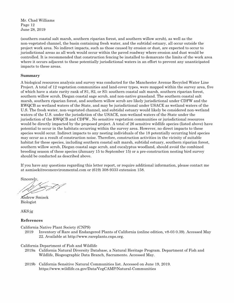
Mr. Chad Williams Page 12 June 28, 2019
(southern coastal salt marsh, southern riparian forest, and southern willow scrub), as well as the non-vegetated channel, the basin containing fresh water, and the subtidal estuary, all occur outside the project work area. No indirect impacts, such as those caused by erosion or dust, are expected to occur to jurisdictional areas as all work would occur within the paved roadway where erosion and dust would be controlled. It is recommended that construction fencing be installed to demarcate the limits of the work area where it occurs adjacent to these potentially jurisdictional waters in an effort to prevent any unanticipated impacts to these areas.
Summary A biological resources analysis and survey was conducted for the Manchester Avenue Recycled Water Line Project. A total of 12 vegetation communities and land-cover types, were mapped within the survey area, five of which have a state rarity rank of S1, S2, or S3: southern coastal salt marsh, southern riparian forest, southern willow scrub, Diegan coastal sage scrub, and non-native grassland. The southern coastal salt marsh, southern riparian forest, and southern willow scrub are likely jurisdictional under CDFW and the RWQCB as wetland waters of the State, and may be jurisdictional under USACE as wetland waters of the U.S. The fresh water, non-vegetated channel, and subtidal estuary would likely be considered non-wetland waters of the U.S. under the jurisdiction of the USACE, non-wetland waters of the State under the jurisdiction of the RWQCB and CDFW.. No sensitive vegetation communities or jurisdictional resources would be directly impacted by the proposed project. A total of 26 sensitive wildlife species (listed above) have potential to occur in the habitats occurring within the survey area. However, no direct impacts to these species would occur. Indirect impacts to any nesting individuals of the 18 potentially occurring bird species may occur as a result of construction noise. Therefore, construction activities in the vicinity of suitable habitat for these species, including southern coastal salt marsh, subtidal estuary, southern riparian forest, southern willow scrub, Diegan coastal sage scrub, and eucalyptus woodland, should avoid the combined breeding season of these species (January 15 to September 15) or a pre-construction nesting bird survey should be conducted as described above.
If you have any questions regarding this letter report, or require additional information, please contact me at [email protected] or (619) 308-9333 extension 158.
Sincerely,
Andrew Smisek Biologist
AKS:jg
References California Native Plant Society (CNPS) 2019 Inventory of Rare and Endangered Plants of California (online edition, v8-03 0.39). Accessed May
22. Available at http://www.rareplants.cnps.org. California Department of Fish and Wildlife 2019a California Natural Diversity Database, a Natural Heritage Program. Department of Fish and
Wildlife, Biogeographic Data Branch, Sacramento. Accessed May. 2019b California Sensitive Natural Communities list. Accessed on June 19, 2019.
https://www.wildlife.ca.gov/Data/VegCAMP/Natural-Communities
Mr. Chad Williams Page 13 June 28, 2019
Holland, R. F. 1986 Preliminary Descriptions of the Terrestrial Natural Communities of California. Nongame-
Heritage Program, California Department of Fish and Game. October. Oberbauer, Thomas, Meghan Kelly, and Jeremy Buegge. 2008 Draft Vegetation Communities of San Diego County. Based on “Preliminary Descriptions of the
Terrestrial Natural Communities of California,” Robert F. Holland, Ph.D., October 1986. March. San Diego, County of 2009 Draft Multiple Species Conservation Program North County Plan. February 19. 2019 SanBIOS points. SanGIS Data Warehouse. San Diego Geographic Information Source – JPA.
Modified from the Biological Observation Database. Department of Planning and Land Use. Accessed May. Available at http://www.sangis.org/download/index.html.
Tremor, Scott, D. Stokes, W. Spencer, J. Diffendorfer, H. Thomas, S. Chivers, and P. Unitt, eds. 2017 San Diego County Mammal Atlas. San Diego Natural History Museum. U.S. Fish and Wildlife Service (USFWS) 2019a All Species Occurrences GIS Database. Carlsbad Fish and Wildlife Office. Downloaded May. 2019b Critical Habitat Portal. Available at: http://www.fws.gov/endangered/what-we-do/critical-
habitats.html. Accessed May. Unitt, P. 2004 San Diego County Bird Atlas. San Diego Natural History Museum. Ibis Publishing Company. San
Diego, California. October. U.S. Department of Agriculture 1973 Soil Survey, San Diego Area, California. Edited by Roy H. Bowman. Soil Conservation Service
and Forest Service. December. U.S. Geological Survey (USGS) 1975 Encinitas, California 7.5-minute topographical map.

Initial Study Checklist/Mitigated Negative Declaration
Manchester Avenue Recycled Water Pipeline Project
APPENDIX C
Cultural Resources Assessment

An Employee-Owned Company
1927 Fifth Avenue, San Diego, CA 92101 | 619.308.9333 | reconenvironmental.com SAN DIEGO | BAY AREA | TUCSON
October 28, 2019
Mr. Chad Williams Engineering Services Supervisor Olivenhain Municipal Water District 1966 Olivenhain Road Encinitas, CA 92024
Reference: Cultural Resources Survey for the Manchester Avenue Recycled Water Pipeline Project, Agreement # 19AGR026 (RECON Number 9421-1)
Dear Mr. Williams:
This letter report presents the results of a cultural resources survey completed for the Olivenhain Municipal Water District’s (OMWD) proposed Manchester Avenue Recycled Water Pipeline Project (project). Both the records search and field survey were negative for cultural resources within the project area. There will be no impacts to known cultural resources from trenching activities associated with the project. The project does have the potential to excavate into undisturbed soils, and impact currently unidentified prehistoric or historic cultural resources. Because of this, RECON recommends a cultural resources monitoring program be conducted during any excavations that have the potential to extend into undisturbed soils.
1.0 Project Location and Site Description
The project is located in western San Diego County, in southern Encinitas adjacent to San Elijo Lagoon (Figure 1). The proposed project includes the installation of approximately 7,400 linear feet of 6-inch PVC recycled water pipeline within the paved right-of-way (R/W) of Manchester Avenue and El Camino Real, in the city of Encinitas. The project begins at the intersection of Via Poco and Manchester Avenue, and extends north to the intersection of El Camino Real and Tennis Club Drive. The project site is in the east ½ of Section 26 and the eastern ¼ of Section 23, Township 13 South, Range 4 West, of the U.S. Geological Survey 7.5-minute topographic map series, Encinitas quadrangle (Figure 2). The community of Cardiff is to the west, the city of Solana Beach is to the south, and the community Rancho Santa Fe is to the east. The project extends along the northern edge of San Elijo Lagoon for approximately ¾ mile than turns north into Lux Canyon for approximately 0.7 mile. Adjacent to San Elijo Lagoon, the project area on the east side of Manchester Avenue is undeveloped and vegetation consists predominately of native brackish and freshwater species. The west side of Manchester Avenue is developed, and non-native ornamental plants dominate (Figure 3). Elevation varies between less than10 feet above mean sea level at the south end of the project to approximately 140 feet above mean sea level at the north end.
2.0 Project Description
The proposed project includes the installation of approximately 7,400 linear feet of 6-inch PVC recycled water pipeline within the paved R/W of Manchester Avenue and El Camino Real. The new pipeline will be constructed via standard cut and cover technique with the bottom of the trench extending 4 to 6 feet below grade and between 24 to 32 inches wide. Typical construction equipment employed will include a backhoe, flatbed supply trucks, pickup trucks, excavator, and dump trucks. Project construction activity would occur in one phase, with construction lasting approximately six months, and would occur between the hours of 7:00 a.m. and 5:00 p.m., Monday through Friday only (not on the weekend) and excluding federal holidays.
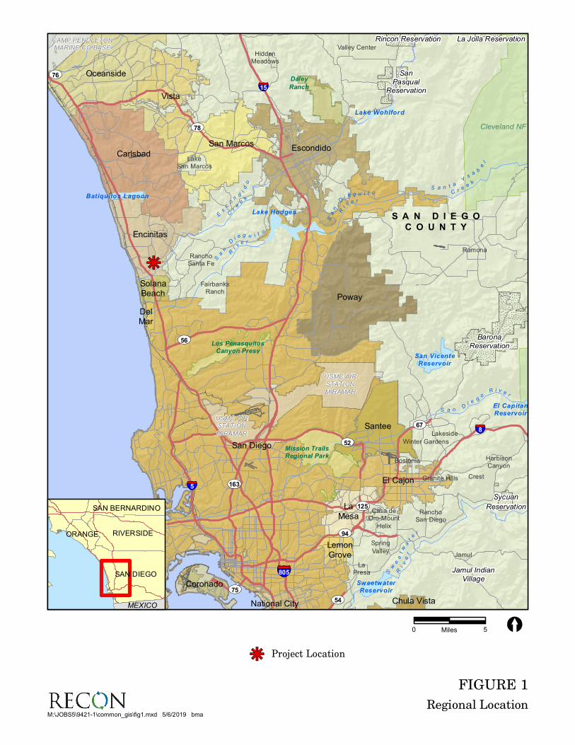
FIGURE 1
Regional Location
kj
USMC AIRSTATION
MIRAMAR
USMC AIRSTATION
MIRAMAR
CAMP PENDLETONMARINE CO BASE
Daley
Ranch
Los PenasquitosCanyon Presv
Mission TrailsRegional Park
Cleveland NF
Lake Wohlford
Batiquitos Lagoon
Lake Hodges
El CapitanReservoir
San VicenteReservoir
SweetwaterReservoir
Sa
nD
i e g u i t o
Ri
v e r
Sa
n
D
i e g u i t oR
i
v e r
S a n t aY
sa
b
el
C r ee
k
Sw
ee
tw
at
e
r
Ri
ve
r
Es
co
nd
id
o
Cr
e
ek
S a n Di e g
oR i v e
r
Jamul Indian
Village
San
PasqualReservation
Rincon Reservation
Sycuan
Reservation
La Jolla Reservation
Barona
Reservation
Valley Center
Bostonia
Casa deOro-Mount
Helix
Crest
FairbanksRanch
Granite Hills
HarbisonCanyon
HiddenMeadows
Jamul
LakeSan Marcos
Lakeside
LaPresa
Ramona
RanchoSan Diego
RanchoSanta Fe
Spring
Valley
Winter Gardens
UV163
UV78
UV54
UV56
UV76
UV75
UV125
UV67
UV94
UV52
§̈¦8
§̈¦805
§̈¦15
§̈¦5
S A N D I E G O
C O U N T Y
Carlsbad
Chula Vista
Coronado
DelMar
El Cajon
Encinitas
Escondido
LaMesa
LemonGrove
National City
Oceanside
Poway
San Diego
San Marcos
Santee
SolanaBeach
Vista
kj
USMC AIRSTATION
MIRAMAR
USMC AIRSTATION
MIRAMAR
CAMP PENDLETONMARINE CO BASE
Daley
Ranch
Los PenasquitosCanyon Presv
Mission TrailsRegional Park
Cleveland NF
Lake Wohlford
Batiquitos Lagoon
Lake Hodges
El CapitanReservoir
San VicenteReservoir
SweetwaterReservoir
Sa
nD
i e g u i t o
Ri
v e r
Sa
n
D
i e g u i t oR
i
v e r
S a n t aY
sa
b
el
C r ee
k
Sw
ee
tw
at
e
r
Ri
ve
r
Es
co
nd
id
o
Cr
e
ek
S a n Di e g
oR i v e
r
Jamul Indian
Village
San
PasqualReservation
Rincon Reservation
Sycuan
Reservation
La Jolla Reservation
Barona
Reservation
Valley Center
Bostonia
Casa deOro-Mount
Helix
Crest
FairbanksRanch
Granite Hills
HarbisonCanyon
HiddenMeadows
Jamul
LakeSan Marcos
Lakeside
LaPresa
Ramona
RanchoSan Diego
RanchoSanta Fe
Spring
Valley
Winter Gardens
UV163
UV78
UV54
UV56
UV76
UV75
UV125
UV67
UV94
UV52
§̈¦8
§̈¦805
§̈¦15
§̈¦5
S A N D I E G O
C O U N T Y
Carlsbad
Chula Vista
Coronado
DelMar
El Cajon
Encinitas
Escondido
LaMesa
LemonGrove
National City
Oceanside
Poway
San Diego
San Marcos
Santee
SolanaBeach
Vista
0 5Miles [
M:\JOBS5\9421-1\common_gis\fig1.mxd 5/6/2019 bma
SAN DIEGO
RIVERSIDE
SAN BERNARDINO
ORANGE
MEXICO
Project Locationkj

FIGURE 2
Project Location on USGS Map
Map Source: USGS 7.5 minute topographic map series, Encinitas quadrangle, 1975, T13S R04W
0 2,000Feet [
Project Boundary
M:\JOBS5\9421-1\common_gis\fig2.mxd 5/6/2019 bma

FIGURE 3a
Project Location on Aerial Photograph, South Half
WALES D
R
VIA
PO
CO
ESTE VISTA CT
VIA
TIE
MP
O
MIR
A C
OS
TA C
OLL
EG
E R
D
CRE
ST
DR
MANCHESTER AVE
WALES D
R
VIA
PO
CO
ESTE VISTA CT
VIA
TIE
MP
O
MIR
A C
OS
TA C
OLL
EG
E R
D
CRE
ST
DR
MANCHESTER AVE
Image Source: NearMap (flown February 2019)
0 300Feet [
Project Boundary
M:\JOBS5\9421-1\common_gis\fig3a.mxd 5/24/2019 bma

FIGURE 3b
Project Location on Aerial Photograph, North Half
SE
LC
AM
I NO
RE
AL
PA
CIF
ICR
AN
CH
DR
GA
RN
ER
PL
BE
RR
YM
AN
CA
NY
ON
TENNIS CLUB DR
ENCLAVE CT
MANCHESTER AVE
CA
LL
ESCOTT
CA
LL
EC
HR
ISTO
PH
ER
LORIMER LN
CA
LL
E C
HR
IST
OP
HE
R
LUX CANYON DR
EL CAMINO CT
CALLE RYAN
SAGE CANYON DR
SE
LC
AM
I NO
RE
AL
PA
CIF
ICR
AN
CH
DR
GA
RN
ER
PL
BE
RR
YM
AN
CA
NY
ON
TENNIS CLUB DR
ENCLAVE CT
MANCHESTER AVE
CA
LL
ESCOTT
CA
LL
EC
HR
ISTO
PH
ER
LORIMER LN
CA
LL
E C
HR
IST
OP
HE
R
LUX CANYON DR
EL CAMINO CT
CALLE RYAN
SAGE CANYON DR
Image Source: NearMap (flown February 2019)
0 300Feet [
Project Boundary
M:\JOBS5\9421-1\common_gis\fig3b.mxd 5/24/2019 bma

Mr. Chad Williams Page 6 October 28, 2019
3.0 Cultural Setting
The prehistoric cultural sequence in San Diego County is generally conceived as comprising three basic periods: the Paleoindian, dated between about 11,500 and 8,500 years ago and manifested by the artifacts of the San Dieguito Complex; the Archaic, lasting from about 8,500 to 1,500 years ago (a.d. 500) and manifested by the cobble and core technology of the La Jollan Complex; and the Late Prehistoric, lasting from about 1,500 years ago to historic contact (i.e., a.d. 500 to 1769) and represented by the Cuyamaca Complex. This latest complex is marked by the appearance of ceramics, small arrow points, and cremation burial practices.
The Paleoindian Period in San Diego County is most closely associated with the San Dieguito Complex, as identified by Rogers (1938, 1939, 1945). The San Dieguito assemblage consists of well-made scraper planes, choppers, scraping tools, crescentics, elongated bifacial knives, and leaf-shaped points. The San Dieguito Complex is thought to represent an early emphasis on hunting (Warren et al. 1993:III-33).
The Archaic Period in coastal San Diego County is represented by the La Jollan Complex, a local manifestation of the widespread Millingstone Horizon. This period brings an apparent shift toward a more generalized economy and an increased emphasis on seed resources, small game, and shellfish. Along with an economic focus on gathering plant resources, the settlement system appears to have been more sedentary. The La Jollan assemblage is dominated by rough, cobble-based choppers and scrapers, and slab and basin metates. Elko series projectile points appeared by about 3,500 years ago. Large deposits of marine shell at coastal sites argue for the importance of shellfish gathering to the coastal Archaic economy.
Near the coast and in the Peninsular Mountains beginning approximately 1,500 years ago, patterns began to emerge that suggest the ethnohistoric Kumeyaay. The Late Prehistoric Period is characterized by higher population densities and elaborations in social, political, and technological systems. Economic systems diversify and intensify during this period, with the continued elaboration of trade networks, the use of shell-bead currency, and the appearance of more labor-intensive, but effective technological innovations. The late prehistoric archaeology of the San Diego coast and foothills is characterized by the Cuyamaca Complex. The Cuyamaca Complex is characterized by the presence of steatite arrow shaft straighteners, steatite pendants, steatite comales (heating stones), Tizon Brownware pottery, ceramic figurines reminiscent of Hohokam styles, ceramic “Yuman bow pipes,” ceramic rattles, miniature pottery, various cobble-based tools (e.g., scrapers, choppers, hammerstones), bone awls, manos and metates, mortars and pestles, and Desert Side-Notched (more common) and Cottonwood Series projectile points (True 1970).
Ethnohistory
The Kumeyaay (also known as Kamia, Ipai, Tipai, and Diegueño) occupied the southern two-thirds of San Diego County. The Kumeyaay lived in semi-sedentary, politically autonomous villages or rancherias. Settlement system typically consisted of two or more seasonal villages with temporary camps radiating away from these central places (Cline 1984a and 1984b). Their economic system consisted of hunting and gathering, with a focus on small game, acorns, grass seeds, and other plant resources. The most basic social and economic unit was the patrilocal extended family. A wide range of tools was made of locally available and imported materials. A simple shoulder-height bow was utilized for hunting. Numerous other flaked stone tools were made including scrapers, choppers, flake-based cutting tools, and biface knives. Preferred stone types were locally available metavolcanics, cherts, and quartz. Obsidian was imported from the deserts to the north and east. Ground stone objects include mortars, manos, metates, and pestles typically made of locally available fine-grained granite. Both portable and bedrock types are known. The Kumeyaay made fine baskets using either coiled or twined construction. The Kumeyaay also made pottery, utilizing the paddle-and-anvil technique. Most were a plain brown utility ware called Tizon Brownware, but some were decorated (Meighan 1954; May 1976, 1978).
3.1 Spanish/Mexican/American Periods
The Spanish Period (1769–1821) represents a time of European exploration and settlement. Military and naval forces along with a religious contingent founded the San Diego Presidio, the pueblo of San Diego, and

Mr. Chad Williams Page 7 October 28, 2019
the San Diego Mission in 1769 (Rolle 1998). The mission system used forced Native American labor and introduced horses, cattle, other agricultural goods, and implements. Native American culture in the coastal strip of California rapidly deteriorated despite Native Americans’ repeated attempts to revolt against the Spanish invaders (Cook 1976). One of the hallmarks of the Spanish colonial scheme was the rancho system. In an attempt to encourage settlement and development of the colonies, large land grants were made to meritorious or well-connected individuals. The closest rancho to the project was Rancho Los Encinitas, granted to Don Andres Ybarra in 1842 by Governor Juan Bautista Alvarado (Pourade 1969). Don Ybarra sold the 4,431-acre rancho to Joseph Manasse and Marcus Schiller in 1860, who used it as a stage stop. A 2,000-acre portion was later sold to Edward Rutherford and used as a cattle ranch (Pourade 1969).
In 1821, Mexico declared its independence from Spain. During the Mexican Period (1822–1848), the mission system was secularized by the Mexican government, and these lands allowed for the dramatic expansion of the rancho system. The southern California economy became increasingly based on cattle ranching.
The Mexican Period ended when Mexico signed the Treaty of Guadalupe Hidalgo on February 2, 1848, concluding the Mexican–American War (1846–1848; Rolle 1998). Just prior to the signing of the Treaty of Guadalupe Hidalgo, gold was discovered in the northern California Sierra–Nevada foothills, the news was published on March 15, 1848, and the California Gold Rush began. The great influx of Americans and Europeans eliminated many remaining vestiges of Native American culture. California became a state in 1850.
The first pioneer settlers to live in the coastal Encinitas area were Nathan Eaton and Hector MacKinnon and his wife, both arriving in 1875 (O’Connell 1987). Eaton first settled on the south shore of Batiquitos Lagoon, and MacKinnon settled on the north side of San Elijo Lagoon. The coming of the California Southern Railroad to Encinitas in 1881 did little to spark growth in Encinitas, Leucadia or Cardiff. By 1883, there were only 11 people in Encinitas, with a combination grocery store and ticket office by the railroad tracks. The school house was built in 1883, at the intersection of Third and E Streets. In 1884, a flood devastated the area, and the rail line to San Diego was washed out. It was two months before the trestles and tracks were rebuilt during this time, and food and supplies were delivered to Encinitas with difficulty (O’Connell 1987). In 1885, the California Southern Railroad sent Thomas Rattan who, with John Pitcher, worked to develop Encinitas. The results of this were an increase in growth in Encinitas in the late 1880s, with an entire block of buildings constructed on the west side of First Street in 1887 (Hartley 1999). The population of the area in what is now encompassed by the City of Encinitas stood at about 160 people by the late 1880s (Hartley 1999). The population stayed small through the turn of the century. In 1913, the State of California constructed a road through Encinitas, which brought some new revenue with the new traffic, and electricity arrived in 1915 (Hartley 1999). The founding of the San Dieguito Water District in 1923 meant a regular water supply was now available for Encinitas. The availability of water sent land prices shooting up, and helped the introduction of avocados as a crop into the area.
4.0 Survey Methods
The cultural resources survey included both an archival search and an on-site foot survey of the proposed project parcel. The entire parcel is considered the Area of Potential Effects (APE). A record search with a one-mile-radius buffer of the project site was requested from the California Historical Resources Information System, South Coastal Information Center.
A letter was sent to the Native American Heritage Commission (NAHC) on May 14, 2019 requesting them to search their files to identify spiritually significant and/or sacred sites or traditional use areas in the project parcel vicinity. On May 31, 2019, RECON received a response stating that a record search of the NAHC Sacred Lands File was completed and results were negative (Attachment 1).
The APE is considered to be the existing R/W of the portions of Manchester Avenue and El Camino Real within the project boundary, which encompasses both the permanent and temporary impact areas associated with the project.

Mr. Chad Williams Page 8 October 28, 2019
5.0 Survey Results
5.1 Record Search
The self-search on May 15, 2019 indicated that there have been 79 cultural resources identified within the one-mile search radius. These resources include 9 historic sites, 52 prehistoric sites, 1 multicomponent site, and 17 prehistoric isolated artifacts. No sites are within the project boundary. The closest sites are CA-SDI-14,148 (P-37-014375) and CA-SDI-14,150 (P-37-014377). Both are small marine shell scatters located just east of the project and northeast of the intersection of Manchester Avenue and El Camino Real.
Eighty-six cultural resources investigations have been conducted within one mile of the project. Of these 86 investigations, 24 encompass or are adjacent to the APE (Confidential Attachment 1). No historic addresses are within the one-mile radius.
The list of sites and reports within one mile of the project are included with the record search results in Confidential Attachment 1.
5.2 Field Results
RECON archaeologists Nathanial Yerka and Harry J. Price surveyed the project area on May 21, 2019. The survey was conducted in conditions of partially cloudy skies and moderate temperature. The entire project area within the Manchester Avenue and El Camino Real R/W has been extensively disturbed by construction of the two roads. In addition, most of the area adjacent to the R/W has been impacted by development.
A drainage ditch has been excavated on the north/northwest side of Manchester Avenue, between the road edge and the R/W limit, beginning at the south end of the project at Val Poco, and extending east/northeast for approximately 1,350 feet. Ground visibility in this area averages 10 percent due to non-native vegetation (Photograph 1). There were occasional patches of high visibility adjacent to the R/W fence. Beginning at the south end of the project at the Manchester off-ramp and extending approximately 3,100 feet northeast, the east-bound road shoulder consists of the slope of the berm Manchester is constructed on (Photograph 2). Vegetation on the berm slope consists primarily of native riparian and marsh species, with non-native plants along the asphalt edge. Ground visibility is very low, less than five percent. The remainder of the shoulder north to the Manchester Avenue/El Camino Real intersection has a combination of native and non-native vegetation. Ground visibility is low, averaging below 10 percent.
On the west side of Manchester Avenue, adjacent to Mira Costa College and Saints Constantine and Helen Greek Orthodox Church, the shoulder is landscapes and ground visibility is below five percent (Photograph 3). The approximately 650 feet of shoulder south of the Manchester Avenue/El Camino Real intersection consists of a concrete sidewalk and landscaped are between the sidewalk and building/parking lot. Ground visibility in the landscaped area was below five percent.
North of the Manchester Avenue/El Camino Real intersection the road shoulder is predominantly dirt, with short stretches of concrete sidewalk (Photograph 4). A narrow unpaved walkway runs adjacent to the road edge. The dirt shoulders have been impacted by road construction. A combination of non-native landscaping vegetation and scattered native plants grow on the shoulders. Ground visibility varied from 90 percent in the actual walkways to less than 10 percent in the landscaped areas.
No potentially significant prehistoric or historic cultural material was observed during the survey. No evidence of CA-SDI-14375 was observed, but as this site is mapped outside the project boundary, none was expected. A small scatter of 10 to 12 Chione sp. shell fragments were observed on the west side of Manchester Avenue, in the west wall of the drainage ditch. No shell was seen adjacent to the ditch, and none was visible in the agricultural field immediately west of the project. No obvious cultural material such as flakes, lithic tools, or pottery was observed with the shell. The area has been heavily disturbed by construction of the ditch, and the shell may be displaced from another location.

P:\9421-1\Arc\Manchester\Photos\Photos1-4.docx 05/23/19
PHOTOGRAPH 1
Looking Southwest at Drainage Ditch Adjacent to Manchester Avenue
PHOTOGRAPH 2
Looking Northeast along Manchester Avenue, Showing Side of Road Berm Adjacent to San Elijo Lagoon

P:\9421-1\Arc\Manchester\Photos\Photos1-4.docx 05/23/19
PHOTOGRAPH 3
Area Adjacent to Mira Costa College
PHOTOGRAPH 4
Looking South on El Camino Real North of the Manchester Avenue/El Camino Real Intersection

Mr. Chad Williams Page 11 October 28, 2019
6.0 Regulatory Context
6.1 National Register of Historic Places Eligibility Criteria
A property that qualifies for the National Register of Historic Places is considered significant in terms of the planning process under the National Historic Preservation Act, National Environmental Policy Act, and other federal mandates. The National Register Criteria for Evaluation (36 Code of Federal Regulations [CFR] 60.4) provides guidance in determining a property’s eligibility for listing on the National Register of Historic Places. This states that the quality of significance in American history, architecture, archaeology, engineering, and culture is present in districts, sites, buildings, structures, and objects that possess integrity of location, design, setting, materials, workmanship, feeling, and association, and:
A. is associated with events that have made a significant contribution to the broad patterns of our history; or
B. is associated with the lives of persons significant in our past; or,
C. embodies the distinctive characteristics of a type, period, or method of construction, or that represents the work of a master, or that possesses high artistic values, or that represents a significant and distinguishable entity whose components may lack individual distinction; or
D. has yielded, or may be likely to yield, information important in prehistory or history [36 CFR 60.4].
6.2 California Environmental Quality Act
The regulatory framework and methods for determining impacts on cultural resources include compliance with the requirements of the California Environmental Quality Act (CEQA) as defined in Section 15064.5 of the CEQA Determining the Significance of Impacts to Archaeological and Historical Resources (CEQA Guidelines. These guidelines require the identification of cultural resources that could be affected by the proposed project, the evaluation of the significance of such resources, an assessment of the proposed project impacts on significant resources, and a development of a research design and data recovery program to avoid or address adverse effects to significant resources. Significant resources, also called historical resources, are those cultural resources (whether prehistoric or historic) that have been evaluated and determined to be eligible for listing in the California Register of Historical Resources.
According to CEQA Section 15064.5 (a), a historical resource includes the following:
1. A resource listed in, or determined to be eligible for listing on, the California Register of Historical Resources.
2. A resource included in the local register.
3. A resource which an agency determines to be historically significant. Generally a resource shall be considered to be “historically significant,” if the resource meets the criteria for listing on the California Register of Historical Places (Public Resources Code Section 5024.1 Title 14 California Code of Regulations, Section 4852) including the following:
A. Is associated with events that have made a significant contribution to the broad patterns of California’s history or cultural heritage;
B. Is associated with the lives of persons important in our past;
C. Embodies the distinctive characteristics of a type, period, region or method of construction or represents the work of an important creative individual, or possesses high artistic values; or
D. Has yielded, or maybe likely to yield, information important to prehistory or history.
4. The fact that a resource is not listed in or determined to be eligible for listing in the California Register of Historical Resources or a local register does not preclude a lead agency from determining

Mr. Chad Williams Page 12 October 28, 2019
that the resource may be an historical resource as defined in Public Resources Code Sections 5020.1(j) or 5024.1.
A resource must meet one of the above criteria and must have integrity; that is, it must evoke the resource’s period of significance or, in the case of criterion D, it may be disturbed, but it must retain enough intact and undisturbed deposits to make a meaningful data contribution to regional research issues.
7.0 Significance Determination/Management Recommendations
No prehistoric or historic cultural resources were mapped on or immediately adjacent to the property in the South Coastal Information Center record search files. No significant or potentially significant prehistoric or historic cultural resources were found during the survey of the project property. The small scatter of 10–12 Chione sp. shell fragments observed on the west side of Manchester Avenue is not considered a potentially significant historical resource. No obvious cultural material such as flakes, lithic tools, or pottery was observed with the shell. The area has been heavily disturbed by construction of the ditch, and the shell may be displaced from another location. Without the presence of artifacts, it is also possible that the shell is naturally occurring. Therefore, the proposed project will not cause a substantial adverse change in the significance of a known cultural resource and mitigation is not required.
The project does have the potential to excavate into undisturbed soils, and impact currently unidentified prehistoric or historic cultural resources; because of this, RECON recommends a qualified archaeological monitor and Native American monitor be present during any excavations that have the potential to extend into undisturbed soils. In the event that unknown cultural resources or significant features are encountered during construction monitoring, the archaeological and Native American monitors will be authorized to temporarily divert trenching in the area of discovery until the significance and the appropriate mitigation measures are determined. To mitigate potential impacts to significant cultural resources, an Archaeological Data Recovery Program shall be submitted by the Principal Investigator, approved by OMWD, and implemented prior to resuming construction activities. All cultural material collected during the monitoring and data recovery program shall be processed and permanently curated with an appropriate institution. If human remains are discovered, work shall halt in that area and the procedures set forth in the California Public Resources Code (Section 5097.98) and State Health and Safety Code (Section 7050.5) will be followed.
After the completion of the monitoring, an appropriate report shall be prepared. If no significant cultural resources are discovered, a brief letter shall be prepared. If significant cultural resources are discovered, a report with the results of the monitoring and data recovery (including the interpretation of the data within the research context) shall be prepared.
If you have any questions, please me at 619-308-9333 extension 103 or e-mail at [email protected].
Sincerely,
Harry J. Price Project Archaeologist
HJP:jg
Attachments

Mr. Chad Williams Page 13 October 28, 2019
8.0 References
Cline, Lora L. 1984a Just Before Dawn. L. C. Enterprises, Tombstone, Arizona. 1984b Just Before Sunset. J and L Enterprises, Jacumba, California. Cook, Sherburne F. 1976 The Population of California Indians, 1769-1970. Berkeley: University of California Press. Hartley, Mac 1999 Encinitas, History and Heritage. Donning Company/Publishers. May, Ronald V. 1976 An Early Ceramic Date Threshold in Southern California. Masterkey 50(3):103-107. 1978 A Southern California Indigenous Ceramic Typology: A Contribution to Malcolm J. Rogers
Research. ASA Journal 2:2. Meighan, Clement W. 1954 A Late Complex in Southern California Prehistory. Southwestern Journal of Anthropology
10:215-227. O’Connell, Lloyd. 1987 A Short History of Encinitas. Accessed in June 2010. Retrieved from
http://encinitashistoricalsociety.com. Pourade, Richard F. (editor) 1969 Historic Ranchos of San Diego. A Copley Book, Union-Tribune Publishing, San Diego. Rogers, Malcolm J. 1938 Archaeological and Geological Investigations of the Culture Levels in an Old Channel of San
Dieguito Valley. Carnegie Institution of Washington Yearbook 37:344-45. 1939 Early Lithic Industries of the Lower Basin of the Colorado River and Adjacent Desert Areas. San
Diego Museum of Man Papers 3. 1945 An Outline of Yuman Prehistory. Southwestern Journal of Anthropology 1(2):167-198.
Albuquerque. Rolle, Andrew 1998 California: A History. Harlan Davidson, Inc. Wheeling, Illinois. True, Delbert L. 1970 Investigation of a Late Prehistoric Complex in Cuyamaca Rancho State Park, San Diego County,
California. Department of Anthropology Publications, University of California, Los Angeles. Warren, Claude N., Gretchen Siegler, and Frank Dittmer 1993 Paleoindian and Early Archaic Periods. In Historic Properties Background Study for the City of
San Diego Clean Waste Program. On file with Mooney and Associates.

ATTACHMENT 1
NAHC Response

STATE OF CALIFORNIA Gavin Newsom, Governor
NATIVE AMERICAN HERITAGE COMMISSION Cultural and Environmental Department 1550 Harbor Blvd., Suite 100 West Sacramento, CA 95691 Phone: (916) 373-3710 Email: [email protected] Website: http://www.nahc.ca.gov Twitter: @CA_NAHC
May 31, 2019
Carmen Zepeda-Herman RECON Environmental VIA Email to: [email protected] RE: Manchester Avenue Recycled Water Pipeline Project, San Diego County Dear Ms. Zepeda-Herman:
A record search of the Native American Heritage Commission (NAHC) Sacred Lands File (SLF) was completed for the information you have submitted for the above referenced project. The results were negative. However, the absence of specific site information in the SLF does not indicate the absence of cultural resources in any project area. Other sources of cultural resources should also be contacted for information regarding known and recorded sites. Attached is a list of Native American tribes who may also have knowledge of cultural resources in the project area. This list should provide a starting place in locating areas of potential adverse impact within the proposed project area. I suggest you contact all of those indicated; if they cannot supply information, they might recommend others with specific knowledge. By contacting all those listed, your organization will be better able to respond to claims of failure to consult with the appropriate tribe. If a response has not been received within two weeks of notification, the Commission requests that you follow-up with a telephone call or email to ensure that the project information has been received. If you receive notification of change of addresses and phone numbers from tribes, please notify the NAHC. With your assistance, we can assure that our lists contain current information. If you have any questions or need additional information, please contact me at my email address: [email protected]. Sincerely, Steven Quinn Associate Governmental Program Analyst Attachment

CONFIDENTIAL ATTACHMENT 1
(Under Separate Cover)