Initial Study and Draft Supplemental Mitigated Negative ... · Initial Study and Draft Supplemental...
78
Initial Study and Draft Supplemental Mitigated Negative Declaration to the Freeport Regional Water Project Final Environmental Impact Report State Clearinghouse No. 2002032132 Prepared for: Freeport Regional Water Authority Sacramento County Water Agency East Bay Municipal Utility District Prepared by: Jones & Stokes 2600 V Street Sacramento, CA 95818-1914 Contact: Gregg Ellis 916/737-3000 February 2006
Transcript of Initial Study and Draft Supplemental Mitigated Negative ... · Initial Study and Draft Supplemental...

Initial Study and Draft Supplemental Mitigated Negative Declaration to the
Freeport Regional Water Project Final Environmental Impact Report
State Clearinghouse No. 2002032132
Prepared for:
Freeport Regional Water Authority Sacramento County Water Agency
East Bay Municipal Utility District
Prepared by:
Jones & Stokes
2600 V Street
Sacramento, CA 95818-1914
Contact: Gregg Ellis
916/737-3000
February 2006

Jones & Stokes. 2006. Initial Study and Draft Supplemental Mitigated Negative
Declaration to the Freeport Regional Water Project Final Environmental Impact
Report. February. (J&S 03072.03.) Sacramento, CA.

Notice of Intent
to Adopt a Supplemental Mitigated Negative Declaration
Freeport Regional Water Authority
Sacramento and San Joaquin Counties, California
Freeport Regional Water Project
The Freeport Regional Water Authority (FRWA) is acting as the lead agency for a water
supply project in Sacramento and San Joaquin Counties, California. The FRWA’s basic
project purpose is to increase water service reliability for customers, reduce rationing
during droughts, and facilitate conjunctive use of surface water and groundwater supplies
in Central Sacramento County. The proposed project involves a 185 million gallon per
day-capacity (MGD) intake facility and pumping plant located on the Sacramento River,
a reservoir and water treatment plant, a terminal facility located at the point of delivery to
the Folsom South Canal (FSC), a canal pumping plant located at the FSC terminus, an
aqueduct pumping plant and pretreatment facility near the Mokelumne Aqueducts/
Camanche Reservoir area, and pipelines carrying the water from the intake facility to the
Zone 40 Surface Water Treatment Plant and to the Mokelumne Aqueducts. The Final
Environmental Impact Report (EIR) for the Freeport Regional Water Project (FRWP)
was certified in April 2004 (SCH# 2002032132). However, minor adjustments to the
project have been made since the Final FRWP EIR was certified that are described and
analyzed in this Initial Study and Supplemental Mitigated Negative Declaration
(IS/MND). The minor adjustments include a sediment return system at the intake
facility, a surge tank facility near the intersection of Gerber and Vineyard Roads to
control transient pressures in the conveyance system, and discharge of water to local
drainages during drainage of the pipelines.
Consistent with State California Environmental Quality Act (CEQA) Guidelines
(Sections 15162 and 15163), FRWA reviewed the information regarding the minor
changes to the FRWP and has prepared an IS/MND for this project. The results of the
IS/MND indicate that mitigation measures would reduce all potential adverse impacts to
less-than-significant levels. The FRWA will take public comments and consider
certification of the IS/MND during a regularly scheduled Board meeting on April 13,
2006 at 10:00 a.m. at:
Sacramento County Administration Center
700 H Street, Room 1450
Sacramento, CA 95814
The FRWA will accept comments on the IS/MND from February 3. 2006 through March
4, 2006. Written comments may be submitted to:

Mr. Gregg Ellis
Freeport Regional Water Project
Supplemental Mitigated Negative Declaration Comment
Jones & Stokes
2600 V Street
Sacramento, CA 95818
Fax: (916) 737-3030
The IS/MND is available at the following local facilities for public review:
Belle Cooledge Community Library—5600 South Land Park Drive, Sacramento,
CA 95822
Elk Grove Community Library—8962 Elk Grove Boulevard, Elk Grove, CA
95624
Galt Neighborhood Library—1000 Caroline Avenue, Galt, CA 95632
Lodi Public Library—201 W. Locust Street, Lodi, CA 95240
Pannell Meadowview Community Center—2450 Meadowview Road,
Sacramento, CA 95832
Sacramento County Clerk/Recorder’s Office—600 Eighth Street, Sacramento, CA
95814
Sacramento County Water Agency—827 Seventh Street, Sacramento, CA 95814
Sacramento Central Library—828 I Street, Sacramento, CA 95814
San Joaquin County Clerk/Recorder’s Office—6 South El Dorado Street,
Stockton, CA 95202
Southgate Community Library 6132 66th
Avenue, Sacramento, CA 95823
Valley Hi-North Laguna Library—6351 Mack Road, Sacramento, CA 95823
The IS/MND and all associated documents are available for public review at the Freeport
Regional Water Authority—2710 Gateway Oaks Drive, Ste. 320-South, Sacramento, CA
95833.

Initial Study and Draft Supplemental Mitigated Negative Declaration to the Freeport Regional Water Project Final Environmental Impact Report
i
February 2006
J&S 03072.03
Contents
Page
Chapter 1 Introduction...........................................................................................1-1Background.............................................................................................1-1Project Purpose/Objectives and Need....................................................1-1Need .......................................................................................................1-1Purposes/Objectives...............................................................................1-2
Freeport Regional Water Project ......................................................1-2California Environmental Quality Act Process ........................................1-3
Purpose of Supplemental Initial Study and Mitigated Negative Declaration ........................................................................1-5Document Organization ....................................................................1-6
Chapter 2 Project Description...............................................................................2-1Introduction.............................................................................................2-1Sediment Return at the Intake Facility....................................................2-1Surge Tank Facility at the Pipeline Bifurcation .......................................2-2Discharge to Local Drainages.................................................................2-3
Drainage of Continuous-Use Pipelines.............................................2-3Drainage of Intermittent-Use Pipelines .............................................2-6
Chapter 3 Environmental Setting and Impacts....................................................3-1Introduction.............................................................................................3-1Surge Tank Facility .................................................................................3-2Sediment Return to River .......................................................................3-6
Use of the Lower Sacramento River by Salmon...............................3-7Potential Sediment Effects on Salmon .............................................3-7
Surge Tank Facility .................................................................................3-9Discharge to Local Drainages.................................................................3-9Discharge to Local Drainages...............................................................3-15Sediment Return to the River ...............................................................3-20Discharge to Local Drainages...............................................................3-21Surge Tank Facility ...............................................................................3-25
County of Sacramento General Plan Noise Element......................3-26County of Sacramento Noise Ordinance ........................................3-26
Discharge to Local Drainages...............................................................3-32

Initial Study and Draft Supplemental Mitigated Negative Declaration to the Freeport Regional Water Project Final Environmental Impact Report
ii
February 2006
J&S 03072.03
Chapter 4 List of Preparers and References .......................................................4-1List of Preparers .....................................................................................4-1
Jones & Stokes.................................................................................4-1References .............................................................................................4-1
Printed References ...........................................................................4-1

Initial Study and Draft Supplemental Mitigated Negative Declaration to the Freeport Regional Water Project Final Environmental Impact Report
iii
February 2006
J&S 03072.03
Tables
Page
S-1 Summary of Previously Addressed Significant Impacts and Mitigation Measures from the Adopted FRWP EIR for the Approved Alternative ..............................................................................1-4
S-2 Summary of Previously Addressed Less-than-Significant Impacts and Mitigation Measures from the Adopted FRWP EIR for the Approved Alternative ..............................................................................1-4
1 FRWA Drainage Details..........................................................................2-5
2 FSCC Drainage Details ..........................................................................2-7
3 Noise Level Performance Standards for Residential Areas Affected by Non-Transportation Noise..................................................3-26
S-3 Summary of Previously Addressed Significant Cumulative Impacts and Mitigation Measures from the Adopted FRWP EIR for the Approved Alternative .................................................................3-34
Initial Study and Draft Supplemental Mitigated Negative Declaration to the Freeport Regional Water Project Final Environmental Impact Report
iv
February 2006
J&S 03072.03
Figures
Follows Page
1 Service Areas .........................................................................................1-2
2 Process Flow Schematic ........................................................................2-2
3 Freeport Regional Water Agency (FRWA) Pipeline Alignment...............2-2
4 Freeport Regional Water Agency (FRWA) Pipeline Alignment (Continued) .............................................................................................2-2
5 Surge Tank Facility Approximate Elevation ............................................2-2
6 Typical Energy Dissipater .......................................................................2-4
7 Folsom South Canal Connection (FSCC) Pipeline Alignment ................2-6
8 General Run Timing of Adult and Juvenile Salmonids in the Sacramento River ...................................................................................3-8

Initial Study and Draft Supplemental Mitigated Negative Declaration to the Freeport Regional Water Project Final Environmental Impact Report
v
February 2006
J&S 03072.03
Acronyms and Abbreviations
Adopted FRWP EIR Adopted Final Freeport Water Project Environmental Impact
Report
CEQA California Environmental Quality Act
CEQA California Enviro
nmental Quality Act
cfs cubic feet per second
EBMUD East Bay Municipal Utility District
EIR Environmental Impact Report
FRWA Freeport Regional Water Authority
FRWP Freeport Regional Water Project
FRWP Freeport Regional Water Project
FSC Folsom South Canal
FSCC Folsom South Canal Connection
IS/MND Initial Study and Draft Supplemental Mitigated Negative
Declaration
Mgd million gallons per day
Reclamation Bureau of Reclamation
RWQCB Regional Water Quality Control Board
SCWA Sacramento County Water Agency
SRCSD Sacramento Regional County Sanitation District
SWTP Surface Water Treatment Plant

Initial Study and Draft Supplemental Mitigated Negative Declaration to the Freeport Regional Water Project Final Environmental Impact Report
1-1
February 2006
J&S 03072.03
Chapter 1
Introduction
Minor adjustments to the Freeport Regional Water Project (FRWP) have been
made since the Final FRWP Environmental Impact Report (EIR) was certified
and adopted (Adopted FRWP EIR). This document evaluates the potential
impacts on the environment of these changes.
Background
The Freeport Regional Water Authority (FRWA) was created by exercise of a
joint powers agreement between the Sacramento County Water Agency (SCWA)
and the East Bay Municipal Utility District (EBMUD). FRWA’s basic project
purpose is to increase water service reliability for customers, reduce rationing
during droughts, and facilitate conjunctive use of surface water and groundwater
supplies in central Sacramento County. FRWA is proposing the Freeport
Regional Water Project (FRWP) to meet this basic project purpose and others
summarized under Project Purpose/Objectives and Need below.
Project Purpose/Objectives and Need
The FRWP is intended to contribute to meeting the objectives of SCWA and
EBMUD. The primary need for the project, and its purposes and objectives, are
discussed below.
Need
The project is needed because:
The SCWA Zone 40 Water Supply Master Plan is based on a conjunctive use
water supply program that will protect the long-term sustainable yield of the
central Sacramento County groundwater basin recommended by the
Sacramento Water Forum Agreement, and surface water is necessary to
fulfill that water supply program; and
EBMUD forecasts water shortages during drought periods, based on
maintenance of existing Mokelumne River basin supply or catastrophic

Freeport Regional Water Authority Chapter 1. Introduction
Initial Study and Draft Supplemental Mitigated Negative Declaration to the Freeport Regional Water Project Final Environmental Impact Report
1-2
February 2006
J&S 03072.03
events exacerbated by increased flows for senior water right holders,
resource protection, and increasing population.
Purposes/Objectives
The purposes and objectives of the project are to:
support acquisition of additional SCWA surface water entitlements for a
conjunctive use program in its Zone 40 area, consistent with the Sacramento
Area Water Forum Agreement and County of Sacramento General Plan
policies;
provide facilities through which SCWA can deliver existing and anticipated
surface water entitlements to Zone 40 area;
provide facilities through which EBMUD can take delivery of a
supplemental supply of water that would substantially meet its need for water
and reduce existing and future customer deficiencies during droughts; and
improve EBMUD system reliability and operational flexibility during
droughts, catastrophic events, and scheduled major maintenance at Pardee
Dam or Reservoir and meet settlement agreements with Contra Costa Water
District and Santa Clara Valley Water District.
Freeport Regional Water Project
The FRWP is a water supply project to achieve the identified water delivery
needs of FRWA. The design capacity of the system is 185 million gallons per
day (mgd). Up to 85 mgd of water would be diverted under Sacramento
County’s existing Reclamation water service contract and other anticipated water
entitlements. This water would be used to meet municipal and industrial
demands in the Zone 40 area of south Sacramento County, consistent with the
Water Forum Agreement.
Up to 100 mgd of water also would be diverted under EBMUD’s amended
Bureau of Reclamation (Reclamation) water service contract. This supplemental
water would be used to reduce existing and future EBMUD customer
deficiencies to manageable levels during drought conditions and would provide
an alternative water supply in case of planned or unplanned outages at EBMUD’s
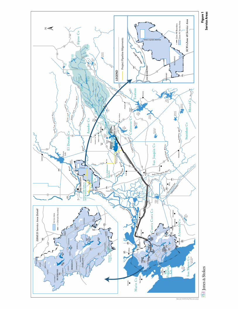
Mokelumne River diversion facilities. Figure 1 provides an overview of the
SCWA and EBMUD service areas and the general location of project facilities.
As more fully described in the Adopted FRWP EIR, the project consists of the
following components:
a 185 mgd–capacity intake facility (Freeport intake facility) and pumping
plant located on the Sacramento River near the community of Freeport;
Fig
ure
1
Se
rvic
e A
rea
s
03072.03 Neg Declaration (01/06)
Folsom
SouthCanal
Cosum
nes
Riv
er
No
rth
Fo
rkC
osu
mn
esR
iver
Mid
dle
Fo
rkC
osu
mn
esR
iver
So
uth
For
kC
osu
mn
esR
iver
M
okelum
ne
Riv
er
SacramentoRiver
A
meri
can
Riv
er
So
uth
Fo
rkA
mer
ica
nR
iver
Ca
lav
era
sR
iver
Sta
nis
lau
sR
ive r
Tu
olu
mn
eR
iver
North
ForkSta
nislausRiver Mid
dle
Fo
rkS
tan
isla
us
River
Mer
ce
dR
iver
Tu
olu
mn
eR
iver
Mid
dle
Fo
rkT
uo
lum
ne
Riv
er
So
uth
Fo
rkTu
olu
mn
eR
iver
NorthForkTuolumne
Riv
erS
ou
thF
ork
Sta
nis
lau
s
River
San Joaquin River
Old
Riv
er
Mid
d le River
Sout
hBa
yAq
ueduct
Sa
cra
men
toRiver
Sa
nJo
aqu
inR
iver
Cry
stal
Spr
ings
Res
ervo
ir
San
And
reas
Lake
Che
rry
Lake
Lak
eEl
eano
rH
etch
Het
chy
Res
ervo
ir
Pine
cres
tLa
ke
Don
nels
Res
ervo
ir
Uni
onR
es.
Lake
Alp
ine
Uti
caR
es.
Bea
rdsl
eyLa
ke
New
Mel
ones
Lake
Tullo
chR
eser
voir
Don
Pedr
oR
eser
voir
Lake
Mc C
lure
Turl
ock
Res
ervo
ir
Mod
esto
Res
ervo
ir
Woo
dwar
dR
eser
voir
Salt
Spr
ing
Val
ley
Res
.
Fols
omLa
ke
Lake
Nat
oma
Cal
aver
asR
es.
New
Hog
anR
es.
San
Ant
onio
Res
.
Silv
er L
ake
Cap
les
Lake
Pacific C
reek
Sout
h
Fork
Lick
ing
ForkM
iddl
eFo
rk
Fore
stC
reek
Blu
eC
reek
Col
eC
reek
Tiger
Creek
SummitCreek
Lake
Tabe
aud
Low
er B
ear
El. 5
820
Upp
er B
ear
El. 5
900
Blue
Lak
esEl
. 800
0
Hig
hlan
d La
keEl
. 850
0
Jeff
Dav
isEl
. 280
0
Scha
ad’s
El. 2
900
Pard
eeRes
ervo
irEl
. 568
Salt
Sprin
gsEl
. 404
1
Jack
son
Val
ley
Res
.
AQ
UE
DU
CT
S
Cam
anch
eRes
ervo
irEl
. 235
Yolo
Co
Solan
o Co
Nap
a Co
Sono
ma C
o
Mar
in C
o
Am
ador
Co
Cal
aver
as C
o
Con
tra
Cos
ta C
o
Ala
med
a C
o
San
Fran
cisco
Co
San
Mat
eo C
oSt
anisl
aus C
oM
erced
Co
Mar
ipos
a C
o
Tuol
umne
Co
Alpi
neC
o
El D
orad
o C
o
San
Joaq
uin
Co
Cross-DeltaCanal
Yose
mite
Nati
onal
Park
5
5
4
49
49
49
49
4
44
680
80
880
680
24
13
580
580
880
80
99
99
99
Mok
elum
ne R
iver
Fish
Hat
cher
y
88
88
26
12
26
12
88
88
88
80
205
80
80
5
89
89
4
4
4
UP
PER
SA
NLE
AN
DR
OW
TP
SO
BR
AN
TEW
TP
SA
N P
AB
LOW
TP
OR
IND
AW
TP
LAFA
YET
TEW
TPW
ALN
UT
CR
EEK
WTP
●
Pard
eePH
●
●El
ectr
a PH
Wes
t Poi
ntPH
●
● T
iger
Cree
kPH
Salt
Sprin
gs P
H●
An
gels
Cam
p●
Mu
rph
ys●
● S
on
ora
● S
an A
nd
reas
● C
amp
o S
eco
Jack
son
●
Pin
eG
rove
●
Pin
ecre
st●
Lo
ng
Bar
n●
Mo
des
to●
Man
teca ●
●Tr
acy
Liv
erm
ore
●P
leas
anto
n●
●D
ub
lin
●H
ayw
ard
San
Fran
cisc
o●
● V
alle
jo
San
Raf
ael
●
No
vato
●
Son
om
a●
Nap
a●
Fair
fiel
d●
Vac
avil
le●
Co
nco
rd●
●M
arti
nez
●P
itts
bu
rg
● A
nti
och
Dav
is●
● Sacr
amen
to
●R
ail
Ro
adFl
at●
Cla
y
Ion
e●
Dry
tow
n ●
Am
ado
r C
ity
●
Sutt
er C
reek
●
Bu
ena
Vis
ta●
●H
olt
●B
ixle
r
Lo
di●
●St
ock
ton
Au
bu
rn●
Rob
erts
Isla
nd
Low
er J
ones
Trac
t
Up
per
Jon
esTr
act
Bacon Island
Vic
tori
aIs
lan
d
Palm
Trac
t
Sarg
ent-
Bar
nh
art
Trac
t
Clif
ton
Cou
rtFo
reba
y
Bet
hany
Res
.
Del
ta-M
endo
ta C
anal
Calif
orni
a Aq
uedu
ct
Woo
d-
war
d I
slan
d
Chabot
Res
Lafa
yet
teRes
San
Pablo
Res
Bri
ones
Res
Contra
Cos
taCo.
Alam
eda
Co.
EB
MU
D S
ervi
ce A
rea
Det
ail
Serv
ice
Are
a
Ulti
mat
e Bo
unda
ry
Upper
San
Leandro
Res
Bays
ide
Loca
lG
roun
dwat
erPr
ojec
t
24
680
580
580
880
13
80
4
680
80
CR
OC
KE
TT
RIC
HM
ON
D
HE
RC
UL
ES
RO
DE
O
OR
IND
A
WA
LN
UT
CR
EE
K
AL
AM
O
DA
NV
ILL
E
MO
RA
GA
EL
CE
RR
ITO
AL
BA
NY
PIE
DM
ON
T
EM
ER
YV
ILL
E
SAN
RA
MO
N
CA
STR
OV
AL
LE
Y
SAN
LO
RE
NZ
O
SAN
LE
AN
DR
O
BE
RK
EL
EY
LA
FAY
ET
TE
PIN
OL
E
SAN
PA
BL
O
OA
KL
AN
D
AL
AM
ED
A
PAR
DEE
CEN
TER
Cam
anch
ePH
MO
KE
LU
MN
E
Zon
e 40
Bou
ndar
yZ
one
41 S
ervi
ce A
reas
SA
CR
AM
EN
TO
EL
K G
RO
VE
99
80
50
Amer
icanRive
r
FR
EE
PO
RT
5
Zon
e 40
Bou
ndar
yZ
one
41 S
ervi
ce A
rea
SCW
A Zo
ne 4
0 Se
rvic
e Ar
ea
FOLSOM SOUTH CANAL
Proj
ect P
ipel
ine
Alig
nmen
ts
Inta
keIn
take
LEGEN
D
Free
po
rt In
take
Fac
ility
to
Zo
ne
40 S
urfa
ce W
TP/F
SC
FSC
to
Mo
kelu
mn
eA
que
duc
ts
Sacr
amen
toC
o

Freeport Regional Water Authority Chapter 1. Introduction
Initial Study and Draft Supplemental Mitigated Negative Declaration to the Freeport Regional Water Project Final Environmental Impact Report
1-3
February 2006
J&S 03072.03
a reservoir and a water treatment plant (known as the Zone 40 Surface Water
Treatment Plant [SWTP]) located in central Sacramento County;
a terminal facility located at the point of delivery to the Folsom South Canal
(FSC);
a canal pumping plant located at the FSC terminus;
a series of settling basins;
an aqueduct pumping plant and pretreatment facility situated near the
Mokelumne Aqueducts/Camanche Reservoir area; and
four pipelines carrying the water from the intake facility to the Zone 40
SWTP and to the Mokelumne Aqueducts:
a 185 mgd–capacity (84-inch) pipeline from the intake facility to the
turnout to the Zone 40 SWTP,
an 85 mgd–capacity (60-inch) pipeline from the turnout to the Zone 40
SWTP,
a 100 mgd–capacity (66-inch) pipeline from the turnout to FSC, and
a 100 mgd–capacity (66-inch) pipeline from the terminus of FSC to the
Mokelumne Aqueducts.
California Environmental Quality Act Process
FRWA has prepared extensive environmental documentation under the
California Environmental Quality Act (CEQA) for its proposed FRWP. This
documentation includes:
The Draft EIR/EIS for the Freeport Regional Water Project (Jones and
Stokes Associates 2003) (State Clearinghouse number 2002032132); and
The Final EIR for the Freeport Regional Water Project (Jones and Stokes
Associates 2004)
CEQA requires that EIRs describe and evaluate reasonable alternatives to a
proposed action and describe an alternative that assumes that the proposed action
and alternatives would not be implemented. The Adopted FRWP EIR examined
the impacts of the proposed project and several alternatives in detail and
identified mitigation measures to reduce these impacts to less-than-significant
levels. Certain impacts could not be reduced to less-than-significant levels.
FRWA and its member agencies certified the Final FRWP EIR, with Alternative
5 being the approved project, and adopted CEQA Findings in April 2004.
Alternative 5 consists of the Freeport intake facility, Zone 40 Surface Water
Treatment Plant, Canal Pumping Plant, Aqueduct Pumping Plant and
Pretreatment Facility, and pipelines running primarily along Cosumnes River
Boulevard, Power Inn Road, Gerber Road, Clay Station Road, Elliott Road,

Freeport Regional Water Authority Chapter 1. Introduction
Initial Study and Draft Supplemental Mitigated Negative Declaration to the Freeport Regional Water Project Final Environmental Impact Report
1-4
February 2006
J&S 03072.03
Liberty Road, Buena Vista Road, and Cord Road. This constitutes the approved
project and is further described in Chapter 2.
The impacts and mitigation measures associated with the approved project and
previously addressed in the Adopted FRWP EIR are presented in Tables S-1 and
S-2. Table S-1 summarizes the significant environmental impacts in the Adopted
FRWP EIR, and Table S-2 summarizes the less-than-significant environmental
impacts in the Adopted FRWP EIR. The tables are organized to present impacts
by environmental topic area and to indicate the significance of each impact,
available mitigation measures, and the significance of each impact with
mitigation implemented. This information is provided for reference and to
summarize the environmental documentation conducted to date.
FRWA has incorporated certain mitigation measures into the project description
as environmental commitments. These commitments include preparation and
implementation of the measures listed below.
General construction measures to reduce or eliminate construction-related
effects, in particular those related to traffic disruptions and dust generation as
they may affect area residences and businesses.
Erosion and sediment control plan to control short-term and long-term
erosion and sedimentation effects and to restore soils and vegetation in areas
affected by construction activities.
Stormwater pollution prevention plan in compliance with the National
Pollutant Discharge Elimination System.
Traffic control plan for construction activities to reduce construction-related
effects on the roadway system and traffic and circulation patterns throughout
the affected project area during the construction period.
Dust suppression plan to reduce fugitive emissions during construction
activities.
Fire control plan to ensure appropriate fire prevention and response methods.
Phase I and Phase II hazardous materials studies to identify existing
hazardous materials and, if necessary, manage hazardous materials within
construction areas.
Hazardous materials management plan, including the appropriate practices to
reduce the likelihood of a spill of toxic chemicals and other hazardous
materials during construction.
Channel and levee restoration plan to ensure levee flood protection and all
water channels and levees affected by project construction activities are
restored to preconstruction conditions.
Hydrologic simulation modeling and scour analysis to identify potential
effects and identify measures for minimizing or avoiding adverse effects
related to scour, erosion, and sedimentation.

Ta
ble
S-1
.S
um
mary
of P
revio
usly
Addre
ssed S
ignific
ant Im
pacts
and M
itig
ation M
easure
s fro
m the A
dopte
d F
RW
P E
IR
for
the A
ppro
ved A
ltern
ative
Page 1
of 5
Res
ourc
e T
opic
/Im
pac
t M
itig
atio
n M
easu
re
Lev
el o
f
Sig
nif
ican
ce
afte
r M
itig
atio
n
Hyd
rolo
gy, W
ate
r S
up
ply
, an
d P
ow
er—
No
sig
nif
ican
t im
pac
ts
Wate
r Q
uali
ty—
No s
ignif
ican
t im
pac
ts
Fis
h—
No s
ignif
ican
t im
pac
ts
Rec
reati
on
—N
o s
ignif
ican
t im
pac
ts
Veg
etati
on
an
d W
etla
nd
Res
ou
rces
Tem
pora
ry d
istu
rban
ce t
o o
r pote
nti
al l
oss
of
sen
siti
ve
veg
etat
ion a
nd
wet
land r
esourc
es n
ear
acti
ve
const
ruct
ion a
reas
Imp
lem
ent
Mit
igat
ion
Mea
sure
7-1
: C
on
fin
e co
nst
ruct
ion
acti
vit
ies
and e
quip
men
t to
the
des
ignat
ed c
onst
ruct
ion
work
are
a
Imp
lem
ent
Mit
igat
ion
Mea
sure
7-2
: A
void
an
d p
rote
ct
sensi
tive
veg
etat
ion a
nd w
etla
nd r
esourc
es n
ear
des
ignat
ed
const
ruct
ion w
ork
are
as
Imp
lem
ent
Mit
igat
ion
Mea
sure
7-3
: R
eest
abli
sh
pre
con
stru
ctio
n s
ite
cond
itio
ns
to a
llow
nat
ura
l co
lon
izat
ion
of
pla
nt
spec
ies
and
res
eed
, if
nec
essa
ry
LS
Po
ten
tial
in
tro
du
ctio
n a
nd
spre
ad o
f n
ox
iou
s w
eed
s Im
ple
men
t M
itig
atio
n M
easu
re 7
-4:
Im
ple
men
t b
est
man
agem
ent
pra
ctic
es d
uri
ng c
onst
ruct
ion a
ctiv
itie
s
LS
Deg
rad
atio
n o
f b
lue
oak
wo
od
lan
ds
and l
oss
of
indiv
idual
lo
call
y
pro
tect
ed t
rees
Imp
lem
ent
Mit
igat
ion
Mea
sure
7-5
: I
den
tify
an
d a
vo
id o
ak
woodla
nd a
nd i
ndiv
idual
lo
call
y p
rote
cted
tre
es
Imp
lem
ent
Mit
igat
ion M
easu
re 7
-6:
Obta
in a
nd c
om
ply
wit
h c
ounty
tre
e re
moval
per
mit
s an
d i
mple
men
t co
ndit
ions
of
per
mit
s
LS
Lo
ss o
f o
r d
istu
rban
ce t
o r
ipar
ian
co
mm
un
itie
s Im
ple
men
t M
itig
atio
n M
easu
re 7
-7:
Est
abli
sh a
pro
tect
ion
buff
er a
round w
oody r
ipar
ian c
om
munit
ies
Imp
lem
ent
Mit
igat
ion
Mea
sure
7-8
: C
om
pen
sate
for
unav
oid
able
rip
aria
n w
oodla
nd l
oss
es
LS

Ta
ble
S-1
. C
ontinued
Page 2
of 5
Res
ourc
e T
opic
/Im
pac
t M
itig
atio
n M
easu
re
Lev
el o
f
Sig
nif
ican
ce
afte
r M
itig
atio
n
Lo
ss o
f o
r d
istu
rban
ce t
o j
uri
sdic
tio
nal
wat
ers
of
the
Un
ited
Sta
tes,
incl
ud
ing
wet
lan
ds
Imp
lem
ent
Mit
igat
ion
Mea
sure
7-9
: A
vo
id a
nd
min
imiz
e
impac
ts o
n j
uri
sdic
tional
wat
ers
of
the
Unit
ed S
tate
s,
incl
ud
ing
wet
lan
ds,
by
in
stal
lin
g p
rote
ctiv
e b
arri
ers
and
imp
lem
enti
ng
bes
t m
anag
emen
t p
ract
ices
Imp
lem
ent
Mit
igat
ion
Mea
sure
7-1
0:
Ob
tain
and
co
mp
ly
wit
h s
tate
and f
eder
al w
etla
nd p
erm
its
Imple
men
t M
itig
atio
n M
easu
re 7
-11:
Co
mp
ensa
te f
or
un
avo
idab
le i
mp
acts
on
juri
sdic
tio
nal
wat
ers
of
the
Un
ited
Sta
tes
LS
Po
ten
tial
lo
ss o
f sp
ecia
l-st
atu
s p
lan
t po
pu
lati
on
s Im
ple
men
t M
itig
atio
n M
easu
re 7
-12
: C
onduct
pre
con
stru
ctio
n s
urv
eys
in a
reas
not
pre
vio
usl
y i
nven
tori
ed
Imp
lem
ent
Mit
igat
ion
Mea
sure
7-1
3:
Av
oid
know
n
spec
ial-
stat
us
pla
nt
po
pu
lati
ons
du
rin
g p
roje
ct d
esig
n
Imple
men
t M
itig
atio
n M
easu
re 7
-14:
Co
mp
ensa
te f
or
impac
ts o
n s
pec
ial-
stat
us
pla
nt
popula
tions
LS
Wil
dli
fe
Loss
or
alte
rati
on o
f ver
nal
pools
, v
ern
al s
wal
es,
and
oth
er t
emp
ora
ry
po
nd
s th
at c
ou
ld p
rov
ide
hab
itat
fo
r ver
nal
pool
fair
y s
hri
mp
, ver
nal
pool
tadpole
shri
mp,
mid
val
ley f
airy
shri
mp,
and C
alif
orn
ia l
inder
iell
a
Imp
lem
ent
Mit
igat
ion
Mea
sure
8-1
: C
on
du
ct s
urv
eys
and
dev
elo
p a
mit
igat
ion
pla
n f
or
ver
nal
po
ol
fair
y s
hri
mp
an
d
ver
nal
pool
tadpole
shri
mp
LS
Pote
nti
al m
ort
alit
y o
f, d
istu
rban
ce t
o, or
rem
oval
of
hab
itat
of
the
val
ley
elder
ber
ry l
onghorn
bee
tle
duri
ng c
onst
ruct
ion
Imp
lem
ent
Mit
igat
ion
Mea
sure
8-2
: C
on
du
ct
pre
con
stru
ctio
n s
urv
eys
for
val
ley e
lder
ber
ry l
ong
horn
bee
tle
and
avo
id o
r co
mp
ensa
te f
or
loss
of
hab
itat
LS
Pote
nti
al m
ort
alit
y o
f, d
istu
rban
ce t
o, or
loss
of
hab
itat
for
gia
nt
gar
ter
snak
e an
d w
este
rn p
on
d t
urt
le
Imp
lem
ent
Mit
igat
ion
Mea
sure
8-3
: A
vo
id, m
inim
ize,
an
d
com
pen
sate
fo
r u
nav
oid
able
im
pac
ts o
n j
uri
sdic
tio
nal
wat
ers
of
the
Unit
ed S
tate
s, i
ncl
udin
g w
etla
nds,
and
imple
men
t as
soci
ated
wil
dli
fe p
rote
ctio
n a
nd c
om
pen
sati
on
mea
sure
s
LS

Ta
ble
S-1
. C
ontinued
Page 3
of 5
Res
ourc
e T
opic
/Im
pac
t M
itig
atio
n M
easu
re
Lev
el o
f
Sig
nif
ican
ce
afte
r M
itig
atio
n
Pote
nti
al m
ort
alit
y o
f, d
istu
rban
ce t
o, or
loss
of
hab
itat
for
the
Cal
iforn
ia
tiger
sal
aman
der
an
d w
este
rn s
pad
efoot
Imp
lem
ent
Mit
igat
ion
Mea
sure
8-4
: C
on
du
ct
pre
const
ruct
ion s
urv
eys
and c
om
pen
sate
for
loss
of
Cal
iforn
ia t
iger
sal
aman
der
and
wes
tern
spad
efoot
hab
itat
if
thes
e sp
ecie
s ar
e pre
sent
LS
Lo
ss o
f o
r d
istu
rban
ce t
o a
ctiv
e ra
pto
r n
ests
or
tric
olo
red
bla
ckb
ird n
ests
Im
ple
men
t M
itig
atio
n M
easu
re 8
-5:
Conduct
surv
eys
for
nes
ting r
apto
rs a
nd t
rico
lore
d b
lack
bir
ds
LS
Dis
turb
ance
of
nes
tin
g S
wai
nso
n’s
haw
ks
Imp
lem
ent
Mit
igat
ion
Mea
sure
8-5
Imp
lem
ent
Mit
igat
ion
Mea
sure
8-6
: C
onsu
lt w
ith t
he
Cal
ifo
rnia
Dep
artm
ent
of
Fis
h a
nd
Gam
e if
haw
ks
are
pre
sen
t an
d f
oll
ow
mit
igat
ion
gu
idel
ines
to
av
oid
dis
turb
ance
of
nes
tin
g h
awk
s an
d/o
r th
e re
mo
val
of
haw
ks’
nes
ting t
rees
LS
Lo
ss o
f S
wai
nso
n’s
haw
k a
nd
whit
e-ta
iled
kit
e fo
rag
ing
hab
itat
Im
ple
men
t M
itig
atio
n M
easu
re 8
-7:
Consu
lt w
ith
Cal
ifo
rnia
Dep
artm
ent
of
Fis
h a
nd
Gam
e an
d S
acra
men
to
Co
un
ty a
nd
com
pen
sate
fo
r lo
ss o
f fo
rag
ing
hab
itat
LS
Lo
ss o
f o
r d
istu
rban
ce t
o n
esti
ng
wes
tern
bu
rro
win
g o
wls
Im
ple
men
t M
itig
atio
n M
easu
re 8
-5
Imp
lem
ent
Mit
igat
ion
Mea
sure
8-8
: C
onsu
lt w
ith
Cal
ifo
rnia
Dep
artm
ent
of
Fis
h a
nd
Gam
e an
d f
oll
ow
th
e
burr
ow
ing o
wl
mit
igat
ion g
uid
elin
es
LS
Pote
nti
al l
oss
of
hab
itat
fo
r S
acra
men
to a
nth
icid
bee
tle
and S
acra
men
to
val
ley t
iger
bee
tle
Imple
men
t M
itig
atio
n M
easu
res
7-7
and 7
-8
LS
Geo
logy, S
oil
s, S
eism
icit
y, an
d G
rou
nd
wate
r—N
o s
ignif
ican
t im
pac
ts
La
nd
Use
—N
o s
ign
ific
ant
imp
acts
Agri
cult
ura
l R
esou
rces
Lo
ss o
r co
nv
ersi
on
of
pri
me
farm
land a
nd f
arm
land o
f st
atew
ide
imp
ort
ance
Imple
men
t M
itig
atio
n M
easu
re 1
1-1
: C
om
ply
wit
h
Sac
ram
ento
County
Gen
eral
Pla
n r
equir
emen
ts
LS

Ta
ble
S-1
. C
ontinued
Page 4
of 5
Res
ourc
e T
opic
/Im
pac
t M
itig
atio
n M
easu
re
Lev
el o
f
Sig
nif
ican
ce
afte
r M
itig
atio
n
Tra
ffic
an
d T
ran
spo
rta
tio
n—
No s
ignif
ican
t im
pac
ts
Air
Qu
ali
ty
Short
-ter
m i
ncr
ease
in N
Ox a
nd C
O e
mis
sions
in S
acra
men
to C
ounty
Imple
men
t M
itig
atio
n M
easu
re 1
3-1
: I
ncl
ude
air
qual
ity
mit
igat
ion
mea
sure
s as
par
t o
f th
e p
rop
ose
d p
roje
ct’s
con
stru
ctio
n m
anag
emen
t p
lan
LS
Short
-ter
m i
ncr
ease
in N
Ox e
mis
sions
in S
an J
oaq
uin
County
Imple
men
t M
itig
atio
n M
easu
re 1
3-1
L
S
Short
-ter
m i
ncr
ease
in P
M10 e
mis
sions
in S
an J
oaq
uin
County
Imple
men
t M
itig
atio
n M
easu
re 1
3-2
: C
om
ply
wit
h
Reg
ula
tio
n V
III
for
con
tro
l m
easu
res
of
fug
itiv
e P
M1
0
LS
No
ise
Short
-ter
m i
ncr
ease
s in
const
ruct
ion n
ois
e le
vel
s duri
ng d
ayti
me
hours
Imp
lem
ent
Mit
igat
ion M
easu
re 1
4-1
: P
rovid
e publi
c noti
ce
of
pro
pose
d a
ctiv
itie
s an
d p
rovid
e nois
e sh
ield
ing t
o t
he
exte
nt
feas
ible
SU
Exposu
re o
f nois
e-se
nsi
tive
land u
ses
to g
ener
al c
onst
ruct
ion n
ois
e at
nig
ht
Imp
lem
ent
Mit
igat
ion
Mea
sure
14
-1
Imp
lem
ent
Mit
igat
ion
Mea
sure
14-2
: M
inim
ize
nig
htt
ime
const
ruct
ion a
ctiv
ity
SU
Pu
bli
c H
ealt
h a
nd
Sa
fety
—N
o s
ignif
ican
t im
pac
ts
Vis
ua
l R
eso
urc
es
Adver
se i
mpac
ts o
n v
iew
s of
the
Zone
40 S
urf
ace
WT
P
Imple
men
t M
itig
atio
n M
easu
re 1
6-1
: R
educe
vis
ual
intr
usi
on b
y p
repar
ing d
esig
n p
lans
consi
sten
t w
ith r
ura
l
vis
ual
ch
arac
ter,
pro
vid
ing
veg
etat
ive
bu
ffer
LS
Adver
se c
han
ge
to v
iew
s of
the
canal
pum
pin
g p
lan
t si
te
Imple
men
t M
itig
atio
n M
easu
re 1
6-1
L
S
Ad
ver
se c
han
ge
to v
iew
s o
f th
e aq
ued
uct
pu
mp
ing
pla
nt
and
pre
trea
tmen
t
faci
lity
sit
e (C
aman
che
site
and o
pti
onal
Bra
ndt
site
)
Imp
lem
ent
Mit
igat
ion
Mea
ure
16-2
: I
mp
lem
ent
appro
pri
ate
aest
het
ic t
reat
men
t at
the
aqued
uct
pum
pin
g p
lant
and
pre
trea
tmen
t fa
cili
ty s
ite
LS

Ta
ble
S-1
. C
ontinued
Page 5
of 5
Res
ourc
e T
opic
/Im
pac
t M
itig
atio
n M
easu
re
Lev
el o
f
Sig
nif
ican
ce
afte
r M
itig
atio
n
Cu
ltu
ral
Res
ou
rces
Dis
turb
ance
of
know
n c
ult
ura
l re
sourc
es
Imple
men
t M
itig
atio
n M
easu
re 1
7-1
: P
repar
e an
d
imple
men
t a
cult
ura
l re
sourc
es s
ignif
ican
ce e
val
uat
ion,
effe
cts
anal
ysi
s, a
nd m
itig
atio
n p
lan f
or
know
n c
ult
ura
l
reso
urc
es
LS
Dis
turb
ance
of
unid
enti
fied
cult
ura
l re
sourc
es
Imple
men
t M
itig
atio
n M
easu
re 1
7-2
: P
repar
e an
d
imp
lem
ent
a cu
ltu
ral
reso
urc
es i
nv
ento
ry, si
gn
ific
ance
eval
uat
ion,
effe
cts
anal
ysi
s, a
nd m
itig
atio
n p
lan f
or
un
iden
tifi
ed c
ult
ura
l re
sou
rces
Imple
men
t M
itig
atio
n M
easu
re 1
7-3
: P
repar
e an
d
imp
lem
ent
a p
lan
fo
r u
nan
tici
pat
ed d
isco
ver
y o
f cu
ltu
ral
reso
urc
es
LS
LS
=
L
ess
than
sig
nif
ican
t
SU
=
S
ignif
ican
t an
d u
nav
oid
able

Table S-2. Summary of Previously Addressed Less-than-Significant Impacts and Mitigation Measures from the Adopted FRWP EIR for the Approved Alternative
Page 1 of 4
Resource Topic/Impact Mitigation Measure
Hydrology, Water Supply, and Power
Changes in Upper Sacramento River Basin hydrologic conditions No mitigation required
Changes in Lower Sacramento River, Delta Inflow, and Delta Outflow
hydrologic conditions
No mitigation required
Changes in Mokelumne River Basin hydrologic conditions No mitigation required
Changes in south-of-Delta water supply delivery operations No mitigation required
Hydropower and energy production changes at CVP facilities No mitigation required
Water Quality
Potential contaminant discharges during construction could occur for
approximately 2 years, and disturbed construction areas would be exposed to
storms that could transport materials
No mitigation required
Operational effects during reverse flow in the Sacramento River associated with
diversion of water from the Freeport intake facility could result in diluted
discharges
No mitigation required
Operational effects on water quality in the Sacramento River downstream of the
diversion (the Freeport intake facility) could result due to reduced background
streamflow and increased SRWWTP effluent discharges
No mitigation required
Changes to reservoir temperature patterns for Camanche and Pardee Reservoirs
attributable to project-related diversions of Sacramento River water
No mitigation required
Increased inorganic mineral content and nutrients could incrementally increase
the frequency or duration of adverse taste and odor events in EBMUD terminal
reservoirs
No mitigation required
Changes to Folsom South Canal water quality, attributable to project-related
diversions of Sacramento River water that will be discharged to the FSC
No mitigation required
Operation effects on Delta water quality No mitigation required
Pipeline operation effects on surface drainages attributable to change in
discharge levels
No mitigation required
Fish
Negative impact on spawning habitat of fish species from construction-related
activities
No mitigation required
Negative impact on rearing habitat of fish species from construction-related
activities
No mitigation required
Negative impact on migration habitat of fish species from construction-related
activities
No mitigation required
Introduction of contaminants harmful to fish populations during construction No mitigation required
Creation of additional habitat for predators of native fish populations from
temporary structures
No mitigation required
Direct injury to fish from construction activities No mitigation required

Table S-2. Continued Page 2 of 4
Resource Topic/Impact Mitigation Measure
Adverse impacts on spawning habitat of fish resulting from decreased flows
during ongoing operations
No mitigation required
Adverse impacts on rearing habitat of fish resulting from decreased flows
during ongoing operations
No mitigation required
Adverse impacts on migration habitat of fish resulting from decreased flows
during ongoing operations
No mitigation required
Adverse impacts on water temperature resulting from changes in reservoir
storage and river flow during operations
No mitigation required
Potential risk of fish entrainment at the intake facility No mitigation required
Adverse impacts on fish habitat resulting from changes in reservoir storage
during project operations
No mitigation required
Recreation
Temporary disruption to recreational opportunities during construction of the
intake facility
No mitigation required
Temporary disruption to recreational opportunities during construction of the
pipeline from the intake facility to Zone 40 Surface WTP/FSC
No mitigation required
Temporary disruption to recreational opportunities along the Folsom South
Canal
No mitigation required
Temporary disruption to recreational opportunities during construction of the
pipeline from the Folsom South Canal to the Mokelumne Aqueducts
No mitigation required
Change in water-dependent and water-enhanced recreation opportunities at
Shasta, Oroville, and Trinity Reservoirs and the Sacramento River
No mitigation required
Change in water-dependent and water-enhanced recreation opportunities at
Folsom Reservoir
No mitigation required
Change in water-dependent recreation opportunities on the lower American
River
No mitigation required
Disruption to recreation opportunities on the Sacramento River associated with
location of the intake facility
No mitigation required
Potential inconsistency with local plans and policies addressing recreation No mitigation required
Vegetation and Wetland Resources
Temporary disturbance to and permanent loss of developed areas, agricultural
land, eucalyptus stands, artificially created roadside drainage ditches, and
annual grassland habitat within construction corridor
No mitigation required
Wildlife
Loss of or disturbance to developed and agricultural lands and associated
wildlife habitats
No mitigation required
Temporary loss or alteration of Swainson’s hawk foraging habitat No mitigation required
Temporary loss of San Joaquin pocket mouse habitat No mitigation required
Geology, Soils, Seismicity, and Groundwater
Localized erosion and sedimentation from construction-related activities No mitigation required
Threat of hydrological hazards from potential trench dewatering No mitigation required

Table S-2. Continued Page 3 of 4
Resource Topic/Impact Mitigation Measure
Destruction of unique geological features from construction-related activities No mitigation required
Threat of ground shaking and fault rupture No mitigation required
Subsidence south of the Delta from increased groundwater pumping No mitigation required
Land Use
Construction-period conflicts with residential and urbanized land uses No mitigation required
Postconstruction conflicts with residential and urbanized land uses No mitigation required
Inconsistency with local plans and policies and land use designations No mitigation required
Conflicts with planned new land uses No mitigation required
Disproportionate impacts on low income residents and other environmental
justice considerations
No mitigation required
Agricultural Resources
Loss of agricultural production No mitigation required
Nonrenewal or termination of Williamson Act Contracts No mitigation required
Reduction in agricultural productivity in the San Joaquin Valley No mitigation required
Traffic and Transportation
Alteration of present patterns of vehicular circulation, increased traffic delay,
and increased traffic hazards during construction of facilities
No mitigation required
Damage to the roadway surface during construction of facilities No mitigation required
Disruption of rail traffic during construction No mitigation required
Interference with emergency response routes during construction No mitigation required
Interference with bicycle routes during construction No mitigation required
Congestion of roadways and the permanent alteration of present patterns of
vehicular circulation from the facility operations
No mitigation required
Air Quality
Short-term increase in ROG and PM10 emissions in Sacramento County from
construction
No mitigation required
Short-term increase in ROG and CO emissions in San Joaquin County from
construction
No mitigation required
Long-term increase in emissions in Sacramento and San Joaquin Counties from
operations
No mitigation required
Noise
Exposure of existing structures to vibration from pile driving activities No mitigation required
Increase in noise levels from facility operation No mitigation required
Public Health and Safety
Exposure of people to existing contamination No mitigation required
Contamination of soil and water during construction No mitigation required

Table S-2. Continued Page 4 of 4
Resource Topic/Impact Mitigation Measure
Increased risk of fires during construction No mitigation required
Increased flooding along Sacramento River No mitigation required
Increased flooding during pipeline construction No mitigation required
Increased risk from use and storage of hazardous materials during operations at
water treatment plants and intake facility
No mitigation required
Increased risk from transportation of hazardous materials during operations No mitigation required
Visual Resources
Short-term changes to views associated with construction of project components No mitigation required
Adverse changes to views of the intake facility site No mitigation required
Adverse changes to views along the pipeline from the intake facility to Zone 40
Surface WTP/FSC
No mitigation required
Adverse changes to views along the pipeline from the FSC to the Mokelumne
Aqueducts
No mitigation required
Cultural Resources—No less-than-significant impacts

Freeport Regional Water Authority Chapter 1. Introduction
Initial Study and Draft Supplemental Mitigated Negative Declaration to the Freeport Regional Water Project Final Environmental Impact Report
1-5
February 2006
J&S 03072.03
Agricultural land restoration to ensure agricultural lands that have been
disturbed during the construction process are returned to preproject levels of
production, where practicable.
Spoil disposal plan to ensure that spoil material from construction activities
is properly disposed of off site, or used in the construction process when
feasible.
Environmental training to ensure the avoidance and/or protection of sensitive
resources.
Access point/staging areas plan to minimize the extent of effects resulting
from construction activities.
Trench safety plan to minimize the amount of time that trenches are present
and ensure adequate safety.
Private property acquisition and access measures to notify, compensate, and
provide adequate access to private property owners.
Noise compliance with local ordinances for noise-generating facilities.
Coordinated operations among FRWA, Sacramento Regional County
Sanitation District (SRCSD), and the City of Sacramento to avoid potential
timing-related conflicts between diversions and discharges.
Project planning, coordination, and communication plan to provide
consistency with local agency policies and limit potential conflicts with other
local activities.
Purpose of Supplemental Initial Study andMitigated Negative Declaration
CEQA requires that state agencies consider the environmental consequences of
projects over which they have discretionary authority before taking action on
those projects. FRWA has complied with CEQA through certification of the
Final FRWP EIR as previously described. However, minor adjustments to the
project have been made since the Final FRWP EIR was certified. As a result,
FRWA has prepared this initial study to evaluate the potential impacts on the
environment of these changes.
The purpose of this initial study is to determine whether there are new significant
environmental effects, a substantial increase in the severity of previously
identified significant effects, or new information of substantial importance when
compared to the analysis in the Adopted FRWP EIR.
CEQA Guidelines state that a subsequent EIR shall not be prepared unless there
are new significant environmental effects, a substantial increase in the severity of
previously identified significant effects, or new information of substantial
importance (CEQA Guidelines Section 15162). A supplement to an EIR can be
prepared if only minor additions or changes would be necessary to make the

Freeport Regional Water Authority Chapter 1. Introduction
Initial Study and Draft Supplemental Mitigated Negative Declaration to the Freeport Regional Water Project Final Environmental Impact Report
1-6
February 2006
J&S 03072.03
previous EIR adequately apply to the project in the changed situation (CEQA
Guidelines Section 15163).
Consistent with the State CEQA Guidelines (Sections 15162 and 15163), FRWA
has reviewed the information regarding the minor changes to the FRWP and
determined that it is appropriate to prepare a supplement to the Adopted Freeport
EIR in the form of an Initial Study and Draft Supplemental Mitigated Negative
Declaration (IS/MND). A mitigated negative declaration may be adopted if the
project would result in less-than-significant impacts with mitigation measures
incorporated into the project. The Adopted FRWP EIR is still relied on to
address the impacts associated with those aspects of the project adjustments that
do not result in new information or new significant impacts and associated
mitigation measures.
The modifications to the project that potentially may have effects on the
environment different from those described in the Adopted FRWP EIR are:
addition of sediment return to the Sacramento River at the intake facility,
addition of a surge tank facility at the pipeline bifurcation,
periodic discharge of water from the pipeline to local drainages as part of
operation and maintenance procedures.
The purpose of this IS/MND is to describe the changes to the project that have
been identified and to analyze their environmental impacts and identify
appropriate mitigation measures if needed.
Document Organization
Chapter 1 provides an overview of the project, describes the CEQA process to
date, and identifies the need to prepare an IS/MND. Chapter 2 contains the
Project Description, which describes the modifications to the FRWP, Chapter 3
discusses the environmental effects of these modifications and identifies
appropriate mitigation measures, and Chapter 4 lists references cited and
preparers.

Initial Study and Draft Supplemental Mitigated Negative Declaration to the Freeport Regional Water Project Final Environmental Impact Report
2-1
February 2006
J&S 03072.03
Chapter 2
Project Description
Introduction
Since adoption of the FRWP EIR, FRWA has refined the design of the FRWP
facilities and pipeline. FRWA has made minor modifications to the design of
some of the facilities, and some new facilities and activities have been identified.
This chapter describes those modifications to the project.
Sediment Return at the Intake Facility
The FRWP will divert up to 185 mgd of water from the Sacramento River. At its
maximum diversion and minimum river flow, this is up to 4.5% of the
Sacramento flow at Freeport. However, for at least 75% of the time the diversion
will be 1% or less of the total river flow. The diverted water will contain an
appreciable amount of suspended sediment, reflecting the background turbidity in
the river. To prevent sediment from entering the transmission pipeline where it
could settle out and create an operator and maintenance problem, the intake will
include a forebay structure designed to allow some sediment to settle out prior to
the water entering the transmission system. The forebay settling structure is
expected to capture relatively coarse sediments (sand totaling about one-third of
the sediment passing through the fish screens). The project originally planned to
manage this sediment in settling basins on the landside of the levee at the intake
facility.
The project has been changed to include the return of the sediment directly to the
Sacramento River before it enters the pumps. The sediment that settles out in the
forebay will be continuously removed by a chain and scraper collection system.
The chain and scraper system will move the settled sediment to hoppers where
sediment pumps will return the sediment to the Sacramento River just
downstream of the fish screens (Figure 2). The return flow depth will be at the
same depth range as the fish screens, the depth at which the material was
originally diverted.
No additional material will be introduced, and thus all returned sediment will be
material suspended in the Sacramento River flow that would otherwise be part of
the prevailing sediment load. The suspended sediment is only temporarily

Fig
ure
2
Pro
cess
Flo
w S
che
ma
tic
03072.03 Neg Declaration (1-06)
Sou
rce:
CH
2MH
ill

Freeport Regional Water Authority Chapter 2. Project Description
Initial Study and Draft Supplemental Mitigated Negative Declaration to the Freeport Regional Water Project Final Environmental Impact Report
2-2
February 2006
J&S 03072.03
retained within the intake structure. The project is expected to create a
suspended plume of sediment below the diversion structure that will dissipate as
material is diluted by river flow.
The intake facility is located at the upstream end of an outside bend of the
Sacramento River (Figure 3). The sediment outfall will be located at the
downstream end of the intake facility, and the suspended sediment being returned
to the river will enter the river at approximately the edge of the higher-velocity
portion of the river flow.
Surge Tank Facility at the Pipeline Bifurcation
As previously described in Chapter 1, several facilities are associated with the
operation and maintenance of the FRWP, including the Freeport intake facility,
FRWA pipeline, Zone 40 SWTP, and a terminal facility at the FSC. It was
determined during design that an additional facility, a surge tank facility, is
needed to mitigate negative pressures in the pipeline extensions, downstream of
the bifurcation. While the exact location is not known at this time, the surge tank
facility will be located within 1,000 feet of the intersection of Gerber Road and
Vineyard Road (Figure 4). The surge tank and the valve assembly associated
with the bifurcation will be located on an approximately 1-acre site.
The purpose of the surge tank at the pipeline bifurcation is to control transient
pressures in the overall system.
The facility will consist of the following items:
steel surge tank approximately 10 feet in diameter by 40 feet long by 14 feet
above grade;
control building to enclose a motor control center, control equipment, air
compressor, and other associated equipment;
emergency generator, either in a separate building or a sound-dampening
enclosure;
belowground concrete vaults to access valves and flow meter;
security fence or wall around the perimeter of the facility; and
lighting for safety and security.
Figure 5 shows an approximate layout of the surge tank facility. The buildings
and perimeter fence or wall will be designed and constructed in a manner
consistent with structures in the surrounding area and will include landscape
vegetation to serve as a visual buffer.

Fig
ure
3
Fre
ep
ort
Re
gio
na
l Wa
ter
Ag
en
cy (
FR
WA
) P
ipe
lin
e A
lig
nm
en
t
03072.03 Neg Declaration (1/06)
Cit
y of
E
lk G
rove
GG
Cal
vine
Roa
d
5
Bruceville Road
Mea
dow
view
Roa
d
Sa
cr
am
en
toRiver
Free
port
Sac
ram
ento
Cou
nty
Reg
iona
l W
aste
Wat
er T
reat
men
t P
lant
Cos
umne
s Ri
ver
Blv
d.
Mac
k R
oad
Power Inn Rd
Elsie
Ave
Ger
ber
Roa
d
U.P.R.R.
Elk Grove-Florin Road
Franklin Boulevard
Cit
y of
Sac
ram
ento
Power Inn Road
Flor
in R
oad
Elde
r C
reek
Roa
d
Free
port
Int
ake
Faci
lity
84” Intake
facil
ity jo
int pipelin
e
84”
FRW
A pi
pelin
e (Se
gmen
t 1)
84” F
RWA p
ipeli
ne (S
egm
ent 2
)
De
scri
Mile
s
02
.51
99
MATCH LINE (see Fig 1b)
LE
GE
ND
Ap
pro
xim
ate
Dra
in L
ocat
ions
Segm
ent 1
– (
Stat
ion
10+
00 t
o 2
82+
64)
Segm
ent 2
– (
Stat
ion
400+
00 t
o 7
52+
53)

Fig
ure
4
Fre
ep
ort
Re
gio
na
l Wa
ter
Ag
en
cy (
FR
WA
) P
ipe
lin
e A
lig
nm
en
t (C
on
tin
ue
d)
03072.03 Neg Declaration (1/06)
ine
Road
alvi
neRo
adC
alvi
ne R
oad
Shel
don
Road
Elk Grove-Florin Road
Ger
ber
Road
Vineyard Road
Excelsior Road
Grant L
ine Road
FolsomSouth
Canal
Flor
in R
oad
C.T.C.R.R.
Elde
r C
reek
Roa
d
Bradshaw Road
Zon
e 40
Sur
face
WT
P
Surg
e Ta
nk F
acili
ty (
wit
hin
1,00
0 ft
rad
ius)
MATCH LINE (see Fig 1a)
72”
FRW
A pi
pelin
e (Se
gmen
t 3)
66 ” VRPE pipeline
(Segment 4)
84”
FRW
A pi
pelin
e (Se
gmen
t 2) c
ontin
ued
Mile
s
02
.51
LEG
END
Ap
pro
xim
ate
Dra
in L
ocat
ions
Segm
ent 3
– (
Stat
ion
800+
00 t
o 1
007+
55)
Segm
ent 2
– (
Stat
ion
400+
00 t
o 7
52+
53)
Segm
ent 4
– (
Stat
ion
1100
+00
to
115
5+40
)
Term
inal
Fac
ility
To Canal Pumping Plant

Fig
ure
5
Su
rge
Ta
nk
Fa
cili
ty
Ap
pro
xim
ate
Ele
va
tio
n
Sour
ce:
Kenn
edy/
Jenk
s Co
nsul
tant
s
03072.03 Neg Declaration (1-06)

Freeport Regional Water Authority Chapter 2. Project Description
Initial Study and Draft Supplemental Mitigated Negative Declaration to the Freeport Regional Water Project Final Environmental Impact Report
2-3
February 2006
J&S 03072.03
Discharge to Local Drainages
The FRWP will provide water to both SCWA and EBMUD service areas. The
project will provide a continuous supply of surface water to SCWA’s Zone 40
area and a supplemental supply to EBMUD’s service area only during periods of
drought. As a result, some project facilities will be in use all of the time while
other project facilities will be in use only periodically.
Facilities that will be in continuous use to provide the SCWA Zone 40 area with
surface water are the Freeport intake facility, the Zone 40 SWTP, and the
pipeline connecting the two (Segments 1, 2, and 4). Facilities that will be used
intermittently by the project are the FRWA pipeline segment extending beyond
the bifurcation structure to the FSC (Segment 3), the FSC, the Canal Pumping
Plant, the Folsom South Canal Connection (FSCC) pipeline, and the Aqueduct
Pumping Plant and Pretreatment Facility (Figures 3, 4, and 5).
All project pipelines must be able to be drained for maintenance and/or
emergency procedures. Additionally, the segments of pipeline that will only be
used intermittently need to be drained when not in use. In general, pipelines will
be drained to existing local drainages, primarily creeks in both Sacramento and
San Joaquin Counties.
Drainage of Continuous-Use Pipelines
Segments 1, 2, and 4 of the FRWA pipeline will be drained very infrequently for
occasional maintenance or in emergency situations (Figures 3 and 4). Drainage
points will be located strategically along the pipeline to provide for pipeline
draining.
The pipeline will be drained with a combination of two methods. A majority of
the water will be drained by gravity flow out of five major drain structures. Once
a majority of the water has been drained by gravity, the remaining water in the
pipeline will be pumped out via smaller drain structures located at low points or
other critical flushing points along the system, including appropriate drainage
crossings such as local storm sewers, drainage channels, and sanitary sewers.
Gravity Drainage Structure Design and Operation
The FRWA pipeline is expected to have five gravity drain structures along the
alignment (Figures 3 and 4). All four segments of the FRWA pipeline may drain
through these locations, with the exception of pumped drainages described under
Pumped Drainage Structure Design and Operation. Each gravity drain structure
will include an energy dissipation structure to limit the discharge velocity to a
level that will not result in excessive ground erosion (Figure 6).

Fig
ure
6
Ty
pic
al
En
erg
y D
issi
pa
ter
03072.03 Neg Declaration (1-06)
finis
h g
rad
efla
p g
ate
con
cret
e w
all
rip
rap
wat
erw
ay
Freeport Regional Water Authority Chapter 2. Project Description
Initial Study and Draft Supplemental Mitigated Negative Declaration to the Freeport Regional Water Project Final Environmental Impact Report
2-4
February 2006
J&S 03072.03
During the infrequent drainage operation, water will flow through the five gravity
drain structures into Sump 28, Meadowview Drainage Channel, Morrison Creek,
Strawberry Creek, and Union House Creek. Drainage is expected to be
completed in an 8-hour period. Each drainage event will be closely coordinated
and scheduled with the local agencies that have jurisdiction over these drainage
channels.
Table 1 provides preliminary details about the discharge location, dimensions of
each drain structure outlet, the peak flow in cubic feet per second (cfs), and the
type of use (e.g., pipelines in continuous use will be drained very infrequently for
maintenance or during emergencies, pipelines in intermittent use will be drained
after each period of use).

Freeport Regional Water Authority Chapter 2. Project Description
Initial Study and Draft Supplemental Mitigated Negative Declaration to the Freeport Regional Water Project Final Environmental Impact Report
2-5
February 2006
J&S 03072.03
Table 1. FRWA Drainage Details
Discharge Location
Drain Diameter
(inches)
Peak Flow
Rate (cfs) Type of Use
Sump 28 42 83 Infrequent maintenance and
emergency
Meadowview
Drainage Channel
42 83 Infrequent maintenance and
emergency
Morrison Creek 42 83 Infrequent maintenance and
emergency
Strawberry Creek 36 55 Infrequent maintenance and
emergency
Union House Creek 36 55 Infrequent maintenance and
emergency
Station 533+50 2 <1 Infrequent maintenance and
emergency
Station 588+20 2 <1 Infrequent maintenance and
emergency
Station 669+00 2 <1 Infrequent maintenance and
emergency
Station 685+00 2 <1 Infrequent maintenance and
emergency
Station 714+00 2 <1 Infrequent maintenance and
emergency
Station 801+25 2 <1 Infrequent maintenance and
emergency
Station 808+25 2 <1 Infrequent maintenance and
emergency
Station 875+90 2 <1 Periodic based on
intermittent use of pipeline
Station 891+89 2 <1 Periodic based on
intermittent use of pipeline
Station 931+75 2 <1 Periodic based on
intermittent use of pipeline
Pumped Drainage Structure Design and Operation
Several pump drainage structures will be placed along the pipeline at low points
where portable pumps can be used to drain any water in the pipeline following
gravity drainage. For example, locations where the main pipeline will siphon
under existing utilities will result in a relatively short section of pipe that will
need to be pumped out during the drainage process. At these locations, a
submersible pump will be lowered down an approximately 10-inch riser to pump
Freeport Regional Water Authority Chapter 2. Project Description
Initial Study and Draft Supplemental Mitigated Negative Declaration to the Freeport Regional Water Project Final Environmental Impact Report
2-6
February 2006
J&S 03072.03
out any water remaining in the pipeline. The discharge water will be directed to
a storm drain, sanitary sewer, or small drainage channel. When drainage
channels are used, the drainage point will be temporarily lined with geotextile
fabric and riprap to prevent erosion. The drainage process using portable pumps
along Segments 1, 2, and 4 will be for a short duration (less than 24 hours), and
flows will be less than 1 cfs at each discharge location.
Drainage of Intermittent-Use Pipelines
Segment 3 of the FRWA pipeline and the FSCC pipeline will need to be drained
periodically after each use (Figures 4 and 7). This is a result of these pipeline
segments conveying water on an intermittent basis to EBMUD during drought
conditions and annually transferring water to Contra Costa Water District.
Additionally, the capability to drain the pipeline is required for maintenance
and/or repair conditions. The majority of water in Segment 3 of the FRWA
pipeline will be drained into the Zone 40 SWTP through the Segment 4 pipeline
after each use. There are localized low points on Segment 3 that will be drained
by gravity or small pumps into local drainages along its alignment or the FSC.
The FSCC pipeline will be drained by gravity and/or pumped using small pumps
to existing drainages along its alignment after each use. If these pipeline
segments (Segment 3 and the FSCC pipeline, total volume of approximately 24
million gallons) are not drained after each use, the pH of the water will rise
quickly as a result of release of basic chemical constituents from the pipeline
mortar lining. In order to comply with low threat discharge requirements of the
Regional Water Quality Control Board (RWQCB), the water should be released
within 2 weeks after the pipeline is removed from service.
Drainage Structure Design and Operation
Drains along Segment 3 are needed only for draining low points as the majority
of water will be drained by gravity to the Zone 40 SWTP or the FSC.
Approximately three pumped drainages are needed in this segment. These
drainages will be pumped following completion of the gravity drainage.
Drains along the FSCC will be installed at approximately 38 low points on the
pipeline. In addition, common header piping linking groups of the 38 drains will
be installed to collect drainage and convey it to approximately 10 discharge
points that will drain the water to existing channels such as small streams.
Portable pumps will be required to transfer drainage through the common header
piping system.
Drainage collection facilities include approximately 30,000 feet of small
diameter PVC pipe (6-inch to 12-inch), associated valves, and outlet structures
adjacent to streams. Drainage collection piping will be placed parallel to the
main pipeline within the permanent easement, except in a few locations totaling
about 3,000 feet. In those locations, the small-diameter PVC pipe will extend

Mok
elum
ne A
qued
ucts
88
12
Bord
en R
oad
Sa
cra
men
to C
ou
nty
Dr
yC
re
ek
Ang
rave
Roa
d
Clay Station Road
Libe
rty
Roa
d
Sa
n J
oa
qu
in C
ou
nty
Cam
anch
eR
eser
voir
Cord Road
Mo
ke
lu
mn
eR
iv
e
r
Can
al P
umpi
ng P
lant
Folso
m S
outh
Can
al
Aqu
educ
t Pu
mpi
ng P
lant
and
Pret
reat
men
t Fa
cilit
y
Fig
ure
7
Fo
lso
m S
ou
th C
an
al
Co
nn
ec
tio
n (
FS
CC
) P
ipe
lin
e A
lig
nm
en
t
03072.03 Neg Declaration (1/06)
LEG
END
Ap
pro
xim
ate
Dra
in L
ocat
ions
Mile
s
02
.51
66”
FSCC
pip
elin
e
Freeport Regional Water Authority Chapter 2. Project Description
Initial Study and Draft Supplemental Mitigated Negative Declaration to the Freeport Regional Water Project Final Environmental Impact Report
2-7
February 2006
J&S 03072.03
perpendicular to the main pipeline in order to reach an acceptable drainage point
(Figure 6). Each drainage point will include an energy dissipater structure to
reduce discharge velocity to ensure that excessive ground erosion will not occur.
The FSCC pipeline will be drained in a sequenced manner, beginning with
gravity drainage and ending with pumped drainage. Additional sequencing will
occur within that drainage routine so that not all of the gravity drainages are
draining at any one time. Following completion of the gravity drainage, the
pumped drainage will begin. Similar to the gravity drainage routine, pumped
drainage will be sequenced so that not all of the pumped drainages are draining at
any one time. Sequencing is particularly relevant to the operation when there is
more than one drainage on a single stream, and the drainage routine will
accommodate that aspect. Table 2 provides details on FSCC discharge points
including name of creek, drain diameter, maximum discharge rate, and type of
drainage use. Drainage is expected to be completed within a 2-week period.
Drainage most likely will occur between December and March and will be
coordinated with the flood control agency having local jurisdiction, including
possible restrictions on discharges soon after a rain event.
Table 2. FSCC Drainage Details
Discharge Location
Drain Diameter
(inches)
Peak Flow
Rate (cfs) Type of Use
Skunk Creek 8 4 Periodic based on
intermittent use of pipeline
Dry Creek 8 5.5 Periodic based on
intermittent use of pipeline
Coyote Creek 8 4 Periodic based on
intermittent use of pipeline
Coyote Creek 8 2.5 Periodic based on
intermittent use of pipeline
Coyote Creek 6 2 Periodic based on
intermittent use of pipeline
Mokelumne River 8 5.5 Periodic based on
intermittent use of pipeline
Mokelumne River 8 2.5 Periodic based on
intermittent use of pipeline
Bear Creek 8 2.5 Periodic based on
intermittent use of pipeline
Tributary to Bear
Creek
6 1 Periodic based on
intermittent use of pipeline
Tributary to Bear
Creek
6 1 Periodic based on
intermittent use of pipeline
Tributary to Bear
Creek
6 1 Periodic based on
intermittent use of pipeline

Freeport Regional Water Authority Chapter 2. Project Description
Initial Study and Draft Supplemental Mitigated Negative Declaration to the Freeport Regional Water Project Final Environmental Impact Report
2-8
February 2006
J&S 03072.03

Initial Study and Draft Supplemental Mitigated Negative Declaration to the Freeport Regional Water Project Final Environmental Impact Report
3-1
February 2006
J&S 03072.03
Chapter 3
Environmental Setting and Impacts
Introduction
The environmental setting and impacts are described for the various resources
that could be affected by the project modifications. Significance criteria are
based on the CEQA Guidelines and are listed in the checklist tables for each
resource.

Freeport Regional Water Authority Chapter 3. Environmental Setting and Impacts
Initial Study and Draft Supplemental Mitigated Negative Declaration to the Freeport Regional Water Project Final Environmental Impact Report
3-2
February 2006
J&S 03072.03
PotentiallySignificant
Impact
Less than Significant
withMitigation
Incorporated
Less-than-Significant
ImpactNo
Impact
I. AESTHETICS. Would the project:
a. Have a substantial adverse effect on a scenic vista?
b. Substantially damage scenic resources, including,
but not limited to, trees, rock outcroppings, and
historic buildings along a scenic highway?
c. Substantially degrade the existing visual character
or quality of the site and its surroundings?
d. Create a new source of substantial light or glare
that would adversely affect daytime or nighttime
views in the area?
The term aesthetics typically refers to the perceived visual character of an area,
such as of a scenic view, open space, or architectural facade. The aesthetic value
of an area is a measure of its visual character and visual quality combined with
viewer response (Federal Highway Administration 1983). This combination may
be affected by the components of a project (e.g., buildings constructed at heights
that obstruct views, hillsides cut and graded, open space changed to an urban
setting), as well as variable elements such as light, weather, and the length and
frequency of viewer exposure to the setting. Aesthetic impacts are changes in
viewer response as a result of project construction and operation.
The project changes associated with returning sediment to the river at the intake
facility and discharging water to local drainages entail facilities that are
underground or within stream channels. Because the facilities will not generally
be visible they will not result in any impacts on aesthetic resources and are not
discussed further in this section.
Surge Tank Facility
In general, a mix of developed, agricultural, and natural landscapes characterizes
the area surrounding the proposed surge tank facility. Development consists of
“rural ranchettes” with various types of outbuildings supporting residential and
agricultural purposes, a golf course and clubhouse, overhead utility lines
supported by single wood poles, and roadways. Open space, consisting of
grazing lands with vernal pools and irrigated farmlands, is present throughout the
area.
Overall, views associated with the location of the surge tank facility have low-to-
moderate vividness because they are representative of the agricultural-residential

Freeport Regional Water Authority Chapter 3. Environmental Setting and Impacts
Initial Study and Draft Supplemental Mitigated Negative Declaration to the Freeport Regional Water Project Final Environmental Impact Report
3-3
February 2006
J&S 03072.03
surroundings in the area and are relatively common and typical of the roadside
scenery in this area; they are moderately intact because the area is a mix of open
space rangelands and ranchettes with nearby encroaching elements; and they are
moderately unified because the existing landscape is congruent and harmonious
in terms of scale, color, and form with nearby encroaching elements.
However, this area is rapidly changing from a rural, pastoral landscape of
rangeland and open space to an urbanized landscape, with development of
planned communities and small commercial establishments, as identified in the
North Vineyard Station Specific Plan and the Vineyard Springs Comprehensive
Plan. Roadways are prevalent in the corridor area. Several development plans
are in progress for this particular area that will significantly change the visual
environment.
Impact VIS-1: Change in Views of the Surge Tank Facility Site
The surge tank facility will be located within 1,000 feet of the intersection of
Gerber Road and Vineyard Road. The facilities will be relatively low profile and
consistent with existing built elements in the area. Area residents and commuters
traveling along the roadways would have the most frequent views of the facility.
Exposure and sensitivity would be considered relatively high for residents and
low to moderate for commuters.
While placement of the new features along the roadway will change the views of
the site, the resultant changes in the viewscape will be minimized given the
similarity in appearance of the surge tank facility and other structures in the area,
the design and construction of the facility in a manner consistent with
surrounding structures, and the inclusion of landscape vegetation to serve as a
visual buffer. Building materials that do not create a source of glare will be used,
and lighting will be directed away from residential and roadway areas. Because
the proposed project will not substantially change any scenic vistas or the visual
character of the project area or create new sources of light and glare, this impact
is less than significant. No mitigation is required.

Freeport Regional Water Authority Chapter 3. Environmental Setting and Impacts
Initial Study and Draft Supplemental Mitigated Negative Declaration to the Freeport Regional Water Project Final Environmental Impact Report
3-4
February 2006
J&S 03072.03
PotentiallySignificant
Impact
Less than Significant
withMitigation
Incorporated
Less-than-Significant
ImpactNo
Impact
II. AGRICULTURAL RESOURCES. In
determining whether impacts on agricultural
resources are significant environmental effects,
lead agencies may refer to the California
Agricultural Land Evaluation and Site Assessment
Model (1997) prepared by the California
Department of Conservation. Would the project:
a. Convert Prime Farmland, Unique Farmland, or
Farmland of Statewide Importance (Farmland), as
shown on the maps prepared pursuant to the
Farmland Mapping and Monitoring Program of the
California Resources Agency, to non-agricultural
use?
b. Conflict with existing zoning for agricultural use or
conflict with a Williamson Act contract?
c. Involve other changes in the existing environment
that, due to their location or nature, could result in
conversion of Farmland to non-agricultural use?
The project modifications, including sediment return to the river, addition of a
surge tank facility, and discharge to local drainages, will not have any impacts on
agricultural resources beyond those already disclosed in the Adopted FRWP EIR.
Therefore, no additional discussion is provided in this IS/MND. Tables S-1 and
S-2, in Chapter 1 of this document, provide a summary of the impacts disclosed
and mitigation measures adopted in the Adopted FRWP EIR.
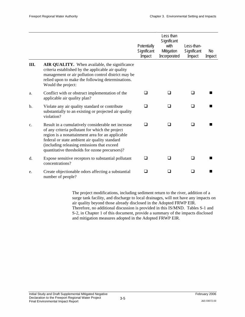
Freeport Regional Water Authority Chapter 3. Environmental Setting and Impacts
Initial Study and Draft Supplemental Mitigated Negative Declaration to the Freeport Regional Water Project Final Environmental Impact Report
3-5
February 2006
J&S 03072.03
PotentiallySignificant
Impact
Less than Significant
withMitigation
Incorporated
Less-than-Significant
ImpactNo
Impact
III. AIR QUALITY. When available, the significance
criteria established by the applicable air quality
management or air pollution control district may be
relied upon to make the following determinations.
Would the project:
a. Conflict with or obstruct implementation of the
applicable air quality plan?
b. Violate any air quality standard or contribute
substantially to an existing or projected air quality
violation?
c. Result in a cumulatively considerable net increase
of any criteria pollutant for which the project
region is a nonattainment area for an applicable
federal or state ambient air quality standard
(including releasing emissions that exceed
quantitative thresholds for ozone precursors)?
d. Expose sensitive receptors to substantial pollutant
concentrations?
e. Create objectionable odors affecting a substantial
number of people?
The project modifications, including sediment return to the river, addition of a
surge tank facility, and discharge to local drainages, will not have any impacts on
air quality beyond those already disclosed in the Adopted FRWP EIR.
Therefore, no additional discussion is provided in this IS/MND. Tables S-1 and
S-2, in Chapter 1 of this document, provide a summary of the impacts disclosed
and mitigation measures adopted in the Adopted FRWP EIR.

Freeport Regional Water Authority Chapter 3. Environmental Setting and Impacts
Initial Study and Draft Supplemental Mitigated Negative Declaration to the Freeport Regional Water Project Final Environmental Impact Report
3-6
February 2006
J&S 03072.03
PotentiallySignificant
Impact
Less than Significant
withMitigation
Incorporated
Less-than-Significant
ImpactNo
Impact
IV. BIOLOGICAL RESOURCES. Would the
project:
a. Have a substantial adverse effect, either directly or
through habitat modifications, on any species
identified as a candidate, sensitive, or special-status
species in local or regional plans, policies, or
regulations, or by the California Department of
Fish and Game or U.S. Fish and Wildlife Service?
b. Have a substantial adverse effect on any riparian
habitat or other sensitive natural community
identified in local or regional plans, policies, or
regulations, or by the California Department of
Fish and Game or U.S. Fish and Wildlife Service?
c. Have a substantial adverse effect on federally
protected wetlands as defined by Section 404 of the
Clean Water Act (including, but not limited to,
marshes, vernal pools, coastal wetlands, etc.)
through direct removal, filling, hydrological
interruption, or other means?
d. Interfere substantially with the movement of any
native resident or migratory fish or wildlife species
or with established native resident or migratory
wildlife corridors, or impede the use of native
wildlife nursery sites?
e. Conflict with any local policies or ordinances
protecting biological resources, such as a tree
preservation policy or ordinance?
f. Conflict with the provisions of an adopted habitat
conservation plan, natural community conservation
plan, or other approved local, regional, or state
habitat conservation plan?
Sediment Return to River
Fish are the only biological resources potentially affected by returning sediment
to the river at the intake facility, and salmonid are the fish species most likely to

Freeport Regional Water Authority Chapter 3. Environmental Setting and Impacts
Initial Study and Draft Supplemental Mitigated Negative Declaration to the Freeport Regional Water Project Final Environmental Impact Report
3-7
February 2006
J&S 03072.03
be affected. Resident fish species, including delta smelt, are well adapted to a
highly turbid system in which suspended sediment varies across a large range.
Use of the Lower Sacramento River by Salmon
The Sacramento River supports four races of Chinook salmon and steelhead
trout. There are fall, late-fall, winter and spring runs of Chinook salmon
characterized by their adult return timing to the river (Figure 8). Sacramento
River winter-run Chinook salmon are listed as endangered, and the spring run is
listed as threatened. Central Valley steelhead return in late winter and are listed
as threatened.
The lower Sacramento River is used by salmon and steelhead primarily for adult
and juvenile migrations. There is also likely some juvenile growth and rearing,
especially for fall-run Chinook salmon and other ocean-type juvenile migrants.
Otherwise, all spawning and early juvenile rearing takes place above Freeport.
Figure 8 provides approximate timing of adult and juvenile migrations through
the lower Sacramento River based on Fisher (1994) and Snider and Titus (2000).
Potential Sediment Effects on Salmon
Bash et al. (2001) characterize the effects of suspended sediment and turbidity on
salmonids into three general categories:
Physiological Behavioral Habitat
Gill trauma Avoidance Reduction in spawning habitat
Osmoregulation Territoriality Effect on hyporheic upwelling
Blood chemistry Foraging and predation Reduction in benthic invertebrate habitat
Reproduction and growth Homing and migration Damage to redds
The effects of sediment on salmon depend on temperature, size, and angularity of
the particles and the life stage (Bash et al. 2001) . In general, adverse effects of
turbidity increase with temperature, are greater for juveniles than for adults, and
highly angular particles may have a greater adverse effect than smooth or
rounded particles (Lake and Hinch 1999).
Physiological effects of particular relevance to this project are gill trauma and
osmoregulation. Gill trauma occurs when gills are damaged by passing high
levels of sediment across the gill membranes. Lake and Hinch (1999) found that
highly angular particles caused greater damage to the gills of coho salmon than
did smooth particles although angularity was not related to mortality. An LC50
value (e.g., a lethal concentration of a substance which kills 50% of a sample
population in a given time) of sockeye salmon increased with particle size (i.e.,
smaller particles are worse than larger ones). In laboratory experiments, cough
frequency of juvenile coho salmon was elevated at 240 mg/L (Bash et al. 2001) .
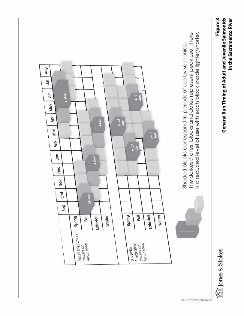
Fig
ure
8
Ge
ne
ral
Ru
n T
imin
g o
f A
du
lt a
nd
Ju
ve
nil
e S
alm
on
ids
in
th
e S
acr
am
en
to R
ive
r
03072.03 Neg Declaration (1-06)
21-Sep
Sha
de
d b
loc
ks c
orre
spo
nd t
o p
erio
ds
of u
se b
y sa
lmo
nid
s.Th
e d
ark
est
/ta
llest
blo
cks
and
da
tes
rep
rese
nt p
ea
k us
e. T
here
is a
red
uce
d le
vel o
f use
with
ea
ch
blo
ck
sha
de
lig
hte
r/sh
ort
er.

Freeport Regional Water Authority Chapter 3. Environmental Setting and Impacts
Initial Study and Draft Supplemental Mitigated Negative Declaration to the Freeport Regional Water Project Final Environmental Impact Report
3-8
February 2006
J&S 03072.03
Osmoregulation is a concern for salmonid adult and smolt transformation
between fresh and salt water. The project is near the Delta, where juvenile fish
are entering the critical life history phase. During the transition period, juvenile
salmonids are more susceptible to sediment impacts than they are at other times.
During smoltification, LC50s have been reported to decline to 1,500 mg/L but
rise to 30,000 mg/L during other periods (Bash et al. 2001) .
Behavioral effects that could be a concern include avoidance of high levels of
sediment by adult and juvenile salmonids as well as possible effects on foraging
and predation. Avoidance is a difficult parameter to measure because it occurs
relative to the ambient level in the environment. In other words, in a clear stream
fish may avoid a level of suspended sediment that will have no effect in a more
turbid environment. However, fish often encounter areas of higher turbidity as
they migrate past river confluences. While little is known about the fine scale
movement of adult or juvenile salmon around sediment plumes, natural sediment
plumes from turbid tributaries, at least, do not appear to appreciably impair
salmon migration. Where fish are actively feeding, increased turbidity can
decrease success (Bash et al. 2001) . Conversely, increased turbidity can provide
protection for fish being preyed upon.
Impact BIO-1: Impacts on Special-Status Fish Species
The overall effect of the Freeport project on adult and juvenile salmonids is
likely to be minimal. The potential for effects on salmonids is likely greatest for
adult fall-run Chinook salmon because their migration occurs when the ambient
turbidity level in the river is typically at the lowest and when flow diversion and
sediment return are typically the greatest. Other salmonids pass by the intake
facility during winter and spring months when ambient turbidity levels are both
typically much higher and variable while flow diversion and sediment return are
lower. Therefore, potential changes to ambient conditions that may occur in the
fall have the most potential to affect salmonids.
Based on available information (CH2M HILL 2005) and review of relevant
literature:
Sediment returned to the river is extracted from the river flow and, therefore,
introduces no additional chemical pollutants to the river.
While salmon may be expected to avoid the highest levels of sediment near
the point of discharge, the sediment plume will rapidly dissipate, and dilution
will reach approximately 300:1 within 500 feet downstream of the intake
facility. Therefore, the plume will rapidly reach suspended sediment levels
only slightly higher than ambient levels in the river.
Because of the size of the particles being returned to the river, it is likely that
a very small proportion of the returned sediment would temporarily settle
along the constructed and riprapped levee, and another portion would move
low in the water column where any potential for effects on salmonids is
likely low.

Freeport Regional Water Authority Chapter 3. Environmental Setting and Impacts
Initial Study and Draft Supplemental Mitigated Negative Declaration to the Freeport Regional Water Project Final Environmental Impact Report
3-9
February 2006
J&S 03072.03
Although standard modeling techniques predict the plume may be up to 200
feet wide 800 feet downstream of the facility, the river is approximately 800
feet wide in this area, thereby leaving a substantial portion of the river
unaffected. At 800 feet downstream, the dilution ratio is predicted to
approach 450:1. Therefore sediment levels downstream of the release will
rapidly approach ambient levels. In addition, it is unlikely that the
measurable plume will reach the full calculated width because of the location
of the sediment outlet. Thalweg flow should force the plume to stay
generally along the eastern bank of the river and mix into the river along the
edge of the higher-velocity flow.
The plume is not expected to have any measurable effect on salmonids
because: (a) the returned material is no different from that in the ambient
turbidity; (b) it will likely be spatially confined by flow; (c) the suspended
sediment levels rapidly will dilute to levels approaching ambient levels; (d)
downstream of the sediment release, levels of suspended sediment in the
plume are within the range of suspended sediment already occurring in the
river; and (e) regardless, the plume could be easily avoided and bypassed by
salmonids.
Because of the relatively larger size of particles returned to the river, effects
on visible turbidity will be confined within a short distance of the return
facility. Therefore, fish will likely not be substantially affected by the
increased turbidity.
In conclusion, the effects on fish of returning sediment to the river are less than
significant. No mitigation is required.
Surge Tank Facility
The surge tank facility will not have any impacts on biological resources beyond
those already disclosed in the Adopted FRWP EIR. The types of impacts
disclosed include those on vegetation and wetland resources and wildlife
resources. Therefore, no additional discussion is provided in this IS/MND.
Tables S-1 and S-2, in Chapter 1 of this document, provide a summary of the
impacts disclosed and mitigation measures adopted in the Adopted FRWP EIR.
Discharge to Local Drainages
All project pipelines require the capability to be drained for scheduled
maintenance and/or emergency procedures. Additionally, the segments of
pipeline that will only be used intermittently need to be drained when not in use.
In general, pipelines will be drained to existing local drainages.
A majority of the water will be drained by gravity flow. Once a majority of the
water has been drained by gravity, the remaining water in the pipeline will be
pumped out via smaller drain structures located at low points or other critical
flushing points along the system. In some cases, this includes appropriate

Freeport Regional Water Authority Chapter 3. Environmental Setting and Impacts
Initial Study and Draft Supplemental Mitigated Negative Declaration to the Freeport Regional Water Project Final Environmental Impact Report
3-10
February 2006
J&S 03072.03
drainage crossings such as local storm sewers, drainage channels, and sanitary
sewers.
Discharges will be required to meet several parameters required by the RWQCB,
including those for biochemical oxygen demand, total suspended solids,
settleable solids, pH, dissolved oxygen, temperature, and turbidity.
The biological communities in these local drainages vary, but they all provide
some level of habitat for various fish and/or wildlife species. Their condition
ranges from concrete-lined channels with minimal vegetation to natural streams
meandering through grasslands or oak woodlands, in some cases supporting
confined bands of riparian vegetation.
Impact BIO-2: Impacts on Biological Resources from Drainage of Continuous-Use Pipelines
The continuous-use pipelines will be drained only during infrequent periods of
scheduled maintenance or during an emergency. The majority of the water will
be drained by gravity into five stream channels. These five stream channels are a
key part of city and county local drainage systems and are regularly used to carry
substantial amounts of stormwater.
While the biological value of these streams varies to some degree, they are all
regularly maintained to ensure adequate capacity to convey stormwater. Some
channels are completely lined with concrete, some have concrete lining only on
the bottom of the channel and the side slopes support grasses and shrubs, and
others have no concrete lining and also support grasses and shrubs.
The channels that will receive the greatest volumes of water (Sump 28,
Meadowview Drainage Channel, Morrison Creek, Strawberry Creek, and Union
House Creek) will not be adversely affected by the proposed discharges. The
latter three, which support the most biological resources of the five, were
analyzed through a channel stability assessment for project design purposes.
Field observations conducted as a part of the study, as well as the hydraulic
analysis itself, conclude that the potential for long-term bed degradation and bed
scour is not significant. The hydraulic analysis considered flows ranging from
typical flood events up to the 500-year-flood event and concluded that the
channels were capable of handling the full range of events without resulting in
substantial changes to the stream channel or its vegetation. Discharges
associated with the project will be a small fraction of the floodflows analyzed in
the hydraulic analysis. Therefore, vegetation in these channels will not be
adversely affected by project discharges.
Since these flows will be well within the banks of these channels, any fish and
wildlife using the channels, including giant garter snake that may occupy
Morrison Creek, will not be displaced or otherwise adversely affected.

Freeport Regional Water Authority Chapter 3. Environmental Setting and Impacts
Initial Study and Draft Supplemental Mitigated Negative Declaration to the Freeport Regional Water Project Final Environmental Impact Report
3-11
February 2006
J&S 03072.03
While the remaining channels are generally smaller in size than the
aforementioned channels, the discharges they will receive are very small relative
to natural runoff rates, and they will be confined to existing, well-defined stream
channels. Discharges will be for a short duration and will be a small fraction of
the stream channel capacity. The additional water will be neutral or beneficial
for riparian vegetation, and it will not harm or disrupt fish or wildlife using the
stream corridor. Vegetation, fish, and wildlife in these channels will not be
adversely affected by project discharges.
As further described below under Water Quality, the quality of the water will not
affect any beneficial uses, including fisheries. Water in the buried pipeline will
remain at a relatively constant, cool temperature and will maintain suitable
characteristics such as levels of dissolved oxygen and pH because of the short
amount of time the water will be in the pipeline.
Therefore, this impact is less than significant. No mitigation is required.
Impact BIO-3: Impacts on Biological Resources from Drainage of Intermittent-Use Pipelines
The drainage of intermittent-use pipelines will occur no more than once a year,
primarily between December and March.
The stream channels vary in size but are all well-defined channels and provide
moderate to good biological values. The stream channels run through oak
woodlands and grasslands and in some cases are surrounded by bands of riparian
vegetation.
There should be no adverse operations-related biological impacts from these
discharges because the volumes will be extremely small relative to natural runoff
rates and they will be confined to existing, well-defined stream channels.
Discharges will be for a short duration and will be a small fraction of the stream
channel capacity. The additional water will be neutral or beneficial for riparian
vegetation, and it will not harm or disrupt fish or wildlife using the stream
corridor.
As further described below under Water Quality, the quality of the water will not
affect any beneficial uses, including fisheries. Water in the buried pipeline will
remain at a relatively constant, cool temperature and will maintain suitable
characteristics such as levels of dissolved oxygen and pH because of the short
amount of time the water will be in the pipeline. Additionally, the percentage of
flow attributable to project discharges in streams supporting or potentially
supporting special-status fish species (Mokelumne River, Dry Creek) is
extremely low and will not substantially affect existing conditions.
Therefore, this impact is less than significant. No mitigation is required.

Freeport Regional Water Authority Chapter 3. Environmental Setting and Impacts
Initial Study and Draft Supplemental Mitigated Negative Declaration to the Freeport Regional Water Project Final Environmental Impact Report
3-12
February 2006
J&S 03072.03
Impact BIO-4: Impacts on Riparian Vegetation from Construction of Drainage Facilities
Construction of the drainage facilities, including the energy dissipaters, will
cause the permanent loss of riparian habitat. Woody riparian communities
provide important functions and values, are regulated by state and federal
agencies, and are of concern to local planning departments. This impact is
significant. Implementation of the following mitigation measures will reduce
this impact to a less-than-significant level.
Mitigation Measure BIO-4a: Establish a Protection Buffer around Woody Riparian Communities To the extent feasible, a temporary construction buffer will be established for
each drainage in the project area that supports woody riparian vegetation and that
could be affected by construction activities. This buffer will be established in the
field and will generally extend from the outer edge of the riparian vegetation.
The width of the buffer will be identified before initiation of construction
activities and will be based on site-specific conditions, seasonal restrictions for
wildlife, local planning department specifications, and resource agency (e.g.,
USFWS and DFG) requirements. The outer edge of the designated riparian
protection buffer will be demarcated using flagging or temporary orange mesh
construction fencing.
Mitigation Measure BIO-4b: Compensate for Unavoidable Riparian Woodland Losses A combination of restoration and enhancement of degraded riparian sites will be
used to compensate for the very minor losses of this community that would result
from construction of the drainage facilities. Restoration will occur as close as
possible to the area affected, preferably along the same drainage that would
sustain the impacts.
Compensation for riparian community losses will encompass the goal of “no net
loss” of riparian habitat acres or values. Impacts on riparian communities will be
compensated for at a minimum ratio of 2:1 (2 acres restored for every 1 acre
affected). The ratio of trees and shrubs planted for each tree or shrub eliminated
will be determined on a site-by-site basis to ensure long-term replacement of
habitat functions and values. A revegetation plan will be prepared by a qualified
restoration ecologist and reviewed by the appropriate agencies. The revegetation
plan will specify the planting stock appropriate for the region and each site and
employ the most successful techniques available at the time of planting. Success
criteria will be established as part of the plan. Plantings will be monitored for 5
years to ensure they have established successfully. The riparian community
mitigation will be considered successful when sapling trees are established, no
longer require active management, and are arranged in groups that, when mature,
replicate the area, natural structure, and species composition of similar riparian
habitats in the region.

Freeport Regional Water Authority Chapter 3. Environmental Setting and Impacts
Initial Study and Draft Supplemental Mitigated Negative Declaration to the Freeport Regional Water Project Final Environmental Impact Report
3-13
February 2006
J&S 03072.03
PotentiallySignificant
Impact
Less than Significant
withMitigation
Incorporated
Less-than-Significant
ImpactNo
Impact
V. CULTURAL RESOURCES. Would the project:
a. Cause a substantial adverse change in the
significance of a historical resource as defined in
Section 15064.5?
b. Cause a substantial adverse change in the
significance of an archaeological resource pursuant
to Section 15064.5?
c. Directly or indirectly destroy a unique
paleontological resource or site or unique geologic
feature?
d. Disturb any human remains, including those
interred outside of formal cemeteries?
The project modifications, including sediment return to the river, addition of a
surge tank facility, and discharge to local drainages, will not have any impacts on
cultural resources beyond those already disclosed in the Adopted FRWP EIR.
Surveys previously conducted indicate no known cultural resources in areas
affected by new facilities. Therefore, no additional discussion is provided in this
IS/MND. Tables S-1 and S-2, in Chapter 1 of this document, provide a summary
of the impacts disclosed and mitigation measures adopted in the Adopted FRWP
EIR.

Freeport Regional Water Authority Chapter 3. Environmental Setting and Impacts
Initial Study and Draft Supplemental Mitigated Negative Declaration to the Freeport Regional Water Project Final Environmental Impact Report
3-14
February 2006
J&S 03072.03
PotentiallySignificant
Impact
Less than Significant
withMitigation
Incorporated
Less-than-Significant
ImpactNo
Impact
VI. GEOLOGY AND SOILS. Would the project:
a. Expose people or structures to potential substantial
adverse effects, including the risk of loss, injury, or
death involving:
1. Rupture of a known earthquake fault, as
delineated on the most recent Alquist-Priolo
Earthquake Fault Zoning Map issued by the
State Geologist for the area or based on other
substantial evidence of a known fault? Refer to
Division of Mines and Geology Special
Publication 42.
2. Strong seismic groundshaking?
3. Seismic-related ground failure, including
liquefaction?
4. Landslides?
b. Result in substantial soil erosion or the loss of
topsoil?
c. Be located on a geologic unit or soil that is unstable
or that would become unstable as a result of the
project and potentially result in an onsite or offsite
landslide, lateral spreading, subsidence,
liquefaction, or collapse?
d. Be located on expansive soil, as defined in Table
18-1-B of the Uniform Building Code (1994),
creating substantial risks to life or property?
e. Have soils incapable of adequately supporting the
use of septic tanks or alternative wastewater
disposal systems in areas where sewers are not
available for the disposal of wastewater?
The project changes associated with returning sediment to the river at the intake
facility and adding the surge tank facility will not result in any impacts related to
geology and soils beyond those already disclosed in the Adopted FRWP EIR and
are not discussed further in this section.

Freeport Regional Water Authority Chapter 3. Environmental Setting and Impacts
Initial Study and Draft Supplemental Mitigated Negative Declaration to the Freeport Regional Water Project Final Environmental Impact Report
3-15
February 2006
J&S 03072.03
Discharge to Local Drainages
As previously described, all project pipelines require the capability to be drained
for maintenance and/or emergency procedures. Additionally, the segments of
pipeline that will only be used intermittently need to be drained when not in use.
In general, pipelines will be drained to existing local drainages.
A majority of the water will be drained by gravity flow. Once a majority of the
water has been drained by gravity, the remaining water in the pipeline will be
pumped out via smaller drain structures located at low points or other critical
flushing points along the system. In some cases, these points include appropriate
drainage crossings such as local storm sewers, drainage channels, and sanitary
sewers.
The condition of the stream channels ranges from concrete-lined channels with
minimal vegetation to natural streams meandering through grasslands or oak
woodlands, in some cases supporting confined bands of riparian vegetation.
Impact GEO-1: Impacts on Stream Channels through Soil Erosion
The continuous-use pipelines will be drained only during infrequent periods of
maintenance or during an emergency. The majority of the water will be drained
by gravity into five stream channels. These five stream channels are a key part of
city and county local drainage systems and are regularly used to carry substantial
amounts of stormwater.
These streams are regularly maintained to ensure adequate capacity to convey
stormwater. Some channels are completely lined with concrete, some have
concrete lining only on the bottom of the channel and the side slopes support
grasses and shrubs, and others have no concrete lining and also support grasses
and shrubs.
The channels that will receive the greatest volumes of water (Sump 28,
Meadowview Drainage Channel, Morrison Creek, Strawberry Creek, and Union
House Creek) will not be adversely affected by the proposed discharges. The
latter three were analyzed through a channel stability assessment for project
design purposes. Field observations conducted as a part of the study, as well as
the hydraulic analysis itself, conclude that the potential for long-term bed
degradation and bed scour is not significant. The hydraulic analysis considered
flows ranging from typical flood events up to the 500-year-flood event and
concluded that the channels were capable of handling the full range of events
without resulting in substantial changes to the stream channel. Discharges
associated with the project will be a small fraction of the floodflows analyzed in
the hydraulic analysis and will not result in soil erosion. Therefore, geology and
soil resources in these channels will not be adversely affected by project
discharges.
Freeport Regional Water Authority Chapter 3. Environmental Setting and Impacts
Initial Study and Draft Supplemental Mitigated Negative Declaration to the Freeport Regional Water Project Final Environmental Impact Report
3-16
February 2006
J&S 03072.03
While the remaining channels that will be used for infrequent and/or intermittent
drainage vary in size (e.g., Mokelumne River, Dry Creek, Skunk Creek, Coyote
Creek, Bear Creek, and unnamed tributaries), the discharges they will receive are
very small relative to natural runoff rates, and they will be confined to existing,
well-defined stream channels. Discharges will be for a short duration and will be
a small fraction of the stream channel capacity. These flows will not result in
soil erosion. Therefore, geology and soil resources in these channels will not be
adversely affected by project discharges.
Therefore, this impact is less than significant. No mitigation is required.

Freeport Regional Water Authority Chapter 3. Environmental Setting and Impacts
Initial Study and Draft Supplemental Mitigated Negative Declaration to the Freeport Regional Water Project Final Environmental Impact Report
3-17
February 2006
J&S 03072.03
PotentiallySignificant
Impact
Less than Significant
withMitigation
Incorporated
Less-than-Significant
ImpactNo
Impact
VII. HAZARDS AND HAZARDOUS MATERIALS.
Would the project:
a. Create a significant hazard to the public or the
environment through the routine transport, use, or
disposal of hazardous materials?
b. Create a significant hazard to the public or the
environment through reasonably foreseeable upset
and accident conditions involving the release of
hazardous materials into the environment?
c. Emit hazardous emissions or involve handling
hazardous or acutely hazardous materials,
substances, or waste within one-quarter mile of an
existing or proposed school?
d. Be located on a site that is included on a list of
hazardous materials sites compiled pursuant to
Government Code Section 65962.5 and, as a result,
would it create a significant hazard to the public or
the environment?
e. Be located within an airport land use plan area or,
where such a plan has not been adopted, be within
two miles of a public airport or public use airport,
and result in a safety hazard for people residing or
working in the project area?
f. Be located within the vicinity of a private airstrip
and result in a safety hazard for people residing or
working in the project area?
g. Impair implementation of or physically interfere
with an adopted emergency response plan or
emergency evacuation plan?
h. Expose people or structures to a significant risk of
loss, injury, or death involving wildland fires,
including where wildlands are adjacent to
urbanized areas or where residences are intermixed
with wildlands?
The project modifications, including sediment return to the river, addition of a
surge tank facility, and discharge to local drainages, will not have any impacts
related to hazards and hazardous materials beyond those already disclosed in the
Freeport Regional Water Authority Chapter 3. Environmental Setting and Impacts
Initial Study and Draft Supplemental Mitigated Negative Declaration to the Freeport Regional Water Project Final Environmental Impact Report
3-18
February 2006
J&S 03072.03
Adopted FRWP EIR. Surveys previously conducted indicate no known
hazardous materials sites in areas affected by new facilities. Therefore, no
additional discussion is provided in this IS/MND. Tables S-1 and S-2, in Chapter
1 of this document, provide a summary of the impacts disclosed and mitigation
measures adopted in the Adopted FRWP EIR.

Freeport Regional Water Authority Chapter 3. Environmental Setting and Impacts
Initial Study and Draft Supplemental Mitigated Negative Declaration to the Freeport Regional Water Project Final Environmental Impact Report
3-19
February 2006
J&S 03072.03
PotentiallySignificant
Impact
Less than Significant
withMitigation
Incorporated
Less-than-Significant
ImpactNo
Impact
VIII. HYDROLOGY AND WATER QUALITY.
Would the project:
a. Violate any water quality standards or waste
discharge requirements?
b. Substantially deplete groundwater supplies or
interfere substantially with groundwater recharge,
resulting in a net deficit in aquifer volume or a
lowering of the local groundwater table level (e.g.,
the production rate of pre-existing nearby wells
would drop to a level that would not support
existing land uses or planned uses for which
permits have been granted)?
c. Substantially alter the existing drainage pattern of
the site or area, including through the alteration of
the course of a stream or river, in a manner that
would result in substantial erosion or siltation
onsite or offsite?
d. Substantially alter the existing drainage pattern of
the site or area, including through the alteration of
the course of a stream or river, or substantially
increase the rate or amount of surface runoff in a
manner that would result in flooding onsite or
offsite?
e. Create or contribute runoff water that would exceed
the capacity of existing or planned stormwater
drainage systems or provide substantial additional
sources of polluted runoff?
f. Otherwise substantially degrade water quality?
g. Place housing within a 100-year flood hazard area,
as mapped on a federal Flood Hazard Boundary or
Flood Insurance Rate Map or other flood hazard
delineation map?
h. Place within a 100-year flood hazard area
structures that would impede or redirect
floodflows?
i. Expose people or structures to a significant risk of
loss, injury, or death involving flooding, including
flooding as a result of the failure of a levee or dam?

Freeport Regional Water Authority Chapter 3. Environmental Setting and Impacts
Initial Study and Draft Supplemental Mitigated Negative Declaration to the Freeport Regional Water Project Final Environmental Impact Report
3-20
February 2006
J&S 03072.03
PotentiallySignificant
Impact
Less than Significant
withMitigation
Incorporated
Less-than-Significant
ImpactNo
Impact
j. Contribute to inundation by seiche, tsunami, or
mudflow?
Sediment Return to the River
The beneficial uses and water quality objectives for waters in the Sacramento
River Basin are established in the Water Quality Control Plan (Basin Plan) for
the Central Valley RWQCB. Water quality objectives are designed to protect
beneficial uses such as agricultural, municipal, and industrial supply; fish and
wildlife; and body contact and noncontact recreation. The Basin Plan contains
numerical and narrative water quality objectives for physical and chemical
parameters. Returning sediment to the river will require approval by the
RWQCB.
The Intake Facility is within the legal boundaries of the Delta, but not within the
Central Delta. Water quality objectives are based accordingly. Water quality
objectives for sediment, settleable material, and suspended material are defined
by the Basin Plan to “not be altered in such a manner as to cause nuisance or
adversely affect beneficial uses.”
The average annual sediment quantity returned to the river will be about one-fifth
of 1% (0.2%) of the total average annual suspended sediment quantity in the
river. More than 75% of the time, the sediment quantity returned to the river will
be less than 0.33% of the total suspended sediment quantity in the river at the
time. Less than 2% of the time, the sediment quantity returned to the river will be
more than 1% of the total suspended sediment quantity in the river.
The reach of the Sacramento River at the Intake Facility is not impaired for
turbidity, sediment, settleable material, or suspended material, as defined by the
2002 Clean Water Act Section 303(d) List of Water Quality Limited Segments.
A zone of dilution will be needed for the greater-than-ambient sediment
concentrations to meet the criteria set in the Basin Plan. A minimum dilution of
at least 100:1 will occur within 250 feet of the point of return and 200:1 within
500 feet downstream of the intake facility. A mean dilution within the plume
will be about 150:1 in 250 feet and about 280:1 in 500 feet. Therefore, the plume
will rapidly reach suspended sediment levels only slightly higher than ambient
levels in the river.
The receiving water (Sacramento River) flow is substantially greater than the
FRWP proposed return flow, thereby ensuring substantial dilution, as described

Freeport Regional Water Authority Chapter 3. Environmental Setting and Impacts
Initial Study and Draft Supplemental Mitigated Negative Declaration to the Freeport Regional Water Project Final Environmental Impact Report
3-21
February 2006
J&S 03072.03
above. Furthermore, the receiving water is not impaired by sediment or turbidity
and therefore has the assimilative capacity to accept the returned sediment while
not exceeding applicable water quality objectives at the edge of the mixing zone
or adversely affecting the river’s beneficial uses. The pH and temperature of the
return stream will be indistinguishable from river water.
Once the return flow is well mixed with the river flow, the actual effect of the
return flow system on river water quality will be inconsequential because the
quantity of sediment returned is very small relative to background. Sediment
collected in the intake forebay will have been in suspension in the river prior to
settling. Therefore, it should easily go back into suspension once returned to the
river.
In conclusion, the effects of returning sediment to the river on water quality are
less than significant. No mitigation is required.
Discharge to Local Drainages
As previously described, all project pipelines require the capability to be drained
for maintenance and/or emergency procedures. Additionally, the segments of
pipeline that will only be used intermittently need to be drained when not in use,
primarily between December and March. In general, pipelines will be drained to
existing local drainages.
A majority of the water will be drained by gravity backflow. Once a majority of
the water has been drained by gravity, the remaining water in the pipeline will be
pumped out via smaller drain structures located at low points or other critical
flushing points along the system. In some cases, these points include appropriate
drainage crossings such as local storm sewers, drainage channels, and sanitary
sewers.
Pipeline drainage will occur over a relatively short timeframe and will require up
to 2 weeks to complete.
Impact HYD-1: Degradation of Water Quality
There should be no substantial operations-related water quality impacts from
these discharges because the volumes will be small relative to natural runoff rates
and discharges will be conducted in a manner to meet regulatory requirements.
Project-related discharges will require authorization through the RWQCB
General Order for dewatering and other low-threat discharges to surface waters.
Discharges will be required to meet several parameters, including those for
biochemical oxygen demand, total suspended solids, settleable solids, pH,
dissolved oxygen, temperature, and turbidity. Discharges will be monitored and
regulated to meet these parameters as they relate to the quality of the receiving
waters.

Freeport Regional Water Authority Chapter 3. Environmental Setting and Impacts
Initial Study and Draft Supplemental Mitigated Negative Declaration to the Freeport Regional Water Project Final Environmental Impact Report
3-22
February 2006
J&S 03072.03
This impact is less than significant because beneficial uses of water will not be
adversely affected, existing adopted water quality standards will not be exceeded,
and no substantive effect on public health or environmental receptors will be
produced. No mitigation is required.
Impact HYD-2: Drainage Patterns
The continuous-use pipelines will be drained only during infrequent periods of
maintenance or during an emergency. The majority of the water will be drained
by gravity into five stream channels. These five stream channels are a key part of
city and county local drainage systems and are regularly used to carry substantial
amounts of stormwater.
These streams are regularly maintained to ensure adequate capacity to convey
stormwater. Some channels are completely lined with concrete, some have
concrete lining only on the bottom of the channel and the side slopes support
grasses and shrubs, and others have no concrete lining and also support grasses
and shrubs.
The channels that will receive the greatest volumes of water (Sump 28,
Meadowview Drainage Channel, Morrison Creek, Strawberry Creek, and Union
House Creek) will not be adversely affected by the proposed discharges. The
latter three were analyzed through a channel stability assessment for project
design purposes. Field observations conducted as a part of the study, as well as
the hydraulic analysis itself, conclude that the potential for long-term bed
degradation and bed scour is not significant. The hydraulic analysis considered
flows up to the 500-year-flood event. Discharges associated with the project will
be a small fraction of these floodflows, will not result in soil erosion or siltation,
and will not come close to being bank full flows. Therefore, drainage patterns in
these channels will not be adversely affected by project discharges.
While the remaining channels that will be used for infrequent and/or intermittent
drainage vary in size (e.g., Mokelumne River, Dry Creek, Skunk Creek, Coyote
Creek, Bear Creek, and unnamed tributaries), the discharges they will receive are
very small relative to natural runoff rates and they will be confined to existing,
well-defined stream channels. Discharges will be for a short duration and will be
a small fraction of the stream channel capacity, remaining substantially below
bank full flows. These flows will not result in soil erosion, siltation, or alteration
of drainage patterns. Therefore, drainage patterns in these channels will not be
adversely affected by project discharges.
Therefore, this impact is less than significant. No mitigation is required.

Freeport Regional Water Authority Chapter 3. Environmental Setting and Impacts
Initial Study and Draft Supplemental Mitigated Negative Declaration to the Freeport Regional Water Project Final Environmental Impact Report
3-23
February 2006
J&S 03072.03
PotentiallySignificant
Impact
Less than Significant
withMitigation
Incorporated
Less-than-Significant
ImpactNo
Impact
IX. LAND USE AND PLANNING. Would the
project:
a. Physically divide an established community?
b. Conflict with any applicable land use plan, policy,
or regulation of an agency with jurisdiction over
the project (including, but not limited to, a general
plan, specific plan, local coastal program, or zoning
ordinance) adopted for the purpose of avoiding or
mitigating an environmental effect?
c. Conflict with any applicable habitat conservation
plan or natural community conservation plan?
The project modifications, including sediment return to the river, addition of a
surge tank facility, and discharge to local drainages, will not have any impacts
related to land use and planning beyond those already disclosed in the Adopted
FRWP EIR. The surge tank will represent a change in land use, but these types
of impacts were addressed in the Adopted FRWP EIR and found to be less than
significant. Therefore, no additional discussion is provided in this IS/MND.
Tables S-1 and S-2, in Chapter 1 of this document, provide a summary of the
impacts disclosed and mitigation measures adopted in the Adopted FRWP EIR.

Freeport Regional Water Authority Chapter 3. Environmental Setting and Impacts
Initial Study and Draft Supplemental Mitigated Negative Declaration to the Freeport Regional Water Project Final Environmental Impact Report
3-24
February 2006
J&S 03072.03
PotentiallySignificant
Impact
Less than Significant
withMitigation
Incorporated
Less-than-Significant
ImpactNo
Impact
X. MINERAL RESOURCES. Would the project:
a. Result in the loss of availability of a known
mineral resource that would be of value to the
region and the residents of the state?
b. Result in the loss of availability of a locally
important mineral resource recovery site delineated
on a local general plan, specific plan, or other land
use plan?
The project modifications, including sediment return to the river, addition of a
surge tank facility, and discharge to local drainages, will not have any impacts on
mineral resources beyond those already disclosed in the Adopted FRWP EIR.
Therefore, no additional discussion is provided in this IS/MND. Tables S-1 and
S-2, in Chapter 1 of this document, provide a summary of the impacts disclosed
and mitigation measures adopted in the Adopted FRWP EIR.

Freeport Regional Water Authority Chapter 3. Environmental Setting and Impacts
Initial Study and Draft Supplemental Mitigated Negative Declaration to the Freeport Regional Water Project Final Environmental Impact Report
3-25
February 2006
J&S 03072.03
PotentiallySignificant
Impact
Less than Significant
withMitigation
Incorporated
Less-than-Significant
ImpactNo
Impact
XI. NOISE. Would the project:
a. Expose persons to or generate noise levels in
excess of standards established in a local general
plan or noise ordinance or applicable standards of
other agencies?
b. Expose persons to or generate excessive
groundborne vibration or groundborne noise
levels?
c. Result in a substantial permanent increase in
ambient noise levels in the project vicinity above
levels existing without the project?
d. Result in a substantial temporary or periodic
increase in ambient noise levels in the project
vicinity above levels existing without the project?
e. Be located within an airport land use plan area, or,
where such a plan has not been adopted, within two
miles of a public airport or public use airport and
expose people residing or working in the project
area to excessive noise levels?
f. Be located in the vicinity of a private airstrip and
expose people residing or working in the project
area to excessive noise levels?
The project changes associated with returning sediment to the river at the intake
facility and discharging water to local drainages will not result in any impacts
related to noise and are not discussed further in this section.
Surge Tank Facility
In general, a mix of developed, agricultural, and natural landscapes characterizes
the area surrounding the proposed surge tank facility. Development consists of
rural ranchettes with various types of outbuildings supporting residential and
agricultural purposes, a golf course and clubhouse, and roadways. Open space,
consisting of grazing lands with vernal pools and irrigated farmlands, is present
throughout the area.

Freeport Regional Water Authority Chapter 3. Environmental Setting and Impacts
Initial Study and Draft Supplemental Mitigated Negative Declaration to the Freeport Regional Water Project Final Environmental Impact Report
3-26
February 2006
J&S 03072.03
The surge tank facility will be located in Sacramento County. Ambient noise
levels in this area could be as low as 35–40 dBA Ldn. The nearest existing
sensitive receptor is approximately 100 feet from the proposed surge tank
facility.
County of Sacramento General Plan Noise Element
The Sacramento County General Plan Noise Element states that noise created by
new non-transportation noise sources may not exceed the noise level standards
shown in Table 3, as measured immediately within the property line of any
affected residentially designated land.
Table 3. Noise Level Performance Standardsa for Residential Areas Affected by
Non-Transportation Noiseb
Exterior Noise Level Standards (dBA)
Statistical Noise
Level Descriptor Daytime
(7:00 a.m. to 10:00 p.m.)
Nighttime
(10:00 p.m. to 7:00 a.m.)
L50 50 45
Lmax 70 65
a These standards are for planning purposes and may vary from standards of the
County Noise Ordinance, which are for enforcement purposes. b These standards apply to new or existing residential areas affected by new or existing
non-transportation sources.
County of Sacramento Noise Ordinance
The Sacramento County Noise Ordinance states that exterior noise limits shall
not exceed 50 dBA between 10:00 p.m. and 7:00 a.m. and 55 dBA between 7:00
a.m. and 10:00 p.m. for residential and agricultural areas. However, construction
activities between 6:00 a.m. and 8:00 p.m., Monday through Friday, and 7:00
a.m. and 8:00 p.m. on weekends are exempt from this ordinance. Agricultural
operations that occur between 6:00 a.m. and 8:00 p.m. are also exempt from the
ordinance.
Impact NOI-1: Increase in Noise Levels fromFacility Operation
The surge tank facility will require long-term operation of noise-generating
facilities, including the air compressor and, during power outages, the emergency
generator. As described in the Adopted FRWP EIR, FRWA has determined that
noise-generating facilities can be designed and constructed so that noise will

Freeport Regional Water Authority Chapter 3. Environmental Setting and Impacts
Initial Study and Draft Supplemental Mitigated Negative Declaration to the Freeport Regional Water Project Final Environmental Impact Report
3-27
February 2006
J&S 03072.03
remain within 5 dB of existing noise levels at the nearest existing sensitive
receptor locations. This will be accomplished through design features such as
noise dampening enclosures.

Freeport Regional Water Authority Chapter 3. Environmental Setting and Impacts
Initial Study and Draft Supplemental Mitigated Negative Declaration to the Freeport Regional Water Project Final Environmental Impact Report
3-28
February 2006
J&S 03072.03
PotentiallySignificant
Impact
Less than Significant
withMitigation
Incorporated
Less-than-Significant
ImpactNo
Impact
XII. POPULATION AND HOUSING. Would the
project:
a. Induce substantial population growth in an area,
either directly (e.g., by proposing new homes and
businesses) or indirectly (e.g., through extension of
roads or other infrastructure)?
b. Displace a substantial number of existing housing
units, necessitating the construction of replacement
housing elsewhere?
c. Displace a substantial number of people,
necessitating the construction of replacement
housing elsewhere?
The project modifications, including sediment return to the river, addition of a
surge tank facility, and discharge to local drainages, will not have any impacts
related to population and housing beyond those already disclosed in the Adopted
FRWP EIR. Therefore, no additional discussion is provided in this IS/MND.
Tables S-1 and S-2, in Chapter 1 of this document, provide a summary of the
impacts disclosed and mitigation measures adopted in the Adopted FRWP EIR.

Freeport Regional Water Authority Chapter 3. Environmental Setting and Impacts
Initial Study and Draft Supplemental Mitigated Negative Declaration to the Freeport Regional Water Project Final Environmental Impact Report
3-29
February 2006
J&S 03072.03
PotentiallySignificant
Impact
Less than Significant
withMitigation
Incorporated
Less-than-Significant
ImpactNo
Impact
XIII. PUBLIC SERVICES. Would the project:
a. Result in substantial adverse physical impacts
associated with the provision of new or physically
altered governmental facilities or a need for new or
physically altered governmental facilities, the
construction of which could cause significant
environmental impacts, in order to maintain
acceptable service ratios, response times, or other
performance objectives for any of the following
public services:
Fire protection?
Police protection?
Schools?
Parks?
Other public facilities?
The project modifications, including sediment return to the river, addition of a
surge tank facility, and discharge to local drainages, will not have any impacts
related to public services beyond those already disclosed in the Adopted FRWP
EIR. Therefore, no additional discussion is provided in this IS/MND. Tables S-1
and S-2, in Chapter 1 of this document, provide a summary of the impacts
disclosed and mitigation measures adopted in the Adopted FRWP EIR.

Freeport Regional Water Authority Chapter 3. Environmental Setting and Impacts
Initial Study and Draft Supplemental Mitigated Negative Declaration to the Freeport Regional Water Project Final Environmental Impact Report
3-30
February 2006
J&S 03072.03
PotentiallySignificant
Impact
Less than Significant
withMitigation
Incorporated
Less-than-Significant
ImpactNo
Impact
XIV. RECREATION. Would the project:
a. Increase the use of existing neighborhood and
regional parks or other recreational facilities such
that substantial physical deterioration of the facility
would occur or be accelerated?
b. Include recreational facilities or require the
construction or expansion of recreational facilities
that might have an adverse physical effect on the
environment?
The project modifications, including sediment return to the river, addition of a
surge tank facility, and discharge to local drainages, will not have any impacts on
recreation resources beyond those already disclosed in the Adopted FRWP EIR.
Therefore, no additional discussion is provided in this IS/MND. Tables S-1 and
S-2, in Chapter 1 of this document, provide a summary of the impacts disclosed
and mitigation measures adopted in the Adopted FRWP EIR.

Freeport Regional Water Authority Chapter 3. Environmental Setting and Impacts
Initial Study and Draft Supplemental Mitigated Negative Declaration to the Freeport Regional Water Project Final Environmental Impact Report
3-31
February 2006
J&S 03072.03
PotentiallySignificant
Impact
Less than Significant
withMitigation
Incorporated
Less-than-Significant
ImpactNo
Impact
XV. TRANSPORTATION/TRAFFIC. Would the
project:
a. Cause an increase in traffic that is substantial in
relation to the existing traffic load and capacity of
the street system (i.e., result in a substantial
increase in the number of vehicle trips, the volume-
to-capacity ratio on roads, or congestion at
intersections)?
b. Cause, either individually or cumulatively,
exceedance of a level-of-service standard
established by the county congestion management
agency for designated roads or highways?
c. Result in a change in air traffic patterns, including
either an increase in traffic levels or a change in
location that results in substantial safety risks?
d. Substantially increase hazards because of a design
feature (e.g., sharp curves or dangerous
intersections) or incompatible uses (e.g., farm
equipment)?
e. Result in inadequate emergency access?
f. Result in inadequate parking capacity?
g. Conflict with adopted policies, plans, or programs
supporting alternative transportation (e.g., bus
turnouts, bicycle racks)?
The project modifications, including sediment return to the river, addition of a
surge tank facility, and discharge to local drainages, will not have any impacts
related to transportation or traffic beyond those already disclosed in the Adopted
FRWP EIR because none of the facilities are located in roadways or will generate
additional traffic. Returning sediment to the river will reduce the traffic
associated with removal of sediment from the settling basins. Therefore, no
additional discussion is provided in this IS/MND. Tables S-1 and S-2, in Chapter
1 of this document, provide a summary of the impacts disclosed and mitigation
measures adopted in the Adopted FRWP EIR.
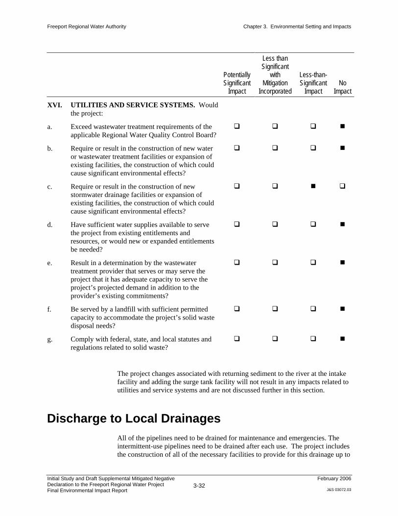
Freeport Regional Water Authority Chapter 3. Environmental Setting and Impacts
Initial Study and Draft Supplemental Mitigated Negative Declaration to the Freeport Regional Water Project Final Environmental Impact Report
3-32
February 2006
J&S 03072.03
PotentiallySignificant
Impact
Less than Significant
withMitigation
Incorporated
Less-than-Significant
ImpactNo
Impact
XVI. UTILITIES AND SERVICE SYSTEMS. Would
the project:
a. Exceed wastewater treatment requirements of the
applicable Regional Water Quality Control Board?
b. Require or result in the construction of new water
or wastewater treatment facilities or expansion of
existing facilities, the construction of which could
cause significant environmental effects?
c. Require or result in the construction of new
stormwater drainage facilities or expansion of
existing facilities, the construction of which could
cause significant environmental effects?
d. Have sufficient water supplies available to serve
the project from existing entitlements and
resources, or would new or expanded entitlements
be needed?
e. Result in a determination by the wastewater
treatment provider that serves or may serve the
project that it has adequate capacity to serve the
project’s projected demand in addition to the
provider’s existing commitments?
f. Be served by a landfill with sufficient permitted
capacity to accommodate the project’s solid waste
disposal needs?
g. Comply with federal, state, and local statutes and
regulations related to solid waste?
The project changes associated with returning sediment to the river at the intake
facility and adding the surge tank facility will not result in any impacts related to
utilities and service systems and are not discussed further in this section.
Discharge to Local Drainages
All of the pipelines need to be drained for maintenance and emergencies. The
intermittent-use pipelines need to be drained after each use. The project includes
the construction of all of the necessary facilities to provide for this drainage up to

Freeport Regional Water Authority Chapter 3. Environmental Setting and Impacts
Initial Study and Draft Supplemental Mitigated Negative Declaration to the Freeport Regional Water Project Final Environmental Impact Report
3-33
February 2006
J&S 03072.03
the point that the discharges reach existing, well-defined drainage channels such
as streams. Drainage facilities include piping and energy-dissipation structures.
In conclusion, no drainage facilities beyond those included in the project
description in the Adopted FRWP EIR are needed as a result of project
construction and operation. Therefore, this impact is less-than-significant. No
mitigation is required.

Freeport Regional Water Authority Chapter 3. Environmental Setting and Impacts
Initial Study and Draft Supplemental Mitigated Negative Declaration to the Freeport Regional Water Project Final Environmental Impact Report
3-34
February 2006
J&S 03072.03
PotentiallySignificant
Impact
Less than Significant
withMitigation
Incorporated
Less-than-Significant
ImpactNo
Impact
XVII. MANDATORY FINDINGS OF
SIGNIFICANCE.
a. Does the project have the potential to degrade the
quality of the environment, substantially reduce the
habitat of a fish or wildlife species, cause a fish or
wildlife population to drop below self-sustaining
levels, threaten to eliminate a plant or animal
community, substantially reduce the number or
restrict the range of a rare or endangered plant or
animal, or eliminate important examples of the
major periods of California history or prehistory?
b. Does the project have impacts that are individually
limited but cumulatively considerable?
(“Cumulatively considerable” means that the
incremental effects of a project are considerable
when viewed in connection with the effects of past
projects, the effects of other current projects, and
the effects of probable future projects.)
c. Does the project have environmental effects that
will cause substantial adverse effects on human
beings, either directly or indirectly?
The project modifications—sediment return to the river, addition of a surge tank
facility, and discharge to local drainages—will not have cumulatively
considerable impacts beyond those already disclosed in the Adopted FRWP EIR
and presented in Table S-3. Therefore, no additional discussion is provided in
this IS/MND.

Ta
ble
S-3
.S
um
mary
of P
revio
usly
Addre
ssed S
ignific
ant C
um
ula
tive Im
pacts
and M
itig
ation M
easure
s fro
m the A
dopte
d F
RW
P E
IR for
the
Appro
ved A
ltern
ative
Page 1
of 2
Res
ourc
e T
opic
/Im
pac
t M
itig
atio
n M
easu
re
Res
ult
Hyd
rolo
gy, W
ate
r S
up
ply
, an
d P
ow
er—
No p
roje
ct-
rela
ted c
ontr
ibuti
on
Wate
r Q
uali
ty—
No p
roje
ct-r
elat
ed c
ontr
ibuti
on
Fis
h—
No
pro
ject
-rel
ated
contr
ibu
tion
Rec
reati
on
—N
o p
roje
ct-r
elat
ed c
ontr
ibuti
on
Veg
etati
on
an
d W
etla
nd
Res
ou
rces
Eff
ects
of
loca
l an
d r
egio
nal
pro
ject
s an
d g
ener
al g
row
th i
n
the
reg
ion
, in
co
mb
inat
ion
wit
h t
he
FR
WP
, on
th
e
cum
ula
tive
loss
of
iden
tifi
ed s
ensi
tive
reso
urc
es,
incl
udin
g
wet
lan
ds
and
rip
aria
n w
oo
dla
nd
s.
Imp
lem
enti
ng
all
mit
igat
ion
mea
sure
s d
escr
ibed
in
Ch
apte
r
7,
“Veg
etat
ion a
nd W
etla
nd R
esourc
es,”
wil
l el
imin
ate
any
contr
ibuti
on t
o c
um
ula
tive
effe
cts.
No
t cu
mu
lati
vel
y c
on
sid
erab
le
Wil
dli
fe
Eff
ects
of
loca
l an
d r
egio
nal
pro
ject
s an
d g
ener
al g
row
th i
n
the
reg
ion
on
th
e cu
mu
lati
ve
loss
of
iden
tifi
ed s
ensi
tiv
e
reso
urc
es,
incl
udin
g h
abit
ats
for
sensi
tive
wil
dli
fe s
pec
ies.
Imp
lem
enti
ng
all
mit
igat
ion
mea
sure
s d
escr
ibed
in
Ch
apte
r
8,
“Wil
dli
fe,”
wil
l el
imin
ate
any c
ontr
ibuti
on t
o c
um
ula
tive
effe
cts.
No
t cu
mu
lati
vel
y c
on
sid
erab
le
Geo
logy, S
oil
s, S
eism
icit
y, an
d G
rou
nd
wate
r—N
o
signif
ican
t im
pac
ts
La
nd
Use
—N
o p
roje
ct-r
elat
ed c
on
trib
uti
on
Agri
cult
ura
l R
esou
rces
Eff
ects
of
loca
l an
d r
egio
nal
pro
ject
s an
d g
ener
al g
row
th i
n
the
reg
ion
, in
co
mb
inat
ion
wit
h t
he
FR
WP
, on
th
e
cum
ula
tive
loss
of
pri
me
agri
cult
ura
l la
nds.
No m
itig
atio
n a
vai
lable
to r
educe
eff
ect
to l
ess
than
cum
ula
tiv
ely c
on
sid
erab
le
SU
Tra
ffic
an
d T
ran
spo
rta
tio
n—
No p
roje
ct-r
elat
ed
con
trib
uti
on
Air
Qu
ali
ty—
No p
roje
ct-r
elat
ed c
ontr
ibuti
on

Ta
ble
S-3
. C
ontinued
Page 2
of
2
Res
ourc
e T
opic
/Im
pac
t M
itig
atio
n M
easu
re
Res
ult
No
ise—
No
pro
ject
-rel
ated
con
trib
uti
on
Pu
bli
c H
ealt
h a
nd
Sa
fety
—N
o p
roje
ct-r
elat
ed
con
trib
uti
on
Vis
ua
l R
eso
urc
es—
No
pro
ject
-rel
ated
con
trib
uti
on
Cu
ltu
ral
Res
ou
rces
Eff
ects
of
loca
l an
d r
egio
nal
pro
ject
s an
d g
ener
al g
row
th i
n
the
regio
n o
n t
he
cum
ula
tiv
e lo
ss o
f cu
ltura
l (a
rcheo
logic
al
and h
isto
ric)
res
ourc
es.
Imp
lem
enti
ng
all
mit
igat
ion
mea
sure
s d
escr
ibed
in
Ch
apte
r
17,
“Cult
ura
l R
esourc
es,”
wil
l el
imin
ate
any c
ontr
ibuti
on t
o
cum
ula
tive
effe
cts.
No
t cu
mu
lati
vel
y c
on
sid
erab
le
SU
=
S
ignif
ican
t an
d u
nav
oid
able
Initial Study and Draft Supplemental Mitigated Negative Declaration to the Freeport Regional Water Project Final Environmental Impact Report
4-1
February 2006
J&S 03072.03
Chapter 4
List of Preparers and References
List of Preparers
Jones & Stokes
Gregg Ellis
Harlan Glines
Chip McConnahah
Andrea Mauro
Darle Tilly
References
Printed References
Bash, J., C. Berman, and S. Bolton. 2001. Effects of turbidity and suspended solids on salmonids. Prepared for Washington Department of Transportation
by University of Washington, Center for Streamside Studies, Seattle, WA;
Report, 74 pages.
Fisher, F. W. 1994. Past and present status of Central Valley Chinook salmon.
Conservation Biology 8:870-873.
Lake, R. G., and S. G. Hinch. 1999. Acute effects of suspended sediment
angularity on juvenile coho salmon (Oncorhynchus kisutch). Canadian Journal of Fisheries and Aquatic Sciences 56:862-867.
Snider, B., and R. G. Titus. 2000. Timing, composition and abundance of juvenile anadromous salmonid emigration in the Sacramento River near Knights Landing October 1997–September 1998. California Department of
Fish and Game Habitat Conservation Division, Sacramento, CA Stream
Evaluation Program Technical Report 00-05,70 pages

Freeport Regional Water Authority Chapter 3. Environmental Setting and Impacts
Initial Study and Draft Supplemental Mitigated Negative Declaration to the Freeport Regional Water Project Final Environmental Impact Report
4-2
February 2006
J&S 03072.03
CH2M HILL. 2005. Freeport Regional Water Project—Sediment Return Flow
Analysis. Technical memorandum. October. Prepared for Freeport
Regional Water Authority.
WRECO. 2005. Channel stability assessment report, FRWA Pipeline Facilities Project, Sacramento County. October. Prepared for Freeport Regional
Water Authority and Kennedy/Jenks Consultants. Walnut Creek, CA.