Initial Joint Polar System (IJPS) Era Processing and ... · Initial Joint Polar System (IJPS) ......
26
Initial Joint Polar System (IJPS) Era Processing and Beyond at the Information Processing Division (IPD) of the Office of Satellite Data Processing and Distribution Vince Tabor Office of Satellite Data Processing and Distribution ITSC – Beijing, May 30, 2005
Transcript of Initial Joint Polar System (IJPS) Era Processing and ... · Initial Joint Polar System (IJPS) ......
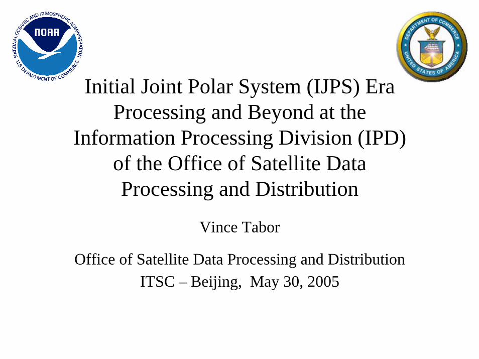
Initial Joint Polar System (IJPS) Era Processing and Beyond at the
Information Processing Division (IPD) of the Office of Satellite Data Processing and Distribution
Vince Tabor
Office of Satellite Data Processing and DistributionITSC – Beijing, May 30, 2005
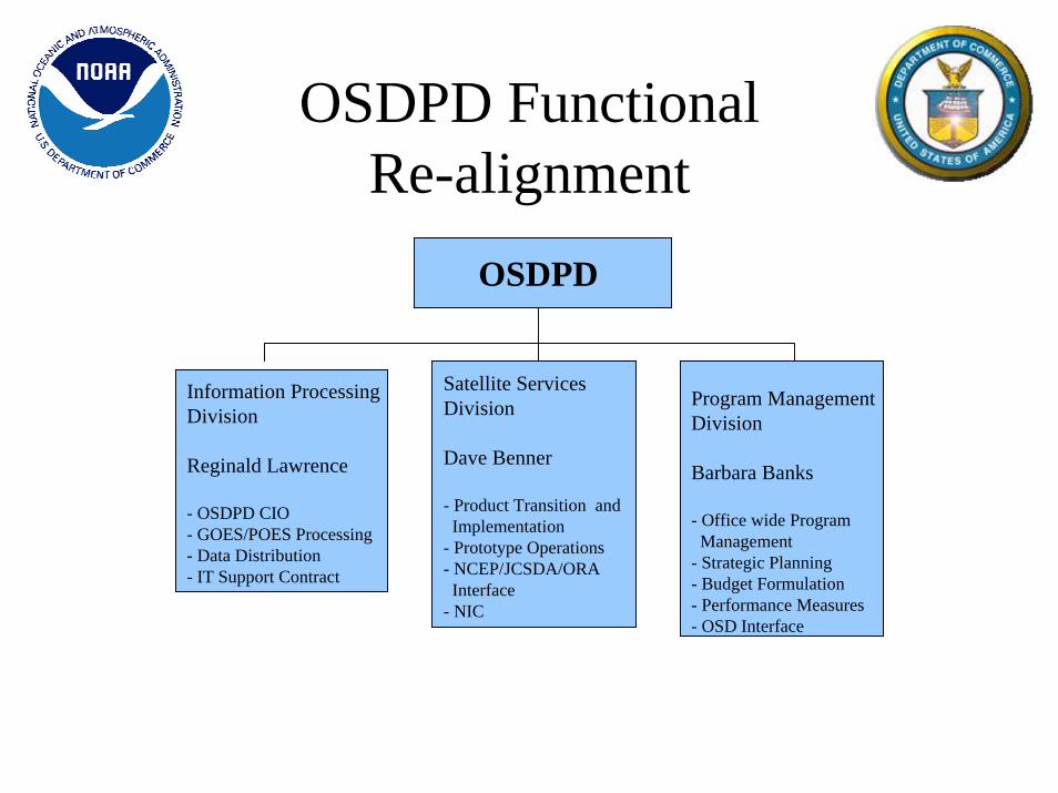
OSDPD Functional Re-alignment
Satellite ServicesDivision
Dave Benner
- Product Transition and Implementation
- Prototype Operations- NCEP/JCSDA/ORA Interface
- NIC
Program ManagementDivision
Barbara Banks
- Office wide ProgramManagement
- Strategic Planning- Budget Formulation- Performance Measures- OSD Interface
Information ProcessingDivision
Reginald Lawrence
- OSDPD CIO- GOES/POES Processing - Data Distribution- IT Support Contract
OSDPD

A New Era was Launched May, 20 2005

NOAA-18 Visible Image May 21, 2005
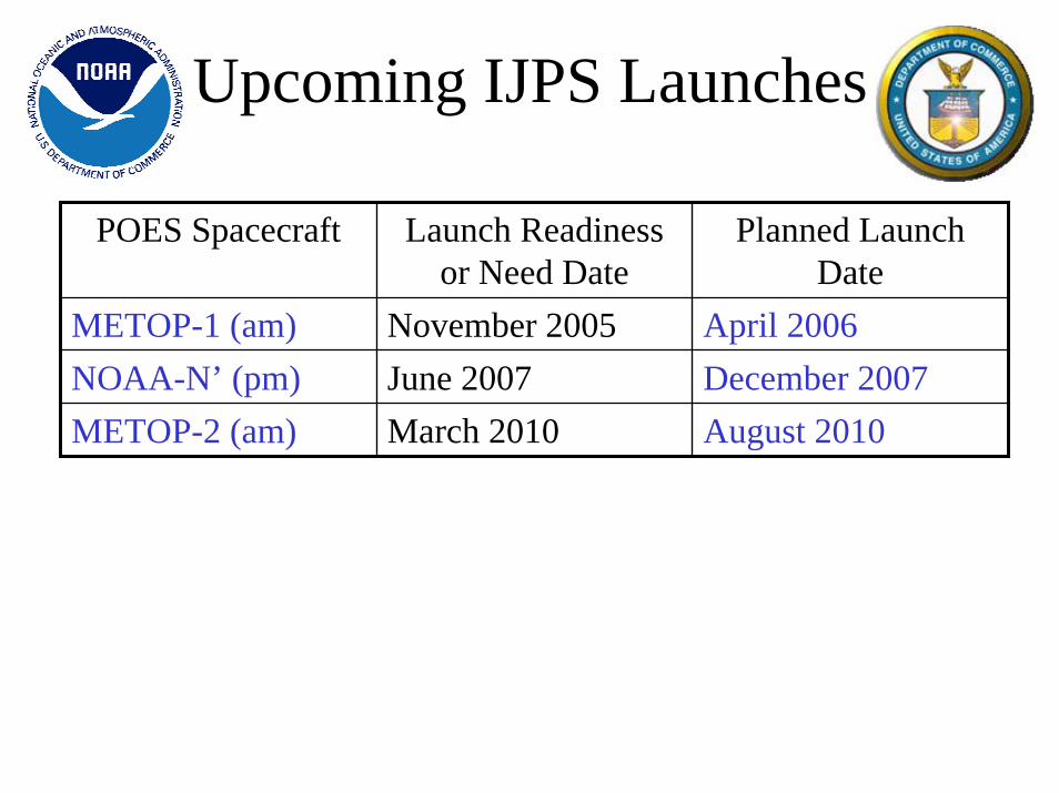
Upcoming IJPS Launches
POES Spacecraft Launch Readiness or Need Date
Planned Launch Date
METOP-1 (am) November 2005 April 2006NOAA-N’ (pm) June 2007 December 2007METOP-2 (am) March 2010 August 2010

Major IJPS Era Changes • New Preprocessing Software• New Data Processing Platform• New Advanced Front End Processor
(AFEP)• New Distribution System• New Facility• New Preprocessor for Metop• New Schemes for More Timely Data

Modifications Implemented in New
Preprocessor • On April 28, implemented new Preprocessor and 1b
format • Incorporated MHS Code
– MHS Replaced AMSU-B on NOAA-N
• Field of View (FOV) Size Change for HIRS– Field of View Changed from 20km to 10km on HIRS/4

• HIRS specific calibration and format changes– Calibration Modified for HIRS/4
• Take into account 5th Internal Warm Target (PRT)
• Third telescope temperature sensor • Patch Temperature changed from 100 to 95K• Added extra bit to the electronic serial number in the Digital A data stream Element 63
Bits 40-44
• HIRS specific calibration and format changes (cont.)– HIRS Calibration Algorithm Version 4.0
• New algorithm to be introduced as a supplement or replacement tocurrent operational HIRS calibration algorithm
• Lunar Contamination Detection and Correct– Lunar contamination detection added
Modifications Implemented in New
Preprocessor

• AMSU-A Changes– Lunar contamination detection and correction
• Required minor change to 1b format– Header and Data record
• Plan to change implement in Earth Location System
– Still working on correction for sudden jumps in the calibration counts (NOAA-17 Channel 3 & Metopanomaly)
• Required minor change to 1b format– Header and Data record
Modifications Implemented in New
Processor
Modifications Implemented in New
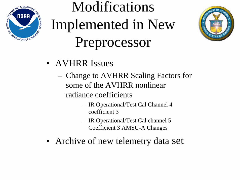
Preprocessor • AVHRR Issues
– Change to AVHRR Scaling Factors for some of the AVHRR nonlinear radiance coefficients
– IR Operational/Test Cal Channel 4 coefficient 3
– IR Operational/Test Cal channel 5 Coefficient 3 AMSU-A Changes
• Archive of new telemetry data set
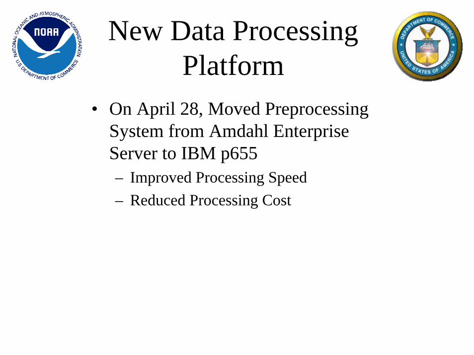
New Data Processing Platform
• On April 28, Moved Preprocessing System from Amdahl Enterprise Server to IBM p655– Improved Processing Speed– Reduced Processing Cost

• Reason for change– Replace out dated Front End Processor
(FEP)– Allow Ingest of Metop CCSDS data
• Internal Tests are being conducted– Encountered Problems with Interface to
Satellite Operations Control Center (SOCC)
• Will resume testing with user community
• Transition to AFEP soon
New Advanced Front End Processor (AFEP)
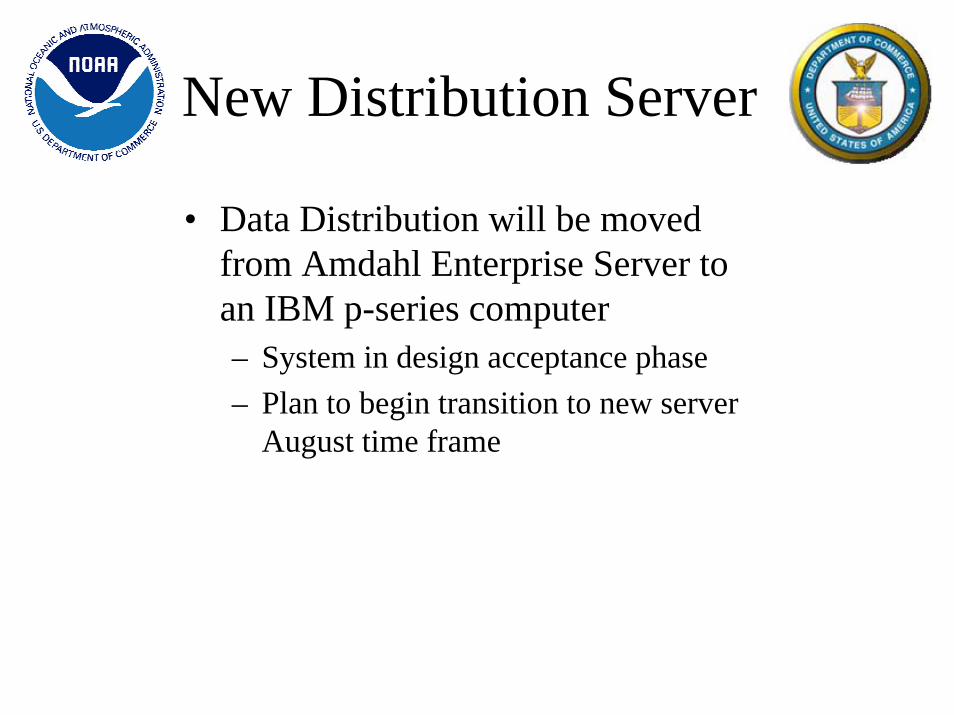
New Distribution Server
• Data Distribution will be moved from Amdahl Enterprise Server to an IBM p-series computer– System in design acceptance phase– Plan to begin transition to new server
August time frame

Move to New Facility
• IPD will move to new NOAA Satellite Operations Facility (NSOF) – Scheduled to begin moving equipment
August time frame– Scheduled to begin moving staff
October time frame– Plan to complete transition by January– No interruption to service plan
• Metop Development is underway• Plan to employ pipeline processing scheme to reduce data
age• Data age should be more constant using this scheme• User with timeliness requirements may elect to receive
data granules for Metop• User without timeliness requirements may elect to receive
full orbit files • NOAA may decide to employ pipeline processing scheme
for NOAA satellites
Metop Processing

Other Schemes for Improved Data Timeliness
• Eumetsat NOAA-N & N’ Blind Orbit Support – Plan to employ pipeline processing
scheme
• Blind Orbit Support for KLM series– OSD is investigating avenues for
obtaining blind orbits for KLM series of satellites
Eumetsat Unique Instrument Processing
Plans• Receive ASCAT, GOME, GRAS 1b data from
Eumetsat • Receive full resolution ASCAT 1b file from
Eumetsat– May elect to perform L0 processing for ASCAT
• Receive IASI 1c Data from Eumetsat– Plan to generate PCs and reconstructed radiance– May generate cloud cleared radiances
in future

Beyond IJPS: Continuing Current Non-NOAA
Satellite Activities
Selection Criteria:
• Receiving raw Terra (MODIS) and Aqua (AIRS, MODIS, AMSR-E) data in real time from NASA
• Receiving raw QuikSCAT (SeaWINDS) data in real time from NASA
• Receiving processed TRMM products from NASA in near real time
• Receiving JASON-1 products from NASA/JPL
• Receiving raw WindSAT data from IPO

Beyond IJPS: Jason-2
•Jason-2 provides continuity of sea surface height measurements beyond Topex/Poseidon and Jason-1, which is used in NOAA operations
– Jason-1 is a cooperative program between NASA and the French Space Agency (CNES)
•NOAA and EUMETSAT have committed to join this partnership for Jason-2
•NOAA will leverage expertise from NASA and CNES and our own expertise in building ground systems and operating satellites
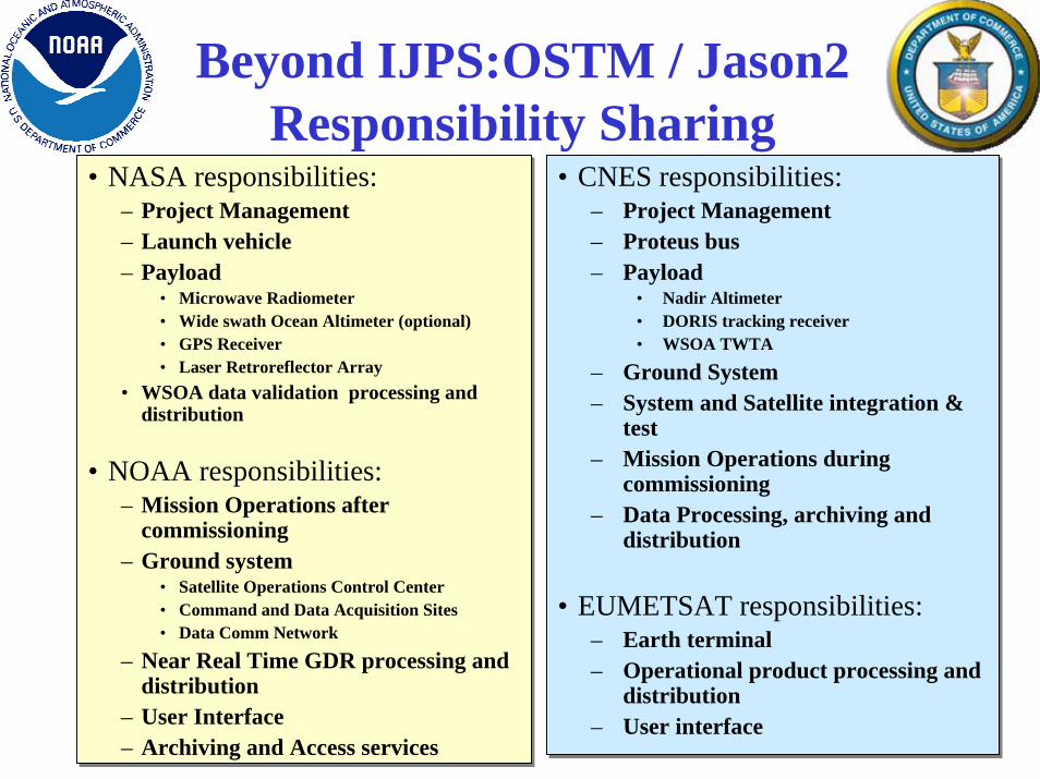
• NASA responsibilities:– Project Management – Launch vehicle – Payload
• Microwave Radiometer• Wide swath Ocean Altimeter (optional)• GPS Receiver• Laser Retroreflector Array
• WSOA data validation processing and distribution
• NOAA responsibilities:– Mission Operations after
commissioning– Ground system
• Satellite Operations Control Center• Command and Data Acquisition Sites• Data Comm Network
– Near Real Time GDR processing and distribution
– User Interface– Archiving and Access services
• CNES responsibilities:– Project Management– Proteus bus– Payload
• Nadir Altimeter• DORIS tracking receiver• WSOA TWTA
– Ground System– System and Satellite integration &
test– Mission Operations during
commissioning– Data Processing, archiving and
distribution
• EUMETSAT responsibilities:– Earth terminal– Operational product processing and
distribution– User interface
Beyond IJPS:OSTM / Jason2 Responsibility Sharing

Beyond IJPS:Jason - Data Flow
Wallops, VA Fairbanks, AK
Jason-2
EUMETSAT, Darmstadt, Germany
CNES, Toulouse, France
Usingen, Germany
NASA/JPL – Pasadena, CANOAA Satellite Operations Facility Suitland, MD
Mission Data
Operational Products
Customers

DMSP (Defense Meteorological
Satellite Program)
EOS (Earth Observing System)
NPOESS (National Polar Orbiting Operational
Environmental Satellite System)
Sensor data rate: 1.5 MbpsData latency: 100-150 min.
15 Mbps sensor data rateData latency: 100-180 min.Data availability: 98%Ground revisit time: 12 hrs.
20 Mbps sensor data rateData latency: 28 min.Data availability: 99.98%Autonomy capability: 60 daysSelective encryption/deniabilityGround revisit time: 4-6 hrs.
Beyond IJPS: Evolutionary Roadmap
POES (Polar Orbiting Operational
Environmental Satellites)
NPP (NPOESS Preparatory Program)
1960 - 2000 2000 - 2010 2010 – 2020+
NESDISAFWA
C3SegmentC3Segment Field
Terminal SegmentFieldTerminal Segment
SvalbardPrimary T&CNPP SMD
SvalbardPrimary T&CNPP SMD
TDRSS
LaunchSupportSegment
LaunchSupportSegment
NPP (1030)NPP
(1030)
MMC at SuitlandFlight Operations Team• Enterprise Management• Mission Management• Satellite Operations• Data Monitoring & Recovery
White Sands ComplexLEO & A Backup T&C
White Sands ComplexLEO & A Backup T&C
TDRSS
SDS
Data Handling Node, Front End ProcessorOne full set resides in each of the 2 Centrals
NPP Stored Mission DataCommand and Telemetry
Interface Data Processing SegmentInterface Data Processing SegmentOne full set resides in each of the 2 CentralsOne full set resides in each of the 2 Centrals
Data MgtData MgtInfraInfra
IngestIngest
Cal/ValCal/Val
Proc
ess
Proc
ess
Data DelData Del
Data MgtData MgtInfraInfra
IngestIngest
Cal/ValCal/Val
Proc
ess
Proc
ess
Data DelData Del
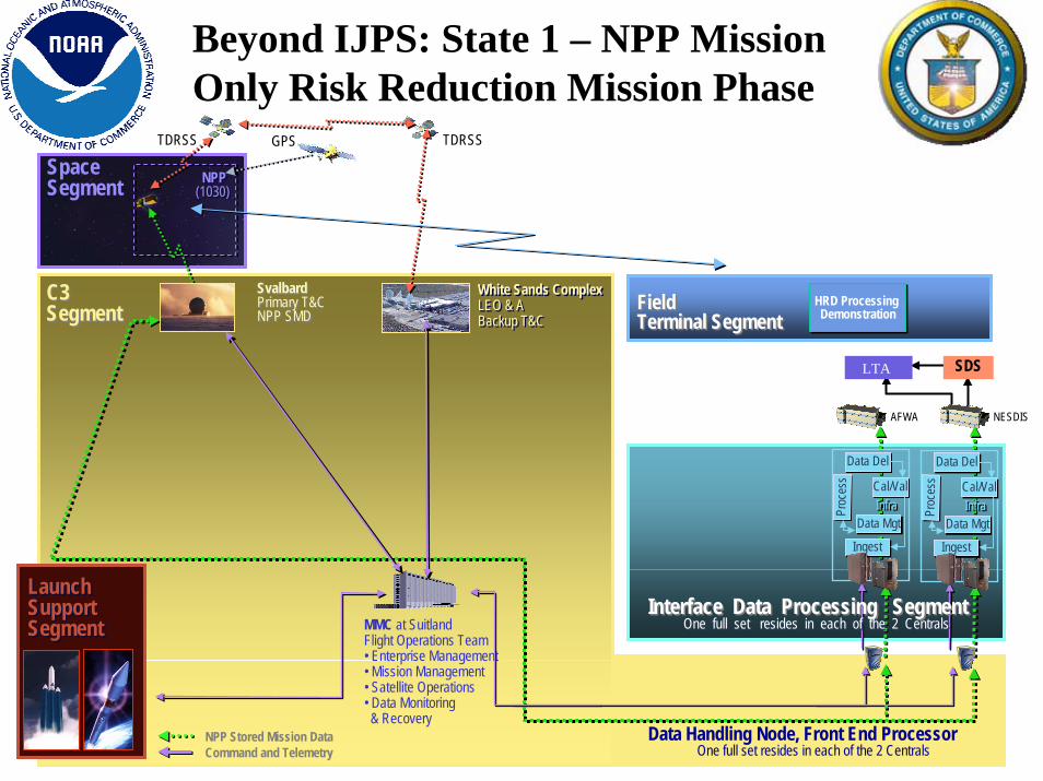
Beyond IJPS: State 1 – NPP Mission Only Risk Reduction Mission Phase
HRD Processing Demonstration
HRD Processing Demonstration
GPS
LTA
SpaceSegment
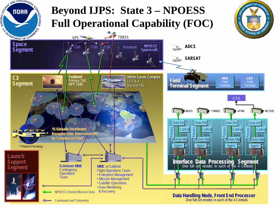
NESDISAFWANAVO FNMOC
SpaceSegment
C3SegmentC3Segment
1330 1730 2130
FieldTerminal SegmentFieldTerminal Segment
GPS
SvalbardPrimary T&CNPP SMD
SvalbardPrimary T&CNPP SMD
TDRSS
Residuals NPOESSSpacecraft
LaunchSupportSegment
LaunchSupportSegment MMC at Suitland
Flight Operations Team• Enterprise Management• Mission Management• Satellite Operations• Data Monitoring & Recovery
White Sands ComplexLEO & A Backup T&C
White Sands ComplexLEO & A Backup T&C
ADCS
SARSAT
HRDField
Terminal
HRDField
Terminal
LRDField
Terminal
LRDField
Terminal
Schriever MMCContingency Operations Team
Data Handling Node, Front End ProcessorOne full set resides in each of the 4 Centrals
15 Globally DistributedReceptor Sites Interconnectedby Commercial Fiber
15 Globally DistributedReceptor Sites Interconnectedby Commercial Fiber
NPOESS Stored Mission Data
Command and Telemetry
Interface Data Processing SegmentInterface Data Processing SegmentOne full set resides in each of the 4 CentralsOne full set resides in each of the 4 Centrals
Data MgtData MgtInfraInfra
IngestIngest
Cal/ValCal/Val
Proc
ess
Proc
ess
Data DelData Del
Data MgtData MgtInfraInfra
IngestIngest
Cal/ValCal/Val
Proc
ess
Proc
ess
Data DelData Del
Data MgtData MgtInfraInfra
IngestIngest
Cal/ValCal/Val
Proc
ess
Proc
ess
Data DelData Del
Data MgtData MgtInfraInfra
IngestIngest
Cal/ValCal/Val
Proc
ess
Proc
ess
Data DelData Del
* Patent Pending
*
Beyond IJPS: State 3 – NPOESS Full Operational Capability (FOC)
LTA
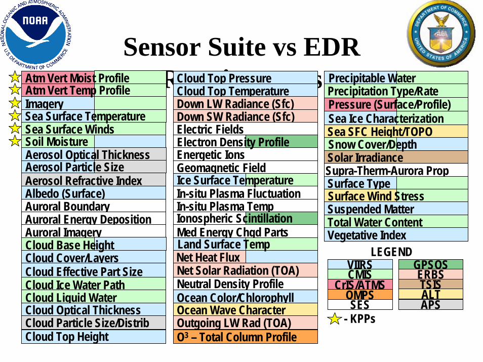
Sensor Suite vs EDR Requirements Precipitation Type/Rate
Sea SFC Height/TOPO
Solar IrradianceSupra-Therm-Aurora PropSurface Type
Suspended MatterTotal Water ContentVegetative Index
Surface Wind Stress
Snow Cover/Depth
Cloud Top PressureCloud Top TemperatureDown LW Radiance (Sfc)Down SW Radiance (Sfc)Electric Fields
Energetic IonsGeomagnetic Field
In-situ Plasma FluctuationIn-situ Plasma Temp
Med Energy Chgd Parts
Net Solar Radiation (TOA)Neutral Density ProfileOcean Color/ChlorophyllOcean Wave CharacterOutgoing LW Rad (TOA)O3 – Total Column Profile
Electron Density Profile
Ionospheric Scintillation
Ice Surface Temperature
Land Surface TempNet Heat Flux
Imagery
Sea Surface Winds
Aerosol Refractive IndexAlbedo (Surface)Auroral BoundaryAuroral Energy DepositionAuroral Imagery
Cloud Cover/LayersCloud Effective Part SizeCloud Ice Water PathCloud Liquid WaterCloud Optical ThicknessCloud Particle Size/DistribCloud Top Height
Atm Vert Moist ProfileAtm Vert Temp Profile
Sea Surface Temperature
Cloud Base HeightVIIRSCMIS
CrIS/ATMSSES
OMPS
GPSOSTSISERBSALTAPS
LEGEND
- KPPs
Precipitable Water
Soil MoistureAerosol Optical ThicknessAerosol Particle Size
Pressure (Surface/Profile)Sea Ice Characterization

Conclusion
• There are many changes planned for the IJPS era and Beyond at IPD. These changes are required to keep up with changes in instrumentation, missions or to improve service. IPD will work with the user community to minimize or eliminate any negative impacts.
Selection Criteria:


![Globalization, Culture, and Identities in Crisis...P1: GDX International Journal of Politics, Culture and Society [ijps] ph152-ijps-452813 October 1, 2002 19:27 Style file version](https://static.fdocuments.in/doc/165x107/5e88de5c0d7f6f112a4a7c31/globalization-culture-and-identities-in-crisis-p1-gdx-international-journal.jpg)