The shortcomings of conservation strategies in inhabited areas, a case study of zakynthos, greece (l
Upload
anna-boldinaCategory
view
229download
2description

2. Grand Union Canal,Paddington branch.
3. Park in “green net” of London. 4. Schemes. 5. Photos.
SITE SURVEYLOCATION:WILLESDEN JUNCTION POSTCODE:NW2BOROUGHS:BRENT,EALING,HAMMERTHMITH&FULHAMLANDOWNER:RAIL NETWORK
Location Map
INHABITED 3D PARK
Existing situation 1:7000
SITE
EXISTING ADJACENT HOUSING
EXISTING HOUSING ON THE SITE
WORMWOOD SCRUBS PARK
ST'MARY'S CEMENTARY
LITTLE SCRUBS
WILLESDENJUNCTIONSTATION
The space is situated on the North-East of London, being forgotten between 3 boroughs: Brent, Ealing and Hammerthmith&Fulham. Main problem of the area is a huge gap in urban fabric, dehiscing on the body of a city. Grand Union Canal(Paddington branch) goes right in the middle of the site. It could be the PEARL OF THE AREA, but it is isolated from londoners by railways and industrial objects,sides of the canal are covered with waste.I want to fix it.
Trains require big space to turn, so big areas between curved railways are abandoned or ineffectively used for warehouses. and open air stores.
At the moment the site is extrimly pedestrian-unfriendly.perimeters of “ISLANDS ON INACCESSIBILITY” reach 3 km.Even though inhabitants of the area are probably avare of the harm of cars to the invironment- nobody would walk such distances every day, so “islands of inaccessibility makethe site unsustainable.
Site is sitting on a grand union canal, so it has potentialof being a part of LEISURE-CULTURE LINE along the canalthat could be a part of preparation for Olimpix 2012, as canal is connected to Olimpix site.
Cold wet weather makes riverside of Themes unpopular. I think that canal can take the part of a “most pleasant place in London”. It has long history, it has life to watch (boats, birds) ,it has connection to landmark places of London: big transport junctions :St Pancras and Paddigton, Regent’s park, Camden-town and goes up to Hayers, Droyton and West Hyde. Public area along the canal (or instead of river as in Valencia) has an advantage of being continuous, as traffic goes above it by bridges.
Unique park in east-central London is a necessary landmark for the area of solid rows of terraced houses and industry.On the map of green areas of London we can see that Willesden junction is unfairly empty.
1. Site planScale 1:500
1.
2
3
4. 5.
INHABITED 3D PROPOSAL
PARK
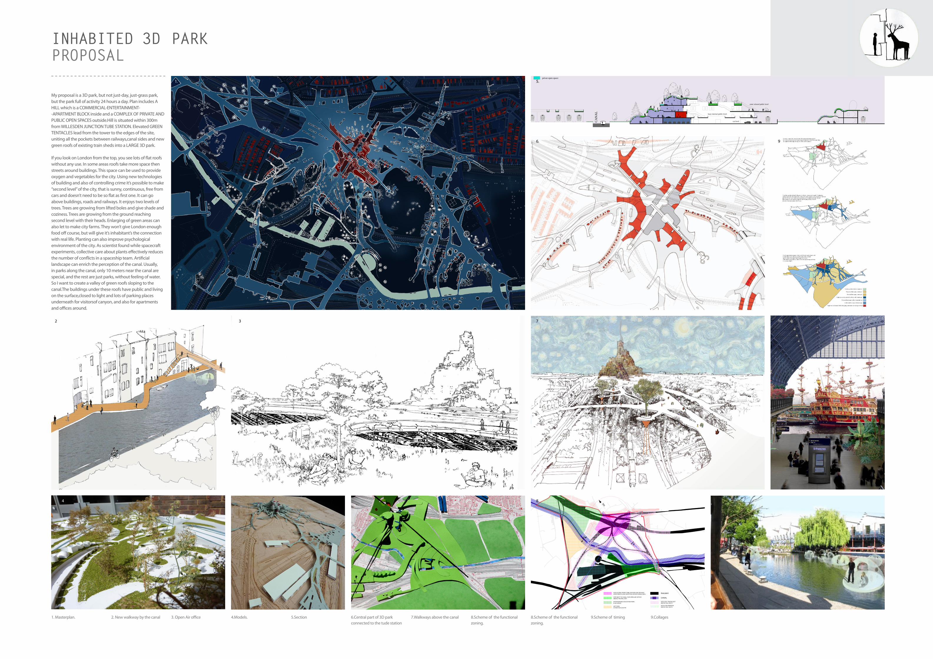
My proposal is a 3D park, but not just-day, just-grass park, but the park full of activity 24 hours a day. Plan includes A HILL which is a COMMERCIAL-ENTERTAINMENT--APARTMENT BLOCK inside and a COMPLEX OF PRIVATE ANDPUBLIC OPEN SPACES outside.Hill is situated within 300mfrom WILLESDEN JUNCTION TUBE STATION. Elevated GREEN TENTACLES lead from the tower to the edges of the site, uniting all the pockets between railways,canal sides and new green roofs of existing train sheds into a LARGE 3D park.
If you look on London from the top, you see lots of flat roofswithout any use. In some areas roofs take more space thenstreets around buildings. This space can be used to provideoxygen and vegetables for the city. Using new technologies of building and also of controlling crime it’s possible to make “second level” of the city, that is sunny, continuous, free from cars and doesn’t need to be so flat as first one. It can go above buildings, roads and railways. It enjoys two levels of trees. Trees are growing from lifted boles and give shade and coziness. Trees are growing from the ground reachingsecond level with their heads. Enlarging of green areas can also let to make city farms. They won’t give London enough food off course, but will give it’s inhabitant’s the connection with real life. Planting can also improve psychological environment of the city. As scientist found while spacecraft experiments, collective care about plants effectively reduces the number of conflicts in a spaceship team. Artificial landscape can enrich the perception of the canal. Usually,in parks along the canal, only 10 meters near the canal arespecial, and the rest are just parks, without feeling of water.So I want to create a valley of green roofs sloping to the canal.The buildings under these roofs have public and living on the surface,closed to light and lots of parking places underneath for visitorsof canyon, and also for apartments and offices around.
1. Masterplan. 2. New walkway by the canal 3. Open Air office 4.Models. 5.Section 6.Central part of 3D park connected to the tude station
7.Walkways above the canal 8.Scheme of the functional zoning.
8.Scheme of the functional zoning.
9.Scheme of timing 9.Collages
CA
NA
L
car level
buzy internal public level
outer relaxed public level
CROSS-SECTION OF THE NOTH SIDE OF THE CANYON 1:200
public
parking
public open space
semi-privat open space
privat open space
apartment
Zoning 1:7000
300
RAILWAYSITE IN 300m FROM TUBE STATION FOR OFFICES,APARTMENTS AND SHOPPING-ENTARTAINING MALL
CANALSITE NEXT TO CANAL FOR OPEN-AIR OFFICEABOVE THE RAIL WAY
SITE FOR "TENTACLES"ABOVE RAIL WAYS
ENTERTAINING-EDUCATION PARKIN 3D SPACE
ART PARKEXHIBITION CENTRE
"MOVING" PARKABOVE THE RAILWAY
SITES FOR BRIDGESABOVE RAIL WAYS
GREEN ROOFSON EXISTING BUILDINGS
120
60
1. 5.
6.
7
8
2
3
3
4
9
10