Infrastructure Delivery Plan - Cotswold District · Infrastructure Delivery Plan (IDP) for Land...
73
Infrastructure Delivery Plan
-
Upload
nguyenkhue -
Category
Documents
-
view
223 -
download
0
Transcript of Infrastructure Delivery Plan - Cotswold District · Infrastructure Delivery Plan (IDP) for Land...
Infrastructure Delivery Plan

Land South of Chesterton, Cirencester Infrastructure Delivery Plan, 2017
2
Contents 1. Introduction 3 2. Strategic Site Allocation 6
3. Planning Application Development Proposals 20
4. Planning Application Impacts 24
5. Infrastructure Proposals 27
6. Infrastructure Implementation 66
Appendix 1 - Links to Relevant Planning Application Documents
Land South of Chesterton, Cirencester Infrastructure Delivery Plan, 2017
3
1. Introduction
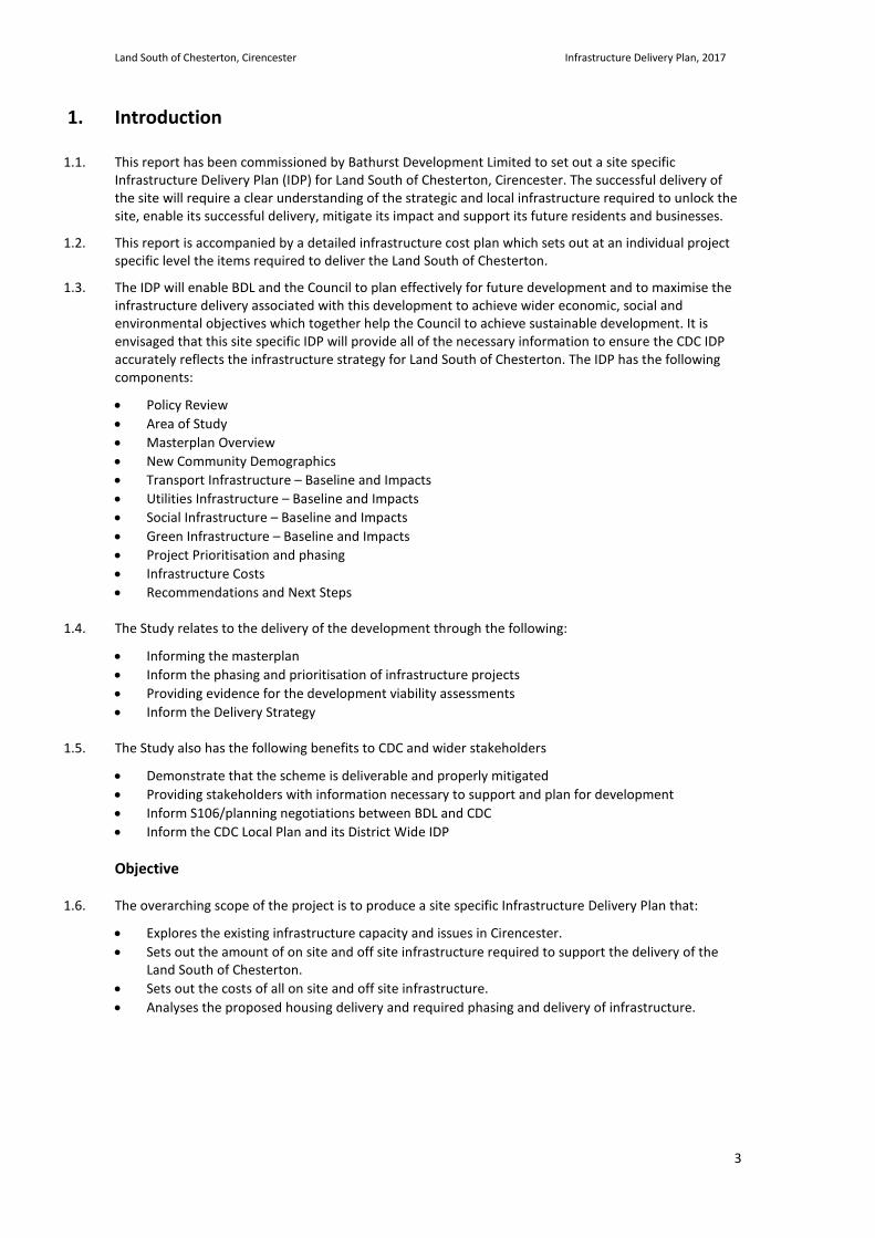
1.1. This report has been commissioned by Bathurst Development Limited to set out a site specific Infrastructure Delivery Plan (IDP) for Land South of Chesterton, Cirencester. The successful delivery of the site will require a clear understanding of the strategic and local infrastructure required to unlock the site, enable its successful delivery, mitigate its impact and support its future residents and businesses.
1.2. This report is accompanied by a detailed infrastructure cost plan which sets out at an individual project specific level the items required to deliver the Land South of Chesterton.
1.3. The IDP will enable BDL and the Council to plan effectively for future development and to maximise the infrastructure delivery associated with this development to achieve wider economic, social and environmental objectives which together help the Council to achieve sustainable development. It is envisaged that this site specific IDP will provide all of the necessary information to ensure the CDC IDP accurately reflects the infrastructure strategy for Land South of Chesterton. The IDP has the following components:
• Policy Review • Area of Study • Masterplan Overview • New Community Demographics • Transport Infrastructure – Baseline and Impacts • Utilities Infrastructure – Baseline and Impacts • Social Infrastructure – Baseline and Impacts • Green Infrastructure – Baseline and Impacts • Project Prioritisation and phasing • Infrastructure Costs • Recommendations and Next Steps
1.4. The Study relates to the delivery of the development through the following:
• Informing the masterplan • Inform the phasing and prioritisation of infrastructure projects • Providing evidence for the development viability assessments • Inform the Delivery Strategy
1.5. The Study also has the following benefits to CDC and wider stakeholders
• Demonstrate that the scheme is deliverable and properly mitigated • Providing stakeholders with information necessary to support and plan for development • Inform S106/planning negotiations between BDL and CDC • Inform the CDC Local Plan and its District Wide IDP
Objective
1.6. The overarching scope of the project is to produce a site specific Infrastructure Delivery Plan that:
• Explores the existing infrastructure capacity and issues in Cirencester. • Sets out the amount of on site and off site infrastructure required to support the delivery of the
Land South of Chesterton. • Sets out the costs of all on site and off site infrastructure. • Analyses the proposed housing delivery and required phasing and delivery of infrastructure.
Land South of Chesterton, Cirencester Infrastructure Delivery Plan, 2017
4
Scope
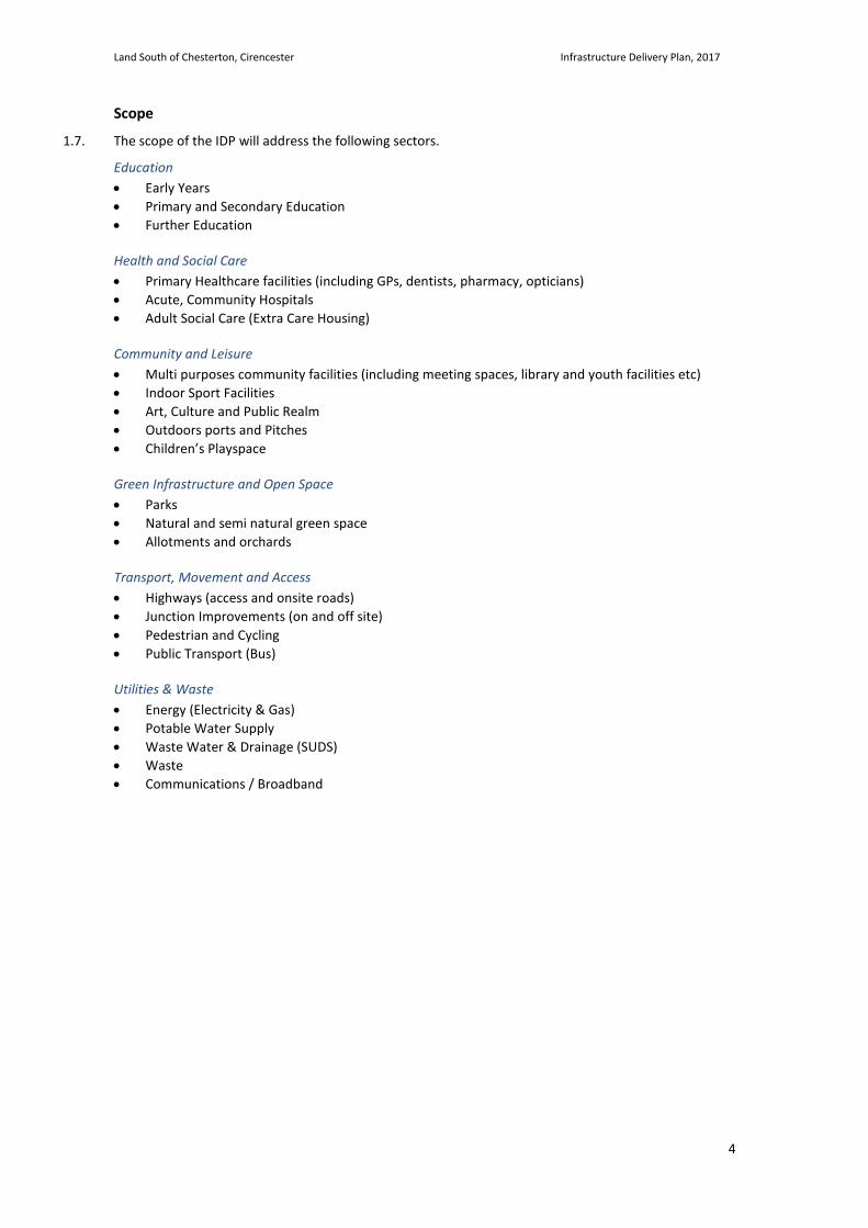
1.7. The scope of the IDP will address the following sectors.
Education • Early Years • Primary and Secondary Education • Further Education
Health and Social Care • Primary Healthcare facilities (including GPs, dentists, pharmacy, opticians) • Acute, Community Hospitals • Adult Social Care (Extra Care Housing)
Community and Leisure • Multi purposes community facilities (including meeting spaces, library and youth facilities etc) • Indoor Sport Facilities • Art, Culture and Public Realm • Outdoors ports and Pitches • Children’s Playspace
Green Infrastructure and Open Space • Parks • Natural and semi natural green space • Allotments and orchards
Transport, Movement and Access • Highways (access and onsite roads) • Junction Improvements (on and off site) • Pedestrian and Cycling • Public Transport (Bus)
Utilities & Waste • Energy (Electricity & Gas) • Potable Water Supply • Waste Water & Drainage (SUDS) • Waste • Communications / Broadband
Land South of Chesterton, Cirencester Infrastructure Delivery Plan, 2017
5
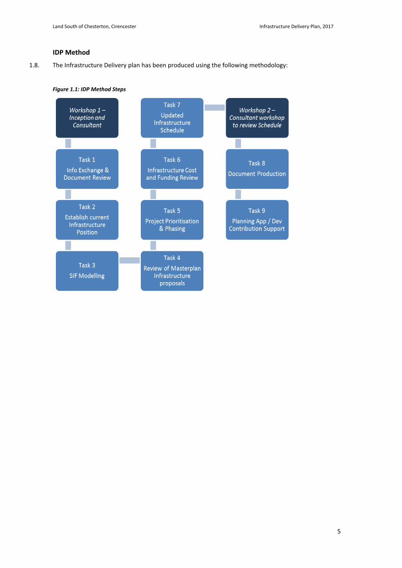
IDP Method
1.8. The Infrastructure Delivery plan has been produced using the following methodology:
Figure 1.1: IDP Method Steps
Land South of Chesterton, Cirencester Infrastructure Delivery Plan, 2017
6
2. Strategic Site Allocation
Site Location Regional Context
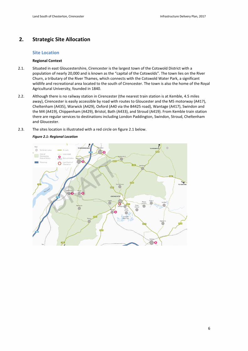
2.1. Situated in east Gloucestershire, Cirencester is the largest town of the Cotswold District with a population of nearly 20,000 and is known as the “capital of the Cotswolds”. The town lies on the River Churn, a tributary of the River Thames, which connects with the Cotswold Water Park, a significant wildlife and recreational area located to the south of Cirencester. The town is also the home of the Royal Agricultural University, founded in 1840.
2.2. Although there is no railway station in Cirencester (the nearest train station is at Kemble, 4.5 miles away), Cirencester is easily accessible by road with routes to Gloucester and the M5 motorway (A417), Cheltenham (A435), Warwick (A429), Oxford (A40 via the B4425 road), Wantage (A417), Swindon and the M4 (A419), Chippenham (A429), Bristol, Bath (A433), and Stroud (A419). From Kemble train station there are regular services to destinations including London Paddington, Swindon, Stroud, Cheltenham and Gloucester.
2.3. The sites location is illustrated with a red circle on figure 2.1 below.
Figure 2.1: Regional Location
Land South of Chesterton, Cirencester Infrastructure Delivery Plan, 2017
7
Site Location
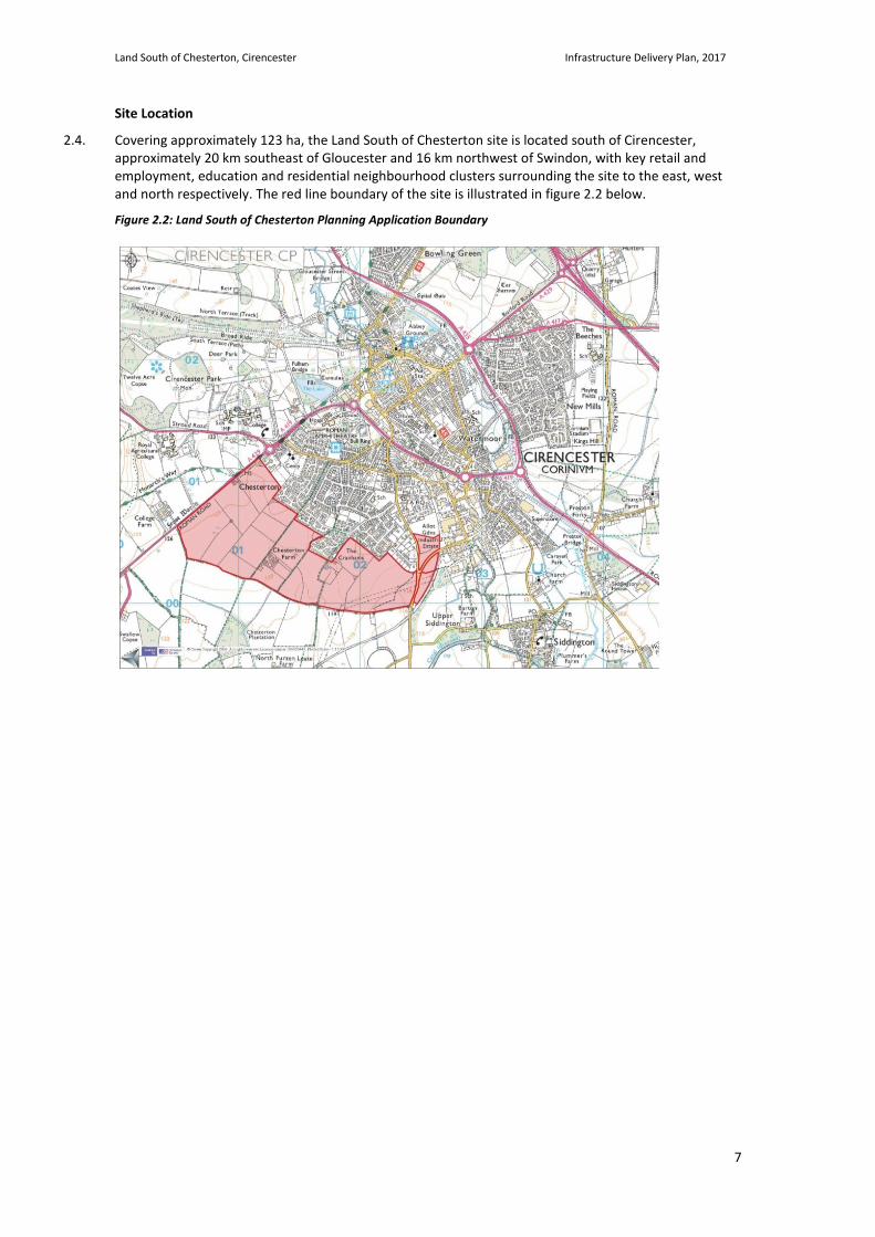
2.4. Covering approximately 123 ha, the Land South of Chesterton site is located south of Cirencester, approximately 20 km southeast of Gloucester and 16 km northwest of Swindon, with key retail and employment, education and residential neighbourhood clusters surrounding the site to the east, west and north respectively. The red line boundary of the site is illustrated in figure 2.2 below.
Figure 2.2: Land South of Chesterton Planning Application Boundary
Land South of Chesterton, Cirencester Infrastructure Delivery Plan, 2017
8
Policy Context 2.5. This section sets out relevant planning policy focusing on infrastructure provision at Chesterton.
National Planning Policy
National Planning Policy Framework
2.6. The NPPF places an emphasis on the need to promote the provision of infrastructure and includes this as part of the economic role of sustainable development. Local planning authorities are expected to set policies that seek to address the barriers faced by business investment, including infrastructure deficits and to identify priority areas for infrastructure provision.
2.7. The need to plan positively for the infrastructure required to encourage development is stressed in the 'Plan making' section of the NPPF where authorities are asked to work with their neighbours to assess the quality and capacity of infrastructure and to take account of the need to plan for strategic infrastructure. This policy is reinforced by the definition of 'soundness' in the NPPF which includes a need for plans to be "positively prepared" which is described as plans which are based on a strategy which seeks to meet objectively assessed development and infrastructure requirements.
2.8. The NPPF also seeks the identification of infrastructure costs and the timescales for delivery to ensure that there is a reasonable prospect that planned infrastructure is deliverable in a timely fashion. In order to facilitate this, it expects authorities to prepare infrastructure and development policies at the same time as part of the Local Plan.
Local Planning Policy
Adopted Local Plan
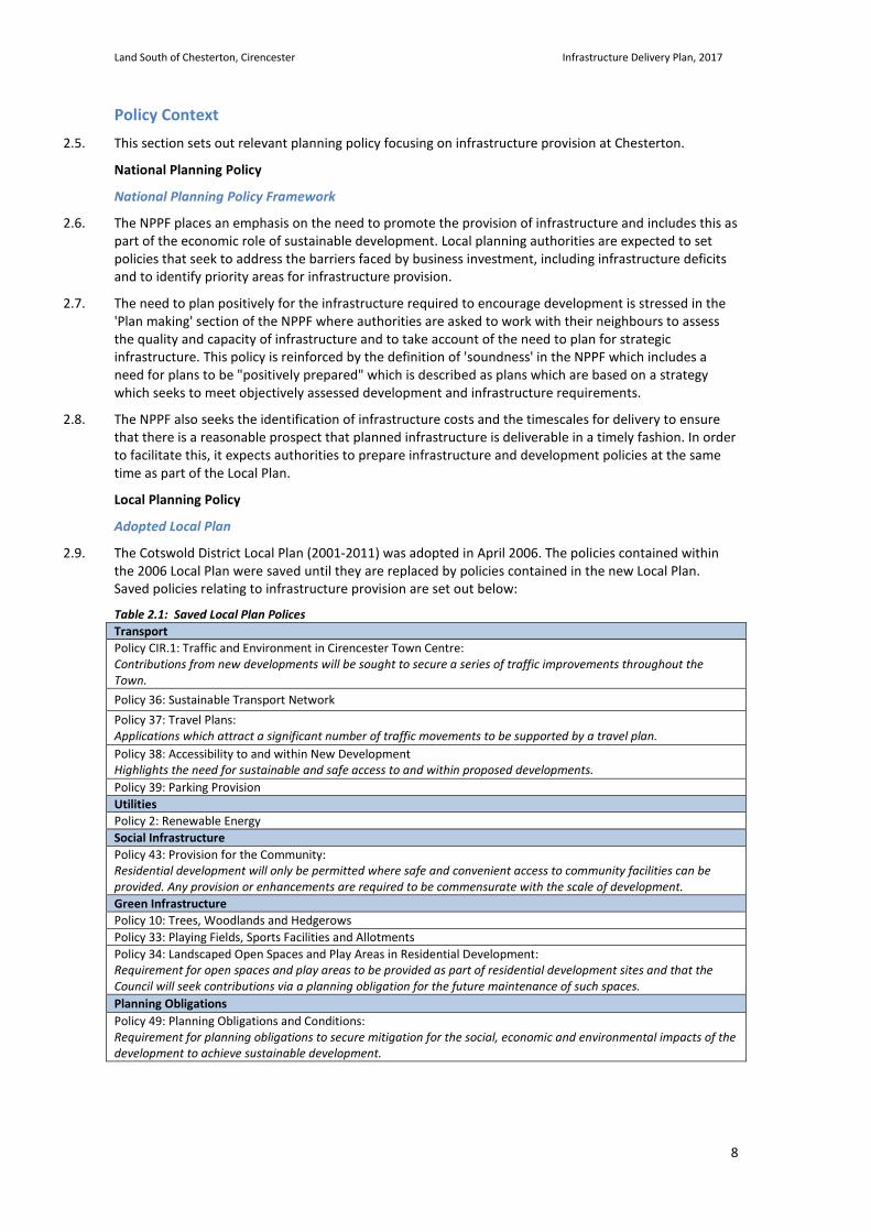
2.9. The Cotswold District Local Plan (2001-2011) was adopted in April 2006. The policies contained within the 2006 Local Plan were saved until they are replaced by policies contained in the new Local Plan. Saved policies relating to infrastructure provision are set out below:
Table 2.1: Saved Local Plan Polices Transport Policy CIR.1: Traffic and Environment in Cirencester Town Centre: Contributions from new developments will be sought to secure a series of traffic improvements throughout the Town. Policy 36: Sustainable Transport Network Policy 37: Travel Plans: Applications which attract a significant number of traffic movements to be supported by a travel plan. Policy 38: Accessibility to and within New Development Highlights the need for sustainable and safe access to and within proposed developments. Policy 39: Parking Provision Utilities Policy 2: Renewable Energy Social Infrastructure Policy 43: Provision for the Community: Residential development will only be permitted where safe and convenient access to community facilities can be provided. Any provision or enhancements are required to be commensurate with the scale of development. Green Infrastructure Policy 10: Trees, Woodlands and Hedgerows Policy 33: Playing Fields, Sports Facilities and Allotments Policy 34: Landscaped Open Spaces and Play Areas in Residential Development: Requirement for open spaces and play areas to be provided as part of residential development sites and that the Council will seek contributions via a planning obligation for the future maintenance of such spaces. Planning Obligations Policy 49: Planning Obligations and Conditions: Requirement for planning obligations to secure mitigation for the social, economic and environmental impacts of the development to achieve sustainable development.
Land South of Chesterton, Cirencester Infrastructure Delivery Plan, 2017
9
Local Plan 2011-2031:
2.10. The saved policies will be superseded by the Cotswold District Local Plan 2031. Cotswold District Council (CDC) is preparing a new Local Plan, the Cotswold District Local Plan. The purpose of this Local Plan is to develop a forward looking Plan, which will help shape communities and, crucially, serve as a blueprint for the future use of land, taking account of local needs.
2.11. The Plan will cover the period 2011 to 2031 and its policies will be used to control development and guide most day-to-day planning decisions. All local authorities are required to plan for future levels of housing development in suitable locations, taking account of population forecasts, reductions in household size, and other changes.
2.12. As part of the Local Plan making process, in May 2013 CDC published ‘The Local Plan Consultation Paper: Preferred Development Strategy’ for public consultation. The purpose of this document was to set out the strategic context for development and establish the level and location of future development required across the District to meet its projected needs. The site was first identified in this paper as a preferred site for development within the District given its proximity to Cirencester, a key sustainable settlement area.
2.13. Cirencester accounts for almost a quarter of the District’s population, over 30% of jobs and is ranked in the top 200 retail centres of the UK. The town’s position as a dominant centre, amongst other factors, meant it was a suitable and ideal location for strategic development.
2.14. In January 2015, the site was identified as a Strategic Allocation Site in the CDC Local Plan Regulations 18 Consultation: Development Strategy and Site Allocations document. This demonstrated council support that the site was a suitable and ideal location for strategic development at Cirencester.
Figure 2.3: Extract from the Draft Local Plan Development Strategy and Site Allocations (Jan 2015)
2.15. In support of CDC’s belief that the site was the best location for strategic development at Cirencester,
the Council set out an overall vision. This vision, in conjunction with the emerging Local Plan confirms that:
“Cirencester will continue to be the main focus for additional housing and employment growth, while its function as the dominant business location, service and cultural centre for much of the District will have been enhanced.”
“An overall total of up to 3,387 dwellings is proposed for Cirencester over the period April 2011 to March 2031, including housing built to date and outstanding permissions. Of these, up to 2,350 dwellings will be
Land South of Chesterton, Cirencester Infrastructure Delivery Plan, 2017
10
provided on land to the south of Chesterton phased over the period to 2031, together with 9.1 hectares of employment, and appropriate community infrastructure to support the new development”.
Local Plan 2011-2031: Submission Draft Reg 19
2.16. Policy S2 sets out the proposed strategic allocation for mixed use development on land south of Chesterton, to which this document relates. The proposed policy text sets out that the development will include the following:
• Land to the south of Chesterton, shown on the Proposals Policies Map, is allocated for a sustainable, high quality, mixed used development, including up to 2,350 dwellings (net), (incorporating up to 40% affordable housing) and approximately 9.1 hectares of B1, B2 and B8 employment land.
• Infrastructure provision, informed by the Infrastructure Delivery Plan and the Vision and Objectives (Appendix B) for the site, will be required relating to matters including:
- Community facilities and culture (including Neighbourhood Centre);
- Education;
- Health care;
- Open space, sport and recreation;
- Transport and highways;
- Flood management, waste water, and a Sustainable Urban Drainage System; and
- Water supply.
• The development will be master planned and implemented on a comprehensive basis. It will be designed and phased to ensure:
- Maximum practicable integration between the different uses within and beyond the site;
- All necessary supporting infrastructure and community facilities are delivered in synchronisation with housing and employment development; and
- To maintain a timely supply of housing and employment land over the plan period.
2.17. Appendix B to the Local plan sets out the Vision and Objectives of the Strategic Site in more detail as follows:
• Development of the land south-west of Chesterton and adjacent to the Royal Agricultural University presents an opportunity to create a new and attractive south-western edge to Cirencester. This vision statement describes the ultimate ambition for the place. The development will sit comfortably within the gently undulating landform, successfully incorporating significant trees and hedgerows within green corridors. A range of public open spaces will also help to green the place. In its town planning, the development will reflect the built environment of Cirencester. All buildings will exhibit high architectural quality, making optimum use of modern systems internally. The external appearance will avoid pastiche whilst preserving contact with the best local building traditions, not least in the use of high quality materials. The built environment will strike a successful balance between variety and harmony. As in the best historic townscapes, the scale, massing and detailing of particular buildings will respond to the character and role of the street they address. Within the layout, focal points and landmarks will be highlighted with distinctive buildings and spaces. A carefully planned network of green infrastructure will serve as a foil to the built environment, helping to create and define smaller, recognisable neighbourhoods within the development. As a consequence, the layout will be easy to understand and navigate. Integration with existing streets and paths in the vicinity, which will be enhanced where necessary, will ensure this new part of Cirencester is well connected to Chesterton, the rest of the town, and the countryside beyond.
• The mix of homes and tenure types will reflect the needs and ambition of the local community. Residents will have convenient access to community facilities such as schools, shops, health care and play areas. Sufficient employment land and buildings will be provided to ensure a wide range of job opportunities, and these will be closely integrated with residential uses where practicable. All properties will have convenient access to public transport and to a finely branched network of safe
Land South of Chesterton, Cirencester Infrastructure Delivery Plan, 2017
11
and direct walking and cycling routes, linking people to schools, work places and services, both within the development and beyond. Ready access to high speed broadband will enable home working and help reduce the number of journeys by private car. Public spaces will be well designed, with suitable management and maintenance arrangements in place to ensure their continued upkeep. All public spaces and routes will be overlooked to ensure they feel safe.
• This new part of Cirencester will have a range of site-wide features to reduce its environmental impact including low carbon energy generation, SuDS, and convenient access to recycling facilities. Homes will provide ample space for living and storage. Allotments and gardens will provide opportunities for residents to grow their own food. The development will promote innovation in residential, commercial and infrastructure design with a view to achieving more sustainable ways of living and a place that is future-proof. Essential infrastructure and services will be fully integrated in the design of the place from the outset and delivered in phase with the building work.
Cotswold District Council Infrastructure Delivery Plan May 2013/14 & 2016 Update
2.18. Prior to the publication of the National Planning Policy Framework (NPPF), Infrastructure Delivery Plans had a formal planning role to satisfy the requirements of Planning Policy Statement 12. Whilst the NPPF no longer requires the publication of an IDP, it does require clear evidence of infrastructure planning, including the identification of the infrastructure needed to support development. It also requires identification of the likely costs and timing of delivery of infrastructure that is needed to ensure proposed development is viable and deliverable.
2.19. An IDP was prepared by consultancy practice ARUP on behalf of CDC to support public consultation on the Draft Local Plan Development Strategy, which set out the overall spatial strategy for the District. The IDP provides a comprehensive analysis of existing baseline infrastructure capacity and demand issues across the District and includes analysis of Cirencester and the Land South of Chesterton site.
2.20. Three iterations of the local plan IDP have been produced, initially in 2013 with revisions to update the plan in 2014 and 2016.
2.21. The 2013 and 2014 versions of the Local Plan IDP provide an independent assessment of the appropriate infrastructure interventions required to support the Land South of Chesterton site. The 2016 update provides a comparison at that point in time of the Local Plan IDP recommendation for the site and the infrastructure proposals set out within the outline planning application and its associated site wide IDP.
Land South of Chesterton, Cirencester Infrastructure Delivery Plan, 2017
12
Existing Infrastructure Capacity and Issues Transport
Highways
2.22. Cirencester is located approximately 15 miles from Cheltenham and 18 miles from Gloucester to the north, 20 miles from Swindon to the south and 13 miles from Stroud to the west and 11 miles from Tetbury in the south-west. The town is well connected to the local and strategic highway networks, including the A417 / A419, with direct links provided to each of the above destinations.
Public Transport
2.23. There are a number of bus stops located in close proximity of the site. There are stops located on Cranhams Lane, to the north of the site. The principal bus route serving these stops is the 51A, which provides an hourly service between Cirencester, Cricklade, and Swindon. The first available service towards Cricklade and Swindon leaves the stops nearest the site at 0712 and the last return journey is at 1750. The earliest service for Cirencester town centre leaves at 0939 and the last return journey is at 1718. Earlier services (0701 – no. 51X and 0746 – no. 51) towards Cirencester and Cheltenham are available from the bus stops located on Chesterton Lane, approximately 700m to the north of the northern boundary to the site.
2.24. Together with service 51, which is available in Cirencester town centre, these form a 30-minute frequency between Cirencester and Swindon. This service replaced services 58 and 59 from 1 November 2015. Service 50 was also introduced from 7 August 2016 and provides a circular hourly route between Down Ampney and Cirencester town centre.
2.25. There is a northbound bus stop located on Tetbury Road along the western boundary to the site, which provides a two-hourly service from Malmesbury to the town centre (but no outbound journeys). There is also a bus stops located on Somerford Road in the vicinity of the junction with Wilkinson Road along the site frontage to the east of the site. These provide a two-hourly service to/from Malmesbury and two outbound and four inbound journeys per day to Kemble and Tetbury. Further bus stops are located on Stroud Road adjacent to the access to Deer Park School and Cirencester College. These provide an approximately 90-minute to two-hourly service to/from Stroud. Additional bus routes serve Deer Park School at school drop off and pick up times.
2.26. Additional bus services are available in Cirencester town centre, including an hourly circular service to Stratton, a two-hourly service to/from Fairford and Lechlade and approximately four return daily services per day to Cricklade, Swindon, and Gloucester. There are also infrequent services via Bibury to Northleach with connections to Bourton-on-the-Water, Stow-on-the-Wold, and Moreton-in-Marsh.
2.27. Kemble train station is the nearest train station, located approximately 4.5miles to the south-west, from which there are hourly services to London Paddington, Swindon, Stroud, Cheltenham and Gloucester.
Pedestrian and Cycle
2.28. A good network of interconnecting pedestrian and cycle routes and connections exist in and around Cirencester and connect with the wider region. The open landscape to the south and west of Cirencester has a network of Public Rights of Way (PROW) (footpaths and bridleways) and recreational routes.
2.29. On the site there are three existing PROW, comprising of two bridleways and one footpath. These all run in a north-south direction through the site and link in with a footpath network within the adjoining neighbourhood to the north. These PROW also link into a farm track and bridleway running along the southern boundary of the site. Monarch’s Way, a long distance footpath which links the site to Cirencester Park, the town centre and the countryside to the west is located adjacent to the site along Tetbury Road.
2.30. There are also a number of cycle routes and public footpath links providing access between Cirencester and Cotswold Water Park. A number of cycle routes through the open landscape to the south of Cirencester connect Cirencester easily with the Cotswold Water Park, Kemble Station and a number of settlement areas in the local region, including Gloucester and Swindon. These cycle routes include the Sustrans National Cycle Route 45 and Route 48, the Cotswold Cycle Guide Route 5 and ‘The Infant Thames’ which is promoted by the Cotswold Area of Natural Beauty (AONB).
Land South of Chesterton, Cirencester Infrastructure Delivery Plan, 2017
13
Utilities
Electricity
2.31. Scottish & Southern Energy (SSE) is responsible for electricity distribution locally.
2.32. There are two overhead powerlines crossing the site. These high voltage power lines (132Kv), with associated pylons, run in a north east to south west direction, crossing over Spratsgate Lane. Running in parallel, these lines exit the site and extend to the open countryside to the east.
2.33. Given the size and prevalence of existing infrastructure in the immediate vicinity of the site it is considered unlikely that there would be any issues with the provision of new supplies to the proposed development. It is anticipated that a number of new sub-stations will be required. SSE has provided a cost to undertake a feasibility study. The main purpose of this would be to establish the number of sub-stations required on the site rather than the feasibility of supplying the site which should not be in doubt.
Gas
2.34. Gas is distributed in the local area by Wales and West Utilities.
2.35. A below ground gas pipeline runs through the site and extends beyond the site boundary. On the east side of the site an intermediate gas main runs in a north-east to south-east direction towards Spratsgate Lane and extends beyond the site boundary. Where this line meets with Spratsgate Lane a below ground National Grid gas pipeline runs along the end of the site in a west direction towards Tetbury Road to the south of The Steadings.
2.36. With respect to gas and electricity supply the site is well positioned to enable connection to sizeable existing infrastructure with gas pressure reducer stations and major electricity sub-stations in the immediate vicinity of the site.
2.37. Wales & West Utilities has confirmed that there is unlikely to be an issue with the provision of supplies to the site given the prevalence and size of gas infrastructure in the immediate vicinity of the site.
Potable Water Supply
2.38. Thames Water is responsible for water supply in the area.
2.39. Thames Water’s consultant Atkins have prepared a report assessing the capacity of the existing strategic network to serve the proposed development and identified a solution to serve the proposed development with potable water, which is sufficient in terms of demonstrating deliverability in planning terms. Thames Water has also confirmed that the provision of new water supplies is unlikely to be an issue for the proposed development. A new water main will be required to connect the strategic site to the potable water supply reservoir.
Foul Water Drainage
2.40. The existing foul network is at or very close to capacity and suffers from sewer flooding.
2.41. Sewer records obtained from Thames Water Utilities Limited (TWUL) indicate the presence of adopted foul and surface water networks on the site. There are two surface water sewers and a Thames Water Balancing Pond, of which the latter is located outside the site boundary. A 375mm diameter sewer conveys flows from Thames Water’s Balancing Pond to the head of Ditch 1. A 525mm diameter sewer conveys flows from the eastern part of the residential development along Cranhams Lane and discharges to Ditch 1. A 225mm / 300mm diameter foul water rising main and gravity sewer are located within the north-east corner of the site.
2.42. Thames Water has confirmed that the existing treatment works at South Cerney has already been upgraded so that it can accommodate the flows of waste water from the Land South of Chesterton site. A design solution will be required to provide a new pipeline to convey wastewater from the new development directly to the treatment works.
Land South of Chesterton, Cirencester Infrastructure Delivery Plan, 2017
14
Flood Risk and Surface Water Drainage
2.43. Glanville Consultants on behalf of Bathurst Development Ltd have prepared a Flood Risk Assessment and Surface Water Drainage Strategy. The report assesses flood risk associated specifically with developing the site, in accordance with the National Planning Policy Framework (NPPF) (March 2012) and Planning Practice Guidance (March 2014), issued by the Department for Communities and Local Government.
2.44. Local guidance concerning flood risk is provided within the Gloucestershire County Council Strategic Flood Risk Assessment Level 1 (September 2008) and the Cotswold District Council Strategic Flood Risk Assessment Level 1 (September 2008). The report defines the principles for the management of surface water run-off generated by the proposed development and demonstrates how Sustainable Urban Drainage Systems (SuDS) can be incorporated.
2.45. The report concludes that the site is not at risk of flooding and can be developed safely without increasing flood risk elsewhere, and that development proposals comply with relevant planning policy concerning flood risk. The report demonstrates that suitable provision for the location of SuDS features has been provided within the illustrative masterplan for the development.
Solid Waste
2.46. From April 2013, oversight of waste management recycling and street care services for Cheltenham Borough Council, Cotswold District Council, Forest of Dean District Council and Gloucestershire County was passed to a Joint Waste Committee. Over the last two decades, the roles of waste collection authorities (district councils) have become more complex and interdependent on the roles of county councils as waste disposal authority and vice-versa. There has also been growing interest in sharing services across district boundaries to benefit from economies of scale.
2.47. Gloucestershire’s Joint Waste Committee (JWC) is a body with delegated powers to make decisions concerning the recycling, waste collection and street cleansing services for three district and borough councils and to deliver waste treatment and disposal for the County.
Municipal Solid Waste (MSW):
• Household Recycling – Fosse Cross (six miles north of Cirencester on the A429), Pyke Quarry HRC (15 miles west of Cirencester)
• Waste Transfer Station - Love Lane WTS, Cirencester. WTS’s are used to transfer residual waste and to bulk-up kerbside collected dry recyclables
• Landfill Destination – Hempsted Landfill site, which is west of Gloucester City
Communications and Broadband
2.48. BT will not comment or progress designs in the absence of a planning permission, but given the prevalence of existing plant within the vicinity of the site, no issues with supply are anticipated and therefore no further work is envisaged at this time. It is likely however that some diversions of existing communication and broadband lines will be necessary as a result of off-site highways works associated with the strategic site.
Land South of Chesterton, Cirencester Infrastructure Delivery Plan, 2017
15
Social Infrastructure
Education Overview
2.49. In close proximity to the site are primary, secondary and tertiary level facilities which serve Cirencester and the wider surrounding area. To the west of the site, off Stroud Road, is the renowned Royal Agricultural University. Directly north on Fosse Campus are Cirencester College and the Deer Park Secondary School.
2.50. Chesterton Primary School and Siddington Church of England School are respectively located to the north and south east of the site. Kingshill School is located to the north east edge of the town and is one of the largest secondary schools in the area.
Early Years Provision
2.51. The analysis below identifies that there are currently 8 early year facilities operating within the Area of Study, the majority of which are in Cirencester.
Table 2.2: Early year provision
Facility Description
Busybees at Chesteton Preschool and Nursery Acorns Nursery School Nursery Stepping Stones Nursery Nursery Tiggers' Nurseries Nursery Sunflowers At St Peters Nursery / Playgroup Bingham Kindergarten Nursery Bright Eyes Early Years Centre Preschool as part of Cirencester College Duke of Gloucester Playgroup Preschool playgroup Source: Desktop based research 2016
Primary Schools
2.52. The analysis below identifies the local provision of primary schools. The current capacity, number on roll and associated deficit or surplus is outlined.
2.53. Chesterton Primary School, which only currently contains a limited number for surplus places, is approximately 10-20 minute walk from the development site. Across the Cirencester area, there are currently 138 surplus primary school places, equivalent to around half a Form of Entry. This surplus provision is forecast to decline in coming years.
2.54. GCC has advised the project team that Chesterton Primary school is forecast to have no surplus places by 2018/19 and that the additional primary school places generated by the proposed development will not be able to rely upon existing primary school capacity to serve new pupils as there is an existing capacity issue within the area which requires action.
Table 2.3: Primary school provision
Facility Place Capacity Number on Roll Surplus Places
Chesterton Primary School 210 188 22 Siddington C of E Primary School 84 83 1 Cirencester Primary School 420 397 23 Powell's C of E Primary School 420 421 -1 Watermoor C of E Primary School 210 159 51 Stratton C of E Primary School 210 209 1 Ann Edwards C of E School 315 284 31 North Cerney C of E Primary School 70 60 10 Total 1,939 1,801 138 Source: January 2017 DfE data
Land South of Chesterton, Cirencester Infrastructure Delivery Plan, 2017
16
Secondary Schools, Further and Higher Education
2.55. The analysis below identifies the local provision of secondary schools within Cirencester. The current capacity, number on roll and associated deficit or surplus is outlined.
2.56. Between Cirencester’s two academy secondary schools, Deer Park School and Kingsmill School, there are currently 190 surplus places identified, equivalent to approximately one Form of Entry. The additional secondary school places generated by the proposed development will not however be able to wholly rely upon existing secondary school capacity to serve new pupils. The capacity of secondary schools is driven largely by the curriculum capacity of the schools. An up to date curriculum capacity assessment is required on the two secondary schools which has been commissioned by GCC. The curriculum analysis will allow a detailed examination of likely operational surplus within the secondary schools to provide an assessment of the impact from the Chesterton scheme.
2.57. In addition to the two main secondary schools, Paternoster School provides a limited number of special school places. Cirencester College, a 10 to 15 minute walk to the north of the development site, provides the primary sixth form education for the local area. Higher level education is provided locally at Royal Agricultural University, located to the west of the development site.
Table 2.4: Secondary school provision
Facility Place Capacity Number on Roll Surplus Places
Cirencester Deer Park School 1045 965 92 Cirencester Kingshill School 912 802 -7 Total 1,957 1,767 85 Source: January 2016 DfE data
Primary Healthcare: GP Surgeries
2.58. The analysis below identifies that there are approximately 23GPs operating within the Cirencester area. This is equivalent to 1,470 patients per GP. The closest surgery is the Phoenix Surgery which also operates a number of branch surgeries in the local area. The information presented in the table below is limited to that publicly available from the NHS and does not necessary represent the true capacity issues in local healthcare services.
Table 2.5: Provision of GP surgeries
Facility GPs Patients Patients per GP
The Phoenix Surgery & Branches 6 13,145 2,190 Dr Hewett MF & Partners 5 6,495 1,299 The Avenue Surgery 5 6,567 1,313 The Park Surgery 7 7,606 1,086 Total 23 33,813 1,470 Source: NHS Choices Data 2017
Primary Healthcare: Dental Surgeries
2.59. The analysis below identifies the local provision of dental surgeries within Cirencester. There are currently 19 dentists and 2 hygienists operating within the area. The reason for this apparent high provision of Dental facilities is the town centre role within Cirencester, whereby dental practices will typically locate along retail streets.
Table 2.6: Provision of dental practices
Facility Dentists Hygienist
Chipping Manor Dental Practice 5 1 Market Place Dental Practice 4 - Corimium Dental Practice 1 - Genix Healthcare Ltd 4 1 Coleman Associates 2 - Gloucester Street Dental Practice 3 - Total 19 2 Source: NHS Choices Data 2017
Land South of Chesterton, Cirencester Infrastructure Delivery Plan, 2017
17
Acute Healthcare: Hospitals
2.60. The main hospital serving the area is Cirencester Hospital, located to the south of the town centre between Strategic Site and the town. This facility is run by Gloucestershire Care Services Limited and contains 3 wards and 72 beds. As part of Care UK on behalf of the NHS, Cirencester Treatment Centre is located on the same site and provides more bespoke treatment services.
Table 2.7: Hospital Services
Hospital Name Organisation Site Type Wards Beds
Cirencester Hospital Gloucestershire Care Services NHS Trust Community 3 72
Cirencester Treatment Centre Care UK PLC Treatment Centre without in-patient
facilities - non NHS organisations only 1 5
Sources: NHS Choices and NHS HSCIC Place Data
Community Facilities
2.61. Cirencester can be described as having a strong base of community facilities and services across the town with a library, places of worship, a cemetery, community gardens and allotments, a museum and sport centres. A strong network of community groups are present in the areas of education, sport, youth and community support, heritage and interest groups. The New Brewery Arts Centre is a flexible community space within Cirencester which opened in 2016.
2.62. Several community groups are active within the area, including:
• Beeches Community Group • Chesterton Community Project • Stratton Association • Park Community Group • Watermoor Community Group
2.63. The majority of these groups do not have a permanent community facility to meet. The latter two
groups meet at Waterloo Meeting Room and the Fire Station respectively. There is also a strong church presence within the area, including a Parish Church, which provides space for numerous community activities.
2.64. Library provision is provided by Cirencester Bingham Library which is located within central Cirencester just over 30 minutes walk from the development site.
Indoor and Outdoor Sports
2.65. The town can be described as having a good profile of leisure facilities, made up of recreation grounds, open spaces and indoor and outdoor facilities and social groups. The largest leisure provisions across the town include the Cotswold Leisure Centre located off Tetbury Road, the Cirencester open air swimming pool located off Cecily Hill, Cirencester tennis club located at Cirencester Park and Corinium Stadium off Kingshill Lane.
2.66. Restricted and public park provision across the town including Cirencester Park, St. Michael’s Park, the Abbey Grounds and the Roman Amphitheatre. A number of smaller open spaces and green spaces exist around the town, including some adjacent to the site. A strong network of social and leisure clubs in Cirencester include the cricket club, polo club, bike polo, the aircraft club, karate and judo club and rugby club amongst others. The development site enjoys good access to sports facilities due to its proximity to Deer Park School, the Royal Agricultural College, Cirencester College and Cotswold Leisure Centre which are all within a 15-30 minute walk from the development site.
Play space
2.67. Place space is distributed across Cirencester. Part of the northern boundary of the site falls within the catchment of an existing children’s play area.
Land South of Chesterton, Cirencester Infrastructure Delivery Plan, 2017
18
Green Infrastructure
2.68. The analysis from the following figures sets out the local provision of public open space within the Cirencester area
2.69. Cirencester benefits from good existing open space network, including three town parks as well as Cirencester Park to the northwest of the town. However, due to its nature as a town fringe site, the Land South of Chesterton site is currently outside the required catchment of these open spaces. This would require development to provide additional on-site open space.
Figure 2.4: Existing Recreation and Amenity Sites
Source: Land South of Chesterton Cirencester, Green Infrastructure Strategy 2017
Land South of Chesterton, Cirencester Infrastructure Delivery Plan, 2017
19
Figure 2.5: Existing Green Infrastructure
Source: Land South of Chesterton Cirencester, Green Infrastructure Strategy 2017
Land South of Chesterton, Cirencester Infrastructure Delivery Plan, 2017
20
3. Planning Application Development Proposals
3.1. Land South of Chesterton, Cirencester, extends to 120.35 hectares (297.39 acres) and is located to the south of Cirencester.
3.2. Bathurst Development Limited (BDL) is committed to providing a high quality residential-led development that meets the needs of the local community and the wider District. The proposed scheme has been developed in discussion with Cotswold District Council (CDC), local stakeholders and the local community over the past three years.
3.3. The development proposed comprises a mix of uses, which include:
• Up to 2,350 residential dwellings (with up to 50% of the total number as affordable housing), including up to 100 units of student accommodation (C3) and 60 homes for the elderly (C2 or C3);
• Up to 9.1 hectares of land allocated for employment (B1, B2 and B8);
• A 3 Form Entry (FE) primary school (D1 use);
• A new neighbourhood centre including A1, A2, A3, A4 as well as community facilities (health care facility (D1);
• Approximately 40 hectares of publicly accessible open space and landscape;
• Playing fields;
• Pedestrian and cycle links;
• Landscaping and associated supporting infrastructure to include vehicular access points from Tetbury Road (A429), Spratsgate Lane and Wilkinson Road;
Illustrative Masterplan
3.4. Figure 3.1 presents the illustrative masterplan.
Figure 3.1: Illustrative Masterplan
Land South of Chesterton, Cirencester Infrastructure Delivery Plan, 2017
21
Land Use Proposals 3.5. The scheme incorporates a mix of uses including residential, commercial, employment, community uses,
including a primary school, and sports and recreation uses. A mixed use neighbourhood centre is located at the heart of the masterplan providing a new retail and employment offer, incorporating existing listed buildings on site and connecting into Chesterton and the wider area. The mix of land uses as informed by the land use budget is set out in tables 3.1 below.
Table 3.1: Land Use Budget
Land Use Type Total Site Area (ha)
Employment 9.15 Residential development 59.05 Homes for the Elderly 0.52 Student Accommodation 0.59 Primary School 3.00 Community Uses 1.02 Indoor Sports Provision 0.26 Amenity Green Space 8.33 Formal Park 6.05 Natural and Semi Natural Space 14.58 Allotments and orchards 0.66 Public Square 0.27 Sports provision (outdoor) 1.03 Green Space under Powerlines 3.88 Scheduled ancient monument (SAM) 4.52 Existing Track / footpaths / bridleways 1.10 Primary roads 6.34
Total Site Area 120.35
Employment and Housing Proposals Employment Proposals
3.6. The following employment components are included within the proposed development:
• Office type employment proposed off the primary road east of Tetbury Road • Industrial / storage type employment is provided off Spratsgate Lane to the east • Office type employment is located west of Spratsgate Lane within the main part of the site.
3.7. Table 3.2 below sets out the proposed employment site areas and associated floorspace.
Table 3.2: Employment Proposals
Employment Proposals Site Area (ha) Floorspace (sq.m) Floorspace (sq.ft)
B1 Business Space 5.9 30,658 300,000
B2/B8 Industrial Storage and Distribution 3.2 13,006 139,995
Total employment Space 9.15 43,664 439,995
Housing Proposals
3.8. Through an average net density of 35 dwellings per hectare (dph), the Masterplan envisages a total of 2,350 dwellings on the development site.
Land South of Chesterton, Cirencester Infrastructure Delivery Plan, 2017
22
Table 3.3: Residential Proposals
Residential Proposals Total
Residential development 2,190
Homes for the Elderly 60
Student Accommodation 100
Total Units 2,350
3.9. The delivered housing mix will vary according to future housing need and market conditions. Table 3.4 sets out housing mix assumptions based on working assumptions reflecting the indicative housing mix submitted within the planning application.
Table 3.4: Indicative Housing Mix
Unit Type Units %
1 Bed Apartment 163 7%
2 Bed Apartment 133 6%
3 Bed Apartment 24 1%
2 Bed House 533 23%
3 Bed House 1,057 45%
4 Bed House 439 19%
Total 2,350
Development Phasing
3.10. The phasing and construction of the development may commence from 2018 - subject to the outcome of the Outline Planning Application and subsequent Reserved Matters Applications.
3.11. The outline planning application is supported by a Delivery Strategy Statement which presents the approach towards site development and the likely rate of delivery. The indicative phasing programme for housing delivery is presented in table 3.5 below.
Table 3.5: Indicative Phasing of Housing Delivery
2019/20 2020/21 2021/22 2022/23 2023/24 2024/25 2025/26 2026/27 2027/28 2028/29 2029/30 2030/31 2031/32
Annual 21 171 229 229 229 229 229 229 229 229 229 101 0
Cumulative 21 192 421 649 878 1,107 1,335 1,564 1,792 2,021 2,249 2,350 2,350
3.12. The following page demonstrates an indicative phasing of plot delivery. The development has been broken down into parcels with the delivery shown commencing from the east before parallel development beginning to the west and at the proposed community hub.
3.13. Transport and utility infrastructure requirements and phasing has been guided by advice from the applicants infrastructure consultants. The timing of social infrastructure requirements has been informed by the housing trajectory and associated on-site population profile. Consideration has also been given to ensuring the necessary place-making elements of the masterplan are delivered at an early stage. Consultation and discussion with interested parties is still however ongoing regarding the sequence of development and associated infrastructure.
Land South of Chesterton, Cirencester Infrastructure Delivery Plan, 2017
23
Figure 3.2: Indicative phasing of development plots
Land South of Chesterton, Cirencester Infrastructure Delivery Plan, 2017
24
4. Planning Application Impacts Estimated population Impacts from proposals
4.1. In order to review and confirm the infrastructure provision required to support the housing proposals, it is necessary to estimate the potential demographic impacts of the site and how the population will grow and change over the build out phase.
Household Characteristics
4.2. It is possible to identify Cotswold District household characteristics (in terms of household size and age profiles) according to the 2011 Census. Table 4.1 below sets out average household sizes for market and affordable housing across all existing properties in the Cotswold District. This evidence enabled an estimate of population by age according to the housing development proposals.
Table 4.1: Average Household Size assumptions by Unit type
Apartment Houses
1 Bedroom 2 Bedroom 3 Bedroom 2 Bedroom 3 Bedroom 4 Bedroom All Units
Market Housing 1.29 1.50 1.81 1.68 2.21 2.71 2.27
Affordable Housing 1.21 1.87 1.86 2.00 2.98 4.14 2.20
All units 1.27 1.67 2.02 1.78 2.35 2.77 2.24
Source: 2011 Census (Specific to Cotswolds District)
4.3. Figure 4.1 below illustrates average age profiles for market and affordable housing across all existing properties in the Cotswold District, according to the 2011 Census. Colour shading has been applied to illustrate the variation in household age profiles according to both tenure and unit type and size. Most notable is the high number of elderly residents in smaller units (particularly in the market sector) and the high number of school aged children in the larger units (particularly in the affordable tenure as opposed to the market). This illustrates the importance of taking the housing mix into consideration when forecasting future infrastructure needs as these will ultimately drive the scale and type of social infrastructure needs of the development.
Figure 4.1: Age Profile assumptions by Unit type
Land South of Chesterton, Cirencester Infrastructure Delivery Plan, 2017
25
Population Impact from the Proposed Development
4.4. The presented household characteristic assumptions have been applied to the housing proposals in order to determine the population impacts. Table 4.2 below presents the population by age cohort estimated to be generated at full occupation. The population generated from the Land South of Chesterton site is estimated as 5,247 residents.
Table 4.2: Estimated population impact from the Proposed Development
Residents % split
0 - 3 191 4%
4 - 10' 377 7%
11 - 15' 327 6%
16 - 17 138 3%
18 - 19 111 2%
20 - 24 190 4%
25 - 29 178 3%
30 - 34 203 4%
35 - 39 302 6%
40 - 44 380 7%
45 - 49 408 8%
50 - 54 379 7%
55 - 59 369 7%
60 - 64 416 8%
65 - 69 351 7%
70 - 74 289 6%
75 + 639 12%
Total Population 5,247 100%
Source: AECOM Analysis utilising ONS Census 2011 data
Estimated Child Yields from Proposals Child Yield from the Proposed Development
4.5. Gloucestershire County Council (GCC) has an established standard approach towards assessing the likely impact from new housing developments upon the County education provision. Based upon a review of pupil product from developments across Gloucestershire, the County Council have estimated the average number of children generated of each age group per 100 new housing units.
4.6. A number of housing unit types are exempt from the GCC child yield multipliers which is important in the case of this proposed development and are as follows:
• All 1 bed units
• Student Accommodation
• Elderly / retirement housing units
4.7. GCC has advised that the child yield multiplier and exempt property types is reviewed periodically, and was most recently reviewed as part of the updating of the Local Developer Guide in December 2016.
4.8. Table 4.3 provides the indicative housing mix, and the assumed child yield, applying the GCC formula in use at the time of the assessment.
Land South of Chesterton, Cirencester Infrastructure Delivery Plan, 2017
26
Table 4.3: Estimated Child Yield
Total Units 2,350
Qualifying Units (Exclude all Apartment, retirement and 1 bed units) 2,029 (86%)
GCC Yield per Qualifying Unit
Early year aged yield: 0-3 year olds 7 per 100 Units 142
Primary aged yield: 4-10 year olds 25 per 100 Units 507
Secondary age yield: 11-15 year olds 13 per 100 Units 264
Sixth Form aged yield: 16-17 year olds 2 per 100 Units 41
* Child Yields from GCC’s OPA consultation response (26/04/16) on education and libraries Phasing of Impacts
4.9. In line with the housing trajectory the total population and associated child yield is estimated to build up gradually over the development period as presented in table 4.4 below.
Table 4.4: Phased population and child yield
Housing Housing (Cumulative)
Total Population
Early Year Places
Primary School
Children
Secondary School
Children
Sixth Form Children
2019/20 21 21 47 1 5 2 0
2020/21 171 192 429 12 42 22 3
2021/22 229 421 940 25 91 47 7
2022/23 229 649 1,450 39 140 73 11
2023/24 229 878 1,960 53 190 99 15
2024/25 229 1,107 2,471 67 239 124 19
2025/26 229 1,335 2,981 81 288 150 23
2026/27 229 1,564 3,491 95 338 176 27
2027/28 229 1,792 4,002 108 387 201 31
2028/29 229 2,021 4,512 122 436 227 35
2029/30 229 2,249 5,022 136 486 252 39
2030/31 101 2,350 5,248 142 507 264 41
2031/32 0 2,350 5,248 142 507 264 41
Land South of Chesterton, Cirencester Infrastructure Delivery Plan, 2017
27
5. Infrastructure Proposals Transport Infrastructure
5.1. A Transport Assessment (TA) and Framework Travel Plan (FTP) was submitted in support of the outline application. CDC is currently liaising with Gloucestershire County Council (GCC) as the Local Highway Authority (LHA) and Highways England (HE) over the TA.
Access Arrangements
5.2. There will be no vehicular access from Cranhams Lane (Chesterton) to the north. Instead, the existing accesses and Public Rights of Way connecting the site with Cranhams Lane will form part of the core pedestrian and cycle routes connecting the site with Chesterton and the town centre.
5.3. Road access is proposed from the A429 Tetbury Road to the west and Spratsgate Lane / Wilkinson Road / Somerford Road to the east.
5.4. There will be no through route for car traffic within the development, enforced by a bus gate situated broadly to the south of The Cranhams that would permit pedestrian, cycle and bus movements, and the potential for taxi movements.
Site Access A – Western Vehicular Access
Proposed A429 Tetbury Road / North Eastern Access roundabout – Principal Access from the West
5.5. The principal access to the site will be via a new roundabout on Tetbury Road. The south eastern arm provides access to the site whilst there is also the opportunity to provide a north western arm providing access to the consented RAU business park. It is proposed to extend the dual carriageway link between the proposed roundabout and the A419 Stroud Road / A429 Tetbury Road junction. Footways / cycleways are proposed along the dual carriageway link and pedestrian / cycle crossing provision on Tetbury Road is also proposed at road level.
Proposed A429 Tetbury Road / South Western Access roundabout - Secondary Access from the West
5.6. A smaller roundabout will be provided further to the south west along the A429 Tetbury Road to provide a secondary access to the development from Tetbury Road. The south eastern arm provides access to the site whilst the north western arm provides improved access to the College Farm Buildings. A footway / cycleway is proposed to the south of Tetbury Road linking in with the proposed provision to the north east at the principal access roundabout.
Site Access B – Eastern Vehicular Access
Proposed Spratsgate Lane / Wilkinson Road / Somerford Road Access Arrangements - Access from the East
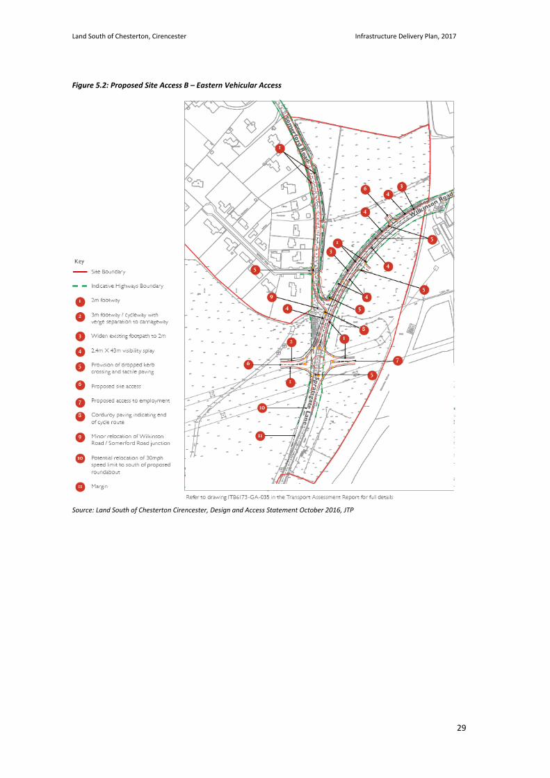
5.7. A new roundabout will be provided on Spratsgate Lane to the south of the Wilkinson Road / Somerford Road junction. The western arm will provide access to the main part of the development site whilst the eastern arm provides an access to the proposed employment area. Two priority junctions are proposed on Wilkinson Road – the junction on the south side provides access to the proposed employment area whilst the junction on the north side provides access to the proposed residential area. Direct access is proposed to the residential properties fronting Somerford Road. Improved footway provision is proposed along both Wilkinson Road and Somerford Road.
Site Access C – Pedestrian and Cycle Access
5.8. The masterplan provides for a fully connected and permeable high quality network of streets, as well as pedestrian / cycle routes of different character within the site. This will minimise barriers to walking and cycling, naturally calm traffic speeds and encourage these modes as an attractive means of travel; and prioritising a “people first, car second” environment.
5.9. Pedestrian / cycle accesses will be provided from Cranhams Lane to the north in the following locations:
• Western pedestrian / cycle access (existing Chesterton Farm access and Bridleway);
• Central pedestrian / cycle access (existing Bridleway); and
Land South of Chesterton, Cirencester Infrastructure Delivery Plan, 2017
28
• Eastern pedestrian / cycle access (existing gated access).
5.10. Improvements to these routes will be undertaken in the form of surfacing and drainage improvements, and provision of sensitive lighting schemes (western and eastern pedestrian / cycle access only) in order to provide attractive pedestrian / cycle linkages to Cranhams Lane, Chesterton and the town centre beyond.
5.11. The existing footpath connection to The Maples will have surfacing and drainage improvements and will be available for use, although it will remain narrow and will not form part of the core pedestrian and cycle network.
5.12. There are a series of bridleways and public footpath links to the south which will continue to be available as Public Rights of Way accessing the countryside towards Kemble to the south and Siddington to the south-east.
Figure 5.1: Proposed Site Access A – Western Vehicular Access
Source: Land South of Chesterton Cirencester, Design and Access Statement October 2016, JTP
Land South of Chesterton, Cirencester Infrastructure Delivery Plan, 2017
29
Figure 5.2: Proposed Site Access B – Eastern Vehicular Access
Source: Land South of Chesterton Cirencester, Design and Access Statement October 2016, JTP
Land South of Chesterton, Cirencester Infrastructure Delivery Plan, 2017
30
Onsite Highways
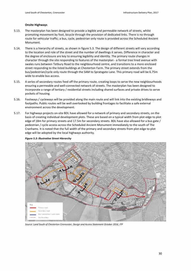
5.13. The masterplan has been designed to provide a legible and permeable network of streets, whilst promoting movement by foot, bicycle through the provision of dedicated links. There is no through route for vehicular traffic; a bus, cycle, pedestrian only route is provided across the Scheduled Ancient Monument.
5.14. There is a hierarchy of streets, as shown in figure 5.3. The design of different streets will vary according to the location and role of the street and the number of dwellings it serves. Difference in character and the degree of enclosure are key to ensuring legibility and identity. The primary route changes in character through the site responding to features of the masterplan - a formal tree lined avenue with swales runs between Tetbury Road to the neighbourhood centre, and transitions to a more enclosed street responding to the listed buildings at Chesterton Farm. The primary street extends from the bus/pedestrian/cycle only route through the SAM to Spratsgate Lane. This primary road will be 6.75m wide to enable bus access.
5.15. A series of secondary routes feed off the primary route, creating loops to serve the new neighbourhoods ensuring a permeable and well-connected network of streets. The masterplan has been designed to incorporate a range of tertiary / residential streets including shared surfaces and private drives to serve pockets of housing.
5.16. Footways / cycleways will be provided along the main route and will link into the existing bridleways and footpaths. Public routes will be well overlooked by building frontages to facilitate a safe external environment across the development.
5.17. For highways projects on-site BDL have allowed for a network of primary and secondary streets, on the basis of creating individual development plots. These are based on a typical width from plot edge to plot edge of 18m for primary streets and 17.5m for secondary streets. BDL have also allowed for a bus gate / pedestrian / cycle access across the Scheduled Ancient Monument immediately to the south of The Cranhams. It is noted that the full width of the primary and secondary streets from plot edge to plot edge will be adopted by the local highways authority.
Figure 5.3: illustrative Street Hierarchy
Source: Land South of Chesterton Cirencester, Design and Access Statement October 2016, JTP
Land South of Chesterton, Cirencester Infrastructure Delivery Plan, 2017
31
Off Site Highways
5.18. In agreement with the local highway authority, Gloucestershire County Council (GCC), Highways England and CDC, a traffic model was produced for Cirencester, covering areas including the A419 / A429 ring road, the local roads in the vicinity of the site, the town centre, as well as Siddington and South Cerney.
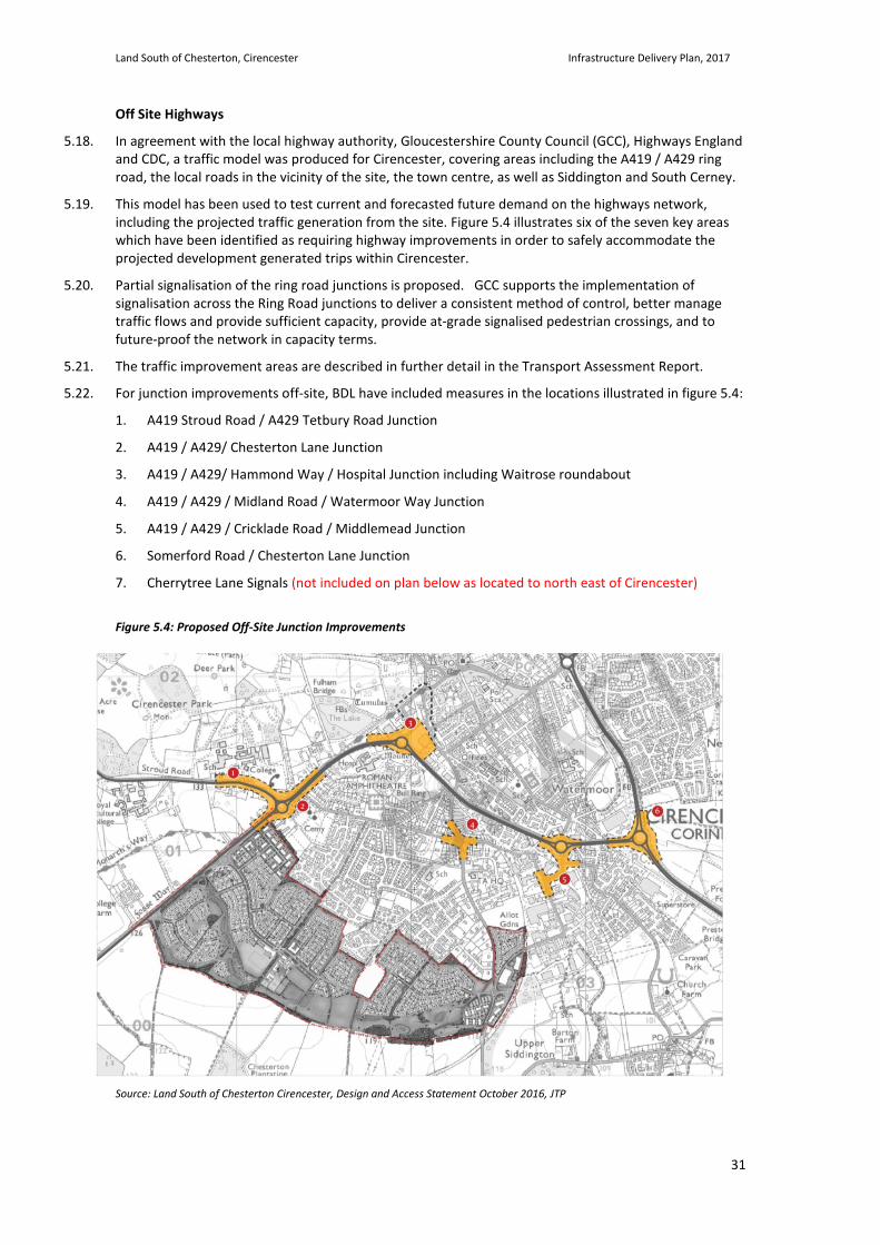
5.19. This model has been used to test current and forecasted future demand on the highways network, including the projected traffic generation from the site. Figure 5.4 illustrates six of the seven key areas which have been identified as requiring highway improvements in order to safely accommodate the projected development generated trips within Cirencester.
5.20. Partial signalisation of the ring road junctions is proposed. GCC supports the implementation of signalisation across the Ring Road junctions to deliver a consistent method of control, better manage traffic flows and provide sufficient capacity, provide at-grade signalised pedestrian crossings, and to future-proof the network in capacity terms.
5.21. The traffic improvement areas are described in further detail in the Transport Assessment Report.
5.22. For junction improvements off-site, BDL have included measures in the locations illustrated in figure 5.4:
1. A419 Stroud Road / A429 Tetbury Road Junction
2. A419 / A429/ Chesterton Lane Junction
3. A419 / A429/ Hammond Way / Hospital Junction including Waitrose roundabout
4. A419 / A429 / Midland Road / Watermoor Way Junction
5. A419 / A429 / Cricklade Road / Middlemead Junction
6. Somerford Road / Chesterton Lane Junction
7. Cherrytree Lane Signals (not included on plan below as located to north east of Cirencester)
Figure 5.4: Proposed Off-Site Junction Improvements
Source: Land South of Chesterton Cirencester, Design and Access Statement October 2016, JTP
Land South of Chesterton, Cirencester Infrastructure Delivery Plan, 2017
32
Public Transport – Bus
5.23. The masterplan has been designed so as to connect and link with existing public transport services, namely bus services. An internal spine avenue will be designed so it can form a bus route through the site, extending from Tetbury Road on the west to Spratsgate Lane on the east and runs along the southern end of The Cranhams, to maximise opportunities for future residents for access to improved bus services.
5.24. The public transport strategy for the proposed development has been the subject of extensive discussions with GCC's Integrated Transport Unit throughout the planning process. The agreed public transport strategy is set out below and offers not only benefit to the proposed residents and employees of the Land South of Chesterton development but also an enhanced level of public transport for existing residents. It is proposed for the developer to provide the following level of public transport service through a Bus Service Level Agreement secured under Sc106 planning obligation. The choice of method for delivering the service levels set out below will be the responsibility of the developer but it is most likely that it will be through providing enhancements to the existing services.
5.25. Prior to occupation of the 1st dwelling (Bus Service Phase 1):
• An hourly bus service from at least 06:00-10:00 and 16:00-20:00 to serve the site and Cirencester Town Centre and Kemble Station, Monday-Saturday excluding Bank Holidays
• The above bus service to stop at RTPI ready bus shelters with bus stop information panels provided by the developer within a reasonable walking distance (maximum of 800m) of all occupied properties
5.26. Prior to occupation of the 500th dwelling (Bus Service Phase 2):
• An hourly bus service from at least 06:00-10:00 and 16:00-20:00 to serve the site and Cirencester Town Centre and Kemble Station, Monday-Saturday excluding Bank Holidays
• An hourly bus service from at least 10:00-16:00 to serve the site and Cirencester Town Centre - Monday-Saturday excluding Bank Holidays
• The above bus service to stop at RTPI ready bus shelters with bus stop information panels provided by the developer within a reasonable walking distance (maximum of 800m) of all occupied properties
5.27. Prior to occupation of the 1000th dwelling (Bus Service Phase 3 - Full Bus Service):
• Provide link road through the site connecting Tetbury Road and Spratsgate Lane capable of accommodating buses
• An hourly service Monday to Saturday between Cirencester Town Centre, Land South of Chesterton (the site) and Kemble Station between 06:00-21:00. The frequency would increase to half hourly during peak commuter times 06:00-10:00 and 16:00-20:00 Monday to Saturday excluding Bank Holidays
• Extension to the new Cirencester Town Bus Service to serve the Land South of Chesterton (the Site) and wider areas (this will build on the recently introduced Bus Service 50). The service will operate at least between 10:00 - 16:00 Monday-Saturday excluding Bank Hollidays
• The above bus service to stop at RTPI ready bus shelters with bus stop information panels provided by the developer within a reasonable walking distance (maximum of 800m) of all occupied properties
Land South of Chesterton, Cirencester Infrastructure Delivery Plan, 2017
33
Public Transport – Travel Planning
5.28. The primary purpose of the travel plan is to identify opportunities for the effective promotion and delivery of sustainable transport initiatives e.g. walking, cycling, public transport and tele-commuting, in connection with both the proposed and existing developments in Cirencester and through this to thereby reduce the demand for travel by less sustainable modes.
5.29. Individual travel plans are proposed for each of the main land uses on the site and a framework for each travel plan, including the various non-infrastructure or ‘soft’ Travel Plan measures which put forward a range of non-infrastructure or ‘soft’ measures aimed at influencing modal choice for residents/employees/visitors of the new development is set out. A suggested timetable for the implementation of these measures has been put forward.
5.30. A Travel Plan Co-ordinator will be appointed by the developer for each land use prior to first occupation of that particular land use, to oversee the development of the proposed measures and ensure the implementation of the Travel Plan ahead of occupation.
5.31. A Transport Management Association (TMA) will be secured through a planning obligation to manage the individual travel plans of the various land uses across the site and provide the area-wide travel plan elements. As part of the TMA, the developer will fund a Site Wider Travel Plan Co-ordinator for the duration of the building programme and two-years thereafter. The TPC for each land use will sit on the TMA steering group.
5.32. A summary of the key measures proposed for each land use is set out below:
Residential Uses:
• A £150 sustainable travel voucher for every household, with options to encourage public transport use and assist residents with the purchase of bicycles;
• Measures to promote walking and cycling, including provision of plans showing walking and cycling routes to local facilities, and a bicycle user group;
• Financial contribution towards additional town centre cycle parking;
• Measures to promote public transport, including provision of public transport timetable and route information and the opportunity to apply for a free short term season ticket for use on public transport services;
• Provision of a site specific car share scheme and promotion of existing local schemes;
• Procurement of an on-site Car Club (subject to commercial viability);
• Provision of broadband access to enable easy access to local home delivery services and home working;
• A resident’s travel information pack and Facebook Travel Plan Group; and
• Provision of up to date travel information by other means, including a community travel website and community notice boards.
Employment Uses
• Provision of a travel information pack to all new staff as part of the induction process including information on walking and cycling routes, public transport services, and facilities within the local area;
• Each business to be encouraged to offer interest free loans to staff to purchase bus/rail season tickets;
• Provision of showers, lockers and changing facilities for staff use within each employment building;
• Promotion of site specific car share scheme, and consideration of allocation of car parking spaces to car sharers; and
• Development of Bicycle User Group.
Land South of Chesterton, Cirencester Infrastructure Delivery Plan, 2017
34
Primary School:
• Provision of travel information pack to all parents and staff including information on walking and cycling routes within the local area;
• Development of school crossing patrols;
• Development of Bicycle User Group for parents and staff;
• Promotion of ‘Bikeability’ cycle training courses to parents and staff, and participation of the ‘Bike It’ programme run by GCC / Sustrans and other national awareness programmes.
Local Centre:
• Provision of a travel information pack to all new staff as part of the induction process including information on walking and cycling routes, public transport services, and promotion of site specific car share scheme;
• Development of Bicycle User Group for staff;
• Provision of showers, lockers and changing facilities for staff use for each building at the Local Centre; and
• Provision of public transport timetables and cycle route maps in reception areas where appropriate (i.e. health centre, sports halls, health and fitness) to encourage need for customers to travel to the Local Centre by non-car modes.
5.33. The applicant has also agreed to make a financial contribution, secured through the Section 106 agreement, to implement Town Wide Smarter Choices measures through Personalised Travel Planning (PTP) across Cirencester. This will assist in achieving a modal shift of existing journeys made within the town and lessen the traffic impact of the proposed development.
5.34. The Travel Planning measures currently under discussion include the following:
• A Transport Management Association to co-ordinate delivery of the travel plan across the site and land uses.
• A sustainable travel voucher for every household, with options to encourage public transport use and assist residents with the purchase of bicycles.
• Measures to promote walking and cycling, including provision of plans showing walking and cycling routes to local facilities, and a bicycle user group.
• Promotion of public transport, including provision of public transport timetable and route information and the opportunity to apply for a free short term season ticket for use on public transport services.
• Promotion of Gloucestershire County Council’s preferred car sharing scheme. • Procurement of a Car Club (subject to commercial viability). • Provision of broadband access to enable easy access to local home delivery services and home
working.
• A resident’s travel information pack and Facebook Travel Plan Group. • Provision of up-to-date travel information. • Personalised travel planning across the site • Town wide personalised travel planning.
Land South of Chesterton, Cirencester Infrastructure Delivery Plan, 2017
35
Pedestrian and Cycle measures
5.35. The number of walking and cycling improvements, between the site and the town centre and other key local destinations, will be delivered by the proposed development. This will ensure that future residents of the site will have the opportunity to access a range of destinations, via a choice of good routes, on foot and by bike, while also benefiting existing residents in Cirencester.
5.36. BDL is proposing a number of improvements to these established connections including the provision of dedicated controlled at-grade pedestrian/cycling facilities across the Ring Road which will improve pedestrian and cycling connectivity between the proposed development and the town centre and other key destinations and assist in reducing the severance effect of the dual-carriageway Ring Road, as well as introducing tactile paving, dropped kerbs and widening existing facilities within the network where possible.
5.37. The studies demonstrate that through the use, and enhancement of these existing routes between Chesterton, the town centre and other key local destinations, the proposed development can be integrated with the town without reliance on transport by vehicle.
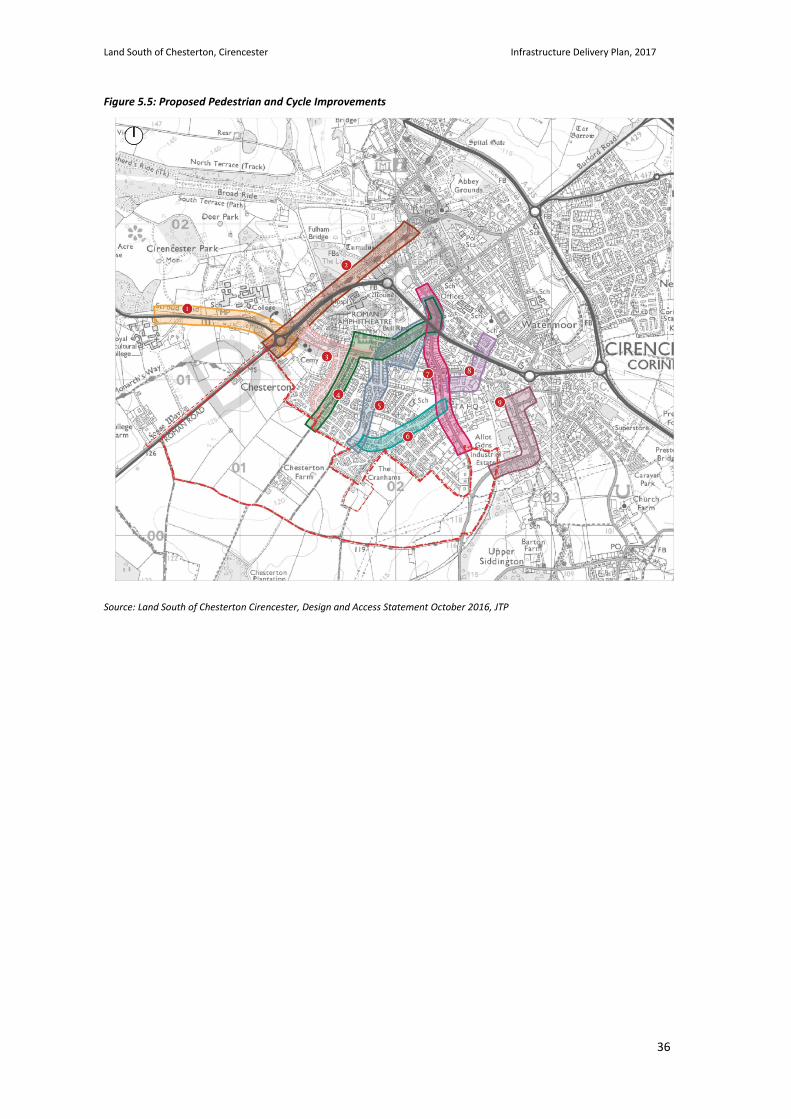
5.38. For pedestrian & cycle projects off-site, BDL have proposed measures on 9 routes which are illustrated in figure 5.5:
• Route 1 - Stroud Road (between Tetbury Road and Deer Park School/Cirencester College/RAU) • Route 2 - Tetbury Road (Between site boundary and town centre) • Route 3 - Cranhams Lane (Existing Farm access) to the A429 via Chesterton Lane • Route 4 - Cranhams Lane (Existing Farm access) to Town Centre (viz existing Bridleway No 24, Four
Acre Field, Cotswold Close, Cotswold Avenue/Mount Street and Somerford Road)
• Route 5 - Cranhams Lane (Existing Bridleway No 30) to Town Centre (via Brooke Road, Bathurst Road, Cotswold Avenue/Mount Street and Somerford Road)
• Route 6 - Cranhams Lane (between The Maples and Somerford Road) • Route 7 - Somerford Road (between site boundary and town centre) • Route 8 - Oaklands to Sperringate (between Somerford Road and Trinity Road/School Lane) • Route 9 - Wilkinson Road/Love Lane/Midland Road
5.39. For Further details and diagrams of the masterplan proposals refer to the Design and Access Statement and the Transport Assessment Report.
Land South of Chesterton, Cirencester Infrastructure Delivery Plan, 2017
36
Figure 5.5: Proposed Pedestrian and Cycle Improvements
Source: Land South of Chesterton Cirencester, Design and Access Statement October 2016, JTP
Land South of Chesterton, Cirencester Infrastructure Delivery Plan, 2017
37
Utilities 5.40. Relevant Evidence base documents:
• Foul Water Drainage and Utilities Assessment, Issue 1, Glanville (14th September 2015)
• Food Risk Assessment and Surface Water Drainage Strategy, Issue 2, Glanville (15th September 2015)
• Thames Water Modelling – Chesterton Farm Modelling Report, Atkins (30th May 2014)
• S98 Foul Sewer Requisition Report - Thames Water (June 2015)
5.41. The Glanville produced document ‘Foul Water Drainage and Utilities Assessment’ provides the basis for the majority of this Utility section. For further details on all these Utility aspects refer to these Glanville produced documents.
5.42. Records have been obtained from utility companies anticipated to have plant within the vicinity of the site. The principal companies contacted with apparatus in the vicinity of the site are as follows:
• National Grid (gas transmission);
• National Grid (electricity transmission);
• Wales & West Utilities (gas distribution and supply);
• Scottish and Southern Energy (electricity distribution and supply);
• Thames Water (sewerage services and potable water); and
• BT Openreach (telecommunications).
Electricity
5.43. For power, it is noted that the existing overhead lines will be retained and not diverted. For the new supplies, a connection will be made to the existing sub-station adjacent to the site and there will be new local sub-stations on-site.
5.44. BDL have also allowed for diversions of the existing 11KV on site, and for grounding & diversions off-site in relation to the proposed highway works.
Gas
5.45. For heating and hot water, it is assumed that a combined heat and power plant serving a district heating system is not utilised as it is considered that this would not be viable. As such, it is assumed that a traditional gas supply is provided to all plots.
5.46. For the gas, it is noted that the existing high pressure mains will be retained and not diverted. BDL have made an allowance for diverting and / or uprating the existing intermediate pressure main on-site and an allowance for diversions off-site in relation to the proposed highways works.
Potable Water Supply
5.47. BDL have been advised that off-site network reinforcement including booster pumps will be required to connect the site to the potable water reservoir. As such and as per the Thame Water commissioned Atkins Report, BDL have allowed for 111m of new 350mm water main & 2087m of new 450mm water main. BDL have also included an allowance for diversions off-site in relations to the proposed highway works.
Foul Water Drainage
5.48. Currently there are a number of existing public foul sewers running through the site. They are located in the eastern end connecting to existing residential dwelling in Chesterton and Chesterton Farm.
5.49. The foul water drainage strategy will be to install a new foul drainage network within the proposed development. Thames Water has been commissioned to design a new pipeline to convey flows from the proposed development directly to the sewage treatment works in South Cerney, thus avoiding the need
Land South of Chesterton, Cirencester Infrastructure Delivery Plan, 2017
38
to connect to the existing sewage system. Initial designs are complete and the route of the new pipeline is located within land owned by the Bathurst Estate and along public highway.
5.50. There is the potential for the new pipeline to also convey effluent from existing development in Chesterton therefore reducing flows into the existing sewer network and helping alleviate the risk of sewer flooding experienced within parts of Cirencester. The extent of the benefit the scheme could offer to the existing community will be determined by Thames Water at the detailed design stage.
5.51. Due to level differences across the site, it will be necessary to pump up to the network. Three separate pumping station locations have been identified within the site, as illustrated in figure 5.6. All of the stations will comprise manholes for the pumping equipment and will be in an enclosed compound with access for maintenance vehicle. The pumping strategy has been developed to avoid the need for a new gravity sewer to be located across the area of the site designated as SAM. The foul drainage network, including the pumping stations and the pumping mains will be offered for adoption to Thames Water and will be designed and built in accordance with their specifications.
Figure 5.6: Illustrative on-site Drainage proposals
Source: Land South of Chesterton Cirencester, Design and Access Statement October 2016, JTP
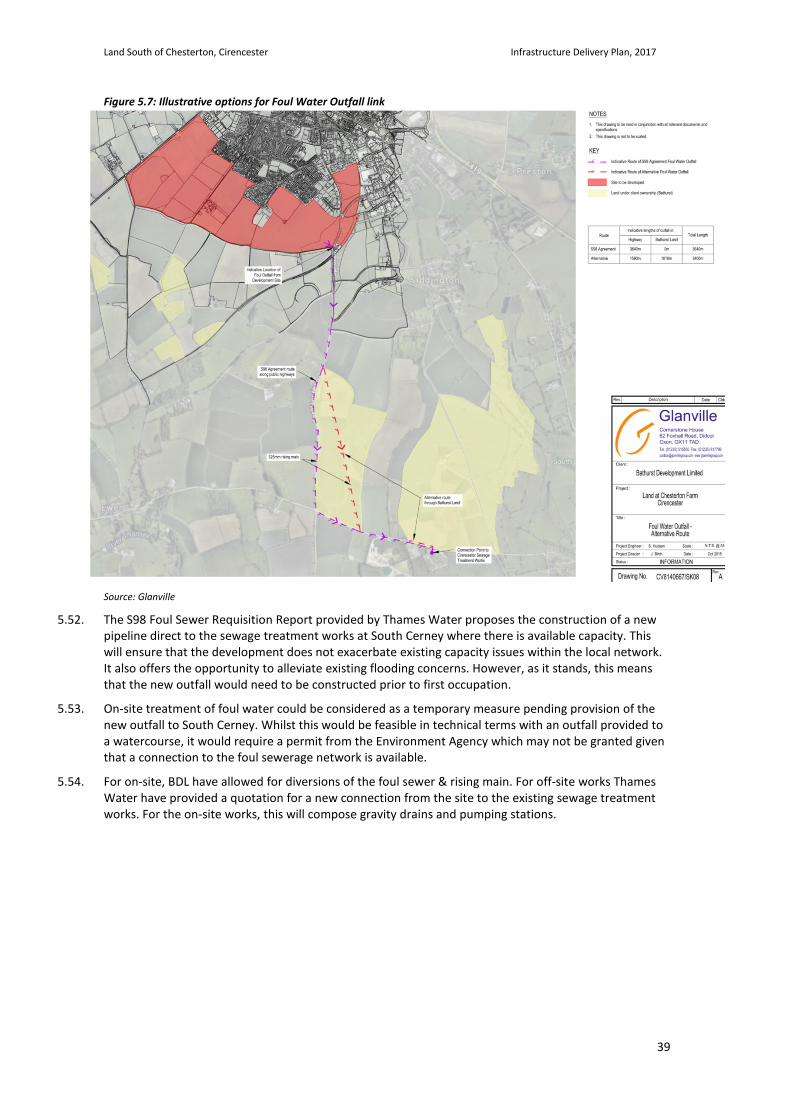
Land South of Chesterton, Cirencester Infrastructure Delivery Plan, 2017
39
Figure 5.7: Illustrative options for Foul Water Outfall link
Source: Glanville
5.52. The S98 Foul Sewer Requisition Report provided by Thames Water proposes the construction of a new pipeline direct to the sewage treatment works at South Cerney where there is available capacity. This will ensure that the development does not exacerbate existing capacity issues within the local network. It also offers the opportunity to alleviate existing flooding concerns. However, as it stands, this means that the new outfall would need to be constructed prior to first occupation.
5.53. On-site treatment of foul water could be considered as a temporary measure pending provision of the new outfall to South Cerney. Whilst this would be feasible in technical terms with an outfall provided to a watercourse, it would require a permit from the Environment Agency which may not be granted given that a connection to the foul sewerage network is available.
5.54. For on-site, BDL have allowed for diversions of the foul sewer & rising main. For off-site works Thames Water have provided a quotation for a new connection from the site to the existing sewage treatment works. For the on-site works, this will compose gravity drains and pumping stations.
Land South of Chesterton, Cirencester Infrastructure Delivery Plan, 2017
40
Flood Risk and Surface Water Drainage
5.55. Sustainable Drainage Systems (SuDS) have been integrated within the masterplan. SuDS aim to drain surface water runoff from the development by mimicking the existing flow regime of the undeveloped greenfield site, ensuring that development proposals do not increase the risk of flooding downstream.
5.56. The choice of SuDS is dependent upon site characteristics and can include infiltration of surface water runoff to the ground, or attenuation of flows before discharge to the local watercourse at controlled rates. SuDS designs within the masterplan are based on soakaways, permeable paving, swales, and basins, which will be designed to maximise the use of infiltration into the ground with overflows to the existing ditch network. Attenuation basins are located at lower areas of the site designed as part of the Green Infrastructure and open space network. The majority of these basins will not be wet and will be planted / grassed areas enhancing biodiversity.
5.57. Any discharge to the local watercourse will be restricted to the natural undeveloped greenfield runoff rate. SuDS are designed to accommodate surface water runoff generated from all rainfall events up to and including the 1 in 100 year, including an increase of 30% in rainfall intensity as allowance for the potential effects of climate change.
5.58. Figure 5.8 indicates the location of the attenuation basins – the larger areas of blue, along with indicative connectivity between the features. Swales are shown along the primary road from Tetbury Road.
Figure 5.8: Illustrative SUDs proposals
Source: land South of Chesterton Cirencester, Green Infrastructure Strategy 2016
BDL have been advised by Glanville that there are no works required in connection with flooding measures.
For surface water, this will be based on the principles of sustainable urban drainage systems (SUDS) and will comprise a series of swales and alteration ponds discharging into local water courses. A number of other on-plot measures will be included against the on-plot costs in relation to rainwater harvesting, green roofs, soakaways and geocellular storage.
Land South of Chesterton, Cirencester Infrastructure Delivery Plan, 2017
41
Solid Waste
5.59. Specific details on waste infrastructure requirement have not formed part of the outline planning application documentation and BDL have been advised there are no requirements to increase the capacity of the existing local civic amenity site for household waste. BDL has therefore included allowances for hardstanding’s as recycling points on-site.
Communications and Broadband
5.60. For on-site works, BDL have included for trenches and ducts only on the assumption that all cabling and equipment will be supplied & fixed by others at no cost to the Client.
5.61. For off-site works, there are no details available on the requirement or otherwise for network reinforcement. BDL have included however a significant allowance for diversions off-site in relation to the proposed highways works.
5.62. In respect of Security/Information Technology, BDL have assumed that this will be provided on primary streets only in an integrated system incorporating ductwork for CCTV, parking control, bus information and smart meters.
Diversions from Off Site Highway Works
5.63. Glanville have obtained utility record drawings for the areas off-site that will be affected by the highway works proposed by i-Transport. Moving forwards, the records will need to be reviewed against the proposed highway works to establish the likely effect of the works on existing services and identify the need for service diversions or protective measures.
5.64. In the first instance Glanville would simply identify the likely impact, focussing initially on the Tetbury Road access. They would then liaise with i-Transport to establish if changes were possible to the highways works to mitigate the impact on services. Glanville would then contact the utility companies and request budget estimates for any service diversions or protective measures, although charges are likely to apply and it will take some time to obtain responses.
Land South of Chesterton, Cirencester Infrastructure Delivery Plan, 2017
42
Social Infrastructure 5.65. This section outlines the current social infrastructure proposals identified to support the Land South of
Chesterton Site.
Education Proposals
Early Year Provision:
5.66. Uptake of early year facility places based on GCC Child Yield Assumptions and exemptions. Calculation estimates 142 additional children requiring places. This is likely to be provided across multiple sites including a nursery within the new Primary School.
5.67. Discussions between BDL, CDC and GCC have arrived at the following working position in terms of early year provision planning:
• A number of these places should be provided in-kind, as part of an on-site nursery, attached to or associated with the 3FE primary school. Provision is made in set ratios of staff to children, and for a 3FE primary school, a nursery would be provide up to 78 places.
• The balance of places (i.e. 64) will be provided elsewhere across the site or serving the site, and secured through a financial contribution.
• Developer Contribution monies will be applied to increasing capacity of existing nursery and pre-school child care facilities serving the development.
Primary schools - Potential Financial Contribution to temporary provision
5.68. There is an identified need for temporary Primary school places. Chesterton Primary will be full by 2019.
5.69. Discussions between BDL, CDC and GCC have arrived at the following working position in terms of temporary primary school planning:
• Preferred option being progressed for temporary provision at Chesterton Primary School through a bulge year early in the development phase.
• Year 1 would be covered by existing capacity in schools.
• Year 2 would be covered by bulge class at Chesterton Primary.
• Years 3 – 4 would be covered by temporary provision. GCC is actively pursuing a host site within a 2 mile catchment of the site, to host the temporary school in its early stages. Whilst there are a number of options (including alternative primary schools, secondary schools and colleges), this needs the agreement of the host site. A suitable site would also need to meet certain criteria around accessibility and suitability. If it is unable to secure the agreement on a suitable site, alternatives will be explored including land inthe development site
• Where a temporary site is identified, any legacy temporary buildings used as the host site for the new school could then become part of the host school offer, or could form part of the required nursery provision.
• Discussions with the nearest primary school (Chesterton Primary) have revealed the need for alternative solutions, all of which are being explored during 2017:
o Option: Potential to provide temporary classrooms on secondary school site and those legacy buildings continue to operate as nursery longer term.
o Option: Potential to provide temporary classrooms on Chesterton Site in early phases of development – within employment area to east of development, or within the existing buildings which will become community uses
Primary schools - Construction of new 3FE (630 place) school
5.70. In line with GCC guidelines, applying GCC Child Yield assumptions and exemptions (no pupils from flats, student accommodation and elderly supported housing) creates the estimated need for 507 additional primary school places.
Land South of Chesterton, Cirencester Infrastructure Delivery Plan, 2017
43
5.71. Discussions between BDL, CDC and GCC have arrived at the following working position in terms of primary school planning:
• Trigger point for school estimates are between the occupation of 500-750 units. According to the current housing trajectory this would require the primary school to be open on site by 2023.
• GCC estimate 2 year build time, with first 2FE built out and extension to 3FE around 2028 (at occupation of 2,000 units).
• S106 will need to be drafted with sufficient flexibility to cater for an under demand or over demand for school places in light of a different built out trajectory.
• Primary school is likely to be operated by Multi Academy Trust (MAT). Generally put out to competition and GCC have 3-4 preferred MATs they are currently working with.
• For School opening in 2023 the process for appointing a MAT would begin in January 2020 with appointment by November 2020. GCC have provided BDL with a detailed timeline from opening consultation to school opening.
Secondary Schools – Potential Financial Contribution towards places at Cirencester Schools
5.72. Applying GCC Child Yield assumptions and exemptions (no pupils from flats, student accommodation and elderly supported housing) creates the estimated need for 264 additional secondary school places. This does not equate to a scale to justify an onsite secondary school facility. As a result, an off-site financial contribution towards expansion of existing secondary school pupil capacity will be necessary.
5.73. Discussions between BDL, CDC and GCC have arrived at the following working position in terms of secondary school planning:
• Capacity will be made available across the two secondary schools in Cirencester as parental choice will allow future residents to apply to either of the schools and the county councils duty is to ensure sufficient places are available across the catchment area.
• GCC will undertake capacity and curriculum assessments of the secondary schools to better understand how they will accommodate increases in pupils and what affect this has on developer contribution levels and timings.
• GCC have confirmed that Deer Park and Kings Hill Secondary Schools will provide capacity for the pupils from Chesterton Strategic Site.
• GCC expects 77 of these to be accommodated within the surplus places forecast, and the balance of 187 to be provided for through expansion, secured through the s106 agreement.
Sixth Form places - Potential Financial Contribution towards places at Cirencester College
5.74. Applying GCC Child Yield assumptions and exemptions (no pupils from flats, student accommodation and elderly supported housing) creates the estimated need for 41 additional sixth form places.
5.75. This does not equate to a scale to justify an onsite sixth form school facility. The existing sixth form provision in Cirencester, the Cirencester College will cater for demand from the strategic site.
Health and Social Care Proposals
Primary Healthcare – Healthcare Hub
5.76. Based upon the assessed population impacts from the proposed development a future patient list size of up to 5,500 people has been estimated. Based upon a planning benchmark of 1,800 patients per GP1 and 2,207 patients per dentist2 this would require an onsite provision of approximately three GPs and two dentists with a full range of complimentary primary healthcare services including pharmacy and optician facilities.
5.77. A floorspace allowance of 600 sq.m has been identified within the planning application for a combined healthcare hub which would accommodate these various primary healthcare services. Opportunities to
1 NHS Gloucestershire, the NHS Information Centre (NHS-NI) and Department of Health (ref Gloucestershire SIDP 2010) 2 Provision for dental services within the South West Strategic Health Authority (2007-2008) (ref Gloucestershire SIDP 2010)
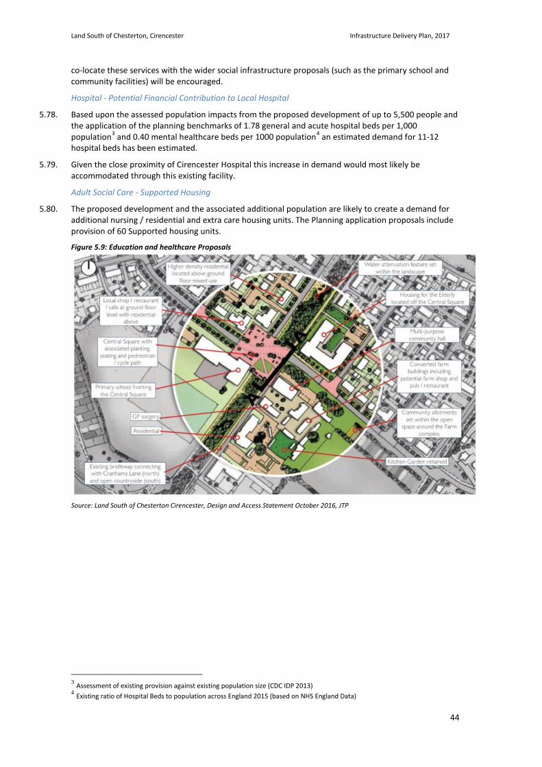
Land South of Chesterton, Cirencester Infrastructure Delivery Plan, 2017
44
co-locate these services with the wider social infrastructure proposals (such as the primary school and community facilities) will be encouraged.
Hospital - Potential Financial Contribution to Local Hospital
5.78. Based upon the assessed population impacts from the proposed development of up to 5,500 people and the application of the planning benchmarks of 1.78 general and acute hospital beds per 1,000 population3 and 0.40 mental healthcare beds per 1000 population4 an estimated demand for 11-12 hospital beds has been estimated.
5.79. Given the close proximity of Cirencester Hospital this increase in demand would most likely be accommodated through this existing facility.
Adult Social Care - Supported Housing
5.80. The proposed development and the associated additional population are likely to create a demand for additional nursing / residential and extra care housing units. The Planning application proposals include provision of 60 Supported housing units.
Figure 5.9: Education and healthcare Proposals
Source: Land South of Chesterton Cirencester, Design and Access Statement October 2016, JTP
3 Assessment of existing provision against existing population size (CDC IDP 2013) 4 Existing ratio of Hospital Beds to population across England 2015 (based on NHS England Data)
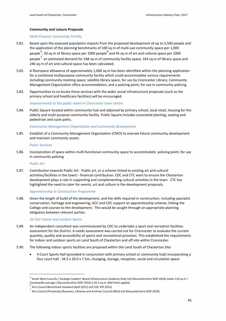
Land South of Chesterton, Cirencester Infrastructure Delivery Plan, 2017
45
Community and Leisure Proposals
Multi-Purpose Community Facility
5.81. Based upon the assessed population impacts from the proposed development of up to 5,500 people and the application of the planning benchmarks of 100 sq.m of multi-use community space per 1,000 people5, 30 sq.m of library space per 1000 people6 and 45 sq.m of art and cultural space per 1000 people7, an estimated demand for 548 sq.m of community facility space, 164 sq.m of library space and 246 sq.m of art and cultural space has been calculated.
5.82. A floorspace allowance of approximately 1,000 sq.m has been identified within the planning application for a combined multipurpose community facility which could accommodate various requirements including community meeting space; satellite library space, for use by Cirencester Library; Community Management Organization office accommodation; and a policing point, for use in community policing.
5.83. Opportunities to co-locate these services with the wider social infrastructure proposals (such as the primary school and healthcare facilities) will be encouraged.
Improvements to the public realm in Cirencester town centre
5.84. Public Square located within community hub and adjoined by primary school, local retail, housing for the elderly and multi-purpose community facility. Public Square includes associated planting, seating and pedestrian and cycle paths.
Community Management Organization and community development
5.85. Establish of a Community Management Organization (CMO) to oversee future community development and maintain community assets.
Police Services
5.86. Incorporation of space within multi-functional community space to accommodate policing point, for use in community policing
Public Art
5.87. Contribution towards Public Art - Public art, or a scheme linked to existing art and cultural activities/facilities in the town) - financial contribution. CDC and CTC want to ensure the Chesterton development plays a role in supporting and complementing cultural activities in the town. CTC has highlighted the need to cater for events, art and culture in the development proposals.
Apprenticeship in Construction Programme
5.88. Given the length of build of the development, and the skills required in construction, including specialist conservation, heritage and engineering, GCC and CDC support an apprenticeship scheme, linking the College and courses to the development. This would be sought through an appropriate planning obligation between relevant parties.
On Site Indoor and outdoor Sports
5.89. An independent consultant was commissioned by CDC to undertake a sport and recreation facilities assessment for the District. A needs assessment was carried out for Cirencester to evaluate the current quantity, quality and accessibility of sports and recreational provision. This established the requirements for indoor and outdoor sports on Land South of Chesterton and off-site within Cirencester.
5.90. The following indoor sports facilities are proposed within the Land South of Chesterton Site:
• 4 Court Sports Hall (provided in conjunction with primary school or community hub) incorporating a four court hall - 34.5 x 20.0 x 7.5m, changing, storage, reception, social and circulation space.
5 South West Councils / Strategic Leaders’ Board Infrastructure Guidance Note (ref Gloucestershire SIDP 2010) states 110 sq.m / Countywide average ( Gloucestershire SIDP 2010) is 92.5 sq.m. Mid-Point applied. 6 Arts Council Benchmark standard (April 2012) (ref CDC IDP 2013) 7 Arts Council (Previously Museums, Libraries and Archives Council (MLA) (ref Gloucestershire SIDP 2010)
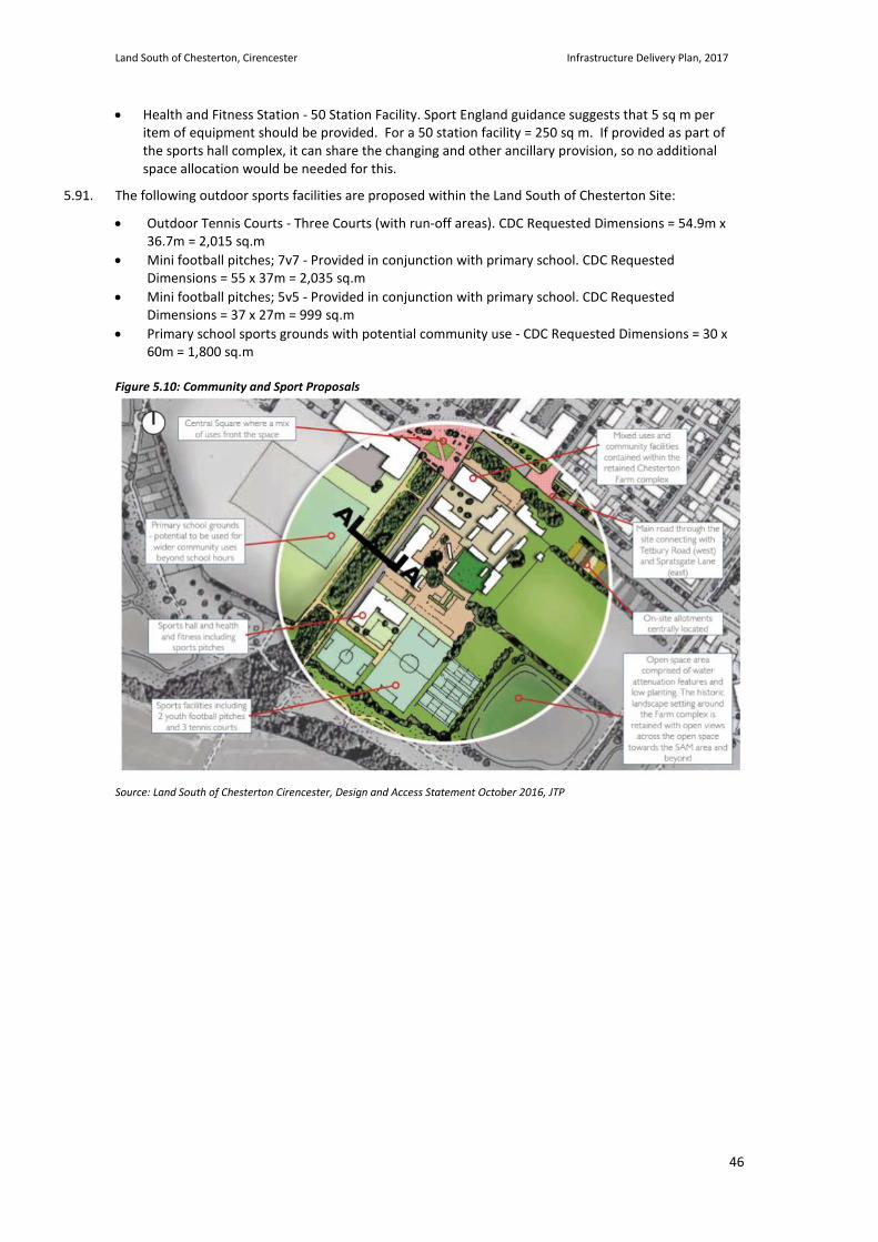
Land South of Chesterton, Cirencester Infrastructure Delivery Plan, 2017
46
• Health and Fitness Station - 50 Station Facility. Sport England guidance suggests that 5 sq m per item of equipment should be provided. For a 50 station facility = 250 sq m. If provided as part of the sports hall complex, it can share the changing and other ancillary provision, so no additional space allocation would be needed for this.
5.91. The following outdoor sports facilities are proposed within the Land South of Chesterton Site:
• Outdoor Tennis Courts - Three Courts (with run-off areas). CDC Requested Dimensions = 54.9m x 36.7m = 2,015 sq.m
• Mini football pitches; 7v7 - Provided in conjunction with primary school. CDC Requested Dimensions = 55 x 37m = 2,035 sq.m
• Mini football pitches; 5v5 - Provided in conjunction with primary school. CDC Requested Dimensions = 37 x 27m = 999 sq.m
• Primary school sports grounds with potential community use - CDC Requested Dimensions = 30 x 60m = 1,800 sq.m
Figure 5.10: Community and Sport Proposals
Source: Land South of Chesterton Cirencester, Design and Access Statement October 2016, JTP
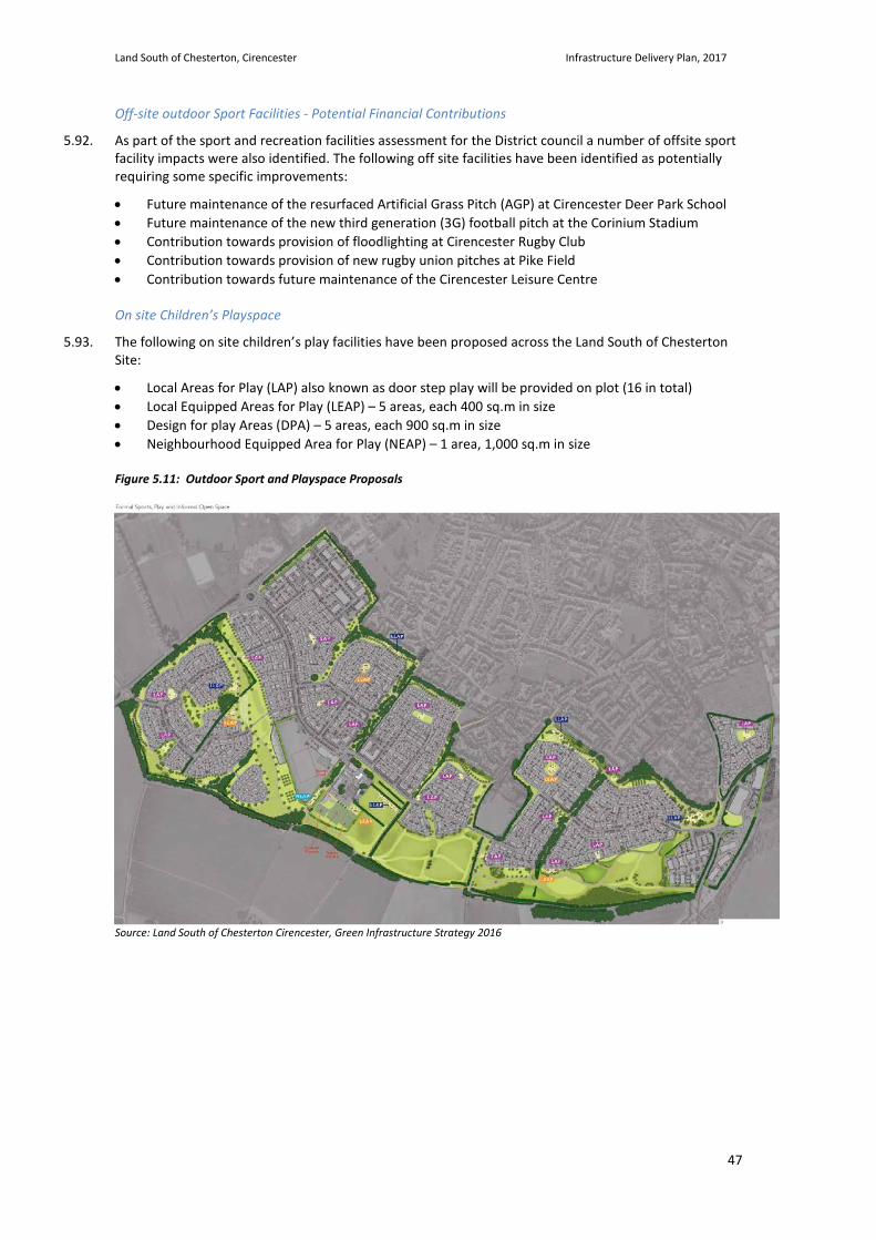
Land South of Chesterton, Cirencester Infrastructure Delivery Plan, 2017
47
Off-site outdoor Sport Facilities - Potential Financial Contributions
5.92. As part of the sport and recreation facilities assessment for the District council a number of offsite sport facility impacts were also identified. The following off site facilities have been identified as potentially requiring some specific improvements:
• Future maintenance of the resurfaced Artificial Grass Pitch (AGP) at Cirencester Deer Park School • Future maintenance of the new third generation (3G) football pitch at the Corinium Stadium • Contribution towards provision of floodlighting at Cirencester Rugby Club • Contribution towards provision of new rugby union pitches at Pike Field • Contribution towards future maintenance of the Cirencester Leisure Centre
On site Children’s Playspace
5.93. The following on site children’s play facilities have been proposed across the Land South of Chesterton Site:
• Local Areas for Play (LAP) also known as door step play will be provided on plot (16 in total) • Local Equipped Areas for Play (LEAP) – 5 areas, each 400 sq.m in size • Design for play Areas (DPA) – 5 areas, each 900 sq.m in size • Neighbourhood Equipped Area for Play (NEAP) – 1 area, 1,000 sq.m in size Figure 5.11: Outdoor Sport and Playspace Proposals
Source: Land South of Chesterton Cirencester, Green Infrastructure Strategy 2016
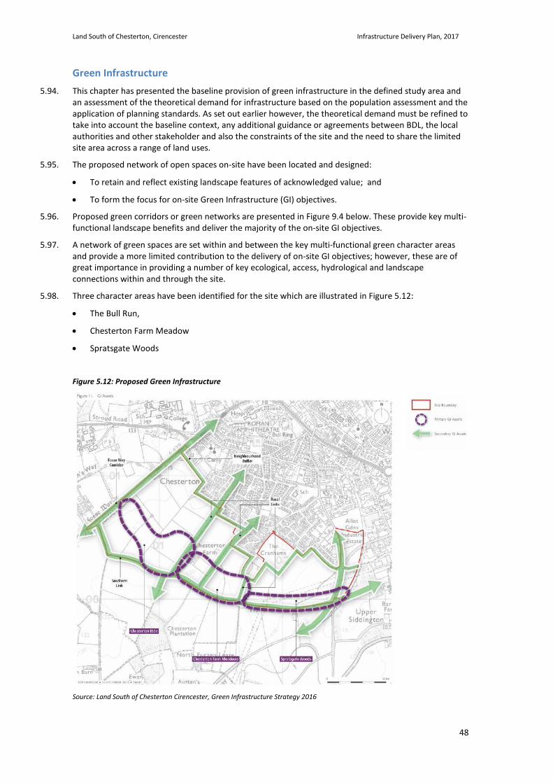
Land South of Chesterton, Cirencester Infrastructure Delivery Plan, 2017
48
Green Infrastructure 5.94. This chapter has presented the baseline provision of green infrastructure in the defined study area and
an assessment of the theoretical demand for infrastructure based on the population assessment and the application of planning standards. As set out earlier however, the theoretical demand must be refined to take into account the baseline context, any additional guidance or agreements between BDL, the local authorities and other stakeholder and also the constraints of the site and the need to share the limited site area across a range of land uses.
5.95. The proposed network of open spaces on-site have been located and designed:
• To retain and reflect existing landscape features of acknowledged value; and
• To form the focus for on-site Green Infrastructure (GI) objectives.
5.96. Proposed green corridors or green networks are presented in Figure 9.4 below. These provide key multi-functional landscape benefits and deliver the majority of the on-site GI objectives.
5.97. A network of green spaces are set within and between the key multi-functional green character areas and provide a more limited contribution to the delivery of on-site GI objectives; however, these are of great importance in providing a number of key ecological, access, hydrological and landscape connections within and through the site.
5.98. Three character areas have been identified for the site which are illustrated in Figure 5.12:
• The Bull Run,
• Chesterton Farm Meadow
• Spratsgate Woods
Figure 5.12: Proposed Green Infrastructure
Source: Land South of Chesterton Cirencester, Green Infrastructure Strategy 2016
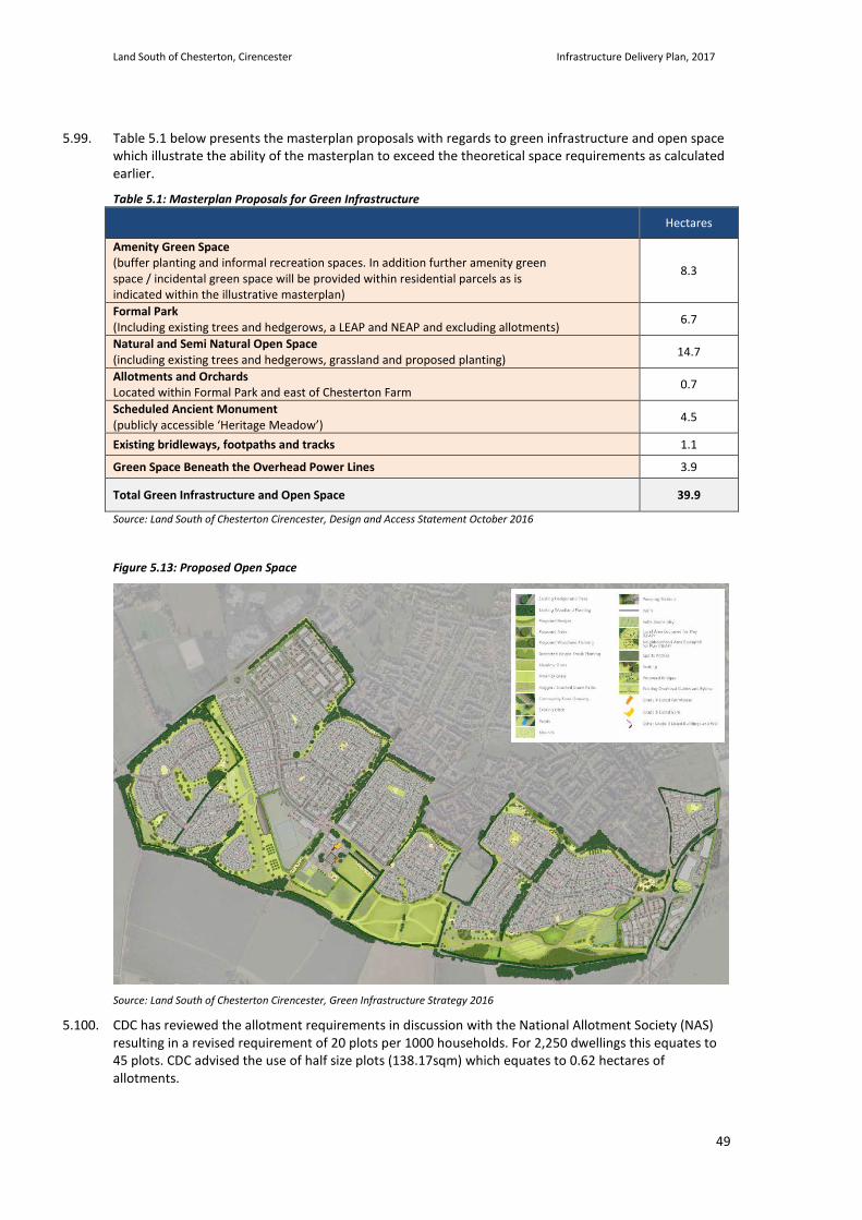
Land South of Chesterton, Cirencester Infrastructure Delivery Plan, 2017
49
5.99. Table 5.1 below presents the masterplan proposals with regards to green infrastructure and open space which illustrate the ability of the masterplan to exceed the theoretical space requirements as calculated earlier.
Table 5.1: Masterplan Proposals for Green Infrastructure Hectares
Amenity Green Space (buffer planting and informal recreation spaces. In addition further amenity green space / incidental green space will be provided within residential parcels as is indicated within the illustrative masterplan)
8.3
Formal Park (Including existing trees and hedgerows, a LEAP and NEAP and excluding allotments) 6.7
Natural and Semi Natural Open Space (including existing trees and hedgerows, grassland and proposed planting) 14.7
Allotments and Orchards Located within Formal Park and east of Chesterton Farm 0.7
Scheduled Ancient Monument (publicly accessible ‘Heritage Meadow’) 4.5
Existing bridleways, footpaths and tracks 1.1
Green Space Beneath the Overhead Power Lines 3.9
Total Green Infrastructure and Open Space 39.9
Source: Land South of Chesterton Cirencester, Design and Access Statement October 2016
Figure 5.13: Proposed Open Space
Source: Land South of Chesterton Cirencester, Green Infrastructure Strategy 2016
5.100. CDC has reviewed the allotment requirements in discussion with the National Allotment Society (NAS) resulting in a revised requirement of 20 plots per 1000 households. For 2,250 dwellings this equates to 45 plots. CDC advised the use of half size plots (138.17sqm) which equates to 0.62 hectares of allotments.

Land South of Chesterton, Cirencester Infrastructure Delivery Plan, 2017
50
5.101. Playing field requirements against proposals has been presented earlier under the social infrastructure section and reflect the dialogue between BDL and CDC where a series of off-site proposals for outdoor sports provision have been suggested as opposed to a series of additional on-site sports fields which were explored by the design team but shown to require additional land to the south of the site boundary.
5.102. The Green Infrastructure Strategy and the Design and Access Statement, accompanying the Outline Planning Application (OPA), provide in-depth detail on each of the green infrastructure character areas and components of the green infrastructure package.
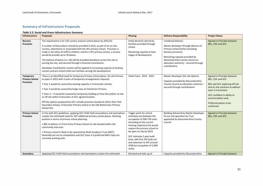
Land South of Chesterton, Cirencester Infrastructure Delivery Plan, 2017
51
Summary of Infrastructure Proposals Table 5.2: Social and Green Infrastructure Summary Infrastructure Proposals Phasing Delivery Responsibility Project Status
Nursery Provision
The requirement is for 142 nursery and pre-school places by 2031/32.
A number of these places should be provided in-kind, as part of an on-site nursery, attached to or associated with the 3FE primary school. Provision is made in set ratios of staff to children, and for a 3FE primary school, a nursery would be provide up to 78 places.
The balance of places (i.e. 64) will be provided elsewhere across the site or serving the site, and secured through a financial contribution.
Developer Contribution monies will be applied to increasing capacity of existing nursery and pre-school child care facilities serving the development.
Initial demand catered by facilities provided through school.
Remaining capacity at later stages of development.
Combined delivery:
Master developer through delivery of Primary school facility (including Nursery provision)
Remaining capacity provided by Gloucestershire County Council as education authority – secured through contributions
Agreed in Principle between BDL, CDC and GCC
Temporary Primary School Provision
There is an identified need for temporary Primary school places. On site Primary to open in 2023 with 4 years of temporary arrangements required:
• Year 1 would be covered by existing capacity in Cirencester schools.
• Year 2 would be covered by bulge class at Chesterton Primary.
• Years 3 – 4 would be covered by temporary building at Host Site (either on site or off site within Cirencester at GCC agreed location.
Off Site options proposed by GCC include provision located at either Deer Park Secondary School, Cirencester Primary School or the Old Watermoor Primary School Site.
Initial Years: 2019 - 2022 Master Developer (On site Option)
Capacity provided by Gloucestershire County Council as education authority – secured through contributions
Agreed in Principle between BDL, CDC and GCC
BDL and GCC exploring off site and on site solutions to address years 3-4 provision.
GCC confident in ability to accommodate need.
Preferred option to be confirmed.
Primary School Provision
In line with GCC guidelines, applying GCC Child Yield assumptions and exemptions creates the estimated need for 507 additional primary school places. Working position in terms of primary school planning:
• BDL to deliver a 3 Form Entry Primary School on site located within the community hub area.
• Primary school is likely to be operated by Multi Academy Trust (MAT). Generally put out to competition and GCC have 3-4 preferred MATs they are currently working with.
Trigger point for school estimates are between the occupation of 500-750 units. According to the current housing trajectory this would require the primary school to be open on site by 2023.
GCC estimate 2 year build time, with first 2FE built out and extension to 3FE around 2028 (at occupation of 2,000 units).
Building delivered by Master Developer, fit out and operation by Trust appointed by Gloucestershire County Council
Agreed in Principle between BDL, CDC and GCC
Secondary Applying GCC Child Yield assumptions and exemptions creates the estimated Demand and take up of Capacity provided by Gloucestershire Agreed in Principle between
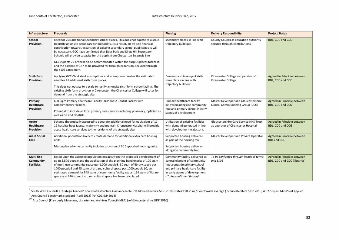
Land South of Chesterton, Cirencester Infrastructure Delivery Plan, 2017
52
Infrastructure Proposals Phasing Delivery Responsibility Project Status
School Provision
need for 264 additional secondary school places. This does not equate to a scale to justify an onsite secondary school facility. As a result, an off-site financial contribution towards expansion of existing secondary school pupil capacity will be necessary. GCC have confirmed that Deer Park and Kings Hill Secondary Schools will provide capacity for the pupils from Chesterton Strategic Site
GCC expects 77 of these to be accommodated within the surplus places forecast, and the balance of 187 to be provided for through expansion, secured through the s106 agreement.
secondary places in line with trajectory build out.
County Council as education authority – secured through contributions
BDL, CDC and GCC
Sixth Form Provision
Applying GCC Child Yield assumptions and exemptions creates the estimated need for 41 additional sixth form places.
This does not equate to a scale to justify an onsite sixth form school facility. The existing sixth form provision in Cirencester, the Cirencester College will cater for demand from the strategic site.
Demand and take up of sixth form places in line with trajectory build out.
Cirencester College as operator of Cirencester College
Agreed in Principle between BDL, CDC and GCC
Primary Healthcare Provision
600 Sq.m Primary healthcare Facility (3GP and 2 Dentist Facility with complimentary facilities)
Potential to include all local primary care services including pharmacy, optician as well as GP and Dentists.
Primary healthcare facility delivered alongside community hub and primary school in early stages of development
Master Developer and Gloucestershire Clinical Commissioning Group (CCG)
Agreed in Principle between BDL, CDC and CCG
Acute Healthcare Provision
Scheme theoretically assessed to generate additional need for equivalent of 11-12 hospital beds (acute, maternity and mental). Cirencester Hospital will provide acute healthcare services to the residents of the strategic site.
Utilisation of existing facilities with demand generated in line with development trajectory.
Gloucestershire Care Service NHS Trust as operator of Cirencester Hospital
Agreed in Principle between BDL, CDC and CCG
Adult Social Care
Additional population likely to create demand for additional extra care housing units.
Masterplan scheme currently includes provision of 60 Supported housing units.
Supported housing delivered as part of the housing mix.
Supported housing delivered alongside community hub
Master Developer and Private Operator Agreed in Principle between BDL and CDC
Multi Use Community Facilities
Based upon the assessed population impacts from the proposed development of up to 5,500 people and the application of the planning benchmarks of 100 sq.m of multi-use community space per 1,000 people8, 30 sq.m of library space per 1000 people9 and 45 sq.m of art and cultural space per 1000 people10, an estimated demand for 548 sq.m of community facility space, 164 sq.m of library space and 246 sq.m of art and cultural space has been calculated.
Community facility delivered as central element of community hub alongside primary school and primary healthcare facility in early stages of development - To be confirmed through
To be confirmed through heads of terms and S106
Agreed in Principle between BDL, CDC and GCC (libraries)
8 South West Councils / Strategic Leaders’ Board Infrastructure Guidance Note (ref Gloucestershire SIDP 2010) states 110 sq.m / Countywide average ( Gloucestershire SIDP 2010) is 92.5 sq.m. Mid-Point applied. 9 Arts Council Benchmark standard (April 2012) (ref CDC IDP 2013) 10 Arts Council (Previously Museums, Libraries and Archives Council (MLA) (ref Gloucestershire SIDP 2010)
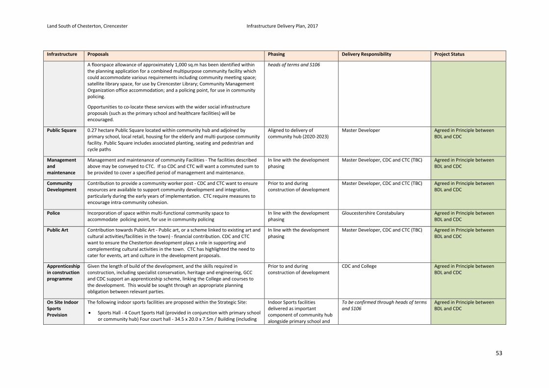
Land South of Chesterton, Cirencester Infrastructure Delivery Plan, 2017
53
Infrastructure Proposals Phasing Delivery Responsibility Project Status
A floorspace allowance of approximately 1,000 sq.m has been identified within the planning application for a combined multipurpose community facility which could accommodate various requirements including community meeting space; satellite library space, for use by Cirencester Library; Community Management Organization office accommodation; and a policing point, for use in community policing.
Opportunities to co-locate these services with the wider social infrastructure proposals (such as the primary school and healthcare facilities) will be encouraged.
heads of terms and S106
Public Square 0.27 hectare Public Square located within community hub and adjoined by primary school, local retail, housing for the elderly and multi-purpose community facility. Public Square includes associated planting, seating and pedestrian and cycle paths
Aligned to delivery of community hub (2020-2023)
Master Developer Agreed in Principle between BDL and CDC
Management and maintenance
Management and maintenance of community Facilities - The facilities described above may be conveyed to CTC. If so CDC and CTC will want a commuted sum to be provided to cover a specified period of management and maintenance.
In line with the development phasing
Master Developer, CDC and CTC (TBC) Agreed in Principle between BDL and CDC
Community Development
Contribution to provide a community worker post - CDC and CTC want to ensure resources are available to support community development and integration, particularly during the early years of implementation. CTC require measures to encourage intra-community cohesion.
Prior to and during construction of development
Master Developer, CDC and CTC (TBC) Agreed in Principle between BDL and CDC
Police Incorporation of space within multi-functional community space to accommodate policing point, for use in community policing
In line with the development phasing
Gloucestershire Constabulary Agreed in Principle between BDL and CDC
Public Art Contribution towards Public Art - Public art, or a scheme linked to existing art and cultural activities/facilities in the town) - financial contribution. CDC and CTC want to ensure the Chesterton development plays a role in supporting and complementing cultural activities in the town. CTC has highlighted the need to cater for events, art and culture in the development proposals.
In line with the development phasing
Master Developer, CDC and CTC (TBC) Agreed in Principle between BDL and CDC
Apprenticeship in construction programme
Given the length of build of the development, and the skills required in construction, including specialist conservation, heritage and engineering, GCC and CDC support an apprenticeship scheme, linking the College and courses to the development. This would be sought through an appropriate planning obligation between relevant parties.
Prior to and during construction of development
CDC and College Agreed in Principle between BDL and CDC
On Site Indoor Sports Provision
The following indoor sports facilities are proposed within the Strategic Site:
• Sports Hall - 4 Court Sports Hall (provided in conjunction with primary school or community hub) Four court hall - 34.5 x 20.0 x 7.5m / Building (including
Indoor Sports facilities delivered as important component of community hub alongside primary school and
To be confirmed through heads of terms and S106
Agreed in Principle between BDL and CDC
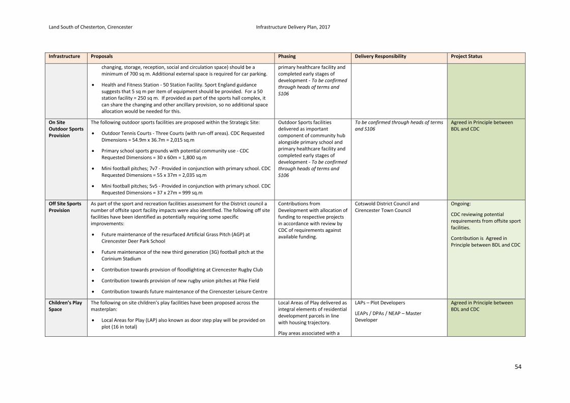
Land South of Chesterton, Cirencester Infrastructure Delivery Plan, 2017
54
Infrastructure Proposals Phasing Delivery Responsibility Project Status
changing, storage, reception, social and circulation space) should be a minimum of 700 sq m. Additional external space is required for car parking.
• Health and Fitness Station - 50 Station Facility. Sport England guidance suggests that 5 sq m per item of equipment should be provided. For a 50 station facility = 250 sq m. If provided as part of the sports hall complex, it can share the changing and other ancillary provision, so no additional space allocation would be needed for this.
primary healthcare facility and completed early stages of development - To be confirmed through heads of terms and S106
On Site Outdoor Sports Provision
The following outdoor sports facilities are proposed within the Strategic Site:
• Outdoor Tennis Courts - Three Courts (with run-off areas). CDC Requested Dimensions = 54.9m x 36.7m = 2,015 sq.m
• Primary school sports grounds with potential community use - CDC Requested Dimensions = 30 x 60m = 1,800 sq.m
• Mini football pitches; 7v7 - Provided in conjunction with primary school. CDC Requested Dimensions = 55 x 37m = 2,035 sq.m
• Mini football pitches; 5v5 - Provided in conjunction with primary school. CDC Requested Dimensions = 37 x 27m = 999 sq.m
Outdoor Sports facilities delivered as important component of community hub alongside primary school and primary healthcare facility and completed early stages of development - To be confirmed through heads of terms and S106
To be confirmed through heads of terms and S106
Agreed in Principle between BDL and CDC
Off Site Sports Provision
As part of the sport and recreation facilities assessment for the District council a number of offsite sport facility impacts were also identified. The following off site facilities have been identified as potentially requiring some specific improvements:
• Future maintenance of the resurfaced Artificial Grass Pitch (AGP) at Cirencester Deer Park School
• Future maintenance of the new third generation (3G) football pitch at the Corinium Stadium
• Contribution towards provision of floodlighting at Cirencester Rugby Club
• Contribution towards provision of new rugby union pitches at Pike Field
• Contribution towards future maintenance of the Cirencester Leisure Centre
Contributions from Development with allocation of funding to respective projects in accordance with review by CDC of requirements against available funding.
Cotswold District Council and Cirencester Town Council
Ongoing:
CDC reviewing potential requirements from offsite sport facilities.
Contribution is Agreed in Principle between BDL and CDC
Children’s Play Space
The following on site children’s play facilities have been proposed across the masterplan:
• Local Areas for Play (LAP) also known as door step play will be provided on plot (16 in total)
Local Areas of Play delivered as integral elements of residential development parcels in line with housing trajectory.
Play areas associated with a
LAPs – Plot Developers
LEAPs / DPAs / NEAP – Master Developer
Agreed in Principle between BDL and CDC
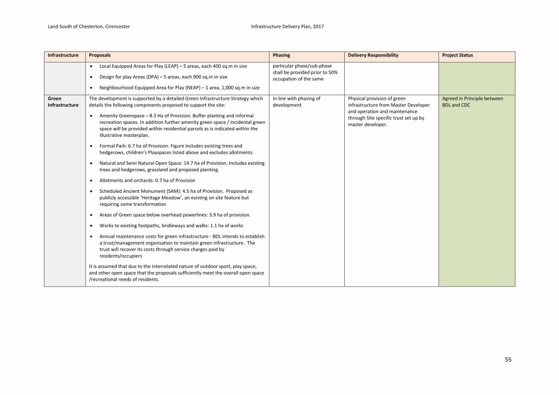
Land South of Chesterton, Cirencester Infrastructure Delivery Plan, 2017
55
Infrastructure Proposals Phasing Delivery Responsibility Project Status
• Local Equipped Areas for Play (LEAP) – 5 areas, each 400 sq.m in size
• Design for play Areas (DPA) – 5 areas, each 900 sq.m in size
• Neighbourhood Equipped Area for Play (NEAP) – 1 area, 1,000 sq.m in size
particular phase/sub-phase shall be provided prior to 50% occupation of the same
Green Infrastructure
The development is supported by a detailed Green Infrastructure Strategy which details the following components proposed to support the site:
• Amenity Greenspace – 8.3 Ha of Provision. Buffer planting and informal recreation spaces. In addition further amenity green space / incidental green space will be provided within residential parcels as is indicated within the illustrative masterplan.
• Formal Park: 6.7 ha of Provision. Figure includes existing trees and hedgerows, children’s Playspaces listed above and excludes allotments.
• Natural and Semi Natural Open Space: 14.7 ha of Provision. Includes existing trees and hedgerows, grassland and proposed planting.
• Allotments and orchards: 0.7 ha of Provision
• Scheduled Ancient Monument (SAM): 4.5 ha of Provision. Proposed as publicly accessible ‘Heritage Meadow’, an existing on site feature but requiring some transformation
• Areas of Green space below overhead powerlines: 3.9 ha of provision.
• Works to existing footpaths, bridleways and walks: 1.1 ha of works
• Annual maintenance costs for green infrastructure - BDL intends to establish a trust/management organisation to maintain green infrastructure. The trust will recover its costs through service charges paid by residents/occupiers
It is assumed that due to the interrelated nature of outdoor sport, play space, and other open space that the proposals sufficiently meet the overall open space /recreational needs of residents.
In line with phasing of development
Physical provision of green infrastructure from Master Developer and operation and maintenance through Site specific trust set up by master developer.
Agreed in Principle between BDL and CDC
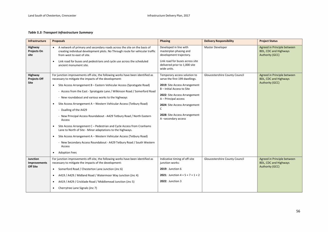
Land South of Chesterton, Cirencester Infrastructure Delivery Plan, 2017
56
Table 5.3: Transport Infrastructure Summary Infrastructure Proposals Phasing Delivery Responsibility Project Status
Highway Projects On site
• A network of primary and secondary roads across the site on the basis of creating individual development plots. No Through route for vehicular traffic from west to east of site.
• Link road for buses and pedestrians and cycle use across the scheduled ancient monument site.
Developed in line with masterplan phasing and development trajectory.
Link road for buses across site delivered prior to 1,000 site wide units.
Master Developer Agreed in Principle between BDL, CDC and Highways Authority (GCC)
Highway Projects Off Site
For junction improvements off-site, the following works have been identified as necessary to mitigate the impacts of the development:
• Site Access Arrangement B – Eastern Vehicular Access (Spratsgate Road)
- Access from the East - Spratsgate Lane / Wilkinson Road / Somerford Road
- New roundabout and various works to the highways
• Site Access Arrangement A – Western Vehicular Access (Tetbury Road)
- Dualling of the A429
- New Principal Access Roundabout - A429 Tetbury Road / North Eastern Access
• Site Access Arrangement C – Pedestrian and Cycle Access from Cranhams Lane to North of Site - Minor adaptations to the highways.
• Site Access Arrangement A – Western Vehicular Access (Tetbury Road)
- New Secondary Access Roundabout - A429 Tetbury Road / South Western Access
• Adoption Fees
Temporary access solution to serve the first 199 dwellings.
2019: Site Access Arrangement B – Initial Access to Site
2022: Site Access Arrangement A – Principal access
2024: Site Access Arrangement C
2028: Site Access Arrangement A –secondary access
Gloucestershire County Council Agreed in Principle between BDL, CDC and Highways Authority (GCC)
Junction Improvements Off Site
For junction improvements off-site, the following works have been identified as necessary to mitigate the impacts of the development:
• Somerford Road / Chesterton Lane Junction (Jnc 6)
• A419 / A429 / Midland Road / Watermoor Way Junction (Jnc 4)
• A419 / A429 / Cricklade Road / Middlemead Junction (Jnc 5)
• Cherrytree Lane Signals (Jnc 7)
Indicative timing of off-site junction works:
2019: Junction 6
2021: Junction 4 + 5 + 7 + 1 + 2
2022: Junction 3
Gloucestershire County Council Agreed in Principle between BDL, CDC and Highways Authority (GCC)
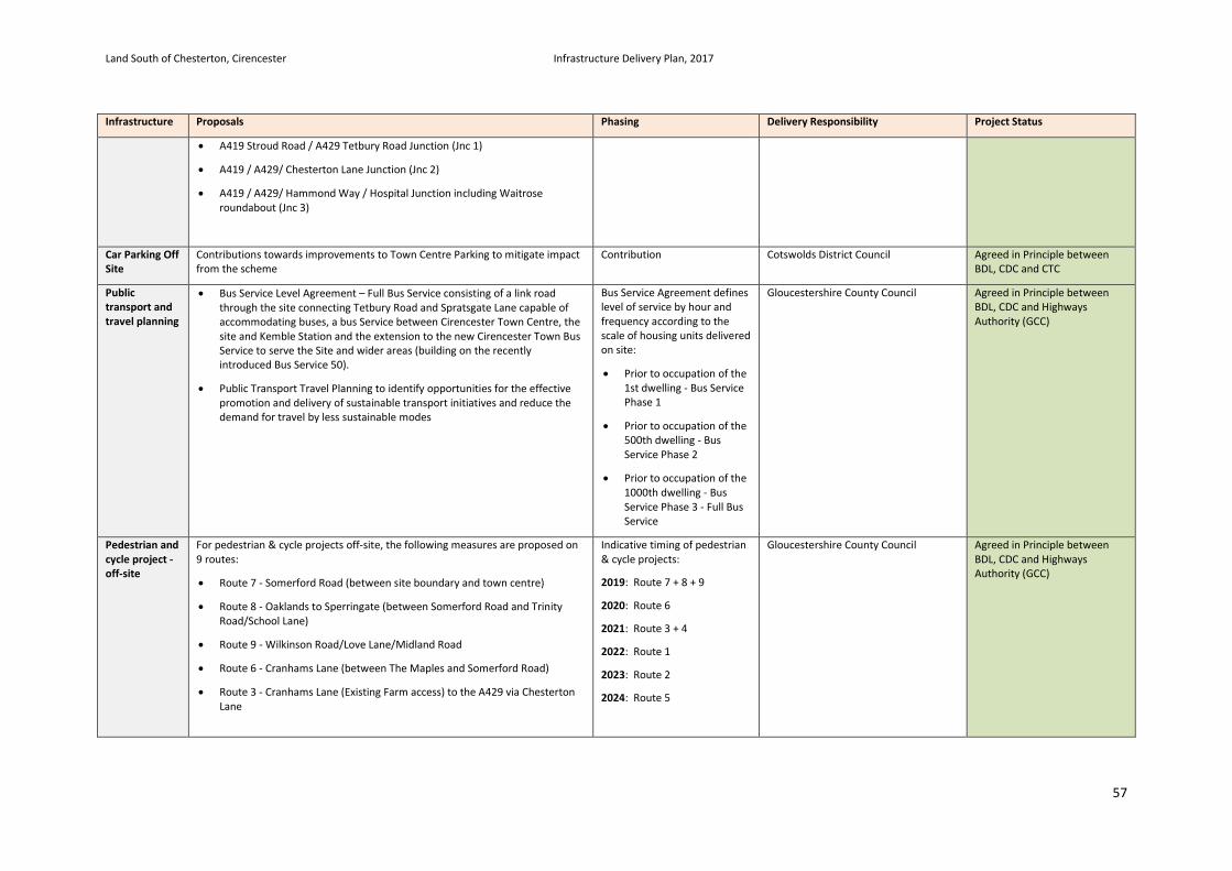
Land South of Chesterton, Cirencester Infrastructure Delivery Plan, 2017
57
Infrastructure Proposals Phasing Delivery Responsibility Project Status
• A419 Stroud Road / A429 Tetbury Road Junction (Jnc 1)
• A419 / A429/ Chesterton Lane Junction (Jnc 2)
• A419 / A429/ Hammond Way / Hospital Junction including Waitrose roundabout (Jnc 3)
Car Parking Off Site
Contributions towards improvements to Town Centre Parking to mitigate impact from the scheme
Contribution Cotswolds District Council Agreed in Principle between BDL, CDC and CTC
Public transport and travel planning
• Bus Service Level Agreement – Full Bus Service consisting of a link road through the site connecting Tetbury Road and Spratsgate Lane capable of accommodating buses, a bus Service between Cirencester Town Centre, the site and Kemble Station and the extension to the new Cirencester Town Bus Service to serve the Site and wider areas (building on the recently introduced Bus Service 50).
• Public Transport Travel Planning to identify opportunities for the effective promotion and delivery of sustainable transport initiatives and reduce the demand for travel by less sustainable modes
Bus Service Agreement defines level of service by hour and frequency according to the scale of housing units delivered on site:
• Prior to occupation of the 1st dwelling - Bus Service Phase 1
• Prior to occupation of the 500th dwelling - Bus Service Phase 2
• Prior to occupation of the 1000th dwelling - Bus Service Phase 3 - Full Bus Service
Gloucestershire County Council Agreed in Principle between BDL, CDC and Highways Authority (GCC)
Pedestrian and cycle project - off-site
For pedestrian & cycle projects off-site, the following measures are proposed on 9 routes:
• Route 7 - Somerford Road (between site boundary and town centre)
• Route 8 - Oaklands to Sperringate (between Somerford Road and Trinity Road/School Lane)
• Route 9 - Wilkinson Road/Love Lane/Midland Road
• Route 6 - Cranhams Lane (between The Maples and Somerford Road)
• Route 3 - Cranhams Lane (Existing Farm access) to the A429 via Chesterton Lane
Indicative timing of pedestrian & cycle projects:
2019: Route 7 + 8 + 9
2020: Route 6
2021: Route 3 + 4
2022: Route 1
2023: Route 2
2024: Route 5
Gloucestershire County Council Agreed in Principle between BDL, CDC and Highways Authority (GCC)
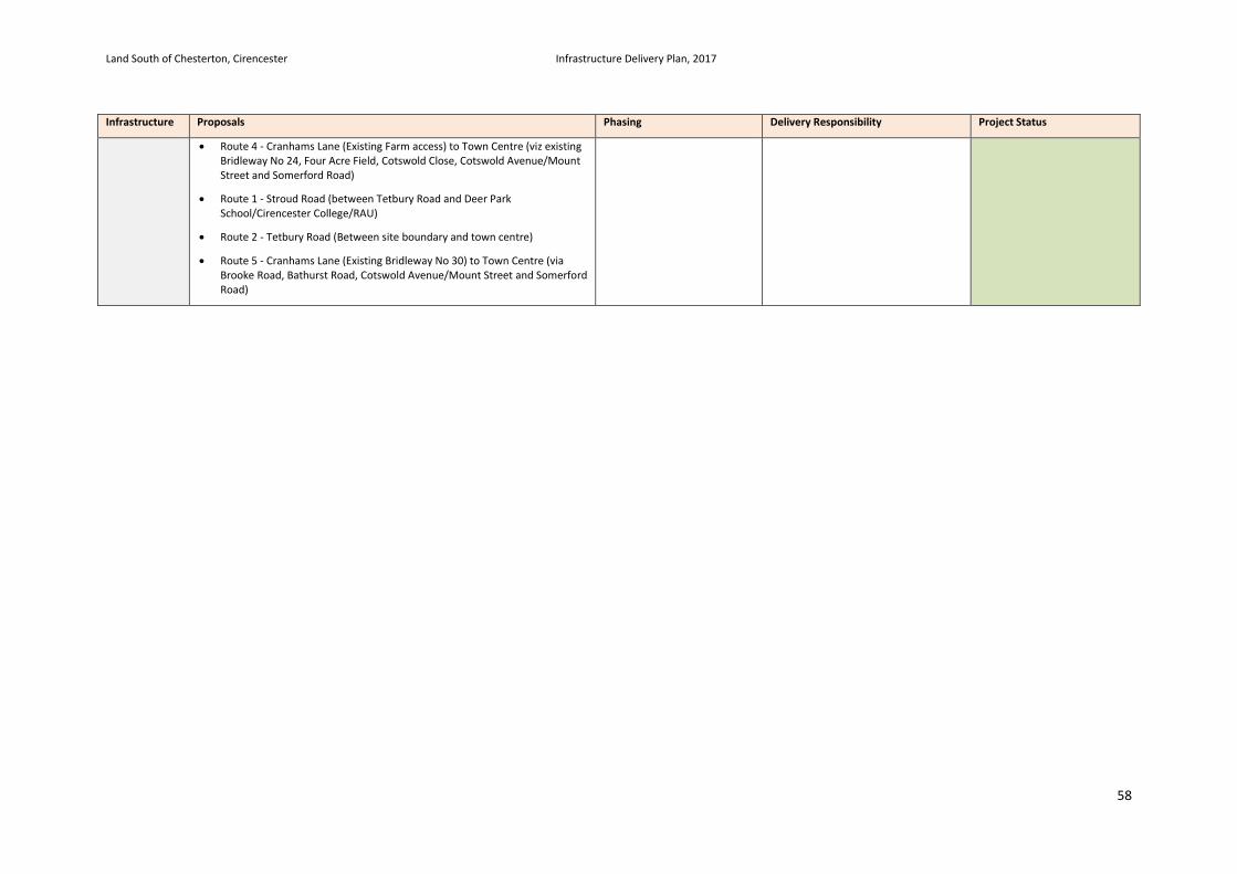
Land South of Chesterton, Cirencester Infrastructure Delivery Plan, 2017
58
Infrastructure Proposals Phasing Delivery Responsibility Project Status
• Route 4 - Cranhams Lane (Existing Farm access) to Town Centre (viz existing Bridleway No 24, Four Acre Field, Cotswold Close, Cotswold Avenue/Mount Street and Somerford Road)
• Route 1 - Stroud Road (between Tetbury Road and Deer Park School/Cirencester College/RAU)
• Route 2 - Tetbury Road (Between site boundary and town centre)
• Route 5 - Cranhams Lane (Existing Bridleway No 30) to Town Centre (via Brooke Road, Bathurst Road, Cotswold Avenue/Mount Street and Somerford Road)
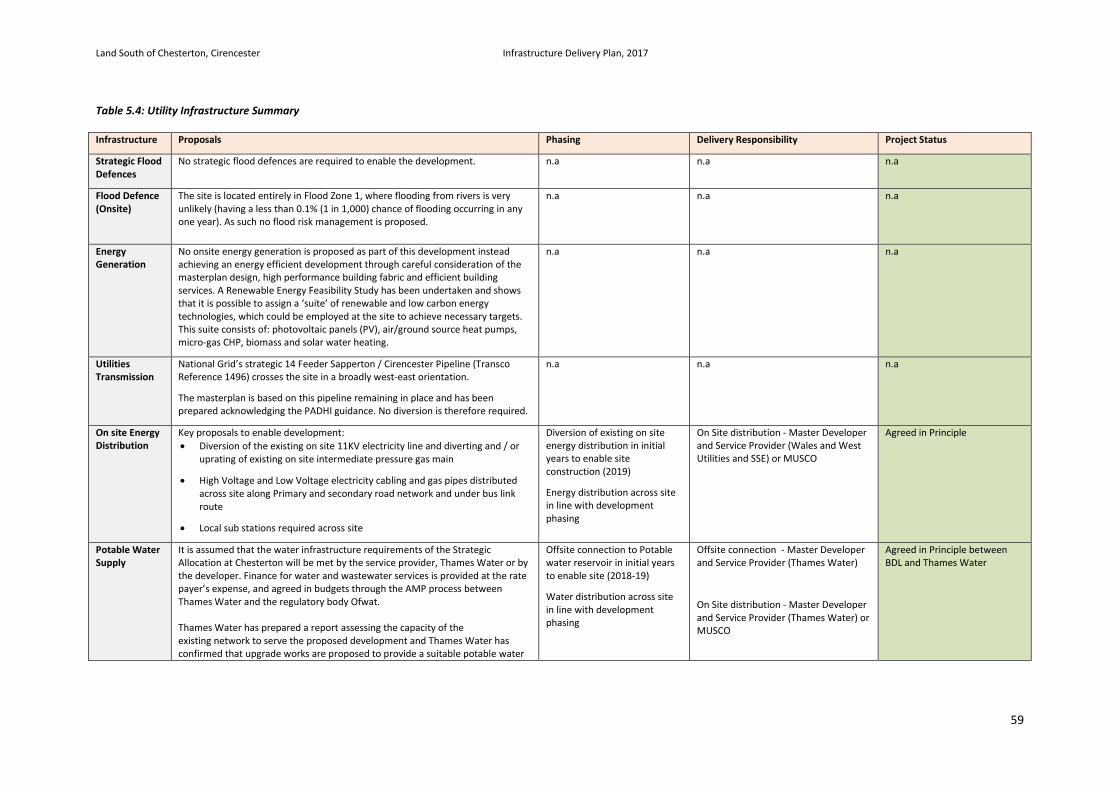
Land South of Chesterton, Cirencester Infrastructure Delivery Plan, 2017
59
Table 5.4: Utility Infrastructure Summary Infrastructure Proposals Phasing Delivery Responsibility Project Status
Strategic Flood Defences
No strategic flood defences are required to enable the development. n.a n.a n.a
Flood Defence (Onsite)
The site is located entirely in Flood Zone 1, where flooding from rivers is very unlikely (having a less than 0.1% (1 in 1,000) chance of flooding occurring in any one year). As such no flood risk management is proposed.
n.a n.a n.a
Energy Generation
No onsite energy generation is proposed as part of this development instead achieving an energy efficient development through careful consideration of the masterplan design, high performance building fabric and efficient building services. A Renewable Energy Feasibility Study has been undertaken and shows that it is possible to assign a ‘suite’ of renewable and low carbon energy technologies, which could be employed at the site to achieve necessary targets. This suite consists of: photovoltaic panels (PV), air/ground source heat pumps, micro-gas CHP, biomass and solar water heating.
n.a n.a n.a
Utilities Transmission
National Grid’s strategic 14 Feeder Sapperton / Cirencester Pipeline (Transco Reference 1496) crosses the site in a broadly west-east orientation.
The masterplan is based on this pipeline remaining in place and has been prepared acknowledging the PADHI guidance. No diversion is therefore required.
n.a n.a n.a
On site Energy Distribution
Key proposals to enable development: • Diversion of the existing on site 11KV electricity line and diverting and / or
uprating of existing on site intermediate pressure gas main
• High Voltage and Low Voltage electricity cabling and gas pipes distributed across site along Primary and secondary road network and under bus link route
• Local sub stations required across site
Diversion of existing on site energy distribution in initial years to enable site construction (2019)
Energy distribution across site in line with development phasing
On Site distribution - Master Developer and Service Provider (Wales and West Utilities and SSE) or MUSCO
Agreed in Principle
Potable Water Supply
It is assumed that the water infrastructure requirements of the Strategic Allocation at Chesterton will be met by the service provider, Thames Water or by the developer. Finance for water and wastewater services is provided at the rate payer’s expense, and agreed in budgets through the AMP process between Thames Water and the regulatory body Ofwat. Thames Water has prepared a report assessing the capacity of the existing network to serve the proposed development and Thames Water has confirmed that upgrade works are proposed to provide a suitable potable water
Offsite connection to Potable water reservoir in initial years to enable site (2018-19)
Water distribution across site in line with development phasing
Offsite connection - Master Developer and Service Provider (Thames Water)
On Site distribution - Master Developer and Service Provider (Thames Water) or MUSCO
Agreed in Principle between BDL and Thames Water
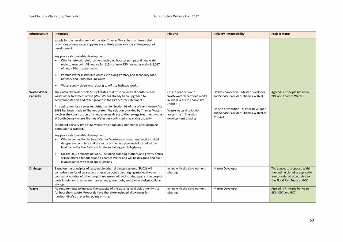
Land South of Chesterton, Cirencester Infrastructure Delivery Plan, 2017
60
Infrastructure Proposals Phasing Delivery Responsibility Project Status
supply for the development of the site. Thames Water has confirmed that provisions of new water supplies are unlikely to be an issue at the proposed development. Key proposals to enable development: • Off-site network reinforcement including booster pumps and new water
main to reservoir. Allowance for 111m of new 350mm water main & 2,087m of new 450mm water main.
• Potable Water distributed across site along Primary and secondary road network and under bus link route
• Water supply diversions relating to off site highway works
Waste Water Capacity
The Cotswold Water Cycle Study1 states that “The capacity at South Cerney wastewater treatment works (WwTW) has already been upgraded to accommodate this and other growth in the Cirencester catchment.”
An application for a sewer requisition under Section 98 of the Water Industry Act 1991 has been made to Thames Water. The solution provided by Thames Water involves the construction of a new pipeline direct to the sewage treatment works at South Cerney where Thames Water has confirmed is available capacity.
Estimated delivery time of 68 weeks which can only commence after planning permission is granted.
Key proposals to enable development: • Off-site connection to South Cerney Wastewater treatment Works - Initial
designs are complete and the route of the new pipeline is located within land owned by the Bathurst Estate and along public highway
• On site foul drainage network, including pumping stations and gravity drains will be offered for adoption to Thames Water and will be designed and built in accordance with their specifications
Offsite connection to Wastewater treatment Works in initial years to enable site. (2018-19)
Waste water distribution across site in line with development phasing
Offsite connection - Master Developer and Service Provider (Thames Water)
On Site distribution - Master Developer and Service Provider (Thames Water) or MUSCO
Agreed in Principle between BDL and Thames Water
Drainage Based on the principles of sustainable urban drainage systems (SUDS) will comprise a series of swales and alteration ponds discharging into local water courses. A number of other on-plot measures will be included against the on-plot costs in relation to rainwater harvesting, green roofs, soakaways and geocellular storage.
In line with the development phasing
Master Developer The concepts proposed within the outline planning application are considered acceptable to the Flood Risk Team at GCC.
Waste No requirements to increase the capacity of the existing local civic amenity site for household waste. Proposals have therefore included allowances for hardstanding’s as recycling points on-site.
In line with the development phasing
Master Developer Agreed in Principle between BDL, CDC and GCC
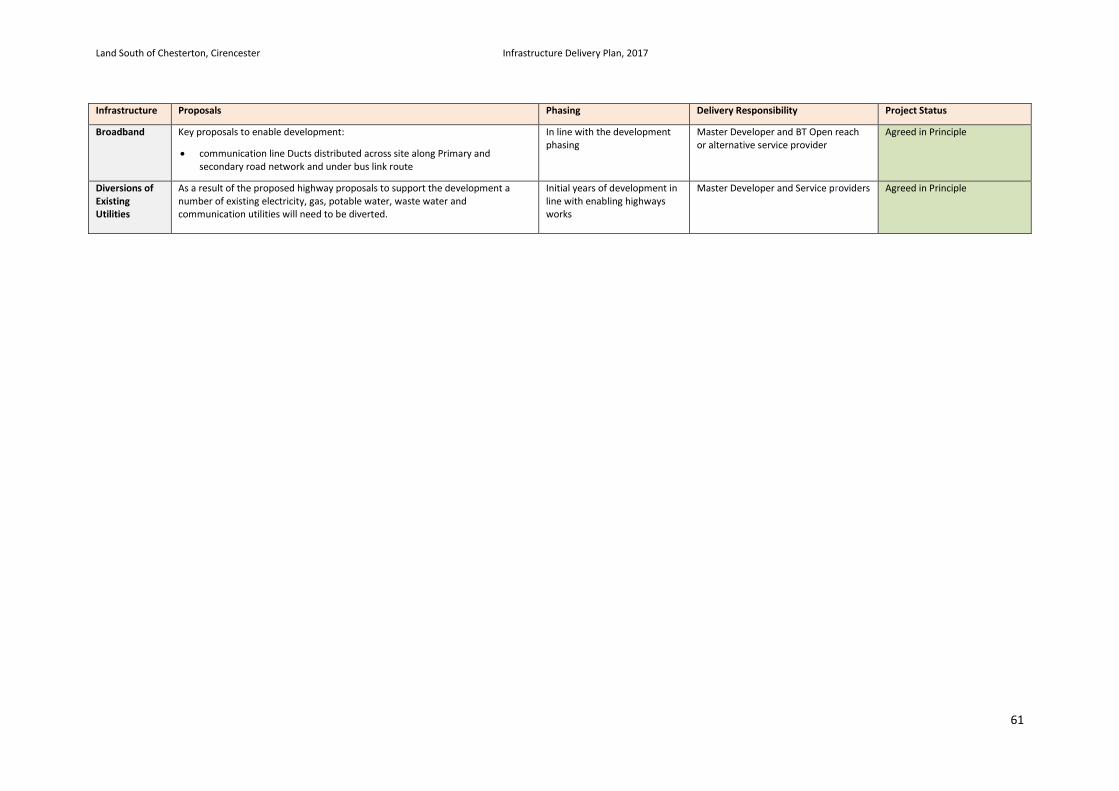
Land South of Chesterton, Cirencester Infrastructure Delivery Plan, 2017
61
Infrastructure Proposals Phasing Delivery Responsibility Project Status
Broadband Key proposals to enable development:
• communication line Ducts distributed across site along Primary and secondary road network and under bus link route
In line with the development phasing
Master Developer and BT Open reach or alternative service provider
Agreed in Principle
Diversions of Existing Utilities
As a result of the proposed highway proposals to support the development a number of existing electricity, gas, potable water, waste water and communication utilities will need to be diverted.
Initial years of development in line with enabling highways works
Master Developer and Service providers Agreed in Principle
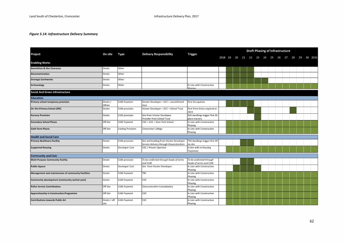
Land South of Chesterton, Cirencester Infrastructure Delivery Plan, 2017
62
Figure 5.14: Infrastructure Delivery Summary
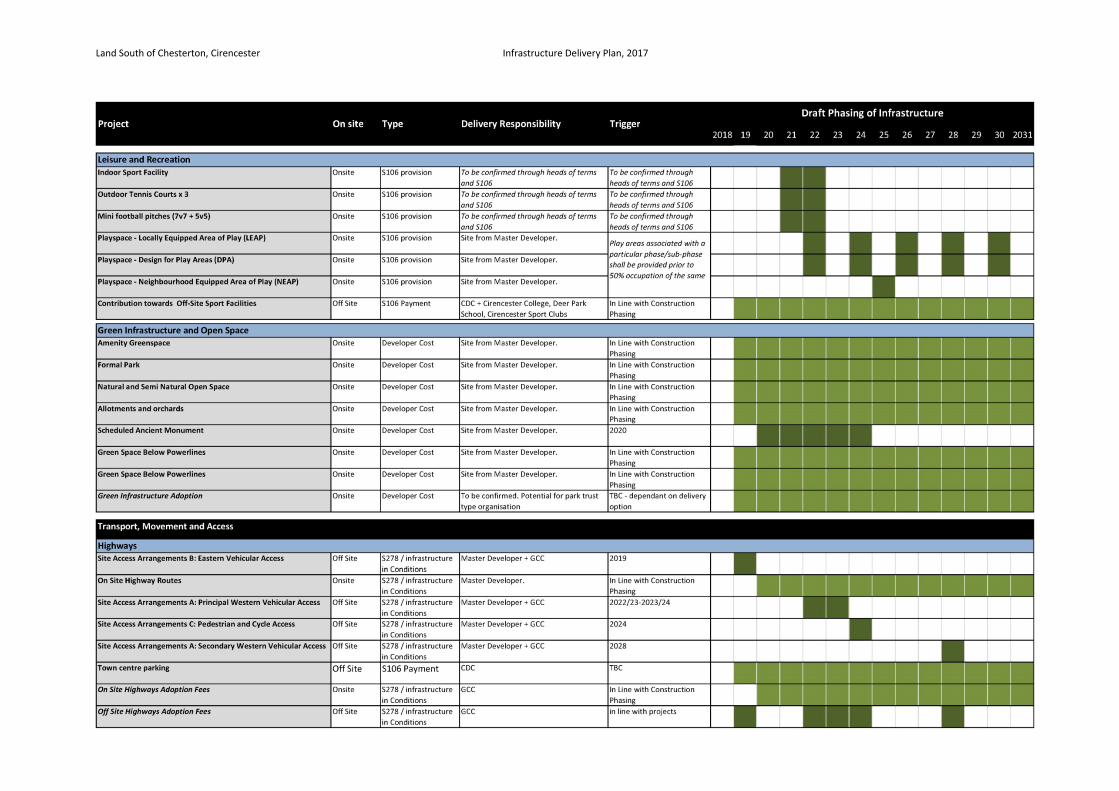
Land South of Chesterton, Cirencester Infrastructure Delivery Plan, 2017
63
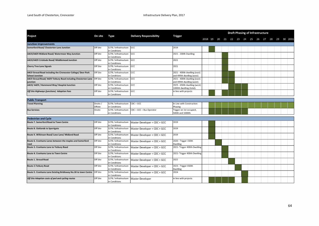
Land South of Chesterton, Cirencester Infrastructure Delivery Plan, 2017
64
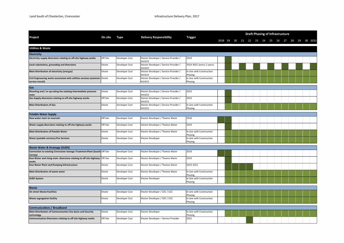
Land South of Chesterton, Cirencester Infrastructure Delivery Plan, 2017
65
Land South of Chesterton, Cirencester Infrastructure Delivery Plan, 2017
66
6. Infrastructure Implementation Phasing and prioritisation Infrastructure Project Schedule
6.1. The previous chapter has set out in detail the infrastructure projects identified as necessary to support the Land South of Chesterton Site. The Infrastructure Delivery Plan is supported by a project schedule which encapsulates this detail into a single document allowing the full package of infrastructure requirements to be effectively communicated for the purposes of the planning application process, the cost planning work, parallel viability assessments and to inform Section 106 negotiations between BDL and the planning authority. The project schedule sets out for each infrastructure project the following information:
• Description of Project
• On or Off Site Project
• Source of Project Details
• Delivery Cost Estimate
• Delivery Principles
• Prioritisation (Critical & Essential Mitigation or Place Making)
• Delivery Type (Onsite Provision, Developer Contribution, Contribution in kind, other)
• Partner Funding Potential
• Trigger for Delivery if appropriate
• Delivery Sequencing
Infrastructure Prioritisation
6.2. Prioritisation of the Infrastructure Project list as part of the Infrastructure Delivery Plan is an important process for the following reasons:
• A clear approach to prioritisation will aid long term delivery. It is essential that the market has a clear understanding of infrastructure investment priorities, thus establishing positive working relationships with delivery partners and ensuring development does not become unduly stifled or advanced ahead of anticipated timescales. Development will be unlocked through a joined up approach between public and private sectors.
• Prioritisation of infrastructure and anticipated delivery timescales enables a clear understanding of cashflow. It is known that certain projects will have a lag time associated with investment and require ‘pump priming’. Prioritisation will influence future spending and banking of monies and help to mitigate and manage funding gaps.
• Prioritisation identifies key strategic priorities that will unlock smaller scale priorities. A holistic approach needs to be established both for strategic projects as well as local ones. The relationships between projects are critical.
• Prioritisation of infrastructure assists in the understanding of viability constraints and can direct investment decisions.
6.3. Following the identification of all necessary Infrastructure projects the Chesterton IDP has assigned each project a level of priority. This distinguishes those projects critical to enabling development and mitigating infrastructure compared to those that are important to deliver good place making principles. This process is intrinsically linked to the development trajectory and requires consideration of the role infrastructure plays in unlocking development as well as mitigating the pressures arising from population growth.
6.4. The categories set out in the Table 6.1 have been adopted in support of the prioritisation process.
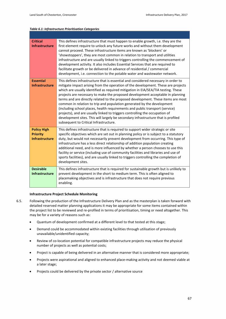
Land South of Chesterton, Cirencester Infrastructure Delivery Plan, 2017
67
Table 6.1: Infrastructure Prioritisation Categories
Critical Infrastructure
This defines infrastructure that must happen to enable growth, i.e. they are the first element require to unlock any future works and without them development cannot proceed. These infrastructure items are known as ‘blockers’ or ‘showstoppers’, they are most common in relation to transport and utilities infrastructure and are usually linked to triggers controlling the commencement of development activity. It also includes Essential Services that are required to facilitate growth or be delivered in advance of residential / commercial development, i.e. connection to the potable water and wastewater network.
Essential Infrastructure
This defines infrastructure that is essential and considered necessary in order to mitigate impact arising from the operation of the development. These are projects which are usually identified as required mitigation in EIA/SEA/TIA testing. These projects are necessary to make the proposed development acceptable in planning terms and are directly related to the proposed development. These items are most common in relation to trip and population generated by the development (including school places, health requirements and public transport (service) projects), and are usually linked to triggers controlling the occupation of development sites. This will largely be secondary infrastructure that is profiled subsequent to Critical Infrastructure.
Policy High Priority Infrastructure
This defines infrastructure that is required to support wider strategic or site specific objectives which are set out in planning policy or is subject to a statutory duty, but would not necessarily prevent development from occurring. This type of infrastructure has a less direct relationship of addition population creating additional need, and is more influenced by whether a person chooses to use this facility or service (including use of community facilities and libraries and use of sports facilities), and are usually linked to triggers controlling the completion of development sites.
Desirable Infrastructure
This defines infrastructure that is required for sustainable growth but is unlikely to prevent development in the short to medium term. This is often aligned to placemaking objectives and is infrastructure that does not require previous enabling.
Infrastructure Project Schedule Monitoring
6.5. Following the production of the Infrastructure Delivery Plan and as the masterplan is taken forward with detailed reserved matter planning applications it may be appropriate for some items contained within the project list to be reviewed and re-profiled in terms of prioritisation, timing or need altogether. This may be for a variety of reasons such as:
• Quantum of development confirmed at a different level to that tested at this stage;
• Demand could be accommodated within existing facilities through utilisation of previously unavailable/unidentified capacity;
• Review of co-location potential for compatible infrastructure projects may reduce the physical number of projects as well as potential costs;
• Project is capable of being delivered in an alternative manner that is considered more appropriate;
• Projects were aspirational and aligned to enhanced place-making activity and not deemed viable at a later stage;
• Projects could be delivered by the private sector / alternative source
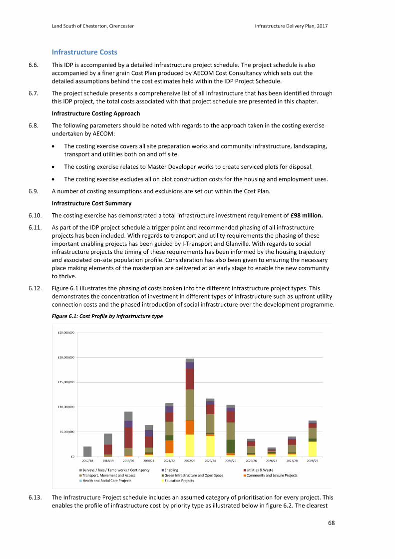
Land South of Chesterton, Cirencester Infrastructure Delivery Plan, 2017
68
Infrastructure Costs 6.6. This IDP is accompanied by a detailed infrastructure project schedule. The project schedule is also
accompanied by a finer grain Cost Plan produced by AECOM Cost Consultancy which sets out the detailed assumptions behind the cost estimates held within the IDP Project Schedule.
6.7. The project schedule presents a comprehensive list of all infrastructure that has been identified through this IDP project, the total costs associated with that project schedule are presented in this chapter.
Infrastructure Costing Approach
6.8. The following parameters should be noted with regards to the approach taken in the costing exercise undertaken by AECOM:
• The costing exercise covers all site preparation works and community infrastructure, landscaping, transport and utilities both on and off site.
• The costing exercise relates to Master Developer works to create serviced plots for disposal.
• The costing exercise excludes all on plot construction costs for the housing and employment uses.
6.9. A number of costing assumptions and exclusions are set out within the Cost Plan.
Infrastructure Cost Summary
6.10. The costing exercise has demonstrated a total infrastructure investment requirement of £98 million.
6.11. As part of the IDP project schedule a trigger point and recommended phasing of all infrastructure projects has been included. With regards to transport and utility requirements the phasing of these important enabling projects has been guided by I-Transport and Glanville. With regards to social infrastructure projects the timing of these requirements has been informed by the housing trajectory and associated on-site population profile. Consideration has also been given to ensuring the necessary place making elements of the masterplan are delivered at an early stage to enable the new community to thrive.
6.12. Figure 6.1 illustrates the phasing of costs broken into the different infrastructure project types. This demonstrates the concentration of investment in different types of infrastructure such as upfront utility connection costs and the phased introduction of social infrastructure over the development programme.
Figure 6.1: Cost Profile by Infrastructure type
6.13. The Infrastructure Project schedule includes an assumed category of prioritisation for every project. This enables the profile of infrastructure cost by priority type as illustrated below in figure 6.2. The clearest
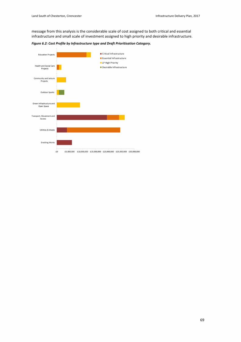
Land South of Chesterton, Cirencester Infrastructure Delivery Plan, 2017
69
message from this analysis is the considerable scale of cost assigned to both critical and essential infrastructure and small scale of investment assigned to high priority and desirable infrastructure.
Figure 6.2: Cost Profile by Infrastructure type and Draft Prioritisation Category.

Land South of Chesterton, Cirencester Infrastructure Delivery Plan, 2017
70
Infrastructure Funding 6.14. A funding Gap has not been identified for the Land South of Chesterton Site. The scheme is identified as
fully funded according to the sources set out below.
Master Developer Direct Provision and S106 Contributions
6.15. The outline planning application is supported by a detailed Infrastructure Delivery Plan and supporting cost plan which sets out the infrastructure proposed to support the delivery of the site. A number of the infrastructure proposals will be delivered and subsequently financed directly by the site master developer. These would include for example the internal road network, drainage systems, on site primary school, on site community facilities and green infrastructure.
6.16. In other circumstances the infrastructure required to mitigate the impact of the proposed development is not directly provided through the masterplan and will instead be funded through a financial contribution from the site master developer to the relevant authorities. These would include for example, contributions towards off site secondary school places, contributions towards off site temporary primary school provision and town centre parking.
6.17. Refer to the Delivery Strategy for more detail regarding master developer funding sources.
Utility Service Company Investment
6.18. Utilities infrastructure delivery and funding of it is largely the responsibility of the relevant utility companies, with connections to services for new sites such as the Land South of Chesterton Site also part funded by the site developers.
6.19. A majority of costs associated with off-site utilities reinforcement provision will be met by the utility companies as part of their 5 year investment plans. BDL is working with the above utility companies to ensure the required infrastructure investment is included within their short, medium and long term planning frameworks. A contribution will be made from BDL towards the cost of specific connection costs such as the potable water mains from the site to the supply reservoir and the sewage discharge pipe from the site to the treatment works. Refer to table 5.4 for greater detail on the proposed utility works and associated phasing.
Delivery Parties 6.20. Alongside Cotswold District Council and the applicant, Bathurst Development Limited, a number of other
organisations will play an important part in the successful delivery of the Land South of Chesterton Site. Some of the key organisations are set out here although this does not represent every involved party.
Gloucestershire County Council
6.21. Gloucestershire County Council, as the local education authority, has a statutory duty to plan the provision of school places and to secure the balance in supply of school places and demand for places. Typically the County Council will request a Section 106 contribution in order to contribute towards the expansion of school places or provision of a new school. The County Council can reduce the assessed payment in lieu of on-site provision of facilities that will effectively provide that same level of provision.
6.22. With regards to operations, any new schools would be expected to be operated by an Academy Trust, chosen through a competition process administered by Gloucestershire County Council.
Cirencester Town Council
6.23. Town councils are the first tier of local government. They are elected corporate bodies and have variable tax raising powers. Town councils have powers to provide some facilities themselves, or they can contribute towards their provision by others. Services provided can include the following relevant to this Infrastructure Delivery Plan:
• Support and encouragement of arts and crafts
• Provision of village halls
• Recreation grounds, parks, children’s play areas, playing fields and swimming baths
• Cemeteries and crematoria
Land South of Chesterton, Cirencester Infrastructure Delivery Plan, 2017
71
• Public conveniences
• Provision of cycle and motorcycle parking
• Acquisition and maintenance of rights of way
6.24. The Council also has the power to raise money through taxation, the precept. The precept is the Town Council’s share of the council tax. The precept demand goes to the billing authority - the local authority - which collects the tax for the Town Council.
6.25. Town councils also receive a “meaningful proportion” of Community Infrastructure Levy receipts to the neighbourhoods affected by development, typically 15-25%. The scale of this contribution is directly linked to the number of homes developed in the town and the existing scale of the town (in terms of dwellings). The meaningful proportion can be spent on anything to help mitigate the impact the development has on the town. It is the decision of the town council where the money is spent.
NHS Gloucestershire Clinical Commissioning Group (CCG)
6.26. NHS Gloucestershire CCG is a clinically led membership organisation (all 81 GP practices in Gloucestershire are members) responsible for commissioning (buying) local NHS services to meet the needs of local people.
6.27. The Development would be limited to providing the appropriate scale and location of facility in which a health care provider could then operate. Primary Healthcare provision would be delivered and operated by NHS Gloucestershire Clinical Commissioning Group who would be responsible for identifying viable tenants. The Strategic Site is estimated to generate between 5,000 and 5,500 additional residents and will subsequently provide that number of new patients to any healthcare facility choosing to operate from the development. Each of these new patients will generate a revenue funding allocation from the NHS.
Utility Companies
6.28. The IDP has identified a number of utility projects required to enable the site. With regards to a traditional approach to utility infrastructure solutions the following utility companies will be partners in the delivery of the Strategic Site:
• Energy - Scottish and Southern Energy (SSE) and Wales and West Utilities.
• Potable and Foul Water - Thames Water
• Telecommunication / Broadband – BT / BT Open Reach
6.29. A majority of costs associated with off-site utilities reinforcement provision will be met by the utility companies as part of their 5 year investment plans. BDL is working with the above utility companies to ensure the required infrastructure investment is included within their short, medium and long term planning frameworks. A contribution will be made from BDL towards the cost of specific connection costs such as the potable water mains from the site to the supply reservoir and the sewage discharge pipe from the site to the treatment works.
Multi Utility Companies
6.30. There are a number of providers that can offer utility supplies ranging from 2 utilities such as gas and electricity supplies through to providers such as SSE who can provide all onsite utilities including adopted sewerage.
6.31. There are obvious opportunities for economies of scale and hence cost savings as well as for overall coordination both for construction and for maintenance so that there is no conflict between numerous separate utility companies. A company providing energy and water services is referred to as a MUSCo, whist a company providing energy only is referred to as an ESCo. BDL is in discussion with a number of MUSCo’s to fully understand the capacities of these organisations to deliver a joined up utility service for the Strategic Site and to understand the advantages and disadvantages of such as approach.
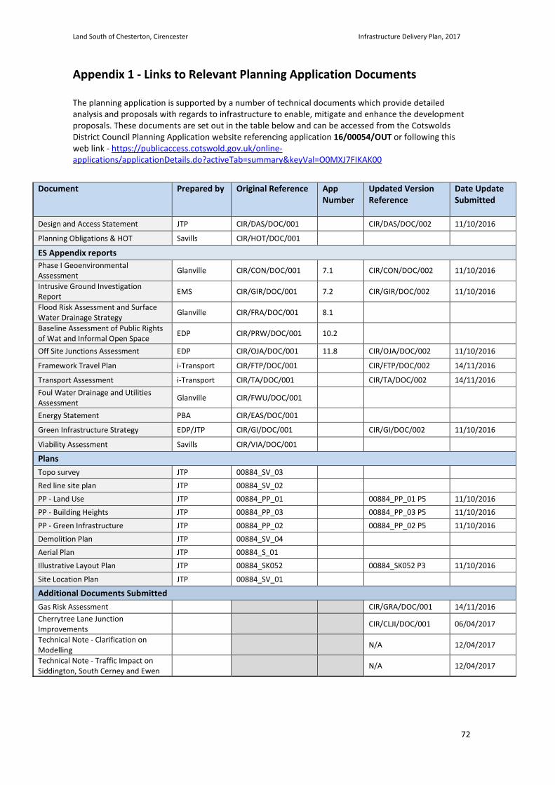
Land South of Chesterton, Cirencester Infrastructure Delivery Plan, 2017
72
Appendix 1 - Links to Relevant Planning Application Documents The planning application is supported by a number of technical documents which provide detailed analysis and proposals with regards to infrastructure to enable, mitigate and enhance the development proposals. These documents are set out in the table below and can be accessed from the Cotswolds District Council Planning Application website referencing application 16/00054/OUT or following this web link - https://publicaccess.cotswold.gov.uk/online-applications/applicationDetails.do?activeTab=summary&keyVal=O0MXJ7FIKAK00
Document Prepared by Original Reference App
Number Updated Version Reference
Date Update Submitted
Design and Access Statement JTP CIR/DAS/DOC/001 CIR/DAS/DOC/002 11/10/2016
Planning Obligations & HOT Savills CIR/HOT/DOC/001
ES Appendix reports Phase I Geoenvironmental Assessment Glanville CIR/CON/DOC/001 7.1 CIR/CON/DOC/002 11/10/2016
Intrusive Ground Investigation Report EMS CIR/GIR/DOC/001 7.2 CIR/GIR/DOC/002 11/10/2016
Flood Risk Assessment and Surface Water Drainage Strategy Glanville CIR/FRA/DOC/001 8.1
Baseline Assessment of Public Rights of Wat and Informal Open Space EDP CIR/PRW/DOC/001 10.2
Off Site Junctions Assessment EDP CIR/OJA/DOC/001 11.8 CIR/OJA/DOC/002 11/10/2016
Framework Travel Plan i-Transport CIR/FTP/DOC/001 CIR/FTP/DOC/002 14/11/2016
Transport Assessment i-Transport CIR/TA/DOC/001 CIR/TA/DOC/002 14/11/2016 Foul Water Drainage and Utilities Assessment Glanville CIR/FWU/DOC/001
Energy Statement PBA CIR/EAS/DOC/001
Green Infrastructure Strategy EDP/JTP CIR/GI/DOC/001 CIR/GI/DOC/002 11/10/2016
Viability Assessment Savills CIR/VIA/DOC/001
Plans Topo survey JTP 00884_SV_03
Red line site plan JTP 00884_SV_02
PP - Land Use JTP 00884_PP_01 00884_PP_01 P5 11/10/2016
PP - Building Heights JTP 00884_PP_03 00884_PP_03 P5 11/10/2016
PP - Green Infrastructure JTP 00884_PP_02 00884_PP_02 P5 11/10/2016
Demolition Plan JTP 00884_SV_04
Aerial Plan JTP 00884_S_01
Illustrative Layout Plan JTP 00884_SK052 00884_SK052 P3 11/10/2016
Site Location Plan JTP 00884_SV_01
Additional Documents Submitted Gas Risk Assessment CIR/GRA/DOC/001 14/11/2016 Cherrytree Lane Junction Improvements CIR/CLJI/DOC/001 06/04/2017
Technical Note - Clarification on Modelling N/A 12/04/2017
Technical Note - Traffic Impact on Siddington, South Cerney and Ewen N/A 12/04/2017