Information system of Spatial Development (ISPU): Growing ... · 1\ ISPU (Information System of...
27
ESPON Scientific Conference ‘Science in support of European Territorial Development and Cohesion’ Luxembourg 12-13 September 2013 Ministry of Construction and Physical Planning, Croatia Information system of Spatial Development (ISPU): Growing attention to flows, networks and functional inter-linkages Ivana Liovic \ [email protected] \ +385 1 3782 102
Transcript of Information system of Spatial Development (ISPU): Growing ... · 1\ ISPU (Information System of...

ESPON Scientific Conference ‘Science in support of European Territorial Development and Cohesion’ Luxembourg 12-13 September 2013
Ministry of Construction and Physical Planning, Croatia
Information system of Spatial Development (ISPU): Growing attention to flows, networks and functional inter-linkages
Ivana Liovic \ [email protected] \ +385 1 3782 102

\ PRESENTATION STRUCTURE
INSPIRE >> NIPP (National Spatial Data Infrastructure) >> \ ISPU (Information System of Spatial Development):
What it is
\ PROJECT DEVELOPMENT \ LEGAL FRAMEWORK
\ NETWORKING: Who is who
\ FUNCTIONAL INTER-LINKING: e-plans
e-permit e-inspection
\ ISPU: How it works What it brings
\ 2 \ 3
\ 4
\ 5
\ 6
\ 1
\ G
RO
WTH
>>
Co
ncl
usi
on
s
\ 7

1\ ISPU (Information System of Spatial Development): What it is
• ISPU (Information System of Spatial Development) refers primarily to the GIS (Geographic Information system). According to the Act in force, ISPU’s task is providing an effective support to spatial development as well as to enforcement of other land related policies.
• ISPU is set up in order to: • continuously monitor trends in spatial development, • enable e-plans, e-permits and e-inspection, • provide comprehensive management and protection of the territory, • enable regular reporting about spatial trends (by means of drafting the Report on Spatial Situation in Croatia), • effectively monitor how Physical Development Strategy of Croatia and other spatial planning documents are implemented, • improve public participation when spatial plans are drafted and enforced.

2\ ISPU: PROJECT DEVELOPMENT
• ISPU project was first launched in 2004 by Ministry of Environmental Protection, Physical Planning and Construction (now Ministry of Construction and Physical Planning).
• Phase one (I) of the ISPU project: 2004-2008 • Development of the GIS platform with spatial plans for the coastal part of Croatia (Adriatic). • Area of 7 Adriatic counties was included in the initial GIS platform. • Adriatic area of Croatia was selected for the phase one of the ISPU, based on the criteria that: (1) it has extremely pronounced development potential as well as (2) vulnerability (requirements for protection). • Lead partner in the project was Ministry. Spatial development institutes located in the Adriatic counties were involved, too (project partners). • Technical support was given by a geo-information company. • ISPU phase one was financed from the Government budget.
2\ ISPU: PROJECT DEVELOPMENT
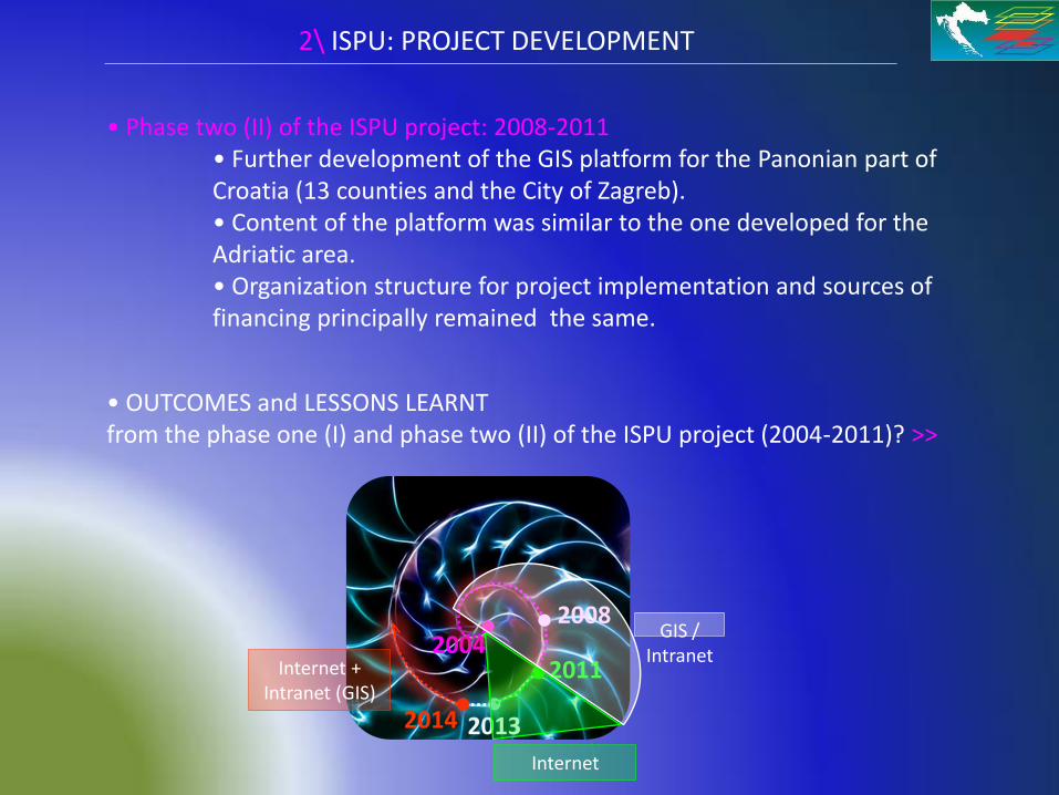
• Phase two (II) of the ISPU project: 2008-2011 • Further development of the GIS platform for the Panonian part of Croatia (13 counties and the City of Zagreb). • Content of the platform was similar to the one developed for the Adriatic area. • Organization structure for project implementation and sources of financing principally remained the same.
• OUTCOMES and LESSONS LEARNT from the phase one (I) and phase two (II) of the ISPU project (2004-2011)? >>
2013
2004
2008
2011
2014
GIS / Intranet
Internet
Internet + Intranet (GIS)
2\ ISPU: PROJECT DEVELOPMENT
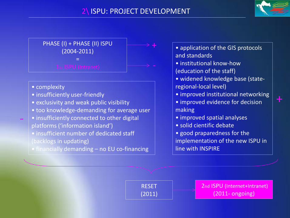
PHASE (I) + PHASE (II) ISPU (2004-2011)
= 1st ISPU (Intranet)
+
-
• application of the GIS protocols and standards • institutional know-how (education of the staff) • widened knowledge base (state-regional-local level) • improved institutional networking • improved evidence for decision making • improved spatial analyses • solid cientific debate • good praparedness for the implementation of the new ISPU in line with INSPIRE
• complexity • insufficiently user-friendly • exclusivity and weak public visibility • too knowledge-demanding for average user • insufficiently connected to other digital platforms (‘information island’) • insufficient number of dedicated staff (backlogs in updating) • financially demanding – no EU co-financing
-
+
RESET (2011)
2nd ISPU (Internet+Intranet)
(2011- ongoing)

3\ ISPU: LEGAL FRAMEWORK
• Spatial Data Infrastructure Act (Official Gazette 56/13) at
http://www.nipp.hr/UserDocsImages/dokumenti/ZoNIPP/SDI%20Law.pdf
• Croatian Law on State Survey and the Real Property Cadaster (Official Gazette 16/07) at http://www.nipp.hr/UserDocsImages/dokumenti/zakonska%20regulativa/zakon/Croatia-Law_on_State_Survey_and_the_Real-Estate_Cadastre.pdf
• Directive 2007/2/EC of the European Parliament and of the Council of 14 March 2007 establishing an Infrastructure for Spatial Information on the European Community (INSPIRE) at
http://www.nipp.hr/UserDocsImages/dokumenti/zakonska%20regulativa/INSPIRE/inspire_directive_eng.pdf
• PHYSICAL PLANNING AND BUILDING ACT (Official Gazette 76/07, 38/09, 55/11, 90/11, 50/12)
Croatian version at http://narodne-novine.nn.hr/default.aspx
• Ordinance on the content, criteria for map projections, required spatial indicators and the standards of physical planning studies (Official Gazette 106/98, 39/04, 45/04)
Croatian version at http://narodne-novine.nn.hr/default.aspx
• Strong reference to ISPU also in the strategic documents of spatial development: • Report on Spatial Situation in Croatia 2008-2012 Croatian version at http://www.mgipu.hr/doc/Prostorno/Izvjesce_SPRH_08_12.pdf
• Physical Planning Strategy of Croatia Summary at http://www.mgipu.hr/doc/StrategijaRH/Strategija_sazetci.pdf
• Amendments to the Physical Planning Strategy of Croatia as of
June 2013 Croatian version at http://www.mgipu.hr/doc/Prostorno/IDSPU_RH_2013.pdf
NSDI
ISPU

3\ ISPU: LEGAL FRAMEWORK
• Amendments and changes to the existing PHYSICAL PLANNING AND BUILDING ACT are underway >> Set of 3 new (separated but compatible) Acts regulating the area has been drafted (July 2013) >> autumn 2013 Acts will be sent to the Parliament for adoption
(1) PHYSICAL PLANNING ACT + (2) BUILDING ACT + (3) BUILDING INSPECTION ACT
PHYSICAL PLANNING AND BUILDING ACT in force
towards new PHYSICAL PLANNING ACT (2013)
WHY is legal resetting required?
Main reason is that Physical Planning and Building Act in force has not accomplished
desired goals and targets, therefore has failed to fulfill its mission (for the number
of reason).

3\ ISPU: LEGAL FRAMEWORK
PHYSICAL PLANNING AND BUILDING ACT in force
towards new PHYSICAL PLANNING ACT (2013)
SHORTCOMINGS / PROBLEMS IMPROVEMENTS
Too great volume of the Act. It is difficult to get good overview (understanding) of the Act because it simultaneously regulates
two administrative areas.
Volume will be reduced by means of enforcing 3 separate (but compatible) Acts: Physical Planning Act, Building Act and
Building Inspection Act. This way, better understanding and clarity will be provided.
Parts of the existing legal text are vague/ambiguous, inconsistent with each other as well as legally and technically
clumsy.
No ambivalence of legal norms, improved consistency and sharpness of legal wording.
Difficulties/problems with the implementation of the Act. Easier implementation of the Act.
Partial implementation of the principle of public participation and access to spatial data and information. Inadequate legal setup required to support the Information System of Spatial
Development (ISPU).
Information System of Spatial Development (ISPU) in line with the Spatial Data Infrastructure Act (which basically transposes the INSPIRE Directive). Enforcing the Ordinance on the ISPU.
Improved public participation and accessibility of spatial plans via ISPU. Easy, quick and free of charge access to public spatial
data on all levels of governance.
Deadlocks in enforcement of spatial plans, raising prices of plans and loss of trust.
Timely enforcement and reduced costs of the plans as well as legal certainty.
Too great influence of the regional and local spatial plans on the planning of the projects which are State (and beyond)
relevant. Abuse of the principle of decentralization of spatial plans.
Introduction of the Spatial Development Plan of Croatia. Enabling direct implementation of the Spatial Plan of Croatia
when State relevant projects are concerned, without mediation of the lower levels plans (county, municipality/town). Enabling
direct implementation of the county plans, when projects relevant for the county are in question.

3\ ISPU: LEGAL FRAMEWORK
PHYSICAL PLANNING AND BUILDING ACT in force
towards new PHYSICAL PLANNING ACT (2013)
SHORTCOMINGS / PROBLEMS IMPROVEMENTS
Changes and amendments to the local plans after investors had drafted necessary projects and submitted them for Location
Permit. Abuse of the decentralization, creating legal uncertainty for
investors.
Comprehensive monitoring of spatial development will be possible through the effective use of ISPU, Location
Information, access to real-estate and property data as well as regular drafting of the Report on Spatial Situation in Croatia.
Increased responsibility of regional and local bodies for issuing Location Permits.
No subject on the State level in charge of coordinating planning and investments. Significant State resources and possibilities
are either not used or inefficiently used.
Empowerment of the Spatial Development Institute of Croatia.
By October-1-2017 General Urban Plans should cease existing. Legal restoration of the General Urban Plans because they are (historically and technically) an in displaceable instrument of
urban planning of big/major towns.
No existing legal norm or act which formulates/guides procedure for the assessment of the value of the real-estates. Currently, assessment of the value of the real-estate is entirely
left to the arbitrary will of assessors.
Setting the ground for the enforcement of the Ordinance which will proscribe unique procedure for the assessment of the
value of all the real-estates.

4\ NETWORKING: Who is who
NSDI (National Spatial Data Infrastructure)
/State Geodetic Administration /
ISPU (Information System of Spatial Development)
/ Ministry of Construction and Physical Planning /
CORINE Land Cover Croatia
/ Croatian Environment Agency/
DUZS Information System
/ National Protection and Rescue Directorate/
CGN (Gazetter of the
Republic of Croatia)
/ State Geodetic Administration /
CROPOS (Croatian Positioning System)
GEO PORTAL
/ Ministry of Agriculture, Fisheries and Rural Development/
ARKOD Land Register
/ Croatian Mine Action Centre/
HCR MIS Portal
CADASTRE
GIS Portal of Nature Protection
/ Ministry of Environment and Nature Protection/
/ City of Zagreb/

5\ ISPU: How it works
https://ispu.mgipu.hr/

5\ ISPU: How it works

5\ ISPU: How it works

5\ ISPU: How it works

5\ ISPU: How it works

5\ ISPU: How it works

5\ ISPU: How it works

5\ ISPU: How it works

5\ ISPU: How it works

5\ ISPU: How it works

5\ ISPU: How it works

5\ ISPU: How it works

5\ ISPU: How it works

5\ ISPU: What it brings
ISPU strongly supports: • public participation, • transparency, • fact-based decision making, • responsibility of all the parties involved, • greater efficiency, • legal certainty, • sustainable development,
as well as • STRONGER INVOLVEMENT OF SCIENTIFIC COMMUNITY (institutes, faculties), • IMPROVED LINKS between SCIENCE and DECISION MAKING.
ISPU’s task is to connect DIRECT EXPERIENCE (implementation, function) with SCIENCE (research)
RESEARCH DIRECT EXPERIENCE
PRESENT
2 LOOPS • Occasionally mechanically connected, unbalanced • Manifestations: sporadic
FUTURE
RESEARCH DIRECT EXPERIENCE
1 LOOP • Perpetual, organic, balanced
MANIFESTATION / CONCRETIZATION

6\ FUNCTIONAL INTER-LINKING
E - P L A N E - P E R M I T E - I N S P E C T I O N
1st version of the (GIS) plan >> Plan is uploaded in the system of e-plans . >> County Institutes for spatial development as bodies in charge of: (1) accepting proposals of e-plans and (2) e-verification of the phases of the plans (existing statutory procedure requires that each plan progresses through the phases before it is adopted, which includes public hearings and discussions).
>> New concept of e-planning should be formally regulated by end 2013.
1 2 3
Interface
Phases

7\ GROWTH: Conclusions
• ISPU 2004-2011 (1st ISPU) was a valuable learning experience.
• ISPU 2011- ongoing (2nd ISPU) supports and materializes:
• new generation of administrative procedures, • new generation of research.
• 2nd ISPU is an integral part of the INSPIRE family of data and procedures.
• Concrete and viable plan for 2nd ISPU already exists. In order to be
implemented, this plan needs to be supported by EU funds , too.
• 2nd ISPU is visible as we speak. It is gradually being delivered.
• On a wider level, ISPU significantly adds to the body of knowledge.
= Thank you for the attention =