Information Science International Journal of Geographicalwenwenl1/papers/4.pdf · An optimized...
21
This article was downloaded by: [University of California Santa Barbara] On: 04 January 2012, At: 17:51 Publisher: Taylor & Francis Informa Ltd Registered in England and Wales Registered Number: 1072954 Registered office: Mortimer House, 37-41 Mortimer Street, London W1T 3JH, UK International Journal of Geographical Information Science Publication details, including instructions for authors and subscription information: http://www.tandfonline.com/loi/tgis20 An optimized framework for seamlessly integrating OGC Web Services to support geospatial sciences Zhenlong Li a , Chaowei Phil Yang b , Huayi Wu a , Wenwen Li c & Lizhi Miao a a Center for Intelligent Spatial Computing, George Mason University, Fairfax, VA, USA b Joint Center for Intelligent Spatial Computing, George Mason University, Fairfax, VA, USA c Department of Earth System and Geoinformation Science, George Mason University, Fairfax, VA, USA Available online: 29 Oct 2010 To cite this article: Zhenlong Li, Chaowei Phil Yang, Huayi Wu, Wenwen Li & Lizhi Miao (2011): An optimized framework for seamlessly integrating OGC Web Services to support geospatial sciences, International Journal of Geographical Information Science, 25:4, 595-613 To link to this article: http://dx.doi.org/10.1080/13658816.2010.484811 PLEASE SCROLL DOWN FOR ARTICLE Full terms and conditions of use: http://www.tandfonline.com/page/terms-and- conditions This article may be used for research, teaching, and private study purposes. Any substantial or systematic reproduction, redistribution, reselling, loan, sub-licensing, systematic supply, or distribution in any form to anyone is expressly forbidden. The publisher does not give any warranty express or implied or make any representation that the contents will be complete or accurate or up to date. The accuracy of any instructions, formulae, and drug doses should be independently verified with primary sources. The publisher shall not be liable for any loss, actions, claims, proceedings,
Transcript of Information Science International Journal of Geographicalwenwenl1/papers/4.pdf · An optimized...

This article was downloaded by: [University of California Santa Barbara]On: 04 January 2012, At: 17:51Publisher: Taylor & FrancisInforma Ltd Registered in England and Wales Registered Number: 1072954 Registeredoffice: Mortimer House, 37-41 Mortimer Street, London W1T 3JH, UK
International Journal of GeographicalInformation SciencePublication details, including instructions for authors andsubscription information:http://www.tandfonline.com/loi/tgis20
An optimized framework for seamlesslyintegrating OGC Web Services tosupport geospatial sciencesZhenlong Li a , Chaowei Phil Yang b , Huayi Wu a , Wenwen Li c &Lizhi Miao aa Center for Intelligent Spatial Computing, George MasonUniversity, Fairfax, VA, USAb Joint Center for Intelligent Spatial Computing, George MasonUniversity, Fairfax, VA, USAc Department of Earth System and Geoinformation Science,George Mason University, Fairfax, VA, USA
Available online: 29 Oct 2010
To cite this article: Zhenlong Li, Chaowei Phil Yang, Huayi Wu, Wenwen Li & Lizhi Miao (2011): Anoptimized framework for seamlessly integrating OGC Web Services to support geospatial sciences,International Journal of Geographical Information Science, 25:4, 595-613
To link to this article: http://dx.doi.org/10.1080/13658816.2010.484811
PLEASE SCROLL DOWN FOR ARTICLE
Full terms and conditions of use: http://www.tandfonline.com/page/terms-and-conditions
This article may be used for research, teaching, and private study purposes. Anysubstantial or systematic reproduction, redistribution, reselling, loan, sub-licensing,systematic supply, or distribution in any form to anyone is expressly forbidden.
The publisher does not give any warranty express or implied or make any representationthat the contents will be complete or accurate or up to date. The accuracy of anyinstructions, formulae, and drug doses should be independently verified with primarysources. The publisher shall not be liable for any loss, actions, claims, proceedings,
demand, or costs or damages whatsoever or howsoever caused arising directly orindirectly in connection with or arising out of the use of this material.
Dow
nloa
ded
by [
Uni
vers
ity o
f C
alif
orni
a Sa
nta
Bar
bara
] at
17:
51 0
4 Ja
nuar
y 20
12

An optimized framework for seamlessly integrating OGCWeb Servicesto support geospatial sciences
Zhenlong Lia, Chaowei Phil Yangb*, Huayi Wua, Wenwen Lic and Lizhi Miaoa
aCenter for Intelligent Spatial Computing, George Mason University, Fairfax, VA, USA; bJoint Centerfor Intelligent Spatial Computing, George Mason University, Fairfax, VA, USA; cDepartment of Earth
System and Geoinformation Science, George Mason University, Fairfax, VA, USA
(Received 6 November 2009; final version received 28 March 2010)
OGC Web Services (OWS) are essential building blocks for the national and globalspatial data infrastructure (NSDI and GSDI) and the geospatial cyberinfrastructure (GCI).Web Map Service (WMS), Web Feature Service (WFS), Web Coverage Service (WCS),and Catalogue Service for Web (CSW) have been increasingly adopted to serve scientificdata. Interoperable services can facilitate the integration of different scientific applica-tions by searching, finding, and utilizing the large number of scientific data and Webservices. However, these services are widely dispersed and hard to be found and utilizedwith acceptable performance. This is especially true when developing a science applica-tion to seamlessly integrate multiple geographically dispersed services. Focusing on theintegration of distributed OWS resources, we propose a layer-based service-orientedintegration framework and relevant optimization technologies to search and utilizerelevant resources. Specifically, (1) an AJAX (Asynchronous JAvaScript andeXtensible Markup Language)-based synchronous multi-catalogue search is proposedand utilized to enhance the multi-catalogue searching performance; (2) a layer-basedsearch engine with spatial, temporal, and performance criteria is proposed and used foridentifying better services; (3) a service capabilities clearinghouse (SCCH) is proposedand developed to address the service issues identified by a statistical experiment. Ascience application of data correlation analysis is used as an example to demonstrate theperformance enhancement of the proposed framework.
Keywords: spatial data infrastructure; geospatial cyberinfrastructure; performance; dis-tributed geographic information processing; spatial computing; OGC Web Services;spatial web portal; interoperability; geoportal
1. Introduction
Over the past decade, we have witnessed the increasing importance of Web services. Webservices are widely used to deploy business-to-business scenarios that crosscut companyboundaries. Web services are geographically dispersed and are used by a wide array ofcompanies and government organizations because of the reusability, flexibility, and platformindependence (Shen et al. 2007). The geospatial sciences are data-intensive domains, whereresearch and development typically produces and analyzes large volumes of distributedheterogeneous geospatial data sets. Subsequently, these domains are also experiencing anincreased need for both computational power and quantity of information and to make large
International Journal of Geographical Information ScienceVol. 25, No. 4, April 2011, 595–613
*Corresponding author. Email: [email protected]
ISSN 1365-8816 print/ISSN 1362-3087 online# 2011 Taylor & FrancisDOI: 10.1080/13658816.2010.484811http://www.informaworld.com
Dow
nloa
ded
by [
Uni
vers
ity o
f C
alif
orni
a Sa
nta
Bar
bara
] at
17:
51 0
4 Ja
nuar
y 20
12

spatial data available over the Internet (Vaccari et al. 2009). For example, the Terra instruments(http://terra.nasa.gov/) generate about 195 gigabytes of level 0 data (raw data at full instrumentresolution) daily and can reach 850 terabytes when processed to higher level science products(Parkinson et al. 2006). The data can be accessed online through a variety of Web-basedapplications such as Earth Observing System (EOS) Data Gateway (EDG). The sharing oflarge volume of data sets encourages researchers and organizations to pay attention toconsensus development of standard protocols and tools to publish and interoperate theselarge volumes of data sets (Vaccari et al. 2009).
The Open Geospatial Consortium (OGC) has gained momentum with thousands ofadopters of OGCWeb Services (OWS) since the OGCWebMap Service (WMS) specificationpublished in 1999 (Kralidis 2007). WMS is the standard in providing simple HyperTextTransfer Protocol (HTTP) interfaces to serve geo-referenced mapped images over theInternet (Beaujardiere 2004).WMS has been increasingly adopted to provide the interoperableintegration of different Web applications from a large number of data within various scientificdomains. A remarkable number of government organizations, research institutions, and privatecompanies have deployed WMS servers. For example, National Aeronautics and SpaceAdministration (NASA) Earth Observations (NEO) established a time-enabled WMS serverto serve the massive amounts of monthly and daily satellite data related to climate andenvironmental changes (Ward 2009). Private companies, such as Environmental SystemsResearch Institute (ESRI) and Intergraph, developed interoperable interfaces into their soft-ware products and set up their own WMS servers. AWMS server list maintained by SkylabMobilesystems Ltd. shows that there were 994 WMSs and 339,254 layers available in theInternet in March 2009 (Skylab 2009). According to the service status checker maintained bythe Federal Geographic Data Committee (FGDC, http://registry.fgdc.gov/statuschecker/wmsResultsReport.php), 13,681 WMSs were registered with the Geospatial One Stop(GOS, http://gos2.geodata.gov/wps/portal/gos) by September 2009.
To leverage the success of WMS and to support direct data sharing through the Web, theOGC published the Web Feature Service (WFS) and Web Coverage Service (WCS). WFSprovides an interface for describing data manipulation operations for geospatial featuresusing HTTP (Vretanos 2005). WCS defines a standard interface that enables users to accessgeospatial coverage, such as satellite images, digital aerial photos, and other phenomenarepresented by values at each measurement point (Whiteside and Evans 2008). WFS andWCS have also been adopted by many geographic information system (GIS) vendors, suchas ESRI, to support interoperability in their products, such as ArcGIS Desktop 9.3.
Furthermore, numerous Open Source projects have implemented OWS to provide bothserver and client functions, such as GeoServer (http://geoserver.org), MapServer (http://mapserver.org/), and OpenLayers (http://openlayers.org/). By December 2009, 462 compli-ant/implementing products have been registered in the OGC implementing products Webpage (http://www.opengeospatial.org/resource/products/implementing). WMS, WFS, andWCS are widely supported by these products. Driven by the Open Source projects, majorGIS vendors, and the demand for sharing and interoperating heterogeneous geospatial data,more and more OWSs are developed and become available over the Internet.
The increasing number of OWSs provides a great opportunity and also many challengesfor geospatial sciences. Because generic searching engines, such as Google or Yahoo, havenot been developed to support the geospatial characteristics of geospatial services, geospa-tial catalogues are utilized to catalogue and enable users to search information acrossmultiple servers (Kottman 1999, Nogueras-Iso et al. 2005). OGC Catalogue Service forWeb (CSW) (Nebert et al. 2007) catalogues have become a major mechanism for catalo-guing Web-based geospatial data. Government agencies and research institutes, such as
596 Z. Li et al.
Dow
nloa
ded
by [
Uni
vers
ity o
f C
alif
orni
a Sa
nta
Bar
bara
] at
17:
51 0
4 Ja
nuar
y 20
12

NASA, National Oceanic and Atmospheric Administration (NOAA), and United StatesGeological Survey (USGS), have built their own CSW services to support the cataloguingand discovery of geospatial data and services. However, each CSW has its own focused fieldand many CSWs have yet to be integrated to support comprehensive geospatial applications.For example, the CSW of Virtual Arctic Spatial Data Infrastructure (VASDI) is focused onthe arctic geospatial region. The Air Quality Community CSW is focusing on air quality inthe United States. If scientists need to make an air quality application using high-resolutionsatellite data, they may need to dig into several different CSW services to find the bestresources. Therefore, the first challenge is to integrate multiple catalogues to search anddiscover data and services for an application in an acceptable manner.
OWS was proposed as a solution to the integration problem (Alonso et al. 2004). Byselecting reliable services based on the service performance and then integrating them seam-lessly, it can help solve complicated problems (Nikola and Miroslaw 2004). Many initiatives,such as geospatial cyberinfrastructure (CI) (GCI, Brodaric et al. 2009, Wang and Liu 2009,Yang et al. 2010) and Digital Earth (Yang et al. 2008) aim to utilize the interoperable OWSsand other services to foster the integration of heterogeneous geospatial information, Web-based mapping, and geo-analytical services across the Internet (Zhang et al. 2006) to supportgeospatial sciences. Besides OWS, another popular Web service is the Tiled Map Service(TMS) which provides a simple HTTP interface to serve the tiled maps of geo-referenced data.The tiled maps could be pre-rendered and pre-cut at fixed scales on the TMS server or becompiled on-the-fly from a shapefile or a spatial database; therefore, TMS provides a high-performancemethod for obtaining two-dimensional raster (e.g., coverage or grid) data and pre-rendered vector (e.g., Shapefile) data. Though no official standard is available for TMS yet,Open Source Geospatial Foundation (OSGeo) has released a non-official TMS specificationthat standardizes the way in which map tiles are requested by clients and the ways that serversdescribe their tiled maps (http://wiki.osgeo.org/wiki/Tile_Map_Service_Specification).During the past decade, TMS has been widely used in various online maps, such as GoogleMaps (http://maps.google.com/maps), Microsoft Bing Maps (http://www.bing.com/maps/),and Yahoo Maps (http://maps.yahoo.com/). It is another challenge to determine how tointegrate, evaluate, and utilize the TMS effectively and efficiently.
Over the past two decades we witnessed the growth of spatial data infrastructures (SDIs)for support of different domains and different geographic regions from global SDI (GSDI),national SDI (NSDI), to local SDI (LSDI) (Maguire and Longley 2005, Yang et al. 2005,Vaccari et al. 2009). The booming of the SDIs is primarily driven by the sharing ofheterogeneous and distributed geospatial information across the Internet (Yang and Raskin2009). OWSs are acting as the essential building blocks for these SDIs, as OWSs madetransparent the differences of heterogeneous information through a set of internationalstandards. Therefore, a third challenge is to enable the integrated OWS to be interoperableby designing a Service-Oriented Architecture (SOA) framework.
To handle the challenges and to optimize the integration performance on service discovery,integration, and utilization, we propose a framework that includes the following components andtechnologies: (1) anAJAX (Asynchronous JAvaScript and eXtensibleMarkup Language)-basedsynchronous multi-catalogue search mechanism to enhance the searching performance; (2) aservice capabilities clearinghouse (SCCH) to enable seamless and high-performance integrationof thousands of OWSs; (3) an SOA to make the framework reusable and interoperable bydeploying layer-based CSW services to serve the integrated services through a standard inter-face. As TMS is also based on HTTP, the technologies described in this article are also suitablefor TMS when it becomes more complicated (i.e., return metadata), such as the GetCapabilitiesrequest provided in the non-official TMS specification.
International Journal of Geographical Information Science 597
Dow
nloa
ded
by [
Uni
vers
ity o
f C
alif
orni
a Sa
nta
Bar
bara
] at
17:
51 0
4 Ja
nuar
y 20
12

2. Related work
A number of specifications and languages have been developed to support generic serviceintegration. For example, Web Service Conversation Language (WSCL) allows the abstractinterfaces of Web services (http://www.w3.org/TR/wscl10/). WSCL focuses on the modelingof the sequence of interactions between Web services (Wang et al. 2004) and is an earlyinitiative toward the Web services integration. The Web Services Flow Language (WSFL)proposed by IBM describes how Web services may be composed into new Web services tosupport business processes (Leymann 2001). The Business Process Execution Language forWeb Services (BPEL4WS) specification is proposed as the Web services standard for compo-sition (Sanjiva and Francisco 2002). The Web Services Choreography Interface (WSCI),another W3C specification from BEA Systems, Intalio, SAP, and Sun Microsystems, is aneXtensible Markup Language (XML)-based interface description language that describes theflow ofmessages exchanged by aWeb service participating in choreographed interactionswithother services (http://www.w3.org/TR/wsci/). All these approaches focus on the high-levelservice integration, composition, or communication among services and are useful for theintegration of the services from different domains. However, they are not flexible or detailedenough when referring to specific OWS, such as WMS.
For geospatial Web services, Thakkar et al. (2002) proposed a mediator-based integra-tion framework to dynamically integrate geospatial Web services as information sources andto compose new Web services. Yue et al. (2007) proposed a semantics-based automaticcomposition strategy to integrate geospatial Web services based on the SOA. This strategyallows the automatic composition of geospatial Web services based on geospatial semantics.Lutz et al. (2007) proposed a rule-based description framework for the composition ofgeospatial information services, which was based on enhanced ontologies. The semantic-based integration concept can be leveraged to improve the intelligence of the integratedsystem (Oren et al. 2008). These approaches are valuable when dealing with the integrationand chaining of various types of geospatial services. To seamlessly integrate a large numberof specific OWS, such as tens of thousands of WMS services, these approaches are notsuitable.
For geospatial information discovery, Ramroop and Pascoe (2001) proposed a virtualGeo-resource Centre to collect and store distributed geospatial resource metadata by usingLightweight Directory Access Protocol (LDAP). In this Geo-resource Centre, a selectorbroker is used to process metadata queries in the search for appropriate data sets. When usersconduct searches against the virtual Geo-resource Centre instead of the distributed geospa-tial resources, the selector broker will use the pre-defined semantic and syntactic mappingsto translate the initial searches. The various geospatial metadata standards are made trans-parent by such a Geo-resource Centre. Similarly, Chen and Mohapatra (2005) proposed aservice broker that gathers all the requests from distributed servers and intelligently pro-cesses them. Lee et al. (2006) proposed a tool to generate an adapter for the integration ofWeb services, where users can access several Web services like a singleWeb service throughthe adapter because the differences among the services are integrated by the adapter.Actually, it has been proved that the brokering and centralizing techniques may provide anefficient search when discovering multiple catalogues or databases (Laurini 1998, Menaet al. 2000, Ramroop and Pascoe 2001, Koponen and Virtanen 2004). By adapting thecentralizing concept, we propose the SCCH to enable seamless and high-performanceintegration of thousands of OWSs. By adapting the brokering concept and focusing on theCSW services, we use a CSW adapter to facilitate the AJAX-based synchronous multi-catalogue search.
598 Z. Li et al.
Dow
nloa
ded
by [
Uni
vers
ity o
f C
alif
orni
a Sa
nta
Bar
bara
] at
17:
51 0
4 Ja
nuar
y 20
12

Based on the above analysis, we propose a performance-improved framework to seam-lessly integrate OWSs. The framework is implemented in one of our spatial Web portal(Yang et al. 2007a) prototypes. This article details the framework. Section 3 introduces theproposed framework. Sections 4 and 5 discuss the methods used in the framework and therelevant experimentations. Section 6 describes a spatial Web portal prototype based on theintegration framework to demonstrate how the optimized framework can be adapted forapplication integration.
3. Framework
To address the challenges and maintain the flexibility of the spatial Web portal prototype, wedesigned the framework in layers including integration layer, interoperation layer, andpresentation layer (Figure 1).
Integration layer is the core layer of this framework. It consists of two components:discovery client and centralizing server. For the discovery client, we propose an AJAX-based synchronous multi-catalogue search mechanism to enable users to search multiplecatalogues synchronously (Section 4.1). The client is connected to aCSWadapter (Figure 2).The centralizing server is responsible for integrating thousands of OWSs seamlessly. Toimplement the centralizing server, we propose a SCCH to harvest, pre-process, and cache theservice capability information (Section 4.2).
Integration layer
Interoperation layer Presentation layer
Ajax-based synchronous multi-cataloguesearch
CSW adapter
Service capability harvesting, pre-processing,and caching
GUIWeb services
SCCH
Discovery client
Centralizing server
Figure 1. A framework to seamlessly integrate OWS.
International Journal of Geographical Information Science 599
Dow
nloa
ded
by [
Uni
vers
ity o
f C
alif
orni
a Sa
nta
Bar
bara
] at
17:
51 0
4 Ja
nuar
y 20
12

Interoperation layer provides a layer-based CSWand application programming interface(API) (Section 4.3) to enable other applications’ access to this framework through a standardinterface.
Presentation layer provides various functional components, such as visualization, timedimensional analysis, and map composition. Meanwhile, an interactive graphic user inter-face (GUI) is provided for user interactions.
This article will focus on the integration layer and interoperation layer. The AJAX-basedsynchronous multi-catalogue search mechanism, SCCH, and layer-based search are detailedin Sections 4 and 5.
4. Methods
4.1. AJAX-based synchronous multi-catalogue search
When searching from multiple catalogue services, the traditional approach is to send therequest, receive and process the response sequentially. Therefore, the time spent increaseslinearly with the increased number of servers. For example, if we search from N number ofCSW services at one time, the total processing time is
Twaiting ¼ T1 þ T2 þ T3 þ � � � þ Tn (1)
where Twaiting is the total time spent when all N requests return a response. Tn is the responsetime of the Nth service.
Multithreading can be used to handle problems related to multiple and concurrentrequests (Solomon and Rankings 1997, Yang et al. 2005, Yang et al. 2007b). By adapting
CSW client (GUI) CSW adapter CSW server
QueryStringQuerystring analyzer
GetCapabilities
Capabilities fileCapabilities file parser
OGC common query language(CQL) generator
Response metadata interpreter
Plug&Play interpreters
FGDCinterpreters
Dublin Coreinterpreter
ISO 19115interpreter
Others...ISO 19139interpreter
ISO 19119interpreter
GetRecords
CQL in XML
Records metadata
e.g., ISO 19139, FGDC
Formatted results
Figure 2. CSWadapter architecture and its communication sequence with the CSW client and server.
600 Z. Li et al.
Dow
nloa
ded
by [
Uni
vers
ity o
f C
alif
orni
a Sa
nta
Bar
bara
] at
17:
51 0
4 Ja
nuar
y 20
12

the multithread principle, N requests to N servers can be sent simultaneously and can beprocessed synchronously. Because these N servers are independent logically and evenphysically, the total time is determined only by the longest response time of these N servers:
Twaiting ¼ Max T1; T2; T3; . . . ; Tnf g (2)
where Twaiting is total time consumed when allN requests return a response. Tn is the responsetime of the Nth service.
Equation (2) is only true when T is longer than the resulting overhead which increases asthe number of connections increases. Actually, when T is shorter than the resulting overhead,techniques to reduce the waiting time is not urgent. Therefore, when T is much longer thanthe resulting overhead, the total waiting time can be dramatically reduced by applying themultithread principle. The response times of these N servers may be different because of thenumber of discovered records as well as the server performance; therefore, Twaiting inEquation (2) may be very long. To further reduce users’ waiting time, AJAX is adapted torefresh the result page immediately once any of the N servers returns records. The waitingtime can be denoted as
Twaiting ¼ Min T1; T2; T3; . . . ; Tnf g (3)
where Twaiting is the time before users get the first record. Tn is the response time of the Nthservice.
To implement the AJAX-based multi-catalogue search, we need to handle multiplecatalogue services in a single client. CSW interface contains two important operations:GetCapabilities and GetRecords (Nebert et al. 2007). The GetCapabilities operation retrievesservice metadata describing a server’s capabilities, such as the supported output schemas,result types, and spatial comparison operators. The GetRecords operation conducts a searchbased on the search parameters and returns the results as the primary method of resourcediscovery. A GetRecords request is complicated because of the following: (1) the query string,often encoded as XML, usually contains various filters, spatial operators, and time constraints;(2) the response is also XML encoded and needs to be interpreted; and (3) different CSWservices from different vendors may support different query filters, output schemas, andapplication profiles because of the coexistence of multiple profiles in CSW specification.For example, both ebRIM (Electronic business Registry Information Model) and ISO(International Organization for Standardization) profiles are supported by CSW. These issuesmake it harder to dynamically support multi-CSW without changing the program.
To address this problem, a CSW adapter (Figure 2) is proposed to deal with thedifferences among various CSW services. Its communication sequence includes the follow-ing: (1) the CSW client collects user’s input (such as CSW server URL, searching keywords,time span, and geographic region) and submits a search request to a CSW adapter; (2) theQueryString analyzer extracts the parameters and sends a GetCapabilities request to CSWservers; (3) the Capabilities file parser interprets the query filters and response schemassupported by this CSW server; (4) the Common query language (CQL) generator then usesthis information and query parameters to build the CQL that satisfies this CSW server andsends the request; and (5) the Response metadata interpreter receives the response andselects a proper metadata interpreter to interpret and format the results. For example, FGDCinterpreter will be selected if a CSW server returns FGDC standard metadata.
International Journal of Geographical Information Science 601
Dow
nloa
ded
by [
Uni
vers
ity o
f C
alif
orni
a Sa
nta
Bar
bara
] at
17:
51 0
4 Ja
nuar
y 20
12

The CQL generator is used to integrate the different query filters supported by differentCSWs based on service capabilities information. The Response metadata interpreter is usedto handle different response formats because of the different application profiles. All themetadata interpreters can plug-and-play to make the CSWadapter flexible and scalable. Byusing the CSW adapter, the CSW client can provide an intuitive and interactive GUI tocollect user’s input and display the formatted results. The differences of different CSWservices are encapsulated and made transparent to others by the CSWadapter.
Based on the CSW adapter, we adopted an architecture pictured in Figure 3, whereAJAX-based request/response controller is responsible for (1) sending requests to thedistributed CSW servers simultaneously and (2) displaying results dynamically after gettinga response from a server.
4.2. Service capabilities clearinghouse
The AJAX-based multi-CSW search mechanism provides an efficient and effective way tolocate desired geospatial resources. Once the resources are located, how to integrate themefficiently is another challenge. OWSs provide the GetCapabilities operation to allow usersto retrieve the metadata of the targeted service. After parsing the server’s metadata, otherstandard operations (such as GetMap for WMS, GetFeature for WFS, and GetCoverage forWCS) can be invoked to retrieve the data. As a result, the typical workflow for a OWS clientis (1) invoke GetCapabilities request to download the service capabilities in XML; (2)interpret the XML file to extract the capabilities information; (3) construct the query stringand invoke other operations to fetch the real data, and finally (4) utilize the returned maps,features, and data in applications. When accessing thousands of services, steps 1 and 2 haveserious performance issues including (1) time consumed in downloading the capabilities fileand (2) time consumed in interpreting large capabilities files on-the-fly.
As WMS is the most widely used OGC service, we use it as an example. We experi-mented to get 1074 WMS response times of GetCapabilities request for each service(Figure 4) and found that 698 of 1074 (65%) WMS services failed to return the capabilities
CSW server 2
CSW adapter
Input Ajax-basedrequest/response controller
Discovey client
Dynamic output
Synchronousrequests
Query stringto multi-servers
Responses
Formatted resultsfrom multi-servers
CSW server nCSW server 1
Figure 3. Architecture of AJAX-based synchronous multi-catalogue search.
602 Z. Li et al.
Dow
nloa
ded
by [
Uni
vers
ity o
f C
alif
orni
a Sa
nta
Bar
bara
] at
17:
51 0
4 Ja
nuar
y 20
12

files within 2 min and some never responded. Therefore, it will be very helpful to display theservice’s status and to give users a quicker response when the same service is accessed. Forthose 376 services that returned responses within a minute, there were 84 services (22%) thathad a response time longer than 2 s and 167 services (44%) that had a response time longerthan 1 s. For one or several WMSs, response time in seconds is not an issue to theperformance; however, when dealing with the integration of thousands of services, thisbecomes a serious problem that can reduce the system performance dramatically.
Caching data on the client side can reduce the load on network transmission and serverprocessing (Yang et al. 2005) and improve the overall system performance. Instead ofsending a GetCapabilities request and interpreting a response every time a user accesses aservice, we can cache the interpreted information (such as version, abstract, keywords,geographic region, and reference system) on a centralizing server once the firstGetCapabilities request is invoked. However, two issues occur when trying to cache thecapabilities file: (1) the service capabilities file may change in an irregular manner and (2)the cached data may be so overwhelming that it will overflow the centralizing server. Thefirst issue can be addressed by re-downloading and re-interpreting the capabilities file on adesigned schedule. For the second issue, another experiment was conducted to test the sizeof capabilities files. Figure 5 shows the frequency distribution of the size of capabilities filesof the 376 WMS services; most of the files (76%) are smaller than 20 KB and only four arebigger than 1MB. Based on this experiment, the centralizing server can easily handle tens ofthousands of capabilities files.
We propose a SCCH to accelerate the service integration and access based on theexperiments (Figure 6). The major goal of SCCH is to harvest and pre-process the servicecapabilities files and to cache the processed information in a database. SCCH works as acentralizing service broker to cache service metadata on a centralizing server. Therefore, thecached information can be accessed not only by the user invoking the operation, but also byeveryone connecting to SCCH. OWSs are harvested by SCCH from CSW search results,user input, and service crawler (Li et al. 2010): (a) the capabilities file parser is responsiblefor extracting the layer-based metadata and store them in the service layer repository; (b) thecapabilities updater is running in the background to update the service metadata byreprocessing the capabilities information on a pre-defined frequency (e.g., daily) to keepthem consistent with providers; (c) the layer-based performance evaluator is responsible fortesting and recording the response time for each layer. APIs are provided for other compo-nents to retrieve information from the SCCH.
Frequency distribution of GetCapabilities response time
Num
ber
of W
MS
ser
vice
s
800
700
600
500
400
300
200
100
04 20
88 97 83
42 22 8 4 2 1
698
GetCapabilities response time (MS)
62.5 125 250 500 1000 2000 4000 8000 16,000 32,000 64,000 Failed
Figure 4. Frequency distribution of GetCapabilities response times of 1074 WMS services.
International Journal of Geographical Information Science 603
Dow
nloa
ded
by [
Uni
vers
ity o
f C
alif
orni
a Sa
nta
Bar
bara
] at
17:
51 0
4 Ja
nuar
y 20
12

When a service metadata is requested, SCCH will search the requested records in itsdatabase and respond to the users immediately if the service is already registered to reducethe waiting time. If the requested service is not in SCCH, SCCH will automatically harvestthis service and return the requested records, in which case it needs a little more time fordownloading and interpreting capabilities files on-the-fly. SCCH automatically collectsservices from users’ requests, which makes it a self-growing system.
4.3. Layer-based search
A common characteristic of OWSs (including TMS) is that their service unit is layered,which means every service contains one or more layers. When users access a service, they
Services from CSW client, user input, crawler
Services capabilities clearinghouse (SCCH)
Capabilities file paraser
Services layerrepository
Internal APIs
Capabilitiesupdater
Visualization, layer-based CSW services, REST APIs
Layer-based performanceevaluator
Register
Retrieve
Figure 6. Architecture and workflow of SCCH.
Frequency distribution of the size of capabilities fileN
umbe
r of
WM
S s
ervi
ces
120 113 112
42
16 169
3 2 2
61
100
80
60
40
20
05 10 20
Size of capabilities file (KB)
40 80 160 320 640 1280 2560
Figure 5. Frequency distribution of the Capabilities files’ sizes of the 376 WMSs.
604 Z. Li et al.
Dow
nloa
ded
by [
Uni
vers
ity o
f C
alif
orni
a Sa
nta
Bar
bara
] at
17:
51 0
4 Ja
nuar
y 20
12
are accessing layers from the service; therefore, it is helpful to allow users to search againstlayers directly based on the layers’ keywords, geographic extent, and so on. Furthermore,layers that provide the same geo-information from different services have different perfor-mance; selecting the best performance layers is extremely useful for layer aggregation.
SCCH acts as a layer repository and has detailed meta-information for each layer; thismeta-information is adequate to build the query string to fetch real data from the server.Based on such a scenario, we suggest a layer-based search API to provide functions that cansearch the layer information (such as name, title, keywords, reference system, and geo-graphic extent) from SCCH. This layer-based search API not only enhances the searchefficiency but also makes SCCH interoperable.
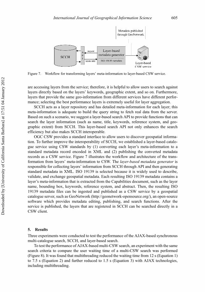
OGC CSW provides a standard interface to allow users to discover geospatial informa-tion. To further improve the interoperability of SCCH, we established a layer-based catalo-gue service using CSW standards by (1) converting each layer’s meta-information to astandard metadata record encoded in XML and (2) publishing the converted metadatarecords as a CSW service. Figure 7 illustrates the workflow and architecture of the trans-formation from layers’ meta-information to CSW. The layer-based metadata generator isresponsible for collecting layers’ information from SCCH through API and then generatingstandard metadata in XML. ISO 19139 is selected because it is widely used to describe,validate, and exchange geospatial metadata. Each resulting ISO 19139 metadata contains alayer’s meta-information that is extracted from the Capabilities document, such as the layername, bounding box, keywords, reference system, and abstract. Then, the resulting ISO19139 metadata files can be ingested and published as a CSW service by a geospatialcatalogue server, such as GeoNetwork (http://geonetwork-opensource.org/), an open-sourcesoftware which provides metadata editing, publishing, and search functions. After theservice is published, the layers that are registered in SCCH can be searched directly in aCSW client.
5. Results
Three experiments were conducted to test the performance of the AJAX-based synchronousmulti-catalogue search, SCCH, and layer-based search.
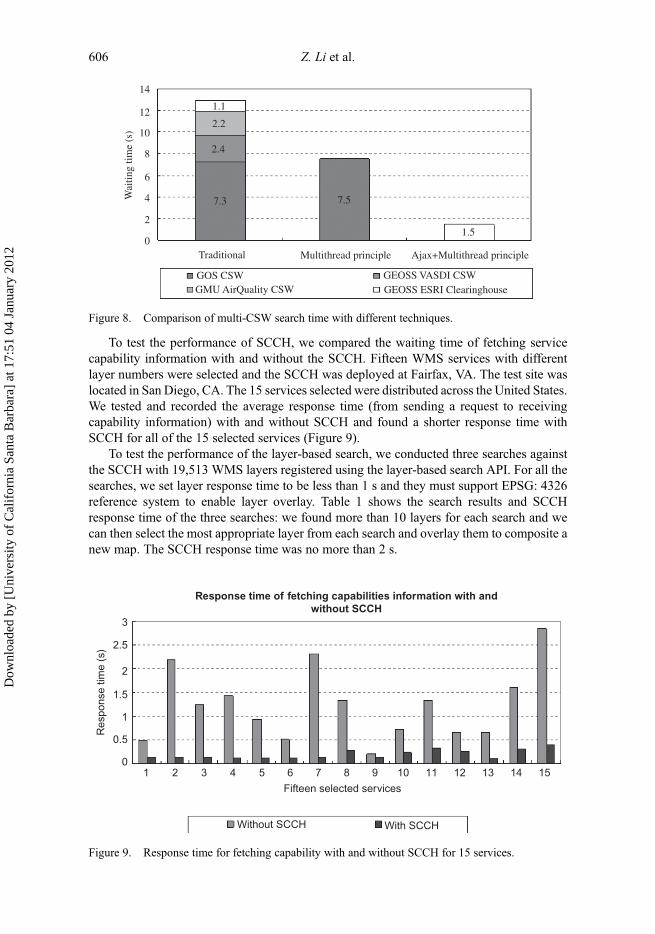
To test the performance of AJAX-based multi-CSW search, an experiment with the samesearch criteria to compare the user waiting time of a multi-CSW search was performed(Figure 8). It was found that multithreading reduced the waiting time from 12 s (Equation 1)to 7.5 s (Equation 2) and further reduced to 1.5 s (Equation 3) with AJAX technologies,including multithreading.
Figure 7. Workflow for transforming layers’ meta-information to layer-based CSW service.
International Journal of Geographical Information Science 605
Dow
nloa
ded
by [
Uni
vers
ity o
f C
alif
orni
a Sa
nta
Bar
bara
] at
17:
51 0
4 Ja
nuar
y 20
12
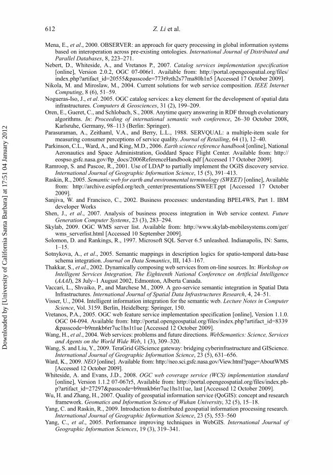
To test the performance of SCCH, we compared the waiting time of fetching servicecapability information with and without the SCCH. Fifteen WMS services with differentlayer numbers were selected and the SCCH was deployed at Fairfax, VA. The test site waslocated in San Diego, CA. The 15 services selected were distributed across the United States.We tested and recorded the average response time (from sending a request to receivingcapability information) with and without SCCH and found a shorter response time withSCCH for all of the 15 selected services (Figure 9).
To test the performance of the layer-based search, we conducted three searches againstthe SCCH with 19,513 WMS layers registered using the layer-based search API. For all thesearches, we set layer response time to be less than 1 s and they must support EPSG: 4326reference system to enable layer overlay. Table 1 shows the search results and SCCHresponse time of the three searches: we found more than 10 layers for each search and wecan then select the most appropriate layer from each search and overlay them to composite anew map. The SCCH response time was no more than 2 s.
Wai
ting
time
(s)
14
7.3 7.5
1.5
2.4
2.2
1.112
10
8
6
4
2
0Traditional
GOS CSWGMU AirQuality CSW GEOSS ESRI Clearinghouse
GEOSS VASDI CSW
Multithread principle Ajax+Multithread principle
Figure 8. Comparison of multi-CSW search time with different techniques.
Response time of fetching capabilities information with andwithout SCCH
3
2.5
2
1.5
1
0.5
0
Res
pons
e tim
e (s
)
1 2 3 4 5 6 7
Fifteen selected services
With SCCHWithout SCCH
8 9 10 11 12 13 14 15
Figure 9. Response time for fetching capability with and without SCCH for 15 services.
606 Z. Li et al.
Dow
nloa
ded
by [
Uni
vers
ity o
f C
alif
orni
a Sa
nta
Bar
bara
] at
17:
51 0
4 Ja
nuar
y 20
12

6. A spatial Web portal prototype based on the framework
This section proposes a spatial Web portal architecture by adapting the framework, and aspatial Web portal prototype is used to demonstrate how this framework can be utilized forsupporting geospatial sciences.
6.1. Spatial Web portal architecture
A spatial Web portal (Yang et al. 2007a) is based on the portlet technologies (Hepper 2006) andprovides a flexible and extensible architecture to integrate distributed and heterogeneousgeospatial contents, such as data, services, and applications, onto a single website by providinga single entry point to the integrated geospatial resources. The framework proposed above can beeasily adapted to construct an effective spatial Web portal to support geospatial sciences.
The spatial Web portal, through its connection mechanism to other systems (Figure 10),allows users to discover, integrate, utilize, and, finally, share WMS services. SCCH,described in Section 4.2, is the core component of this portal. The multi-catalogue search
Spatial Web portal architecture
Other application-based portletse.g., visualization, analysis,...
Othersystems
GoogleEarth/Maps
WMS/WMCclient
CSW client
HTTP
HTTP
HTTP
Discoveryportlet
Database Management System (MySQL)
Tomcat
UsersFirefox, Intenet Explore, Safari, Chrome,......
......
GeoNetwork
Layer-based searchportlet
SCCH
Figure 10. The spatial Web portal architecture based on the framework.
Table 1. The search results and SCCH response time of the four searches.
Keyword Search result SCCH response time (s)
DEM 23 layers from 6 servers 1.16Stream 28 layers from 19 servers 1.24State boundary 108 layers from 50 servers 1.83
International Journal of Geographical Information Science 607
Dow
nloa
ded
by [
Uni
vers
ity o
f C
alif
orni
a Sa
nta
Bar
bara
] at
17:
51 0
4 Ja
nuar
y 20
12

portlet is a CSW client adapting the search mechanism described in Section 4.1 to allowusers to dig into multiple geospatial catalogues efficiently and effectively. The layer-basedsearch portlet implements layer-based search APIs and allows users to discover the neededWMS layers more directly and accurately by searching layers crossing services with detailedconstraints such as keywords, bounding box, reference system, and average response time.
6.2. The spatial Web portal prototype
A spatial Web portal prototype (Figure 11) was developed to integrate thousands of WMSseamlessly. Currently, 1145 WMS services including 19,513 WMS layers have been regis-tered in SCCH.
OpenLayers (Figure 11) and Google Earth plugin (Figure 12) are integrated in this portalto provide smooth visualization of the Web services.
6.3. An animation usage scenario for the spatial Web portal prototype
The Earth’s surface is always changing and Earth observation data with time dimension isextremely valuable in earth science studies. Currently, a lot of Earth observation data ispublished through time-enabled WMS. The animation portlet provides a flexible andeffective approach to analyze time dimension. By animating Earth observation data, suchas MODIS (Moderate Resolution Imaging Spectroradiometer) data products, we can intui-tively visualize and examine the changing spatial and temporal patterns of phenomena, suchas sea ice coverage, in Arctic area and global snow cover.
Figure 11. Graphic user interface of the spatial Web portal prototype.
608 Z. Li et al.
Dow
nloa
ded
by [
Uni
vers
ity o
f C
alif
orni
a Sa
nta
Bar
bara
] at
17:
51 0
4 Ja
nuar
y 20
12

The following is a scientific usage scenario analyzing correlation between snow coverand wildfire: (1) animate the monthly global active wild fires (NEO WMS http://neowms.s-ci.gsfc.nasa.gov/wms/wms, layer: MOD14A1_M_FIRE) to detect the seasonal patterns ofwild fires; (2) animate global snow cover (NEO WMS, layer: MOD10C1_D_SNOW) fromthe year 2000 to 2008 by month to examine the change of snow cover for the same place atthe same time of a year; (3) overlay the two layers and animate them simultaneously tovisualize and analyze the potential correlation between wild fires and snow cover(Figure 13).
7. Discussion and conclusion
This article proposed a three-layer framework to facilitate the seamless integration of OWSsto support sharing of heterogeneous geospatial data and service through discovery, visuali-zation, and animation: (1) for service discovery, a search mechanism has been proposed byadapting AJAX techniques including multithreading to allow users to discover multipleCSW services effectively and conveniently; (2) for service integration, a centralizing server(SCCH), acting as a service repository, is proposed to pre-process and cache the capabilitiesinformation for the distributed services; (3) a layer-based performance evaluator is proposedand used to evaluate each service layer’s performance stored in SCCH; (4) to facilitateservice interoperability, a layer-based CSW service and APIs have been introduced to servethe layer-based metadata and service quality information through open standard-basedinterfaces.
Figure 12. Google Earth plugin is integrated in the spatial Web portal.
International Journal of Geographical Information Science 609
Dow
nloa
ded
by [
Uni
vers
ity o
f C
alif
orni
a Sa
nta
Bar
bara
] at
17:
51 0
4 Ja
nuar
y 20
12

A spatial Web portal architecture is introduced and a spatial Web portal prototype isdeveloped to integrate tens of thousands of WMS layers seamlessly, while providingefficient search and comprehensive visualization/animation to the integrated services. Thisframework is proved to be critical for enhancing the performance of multi-catalogue searchand for integrating thousands of WMSs seamlessly.
The performance evaluator used in this framework records the response time of theservice layer, which is only one dimension of Quality of Service (QoS) (Parasuraman et al.1988); the service reliability, accuracy, and consistency can also be recorded because of thecharacteristics of geospatial data. For example, some layers may have a very short responsetime but the returned data is not consistent with its metadata or the data is not accurateenough (Wu and Zhang 2007). Therefore, further research is needed to upgrade the layer-based one-dimension performance evaluator to a multi-dimension evaluator to provide morecomprehensive and reliable performance indications.
WMS is used to illustrate the seamless integration capability of this framework. Similarto WMS, both WFS and WCS are organized as layer structure (Vretanos 2005, Whitesideand Evans 2008). Therefore, SCCH can be easily adapted to support WFS and WCS.
In the future, we plan to enhance the framework to integrate intelligence for theperformance and interoperability of the discovery component of the framework usingsemantic search (Alesso and Smith 2005, Li et al. 2008) with Semantic Web for EarthEnvironmental Terminology (SWEET) (Raskin 2005), Web Ontology Service (WOS)(Lacasta et al. 2007), BUSTER system (Bremen University Semantic Translator forEnhanced Retrieval) (Visser 2004), and spatio-temporal conceptual schemas (Sotnykovaet al. 2005). Initiatives and studies on the cloud computing can also be potentially used to
Figure 13. Correlation analysis between snow cover and wildfires in March, 2000 to 2009.
610 Z. Li et al.
Dow
nloa
ded
by [
Uni
vers
ity o
f C
alif
orni
a Sa
nta
Bar
bara
] at
17:
51 0
4 Ja
nuar
y 20
12

further improve the overall performance of this framework by (1) adapting a workflowengine, (2) inserting a grid layer (Zhang and Tsou 2009) between presentation layer andintegration layer of this framework, and (3) connecting to a grid-based gateway (Wang andLiu 2009).
Global concerns, such as water, disaster, climate, and energy, call for coordinated,collaborative global Earth observations and OWSs to discover, share, and interoperate theaccumulated geospatial resources. With the increasing number of OWSs available on theInternet and the increasing demand of interoperability, the performance issues of effectivediscovery and seamless integration of these heterogeneous and distributed OWSs willbecome even more complicated and prominent. We expect that the performance-improvedframework proposed in this article can raise the awareness of integrating these dispersedOWSs to better support geospatial sciences by leveraging SOA, QoS, DistributedGeographic Information Processing (DGIP) principles, and other technologies.
ReferencesAlesso, H.P. and Smith, C.F., 2005. Developing semantic web services. Natick, MA: A K Peters, 445.Alonso, G., et al., 2004.Web services: concepts, architectures, and applications. New York: Springer
Verlag.Beaujardiere, J., 2004. OGC web map service interface [online], version 1.3.0, OGC 03-109r1.
Available from: http://portal.opengeospatial.org/files/index.php?artifact_id = 4756 &passco-de=b9mnkb6rr7uc1hs1t1ue [Accessed 6 September 2009].
Brodaric, B., Fox, P., and McGuinness, D.L., 2009. Geoscience knowledge representation in cyberin-frastructure. Computers & Geosciences, 35 (4), 697–699.
Chen, H. and Mohapatra, P., 2005. Using service brokers for accessing backend servers for webapplications. Journal of Network and Computer Applications, 28 (1), 57–74.
Hepper, S., 2006. JavaTM portlet specification [online], Version 2.0, Sun Microsystems. Availablefrom: https://cds.sun.com/is-bin/INTERSHOP.enfinity/WFS/CDS-CDS_JCP-Site/en_US/-/USD/ViewFilteredProducts-SingleVariationTypeFilter [Accessed 30 October 2009.
Koponen, T. and Virtanen, T., 2004. A service discovery: a service broker approach. In: Proceedingsof the 37th Hawaii international conference on system sciences [online]. Available from: http://csdl.computer.org/comp/proceedings/hicss/2004/2056/09/205690284b.pdf [Accessed 2November 2009].
Kottman, C., 1999. The OpenGIS abstract specification. Topic13: Catalog Services (version4). OpenGISProject Document 99–113, OpenGIS Consortium Inc.
Kralidis, A.T., 2007. Geospatial web services: the evolution of geospatial data infrastructure. In:A. Scharl and K. Tochtermann (Eds.), The Geospatial Web, (London: Springer), 223–228.
Lacasta, J., et al., 2007. A Web Ontology Service to facilitate interoperability within a spatial datainfrastructure: applicability to discovery. Data & Knowledge Engineering, 63, 947–971.
Laurini, R., 1998. Spatial multi-database topological continuity and indexing: a step towards seamlessGIS data interoperability. International Journal for Geographic Information Science, 12 (4),373–402.
Leymann, F., 2001. Web Services Flow Language (WSFL 1.0), IBM software Group. Available onlineat http://www.itee.uq.edu.au/˜ infs7201/Assessments/Assignment%201%20Material/WSFL.pdf(accessed 1 May 2010).
Li, W., Yang, C., and Yang, C., 2010. An active crawler for discovering geospatial web services andtheir distribution pattern. International Journal of Geographic Information Science, 24(8),1127–1147.
Lutz, M., et al., 2007. A rule-based description framework for the composition of geospatial informa-tion services. In: F.T. Fonseca, M.A. Rodrı́guez, and S. Levashkin, eds. GeoS – Volume 4853 oflecture notes in computer science. Berlin: Springer, 114–127
Maguire, D.J. and Longley, P.A., 2005. The emergence of geoportals and their role in spatial datainfrastructures. Computers, Environment and Urban Systems, 29, 3–14
International Journal of Geographical Information Science 611
Dow
nloa
ded
by [
Uni
vers
ity o
f C
alif
orni
a Sa
nta
Bar
bara
] at
17:
51 0
4 Ja
nuar
y 20
12
Mena, E., et al., 2000. OBSERVER: an approach for query processing in global information systemsbased on interoperation across pre-existing ontologies. International Journal of Distributed andParallel Databases, 8, 223–271.
Nebert, D., Whiteside, A., and Vretanos P., 2007. Catalog services implementation specification[online], Version 2.0.2, OGC 07-006r1. Available from: http://portal.opengeospatial.org/files/index.php?artifact_id=20555&passcode=773t9zth2s77ma80h1n5 [Accessed 17 October 2009].
Nikola, M. and Miroslaw, M., 2004. Current solutions for web service composition. IEEE InternetComputing, 8 (6), 51–59.
Nogueras-Iso, J., et al. 2005. OGC catalog services: a key element for the development of spatial datainfrastructures. Computers & Geosciences, 31 (2), 199–209.
Oren, E., Gueret, C., and Schlobach, S., 2008. Anytime query answering in RDF through evolutionaryalgorithms. In: Proceeding of international semantic web conference, 26–30 October 2008,Karlsruhe, Germany, 98–113 (Berlin: Springer).
Parasuraman, A., Zeithaml, V.A., and Berry, L.L., 1988. SERVQUAL: a multiple-item scale formeasuring consumer perceptions of service quality. Journal of Retailing, 64 (1), 12–40.
Parkinson, C.L., Ward, A., and King, M.D., 2006. Earth science reference handbook [online], NationalAeronautics and Space Administration, Goddard Space Flight Center. Available from: http://eospso.gsfc.nasa.gov/ftp_docs/2006ReferenceHandbook.pdf [Accessed 17 October 2009].
Ramroop, S. and Pascoe, R., 2001. Use of LDAP to partially implement the OGIS discovery service.International Journal of Geographic Information Science, 15 (5), 391–413.
Raskin, R., 2005. Semantic web for earth and environmental terminology (SWEET) [online], Availablefrom: http://archive.esipfed.org/tech_center/presentations/SWEET.ppt [Accessed 17 October2009].
Sanjiva, W. and Francisco, C., 2002. Business processes: understanding BPEL4WS, Part 1. IBMdeveloper Works
Shen, J., et al., 2007. Analysis of business process integration in Web service context. FutureGeneration Computer Systems, 23 (3), 283–294.
Skylab, 2009. OGC WMS server list. Available from: http://www.skylab-mobilesystems.com/ger/wms_serverlist.html [Accessed 10 September 2009].
Solomon, D. and Rankings, R., 1997. Microsoft SQL Server 6.5 unleashed. Indianapolis, IN: Sams,1–15.
Sotnykova, A., et al., 2005. Semantic mappings in description logics for spatio-temporal data-baseschema integration. Journal on Data Semantics, III, 143–167.
Thakkar, S., et al., 2002. Dynamically composing web services from on-line sources. In:Workshop onIntelligent Services Integration, The Eighteenth National Conference on Artificial Intelligence(AAAI), 28 July–1 August 2002, Edmonton, Alberta Canada.
Vaccari, L., Shvaiko, P., and Marchese M., 2009. A geo-service semantic integration in Spatial DataInfrastructures. International Journal of Spatial Data Infrastructures Research, 4, 24–51.
Visser, U., 2004. Intelligent information integration for the semantic web. Lecture Notes in ComputerScience, Vol. 3159. Berlin, Heidelberg: Springer, 150.
Vretanos, P.A., 2005. OGC web feature service implementation specification [online], Version 1.1.0.OGC 04-094. Available from: http://portal.opengeospatial.org/files/index.php?artifact_id=8339&passcode=b9mnkb6rr7uc1hs1t1ue [Accessed 12 October 2009].
Wang, H., et al., 2004. Web services: problems and future directions.WebSemantics: Science, Servicesand Agents on the World Wide Web, 1 (3), 309–320.
Wang, S. and Liu, Y., 2009. TeraGrid GIScience gateway: bridging cyberinfrastructure and GIScience.International Journal of Geographic Information Science, 23 (5), 631–656.
Ward, K., 2009. NEO [online]. Available from: http://neo.sci.gsfc.nasa.gov/View.html?page=AboutWMS[Accessed 12 October 2009].
Whiteside, A. and Evans, J.D., 2008. OGC web coverage service (WCS) implementation standard[online], Version 1.1.2 07-067r5, Available from: http://portal.opengeospatial.org/files/index.ph-p?artifact_id=27297&passcode=b9mnkb6rr7uc1hs1t1ue, last [Accessed 12 October 2009].
Wu, H. and Zhang, H., 2007. Quality of geospatial information service (QoGIS): concept and researchframework. Geomatics and Information Science of Wuhan University, 32 (5), 15–18.
Yang, C. and Raskin, R., 2009. Introduction to distributed geospatial information processing research.International Journal of Geographic Information Science, 23 (5), 553–560
Yang, C., et al., 2005. Performance improving techniques in WebGIS. International Journal ofGeographic Information Sciences, 19 (3), 319–341.
612 Z. Li et al.
Dow
nloa
ded
by [
Uni
vers
ity o
f C
alif
orni
a Sa
nta
Bar
bara
] at
17:
51 0
4 Ja
nuar
y 20
12
Yang, C., et al., 2008. Distributed geospatial information processing: sharing earth science informationto support Digital Earth. International Journal of Digital Earth, 1 (3), 259–278.
Yang, C., et al., 2010. Geospatial cyberinfrastructure: past, present and future. Computer, Environmentand Urban Systems, 34 (4), doi: 10.1016/j.compenvurbsys.2010.04.01.
Yang, P., Cao, Y., and Evans, J., 2007a. WMS performance and client design principles. Journal ofGIScience & Remote Sensing, 44 (4), 320–333.
Yang, P., et al., 2007b. The emerging concepts and applications of the spatial web portal. PE&RS, 73(6), 691–698.
Yue, P., et al., 2007. Semantics-based automatic composition of geospatial web service chains.Computers & Geosciences, 33, 649–665.
Zhang, T. and Tsou, M., 2009, Developing a grid-enabled spatial web portal for Internet GIServicesand geospatial cyberinfrastructure. International Journal of Geographic Information Science, 23(5), 605–630.
Zhang, T., et al., 2006. Building an intelligent geospatial cyberinfrastructure: an analytical problemsolving approach. Proceedings of SPIE, 64200A-64200A-14, doi:10.1117/12.712656.
International Journal of Geographical Information Science 613
Dow
nloa
ded
by [
Uni
vers
ity o
f C
alif
orni
a Sa
nta
Bar
bara
] at
17:
51 0
4 Ja
nuar
y 20
12