INFORMATION REGARDINGINFORMATION REGARDING ENVIRONMENTAL AUDIT REPORTS August 2007 VICTORIA’S...
103
INFORMATION REGARDING ENVIRONMENTAL AUDIT REPORTS August 2007 VICTORIA’S AUDIT SYSTEM An environmental audit system has operated in Victoria since 1989. The Environment Protection Act 1970 (the Act) provides for the appointment by the Environment Protection Authority (EPA Victoria) of environmental auditors and the conduct of independent, high quality and rigorous environmental audits. An environmental audit is an assessment of the condition of the environment, or the nature and extent of harm (or risk of harm) posed by an industrial process or activity, waste, substance or noise. Environmental audit reports are prepared by EPA- appointed environmental auditors who are highly qualified and skilled individuals. Under the Act, the function of an environmental auditor is to conduct environmental audits and prepare environmental audit reports. Where an environmental audit is conducted to determine the condition of a site or its suitability for certain uses, an environmental auditor may issue either a certificate or statement of environmental audit. A certificate indicates that the auditor is of the opinion that the site is suitable for any beneficial use defined in the Act, whilst a statement indicates that there is some restriction on the use of the site. Any individual or organisation may engage appointed environmental auditors, who generally operate within the environmental consulting sector, to undertake environmental audits. The EPA administers the environmental audit system and ensures its ongoing integrity by assessing auditor applications and ensuring audits are independent and conducted with regard to guidelines issued by EPA. AUDIT FILES STRUCTURE Environmental audit reports are stored digitally by EPA in three parts: the audit report (part A), report appendices (part B) and, where applicable, the certificate or statement of environmental audit and an executive summary (part C). A report may be in colour and black-and-white formats. Generally, only black- and-white documents are text searchable. Report executive summaries, findings and recommendations should be read and relied upon only in the context of the document as a whole, including any appendices and, where applicable, any certificate or statement of environmental audit. AUDIT REPORT CURRENCY Audit reports are based on the conditions encountered and information reviewed at the time of preparation and do not represent any changes that may have occurred since the date of completion. As it is not possible for an audit to present all data that could be of interest to all readers, consideration should be made to any appendices or referenced documentation for further information. When information regarding the condition of a site changes from that at the time an audit report is issued, or where an administrative or computation error is identified, environmental audit reports, certificates and statements may be withdrawn or amended by an environmental auditor. Users are advised to check EPA’s website to ensure the currency of the audit document. PDF SEARCHABILITY AND PRINTING EPA Victoria can only certify the accuracy and correctness of the audit report and appendices as presented in the hardcopy format. EPA is not responsible for any issues that arise due to problems with PDF files or printing. Except where PDF normal format is specified, PDF files are scanned and optical character recognised by machine only. Accordingly, while the images are consistent with the scanned original, the searchable hidden text may contain uncorrected recognition errors that can reduce search reliability. Therefore, keyword searches undertaken within the document may not retrieve all references to the queried text. This PDF has been created using the Adobe-approved method for generating Print Optimised Output. To assure proper results, proofs must be printed, rather than viewed on the screen. This PDF is compatible with Adobe Acrobat Reader Version 4.0 or any later version which is downloadable free from Adobe’s Website, www.adobe.com. FURTHER INFORMATION For more information on Victoria’s environmental audit system, visit EPA’s website or contact EPA’s Environmental Audit Unit. Web: www.epa.vic.gov.au/envaudit Email: [email protected]
Transcript of INFORMATION REGARDINGINFORMATION REGARDING ENVIRONMENTAL AUDIT REPORTS August 2007 VICTORIA’S...

INFORMATION REGARDING ENVIRONMENTAL AUDIT REPORTS August 2007
VICTORIA’S AUDIT SYSTEM An environmental audit system has operated in Victoria since 1989. The Environment Protection Act 1970 (the Act) provides for the appointment by the Environment Protection Authority (EPA Victoria) of environmental auditors and the conduct of independent, high quality and rigorous environmental audits.
An environmental audit is an assessment of the condition of the environment, or the nature and extent of harm (or risk of harm) posed by an industrial process or activity, waste, substance or noise. Environmental audit reports are prepared by EPA-appointed environmental auditors who are highly qualified and skilled individuals.
Under the Act, the function of an environmental auditor is to conduct environmental audits and prepare environmental audit reports. Where an environmental audit is conducted to determine the condition of a site or its suitability for certain uses, an environmental auditor may issue either a certificate or statement of environmental audit.
A certificate indicates that the auditor is of the opinion that the site is suitable for any beneficial use defined in the Act, whilst a statement indicates that there is some restriction on the use of the site.
Any individual or organisation may engage appointed environmental auditors, who generally operate within the environmental consulting sector, to undertake environmental audits. The EPA administers the environmental audit system and ensures its ongoing integrity by assessing auditor applications and ensuring audits are independent and conducted with regard to guidelines issued by EPA.
AUDIT FILES STRUCTURE Environmental audit reports are stored digitally by EPA in three parts: the audit report (part A), report appendices (part B) and, where applicable, the certificate or statement of environmental audit and an executive summary (part C). A report may be in colour and black-and-white formats. Generally, only black-and-white documents are text searchable.
Report executive summaries, findings and recommendations should be read and relied upon only in the context of the document as a whole, including any appendices and, where applicable, any certificate or statement of environmental audit.
AUDIT REPORT CURRENCY
Audit reports are based on the conditions encountered and information reviewed at the time of preparation and do not represent any changes that may have occurred since the date of completion. As it is not possible for an audit to present all data that could be of interest to all readers, consideration should be made to any appendices or referenced documentation for further information.
When information regarding the condition of a site changes from that at the time an audit report is issued, or where an administrative or computation error is identified, environmental audit reports, certificates and statements may be withdrawn or amended by an environmental auditor. Users are advised to check EPA’s website to ensure the currency of the audit document.
PDF SEARCHABILITY AND PRINTING EPA Victoria can only certify the accuracy and correctness of the audit report and appendices as presented in the hardcopy format. EPA is not responsible for any issues that arise due to problems with PDF files or printing.
Except where PDF normal format is specified, PDF files are scanned and optical character recognised by machine only. Accordingly, while the images are consistent with the scanned original, the searchable hidden text may contain uncorrected recognition errors that can reduce search reliability. Therefore, keyword searches undertaken within the document may not retrieve all references to the queried text.
This PDF has been created using the Adobe-approved method for generating Print Optimised Output. To assure proper results, proofs must be printed, rather than viewed on the screen.
This PDF is compatible with Adobe Acrobat Reader Version 4.0 or any later version which is downloadable free from Adobe’s Website, www.adobe.com.
FURTHER INFORMATION For more information on Victoria’s environmental audit system, visit EPA’s website or contact EPA’s Environmental Audit Unit.
Web: www.epa.vic.gov.au/envaudit
Email: [email protected]

The business of sustainability
Alpine Shire Council Closed Landfill Section 53V Audit Porepunkah Landfill Roberts Creek Road Porepunkah, Victoria CARMS Reference: 68317-2 Service Order Number: 8005871
2 April 2019
Project No.: 0468602

www.erm.com Version: 1.0 Project No.: 0468602 Client: Alpine Shire Council 2 April 2019
Document details
Document title Closed Landfill Section 53V Audit Porepunkah Landfill Roberts Creek Road Porepunkah, Victoria
Document subtitle CARMS Reference: 68317-2 Service Order Number: 8005871
Project No. 0468602
Date 2 April 2019
Version 1.0
Author Paul Fridell
Client Name Alpine Shire Council

www.erm.com Version: 1.0 Project No.: 0468602 Client: Alpine Shire Council 2 April 2019
Signature Page
2 April 2019
Closed Landfill Section 53V Audit Porepunkah Landfill Roberts Creek Road Porepunkah, Victoria CARMS Reference: 68317-2 Service Order Number: 8005871
Paul Fridell Environmental Auditor (Appointed pursuant to the Environment Protection Act 1970)
ERM Melbourne Citic House Level 6, 99 King Street Melbourne VIC 3000
© Copyright 2019 by ERM Worldwide Group Ltd and / or its affiliates (“ERM”). All rights reserved. No part of this work may be reproduced or transmitted in any form, or by any means, without the prior written permission of ERM

www.erm.com Version: 1.0 Project No.: 0468602 Client: Alpine Shire Council 2 April 2019 Page i
CLOSED LANDFILL SECTION 53V AUDIT POREPUNKAH LANDFILL ROBERTS CREEK ROAD POREPUNKAH, VICTORIA
CONTENTS
CONTENTS
EXECUTIVE SUMMARY ........................................................................................................................ 1
1. INTRODUCTION ........................................................................................................................ 13 1.1 Audit Purpose .............................................................................................................................. 13 1.2 Audit Objective ............................................................................................................................. 13 1.3 Audit Scope ................................................................................................................................. 13
1.3.1 Activity Audited ........................................................................................................... 14 1.3.2 Components of the Activity Considered ...................................................................... 14 1.3.3 Segments of the Environment Considered ................................................................. 14 1.3.4 Elements of the Environment Considered ................................................................... 14 1.3.5 Beneficial Uses Considered ........................................................................................ 14 1.3.6 Audit Criteria ............................................................................................................... 15 1.3.7 Audit Period ................................................................................................................ 15 1.3.8 Risk Assessment ........................................................................................................ 15 1.3.9 Exclusions ................................................................................................................... 15
1.4 Auditor Independence .................................................................................................................. 16 1.5 Parties Involved ........................................................................................................................... 16 1.6 Report Content and Audit Findings .............................................................................................. 16
2. AUDIT METHODOLOGY ........................................................................................................... 18 2.1 Notification of Audit ...................................................................................................................... 18 2.2 Site Inspection ............................................................................................................................. 18 2.3 Documents Reviewed and Considered ........................................................................................ 18
2.3.1 EPA Documents.......................................................................................................... 18 2.3.2 Site Specific Documents ............................................................................................. 18 2.3.3 Previous Audit Reports & Auditor Verifications / Communications ............................. 19 2.3.4 External Reference Documents .................................................................................. 20 2.3.5 EPA Publications ........................................................................................................ 20
2.4 Re-Verification of Monitoring Program ......................................................................................... 21 2.5 Stakeholder Engagement ............................................................................................................ 21 2.6 Auditor Support Personnel ........................................................................................................... 21 2.7 Auditor Expert Support................................................................................................................. 21
3. SITE DETAILS ............................................................................................................................ 22 3.1 Site Description ............................................................................................................................ 22 3.2 Site Layout ................................................................................................................................... 22 3.3 Planning Scheme ......................................................................................................................... 23 3.4 Surrounding Land Uses and Receptors ....................................................................................... 23 3.5 Climate ......................................................................................................................................... 24 3.6 Topography .................................................................................................................................. 24 3.7 Surface Water .............................................................................................................................. 24 3.8 Underground Services ................................................................................................................. 25
4. GEOLOGY AND HYDROGEOLOGY ......................................................................................... 26 4.1 Regional Geology ........................................................................................................................ 26 4.2 Site Specific Geology ................................................................................................................... 26 4.3 Regional Hydrogeology................................................................................................................ 26
4.3.1 Existing Nearby Uses of Groundwater ........................................................................ 26 4.3.2 Groundwater Flow Direction ....................................................................................... 27
4.4 Site Hydrogeology ....................................................................................................................... 29
5. BENEFICIAL USES .................................................................................................................... 31 5.1 SEPP (Waters) ............................................................................................................................ 31
5.1.1 Surface Water ............................................................................................................. 31

www.erm.com Version: 1.0 Project No.: 0468602 Client: Alpine Shire Council 2 April 2019 Page ii
CLOSED LANDFILL SECTION 53V AUDIT POREPUNKAH LANDFILL ROBERTS CREEK ROAD POREPUNKAH, VICTORIA
CONTENTS
5.1.2 Groundwater ............................................................................................................... 32 5.2 SEPP – Prevention and Management of Contamination of Land ................................................ 34 5.3 SEPP – Air Quality Management ................................................................................................. 35 5.4 Noise from Industry in Regional Victoria (EPA Publication 1411) ................................................ 35
6. AFTERCARE MANAGEMENT .................................................................................................. 36 6.1 Waste Acceptance ....................................................................................................................... 36 6.2 Combustible Recyclable Material Storage ................................................................................... 36 6.3 Landfill Cells and Construction .................................................................................................... 37 6.4 Landfill Rehabilitation ................................................................................................................... 38 6.5 Leachate Management ................................................................................................................ 42 6.6 Landfill Gas Management ............................................................................................................ 42 6.7 Stormwater Management ............................................................................................................. 43 6.8 Chemical Storage and Handling .................................................................................................. 45 6.9 Fire Management ......................................................................................................................... 45 6.10 Perimeter Fencing and Litter Management .................................................................................. 46 6.11 Noxious Weeds/ Disease Vectors ................................................................................................ 46 6.12 Site Access and Traffic Management .......................................................................................... 46
7. ENVIRONMENTAL CONDITION OF THE SITE ........................................................................ 47 7.1 Leachate ...................................................................................................................................... 47
7.1.1 Leachate Monitoring Locations ................................................................................... 47 7.1.2 Leachate Levels .......................................................................................................... 47 7.1.3 Leachate Quality ......................................................................................................... 52 7.1.4 Leachate - Environmental Monitoring Program Compliance ....................................... 53
7.2 Groundwater ................................................................................................................................ 53 7.2.1 Groundwater Monitoring Locations ............................................................................. 53 7.2.2 Groundwater Standing Levels ..................................................................................... 54 7.2.3 Groundwater Quality ................................................................................................... 55 7.2.4 Groundwater - Environmental Monitoring Program Compliance ................................. 57
7.3 Surface Water .............................................................................................................................. 57 7.3.1 Surface Water Monitoring Locations ........................................................................... 57 7.3.2 Surface Water Quality ................................................................................................. 57 7.3.3 Surface Water Monitoring Program ............................................................................. 58
7.4 Landfill Gas .................................................................................................................................. 59 7.4.1 Landfill Gas Monitoring Locations ............................................................................... 59 7.4.2 Landfill Gas - Subsurface Monitoring .......................................................................... 59 7.4.3 Landfill Gas - Surface Emissions ................................................................................ 59 7.4.4 Landfill Gas – Buildings, Structures & Subsurface Services ....................................... 59 7.4.5 Landfill Gas - Environmental Monitoring Program Compliance ................................... 59
7.5 Air ................................................................................................................................................ 60 7.5.1 Odour .......................................................................................................................... 60 7.5.2 Dust ............................................................................................................................ 60
7.6 Quality Assurance/Quality Control ............................................................................................... 60 7.7 Site Aftercare Risk Management Monitoring Records ................................................................. 60 7.8 Assessment of Adequacy of Implementation of EMP .................................................................. 61
8. RISK ASSESSMENT .................................................................................................................. 62 8.1 Risk Assessment Methodology .................................................................................................... 62 8.2 Risk from Landfill Aftercare Management .................................................................................... 63
9. RE-VERIFICATION OF MONITORING PROGRAM .................................................................. 69 9.1 Adequacy of Monitoring Plan for PC PAN Compliance ................................................................ 69 9.2 Monitoring of Environmental Risk ................................................................................................ 71
9.2.1 Groundwater ............................................................................................................... 71

www.erm.com Version: 1.0 Project No.: 0468602 Client: Alpine Shire Council 2 April 2019 Page iii
CLOSED LANDFILL SECTION 53V AUDIT POREPUNKAH LANDFILL ROBERTS CREEK ROAD POREPUNKAH, VICTORIA
CONTENTS
9.2.2 Leachate ..................................................................................................................... 72 9.2.3 Surface Water ............................................................................................................. 73 9.2.4 Landfill Gas ................................................................................................................. 74
9.3 Amenity Monitoring (Dust, Noise, Litter, Odour) .......................................................................... 75 9.4 Audit Frequency ........................................................................................................................... 75
10. AUDIT FINDINGS ....................................................................................................................... 76
11. AUDITOR RECOMMENDATIONS ............................................................................................. 81 11.1 Recommendations of This Audit .................................................................................................. 81 11.2 Implementation of Previous Audit Recommendations ................................................................. 83
12. STATEMENT OF LIMITATIONS ................................................................................................ 87
13. REFERENCES ........................................................................................................................... 89
APPENDIX A FIGURES APPENDIX B EPA DOCUMENTS APPENDIX C AFTERCARE MANAGEMENT PLAN APPENDIX D DELWP DOCUMENTS APPENDIX E AUDITOR HA VERIFICATION APPENDIX F REHABILITATION PLAN APPENDIX G MONITORING DATA APPENDIX H INSPECTION RECORDS APPENDIX I RISK ASSESSMENT APPENDIX J PREVIOUS AUDITOR RECOMMENDATIONS
List of Tables Table 1 Name and Roles of Parties Involved During the Audit................................................... 16 Table 2 Location of Audit Findings within this Aftercare Management Audit Report. ................. 16 Table 3 Surrounding Land Uses and Receptors ......................................................................... 24 Table 4 Local Climate Data – Porepunkah, Victoria (BOM, 1985 – 2018) ................................. 24 Table 5 Use of Nearby Groundwater Bores ................................................................................ 26 Table 6 Protected Beneficial Uses for Inland Waters ................................................................. 31 Table 7 Protected Beneficial Uses of Groundwater .................................................................... 32 Table 8 Relevance of Protected Beneficial Uses of Groundwater .............................................. 33 Table 9 Protected Beneficial Uses of Land ................................................................................. 34 Table 10 Summary of Landfill Cells – Porepunkah Landfill .......................................................... 37 Table 11 Landfill Cap Rehabilitation Details – Porepunkah Landfill ............................................. 39 Table 12 Leachate Monitoring Network and Maximum Leachate Levels. .................................... 47 Table 13 Leachate Monitoring Network and Maximum Leachate Levels. .................................... 48 Table 14 Leachate LN Ratio Range. ............................................................................................. 52 Table 15 Groundwater Monitoring Network .................................................................................. 54 Table 16 Leachate/ Native Cation Ratio - Groundwater (August, 2018) ...................................... 56 Table 17 Likelihood Matrix ............................................................................................................ 62 Table 18 Consequence Matrix ...................................................................................................... 62 Table 19 Risk Matrix ..................................................................................................................... 63 Table 20 Risk to Beneficial Uses with Regard to Landfill Aftercare management Deemed Moderate to High ................................................................................................................................... 65 Table 21 Auditor Review of Monitoring Plan – Adequacy for PC PAN Compliance ..................... 69 Table 22 Auditor Review of AMP - Groundwater .......................................................................... 71

www.erm.com Version: 1.0 Project No.: 0468602 Client: Alpine Shire Council 2 April 2019 Page iv
CLOSED LANDFILL SECTION 53V AUDIT POREPUNKAH LANDFILL ROBERTS CREEK ROAD POREPUNKAH, VICTORIA
CONTENTS
Table 23 Auditor Review of AMP – Leachate Monitoring ............................................................. 72 Table 24 Auditor Review of AMP – Surface Water ....................................................................... 73 Table 25 Auditor Review of EMP – Landfill Gas ........................................................................... 74 Table 26 Audit Findings ................................................................................................................ 77 Table 27 Auditor Recommendation Priority Ranking Matrix ......................................................... 81 Table 28 Auditor Recommendations 2019 .................................................................................... 82 Table 29 Previous Audit Recommendations yet to be Closed ...................................................... 84
List of Figures Figure 1 Groundwater Bores as located on the Visualising Victoria’s Groundwater online database (accessed 10/12/2018) .......................................................................................................... 27 Figure 2 Southwest Groundwater flow, March 2015 (dry season). Sourced from EES, 2015. .... 28 Figure 3 Groundwater flow, October 2014 (wet season). Westward across the Site, becoming southwest. Sourced from EES, 2015. ................................................................................................... 28 Figure 4 Cross Section of Site showing unnamed creek as a source for groundwater recharge. Creek elevation approximately 363 – 370 mAHD. Groundwater elevation approximately 357 mAHD, below creek. Sourced from EES, 2015. ................................................................................................ 29 Figure 5 Groundwater elevation below Areas 5-7. Sourced from EES, 2015. ............................. 30 Figure 6 Locations of the leachate wells (LW1 – LW6) also referred to as leachate bores LB1 – LB6 48 Figure 7 Leachate thickness (LB1 – LB6) .................................................................................... 50 Figure 8 Leachate L:N ratios ........................................................................................................ 52 Figure 9 Historic Standing Water Levels and Precipitation Events. ............................................. 54 Figure 10 Groundwater Trends ...................................................................................................... 55 Figure 11 Surface water Trends ..................................................................................................... 58

www.erm.com Version: 1.0 Project No.: 0468602 Client: Alpine Shire Council 2 April 2019 Page 1
CLOSED LANDFILL SECTION 53V AUDIT POREPUNKAH LANDFILL ROBERTS CREEK ROAD POREPUNKAH, VICTORIA
EXECUTIVE SUMMARY
EXECUTIVE SUMMARY
Mr Paul Fridell (the Auditor) of Environmental Resources Management Australia Pty Ltd (ERM) was engaged in his capacity as an Environmental Auditor (a person appointed as an Environmental Auditor, pursuant to the Environment Protection Act 1970) to undertake a section 53V audit of the Porepunkah Landfill (the site) (refer to Figure F1 Appendix A for site location) aftercare management including a review of the landfill notice holder’s risk assessment and re-verification of the Environmental Monitoring Program (EMP) and Hydrogeological Assessment (HA).
In consideration of the audit objectives, the audit has: identified the risk of possible harm or detriment to the environment caused by the aftercare of the
landfill;
considered the risk of possible harm or detriment to the environment caused by the aftercare of the landfill as “intolerable” for the beneficial uses of the environment as outlined in Table E1 below;
made recommendations to address the identified ‘intolerable’ risks to beneficial uses; and,
reviewed the completeness of the risk assessment and deemed that the risk assessment process undertaken as adequate to identify and evaluate the potential risks to the environment from landfill aftercare management.
The notice holder did not complete a risk assessment, therefore the auditor undertook a risk assessment of aftercare management based on the monitoring data provided and the auditor’s own site inspection. The table below summarises the auditor’s opinion as to the intolerable risks of possible harm or detriment to the environment caused by the aftercare management of the landfill.
Table E1 Summary of risk of possible harm or detriment to beneficial uses. Hazard Description Aspect Impact Potentially Precluded
Beneficial Uses
Ris
k R
atin
g Wild fire entering site from off-site
Fire Air pollution (smoke) Air SEPP (1a-e) H
Significant emission of fugitive gas causing an asphyxiation hazard
Landfill gas Air pollution (CO2) Air SEPP (1a, b) H
Significant leak of methane through geological migration that presents an explosion risk
Landfill gas Air pollution (methane accumulation)
Air SEPP (1a,b,e) H

www.erm.com Version: 1.0 Project No.: 0468602 Client: Alpine Shire Council 2 April 2019 Page 2
CLOSED LANDFILL SECTION 53V AUDIT POREPUNKAH LANDFILL ROBERTS CREEK ROAD POREPUNKAH, VICTORIA
EXECUTIVE SUMMARY
Diffuse and acute leakage of leachate through basal LF liner above 'allowed' rate
Leachate Contamination of groundwater
Water SEPP • water dependent ecosystems and species • potable water supply • agriculture (stock watering) and irrigation • primary contact recreation; • cultural and spiritual values.
M
Flow of leachate into surface water from breach of cell
Leachate Contamination of surface water
Water SEPP • water dependent ecosystems and species (largely unmodified) • irrigation • human consumption of aquatic food • primary, secondary, aesthetic recreation; • cultural and spiritual values.
M
Stockpiling of combustible recyclable materials, in a manner causing fire.
Fire Air pollution (smoke) Air SEPP (1c) M
Stockpiling of green waste in a manner resulting in anaerobic decomposition and fire
Fire Air pollution (smoke) Air SEPP (1c) M
The summary information related to this audit is presented in the table below in accordance with EPA Publication 1147, Environmental Auditor Guidelines – Provision of Environmental Audit Reports, Certificates and Statements.

www.erm.com Version: 1.0 Project No.: 0468602 Client: Alpine Shire Council 2 April 2019 Page 3
CLOSED LANDFILL SECTION 53V AUDIT POREPUNKAH LANDFILL ROBERTS CREEK ROAD POREPUNKAH, VICTORIA
EXECUTIVE SUMMARY
Table E2 Summary of Audit Information Auditor Paul Fridell
Auditor account number 75638
Auditor appointment end date 23 May 2011 to 19 November 2023
Audit type S53V Audit of Landfill Aftercare management
Date EPA Notified of Audit 11/07/2018
Audit service order number 8005871 (CARMs 68317-2)
Name of person requesting the Audit
Brett Jordan
Relationship to premises/ location
Project Manager on behalf of the Owner
Name of premises owner Alpine Shire Council
Date of auditor engagement 11/07/2018
Completion date of the audit 02/04/2019
Reasons for audit Post Closure Pollution Abatement Notice 90007375 – Condition LC12 and auditor verified Environmental Monitoring Program requires routine audits of landfill aftercare.
Audit Categorisation Risk of any possible harm or detriment to a segment of the environment caused by the aftercare management of a landfill.
Environmental Segments The area of land on which the landfill is located, including the emissions to the air at the site, sub-surface geology, groundwater beneath the site, any surface water on or near the site or linked hydrogeologically to the site, and the environment surrounding the landfill to which the activity may pose a risk.
If the audit was required by an EPA notice, licence or other, please provide EPA reference number
Post Closure Pollution Abatement Notice 90007375 (signed 15 March 2017)
Current land use zoning Public Conservation and Resource Zone (PCRZ)
EPA Region North East
Municipality Alpine Shire Council
Dominant – Lot on plan Part of Allotment 8, Section 8, Parish of Porepunkah
Additional – Lot on Plan (s)
Site/ Premises Name Porepunkah Landfill
Building/complex sub-unit No.
Street/Lot – Lower No.
Street/ Lot – Upper NO.
Street Name Roberts Creek
Street Type (Road, Court, etc.)
Road

www.erm.com Version: 1.0 Project No.: 0468602 Client: Alpine Shire Council 2 April 2019 Page 4
CLOSED LANDFILL SECTION 53V AUDIT POREPUNKAH LANDFILL ROBERTS CREEK ROAD POREPUNKAH, VICTORIA
EXECUTIVE SUMMARY
Street Suffix (north, south, etc.)
Suburb Porepunkah
Postcode 3740
GIS coordinate of site centroid
Longitude/ Northing 146.959167
Latitude / Easting -36.697222
Member and Categories of Support Team Utilised
None used
Further work or requirements A detailed list of recommendations is included in the Table E5 below.
Nature and extent of continuing risk
The auditor completed a risk assessment for the site to identify and assess the environmental risks associated with current site aftercare management.
The nature and extent of continuing risks were identified in the risk assessment and the auditor formed an opinion as to whether the risks were tolerable or intolerable as per EPA Licence Assessment Guidelines (Publication 1321). Risks were considered tolerable if all practicable risk mitigation measures had been implemented. Intolerable risks were allocated recommendations. A summary of the intolerable risks are included above in Table E1.
As there are a number of intolerable risks remaining and recommendations pending, the risks are not yet adequately monitored or managed.
Outcomes of the Audit Implementation of Environmental Monitoring Program The auditor verified EMP (IS, 2016) required quarterly sampling of groundwater and surface waters. Based on the data provided for consideration in the audit, quarterly monitoring of waters occurred between July 2015 and December 2016 and then sampled biannually (every 6 months) in 2017 until March 2018 which is in compliance with the verified monitoring program (albeit the sampling months are not exactly as specified in the EMP, but this is not considered significant).
Not all field sheets were provided for review therefore it cannot be confirmed that all field works methodologies were in compliance with the EMP.
Leachate levels in the leachate bores was monitored monthly as required by the EMP (2016), however the method for calculating leachate thickness changed in May 2018 which has produced erroneous results since this time. Leachate levels are not routinely assessed against the maximum leachate levels specified in the HA (where available). Noted the HA does not include clearly specified maximum leachate levels.
The EMP (2016) required monitoring of LFG cap surface emissions on a quarterly basis. Based on the information provided for consideration in the audit, LFG monitoring was only undertaken on one occasion in the audit period (March 2018) which does not meet the EMP requirements.
Overall the monitoring methods and analytes appear to be generally consistent with the EMP requirements with the exception of the QA/QC

www.erm.com Version: 1.0 Project No.: 0468602 Client: Alpine Shire Council 2 April 2019 Page 5
CLOSED LANDFILL SECTION 53V AUDIT POREPUNKAH LANDFILL ROBERTS CREEK ROAD POREPUNKAH, VICTORIA
EXECUTIVE SUMMARY
which did not met the EMP requirements. Except for 2015, no field sampling sheets were provided to enable the audit team to verify sampling methods or sample preservation adequacy (e.g. field filtering of metals samples). No split duplicates (second laboratory) have been taken and sample blanks were noted to have been reported with leachate indicators present (e.g. ammonia).
Overall the quality control and quality of assurance methods did not meet industry standards or EPA guidelines and thus the precision and accuracy of the data could not be confirmed, although for the purposes of assessing broad trends and relative differences between sample locations the data was considered adequate. The auditor has therefore been cautious drawing low risk conclusions on a poor data set and has generally adopted a conservative approach to assessing risks as a result.
There was no evidence provided that the site inspection checklist included in the EMP had been routinely completed.
Interpretation of Monitoring Results (2015-2018) Given the inadequacies of the EMP and the non-compliances with the EMP, the interpretation of the monitoring data is limited to data that could be verified. Data was relied upon if it was generally consistent with historical data trends and/or when complete field records were provided.
Leachate levels in the landfill cells have historically been reported above the maximum levels specified in the HA (for cells where a maximum level was specified). Historical leachate thickness monitoring have consistently reported between 2 and 7 metres of leachate in the cells up to the end of 2017. This is considered excessive given the maximum leachate levels specified in the HA typically allow approximately 2 metres of leachate. Recent reported reductions in leachate head since the capping works cannot be confirmed as the data is most likely erroneous because the method used since May 2018 has changed and is now calculated based on depth to leachate from top of casing rather than a direct measurement of thickness from the base of the bore. This new method (from top of casing) incorrectly calculates leachate thickness and height if the leachate bore casing heights change, which is likely as leachate bores are extended during capping construction works. An extension of the leachate bore casings would significantly and incorrectly reduce the calculated thickness and relative level.
Based on analysis of leachate and native ions in groundwater monitoring data it is the auditor’s opinion that the groundwater monitoring results indicate an increasing trend of leachate ions and TDS in groundwater well MW2 over the last 4 years. Potassium is not commonly found in the natural environment is prevalent in leachate and ammonium is elevated in MW2 with TDS showing a steady increasing trend in this bore. While potassium does not have an assessment criteria it is in an indication that other contaminants of concern exceeding guidelines such as ammonia and manganese) are more likely as a result of leachate than natural variation. The auditor is therefore of the opinion that MW2 is currently reporting minor leachate contamination and monitoring indicates an increasing trend and an approaching leachate front. This bore is located on-site and a considerable distance from any groundwater receptors therefore risk is considered to be medium. The risk is intolerable because

www.erm.com Version: 1.0 Project No.: 0468602 Client: Alpine Shire Council 2 April 2019 Page 6
CLOSED LANDFILL SECTION 53V AUDIT POREPUNKAH LANDFILL ROBERTS CREEK ROAD POREPUNKAH, VICTORIA
EXECUTIVE SUMMARY
measures such as reducing leachate thickness in cells and implementing Stages 2 and 3 of the rehabilitation plan will reduce risk.
In most recent surface water sampling events in 2018, there are minor increases in potassium and ammonia in SW1 which is suggesting potential minor leachate influence. Given the ambiguity in current leachate levels in the cell and the previous connectivity between leachate in Area 3 and surface water, this is considered a medium intolerable risk and therefore surface water monitoring is recommended to be reinstated.
Implementation of Progressive Remediation The capping in Stage 1 (Areas 2/3, 4, 5a, 5 and 8) as defined in the rehabilitation plan was completed in 2017. A CQAS Supervision and Testing Report (SMEC, 2017) documenting the ‘as built’ construction of the capping in these areas was provided and appears generally consistent with the requirements of the CQA plan, although it is outside the scope of this audit to undertake a detailed audit of compliance.
Verification of Environmental Monitoring Program The environmental auditor is of the opinion that having considered the notice-holder’s environmental monitoring program and the auditor’s risk assessment while having regard to the post closure pollution abatement notice (PC PAN) conditions and other relevant policies or documents published by the Authority (or other relevant bodies), the environmental monitoring program is not sufficient to enable the notice holder and EPA to determine compliance with the licence. Therefore the current EMP requires revision and resubmission for auditor verification considering the recommendations made in this audit and by previous auditors as documented in the table below.
The EMP is to be updated outside of this audit process and re-submitted for verification by an EPA appointed Environmental Auditor by 1 September 2019.
Verification of the Hydrogeological Assessment The environmental auditor is of the opinion, having considered the notice-holder’s hydrogeological assessment, the auditor’s risk assessment and while having regard to the current rehabilitation plan and other relevant policies or documents published by the Authority (or other relevant bodies), the maximum leachate levels specified in the hydrogeological assessment are not considered sufficient to ensure a low and acceptable risk to groundwater nor allow effective management of landfill gas. Therefore the current HA requires revision and resubmission for auditor verification considering the recommendations made in this audit and by previous auditors as documented in the tables of recommendations.
The HA is to be updated outside of this audit process and re-verified by an EPA appointed Environmental Auditor by 1 September 2019.
Audit Frequency The Auditor recommends that the next s53V landfill aftercare management audit be completed by 31 March 2021 considering all

www.erm.com Version: 1.0 Project No.: 0468602 Client: Alpine Shire Council 2 April 2019 Page 7
CLOSED LANDFILL SECTION 53V AUDIT POREPUNKAH LANDFILL ROBERTS CREEK ROAD POREPUNKAH, VICTORIA
EXECUTIVE SUMMARY
monitoring data between 1 July 2018 and 31 December 2020. Annual reports are to be forwarded by 15 February annually by the notice holder to an Environmental Auditor for review to confirm adequacy of the monitoring program, especially the QA/QC program, is suitable for the audit.
Table E3 Physical site information
Historical land use
Current land use Landfill
Surrounding land use - north State Forest
Surrounding land use - south State Forest and agricultural land
Surrounding land use - east State Forest
Surrounding land use - west State Forest and agricultural land
Proposed land use zoning
Nearest surface water receptor – name Roberts Creek, at its closest point, is located approximately 500 m south of the site.
Nearest surface water receptor – direction
South
Groundwater Segment Segment A1
The audit recommendations have been prioritised based on risk in accordance with the High, Medium and Low risk based priorities as outlined in the EPA Publication 1323.3. The Auditor has also adopted an additional priority (3B) for amendments to the environmental residual risk monitoring program that are required to be implemented prior to the next monitoring event regardless of risk level.
Priority ratings 1 - 3A indicate the priority of recommendations related to the implementation of risk management reduction measures to be implemented. Prioritisation and implementation timing has been based on EPA “Landfill Licensing Guidelines“, Publication 1323.
Priority 3B is the default priority for any recommendations related to the improvement of residual risk monitoring and changes to the EMP. As these recommendations are required for the measurement of the residual risk after the implementation of the risk management measure, they are typically not risk based however there is an expectation that they are implemented from the start of the next monitoring round or prior to the next monitoring report.
Table E4 Auditor Recommendation Priority Ranking Matrix
Priority Risk Level Being Addressed Acceptability Implementation Timing
1 Very High - High Risk. Intolerable. Requires immediate action within 3 months unless otherwise stated in the recommendation.
2 Moderate Risk. Intolerable. Requires prompt action within 6 months unless otherwise stated in the recommendation.

www.erm.com Version: 1.0 Project No.: 0468602 Client: Alpine Shire Council 2 April 2019 Page 8
CLOSED LANDFILL SECTION 53V AUDIT POREPUNKAH LANDFILL ROBERTS CREEK ROAD POREPUNKAH, VICTORIA
EXECUTIVE SUMMARY
3A Low Risk Intolerable Requires action prior to the next landfill aftercare management audit unless otherwise stated in the recommendation.
3B Residual Risk Monitoring Prior to next monitoring event or monitoring report unless otherwise stated in the recommendation.
All audit new recommendations are included in the table below which includes:
A unique reference identification number consisting of year, month and the recommendation number to allow tracking of the recommendation through subsequent audits;
The priority ranking as per the table above; and
A description of the recommendation.
Table E5 Summary of Audit Recommendations 2019
ID Priority Ranking
Recommendations
1902-R01 1 Undertake a risk assessment as per EPA Management and Storage of Combustible Recyclable and Waste Materials - Guideline (EPA Publication 1667.1) to ensure that the risk associated with the storage of organics on-site is low and acceptable.
1902-R02 3B All subsurface LFG monitoring is to include carbon dioxide, methane and LFG flow rates as per EPA Publication 1684 Landfill gas fugitive emissions monitoring guideline (as amended). The EMP is required to be updated to include this requirement.
LFG surface emissions are to be measured on all landfill cells and landfill caps (intermediate and final caps) including in proximity to cap penetrations, as per EPA Publication 1684 Landfill gas fugitive emissions monitoring guideline (as amended). The EMP is required to be updated to include this requirement.
Additionally, in revising the EMP, the monitoring method and action levels for the biofilters are to be agreed between the verifying Environmental Auditor and EPA LFG experts and documented in the EMP.
1902-R03 3B It is recommended that leachate bores and Area 3 leachate sump are resurveyed and the leachate level measuring method is reviewed in the AMP to ensure consistent and reliable results are being generated.
1902-R04 3B The verified Hydrogeological Assessment (HA) did not include specific maximum leachate levels for the leachate bores on the condition that the levels could be further refined upon completion of capping works. It is also noted that there were also a number of outstanding auditor recommendations that have not been completed. Therefore the HA has not been re-verified as part of this audit. An update of the HA is required considering all current audit findings related to groundwater, current and previous audit recommendations

www.erm.com Version: 1.0 Project No.: 0468602 Client: Alpine Shire Council 2 April 2019 Page 9
CLOSED LANDFILL SECTION 53V AUDIT POREPUNKAH LANDFILL ROBERTS CREEK ROAD POREPUNKAH, VICTORIA
EXECUTIVE SUMMARY
as documented in this audit report and considering the updated SEPP (Waters). This update is to be undertaken in conjunction with the update of the EMP resubmitted for auditor verification outside of the formal audit process. The revised HA is to be verified by 1 September 2019.
1902-R05 3B Despite the observation that the leachate sump has now been segregated from Area 3 stormwater, the previous auditor comment that there was significant head of leachate in Area 3 cell is required to be addressed. It is recommended that the Area 3 sump be retained for the purpose of monitoring leachate quality and leachate levels in Area 3 and not be decommissioned.
1902-R06 3B Include turbidity as a field measurement when monitoring stormwater.
1902-R07 3B Included dissolved oxygen as a field parameter in water monitoring as part of the revised EMP.
1902-R08 3B Sampling of off-site surface water upstream and downstream of the site is to be reinstated until it can be confirmed that leachate levels in cells have reduced and turbidity discharges to stormwater are confirmed as low and acceptable.
1902-R09 3B The site inspection checklist in the current EMP is to be updated to include amenity impact inspections (odour, dust, noise) to demonstrate compliance with the PC PAN conditions and include combustible recyclable stockpile inspections as per the outcomes of combustibles storage risk assessment.
1902-R10 3B QA/QC management of data does not meet industry or EPA guidelines and has been an ongoing recommendation of all previous audit reports and auditor verifications since 2011. These recommendations have not been addressed. It is therefore recommended that a specific QA/QC data management procedure be developed for all monitoring on the site and it is included as a separate Annex/Appendix item in the EMP that is verified by an auditor.
1902-R11 3B The current EMP (Infrastructure Solutions, 2016) is not considered adequate to monitoring licence compliance and environmental risk and therefore the EMP has not been re-verified in this audit. Previous verifications were conditional upon adoption of previous auditor recommendations. The majority of the previous auditor recommendations have not been adopted in subsequent revisions of the EMP, nor complied with as part of the monitoring program implemented since the EMP was conditionally verified. A significant update of the EMP is required considering all current and previous audit recommendations as documented in this audit report and considering the updated SEPP (Waters) prior to resubmission for auditor verification outside of the formal audit process. The revised EMP is to be verified by 1 September 2019.
www.erm.com Version: 1.0 Project No.: 0468602 Client: Alpine Shire Council 2 April 2019 Page 10
CLOSED LANDFILL SECTION 53V AUDIT POREPUNKAH LANDFILL ROBERTS CREEK ROAD POREPUNKAH, VICTORIA
EXECUTIVE SUMMARY
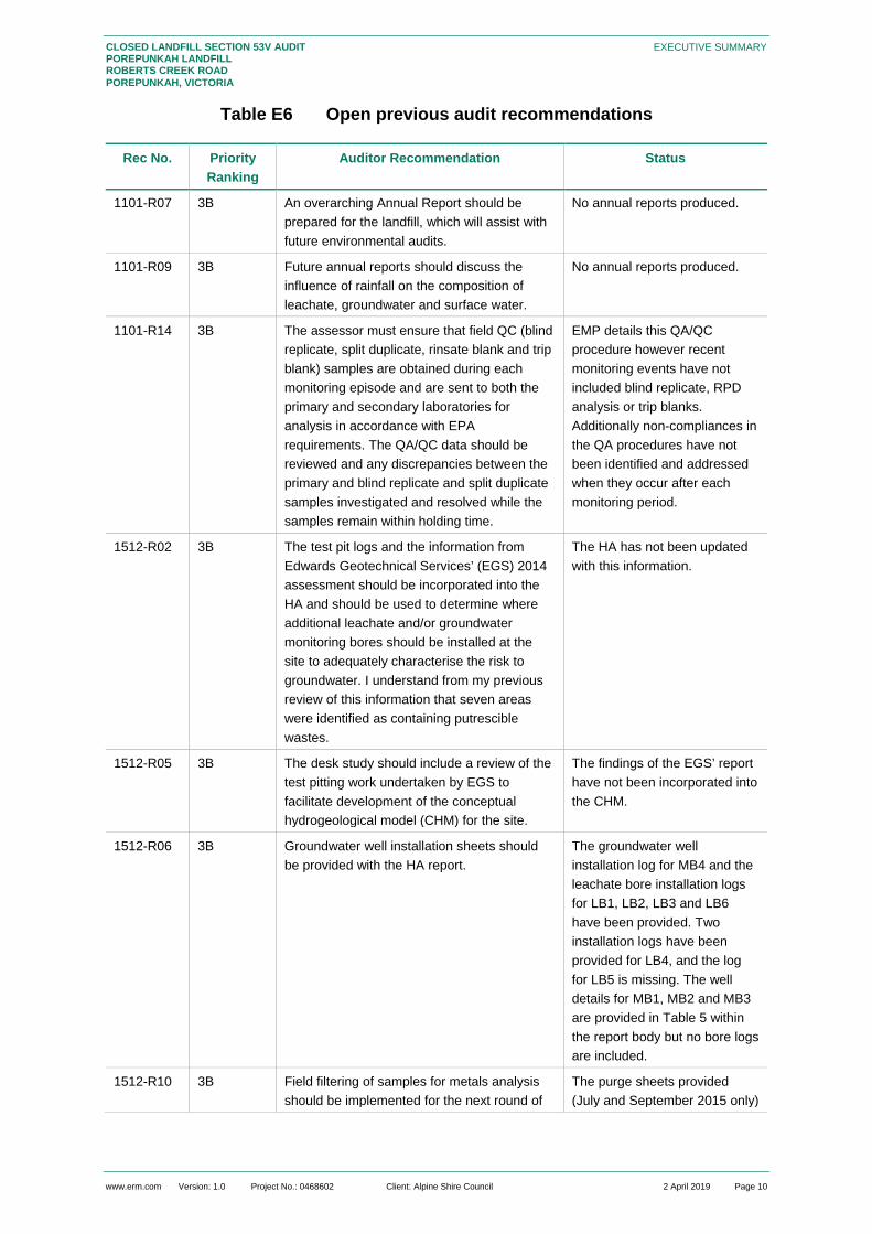
Table E6 Open previous audit recommendations
Rec No. Priority Ranking
Auditor Recommendation Status
1101-R07 3B An overarching Annual Report should be prepared for the landfill, which will assist with future environmental audits.
No annual reports produced.
1101-R09 3B Future annual reports should discuss the influence of rainfall on the composition of leachate, groundwater and surface water.
No annual reports produced.
1101-R14 3B The assessor must ensure that field QC (blind replicate, split duplicate, rinsate blank and trip blank) samples are obtained during each monitoring episode and are sent to both the primary and secondary laboratories for analysis in accordance with EPA requirements. The QA/QC data should be reviewed and any discrepancies between the primary and blind replicate and split duplicate samples investigated and resolved while the samples remain within holding time.
EMP details this QA/QC procedure however recent monitoring events have not included blind replicate, RPD analysis or trip blanks. Additionally non-compliances in the QA procedures have not been identified and addressed when they occur after each monitoring period.
1512-R02 3B The test pit logs and the information from Edwards Geotechnical Services’ (EGS) 2014 assessment should be incorporated into the HA and should be used to determine where additional leachate and/or groundwater monitoring bores should be installed at the site to adequately characterise the risk to groundwater. I understand from my previous review of this information that seven areas were identified as containing putrescible wastes.
The HA has not been updated with this information.
1512-R05 3B The desk study should include a review of the test pitting work undertaken by EGS to facilitate development of the conceptual hydrogeological model (CHM) for the site.
The findings of the EGS’ report have not been incorporated into the CHM.
1512-R06 3B Groundwater well installation sheets should be provided with the HA report.
The groundwater well installation log for MB4 and the leachate bore installation logs for LB1, LB2, LB3 and LB6 have been provided. Two installation logs have been provided for LB4, and the log for LB5 is missing. The well details for MB1, MB2 and MB3 are provided in Table 5 within the report body but no bore logs are included.
1512-R10 3B Field filtering of samples for metals analysis should be implemented for the next round of
The purge sheets provided (July and September 2015 only)

www.erm.com Version: 1.0 Project No.: 0468602 Client: Alpine Shire Council 2 April 2019 Page 11
CLOSED LANDFILL SECTION 53V AUDIT POREPUNKAH LANDFILL ROBERTS CREEK ROAD POREPUNKAH, VICTORIA
EXECUTIVE SUMMARY
groundwater monitoring and the HA report should be updated to include a discussion of the heavy metals contamination status of the groundwater. Samples should be collected in appropriate sampling containers and the samples to be analysed for heavy metals should be filtered in the field using 0.1 micron filters to remove colloidal material. This is in accordance with EPA guidelines.
indicate that the samples retrieved were considered to be too turbid to filter in the field. Field filtering in the field does not appear to be undertaken.
1512-R11 3B The field sampling records, including groundwater well purging and sampling records and equipment calibration records should be included with the HA report so that it can be confirmed that sampling has been performed in accordance with EPA guidelines.
Field sampling records have only been provided for July and September 2015. No other field sheets provided for review as part of this audit.
1512-R20 3B It is imperative that appropriate quality control measures are implemented. That is, split duplicate and blind replicate samples must be collected and analysed by primary and secondary laboratories during each future monitoring round and the results compared with quality assurance/quality control (QA/QC) acceptance criteria specified in the National Environment Protection (Assessment of Site Contamination) Measure 1999 (ASC NEPM).
Sampling data provided in this audit does not meet this minimum data QA/QC management requirement.
1512-R24 3B The protected beneficial uses are outlined in the Groundwater Contamination Assessment section (Section 6.0) of the HA report (rather than within the CHM section) and an appraisal of the contaminant status of the groundwater with respect to the relevant beneficial uses is also presented Section 6.0. • ANZECC 2000 guidelines have been adopted for the beneficial uses of potable water supply, agriculture parks and gardens, stock watering and primary contact recreation. However, in accordance with the State Environment Protection Policy (SEPP) (Groundwaters of Victoria), the ANZECC 1992 guideline values should be adopted. • The relevant beneficial uses of the groundwater are considered to be maintenance of ecosystems, agriculture, parks and gardens and stockwatering based on the nearby registered bores and the surrounding land uses. • I note that criteria have not been considered for Industrial Water Use or Buildings and Structures, which are protected beneficial uses for the Segment A1 groundwater. Generic criteria are available for various industries in the Australian Water Quality
Additional updates are required to consider the new SEPP (Waters) 2018.

www.erm.com Version: 1.0 Project No.: 0468602 Client: Alpine Shire Council 2 April 2019 Page 12
CLOSED LANDFILL SECTION 53V AUDIT POREPUNKAH LANDFILL ROBERTS CREEK ROAD POREPUNKAH, VICTORIA
EXECUTIVE SUMMARY
Guidelines (ANZECC 1992) and for Buildings and Structures in Australian Standard AS 2159-2009, Piling – Design and Installation, Incorporating Amendment No. 1 (AS2159-2009). • The results of any future monitoring rounds should implement the guideline values specified in this verification.
1512-R25 3B It is recommended that MW1, which is reportedly blocked, be repaired or reinstalled so the groundwater at this location can continue to be sampled.
1603-R01 3B The BPEM requires monitoring around any surface penetrations; therefore the AMP should include provision for this in the gas monitoring program. No amendment appears to be included for monitoring around surface penetrations such as leachate bores. In addition, no landfill gas monitoring bores appear to have been included in the monitoring program around the perimeter of the landfill, as per Stephen Cambridge email to Council dated 1 March 2016 and forwarded to Infrastructure Solutions on 1 March 2016. Landfill gas monitoring bores are required. Revision 2 of the AMP includes action levels, however not all relevant action levels as per the BPEM are included, and the action level for penetrations through the cap is not correct. These items have been noted in the Auditor Declaration.
This audit report supersedes previous reports while taking into account the key findings and recommendations of those reports. The recommendations in this report may be in addition to those made previously, modifications to those made previously, or in the case of any that have not been implemented they are repeated in this report. Therefore, the recommendations in this report are the only recommendations that need to be implemented.
It is the auditor’s opinion that risks to the environment associated with landfill aftercare management are not currently being adequately identified, managed and monitored.

www.erm.com Version: 1.0 Project No.: 0468602 Client: Alpine Shire Council 2 April 2019 Page 13
CLOSED LANDFILL SECTION 53V AUDIT POREPUNKAH LANDFILL ROBERTS CREEK ROAD POREPUNKAH, VICTORIA
INTRODUCTION
1. INTRODUCTION
Mr. Paul Fridell of Environmental Resources Management Australia Pty Ltd (ERM) has been engaged as the Environmental Auditor to undertake an environmental audit of the aftercare management of the former Porepunkah Landfill (the site) located at Roberts Creek Road, Porepunkah, Victoria (refer to Figure F1, Appendix A for a site locality plan). The audit was conducted in accordance with Section 53V of the Environment Protection Act 1970.
1.1 Audit Purpose The audit is required to satisfy the Environment Protection Authority (EPA) Post Closure Pollution Abatement Notice (PC PAN) (90007375) (Appendix B) conditions below:
Condition L12: “You must engage an environmental auditor to conduct environmental audits in accordance with section 53V of the Environment Protection Act 1970 at the frequency specified in the verified monitoring program.”
1.2 Audit Objective The primary objective of the audit is to identify and, where possible, quantify the risk of any possible harm or detriment to a segment of the environment caused by the aftercare management of the landfill.
The audit objectives also include:
an independent assessment of compliance with the notice requirements;
review of the completeness of the site risk assessment (RA); and,
re-verification of the Environmental Monitoring Program (EMP) considering assessment and monitoring data collected over the preceding period and the outcomes of the Auditor’s site visit.
The objective of the EMP re-verification is to verify that the EMP is sufficient for the licence holder to:
to enable the notice holder to determine compliance with the PC PAN;
monitor and evaluate the management of risks to the environment from aftercare management of the site;
specify an environmental audit frequency that reflects the overall environmental risk presented by the landfill; and,
enable the environmental audit cycle to determine when the site no longer poses a risk of pollution of the environment or an environmental hazard.
The auditor is also required to comment on whether the risks to the environment associated with the landfill aftercare management are being adequately identified, managed and monitored.
1.3 Audit Scope The scope was defined as per EPA Publication 1490.1 (January 2018) Closed Landfill Guidelines, specifically:
Appendix 4: Scope of Environmental Auditor verification of an Environmental Monitoring Program; and
Appendix 5: Scope for audits of aftercare management.

www.erm.com Version: 1.0 Project No.: 0468602 Client: Alpine Shire Council 2 April 2019 Page 14
CLOSED LANDFILL SECTION 53V AUDIT POREPUNKAH LANDFILL ROBERTS CREEK ROAD POREPUNKAH, VICTORIA
INTRODUCTION
This audit report has also been prepared in compliance with EPA Publication 952 (as amended) Environmental Auditor Guidelines for the Preparation of Environmental Audit Reports on Risk to the Environment.
1.3.1 Activity Audited The activity audited is the aftercare management of the former Porepunkah Landfill, located at Roberts Creek Road, Porepunkah (refer to Figure F1 and Figure F2, Appendix A for a site locality plan and site features). The landfill ceased accepting waste in 2008.
1.3.2 Components of the Activity Considered The audit assessed all aspects of landfill aftercare including the operation of the landfill gas management system, the leachate collection and treatment system, surface water control and collection, and cap inspection and repair.
In addition, the audit also considered and made comment on the risk assessment (RA), environmental management plan (EMP) and rehabilitation of the landfill cells. In particular, the Environmental Auditor reviewed the ability of the EMP to enable determination of compliance with the PC PAN requirements.
1.3.3 Segments of the Environment Considered The segment of the environment considered during the audit was the area of land on which the site is located, including atmosphere at the site, sub-surface geology, groundwater beneath the site and any surface water on or near the site or linked hydrogeologically to the site, and the environment surrounding the site on which the activity may pose a risk.
The segments of the environment audited include:
land defined by the premises boundary of the site on at Roberts Creek Road as detailed in EPA PC PAN 90007375; and
an approximate 500 metre (m) buffer around the site to which the facility may pose a risk.
1.3.4 Elements of the Environment Considered The elements of the environment considered included groundwater, surface water, land, emissions of landfill gas to the air, landfill gas presence in the sub-surface geology, sub-surface services and buildings on the site.
1.3.5 Beneficial Uses Considered Beneficial uses considered during the audit were those specified in the relevant State Environmental Protection Policies (“SEPPs”) including:
State Environment Protection Policy (Waters), Victorian Government Gazette, No. S499, October 2018;
State Environment Protection Policy (Control of Noise from Commerce, Industry and Trade), Victorian Government Gazette No. S31, June 1989;
State Environment Protection Policy (Air Quality Management), Victorian Government Gazette, No. S240, December 2001; and,
State Environment Protection Policy (Prevention and Management of Contaminated Land), Victorian Government Gazette, No. S95, June 2002, as varied by Variation to the State environment protection policy (Prevention and Management of Contamination of Land) No. G39, Gazette 26 September 2013.

www.erm.com Version: 1.0 Project No.: 0468602 Client: Alpine Shire Council 2 April 2019 Page 15
CLOSED LANDFILL SECTION 53V AUDIT POREPUNKAH LANDFILL ROBERTS CREEK ROAD POREPUNKAH, VICTORIA
INTRODUCTION
1.3.6 Audit Criteria In undertaking the audit, audit criteria were drawn from the above policies and the following additional policies, guidelines and documents:
Environmental Protection Act 1970;
Waste Management Policy (Siting, Design and Management of Landfills), Victorian Government Gazette No. S264 December 2004;
EPA Victoria Publication 788.3 (2015), Best Practice Environmental Management – Siting, design, operation and rehabilitation of landfills, August 2015.
Waste Management Policy (Resource Recovery Facilities), Victorian Government Gazette No. S289 August 2017;
EPA Victoria Publication 1667.2 (2018), Management and storage of combustible recyclable and waste materials – guideline.
EPA Post Closure Pollution Abatement Notice 90007375 (signed 15 March 2017).
Infrastructure Solutions (2016) Porepunkah Landfill Rehabilitation – Aftercare Management Plan.
1.3.7 Audit Period The data considered in the audit was limited to the data collected from November 2015 until March 2018.
The audit was undertaken from August 2018 – April 2019.
1.3.8 Risk Assessment The Environmental Auditor has conducted a qualitative assessment of significant risks associated with the landfill as an integral part of the audit using the risk management approach outlined in EPA Publication 1321 (as amended) Licence Assessment Guidelines.
1.3.9 Exclusions This audit focuses on any possible harm or detriment to a segment of the environment (land, groundwater, surface water and air) caused by the aftercare management of the landfill. The audit does not include:
The assessment of risks posed by other activities on the site unrelated to the aftercare management of the landfill including the general operation of any on-site waste and resource recovery facility; any general earthworks activities or any extractive industry activities occurring on the site.
The assessment of other groundwater contaminants potentially arising from other nearby sources in the surrounding areas;
The impact of greenhouse gas emissions to atmosphere due to the presence of methane and carbon dioxide in landfill gas; and
A total assessment of the site to determine suitability for future use of the site or surrounding areas.

www.erm.com Version: 1.0 Project No.: 0468602 Client: Alpine Shire Council 2 April 2019 Page 16
CLOSED LANDFILL SECTION 53V AUDIT POREPUNKAH LANDFILL ROBERTS CREEK ROAD POREPUNKAH, VICTORIA
INTRODUCTION
In considering the objective of the EMP re-verification to determine compliance with the notice requirements, the following EPA PC PAN requirements were excluded on the basis that they are EPA administrative requirements and do not monitor environmental risk:
LC7 You must maintain a financial assurance calculated in accordance with the EPA method
LC13 By 31st March each year you must supply to the Authority an annual statement to EPA on your compliance and with or progress towards completion with each requirement of this notice;
LC13.1 You must retain all documents and monitoring records used for preparation of the annual report for a period of at least 7 years.
1.4 Auditor Independence The audit has been completed by Mr Paul Fridell. This is Mr Fridell’s and ERM’s first involvement with the former Porepunkah Landfill. Therefore, the auditor does not consider that there is any conflict of interest in undertaking this audit and that the current engagement is appropriate.
The auditor considers that they have, while undertaking this audit, acted diligently, impartially and conscientiously and exercised professional judgement. In forming their opinions and determinations, the auditor has maintained independence from the licence holder Alpine Shire Council, and the assessor(s).
1.5 Parties Involved The following table lists relevant parties involved in this audit.
Table 1 Name and Roles of Parties Involved During the Audit.
Name Role
Alpine Shire Council EPA PC PAN Holder
Alpine Shire Council Aftercare Manager
ALS, SGS and Infrastructure Solutions
Site Assessor
ERM Environmental Auditor
EPA Victoria (EPA) Regulatory Body
1.6 Report Content and Audit Findings This section provides a brief summary of the contents of this audit report and the respective locations of the Audit Findings within the report.
Table 2 Location of Audit Findings within this Aftercare Management Audit Report.
Audit Findings Location in audit report
Risk of landfill aftercare management to the beneficial uses identified by the Environmental Auditor.
Section 8.2
Comment on the risk assessments (aftercare management and landfill gas) prepared by the landfill operator.
Section 8.2 and Table 26
Comment on the completeness of the environmental monitoring program, including comment on the audit frequency.
Section 7 and Table 26

www.erm.com Version: 1.0 Project No.: 0468602 Client: Alpine Shire Council 2 April 2019 Page 17
CLOSED LANDFILL SECTION 53V AUDIT POREPUNKAH LANDFILL ROBERTS CREEK ROAD POREPUNKAH, VICTORIA
INTRODUCTION
Assessment of the adequacy of the monitoring program to determine compliance with the PC PAN requirements.
Section 7 and Table 26
Assessment of the implementation of the monitoring program. Section 7 and Table 26
Interpretation of the monitoring results. Section 7 and Table 26
Implementation of progressive rehabilitation. Section 9 and Table 26
Re-verification of the revised environmental monitoring program. Section 6.16 and Table 26
Recommendations. Section 11.1
Implementation of recommendations made in previous audit reports.
Section 11.2

www.erm.com Version: 1.0 Project No.: 0468602 Client: Alpine Shire Council 2 April 2019 Page 18
CLOSED LANDFILL SECTION 53V AUDIT POREPUNKAH LANDFILL ROBERTS CREEK ROAD POREPUNKAH, VICTORIA
AUDIT METHODOLOGY
2. AUDIT METHODOLOGY
2.1 Notification of Audit It is a statutory requirement to notify EPA of the request to complete an audit and prepare an audit report. This takes the form of preparing a notification and forwarding it to the EPA’s Manager of Environmental Audit through the EPA portal. The notification was made on 11 August 2018 by Paul Fridell.
2.2 Site Inspection The auditor, Paul Fridell, of ERM visited the site with Brett Jordan of Alpine Shire Council on the 16 August 2018 to audit existing site operations and to assess current environmental condition of the site.
The site inspection allowed for a review of aftercare management activities at the site to assist in identifying risks posed by these activities, a review of existing pollution controls, progressive rehabilitation and site management practices to assist in identifying risks posed by aftercare management at the site and identification of any specific issues or risks that may require addressing.
2.3 Documents Reviewed and Considered
2.3.1 EPA Documents The relevant EPA regulatory instruments applicable during the audit included:
EPA Victoria, Post Closure Pollution Abatement Notice No. 90007375, signed 15 March 2017 (current);
EPA Victoria, Pollution Abatement Notice No. 90006757, signed 13 April 2016 (revoked 12 May 2016);
EPA Victoria, Pollution Abatement Notice No. 90006296, signed 24 August 2015 (revoked 4 March 2016 and replaced with Pollution Abatement Notice 90006757);
EPA Victoria, Pollution Abatement Notice No. 90006172, signed 18 June 2015 (amended 25 September 2015) (revoked 8 February 2016);
EPA Victoria, Pollution Abatement Notice No. 90003843, signed 6 June 2013 (revoked 24 August 2015 and replaced with Pollution Abatement Notice 90006296); and
EPA Victoria, Pollution Abatement Notice No. 90003842, signed 6 June 2013 (revoked 29 June 2015 and replaced with Pollution Abatement Notice 90006172).
The Auditor considered the following inspection reports made available for the audit (included in Appendix B):
EPA Victoria, 30 April 2015, Inspection Report No 80009538;
EPA Victoria, 30 October 2018, Inspection Report No 80016991. All EPA documents considered are included in Appendix B.
2.3.2 Site Specific Documents A review of documents provided below has been undertaken as part of this audit and have been relied upon:
Infrastructure Solutions Pty Ltd, 30 March 2016, Alpine Shire – Porepunkah Landfill Rehabilitation – Aftercare Management Plan. Revision 2;

www.erm.com Version: 1.0 Project No.: 0468602 Client: Alpine Shire Council 2 April 2019 Page 19
CLOSED LANDFILL SECTION 53V AUDIT POREPUNKAH LANDFILL ROBERTS CREEK ROAD POREPUNKAH, VICTORIA
AUDIT METHODOLOGY
Infrastructure Solutions Pty Ltd, March 2016, Alpine Shire – Porepunkah Resource Recovery Facility Master Plan and Landfill Rehabilitation Design Report – Roberts Creek Road, Porepunkah. Revision 1;
Alpine Shire Council, (undated), Safe Work Method Statement (SWMS01) - To measure the depth of leachate in each leachate monitoring bore at six (6) locations shown on the attached Plan as LB1, LB2, LB3, LB4, LB5 and LB6.
SMEC Australia Pty Ltd, June 2017, CQAS Supervision and Testing Report - Porepunkah Landfill Rehabilitation - Stage 1. Revision 1.
Safe Work Method Statement (SWMS01) - To measure the depth of leachate in each leachate monitoring bore at six (6) locations shown on the attached Plan as LB1, LB2, LB3, LB4, LB5 and LB6.
Environmental Earth Sciences, 26 October 2015, Alpine Shire Council – Hydrogeological Assessment at Porepunkah Landfill. Report reference: 215017.
SGS, 11 December 2015, Analytical Report – Porepunkah Ground/Surface Water Analysis. Report TE105574.
SGS, 18 April 2016, Analytical Report – Porepunkah Ground/Surface Water Analysis. Report TE106185 R0.
SGS, 15 July 2016, Analytical Report – Porepunkah Ground/Surface Water Analysis. Report TE106550 R0.
SGS, 24 October 2016, Analytical Report – Porepunkah Ground/Surface Water Analysis. Report TE106940 R0.
SGS, 11 January 2017, Analytical Report – Porepunkah Ground/Surface Water Analysis. Report TE107275 R0.
SGS, 7 June 2017, Analytical Report – Porepunkah Ground/Surface Water Analysis. Report TE107834 R0.
SGS, 4 January 2018, Analytical Report – Porepunkah Groundwater Analysis. Report TE108720 R0.
SGS, 7 June 2017, Analytical Report – Porepunkah Ground/Surface Water Analysis. Report TE107834 R0.
SGS, 17 January 2018, Surface Monitoring, December 2017. Report M180036.
SGS, 9 April 2018, Analytical Report – Porepunkah Groundwater Analysis. Report TE109153 R0.
SGS, 18 April 2018, LFG Monitoring and Surface Monitoring – March 2018. Report M180257.
2.3.3 Previous Audit Reports & Auditor Verifications / Communications The findings and recommendations of previous audit reports were considered as part of this audit. The previous audit report(s) include:
EHS Support, 19 June 2017, RE: Auditor review of design variations for construction of Stage 1 of the Porepunkah landfill rehabilitation works, Victoria. Letter from Mr Stephen Cambridge (Environmental Auditor) to Ewen Oldmeadow (North, North East Project Management).
Coffey, 14 April 2016, Environmental Auditor Declaration of Technical Specification, CQA Plan and Aftercare Management Plan Assessment. Report Reference: ENAUABTF20319AA-R01-design declaration.docx.

www.erm.com Version: 1.0 Project No.: 0468602 Client: Alpine Shire Council 2 April 2019 Page 20
CLOSED LANDFILL SECTION 53V AUDIT POREPUNKAH LANDFILL ROBERTS CREEK ROAD POREPUNKAH, VICTORIA
AUDIT METHODOLOGY
Peter J Ramsay & Associates Pty Ltd, 8 December 2015, Environmental Auditor Verification of a Hydrogeological Assessment Report prepared for the Porepunkah Landfill, Roberts Creek Road, Porepunkah, Victoria.
Peter J Ramsay & Associates Pty Ltd, May 2011, Environmental Audit of the Risk of any Possible Harm or Detriment to Groundwater and Surface Water Pursuant to Part IXD (Section 53V) of the Environmental Protection Act 1970 – Porepunkah Landfill, Roberts Creek Road, Porepunkah, Victoria. CARMS 68317-1.
2.3.4 External Reference Documents The Environmental Auditor has also considered the following site specific reference information:
Planning scheme information – source online from the State of Victoria, Department of Planning and Community Development at: http://planning-schemes.delwp.vic.gov.au/schemes/alpine;
Bureau of Meteorology – sourced online from http://bom.gov.au/;
Visualising Victorian Groundwater database sourced online http://maps.ubspatial.com.au.
State Government of Victoria, Map Centre sourced on line at http://www.land.vic.gov.au.
2.3.5 EPA Publications In undertaking this audit, the Environmental Auditor had regard to the following EPA guidelines:
EPA Victoria Publication 952.5, Environmental Auditor Guidelines for the Preparation of Environmental Audit Reports on Risk to the Environment, December 2015;
EPA Victoria Publication 788.3, Siting, design, operation and rehabilitation of landfills, August 2015;
EPA Victoria Publication 275, Construction Techniques for Sediment Pollution Control, May 1991;
EPA Victoria Publication 347.1, Bunding Guidelines, October 2015;
EPA Victoria Publication 1147.2, Environmental Auditor Guidelines – Provisions of Environmental Audit Reports, Certificates and Statements, December 2015;
EPA Victoria Publication 1321.2, Licence Assessment Guidelines – Guidelines for using a Risk Management Approach to Assess Compliance with Licence Conditions, June 2011;
EPA Victoria Publication 1322.9, Licence Management Guidelines, December 2017;
EPA Victoria Publication 1323.3, Landfill Licensing Guidelines, September 2016;
EPA Victoria Publication 1490.1, Closed Landfill Guidelines, January 2018;
EPA Victoria Publication 1667.1, Management and Storage of Combustible Recyclable and Waste Materials - Guideline, November 2017;
EPA Victoria Publication 1684, Landfill gas fugitive emissions monitoring, February 2018;
EPA Victoria Publication, Industrial Waste Resource Guidelines IWRG 621, Soil Hazard Categorisation and Management, June 2009;
EPA Victoria Publication, Industrial Waste Resource Guidelines IWRG 631, Solid Industrial Waste Hazard Categorisation and Management, June 2009; and
EPA Victoria Publication, Industrial Waste Resources Guidelines IWRG 701, Sampling and Analysis of Waters, Wastewaters, Soils and Wastes, June 2009

www.erm.com Version: 1.0 Project No.: 0468602 Client: Alpine Shire Council 2 April 2019 Page 21
CLOSED LANDFILL SECTION 53V AUDIT POREPUNKAH LANDFILL ROBERTS CREEK ROAD POREPUNKAH, VICTORIA
AUDIT METHODOLOGY
2.4 Re-Verification of Monitoring Program The Auditor re-verification included an assessment of the site risk assessment and Aftercare Management Plan (AMP) as it relates to site aftercare site activities and their impact on the environment.
This included an assessment of current PAN obligations, sampling infrastructure, sampling methods and protocols, Quality Assurance and Quality Control (QA/QC) program or any other items deemed appropriate by the environmental Auditor to meet the objective of re-verifying the AMP.
The re-verified monitoring plan, as a part of the AMP (March 2016) is presented in Appendix C.
2.5 Stakeholder Engagement The stakeholders consulted during the audit included: • Alpine Shire Council - Waste Management Coordinator; and
• Environment Protection Authority.
2.6 Auditor Support Personnel The Environmental Auditor has principally relied upon his own expertise in contaminated land and landfills to assess the risks of landfill aftercare managements in undertaking this audit. ERM personnel utilised by the Environmental Auditor to assist in completing the audit are presented below: • Kathleen Prohasky (Senior Environmental Consultant) – Report preparation; and
• Cole Pearson (Environmental Scientist) – Report preparation.
2.7 Auditor Expert Support During this audit, the Environmental Auditor has not called upon the expertise of any of the members of his expert support team.

www.erm.com Version: 1.0 Project No.: 0468602 Client: Alpine Shire Council 2 April 2019 Page 22
CLOSED LANDFILL SECTION 53V AUDIT POREPUNKAH LANDFILL ROBERTS CREEK ROAD POREPUNKAH, VICTORIA
SITE DETAILS
3. SITE DETAILS
3.1 Site Description The closed Porepunkah Landfill is located on Roberts Creek Road, Porepunkah, Victoria, approximately 3 km north of Bright. The Site occupies approximately 15.65 hectares (ha), with state forest bounding the Site in all directions and an ephemeral creek along the west boundary.
Alpine Shire Council manages the Site and leases the land from the current Department of Environment, Land, Water and Planning (DELWP). Landfilling occurred at the Site between 1980 and 2008, under EPA license ES102 (Appendix B). During this time, accepted waste was predominately domestic and general municipal, including asbestos of domestic origin.
The Site currently operates under a PCPAN (ID: 90007375, dated 15 March 2017, see Appendix B). All putrescible waste cells have been inactive since 2008, however small volumes of solid inert waste have been landfilled after this time (Peter J Ramsey, 2011). The transfer station on site still accepts and transfers recyclable and putrescible waste to the Myrtleford Landfill for processing on forwarding to Patho Landfill. The Site is currently in the process of capping and rehabilitating the closed landfill areas.
Refer to Appendix A, Figure F1 for a Site Locality Plan and Figure F2 for a Site Features Plan.
3.2 Site Layout The site consists of a number of former landfill areas aligned north east to south west and a current transfer station / recycling station for local residents. The transfer station is positioned in the central west area of the site and the site is subdivided into nine (9) nominal former filling areas (refer to Figure F1 in Appendix A).
At the time of the site inspection on 16 August 2018, the former landfill areas were at various stages of rehabilitation and the transfer station was operational. A small workshop area was included within the transfer station area and a drop off wall with skip bins was included in the south east area of the site however no other permanent facilities were observed on-site.
A number of stockpiles of recyclable materials were located around various areas of the site.
Photo 1: Transfer Station Area and Workshop (“Roofed Area”) (16 August 2018)

www.erm.com Version: 1.0 Project No.: 0468602 Client: Alpine Shire Council 2 April 2019 Page 23
CLOSED LANDFILL SECTION 53V AUDIT POREPUNKAH LANDFILL ROBERTS CREEK ROAD POREPUNKAH, VICTORIA
SITE DETAILS
Photo 2: Site looking north east over Area 3 (left) and site looking south over Area 6 towards Area 8 & 9 (right) (16 August 2018).
Photo 3: Site looking north east over Areas 8, 5A and 5 (left) and site looking south west over Area 9 and the drop off wall with skips (right) (16
August 2018). Refer to Figure F2, Appendix A for the Site Features Plan which provides details of the layout of the site, including the areas detailed above.
3.3 Planning Scheme The Site is zoned as Public Conservation and Resource Zone (PCRZ) according to the Department of Environment, Land, Water and Planning (DELWP) “Planning Maps Online” website. Land immediately surrounding the Site to the north and east, is also zoned as PCRZ, while land to the south and west is a part of the Farming Zone (FZ). The Site and surrounding land are in a designated bushfire prone area and are subject to a bushfire management overlay (BMO). A copy of the Property Planning Report is saved in Appendix D.
3.4 Surrounding Land Uses and Receptors Table 3 below summarises the immediate and general land use and potential receptors identified in the vicinity of the site.

www.erm.com Version: 1.0 Project No.: 0468602 Client: Alpine Shire Council 2 April 2019 Page 24
CLOSED LANDFILL SECTION 53V AUDIT POREPUNKAH LANDFILL ROBERTS CREEK ROAD POREPUNKAH, VICTORIA
SITE DETAILS
Table 3 Surrounding Land Uses and Receptors
Current Surrounding Land Uses
Direction from Site Closest Distance from Site Boundary
Potential Receptor
State Forest Surrounding Adjacent Wildlife
Agricultural Property South, West 100 m Farmers, agriculture, surface water, bore water
Residential Property South west 680 m Residents Sources 1. Google Earth, accessed October 2018 2. Planning Schemes Online, accessed October 2018 3. Auditor’s site inspection notes (16 August 2018)
3.5 Climate Table 4 summarises the area climate data. This data was sourced from a number of locations including the Bureau of Meteorology (BOM). Edi Upper Weather Station No: 083083 is the closest operational weather station to the site, located approximately 41 km west of the Site. Wangaratta Aero Weather Station No 082138 is 65 km to the north west of the Site and was used to obtain trans-evaporation data. The mean rainfall and pan-evaporation data indicate that the climate is relatively dry in summer and wet in winter.
Table 4 Local Climate Data – Porepunkah, Victoria (BOM, 1985 – 2018)
Parameter Summer (Jan) Winter (July) Annual
Mean Rainfall (mm) 61.5 127.9 1048.9
Mean Pan-evaporation (mm)*
~170 - 200 ~30 ~1200
Mean Temperature (oC) 14.0 – 30.3 3.6 – 11.9 8.2 – 20.9 Source http://www.bom.gov.au/climate/averages Rainfall and temperature data collected from all years of record * Pan-evaporation data not available from nearby weather stations. Data approximated from BoM evaporation maps.
Wind roses from Albury Airport, weather station no. 072146, indicate the dominant wind direction in the region (based on annual data) are typically from a south easterly direction in the morning and from the west in afternoon.
3.6 Topography In general, the Site maintains a moderate slope from the north (398 mAHD) to the south west (370 mAHD) over approximately 370 m. The landfilled areas have been re-shaped with steep batters to the south and west, and a flat top surface. See Figure F2, Appendix A for site features plan including survey data.
3.7 Surface Water A review of the site setting, indicated an unnamed ephemeral creek along the western boundary. The creek flows towards the south west and appears to be a natural drainage point for the Site. The creek drains into Roberts Creek (approximately 500 m to the south), which feeds the Ovens River (approximately 2.7 km to the southwest).

www.erm.com Version: 1.0 Project No.: 0468602 Client: Alpine Shire Council 2 April 2019 Page 25
CLOSED LANDFILL SECTION 53V AUDIT POREPUNKAH LANDFILL ROBERTS CREEK ROAD POREPUNKAH, VICTORIA
SITE DETAILS
The unnamed creek has an elevation of approximately 363 – 370 mAHD, while the Site’s elevation ranges from 370 – 398 mAHD. The EES HA (2015) reports the surface water creek significantly above the water table.
The Site drainage system diverts storm water around landfilled areas and discharges into the creek along the west boundary. The run off from final capped Area 3 is discharged into the west boundary creek. In preparation for capping, the remaining areas at the Site have be re-shaped and armoured with aggregate, to reduce erosion.
3.8 Underground Services No underground services were readily identified during the site inspection.

www.erm.com Version: 1.0 Project No.: 0468602 Client: Alpine Shire Council 2 April 2019 Page 26
CLOSED LANDFILL SECTION 53V AUDIT POREPUNKAH LANDFILL ROBERTS CREEK ROAD POREPUNKAH, VICTORIA
GEOLOGY AND HYDROGEOLOGY
4. GEOLOGY AND HYDROGEOLOGY
4.1 Regional Geology Based on review of the Geological Survey of Victoria Geological Map Series, Bright 1:50 000 (Vandenberg and Morand, 2004) and Wangaratta and part of Jerilderie SJ 55-2 Edition 2, 1:250 000 (Vandenberg, 1997), the regional geology of the Porepunkah area and site encompasses the Lower Ordovician Pinnak Sandstone and areas of Quaternary colluvial deposits. The Pinnak Sandstone, a part of the Adaminaby Group, comprises of marine sandstone, siltstone and minor chert.
4.2 Site Specific Geology The bore logs from the leachate and ground water wells, installed by Environmental Earth Sciences (EES) in 2014 and 2015, were reviewed. EES describes the basement rock as a low strength, fractured shale, first encountered at depths 7-11 mbgl. The shale is overlain by Quaternary colluvium thickening across the Site, towards the west, up to 11 m in thickness (EES, 2015). The colluvium is characterised by soft, moist clay, with fragments of the bedrock shale and mudstone. A similar lithology was noted by Coffey during the installation of MW1 and MW2 in 1998 (Peter J Ramsey & Associates, 2011). In the case of the leachate wells, landfill waste was recorded throughout the clay, to a maximum depth of 10 mbgl.
4.3 Regional Hydrogeology EES undertook a Hydrogeological Assessment (HA) of the site and surrounding area, in 2015 (Appendix E). EES interpreted the water table to be predominately within the Pinnak Sandstone bedrock and likely flowing through the colluvium closer to Roberts Creek.
Roberts Creek is interpreted to be the major receptor of groundwater, however a number of springs to the north of the creek are also potential receptors. EES noted that the chemistry of groundwater discharging from Spring 1 appeared more consistent with surface water samples collected from the nearby tributary to Roberts Creek, opposed to groundwater samples from on-site, up-gradient well.
The Visualising Victoria’s Groundwater (VVG) online database estimates groundwater in the area to have a salinity <500 mg/L and situated 10-20 mbgl, placing it within the basement geology.
4.3.1 Existing Nearby Uses of Groundwater A review of the VVG online database, reported 10 wells within a 2 Km radius of the Site (see Figure 1 below). This search does include the groundwater monitoring wells onsite. The closest off site bore (WRK084680) was located adjacent to the east boundary of the site and was registered as for observation. The closest down gradient wells are located 780 m to the southwest and 1 km south of the Site and were listed for irrigation, and domestic and stock use respectively. A summary of bore use in the area is summarised in Table 5 below.
Table 5 Use of Nearby Groundwater Bores
Number of Bores Use
3 Domestic
3 Irrigation
2 Domestic and Stock
1 Not reported
1 Observation
Source: Visualising Victoria’s Groundwater online database, accessed 10 December 2018.

www.erm.com Version: 1.0 Project No.: 0468602 Client: Alpine Shire Council 2 April 2019 Page 27
CLOSED LANDFILL SECTION 53V AUDIT POREPUNKAH LANDFILL ROBERTS CREEK ROAD POREPUNKAH, VICTORIA
GEOLOGY AND HYDROGEOLOGY
Figure 1 Groundwater Bores as located on the Visualising Victoria’s Groundwater online database (accessed 10/12/2018)
4.3.2 Groundwater Flow Direction The Hydrogeological Assessment (EES, 2015) found that groundwater flow is predominately south west (Figure 2), with an increasing westward flow during the wetter season (winter) (Figure 3). The groundwater generally follows the slope of the topography, and discharges in Roberts Creek.

www.erm.com Version: 1.0 Project No.: 0468602 Client: Alpine Shire Council 2 April 2019 Page 28
CLOSED LANDFILL SECTION 53V AUDIT POREPUNKAH LANDFILL ROBERTS CREEK ROAD POREPUNKAH, VICTORIA
GEOLOGY AND HYDROGEOLOGY
Figure 2 Southwest Groundwater flow, March 2015 (dry season). Sourced from EES, 2015.
Figure 3 Groundwater flow, October 2014 (wet season). Westward across the Site, becoming southwest. Sourced from EES, 2015.

www.erm.com Version: 1.0 Project No.: 0468602 Client: Alpine Shire Council 2 April 2019 Page 29
CLOSED LANDFILL SECTION 53V AUDIT POREPUNKAH LANDFILL ROBERTS CREEK ROAD POREPUNKAH, VICTORIA
GEOLOGY AND HYDROGEOLOGY
4.4 Site Hydrogeology Two groundwater monitoring bores were installed by Coffey in 1998, MW1 and MW2. Both were installed on the western side of the Site and MW3 was installed in 2011, on the east of the Site. Bore logs could not be located for these bores. In 2015, EES installed an additional groundwater well, MW4, as well as six leachate bores. MW4 was installed to the north of the existing MW1 & MW2, in order to extend the coverage along the west boundary.
Slug tests conducted in these monitoring wells, by EES (2015), recorded a hydraulic conductivity within the bedrock of up to 0.4 m/d (2 x E-07 to 5 x E-06 m/s,). EES therefore considered the aquifer to be economical for stock and domestic use. Background groundwater was described “as slightly acidic, low TDS, calcium bicarbonate water.”
The groundwater flow direction was reported (EES, 2015) as towards the south west but is locally more westward during wetter months, due to the effect of local recharge.
The EES HA (2015) also noted that due to a lack of vegetation across the site, high infiltration of surface water to groundwater was expected, compared to the more vegetated surrounding land. The creek to the west was also noted as an area for potential groundwater recharge as it is situated several metres above the water table. The water chemistry of Spring 1, down gradient of the Site, is noted to be more similar to the surface water sampled in the creek, compared to the groundwater sampled from the onsite wells. Further, groundwater is unlikely to discharge to this creek as it is situated above the groundwater level (see Figure 4 below).
The leachate bores, located within Area 3, recorded different compositions and leachate levels, indicating minimal hydraulic connection between the different trenches in Area 3.
In general, the base of the landfill cells is situated around 10 m above the groundwater level, while the base of the sump is situated approximately 20 m above the water table (Figure 4 and Figure 5 below). There is therefore a potential for leachate to infiltrate down to the water table.
The Auditor agrees with these observations.
Figure 4 Cross Section of Site showing unnamed creek as a source for groundwater recharge. Creek elevation approximately 363 – 370 mAHD. Groundwater elevation approximately 357 mAHD, below creek. Sourced from EES, 2015.

www.erm.com Version: 1.0 Project No.: 0468602 Client: Alpine Shire Council 2 April 2019 Page 30
CLOSED LANDFILL SECTION 53V AUDIT POREPUNKAH LANDFILL ROBERTS CREEK ROAD POREPUNKAH, VICTORIA
GEOLOGY AND HYDROGEOLOGY
Figure 5 Groundwater elevation below Areas 5-7. Sourced from EES, 2015.

www.erm.com Version: 1.0 Project No.: 0468602 Client: Alpine Shire Council 2 April 2019 Page 31
CLOSED LANDFILL SECTION 53V AUDIT POREPUNKAH LANDFILL ROBERTS CREEK ROAD POREPUNKAH, VICTORIA
BENEFICIAL USES
5. BENEFICIAL USES
Beneficial uses requiring protection are based on the State Environmental Protections Policies (SEPPs) and the applicable land uses on and offsite that may be impacted by the site’s aftercare management. The applicable SEPPs, or guideline in the case of noise, and their beneficial uses requiring protection are detailed in the sections below.
5.1 SEPP (Waters) The SEPP (Waters) seeks to protect human health and the environment by reducing the harmful effects of pollution and waste, and to contribute to the restoration and protection of the ecological integrity of Victorian waters. The policy applies to all surface water and groundwater (excluding artificial assets) throughout the State of Victoria.
The beneficial uses to be protected under SEPP (Waters) are classified under specified segments for groundwater and surface waters.
5.1.1 Surface Water The Porepunkah Landfill is located in the uplands of the Ovens River catchment and is therefore classified under ‘Rivers and Streams – Uplands B’ as per Schedule 1 of SEPP (Waters).
The beneficial uses to be protected under this segment are highlighted in Table 6 below.
Table 6 Protected Beneficial Uses for Inland Waters
Beneficial Uses Rivers & Streams – Segments
Hig
hlan
ds
Upl
ands
A
Upl
ands
B
Cle
ared
Foo
thills
and
C
oast
al P
lain
s
Urb
an
Mur
ray
& W
este
rn P
lain
s
Water dependent ecosystems and species that are:
Largely unmodified X X X
Slightly to moderately modified
X X
Highly modified X
Human consumption after appropriate treatment
Where water is sourced for supply in accordance with the special water supply catchments area set out in Schedule 5 of the Catchment and Land Protection Act 1994 or the Safe Drinking Water Act 2003.
Agriculture and irrigation X X X X X X
Human consumption of aquatic foods X X X X X X
Aquaculture Where the environmental quality is suitable and an aquaculture licence has been approved in accordance with the Fisheries Act 1995
Industrial and commercial X X X X X
Water-based recreation (primary contact) X X X X X X

www.erm.com Version: 1.0 Project No.: 0468602 Client: Alpine Shire Council 2 April 2019 Page 32
CLOSED LANDFILL SECTION 53V AUDIT POREPUNKAH LANDFILL ROBERTS CREEK ROAD POREPUNKAH, VICTORIA
BENEFICIAL USES
Water-based recreation (secondary contact) X X X X X X
Water-based recreation (aesthetic enjoyment) X X X X X X
Traditional Owner cultural values X X X X X X
Cultural and spiritual values X X X X X X
Navigation and shipping X X X X X X 1. Shading indicates the selected segment for the site 2. Based on Schedules 1 and 2, SEPP (Waters).
The Water SEPP classifies the ‘Uplands B’ segment as a ‘largely unmodified’ aquatic ecosystem, which in turn defines the level of ecosystem protection, at 99%. The environmental quality indicators and objectives for protecting aquatic ecosystems are specified in the ‘Australian and New Zealand Guidelines for Fresh and Marine Water Quality’ (ANZECC, 2000) and as per Tables 1-14 of Schedule 3 of the SEPP (Waters) for ‘Uplands B’ Segment.
5.1.2 Groundwater The SEPP (Waters) applies to all groundwaters and aquifers, excluding groundwater within any landfill cell. SEPP (Waters) groundwater segments are defined by the background levels of Total Dissolved Solids (TDS) (mg/L) in the groundwater. The beneficial uses to be protected are defined for each groundwater segment.
The DELWP Groundwater Resource Report for the Porepunkah Landfill site (Appendix D) indicates that the groundwater at the Site is typically less than 500 mg/L and previous monitoring data of the upgradient (background bore MW3) has consistently reported TDS below 600 mg/L.
Table 7 below highlights the beneficial uses to be protected under Segment A1 for groundwater with background TDS < 600 mg/L.
Table 7 Protected Beneficial Uses of Groundwater Beneficial Uses Segments (mg/L TDS)
A1 0 – 600
A2 601-1,200
B 1,201–3,100
C 3,101– 5,400
D 5,401– 7,100
E 7,101– 10,000
F >10,001
Water dependent ecosystems and species
X X X X X X X
Potable water supply (desirable)
X
Potable water supply (acceptable)
X
Potable mineral water supply
X X X X
Agriculture and irrigation (irrigation)
X X X
Agriculture and irrigation (stock watering)
X X X X X X
Industrial and commercial
X X X X X

www.erm.com Version: 1.0 Project No.: 0468602 Client: Alpine Shire Council 2 April 2019 Page 33
CLOSED LANDFILL SECTION 53V AUDIT POREPUNKAH LANDFILL ROBERTS CREEK ROAD POREPUNKAH, VICTORIA
BENEFICIAL USES
Water based recreation (primary contact recreation)
X X X X X X X
Traditional Owner cultural values
X X X X X X X
Cultural and spiritual values
X X X X X X X
Buildings and structures
X X X X X X X
Geothermal properties X X X X X X X
1. Highlighted segment represents the site
Table 8 below and the following discussions are based on the findings from the database search and land use planning information.
Table 8 Relevance of Protected Beneficial Uses of Groundwater
Beneficial Use On-site Off-site
Water dependent ecosystems and species3
Unlikely – No surface water present on site.
Existing – Roberts Creek (tributary to Ovens River) is a receiver of groundwater down gradient of the Site.
Potable water supply (desirable)
Unlikely – Groundwater is not used for drinking on Site.
Possible – Groundwater bore 88318 is registered for domestic use and located within the likely flow path of groundwater from the Site (north of Roberts Creek). Four other bores within the vicinity of the Site (2 km) are registered for domestic use, including two registered for domestic and stock use. Reticulated water is available to residents.
Potable mineral water supply
Unlikely – Mineral groundwater is not used on Site.
Unlikely – No mineral springs are located within the vicinity of the Site.
Agriculture and irrigation (irrigation)
Unlikely – Groundwater is not used for irrigation on Site.
Existing – No groundwater bores registered for irrigation or agricultural use are located directly down gradient of the Site (north of Roberts Creek), however, three bores within the vicinity of the Site (2 km) are registered for irrigation.
Agriculture and irrigation (stock watering)
Unlikely – Groundwater is not used for stock watering on Site.
Existing – No groundwater bores registered for stock use are located directly down gradient of the Site (north of Roberts Creek), however, two bores within the vicinity of the Site (2 km) are registered for domestic and stock use.
Industrial and commercial
Unlikely - Given the potable supply of water available at the site.
Unlikely – No groundwater bores registered for industrial use are located within the vicinity of the Site (2km). Surrounding land use is primarily rural residential, agricultural and state forest.
Water based recreation (primary contact recreation)
Unlikely - Given the potable supply of water available at the site.
Likely – No groundwater bores registered for domestic use are located directly down gradient of the Site (north of Roberts Creek), however, five bores within the vicinity of the Site have domestic use listed as at least one use and groundwater may be extracted to fill swimming pools.

www.erm.com Version: 1.0 Project No.: 0468602 Client: Alpine Shire Council 2 April 2019 Page 34
CLOSED LANDFILL SECTION 53V AUDIT POREPUNKAH LANDFILL ROBERTS CREEK ROAD POREPUNKAH, VICTORIA
BENEFICIAL USES
Traditional Owner cultural values
Unlikely – The Site does not contain areas of Aboriginal cultural heritage sensitivity (DELWP, 2018)
Possible – Roberts Creek located approximately 500 m down gradient from the Site is an area of Aboriginal cultural heritage sensitivity (DELWP, 2018)
Cultural and spiritual values
Unlikely – The Site does not contain areas of Aboriginal cultural heritage sensitivity (DELWP, 2018)
Possible – Roberts Creek located approximately 500 m down gradient from the Site is an area of Aboriginal cultural heritage sensitivity (DELWP, 2018)
Buildings And Structures
Unlikely – Due to the depth of groundwater, approximately 15 mbgl.
Unlikely – Due to the depth of groundwater, greater than 15 mbgl, as well as minimal building/structures in close proximity to the site.
Geothermal properties
Unlikely – The temperature of groundwater at the Site is <30˚C.
Unlikely – The temperature of groundwater surrounding the Site is <30˚C.
The Environmental Auditor considers that the relevant beneficial uses for groundwater to be off site maintenance of ecosystems, potable water, agricultural, stock watering and primary contact recreation.
5.2 SEPP – Prevention and Management of Contamination of Land The objective of this policy is to maintain, and where appropriate and practicable, improve the condition of the land environment sufficient to protect current and future beneficial uses of land from the detrimental effects of contamination (Land SEPP, 2002).
The beneficial uses of land to be protected are defined under the Land SEPP by the current and zone land use. The landfill site is classified under the ‘Industrial’ land use and surrounding areas as ‘Agricultural’ and “Parks and Reserves”. Table 9 below highlights the beneficial uses to be protected as outlined in the Land SEPP.
Table 9 Protected Beneficial Uses of Land
Beneficial Use Land Use
Park
s &
Res
erve
s
Agric
ultu
ral
Sensitive use
Rec
reat
ion/
Ope
n sp
ace
Com
mer
cial
Indu
stria
l
Hig
h de
nsity
Oth
er
Maintenance of ecosystems:
Natural ecosystems X
Modified ecosystems X X X X
Highly Modified ecosystems X X X X X X

www.erm.com Version: 1.0 Project No.: 0468602 Client: Alpine Shire Council 2 April 2019 Page 35
CLOSED LANDFILL SECTION 53V AUDIT POREPUNKAH LANDFILL ROBERTS CREEK ROAD POREPUNKAH, VICTORIA
BENEFICIAL USES
Human Health X X X X X X X
Buildings and structures X X X X X X X
Aesthetics X X X X X
Production of food and fauna and fibre X X X
1. Highlighted segments represent the site and the land immediately adjacent to the site.
5.3 SEPP – Air Quality Management The aims of the Air SEPP are to:
ensure that the environmental quality objectives of the State Environmental Protection Policy (Ambient Air Quality) are met;
drive continuous improvement in air quality and achieve the cleanest air possible having regard to the social and economic development of Victoria; and
support Victorian and national measures to address the enhanced greenhouse effect and depletion of the ozone layer (Air SEPP, 2001).
The beneficial uses to be protected under the Air SEPP include:
a. life, health and well-being of humans;
b. life, health and well-being of other forms of life, including the protection of ecosystems and biodiversity;
c. local amenity and aesthetic enjoyment;
d. visibility;
e. the useful life and aesthetic appearance of buildings, structures, property and materials; and
f. climate systems that are consistent with human development, the life, health and well-being of humans, and the protection of ecosystem and biodiversity.
5.4 Noise from Industry in Regional Victoria (EPA Publication 1411) The objective of this guideline is to provide the methods to set noise levels for industry in Regional Victoria to promote normal domestic use of the home and sleep at night. The guidelines set out recommended maximum noise levels which can be applied to manage the impacts of noise on the community. These guidelines have been applied as the site does not fall within the SEPP N-1 (State Environment Protection Policy (Control of Noise from Commerce, Industry and Trade) No. N-1 (‘SEPP N-1’)) area.

www.erm.com Version: 1.0 Project No.: 0468602 Client: Alpine Shire Council 2 April 2019 Page 36
CLOSED LANDFILL SECTION 53V AUDIT POREPUNKAH LANDFILL ROBERTS CREEK ROAD POREPUNKAH, VICTORIA
AFTERCARE MANAGEMENT
6. AFTERCARE MANAGEMENT
6.1 Waste Acceptance The Site does not currently accept waste for landfilling and operates under a PCPAN (ID: 90007375, dated 15/03/2017, see Appendix B). All putrescible waste cells have been inactive since 2008, with small volumes of solid inert waste landfilled after this time. Between 1999 and 2008, the Site accepted approximately 3,500 tonnes of waste per annum (Peter J Ramsey & Associates, 2011). The transfer station on site still accepts and transfers recyclable and putrescible waste to the Myrtleford Landfill for processing and ultimately disposal outside of the Council area (reportedly Patho Landfill).
6.2 Combustible Recyclable Material Storage In regards to combustible recyclable waste, the following notes were taken during the Auditor’s site inspection on 16 August 2018:
Organic material was not treated (windrow composting) on site, however a stockpiles of woodchips (with timber) and green waste were observed at various locations around the site;
A stockpile of crushed concrete was observed;
A small stockpile of tyres was observed.
All stockpiles of combustible recyclable material appeared to be adequately and appropriately stored to reduce risk of fire as per the EPA Publication 1667.2 - Management and storage of combustible recyclable and waste materials – guideline, however the auditor did not complete a detailed audit against the guideline. It is recommended that the Council undertake a detailed risk assessment and review of the site storage in accordance with this guideline.
Photo 4 Tyre stockpile adjacent to transfer station on western boundary (left) and wood/timber mulch stockpile on Area 6 (right) (16 August 2018).

www.erm.com Version: 1.0 Project No.: 0468602 Client: Alpine Shire Council 2 April 2019 Page 37
CLOSED LANDFILL SECTION 53V AUDIT POREPUNKAH LANDFILL ROBERTS CREEK ROAD POREPUNKAH, VICTORIA
AFTERCARE MANAGEMENT
Photo 5 Concrete stockpile on Area 6 (left) and green waste stockpile on Area 9 (16 August 2018).
Photo 6 Green waste stockpile on Area 5 (left) and wood mulch stockpile on Area 5 (right) (16 August 2018).
6.3 Landfill Cells and Construction There are no current landfill cells on-site accepting waste. It is reported that the acceptance of waste ceased in approximately 2008. The rehabilitation plan (IS, 2016) included a figure prepared by Infrastructure Solutions (included as Figure F2 in Appendix A) outlines the location of the waste trenches, the approximate area calculation and the types of waste placed in the trenches within each area.
The summary of the areas identified on the plan are replicated in Table 10 below.
Table 10 Summary of Landfill Cells – Porepunkah Landfill
Location of Trenches Type of Waste Approximate Area (m2)
Area 1 Animal burial area 436
Area 2 Inert hardwaste cell 396
Area 3 Putrescible waste cell 10,155
Area 4 Inert hardwaste cell 2,160
Area 5 Putrescible waste cell 5,552
Area 5A Putrescible waste cell
Area 6 Putrescible waste cell 4,648
Area 7 Putrescible waste cell 1,936

www.erm.com Version: 1.0 Project No.: 0468602 Client: Alpine Shire Council 2 April 2019 Page 38
CLOSED LANDFILL SECTION 53V AUDIT POREPUNKAH LANDFILL ROBERTS CREEK ROAD POREPUNKAH, VICTORIA
AFTERCARE MANAGEMENT
Area 8 Putrescible waste cell 1,537
Area 9 Inert hardwaste cell 4,788
In the previous audit report (Peter J Ramsey & Associates, 2011) it was noted that trenches are unlined and do not include dedicated leachate collection systems.
6.4 Landfill Rehabilitation A landfill rehabilitation plan and associated detailed construction documents (design drawings, CQA plan and technical specification) has been prepared for the site. A copy of the rehabilitation plan is provided in Appendix F. The rehabilitation plan has been verified by an Environmental Auditor (Mr Stephen Cambridge) (Coffey, 2016) and the detailed construction documents have also been assessed by an EPA appointed Environmental Auditor (Mr Stephen Cambridge).
In assessing the rehabilitation plan and detailed construction documents adequacy to mitigate risks to groundwater, Mr Cambridge relied on the auditor verification of the HA by Mr Peter Ramsay who stated in his verification report (PJRA, 2015):
“I concur with the recommendations presented in Section 8 of the HA report. In particular, I agree that areas of putrescible waste should be capped starting with Areas 2, 3 and 5, followed by Areas 6 and 7, and other areas in accordance with current Best Practice Environmental Management for low risk regional landfills. It is understood Porepunkah Landfill has a number of attributes of low risk rural landfill as it received significantly less than 20,000 tonnes of waste a year when operating, is more than 2 m above the water table, and is located further than 500 m from sensitive receptors such as residences and waterways.”
It is noted that this landfill is located on a Segment A1 groundwater aquifer and therefore does not meet all the criteria specified in Section 6.12 of the Landfill BPEM required to be classified as a ‘Low Risk Rural Landfill’. Determinations of a landfill as a Low Risk Rural Landfill can only be made by EPA. No written determination by EPA has been provided thus the site is not considered a ‘Low Risk Rural Landfill’ for the purposes of this audit.
According to Peter J Ramsey & Associates (2011), following closure of the landfill the “cells were capped with between 0.2 m to 1.5 m of gravelly- or sandy-clay with low to medium plasticity. The capping has a hydraulic conductivity of 1.2 x10⁻⁷ m/s.”
EPA PAN 90006757 (April 2016) (conditions LC3.1 and LC3.3) required Alpine Shire to prepare a rehabilitation plan and that it be verified by an EPA appointed Environmental Auditor.
In preparing the rehabilitation plan and with regard to the existing capping already in place, the capping profile proposed in the rehabilitation design must consider Clause 15(3) of the Waste Management Policy (Siting, Design and Management of Landfills) (2004) in that the cap profile design must meet the required outcome of the Landfill BPEM (a mandatory requirement under clause 15(3) of the policy). The auditor (Mr Stephen Cambridge) in assessing the rehabilitation design has adopted the Landfill BPEM at the time of closure (circa 2008) and applied the Landfill BPEM applicable at the time (Landfill BPEM, 2001). The required outcome of the Landfill BPEM (2001) was “that the seepage through the landfill cap is no more than 75 per cent of the anticipated seepage rate through the landfill liner”. Given that no landfill liner was installed in the cells, the adopted cap seepage rate was 75% of the anticipated seepage through the natural formation on-site. It is noted that the current Landfill BPEM (published since 2011) has a more stringent requirement in that the cap seepage rate is to be less than 75% of the anticipated seepage rate through a “basal liner that meets practice requirements” regardless of the basal liner actually constructed.
This rationale and proposed concept capping design profiles assessed against the requirement of the former Landfill BPEM (2001) and old licence requirements was submitted to EPA for in principle approval which was provided in email advice from EPA dated 5 July 2015 stating that:

www.erm.com Version: 1.0 Project No.: 0468602 Client: Alpine Shire Council 2 April 2019 Page 39
CLOSED LANDFILL SECTION 53V AUDIT POREPUNKAH LANDFILL ROBERTS CREEK ROAD POREPUNKAH, VICTORIA
AFTERCARE MANAGEMENT
“considering the requirements of historical approvals, history of operation, size, the nature of the site, nature of the existing cap and your site visit report, [EPA] would have to consider this proposal to be a plan for rectification work and to finalise the existing landfill cap. Hence, the proposal is acceptable in principle”.
Mr Stephen Cambridge relied upon this “in principle” email approval in his verification of the rehabilitation plan and construction documents in endorsing a cap profile with a higher infiltration rate than would typically be required by the current Landfill BPEM (2015).
EPA further endorsed this approach with the notice of revocation of PAN 90006757 on 12 May 2016 upon receipt of the auditor verified rehabilitation plan, although it is noted that in the Notice of Revocation the EPA observed that the rehabilitation plan was in accordance “with the most recent version” of the Landfill BPEM, despite this not actually being the case.
Since the verification of the rehabilitation plan in 2016, the Council has progressed the construction of the final caps in Stage 1 as per the auditor verified rehabilitation plan and auditor assessed construction documents. Stage 1 of the rehabilitation works completed in 2017 (SMEC, 2017). Cap construction details are summarised in Table 11 below.
Table 11 Landfill Cap Rehabilitation Details – Porepunkah Landfill
Cell ID Rehab Stage
Waste Type Current Cap – August 2018
Proposed Cap – Rehab Plan
Area 1 Unknown Animal carcasses.
Soil cover, Not included in stages 1-3. Assumed to be rehabilitated to the satisfaction of EPA.
Area 2 1 Solid Inert Final Cap:
100 mm Top Soil or Mulch
200 mm Compacted Fill
1000 mm CCL
(K= 1 x10⁻⁹ m/s).
Rehabilitation completed 2017.
Area 3 1 Putrescible Final Cap:
100 mm Top Soil or Mulch
200 mm Compacted Fill
1000 mm CCL
(K= 1 x10⁻⁹ m/s).
Rehabilitation completed 2017
Area 4 3 Solid Inert Temporary Cover:
300 mm Compacted Soil
(K = 1 x10⁻⁹ m/s).
Installed 2017
Final Cap (vegetation):
100 mm approved topsoil / mulch.
500 mm approved CCL (K = 1 x10⁻⁹ m/s).
Final Cap (hardstand):
100 mm recycled crushed concrete
700 mm approved CCL (K = 1 x10⁻⁹ m/s).
Area 5 1 Putrescible Final Hardstand Cap: Rehabilitation completed 2017

www.erm.com Version: 1.0 Project No.: 0468602 Client: Alpine Shire Council 2 April 2019 Page 40
CLOSED LANDFILL SECTION 53V AUDIT POREPUNKAH LANDFILL ROBERTS CREEK ROAD POREPUNKAH, VICTORIA
AFTERCARE MANAGEMENT
100 mm Compacted Crushed Concrete (CC3 - VicRoads Specification)
Variable CCL (K = 1 x10⁻⁹ m/s) to finished surface.
1000 mm existing CCL as per licence at the time.
Area 5A 3 Putrescible Temporary Cover:
300 mm Compacted Cover Material
(K = 1 x10⁻⁹ m/s).
Installed 2017
Final Cap (vegetation):
100 mm approved topsoil / mulch.
500 mm approved CCL (K = 1 x10⁻⁹ m/s).
Final Cap (hardstand):
100 mm recycled crushed concrete
700 mm approved CCL (K = 1 x10⁻⁹ m/s).
Area 6 2 Putrescible Final Cap:
100 mm recycled crushed concrete or approved topsoil / mulch.
700 mm approved CCL (K = 1 x10⁻⁹ m/s).
Area 7 2 Putrescible Final Cap (vegetation):
100 mm approved topsoil / mulch.
500 mm approved CCL (K = 1 x10⁻⁹ m/s).
Final Cap (hardstand):
100 mm recycled crushed concrete
700 mm approved CCL (K = 1 x10⁻⁹ m/s).
Area 8 3 Putrescible Temporary Cover:
300 mm Compacted Cover Material
(K = 1 x10⁻⁹ m/s).
Installed 2017
Final Cap (vegetation):
100 mm approved topsoil / mulch.
500 mm approved CCL (K = 1 x10⁻⁹ m/s).
Final Cap (hardstand):
100 mm recycled crushed concrete

www.erm.com Version: 1.0 Project No.: 0468602 Client: Alpine Shire Council 2 April 2019 Page 41
CLOSED LANDFILL SECTION 53V AUDIT POREPUNKAH LANDFILL ROBERTS CREEK ROAD POREPUNKAH, VICTORIA
AFTERCARE MANAGEMENT
700 mm approved CCL (K = 1 x10⁻⁹ m/s).
Area 9 3 Solid Inert Capping depth range 0.7 to 1.2m of compacted earth covered with topsoil, vegetated, contoured and drained.
Final Cap (vegetation):
100 mm approved topsoil / mulch.
500 mm approved CCL (K = 1 x10⁻⁹ m/s).
(as per pre 1992 licence)
Source: Infrastructure Solutions, 2016, Aftercare Management Plan, Drawing IS07112.24-10 - CCL = Compacted Clay Liner
As required by the auditor endorsed CQA plan, the notice holder engaged SMEC Australia Pty Ltd (SMEC) as an independent site CQA supervisor during the construction works of Stage 1 capping. SMEC prepared a detailed ‘as constructed’ report for stage 1 capping works concluding that the cap was constructed in accordance with the technical specification and CQA plan.
As agreed with EPA (documented in the auditor verification of the construction documents) (Coffey, 2016), the cap construction was not required to be audited under a s53V audit, however an Environmental Auditor (Mr Stephen Cambridge of EHS) was engaged to review and endorse minor variations to the Stage 1 cap construction documents (EHS, 2017).
While it is beyond the scope of this audit to undertake a detailed compliance audit of the SMEC SCQA report (SMEC, 2017) against the auditor verified construction documents, the auditor completed a cursory review of the key CQA construction parameters for the 1000 mm compacted clay liner (permeability, compaction densities, thickness) and sampling frequency, and all parameters appeared to meet the specification/CQA plan requirements.
The auditor inspected the status of landfill capping in August 2018, specifically final capping of Area 2 and 3 as well as the reshaping and temporary capping of Areas 4, 5A, 8, and 9 as shown in the photos below. The cap appeared to be well maintained.
Photo 7 Rehabilitated Areas (16 August 2018).
Area 3 looking north Area 3 looking east

www.erm.com Version: 1.0 Project No.: 0468602 Client: Alpine Shire Council 2 April 2019 Page 42
CLOSED LANDFILL SECTION 53V AUDIT POREPUNKAH LANDFILL ROBERTS CREEK ROAD POREPUNKAH, VICTORIA
AFTERCARE MANAGEMENT
Area 4 looking north Area 5 looking south-west
6.5 Leachate Management No leachate pumping or treatment is currently being undertaken at the site. The primary leachate management measure adopted on-site is the construction and maintenance of the landfill caps. The Area 3 leachate sump still exists on-site.
Photo 8 Area 3 Leachate Sump (LS) (16 August 2018).
6.6 Landfill Gas Management As a part of the final cap over Areas 2 and 3, landfill gas is vented via a passive collection system, through compost biofilters (Photo 11, below). There are four passive gas vents located around the perimeter of Area 3, as shown on Figure F2, in Appendix A. No other landfill gas management has been adopted on the site.

www.erm.com Version: 1.0 Project No.: 0468602 Client: Alpine Shire Council 2 April 2019 Page 43
CLOSED LANDFILL SECTION 53V AUDIT POREPUNKAH LANDFILL ROBERTS CREEK ROAD POREPUNKAH, VICTORIA
AFTERCARE MANAGEMENT
Photo 9 Passive landfill gas vent, with biofilter. Perimeter of Area 3, 16 October 2018.
6.7 Stormwater Management In the auditor verification of the rehabilitation plan, Mr Cambridge made the following observation (Coffey, 2016):
“One of the key requirements of the stormwater management is to prevent the infiltration of water into the former waste cells, particularly Area 3, where there is currently a significant head of leachate. The Auditor’s site inspection identified that there appears to be a leachate seep from the western side of Area 3, which is then draining to an unsealed leachate sump. The initial design documentation included decommissioning of the leachate sump during part of the preliminary works for the Area 3 cap. The timing of the leachate sump decommissioning was stipulated in the previously completed Auditor verified Hydrogeolgical Assessment, which required an assessment of whether leachate was still seeping through the side of Area 3 after capping, and if not, then the leachate sump could be decommissioned. The design documentation was subsequently changed to reflect this requirement at the Auditor’s request.”
Stormwater across the Site naturally drains into the unnamed creek adjacent the west boundary. The creek feeds into Roberts Creek and eventually the Ovens River. Drainage around the site also directs stormwater into the west creek.
Rehabilitated landfill areas (including Area 3) have been re-shaped and armoured with gravel to reduce erosion and prevent stormwater ponding. Area 3 has been rehabilitated and vegetated, reducing infiltration, with surface-water run-off also directed to the west creek.
During the site visit on 16 August 2018, the Auditor noted that:
Stormwater was sufficiently segregated from leachate and no longer discharging into the Area 3 leachate sump;
Sedimentation basin is located at the
The drainage network was maintained and clear or debris;
A sediment curtain was in place at drainage pipe ends to reduce erosion and turbidity;
Minor erosion was evident of the batters of Area 8 where mulching had not yet been placed, however rock armouring at toe of batter appeared effective; and
Stormwater was not reused onsite.

www.erm.com Version: 1.0 Project No.: 0468602 Client: Alpine Shire Council 2 April 2019 Page 44
CLOSED LANDFILL SECTION 53V AUDIT POREPUNKAH LANDFILL ROBERTS CREEK ROAD POREPUNKAH, VICTORIA
AFTERCARE MANAGEMENT
Photo 10 Stormwater sediment curtains adjacent to drainage structure on Area 3 (16 August 2018.
Photo 11 Minor erosion on north west batter of Area 8 and rock armour in drainage channel at toe of batter (16 August 2018).
Photo 12 Existing stormwater sediment basin (Coffey, 2016) Despite the observation that the leachate sump has now been segregated from Area 3 stormwater, the comment that there is a significant head of leachate in Area 3 cell is required to be addressed. It is recommended that the Area 3 sump be retained for the purpose of monitoring leachate quality and leachate levels and not be decommissioned.

www.erm.com Version: 1.0 Project No.: 0468602 Client: Alpine Shire Council 2 April 2019 Page 45
CLOSED LANDFILL SECTION 53V AUDIT POREPUNKAH LANDFILL ROBERTS CREEK ROAD POREPUNKAH, VICTORIA
AFTERCARE MANAGEMENT
6.8 Chemical Storage and Handling The transfer station accepts minor quantities of chemical and oil waste. During the 2018 site visit, the Auditor observed that oils were stored within an internally bunded storage area and determined the storage of chemicals to be adequate, noting no staining around HAZCHEM area.
Photo 13 HAZCHEM store and waste oil drop off point other drop off areas (16 August 2018)
Photo 14 Waste paint drop off area (16 August 2018)
6.9 Fire Management A fire access track is maintained around the site, allowing fire trucks easy access to the site. Firefighting water is available on site via reticulation, as well as the fire tanks to the north of the site and south of Area 8. There is no reported fires at the Site.

www.erm.com Version: 1.0 Project No.: 0468602 Client: Alpine Shire Council 2 April 2019 Page 46
CLOSED LANDFILL SECTION 53V AUDIT POREPUNKAH LANDFILL ROBERTS CREEK ROAD POREPUNKAH, VICTORIA
AFTERCARE MANAGEMENT
Photo 15 Water tanks north of Area 1 (left) and south of Area 8 (right) (16 August 2018)
6.10 Perimeter Fencing and Litter Management As observed during ERM’s site visit (August 2018) the wire perimeter fencing is generally secure and regularly inspected by landfill operations staff.
Litter monitoring around the site boundary and litter collection are completed as required. However all waste cells are currently covered by at least an intermediate cover 0.2 m thick.
During the site visit on 16 August 2018, the Auditor did not observe litter off site or in stormwater channels.
6.11 Noxious Weeds/ Disease Vectors No noxious weeds or evidence of vermin was observed during the Auditor site visit on 16 August 2018.
6.12 Site Access and Traffic Management Access to the site from Roberts Creek Road is sealed, however internal haul roads are unsealed; crushed rock has been placed on the roads to minimise potential dust and mud issues. Vehicle movement on the Site is minimal with signage to ensure one-way traffic flow.

www.erm.com Version: 1.0 Project No.: 0468602 Client: Alpine Shire Council 2 April 2019 Page 47
CLOSED LANDFILL SECTION 53V AUDIT POREPUNKAH LANDFILL ROBERTS CREEK ROAD POREPUNKAH, VICTORIA
ENVIRONMENTAL CONDITION OF THE SITE
7. ENVIRONMENTAL CONDITION OF THE SITE
Groundwater, surface water, leachate and landfill gas monitoring was carried out by SGS Australia Pty Ltd (SGS) over the last financial year and is summarised below. Monitoring was undertaken as required by the relevant AMP (Infrastructure Solutions, 2016).
7.1 Leachate
7.1.1 Leachate Monitoring Locations There are six leachate bores on site, installed by EES in 2014/2015. A monitoring bore for the leachate sump was also prior to 2011.
Table 12 below summarises the construction details of the leachate bores.
See Figure F2, Appendix A for leachate bore locations.
Table 12 Leachate Monitoring Network and Maximum Leachate Levels.
Bore ID
Waste Area
Date Installed
Bore Depth (mbgl
)
Screen Interval (mbgl)
Sealed Interval (mbgl)
RL TOC (mAHD)
RL Ground Surface (mAHD)
Stick Up (m)
Maximum Leachate
Level (mAHD)
LB1 Area 3 29/09/2014 9.47 0.6-9.47
0.0-0.6 387.61 386.80 0.81 380.0-383.5
LB2 Area 3 29/09/2014 8.75 0.5-8.75
0.0-0.5 388.49 387.67 0.82 380.0-383.5
LB3 Area 3 29/09/2014 9.91 0.9-9.91
0.0-0.9 389.03 388.4 0.63 380.0-383.5
LB4 Area 7 18/03/2015 8.00 2.0-8.0 0.5-1.4 375.77 375.10 0.67 DRY
LB5 Area 6 18/03/2015 8.10 2.0-8.1 0.0-1.5 380.02 379.32 0.70 DRY
LB6 Area 5 18/03/2015 11.00 2.0-11.0
0.5-1.5 388.12 387.25 0.87 378.1
L1 Leachate Sump
7.02* 0.40*
Reproduce from Table 6 and Table 11 of the Hydrogeological Report, EES, 2015.
Note: The HA refers to LB1-LB6 as LW1-LW6
* Details provided in text in Section 4.3.6 of the Hydrogeological Report, EES, 2015.
7.1.2 Leachate Levels In October 2015, Environmental Earth Sciences (EES) prepared a Hydrogeological Assessment for the Porepunkah Landfill (EES, 2015) which was verified by Mr Peter Ramsay, an EPA appointed Environmental Auditor (refer to Appendix E).
Six leachate monitoring wells (LW) were installed over the 2014/2015 period by EES. Note that this audit report has adopted the nomenclature of the HA (LW1 – LW6) however it is noted that recent documents refer to these wells as leachate bores (LB1 – LB6).
LW1 to LW3 were installed within Area 3; the positioning was based on an Electromagnetic Survey to identify areas most likely to contain putrescible waste. LW4, LW5 and LW6 were placed within cells also known to contain putrescible waste, Area 7, Area 6 and Area 5 respectively.

www.erm.com Version: 1.0 Project No.: 0468602 Client: Alpine Shire Council 2 April 2019 Page 48
CLOSED LANDFILL SECTION 53V AUDIT POREPUNKAH LANDFILL ROBERTS CREEK ROAD POREPUNKAH, VICTORIA
ENVIRONMENTAL CONDITION OF THE SITE
A former leachate sump also exists to the west of Area 3. It was reported that prior to the rehabilitation works on Area 3, surface water from Area 3 was drained into the leachate sump and regularly pumped and disposed of off-site.
Figure 6 Locations of the leachate wells (LW1 – LW6) also referred to as leachate bores LB1 – LB6
The specified maximum leachate levels in the auditor verified hydrogeological assessment are as per Table 13 below.
Table 13 Leachate Monitoring Network and Maximum Leachate Levels.
Landfill Cell Leachate Well Reference
Leachate Well Depth (as per Table 6 EES HA (2015) (mAHD)
Maximum specified Leachate level as per Table 11, EES HA (2015) (mAHD)
Area 3 LW1 377.3 380 – 383.5
Area 3 LW2 378.9 380 – 383.5
Area 3 LW3 378.5 380 – 383.5
Area 5 LW6 376.3 378.1
Area 6 LW5 371.2 Not specified (remain dry)
Area 7 LW4 367.1 Not specified (remain dry)

www.erm.com Version: 1.0 Project No.: 0468602 Client: Alpine Shire Council 2 April 2019 Page 49
CLOSED LANDFILL SECTION 53V AUDIT POREPUNKAH LANDFILL ROBERTS CREEK ROAD POREPUNKAH, VICTORIA
ENVIRONMENTAL CONDITION OF THE SITE
It is noted that the auditor verified HA did not provide clear maximum leachate levels for each bore to allow compliance assessment. Mr Peter Ramsay in his hydrogeological assessment verification report (section 6) states:
“The HA report states that suitable target maximum leachate levels to be maintained at the site, and timeframes for achieving the target leachate levels, will be provided following the implementation of the final cap. As the condition of the groundwater is not currently precluding any of the relevant beneficial uses of the groundwater at the site, this approach is considered to be appropriate.”
However in Mr Cambridge’s verification / assessment of the rehabilitation and aftercare management plan, he states:
“The current head of leachate in Area 3 is not compliant with the BPEM requirements, and the strategy of capping the site to reduce infiltration and therefore reduce the leachate levels with time is also reliant on suitable contingency measures, in the event that the leachate levels do not reduce sufficiently. If leachate levels do not reduce, there is a risk of slope stability issues in Area 3 specifically; ongoing leachate input to groundwater; and increased risk of production of landfill gas. Suitable contingency measures can be identified as part of the future risk assessment (which is a requirement of the Auditor verified Hydrogeological Assessment), however may include items such as extraction of leachate from the leachate bores or gas vents, or installing a cut-off trench on the northern side of the site, to reduce shallow infiltration. Therefore it is important that accurate and regular leachate levels are monitored during the aftercare management period, and the Auditor considers that this has been addressed in the Aftercare Management Plan.”
ERM has summarised a table based on the available data showing leachate thickness and a leachate levels over time. It was noted in compiling the graphs that there were inconsistencies in the data provided that need to be considered in interpreting the findings. The inconsistencies included:
Prior to the May 2018 monitoring round, the leachate thickness (m) was entered into the spreadsheet provided by Council and the relative level of leachate (mAHD) was calculated by the audit team based on the leachate well depth.
After and including the May 2018 monitoring rounds, the leachate head depth from the top of the casing was entered into the spreadsheet (m). The audit team then had to calculate the leachate thickness from the reported well depth and the leachate level (mAHD) from the reported level of the Top of Well Casing. This method is susceptible to changes in leachate well top of casing level and considering a number of negative thicknesses were calculated after this monitoring event it is likely that the levels of the leachate bores casings has significantly changed resulting in erroneous data.
A leachate thickness of 30 m was recorded for LB4 in September 2015 which appears to be an outlier error but no field data is available to verify the result therefore this result has been excluded from the data set.

www.erm.com Version: 1.0 Project No.: 0468602 Client: Alpine Shire Council 2 April 2019 Page 50
CLOSED LANDFILL SECTION 53V AUDIT POREPUNKAH LANDFILL ROBERTS CREEK ROAD POREPUNKAH, VICTORIA
ENVIRONMENTAL CONDITION OF THE SITE
Figure 7 Leachate thickness (LB1 – LB6)
0
1
2
3
4
5
6
7
8
372
374
376
378
380
382
384
386
388
Leac
hate
Thi
ckne
ss (m
)
Leac
hate
Lev
els
(mAH
D)
Date
Area 3
Maximum Leachate Level (Range) Leachate Thickness (LB1)
Leachate Thickness (LB2) Leachate Thickness (LB3)
Leachate Levels (LB1) Leachate Levels (LB2)
Leachate Levels (LB3)
-2-1012345678
358360362364366368370372374376378380
Leac
hate
Thi
ckne
ss (m
)
Date
Leac
hate
Lev
els
(mAH
D)
Area 5
Leachate Thickness (LB6) Leachate Levels (LB6)
Maximum Leachate Level

www.erm.com Version: 1.0 Project No.: 0468602 Client: Alpine Shire Council 2 April 2019 Page 51
CLOSED LANDFILL SECTION 53V AUDIT POREPUNKAH LANDFILL ROBERTS CREEK ROAD POREPUNKAH, VICTORIA
ENVIRONMENTAL CONDITION OF THE SITE
If the capping design intent of 75% infiltration through the cap compared to the natural underlying soil has been met then leachate will drain out of the base of the landfill more quickly than it can infiltrate through the cap, thus resulting in a net negative water balance and a lowering of leachate levels in the landfill. The graphs above suggests a lowering of leachate levels late 2017 /early 2018 (after the Stage 1 rehabilitation) however it cannot be determined from the data if this is as a result of the capping or the change in measurement methods and /or the levels of the leachate bores following rehabilitation works. A SWMS statement (included in Appendix C) has been prepared for the measurement of leachate thickness but it does not appear to have been followed since May 2018.
It is recommended that leachate bores are resurveyed and the leachate level measuring method is reviewed in the AMP to ensure consistent and reliable results are being generated. As per the AMP, the leachate levels in the sump are required to be measured.
The tables also indicate that historical leachate levels have consistently been reported between 2 and 7 metres up to the end of 2017. It is also recommended that the HA be revised to include maximum leachate levels that do not permit such large thicknesses of leachate to accumulate in the cells. Excessive leachate in the cells can result in leachate breakout resulting in stormwater impacts, excessive LFG emissions or instability of the waste mass.
-2024681012
10/1
1/20
1428
/11/
2014
19/0
6/20
157/
08/2
015
9/10
/201
511
/12/
2015
12/0
2/20
1610
/04/
2016
18/0
6/20
169/
08/2
016
11/1
0/20
1613
/12/
2016
23/0
4/20
1711
/06/
2017
23/1
0/20
1727
/12/
2017
14/0
2/20
1818
/04/
2018
20/0
6/20
18
2
9/8/
2018
364366368370372374376378380382
Leac
hate
Thi
ckne
ss (m
)
Date
Leac
hate
Lev
els
(mAH
D)
Area 6
Leachate Thickness (LB5) Leachate Levels (LB5)
-101234567
372373374375376377378379380381382383
Leac
hate
Thi
ckne
ss (m
)
Leac
hate
Lev
els
(mAH
D)
Date
Area 7
Leachate Thickness (LB4) Leachate Levels (LB4)

www.erm.com Version: 1.0 Project No.: 0468602 Client: Alpine Shire Council 2 April 2019 Page 52
CLOSED LANDFILL SECTION 53V AUDIT POREPUNKAH LANDFILL ROBERTS CREEK ROAD POREPUNKAH, VICTORIA
ENVIRONMENTAL CONDITION OF THE SITE
7.1.3 Leachate Quality Chemical analysis could only be completed for the sump as leachate levels in all other wells were too low to allow sampling in the 2018 monitoring round. Due to surface water dilution, the HA (2015) did not consider the sample from the leachate sump to be representative of leachate on the Site; this dilution is expected to be reduced in recent monitoring rounds, with the Area 2 and 3 final capping now complete.
Typically, leachate on Site has recorded higher concentrations of potassium, ammonia, nitrate, bicarbonate, sulfate, TOC and TDS, with a lower pH, as compared to the background well MW3. Zinc, iron and nickel have previously been reported above ecosystem criteria within Area 3 (EES, 2015).
The leachate sump has recorded similar characteristics in the March and August 2018 monitoring round. Specifically recording potassium and TOC as higher than MW3, as well as a lower pH.
The Leachate/ Native cation ratio (LN ratio), developed by Mulvey (1996), can also be used to identify leachate breakthrough in ground and surface water when background salinity is high. The ratio is calculated using the following formula:
Leachate / Native cation ratio = (K + NH4 + NO3)/(Mg + Ca + Na) x 100
The LN ratios for the various leachate bores (LB1-LB6) was calculated for the period September 2015 until May 2017, except for L1 (leachate sump) which was consistently sampled until August 2018.
Figure 8 Leachate L:N ratios
Table 14 Leachate LN Ratio Range.
Leachate Bore Cell No. Samples LN Ration Range Average LN Ratio
LB1 Area 3 7 106 - 134 122
LB2 Area 3 5 87 - 126 111
LB3 Area 3 5 141 – 177 168
L1 (Leachate Sump) Area 3 9 10 - 79 35
LB4 Area 7 0 - -
LB5 Area 6 3 97-118 105

www.erm.com Version: 1.0 Project No.: 0468602 Client: Alpine Shire Council 2 April 2019 Page 53
CLOSED LANDFILL SECTION 53V AUDIT POREPUNKAH LANDFILL ROBERTS CREEK ROAD POREPUNKAH, VICTORIA
ENVIRONMENTAL CONDITION OF THE SITE
LB6 Area 5 6 8-20 11
The graph and data demonstrates that leachate in Area 3 (LB1-LB3) contains a high proportion of leachate ions however L1 has significant reduction in the same landfill. This is suggestive of continued surface water influence on the leachate sump. It is also noted that since the installation of the cap the leachate ratio continued to reduced suggesting the fresh surface water influence has continued, however it is now increasing again as expected if the cap was effective at preventing stormwater ingress. Continued monitoring of the leachate levels and leachate quality in the capped and uncapped areas will be critical to assessing the cap performance.
7.1.4 Leachate - Environmental Monitoring Program Compliance Leachate levels are required to be monitored monthly and generally the monitoring of the leachate bores has been undertaken monthly, although the method for calculating the leachate level and thickness is documented in the SWMS but is not being consistently applied.
Based on the spreadsheet provided, leachate sampling from LB1-LB6 was sporadic. Some bores were sampled routinely until May 2017 (e.g LB1) whereas others were not sampled at all (shown as “NA”). In some cases the note indicates the well was dry but this note is not applicable to all non-sample results. There is insufficient information provided to inform why the sample was not taken.
For the samples that were taken the leachate has been sampled in general accordance with the analytical suite in the AMP (2016) applicable at the time of monitoring. There is also no information provided on the quality control or quality assurance samples or discussion on the laboratory QA/QC.
7.2 Groundwater
7.2.1 Groundwater Monitoring Locations The current groundwater monitoring network consists of four groundwater monitoring bores close to the perimeter of the Site.
Two groundwater monitoring bores were installed by Coffey in 1998, MW1 and MW2 on the western side of the Site. MW3 was installed in 2011, on the east of the Site and MW4 was installed in March 2015 to increase the monitoring coverage along the west boundary, particularly down gradient of Area 3.
Table 15 below summarises the construction details of the groundwater monitoring wells.
See Figure F2, Appendix A for groundwater monitoring well locations.

www.erm.com Version: 1.0 Project No.: 0468602 Client: Alpine Shire Council 2 April 2019 Page 54
CLOSED LANDFILL SECTION 53V AUDIT POREPUNKAH LANDFILL ROBERTS CREEK ROAD POREPUNKAH, VICTORIA
ENVIRONMENTAL CONDITION OF THE SITE
Table 15 Groundwater Monitoring Network
7.2.2 Groundwater Standing Levels Groundwater standing water levels (SWL) have generally remained within historical variation with fluctuations correlating to precipitation. Groundwater monitoring bore MW2 has experienced the most variation. The HA (2015) noted that this variation was likely a result of the well’s proximity to the creek to the west of the Site, providing higher recharge to the groundwater during rainfall events.
Historic standing water levels for all groundwater wells are compared to precipitation records in Figure 9 below.
Figure 9 Historic Standing Water Levels and Precipitation Events.
Rainfall Data sourced from BOM: Ovens River @ Eurobin, 2003 - 2018

www.erm.com Version: 1.0 Project No.: 0468602 Client: Alpine Shire Council 2 April 2019 Page 55
CLOSED LANDFILL SECTION 53V AUDIT POREPUNKAH LANDFILL ROBERTS CREEK ROAD POREPUNKAH, VICTORIA
ENVIRONMENTAL CONDITION OF THE SITE
7.2.3 Groundwater Quality
7.2.3.1 Field Parameters The results of the field parameters measured by SGS during their groundwater quality monitoring events since 2015 are presented in Table 1 in Appendix G. The parameters have been compared with those measured during previous groundwater monitoring episodes undertaken at the site.
7.2.3.2 Groundwater Quality Analysis Assessment The 2015 HA characterised the background groundwater “as slightly acidic, low TDS, calcium bicarbonate water”. This characterisation is generally consistent with the most recent round of sampling. The background groundwater well MW3 recorded a slightly acidic pH ranging from 5.3 to 6.8 over the 2014 – 2018 period, generally higher than the other groundwater and leachate wells.
Analysis of groundwater chemistry indicates MW2 consistently records elevated levels of key leachate analytes. Specifically, MW2 shows higher concentrations of potassium, zinc, nickel, and minor detections of nitrate, compared to the background well MW3. TDS is also elevated compared to background, with an increasing trend.
In MW1 and MW4, these analytes generally fall below the levels reported in MW3, with a few exceptions. Zinc in MW4 was above background levels. MW1 recorded some elevated levels of iron. All wells consistently record a lower pH compared to MW3.
These results are displayed in the figures below.
Figure 10 Groundwater Trends

www.erm.com Version: 1.0 Project No.: 0468602 Client: Alpine Shire Council 2 April 2019 Page 56
CLOSED LANDFILL SECTION 53V AUDIT POREPUNKAH LANDFILL ROBERTS CREEK ROAD POREPUNKAH, VICTORIA
ENVIRONMENTAL CONDITION OF THE SITE
The average LN ratios calculated for groundwater at the site over the audit period (2016-2018) are presented in Table 16 below. MW3 is the nominal background bore and MW2 is the nominal down gradient bore.
Table 16 Leachate/ Native Cation Ratio - Groundwater (August, 2018)
Bore ID MW1 MW2 MW3 MW4
Average L/N Ratio
- 8.1 2.1 3.2
Number of results:
MW1 (n= 0); MW2 (n=8); MW3 (n=8); MW4 (n=8)
www.erm.com Version: 1.0 Project No.: 0468602 Client: Alpine Shire Council 2 April 2019 Page 57
CLOSED LANDFILL SECTION 53V AUDIT POREPUNKAH LANDFILL ROBERTS CREEK ROAD POREPUNKAH, VICTORIA
ENVIRONMENTAL CONDITION OF THE SITE
The LN ratios, in combination with the reported concentrations of TDS, potassium and ammonia suggest that MW2 is reporting some leachate influence. Exceedances of metals (e.g. manganese) above the nominal investigation levels may therefore be as a result of leachate and not natural background.
7.2.4 Groundwater - Environmental Monitoring Program Compliance Groundwater has been generally sampled biannually in 2017 and 2018 as required by the AMP (Infrastructure Solutions, 2016) although not necessarilty in the specified months as per the AMP. In 2016 the groundwater was sampled quarterly. Groundwater has been sampled in general accordance with the analytical suite in the AMP (2016) applicable at the time of monitoring.
For assessment the auditor was provided with raw lab certificates and the data spreadsheets without any sampling sheets. The Auditor team undertook a cursory review of the lab certificates against spreadsheet inputs although it was beyond the scope of the audit to check all values. Where possible the audit team worked from the laboratory certificates. Without the sampling field sheet the audit team was not able to verify the sampling method used or if the method had been implemented correctly, such making assessments about purge rates or if metals samples were appropriately filtered in the field.
In reviewing the QA/QC data the audit team could not readily identify if the assessor (SGS) had undertaken split duplicate samples (secondary laboratory). The assessor typically sampled rinsate blanks and took a blind duplicate however no RPD analysis of the duplicate sample was provided. Similarly the rinsate blanks (e.g. March 2018, TE109153 R0) occasionally reported concentrations of leachate parameters (e.g. ammonia) in the rinsate blank sample suggesting inadequate decontamination between samples.
Overall the level of quality control and quality of assurance did not provide confidence that the data was precise, although for the purposes of assessing broad trends and relative differences between sample locations the data was considered adequate.
7.3 Surface Water
7.3.1 Surface Water Monitoring Locations As detailed in Section 3.7, surface water is drained and discharged off site and not collected on site. A drainage network across the Site discharges surface water to the ephemeral creek to the west of the Site. Two surface water monitoring points are positioned along the creek, one up gradient and one down gradient point, as shown on Figure F2, Appendix A.
7.3.2 Surface Water Quality Field Parameters
The results of the field parameters measured by SGS during their surface water monitoring events are presented in Table 1 in Appendix G.
Surface Water Quality Analysis Assessment
The areas of erosion across the intermediate landfill cap increase the risk of contamination of surface water with sediments as well as reducing the cap thickness, increasing the risk on infiltration. The results from surface water sampling did not reveal typical leachate impacted analytical concentrations, such as ammonia, or potassium. Turbidity was not included in the analytic suite for surface water.
Surface water results for ammonia and potassium are displayed in the figures below.

www.erm.com Version: 1.0 Project No.: 0468602 Client: Alpine Shire Council 2 April 2019 Page 58
CLOSED LANDFILL SECTION 53V AUDIT POREPUNKAH LANDFILL ROBERTS CREEK ROAD POREPUNKAH, VICTORIA
ENVIRONMENTAL CONDITION OF THE SITE
Figure 11 Surface water Trends
The monitoring of surface water has not been consistent over time, often due to dry conditions, however it is not always stated why samples were not taken. In most recent sampling events in 2018, there are minor increases in potassium and ammonia in SW1 which is suggesting potential minor leachate influence.
7.3.3 Surface Water Monitoring Program The AMP, Section 4, does not require surface water sampling to be undertaken. However, the Technical Specification (Appendix D of the AMP) does make some references to surface water monitoring. It appears sampling has occurred when possible to do so, that is when surface water is present in the creek. Turbidity field measurements do not appear to have been recorded during the most recent monitoring rounds.

www.erm.com Version: 1.0 Project No.: 0468602 Client: Alpine Shire Council 2 April 2019 Page 59
CLOSED LANDFILL SECTION 53V AUDIT POREPUNKAH LANDFILL ROBERTS CREEK ROAD POREPUNKAH, VICTORIA
ENVIRONMENTAL CONDITION OF THE SITE
7.4 Landfill Gas
7.4.1 Landfill Gas Monitoring Locations According to the AMP, landfill gas monitoring is required to conducted at:
The three Gas Monitoring Wells surrounding Area 2 & 3, GMW1 – GMW3;
The four passive Gas Vents, located on the Area 3 cap, GV1 – GV4;
The six Leachate bores, LB1 – LB6;
Four stormwater pipe locations, P1 – P4; and
Thirty surface points across the Area 2 & 3 final cap (G1 to G30). These locations are shown on Figure F2 in Appendix A.
7.4.2 Landfill Gas - Subsurface Monitoring Monitoring of leachate bores (LB1-LB6) and GMW2 was undertaken by SGS in March 2018. Monitoring of GMW1, and GMW3 does not appear to have been undertaken. SGS noted bore caps were loose on all bores and LB2 had LFG sampling cap. It was also noted that LB5 was inaccessible due a pile of wire.
Concentrations of methane were reported at 32.7%, 33.5% and 38.2% v/v in LB1, LB3 and LB6 respectively, as expected given the bores are installed in waste. Similarly carbon dioxide concentrations were reported at 21.2%, 15.6% and 21.1% v/v in LB1, LB3 and LB6 respectively.
In the subsurface monitoring bore GMW2, methane and carbon dioxide was reported at 1.7% v/v for both parameters on 22 March 2018, the day after bore installation ion 21 March 2018. The installation bore logs for the LFG bores were not provided for review.
Landfill gas monitoring data can be found in Appendix G.
7.4.3 Landfill Gas - Surface Emissions A landfill gas surface emissions survey was completed across the final Area 2 and Area 3 cap at the locations specified in the AMP.
Concentrations of methane above the final cap action level (100 ppm) were not detected at the Site during the March 2018 monitoring round. Landfill gas monitoring data can be found in Appendix G.
7.4.4 Landfill Gas – Buildings, Structures & Subsurface Services During the March 2018 monitoring round, SGS recorded methane levels for the leachate sump, L1, and gas vents GV1 to GV4.
Concentrations of methane above the buildings and structures action level (5,000 ppm) were not detected during the March 2018 monitoring round.
It does not appear the stormwater pipes, P1 to P4, were monitored.
Landfill gas monitoring data can be found in Appendix G.
7.4.5 Landfill Gas - Environmental Monitoring Program Compliance LFG monitoring has been conducted for the Area 2 and Area 3 cap, leachate bores, gas vents, and GMW2 for one monitoring round in March 2018. The AMP requires biannual monitoring to occur in concurrence with other monitoring on the Site. The AMP also specifies monitoring be conducted at the stormwater pipes, P1 to P4, as well as at GMW1 and GMW3. No LFG monitoring data was provided for 2017. The equipment calibration certificates were provided for the instruments used.

www.erm.com Version: 1.0 Project No.: 0468602 Client: Alpine Shire Council 2 April 2019 Page 60
CLOSED LANDFILL SECTION 53V AUDIT POREPUNKAH LANDFILL ROBERTS CREEK ROAD POREPUNKAH, VICTORIA
ENVIRONMENTAL CONDITION OF THE SITE
7.5 Air
7.5.1 Odour The notice holder (Notice Condition LC2) must ensure that odours offensive to the senses of human beings are not discharged, emitted or released beyond the boundaries of the premises.
To demonstrate compliance the notice holder must not have received any verified odour complaints. Verified complaints are those that can be shown to be caused by odour that comes from the landfill site at a frequency, duration or level that is ‘offensive’.
No odours were observed at the boundary of the site during the site visit. No verified odour complaints were received by during the audit period. No routine inspections are undertaken for odour during odour generating activities (e.g. large green waste stockpile transfers or mulching).
7.5.2 Dust The notice holder (Notice Condition LC4) must ensure that nuisance dust is not discharged beyond the boundaries of the premises.
To demonstrate compliance the notice holder must not have received any verified dust complaints. Verified complaints are those that can be shown to be caused by dust that comes from the landfill at a frequency, duration or level that is ‘offensive’.
Dust is more likely to be a potential issue in the drier months, i.e. summer and during times when dust generating activities are being undertaken (e.g. greenwaste mulching or concrete crushing). No verified odour complaints were received by during the audit period. No routine inspections are undertaken for dust during dust generating activities (e.g. green waste stockpile mulching or concrete crushing).
7.6 Quality Assurance/Quality Control Overall it is considered by the Environmental Auditor, based on the information provided, that quality assurance and quality control procedures undertaken by the Assessors for groundwater and leachate monitoring were not in accordance with relevant Australian guidelines and standards material issues identified in Auditor review.
Recorded leachate levels in cells are unreliable due to what appears to be changes in measuring method and change in top of casing levels (to be confirmed). Field monitoring data sheets were not typically provided therefore there is uncertainty as to appropriateness of sampling methods and sample preservation techniques, especially with regard to metal samples being filtered in the field.
One duplicate sample was taken during each monitoring event as required, however a triplicate sample (blind replicate) was not taken. RPDs between the duplicate and primary sample have not be calculated. Trip blank was not analysed.
Rinsate samples were collected at the required frequency however there were instances were results were reported above laboratory limit of reporting, thus raising concerns about the decontamination procedures adopted on-site.
7.7 Site Aftercare Risk Management Monitoring Records The operator provided documentation of two biannual inspection reports that were conducted at the site on 28 September 2017 and 20 March 2018 using the AMP inspection checklist included in Appendix C of the AMP. A copy of the inspection reports are provided in Appendix H.
From the September 2017 inspection the following was observations were made:
Leachate bore LB2 required inspection and repair. Follow up actions were signed off by the facility manager as complete on 22 March 2018.

www.erm.com Version: 1.0 Project No.: 0468602 Client: Alpine Shire Council 2 April 2019 Page 61
CLOSED LANDFILL SECTION 53V AUDIT POREPUNKAH LANDFILL ROBERTS CREEK ROAD POREPUNKAH, VICTORIA
ENVIRONMENTAL CONDITION OF THE SITE
Landfill gas monitoring wells were not yet installed. These wells were installed in March 2018.
Some erosion was observed at the point of contact between the batter and the road. Completed actions in September 2017 included putting in place a rubble drain at the junction of the batter and the road to minimise erosion.
Minor grading was required on the road that provides access to the rear of the Site.
Leachate and groundwater well and gas monitoring was not undertaken as required in October 2017. The Operator noted that sampling was to be undertaken in December 2017 and March 2018.
No other actions were recorded as required.
From the March 2018 inspection the following was observations were made:
Minor repairs to the framework around the biofilters was required. This has not yet been completed;
The landfill gas monitoring wells were installed in March 2018 and considered to be in good working order; and
No other actions were recorded as required.
7.8 Assessment of Adequacy of Implementation of EMP The monitoring was undertaken with regard to the auditor verified AMP (Infrastructure Solutions, 2016). In general the leachate and water monitoring was undertaken in accordance with the required AMP.
The main significant non compliances identified include:
Presumably incorrect survey information combined with changes in the measurement technique of leachate thickness has resulted in incorrect calculations of leachate thickness suggesting a reduction in leachate thickness but the data cannot be relied upon; and,
Insufficient sampling frequency of LFG as only one sampling round (March 2018) was available for review.

www.erm.com Version: 1.0 Project No.: 0468602 Client: Alpine Shire Council 2 April 2019 Page 62
CLOSED LANDFILL SECTION 53V AUDIT POREPUNKAH LANDFILL ROBERTS CREEK ROAD POREPUNKAH, VICTORIA
RISK ASSESSMENT
8. RISK ASSESSMENT
The Auditor has considered the risks and recommendations addressed in the EES HA (2016), as well taking into consideration all monitoring data until August 2018.
8.1 Risk Assessment Methodology The Auditor’s risk assessment was based on the process and risk matrix as outlined in EPA Publication 1321 which is based on HB 203:2006, Environmental Risk Management – Principals and Process, which requires a qualitative assessment of likelihood and consequence to assess risk. The risk assessment matrices adopted by the Auditor are included in Tables 17 – 19 below.
Table 17 Likelihood Matrix
Level Indicator Frequency
A Almost certain Is expected to occur almost all of the time. Incident occurs at least once per year on the site.
B Likely Is expected to occur most of the time. Incident has occurred between 1-10 years on the site.
C Probable Might occur. Incident has occurred on the site more than 10 years ago.
D Unlikely Might occur but not expected. Incident has never occurred on this site but multiple documented occurrences globally at frequency of between 10 -100 years.
E Rare Only expected to occur under exceptional circumstances. Incident has never occurred on this site but there has been documented occurrence globally at a frequency of once per 100 years.
Table 18 Consequence Matrix
Level Indicator Description
1 Severe Death, substantial offsite impacts to broader environment, long-term environmental damage, and extensive clean-up required, complete failure of environmental protection controls.
2 Significant Hospitalisation required, offsite impacts to a segment of the environment, medium-term environmental damage, offsite clean-up required, breach of environmental legislation.
3 Moderate Medical attention required, some offsite, temporary impacts, moderate onsite impacts.
4 Minor First aid required, minimal onsite impacts immediately contained, no discernible offsite impacts, no external complaints received.
5 Negligible No health impacts, negligible onsite impacts, no offsite impacts.

www.erm.com Version: 1.0 Project No.: 0468602 Client: Alpine Shire Council 2 April 2019 Page 63
CLOSED LANDFILL SECTION 53V AUDIT POREPUNKAH LANDFILL ROBERTS CREEK ROAD POREPUNKAH, VICTORIA
RISK ASSESSMENT
Table 19 Risk Matrix
Consequence Likelihood
A Almost certain B Likely C Probable D Unlikely E Rare
1 Severe V V V H H
2 Significant V H H H M
3 Moderate V H M M M
4 Minor H M M M L
5 Negligible H M L L L
V = Very high risk H = High risk M = Moderate risk L = Low risk
Hazards were assessed using likelihood and consequences to determine the residual risk of the hazard assuming risk mitigations measures are in place and are effective. The qualitative risk analysis matrix tables used are consistent with Tables 2, 3 and 4 in EPA Publication 1321.
In assessing risks of impacts, in most cases the consequence on a particular impact is constant and the likelihood can be reduced by implementation of risk mitigation measures to reduce the overall likelihood. It is noted however that despite reducing likelihood of events to Unlikely or Rare using mitigation measures, the risk matrix table from EPA Publication 1321 does not allow the risk for Moderate, Significant and Severe consequences to reduce below Moderate Risk. In cases of ‘severe’ consequence but ‘rare’ events (such as bushfire or LFG migration into a building) the lowest risk ranking achievable is “High” despite all risk mitigation measures
To assist in prioritising recommendations in the register, the Auditor has categorised the residual risks into the following groups:
1. Acceptable - All residual risks assessed as low and risk mitigation measures (including Landfill BPEM suggested measures) are deemed to be adequate such that no additional risk management measures are deemed necessary. Residual risks are adequately monitored as part of the current environmental monitoring program.
2. Tolerable – Residual risks are assessed as medium to very high and risk mitigation measures (including Landfill BPEM suggested measures) are deemed to be adequate such that no additional risk management measures are deemed necessary. Residual risks are adequately monitored as part of the existing monitoring systems and processes, however recommendations may still may be made to improve the monitoring program.
3. Intolerable - Residual risks are assessed as medium to very high however risk mitigation measures are not deemed to be adequate or have not been adequately implemented. Auditor will make prioritised recommendations to improve adequacy of existing risk mitigation measures to reduce the risk. Alternatively the risk mitigation measures may be deemed adequate and adequately implemented but the environmental monitoring program is inadequate to assess the effectiveness of the mitigation measures in place in which case the Auditor may make recommendation to close significant data gaps in the environmental monitoring program.
8.2 Risk from Landfill Aftercare Management The table below is a summary of the Environmental Auditor’s risk matrix (Appendix I) findings of medium to very high risk for the aftercare management of the landfill. Refer to the Auditor’s risk register presented in Appendix I for landfill activities deemed to be acceptable to relevant beneficial uses.

www.erm.com Version: 1.0 Project No.: 0468602 Client: Alpine Shire Council 2 April 2019 Page 64
CLOSED LANDFILL SECTION 53V AUDIT POREPUNKAH LANDFILL ROBERTS CREEK ROAD POREPUNKAH, VICTORIA
RISK ASSESSMENT
The Auditor considers that the risks to the environment associated with aftercare management of the landfill are not being adequately managed, those prioritised as “intolerable” as detailed in Table 20 below:

www.erm.com Version: 1.0 Project No.: 0468602 Client: Alpine Shire Council 2 April 2019 Page 65
CLOSED LANDFILL SECTION 53V AUDIT POREPUNKAH LANDFILL ROBERTS CREEK ROAD POREPUNKAH, VICTORIA
RISK ASSESSMENT
Table 20 Risk to Beneficial Uses with Regard to Landfill Aftercare management Deemed Moderate to High Hazard Description On-site or
Off-site Risk
Impact Potentially Precluded
Beneficial Uses
Existing Controls
Ris
k R
atin
g
Prio
ritis
atio
n Recommendation Reference
Wild fire entering site from off-site On-site & Off-site
Air pollution (smoke)
Air SEPP (1a-e) * Water tanks on site in north and south; * Limited stockpiling of combustibles.
H Intolerable 1902-R01
Wild fire entering site from off-site On-site & Off-site
Degradation of land
Land SEPP - all beneficial uses
* Water tanks on site in north and south; * Limited stockpiling of combustibles.
M Intolerable 1902-R01
Significant emission of fugitive gas causing an asphyxiation hazard
On-site & Off-site
Air pollution (CO2)
Air SEPP (1a, b) Landfill gas generation is reduced and receptors are a significant distance away.
H Intolerable 1902-R02
Significant leak of methane through geological migration that presents an explosion risk
On-site & Off-site
Air pollution (methane accumulation)
Air SEPP (1a,b,e) Landfill gas generation is reduced and receptors are a significant distance away.
H Intolerable 1902-R02

www.erm.com Version: 1.0 Project No.: 0468602 Client: Alpine Shire Council 2 April 2019 Page 66
CLOSED LANDFILL SECTION 53V AUDIT POREPUNKAH LANDFILL ROBERTS CREEK ROAD POREPUNKAH, VICTORIA
RISK ASSESSMENT
Asphyxia of plants on rehabilitated areas of the landfill.
On-site Contamination of land
Land SEPP - maintenance of ecosys, human health
Landfill gas generation is reduced. Final landfill capping being constructed.
M Tolerable
Significant leak of landfill gas through geological migration
On-site & Off-site
Air pollution (air toxics)
Air SEPP (1a,b) Landfill gas generation is reduced and receptors are a significant distance away. VOCs are low concentration in LFG.
H Tolerable
Diffuse and acute leakage of leachate through basal LF liner above 'allowed' rate
On-site Contamination of groundwater
Groundwater SEPP • maintenance of ecosystems • potable water • agriculture, parks and gardens • stock watering • primary contact recreation
* Rehabilitation plan established for final capping of cells to reduce storm water infiltration; * Final cap completed for Area 2 & 3;
M Intolerable 1902-R03 1902-R04 1902-R05

www.erm.com Version: 1.0 Project No.: 0468602 Client: Alpine Shire Council 2 April 2019 Page 67
CLOSED LANDFILL SECTION 53V AUDIT POREPUNKAH LANDFILL ROBERTS CREEK ROAD POREPUNKAH, VICTORIA
RISK ASSESSMENT
Diffuse and acute leakage of leachate through basal LF liner above 'allowed' rate
Off-site Contamination of groundwater
Groundwater SEPP • maintenance of ecosystems • potable water • agriculture, parks and gardens • stock watering • primary contact recreation
* Rehabilitation plan established for final capping of cells, reduced storm water infiltration and leachate flux; * Final cap completed for Area 2 & 3;
M Intolerable 1902-R03 1902-R04 1902-R05
Flow of leachate into surface water from breach of cell
Off-site Contamination of surface water
Water SEPP - All Beneficial Uses
* Rehabilitation plan established for final capping of cells, reduced storm water infiltration and leachate flux; * Final cap completed for Area 2 & 3;
M Intolerable 1902-R03 1902-R04 1902-R05
Stormwater channels or bunds impacted by storm event, stormwater flow across active cells
Off-site Contamination of surface water
Water SEPP - all beneficial uses
* Rehabilitation plan for final caps, * Final cap on Areas 2 & 3; * Cap prevents stormwater contact with leachate; * Site drainage directs stormwater around landfilled areas and discharges offsite.
M Tolerable

www.erm.com Version: 1.0 Project No.: 0468602 Client: Alpine Shire Council 2 April 2019 Page 68
CLOSED LANDFILL SECTION 53V AUDIT POREPUNKAH LANDFILL ROBERTS CREEK ROAD POREPUNKAH, VICTORIA
RISK ASSESSMENT
Erosion of stormwater channels or bunds, increasing settlement load
Off-site Contamination of surface water
Water SEPP - All Beneficial Uses
* Rehabilitation and cap reshaping has commenced;* Final cap on Areas 2 & 3;* Temporary caps include crushed rock hardstand;* Batters armoured with gravel.* Site drainage directs stormwater around landfilled areas and discharges offsite.
M Tolerable
Stockpiling of combustible recyclable materials, in a manner causing fire.
On-site & Off-site
Air pollution (smoke)
Air SEPP (1c) Minor stockpiles M Intolerable 1902-R01
Stockpiling of green waste in a manner resulting in vermin
On-site & Off-site
Human and animal health
Land SEPP • maintenance of ecosystems • human health • production of food, flora and fibre
* Minor stockpiles. M Tolerable
Stockpiling of green waste in a manner resulting in anaerobic decomposition and fire
Off-site Air pollution (smoke)
Air SEPP (1c) * Minor stockpiles; * Water tanks for firefighting on site.
M Intolerable 1902-R01

www.erm.com Version: 1.0 Project No.: 0468602 Client: Alpine Shire Council 2 April 2019 Page 69
CLOSED LANDFILL SECTION 53V AUDIT POREPUNKAH LANDFILL ROBERTS CREEK ROAD POREPUNKAH, VICTORIA CARMS Reference: 68317-2
RE-VERIFICATION OF MONITORING PROGRAM
9. RE-VERIFICATION OF MONITORING PROGRAM
In consideration of the conceptual model including existing risk mitigation controls in place (e.g. capping), and the existing monitoring infrastructure on-site, the Auditor has considered the adequacy of the proposed environmental monitoring program (Infrastructure Solutions, 2016) to:
Determine compliance with the notice conditions;
Monitor and evaluate the management of risks to the environment from the management of the site;
Specify the auditing program until the site no longer poses a risk of pollution to the environment.
The key environmental elements considered relevant for monitoring are leachate, groundwater, surface water and landfill gas.
The key amenity elements considered relevant for monitoring are dust, noise, litter and odour.
The AMP is presented in Appendix C.
9.1 Adequacy of Monitoring Plan for PC PAN Compliance The Auditor has considered the adequacy of the monitoring plan to assess compliance with PC PAN Requirements.
Table 21 Auditor Review of Monitoring Plan – Adequacy for PC PAN Compliance
General Requirements AMP Reference Adequate (Y/N)
LC1. You must not accept any wastes for landfilling at the premises
NA NA
LC2.
You must control all sources of offensive odours at the premises such that they are not discharged beyond the boundaries of the premises.
Section 3 Biannual cap inspection. Appendix C Site Inspection Forms.
N Need to trigger specific
inspections when moving green waste
stockpiles.
LC3.
You must install and maintain controls such that the contaminated water or leachate is not discharged beyond the boundaries of the premises.
Section 3 Biannual cap inspection. Section 4 and 4.1 Leachate monitoring frequency Section 5 Drainage network monitoring Appendix D, Section 1.1 and 2.2 Leachate monitoring method
N No monitoring of surface waters which is deemed
medium risk.
LC4.
You must control all sources of dust such that it is not discharged beyond the boundaries of the premises.
Section 3 Biannual cap inspection.
N No monitoring of
potential dust discharge during concrete crushing
or mulching activities.

www.erm.com Version: 1.0 Project No.: 0468602 Client: Alpine Shire Council 2 April 2019 Page 70
CLOSED LANDFILL SECTION 53V AUDIT POREPUNKAH LANDFILL ROBERTS CREEK ROAD POREPUNKAH, VICTORIA CARMS Reference: 68317-2
RE-VERIFICATION OF MONITORING PROGRAM
LC5.
You must not burn waste at the premises. Appendix C Site Inspection Forms
N Inspection forms need to
be updated to include inspections of
combustible stockpiles as per recent EPA
guidelines.
LC6.
You must control all sources of litter such that it is not deposited beyond the boundaries of the premises.
Section 3 Biannual cap inspection.
N Boundary inspections for
litter not in checklist.
LC7. You must maintain a financial assurance calculated in accordance with the EPA method.
NA NA
LC8.
You must take all practicable measures to prevent emissions of landfill gas from exceeding the levels specified in the most recent version of the Best Practice Environmental Management Guidelines, Siting, Design, Operation and Rehabilitation of Landfills, (EPA Publication 788).
Section 4 and 4.2 Landfill Gas monitoring frequency and action
levels; Appendix D, Section 2 Landfill Gas monitoring
methods.
N CO2 trigger not
specified. Cap emission monitoring only completed cells, not
all cells. Bio-filter monitoring method is
unclear.
LC9.
You must extract leachate from the landfill such that it does not exceed the level specified for each cell in schedule 1 of the Hydrogeological Assessment Report, Document Reference: 215017.
Section 4.1 Leachate collection
N Does not refer to HA
maximum levels.
LC10. You must comply with the Landfill Rehabilitation Plan, Document Reference: ENAUBTF20319AAROI.
NA NA
No monitoring elements in Rehab plan.
LC11. You must comply with the Aftercare Management Plan, Document Reference: ENAUABTF20319AAROI.
NA AMP not currently
adequate to assess notice compliance.
LC12.
You must engage an environmental auditor to conduct environmental audits in accordance with section 53V of the Environment Protection Act 1970 at the frequency specified in the verified monitoring program.
Section 1.2 Y
Reporting Requirements
LC13.
By 31st March each year you must supply to the Authority an annual statement on your compliance with or progress towards compliance with each requirement of this notice.
Not addressed.
N Need reporting section in AMP to cover notice
obligations.
LC13.1
You must retain all documents and monitoring records used for the preparation of the annual report for a period of at least 7 years.
Not addressed
N Need reporting section in AMP to cover notice
obligations.
LC14 You must immediately notify EPA of non-compliance with any requirement of this notice.
Section 4.3 Refers to LFG only.
N Need reporting section in AMP to cover notice
obligations.

www.erm.com Version: 1.0 Project No.: 0468602 Client: Alpine Shire Council 2 April 2019 Page 71
CLOSED LANDFILL SECTION 53V AUDIT POREPUNKAH LANDFILL ROBERTS CREEK ROAD POREPUNKAH, VICTORIA CARMS Reference: 68317-2
RE-VERIFICATION OF MONITORING PROGRAM
9.2 Monitoring of Environmental Risk
9.2.1 Groundwater The Auditor has considered the adequacy of a number of key parameters in the AMP for groundwater and provides the following comments.
Table 22 Auditor Review of AMP - Groundwater
AMP Summary AMP Reference
Auditor Comments
Groundwater Monitoring Locations ■ The current groundwater monitoring network comprises of
four groundwater monitoring wells. ■ Manager Council Facilities to be notified of damaged bores
Section 4 and Appendix D, Section 1.1
Acceptable
Groundwater Monitoring Frequency ■ Groundwater monitoring, gauging and sampling, is
conducted biannually, April and October.
Section 4 and Appendix D, Section 1.1
Acceptable
Groundwater Monitoring Parameters Field measured parameters: ■ Electrical conductivity; ■ Temperature; ■ Redox potential; ■ pH; ■ Standing water level Laboratory analytes: ■ pH; ■ Total Dissolved Solids; ■ Calcium, ■ Magnesium, ■ Potassium, ■ Sodium, ■ Sulphate, ■ Alkalinity (HCO3 as CaCO3) ■ Chloride; ■ Nitrate (NO3); ■ Nitrogen (NO2); ■ Ammonia; ■ Reactive Phosphorus (PO4); ■ Fluoride; ■ Halogens Bromide. ■ Aluminium; ■ Arsenic; ■ Cadmium; ■ Chromium; ■ Copper; ■ Iron; ■ Mercury; ■ Manganese; ■ Nickel; ■ Lead; ■ Zinc. ■ ■ Biological Oxygen Demand; ■ Total Dissolved Carbon.
Appendix , Section 1.2 and 1.3
Dissolved oxygen is to be included in the field sampling parameters.

www.erm.com Version: 1.0 Project No.: 0468602 Client: Alpine Shire Council 2 April 2019 Page 72
CLOSED LANDFILL SECTION 53V AUDIT POREPUNKAH LANDFILL ROBERTS CREEK ROAD POREPUNKAH, VICTORIA CARMS Reference: 68317-2
RE-VERIFICATION OF MONITORING PROGRAM
Groundwater Monitoring Methodology ■ Sampling method references EPA Publications 669 and
IWRG701 ■ Heavy metals samples to be field filtered with 0.1 um filter. ■ Low flow sampling method to be used.
Appendix D, Section 1.1
Acceptable
Groundwater Trigger Levels ■ Data to be entered into historical data spreadsheet.
Section 4 and Appendix E
EMP to be updated to consider the groundwater trigger levels as per the beneficial uses specified under the new SEPP (Waters).
QA/QC ■ Inter and intra laboratory duplicates (blind and split duplicate
samples), trip blank, and rinsate blanks are included; ■ Reference to Australian Standard AS4482.1 ■ Laboratory QA/QC ■ Discussion of RPDs
Appendix D, Section 1.4
Acceptable
9.2.2 Leachate The Auditor has considered the adequacy of a number of key parameters in the EMP for leachate monitoring and provides the following comments.
Table 23 Auditor Review of AMP – Leachate Monitoring
EMP Summary AMP Reference
Auditor Comments
Leachate Monitoring Locations ■ There are currently six leachate bore locations and one
leachate sump.
Section 4, and Appendix D, Section 1.1 and 2 and 2.2
Add the existing leachate sump to the monitoring program.
Maximum leachate levels ■ Leachate to be pumped if an increase in levels is recorded.
Section 4.1 Not included.
Leachate Collection ■ NA
NA NA
Leachate gauging frequency ■ Gauging of leachate bores to occur monthly. ■ Frequency may be reduce by Auditor if decreasing trend
shown.
Section 4 Acceptable
Leachate Monitoring Frequency ■ Leachate sampling to occur biannually in April and October.
Section 4 and Appendix D, Section 1.1
Acceptable
Leachate Monitoring Parameters ■ Leachate sample analytes as detailed for groundwater with
the addition of volatile fatty acids.
Appendix , Section 1.2 and 1.3
Acceptable
Leachate Monitoring Methodology ■ Sampling method references EPA Publications 669 and
IWRG701
Appendix D, Section 1.1
Acceptable

www.erm.com Version: 1.0 Project No.: 0468602 Client: Alpine Shire Council 2 April 2019 Page 73
CLOSED LANDFILL SECTION 53V AUDIT POREPUNKAH LANDFILL ROBERTS CREEK ROAD POREPUNKAH, VICTORIA CARMS Reference: 68317-2
RE-VERIFICATION OF MONITORING PROGRAM
■ Heavy metals samples to be field filtered with 0.1 um filter. ■ Low flow sampling method to be used.
QA/QC ■ Inter and intra laboratory duplicates (blind and split
duplicate samples), trip blank, and rinsate blanks are included;
■ Reference to Australian Standard AS4482.1 ■ Laboratory QA/QC ■ Discussion of RPDs
Appendix D, Section 1.4
Acceptable
9.2.3 Surface Water The Auditor verified Hydrogeological Assessment (HA) (PJRA, 2015) recommended that there was no longer a requirement for surface water monitoring in the nearby creek, due to the HA concluding that groundwater was not discharging to this creek. This was further endorsed by Mr Stephen Cambridge in his verification of the 2016 version of the EMP on the basis of groundwater levels in comparison to the creek.
The auditor (Mr Cambridge) did however identify and discuss a leachate seep on the north western batter of Area 3 (near the leachate sump) (pre capping) and the risks of instability of the capping in the event of increased leachate levels in the cell. It was also stated that “after capping, ongoing monitoring of leachate seeps around the perimeter of Area 3 be conducted, with water quality and leachate level monitoring in the sump.”
Given the design of the cap now allows uncontrolled discharge of surface water from Area 2/3 final capping to the surface water creek to the west of the site (which is appropriate), there is a risk of leachate seeps at the toe of the cap if leachate elevations in the sumps are not observed to be reducing. Based on on-site drainage any seeps would discharge into the existing on-site surface water network and discharge off-site therefore it is recommended that surface water sampling be reinstated in conjunction with leachate level monitoring in the leachate sump.
It is noted that the EMP includes various sections related to surface water sampling but does not include locations or a frequency. The Auditor has considered the adequacy of a number of key parameters in the EMP for surface water and provides the following comments.
Table 24 Auditor Review of AMP – Surface Water
EMP Summary AMP Reference
Auditor Comments
Surface Water Monitoring Locations ■ Not included
Not included Include sampling of surface water upstream and downstream of site.
Surface Water Monitoring Frequency ■ Not specified.
Not included Include sampling of surface water upstream and downstream of site.
Surface Water Monitoring Methodology ■ Sampling method references EPA Publication IWRG701 as
well as Australian Standard AS/NWS 5667.4-1998
Appendix D, Section 1.1
Acceptable
Surface water monitoring parameters ■ Sample analytes as detailed for groundwater, with the
addition of suspended solids and removal of standing water level.
Appendix D, Section 1.2 and Section 1.3
Acceptable

www.erm.com Version: 1.0 Project No.: 0468602 Client: Alpine Shire Council 2 April 2019 Page 74
CLOSED LANDFILL SECTION 53V AUDIT POREPUNKAH LANDFILL ROBERTS CREEK ROAD POREPUNKAH, VICTORIA CARMS Reference: 68317-2
RE-VERIFICATION OF MONITORING PROGRAM
Surface Water Trigger Levels ■ Trigger levels included for beneficial uses of groundwater.
Not included.
To be updated considering the revised SEPP (Waters).
QA/QC ■ Inter and intra laboratory duplicates (blind and split
duplicate samples), RPDs, and rinsate blanks are included; ■ Analytical methodologies ■ Laboratory QA/QC ■ Use of consistent sampling technique; ■ Laboratory analytical limits of reporting (detection limits)
Appendix D, Section 1.4
Acceptable
9.2.4 Landfill Gas The Auditor has considered the adequacy of a number of key parameters in the EMP for landfill gas and provides the following comments.
Table 25 Auditor Review of EMP – Landfill Gas
EMP Summary EMP Reference
Auditor Comments
Landfill Gas Monitoring Locations ■ Thirty surface gas monitoring locations detailed for Area 2
and Area 3 final cap; ■ Four passive vents; ■ Three gas monitoring wells; ■ Four stormwater pipe gas monitoring locations; ■ Six leachate bores; and ■ One leachate sump.
Section 4, and Appendix D, Section 2
Acceptable
Landfill Gas Monitoring Frequency ■ Landfill Gas monitoring to occur biannually in April and
October.
Section 4 Acceptable
Landfill Gas Bore Monitoring Methodology ■ GPS to be used for surface points. ■ Geotechnical Instrument GA5000 landfill gas analyser to be
used. ■ Reference to EPA Publication 1684 (Feb 2018).
Section 4, and Appendix D, Section 2 and 2.1.
Landfill gas monitoring methodologies to be reviewed against the revised EPA guideline (EPA Publication 1684) (February 2018) especially with regard to measuring efficacy of methane treatment from biofilters.
Landfill Gas Bore Monitoring Parameters ■ LFG to be recorded in vol% for CO2, CH4, O2.
Appendix D, Section 2.3
Acceptable
Landfill Gas Trigger levels ■ Gas action level table for methane only.
Section 4.2 and Appendix D, Section 2.3.
The EMP is to be updated to include a carbon dioxide action level as required by the Landfill BPEM.
QA/QC ■ None mentioned
The EMP is to include the QA/QC requirements for the LFG monitoring.

www.erm.com Version: 1.0 Project No.: 0468602 Client: Alpine Shire Council 2 April 2019 Page 75
CLOSED LANDFILL SECTION 53V AUDIT POREPUNKAH LANDFILL ROBERTS CREEK ROAD POREPUNKAH, VICTORIA CARMS Reference: 68317-2
RE-VERIFICATION OF MONITORING PROGRAM
9.3 Amenity Monitoring (Dust, Noise, Litter, Odour) The monitoring of these amenity conditions is included in the bi-annual inspection and the checklist is included in Appendix C of the EMP and are considered acceptable for a closed landfill.
9.4 Audit Frequency It is recommended that the aftercare management audit be undertaken every 2 years during the rehabilitation staging works, therefore the next audit will be due by 31 March 2021 considering all the monitoring between 1 July 2018 and 30 December 2020. The notice holder is to provide an annual monitoring reports to the auditor for review by 15 February each year (as per the current AMP (2016) (Section 4)).
It is anticipated that during the audit period, the Auditor will be regularly involved in variations or changes to the EMP and notified of any non-compliances or significant changes in data that may result in an increase risk to the environment.

www.erm.com Version: 1.0 Project No.: 0468602 Client: Alpine Shire Council 2 April 2019 Page 76
CLOSED LANDFILL SECTION 53V AUDIT POREPUNKAH LANDFILL ROBERTS CREEK ROAD POREPUNKAH, VICTORIA CARMS Reference: 68317-2
AUDIT FINDINGS
10. AUDIT FINDINGS
The auditor updated a risk assessment for the site to identify and assess the environmental risks associated with current site operations. The auditor formed an opinion as to whether the risks were tolerable or intolerable as per EPA Licence Assessment Guidelines (Publication 1321.2). Risks were considered tolerable if all practicable risk mitigation measures had been implemented. Intolerable risks were allocated recommendations.
A summary of the medium and high intolerable risks to relevant beneficial uses are included below: Hazard Description Aspect Impact Potentially Precluded
Beneficial Uses
Ris
k R
atin
g
Wild fire entering site from off-site
Fire Air pollution (smoke) Air SEPP (1a-e) H
Significant emission of fugitive gas causing an asphyxiation hazard
Landfill gas Air pollution (CO2) Air SEPP (1a, b) H
Significant leak of methane through geological migration that presents an explosion risk
Landfill gas Air pollution (methane accumulation)
Air SEPP (1a,b,e) H
Diffuse and acute leakage of leachate through basal LF liner above 'allowed' rate
Leachate Contamination of groundwater
Water SEPP • water dependent ecosystems and species • potable water supply • agriculture (stock watering) and irrigation • primary contact recreation; • cultural and spiritual values.
M

www.erm.com Version: 1.0 Project No.: 0468602 Client: Alpine Shire Council 2 April 2019 Page 77
CLOSED LANDFILL SECTION 53V AUDIT POREPUNKAH LANDFILL ROBERTS CREEK ROAD POREPUNKAH, VICTORIA CARMS Reference: 68317-2
AUDIT FINDINGS
Flow of leachate into surface water from breach of cell
Leachate Contamination of surface water
Water SEPP • water dependent ecosystems and species (largely unmodified) • irrigation • human consumption of aquatic food • primary, secondary, aesthetic recreation; • cultural and spiritual values.
M
Stockpiling of combustible recyclable materials, in a manner causing fire.
Fire Air pollution (smoke) Air SEPP (1c) M
Stockpiling of green waste in a manner resulting in anaerobic decomposition and fire
Fire Air pollution (smoke) Air SEPP (1c) M
As there are a number of intolerable risks remaining and recommendations made, the risks are not yet considered to be adequately managed.
As per EPA Publication 1323 the table below has been included with a summary of the key audit findings.
Table 26 Audit Findings
Audit Requirements Summary of Audit Findings
Comment on the risk assessments (aftercare management and landfill gas) prepared by assessors.
No landfill risk assessment was provided by the notice holder. The auditor therefore undertook a separate risk assessment in accordance with EPA guidelines. LFG monitoring to date is limited and is not yet adequate to undertake a detailed risk assessment in accordance with EPA Publication 1490, however a qualitatively assessment of risks suggests a low risk posed by landfill gas. The site is an old landfill therefore peak LFG generation was more than 10 years ago and the volume of waste accepted was less than 20,000 tonnes per year. A semi quantitative risk assessment may be required in the future subject to review of a more consistent LFG data for subsurface gas concentrations over time.
Comment on the completeness of the environmental monitoring program (EMP), including comment on the audit frequency
The groundwater and surface water monitoring program was generally adequate to assess risk to waters however the implementation of the QA/QC requirements was deemed to be inadequate, and thus therefore there were concerns raised about the precision and accuracy of the results collected to date, especially the leachate thicknesses. Improved QA/QC procedures in the coming monitoring periods as part of a more frequent reporting process will assist in generating repeatable and reliable data. The location of groundwater, leachate and landfill gas monitoring network, sample methodology and frequency of monitoring were considered generally acceptable with respect to these segments, however the monitoring program does not include monitoring of surface water or LFG cap emissions from interim (non hardstand) capped areas on the site. Stormwater monitoring was initially removed from the EMP on the basis that the creek is above the groundwater table, however there is a

www.erm.com Version: 1.0 Project No.: 0468602 Client: Alpine Shire Council 2 April 2019 Page 78
CLOSED LANDFILL SECTION 53V AUDIT POREPUNKAH LANDFILL ROBERTS CREEK ROAD POREPUNKAH, VICTORIA CARMS Reference: 68317-2
AUDIT FINDINGS
medium risk of leachate breach of cap considering the inconsistencies of leachate level data in the existing leachate bores and an absence of any leachate monitoring (levels of quality) of the old leachate sump as recommended in subsequent EMP verifications by previous auditors. It is noted that the Hydrogeological Assessment (HA) completed in 2015 does not include clearly specified maximum leachate levels for the existing leachate monitoring bores pending Stage 1 capping completion. Now that Stage 1 rehabilitation is completed and a reasonable amount of data has been collected, the HA is to be revised and specific maximum leachate levels agreed. Once agreed the maximum leachate levels are t be included in an updated EMP. The Auditor recommends that the next s53V landfill aftercare management audit be completed by 31 March 2021 considering all monitoring data between 1 July 2018 and 31 December 2020. Annual reports are to be forwarded by 15 February annually by the notice holder to an Environmental Auditor for review to confirm adequacy of the monitoring program, especially the QA/QC program, is suitable for the audit.
Assessment of the adequacy of the monitoring program to determine compliance with notice conditions
The current auditor verified EMP (IS, 2016) has not been updated to consider the requirements of the current PC PAN, recent Stage 1 cap construction and recent EPA guideline changes. Therefore the current EMP is deemed inadequate to: ■ Determine compliance with the notice conditions; ■ Monitor and evaluate the management of risks to the environment from
aftercare management. The current EMP is required to be updated outside of this audit process and re-verified by an EPA appointed Environmental Auditor by 1 September 2019.
Assessment of the implementation of the monitoring program
The auditor verified EMP (IS, 2016) required quarterly sampling of groundwater and surface waters. Based on the data provided for consideration in the audit, quarterly monitoring of waters occurred between July 2015 and December 2016 and then sampled biannually (every 6 months) in 2017 until March 2018 which is in compliance with the verified monitoring program (albeit the sampling months are not exactly as specified in the EMP, but this is not considered significant).
Not all field sheets were provided for review therefore it cannot be confirmed that all field works methodologies were in compliance with the EMP.
Leachate levels in the leachate bores was monitored monthly as required by the EMP (2016), however the method for calculating leachate thickness changed in May 2018 which has produced erroneous results since this time. Leachate levels are not routinely assessed against the maximum leachate levels specified in the HA (where available). Noted the HA does not include clearly specified maximum leachate levels.
The EMP (2016) required monitoring of LFG cap surface emissions on a quarterly basis. Based on the information provided for consideration in the audit, LFG monitoring was only undertaken on one occasion in the audit period (March 2018) which does not meet the EMP requirements.
Overall the monitoring methods and analytes appear to be generally consistent with the EMP requirements with the exception of the QA/QC which did not met the EMP requirements. Except for 2015, no field sampling sheets were provided to enable the audit team to verify sampling methods or sample preservation adequacy (e.g. field filtering of metals samples). No split duplicates (second laboratory) have been taken and sample blanks were noted to have been reported with leachate indicators present (e.g. ammonia).

www.erm.com Version: 1.0 Project No.: 0468602 Client: Alpine Shire Council 2 April 2019 Page 79
CLOSED LANDFILL SECTION 53V AUDIT POREPUNKAH LANDFILL ROBERTS CREEK ROAD POREPUNKAH, VICTORIA CARMS Reference: 68317-2
AUDIT FINDINGS
Overall the quality control and quality of assurance methods did not meet industry standards or EPA guidelines and thus the precision and accuracy of the data could not be confirmed, although for the purposes of assessing broad trends and relative differences between sample locations the data was considered adequate. The auditor has therefore been cautious drawing low risk conclusions on a poor data set and has generally adopted a conservative approach to assessing risks as a result.
There was no evidence provided that the site inspection checklist included in the EMP had been routinely completed.
Interpretation of monitoring results
Given the inadequacies of the EMP implemented and the non-compliances with the EMP, the interpretation of the monitoring data is limited to data that could be verified. Data was relied upon if it was generally consistent with historical data trends and/or when complete field records were provided.
Leachate levels in the landfill cells have historically been reported above the maximum levels specified in the HA (for cells where a maximum level was specified). Historical leachate thickness monitoring have consistently reported between 2 and 7 metres of leachate in the cells up to the end of 2017. This is considered excessive given the maximum leachate levels specified in the HA typically allow approximately 2 metres of leachate. Recent reported reductions in leachate head since the capping works cannot be confirmed as the data is most likely erroneous because the method used since May 2018 has changed and is now calculated based on depth to leachate from top of casing rather than a direct measurement of thickness from the base of the bore. This new method (from top of casing) is will incorrectly calculate leachate thickness and height if the leachate bore casing heights change, which is likely as leachate bores are extended during capping construction works. An extension of the leachate bore casings would significantly and incorrectly reduce the calculated thickness and relative level.
Based on analysis of leachate and native ions in groundwater monitoring data it is the auditor’s opinion that the groundwater monitoring results indicate an increasing trend of leachate ions and TDS in groundwater well MW2 over the last 4 years. Potassium is not commonly found in the natural environment is prevalent in leachate and ammonium is elevated in MW2 with TDS showing a steady increasing trend in this bore. The auditor is therefore of the opinion that MW2 is currently reporting minor leachate contamination and monitoring indicates and increasing trend.
In most recent surface water sampling events in 2018, there are minor increases in potassium and ammonia in SW1 which is suggesting potential minor leachate influence.
Verification of the Environmental Monitoring Program
The notice holder provided the current EMP (IS, 2016) for auditor verification. The auditor undertook a review of the environmental monitoring program and it was deemed inadequate to assess the nature and extent of the potential environmental risks and is deemed inadequate for the licence holder to demonstrate compliance with the current notice conditions. It is recommended that the existing auditor verified EMP is updated to consider the findings and recommendations of the audit and resubmitted to an EPA appointed Environmental Auditor for verification.

www.erm.com Version: 1.0 Project No.: 0468602 Client: Alpine Shire Council 2 April 2019 Page 80
CLOSED LANDFILL SECTION 53V AUDIT POREPUNKAH LANDFILL ROBERTS CREEK ROAD POREPUNKAH, VICTORIA CARMS Reference: 68317-2
AUDIT FINDINGS
Verification of Hydrogeological Assessment (HA)
The current auditor verified HA (EES, 2015) was prepared prior to the installation of the Stage 1 cap and does not adequately specify maximum leachate levels to be maintained as required by the notice. In addition this audit has identified that groundwater in the most down gradient bore appears to be impacted with leachate, which was not identified in the previous HA. On this basis it is has been recommended that the HA be revised and resubmitted to an EPA appointed Environmental Auditor for verification with the EMP.
Implementation of progressive rehabilitation
The capping in Stage 1 (Areas 2/3, 4, 5a, 5 and 8) as defined in the rehabilitation plan was completed in 2017. A CQAS Supervision and Testing Report (SMEC, 2017) documenting the ‘as built’ construction of the capping in these areas was provided.
Recommendations (including prioritisation)
Audit recommendations have been prioritised in accordance with the audit recommendations priority ranking matrix in Table 11.1 below and recommendations are included in Table 11.2.
Implementation of recommendations made in previous audit reports
The relevant recommendations that have not been completed are included in Section 11 of this audit report.
A number of intolerable risks were identified in the environmental risk assessment; therefore management of risk is not adequate.

www.erm.com Version: 1.0 Project No.: 0468602 Client: Alpine Shire Council 2 April 2019 Page 81
CLOSED LANDFILL SECTION 53V AUDIT POREPUNKAH LANDFILL ROBERTS CREEK ROAD POREPUNKAH, VICTORIA CARMS Reference: 68317-2
AUDITOR RECOMMENDATIONS
11. AUDITOR RECOMMENDATIONS
11.1 Recommendations of This Audit All audit recommendations have been prioritised in accordance with the audit recommendations priority ranking matrix in Table 27 below. All previous auditor recommendations are detailed in Appendix J.
The audit recommendations have been prioritised based on risk in accordance with the High, Medium and Low risk based priorities as outlined in the EPA interim guidance to Auditors dated 20 August 2015. The Auditor has also adopted an additional priority (3B) for amendments to the environmental residual risk monitoring program that are required to be implemented prior to the next monitoring event regardless of risk level.
Priority ratings 1 - 3A indicate the priority of recommendations related to the implementation of risk management reduction measures to be implemented. Prioritisation and implementation timing has been based on EPA Publications 952.4 and 1323.3.
Priority 3B is the default priority for any recommendations related to the improvement of residual risk monitoring and changes to the EMP. As these recommendations are required for the measurement of the residual risk after the implementation of the risk management measure, they are typically not risk based however there is an expectation that they are implemented from the start of the next monitoring round or prior to the next monitoring report.
Table 27 Auditor Recommendation Priority Ranking Matrix
Priority Risk Level Being Addressed Acceptability Implementation Timing
1 Very High -High Risk. Intolerable. Requires immediate action within 3 months unless otherwise stated in the recommendation.
2 Moderate Risk Intolerable. Requires prompt action within 6 months unless otherwise stated in the recommendation.
3A Low Risk Intolerable Requires action prior to the next landfill aftercare management audit unless otherwise stated in the recommendation.
3B Residual Risk Monitoring Prior to next monitoring event or monitoring report unless otherwise stated in the recommendation.
All new audit recommendations are included in the table below which includes: ■ a unique reference identification number consisting of year, month and the recommendation
number to allow tracking of the recommendation through subsequent audits e.g. YYMM-RXX; ■ the priority ranking as per the table above; and ■ a description of the recommendation.

www.erm.com Version: 1.0 Project No.: 0468602 Client: Alpine Shire Council 2 April 2019 Page 82
CLOSED LANDFILL SECTION 53V AUDIT POREPUNKAH LANDFILL ROBERTS CREEK ROAD POREPUNKAH, VICTORIA CARMS Reference: 68317-2
AUDITOR RECOMMENDATIONS
Table 28 Auditor Recommendations 2019
ID Priority Ranking
Recommendations
1902-R01 1 Undertake a risk assessment as per EPA Management and Storage of Combustible Recyclable and Waste Materials - Guideline (EPA Publication 1667.1) to ensure that the risk associated with the storage of organics on-site is low and acceptable.
1902-R02 3B All subsurface LFG monitoring is to include carbon dioxide, methane and LFG flow rates as per EPA Publication 1684 Landfill gas fugitive emissions monitoring guideline (as amended). The EMP is required to be updated to include this requirement.
LFG surface emissions are to be measured on all landfill cells and landfill caps (intermediate and final caps) including in proximity to cap penetrations, as per EPA Publication 1684 Landfill gas fugitive emissions monitoring guideline (as amended). The EMP is required to be updated to include this requirement.
Additionally, in revising the EMP, the monitoring method and action levels for the biofilters are to be agreed between the verifying Environmental Auditor and EPA LFG experts and documented in the EMP.
1902-R03 3B It is recommended that leachate bores and Area 3 leachate sump are resurveyed and the leachate level measuring method is reviewed in the AMP to ensure consistent and reliable results are being generated.
1902-R04 3B The verified Hydrogeological Assessment (HA) did not include specific maximum leachate levels for the leachate bores on the condition that the levels could be further refined upon completion of capping works. It is also noted that there were also a number of outstanding auditor recommendations that have not been completed. Therefore the HA has not been re-verified as part of this audit. An update of the HA is required considering all current audit findings related to groundwater, current and previous audit recommendations as documented in this audit report and considering the updated SEPP (Waters). This update is to be undertaken in conjunction with the update of the EMP resubmitted for auditor verification outside of the formal audit process. The revised HA is to be verified by 1 September 2019.
1902-R05 3B Despite the observation that the leachate sump has now been segregated from Area 3 stormwater, the previous auditor comment that there was significant head of leachate in Area 3 cell is required to be addressed. It is recommended that the Area 3 sump be retained for the purpose of monitoring leachate quality and leachate levels in Area 3 and not be decommissioned.
1902-R06 3B Include turbidity as a field measurement when monitoring stormwater.
1902-R07 3B Included dissolved oxygen as a field parameter in water monitoring as part of the revised EMP.

www.erm.com Version: 1.0 Project No.: 0468602 Client: Alpine Shire Council 2 April 2019 Page 83
CLOSED LANDFILL SECTION 53V AUDIT POREPUNKAH LANDFILL ROBERTS CREEK ROAD POREPUNKAH, VICTORIA CARMS Reference: 68317-2
AUDITOR RECOMMENDATIONS
1902-R08 3B Sampling of off-site surface water upstream and downstream of the site is to be reinstated until it can be confirmed that leachate levels in cells have reduced and turbidity discharges to stormwater are confirmed as low and acceptable.
1902-R09 3B The site inspection checklist in the current EMP is to be updated to include amenity impact inspections (odour, dust, noise) to demonstrate compliance with the PC PAN conditions and include combustible recyclable stockpile inspections as per the outcomes of combustibles storage risk assessment.
1902-R10 3B QA/QC management of data does not meet industry or EPA guidelines and has been an ongoing recommendation of all previous audit reports and auditor verifications since 2011. These recommendations have not been addressed. It is therefore recommended that a specific QA/QC data management procedure be developed for all monitoring on the site and it is included as a separate Annex/Appendix item in the EMP that is verified by an auditor.
1902-R11 3B The current EMP (Infrastructure Solutions, 2016) is not considered adequate to monitoring licence compliance and environmental risk and therefore the EMP has not been re-verified in this audit. Previous verifications were conditional upon adoption of previous auditor recommendations. The majority of the previous auditor recommendations have not been adopted in subsequent revisions of the EMP, nor complied with as part of the monitoring program implemented since the EMP was conditionally verified. A significant update of the EMP is required considering all current and previous audit recommendations as documented in this audit report and considering the updated SEPP (Waters) prior to resubmission for auditor verification outside of the formal audit process. The revised EMP is to be verified by 1 September 2019.
11.2 Implementation of Previous Audit Recommendations The previous audit for the site was completed in 2011 and there has also been a auditor verifications of the HA and EMP which included recommendations. A table of all recommendations made in the previous audit of landfill aftercare management undertaken at the landfill, both open and closed out, are presented in Appendix J. Each auditor recommendation has been given a unique identifier based on the date the audit report was made [year/month-recommendation number e.g. YYMM-RXX].
The recommendations from the previous audit and verifications yet to be closed out and considered to be relevant are detailed below in Table 29.

www.erm.com Version: 1.0 Project No.: 0468602 Client: Alpine Shire Council 2 April 2019 Page 84
CLOSED LANDFILL SECTION 53V AUDIT POREPUNKAH LANDFILL ROBERTS CREEK ROAD POREPUNKAH, VICTORIA CARMS Reference: 68317-2
AUDITOR RECOMMENDATIONS
Table 29 Previous Audit Recommendations yet to be Closed
Rec No. Priority Ranking
Auditor Recommendation Status
1101-R07 3B An overarching Annual Report should be prepared for the landfill, which will assist with future environmental audits.
No annual reports produced.
1101-R09 3B Future annual reports should discuss the influence of rainfall on the composition of leachate, groundwater and surface water.
No annual reports produced.
1101-R14 3B The assessor must ensure that field QC (blind replicate, split duplicate, rinsate blank and trip blank) samples are obtained during each monitoring episode and are sent to both the primary and secondary laboratories for analysis in accordance with EPA requirements. The QA/QC data should be reviewed and any discrepancies between the primary and blind replicate and split duplicate samples investigated and resolved while the samples remain within holding time.
EMP details this QA/QC procedure however recent monitoring events have not included blind replicate, RPD analysis or trip blanks. Additionally non-compliances in the QA procedures have not been identified and addressed when they occur after each monitoring period.
1512-R02 3B The test pit logs and the information from Edwards Geotechnical Services’ (EGS) 2014 assessment should be incorporated into the HA and should be used to determine where additional leachate and/or groundwater monitoring bores should be installed at the site to adequately characterise the risk to groundwater. I understand from my previous review of this information that seven areas were identified as containing putrescible wastes.
The HA has not been updated with this information.
1512-R05 3B The desk study should include a review of the test pitting work undertaken by EGS to facilitate development of the conceptual hydrogeological model (CHM) for the site.
The findings of the EGS’ report have not been incorporated into the CHM.
1512-R06 3B Groundwater well installation sheets should be provided with the HA report.
The groundwater well installation log for MB4 and the leachate bore installation logs for LB1, LB2, LB3 and LB6 have been provided. Two installation logs have been provided for LB4, and the log for LB5 is missing. The well details for MB1, MB2 and MB3 are provided in Table 5 within the report body but no bore logs are included.
1512-R10 3B Field filtering of samples for metals analysis should be implemented for the next round of
The purge sheets provided (July and September 2015 only)

www.erm.com Version: 1.0 Project No.: 0468602 Client: Alpine Shire Council 2 April 2019 Page 85
CLOSED LANDFILL SECTION 53V AUDIT POREPUNKAH LANDFILL ROBERTS CREEK ROAD POREPUNKAH, VICTORIA CARMS Reference: 68317-2
AUDITOR RECOMMENDATIONS
groundwater monitoring and the HA report should be updated to include a discussion of the heavy metals contamination status of the groundwater. Samples should be collected in appropriate sampling containers and the samples to be analysed for heavy metals should be filtered in the field using 0.1 micron filters to remove colloidal material. This is in accordance with EPA guidelines.
indicate that the samples retrieved were considered to be too turbid to filter in the field. Field filtering in the field does not appear to be undertaken.
1512-R11 3B The field sampling records, including groundwater well purging and sampling records and equipment calibration records should be included with the HA report so that it can be confirmed that sampling has been performed in accordance with EPA guidelines.
Field sampling records have only been provided for July and September 2015. No other field sheets provided for review as part of this audit.
1512-R20 3B It is imperative that appropriate quality control measures are implemented. That is, split duplicate and blind replicate samples must be collected and analysed by primary and secondary laboratories during each future monitoring round and the results compared with quality assurance/quality control (QA/QC) acceptance criteria specified in the National Environment Protection (Assessment of Site Contamination) Measure 1999 (ASC NEPM).
Sampling data provided in this audit does not meet this minimum data QA/QC management requirement.
1512-R24 3B The protected beneficial uses are outlined in the Groundwater Contamination Assessment section (Section 6.0) of the HA report (rather than within the CHM section) and an appraisal of the contaminant status of the groundwater with respect to the relevant beneficial uses is also presented Section 6.0. • ANZECC 2000 guidelines have been adopted for the beneficial uses of potable water supply, agriculture parks and gardens, stock watering and primary contact recreation. However, in accordance with the State Environment Protection Policy (SEPP) (Groundwaters of Victoria), the ANZECC 1992 guideline values should be adopted. • The relevant beneficial uses of the groundwater are considered to be maintenance of ecosystems, agriculture, parks and gardens and stockwatering based on the nearby registered bores and the surrounding land uses. • I note that criteria have not been considered for Industrial Water Use or Buildings and Structures, which are protected beneficial uses for the Segment A1 groundwater. Generic criteria are available for various industries in the Australian Water Quality
Additional updates are required to consider the new SEPP (Waters) 2018.
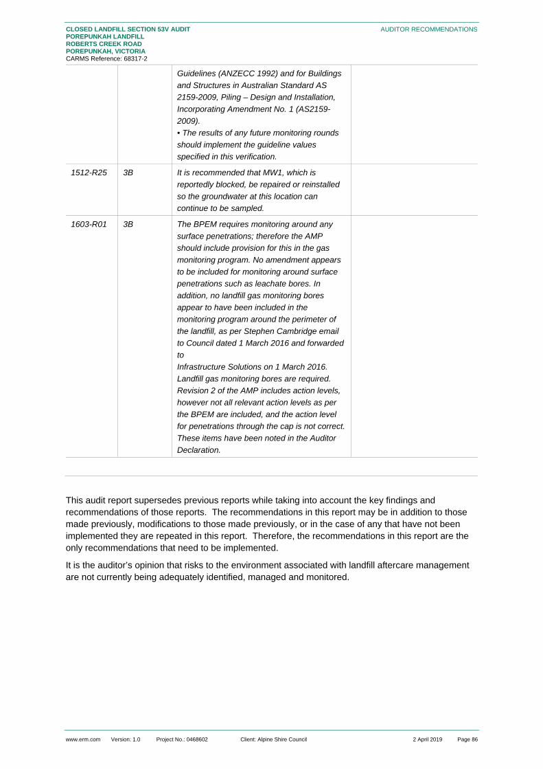
www.erm.com Version: 1.0 Project No.: 0468602 Client: Alpine Shire Council 2 April 2019 Page 86
CLOSED LANDFILL SECTION 53V AUDIT POREPUNKAH LANDFILL ROBERTS CREEK ROAD POREPUNKAH, VICTORIA CARMS Reference: 68317-2
AUDITOR RECOMMENDATIONS
Guidelines (ANZECC 1992) and for Buildings and Structures in Australian Standard AS 2159-2009, Piling – Design and Installation, Incorporating Amendment No. 1 (AS2159-2009). • The results of any future monitoring rounds should implement the guideline values specified in this verification.
1512-R25 3B It is recommended that MW1, which is reportedly blocked, be repaired or reinstalled so the groundwater at this location can continue to be sampled.
1603-R01 3B The BPEM requires monitoring around any surface penetrations; therefore the AMP should include provision for this in the gas monitoring program. No amendment appears to be included for monitoring around surface penetrations such as leachate bores. In addition, no landfill gas monitoring bores appear to have been included in the monitoring program around the perimeter of the landfill, as per Stephen Cambridge email to Council dated 1 March 2016 and forwarded to Infrastructure Solutions on 1 March 2016. Landfill gas monitoring bores are required. Revision 2 of the AMP includes action levels, however not all relevant action levels as per the BPEM are included, and the action level for penetrations through the cap is not correct. These items have been noted in the Auditor Declaration.
This audit report supersedes previous reports while taking into account the key findings and recommendations of those reports. The recommendations in this report may be in addition to those made previously, modifications to those made previously, or in the case of any that have not been implemented they are repeated in this report. Therefore, the recommendations in this report are the only recommendations that need to be implemented.
It is the auditor’s opinion that risks to the environment associated with landfill aftercare management are not currently being adequately identified, managed and monitored.

www.erm.com Version: 1.0 Project No.: 0468602 Client: Alpine Shire Council 2 April 2019 Page 87
CLOSED LANDFILL SECTION 53V AUDIT POREPUNKAH LANDFILL ROBERTS CREEK ROAD POREPUNKAH, VICTORIA CARMS Reference: 68317-2
STATEMENT OF LIMITATIONS
12. STATEMENT OF LIMITATIONS
This environmental audit report (“Report”) has been prepared in accordance with Part IXD of the Environmental Protection Act 1970. The Report presents the Auditor’s opinion on:
potential risks posed by the management of the Porepunkah Landfill (“the site”) to the relevant beneficial uses of the environment;
compliance with relevant EPA Licence requirements for the site; and
the adequacy of the risk based environmental monitoring program for the site.
The scope of this audit is limited to the specific scope as defined in this Report and the Auditor makes no other statement, warranty, comment in respect of the environmental conditions, risks or otherwise in relation to the site beyond this defined scope in this Report.
This Report:
has been prepared by Paul Fridell of Environmental Resources Management Australia Pty Ltd (“ERM”) and his team as indicated in the appropriate sections of this Report for Alpine Shire Council (client);
may be used and relied on by Alpine Shire Council (client);
may be used by and provided to EPA for the purpose of meeting statutory obligations in accordance with the relevant sections of the Environment Protection Act 1970;
may be provided to other third parties but such third parties’ use of or reliance on the Report is at their sole risk because of, and subject to, the uncertainties associated with this audit as noted in the following paragraphs and in this Report; and
may only be used for the purpose as stated in Section 1 of the Report (and must not be used for any other purpose).
To the maximum extent permitted by law, all implied warranties and conditions in relation to the services provided by ERM and the Report are excluded unless they are expressly stated to apply in this Report.
The services undertaken by the Auditor, his team and ERM in connection with preparing this Report were undertaken in accordance with current professional practice and by reference to relevant environmental regulatory authority and industry standards in accordance with section 53V of the Environment Protection Act 1970.
The opinions, conclusions and any recommendations in this Report are based on assumptions made by the Auditor, his team and ERM when undertaking services and preparing the Report (“Assumptions”), as specified throughout this Report.
In preparing the audit, the Auditor and his team have considered the available information in reaching a conclusion regarding the level of risk to beneficial uses; and this has required consideration of information that in some cases was not capable of being verified within the time scale of the audit, is of a nature that does not allow it to be quantified, or had a high degree of uncertainty with respect to magnitude of effect and likelihood of effect. In some cases information was not available and was not able to be obtained within the time scale of the audit. Where information was not available or was uncertain, the Auditor has made a judgment regarding the situation that, in his opinion, is likely to apply. The assessment of risk requires a consideration of the magnitude of effect and the likelihood that an effect of that magnitude will occur; this is inherently uncertain and depends on the significance that persons place on the effect, and other persons may reach an alternative conclusion as to the level of risk that applies.
Because of these factors, caution is required in the use of the information in this Report, and persons referring to, relying on or using in any way the conclusions of this Report should make their own

www.erm.com Version: 1.0 Project No.: 0468602 Client: Alpine Shire Council 2 April 2019 Page 88
CLOSED LANDFILL SECTION 53V AUDIT POREPUNKAH LANDFILL ROBERTS CREEK ROAD POREPUNKAH, VICTORIA CARMS Reference: 68317-2
STATEMENT OF LIMITATIONS
assessment and seek independent advice from persons with the relevant expertise in the field to satisfy themselves that they understand the underlying information and level of uncertainty, and the level of risk that they would assign, which may differ from the level of risk that the Auditor has assigned.
Subject to the paragraphs in this section of the Report, the opinions, conclusions and any recommendations in this Report are based on conditions encountered and information reviewed at the time of preparation of this Report and are relevant until such time as the site conditions or relevant legislations changes, at which time, ERM expressly disclaims responsibility for any error in, or omission from, this Report arising from or in connection with those opinions, conclusions and any recommendations.
The Auditor and ERM have prepared this Report on the basis of information provided by the client’s assessors the Auditor and his team have carried out checks of samples of this information in accordance with industry practice; this checking did not extend to all information; and the Auditor and ERM have not carried out field work to independently verify the information. Where the Auditor considered that the level of uncertainty or errors in the information could lead to a significantly different finding, the Auditor has made recommendations for further work to be carried out in the future to resolve the uncertainty. Because of this, there is uncertainty in the conclusions regarding the risk to beneficial uses and the Auditor and ERM expressly disclaim responsibility for errors that have arisen because of uncertainty in the information.
This Report should be read in full and no excerpts are taken to be representative of the findings of this Report.

www.erm.com Version: 1.0 Project No.: 0468602 Client: Alpine Shire Council 2 April 2019 Page 89
CLOSED LANDFILL SECTION 53V AUDIT POREPUNKAH LANDFILL ROBERTS CREEK ROAD POREPUNKAH, VICTORIA CARMS Reference: 68317-2
REFERENCES
13. REFERENCES
Alpine Shire Council, (undated), Safe Work Method Statement (SWMS01).
Bureau of Meteorology (2018) Online climate data. Assessed at: http://bom.gov.au/.
Department of Planning and Community Development (2018). Planning Scheme Information. Accessed at: http://planning-schemes.delwp.vic.gov.au/schemes/alpine.
EPA Victoria (1991) Publication 275, Construction Techniques for Sediment Pollution Control, May 1991.
EPA Victoria (2009) Publication, Industrial Waste Resource Guidelines IWRG 621, Soil Hazard Categorisation and Management, June 2009.
EPA Victoria (2009) Publication, Industrial Waste Resource Guidelines IWRG 631, Solid Industrial Waste Hazard Categorisation and Management, June 2009.
EPA Victoria (2009) Publication, Industrial Waste Resources Guidelines IWRG 701, Sampling and Analysis of Waters, Wastewaters, Soils and Wastes, June 2009.
EPA Victoria (2011) Publication 1321.2, Licence Assessment Guidelines – Guidelines for using a Risk Management Approach to Assess Compliance with Licence Conditions, June 2011.
EPA Victoria (2013), Pollution Abatement Notice No. 90003843, signed 6 June 2013 (revoked 24 August 2015 and replaced with Pollution Abatement Notice 90006296).
EPA Victoria (2013), Pollution Abatement Notice No. 90003842, signed 6 June 2013 (revoked 29 June 2015 and replaced with Pollution Abatement Notice 90006172).
EPA Victoria, 30 April 2015, Inspection Report No 80009538.
EPA Victoria (2015), Pollution Abatement Notice No. 90006172, signed 18 June 2015 (amended 25 September 2015) (revoked 8 February 2016).
EPA Victoria (2015) Publication 788.3, Siting, design, operation and rehabilitation of landfills, August 2015.
EPA Victoria (2015) Publication 788.3, Best Practice Environmental Management – Siting, design, operation and rehabilitation of landfills, August 2015.
EPA Victoria (2015) Publication 347.1, Bunding Guidelines, October 2015.
EPA Victoria (2015) Publication 1147.2, Environmental Auditor Guidelines – Provisions of Environmental Audit Reports, Certificates and Statements, December 2015.
EPA Victoria (2015) Publication 952.5, Environmental Auditor Guidelines for the Preparation of Environmental Audit Reports on Risk to the Environment, December 2015.
EPA Victoria (2016), Pollution Abatement Notice No. 90006757, signed 13 April 2016 (revoked 12 May 2016).
EPA Victoria (2016), Pollution Abatement Notice No. 90006296, signed 24 August 2015 (revoked 4 March 2016 and replaced with Pollution Abatement Notice 90006757).
EPA Victoria (2016) Publication 1323.3, Landfill Licensing Guidelines, September 2016.
EPA Victoria (2017), Post Closure Pollution Abatement Notice No. 90007375, signed 15 March 2017.
EPA Victoria (2017) Publication 1667.1, Management and Storage of Combustible Recyclable and Waste Materials - Guideline, November 2017.
EPA Victoria (2017) Publication 1322.9, Licence Management Guidelines, December 2017.
EPA Victoria (2018) Publication 1667.2, Management and storage of combustible recyclable and waste materials – guideline.

www.erm.com Version: 1.0 Project No.: 0468602 Client: Alpine Shire Council 2 April 2019 Page 90
CLOSED LANDFILL SECTION 53V AUDIT POREPUNKAH LANDFILL ROBERTS CREEK ROAD POREPUNKAH, VICTORIA CARMS Reference: 68317-2
REFERENCES
EPA Victoria (2018) Publication 1490.1, Closed Landfill Guidelines, January 2018.
EPA Victoria (2018) Publication 1684, Landfill gas fugitive emissions monitoring, February 2018.
EPA Victoria, 30 October 2018, Inspection Report No 80016991.
Environmental Earth Sciences, 26 October 2015, Alpine Shire Council – Hydrogeological Assessment at Porepunkah Landfill. Report reference: 215017.
Infrastructure Solutions Pty Ltd, 30 March 2016, Alpine Shire – Porepunkah Landfill Rehabilitation – Aftercare Management Plan. Revision 2.
Infrastructure Solutions (2016) Porepunkah Landfill Rehabilitation – Aftercare Management Plan.
Peter J Ramsay & Associates Pty Ltd, May 2011, Environmental Audit of the Risk of any Possible Harm or Detriment to Groundwater and Surface Water Pursuant to Part IXD (Section 53V) of the Environmental Protection Act 1970 – Porepunkah Landfill, Roberts Creek Road, Porepunkah, Victoria. CARMS 68317-1.
Peter J Ramsay & Associates Pty Ltd, 8 December 2015, Environmental Auditor Verification of a Hydrogeological Assessment Report prepared for the Porepunkah Landfill, Roberts Creek Road, Porepunkah, Victoria.
SGS, 11 December 2015, Analytical Report – Porepunkah Ground/Surface Water Analysis. Report TE105574.
SGS, 18 April 2016, Analytical Report – Porepunkah Ground/Surface Water Analysis. Report TE106185 R0.
SGS, 15 July 2016, Analytical Report – Porepunkah Ground/Surface Water Analysis. Report TE106550 R0.
SGS, 24 October 2016, Analytical Report – Porepunkah Ground/Surface Water Analysis. Report TE106940 R0.
SGS, 11 January 2017, Analytical Report – Porepunkah Ground/Surface Water Analysis. Report TE107275 R0.
SGS, 7 June 2017, Analytical Report – Porepunkah Ground/Surface Water Analysis. Report TE107834 R0.
SGS, 4 January 2018, Analytical Report – Porepunkah Groundwater Analysis. Report TE108720 R0.
SGS, 7 June 2017, Analytical Report – Porepunkah Ground/Surface Water Analysis. Report TE107834 R0.
SGS, 17 January 2018, Surface Monitoring, December 2017. Report M180036.
SGS, 9 April 2018, Analytical Report – Porepunkah Groundwater Analysis. Report TE109153 R0.
SGS, 18 April 2018, LFG Monitoring and Surface Monitoring – March 2018. Report M180257.
State Government of Victoria (1970) Environmental Protection Act 1970.
State Government of Victoria (1989) State Environment Protection Policy (Control of Noise from Commerce, Industry and Trade), Victorian Government Gazette No. S31, June 1989.
State Government of Victoria (2004) Waste Management Policy (Siting, Design and Management of Landfills), Victorian Government Gazette No. S264 December 2004.
State Government of Victoria (2001) State Environment Protection Policy (Air Quality Management), Victorian Government Gazette, No. S240, December 2001.
State Government of Victoria (2013) State Environment Protection Policy (Prevention and Management of Contaminated Land), Victorian Government Gazette, No. S95, June 2002, as varied

www.erm.com Version: 1.0 Project No.: 0468602 Client: Alpine Shire Council 2 April 2019 Page 91
CLOSED LANDFILL SECTION 53V AUDIT POREPUNKAH LANDFILL ROBERTS CREEK ROAD POREPUNKAH, VICTORIA CARMS Reference: 68317-2
REFERENCES
by Variation to the State environment protection policy (Prevention and Management of Contamination of Land) No. G39, Gazette 26 September 2013.
State Government of Victoria (2017) Waste Management Policy (Resource Recovery Facilities), Victorian Government Gazette No. S289 August 2017.
State Government of Victoria (2018) State Environment Protection Policy (Waters), Victorian Government Gazette, No. S499, October 2018.
State Government of Victoria (2018), Map Centre sourced on line at http://www.land.vic.gov.au.
Visualising Victorian Groundwater database sourced online http://maps.ubspatial.com.au.

CLOSED LANDFILL SECTION 53V AUDIT POREPUNKAH LANDFILL ROBERTS CREEK ROAD POREPUNKAH, VICTORIA
www.erm.com Version: 1.0 Project No.: 0468602 Client: Alpine Shire Council 2 April 2019
APPENDIX A FIGURES

Robert Creek Road
22/01/20190468602m_PLF_G001_R00.mxd
A4
This figure may be based on third party data or data which has notbeen verified by ERM and it may not be to scale. Unless expresslyagreed otherwise, this figure is intended as a guide only and ERM doesnot warrant its accuracy.
Client:Drawn By:
Drawing No:Date: Drawing Size:
Reviewed By:
Porepunkah LandfillRobert Creek Road, Porepunkah
Alpine ShireGR KPCoordinate System: GDA 1994 MGA Zone 55
Site Location F1
0 100 200 300m [N0 5 10 15km
NSW
SA
VIC
Source: ESRI World Imagery and Bing Maps
"
Site Location
Site
Site

x
x
x
MW2MW2
MW1
MW3
This figure may be based on third party data or data which has not been verified by ERM and it may not be to scale. Unless expressly agreed otherwise, this figure is intended as a guide only and ERM does not warrant its accuracy.
F - 2
Alpine ShireClient:
Drawing No:
Date: 22/01/2019
GR KPReviewed by:Drawn by:
Drawing size: A4
Site Layout0468602m_PLF_C001_R00.cdr Porepunkah Land Fill
Roberts Creek Road, Porepunkah
Notes: Text here 10 20m0
Drawing Not to Scale
Type text here
Type text here
Type text heresecond line example
Type text here
Legend
NSource: Appendix F : Porepunkah LF Rehab_Waste Cell Locations & Bores_16-06-15

The business of sustainability
ERM has over 160 offices across the following countries and territories worldwide
Argentina Australia Belgium Brazil Canada Chile China Colombia France Germany Hong Kong India Indonesia Ireland Italy Japan Kazakhstan Kenya Malaysia Mexico Mozambique Myanmar
The Netherlands New Zealand Norway Panama Peru Poland Portugal Puerto Rico Romania Russia Singapore South Africa South Korea Spain Sweden Switzerland Taiwan Thailand UAE UK US Vietnam
ERM’s Melbourne Office Citic House Level 6, 99 King Street Melbourne VIC 3000 PO BOX 266 South Melbourne VIC 3205 T: +61 3 9696 8011 F: +61 3 9696 8022 www.erm.com