Influence of Topography and GPS Fix Interval on GPS … · Influence of Topography and GPS Fix...
10
Influence of Topography and GPS Fix Interval on GPS Collar Performance Author(s): James W. Cain, III, Paul R. Krausman, Brian D. Jansen, John R. Morgart Source: Wildlife Society Bulletin, Vol. 33, No. 3 (Autumn, 2005), pp. 926-934 Published by: Allen Press Stable URL: http://www.jstor.org/stable/3785029 Accessed: 02/06/2010 19:13 Your use of the JSTOR archive indicates your acceptance of JSTOR's Terms and Conditions of Use, available at http://www.jstor.org/page/info/about/policies/terms.jsp. JSTOR's Terms and Conditions of Use provides, in part, that unless you have obtained prior permission, you may not download an entire issue of a journal or multiple copies of articles, and you may use content in the JSTOR archive only for your personal, non-commercial use. Please contact the publisher regarding any further use of this work. Publisher contact information may be obtained at http://www.jstor.org/action/showPublisher?publisherCode=acg. Each copy of any part of a JSTOR transmission must contain the same copyright notice that appears on the screen or printed page of such transmission. JSTOR is a not-for-profit service that helps scholars, researchers, and students discover, use, and build upon a wide range of content in a trusted digital archive. We use information technology and tools to increase productivity and facilitate new forms of scholarship. For more information about JSTOR, please contact [email protected]. Allen Press is collaborating with JSTOR to digitize, preserve and extend access to Wildlife Society Bulletin. http://www.jstor.org
Transcript of Influence of Topography and GPS Fix Interval on GPS … · Influence of Topography and GPS Fix...
Influence of Topography and GPS Fix Interval on GPS Collar PerformanceAuthor(s): James W. Cain, III, Paul R. Krausman, Brian D. Jansen, John R. MorgartSource: Wildlife Society Bulletin, Vol. 33, No. 3 (Autumn, 2005), pp. 926-934Published by: Allen PressStable URL: http://www.jstor.org/stable/3785029Accessed: 02/06/2010 19:13
Your use of the JSTOR archive indicates your acceptance of JSTOR's Terms and Conditions of Use, available athttp://www.jstor.org/page/info/about/policies/terms.jsp. JSTOR's Terms and Conditions of Use provides, in part, that unlessyou have obtained prior permission, you may not download an entire issue of a journal or multiple copies of articles, and youmay use content in the JSTOR archive only for your personal, non-commercial use.
Please contact the publisher regarding any further use of this work. Publisher contact information may be obtained athttp://www.jstor.org/action/showPublisher?publisherCode=acg.
Each copy of any part of a JSTOR transmission must contain the same copyright notice that appears on the screen or printedpage of such transmission.
JSTOR is a not-for-profit service that helps scholars, researchers, and students discover, use, and build upon a wide range ofcontent in a trusted digital archive. We use information technology and tools to increase productivity and facilitate new formsof scholarship. For more information about JSTOR, please contact [email protected].
Allen Press is collaborating with JSTOR to digitize, preserve and extend access to Wildlife Society Bulletin.
http://www.jstor.org
926 TOPOGRAPHY AND GPS COLLAR PERFORMANCE
Influence of topography and GPS fix
interval on GPS collar performance
James W. Cain III, Paul R. Krausman, Brian D. Jansen, and John R. Morgart
Abstract Topography, vegetation, and animal belhavior may influence the performance of Global
Positioning System (GPS) telemetry collars, affecting fix success rates and location error. We reviewed the scientific literature published from 1995 to June 2004 to determine the fix intervals used and fix success rates obtained in studies using GPS telemetry. We also
programmed GPS telemetry collars with 6 different fix intervals and placed them at fixed locations of varying topography in the Cabeza Prieta National Wildlife Refuge, Arizona from August 2003-May 2004. Fix interval affected fix success rates both in our field study (99, 98, 96, 94, 93, 92% fix success rate for 0.25, 0.5, 1, 4, 6, and 13-hour fix intervals, respectively) and in our analysis of data obtained from scientific literature (r2=0.531, P< 0.001), with shorter fix intervals being associated with higher fix success rates.
Topography affected the fix success rate (F2, 77=12.017, P<<0.001), location error (F2, 77 -6.76, P=0.002), and proportion of 3-dimensional (3-D) fixes (F2, 77=10.184, P<0.001), resulting in lower fix success rates and larger location errors in areas with more rugged topography. The influence of topography and fix interval on location error and fix suc- cess rates may bias GPS location data, resulting in misclassification of habitat use and
under-sampling certain areas used by animals. Location error and missing data can increase type II error and may result in incorrect inferences in some studies. These bias- es need to be assessed and steps should be taken to minimize their influence on results of studies of habitat selection and other aspects of animal ecology.
Key words Arizona, fix rate, Global Positioning System, GPS telemetry, location error, success
The ability to collect high quantities of more accurate location data, 24 hours/day, over large geo- graphic areas and under all weather conditions makes the use of Global Positioning System (GPS) telemetry collars more advantageous than very- high-frequency (VHF) radiotelemetry in some situa- tions. As a result, use of GPS telemetry collars in wildlife research has increased (Rempel et al. 1995, Rodgers et al. 1996). Despite these advantages, topography, vegetation, and animal behavior may influence signal transmission between GPS satel- lites and receivers, affecting fix acquisition and location error. Location error and missing data due
to habitat conditions or animal behavior can result in systematic biases in location data obtained from GPS collars, which may influence the results of some studies (Rempel et al. 1995, Obbard et al. 1998, Schwartz and Arthur 1999, Moen et al. 2001, D'Eon et al. 2002). As a result of these potential biases, many studies of the influence of vegetation, topography, and animal behavior on GPS telemetry collar performance have been conducted (Rempel et al. 1995, Edenius 1997, Dussault et al. 1999, Schwartz and Arthur 1999, Di Orio et al. 2003). The majority of these studies were in forested areas with relatively little topography (but see D'Eon et
Address for James W. Cain III, Paul R. Krausman, and Brian D. Jansen: School of Natural Resources, 325 Biological Sciences East, University of Arizona, Tucson, AZ 85721, USA; e-mail for Cain: [email protected]. Address for John R. Morgart: United States Fish and Wildlife Service, Cabeza Prieta National Wildlife Refuge 1611 North Second Avenue, Ajo, AZ 85321, USA; present address: United States Fish and Wildlife Service, New Mexico Ecological Services Field Office, 2105 Osuna Road NE, Albu- querque, NM 87113.
Wildlife Society Bulletin 2005, 33(3):926-934 Peer refereed

Topography and GPS collar performance * Cain et al. 927
al. 2002, Girard et al. 2002a). Researchers studying GPS collar performance routinely program GPS receivers to collect locations with a short interval between fix attempts (i.e., 5-60 min) in order to
expedite data collection. However, many wildlife studies using GPS collars program GPS receivers to collect locations with a longer interval (i.e., 3-13
hours) between fix attempts (Johnson et al. 2002a, Anderson and Lindzey 2003,Joly et al. 2003, Merrill and Erickson 2003). The effect of fix-interval length on GPS collar performance has not been incorpo- rated into most of these studies; however, there are indications that it may influence fix success rates
(Moen et al. 2001). Our objectives were to review the available sci-
entific literature to determine fix intervals used and fix success rate obtained by other researchers using GPS telemetry collars in their studies and deter- mine the influence of topography and fix interval on GPS telemetry collar performance. Specifically, we wanted to determine the influence of topogra- phy and fix interval on the success rate of GPS
fixes, proportion of 3-dimensional (3-D) fixes, and location error.
Study area The study area was in the Sierra Pinta and Cabeza
Prieta mountains, Cabeza Prieta National Wildlife
Refuge (CPNWR), southwestern Arizona.
Topography of CPNWR was a series of rugged northwest-southeast-trending mountain ranges sur- rounded by large bajadas and separated by wide alluvial valleys; elevations ranged from approxi- mately 200-900 m. These mountain ranges were
jagged, sharply crested, and dissected by steep, rugged canyons; slopes >56? were common.
Vegetation in the mountains was the Lower Colorado River Valley subdivision of Sonoran Desertscrub and was characterized by ironwood
(Olneya tesota), catclaw acacia (Acacia greggil), foothill palo verde (Parkinsonia microphylla), cre- osote bush (Larrea tridentata), white bursage (Ambrosia dumosa), ratany (Krameria spp.), brit- tlebush (Encelia farinosa), giant saguaro (Carnegia gigantea), barrel cactus (Ferocactus spp.), and cholla (Opuntia spp.-Turner and Brown
1982). Vegetation was sparse on the study area; canopy cover of plant species >3 m in height (e.g., ironwood, catclaw acacia, foothill palo verde) was <5% (Cain and Krausman, unpublished data). Therefore, we assumed that vegetation would not
affect GPS collar performance.
Methods Literature review
To determine the fix interval used and fix suc- cess rates obtained when employing GPS telemetry collars in wildlife studies and in studies of GPS col- lar performance, we reviewed 15 peer-reviewed journals from 1995 to June 2004 (Table 1). We determined the fix interval and fix success rate for all studies that provided this information.
We recognize that GPS collar manufacturers use different GPS antenna and receiver technology and
configurations in their telemetry collars, which may affect performance. This paper assumes an equiva- lent level of antenna and receiver functioning when
making comparisons between GPS collar perform- ance from studies using GPS collars from different manufacturers.
Collar test To determine the influence of topography and
fix interval on GPS telemetry collar performance, we created a measure of "available sky" (AS), defined as the amount of sky visible from a location in all directions and at all angles (Rodgers et al.
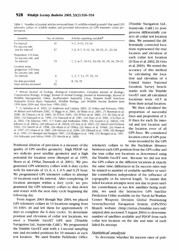
1997, D'Eon et al. 2002). This was considered a measure of the potential unobstructed view of GPS satellites. We used ARCINFO Grid Module
(Environmental System Research Institute, Redlands, Calif.) to calculate AS for all locations in the study area. We used a digital elevation model
(DEM) with a 10 x 10-m pixel size to represent the
topography of the study area. We then created a 10 x 10 grid of points with a 1 x 1-km spacing to rep- resent the sky. We centered the sky grid over each collar test location and set the altitude at 1,000 m; 100 m above the highest location of the study area
(D'Eon et al. 2002). We then conducted a visibility analysis and calculated the proportion of points vis- ible from the center of each 10 x 10-m pixel of the DEM and each collar test location (Figure 1).
All GPS telemetry collars used (Model 3580, Telo:nics, Inc., Mesa, Ariz.) were programmed to
attempt to obtain a location for a maximum of 3 minutes, after which the location attempt was clas- sified as a failed fix attempt. All collars were also
programmed with an elevation angle mask of 10?
(GPS satellites located <10? above the horizon were not used to calculate locations) and a posi- tional dilution of precision (PDOP) mask of 12.0.
928 Widlife Society Bulletin 2005, 33(3):926-934
Table 1. Number of journal articles reviewed from 15 wildlife-related journalsa that used GPS telemetry collars in wildlife studies and provided information on GPS telemetry collar per- formance.
Variable No. of articles Articles reporting variableb
Fix interval 31 1-7, 9-13, 15-34 Fix success rate and fix interval 27 1-2, 4-7, 9-13, 16, 18-19, 21, 23-34
Proportion 3-D fixes, fix success rate, and fix interval 19 1, 3, 6-7, 10-13, 16-18, 20, 24, 26, 29-33
Location error, proportion 3-D fixes, fix success rate, and fix interval 6 1,2, 7, 13, 17,29,34
No data provided 3 8, 14, 35 Total articles reviewed 35
a African Journal of Ecology, Biological Conservation, Canadian Journal of Zoology, Conservation Biology, Ecology, Journal of Animal Ecology, Journal of Mammalogy, Journal of Wildlife Management, Oikos, Southwestern Naturalist, Ursus, Western North American Naturalist (Great Basin Naturalist), Wildlife Biology, and Wildlife Society Bulletin from 1995-june 2004 and Alces from 1995-2002.
b (1) Adrados et al. 2003, (2) Anderson and Lindzey 2003, (3) Arthur and Schwartz 1999, (4) Belant and Follmann 2002, (5) Biggs et al. 2001, (6) Blake et al. 2001, (7) Bowman et al. 2000, (8) Chruszcz et al. 2003, (9) D'Eon 2003, (10) D'Eon et al. 2002, (11) Di Orio et al. 2003, (12) Dussault et al. 1999, (13) Dussault et al. 2001, (14) Dyer et al. 2001, (15) Dyer et al. 2002, (16) Edenius 1997, (17) Fortin and Andruskiw 2003, (18) Girard et al. 2002b, (19) Johnson et al. 2002a, (20) Johnson et al. 2002b, (21) Joly et al. 2003, (22) Merrill and Erickson 2003, (23) Merrill et al. 1998, (24) Moen et al 1996a, (25) Moen et al. 1996b, (26) Moen et al. 1997, (27) Moen et al. 2001, (28) Nelson et al. 2004, (29) Obbard et al. 1998, (30) Rempel et al. 1995, (31) Rempel and Rodgers 1997, (32) Rodgers et al. 1996, (33) Rodgers et al. 1997, (34) Schwartz and Arthur 1999, (35) Welch et al. 2000.
Positional dilution of precision is a measure of the
quality of GPS satellite geometry. High PDOP val- ues indicate poor satellite geometry and a high potential for location error (Rempel et al. 1995, Moen et al. 1996a, Dussault et al. 2001). We pro- grammed GPS telemetry collars with 6 duty cycles with fix intervals of 13, 6, 4, 1, 0.5, and 0.25 hour. We programmed GPS telemetry collars to attempt 10 locations each fix interval. After completing 10 location attempts within a duty cycle, we pro- grammed the GPS telemetry collars to shut down and restart with the next duty cycle beginning the
following day. From August 2003 though May 2004, we placed
GPS telemetry collars in 13 locations ranging from 10-100% AS and left them for approximately 15 days to complete the 6 duty cycles. To determine
position and elevation of collar test locations, we used a Trimble GeoXT GPS unit (Trimble Navigation Ltd., Sunnyvale, Calif.). We programmed the Trimble GeoXT unit with a 1-second sampling rate and recorded positions for 10 minutes at each test location. We used Trimble Pathfinder Office
(Trimble Navigation Ltd., Sunnyvale, Calif.) to post- process differentially cor- rect all collar test location data. We assumed the dif-
ferentially corrected loca- tions represented the true location and elevation of each collar test location
(D'Eon et al. 2002, Di Orio et al. 2003). We tested the
accuracy of this method
by calculating the loca- tion and elevation of 4 United States National Geodetic Survey bench- marks with the Trimble GeoXT unit; all calculated locations were <0.5 m from their actual location.
We then calculated the
proportion of successful fixes and proportion of 3- D fixes for each fix inter- val and test location and the location error of all GPS fixes. We considered location error of GPS posi- tions recorded by the GPS
telemetry collars to be the Euclidean distance between each GPS position from the GPS collar and the true collar test locations as determined using the Trimble GeoXT unit. Because we did not test the GPS collars at the different locations at exactly the same time, differences in fix success rates may be related to number of available satellites or satel- lite constellation independent of the influence of
topography or fix interval length. To ensure that failed location attempts were not due to poor satel- lite constellation or too few satellites being avail- able, we used the Interactive GPS Satellite Prediction Utility available on the Naval Air Warfare Center Weapons Division Global Positioning System/Inertial Navigation System (GPS/INS) Branch website (http://sirius.chinalake.navy.mil/ satpred; date accessed: 5 August 2004) to determine number of satellites available and PDOP from each collar test location on the day and time of each failed fix attempt.
Statistical analysis To determine whether fix success rates of pub-
Topography and GPS collar performance * Cain et al. 929
Available sky (%)
g;"__I 1I 63-875
I I 88 -100
+ Collar test locatic + Collar test 1ocatia
Sky grid Figure 1. Available sky model for section of the Cabeza Prieta Mountains, Cabeza Prieta National Wildlife Refuge, Arizona. Available sky model calculated using 10 x10-m digital elevation model (DEM) with 10 x10 sky grid (a), representative collar test location (+), and visibility grid (b) representing percent of sky grid visible from each 10-m DEM cell.
lished studies were associated with fix interval (minutes log-transformed), we used linear regres- sion. Because animal behavior and habitat use can influence GPS receiver performance we included collar placement (stationary or animal) as a covari- ate. We used t-tests to compare average fix success rates between stationary collars and collars deployed on free-ranging animals.
We used General Linear Model (GLM) proce- dures to examine the influence of fix interval and AS on fix success rates, proportion of 3-D fixes, and location error and elevation error (SPSS 9.0, 1998). We classified test locations according to the AS (class I <33%, class II 33-66%, and class III >66%). We entered fix interval (minutes) and AS class as fixed factors in all GLM procedures. We used mul- tiple comparison tests with Bonferroni confidence
intervals to compare between AS classes and fix rates. Collar test location served as the experimen- tal unit in all GLM procedures. We used t-tests to compare the average location error between 2-D and 3-D fixes, while recognizing that locations col- lected at the same test location are not truly inde- pendent (i.e., pseudoreplicated) we used each suc- cessful GPS location attempt as samples (Hurlbert 1984).
Results Literature review
We found 35 journal articles published between
1995-June 2004 using GPS telemetry collars (Table 1). Nineteen articles described GPS collar perform- ance studies under various conditions; 3 deployed
930 Wildlife Society Bulletin 2005, 33(3):926-934
only stationary collars, 6 deployed stationary and animal-borne collars, and 10 deployed animal-borne collars. Twelve journal articles we reviewed used GPS collars to study some aspect of animal ecology. Eighty-nine percent of the articles provided the fix interval used, 77% provided both fix interval and fix success rate, 54% provided fix interval, fix success
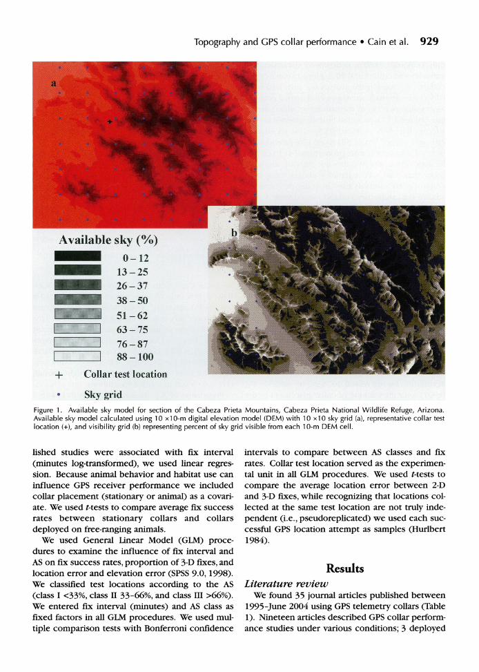
rate, and proportion of 3-D fixes, 17% provided fix interval, fix success rate, proportion 3-D fixes, and location error, and 9% did not provide any data other than that GPS telemetry collars were used (Table 1). Fix intervals used in collar performance studies (i.e., stationary collars) ranged from 5 min- utes to 3 hours, with a median fix interval of 12.5 minutes, whereas fix interval used with collars placed on free-ranging animals ranged from 10 min to 23 hours, with a median fix interval of 4 hours. Fix success rates from studies of collar perform- ance (i.e., stationary collars) ranged from 0.88-1.0 with a mean of 0.948 (95% CI 0.92-0.98) whereas fix success rates from studies using collars on free- ranging animals were 25% lower on average (t48= 6.73, P<0.001), ranging from 0.29-1.0 with a mean of 0.693 (95% CI 0.64-0.75). Overall fix success rate was 0.763 (SE=0.027). The fix interval used in the articles reviewed was inversely related to fix success rates. Fix interval alone accounted for 45% of the variation in fix success rates (r2 =0.452, P< 0.001). The amount of variation in fix success rate accounted for increased to 53% (r2=0.531, P<
0.001) with the addition of collar placement to the regression model. After controlling for collar place- ment, fix success rates declined by 3.3% (95% CI
1.2-5.4%) with each doubling in fix interval (P= -0.110+0.034, t2 44=-3.204, P=0.003; Figure 2).
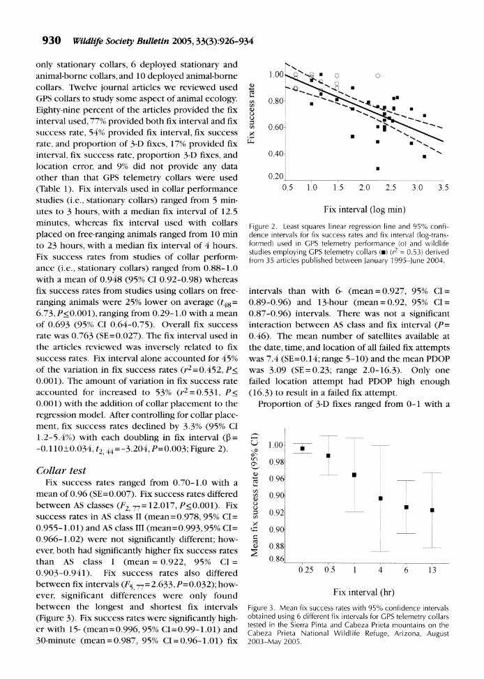
Collar test Fix success rates ranged from 0.70-1.0 with a
mean of 0.96 (SE=0.007). Fix success rates differed between AS classes (F2, 77= 12.017, P<0.001). Fix success rates in AS class II (mean=0.978, 95% CI=
0.955-1.01) and AS class III (mean=0.993,95% CI= 0.966-1.02) were not significantly different; how- ever, both had significantly higher fix success rates than AS class I (mean = 0.922, 95% CI =
0.903-0.941). Fix success rates also differed between fix intervals (F5 77= 2.633,P=0.032); how- ever, significant differences were only found between the longest and shortest fix intervals (Figure 3). Fix success rates were significantly high- er with 15- (mean=0.996, 95% CI=0.99-1.01) and 30-minute (mean=0.987, 95% CI=0.96-1.01) fix
1.
a)
co 0 0 0
0.80-
0.60-
.
.
0.40- .
0.20
0.5 1.0 1.5 2.0 2.5 3.0 3.5
Fix interval (log min)
Figure 2. Least squares linear regression line and 95% confi- dence intervals for fix success rates and fix interval (log-trans- formed) used in GPS telemetry performance (o) and wildlife studies employing GPS telemetry collars (m) (r2 = 0.53) derived from 35 articles published between January 1995-June 2004.
intervals than with 6- (mean = 0.927, 95% CI=
0.89-0.96) and 13-hour (mean = 0.92, 95% CI=
0.87-0.96) intervals. There was not a significant interaction between AS class and fix interval (P= 0.46). The mean number of satellites available at the date, time, and location of all failed fix attempts was 7.4 (SE=0.14; range 5-10) and the mean PDOP was 3.09 (SE=0.23; range 2.0-16.3). Only one failed location attempt had PDOP high enough (16.3) to result in a failed fix attempt.
Proportion of 3-D fixes ranged from 0-1 with a
at
O 0
o\
a)
CO
cn
1.00-
0.98
0.96
0.90
0.92
0.90
0.88
0.86
_ T
0.25 0.5 1 4 6 13
Fix interval (hr)
Figure 3. Mean fix success rates with 95% confidence intervals obtained using 6 different fix intervals for GPS telemetry collars tested in the Sierra Pinta and Cabeza Prieta mountains on the Cabeza Prieta National Wildlife Refuge, Arizona, August 2003-May 2005.
Topography and GPS collar performance * Cain et al. 931
mean of 0.74 (SE=0.02). The proportion of 3-D fixes was significantly different between AS classes
(F2 77=10.184, P<0.001) but did not differ between fix intervals (P=0.358). Available sky class III (mean=0.922, 95% CI=0.816-1.03) had a signif- icantly higher proportion of 3-D fixes than either AS class II (mean=0.769, 95% CI=0.676-0.861) or AS class I (mean=0.632, 95% CI=0.557-0.707). There was not an interaction between fix interval and AS class (P=0.855).
Location errors ranged from 2.5-75 m with an overall mean location error of 9.7 m (SE=0.86). Fifty percent of all location errors were <5.7 m and 95% were <28.9 m. Mean location errors of 2-D locations (mean= 14.6,95% CI= 11.9-17.5 m) were
significantly larger (t280= 4.8, P< 0.001) than 3-D locations (mean= 7.5 m, 95% CI=6.9-8.2). Fifty per- cent of the location errors for 2-D locations were <6.3 m and <5.5 m for 3-D locations and 95% of the location errors were <70.5 m and <19.6 m for 2-D and 3-D locations, respectively. Location errors dif- fered between AS classes (F2 77 = 6.76, P=0.002) but did not differ between fix intervals (P=0.989); the interaction term was not significant (P=0.982). Test locations in AS class I had significantly larger location errors (mean= 13.46 m, 95% CI= 10.8-16.1
m) than test locations in AS class II (mean=7.4 m, 95% CI=4.1-10.6 m) and AS class III (mean=5.0 m, 95% CI=1.2-8.8 m). Elevation errors ranged from 0.04-160 m with an overall mean elevation error of 35.7 m (SE=0.62). Mean elevation errors were not significantly different between AS classes (AS I mean=38.4 m, AS II mean=35.1 m, AS III mean= 34.8 m; P=0.475) or fix intervals (13-hour mean= 35.9 m, 6-hour mean= 33.3,4-hour mean= 37.9 m, 1- hour mean= 36.4 m, 0.5-hour mean= 36.8 m, 0.25- hour mean= 36.2 m; P=0.968).
Discussion Topography, vegetation, and animal behavior may
influence signal transmission between GPS satel- lites and receivers, influencing fix acquisition and location error and may result in a systematic bias in location data (Edenius 1997, Schwartz and Arthur 1999, Bowman et al. 2000, Moen et al. 2001, D'Eon et al. 2002). We found that topography and fix inter- val influenced GPS fix rates and that topography influenced the proportion of 3-D fixes and location error. The influence of habitat characteristics (e.g., vegetation and topography) and animal behavior on GPS telemetry performance have been previously
studied, primarily in forested areas, with most stud- ies finding that characteristics of vegetation (e.g., canopy cover, tree height, tree density, canopy type) and animal behavior influenced GPS telemetry fix rates and location error (Rempel et al. 1995, Edenius 1997, Dussault et al. 1999, Moen et al. 2001, D'Eon et al. 2002, Di Orio et al. 2003). A few stud- ies also have considered the effect of topography on GPS telemetry performance. One study found that topography influenced GPS fix rates (Girard et al. 2002a), and 2 studies found that topography by itself did not influence GPS performance but inter- acted with vegetation to influence fix rates (D'Eon et al. 2002, Frair et al. 2004). Most studies found no effect of topography or were conducted in areas with little variation in topography (Rempel et al. 1995, Edenius 1997, Moen et al. 1996a, Rumble and Lindzey 1997, Dussault et al. 1999).
Topography may interfere with GPS signal trans- mission resulting in a less accurate 2-D location if signals from only 3 satellites are received or a failed fix attempt, if signals from <3 satellites are received by the GPS receiver. Fix interval also has an effect on fix success rates with shorter fix intervals being associated with higher fix success rates (Moen et al. 2001). To calculate a position, ephemeris data needs to be acquired from each GPS satellite being tracked >1 time each hour. Depending on the receiver type, collection of ephemeris data, can take 30 seconds to 3 minutes (United States Coast Guard Navigation Center 1996). Because GPS receivers programmed with short fix intervals (<1 hour) can use previous- ly transmitted ephemeris data, they are able to cal- culate a location in a shorter time period than GPS receivers programmed with longer fix interval, which have to acquire new ephemeris data from satellites prior to calculating a location. To conserve battery power, GPS receivers integrated into wildlife telemetry collars typically are programmed to attempt to obtain a location for 90-180 seconds. If the receiver is unable to obtain a location in this time period, the fix attempt is classified as unsuc- cessful and the receiver is shut down until the next scheduled fix attempt. It may be more common for GPS receivers programmed with longer fix intervals to take >180 seconds to acquire new ephemeris data., resulting in more failed fix attempts than receivers programmed with short fix intervals.
Management implications The influence of topography on GPS location

932 Wildlife Society Bulletin 2005, 33(3):926-934
errors has the potential to bias study results for species (e.g., desert bighorn sheep [Ovis canaden- sis mexicana]) inhabiting areas with a high degree of topographic complexity. The increase in location error due to rugged terrain may represent a sys- tematic bias in location data. Depending on the species and the research objectives this error may influence results. For example, when studying ani- mals occupying areas with heterogeneous habitat conditions, location error can result in misclassifi- cation of habitat use, which decreases the power of statistical tests and has the potential to bias research results leading to erroneous conclusions (White and Garrott 1986, Nams 1989, Samuel and Kenow 1992, Rettie and McLoughlin 1999).
Our results suggested that the influence of topog- raphy and fix interval on GPS fix rates may result in the underrepresentation in the use of certain areas (e.g., the bottom of steep, rugged canyons). Missing data due to failed GPS location attempts represent an even larger problem when drawing inferences from habitat use studies than does location error (ohnson et al. 1998, Frair et al. 2004). Missing loca- tion data can result in under sampling certain areas relative to others (particularly, less-common habi- tats), resulting in incorrect inferences regarding habitat selection (ohnson et al. 1998). For example, Frair et al. (2004) studied the effects of data loss on resource-selection function bias; this was done with 2 sampling intervals (1-hour and 6-hour). They found that a 10% data loss can result in an increase in type II error rate of 30-40%, and a 30% data loss resulted in a 50-70% increase in type II error rates when sampling animal locations at 6-hour intervals; whereas, increasing the sampling rate to 1-hour intervals eliminated type II error rates associated with data loss but produced biased resource-selec- tion function coefficients (Frair et al. 2004). Based on our literature review, we found that missing data from GPS telemetry collars deployed on animals was commonly around 30%, the level at which 50-70% increases in type II error rates were found when sampling at 6-hour intervals. Furthermore, we also found a decrease in fix success rates as fix inter- val increased; therefore, studies that sample animal locations using longer fix intervals are more likely to commit a type II error when location data are miss- ing, but due to the decrease in fix success rate, they also may be more likely to experience higher levels of data loss.
There are methods available that may correct for the effect of location error and missing location
data on habitat studies. The use of error polygons or buffers around point locations may eliminate some of the bias associated with misclassification due to location error (Nams 1989, Samuel and Kenow 1992, Rettie and McLoughlin 1999, Frair et al. 2004). Use of buffers instead of points can reduce erroneous conclusions regarding habitat selection; however, their use can introduce noise into the data set, depending on the heterogeneity of the habitat and the size of the buffer selected, mak- ing detection of habitat selection more conserva- tive (Rettie and McLoughlin 1999). To reduce bias due to missing location data, sample weighting or iterative simulation may prove useful in reducing erroneous conclusions in habitat selection studies (Frair et al. 2004). Use of either of these methods requires development of models that describe the bias associated with obtaining GPS locations in dif- ferent areas. These bias models should not be extrapolated from other study areas but should be developed using the same collars, environmental conditions, and sampling intervals that are going to be used for the location data to be corrected (Frair et al. 2004). Fix intervals used in the development of GPS bias models should not be selected for expe- dient data collection, but should be consistent with fix intervals to be used in collars deployed on free- ranging animals.
The incorporation of GPS technology in wildlife telemetry has provided a tremendous advantage in the tracking of animal movements. Telemetry sys- tems incorporating GPS technology result in larger amounts of more accurate location data. In addi- tion, data can be collected 24 hours/day, over large geographic areas and under all weather conditions (Rempel et al. 1995, Rodgers et al. 1996). Despite these advantages, the potential for systematic bias in GPS location data due to characteristics of topog- raphy, vegetation, animal behavior, and fix interval exists. This bias needs to be assessed and steps need to be taken to minimize its influence on the conclusions of studies of habitat selection and other aspects of animal ecology. We also would sug- gest that, in addition to the fix interval used, authors include measures of GPS collar performance (e.g., fix success rate, proportion of 3-D fixes) in journal articles on studies using GPS telemetry.
Acknowledgments. We thank M. B. Pepper and J. U. Hays, Jr. for assistance in the field. We also thank M. L. Reed, A. M. Honaman, and the Advanced Resource Technology Group at the School of
Topography and GPS collar performance * Cain et al. 933
Natural Resources, University of Arizona for assis- tance with GIS. We thank the United States Fish and Wildlife Service and the Arizona Game and Fish
Department for funding and logistical support. Comments by S. S. Rosenstock, S. M. Tomkiewicz, and 2 anonymous reviewers improved earlier drafts of this manuscript.
Literature cited ADRADOS, C., H. VERHEYDEN-TIXIER, B. CARGNELUTTI, D. PEPIN, AND G.
JANEAU. 2003. GPS approach to study fine-scale site use by wild red deer during active and inactive behaviors. Wildlife Society Bulletin 31:544-552.
ANDERSON, C. R.,AND F G. LINDZEY. 2003. Estimating cougar pre- dation rates from GPS location clusters. Journal of Wildlife Management 67:307-316.
ARTHUR, S. M.,AND C. C. SCHWARTZ. 1999. Effects of sample size on
accuracy and precision of brown bear home range models. Ursus 11:139-148.
BELANT,J. L.,AND E. H. FOLLMANN. 2002. Sampling considerations for American black and brown bear home range and habitat use. Ursus 13:299-315.
BIGGs, J. R., K. D. BENNETT,AND P. R. FRESQUEZ. 2001. Relationship between home range characteristics and the probability of obtaining successful global positioning system (GPS) collar positions for elk in New Mexico. Western North American Naturalist 61:213-222.
BLAKE, S., I. DOUGLAS-HAMILTON, AND W B. KARESH. 2001. GPS telemetry of forest elephants in central Africa: results of a preliminary study. African Journal of Ecology 39:178-186.
BOWMAN,J. L., C. O. KOCHANNY, S. DEMARAIS,AND B. D. LEOPOLD. 2000. Evaluation of a GPS collar for white-tailed deer. Wildlife Society Bulletin 28:141-145.
CHRUSZCZ, B.,A. P CLEVENGER, K. E. GUNSON,AND M. L. GIBEAU. 2003. Relationships among grizzly bears, highways, and habitat in the Banff-Bow Valley, Alberta, Canada. Canadian Journal of Zoology 81:1378-1391.
D'EoN, R. G. 2003. Effects of a stationary GPS fix-rate bias on habitat-selection analysis. Journal of Wildlife Management 67:858-863.
D'EON, R. G., R. SERROUYA, G. SMITH,AND C. O. KOCHANNY. 2002. GPS radiotelemetry and bias in mountainous terrain. Wildlife Society Bulletin 30:430-439.
DI ORIO,A. P., R. CALLAS,AND R.J. SCHAEFER. 2003. Performance of two GPS telemetry collars under different habitat conditions. Wildlife Society Bulletin 31:372-379.
DUSSAULT, C., R. COURTOIS, J.-P. OUELLET, AND J. HUOT. 1999. Evaluation of GPS telemetry collar performance for habitat studies in the boreal forest. Wildlife Society Bulletin 27: 965-972.
DUSSAULT, C., R. COURTOIS, J.-P OUELLET, AND J. HUOT. 2001. Influence of satellite geometry and differential correction on GPS location accuracy. Wildlife Society Bulletin 29:171-179.
DYER, S.J.,J. P O'NEILL, S. M.WASEL,AND S. BOUTIN. 2001. Avoidance of industrial development by woodland caribou. Journal of Wildlife Management 65:531-542.
DYER, S. J., J. P O'NEILL, S. M. WASEL, AND S. BOUTIN. 2002.
Quantifying barrier effects of roads and seismic lines on movements of female woodland caribou in northeastern Alberta. Canadian Journal of Zoology 80:839-845.
EDENIUS, L. 1997. Field test of a GPS location system for moose Alces alces under Scandinavian boreal conditions. Wildlife
Biology 3:39-43. FORTIN, D.,AND M.ANDRUSKIW. 2003. Behavioral response of free-
ranging bison to human disturbance. Wildlife Society Bulletin 31:804-813.
FRAIR,J. L., S. E. NIELSEN, E. H. MERRILL, S. R. LEE, M. S. BOYCE, R. H. M.
MUNRO, G. B. STENHOUSE,AND H. L. BEYER. 2004. Removing GPS collar bias in habitat selection studies. Journal of Applied Ecology 41:201-212.
GIRARD, I., C.ADRADOS,A. PERACINO,J. P MARINOT, B. BASSANO, AND G.
JANEAU. 2002a. Feasibility of GPS use to locate wild ungu- lates in high mountain environment. Pirineos 157:7-13.
GIRARD, I., J.-P. OUELLET, R. COURTOIS, C. DUSSAULT, AND L. BRETON. 2002b. Effects of sampling effort based on GPS telemetry on home-range size estimations. Journal of Wildlife Management 66:1290-1300.
HURLBERT, S. H. 1984. Pseudoreplication and the design of eco- logical field experiments. Ecological Monographs 54: 187-211.
JOHNSON, B. K.,A.A.AGER, S. L. FINDHOLT, M.J. WISDOM, D. B. MAR, J. W KERN,AND L. D. BRYANT. 1998. Mitigating spatial differences in observation rate of automated telemetry systems. Journal of Wildlife Management 62:958-967.
JOHNSON, C. J., K. L. PARKER, D. C. HEARD, AND M. P GILLINGHAM. 2002a. Movement parameters of ungulates and scale-specif- ic responses to the environment. Journal of Animal Ecology 71:225-235
JOHNSON, C.J., D. C. HEARD,AND K. L. PARKER. 2002b. Expectations and realities of GPS animal location collars: results of three years in the field. Wildlife Biology 8:153-159.
JOLY, K., B. W DALE,W. B. COLLINS, AND L. G.ADAMS. 2003. Winter habitat use by female caribou in relation to wildland fires in interior Alaska. Canadian Journal of Zoology 81:1192-1201.
MERIRILL, S. B., L. G. ADAMS, M. E. NELSON, AND L. D. MECH. 1998.
Testing releasable GPS radiocollars on wolves and white- tailed deer. Wildlife Society Bulletin 26:830-835.
MERRILL, S. B.,AND C. R. ERICKSON. 2003. A GPS-based method to examine wolf response to loud noise. Wildlife Society Bulletin 31:769-773.
MOEN, R.,J. PASTOR,Y. COHEN,AND C.C SCHWARTZ. 1996a. Effects of moose movement and habitat use on GPS collar perform- ance. Journal of Wildlife Management 60:659-668.
MOEN, R., J. PASTOR, AND Y. COHEN. 1996b. Interpreting behavior from activity counters in GPS collars on moose. Alces 32: 101-108.
MOEN, R., J. PASTOR, AND Y. COHEN. 1997. Accuracy of GPS teleme-
try collar locations with differential correction. Journal of Wildlife Management 61:530-539.
MOEN, R.,J. PASTOR, AND Y. COHEN. 2001. Effects of animal activity on GPS telemetry location attempts. Alces 37:207-216.
NAMS,V. 0. 1989. Effects of radiotelemetry error on sample size and bias when testing for habitat selection. Canadian Journal of Zoology 67:1631-1636.
NELSON, M. E., L. D. MECH,AND P. F. FRAME. 2004. Tracking of white- tailed deer migration by global positioning system. Journal of Mammalogy 85:505-510.
OBBARD, M. E., B.A. POND,A. PERERA. 1998. Preliminary evaluation of GPS collars for analysis of habitat use and activity patterns of black bears. Ursus 10: 209-217.
REMPEL, R.S.,AND A.R. RODGERS. 1997. Effects of differential cor- rection on accuracy of a GPS animal location system. Journal of Wildlife Management 61:525-530.
934 Wildlife Society Bulletin 2005, 33(3):926-934
REMPEL, R. S.,A. R. RODGERS,AND K. EABRAHAM. 1995. Performance of a GPS animal location system under boreal forest canopy. Journal of Wildlife Management 59:543-551.
RETTIE, W. J., AND P. D. MCLOUGHLIN. 1999. Overcoming
radiotelemetry bias in habitat-selection studies. Canadian Journal of Zoology 77:1175-1184.
RODGERS,A. R., R. S. REMPEL, AND K. EABRAHAM. 1996. A GPS-based
telemetry system. Wildlife Society Bulletin 24:559-566. RODGERS,A. R., R. S. REMPEL, R. MOEN,J. PACZKOWSKI, C. C. SCHWARTZ,
E. J. LAWSON, AND M.J. GLUCK. 1997. GPS collars for moose
telemetry studies: a workshop. Alces 33:203-209. RUMBLE, M.A.,AND F G. LINDZEY. 1997. Effects of forest vegetation
and topography on global positioning system collars for elk. Resource Technology Institute Symposium 4:492-501.
SAMUEL, M. D.,AND K. P. KENOW. 1992. Evaluating habitat selection with radiotelemetry triangulation error. Journal of Wildlife Management 56:725-734.
SCHWARTZ, C. C., AND S. M. ARTHUR. 1999. Radiotracking large wilderness mammals: integration of GPS and Argos technol-
ogy. Ursus 11:261-274. SPSS. 1998. SPSS Graduate Pack 9.0 for Windows. SPSS,
Chicago, Illinois, USA. TURNER, R.M.,AND D.E. BROWN. 1982. Sonoran desertscrub. Pages
181-221 in D. E. Brown, editor. Biotic communities of the American Southwest-United States and Mexico. Desert Plants 4:1-342.
UNITED STATES COAST GUARD NAVIGATION CENTER. 1996. NAVSTAR GPS User Equipment Introduction. Alexandria,Virginia, USA.
WELCH, I. D.,A. R. RODGERS,AND R. S. McKINLEY. 2000. Timber har- vest and calving site fidelity of moose in northwestern Ontario. Alces 36: 93-103.
WHITE, G. C., AND R. A. GARROTT. 1986. Effects of biotelemetry error on detecting habitat selection. Journal of Wildlife Management 50:509-513.
James W. Cain 111 (left) is a Ph.D. candidate in wildlife ecology at the University of Arizona, Tucson. He received his B.S. degree in biology from Colorado State University in 1997 and an M.S. degree in biological conservation from California State University, Sacramento in 2001. He is studying the responses of desert bighorn sheep to the removal of man-made water sources in Cabeza Prieta National Wildlife Refuge, Arizona. James is a board member of the Arizona Chapter of The Wildlife Society and is a technical editor for Wildlife Monographs. Paul R. Krausman (second from left) is professor of wildlife and fish- eries science, University of Arizona, Tucson. He received a B.S. in zoology from Ohio State University, an M.S. in wildlife sci- ence from New Mexico State University, and a Ph.D. in wildlife
ecology from the University of Idaho. Paul is co-advisor of the University of Arizona's Student Chapter of The Wildlife Society, Southwestern Section Representative for TWS, and editor of Wildlife Monographs. His research and teaching emphasizes wildlife ecology and management, especially of large mammals in arid ecosystems. Brian D. Jansen (second from right) is a graduate research assistant working toward his M.S. degree in wildlife ecology at the University of Arizona, Tucson. He is studying desert bighorn sheep responses to disease and mining in the Silver Bell Mountains, Arizona. He received his B.S. is wildlife from the University of Arizona in 2002. John R. Morgart (far right) is the Mexican wolf recovery coordinator for the United States Fish and Wildlife Service. He is stationed out of Albuquerque, New Mexico. Prior to his current position, he worked on the Cabeza Prieta National Wildlife Refuge, Arizona, where he served as the Sonoran pronghorn recovery coordina- tor from 1999-2004. Prior to that, he spent 12 years on the Yukon Delta National Wildlife Refuge, Alaska, as the superviso- ry wildlife biologist. John received his B.S. in wildlife biology and M.S. in zoology from Arizona State University, and his Ph.D. in wildlife ecology from University of Arizona. John has been a member of The Wildlife Society since 1974 and a Certified Wildlife Biologist since 1982.
Associate editor: Applegate
![ICD ~1232MS8 – 1-006 4- ~~~m ,:L.1].pdff[. ... navstar gps phase iii interface control document gps user equipment “pmcise time and time interval (ptti) interpace dwiwing no.:](https://static.fdocuments.in/doc/165x107/5ab938f77f8b9ad3038db4e1/icd-1232ms8-1-006-4-m-l-1pdff-navstar-gps-phase-iii-interface.jpg)