LAND TENURE, PROPERTY RIGHTS, AND NATURAL RESOURCE MANAGEMENT

INDONESIA LAND TENURE AND PROPERTY RIGHTS ASSESSMENT INTEGRATED LAND AND RESOURCE GOVERNANCE TASK ORDER UNDER THE STRENGTHENING TENURE AND RESOURCE RIGHTS II (STARR II) IDIQ Contract Number: 7200AA18D00003/7200AA18F00015 COR: Sarah Lowery USAID Office of Land and Urban Contractor Name: Tetra Tech Author(s): Christopher Bennett, Muhammad Ridwansyah, Mia Siscawati, and Matt Sommerville
OCTOBER 2019
This document was produced for review by the United States Agency for International Development. It was prepared with support from the Integrated Land and Resource Governance Task Order, under the Strengthening Tenure and Resource Rights II (STARR II) IDIQ. It was prepared by PT Numada and Tetra Tech.

Cover Photo: Participatory mapping over land access and use Babah Lueng Village
Aceh. USAID-LESTARI. Tetra Tech Contact(s): Megan Huth, Project Manager 159 Bank Street, Suite 300 Burlington, VT 05402 Tel: (802) 495-0282 Fax: (802) 658-4247 Email: [email protected] Suggested Citation: Bennett, C. P. A., Ridwansyah, M., Siscawati, M., & Sommerville, M.
(2019). Indonesia land tenure and property rights assessment. Washington, DC: USAID Integrated Land and Resource Governance Task Order under the Strengthening Tenure and Resource Rights II (STARR II) IDIQ.

INDONESIA LAND TENURE AND PROPERTY RIGHTS ASSESSMENT INTEGRATED LAND AND RESOURCE GOVERNANCE TASK ORDER UNDER THE STRENGTHENING TENURE AND RESOURCE RIGHTS II (STARR II) IDIQ Submission Date: 23 October 2019 Submitted by: Matt Sommerville, Chief of Party Tetra Tech 159 Bank Street, Burlington VT 05401, USA Tel: (802) 495-0282 Fax: (802) 658-4247 Contract Number: 7200AA18D00003/7200AA18F00015 COR Name: Sarah Lowery USAID Office of Land and Urban Contractor Name: Tetra Tech Author(s): Christopher Bennett, Muhammad Ridwansyah, Mia Siscawati, and Matt Sommerville
DISCLAIMER
This publication is made possible by the support of the American People through the United States Agency for International Development (USAID). The contents of this publication are the sole responsibility of Tetra Tech and do not necessarily reflect the views of USAID or the United States government.

INDONESIA LAND TENURE AND PROPERTY RIGHTS ASSESSMENT i
TABLE OF CONTENTS
TABLE OF CONTENTS .............................................................................................................................. I LIST OF ACRONYMS ................................................................................................................................. II EXECUTIVE SUMMARY ........................................................................................................................... V
INTRODUCTION .................................................................................................................................................................V MAJOR FINDINGS ................................................................................................................................................................V RECOMMENDATIONS FOR USAID ............................................................................................................................ VII CONCLUSIONS ................................................................................................................................................................ VIII
1.0 INTRODUCTION AND BACKGROUND ................................................................................... 1 1.1 WHY LAND TENURE AND PROPERTY RIGHTS? ................................................................................... 1 1.2 LAND TENURE AND PROPERTY RIGHTS IN THE INDONESIAN CONTEXT ............................. 2 1.3 ASSESSMENT SCOPE .......................................................................................................................................... 3
2.0 METHODOLOGY .......................................................................................................................... 5 2.1 RESOURCES AND SOURCES ........................................................................................................................... 5 2.2 USAID’S LAND TENURE AND PROPERTY RIGHTS TOOL TO IDENTIFY THE PRESENT
SITUATION AND STRATEGIC OPPORTUNITIES .................................................................................... 5 3.0 SITUATION ANALYSIS OF LAND TENURE AND PROPERTY RIGHTS IN TODAY’S
INDONESIA ................................................................................................................................... 7
3.1 FINDINGS ............................................................................................................................................................... 7 3.2 BARRIERS TO ACTION ON LAND TENURE AND PROPERTY RIGHTS ....................................... 14 3.3 REASONS FOR ENGAGEMENT .................................................................................................................... 15 3.4 WHY ENGAGE NOW? .................................................................................................................................... 20
4.0 RECOMMENDATIONS AS INPUTS TO USAID CONCEPT NOTE FOR CDCS 2020 – 2024 ....................................................................................................................................................... 22
4.1 STRATEGIC DIRECTIONS .............................................................................................................................. 22 5.0 CONCLUSIONS ........................................................................................................................... 27
5.1 FINDINGS ............................................................................................................................................................. 27 5.2 RECOMMENDATIONS .................................................................................................................................... 27
ANNEX 1: MATRIX OF EXISTING INDONESIAN LAWS AND POLICIES RELATED TO LAND TENURE AND PROPERTY RIGHTS ...................................................................................................... 30
ANNEX 2: GENDER RELATED SITUATION ANALYSIS AND RECOMMENDATIONS ................ 35
ANNEX 3: AMPLIFYING AND SUSTAINING THE POTENTIAL OF COMMUNITY FORESTRY LAND RIGHTS IN INDONESIA .............................................................................................................. 40
ANNEX 4: SCHEDULE OF MEETINGS AND NOTES ......................................................................... 45 ANNEX 5: REFERENCES ......................................................................................................................... 65

INDONESIA LAND TENURE AND PROPERTY RIGHTS ASSESSMENT ii
LIST OF ACRONYMS
ADB Asian Development Bank
AMAN Indigenous Peoples’ Alliance of the Archipelago
APL Private Land Area
ATR Ministry of Agrarian Affairs and Spatial Planning
BAL Basic Agrarian Law
BAPPENAS Ministry of National Development Planning
BIG National Geospatial Information Agency
BPN National Agency for Land
CDCS Country Development Cooperation Strategy
CEDAW Convention on Elimination of All Forms of Discrimination against Women
CLA Collaborating, Learning, and Adapting
CRU Conflict Resolution Unit
DPR National People’s Assembly
FAO Food & Agricultural Organization, United Nations
FMU Forest Management Unit
FPIC Free, Prior, and Informed Consent
GBHN Guidelines on State Policy
GDI Gender-Related Development Index
GII Gender Inequality Index
GIZ German Corporation for International Cooperation
GOI Government of Indonesia
GRB Gender Responsive Budgeting
HDI Human Development Index
HGU Right to Use Private Land for Development
HKM Community Forestry Lease
HPH Natural Production Forest Management Concession
HTI Industrial Timber Plantation Concession
ICCAS Indigenous Peoples and Community Conserved Territories and Areas

INDONESIA LAND TENURE AND PROPERTY RIGHTS ASSESSMENT iii
ICEDII USAID ICED II Project
IDIQ Indefinitely Delivery/Indefinite Quantity
IFACS Indonesia Forestry and Climate Support Project
ILRG Integrated Land and Resource Governance
Inpres Presidential Instruction
KLHK Ministry of Environment and Forestry
KPA Consortium Agrarian Reform
LTPR Land Tenure and Property Rights
MAST Mobile Approaches to Secure Tenure
MCC Millennium Challenge Corporation
NGO Non-Governmental Organization
NRM Natural Resource Management
NTFP Non-Timber Forest Product
PAD Project Appraisal Document
Perpres Presidential Decree
PES Payment for Environmental Services
PIAPS Indicative Maps of Social Forestry Areas
PSKL Directorate General for Social Forestry and Environmental Partnership
RDTR Detailed Spatial Plan
RTRWK Spatial Plan
Rp Rupiah
RPHJP Long-Term Forest Management Plan
RPJMDes Village Development Plan
RPJMN Indonesian Medium-Term National Development Plan
SDG Sustainable Development Goal
SEA Strategic Environmental Assessment
SFA State Forest Area
SIMTARU Papua Spatial Planning Information Management System
STARR II Strengthening Tenure and Resource Rights II
TNC The Nature Conservancy
UNDP United Nations Development Programme

INDONESIA LAND TENURE AND PROPERTY RIGHTS ASSESSMENT iv
USAID United States Agency for International Development
USAID-BIJAK USAID Build Indonesia to Take Care of Nature for Sustainability project
USAID-ICEDII USAID Indonesia Clean Energy Development II project
USAID-IUWASHPLUS USAID Indonesia Water, Sanitation and Hygiene Penyehatan Lingkungan untuk Semua project

INDONESIA LAND TENURE AND PROPERTY RIGHTS ASSESSMENT v
EXECUTIVE SUMMARY
INTRODUCTION
This land tenure and property rights assessment informs the development of United States Agency for International Development (USAID)/Indonesia’s 2020 – 2024 Country Development Cooperation Strategy (CDCS) in support of Indonesia’s national mid-term development plan (RPJMN) and also provides context for USAID/Indonesia project appraisal documents (PADs). The assessment provides a summary of key land tenure and property rights issues, constraints and opportunities, including an overview of recent related reforms by the Government of Indonesia (GOI) under President Joko Widodo. It then identifies potential opportunities for USAID/Indonesia to incorporate land tenure programming across technical offices.
Why a Tenure Assessment: A country’s land and resource governance framework are the rules for acquiring/using land and resources for development in urban and rural areas, often transferring public resources into the hands of private companies and/or local communities or private individuals. Land and resource governance also defines the procedural rules and social and environmental safeguards when stakeholders have overlapping rights or interests (for example, where a community is impacted by a timber or agricultural concession or government plans infrastructure for public services). A country’s framework governing land tenure and property rights (LTPR) and resource governance thus balances the interests of the state, private sector, and local communities, creating opportunities for domestic revenue generation through licenses and tax, creating jobs and economic growth through partnerships with the private sector, and raising living standards of communities. A well-balanced LTPR framework can increase a society’s resiliency, reduce poverty, and enable sustainable development. Land and resource administration is also prone to ambiguity and corruption and can lead to social upheaval. Because land and resource governance is so deeply tied to national autonomy and steeped in complex social, economic, and political relationships, it is often perceived as too complex or costly to address through development assistance. Yet LTPR issues can be broken down into manageable sub-units within a development portfolio. Furthermore, a failure to consider and act on the tenure context can undermine program success. As land tenure considerations establish the playing field for who benefits from development, a land tenure analysis provides a framework for understanding democracy and governance, economic growth, and environmental issues within landscapes.
MAJOR FINDINGS
Current Status. Within Indonesia, weak land and resource governance and poorly performing land markets have led to the current situation of: 1) inequitable access to land; 2) resource conflict and displacement; 3) unsustainable natural resource management and biodiversity loss; and 4) insufficient planning for public service delivery, each of which constrains Indonesia’s Journey to Self-Reliance. At the heart of this challenge is tension between government’s role to generate economic growth through private sector-led investments and government’s role to support community development through community participation and benefits. Multiple ministries have responsibilities over land and work toward their own internal objectives, resulting in a lack of coordination and in some cases outright competition over land use. This challenge has been further exacerbated by the demands made by re-centralization through Regional Autonomy Law 23 of 2014. Most civil servants are reluctant to pilot new legislation that recognizes and registers local rights or engages communities in participatory planning (Government Regulation 45/2017) despite decentralization legislation and encouragement from the Ministry of Home Affairs for innovation by local government. Furthermore, there is selective implementation of the legal framework, particularly around monitoring and enforcement of development conditions within the private sector land use licenses.

INDONESIA LAND TENURE AND PROPERTY RIGHTS ASSESSMENT vi
This status quo results in rural and urban poor who are largely unaware of their land and resource rights. Furthermore, rights documentation processes are largely inaccessible to these populations either due to cost and bureaucracy, or in the case of informal settlements in urban areas, due to illegality and zoning restrictions. This lack of rights multiplies the vulnerability of these populations, as they may be invisible to many service providers, such as those that provide water, sanitation, electricity, and in some cases health services. These undocumented populations are at risk due to natural disasters, as informal settlements are often built in flood or erosion-prone marginal land, or from forced displacement, as lack of documentation can restrict rights to negotiation or fair compensation.
Barriers to Engagement. While these outcomes and opportunities are widely recognized in both urban and rural areas of Indonesia, neither the GOI nor international donors have successfully pushed structural reforms to date because:
• Powerful interests in Indonesian society within both government and the private sector can navigate these constraints to their advantage, based on connections and wealth, and thus continue to stall movement on policy reform and local implementation; and,
• The international community sees land and resource tenure as too complex, a matter of national autonomy, and too political to engage in. Furthermore, donors generally lack understanding on how to address these complex issues strategically and in phases.
From Challenges to Opportunities. Even within this challenging context there are opportunities:
• Support internal pushes by the GOI, civil society organizations, and communities for transparency around land use, particularly through the public information legislation and high-profile platforms like One Map. Such efforts would demonstrate the benefits of making land use information publicly available;
• Scale participatory planning approaches that lead to rights recognition and enhance local decision-making, by addressing capacity gaps. Participatory planning approaches may upset the status quo in ministerial authority and interrupt unofficial benefit flows. As such, participatory planning approaches need to be addressed by engaging those with power and influence to demonstrate the importance of reduced land use conflict and negotiated solutions in long-term sustainable development;
• Increase women’s rights awareness, address barriers to inclusion and decision-making, strengthen women’s rights to land and resources, and strengthen implementation of women’s rights in law. These activities would help promote the social and economic well-being of women and family members, strengthening household resilience; and
• Continue to support implementation of progressive legislation and continued learning/advocacy, which should help to overcome donor dependency, over-reliance on project-funded initiatives in localized areas, lack of GOI prioritization (e.g. weak impact assessments and safeguards), and active resistance (e.g. to decentralization). Encourage civil society-led learning to build momentum for rights-based solutions that deliver results.
A Roadmap for Intervening in the Land Sector. Current political commitment, civil society pressure, technology to increase accountability, and interest of the domestic and international private sector provide a unique and timely opportunity for constructive USAID engagement:
• Political Will: The President is currently using political capital to challenge the status quo on land and resource rights. He has prioritized reallocation of degraded state forest areas, abandoned private land, and expired concession licenses to the poor (PP86/2018); converted a temporary moratorium to a ban on exploitation of 66.2 million hectares of primary forest and

INDONESIA LAND TENURE AND PROPERTY RIGHTS ASSESSMENT vii
peatlands (Inpres 5/2019); and exerted pressure to pass the new land law. He is also said to be planning a restructuring of land ministries in support of these goals for the 2019 – 2024 cabinet.
• Civil Society and Information Technology for Transparency: At the regional and global level, Indonesia recognizes its suboptimal reputation in natural resource management and waste management sectors, as well as a history of land use conflicts (BAPPENAS, 2019c); as of 2019, fewer than half (4,031) of a recorded 10,802 land conflicts had been formally resolved (BAPPENAS, 2019b). The GOI has signed on to pledges which are being monitored globally, and domestic and global pressure is being applied, particularly with the use of information technology.
• Private Sector Interests: There is increasing recognition by elements of the international private sector of the monetary and reputational risks of land and resource tenure conflict, and companies are signing on to binding commitments to verify their social and environmental impacts. And while foreign investment in natural forest management is prohibited in Indonesia, concessionaires in private and state forest areas are actively asking government for enabling regulations for co-management with local communities. Continued support to these processes will create a level playing field for the good actors.
RECOMMENDATIONS FOR USAID
Based on the findings of this assessment, there are opportunities for USAID within the land and resource tenure sector to recognize and support existing GOI priorities and investments; engage donors and private sector community in broad sector reforms; support opportunities that demonstrate commitment and capacity on the Journey to Self-Reliance; invest in activities that promote sustainability and/or scalability beyond the life of USAID; and promote LTPR and improved land and resource governance in the environment and natural resource sector and beyond.
Strategic Directions. USAID should consider the following broad strategies:
1. Focus on implementation of existing major policies that strengthen land and resource rights, including working within private land areas (APL) and state forest areas (Kawasan Hutan Negara), in particular land use zonation and licensing. USAID’s strategic advantage is not in development of new laws or policy, but rather seeing that the impacts of progressive elements of existing policies are demonstrated on the ground.
2. Assess land tenure and property rights constraints and opportunities during the program design phase through a simple diagnostic and encourage subsequent review at program inception and periodically. A framework can be used to identify whether program activities have no tenure link, a potential tenure link, or a strong tenure link. This would not force tenure and property rights onto programs but encourage more integrated and systems thinking. For example, clarifying the challenges that informal settlements and patients without formal title face could provide broader understanding of pathways to tackle health and sanitation challenges.
3. Partner with the private sector to clarify and demonstrate the benefits of addressing land tenure and property rights proactively to avoid costly delays and conflicts associated with joint objectives.
4. Integrate land tenure considerations into USAID’s required gender analyses to determine how the rights of women, indigenous peoples, and vulnerable populations to land and property are respected within program contexts. As USAID/Indonesia invests in women’s empowerment, ensure equitable access to participate, benefit, and decide on the direction of engagement.

INDONESIA LAND TENURE AND PROPERTY RIGHTS ASSESSMENT viii
Women’s engagement in rights documentation or planning processes is a stepping stone to reach these goals.
5. Use participatory technologies including Mobile Approaches to Secure Tenure (MAST) to increase access to information, improve enforcement, and build a broad-based understanding of land and resource rights, potentially through collaboration with One Map.
Specific Opportunities:
6. Promote private sector and infrastructure development and support development actors at the local level to carry out stakeholder consultation and planning in line with the principles of free, prior, and informed consent (FPIC) to build local commitment and capacity and resolve conflicts before they arise and persist. USAID support would focus on rigorous and replicable process.
7. Mobilize Village Funds, which are increasing as forestry budgets shrink, to support responsible and equitable rights documentation (e.g. through Village Law 6/2014). This domestic resource mobilization demonstrates capacity and commitment of communities and provides an enabling environment for inclusive growth, while leveraging USAID technical assistance.
8. Use USAID’s collaborating, learning, and adapting (CLA) methodology where programs are engaging on planning, documenting rights, interacting with private sector or government actors or indigenous peoples and local communities, to promote evidence-based learning and multi-stakeholder dialogue.
9. Ensure that a diversity of landscapes representative of Indonesia’s widely varying geography and socio-cultural contexts are chosen to inform national decisions.
CONCLUSIONS
There is a need for more explicit incorporation of land tenure and property rights considerations in future assistance strategies and specific interventions, reflected in the following conclusions:
1. Mainstream tenure and resource rights considerations in future programming. Results from past activities suggest that stand-alone land programming focused exclusively on land titling is limited in its broader development impact. However, USAID/Indonesia should integrate LTPR and resource governance considerations into its programming. Strengthening land tenure and property rights is a necessary, but insufficient step on its own to achieve the Journey to Self-Reliance. To fully realize the potential of Indonesia’s land and resources in an equitable and efficient way, a wide array of other constraints stand in the way, notably policy-driven undervaluation of resources. There are priority targeted strategic interventions that could be pursued as major components within stand-alone projects, as described below, for example related to private sector investment and environmental governance.
2. Build understanding of the major development value of land tenure and property rights. In order to achieve successful integration, there is a need for coordination and learning across offices. This could be done with a cross-mission advisor (or at least focal point), in a similar fashion to gender integration. This role would help clarify the utility of a tenure framework to disentangle seemingly intractable issues. The land tenure and property rights framework is a useful tool to coordinate and harmonize activities across multiple sectors with competing interests to create a level playing field for inclusive development.
3. Plan to be opportunistic. The shifting political priorities related to land tenure and property rights in Indonesia requires opportunistic support as movement can only occur at the pace of government willingness. The timing and direction of policy decisions fall outside of the likely

INDONESIA LAND TENURE AND PROPERTY RIGHTS ASSESSMENT ix
influence of USAID portfolio development. In particular, pay careful attention to the uncertainty surrounding the outcome of reform processes for the Basic Agrarian Law, roll-out of Indonesia’s present online system for registering land title (ATR [2017]), and the “Cities Without Slum” (Kotaku) program. New interventions should provide an opportunity to plan for activities that have the most traction and promote stakeholder coordination at national and local levels.
4. Focus on tenure interventions that deliver immediate benefits to government, communities, and private sector through local level private sector partnerships, multi-stakeholder planning, information transparency, and gender-sensitive approaches. Discrete activities should focus on bottom-up, but scalable solutions that could include partnerships with a private sector actor who is interested in using a tenure framework to guide negotiations and proactively avoid conflict or employing participatory planning approaches with water/energy utilities, municipality, and upstream communities. These site-level actions are based in existing law, will reduce conflict over land and resource governance and have the potential to scale by being locally relevant and in some cases driven by private sector interests.
5. Promote shared learning to influence policy and practice. Adopting CLA will deliver scale and replicability. Establishing shared opportunities through existing government non-sectoral institutions, for example, Agencies for Regional Planning and Development and local universities will promote adoption of a common vision. This may include communication between USAID programs, links to other development actors, engagement with civil society, and coordination with official government recognized forums for addressing tenure and resource rights. USAID does not need to lead these forums, but should be an active participant, and subsequently promote dissemination within the mission and integration into program design and implementation.

INDONESIA LAND TENURE AND PROPERTY RIGHTS ASSESSMENT 1
1.0 INTRODUCTION AND BACKGROUND
In June/July 2019, the United States Agency for International Development (USAID) requested a land tenure and property rights assessment to inform the development of Indonesia’s 2020-2024 Country Development Cooperation Strategy (CDCS) and to provide context for USAID/Indonesia project appraisal documents (PADs). This assessment builds on the USAID land tenure country profile for Indonesia and from 2013 assessments carried out by the Tenure and Global Climate Change program on marine and coastal tenure, mangrove governance, and land governance in Indonesia that has emerged since the landmark Constitutional Court decision in support of customary land rights (MK35/2013). This current assessment occurred in August 2019 with a team of Indonesia experts who met with the USAID mission, USAID projects, government, and civil society stakeholders, building on the authors’ collective experience. The assessment was carried out by the Integrated Land and Resource Governance (ILRG) task order under the Strengthening Tenure and Resource Rights II (STARR II) Indefinite Delivery/Indefinite Quantity (IDIQ) contract, through a buy-in from USAID/Indonesia.
1.1 WHY LAND TENURE AND PROPERTY RIGHTS?
Land tenure and property rights (LTPR) are directly relevant to Indonesia’s Journey to Self-Reliance, USAID/Indonesia objectives, and to a lesser extent, the Indo-Pacific Strategy. The present assessment comes at a time of significant change in Indonesia following the 2019 general election including anticipated restructuring of government ministries (to be announced no later than October 2019) and a new medium-term national development plan (RPJMN 2020 – 2024, by its initials in Bahasa). In this context, land tenure and property rights are expected to be given higher national priority than in the past. For example, the division of land administration between the Ministry of Agrarian Affairs and Spatial Planning (ATR) and the Ministry of Environment and Forestry (KLHK) may be merged for greater efficiency and more landscape-based management with environmental and social benefits.
A country’s land tenure framework defines how land and resources are allocated, transferred, and managed between the state, communities, individuals, and the private sector. It provides the enabling environment for all short and long-term investment on land, whether in remote rural areas, e.g., Papua Province, or urban skyscrapers, e.g., in the nation’s capital of Jakarta. The land governance framework creates the rules that establish how tracts of forest are allocated to spur economic growth, as well as the processes for government to decide on services to urban informal slums built on sinking land vulnerable to floods.
Land and resource tenure is about more than registering people’s rights. It provides the rules and processes for stakeholders, including multiple government ministries and land users, to navigate overlapping priorities within a given landscape from upper watershed catchments down to settlements, small and large. It not only defines who has the rights to make land use decisions, but also identifies their related responsibilities and rights to benefit.
As a result, land and resource tenure balances the interests of the state, private sector, communities, and individuals within a landscape. Often these different stakeholders have competing objectives. For example, where private sector-led economic growth, community development rights, and environmental protection overlap, a tenure framework allows stakeholders to outline their de facto and legal rights and responsibilities to negotiate decisions. Privately owned land is often considered to be secure and conveys a greater set of rights to the land owner than concessions or community managed public lands. However, there are often zoning restrictions on private lands or limits to the rights that a land owner controls; for example, water rights, minerals rights, or tree rights that do not accompany land ownership. A clear land tenure and property rights framework can contribute to a level playing field for

INDONESIA LAND TENURE AND PROPERTY RIGHTS ASSESSMENT 2
private sector actors, while ensuring that the rights of local stakeholders and environmental concerns are upheld.
1.2 LAND TENURE AND PROPERTY RIGHTS IN THE INDONESIAN CONTEXT
One-third of Indonesia’s land is formally classified as private, including urban areas, whereas two-thirds is public land classified as state forest area (SFA). SFA and village community jurisdictions overlap, however, creating persistent uncertainty over land and resource rights and sometimes conflict. In both urban and rural environments, economic growth objectives are being balanced with social development and environmental management objectives. National development priorities also reveal tensions over resource rights, particularly related to impacts of hydro-energy development.
Within urban areas, lack of secure tenure and property rights is a major barrier to achieving water, sanitation, and household waste management objectives. Due to land scarcity and rights informality, marginal groups, including rural migrants to the city, are often found in public or restricted lands on hillsides or in flood-prone areas, leaving government and development actors with the challenge of deciding whether to recognize and regularize these informal slums by delivering critically needed services, or displace populations to protect the broader landscape and reduce vulnerability. These populations are inherently mobile and often lack a clear address, making tracking their relationship with the health system a distinct challenge. These dynamics reflect a huge inequity between the urban poor and urban wealthy that is transforming the face of Jakarta and other major urban areas in Indonesia.
Rural populations face equally daunting challenges, though more related to the protection of their land in the face of concessions where corporate and small-scale land use intersect and sometimes collide. High profile conflicts over community rights to land and the impacts of large-scale timber exploitation and forest conversion for palm oil plantations have increased international scrutiny on Indonesia’s agriculture and forestry sectors. While opportunities for registration of community rights in these landscapes exist within the Indonesian legal framework and could help to reduce conflict with investors, it also has the potential to undermine the political power of KLHK.
Land Access and Tenure: For a more thorough review of Indonesia’s legal framework on land tenure, see USAID’s land tenure country profile for Indonesia (USAID, 2013b). Land is held through informal title or girik, or as full legal certified title or as leasehold. Companies can hold leaseholds, called Rights to Use Private Land for Development (HGUs). Individuals are restricted to owning a maximum of 25 hectares. Companies are not restricted in the size of a leasehold although they do not obtain a full leasehold until they work the land under a preliminary license called Izin Lokasi. Leaseholds are generally 35 years though can be provided up to 75 years.
Property Rights, Tenure, and Governance
Property rights: The rights held by an individual, group, or state with respect to land, resources or assets.
Land tenure: The formal and informal rules that govern how rights are held, allocated, transferred, or managed within a society.
Land governance: The full bundle of rules, institutions, and structures that result in ownership management.
An individual’s property rights to land or resources are an outcome of a tenure system that sits within a larger governance framework. The terms are often used interchangeably, but in some contexts may have loaded connotations. For example, secure property rights are often stressed within private sector dialogue, while terms like land tenure reform, may have an agrarian/ political connotation. For many years, USAID focused on the terminology “land tenure and property rights,” but land and resource governance terminology is increasingly common.

INDONESIA LAND TENURE AND PROPERTY RIGHTS ASSESSMENT 3
Most individual Indonesians (at least two-thirds of the population) hold land by girik. While they do not have formal certified documentation, their rights are held and respected as approved by the head of a village or municipality. Additionally, social forestry licenses, mostly inside an SFA, allow for five different leaseholds for productive use. Social forestry, designated by KLHK, currently covers about 3.7 million hectares under 35-year leases, in contrast to corporate leaseholds which cover approximately 18 million hectares in SFAs and can be for up to 75 years. It is not permitted for two leasehold licenses to overlap on public or private land. However, because of lack of due diligence, there are many overlapping boundaries. ATR in private land and KLHK in SFAs remain reluctant to make licenses publicly available through Indonesia’s One Map platform on the grounds (publicly) that restricting information is in the national interest and therefore not subject to Indonesia’s Public Information Law, 14/2008. Companies often obtain leasehold licenses over land where communities are already living and cultivating. In these cases, communities are generally compensated, whether or not they have formal documentation. Prior to 1998 during the New Order, displacements without sufficient compensation were common practice.
History of Land Tenure Reform: There has been no substantial reform to Indonesia’s tenure and property rights regime since 1960 except to favor corporate concessions during the New Order (1967 – 1998), especially in rural areas. The main evolution since 1998 has been decisions that unlock the ability of communities to register their rights to land and resources though these have only been partially implemented. However, this process has accelerated since 2014, e.g., the social forestry program that has expanded six-fold in comparison with the previous government.
The Basic Agrarian Law (BAL) of 1960 governs all land (urban and rural) in Indonesia; there have been periodic attempts and subsequent failures to update or modernize the BAL. Current drafts that are under review reportedly do not change the law substantively and do not address the current major tension stemming from the Constitutional Court decision 35 of 2013 for recognition of customary land. The Indigenous Peoples’ Alliance of the Archipelago (AMAN) estimates that 86 million hectares of land should be in the control of customary peoples. The full application of this decision would deeply undermine the status quo of KLHK and would require the addition of a third category of land, customary land or Wilayah Adat, alongside the existing two categories of private and state land (mostly SFAs).
While the BAL (Law 5/1960) encompasses land ownership in Indonesia, land administration in rural and urban areas are also zoned, including coastal areas, according to Spatial Planning Law 26 of 2007 and Coastal Spatial Planning Law 27/2007. Law 26/2007 requires land use zoning nationally, in which are nested the 34 provinces, as well as some 500 towns and districts. Spatial planning is regulated by ATR. Some large islands, e.g., Sumatra, have spatial plans which are the responsibility of each related jurisdiction. There is currently no system and comprehensive database of all spatial plans at the national level.
1.3 ASSESSMENT SCOPE
This assessment took place in the context of increasing democratic engagement over land use governance, while encountering the entrenched interests of those who have long controlled land access in Indonesia. It occurred during a time of political transition just after a presidential election when land tenure and property rights are expected to play an ever more important role in the next five-year development plan (RPJMN 2020 – 2024) coinciding with USAID’s 2020 – 2024 CDCS.
While land tenure and property rights issues may appear to be intractable or require ambitious national level reform beyond the scope of individual development partner interventions, in fact they can usually be broken down into manageable pieces to be implemented at the local level. Indeed, they must be if Indonesia is to enjoy a Journey to Self-Reliance and invite sufficient and responsible private investment

INDONESIA LAND TENURE AND PROPERTY RIGHTS ASSESSMENT 4
for the benefit of the still-growing population. The future stability of Indonesia in the southeast Asia region rests in no small part on resolving land tenure and property rights issues.
This assessment is intended as a contribution to dissecting constraints and revealing opportunities, with a particular interest in USAID priority areas influenced by land tenure security. How land is held (land tenure) and what rights confer entitlement to hold land (property rights) should help the reader gain a greater understanding of the following topics:
1. Status of Land Tenure and Property Rights: Who holds the rights to land and resources in Indonesia and what are the patterns with respect to vulnerable groups, including the landless poor, women, and customary peoples? What are the specific constraints faced by populations in terms of access? How well do markets work to promote economic growth, but also engage with the rights of local stakeholders as well as respect environmental safeguards?
2. State, Private Sector, and Community Relationships: To what extent do the interests and relationships among these stakeholders provide opportunities for USAID to use tenure interventions to catalyze inclusive economic growth and public service delivery while promoting democratic governance?
3. Opportunities for Engagement: Where is USAID strategically placed to engage given USAID and Government of Indonesia (GOI) priorities as well as experience with land and resource governance interventions?
Within this context, the reader should emerge with a greater appreciation for the role played by land and resource governance in achieving economic growth, democratic governance, environment, health, and water objectives, as well as specific ideas for mainstreaming tenure interventions in the Indonesia context.

INDONESIA LAND TENURE AND PROPERTY RIGHTS ASSESSMENT 5
2.0 METHODOLOGY
This assessment aims to support USAID’s 2020 – 2024 CDCS and help staff identify how the mission can improve the efficacy of its programming through integration of activities related to strengthening land tenure and property rights.
2.1 RESOURCES AND SOURCES
Over a period of 30 days, a team of legal land administration, gender, resource economics, social science and land use information specialists reviewed literature, conducted interviews, and analyzed data. Interviews were held with institutions where Indonesian land tenure and property rights play an actual or potential role, namely: (a) USAID (Offices of Democratic Governance and Resilience, Environment, Health, and Human Capacity partnership); (b) USAID programs; (c) other assistance programs, (d) national and sub-national GOI agencies; (d) civil society organizations; and (e) academia.
Key USAID documents were reviewed, notably: (i) Ending the Need for Foreign Assistance: Journey to Self-Reliance; (ii) Suggested Approaches for Integrating Inclusive Development Across the Program Cycle and in Mission Operations; (iii) Country Development Cooperation Strategy for Indonesia 2013 – 2020; and (iv) Indonesia Country Profile for Property Rights & Resource Governance. Additionally, other relevant publications (peer-reviewed and gray) and current news were reviewed. Data sets for private and public land tenure jurisdictions, community forestry, and available data from the One Map database were examined.
2.2 USAID’S LAND TENURE AND PROPERTY RIGHTS TOOL TO IDENTIFY THE PRESENT SITUATION AND STRATEGIC OPPORTUNITIES
The assessment team used USAID’S LTPR Situation Assessment and Intervention Planning Tool (USAID, 2013a) as the conceptual framework for the assessment against the goals of the present CDCS for framing strategic recommendations that significantly contribute to the Journey to Self-Reliance and Indo-Pacific Strategy (Figure 1). The tool provides a matrix of six land tenure and resource rights challenges against which to identify focal interests, namely resource conflict and displacement; weak governance; insecure tenure and property rights; inequitable access to land and natural resources; poorly performing
Figure 1: USAID land tenure and property rights matrix (from USAID, 2013b)

INDONESIA LAND TENURE AND PROPERTY RIGHTS ASSESSMENT 6
land markets; and unsustainable natural resource management and biodiversity loss. Each of these is addressed within the situation assessment.
Subsequent interventions can be identified related to constraints that focus on:
1. Institutions and governance;
2. Legal and regulatory framework;
3. Rights awareness and empowerment;
4. Conflict and dispute resolution;
5. Restitution, redistribution, and consolidation;
6. Rights delivery and administration; and
7. Resource use management.
The assessment team then assessed tenure issues by reflecting on three Mission Development Objectives based on a review of the CDCS 2014 – 2020:
1. Democratic governance and security strengthened, focusing on improving government accountability, combating corruption, protecting human rights, and strengthening key institutions’ ability to counter extremism;
2. Essential human services to targeted populations improved and sustained, aiming to reduce preventable maternal, infant, and child mortality cases, as well as child marriage cases, expanding access to water and sanitation, and improving the capacity of educational institutions; and
3. Global development priorities of mutual prosperity advanced, based on reducing infectious disease threats, enhancing environmental security and resilience, and decreasing constraints to economic opportunity.
Finally, the team identified with USAID/Indonesia priority cross-cutting themes and enablers that are current mission priorities and likely to be integrated into the forthcoming CDCS including: (i) governance at all levels (from national to village) and in all sectors; (ii) private sector engagement and partnerships; (iii) science, technology, and innovation; (iv) civil society and non-governmental organizations (NGOs); and (v) poor and vulnerable populations with a special focus on gender equality.
Together, the land tenure and property rights tool, mission development priorities, and cross-cutting themes and enablers were assessed against the land tenure and property rights matrix and Journey to Self-Reliance and the Indo-Pacific Strategy as well as the President’s vision and the (near final draft) RPJMN 2020 – 2024 which guides Indonesia’s development priorities. Guided by USAID’s conceptual LTPR framework in Figure I, the team identified key findings and strategic recommendations.

INDONESIA LAND TENURE AND PROPERTY RIGHTS ASSESSMENT 7
3.0 SITUATION ANALYSIS OF LAND TENURE AND PROPERTY RIGHTS IN TODAY’S INDONESIA
Based on LTPR matrix topics, this situation analysis finds that Indonesia’s weak land and resource governance and poorly performing land markets have led to the current situation of 1) inequitable access to land; 2) resource conflict and displacement; 3) unsustainable natural resource management (NRM) and biodiversity loss; and 4) insufficient planning for public service delivery, each of which constrains Indonesia’s Journey to Self-Reliance. The drivers of this narrative are presented below, followed by identification of encouraging signs for overcoming challenges. The analysis then outlines the structural reasons why neither the GOI nor the donor community has been able to move land tenure and property interventions forward, followed by a description of signs of optimism and political commitment and capacity to use LTPR reform for sustainable development in Indonesia.
3.1 FINDINGS
3.1.1 LAND TENURE AND PROPERTY RIGHTS ARE RECOGNIZED AS PRIORITIES IN THE RPJMN
Agriculture, forest resources (i.e. timber extraction), and mining (i.e. coal, tin, and gold) have been major drivers of Indonesia’s economic growth over recent decades. The draft RPJMN 2020 – 2024 recognizes the persistent misalignment between the interests of who owns and who works the land. During and since the New Order, state, corporate, and community interests have vied for control of land assets. As polarized and inequitable as the outcomes have often been, at the local level sustainable solutions have tended to be less determined by national policy-related action and more a factor of where inclusive and participatory decision-making has occurred, often facilitated by external assistance. The draft RPJMN identifies misallocation of land use to extractive industries as a major threat to national infrastructure development. Impacts of natural disasters such as floods and landslides exacerbated by inequitable land distribution also threaten people’s livelihoods (BAPPENAS, 2019c). This creates an opening for USAID to support implementation of progressive legislation particularly related to participation, transparency and accountability.
3.1.2 TENSION EXISTS IN BALANCING ECONOMIC GROWTH WITH COMMUNITY RIGHTS AND BENEFITS AMONG GOVERNMENT, PRIVATE SECTOR, AND THE INDONESIAN POPULATION
Regulatory framework remains little changed from previous assessments. The land tenure and use rights for individuals, communities and corporate entities have not changed significantly since USAID’s 2013 country profile (USAID, 2013b). An analysis of the regulatory framework highlighting individual laws is provided in Annex 1 (matrix of existing Indonesian policies for property rights and land tenure).
Corporate land licensing is favored over community-based licenses. Land use licensing continues to prioritize corporate concessions over community concessions. Corporate concession permits dominate private (HGU) and SFAs with 18 million hectares of industrial timber plantation concessions (HTI) and natural production forest management concessions (HPH) lands far exceeding community forest permits, currently at 3.5 million hectares, despite government targets of approving 12.7 million hectares of community permits over the past 10 years (Figure 2). Furthermore, corporate

INDONESIA LAND TENURE AND PROPERTY RIGHTS ASSESSMENT 8
logging concession operations often damage pre-existing community agroforestry resources that are dispersed within natural production forests and are difficult for loggers to identify and avoid (Figure 3). Community forestry rights under the government’s Social Forestry Program have been shown not only to provide access to land for landless, poor, and marginal groups such as widows who have reforested areas, but also to reverse the trend of urban migration (see Annex 3 on amplifying and sustaining the potential of community forest land rights in Indonesia).
Customary domain law is stalled. Following the landmark Constitutional Court decision to recognize customary (adat) land rights in 2013 (MK35/2013), Parliament has demonstrated little appetite to pass a customary rights law. Customary rights NGOs have mapped about 11 million hectares of land and submitted the results to the National Land Agency. An estimated 84 million hectares of land in Indonesia may be classified as customary domain; however, most of this is currently classified as SFAs (Kawasan Hutan Negara). To date, only about 34,000 hectares of customary forest licenses have been granted under KLHK, a small area in comparison with the two most prominent community licenses, Village (Hutan Desa) and Peoples (Hutan Kemasyarakatan) area, which cover the majority of 3.7 million hectares under social forestry. Resistance to following through the court decision is based on commonly expressed fears within KLHK that recognition of customary land will lead to a loss of power and revenue for the Ministry, as significant portions of the SFA will be taken out of their control.
Prolonged reform process for updating BAL 5/1960. Despite consistent public calls and a stated priority of government since 2009 for a new BAL, Parliament has not devoted serious effort to reform. The BAL governs ownership of all land in Indonesia, but there is little political appetite among present parliamentary members to take up a revision. However, based on interviews undertaken during this assessment, the President is pressing all parties to achieve a new land law within the present Parliamentary session. The current main draft law, however, does not indicate significant structural change. Neither does it adequately address one of the core issues, namely, reconciling the Constitutional Court’s decision on customary land rights (MK35/2013) with the existing classification of private and state land. The Constitutional Court decision anticipates a third land category, customary areas, estimated by AMAN to cover some 85 million hectares. As a result, there is an explicit support for agrarian reform at the presidential level, including recognition of customary rights. Yet at the same time, vested interests have weakened the extent to which these wishes are
Figure 3: Timber concession overlap with village land use, Berau District, East Kalimantan. SOURCE: THE NATURE CONSERVANCY
Figure 2: Indicative and actual community forestry license areas (yellow) inside state forest land (grey)

INDONESIA LAND TENURE AND PROPERTY RIGHTS ASSESSMENT 9
addressed in the legislative reform. It is unclear whether the President will push these principles ahead of the expediency and quick win of passing a new BAL. Given that his wishes are not likely to be expressed in the forthcoming law, he could choose to refuse to countersign the new law, though it is unclear if he will.
Size limits on individual land holdings limit land use efficiency. Ever since independence, Indonesia has placed a cap on the size of private landholdings at 25 hectares, a further indication of a structural preference for commercial investment in land over smallholder agriculture. This has the effect of preventing larger holdings necessary for economies of scale to obtain increased agricultural productivity. This also limits opportunities for farming through scale economies especially now that technologies such as remote and drone imagery are offering lower cost and more affordable ways to monitor pests and diseases, water, and fertilizer needs.
3.1.3 TENDENCY TO CENTRALIZE DECISION-MAKING DESPITE DECENTRALIZATION LEGISTLATION AND REPORTED INCENTIVES FOR LOCAL INNOVATION
Accommodating recentralization of forest land decision-making from districts to provinces. Ever since the landmark decentralization law and regulations in the wake of the fall of Soeharto, national government has sought to recentralize control, especially within the two agencies responsible for land administration, KLHK and the National Agency for Land (BPN). Law 23/2014 on regional autonomy recentralized forest land decision-making and management from districts to the provincial level. Authority was removed from more accountable district government to more distant and even less capable provincial management that for the previous 15 years had had little say in land management. These actions largely place responsibilities on the local level for actions, but still allow benefits to accrue at the provincial level. This has been exacerbated by the forest management unit (FMU) system that is also under provincial control, distancing decision-making from local communities. That said, considerable donor support is being provided to support capacity-building for FMUs, notably, from USAID, World Bank, KfW, the German Corporation for International Cooperation (GIZ), and the Nature Conservancy (TNC). The efforts to recentralize some elements of land use management and decision-making are contrary to best practices in resource governance which place decision-making closer to those impacted.
National government encourages sub-national agencies to innovate but this is not common. In contrast to the tendency to re-centralize decision-making, the Home Affairs Ministry has called on sub-national governments to “innovate” even in the absence of usual prescriptive guidelines provided they not break existing regulations (Kompas, 2016), even rewarding innovation (Detik, 2017). This creates an opening for field-level pilots to explicitly inform government law and policy and provides a basis for donor assistance to inform future policy and scaling of practice. Key innovations include participatory zonation processes at local levels in urban and rural areas, and application of structured free, prior, and informed consent (FPIC) processes when carrying out local infrastructure that requires collective action on private land, such as the blocking of canals in private peatland areas. Despite these opportunities, civil servants often do not tackle pressing new problems or choose to innovate in the absence of clear guidelines.
3.1.4 INDIVIDUAL MINISTRIES RESPONSBILE FOR LAND ADMINISTRATION WORK TOWARD THEIR INTERNAL OBJECTIVES, RESULTING IN A DEBILITATING LACK OF COORDINATION
Inefficient sectoral approaches to landscape-based biodiversity conservation. The divide between state forest and private land, which are administered separately under KLHK and ATR, has created a highly sectoral approach to land use planning that undermines sustainable resource management for biodiversity and landscape-level activities. This institutional division does not reflect the movement and development of flora and fauna or habitat. Rather, the division is reflected in lack of

INDONESIA LAND TENURE AND PROPERTY RIGHTS ASSESSMENT 10
coordination between national and sub-national decision-makers as identified above. The role of local-level decision-makers within village areas is rarely considered, supporting the above conclusions on lack of decentralized decision-making. Even within KLHK and ATR, different Directorate Generals find it difficult to coordinate. There have nonetheless been encouraging attempts to address the problem, such as pioneering collaboration between village communities and forestry agencies, for example through the Forest Village Planning Program in Aceh (USAID-LESTARI, 2018c) and a similar approach in East Kalimantan (The Nature Conservancy, 2017). Local successes have yet to be adequately promoted to pressure national government decision-makers to turn them into national programs, hence they have not been adopted or scaled more widely. Building support for these types of approaches with national decision-makers is a key strategy to advance adoption; however, this also requires metrics of success that are based on collaborative outcomes rather than meeting internal ministry procedures of developing plans and programs, rather than implementation (as noted below).
Potential benefits from ministerial restructuring. In recognition of the above lack of coordination there is a reported move to combine ATR and KLHK or at least their land administration units. If this occurs (with environment again becoming a separate ministry), it should represent a significant step away from the debate over the institutional power struggle to convert “unproductive forests” to private uses and may allow for better land use planning.
3.1.5 OVERLAPPING LEGAL FRAMEWORKS AND SELECTIVE IMPLEMENTATION PARTICULARLY AROUND MONITORING AND ENFORCEMENT OF DEVELOPMENT CONDITIONS CREATE COSTLY LOCAL CONFLICTS
Overlapping state and village areas. Arguably, the greatest LTPR issue for Indonesia remains the fractious relationship between public and village community areas in rural areas. While the distinction between state and private land is nominally clear (Figure 4), village and state forest jurisdictions commonly overlap. Some 25,000 villages have been estimated as overlapping in this way although the actual figure is probably higher because formal village boundary setting has only been conducted over a small proportion of Indonesia’s land base. State forestry institutions typically refer to villages as being inside state forest land, whereas Indonesia’s formal administrative boundaries suggest that state forest land falls within district and village jurisdictions. Ministry of Home Affairs Decree 45/2016 recognizes this status of state forest areas within villages, as does the medium-term development planning process, but there are no formal regulated processes to reconcile these tensions. Numerous organizations have analyzed these tensions, including Asian Development Bank, AMAN, Forest Foundation, Millennium Challenge Corporation (MCC), World Wildlife Fund, and many local NGOs. As a result, there are
Figure 4: Public (grey) and private land (white) status in Indonesia, 2014

INDONESIA LAND TENURE AND PROPERTY RIGHTS ASSESSMENT 11
major untapped practical opportunities for closer collaboration in land use allocation and decision-making between village communities and forestry agencies. But each tends to talk past each other and conflicts result. Some local examples exist of collaboration between village and forestry agencies for land use planning (TNC, 2019; USAID-LESTARI, 2018c) but they have yet to be nationally adopted.
Discretionary land rights allocation. Leasehold and even freehold in Indonesia remains vulnerable to discretionary approval and revoking of rights, inviting corruption both in urban and rural settings. There is a lack of due process with effective recourse (WALHI, 2019). For example, one natural forest concession in East Kalimantan, which was well-managed by all accounts, faced in quick succession three warning letters about unspecified poor performance from the then Minister of Forestry in 2003 and had its license revoked, paving the way for a new concessionaire to enter. There was no mechanism for due process rebuttal of the vaguely worded complaint other than a costly legal suit. This and other similar actions by officials reflect the growing scarcity of land in East Kalimantan (Figure 5) and the use of sometimes ad hoc land use conditionalities to justify land reallocations. These dynamics may reflect politics, money, or power at a variety of levels, but they often remain in the shadows and represent risks to development support activities.
Under-resourced government agencies cannot provide oversight of land-related decisions. Ministries responsible for land administration, notably ATR and KLHK, do not provide adequate resources for their local level implementation. Since 2014, the BPN responsible for the administration of private land area (APL) and a Directorate General for Spatial Planning (from the previous Public Works Ministry) were amalgamated to form the Ministry for Agrarian Affairs (ex-BPN) and Spatial Planning (ATR); the Ministry of Forestry responsible for the administration of public or SFAs was combined with the Ministry of Environment to become the Ministry of Environment and Forestry (KLHK). In both ministries, more attention is paid to plans and implementation programs than to tracking their social, environmental, and economic outcomes. Divisions for oversight and control (Pengendalian) are consequently under-resourced, e.g., provided with insufficient budgets to verify impacts on the ground. The authors have observed this lack of funding for oversight across the Ministries of Agriculture, Trade, Industry, ATR, KLHK, and Home Affairs, as well as in conversations with private sector who report on input/output-focused regulations, and less interest on the outcomes and impacts from regulators. The World Bank report on Indonesian corruption (2003) highlights these challenges, which remain common.
Cost of land and resource conflict. In 2018, civil society organization Conflict Resolution Unit (CRU) referred information to the National Commission on Human Rights that Indonesia is continuing to experience systematic and chronic agrarian conflicts as a result of land right disputes over agricultural and forestry plantations, property, infrastructure, and forest management. In 2016, the Commission
Figure 5: East Kalimantan

INDONESIA LAND TENURE AND PROPERTY RIGHTS ASSESSMENT 12
recorded a total of 450 agrarian conflicts covering 1,265,027 hectares, affecting 86,745 households (KPA, 2017). By 2019, a total of 666 agrarian conflicts had been recorded over 1,457,084 hectares, affecting 176,132 households (KSP, 2019). The total costs (monetary and non-monetary) to communities arising from community and commercial plantation conflicts is estimated at 14.73 trillion rupiah (Rp) per year based on a report by CRU in 2018. In 2018, government expenditures to resolve agrarian conflicts from investigations alone amounted to Rp 488.12 billion.
3.1.6 THOSE WITHOUT REGISTERED RIGHTS ARE VULNERABLE TO NATURAL DISASTERS AND DISPLACEMENT AND HAVE LESS ACCESS TO PUBLIC SERVICES
Low priority for urban land allocation to household water supplies and waste processing. The urban poor, crowded in settlements under cramped conditions, find it particularly hard to obtain not just individual land rights but community rights for water and sanitation, e.g., land for municipal water pipes and especially areas for waste treatment. Limited space and narrow roads/alleys make it difficult for government to provide basic public services, including garbage collection and desludging service, leaving the communities with no option but to dump trash and release human waste into nearby canals, resulting in a chronic cycle of pollution and environmental degradation. In additional to logistical challenges due to weak planning and implementation, municipal water and sanitation service providers are unable to extend services/water piping to urban poor who do not have formal land rights.
The difficulties of urban land titling for the poor are exacerbated by inadequate zoning for water, sanitation, and household waste treatment. Inadequate allocation of land for household waste treatment, e.g., sorting and composting, has contributed to Indonesia’s internationally poor reputation for waste management. Recently, Indonesian trash apparently reached the shores of its neighbors in southeast Asia (Jakarta Post, 2019d). USAID globally is increasingly investing in urbanization and waste management. Opportunities may exist to better incorporate tenure into program design into new USAID programs, like the Blue Cities, Clean Oceans program and other regional USAID efforts on waste management.
Insecure access to land for new migrants is leading to increased vulnerability. Poor urban dwellers, frustrated by any chance of obtaining access to land, have begun to innovate in ways that threaten negative effects for all city dwellers. In Jakarta, poor people with no other recourse to obtain land have begun to deposit loads of rock and gravel into the few rivers that cross Jakarta to make new land. Not only will they face the full brunt of future flooding from constrained river flows during the rainy season, but also they are altering flooding patterns for downstream residents, especially the poor who live at the edge of waterways and canals. Participatory zoning and increased understanding about its importance to sustainable urban land use would help reduce the likelihood of such behavior because local communities would have a greater stake in planning and related accountability.
Weak tenure in upstream communities leads to downstream impacts. People residing in downstream urban areas are impacted by the actions of upstream forest dwellers in watershed catchment areas. Most Indonesians (95 percent) reside within river basins where insecure land tenure in upstream communities contributes to degradation and deforestation. For example, forest clearing by upstream communities for food crop cultivation degrades the ability of forests to absorb high rainfall into the soil, resulting in negative downstream impacts. In Sumberjaya, successful payment for environmental service schemes supported by community forest registration are incentivizing upstream farmers to adopt sustainable land use practices (Suyanto, 2006). Such models demonstrate the potential of secure land and resource rights to incentivize strong and sustainable natural resource management for the benefit of both upland and downstream populations.
Eminent domain policies can create vulnerability. It is not only urban populations lacking tenure security who are pushed to marginal lands. Since the mid-2000s, Presidential Decrees 36/2005 and 65/2006 on eminent domain have enabled the release of land for the national infrastructure program through due process (World Bank, 2012; Davidson, 2005). The Land Acquisition Law 2/2012 deals with

INDONESIA LAND TENURE AND PROPERTY RIGHTS ASSESSMENT 13
eminent domain and then Presidential Decrees 148/2015 and 102/2016 were used to accelerate its adoption, much to the concern of some NGOs (see WALHI 2017 regarding grossly insufficient time to resolve land disputes when GOI claims land for infrastructure development). Prior to Law 2/2012, the landless could lose their land without compensation. Now the system identifies an independent commission to decide compensation according to land value formula but its operations remain opaque and apparently discretionary. Compensation is often said to be too low, less than land market value, for those who are displaced. Insufficient time (14 days, now reduced to three days) is given to resolve local community complaints about eviction that must be addressed to the governor (WALHI, 2019). Displaced persons are often then pushed to marginal areas; for example, they may occupy upstream vulnerable areas, precipitating floods and landslides that threaten road infrastructure. This example has occurred in Papua where the fragile geomorphology caused by tectonic activity and heavy rainfall is notoriously prone to landslides (Greenbaum, 1995).
3.1.7 RIGHTS DOCUMENTATION REMAINS INACCESSIBLE TO URBAN AND RURAL POOR, CREATING A VULNERABILITY MULTIPLIER
Land formalization is too expensive for the poor. Obtaining title, whether leasehold or freehold, can be straightforward for private sector or well-funded programs. However, across Indonesia, the poor find the process to be costly and relatively inaccessible representing a formidable barrier for those with limited resources. While the official fee is modest, and subsidies are now being provided (BBC Indonesia, 2018), actual unofficial costs are orders of magnitude higher because of corruption (IEG, 2016). Loans cannot readily be obtained to cover the costs of measuring, mapping, and assessment by BPN because the uncertified land is not accepted by banks as collateral. Moneylender rates are onerous. Youth and widows with relatively constrained finances are disproportionately disadvantaged. Even so accessing titles remains a major priority for smallholders. For example, during the height of rubber and oil palm development projects in the 1980s and 1990s supported by the World Bank and Asian Development Bank, the most important driver for smallholder participation was the speed and ease at which land titles were accessed, not access to new technology, employment, or finance. Currently, smallholder rubber and oil palm farmer support activities operate at a much smaller scale and often with assistance from development partners, like IDH and Swisscontact. Current smallholder activities have weaker land titling components than previous investments (see McCarthy & Robinson, 2016 – chapters on land and smallholder tree crops, Bayu, 2019).
High barriers for communities to register rights. As identified above, private sector driven development appears to have lower procedural barriers for accessing land than communities. For example, despite high-level pressure to advance social forestry, the technical requirements for communities to obtain licenses are more challenging to complete than for corporate concessions who have dedicated administration offices for such purposes. Furthermore, concessionaires are able to undertake certified self-assessments, while more rigorous direct field inspections by the KLHK are required for social forestry licenses. That said, there is increasing interest on the part of production and industrial timber plantations to co-manage with local communities up to 20 percent of their licensed areas, that may yet constitute an alternative to social forestry licensing. Such partnership opportunities could help to advance community engagement.
3.1.8 LIMITED TRANSPARENCY AROUND INFORMATION DESPITE HIGH PROFILE PLATFORMS (ONE MAP) AND LEGISLATION
One Map progress and regress. One of the central pillars of better land governance and transparency of land use information rests on the landmark Public Information Access Law 14/2008 along with GOI’s One Map program. One Map was launched publicly in 2018 ostensibly to announce that anyone could access its geospatial database of land use zones and exploitation licenses. Not all licensing information, however, is accessible to the public. Entry to parts of One Map with license
INDONESIA LAND TENURE AND PROPERTY RIGHTS ASSESSMENT 14
information is locked. Previously, the Anticorruption Commission made considerable efforts to ensure that the National Geospatial Information Agency (BIG) was provided such information. However, revealing information about licenses like oil palm concessions is said to be against the national interest and therefore access remains restricted. Similar arguments have been presented about restricting licensing information for concessions in state forest land. Relevant ministries (ATR and KLHK) argue that they need to resolve license area inconsistencies such as overlaps before making them public. It is hard to see how these awkward problems can be resolved unless through public scrutiny to exert pressure for accountability.
3.2 BARRIERS TO ACTION ON LAND TENURE AND PROPERTY RIGHTS
Each of the above issues and their implications for conflict and public disapproval is broadly understood by communities, civil society, private sector, politicians, and civil servants, yet comprehensive reform has not been forthcoming from the GOI. Similarly, many of these issues constrain the effectiveness of donor-funded interventions and yet land and resource tenure interventions are not the top priority of the international community.
The lack of action by the GOI can be explained through the lens of political and economic power. Powerful interests in Indonesian society are able to navigate these issues to their advantage based on connections and wealth. Their ability to thrive within this opaque environment also keeps out potential investors and actors who may in fact provide equal or better results. At the same time, it is clear that strengthening tenure and property rights alone is inadequate to unlock the potential of rural communities and urban poor to negotiate fairly with the private sector and government or compete with local, ecologically friendly products. At the very least, there is a huge education and information gap between private sector and the rural and urban poor in the negotiation of rights, responsibilities, and benefits. Globally, vulnerable populations have been known to trade their rights to resources at well below market value due to lack of experience.
Additionally, there are structural policies that advantage established industries and modes of agribusiness. For example, Indonesian policy undervalues the opportunities for natural forests and biodiversity habitats to compete with crops for agriculture export. The export ban on semi-finished rattan depresses farmgate prices to 50 percent below international prices and has persuaded smallholder farmers to sell their land rights to monoculture oil palm and cocoa plantations. While data do not exist to track the degree of conversion going on, a study conducted by the USAID Indonesia Forestry and Climate Support Project (IFACS) indicated that it was becoming increasingly more common (USAID-IFACS, 2014).
The international community has also been reluctant to engage in land tenure and property rights, as issues either seem intractable, are determined to be matters of national autonomy, or are perceived to be too political and complex to address strategically. At the USAID office and project level, as well as among other donors and projects, there is general agreement that land tenure matters, but there is also a lack understanding on exactly how and why. Inequitable and insecure access to land reduces incentives to invest in land and decreases the likelihood that stakeholders will hold each other accountable. This is particularly the case under the typical circumstance of overly-sectoral approaches known in Indonesia as “egosektoralisme” (Asian Development Bank [ADB], 2007). Any subsequent engagement by USAID in land and resource governance will need to be accompanied by internal awareness raising on the importance of tenure and property rights as a foundation for stable democracy, economic growth, and public service provision.
The problem with stand-alone support for land tenure and property rights. As a cautionary note, however, hundreds of millions of dollars have been spent on stand-alone LTPR assistance to Indonesia, e.g. land titling with World Bank and other donor support (USAID, 2013b) that assumed only

INDONESIA LAND TENURE AND PROPERTY RIGHTS ASSESSMENT 15
capacity was lacking. In fact, political will was lacking and corrupt vested interests in unofficial land titling payments resisted change (IEG, 2016). While an overly mechanistic approaches was blamed for the lack of progress, at the heart of the issue was entrenched resistance against international meddling stemming from Indonesian independence in the wake of the colonial era. Greater understanding of the value of land tenure and property rights is best incorporated within relevant development strategies and aligned with government priority.
3.3 REASONS FOR ENGAGEMENT
The above analysis highlights the challenges within land and resource governance in Indonesia. The following section outlines the experience in Indonesia with how greater investment in tenure security can achieve development results, followed by reasons for optimism for working with land and resource governance.
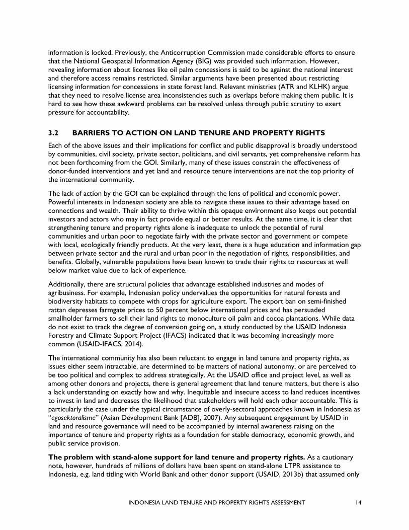
3.3.1 ACTIVITIES TO SECURE LAND RIGHTS ARE DELIVERING DEVELOPMENT RESULTS IN INDONESIA
Providing communities with certainty on their resource rights has been demonstrated in Indonesia to incentivize the use of indigenous knowledge for sustainable development as well as to assist individuals and communities to better understand their relationships and roles in efforts to assure more sustainable growth and development. This societal benefit in turn strengthens the argument for more equitable and certain land tenure and property rights that otherwise is all too easily politicized. Clear tenure, whether de facto or de jure, establishes who is responsible for land use in a specific area, resulting in increased land use responsibility for any negative spillover effects. Resource rights clarify responsibilities over resources and increase accountability for land management, allowing for internal negotiation over process and outcomes. For example:
• Better coordination of land use behavior. The identification of roles and relationships for land holders and managers allows for coordination across complex interconnected landscapes, notably, public forests, private land, and planning within urban areas, where public services are delivered to private lands;1
• Reduced costs from tenurial conflict. A transparent and accessible information source on tenure rights reduces costs of conflict by establishing an approach for reviewing overlapping rights. The work by MCC on participatory land use planning demonstrated a marked decline in fiscal expenditures for conflict mitigation following a participatory planning process (economic modeling by Muhammad Ridwansyah);
• Incentivized use of positive indigenous knowledge. Additionally, communities with secure rights have been shown to apply indigenous knowledge for land management, for example with
1 There are a few approaches adopted by several local governments to resolve land tenure issues in urban slum areas, including land
consolidation as opposed to relocation. See: https://radarsolo.jawapos.com/read/2019/04/20/132864/tanpa-relokasi-semanggi-ditata-dari-nol
Figure 6: Diligent fire break only in private smallholder land, Sintang District, West Kalimantan Province PHOTO: CHRISTOPHER BENNETT
INDONESIA LAND TENURE AND PROPERTY RIGHTS ASSESSMENT 16
respect to drip irrigation, forest fire control, and soil and water conservation (World Bank, 2003; Bennett, 2002) (Figure 6);
• Reduced costs for renewable energy investments.2 Tenure security has been shown to help lower costs for run-of-river hydro investments where control of upstream land prioritizes protection of water resources for electrical power generation over illegal logging. Lack of control of upstream forest land cover results in sediment that can reduce hydro turbine lifetime from 15 to five years (Figure 7). Obtaining certainty of access to
protect upstream SFAs is difficult for communities to acquire, yet it has been achieved to support water protection for energy generation, also resulting in reduced deforestation and carbon stock enhancement as well as benefits to downstream water users. As Indonesia invests in hydropower, opportunities exist to strengthen tenure, while ensuring service provision; and
• Outcomes from community land licenses often compare favorably with corporate land licenses. The assumption of forestry and other land agencies about the greater efficiency of corporate over community licenses is not necessarily borne out by experience. Although a comparative analysis has yet to be made, the Social Forestry Directorate in the KLHK recognizes that community forests can result in highly successful afforestation. Some community licensed areas also enjoyed payments for environmental services by municipalities and hydroelectric initiatives, as well as related tourism with economic multiplier effects that exceeds the revenues from the original license. For example, Kalibiru village in Jogjakarta province with community forestry lease (Hutan Kemasyarakatan [HKM]) licenses went from a few visitors in 2010 to 350,000 in 2017 (see Annex 3 on amplifying and sustaining the potential of community forestry land rights in Indonesia).
3.3.2 PROGRESSIVE LEGISLATION EXISTS
While most of Indonesia’s systems favor private sector and government interests over the rights of communities or the rural poor, there is progressive legislation that allows communities to have a greater say in their development pathway. While it exists, the implementation of this legislation remains largely limited to small-scale activities and donor-funded initiatives.
Increasing access of local communities to land use and related decision-making. In general across Indonesia, it remains difficult for local communities to obtain use rights to public lands such as SFAs that comprise two-thirds of the nation’s land, much of which is informally accessed by village communities. In recent years there have been encouraging signs of more access for local communities, most notably through the following processes:
2 Although these issues apply to community-run/managed hydro power generation, they are much prominent in large scale run-of-river
hydro projects (>1 MW size). The numbers and size of community-managed renewable energy projects across the country are relatively small compared to state and private sector investment, so activities related to community land rights while important for community livelihoods are not likely to create big impact on renewable energy investment.
Figure 7: Catchment area for microhydro installation (red dot) in Muara Madras village, Merangin District, Jambi Province SOURCE: GOOGLE EARTH

INDONESIA LAND TENURE AND PROPERTY RIGHTS ASSESSMENT 17
• Community forestry licenses have used the Social Forestry Program to accelerate community licenses since 2014. The area of community forest licenses approved increased from 500,000 hectares from 2009 to 2014 to 3.7 million hectares over the period 2014 to 2019, demonstrating increased momentum; and
• Participatory infrastructure development on smallholder property. GOI has increasingly recognized that infrastructure programs work better when feedback from smallholders is integrated into technical designs and processes. There has been a series of examples where government has applied FPIC processes involving communities, private sector, government, and engineers. One recent example has been the restoration of hydrology through the blocking of local peoples’ tertiary canals with their explicit approval (USAID-LESTARI, 2018a).
Community-based licenses offer land access to individual households. The majority of successful social forestry licensed land plots are communally owned but individually managed. All members belong to a formal group that holds the license and ensures that all members comply with terms. Preferential access to individual plots, typically one to two hectares in size, is given to the landless, poor, and widows who might otherwise work as laborers or consider moving to urban areas in search of employment (see Annex 3).
History of social exclusion within concessions is evolving. After decades of exclusionary policies that began during the New Order, there are some encouraging signs of alternative approaches that will give local communities greater access to land and natural resources. Recognizing that the political tide is turning against them, forest and agricultural concessions (forest HTI and HPH and plantation HGU) are now giving more serious thought to a genuine provision of space in their licensed areas for collaborative management with village communities:
• HTI and HPH are giving serious thought to setting aside 20 percent of their area for genuine co-management and asking the KLHK to regulate the approach accordingly; and,
• Oil palm concessions in Papua are tentatively exploring participatory zonation of their licensed areas with up to 50 percent being allocated to conservation that allows low-impact harvesting of non-timber forest products (NTFPs) by local communities, the remaining area being zoned to protect water resources and allow some co-management.
3.3.3 PARTICIPATORY AND LANDSCAPE-LEVEL APPROACHES TO PLANNING AND ZONING HAVE PROVEN SUCCESSFUL
Participation and engagement in decision-making are key features of land and resource governance interventions. The movement to participatory planning takes responsibility out of the hands of experts and acknowledges that the people who live in an area are the experts. There have been recent successful examples of participatory planning and zoning, but these have not been adopted or mainstreamed due to a combination of lack of capacity, upfront cost and time required, and even fear that it leads to more recognition of local rights. In practice, however, participatory steps reduce conflict and increase the capacity and commitment required to see these plans implemented.
Potential for landscape-based approaches to slow displacement. There is growing experience with landscape-based approaches that accommodate the interconnectivities between agriculture and forestry as well as water resource relationships (FAO, 2013; Sayer, 2013), e.g., in South Sumatra (Zoological Society of London, 2017), Aceh (USAID-LESTARI, 2018c), and East Kalimantan (TNC, 2019). A central feature of landscape-based approaches is recognition of the diverse relationships between large and small-scale landholders and managers where shared responsibilities for soil and water conservation are in the interests of all in the landscape.

INDONESIA LAND TENURE AND PROPERTY RIGHTS ASSESSMENT 18
Participatory land use zonation has seen increased participation of local village communities in conservation areas as well as production and protection areas (e.g., with USAID support in Aceh and Papua Provinces [USAID-LESTARI, 2018c]).
Sub-national initiatives for greater land information transparency. Despite pockets of resistance at the national level, at the regional level, sub-national governments have seen the utility of establishing transparent and accessible land use information systems through the legally approved spatial plans (e.g., Papua’s Spatial Planning Information Management System [SIMTARU] (USAID-LESTARI, 2018b) and in South Sumatra Province).
3.3.4 RESPECT FOR WOMEN’S RIGHTS IS NON-CONTROVERSIAL, BUT WOMEN REMAIN UNAWARE OF THEIR RIGHTS AND OFTEN ARE EXCLUDED FROM PUBLIC PARTICIPATION DUE TO A LACK OF INCLUSION
Gender and land issues are explored in depth in Annex 2. There are clear opportunities for promoting women’s rights to participate in, decide upon, and benefit from rural development activities that can be enhanced by applying a property rights lens.
Equal formal rights to obtain land. Indonesia’s Constitution states that “Every person shall have the right to own personal property, and such property may not be unjustly held possession of by any party” (Constitution 1945, Article 28H,4). Land inheritance rights are still governed by the 1847 Civil Code in the case of non-Muslims, and by Islamic law in the case of Muslims. The 1847 Civil Code provides for equal rights to inheritance. According to the Basic Agrarian Law 5/1960, article 9 paragraph (2), every Indonesian citizen, both men and women, have equal opportunity to obtain rights to land and to its benefits for themselves and their families. While equal rights are enshrined in law, the practice is less clear.
Lack of women’s awareness of their land rights. Recent research in farmland areas of Jogjakarta and South Sumatra Provinces found that women were mostly unaware of their land ownership status. Many mentioned that they own the land but were unsure whether the land was formally registered in their names. Most believed that all family resources were owned by both husband and wife, and they considered it unnatural for assets or decision-making over assets to be split after marriage (Akter et al., 2017).
Social inequalities within families. Women of different social status and class have certain forms of relationships in managing land and forest resources. One woman may have access to various plots of land, ranging from her own land(s), her husband’s land(s), her conjugal land(s), and her relative’s or neighbor’s land(s), as well as state lands. Women from different backgrounds have important roles to play in managing land and forest resources and have various forms of connections with them. Women from poor families, especially those from landless families, generally access land through their relatives or neighbors where they become field workers. In certain regions, landless women are able to access land that has been claimed as state land, where women are hired as workers.
Informal discrimination against women’s access to land. Women are severely discriminated against when they enter the negotiation process with stakeholders outside of the family/community (Siscawati & Mahaningtyas, 2012). Exclusion of power works via various processes and actors, including on the part of the state, corporations, and other stakeholders involved in the extraction of natural resources. These groups often preferentially reach out to men as the “heads of households,” not adequately consulting with women as individuals or in groups. Further the recent history of top-down concessions have led to threats of violence toward communities in the process of dispossession of land. In these cases, women may not be on the front line of the dispute, yet they are as greatly affected as, if not more so than, the men who commonly act as representatives of the community (Hall, Hirsch, & Li, 2011).

INDONESIA LAND TENURE AND PROPERTY RIGHTS ASSESSMENT 19
Gender mainstreaming in the forestry sector has been strong. Gender mainstreaming in the forestry sector began a few years after the issuance of Presidential Instruction on Gender Mainstreaming in 2000. It began with the issuance of Minister of Forestry Decree No. 528 in 2004 on the implementation of the guidance of gender mainstreaming in the development of the forestry sector. The ministry then issued Regulation P. 65/2011 dated October 11, 2011 on guidelines for gender-responsive planning and budgeting in the forestry sector as a follow up of the Minister of Forestry Decree number 528 of 2004. This ministerial regulation emphasized that the development of the forestry sector in realizing national development should be “pro-poor, pro-jobs, and pro-environment.” This approach has a strong gender dimension that needs to be addressed with further gender-related actions. Both Ministerial Decree No. 528/2004 and Ministerial Regulation P. 65/2011 were later revised by Ministerial Regulation P.31/2017 on the guidance of the implementation of gender mainstreaming in the environment and forestry sector.
But successes have been sporadic in empowering women’s land-related roles. Across Indonesia there appears to be a slow if sporadic trend towards greater women’s empowerment related to land tenure and property rights:
• In South Sulawesi, smallholder cocoa farmers unhesitatingly report that all related finances must be held by women who in turn have a say in what the money is spent on;
• An ongoing case in a community forestry site in Lampung Province indicates significant engagement of women in decision-making at the household and community levels. Girls’ access to education at the micro-scale has been slowly increasing after the implementation of forest tenure reform schemes. This reportedly is based on an increase of income from forest lands secured through the issuance of permits related to forest tenure reform (Siscawati, 2019);
• During participatory land use zonation in state and private land in Aceh Province, village women readily took up the invitation to contribute, often displaying more knowledge than the men about NTFPs and medicinal plants as well as the need to allocate land for their conservation (Figure 8); and
• Local NGO Arkom has successfully negotiated a land sharing agreement and resettlement of an illegal settlement to an adjacent piece of land in Makassar City and confirmed that the process of community planning is slow and arduous. Confronted with considerable animosity in the early stages, moving on with the project required a personal commitment that can hardly be taken as a given. In contrast to the National Slum Upgrading Project/Kotaku (with support from the World Bank), Arkom also puts community planning completely in the hands of women as a way to improve community buy-in (John & Dewi, 2017).
Figure 8: Participatory land zonation of private and forest land, Babalung Village, Aceh Barat Daya District, Aceh Province, 2017 PHOTO: CHRISTOPHER BENNETT

INDONESIA LAND TENURE AND PROPERTY RIGHTS ASSESSMENT 20
As with the success of community forest rights, land use planning successes around gender integration appear to be largely project led and lack an approach that is systematic across development activities.
3.4 WHY ENGAGE NOW?
3.4.1 POLITICAL WILL IS PRESENT FOR THE FIRST TIME IN DECADES
Recognizing the above challenges, the President has: 1) prioritized allocation of degraded state forest areas and abandoned private land and expired concession licenses to the poor (PP86/2018); 2) converted a temporary moratorium to a ban on 66 million hectares of primary forests and peatlands without licenses (Inpres 5/2019); and 3) exerted pressure for the passing of a new agrarian reform law. He is also said to be planning a restructuring of land ministries towards these ends for the 2019 – 2024 cabinet starting in October.
The President has also shown a willingness to push creative solutions to accelerate tenure security in the absence of reform. Little has changed with respect to the efficiency and equity of land markets to serve the poor efficiently and equitably, dating back to the 1960s. Yet, the President has used alternative pathways to promote pro-poor reform. Recognizing the urgent need to improve land markets, Presidential Instruction 86/2018, operating within the existing regulatory framework, identified opportunities for re-allocation of rights in three kinds of land: (a) release of SFAs to APLs; (b) abandoned private land; and (c) ex-HGU. Despite this willingness, conflicts continue to emerge from the use of top-down approaches. For example, well-intended national programs such as road infrastructure and tourism development continue to conflict with local land rights, e.g., in the Lake Toba region of North Sumatra where the President’s “10 New Balis” initiative is being rolled out and local communities are complaining that their land rights are not being sufficiently respected (Jakarta Post 2019b, c).
Threats and opportunities for primary forests and peatlands where the moratorium has become more permanent. Since Presidential Instruction 5/2019 transformed the two-year moratorium on new licenses in primary forests and peatlands into a ban (at least for the next five years), a major opportunity has opened up for better management of 66.2 million hectares of peatland and primary forest in private land as well as for protection and production forest land (Nirarta, 2019). This includes the potential to reduce 32 gigatons of carbon emissions, the equivalency of the emissions released from 6.1 billion passenger vehicles per year. There are, however, exceptions to the ban, e.g., food security objectives could easily turn into loopholes for poorly controlled access to this major land resource endowment unless closely and publicly monitored. The current ban area has no licenses on it and so would not suffer from the problem of hidden license information in One Map. On the other hand, given that the area coincides with 9,000 villages, access to and control of smallholdings less than 25 hectares may seriously undermine the intent of the moratorium to safeguard primary forests and peatlands. Some of the area may even come under the remit of an additional Presidential Instruction 86/2018 that provides smallholders with access to ex-SFAs, abandoned land, and ex-HGUs. This underscores the need to use mapping to ensure that mandates and decrees that ostensibly secure land for smallholders AND protect resources do not lead to conflicting outcomes
3.4.2 CIVIL SOCIETY AND INFORMATION TECHNOLOGY FOR TRANSPARENCY
At the regional and global level, Indonesia recognizes its suboptimal reputation in natural resource and waste management, and acknowledges the issues surrounding land resource conflict (BAPPENAS 2019b,c). The GOI has signed on to pledges to address natural resource management issues which are being monitored globally. Domestic and global pressure is being applied against pledges of better environmental performance, e.g., forest and land fires despite Central Kalimantan’s “Blessed Province” pledge in the five year mid-term regional development plan (RPJMD 2016-2024), and Papua and West Papua Provinces' Manokwari Declaration. Indonesia’s 2011 Presidential Instruction for a moratorium on logging new concessions in undisturbed tropical forests and peatlands (extended for a further five years

INDONESIA LAND TENURE AND PROPERTY RIGHTS ASSESSMENT 21
in 2019), and zero-deforestation pledges made by corporations, have not resolved deforestation and fires as anticipated. One of the most recent pledges, the Manokwari Declaration, was made during an international biodiversity conference for Papua and West Papua Provinces. Signed by the governors along with the private sector and civil society organizations, it is intended to add momentum to efforts to achieve drive sustainable development and conservation in the region. Article 9 of the Manokwari Declaration refers to the establishment of an independent institution to resolve environmental conflicts and Article 2 protects the rights and strengthens the roles of indigenous communities. In addition, the national One Map process has acknowledged resource conflict but has yet to result in full disclosure of natural resource licenses, a necessary precondition to resolve overlapping land use claims. Civil society as well as some government agencies such as the Anti-Corruption Commission can now use these and similar pledges to hold decisionmakers to account for persistent land resource conflicts and their negative economic and social outcomes.
3.4.3 PRIVATE SECTOR INTERESTS
There is increasing recognition by elements of the international private sector of the monetary and reputational risks of land and resource tenure conflict, and companies are signing on to binding commitments to verify their social and environmental impacts. And while foreign investment in the natural forest management sector is prohibited in Indonesia, concessionaires in state forest areas are actively asking government for enabling regulations for co-management with local communities.
In summary, the constraints to secure tenure and resource rights and structural elements that disadvantage the rural and urban poor from being able to register for and exercise rights to land and resources are well understood. However, it is not likely that solutions will come from comprehensive legislative reform, but rather through momentum from district government and community level stakeholders applying local innovation and underused existing regulations in APL and SFAs by province-level decisions in line with Law 23/2014.

INDONESIA LAND TENURE AND PROPERTY RIGHTS ASSESSMENT 22
4.0 RECOMMENDATIONS AS INPUTS TO USAID CONCEPT NOTE FOR CDCS 2020 – 2024
4.1 STRATEGIC DIRECTIONS
To align USAID CDCS priorities with Indonesian national policies, USAID should consider the following opportunities that align with the current political will around pro-poor assistance that advances the rights of customary peoples while not interfering with infrastructure priorities and other major government development programs in the RPJMN. USAID is most likely to support Indonesia’s Journey to Self-Reliance through activities that:
4.1.1 BUILD BROAD-BASED AWARENESS OF THE UTILITY OF LAND TENURE AND PROPERTY RIGHTS ACROSS OFFICES WITHIN USAID/INDONESIA
Primer. New USAID staff should be given the USAID 2013 land tenure country profile as recommended reading for understanding the institutional dynamics of land in Indonesia. This profile would benefit from an update every five years, tracking changes in policy and practice to coincide with each new government, starting in 2020. Another useful quick reference is Annex 1 of this report, detailing the main forms of land and property rights instruments in Indonesia. Under the auspices of the GOI land agencies (ATR and KLHK), USAID could support a cross-donor technical group on issues related to land management, tenure, and rights to help coordinate efforts among donors and raise the most important issues with the GOI. To help achieve this, USAID may wish to identify a resource tenure and governance focal point within the mission (or in the best case, hire a staff member with existing knowledge/experience to act as a Mission Advisor on land and resource tenure). This person would be responsible for being an advocate for land and resource tenure issues; tracking relevant law and policy; informing both USAID and State Department of the implications of policy decisions; supporting the program office and technical staff on integration into program design and existing activities; and leading the relevant learning discussions. A model of a full-time advisor has been deployed by USAID successfully in other countries, such as Burma, Zambia, and Liberia, though usually with a contractor sitting outside of the mission, often in government. In Colombia, Ethiopia, Liberia, Mozambique, and Tanzania, missions have identified internal “land champions.” This person may also spearhead coordination with government and other donors on land and resource tenure discussions.
4.1.2 FOCUS ON IMPLEMENTATION OF EXISTING MAJOR POLICIES
Prioritize better implementation, monitoring, and enforcement of existing regulations. USAID should focus on making better use of existing policy frameworks closely aligned with familiar government instruments, that is, planning (Perencanaan), implementation (Pelaksanaan), and, above all, oversight (Pendengalian). Oversight instruments are an area of land and resource governance that ATR and KLHK recognize are weak and would allow USAID to see capacity improvements and demonstrate commitment of political will that has recently opened. Fundamental policy reforms processes (e.g., BAL and Customary Rights Law) are already well-funded and highly politicized and so would not be a place to engage. The development impacts and adaptive learning from application of existing laws and piloting innovation will also prove constructive, deliver tangible benefits, and support effective decentralization, e.g., detailed spatial planning (RDTR) and zonation or “blocking” as part of the long-term forest management plan (RPHJP) in Aceh Barat Daya District, Aceh (USAID-LESTARI, 2018c) and SIMTARU licensing (USAID-LESTARI, 2018b) and ATR 5/2017 for online land registration.

INDONESIA LAND TENURE AND PROPERTY RIGHTS ASSESSMENT 23
4.1.3 FOCUS ON INTEGRATION, NOT STAND-ALONE PROJECTS
Incorporate land tenure and property rights into existing programs. There is no compelling case for a stand-alone land tenure and property rights program focused on massive land titling. Given issues of land sovereignty, the GOI prefers that any stand-alone land tenure and property rights be supported by multilateral rather than bilateral assistance. World Bank and ADB land tenure projects, well-opposed by vested interests, offer ample evidence of that wrong direction (IEG, 2016). Incorporate LTPR across all programs in ways that are less threatening to still-powerful vested interests but that open the door for community participation and fair negotiations. For example, offer private concession license holders modalities of collaboration with local communities to head off conflict by participatory zonation of production and conservation areas (required by law) in ways that do not destroy existing livelihood sources (e.g., agroforests) nor degrade waterways essential to downstream communities. Thus, for new programs, USAID’s Office of Land and Urban could support the mission to develop a checklist against key land and resource tenure constraints, in line with the USAID Situation Analysis and Intervention Planning Tool. This leads to the following recommendation.
4.1.4 EXPLICITLY INCORPORATE LAND TENURE AND PROPERTY RIGHTS IN DESIGN AND IMPLEMENTATION PHASES OF USAID PROGRAMS
Evaluate new USAID programs through a land and resource governance lens. USAID may wish to use a land tenure and property rights lens in the PAD phase during the implementation of the new CDCS. New projects can be rapidly assessed for whether the current tenure framework will undermine or support proposed program results as well as what impact the intervention itself will have on the rights of project stakeholders. For example, any private sector partnership could consider the role that land rights play in smallholders’ ability to participate. Water and sanitation programs should consider whether access is provided not only to those with formal land title but especially those without formal rights (and the implications of this decision) in slum areas who face constant threat of eviction and yet can be responsible urban dwellers if given support, e.g., in Solo and Makassar (Radar Salo, 2019; John & Dewi, 2017). Health programs could consider the role that land rights play in reaching the most marginal populations, who are least likely to have a stable permanent address. New renewable energy programs could support consideration of upstream/downstream land management impacts, not just the installation of hydro-generation facilities and connections. Similarly, financial inclusion programs should be considering whether they are able to reach households that do not have land as collateral, seeking alternative approaches to document their rights. Environment programs should seek to balance development opportunities with social and environmental safeguards, based on whether stakeholders have legal or de facto rights to live in and control resources within an area.
4.1.5 APPLY A TENURE FRAMEWORK DURING INITIAL ENGAGEMENT AT LANDSCAPE FIELD SITES
Application of a landscape-based tenure framework. Given Indonesia’s geographic and cultural diversity, localized tenure assessments are valuable. This does not need to be an outside or expert-driven process, but rather a local understanding of opportunities and constraints facing communities, private sector, and state institutions. A tenure analysis offers a tool to look at how different sectoral policies impact stakeholders’ rights and responsibilities within an area of interest. In the best case, this allows for negotiation of equitable benefits between private sector, community, household, and government actors. In the worst case, it leads to a winner-take-all approach, where one law or government priority overrides other interests or safeguards. The role of USAID partners is to support “honest brokers” who can convene stakeholders and support negotiations over access, use, and distribution of benefits. To demonstrate results there is a need to focus on landscapes or areas that are large enough to be replicable, but small enough to be manageable, such as sub-watersheds, or neighborhoods (kelurahan) in urban areas. This requires significant investment in coordination at the landscape level, but also a feedback mechanism to the national level to impact policy implementation.

INDONESIA LAND TENURE AND PROPERTY RIGHTS ASSESSMENT 24
MCC’s approach in Indonesia developed a tool that would be well-suited to capturing and addressing LTPR issues in USAID programs, namely, landscape-lifescape analysis (MCC, 2018). Along with building capacity and commitment to develop and realize a common vision across a landscape, this process can lead the private sector to support documentation of community rights as USAID has supported in Mozambique, India, and Ghana. Such activities may also be fundable for verifiable, performance-based tax relief or access to the Ministry of Finance’s green-funding program.
4.1.6 PARTNER WITH PRIVATE SECTOR TO ADDRESS TENURE ISSUES
Work with private sector to demonstrate cost and time savings of proactively addressing tenure. Land tenure conflicts pose immense costs to businesses and government and can derail planned development activities. Given Indonesia’s history providing a favorable environment for large-scale agriculture and, as a result, deforestation, businesses are under increased scrutiny regarding their social and environmental impacts from sourcing, most notably holders of HGU, HTI, and HPH licenses. USAID has growing experience helping companies understand and meet national and global standards for responsible land-based investment and social and environmental compliance. Demonstrating the cost-effectiveness of proactively addressing land tenure conflicts with private sector partners, or through public-private partnerships, and subsequently supporting the GOI to apply and enforce their safeguards, would help create a level playing field for businesses to engage in Indonesia. A useful entry point for this is participatory zonation of existing corporate licenses (see 4.1.3, above). Such an approach can be carried out by working through industry groups that have made pledges to identify viable partners, or companies that have taken measures to learn from low-level conflict. By working through these channels, there are opportunities to build momentum and a constructive relationship between the state and community to identify practical solutions to reduce conflict and negotiation win-win-win solutions.
4.1.7 APPLY INFORMATION TECHNOLOGY TO PROMOTE RESPECT FOR LAND AND RESOURCE RIGHTS AND INCREASE TRANSPARENCY
Use information technology to document rights and promote transparency. USAID has developed a suite of tools around MAST that bring participatory processes for rights registration, land use planning, and decision-making to communities, civil society, and local governments. At the same time, there are numerous platforms to monitor compliance with land use planning agreements and provide decision support from Global Forest Watch to SMART (protected area monitoring tool) to MapHubs and Planet (global daily satellite monitoring platform). Jakarta’s electronic QLUE platform for land-related complaints was singularly successfully when Jakarta was under the Governorship of Basoeki (Ahok). These tools allow communities to record their claims and bring transparency to the agreements they have made. USAID should continue to build on partnerships with One Map to support accountability and transparency in the land and resource rights sector. This approach would make the case for unlocking information about land use licenses in the interests of achieving the goals of the RPJMN. If land title proposals are posted on public noticeboards for small lots, this technique could also be utilized for concessions. Without a modicum of transparency about license locations, One Map falters. USAID could provide leverage by making biodiversity conservation support contingent on geospatial transparency across the 66.2 million hectares of currently unlicensed peatlands and primary forests. Strong coordination with other donors on increasing land transparency could be the catalyst for the GOI making progress on information transparency at different levels as demonstrated in other countries. Such an investment would be based on commitment from USAID to engage with One Map’s work plan, while guiding USAID investments and making clear the areas of progress that are required to sustain investment.

INDONESIA LAND TENURE AND PROPERTY RIGHTS ASSESSMENT 25
4.1.8 SUPPORT SMALL-SCALE PARTICIPATORY ZONATION AND MANAGEMENT, APPLYING FPIC WHERE PRACTICAL
Apply local participatory planning. To the extent that USAID invests in programs that require spatial planning or investments within rural or urban land, there is a need to support bottom-up participatory approaches that engage women, men, and any vulnerable groups in dialogue and negotiation. Land use planning is at the intersection of several programming sectors and could serve as an entry point to establish cross-sectoral best practices on land and resource tenure. These processes should always start with understanding peoples’ legal and de facto rights and responsibilities and current benefit streams. USAID has strong experience from some recent programs that could be deployed more systematically: to RDTR in strategic areas; as part of FMU management plans (RPHJPs); within corporate licenses (HGU, HTI, HPH) and community licenses (HDesa, HKM, HAdat, Kemitraan, HTR); to support tenure security in village and customary areas in self-selected clusters aligned with village grouping regulations (Kawasan Perdesaan); and in urban planning areas where marginalized groups live, especially along riversides, with special attention to water supply and household waste management. Adopt the lessons learned from urban land consolidation rather than eviction, e.g., Makassar (John & Dewi, 2017) and Solo (Radar Salo, 2019). At an urban water management level, integrating social, environmental (including waste management), and economic considerations are guided by Government Regulation PP45/2017 on participation of communities in regional governance.
4.1.9 SUPPORT COMMUNITY-LED PROCESSES TO STRENGTHEN LAND TENURE AND PARTICIPATE IN RESOURCE USE DECISIONS
Amplify the use of Village Funds to support better land governance. Village Funds are a mechanism for communities to support their own development pathways as forestry budgets shrink. Communities are interested in following social forestry pathways but require technical assistance and tools that are low-cost and scalable. Linked with MAST, USAID’s rural-focused funding has the opportunity to support closer collaboration of village communities with FMUs, preferably with their participation on management boards for issues of zonation and assigning forest land use rights. This would subsequently help communities achieve community forestry licensing and implementation. Given the recent ban on new corporate licenses on 66.2 million hectares of primary forest and peatland, now is an ideal time to strengthen community tenure and management rights. Such a focus would of course require additional focus on reducing barriers to community rights registration.
4.1.10 FEATURE WOMEN’S RIGHTS TO LAND AND PRODUCTIVE RESOURCES MORE PROMINENTLY IN DEVELOPMENT PROGRAMS
Raise the profile of women’s rights to land and inheritance in all gender programming and any rural resource program. Integrate awareness raising for women’s rights to demonstrate impacts on livelihoods. In any activity focused on registering forest rights, community management of water or waste infrastructure, or partnerships with private sector, ensure that women’s participation, decision-making, and access to benefits are part of implementation. This would stress specific components on women’s participation, decision-making, and ultimate benefits in land and resource governance. Where rights are being registered or planning is happening for the first time, then these approaches can be integrated into the programing. However, it is also worth returning to existing areas, where women may be under-represented and carrying out stand-alone activities. One example of the importance of the role women play was in Makassar when the direct involvement of women resulted in slum dwellers’ land being consolidated rather than subject to eviction (John & Dewi, 2017). These activities are largely integrated into existing tenure activities, but ensure that field staff have the skills to reach women and that spaces for women to participate effectively are created by the activities. This also requires being attuned to different sets of women within the community.

INDONESIA LAND TENURE AND PROPERTY RIGHTS ASSESSMENT 26
4.1.11 SUPPORT OPERATIONALIZATION OF NATIONAL-LEVEL SOCIAL AND ENVIRONMENTAL SAFEGUARDS ASSOCIATED WITH DEVELOPMENT PROJECTS, PARTICULARLY ROADS
Promote application of infrastructure safeguards. Commitments from the GOI and safeguards through the application of social and environmental impact evaluations exist to protect biodiversity, conserve areas of high carbon stock, and minimize negative impacts on rural communities. However, they are not consistently applied. American companies are likely to closely follow the letter of the law and more stringent international best practices due to high-level scrutiny and expectations, while domestic and regional actors may take advantage of weak enforcement and opportunities for cost savings. Opportunities exist for supporting application of Indonesia’s strategic environmental assessments required for development and spatial planning, adapted for both small-scale activities and large-scale projects (e.g., roads, rail, ports, the new capital of Indonesia now apparently decided for East Kalimantan province). By promoting consistent application of social and environmental best practices around respecting land and resource rights, USAID may help to raise the bar for all companies engaged in Indonesia and increase the comfort of the private sector in engaging constructively with communities.
4.1.12 TEST APPROACHES TO ENSURE THEY ARE REPRESENTATIVE OF INDONESIA’S DIVERSE GEOGRAPHY AND SOCIO-CULTURAL CONTEXTS
Accommodate Indonesia’s diverse geographic and socio-cultural endowments. This assessment was unable to dissect the different dimensions of Indonesia’s geography and cultural contexts in the time available. It over-simplifies both urban and rural issues, and does not differentiate between priorities of different provinces or communities. Eastern Indonesia, where there is the most relative poverty, merits special attention. There can be little doubt that the Provinces of Papua and West Papua represent a case apart where land tenure considerations are key to their part in the development of eastern Indonesia. Subsequent analyses would collect additional data on multiple urban centers, provide more information on rural to urban migration dynamics, explore the different pressures facing high population and low-population density islands, and explore the coastal tenure dynamics to a greater degree (USAID recently completed a marine and coastal tenure assessment [Courtney et al., 2017]). Similarly, investments in land use planning processes or community registration processes would be focused on ensuring that they are relevant to multiple areas. The authors stand by the findings of this assessment but recognize that adapting general interventions to specific local contexts are always required.

INDONESIA LAND TENURE AND PROPERTY RIGHTS ASSESSMENT 27
5.0 CONCLUSIONS
5.1 FINDINGS
Tensions around land and resource governance are at the foundation of many of Indonesia’s most difficult development challenges. They reflect the struggle to generate economic growth through private sector investments and protect community rights and environmental quality that benefit all Indonesians. Powerful interests benefit from the opaque status quo around land allocation and discretionary approval and revocation of rights. Government ministries do not share information and often have competing interests over land use that is exacerbated by the lack of local-level decision-making. The urban poor, particularly migrants, suffer from lack of access to land and often occupy environmental sensitive sites susceptible to flooding or landslides. Municipalities have not adequately planned for waste disposal or water infrastructure for these communities, creating both health and waste management crises. In both urban and rural landscapes there is a lack of monitoring and enforcement of land use planning and zonation due in part to lack of funding, but also to corruption and vested interests. Households and communities that do wish to formally document their rights encounter hurdles to acquire land that are in some cases higher than those for companies. In rural areas, a history of inadequate consultation and compensation over land allocations to companies has created distrust and frequent, costly land conflicts.
While reform has been prioritized by the GOI on paper, it has been repeatedly stalled due to the power of vested interests within government and the private sector. The international community recognizes the importance of land and resource tenure, but sees the challenges as too political and too complex, and frequently does not recognize the incremental, cross-sectoral actions that can be taken to address land and resource governance strategically.
Despite these challenges and barriers to action, there is reason for optimism and concrete opportunities for USAID support, ranging from progressive legislation for rights recognition that has not yet been implemented widely, to opportunities such as improvements in land transparency, participatory approaches to spatial planning, reduced barriers to customary land documentation, and recognition of the importance of women’s rights. Furthermore, the current administration has taken action demonstrating its political will to take on tenure reform while civil society is pushing for increased information transparency. Critically, the private sector and government agencies at the local level are increasingly open to working with communities in participatory ways.
5.2 RECOMMENDATIONS
There is an overarching need for more explicit and measurable incorporation of land tenure and property rights in future assistance strategies and specific interventions. Thus, USAID/Indonesia should prioritize the following:
1. Enhance understanding of land and resource governance as a basis for economic growth and community development. Arguably the greatest impediment to incorporating land and resource tenure in USAID programs is the misperception that it is only a matter of asserting rights and as such is fraught with political and institutional liabilities. Yet a disproportionate number of the most vulnerable populations who USAID is attempting to reach have difficulty accessing and asserting their land and resource rights. This limits their ability to plan for the future, as well as government’s ability to provide water, sanitation, and health services. Secure tenure provides private businesses and households alike with assurance that their long-term investments will be respected. Adding a land and resource rights lens to development programs would allow stakeholders to assess risks and negotiate fair agreements on roles and responsibilities and avoid costly conflict, whether between households or among

INDONESIA LAND TENURE AND PROPERTY RIGHTS ASSESSMENT 28
communities, private sector, and government. Investing in these processes creates stability for service provisions and levels the playing field
2. Mainstream. As important as strengthened LTPR is for Indonesia’s Journey to Self-Reliance and its standing in the Indo-Pacific region, stand-alone assistance with the end goal of massive land titling is not justified. Given the political nature of land and resource tenure and long-standing processes, national level policy and law engagements are not advised. Lessons should be learned from the painful experience of past stand-alone foreign donor assistance (IEG, 2016). Nevertheless, there are many progressive areas within the existing legal framework for rights recognition, public transparency and accountability, and protection of vulnerable populations and habitats that deserve USAID support. Each has supported existing regulations though not necessarily given implementation priority, e.g., PP45/2017 for participatory regional governance, and ATR 5/2017 for online land certification, online submissions for land use licenses, and especially the capacity of oversight divisions tasked with tracking land certification and land use impacts (Pengendalian). By supporting the local-level innovations called for by government, USAID has a chance to produce learning to inform broader uptake of integrated tenure solutions. The caveat is that secure tenure is necessary, but not sufficient on its own, to promote equitable outcomes alongside economic growth. The status quo has produced powerful interests, particularly in government and private sector, who benefit from the current ambiguities and top-down decision-making processes and will resist efforts to deliver seemingly inclusive and equitable outcomes.
3. Plan longer inception phases of interventions and take advantage of openings in political commitment. The shifting political will for addressing land and resource rights in Indonesia argues for support that cannot easily be planned, hence the argument for sufficiently long inception phases for crucial inclusive planning of interventions with partners as well as adapting to political changes. Despite a conducive legal environment over the past decade, it has only been in the past few years that social forestry opportunities moved from paper to practice. In urban areas, there are too few but notable examples of recognition of slum dwellers through their land consolidation rather than recourse to eviction (e.g., Radar Salo, 2019; John & Dewi, 2017). Responding to these opportunities in a timely manner can create self-sustaining momentum that is part of the Journey to Self-Reliance.
4. Focus on private sector partnerships, multi-stakeholder planning, and information transparency through gender-sensitive approaches at local levels to promote equitable, conflict-free results. To avoid becoming entangled in the politics associated with tenure reform, focus on local-level solutions that can become the building blocks for best practices and guidelines, if and when reform moves forward. Many of the best practices associated with tenure-sensitive approaches do not require legislative change; for example, private sector dialogue with local stakeholders and participatory multi-stakeholder planning are already envisioned within law but are rarely practiced. Similarly, gender equality is enshrined in law; ensuring that women’s participation and decision-making rights are considered in local negotiations with companies or government simply requires attention in program design. Participatory approaches for land use planning and simplifying processes for registering rights can be carried out at the local level to inform policy. Documentation of these processes and integration into learning forums can create the momentum for broader public acceptance.
5. Establish shared learning forums. Opportunities for shared learning both within Indonesia and internationally are necessary to build critical momentum. There are many groups already supporting land and resource tenure activities in Indonesia, yet as with gender integration and community forest rights experiences, and a few innovative approaches to accepting rather than evicting slum dwellers, successes have been small and sporadic. To achieve scale these

INDONESIA LAND TENURE AND PROPERTY RIGHTS ASSESSMENT 29
experiences need to be consolidated and reach key public and private decision-makers. One shared-learning device is already enshrined in strategic environmental assessments (SEAs), namely comparing business-as-usual with optimal development pathways through participatory processes. Adding land tenure and property rights components to SEAs is long overdue. It is important that the science be complemented with the immediacy of visualization techniques to readily reach decision-makers as well as members of the public. With current political will, there is the opportunity for shared learning processes to amplify local-level demonstrations to nationwide impacts.

INDONESIA LAND TENURE AND PROPERTY RIGHTS ASSESSMENT 30
ANNEX 1: MATRIX OF EXISTING INDONESIAN LAWS AND POLICIES RELATED TO LAND TENURE AND PROPERTY RIGHTS
This following information was prepared based on the following laws and regulations:
1. Law No. 5 of 1960 on Basic Regulation on Agrarian Principles (Law 5/1960);
2. Law No. 4 of 1996 on Encumbrance Right over Land and Land-Related Objects (Law 4/1996);
3. Law No. 41 of 1999 on Forestry as amended by Government Regulation In Lieu of Law No. 1 of 2014, Law No. 18 of 2013, several Indonesian Constitutional Court Decisions (Law 41/1999);
4. Law No. 20 of 2011 on Apartment (Law 20/2011);
5. Government Regulation No. 40 of 1996 on Right to Cultivate, Right to Build and Right to Use of Land (GR 40/1996);
6. Government Regulation No. 103 of 2015 on Ownership of Residential Property by Foreign Citizens Domiciled in Indonesia (GR 103/2015);
7. Regulation of the Minister of Agrarian Affairs and Spatial Layout/Head of National Land Agency No. 29 of 2016 on Procedures for Granting, Releasing and Transferring Ownership of Residential Property for Foreign Citizens Domiciled in Indonesia (MoA Regulation 29/2016); and
8. Regulation of the Minister of Environment and Forestry No. P.21/MENLHK/SETJEN/KUM/1/4/2019 of 2019 on Customary Forests and Private Forests (MoEF 21/2019).
Please be advised that the following matrix comprise the most common and/or relevant rights over land and apartment units.
No. Title Definition Right Holder Land Tenure Notes Legal Basis 1. Right of
Ownership (1) (Hak Milik/HM)
The hereditary, strongest and fullest land right that may be held by a natural person (with some exceptions).
1. Indonesian nationals. 2. Legal entities as appointed
by the government i.e. (i) state-owned banks, (ii) agricultural cooperatives,
No limitation. 1. Ownership document: Certificate of Right of Ownership (Sertipikat Hak Milik/SHM).
1. Law 5/1960. 2. Law 4/1996. 3. GR 40/1996.

INDONESIA LAND TENURE AND PROPERTY RIGHTS ASSESSMENT 31
No. Title Definition Right Holder Land Tenure Notes Legal Basis (iii) religious bodies, and (iv) social bodies.
2. May be used by its owner as collateral under Encumbrance Right.
2. Right to Cultivate (1) (Hak Guna Usaha/HGU)
Right to cultivate the land, which is directly controlled by the state within a certain period for agriculture, fishery or livestock purposes.
1. Indonesian nationals. 2. Any legal entity duly
established under the laws of Indonesia and domiciled in Indonesia.
May be granted for the maximum period of 35 years and extendable for 25 years.
1. Ownership document: Certificate of Right to Cultivate (Sertipikat Hak Guna Usaha/SHGU).
2. Given for an area of at least five hectares.
3. May be used by its owner as collateral under Encumbrance Right.
4. If the land granted by HGU is State Land that constitutes the Forest Area (Kawasan Hutan), the granting of HGU can only be done after such land is released from its status as Forest Area.
1. Law 5/1960. 2. Law 4/1996. 3. GR 40/1996.
3. Right to Build (1) (2) (3) (Hak Guna Bangunan/HGB)
Right to build and have buildings over the land.
1. Indonesian nationals. 2. Any legal entity duly
established under the laws of Indonesia and domiciled in Indonesia.
May be granted for the maximum period of 30 years and extendable for 20 years.
1. Ownership document: Certificate of Right to Build (Sertipikat Hak Guna Bangunan/SHGB).
2. May be used by its owner as collateral under Encumbrance Right (Hak Tanggungan).
1. Law 5/1960. 2. Law 4/1996. 3. GR 40/1996.
4. Right to Use (1) (2) (3) (Hak Pakai/HP)
Right to use or collect any benefits from the land for any purposes for a certain period.
1. Indonesian nationals. 2. Foreign nationals domiciled
in Indonesia. 3. Any legal entity duly
established under the laws of Indonesia and domiciled in Indonesia.
4. Foreign companies which have a representative in Indonesia.
1. May be granted for the maximum period of 35 years and extendable for 20 years; or
2. May be granted for an unlimited period provided that
1. Ownership document: Certificate of Right to Use (Sertipikat Hak Pakai/SHP).
2. May be used by its owner as collateral under Encumbrance Right.
1. Law 5/1960. 2. Law 4/1996. 3. GR 40/1996.

INDONESIA LAND TENURE AND PROPERTY RIGHTS ASSESSMENT 32
No. Title Definition Right Holder Land Tenure Notes Legal Basis 5. Government institutions,
ministries or departments, or local governments.
6. Religious and social institutions.
7. Representative missions of foreign states or international institutions.
the land remains used for the permitted purpose.
5. Right to Manage (1) (Hak Pengelolaan/HPL)
Right of the state to manage the land and as part of the implementation of such authority, the State can delegate the right to manage to another party.
1. Government agencies, including regional governments.
2. State-owned companies. 3. Regional government-owned
companies. 4. Special-authority agencies. 5. Other governmental legal
entities appointed by the Indonesian government.
May be granted for an unlimited period provided that the land remains used for the permitted purpose.
1. Ownership document: Certificate of Right to Manage (Sertipikat Hak Pengelolaan/SHPL).
2. Cannot be used as collateral under Encumbrance Right.
1. Law 5/1960. 2. Law 4/1996. 3. GR 40/1996.
6. Right of Ownership to an Apartment Unit (Hak Milik Atas Satuan Rumah Susun/HMSRS)
Right to own an apartment unit that is built over land with right of ownership, right build, and right to use.
Individual or legal entity who meets the requirement as the holder of land title.
Follows the term of the underlying land title.
1. Ownership document: Certificate of Right of Ownership to an Apartment Unit (Sertipikat Hak Milik Satuan Rumah Susun/SHMSRS).
2. May be used by its owner as collateral under Encumbrance Right.
1. Law 4/1996. 2. Law 20/2011.
7. Right to Use to an Apartment Unit (4) (Hak Pakai atas Satuan Rumah Susun/SHPSRS)
Right of ownership to an apartment unit (Hak Milik Atas Satuan Rumah Susun/HMSRS) owned or possessed by foreigners.
Foreigner having valid residence permits, actually residing in Indonesia and providing benefit, doing business, working, or investing in Indonesia.
Follows the term of the underlying land title.
1. Ownership document: Certificate of Right to Use to an Apartment Unit (Sertipikat Hak Pakai Satuan Rumah Susun/SHPSRS).
2. There are also certain qualifications on the price of apartment unit (e.g. minimum of IDR 5 billion for an apartment
1. GR 103/2015.
2. MoA Regulation 29/2016.
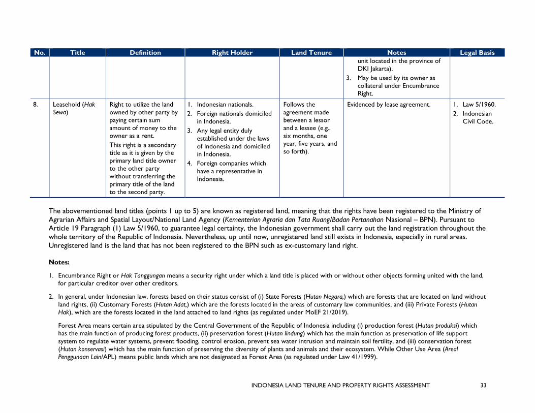
INDONESIA LAND TENURE AND PROPERTY RIGHTS ASSESSMENT 33
No. Title Definition Right Holder Land Tenure Notes Legal Basis unit located in the province of DKI Jakarta).
3. May be used by its owner as collateral under Encumbrance Right.
8. Leasehold (Hak Sewa)
Right to utilize the land owned by other party by paying certain sum amount of money to the owner as a rent. This right is a secondary title as it is given by the primary land title owner to the other party without transferring the primary title of the land to the second party.
1. Indonesian nationals. 2. Foreign nationals domiciled
in Indonesia. 3. Any legal entity duly
established under the laws of Indonesia and domiciled in Indonesia.
4. Foreign companies which have a representative in Indonesia.
Follows the agreement made between a lessor and a lessee (e.g., six months, one year, five years, and so forth).
Evidenced by lease agreement. 1. Law 5/1960. 2. Indonesian
Civil Code.
The abovementioned land titles (points 1 up to 5) are known as registered land, meaning that the rights have been registered to the Ministry of Agrarian Affairs and Spatial Layout/National Land Agency (Kementerian Agraria dan Tata Ruang/Badan Pertanahan Nasional – BPN). Pursuant to Article 19 Paragraph (1) Law 5/1960, to guarantee legal certainty, the Indonesian government shall carry out the land registration throughout the whole territory of the Republic of Indonesia. Nevertheless, up until now, unregistered land still exists in Indonesia, especially in rural areas. Unregistered land is the land that has not been registered to the BPN such as ex-customary land right. Notes:
1. Encumbrance Right or Hak Tanggungan means a security right under which a land title is placed with or without other objects forming united with the land, for particular creditor over other creditors.
2. In general, under Indonesian law, forests based on their status consist of (i) State Forests (Hutan Negara,) which are forests that are located on land without land rights, (ii) Customary Forests (Hutan Adat,) which are the forests located in the areas of customary law communities, and (iii) Private Forests (Hutan Hak), which are the forests located in the land attached to land rights (as regulated under MoEF 21/2019).
Forest Area means certain area stipulated by the Central Government of the Republic of Indonesia including (i) production forest (Hutan produksi) which has the main function of producing forest products, (ii) preservation forest (Hutan lindung) which has the main function as preservation of life support system to regulate water systems, prevent flooding, control erosion, prevent sea water intrusion and maintain soil fertility, and (iii) conservation forest (Hutan konservasi) which has the main function of preserving the diversity of plants and animals and their ecosystem. While Other Use Area (Areal Penggunaan Lain/APL) means public lands which are not designated as Forest Area (as regulated under Law 41/1999).

INDONESIA LAND TENURE AND PROPERTY RIGHTS ASSESSMENT 34
3. State Land or Tanah Negara means land that is directly controlled by the State and has not been given with any land right.
4. (1) means it can be given over State Land.
5. (2) means it can be given over Right of Ownership (Hak Milik/HM).
6. (3) means it can be given over Right to Manage (Hak Pengelolaan/HPL).
7. (4) means that the Local Land Offices (BPN at regional level), at least in Central Jakarta and South Jakarta, have not yet issued certificates of HPSRS or implemented the regulations.

INDONESIA LAND TENURE AND PROPERTY RIGHTS ASSESSMENT 35
ANNEX 2: GENDER RELATED SITUATION ANALYSIS AND RECOMMENDATIONS
GENDER INEQUALITY IN INDONESIA
Indonesia’s Human Development Index (HDI) value for 2017 is 0.694 (which put the country in the medium human development category) positioning it at 116 out of 189 countries and territories, tied with Vietnam. Between 1990 and 2017, Indonesia’s HDI value increased from 0.528 to 0.694, an increase of 31.4 percent (UNDP, 2018).
The Gender Related Development Index (GDI), based on the sex-disaggregated HDI, is defined as a ratio of the female to the male HDI. The GDI measures gender inequalities in achievement in three basic dimensions of human development: health (measured by female and male life expectancy at birth); education (measured by female and male expected years of schooling for children and mean years for adults aged 25 years and older); and command over economic resources (measured by female and male estimated gross national income per capita).
The 2017 female HDI value for Indonesia is 0.666 in contrast with 0.715 for males, resulting in a GDI value of 0.932. In comparison, GDI values for China and Philippines are 0.955 and 1.000 respectively
The Gender Inequality Index (GII) reflects gender-based inequalities in three dimensions: reproductive health, empowerment, and economic activity. Reproductive health is measured by maternal mortality and adolescent birth rates; empowerment is measured by the share of parliamentary seats held by women and attainment in secondary and higher education by each gender; and economic activity is measured by the labor market participation rate for women and men. The GII can be interpreted as the loss in human development due to inequality between female and male achievements in the three GII dimensions.
Indonesia has a GII value of 0.453, ranking it 104 out of 160 countries in the 2017 index. In Indonesia, 19.8 percent of parliamentary seats are held by women, and 44.5 percent of adult women have reached at least a secondary level of education, compared to 53.2 percent of their male counterparts. For every 100,000 live births, 126 women die from pregnancy-related causes and the adolescent birth rate is 47.4 births per 1,000 women aged 15 – 19. Female participation in the labor market in Indonesia is 50.7 percent compared to 81.8 for men. In comparison, China and Philippines are ranked at 36 and 97 respectively on this index.
GENDER EQUALITY AND GENDER MAINSTREAMING POLICIES IN INDONESIA
The 1945 Constitution of the Republic of Indonesia does not specifically distinguish citizens as female or male but has the spirit of equality. The Constitution also serves as one of the basic legal foundations for women’s rights in Indonesia. Article 27 (1) articulates that “All citizens shall be equal before the law and the government and shall be required to respect the law and the government, with no exceptions.” Article 27 (2) states that: “Every citizen shall have the right to work and to earn a humane livelihood.”
Indonesia has signed the Convention on the 1979 Convention on Elimination of All Forms of Discrimination against Women (CEDAW) and ratified it in 1984. This means that Indonesia has to implement Article 14 of CEDAW, which states that “State Parties shall take all appropriate measures to eliminate discrimination against women in rural areas ..... and … shall ensure to such women the right … to have access to … and equal treatment in land and agrarian reform as well as in land resettlement schemes.”

INDONESIA LAND TENURE AND PROPERTY RIGHTS ASSESSMENT 36
A new approach based on gender equality was introduced in the 1999 Guidelines on State Policy (GBHN). The 1999 GBHN states that women’s empowerment is achieved by improving women’s role and status in national life through national policy implemented by institutions that struggle for the actualization of gender equality and justice. Under the leadership of President Abdurrahman Wahid, there was a significant move toward gender equality and women’s empowerment. A major outcome of his leadership was the National Plan of Action to Empower Women, running from 2000 to 2004. During his leadership, Presidential Instruction No. 9/2000 was enacted, stating that all ministries and government agencies, including district and provincial offices, are to conduct gender mainstreaming. This decree was followed by gender awareness program and capacity building program for high officials of the ministry’s offices and all government agencies.
The process of gender mainstreaming, however, had not taken a full stride until the introduction of gender responsive budgeting (GRB) in Indonesia. GRB was officially introduced through the Minister of Finance Regulation of 2009, followed up by the development of GRB in the budgeting system in seven pilot ministries. These seven ministries include four technical ministries (Ministries of Agriculture, Education, Health, and Infrastructure), and three coordinating ministries (Ministries of Finance, Women’s Empowerment and Child Protection, and the National Planning Agency). As a next step, other ministries and state agencies were requested to submit gender budget statements as appendices in their annual work plan budget. In these gender budget statements, they outlined gender inequalities or gaps that they planned to address in their programs and activities in accordance to their strategic planning document. The Minister of Finance Regulation of 2009 was followed by the Minister of Finance Regulation of 2012, which further elaborated guidelines for work plan and budget preparation and review for state ministries/institutions.
Presidential Regulation No. 2 of 2015 on the National Medium-Term Development Plan 2015 – 2019 stipulates that gender mainstreaming is one of the cross-cutting issues in national development. This regulation has also been used to establish performance indicators of each ministry, national state agency, and local government in the implementation of gender mainstreaming.
Goal 5 of the Sustainable Development Goals (SDGs) is one of the international policies that plays a significant role for the realization of the recognition and protection of women’s rights to communal forests, agrarian land and resources in rural and customary territories. In the case of Indonesia, Goal 5 of the SDGs and other goals that have gender dimensions are starting to be referred in the formulation of national and sub-national policies and programs on development of natural resources, which includes forest lands and resources.
NATIONAL LEGAL FRAMEWORK FOR WOMEN’S PROPERTY RIGHTS
The Constitution, adopted in 1945 and last amended in 2002, does not have a specific article on women’s property rights. However, Article 28H (4) states: “Every person shall have the right to own personal property, and such property may not be unjustly held possession of by any party.”
The 1974 Marriage Law is a single marriage law that governs all Indonesian people regardless of religion or ethnicity. Article 35 of this Marriage Law includes the concept of joint ownership of property purchased during the marriage. Article 35 (2) states that property obtained as a gift or inheritance as well as property purchased before marriage are separate property (owned by the recipient). Article 36 articulates that every person who is bound in marriage has control over his or her own property, which is a gift or inheritance, or is purchased before marriage. The Marriage Law also regulates that every person who is bound in a marriage has the right to transfer ownership of property obtained together during the marriage period (for example by selling or giving it as a gift) as long as it is agreed by the partner. The law also allows married couples to carry out prenuptial agreements to make statements

INDONESIA LAND TENURE AND PROPERTY RIGHTS ASSESSMENT 37
about their own property separately. However, prenuptial agreements are not yet common in rural Indonesia.
Land inheritance rights are governed by the 1847 Civil Code in the case of non-Muslims and by Islamic law in the case of Muslims. The 1847 Civil Code provides for equal rights to inheritance. The compilation of Islamic law codifies the Islamic law and is used as the basis for legal decisions made by religious courts which have jurisdiction over family law, inheritance, and divorce matters for Muslims.
The Basic Agrarian Law (BAL) no. 5 Year 1960, article 9 paragraph (2) states that every Indonesian citizen, both men and women, have equal opportunity to rights to land and to benefit for both for themselves and their families. On that basis, land rights of men and women are equal in the eyes of the law.
Recent research on women’s empowerment in agriculture that took place in Jogjakarta and South Sumatra, however, found that female research subjects were mostly unaware of their land ownership status. Many of them mentioned that they own the land, but were unsure whether the land was formally registered under their names. In general, most of them believed that all family resources were owned by both husband and wife, and considered it unnatural for assets or decision-making about assets to be split after marriage (Akter et al., 2017).
GENDER AND ACCESS TO LAND
Women of different social status and classes have certain forms of relationship in managing lands and resources. One woman may have access to variety of different plots of land, ranging from her own land(s), her husband’s land(s), her conjugal land(s), and her relative’s or neighbor’s land(s), as well as state lands. Multiple identities carried by one woman, including her marital status, socioeconomic class, age, occupation, and other factors, influence her position in the daily application of forest tenure and forest governance at the household, clan, and community levels.
Women from various backgrounds have important roles to play in managing land and forest resources, and have various forms of connections with them. A woman may have access to plots of land with different statuses, for example: land owned by the woman herself (both as inheritance from her parents or land bought before the woman was married), land owned by her husband (which is inherited from the husband’s parents), or land bought together with her husband once they were married. This situation exists for women from certain social classes who have inherited land and/or have managed to buy land for themselves. For women from poor families, especially those from landless families, they may access land from relatives or neighbors by operating as field workers. In certain regions, one form of access to land for landless women is claiming state land where women are hired as workers.
In everyday life, to obtain and maintain access to land and forest resources, women must negotiate with stakeholders close to them who have control over those land and forest resources. In some cases, women from the middle classes of masyarakat adat must negotiate with members of their families who have control over land, from their own husbands to their elder brothers and other close male relatives. For poor adat women, especially for those from landless families, in the framework of obtaining and maintaining access to the land that they work on, either as assisting or full-time laborers, they must negotiate with customary leaders and informal leaders in their village who have control over certain areas of customary land. If these landless women work on land that is claimed as state land and is managed by certain government institutions (national parks, state-owned enterprises like Perhutani and Inhutani, private companies with concession permits for natural resources such as permits for forestry companies, industrial crops, oil palm plantations, mining), then the women must negotiate with those stakeholders as well. The stakeholders mentioned so far apply control over land and natural resources via various mechanisms, processes, and social relations. Landless men and men from other marginalized

INDONESIA LAND TENURE AND PROPERTY RIGHTS ASSESSMENT 38
groups face a similar situation. However, women face more problems when they enter the negotiation process with stakeholders who have control over land. Several studies have found that many women face a range of forms of discrimination when they come face-to-face with other stakeholders in the negotiation process (Siscawati & Mahaningtyas, 2012).
The processes mentioned above occur via various mechanisms and involve various actors who all work within networks of power that exclude adat communities and certain local communities, both women and men, from accessing land and the customary territories that were previously in their hands. Exclusion of power works via various processes and actors, including the state, corporations, and other stakeholders involved in the extraction of natural resources. This exclusion results from the creation of strategic policies that are related to market forces, enforced via violence and threats of violence toward communities in the process of dispossession of land as well as various forms of legitimacy, including legitimacy that stems from the community itself and/or close relatives, known as “intimate exclusion” (Hall, Hirsch, & Li, 2011).
GENDER MAINSTREAMING IN FOREST-RELATED POLICIES
The Ministry of Environment and Forestry has incorporated gender as an important aspect in the development of the forestry sector. Gender mainstreaming in the forestry sector is aimed to increase the quality of women’s participation and utilization of development for men and women as well the marginalized group.
Gender mainstreaming in the forestry sector began a few years after the issuance of Presidential Instruction on Gender Mainstreaming in 2000. It began with the issuance of Minister of Forestry Decree No. 528 in 2004 on the implementation of the guidance of gender mainstreaming in the development of forestry sector.
The next step of gender mainstreaming by the Ministry of Environment and Forestry was the enactment of the Regulation P.65/Menhut – II/2011 dated October 11, 2011 on guidelines for gender-responsive planning and budgeting in the forestry sector as a revision to Minister of Forestry Decree number 528 of 2004. This new ministerial regulation emphasized that the development of the forestry sector in realizing national development should be “pro-poor, pro-jobs, and pro-environment.” This approach has strong gender dimension that need to be addressed with further gender-related actions. The 2011 Ministerial Decree was later replaced by the Minister of Forestry Regulation on the guidance of the implementation of gender mainstreaming in the environment and forestry sector, enacted in 2017.
National policies on gender equality and women’s empowerment in Indonesia have contributed to the development of gender mainstreaming policies within the forestry sector. Nevertheless, national forest tenure reform policies, programs, and schemes only adopt a perspective of gender equality and women’s empowerment in a very limited form. Government agencies that are part of the development and implementation of forest tenure reform have not adequately applied the perspective of gender equality and women's empowerment in their activities.
Forest tenure reform at the provincial and district levels is marked with the implementation of gender-neutral national forest tenure reform policies and programs at landscape level. In other words, gender equality and women’s empowerment perspectives have not been applied.
Across Indonesia there appears to be a slow if sporadic trend to increase women’s empowerment related to land tenure and property rights. Three examples illustrate this, albeit from the perspective of isolated examples:
• In South Sulawesi, smallholder cocoa farmers unhesitatingly report that all related finances must be held by women who in turn have a say in what the money is spent on;

INDONESIA LAND TENURE AND PROPERTY RIGHTS ASSESSMENT 39
• An ongoing case in a community forestry site in Lampung Province indicates significant women’s participation in decision making at household and community level. Gendered access to education at the micro-scale has been slowly increasing after the implementation of forest tenure reform schemes in Lampung. This relates to increasing income from forest lands that have been secured through the issuance of permit of certain scheme of forest tenure reform (Siscawati, 2019) and
• During participatory land use zonation in state and private land in Aceh Province, village women readily took up the invitation to contribute, often displaying more knowledge than the men about NTFPs and medicinal plants as well as the need to allocate land for their conservation.
RECOMMENDATIONS
Increasing women’s engagement on land tenure and property rights follows many of the same principles:
1. Provide outreach and awareness campaigns on women’s equal rights to land and property and the benefits of registering these rights.
2. Provide support for the development and implementation of legal reforms on land tenure and property rights promoting a gender equality perspective.
3. Develop collaborative work with government, business actors, and community groups to ensure that all phases of land-based development projects consider, respond to, and uphold equal property rights of women. Such approaches may include ensuring that outreach is targeted to family units rather than household heads; promoting documentation of specific approaches taken to reach women through focus groups, separate meetings, or striving for equal representation at meetings; signing contracts with outgrower farmers jointly between men and women; transferring payments in the names of both men and women; and providing extension services targeted specifically at areas of daily work or the agricultural season that women are likely to be most focused on (e.g., family decisions over sanitation, decisions over land-use in vegetable gardens, packaging and selling products, and even tenure rights associated with informal businesses and markets).
4. Provide support to the enforcement of tenure and property rights for women which may be through the use of paralegals or training of local courts on gender and land rights issues.
5. Ensure gender-disaggregated data on land tenure and property rights is collected.

INDONESIA LAND TENURE AND PROPERTY RIGHTS ASSESSMENT 40
ANNEX 3: AMPLIFYING AND SUSTAINING THE POTENTIAL OF COMMUNITY FORESTRY LAND RIGHTS IN INDONESIA
PIONEERING FORESTRY AGENTS, INNOVATIVE LOCAL GOVERNMENT AND PATIENT CIVIL SOCIETY ORGANIZATIONS
In the early 2000s, during the post-euphoric era of the 1998 regime change, forestry and other government institutions withdrew from the reformist agenda, in part because of rampant illegal logging blamed upon overly zealous decentralization. Ironically, all the regional heads had done was mimic the past practices of the center and enjoyed forestry land rents, admittedly in a more haphazard way. The media spotlight fell more often upon illegal logging laborers and their log loads than those who bankrolled the process, let alone absent forestry law enforcers. At this time, community-based forest resource management rapidly fell out of favor and the pace of policies supporting community-rights slowed. Nonetheless, thanks to the pioneering efforts of a few government forestry officials, innovative local government and grassroots support from civil society organizations, some community forests transitioned from de facto to de jure empowerment. Two examples stand out as emblematic of the social, environmental, and economic benefits of a sense of shared ownership by local communities in SFAs, thereby fostering sustainable agroforestry instead of allowing open-access exploitation. These cases led to the restoration of degraded protection and production forest areas by smallholder agroforestry farmers after they were granted formal leasehold licenses. Leasehold persuaded the communities to introduce their private and sustainable agricultural land management practices.
CASE 1: FROM COMMUNITY FORESTRY TO ECOTOURISM
The case of Kalibiru (sub-village of Hargowilis, Kabupaten Kulonpgrogo, Jogjakarta Province) demonstrates the benefits of securing land access (see Figure 10).
Figure 9: Kalibiru, private smallholder agroforest (left background, LB) and state protection forest (right background, RB). Forest cover (LB) and food-crop areas as well as abandoned scrubland (RB) before HKm community forestry license, 2000. Kulonprogo District, DI Jogjakarta
Figure 10 (left to right): a. Inhutani Production Forest. Scrubland, minimal land use. Sintang District, West Kalimantan Province, 2002; b. Inhutani Production Forest. Fires for livestock grasslands spread uncontrolled across the landscape, 2002; c. Smallholder farmer managed fire to prevent spread beyond his scrubland plot. Adjacent to Inhutani Area, smallholders control fires to prevent spread to neighbors’ plots, 2002; d. Smallholder farmer manages fire to prevent spread beyond to neighbor’s rubber trees. Sanggau District, West Kalimantan Province, 2002

INDONESIA LAND TENURE AND PROPERTY RIGHTS ASSESSMENT 41
Facilitated by the NGO DAMAR, Kalibiru community was granted a temporary five-year community forestry lease (Hutan Kemasyarakatan, HKM) following a five-year process. Once the community was granted a full 35-year HKM, their behavior changed immediately. Based upon smallholder agroforestry, state protection forest (Hutan Lindung) where conventional reforestation had failed repeatedly and only short-term food crops were planted (Figure 11), the community soon planted trees such as mahogany, teak, melinjo, jackfruit and various other fruit trees (Figure 12). Mostly funded by the smallholder farmers themselves, food crops were intercropped before the tree canopies closed. Local smallholder agroforestry farmers cared more intensively for their land than in industrial timber plantations. Indigenous technology for drip irrigation of the rocky soil was applied (Figure 13). Within a few years the protection forest area resembled the agroforests of the private land (Figure 14), providing benefits in situ as well as protecting water resources for the downstream Sermo water reservoir, a protection forest finally functionally-worthy of its formal status.
Though these activities were initially regarded with suspicion by the forestry service agency (Dinas Kehutanan), they soon began to proudly report on the community forestry development success at Kalibiru. Senior officials and then-Ministers of Forestry visited the site. In parallel, an unexpected positive development was that Kalibiru became a local tourist destination, first for its spectacular views to the Sermo reservoir and the south Java coast beyond and then for the facilities installed by the local community such as ziplining, food, and home-stay accommodations. Over an eight-year period, tourist visits grew to hundreds of thousands per annum (see Table 2). Modest visitor fees allowed the community to expand its ecotourism services to include bird watching (Rp10,000 for Saturdays and Sundays; Rp5,000 for weekdays). Recently, other villages in the area have mimicked the ecotourism, promoting regional development. By 2018, the forest cover in the
previously denuded protection forest was fully established and barely distinguishable from the adjacent private agroforests.
Figure 11: Kalibiru, pre-HKM - Only short-period food crops cultivated, e.g., cassava, corn, soybeans. Note the white Protection Forest border marker (private agroforest in the background). Hargowilis, Kulonprgogo District, Jogjakarta Province. 2000.
Figure 12: Kalibiru, HKM 5-year preliminary license – Immediate investment in tree planting (mahogany tree seedlings), interplanted with food crops that are eventually shaded out by expanding tree canopies. 2006.
Figure 13: Kalibiru, HKM 5-year initial license - Drip irrigation. 2006.
Figure 14: Kalibiru, HKM 35-year license - Compare HKm area in state protection forest with pre-HKM of food crop areas as well as abandoned scrubland. 2018.

INDONESIA LAND TENURE AND PROPERTY RIGHTS ASSESSMENT 42
TABLE 2. VISITORS TO HKM COMMUNITY FOREST IN KALIBIRU, HARGOWILIS, KULONPROGRO, DI JOGJAKARTA
YEAR TOTAL AVERAGE/MONTH PERCENT CHANGE
2010 7,167 717 - 2011 13,039 1,087 52 2012 19,012 1,584 46 2013 19,762 1,647 4 2014 79,137 6,595 300 2015 309,541 25,795 291 2016 443,070 36,923 43 2017 355,498 29,279 -27
Source: HKM Kalibiru
CASE 2: FROM COMMUNITY FORESTRY TO PAYMENTS FOR ENVIRONMENTAL SERVICES
HKM in a cluster of villages on Lombok island in West Lombok District, Nusatenggara Barat Province, followed a comparable trajectory of agroforestry development in state forest areas (Desa Sesaot, Lembah Sempaga, Sedau in Sub-district Narmada and Desa Batu Mekar in sub-District Lingsar). This was an outcome of formally recognized shared ownership, but with different positive multiplier effects. Assisted by the national NGO Lembaga, Penelitian, Pendidikan dan Penerangan Ekonomi and Sosial and local NGO Konsepsi, HKM Sesaot had both allies and detractors within the forestry service agency and local government, though ultimately all of these stakeholders came together.
In the Sesaot cluster of rural villages on the side of Mount Rinjani, community forestry transformed the state forest landscape from degraded, fire-prone bush and grassland to agroforestry that reduces local poverty while supporting wider regional economic growth. The key to was to promote socially inclusive, economically viable and environmentally beneficial outcomes as a result of formal leasehold rights to communities in state forest areas through HKMs, persuading them to replace short-term smallholder vegetable-growing with multi-story tree-based farming systems that resemble those in their nearby private land plots (Figures 15 – 18). These kinds of agroforestry systems provide subsistence needs with surplus for market (fruits, spices, and vegetables) as well as cash crops, notably coffee, and are the major source of income for local households.
Initially, of the combined total of 9,000 households (population 25,000), only 60 were granted a temporary HKM license for 25 hectares of scrub and bush land until they proved that they could successfully reforest the area. Even then some years
Figure 15: Sesaot, Pre-HKM license - Scrubland and grassland State Production Forest. West Lombok District, NTB Province, 1997.
Figure 16: Sesaot, HKM preliminary license – Smallholder land clearing and adaptive terracing that traps any soil run-off and later becomes suitable for tree planting.1997.

INDONESIA LAND TENURE AND PROPERTY RIGHTS ASSESSMENT 43
passed before they obtained the full 35-year license. By 2006, the HKM covered 210 hectares and included 1,224 households. Some 3,000 households (access prioritized for the landless poor farmers and widows) are now inside the community forestry system under smallholder farmer management. Community forestry success resulted in the development of a regional regulation (Peraturan Pemerintah) to enable HKM across the district. This occurred in spite of initial false accusations that the HKM holders were carrying out illegal logging in other state mahogany forests.
Forced by the local forestry service agency (Dinas Kehutanan) to plant timber trees interspersed with their traditional tree and vegetable crops, the HKM agroforestry farmers have not been granted timber-harvesting rights. Even now that the timber trees are over 100 feet tall, the
forestry agency refuses to allow the HKM farmers even a small share in the sale price of the timber. In recent years some forestry agencies sought to reclassify the area from protection forest (designated for water and soil conservation) to conservation/Taman Hutan Raya (for recreation and research) that would annul the HKM license and prevent any additional areas being licensed as HKM. Lobbying by the villagers assisted by the NGO Konsepsi, including delegations to the Minister of Forestry in Jakarta, finally resulted in the Ministry backing down but insisting on a validation re-mapping exercise.
With respect to impacts on younger generations, community forest management is not adequate to counter migration trends away from village life to Mataram City or to service the coastal tourist industry, reflecting a broader challenge in terms of developing rural areas for the future. Again with support from Konsepsi, the community foresters began to add value to the agroforests by obtaining payments for environmental services (PES). The local state drinking water company now offers PES payments to the four village communities of about Rp 600 million per year to encourage sustainable land use and natural resource management. Moreover, private entrepreneurs have established micro-hydro units, selling power to the local utility and rewarding the upstream HKM holders.
RESPONSIBLE COMMUNITY FORESTRY MANAGERS
In neither the case of Kalibiru nor Sesaot have local communities taken advantage of their community forestry success and its ancillary benefits to argue for privatization. Possessing legal access licenses (HKM) and freedom from the risk of eviction, communities have generally accepted that this kind of security of access is more important than lobbying for full ownership.
Figure 17: Sesaot, HKM 5-year preliminary license – Smallholders with minimal external assistance establish agroforest as in village private land. 2000.
Figure 18: Sesaot, HKM license 35-year – Multi-story agroforestry with subsistence (e.g., bananas, yams, medicinals) and cash crops (coffee, pepper, spices, petai trees) with acacia (sengon) trees ready for harvest. 2014.

INDONESIA LAND TENURE AND PROPERTY RIGHTS ASSESSMENT 44
COMMUNITY FORESTRY PROSPECTS FROM INDONESIA’S GROWING SPATIAL DEMOCRACY
The main breakthrough for community forestry came in 2014 with the new cabinet and signals from the highest level in support of social forestry. The national Social Forestry Program (consisting of HKM and four other types of community-based forest management) has led to an unprecedented increase in community forestry licenses. Some argue that this will fail without subsequent external capacity-building and management plans, but spatial certainty alone has spurred local communities to find their own ways to maintain agroforests as well as to innovate by adding value to their licensed land as described above for Kalibiru and Sesaot. Greater spatial certainty has emboldened communities to safeguard their licensed areas from outside threats, refusing to yield to the lure of short-term gains at the expense of sustainable agroforestry. For example, HKM license holders in Aceh Selatan have prevented encroachment by gold miners and in Katingan District in Central Kalimantan, HKM holders have been emboldened to resist attempts to convert to oil palm monoculture.
A wide array of inter-related initiatives are combining to increase spatial certainty for local communities that conform to existing Indonesian laws, but are innovative nonetheless, e.g., participatory land use zonation in state forest areas, and village boundary setting and zonation within village development plans. The result is an emergent phenomenon for more efficient and effective licensing and management of community forests. Roles, rights, responsibilities, and relationships among communities and other stakeholders are thereby becoming clearer. Spatial certainty for increasing numbers of local communities is greater and hence their willingness to invest in long-term sustainable community forestry rather than short-term extraction. While some policies still undervalue their products such as trade restrictions, community forestry managers have other means of adding value such as through PES or ecotourism (see above). Some local governments are supportive of the village development funds being deployed for environmental management. Indeed, per unit area, more funds are becoming available for village development planning than to forestry agencies. Secure community forestry licenses provide opportunities for communities to invite more cash-strapped forestry agencies to collaborate, to build capacity for responsible forestry resource management.
That said, there remain structural constraints to sufficient spatial certainty for communities to invest in sustainable agroforestry. For example, under the FMUs, there are more restrictive procedures for community forestry than HKM and Hutan Desa, (e.g., 10 to 15 year leases under Kemitraan in comparison with 35 years for HKM). Be that as it may, the current policy sentiment in support of community forestry, nationally and regionally, remains high.
But can this present degree of support for community forestry be expected to continue? For this reason, it is paramount that the outcomes of community forestry be monitored and evaluated objectively so that the nature of their successes and failures be better understood as well as how they compare with alternative approaches to community-based natural and forestry resource management in Indonesia. Not only is it important to compare and contrast what is known but also to recognize the knowledge gaps that need to be filled. It will be important to stress the importance of certainty of land access to incentivize investment in land use sustainability as well as related multiplier effects that add value to such efforts.

INDONESIA LAND TENURE AND PROPERTY RIGHTS ASSESSMENT 45
ANNEX 4: SCHEDULE OF MEETINGS AND NOTES
Interview notes from the Land Tenure and Property Rights Assessment (LTPR) identify the key findings, alongside participant names & institutions with email and mobile phone contact information as well as date(s) of interviews. Main Points are outlined, followed by relevant notes on their LTPR implications for the assessment. Unless otherwise specified, all interviews were in Jakarta, Indonesia. Most interviews were set up using an introductory letter signed by the USAID Environment Office.
Notes template
INSTITUTION = ABC, 2019 Month Date
# = Interview No. Name (Abc), Position (Abc) (contact information, [email protected])
Main Points
- .
- .
LTPR Implications
- .
- .
TABLE 1. USAID OFFICE AND USAID PROGRAM INTERESTS IN TENURE ISSUES USAID OFFICE # USAID PROGRAM #
ENVIRONMENT - One Map - RPJMN - Village boundary setting - Forestry re-centralization - Private sector role - Lessons from USAID-
IUWASHPLUS
01 USAID-IUWASHPLUS - Space for water aquifer replenishment
wells, meters and pipes, waste processing infrastructure
- Lack of land security as collateral for microfinance for water and sanitation infrastructure
DEMOCRATIC RESILIENCE & GOVERNANCE
- Key role for Free, Prior, and Informed Consent (FPIC)
- Public access to spatial planning information especially where industrial and infrastructure development
03 USAID-LESTARI - SIMTARU & SST spatial planning and
licensing transparency - ATR Minister restricting oil palm
license information reducing effectiveness of One Map
- FPIC smallholder peatlands private land for canal blocking to keep soil wet during dry season and reduce risk of fire.
- License proliferation (social forestry), but capacity and oversight lacking
05 23

INDONESIA LAND TENURE AND PROPERTY RIGHTS ASSESSMENT 46
USAID, 2019 July 30
#01 Matt Burton ([email protected]), James Halperin ([email protected]), Angga Rachmansah ([email protected])
Main Points
GENDER - USAID Women’s
empowerment policies - Inclusion policy - Indigenous/customary people
02 15
ENVIRONMENT - Village funds for environmental
management - Shared-learning approaches
04 USAID-BIJAK - BAPPENAS thinking to allocate 15
million Ha of SFA to Private land - Development of Essential Ecosystem
Land outside SFA - Potential for Villages Funds not just for
infrastructure but improved land use allocation
- Environmental Index for budget allocations to Districts
- Unable to encourage reform of Law 5/1990 on conservation
19
HUMAN CAPACITY PARTNERSHIP Private sector efficiencies through land aggregation constrained by the 25 ha cap on individual private land, effect on productivity and markets
14
ENVIRONMENT Upper catchment protection for mini-hydro investments
16 USAID-ICEDII Upper catchment land areas considered too problematic for assistance to mini-hydro, main renewable energy support
21
ENVIRONMENT - Eminent domain rules for
infrastructure projects - Useful to know what we don’t
know and important future access points
- High-level information and accessible to USAID offices
- Keep Indonesian LTPR audience in mind
17
HEALTH - Public Health services
constrained by lack of land collateral for loans
20

INDONESIA LAND TENURE AND PROPERTY RIGHTS ASSESSMENT 47
- Experiences of other donors such as MCC’s village boundary setting. Inter-District boundaries also an issue, e.g., Sorong District, West Papua province.
- Clear cross-cutting relationship of LTPR in democracy and environment offices.
- Lessons from IUWASPLUS.
- To what extent are LTPR recognized in the new RPJMN?
- One Map getting USAID support, aimed at input to resolving land conflict, but what is the present situation?
- USAID-SEA significant successes finding marine space for fishing communities.
- Outcome of recentralization of forestry from District to Province?
- Potential role of private sector.
- LTPR not more than 25 pages, not including Annexes.
- LTPR not expected to be a publicly-accessible document, primarily input for the Concept Note for CDCS 2020-24.
LTPR Implications
- Balance between detail and accessible brevity for the LTPR assessment report to inform the Concept Note for the CDCS.
USAID, 2019 July 30
#02 James Halperin (above) with Angga Rachmansah (above), Jipy, GENDER ([email protected]), Mispan
Main Points
- LTPR as input to the USAID Concept Note for preparation of CDCS 2020-2024 to include climate change, gender, biodiversity and tropical forest conservation in the context of the country economy.
- LTPR to follow USAID policies on the Journey to Self-reliance and (to a lesser degree) the Indo-Pacific Strategy and be aligned with the RPJMN and its adoption of SDG’s. Also, refer to the USAID document on inclusive development.
- Take into account USAID’s women’s empowerment and prosperity policies, identifying barriers to LTPR.
- Indigenous peoples. USAID Inclusion Policy.
- Recognition of the general cross-cutting nature of LTPR in USAID programs.
USAID, 2019 July 30
#03 Dondy Sentya ([email protected]) & Luthfi Ashari ([email protected]) Office of Democratic Resilience & Governance

INDONESIA LAND TENURE AND PROPERTY RIGHTS ASSESSMENT 48
Main Points
- USAID Empowering Access to Justice (MAJU) project meets challenge of the planned industrial development in Jayapura District be enabling after a long struggle to obtain the District’s spatial plan (RTRWK) through legal action citing Law 14/2008 on Public Information Availability.
- Applying the principle of FPIC. Note Joko Widodo when mayor of Solo had consultative meetings with inhabitants of Solo about finding suitable space for informal street-side food vendors (kaki lima); held 12 such consultations for the same reason when mayor of Jakarta. Striving to capture greater local voice ahead of major developments is essential, especially when displacement is anticipated.
- Need to consider fiscal incentives for improved LTPR such as the DAK.
LTPR Implications
- Potential for closer collaboration with USAID-LESTARI supporting the spatial planning information system (SIMTARU) and sustainability screening tool (SST) in the provincial capital with ready access to RTRWK Jayapura District.
USAID, 2019 July 30,
#04 James Halperin
Main Points
- Value of share-learning processes as demonstrated by NGO Lingkar Temu Lestari Kabupaten (LTLK) in South Sumatra, West Kalimantan and South Sulawesi provinces
- Potential for more environmental use of Dana Desa funds.
LTPR Implications
- Need to achieve shared learning not only about successes but also failures, e.g., past World Bank land certification projects.
- Increasing interest in greater use of Dana Desa for environment-related funding, not just infrastructure, especially roading.
LEMHANNAS (The National Resilience Institute of the Republic of Indonesia); Principal Academic Advisor to Indonesian School of Government & Public Policy (SGPP), 2019 July 30
#04 Governor, Agus Widjojo ([email protected]), Manan Firmansyah ([email protected])
Main Points
- LTPR is not part of the curriculum for senior civil servants.
- Recommends that what is a key feature about resolving LTPR issues is a “willingness to listen”.
LTPR Implications
- Willingness to listen relates to USAID policy on inclusion.

INDONESIA LAND TENURE AND PROPERTY RIGHTS ASSESSMENT 49
USAID-LESTARI, 2019 July 30
#05 Blair Palmer, Stakeholder Engagement, USAID-LESTARI ([email protected],)
Main Points
- Transparency of licensing information backward step with Minister ATR refusal to make oil palm concession information publicly available, limiting the effectiveness of One Map.
- Impressive record of NGO LTKL to encourage shared learning about development experience at the District level.
- LESTARI implementation of FPIC in Central Kalimantan peatlands in smallholder private land for canal blocking to keep soil wet during dry season and reduce risk of fire.
LTPR Implications
- Minister ATR information in the broadly-defined, “national interest” will have a chilling effect on efforts to increase availability of government-held information about land use, slowing adoption of good land governance essential for the journey to self-reliance.
- As a general rule, shared-learning a singular lack of major donor assistance in Indonesia, too often tagged on at the end of projects when too late for course correction and inter-initiative learning. Institutional memories tend to be short. Lost opportunities for the Journey to Self-reliance.
MOE, 2019 July 31
#05 Marzuki Oesman ([email protected]), Ex-Minister of Forestry; Ex-Director Centre for Policy & Implementation Studies (Harvard Institute for International Development, HIID - CPIS), Rimun Wibowo ([email protected])
Main Points
- Interest in reviving the idea of a Policy Study Centre that compares different development pathways in terms of their expected economic, environmental and equity impacts.
- Warns of increasing indebtedness to China through infrastructure projects especially roads. How to invite other FDI?
- Application to World Bank’s Bio Carbon Fund Initiative for community-forestry investment in ex- Forest Concession, Balai Rejo village, Tebu, Jambi.
LTPR Implications
- Better land governance invites a broader mix of FDI.
- Important to link closely any policy studies closely with field experience.
THE TENURE FACILITY, Stockholm, 2019 July 31
#06 Antoinette Royo, Director ([email protected])
INDONESIA LAND TENURE AND PROPERTY RIGHTS ASSESSMENT 50
Main Points
- AMAN, KPA currently well-funded (US$1 million) to lobby for customary domain acceptance in Indonesia thus that the two current land domain types (private and SFA) release customary domains to create a third domain for stewardship, Wilayah Adat, in line the Constitutional Court Decision (MK35/2013). Best for USAID not to enter this politically-charged policy territory.
- Important, however that Wilayah Adat subscribe to principles of good land governance, transparency, participation, accountability, responsiveness and timeliness.
- Significant indigenous knowledge for sustainability can be mobilized where long-term certainty of land access for customary peoples, enhanced by integration with modern land use techniques.
LTPR Implications
- The above latter two are appropriate for USAID assistance.
WORLD BANK, 2019 Aug 01
#07 Andrew Mason, East Asia Pacific, Acting Chief Economist ([email protected])
Main Points
- According to World Bank 10-country, East Asia has enjoyed high growth despite slowing somewhat as result of 2008 global financial crisis.
- Aggregate impressive growth but challenge of ensuring inclusive growth. The study did not include issues of rural urban immigration, though accepts these important.
LTPR Implications
- During the 1997/98 Financial Crisis, rural areas where smallholder farms supplied exports that leaped four-fold in value as the Rupiah currency crashed, (e.g., coffee, cocoa, vanilla, nutmeg, cinnamon, etc.), these became a major informal social safety net and accommodating laborers displaced from capital-intensive urban investments that stalled, back to their villages.
Gender Specialist (before LTPR team member), 2019 Aug 05
#08 Mia Siscawati
Main Points
- Community forestry license (HKM) in Desa Tribudi Syukur, Lampung Barat District, Lampung Province, where women’s farmer groups established for shade coffee, under smallholder farmer systems that belong to the HKM cooperative.
- Women also heavily involved in the Kasepuhan Karang farmer group, in Banten District, Kidul, Java. Women to presidential Palace, witnessed by Minister of Forestry. Although initially ignored by menfolk, NGOs slowly and successfully increased a greater role for them in the Kasepuhan farmer group.
LTPR Implications

INDONESIA LAND TENURE AND PROPERTY RIGHTS ASSESSMENT 51
- Note that many community forestry or social forestry licenses are essentially smallholder farmers group but called community forests because they occur within state forest areas …. or rather that State has designated their village areas as state forests. Most of this occurred during the so-called TGHK of 1983, Consensual Forest Area Delineation that was in fact largely a desk exercise, signed off locally without village community participation.
SPRINGFIELDS, 2019 Aug 06
#09 Simon Field, President Director & UN Consultant on Disaster Relief in Lombok and Central Sulawesi ([email protected])
Main Points
- BMKG warns of a massive earthquake risk along a fault line crossing Jakarta and the island of Java, threatening 10s of millions, at least. This last happened at the end of the 17th century when population centers were small, few and far between, unlike today. Smaller events may be amenable to planning for
- In Palu, schools and public buildings, including disaster relief agencies, were on top of the fault line.
LTPR Implications
- Difficult to prepare for such natural disaster risk, if not impossible. Though not the main reason, shifting the capital of Indonesia to earthquake quiescent Kalimantan may help.
CENTER FOR TRANSDISCIPLINARY AND SUSTAINABILITY SCIENCE (CTSS), 2019 Aug 08
#10 Damayanti Buchori ([email protected])
Main Points
- 1 million hectare landscape, 21 villages, PT CAL / forest carbon, national park and wildlife sanctuary in a single landscape.
- High point when finally many and various stakeholders represented in collaborative management Steering Committee, popular with all parties.
- Success recognized by USAID.
LTPR Implications
- Exemplary landscape-based approach where competing land claims find a voluntary forum for conflict resolution.
KEHATI, 2019 Aug 09
#11A Diah Suradiredja,
Main Points

INDONESIA LAND TENURE AND PROPERTY RIGHTS ASSESSMENT 52
- Of 61 million ha of SFA Production Forest area, 31 million Ha with licenses, 37 million Ha with no licenses but only 16 million Ha as Indicative Maps of Social Forestry Areas (PIAPS), allocated for Perhutanan Sosial (PS, community forestry).
- Finally, after over 15 years, PS in Gunung Kidul, Jogjakarta, permitted to cut teak they planted. Production share 70% to people, 30% to state, though for many years forestry officials argued it should be the other way round. In other areas, failing to obtain the rights to cut teak they planted themselves in PS (e.g., Sidoarjo village, Kulonprogo District), farmers had begun to neglect the teak, planting corn too close to the trunks to optimize land area, and discouraged from accepting offers of land access for planting trees if they have no rights to harvest them (in Production Forests).
- Has identified a typology 5 oil palm conservations in private farmland. 3.4 million Ha of oil palm are inside SFA! 0.8 million is smallholder oil palm inside SFA.
- USAID-LESTARI and USAID-BIJAK should be integrated under one program so that policy and field experience can be mutually-informing.
- USAID projects should have longer inception phases for participatory planning like DfID projects.
- High-cost inter-island shipping persists in Indonesia, e.g., from Palu, Central Sulawesi to Jakarta Rp 15 million per 20 foot container whereas across the Pacific to the west coast of the USA costs about only Rp 30 million per 20 foot container, twice the cost but ten times as away.
- US Lacey Act, a non-tariff barrier to Indonesian wood products.
LTPR Implications
- Integration of LESTARI-BIJAK would be as in the 1990s when authoritarian politics was not conducive to integrating policy and field practice.
- LTPR a necessary but not sufficient condition for the journey to self-reliance. Even if capacity and commitment is in place, if resources undervalued (in this case by protectionist policies), lower incentives for resolving LTPR issues.
DEWA ADAN SUKU JAYAPURA, PAPUA
#11B Daniel Toto, also Adat Representative of Dewan Adat Mamberamo Tami and AMAN representative for Papua
Main Points
- Soon Special Regional Autonomy funds for Papua will end and risk of overexploitation of customary peoples’ land to make up fiscal shortfall.
- Aggrieved that many non-Papuan companies control forest, oil palm and gold concessions. Accepts shortcomings, e.g., poor management of Papuan companies.
- Massive floods off the Cycloops nature resource were caused by landless immigrants from highlands farming the protected forest areas. USAID assistance began in the area but not followed up. Recalls the visit of the US Ambassador 21st January 2016 when so much was promised, a collaborative management agreement signed with Governor and customary leaders, one of whom shouted that this would not end well because insufficiently inclusive.

INDONESIA LAND TENURE AND PROPERTY RIGHTS ASSESSMENT 53
- Striving to find private investment in high water resources for Jayapura city sourced from forest areas of Ormu village, potentially incentivizing people to hold on to the land, and protect it from deforestation and encroachment. 2016 agreement with PDAM never followed up.
- Praises President Joko Widodo for visiting Papua in 2018 to hand over formally 1000’s of land certificates to local people in customary areas.
- Now coastal marine area of Cycloops being overfished by commercial fishing vessels who do not compensate local communities.
LTPR Implications
- Values formal land certificates even in customary areas. Activists often bemoan formal Indonesian land certificates in customary areas. Importance of FPIC when grant land rights.
KLHK, Directorate General for Social Forestry and Environmental Partnership (PSKL), 2019 Aug 12
#12 Erna Rosdiana, Director for preparation of Social Forestry (PS) Land and Syabda
Main Points
- To facilitate PS licensing and capacity building for use, striving to establish Service Centre under FMU (Sentra Pelayan KPH – PEMDA) a so-called Community Forestry Collaboration House with facilitators from District government, one per village. Being trialed in Bulu Kumba and Luwu Utara Districts, South Sulawesi, across private and SFA. Accepts smallholder farm plots as long as tree crops.
- PIAPS indicative map for PS = 13.8 million Ha (as of January 2019). Perpres 56/2018 became a national acceleration program under the Coordinating Economy for the Economy.
- 22,000 villages overlap with the PIAPS areas.
- But, increasingly corporate efforts to take over PIAPS PS land for HTI industrial timber plantation and HPH natural production forests.
- P.02/DG PKSL for monitoring and evaluation but admits being overwhelmed by the task to check on over 5,000 PS licenses. No PS have ever been cancelled!
LTPR Implications
- PS or Community Forestry (mostly in degraded lands) is generally a farming system based upon tree crops cultivated in individual farm plots managed by individual households, not under communal management except as the license holder enforcing environmental impact and social rules, prioritizing landless poor and widows. Coffee, cashew, cocoa and even coconuts. In the past, forestry agencies would forbid agricultural plants fearing locals would then use them to stake full ownership rather leasehold claim. This has not been reported to have occurred. In short, although formally in SFA is granting land access to poor and vulnerable farmers, prioritizing the landless sharecroppers.
- Efforts of corporate to obtain access to PIAPS for HTI and HPH may be an unintended effect of the permanent ban on new licenses in primary forests and peatlands (Perpres 5/2019). An ongoing struggle within KLHK, where other DGs [PHPL and Planologi] eye PIAPS for allocation to corporate concessions.

INDONESIA LAND TENURE AND PROPERTY RIGHTS ASSESSMENT 54
- Unless effective M&E of PS, risk of misuse and evidence for naysayers who would rather more corporate concessions. Enormous body of potential evaluation data has yet to be processed -- an obvious opportunity for external assistance.
KLHK, PKSL, 2019 Aug 13
#13 Bambang Suprianto, Director General & Apik Kariana, DG Secretary
Main Points
- Inequitable access to SFA still an issue. 70% of the area is large-scale private concessions, 30% set aside for local people. Of which, 37% of villages inside SFA are classified as very poor.
- Need PS to expand its productive horizon to invite silvo-fisheries and silvo-tree crops.
- But that is not enough unless the PS areas can enjoy value-added through market access. The national road infrastructure program should increase market access.
- Convinced that this success can reverse or at slow trends of increasing urban migration from villages, creating urban problems.
- PS can help alleviate food insecurity and reduce imports of maize, rice, soybeans, and wheat flour either through intercropping or increasing purchasing power.
- Lack of PS capacity support. Currently 5 of each of the 5,000 permits have a single facilitator, ideally should be one per permit. These are often FMU staff with poor capacity.
- How can more customary (adat) permits be granted? Far more Hutan Desa and Hutan Kemasyarakatan than Hutan Adat.
- Need more private sector collaboration especially for how best to develop the PS permits (pasca izin), e.g., silvo-fisheries of PT. Perindo in Muara Gembok and Nestle in Lumajang, West Java. Clustering PS makes sense for marketing.
- Potential for PS even inside conservation areas, e.g., Rawa Oltra, South East Sulawesi, where mangroves sustainably managed under PS.
LTPR Implications
- One per permit (roughly equivalent to a village) is echoed by others, e.g., TNC in East Kalimantan.
- Moral hazard of the permanent ban on new licenses (Perpres 5/2019) in 66.2 million Ha, focusing well-funding corporate interests on the remaining 9 million Ha of PIAPS assigned for PS.
USAID-IUWASH PLUS, 2019 Aug 13
#14 Bill Parente COP, Alifah DCOP; Febriant Abby; Nur Endah Shofiani USAID COR; Andrea Pavlick, Natural Resource Officer, USAID.
Main Points
- Despite local government support problematic to obtain relatively small areas of urban land for metered piping, for waste processing and for mini-reservoirs to trap rainfall to replenish

INDONESIA LAND TENURE AND PROPERTY RIGHTS ASSESSMENT 55
aquifers. In rural areas, using parastatal / SOE Perum Perhutani (PP) for mini-reservoirs in Java often fails because PP discourages local people access to the land to do maintenance on the wells.
- Even when local people prepared to provide land for the above use, they expect compensation because a “proyek” is implementing, even though all people benefit.
- The poorer the urban community, especially the bottom 40%, the more problematic to obtain land for water and sanitation use.
- Urban zones for sanitation are typically in the wrong place, chosen as such because they have the least value. Result is that water and sanitation infrastructure has to squeeze in small spaces such as long footpaths, prone to being tarmacked over.
- Further difficulty is absentee landowners in urban areas who cannot easily be reached to arrange for water sanitation land use though the community and local government agree.
- Microfinance potential underutilized because waste treatment land not considered by banks as the basis for productive / income-earning loans.
LTPR Implications
- Zonation not part of USAID-IUWASHPLUS SOW. Only through review of existing urban spatial plans can sufficient land be mandated for waste disposal. This would require considerable awareness-building to point out the value of areas for “non-productive” waste processing.
- Domestic food waste not fully sorted because no space for (aerobic) composting that could reduce the volume in landfills by about 50% while generating revenue from compost sales. Done sporadically in Bogor.
- Needless to say, landless who reported as putting rocks in Jakarta’s rivers to establish settlements will be using the rivers for waste “sinks” while constricting flow and increasing the risk of flooding to them and surrounding communities. Zero chance, rightly, that they will be able to get any land security in such areas.
USAID, 2019 Aug 14
#15 Jipy, USAID Gender with LTPR team member Mia Siscawati, Andrea Pavlick, Natural Resources Officer
Main Points
- Crucial inter-sector approach for cross-cutting gender incorporation across offices, democracy, environment, health and human capacity (including private sector).
- Accept that LTPR will focus more on general gender issues than LGBT.
- Indonesian laws in general mandate equal access of women to property including land, but reality is generally different. In agrarian law, equality, but marriage law recognizes man as head of household and main decision-maker. That said, when household land sold, signature of husband and wife required.
- Women often not aware of their rights.

INDONESIA LAND TENURE AND PROPERTY RIGHTS ASSESSMENT 56
- Sporadic cases of women’s empowerment across Indonesia through external assistance, e.g., Lampung, Aceh, Sulawesi Selatan, all too few. A rights issue but also one of foregone investment in and use of human capital.
- Even in matrilineal Minang of West Sumatra where customary women own the land (harta pusaka), it is the uncle (Ninik Mamak) or brother who controls its use, sale etc.
- MK35/2013 does not explicitly recognize women’s rights.
- In Lampung (coffee) and South Sulawesi (cocoa) farm revenue held by women by tradition.
- Development can sometimes disadvantage women, e.g., tourism in West Papua associated with greater domestic violence against women over new source of income.
LTPR Implications
- Women’s role and rights more often neglected than actively denied in Indonesia.
- Entry point of what lies outside patriarchal norms, e.g., in West Sumatra, if woman earns a living on her account the proceeds are hers to dispose of as she wishes.
USAID, 2019 Aug 14
#16 Rosana Pribadi (Oca), Renewable Energy, Andrea Pavlick, Natural Resources Officer
Main Points
- RPJMN targets 23% of Indonesian energy from renewable sources but so far only 11%.
- National energy plan not sub-divided specifically at regional level.
- Renewable energy investments not overly concerned with land rights under ICED 2.
- Recognizes that upper catchment area management for mini-hydro is an issue.
LTPR Implications
- Questionable whether renewable energy investment is so relatively land access neutral, though largest areas when it probably is a significant issue are upper catchment areas for mini-hydro (which makes up most of ICED II focus).
USAID, 2019 Aug 14
#17 Andrea Pavlick, Natural Resources Officer and Focal Point for LTPR
Main Points
- Eminent Domain rules for infrastructure projects?
- For LTPR,
(a) Realize that the USAID Land and Profile is to some extent out of date,
(b) Useful to know what we don’t know and identify important future access points for USAID,

INDONESIA LAND TENURE AND PROPERTY RIGHTS ASSESSMENT 57
(c) Fairly high-level information should be provided and readily-accessible to all USAID offices, and
(d) Keep the USAID/Indonesian LTPR audience in mind as well as local partners.
LTPR Implications
- Found that eminent domain regulations in mid-2000s were issued for infrastructure development. Even under the previous mayor of Jakarta, Basoeki (Ahok), those rules applied to displace marginal communities aggressively.
APHI (INDONESIAN ASSOCIATION OF FOREST CONCESSIONAIRES = ABC, 2019 Month Date
#18 Purwadi Soeprihanto, Executive Director, APHI; Diah Suradiradja, KEHATI.
Main Points
- Concessionaires HTI (Industrial Plantations) and HPH (Natural Forest Concessions) now realize that they cannot work forest lands without meaningful local people’s involvement (in addition to regular CSR programs such Bina Desa). APHI has asked KLHK for enabling regulations. P.12/2105 will soon be replaced for HTI to allow for 20% of the forest land to be collaboratively management with local communities. New regulation for HPH along similar lines will follow. But he admits to uncertainty about how to work with local communities effectively, especially as in the past fractious relationships because local displaced from their lands to make way for the forest concessions.
- Asked USAID-BIJAK in 2018 to explore with APHI and other forestry associations and relevant Ministries the removal of the log and sawn timber export ban to increase the price of wood products and increase the value of forestry resources with safeguards.
LTPR Implications
- Encouraging sign that forest concessionaires are seriously considering sharing access to their concessions for local communities, not just nominally as in the past.
- Indonesia’s forestry resources remain undervalued because of old infant industry protection from the mid-1985’s. Many are close to going out of business. If this happens, other less responsible will likely enter forest areas and cause more damage to traditional NTFP’s and other products of local communities.
USAID-BIJAK, 2019 Aug 16
#19 Ridaya Laodengkoe, DCOP; Hadrianaus Andjar Rafiastanto, Senior Adviser; Eko Budi Wiyono, Land Governance & Policy; Hayu Wibawa, Private Sector
Main Points
- BAPPENAS thinking to allocate 15 million Ha of SFA to Private land. But KLH will likely resist. Even though some 1.1 million Ha of SFA is smallholder oil palm and 2.2 million ha apparently (quasi) legal corporate oil palm.
- BAPPENAS, based upon carrying capacity calculations, further assumes that some 20 million ha should be given smallholder access through PS-like schemes.

INDONESIA LAND TENURE AND PROPERTY RIGHTS ASSESSMENT 58
- Development of Essential Ecosystem Land (KEE) based upon HCV / HCS assessments outside SFA.
- Potential for Villages Funds not just for infrastructure but improved land use allocation - Environmental Index for budget allocations to Districts.
- Unable to encourage reform of Law 5/1990 on conservation.
- Suggestion that a future LESTARI and BIJAK program should be one project.
- Reminder that the President cautions against excessive conservation exuberance if it unnecessarily impedes infrastructure development and related growth and development.
LTPR Implications
- New policy for KEE has been on the KLHK books for over two years.
- Such major changes to the state forestry estate based upon calculations would have highly significant implications for land availability to poor farmers …. or companies. This recalls elder forestry statesman, Wahyudhi (Ex-Secretary General of the then Ministry of Forestry), invocation to all parties to re-think the “why” of Indonesia’s forest land, and rationalize, i.e., re-designate its zonation, in some cases to allow for conversion to agriculture where forest functions have long been lost.
- There is a closer and entangled interdependency between sustainable economic growth in Indonesia and environmental management understood to mean a place for those whose livelihoods depend upon both.
USAID, 2019 Aug 16
#20 Pam Forster, Health Office
Main Points
- Public Health services constrained by lack of land collateral for loans.
LTPR Implications
- Microfinance schemes often waive rules of productive loans for health and education payments, even without collateral, e.g., Pos Daya in Bogor.
AMAN, 2019 Aug 20
#21 Abdon Nababan, Ex-Head AMAN
Main Points
- 84 million Ha of estimated customary (adat) land. Yet to be fully recognized. Draft Law on Wilayah Adat has for several years been pending serious discussion in National People’s Assembly (DPR).
- About 11 million Ha adat land already mapped, 73 million Ha not yet. Map data have been submitted to National Geospatial Agency (BIG).
- Only 34,000 Ha are licensed as Adat under PS.

INDONESIA LAND TENURE AND PROPERTY RIGHTS ASSESSMENT 59
- Admits the need to anticipate institutions to responsibly manage Adat land once formalized.
LTPR Implications
- While lobbying for customary land recognition a questionable strategy for any bilateral assistance agency, certainly a prospective role for assisting with development of professional land governance institutions of government-approved land, ensuring equitable access, optimal value and responsibility for any downstream effects.
USAID-ICED II, 2009 Aug 21
#22 Raymond Bona, DCOP; Meiwardi Yuswan, Project Development Manager; Dhiah Karsiwulan
Main Points
- Upper catchment land areas considered too problematic for assistance to mini-hydro, main renewable energy support. Was apparently looked at during ICED I.
- Sedimentation caused by upstream degradation of the catchment area can reduce the lifetime of a turbine from 15 to 5 years.
- On the Brantas river, East Java, the power utility is taxed, revenue apparently used for upper catchment protection.
LTPR Implications
- Failure to consider responsible access to lands in the upper catchment area increase costs of ICED II most important kind of renewable energy investment support, mini-hydro. Upstream landslide and waste disposal can also bring electricity generation to a halt, e.g., mini-hydro investments in Cianten, Salak region.
- Directing some revenue to land users upstream as a proportion of kilowatt hours can incentive improved land management. Will only work if upstream land managers have secure access to the land, e.g., North Sumatra case of PT.
USAID-LESTARI, 2019 Aug 21
#22 Reed Merrill, COP
Main Points
- SIMTARU & SST spatial planning and licensing transparency. - ATR Minister restricting oil palm license information reducing effectiveness of One Map. - FPIC smallholder peatlands private land for canal blocking to keep soil wet during dry season
and reduce risk of fire. - License proliferation (Social Forestry) but capacity and oversight lacking.
LTPR Implications
- Aligns with KLHK concerns about building capacity among PS and oversight.

INDONESIA LAND TENURE AND PROPERTY RIGHTS ASSESSMENT 60
- While nationally, agencies are restricted information about exploitation licenses, some regions are not. Closer to the ground, more interest in better land governance.
ATR / AGRARIAN AFFAIRS & SPATIAL PLANNING, 2019 Aug 22
#23 Wisnubrota Sarosa, Director Oversight, and Thomas Barano, World Wildlife Fund for Nature
Main Points
- For all land ownership and licenses, promoting 3R = Rights, Restrictions, Responsibilities.
- Minister restricting information on oil palm licenses while sorting out overlapping boundaries problems.
- ATR proposing new zoning of strategic areas for tourism such as Toba, zona terbatas, zona wisata, zona wisata kuliner, zona terpadu, and within these, sub-zones for open licensing, limited licensing, special licenses, licenses not allowed.
- ATR has asked for regional offices focused on impacts of land use, a Unit Pengawasan. So far no success.
- In the present main draft reformed Basic Agrarian Law (BAL), articles 1 to 18 remain unchanged. These articles describe basic land tenure rights. Only operational aspects to be changed.
- Minister ATR has published a land tenure Gini ratio 0.57 that indicates unacceptable inequitable land control.
LTPR Implications
- Presumably the draft new BAL does not sufficiently accommodate customary land domains and will therefore be vigorously challenged by AMAN and KPA.
TNC, EAST KALIMANTAN PROGRAM, 2019 Aug 22
#25 Herlina & Kusworo
Main Points
- Importance of spatial planning at the village level (as intended by Law 26/2007) as meaningful input to District spatial planning reviews (contributing to planning that answers the “why” of forest conservation).
- Approaching (1) through village-cluster approaches (also anticipated in Law 26/2007).
- Value of participatory and formalized village boundary-setting (VBS) for (1) and (2) including resource mapping in RPJMDes (in line with Permendagri 45/2016).
- Need for greater decentralization of social forestry licensing (also benefitting from VBS) to accelerate a program that on balance has resulted in less deforestation, with a major role for “pendamping” in each village.
- Potential for better visualization of the evidence of community-based conservation to persuade decisionmakers and stakeholders of following “Optimal” rather than “BAU” development pathways. Strategic Environmental Assessments (SEA, KLHS) are one of many officially-

INDONESIA LAND TENURE AND PROPERTY RIGHTS ASSESSMENT 61
recognized means for ensuring such evidence be used planning and oversight (Permen KLHK 69/2016).
LTPR Implications
- PS is accelerated where village boundaries are participatorily set. This also established by MCAI 2018.
LEMBAGA WANA AKSARA, 2019 Aug 22
#26 Agung Nugraha
Main Points
- Confirms ATR (Wisnubrota Sarosa, #23), that the present new draft BAL differs little from the original. President is pressing all parties to pass the new BAL by the end of September, before the new Cabinet and Parliament are sworn in. Public reading scheduled for 29 August.
- 30% of production forest areas, some 35 million Ha have no licenses because they have expired and not been renewed by KLHK.
- Despite avowed decentralized decision-making for FMU’s, KLHK still maintains excessive influence.
LTPR Implications
- Still an apparently large rift between CSO’s and the present BAL being promoted in Parliament.
AMAN, 2019 Aug 23
#27 Rukka Sombolinggi, Secretary of AMAN
Main Points
- Recalls president Obama’s endorsement of the UN Declaration on the Rights of Indigenous Peoples in December 2011.
- 33,000 Hutan Adat so far approved by government out of estimated 85 million Ha.
- Economic valuation of Adat land (University of Indonesia & Pajajaran) has shown increased Direct Use values in comparisons with counterfactual areas.
- President has visited and acknowledged the value of Adat forest, Kasepuhan Karang, Lebak District, Banteng Province, Java. Established their own functioning institutions.
- 33 members of Parliament are declared supporters of AMAN’s cause for Adat peoples.
- For some years, AMAN has asked in vain for Home Affairs to mandate regional office for Customary Affairs.
- AMAN and KPA reject the new Land Law.
- For several years, an Adat Land Law has languished in Parliament.
LTPR Implications

INDONESIA LAND TENURE AND PROPERTY RIGHTS ASSESSMENT 62
- The political appetite in Parliament is low. Even customary licenses are not prioritized in KLHK.
- Any support for customary areas should focus on institutional strengthening for already government-approved Adat Lands, building capacity for equity, efficiency and responsibility. Expected positive outcomes should also strengthen the case for customary lands.
ANTICORRUPTION COMMISSION, 2019 Aug 24
#28 Syarif Laode
Main Points
- Despite having pressured government agencies to get license information to BIG, One Map has not made the information public arguing that they must resolve data inconsistencies first.
- Central Kalimantan Province has the most complete set of urban and rural land use information. Suggest that this would be a good place to start with international assistance.
- From a legal perspective, there are also questions for the draft BAL.
LTPR Implications
- If the Anti-Corruption Commission cannot persuade Ministries to release One Map data about licenses to public scrutiny, there is not much hope, at least in the short term.
WRI, 2019 Aug 26
#29 Koni Nirarta, Director
Main Points
- Accepts that One Map is currently stuck as far as full disclosure is concerned.
- Following the President’s permanent ban on licensing of 66.2 million hectares of primary forest and peatlands (without licenses) accounting for 32 gigatons of carbon to be safeguarded from destructive licenses, socially, and environmentally. Huge risks also because 8 development exceptions, including food security. See Koni’s publication via The Conversation.
- Could not the US make available high-resolution of Planet Inc. imagery for monitoring and evaluation?
LTPR Implications
- Enormous potential for assistance to GoI, including access of the poor to land in the 66 million Ha through professional zonation, land use allocation and performance-based monitoring.
THE NATURE CONSERVANCY, 2009 Aug 26
#30 Lastyo Lukito & Tri Agung
Main Points

INDONESIA LAND TENURE AND PROPERTY RIGHTS ASSESSMENT 63
- TNC focus on “Ridge to Reef” and “Development by Design”, upstream to downstream through urban areas. Committed to conservation that provides sufficient access to lands by local communities.
- Potential for mobilization of the Indonesian Agency for Green Funds (BPDLH).
- OJK (Financial Authority’s) Green Bonds that reports to Parliament.
LTPR Implications
- Need for Environmental Index that includes metrics for access to land by local communities.
THE NATURE CONSERVANCY, 2009 Aug 27
# 31 Rizal Algamar, Director & Lastyo Lukito
Main Points
- Agrees LTPR are key to equitable investment in land.
- Working on replicating the model in the US of acquiring title to a concession in Indonesia to be sustainably managed.
- Working with 10 other NGO’s on a central repository of all conservation information, the Forum Konservasi Indonesia (FKKI) to be accessible to anyone.
- Above all, private sector role but cannot work alone, must be multi-stakeholder initiatives.
- Trusts more in small projects that are nonetheless scalable.
- In NTT Province, Rote island, Oeloeti village, where private sector and local fishing community in designated community areas, investment has succeeded sustainably and equitably. Peoples access to resources not only secure but profitable.
LTPR Implications
- TNC has established how private sector, local communities can collaborate and secure land for conservation as well as profit.
BAPPENAS, 2019 Aug 29
#32 Uke Mohammad Husain, Director Spatial Planning; Wita, Rafli, Irin, Ica
Main Points
- Striving for synchronized information of all spatial plans in Indonesia in an accessible database, for jurisdictions - National / Province / District / Villages.
- District spatial plans should be as clusters.
- Need jurisdictional zones as well as licenses to be harmonized.
- Aiming for cartometric map of all Indonesia’s villages by end 2019. Should assist with land registration efforts.

INDONESIA LAND TENURE AND PROPERTY RIGHTS ASSESSMENT 64
- One Map has achieved three of its design goals, Data, including license Compilation and Integration (matching), but is stuck at synchronization, e.g., resolving overlapping land use licenses.
- Any kind of land mapping project should be through less political multilateral than bilateral assistance
LTPR Implications
- Confirmation of One Map impasse.
INSTITUTE FOR STUDYING AND EMPOWERING WOMEN (LPPM), 2019 Aug 30
#33 Ramadhaniati (Women’s Empowerment Advocacy), Director
Main Points
- In West Sumatra, matrilineal system of land ownership (harta pusaka) still exists but use decisions made by “Ninik Mamak,” generally the oldest uncle.
- Women assisted to have greater say in economic decision-making. Can control land only if they buy it with resources they have earned.
- Funding from Asia Foundation, SNV and DFAT.
LTPR Implications
- A long way to go for women, even when customarily own land; or especially so?!
LAND AGENCY, 2019 Aug 30
#34 Akhmad Safik, Land Consultant
Main Points
- Working closely with the National Land Agency (BPN) part of ATR where there major priority currently is, namely, realizing the presidential Instruction 86 of 2018 (Inpres 86/2018) to accelerate land for Indonesia’s poor, with special attention to,
(a) Forest-designated land (mostly without trees) converted to private land (APL) from the SFA estate,
(b) Abandoned private land (APL)
(c) Ex-concession land in private land (APL)
- Current thought is that BPN’s DG responsible for SFA with be moved to KLHK in a Ministerial re-shuffle. Then again, also rumored that ATR and KLHK will be merged with environment being removed.
LTPR Implications
- Pointless to speculate about ministerial restructuring. Most pundits get it wrong! That said, many are hoping to bring an end to the divisiveness of two land agencies in Indonesia.

INDONESIA LAND TENURE AND PROPERTY RIGHTS ASSESSMENT 65
ANNEX 5: REFERENCES
Akter, S., Rusaert, P., Luis, J., Htwe, N. M., San, S. S., Raharjo, B., & Pustika, A. (2017). Women’s empowerment and gender equity in agriculture: A different perspective from Southeast Asia. Food Policy, 69, 270 – 279. https://doi.org/10.1016/j.foodpol.2017.05.003
Asian Development Bank. (2007). Natural resource management in a decentralized framework. Final Report, ADB TA 4687-INO.
Asian Development Bank (2017). Tinjauan Upaya Perlindungan Negara: Indonesia Laporan Akhir Draft/ Considerations of national resilience: Indonesia, draft final report.
BAPPENAS. (2019a). Background study RPJMN Kehutanan 2020-2024: Masterplan Redesain Pembangunan Hutan Indonesia. Jakarta: Directorate Forestry and Water Resource Conservation, Public Consultation, 12 December 2018.
BAPPENAS. (2019b). Bappenas Akan Realisasikan RPJMN “Hijau” Tahun 2020 – 2024. National Workshop, Accelerating Restoration in Indonesia, Introducing Restore+ and Lessons from Landscape Restoration, Jakarta Selatan, 2019. Jakarta: BAPPENAS.
BAPPENAS. (2019c). Rencana Pembangunan Jangka Menengah Nasional 2020-2024: Indonesia Berpenghasilan Menengah – Tinggi yang Sejahtera, Adil, dan Berkesinambungan. BAPPENAS, RPJMN Technochratic Description, Narasi RPJMN IV 2020-2024, Revision 28 June 2019. Jakarta: BAPPENAS.
BAPPENAS. (2019d). Technical formulation of RPJMN 2019-24 and key directions for government policy in 2020. Ministerial Presentation, 9 April 2019. Jakarta: BAPPENAS
Bayu, D. J. (2019, 6 Mar). Minister of Agrarian Affairs refuses open data for concessions for protection of oil palm industry/Tolak Buka Data HGU, Menteri Agraria Berdalih Lindungi Industri Sawit. DKataData, Dialog Khusus.
Bayu, D .J. (2018). Tolak Buka Data HGU, Menteri Agraria Berdalih Lindungi Industri Sawit/Agrarian Minister Decides to Protect Oil Palm Industry. Kata Data, Dialog Khusus, Katadata.co.id.
BBC Indonesia. (2018, 27 March). Percepatan sertifikasi tanah Jokowi, kritik Amien Rais dan betulkah PTSL gratis?/Accelerating and certification system criticized by Amien Rais. Will it be truly free? BBC Indonesia. Retrieved from https://www.bbc.com/indonesia/indonesia-43546159
Bennett, C. P. A. (2002). Of “responsibility,” accountability and national unity. In C. J. P. Colfer & I. A. P. Resosudarmo (Eds.), Which way forward: People, forests, and policymaking in Indonesia. Washington, DC: Resources for the Future and Center for International Forestry Research.
Bennett, C. P. A. (2012). Equitable spatial certainty underpinning green prosperity: Reducing the risk of common failures of investments in renewable natural resources caused by spatial uncertainty. Washington, DC: Millennium Challenge Corporation, Working Paper.
Bennett, C. P. A., & Suwardi, S. (2017). Overcoming conflicts between land use status and function: Intersectoral collaboration at the local landscape level. Journal LESTARI, 2(2), 21-35.
Biswas, R. (2017). Indonesia: The great ascent? Strategic Review: The Indonesian Journal of Leadership, Policy and World Affairs, 7(3), 18 – 27.
Coordinating Ministry for the Economy. (2019). Maklumat Persetujuan Tanah Obyek Reforma Agraria (TORA) dari Kawasan Hutan Melalui Penyelesaian Tanah dalam Kawasan Hutan (PPTKH) dan Pelepasan

INDONESIA LAND TENURE AND PROPERTY RIGHTS ASSESSMENT 66
Kasawan Hutan Produksi yang Dapat di Konversi (HPK) yang Tidak Produktip. 5 August 2019. Jakarta: Coordinating Ministry for the Economy.
Courtney, C. A., Pomeroy, R., De Alessi, M., Adhuri, D., Yuni, C., & Halim, A. (2017). Marine tenure and small-scale fisheries: Learning from the Indonesia experience. Washington, DC: USAID Tenure and Global Climate Change Program and USAID Indonesia Sustainable Ecosystems Advanced Project.
Davidson, J. S. (2016). Eminent domain and infrastructure under the Tudhoyono and Widodo administrations. In J. F. McCarthy & K. Robinson (Eds.), Land and development in Indonesia: Searching for the people’s sovereignty. Singapore: ISEAS Publishing.
Detik. (2017, 19 December). Mendagri Beri Penghargaan Kepala Daerah Berinovasi, Ini Daftarnya. Detik.
De Soto, H. (2003). The mystery of capital: Why capitalism triumphs in the West and fails everywhere else. Basic Books.
Dewan Perwakilan Rakyat (DPR). (2019). Invitation to public hearing on draft Land Law. Jakarta: DPR, PW/13748/DPR RI/VIII/2019, 29 August 2019.
Enemark, S. (2009). Managing rights, restrictions and responsibilities in land. GSDI-11 World Conference, Rotterdam, The Netherlands, 15 – 19 June 2009.
Food and Agriculture Organization. (2012). Voluntary guidelines on the responsible governance of tenure of land, fisheries, and forests in the context of national food security. Rome: Committee on World Food Security.
Food and Agriculture Organization. (2013). Climate-smart agriculture, A sourcebook. Rome: Food and Agriculture Organization.
Food and Agriculture Organization, Centre for International Forestry Research, & Green Climate Fund. (2019). Achieving transformational change through integrated landscape approaches, Global Landscape Forum (GLF). Plenary discussion at GLF Kyoto, 13 May 2019.
Greenbaum, D., Tutton, M., Bowker, M. R., Browne, T. J., Buleka, J., Greally, K. B., … Tragheim. D. G. (1995). Rapid methods of landslide hazard mapping: Papua New Guinea case study. Nottingham, UK: British Geological Society.
Hall, D., Hirsch, P. & Li, T.M. (2011). Powers of exclusion: Land dilemmas in Southeast Asia. Singapore: NUS Press.
Independent Evaluation Group. (2016). Lessons from land administration projects: A review of project performance assessments. Washington, DC: World Bank. Retrieved from http://ieg.worldbankgroup.org/sites/default/files/Data/Evaluation/files/lp_landadmin.pdf.
International Association for Impact Assessment. (2002). Strategic environmental assessment - Performance criteria. Fargo: International Association for Impact Assessment.
Indonesia Investments. (2017). Poverty in Indonesia. Retrieved from https://www.indonesia-investments.com/finance/macroeconomic-indicators/poverty/item301.
Jakarta Globe. (2019, 19 July). Here’s why Indonesia must pass the new Land Bill. Jakarta Globe. Retrieved from https://jakartaglobe.id/love-palm-oil/heres-why-indonesia-must-pass-the-new-land-bill.
Jakarta Post. (2018). Killings mar Papua peace efforts. Jakarta Post.

INDONESIA LAND TENURE AND PROPERTY RIGHTS ASSESSMENT 67
Jakarta Post. (2019a, 14 August). Ciliwung riverbank residents in South Jakarta expand living space with piles of stones. Jakarta Post. Retrieved from https://www.thejakartapost.com/news/2019/08/14/ciliwung-riverbank-residents-in-south-jakarta-expand-living-space-with-piles-of-stones.html.
Jakarta Post. (2019b, 15 August). Indigenous people near Lake Toba report intimidation. Jakarta Post.
Jakarta Post. (2019c, 15 August). Lake Toba development faces hurdles. Jakarta Post.
Jakarta Post. (2019d, 15 August). Sea of debris: RI’s litter washes ashore in Phuket. Jakarta Post.
John, J., & Dewi, Y. (2017). Study of the Indonesian National Slum Upgrading Project: Facts and Fiction (Part II). Heinrich Bol Stiftung. Retrieved from https://th.boell.org/en/2017/11/15/indonesian-national-slum-upgrading-project-facts-and-fiction-part-ii
Johnson, C. (2017, January 6). Indonesia: Rules eased on who can buy land for infrastructure projects. Global Legal Monitor. Retrieved from https://www.loc.gov/law/foreign-news/article/indonesia-rules-eased-on-who-can-buy-land-for-infrastructure-projects/
Kompas. (2016, 20 April). Regional governments that innovate will not be prosecuted/Pemda Berinovasi Tidak Dapat Dipidana. Kompas, Otonomi Daerah.
Konsorsium Pembaruan Agraria. (2018). Masah Depan Reforma Agraria Melampaui Tahun Politik: Peluncuran.
KSP/Presidential Office. (2019). Menteri LHK: Sengketa Lahan di Kawasan Hutan Segera Diselesaikan. 12 June 2019.
Mason, A., & Shetty, A. (2019). A Resurgent East Asia: navigating a changing world. Washington, DC: World Bank. Retrieved from https://openknowledge.worldbank.org/handle/10986/2147.
MCC, Millennium Challenge Corporation (2018) Landscape-Lifescape Analysis – Guidance for Implementation. MCC, Gender & Social Inclusion / Environment & Social Performance Practice Groups, Department of Compact Operations, 9/5/2018.
McCarthy, J. F., & Robinson, K. (2016). Land and development in Indonesia: Searching for the people’s sovereignty. Singapore: ISEAS Publishing.
Minister of Agrarian Affairs and Spatial Planning. (2016). Forestry spatial planning for the People’s Prosperity/Penataan Hutan demi Kemakmuran Bangsa. Jakarta: Minister of Agrarian Aggairs and Spatial Planning. Retrieved from http://tataruangpertanahan.com/artikel-429-penataan-kawasan-hutan-demi-kemakmuran-bangsa.html.
Ministry of Environment and Forestry. (2018). Administration of releasing state forest areas and changing forestry boundaries for agrarian reform/Tata Cara Pelepasan Kawasan Hutan dan Perobahan Batas Hutan untuk Sumber Tanah Obyek Reforma Agraria. Ministerial Decree 17 May 25. Jakarta: Ministry of Environment and Forestry.
Ministry of Environment and Forestry. (2019). Achievement of social forestry to 5 August 2019/Capaian Perhutanan Sosial Sampai Dengan 5 Agustus 2019. Jakarta: Directorate General for Social Forestry and Environmental Partnership.
Ministry of Forestry. (2000). General framework and criteria & standards for forest and land rehabilitation/Pola Umum dan Standar Serta Kriteria Rehabilitasi Hutan dan Lahan. Jakarta: Directorate for Land Rehabilitation and Soil Conservation, Directorate General for Land Rehabilitation and Social Forestry.

INDONESIA LAND TENURE AND PROPERTY RIGHTS ASSESSMENT 68
Mulyana, A., Kosmaryandi, N., Hakim, N., Suryadi, S., & Suwito. (2018). Ruang Adaptif: Refleksi Penataan Zona/Blok di Kawasan Konservasi. Jakarta: Directorate General of Natural Resource & Ecosystem Conservation, Directorate of Natural Resource Conservation Information, KLHK, & USAID-BIJAK.
Nirarta, K. (2019, 15 August). Three benefits of Indonesia’s permanent ban on forest clearance. The Conversation. Retrieved from http://theconversation.com/three-benefits-of-indonesias-permanent-ban-on-forest-clearance-121751.
National Renewable Energy Laboratory. (2013). Studies Contribute to a Landscape Approach to Green Prosperity. NREL and MCC in Indonesia: Green Prosperity Update, 1(12).
Papua Regional Government Regulation. (2008). Protection and management of customary Papua people’s natural resources/Perlindungan dan Pengelolaan Sumber Daya Alam Masyarakat Hukum Adat Papua. Peraturan Daerah Khusus 22/2008.
Presidential Decree. (2018). Re Agrarian Reform. Peraturan President 86/2018, 24 September 2018.
Presidential Instruction. (2019). Government stops new licenses in primary forest and peatlands/Pemerintah Stop Pemberian Izin Baru Hutan Primer dan Lahan Gambut. Inpres Nomor 5/2019, 7 August 2019.
Radar Solo. (2019, 20 April). Tanpa Relokasi, Semanggi Ditata dari Nol. Radar Solo. Retrieved from https://radarsolo.jawapos.com/read/2019/04/20/132864/tanpa-relokasi-semanggi-ditata-dari-nol.
Santika, T., Meijaard, E., Budiharta, S., Law, E. A., Kusworo, A., Hutabarat, J. A., … Wilson, K. A. (2017). Community forest management in Indonesia: Avoided deforestation in the context of anthropogenic and climate complexities. Global Environmental Change, 46, 60 – 71. https://doi.org/10.1016/j.gloenvcha.2017.08.002
Sayer, J., Sunderland, T., Ghazoul, J., Pfund, J-L., Sheil, D., Meijaard, E., … Buck, L. E. (2013). Ten principles for a landscape approach to reconciling agriculture, conservation, and other competing land uses. PNAS, 110(21), 8349 – 8356. https://doi.org/10.1073/pnas.1210595110
Siscawati, M., & Mahaningtyas, A. (2012). Gender justice: Forest tenure and forest governance in Indonesia. In M. Buchy (Ed.), The Challenges of Securing Women’s Tenure and Leadership for Forest Management: The Asian Experience. Washington, DC: Rights and Resources Initiative.
Siscawati, M. (2019) Gender and forest tenure reform in Indonesia. Bogor: Center for International Forestry Research (forthcoming).
The Nature Conservancy. (2017a). Performance of social forestry in Kapuas Hulu District, West Kalimantan/ Kinerja Perhutanan Sosial di Kabupaten Kapuas Hulu, Kalimantan Barat. TNC, Monitoring and Evaluating Social Forestry, Policy Brief II-2017.
The Nature Conservancy. (2017b). Performance of social forestry in Ketapang District West Kalimantan/ Kinerja Perhutanan Sosial di Kabupaten Ketapang, Kalimantan Barat. TNC, Monitoring and Evaluating Social Forestry, Policy Brief I-2017.
The Nature Conservancy. (2019). Measuring the positive impacts of SIGAP: Experiences from 25 villages in Berau District, East Kalimantan Province. TNC Working Paper.
Suyanto, S. (2006) Conditional land tenure: A pathway to healthy landscapes and enhance livelihoods. Bogor: World Agroforestry Centre.
United Nations Development Programme. (2018). Human Development Indices and indicators: 2018 statistical update. New York: United Nations Development Programme.

INDONESIA LAND TENURE AND PROPERTY RIGHTS ASSESSMENT 69
United Nations. (2012). Concluding observations of the Committee on the Elimination of Discrimination against Women: Indonesia. 52nd session of the United Nations Committee on the Elimination of Discrimination against Women, 9 – 27 July 2012.
United States Agency for International Development. (n.d.) Gender-sensitive land tenure impact evaluations. http://www.usaidlandtenure.net/data
United States Agency for International Development. (n.d.) Demokrasi, Ketangguhan dan Tata Kelola. Jakarta: USAID/Indonesia.
United States Agency for International Development. (2013a). Land tenure and property rights situation -- assessment and intervention planning tool. Washington, DC: USAID.
United States Agency for International Development. (2013b) Property rights & resource governance, Indonesia. Washington, DC: USAID.
United States Agency for International Development. (2018a) Suggested approaches for integrating inclusive development across the program cycle and in mission operations. USAID Center of Excellence on Democracy, Human Rights and Governance.
United States Agency for International Development. (2018b). United States Agency for International Development Country Development Cooperation Strategy 2013 – 2018. Jakarta: USAID/Indonesia.
United States Agency for International Development. (2019). Ending the need for foreign assistance - Journeys to Self-reliance. Washington, DC: USAID.
USAID Indonesia Clean Energy Development II Project. (2019a). ICED clean energy fact sheet. Jakarta: USAID-ICEDII.
USAID Indonesia Clean Energy Development II Project. (2019a). ICED project activities & achievements by March 2019. Jakarta: USAID-ICEDII.
USAID Indonesia Water, Sanitation and Hygiene Penyehatan Lingkungan untuk Semua Project. (2018a). Absorption well: Replenishing soil water/Sumur Resapan: Memulih cadangan air tanah. Jakarta: USAID-IUWASHPLUS.
USAID Indonesia Water, Sanitation and Hygiene Penyehatan Lingkungan untuk Semua Project. (2018b). Layanan Lumpur Tinja Terjadwal (LLTT). Jakarta: USAID-IUWASHPLUS.
USAID Indonesia Water, Sanitation and Hygiene Penyehatan Lingkungan untuk Semua Project. (2018c). Master meter to increase access to water supply for low income community. Jakarta: USAID-IUWASHPLUS.
USAID Indonesia Water, Sanitation and Hygiene Penyehatan Lingkungan untuk Semua Project. (2018d). Microfinance for water supply sanitation access. Jakarta: USAID-IUWASHPLUS.
USAID-LESTARI. (2018a). Lessons learned from effective FPIC for canal-blocking as a fundamental enabling condition of peatland restoration. Jakarta: USAID-LESTARI.
USAID-LESTARI. (2018b). Papua Province’s Management Information System for Spatial Planning (SIMTARU), Digital development baseline for sustainable natural resource licensing (SST). Jakarta: USAID-LESTARI.
USAID-LESTARI. (2018c). Participatory land use zonation in state forest areas providing smallholder land security that supports biodiversity conservation. Jakarta: USAID-LESTARI.
USAID-LESTARI. (2019). Land use licensing in Indonesia: Implications for assistance programs. Jakarta: USAID-LESTARI.

INDONESIA LAND TENURE AND PROPERTY RIGHTS ASSESSMENT 70
USAID Empowering Access to Justice Project. (2018). Promoting the protection of citizen’s rights. Jakarta: USAID-MAJU.
Widodo, K., Purba, S., & Eghenter, C. (2018). Indigenous peoples and community conserved territories and areas (ICCA)/Dokumentasi dan Registrasi Areal Konservasi Kelola Masyarakat (AKKM). Guidelines. Working Group ICCAs Indonesia.
Wirajuda, H. (2017) ‘It’s the economy, Bapak’. Strategic Review: The Indonesian Journal of Leadership, Policy and World Affairs, 7(3).
Wiratno. (2017). New paradigm for management of conservation areas in Indonesia: Developing “learning organization”/Paradigma Baru Pengelolaan Kawasan Konservasi di Indonesia: Membangun “learning organization.” Jakarta: Directorate General of Natural Resources and Ecosystem Conservation.
World Bank. (2000). Attacking poverty: Opportunity, empowerment, and security. Washington, DC: World Bank.
World Bank. (2003a). A World Bank strategy for supporting good governance of forest land in Indonesia: Assets for the poor ... the poor as assets. Washington, DC: World Bank.
World Bank. (2003b). Sustainable development in a dynamic world: Transforming institutions, growth, and quality of life. Oxford: Oxford University Press and World Bank.
World Bank. (2003c). Indonesia – Combating corruption in Indonesia – enhancing accountability for development. Washington, DC: World Bank.
World Bank. (2012) Compiled Reports of World Bank Land Acquisition Research in Indonesia. 69279, http://documents.worldbank.org/curated/en/569411468257988257/pdf/692790ESW0P1060esearch0in0Indonesia.pdf.
World Bank. (2016). Indonesia’s Urban Story. World bank, 14 June 2016, https://www.worldbank.org/en/news/feature/2016/06/14/indonesia-urban-story
Yayasan Tropenbos Indonesia. (2019). Konservasi di Luar Kawasan Konservasi (KEE): Pembelajaran dari Kalimantan Barat. Policy Brief, No.1, 2019, May.
Zakaria, R. Y., Pradiptyo, R., Iswari, P., & Wibisana, P. S. (2017). The cost of land and natural resources conflict: A community perspective. Jakarta: Conflict Resolution Unit, Indonesia Business Council for Sustainable Development, Circle for Rural and Agrarian Reform, and UK Aid Direct.
Zoological Society of London. (2017). Kelola Sendang - South Sumatra Partnership for Landscape Management. London: Zoological Society of London.

PUBLICATION NAME (FOOTER IS GILL SANS, 9 PT, ALL CAPS) 71
U.S. Agency for International Development 1300 Pennsylvania Avenue, NW
Washington, DC 20523 Tel: (202) 712-0000 Fax: (202) 216-3524
www.usaid.gov