Individuals’ contribution to cells: a cellular
13
Individuals’ contribution to cells: a cellular automata approach for simulation of collaboratively mapped areas Jamal Jokar, Lukas Loos, Marco Helbich, Mohamed Bakillah GIScience group, University of Heidelberg ACTIVITY Workshop, AGILE 2013 Individuals’ contribution to cells: a Cellular Automata approach for simulation of collaboratively mapped areas Jamal Jokar, Lukas Loos, Marco Helbich, Mohamed Bakillah
Transcript of Individuals’ contribution to cells: a cellular
Individuals’ contribution to cells: a cellular
automata approach for simulation of
collaboratively mapped areas
Jamal Jokar,
Lukas Loos,
Marco Helbich,
Mohamed Bakillah
GIScience group, University of Heidelberg
ACTIVITY Workshop, AGILE 2013
Individuals’ contribution to cells: a Cellular
Automata approach for simulation of
collaboratively mapped areas
Jamal Jokar,
Lukas Loos,
Marco Helbich,
Mohamed Bakillah

Motivations
o The importance of dissemination of individuals’
contributions to VGI, specifically its most well-
known example OpenStreetMap (OSM)
o Simulation of Spatio-temporal evolution of
contributions
o Correlation of contributions with time and locations
of their occurrence

Assumption
• The process of mapping in the OSM project is
a dynamic phenomenon, which is disseminated
over time and space.

Expected outcomes
• Developing a simulation framework adopted for
studying the emergence and evolution of OSM
contributions across time and space
• Predicting the forthcoming contributions,
• Discovering latent patterns behind contributions.

Introduction
• Contributing is a dynamic phenomenon
• Cellular Automata (CA): a rule-based simulation
technique based on simple customized rules that
simulates the behaviour of a phenomenon (e.g., urban
sprawl, fire spread, diseases dissemination)
• CA consists of a set of cells projected in a lattice
indicating actors. The cells emerge in one of a
number of states, (e.g., “infected” and “not-infected”.

Study site
Heidelberg, Germany
Reasons:
a) it has received a considerable amount of contributions, b) it contains heterogeneous landscapes, comprising urban and rural areas.
Data
OSM nodes extracted from
the OSM-Dump file in
August 2012 (represents
which areas have been
mapped by volunteers)

Methods
• A cellular space representing the nodes’ footprints is projected at the spatial resolution of 50 m, which covers 0.2 ha. (4988 pixels)
• Six timestamps (22 July)
• At each timestamp, the cellular network contains either non-contributed cells (0 values) or contributed cells (1 values).
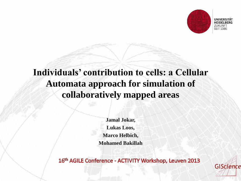
Flowchart of the approach

Results
Spatio-temporal analysis of contributions

Model implementation and evaluation
• Three timestamps (2009,
2010 and 2011) are selected
to train model.
• Contiguity filter: 3 × 3
• Optimal transition
rules: Moore and von
Neumann neighborhood).
• A Kappa index analysis is
carried out to evaluate the
outcomes versus reality.

Prediction
The calibrated CA model is applied to predict 2013 and 2014.
Visual analysis indicates that the whole urban fabrics will be contributed by 2013.
The northwestern part of the study area (farming lands), will not receive further contribution as few features exist.

Conclusions
• VGI is a complex field in GIScience, which is beyond only new data source, and every aspect of it needs to be discovered further.
• In this study, by embedding every single contribution into a lattice of cells, this social activity was footprinted on a spatial domain. Besides, cellular automata model, a very popular simulation technique, was implemented to properly learn the behavior of individuals in order to fit it into a simulation paradigm.
• The earliest and the most prevalent contributions were received on urban fabrics and primarily on the campus area of the Heidelberg University, where education is taking place and highly educated people commute there. This might be due to high and unlimited accessibility to internet infrastructures by highly-updated people to the recent technological developments. Instead, farming lands and water bodies receive contributions later than other features. This implies that socio-economic variables and physical indicators should be considered as well.

Thanks for your attention!