Indiana University Bicycle Master Plan · Kent McDaniel, IU Transportation Liaison and Demand...
47
Indiana University Bicycle Master Plan Bloomington, Indiana August 2015
Transcript of Indiana University Bicycle Master Plan · Kent McDaniel, IU Transportation Liaison and Demand...

Indiana University Bicycle Master Plan
Bloomington, Indiana
August 2015

2
Indiana UniversityBicycle Master Plan
Bloomington, Indiana107 South Indiana Avenue
Bloomington, IN 47405
www.indiana.edu
University PresidentMichael A. McRobbie
VP for Capital Planning and FacilitiesThomas Morrison
Transportion Services DepartmentKent McDaniel, IU Transportation Liaison and Demand Manager, IUB Project Manager – Bicycle Master Plan
Office of SustainabilityBill Brown, AIA, Director
Landscape Architecture DepartmentMia Williams, University Landscape Architect
Mark Ramsey, Director of Landscape ArchitectureTristan Johnson, Landscape Designer
INDIANA UNIVERSITY

3
Acknowledgements
Special thanks to the following people and organizations:
Steering CommitteeKent McDanielMia Williams
Bill BrownMark RamseyTristan Johnson Scott Robinson Henri VenablePerry Maull
Andrew Bredesen Brandon KoppelmannAmanda Turnipseed
Vince Caristo Michael BakerJulie BautersBrian Oliger
prepared by:
Sprinkle Consulting
&Rundell Ernstberger Associates

4
THIS PAGE LEFT BLANK

5
TABLE OF CONTENTS
CHAPTER 1 - INTRODUCTION AND BACKGROUND 06
CHAPTER 2 - GOALS, OBJECTIVES, AND STAKEHOLDERS INVOLVEMENT 08
CHAPTER 3 - EXISTING CONDITIONS, TRENDS AND NEEDS 10
CHAPTER 4 - INFRASTRUCTURE ACTION PLAN: RECOMMENDATIONS AND IMPLEMENTATION 16
CHAPTER 5 - POLICIES AND PROGRAMS 34
APPENDIX 42 APPENDIX A: STAKEHOLDERS COMMENTS MAP 43 APPENDIX B: FUTURE BICYCLE CIRCULATION (2010 IU CAMPUS MASTER PLAN) 44 APPENDIX C: FACILITY DEFINITIONS 45
LIST OF FIGURES AND TABLES
FIGURE 1: EXISTING BICYCLE FACILITIES MAP 11FIGURE 2: BICYCLE TRAVEL PATTERNS AND PRELIMINARY NEEDS MAP 13FIGURE 3: MULTI-USE PATH TYPICAL SECTION 16FIGURE 4: RECOMMENDED BICYCLE FACILITIES MAP 17FIGURE 5: RECOMMENDED BICYCLE FACILITIES MAP - SOUTH CAMPUS DETAIL MAP 18FIGURE 6: 10TH STREET/7TH STREET DETAIL PLAN 19FIGURE 7: EAST UNIVERSITY ROAD BIKEWAY AND MULTI-USE PATH DETAIL PLAN 20FIGURE 8: JONES AVENUE MULTI-USE PATH DETAIL PLAN 21FIGURE 9: JONES AVENUE CONTRA FLOW TYPICAL SECTION 21FIGURE 10: JORDAN RIVER GREENWAY TYPICAL SECTION 22FIGURE 11: JORDAN RIVER GREENWAY - INDIANA AVENUE TO IMU DETAIL PLAN 23FIGURE 12: JORDAN RIVER GREENWAY - IMU TO E. 7TH STREET DETAIL PLAN 24FIGURE 13: JORDAN RIVER GREENWAY - E. 7TH STREET TO UNION STREET DETAIL PLAN 25FIGURE 14: WOODLAWN AVENUE TYPICAL SECTION 27FIGURE 15: FORREST AVENUE SHARED LANE TYPICAL SECTION 27FIGURE 16: NORTH FORREST AVENUE/ARBORETUM BIKEWAY DETAIL PLAN 29FIGURE 17: BIKE HUB DETAIL PLAN 31FIGURE 18: ADJACENT PEDESTRIAN AND BICYCLE FACILITY SEPARATION RECOMMENDATIONS 35
TABLE 1: IMPLEMENTATION TABLE 33

6
INTRODUCTION AND BACKGROUNDINTRODUCTION AND BACKGROUNDThe Indiana University Bicycle Master Plan is an important document that builds upon the bicycling tradition of both the University and the Bloomington community, helps meet objectives of the 2010 IU Bloomington Campus Master Plan, and will aid in fulfilling the research and educational missions of the University. As it is being implemented, the Bicycle Master Plan will further enhance the quality of life of Indiana University students, faculty, staff and the larger university community; it will strengthen the connections to the City; it will provide for more dynamic neighborhoods; and it will create a more robust economic and sustainable base for the community.
Indiana University has a rich history which is reflected not only in its architecture but also in its campus landscape. The natural character of the campus lends itself well to pedestrian travel, but given the travel mode trends and the University’s sustainability goals, there are many areas of constraints in accommodating more bicyclists.
The University (and its partners) has begun to systematically expand the accommodation of bicycling with the addition of a variety of bicycle facilities including shared-use paths, cycle-tracks, bike lanes and shared lane markings. These efforts include: • Identification in the 2010 IU Bloomington Campus
Master Plan of the need for a comprehensive system of both pedestrian and bicycle facilities which provide safe, comfortable and convenient travel for pedestrians, bicyclists and motor vehicles.
• Implementation of a growing network of bicycle facilities including nearly 700 bicycle racks, numerous bike care stations, and a host of growing bicycling support programs.
• A number of University offices and groups working in concert to advance bicycling for many reasons, prominent of which is its role in
achieving a number of recently established sustainability and health goals.
• Receiving a Bronze rating from the League of American Bicyclists and seeks to receive advanced ratings with submittal of a new rating request in August of this year.
• An ambitious program called “Healthy IU” to encourage exercise and better diet among staff and faculty to increase productivity and lower health care costs.
This Bicycle Master Plan includes a detailed analysis of the infrastructure and considers the existing and future needs of students, faculty and staff that currently bicycle, or would be encouraged to bicycle throughout the campus.
As the following sections outline, this plan proposes a bicycling infrastructure network, a supporting expansion of programs and policies, and performance metrics that will help achieve the Bicycle Master Plan’s established goals and objectives for the planning horizon year of 2025.

7

8
GOALS, OBJECTIVES & STAKEHOLDERS INVOLVEMENTBICYCLE MASTER PLAN GOALS AND OBJECTIVESGoals and objectives for the IUB Bicycle Master Plan were developed with input from a Steering Committee and from on-campus stakeholder outreach meetings. Additionally, the IUB Campus Master Plan and the City of Bloomington’s Bicycle and Pedestrian Transportation and Greenways System Plan were reviewed to identify key themes related to bicycling on the IUB campus.
The goals and objectives for the Plan that the Steering Committee affirmed are:
GOAL 1Develop a comprehensive bicycle facility network that provides safe, efficient, and convenient connectivity within the IUB campus, to student housing, and to off-campus locations accessible via the City of Bloomington’s existing and planned network.
Plan Objective: Address major campus bicycling infrastructure needs including internal connectivity through the core campus, interfaces with the City of Bloomington bicycle network, east-west and north-south connectivity through campus, and access to peripheral campus locations (e.g., the athletics facilities).
GOAL 2 Address high-conflict areas within the IUB campus and where campus routes interface with the City of Bloomington’s bicycle network.
Plan Objective: Develop short and long-term solutions to high-conflict areas and provide associated planning-level cost estimates for mitigation thereof.
GOAL 3 Improve the convenience of bicycling through the provision of appropriate bicycle parking facilities and policies.
Plan Objective: Recommend potential enhancements to the criteria for bicycle parking with respect to quantity, type, and location (taking into account factors such as parking demand, proximity to building entrances, impacts on other modes of travel, and campus aesthetics).
GOAL 4Implement new, or refine existing policies and programs to increase bicycle ridership among students, faculty, and staff.
Plan Objective: Implement or refine a range of policies and programs based on evaluation of IU’s Bicycle Friendly Campus application, with the intent of elevating IU’s current rating from Bronze to Silver, and to Gold by target year 2025.
Plan Objective: Increase the combined bicycling mode share of faculty, staff, employees and students from the current 5.6 percent to 15 percent by the target year 2025.
GOAL 5Increase the harmony of interaction among bicyclists, pedestrians, and motorists within the IUB campus and on adjoining city streets.
Plan Objective: Develop a University policy that clearly establishes appropriate and acceptable bicyclist, pedestrian, and motorist code of conduct on campus (e.g. use of bike bells, etc).
Plan Objective: Implement ongoing awareness and education of bicycling laws and associated Univeristy code of conduct for bicycling on campus.
STEERING COMMITTEE & STAKEHOLDER MEETINGSSTEERING COMMITTEE MEETINGSThe Steering Committee for development of the IUB Bicycle Master Plan included: representatives from the Office of the Vice President of Capital Planning & Facilities; the University Architect’s Office; the Office of Sustainability; Graduate and Professional Student Organization; the Indiana University Student Association; the City of Bloomington; Campus Bus; Parking Operations; Auxiliary Business Services; the Indiana University Police Department; and others. Persons from these offices and organizations include: Kent McDaniel, Mia Williams, Bill Brown, Julie Bauters, Mark Ramsey, Tristan Johnson, Scott Robinson, Henri Venable, Perry Maull, Andrew Bredesen, Brandon Koppelmann, Amanda Turnipseed, Vince Caristo, Michael Baker, Brian Oliger and others.
The Spring 2014 report entitled Bicycle Friendly Campus Initiatives by Intern Ms. Hannah Hunt of the Office of Sustainability with mentors Bill Brown, Emilie Rex and

9
GOALS, OBJECTIVES & STAKEHOLDERS INVOLVEMENTPerry Maull was used by the Consultant team as a significant reference in their work in helping the University develop this Bicycle Master Plan.
STAKEHOLDER MEETINGSCampus stakeholder meetings were conducted to gather input from current bicyclists and to provide insight into future users. These were held on November 17, 2014 from 9:00 a.m. to 4:00 p.m. at the Neil Marshal Black Culture Center on campus. In general, the faculty and staff were invited to the morning session and the students were invited to the afternoon session. Draft goals and objectives were presented and a GIS map entitled “Existing Bicycle Facilities” developed as part of this bicycle master plan was used to discuss current routes and areas of concerns for bicyclists.
A wide variety of users were present at the meetings, including current bicyclists, those wishing to bike more, students, faculty, and community members from the surrounding city areas. The comments were graphically illustrated on the Stakeholder Meeting Comments Map (see Appendix “A”) and also included:• Maintenance issues with multi-use path along the
edge of campus• No clear maintenance responsibility between the
University and the City along edges of campus• Would like to see more bike repair stations• Need for education on code of ethics for bicyclists
using facilities in coordination with pedestrians• Would like to see more bike only facilities with
separate facility for pedestrians• More locker rooms with bike storage – design an
important part of making these efficient amenities (difficulty at Cyberinfrastructure Building locker room with locked door outside of locker room – can’t get to items left in locker room if in use by someone else)
• Bike parking around campus seems to be adequate o Would like to see more covered bike parking in parking garages• Hot spots for bike parking / destinations o Kelley School of Business o Library o Student Center o Food Court/Read/Wright Dorms o Ballantine/Simon/Jordan Halls o Hilltop o Cyberinfrastructure Building o Sports Stadiums o Restaurants and Commercial Locations along 3rd Street o Downtown Bloomington o Shopping off-campus on 3rd Street and
College Mall Road• Areas of observed or personally-experienced
conflicts include: o 10th Street & Jordan Ave o 10th Street & Fee Lane o 10th Street at Kelley School of Business - midblock crosswalk o 10th Street at Psychology Building o 10th Street at Woodlawn Avenue o 10th Street at railroad underpass o 10th Street at SR45/SR46 Bypass o 7th Street & Indiana Avenue o 7th Street at Jordan Avenue o 7th Street from Woodlawn to Showalter Fountain o Union Street at 7th Street o Union Street at 3rd Street o Union Street at 10th Street o Indiana Avenue at 6th Street o Indiana Avenue at 4th Street• Suggested connections to other paths/trails/parks o B-Line connection maybe down 4th Street or 6th Street o Allen Street- Covenanter Drive Neighborhood Greenway o Bryan Park o Cascades Park• 10th Street/Union Dorms – lockers not used• Most receive information by email or by visiting
the IU transportation website – would like to see a Facebook page created to communicate all things related to transportation including bike improvements and routes

10
EXISTING CONDITIONS, TRENDS AND NEEDS
EXISTING CONDITIONSA GIS map of existing bicycling facilities, conditions and accommodation was compiled and created with information from a variety of sources from IUB and the City, including the City’s Bicycle and Pedestrian Transportation and Greenways System Plan of 2008. Existing conditions for bicycling on the campus were evaluated with field visits, user survey review (the University’s 2014 TDM Survey), and through stakeholder meetings. In addition, existing planning documents and projects were reviewed for relevance to the bicycle infrastructure and needs of campus. A level of service (LOS) assessment for on-campus and adjoining roads was performed; the dominant LOS factors are portrayed on the Existing Bicycle Facilities map (see Figure 1) via the combined illustration of bicycle facility types and compiled roadway traffic volume classes (shown in various bandwidths).
10th STREET AT ARBORETUM
JORDAN RIVER
AUDITORIUM CYCLE TRACK
DUNN’S WOODS

SR 45/46 BYPASS
13TH STREET
10TH STREET
7TH STREET
10TH STREET
3RD STREET
KIRKWOOD AVE
IND
IAN
A A
VE
WO
OD
LAW
N A
VE
FEE
LAN
E
JORD
AN
AV
E
UN
ION
STR
EET
LAW LANE
JONES AVENUE
17TH STREET
11
FIGURE 1 - EXISTING BICYCLE FACILITIES MAPSEE DIGITAL COPY IN BACK SLEEVE FOR DETAILS

BICYCLE TRAVEL NEEDSThe Bicycle Travel Patterns and Preliminary Needs map (see Figure 2 next page) illustrates the compilation of the major bicycle travel flow needs for both current and future conditions. This compilation was created through review of the Campus Master Plan’s Circulation and Parking element, particularly the Bicycling section’s Future Facilities map; the bicycle master plan’s Steering Committee members’ input over several meetings in 2014 and 2015; numerous field observations; evaluation of the City’s initiatives and plans; input from the campus outreach and stakeholders’ input; and the collective knowledge of existing conditions and trends. As these patterns and needs became evident, five thematic guidelines emerged that guide the action plan for infrastructure, policies and programs that will advance bicycling throughout the IUB campus:
One of the primary challenges to implementing bicycle infrastructure will be providing a balance between providing new, widened, or separate facilities for bikes while preserving the historic and natural environment and aesthetic quality of the campus. While separate (or delineated) facilities for pedestrians and bicyclists are generally functionally ideal, there is a limit to the amount of built environment that is desired on the campus. Preserving the historic and natural character for which the university is known must remain a high priority with the addition of new bike facilities.
The flow of people within the IU Bloomington campus is currently dominated by pedestrians with just a few bicyclists. While it is desirable for the campus to maintain
TRENDS AND TARGETSAs articulated earlier, bicycling has been a feature of campus life for many years, and the activity is increasing. Furthermore, increased bicycling is a highly effective way to achieve a number of goals in the Campus Master Plan and those of the Office of Sustainability, especially given the campus and surrounding land use characteristics and University population’s current and future anticipated travel patterns. The results of the 2014 Transportation Demand Survey indicate a current 5.6% bicycle mode share based on a weighted average of students commuting to campus (7.1% bike mode share), on-campus students commuting to class (3.3%), and employees commuting to campus (5.6%). This existing mode share is in line with nationwide campus trends – while there are outliers such as Stanford University (52%) and UC-Davis (42%), and some campuses have shares as low as 1%, the majority of campuses have an existing bicycle mode share between 4% and 9%.
One of the goals of the University is to bring about a more interconnected, convenient, and intellectually engaging campus. While this goal may be achieved in part through various strategies, potentially including parking restrictions and management, ultimately success will stem from collective increases in mode share among carpooling, walking, motorcycle/moped, transit, and bicycling. Given the inherent limitations of campus carpooling (resulting from divergent employeee and student schedules) and walking (resulting from intra-campus destination travel distances), and the already free and viable transit service, it is likely that an increase in bicycle mode share can reduce reliance on single occupancy vehicles thereby helping to achieve this goal for the campus.
Accordingly, the target bicycle mode share for 2025 should be established at 15%, representing a nearly three-fold increase to the existing bicycle mode share. Noteworthy is this recommendation’s close comparison to that of the University of Maryland, College Park, a fellow Big 10 institution, whose Campus Bicycle Study documents a baseline mode share of 5.1% and a 15% target for a 10-year planning horizon.
12
EXISTING CONDITIONS, TRENDS AND NEEDS
1. Preserve the natural environment and aesthetic character of the campus
2. Provide facilities for bikes while preserving the strong pedestrian character of the campus
3. Create a system of bike facilities which complements existing pedestrian facilities to
create a network which is safe and convenient for both by reducing or minimizing conflict areas4. Supplement the current system of bike and
pedestrian facilities to reduce the use of automobiles within the campus core5. Continue the sustainability initiatives of the
University by creating additional options for bicycle travel both within the campus and via adjoining connections to nieghborhoods and campus supporting land uses

SR 45/46 BYPASS
13TH STREET
10TH STREET
7TH STREET
10TH STREET
3RD STREET
KIRKWOOD AVE
IND
IAN
A A
VE
WO
OD
LAW
N A
VE
FEE
LAN
E
JORD
AN
AV
E
UN
ION
STR
EET
LAW LANE
JONES AVENUE
17TH STREET
13
FIGURE 2 - BICYCLE TRAVEL PATTERNS AND PRELIMINARY NEEDS MAPSEE DIGITAL COPY IN BACK SLEEVE FOR DETAILS
Indiana University has adopted a planning strategy to minimize the use of automobiles within the campus core. The natural growth of the university over time did not always allow for the separation of motor vehicles from the campus, creating areas of high conflict between pedestrians and automobiles, as seen on 10th Street. Roadways providing access directly through campus further aggravate the conflict between the student (e.g., pedestrian and bicycle) population and vehicles traveling through campus. While implementing this planning strategy is a long term process identified by the University and will include many measures such as limiting parking areas within the campus core, reorganizing service access for key buildings, and creating new road connections on the perimeter of campus, there are incentive measures that will/can also be implemented to further the strategy. A long-term future bicycle circulation was envisioned in the Campus Master Plan - see Appendix B.
A complete and convenient network of bicycle facilities can contribute to the success of the overall strategy by making it easier for students, faculty, and staff to travel by bike rather than automobile. This includes providing amenities for bicyclists, including convenient and adequate bike parking, covered bike parking, bike repair stations, lockers and limited shower access for faculty and staff of the university. While bike parking on campus appears to be quite well distributed with good geographic coverage, stakeholders indicated a desire for an expansion in the range of bicycle parking facility types, including covered and interior (building – increased security) facilities, particularly for faculty and staff bicyclists. Furthermore, stakeholders articulated appreciation for the bike repair stations and expressed their desire that their number be expanded as well.
One of the main goals for the Indiana University’s Office of Sustainability is to reduce the demand of single occupancy automobiles on campus by 20%. One key avenue in reducing this demand is providing bicycle facilities which are safe and convenient. There are currently a large number of bicycles parked on campus. Several stakeholders noted that the number of bikes parked on campus is far greater than the actual number of people riding bikes on campus. Some suggest the problem lies with the bicycles’ pre-mature inoperability due to either poor quality, lack of protection from the elements, or a combination of the these two factors. Many stakeholders believe, however, that this ownership-use disparity gap is caused by a frustration with lack of adequate facilities and the conflicts created with the number of pedestrians on campus. Providing
this pedestrian focus, there are significant conflict areas between pedestrians, automobiles, and bicyclists. Solutions to address these conflicts will be an important component outlined in the next chapters of this Plan. Several conflict areas were identified on the Bicycle Travel Patterns and Preliminary Needs map including:• Several conflict points along 10th Street and at
intersecting streets• 7th Street within the core campus area• Union Street at 10th, 7th, and 3rd Streets• Indiana Avenue at 6th and 4th Street• Jordan Avenue between 10th and 3rd Streets
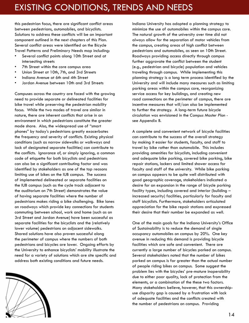
Campuses across the country are faced with the growing need to provide separate or delineated facilities for bike travel while preserving the pedestrian mobility focus. While the two modes of travel are similar in nature, there are inherent conflicts that arise in an environment in which pedestrians constitute the greater mode share. Also, the widespread use of “smart phones” by today’s pedestrians greatly exacerbates the frequency and severity of conflicts. Existing physical conditions (such as narrow sidewalks or walkways and lack of designated separate facilities) can contribute to the conflicts. Ignorance of, or simply ignoring, a common code of etiquette for both bicyclists and pedestrians can also be a significant contributing factor and was identified by stakeholders as one of the top reasons limiting use of bikes on the IUB campus. The success of implemented delineated or separate facilities on the IUB campus (such as the cycle track adjacent to the auditorium on 7th Street) demonstrates the value of having separate facilities where the number of pedestrians makes riding a bike challenging. Bike lanes on roadways which provide key connections for students commuting between school, work and home (such as on 3rd Street and Jordan Avenue) have been successful as separate facilities for the bicyclists and the (relatively lower volume) pedestrians on adjacent sidewalks. Shared solutions have also proven successful along the perimeter of campus where the numbers of both pedestrians and bicycles are lower. Ongoing efforts by the University to enhance bicyclists’ mobility illustrate the need for a variety of solutions which are site specific and address both existing conditions and future needs.
14
EXISTING CONDITIONS, TRENDS AND NEEDS

separate or delineated bicycle facilities alongside the pedestrianways can, in some places, provide a feasible accommodation for bicyclists on campus. In addition, solutions might include additional bicycle facilities which enhance natural corridors such as the Jordan River corridor creating opportunities to restore natural habitat in coordination with the establishment of new facilities such as greenway / pathways. A greatly expanded bike network can contribute to the sustainable goals of the university in many forms, including reducing demand for automobiles, providing an environmentally sensitive transportation solution, and creating a more inclusive and enjoyable campus experience.
A key infrastructure need is better bicycling connections with adjoining neighborhoods, campus supporting land use and regional destinations between the campus and Bloomington. This was affirmed by the Steering Committee and stakeholders alike. A significant majority of the University population lives either on-campus or within 3 miles of the campus – a perfect range for the bicycle as a highly convenient mode of choice. Additional connections were identified as important by the Steering Committee and the stakeholders. These connections included the resurgent downtown Bloomington and destinations extending beyond. Such destinations include reaching the B-Line Trail, Allen Street-Covenanter Drive Neighborhood Greenway, Bryan Park, and Cascades Park. Nearby destinations also included campus-convenient shopping areas such as grocery stores, shopping centers and the mall.
The residential street grid surrounding the campus core provides several opportunities to create these regional connections. Several streets were identified as currently utilized by bicyclists and others that would be utilized with some improvements such as bike lanes. These include:• East 3rd Street• East 4th Street• East Kirkwood Avenue• East 6th Street• East 7th Street• East 8th Street• 10th Street with the Bypass Multi-use path• Bypass Multi-use path• South Jordan Avenue• South Hawthorne Drive• South and North Woodlawn Avenue• South Rose Avenue• South Henderson Street• South Mitchell Street• East 11th Street
• North Walnut Grove• Fee Lane
Summarizing the overall needs and representing the affirmation of the Steering Committee as to the priority and predominant bicycle transportation flow needs is the aforementioned Bicycle Travel Patterns and Preliminary Needs map (Figure 2). This illustrates the compilation of the major bicycle travel flow needs for both current and future conditions to the horizon year 2025. The infrastructure plan is thus developed to meet these needs. The next chapter highlights that plan and its implementation.
DUNN’S WOODS
15
DUNN MEADOW

INFRASTRUCTURE ACTION PLAN: RECOMMENDATIONS AND IMPLEMENTATIONThe bicycle infrastructure in this bicycle master plan is recommended in keeping with the aforementioned goals, meeting the identified existing and future bicycle flow patterns and follows the five thematic guidelines. The infrastructure identified is for a 10-year implementation horizon; as time progresses toward that implementation target date (2025) an update of this Bicycle Master Plan is recommended with future expansion of the network anticipated.
The updated plan is needed to account for projects which are currenlty in planning stages including a future hospital site being considered northeast of State Road 46 Bypass and 10th Street. Direct bikeway connection of that activity center to the campus core should be considered as part of the infrastructure needed to support it.
BICYCLE FACILITIES AND NETWORK A multitude of facility types are recommended to complete a comprehensive network throughout the IUB campus. These include on-road and off-road facilities as well as bike hubs (The Bicycle Hub is defined and functionally described at the end of this section).
The illustrated network of bicycle facilities creates a complete system with strong east-west and north-south connections as recommended in the Campus Master Plan. Figure 4 iilustrates the recommendations for the horizon year 2025. Figure 5 is an enlargement, showing the south-central campus area. Table 1, Implementation Schedule, Horizon, and Costs is a listing of the costs associated with the recommendations and projected timeframes for completion and is found at the end of this chapter. The following text includes a description for the facility types and their roles in completing the campus bicycle network along with any special design considerations for the routes.
EAST-WEST CAMPUS ROUTES 17th Street Multi-Use Path: East 17th Street is a busy and heavily used roadway especially during campus athletic events. The multi-use path proposed adjacent to 17th Street will provide an alternative for students traveling to the athletic complex both during these events and during regular hours. This route provides an important connection to downtown Bloomington but also to the multi-use path along SR 45/46 Bypass (see Figure 3 - Multi-Use Path Typical Section).
Varies
Buffer
Multi-Use Path Typical SectionNot to Scale
12’ 5’ Min. 24’ 5’
Multi-Use Path Buffer Roadway Sidewalk
FIGURE 3 - MULTI-USE PATH TYPICAL SECTION
16
INFRASTRUCTURE ACTION PLAN

17
FIGURE 4 - RECOMMENDED BICYCLE FACILITY MAPSEE DIGITAL COPY IN BACK SLEEVE FOR DETAILS

13th Street- Law Lane Multi-Use Path: The 13th Street -Law Lane multi-use path provides an alternative to the 10th Street route with much different character. This route completes a connection from Indiana Avenue to Union Street through campus. In addition, the location of the Student Recreational Sports Center along this route will make it an important connector for many students, faculty, and staff looking for additional recreational opportunities.
18
INFRASTRUCTURE ACTION PLAN
FIGURE 5 - RECOMMENDED BICYCLE FACILITY MAP - SOUTH-CENTRAL CAMPUS DETAIL MAPSEE DIGITAL COPY IN BACK SLEEVE FOR DETAILS

10th Street Bikeway: Differing bicycle facilities are proposed in the future along 10th Street in the Campus Master Plan (adjacent shared use pathway) and in the City’s Bicycle and Pedestrian Transportation & Greenways System Plan (bike lanes). Whichever implemented in the future, the bikeway will connect with existing bike lanes along the major north-south roadways through campus including Fee Lane, Union Street, and the planned Woodlawn Avenue bike lanes/multi-use path(s). See Figure 6. 10th Street is currently lacking distinct bicycle facilities, but while the corridor is one of the busiest on campus, it’s also one of the slowest moving. This allows for bicycles to also travel as vehicles in the relatively slow traffic environment within the street.
Currently, design improvements for the Woodlawn/10th Street intersection include bike lanes on a short section of 10th Street from Park Avenue to North Forrest Avenue. For this 10 year campus Bicycle Master Plan, there are also a few short segments that bike lanes may be striped
in, but primarily shared use lane markings are suggested for helping accommodate bicyclists through this highly congested and constrained section of 10th Street.
7th Street Bike Lanes/ Shared Lane Route: The extension of existing bike lanes along 7th Street eastward to the IMU follows recommendations included in the Bloomington Bicycle and Pedestrian Transportation & Greenways System Plan. Continuing eastward, with restricted vehicular access east of the IMU parking lot, this bikeway can then transition to a shared lane with bikes inhabiting this low volume, low speed street. If desired, shared lane markings (SLMs) can be used to delineate the desired path of bicycles along this portion of 7th Street. This proposed shared lane route will enable continuity with the existing cycle track adjacent to the Auditorium. The bikeway continues eastward, transitioning into bike lanes as it continues east to Jordan Avenue thus providing a strong east-west connection through the middle of campus. See Figure 6 below.
19
FIGURE 6 - 10TH STREET/7TH STREET DETAIL PLAN

Jones Avenue Bike Path from Jordan Avenue to Southeast Corner of Read Hall: This bike path provides continuity from the Jordan Avenue crossing eastward past the southeast corner of Read Hall. While the Jones Avenue roadway section at times can accommodate bicyclists, a separated multi-use path between the road, the on-street parking, and Read Hall will accommodate virtually all desiring to bicycle through this area. See Figure 8.
Jones Avenue Bikeway – Southeast Corner of Read Hall to South Rose Avenue: This easternmost section of the bikeway corridor will utilize the existing roadway, accommodating bicyclists through a creative restriping of the roadway. The eastern most portion (which is currently one-way motor vehicle traffic) which will have a westbound bike lane striped and the eastbound bicycle traffic sharing the motor vehicle lane with sharrow lane markings providing guidance, see Figure 9 - Jones Avenue Contra Flow Typical Section.
East University Road Bikeway: This low volume, limited access street is the western section of the on-campus bikeway corridor serving the east-west bicycle flow from the southeast student residence area to the proposed Bicycle Hub in the Ballantine-Memorial Union area. This western section utilizes the existing E. University Road from the proposed Bicycle Hub eastward to the southeast corner of the Music Arts Hall. Motor vehicle traffic is restricted in this section, thus traffic flow is low speed and volume. Accordingly, bicyclists can easily and comfortably share this space with minimal roadway striping markings or signage. See Figures 7 and 8.
East University Road to Jordan Avenue Bike Path: Situated approximately parallel to the northwest to southeast diagonal pedestrian walkway is the proposed bikeway (see Figure 8). This short segment, approximate length of 250 feet, provides a direct route for the travel pattern articulated in the above segment. This is recommended to be separate from the existing sidewalk.
20
INFRASTRUCTURE ACTION PLAN
FIGURE 7 - EAST UNIVERSITY ROAD BIKEWAY AND MULTI-USE PATH DETAIL PLAN

Contra Flow Typical SectionNot to Scale
5’
Contra Flow Lane
Buffer
13’One-Way Section
Jones Avenue BufferWalkWalk
21
FIGURE 8 - JONES AVENUE MULTI-USE PATH DETAIL PLAN
FIGURE 9 - JONES AVENUE CONTRA FLOW TYPICAL SECTION

Meadow north of the IU Memorial Union. The greenway then continues east through the proposed bike hub where it continues east, following existing sidewalks south of Woodburn Hall and the Auditorium where it crosses Jordan Avenue and runs to the north of the Jordan Avenue parking garage. After passing the parking garage the greenway turns to the north following the Jordan River as it crosses over 7th Street and then turns east again to the south of Cypress Hall where it ends at Union Street. This corridor provides important connections from the residential areas in the northeast corner of campus to the core of campus at the IU Memorial Union (see figure 11, 12 and 13).
In addition to the travel needs which are fulfilled by the greenway there is an opportunity to provide a multi-use trail with unique character to other trails on-campus. The greenway should be designed with special considerations for the natural corridor in which it is located. Design details should include special material selection for the trail along with amenities to add to the greenway experience such as benches and lighting. The greenway will be an important connector and recreational facility for the campus.
Construction of the greenway also creates an opportunity to implement restoration measures as recommended in the 2010 Campus Master Plan. The greenway should be located outside of the floodway to minimize its footprint on the natural corridor and maintenance issues associated with flooding. See Figure 10- Jordan River Greenway Typical Section.
The recent improvements made along Jordan Avenue between 3rd Street and University Road have greatly enhanced the area of the proposed Jones Avenue-East University Road east-west corridor. Namely, the new medians, left turn lanes, pedestrian crossing, and buffered bike lanes provide a more comfortable corridor for all users. Also, the realignment of University Road with the addition of the left turn lane has lengthened the weave distance a bicyclist has to maneuver across Jordan Avenue to make a left turn off of Jordan.
3rd Street/East-West Corridor: Wrong way riding on 3rd Street should be somewhat alleviated on-campus as a significant portion of the eastbound bicycle activity can be accommodated within the East University Road – Jones Avenue bikeway corridor. It is suggested that in the future the City may wish to investigate ways to optimize the 3rd Street - Atwater Avenue Corridor to explore options for eastbound bicycle travel demand not satiated by the East University Road – Jones Avenue bikeway corridor.
Jordan River Greenway: A key theme of the Campus Master Plan is to embrace the Jordan River - The Jordan River is Bloomington’s most prominent natural feature and represents a unifying common thread through much of the core campus. Its unifying quality and continuity must be leveraged both formally and functionally as the campus develops, further reinforcing the importance of this natural asset. Future development should embrace the river’s natural scenic quality and accentuate its environmental setting.
The Jordan River Greenway proposed in this Bicycle Master Plan thus would follow the Jordan River from the location that it leaves campus near Indiana Avenue through Dunn
Varies 12’ 50’ Min. Varies
Buffer/Open Space Multi-Use Path Restoration & Buffer Zone
Jordan River
Jordan River Greenway Typical SectionNot to Scale
22
INFRASTRUCTURE ACTION PLAN
FIGURE 10 - JORDAN RIVER GREENWAY - TYPICAL SECTION

23
FIGURE 11 - JORDAN RIVER GREENWAY - INDIANA AVENUE TO IMU DETAIL PLAN

24
INFRASTRUCTURE ACTION PLAN
FIGURE 12 - JORDAN RIVER GREENWAY - IMU TO E. 7TH STREET DETAIL PLAN

25
FIGURE 13 - JORDAN RIVER GREENWAY - E. 7TH STREET TO UNION STREET DETAIL PLAN

Dunn’s Woods Corridor (from Ballantine Hall to Sample Gates): The existing east-west corridor just north of Dunn’s Woods is a flow corridor for bicyclists traveling from the Ballantine Hall area through the Sample Gates to Kirkwood Avenue. The current bicycle demand is handled sufficiently with minimal bike/pedestrian conflicts. However, as the campus bicycle infrastructure is developed, the bicycle volume on campus will increase, simultaneously increasing the bicycle flow through the Dunn’s Woods corridor. As this increases, the infrastructure will need to be re-assessed.
NORTH-SOUTH CAMPUS ROUTES Woodlawn Avenue Multi-Use Path/Bike Lanes: The extension of Woodlawn Avenue is providing a new and complete north-south corridor through campus. As such, this corridor has been planned as a complete street. Bike lanes are planned along the street on each side of the roadway along with an off-road multi-use path on each side. Providing both on-road and off-road facilities gives options for bicyclists of different skill levels (see Figure 14). The Woodlawn Avenue corridor provides a direct connection between the southern portion of campus and the athletic facilities including the Stadium and Assembly Hall.
North Forrest Avenue Bikeway: This is a most critical component in serving the north-south central flow of bicycle traffic generally running from the Ballantine and Memorial Union Bike Hub area to the Fee Lane and 10th Street area (see Figure 15). The existing cross-section has potential to be more than adequate to handle increased bicycle flows, if the cross-section is better optimized for both bicyclist flow and pedestrian flow. The solution is fairly straightforward. The existing sidewalks do not serve the current pedestrian flows, thus pedestrians use the whole of the roadway cross-section, as motor vehicle is highly restricted in this roadway segment. Influencing bicycle traffic to travel the portion of the roadway cross-section proximate to the street centerline will enhance bicycle flow while allowing pedestrians to not only use the sidewalks but also the outer portions of the roadway surface, providing a better sharing of the street cross-section. The placement of frequently spaced shared lane markings on both sides of the street centerline can influence bicycle traffic stream location.
26
INFRASTRUCTURE ACTION PLAN
WOODLAWN AVENUE
FORREST AVENUE NEAR 7TH STREET
7TH STREET AT WOODLAWN AVENUE

Bike-Lane Typical SectionNot to Scale
10’
Sidewalk
Two-Way StreetBike LaneBuffer
5’ Min. 5’ 10’
Sidewalk
5’ Min.
Buffer5’
Bike Lane
Shared Lane Typical SectionNot to Scale
Varies
Buffer Shared Lane WalkWalk5’ 5’ Varies
Buffer
27
FIGURE 14 - WOODLAWN AVENUE TYPICAL SECTION
FIGURE 15 - FORREST AVENUE SHARED LANE TYPICAL SECTION

North-South Concourse Bikeway/Arboretum Multi-Use Path: This is the corridor that will carry a significant flow of bicycle traffic from the busy classroom building concentration and the Indiana Memorial Union (IMU) area in the southwest portion of campus to the classroom buildings and other facilities in the 10th Street/Fee Lane vicinity. This proposed corridor will continue from the North Forrest Avenue bikeway northward through the Arboretum to the intersection of 10th Street and Fee.A slight geometric modification to the Forrest Avenue/7th Street intersection would facilitate bicycle through movement northward to the Arboretum area via the service drive between the Public Health and Art Museum. Bicyclists may share the low volume and speed drive. North of this shared vehicular area, a multi-use pathway will be located to minimize impact to the Arboretum while providing this important conduit for bicycle flow. The pathway will incorporate special design considerations for the unique character and history of the Arboretum and the highly congested intersection that it will be connecting with at 10th Street and Fee Lane. As the bikeway/multi-use path approaches the Ticket Booth vicinity just south of the Fee Lane and 10th Street intersection, options for separating the bicycle and pedestrian flows should be investigated during the preliminary design phase. See Figures 7 and 16.
South Hawthorne Drive Multi-Use Path/Shared Lane Markings: Completing this north-south corridor includes shared lane markings on Forrest Drive adjacent to the Union parking lot then traveling slightly east on a multi-use path to connect with another shared lane route on South Hawthorne Drive. This connects the north-south route to bike lanes along 3rd Street and to the neighborhoods adjacent to the campus on the south side.
Indiana Avenue: Indiana Avenue is a one-way, two lane street with on-street parking generally on one side of the street. The majority of it is a 30 foot wide cross-section. It is marked with shared lane markings. Its intersections adjoining the main portion of campus are stop controlled and traffic (posted) speed is approximately 30 mph. The City has proposed bike lane(s) from Hunter (south of 3rd) northward to 17th Street. This campus Bicycle Master Plan’s proposed facilities (e.g., Jordan River Greenway) will connect with the City’s future bike lane on Indiana.
10TH STREET AND FEE LANE
28
INFRASTRUCTURE ACTION PLAN
HEAVY PEDESTRIAN FLOW THROUGH ARBORETUM
OLD STADIUM GATES AT 10TH STREET

29FIGURE 16 - NORTH FORREST AVENUE/ARBORETUM BIKEWAY DETAIL PLAN

IUB BICYCLE HUBA centerpiece to the 2025 Bicycle Facilities Network is the Bicycle Hub in the proximity of the Ballantine Hall/Indiana University Memorial Union. This location is the logical nexus of daily student flow, and particularly for those who are, or will be using bicycles (see Figure 17). Short-term bicycle parking is a central component of the covered open-air Hub, and there will be a menu of parking options including higher-end daily bike storage lockers. Depending on the Hub’s proximity to the Biddle Hotel in the Memorial Union, it could include a future bike share or concierge. The IUB Bike Hub will be host to a number of related functions that further the efficacy of the bicycle as a major agent of sustainability and it will be central in the daily life of campus. For example, the Hub will include several bicycle care (repair) stations, bicycling convenience items, and perhaps a small coffee bar furthering social interaction. It can also include a weekly bike triage/tune-up day, hosted by local bicycle shops on a rotating basis. This can be held in the Hub’s small stage area that campus clubs can also use, similar to what is currently held on the streetside/enlarged sidewalk area just northeast of Ballantine Hall. A smaller Bike Hub, with just the fundamental components, should be considered in the north athletic complex area near the intersection of Woodlawn and 17th Street or near the current park and ride bus center.
PORTLAND STATE BIKE HUB - INDOOR PARKING
PORTLAND STATE BIKE HUB - BIKE REPAIR STATION
NEW YORK BIKE SHARE PROGRAM
OREGON STATE UNIVERSITY - COVERED BIKE PARKING
30
INFRASTRUCTURE ACTION PLAN

FIGURE 17 - BIKE HUB DETAIL PLAN
31

IMPLEMENTATION SCHEDULE, HORIZON AND COSTSTable 1 - Recommended Bicycle Facilities: Indiana University Bicycle Master Plan details the facility type and costs for each facility illustrated on the Recommended Bicycle Facility map (see following page). This table recommends priorities for construction of the facilities to complete the proposed network over the projected 10-year timeframe. Priorities were determined through analysis of the Bicycle Patterns and Needs as well as the budget conditions for the University. High priority facilities include those which would not only fulfill a high demand but would also have a high impact on the use of bicycles by providing the framework for the network within the first year of facility construction. An update of this plan should begin in the year 2023 and should include an inventory of projects which were implemented and analysis of the applicability of proposed projects within current conditions.
JORDAN RIVER CORRIDOR
INTERSECTION OF 7TH STREET AND INDIANA AVENUE
7TH STREET BIKE LANE
UNION STREET CENTER
32
INFRASTRUCTURE ACTION PLAN

Rec
omm
ende
d B
icyc
le F
acili
ties:
Indi
ana
Uni
vers
ity B
icyc
le M
aste
r Pla
n - 1
0 ye
ar Im
plem
enta
tion
Rec
omm
ende
dN
omin
al U
nit
Estim
ated
Faci
lity
Type
(s)
Cos
tsC
onst
.C
ost1
S H
awth
orne
Dr
E 3
rd S
tN
orth
End
of G
oodb
ody
Hal
l0.
09S
LMs
$750
.00/
ea*4
(bot
h di
rect
ions
)$4
,000
1 yr
Uni
vers
ity R
dB
alla
ntin
e-M
U B
ike
Hub
Mus
ic A
rts H
all E
ntra
nce
0.25
Sha
red
Lane
- bi
kew
ay s
igns
$300
/ea*
5 (b
oth
dire
ctio
ns)
$3,0
001y
r
Jone
s A
veS
E c
orne
r of R
ead
Hal
lS
Ros
e A
ve0.
18W
B c
ontra
flow
bik
e la
ne a
nd E
B
SLM
s$1
0,00
0/m
i and
$75
0/ea
*4 (o
ne
dire
ctio
n)$1
0,00
01y
r
E 7
th S
tN
Woo
dlaw
n A
veN
For
rest
Ave
0.06
Bik
e La
nes
$10,
000/
mi
$1,0
001y
r
E 7
th S
tIU
Aud
itoriu
m /
Thea
ter
N J
orda
n A
ve0.
05B
ike
Lane
s$1
0,00
0/m
i$1
,000
1yr
N F
orre
st A
veE
Kirk
woo
d A
veE
7th
St
0.13
SLM
s an
d br
oad
cros
swal
k$7
50/e
a*6
(bot
h di
rect
ions
)$1
5,00
01y
r
N-S
Con
cour
se /
Arb
orte
um P
athw
ayN
. For
rest
Ave
nue
E10
th S
t0.
25M
ulti-
Use
Pat
h (S
LM p
ortio
ns
sout
h of
, and
pot
entia
lly b
etw
een
Pub
lic H
ealth
and
Art
Mus
eum
)
$500
,000
/mi a
nd $
750/
ea*8
(bot
h di
rect
ions
)$3
00,0
003
yr
S H
awth
orne
Dr
Nor
th e
nd o
f Goo
dbod
y H
all
E U
nive
rsity
Rd
0.07
Mul
ti-U
se P
ath
$500
,000
/mi
$50,
000
3yr
10th
St.
N W
oodl
awn
Ave
Uni
on S
treet
0.76
SLM
s$7
50.0
0/ea
*32
(bot
h di
rect
ions
)$2
4,00
03y
r
N W
oodl
awn
Ave
E 7
th S
tN
SR
45
1.31
Bik
e La
nes
and
Mul
ti-U
se P
ath
Und
erw
ay$0
3yr
Uni
vers
ity R
dM
usic
Arts
Hal
l Ent
ranc
eN
Jor
dan
Ave
0.06
Mul
ti-U
se P
ath
$500
,000
/mi
$40,
000
5yr
Jone
s A
veN
Jor
dan
Ave
SE
cor
ner o
f Rea
d H
all
0.16
Mul
ti-U
se P
ath
$500
,000
/mi
$100
,000
5yr
E L
aw L
nN
Fee
Ln
N U
nion
St
0.51
Mul
ti-U
se P
ath
$500
,000
/mi
$325
,000
5yr
N F
ee L
nE
Law
Ln
E 1
3th
St
0.08
Mul
ti-U
se P
ath
$500
,000
/mi
$50,
000
5yr
E 1
7th
St
N D
unn
St
N F
ee L
n0.
50M
ulti-
Use
Pat
h$5
00,0
00/m
i$3
25,0
005y
r
E 1
7th
St
Arm
stro
ng S
tadi
umN
SR
45
0.45
Mul
ti-U
se P
ath
$500
,000
/mi
$300
,000
5yr
Jord
an R
iver
Gre
enw
ay P
athw
ayN
Indi
ana
Ave
N F
orre
st A
ve0.
39M
ulti-
Use
Pat
h$5
00,0
00/m
i$2
50,0
005y
r
Jord
an R
iver
Gre
enw
ay P
athw
ayN
For
rest
Ave
N S
unris
e D
r0.
55M
ulti-
Use
Pat
h$5
00,0
00/m
i$3
50,0
005y
r
Jord
an R
iver
Gre
enw
ay P
athw
ayN
Sun
rise
Dr
Uni
on S
treet
0.31
Mul
ti-U
se P
ath
and
SLM
s$5
00,0
00/m
i and
$75
0/ea
*6 (b
oth
dire
ctio
ns)
$250
,000
5yr
Bik
e H
ub B
alla
ntin
e - M
emor
ial U
nion
N/A
N/A
N/A
Bik
e H
ub$5
00,0
00/e
a$4
75,0
005y
r
Bik
e H
uble
t - S
tadi
um A
rea
N/A
N/A
N/A
Sm
all-S
cale
Bik
e H
ub$1
50,0
00/e
a$1
25,0
005y
r
E 1
3th
St
N In
dian
a A
veN
Fee
Ln
0.43
Mul
ti-U
se P
ath
$500
,000
/mi
$275
,000
10yr
5yr H
oriz
on C
ost
$2,9
98,0
001 In
clud
es 2
5% c
ontin
genc
y in
con
stru
ctio
n co
st10
yr H
oriz
on C
ost
$3,2
73,0
00
Targ
etPr
iorit
yD
ate
Leng
th(m
i)To
From
Faci
lity
Loca
tion
/ Roa
d N
ame
P:\1
362
IU B
ike
and
Ped
Mas
ter P
lan\
Gra
phic
s\M
aste
r Pla
n D
ocum
ent\I
mpl
emen
tatio
n C
hart\
IUB
Bik
e Fa
cilit
y R
ecom
men
datio
ns C
hart
v7 0
7311
5
33

BICYCLE FACILITIES DESIGN STANDARDSThe recommended bicycle facilities design standards should be the most current AASHTO Guide to Development of Bicycle Facilities, the Manual of Uniform Traffic Control Devices, and information from the FHWA’s Characteristics of Emerging Road and Trail Users and Their Safety, particularly for the design of off-street pathways. The City’s Bikeway Design Guidelines should be in harmony with the aforementioned and should be used accordingly. The NACTO Urban Bikeway Design Guide may be used as a reference for planning, but actual design of facilities should give precedence to the prior mentioned documents for facilities’ operational reliability. Planning and design of multi-use pathways and/or cycle tracks, “protected” bikeways, or similarly configured bikeways in close (parallel) proximity to motor vehicle ways should be done with the utmost cognizance, respect and implementation of Indiana traffic laws and driver/operator expectations and reaction abilities with regard to the conflict areas at driveway and street intersections. Horizontal, vertical and aesthetic approach chicanes for bikeways, as successfully pioneered on the Indianapolis Cultural Trail, provides some excellent ways to accomplish these operational reliability goals. Finally, due to the need to preserve pedestrian safety and the ambiance of the IUB campus, design of bikeway facilities with pedestrian ways, whether collinear or at conflict points, should be accomplished with pedestrian comfort and safety as a priority. To that end, collinear facilities designed and constructed in the future should provide distinctly separate and/or distinctive surface patterns guiding bicyclists into primary zones. See Figure 18 for options to achieve this.
BLOOMINGTON BICYCLE FACILITY DESIGN GUIDELINES
City of BloomingtonBicycle Facility Design Guidelines
May 2012 PREPARED BY: Alta Planning + Design 408 E. Wilson Madison, WI 53703 (608) 213-9077
INDIANAPOLIS CULTURAL TRAIL ROAD INTERSECTION
34
POLICIES AND PROGRAMS

10’Multi-Use Path
Seperated Typical Section Option 3Not to Scale
5’Ex.WalkBuffer Buffer
6’ Min. 10’ 6’Min.
Cycle-wayBuffer BufferBuffer
FIGURE 18 - ADJACENT PEDESTRIAN AND BICYCLE FACILITY RECOMMENDATIONS
INDIANAPOLIS CULTURAL TRAIL SEPARATED FACILITIES INDIANAPOLIS CULTURAL TRAIL COMBINED FACILITIES
SEPARATE FACILITIES COMBINED FACILITIES
35

could also hand out the bells in parallel with the City’s off-campus distribution. These efforts should be done in concert with general messaging regarding bicyclist and pedestrian expectations to reach the entire university population.
Interaction with Motorists In addition to interacting with pedestrians, bicyclists on campus must understand how to effectively interact with motorists. Many bicyclists neglect basic rules of the road while riding in and around campus, which exacerbates tension between motorists and cyclists and makes it difficult for drivers to understand their intentions. Conversely, some motorists do not understand the rights of cyclists and how to share the road effectively and safely. As part of the education campaign, students should be provided with information about their legal obligations and how to interact with motorists (and pedestrians) to reinforce safe behaviors, such as: stopping at stop signs and signals, riding with the direction of traffic, riding on the road rather than on sidewalks, and using hand signals. Motorists could also be reminded as to the rights and responsibilities of bicyclists, including: the right to ride in the road, the right to ride two abreast, and the responsibility to follow the same
POLICIES AND PROGRAMSPolicies and programs complement existing and future bicycling infrastructure, and help achieve the goals and objectives of the Plan. Bicycle-related programs and policies currently in place on the Campus are discussed in this section, and recommendations are provided for strengthening these policies and programs or establishing new programs where appropriate.
EDUCATION AND OUTREACH Education of the student, faculty, and staff population is essential to expanding the role of bicycling on the IUB campus and creating safer interactions and better harmony among bicyclists, pedestrians, and motorists. A central challenge is that each year, thousands of new students come to the campus from all over the world and many lack a good understanding of the rules of the road and proper bicycling etiquette. The University should proactively educate new students on the rules of the road as part of a unified bicycle education campaign. Careful consideration of effective outreach tactics is essential to ensure that bicycle safety and encouragement messages reach the target audience. Better education and messaging is also needed for the entire University population to ensure continued harmony as the bicycle mode share increases.
Interaction with Pedestrians One of the key challenges of bicycling on the IUB campus is that lack of dedicated space for cycling results in conflicts with pedestrians. While provision of infrastructure can help with this problem, in keeping with thematic guidelines 1, 2 and 3, broader education of bicyclists on their obligation to yield to pedestrians and overtaking etiquette will help preserve the campus’ pedestrian friendly ambience – even as the bicycle mode share increases.
The City of Bloomington has a program to distribute bicycle bells, which can help alert pedestrians to the presence of an overtaking bicyclist. The University should work with the City to expand this program to cover cyclists on campus. An annual contribution of several thousand dollars to this program would provide a large number of bicyclists with bells. Bells can be issued with bike registration/parking permits. Student volunteers
36
POLICIES AND PROGRAMS

traffic rules that apply to motorists. Motorists could be also reminded as to their legal obligations to bicyclists.
Bicycle ParkingA current challenge faced by the University is that many students often either buy low-cost bicycles that are not capable of withstanding long-term daily use or exposure to the elements – or don’t maintain them. Over a short period of time, many of these bicycles become unusable and are abandoned – often taking up space at University bike racks. They are an eyesore and also take up valuable bike parking space near residential and classroom buildings. The Bicycle Master Plan recommends enhanced bicycle parking at dorms that upon implementation, will afford greater protection for parked bicycles. This investment in bike parking should be accompanied by educational messages related to the types of factors that should be considered when purchasing a bike and how bikes should be stored to extend their useful life.
Outreach ChannelsSuccessful bike education campaigns rely not only on the content of messages, but also in how they are delivered. It must be recognized that influencing behavior is challenging, and that creative approaches are needed to gain the attention of students in particular. The University has several resources in place that can serve as the foundation for its bicycle education communications strategy.
Freshman Orientation provides a unique opportunity to reach a large portion of the incoming class with a consistent bike education message. Although there are many interests competing for the attention of incoming freshman, it is a unique opportunity to provide a comprehensive overview of bicycling on the IUB campus, including information related to routes, quality
bicycle acquisition and maintenance, bike parking, safety concerns, and basic courtesy expectations for interacting with motorists and pedestrians. Incorporating bicycle education into residential programming is another opportunity to reach a large portion of the undergraduate population. Both approaches are recommended to create a lasting education campaign.
Bike Safety Prezi is a unique presentation of recommendations, and applicable Indiana and City of Bloomington laws, produced by the Office of Sustainability. It can be accessed at http://sustain.indiana.edu/programs/bicycle-initiative/biking-tips.php. This presentation should be expanded to include: reasons why bicycling on the sidewalk is not recommended – or at least the operational challenges of riding on sidewalks and walkways, the obligation (and wisdom) of audible indication of overtaking pedestrians on pathways/walkways, and other beneficial actions on the part of bicyclists to promote harmony while interacting with pedestrians throughout the IUB campus.
The Bicycle Resources webpage within the Office of Sustainability’s “Programs” website directs visitors to resources that can enable their better use of the bicycle for transportation and recreation within and around the IUB campus. Similarly, the Office of Parking Operations has information furthering bicycle ridership on its Bicycling page, under the Alternative Transportation tab in their portion of the IUB website. In particular, the bike repair kits located in each of the five IUB vehicular parking garages are mentioned. From the user standpoint, it may be desirable to develop a comprehensive website dedicated to bicycling on campus, but this may be difficult due to differing departmental roles and responsibilities.
The Little 500 is the biggest intramural event on the IU campus and the largest collegiate bike race in the United States. The proceeds from this legendary bike race, held every April, go toward student scholarships at IU. This event, which is well publicized by the University, may also be a good medium for expanding bicycle ridership among students and for distributing educational messages. The University should explore opportunities for using the Little 500 race as an outreach channel for bicycle education and encouragement.
37

Wayfinding Recommendations• Develop an IUB Campus Bike Map including bike routes,
bike parking locations, and educational messages.
ENFORCEMENT Enforcement is a key element of creating lasting behavior change. While some students are likely to change their behavior on the basis of education alone, the risk of an enforcement action can be a deciding factor for many. Increased enforcement must be implemented in a staged manner, and with ample communication in advance of the effort. For example, IUPD could distribute a broad announcement that they will be enforcing stop sign violations during a particular upcoming month. Then, during that month they may start by giving warnings for the first two weeks of the campaign followed by tickets for violators in the latter half of the month. In this case, the goal would be to first create awareness of stop sign laws which can be accomplished through issuance of warnings, and to follow up with tickets to those who did not change their behavior after sufficient warning. This type of phased enforcement reduces the likelihood of negative publicity that sometimes results from enforcement campaigns.
In order for enforcement to be successful, it must be consistent over a longer period of time. IUPD input will be essential for educational messages related to bicycling on campus and ensure that the relevant laws are enforced. Consistent enforcement of the rules of the road is necessary to ensure compliance among bicyclists and motorists alike.
Enforcement Recommendations• Ensure that IUPD is engaged in the establishment of
educational messages related to bicycling on the IUB campus.
• Consistently enforce the rules of the road for bicyclists and motorists on the IUB campus.
The use of social media outlets such as Facebook and Twitter, as mentioned in the report entitled Bicycle Friendly Campus Initiatives by Intern Ms. Hannah Hunt of the Office of Sustainability, can serve an effective role in communicating bicycle education messages. These technologies evolve rapidly, requiring the University to adapt in order to reach students on their preferred communication platform.
Education and Outreach Recommendations• Work with the City to expand its bicycle bell
distribution program to cover cyclists on campus. A few thousand dollars of annual investments is recommended to reach a significant number of cyclists each year. This Fall 2015 a “Bells for Bike Safety” initiative by the Office of Sustainability is underway already.
• Develop new or expand existing educational materials (e.g., Bike Safety Prezi) to clarify bicyclist and pedestrian expectations with respect to the use of shared space.
• Proactively educate new students on the benefits of bicycle use, need for quality bicycles, rules of the road and other bicycle education topics through freshman orientation, and ongoing residential programming.
• Use social media and other innovative communication technologies to ensure bicycle education messages reach the target audience and are reinforced on an ongoing basis.
• Explore opportunities for using the Little 500 race as an outreach channel for bicycle education and encouragement.
WAYFINDING Bicycling (wayfinding and parking) maps, whether on-line or hard copy, can be very beneficial to increasing bicycle ridership – provided adequate physical accommodation exists. The University provides information on bicycle parking locations on campus and the City provides a bicycle suitability and facilities map that includes routes through the campus. As an increasing number of students consider and seek housing in areas adjacent to campus, graphical communication of bicycle-friendly access can help them make informed decisions that affect the campus’ overall bicycle ridership. Development of a campus-focused bike map is recommended to help
new students and faculty that are interested in biking in and around campus. Partnership with the City is key in providing this important information to students, faculty and staff.
38
POLICIES AND PROGRAMS

BICYCLE AVAILABILITY The IUB student population is fortunate to have few barriers to bicycle ownership, but education is needed to elevate the quality and/or maintenance of bicycles being employed. Bicycle parking is provided throughout the campus, and off-campus residences typically provide bicycle storage options. As noted above, recommendations for enhanced bicycle parking are included in the Bicycle Master Plan, which will help students to keep their bicycles in a good state of repair. One way for students to acquire a bike is through the bicycle auctions held by Parking Operations, usually in September and May, where hundreds of abandoned and unclaimed bikes are sold. Auctions are held in the Jordan Ave. parking garage. This activity provides affordable bicycles to students and faculty and helps increase ridership. For this reason, the bicycle auction program should be continued.
The topic of bike share was considered in the development of the Plan, but at this point, there appears to be minimal market need for a full-service bike share system deployment for the IUB campus. While there are many college campuses across the Nation implementing full-service bike share systems - many due to the undeniably highly prominent image that bike share promotes - a system for IUB would need significant capital and operating subsidies. Alternatively, less formal bike pools / share programs, modeled more closely to what some corporations or hotels employ – many using local bike shops to service, could be more effective until a transportation market develops operationally justifying a bike share system investment by the University. The larger bicycle travel market need articulated earlier – safety and courtesy education and enforcement on the campus, should be the focus of the University’s program investments for now.
Bicycle Availability Recommendations
• Increase awareness and education for quality bicycle acquisition and/or maintenance
• Continue the bicycle auction program. • Consider implementing informal bike pool/share
initiatives on the IUB campus.
Finally, the above recommendations will require the increase of one fulltime equivalent of staffing resources.
BICYCLE PARKING Bike parking on the IUB campus has historically been implemented in response to identified bike parking needs. While stakeholders indicated during the development of this Plan that the quantity of bike parking may be adequate overall, there are specific locations that may benefit from an increase in bike parking spaces. Additionally, they articulated that some of the racks do not meet current best practices for bike rack configuration.
As bicycling infrastructure is implemented throughout the campus, the University would benefit from a more accelerated approach to providing parking including development of criteria for calculating the number of spaces and identifying the preferred location and types of racks to be installed. Development and implementation of bike parking guidelines would ensure that racks contribute to the campus aesthetic and aid in the achievement of the new bicycle mode share target.
Bike Parking Recommendations• Establish a target number of bicycle parking spaces for
the entire campus and for specific buildings based on occupancy. For example, the University of California Berkeley has a target of providing one bicycle parking space for every ten students. In comparison with their existing bicycle mode share and the proposed target for IUB, an overall target rate approaching one space per 35 students for the next 10 years should be gradually implemented.
• Increase enforcement of non-functional bicycles’ removal from parking facilities.
• Identify opportunities to implement covered bike parking in existing garages and other covered, and convenient areas.
39

• Develop design guidelines for bike rack installation on campus including rack types, clearance requirements, and foundation specifications. Racks that do not meet newly developed guidelines should be phased out and/or improved over time, as budget allows. The second edition of the Association of Pedestrian and Bicycle Professionals Parking Guidelines provides detailed guidance on planning and implementing bicycle parking.
• Establish a specialty bike rack design (possibly through a student design competition) to be used at high-profile locations such as the IMU and in other highly visible campus locations.
• Develop criteria for the installation of different types of bicycle parking based on the intended use. A few examples are provided below:
- Classroom buildings: short-term uncovered or partially covered (roof only) bike parking; close to building entrances. - Dorms: short-term covered bike shelters (roof and 3 sides); long-term indoor key- controlled bike storage rooms, or bike lockers; reasonably close to buildings. - Special event locations (stadiums, auditorium, etc.): short-term uncovered or partially covered bike parking; may be relatively far from building entrances.• Consider expanding bike parking at locations identified
by stakeholders: - Kelley School of Business - Main library - Student Center - Food Court/Read/Wright Dorms - Ballantine/Simon/Jordan Halls - Hilltop - Cyberinfrastructure Building - Stadiums• Continue to implement bike valet as part of the
Greening of Athletics for major events such as football games.
BICYCLE LOCKER
CUSTOM BIKE RACK
BIKE PARKING IN PARKING GARAGE
40
POLICIES AND PROGRAMS

EVALUATIONThe most recent University administered Travel Demand Management survey included additional questions generated during the Bicycle Master Plan development that will help assess progress towards the above objective. Those questions should be retained in future years to help mark progress towards Goal 1and its increased bike mode share.
Evaluation Recommendations• Continue to collect data through the Travel Demand
Management Survey to assess progress towards Goal 1.• Permanent bicycle counting should be established at
several control points on campus. If infrared counting equipment is installed, then cameras should be used at the locations for one week each quarter to enable mode share splits to be estimated. Annualized bicycle counts can then be established to track the increase of bicycling on campus over time.
INFRARED BICYCLE/PEDESTRIAN COUNTER
41
42
APPENDIX
Indiana UniversityBicycle Master Plan
August 2015
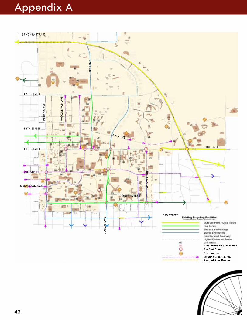
STAKEHOLDER COMMENTS MAP
43
Appendix A
Bike Racks Not IdentifiedConflict Area
DestinationExisting Bike RoutesDesired Bike Routes
SR 45/46 BYPASS
13TH STREET
10TH STREET
7TH STREET
10TH STREET
3RD STREET
KIRKWOOD AVE
IND
IAN
A A
VE
WO
OD
LAW
N A
VE
FEE
LAN
E
JORD
AN
AV
E
UN
ION
STR
EET
LAW LANE
JONES AVENUE
17TH STREET

44
Appendix B
CIRCULATION AND PARKING 173CIRCULATION AND PARKING CIRCULATION AND PARKINGTHE MASTER PLAN
Existing Bicycle Circulation On-Street Bike Lane Off-Street Bike Path Bike-Friendly Street
0 600 1200 1800 Feet
FUTURE BICYCLE CIRCULATION
N J
orda
n A
ve
SR 45/46 Bypass
E 17th St
N F
ee L
n
E 3rd St
E 10th St
N In
dian
a A
ve
INDIANA UNIVERSITY BLOOMINGTON CAMPUS MASTER PLAN (2010) BICYCLE CIRCULATION MAP

Bicycle Level of Service (Bicycle LOS)- A model used to estimate bicyclists’ average perception of the quality of service of a section of roadway between two intersections.
Bicycle Locker or Bike Locker- A secure, lockable container used for individual bicycle storage.
Bicycle Network- A system of bikeways designated by the jurisdiction having authority. This system may include bike lanes, bicycle routes, shared use paths, and other identifiable bicycle facilities.
Bicycle Rack or Bike Rack- A stationary fixture to which a bicycle can be securely attached.
Bicycle Route or Bike Route- A roadway or bikeway designated by the jurisdiction having authority, either with a unique route designation or with Bike Route signs, along which bicycle guide signs may provide directional and distance information. Signs that provide directional, distance, and destination information for bicyclists do not necessarily establish a bicycle route.
FACILITY DEFINITIONS
Bicycle- A pedal-powered vehicle upon which the human operator sits. The term “bicycle” includes three- and four-wheeled human-powered vehicles. In Indiana, a bicycle is considered a vehicle.
Bicycle Boulevard- A street segment, or series of contiguous street segments, that has been modified to accommodate through bicycle traffic and minimize through motor traffic.
Bicycles Facilities- A general term denoting improvements and provisions to accommodate or encourage bicycling, including parking and storage facilities, and shared roadways not specifically defined for bicycle use.
Bicycle Lane or Bike Lane- A portion of roadway that has been designated for preferential or exclusive use by bicyclists by pavement markings and, if used, signs. It is intended for one-way travel, usually in the same direction as the adjacent traffic lane, unless designed as a contra-flow lane.
45
Appendix C

Shared Lane- lane of a traveled way that is open to both bicycle and motor vehicle travel.
Shared-Lane Marking- pavement marking symbol that indicates an appropriate bicycle positioning in a shared lane.
Shared Roadway- roadway that is open to both bicycle and motor vehicle travel.
Shared Use Path- bikeway physically separated from motor vehicle traffic by an open space or barrier and either within the highway right-of-way or within an independent right-of-way. Shared use paths may also be used by pedestrians, skaters, wheelchair users, joggers, and other non-motorized users. Most shared use paths are designed for two-way travel.
Bikeway- A generic term for any road, street, path, or way which in some manner is specifically designated for bicycle travel, regardless of whether such facilities are designated for the exclusive use of bicycles or are to be shared with other transportation modes.
Highway- general term denoting a public way for purposes of vehicular travel, including the entire area within the right-of-way.
Independent Right-of-way-general term denoting right-of-way outside the boundaries of a conventional highway.
Right-of-way- general term denoting land, property or interest therein, usually in a strip, acquired for or devoted to transportation purposes.
Right of way (Assignment)-The right of one driver or pedestrian to proceed in a lawful manner in preference to another driver or pedestrian.
Roadway-The portion of the highway, including shoulders, intended for vehicular use.
Roundabout- type of circular intersection that provides yield control to all entering vehicles and features channelized approaches and geometry to encourage reduced travel speeds through the circular roadway.
Rumble Strips- textured or grooved pavement treatment designed to create noise and vibration to alert motorists of a need to change their path or speed. Longitudinal rumble strips are sometimes used on or along shoulders or center lines of highways to alert motorists who stray from the appropriate traveled way. Transverse rumble strips are placed on the roadway surface in the travel lane, perpendicular to the direction of travel.
46
Appendix C

Shoulder-The portion of the roadway contiguous with the traveled way that accommodates stopped vehicles, emergency use, and lateral support of subbase, base, and surface courses. Shoulders, where paved, are often used by bicyclists.
Sidewalk-That portion of a street or highway right-of-way, beyond the curb or edge of roadway pavement, which is intended for use by pedestrians.
Sidepath- shared use path located immediately adjacent and parallel to a roadway.
Traveled way-The portion of the roadway intended for the movement of vehicles, exclusive of shoulders and any bike lane immediately inside of the shoulder.
Unpaved Path-Path not surfaced with a hard, durable surface such as asphalt or Portland cement concrete.
REFERENCES
1. AASHTO. A Policy on Geometric Design of Highways and Streets. American Association of State Highway and Transportation Officials, Washington, DC, 2011.
2. FHWA. Manual on Uniform Traffic Control Devices. Federal Highway Administration, U.S. Department of Transportation, Washington, DC, 2009.
3. National Highway Traffic Safety Administration, Bureau of Transportation Statistics. National Survey of Pedestrian and Bicyclist Attitudes and Behaviors. U.S. Department of Transportation, Washington, DC, 2002.
47
Appendix C